This Ordinance shall be known as the Unified Development Ordinance for Kent County, Maryland. It provides a unified, comprehensive approach to regulations that affect land use including Zoning, Subdivision, Forest Conservation, Floodplain Management, Sediment and Erosion Control, Stormwater Management, and the Chesapeake Bay Critical Area.
1.2 PURPOSE AND INTENT
The purpose of this Ordinance is to implement the Kent County Comprehensive Plan and to promote the health, safety, general welfare, and prosperity of the present and future inhabitants of Kent County, by:
(A) Giving effect to policies and proposals of the Kent County Comprehensive Plan
(B) Reducing financial burdens imposed on the community by preventing unwise land use that requires costly infrastructure, harms existing communities, or is in areas of natural hazards such as floodplains, shoreline cliffs, steep slopes, and areas subject to erosion.
(C) Minimizing damage to public and private property.
(D) Providing for the preservation and enhancement of the attractiveness of Kent County through good design and arrangement, and the provision of adequate public utilities, open space, services, and facilities.
(E) Enhancing the County’s employment base.
(F) Protecting and preserving Kent County’s agricultural industry and the prime agricultural soils essential to the conduct of this industry.
(G) Providing efficiency in the process of development.
(H) Protecting Kent County’s significant historic structures and areas from destruction or encroachment.
(I) Protecting the biological and environmental quality of Kent County, including forest, water quality, habitat, and wetlands.
(J) Reducing the effects of land use on land erosion or stream channel erosion.
(K) Dividing the territory of Kent County, Maryland into zoning districts; governing the use of the land and the intensity of such use, including bulk and height.
(L) Implementing the Floodplain Management provisions to provide public awareness for flooding prevention, to protect individuals from unknowingly buying land and structures subject to flood hazard, and to encourage appropriate construction practices in order to prevent or minimize future flood damage.
(M) Implementing the Stormwater Management provisions to reduce local flooding, to control adverse impacts associated with increased stormwater, and to improve or substantially maintain after development the predevelopment runoff characteristics of the site
1.3 APPLICABILITY
(A) The provisions of this Ordinance shall apply to the unincorporated territory of Kent County, Maryland.
(B) Except as otherwise provided by this Ordinance, all land use that occurs within the unincorporated territory of Kent County, Maryland shall comply with the applicable terms and requirements of this Ordinance.
(C) No lot shall be created which does not conform to the applicable requirements of this Ordinance, unless a variance is granted by the Board of Appeals.
1.4 COMPLIANCE WITH REGULATIONS
Hereafter, the following shall not take place unless in conformity with the regulations set forth in this Ordinance:
(A) Change of a use of any land and structures, except that existing structures may be used for any permitted use, special exception, or accessory use allowed in the zoning district where they are located.
(B) Construction, reconstruction, modification, extension, expansion, or relocation of buildings or structures.
(C) Placement of fill, grading, and land excavation.
(D) Land and forest clearing.
(E) Dumping or storage of materials.
(F) Subdivisions including lot line adjustments.
1.5 VALIDITY OF ORDINANCE
If any section, paragraph, subsection, clause, phrase, or provision of this Ordnance shall be judged invalid or held unconstitutional, the same shall not affect the validity of this Ordinance as a whole or any part of the provisions thereof, other than the part so decided to be invalid or unconstitutional.
1.6 REPEAL OF CONFLICTING ORDINANCES
The Kent County Land Use Ordinance adopted December 3, 2002, and all amendments are hereby replaced by this Ordinance and any amendments from time to time.
SECTION 2. ZONING MAP
1.7 CONFLICT WITHIN ORDINANCE
In the event of any conflict between the limitations, requirements, or standards contained in different provisions of this Ordinance, the more restrictive provision shall apply, unless context would imply otherwise In the case of any ambiguities or discrepancies within or between these provisions, such matters shall be explained and interpreted, if possible, in a manner which gives effect to each part and which avoids or minimizes conflicts among such parts, as may be possible.
1.8 CONFLICT WITH OTHER REGULATIONS
In the event that this regulation conflicts with other federal, State, or local regulations, the more restrictive regulation shall prevail
SECTION 2 ZONING MAP
2.1 MAP INCORPORATION INTO ZONING CODE
The boundaries of zoning districts as shown on the official zoning maps of Kent County are hereby made a part of this chapter. The official zoning maps, together with amendments thereto, shall be kept by the Planning Department in both digital and printed form. In the event of a conflict between the digital and printed versions, the digital version shall control. Copies of the Official Zoning Map shall be available for inspection in the Department of Planning and Zoning.
2.2 REVISION OF THE DISTRICT MAP
No later than March 31 of the year following adoption of this Ordinance, printed copies of the map shall be available to the public upon request.
2.3
PERIODIC REVIEW
Following adoption of a new or revised Kent County Comprehensive Plan, the Planning Commission and County Commissioners shall review the land use regulations and zoning district map for consistency with the Comprehensive Plan, deficiencies or difficulties in administration, or any other reason the County Commissioners may determine. This Ordinance does not provide regulations for the Comprehensive Rezoning process. The Comprehensive Rezoning process may be set forth independently of this Ordinance by policy, practice, or if desired by adopted Resolution.
SECTION 3 AMENDMENTS
3.1 APPLICATION FOR ZONING MAP AMENDMENT
1. The application for an amendment to the Zoning Map of this Ordinance shall, at a minimum, specify the map and parcels sought to be amended, the current and proposed zoning classification, and recite the reasons for the proposed amendment.
2. Applications for map amendments to change the zoning classification of a property may only be submitted by the property owner or owners of the subject property for which a zoning map amendment is being requested, or by the County Commissioners of Kent County. The Planning Commission may make a recommendation to the County Commissioners to request the initiation of an application.
3. Per Md. Code Ann., Land Use, § 4-204, an application for a zoning map amendment, other than an amendment proposed during a Comprehensive Rezoning process, must meet the requirements of the change or mistake rule. Applicants are advised to seek legal counsel.
4. Except in the case of a Countywide comprehensive rezoning, the County Commissioners may grant an amendment to change the zoning classification for a property based on a finding that there was either: (a) a substantial change in the character of the neighborhood where the property is located; or (b) a mistake in the existing zoning classification.
5. An application may not be filed for a reclassification of all or part of any land for which a reclassification has been denied by the legislative body on the merits in the 12 months before the date of the application, per Md. Code Ann., Land Use, § 4-204.
3.2 APPLICATION FOR ZONING TEXT AMENDMENT
1. The County Commissioners may amend, supplement, or change the regulations of this Ordinance. Any zoning text amendment may be initiated by resolution of the County Commissioners, motion of the Planning Commission, submittal by County staff, or petition of any person using forms specified by the Department
2. The application for a zoning text amendment to this Ordnance will state the article, section, and paragraph sought to be amended. The application shall contain the text of the proposed amendment and shall recite the reasons for such proposed change.
3.3 AMENDMENT PROCESS
1. The Board of County Commissioners will submit its own proposals for amendments to the Planning Commission for review and recommendation, before taking any action on any of its own proposed zoning map or text amendments, revisions, supplements, or changes
2. Applications for zoning map or text amendments initiated by members of the public, the Planning Commission, or staff will first be submitted to the Planning Commission for review and recommendation. The Planning Commission may choose not to forward its
own applications; all other applications will be forwarded to the County Commissioners and presented for introduction. The Board of County Commissioners may choose whether to introduce amendments at its discretion. Applications not introduced may be submitted again at any time. Failure to introduce amendments does not constitute denial.
3. The Planning Commission may hold a public hearing with notice in a newspaper having general circulation in Kent County on any proposed map or text amendment, revision, supplement, or change before submitting its recommendation to the County Commissioners. The Planning Commission may request any pertinent data and information, as it deems necessary.
4. For a zoning map amendment, the property shall also be conspicuously posted prior to the hearing. Published notices shall refer to places where the zoning map amendment may be examined
5. When reviewing a zoning text amendment, the Planning Commission shall address:
(A) How the proposed zoning text amendment would serve the public interest in general; and
(B) The extent to which the proposed text amendment complies with or deviates from the Comprehensive Plan and the Critical Area Law.
6. When reviewing a zoning map amendment, the Planning Commission will also address the suitability of the property in question for the uses permitted in the proposed district.
7. The Planning Commission will not recommend the adoption of the amendment unless it finds that the adoption of the amendment is in the public interest, in that, it furthers the health, safety, and general welfare of the community, as well as the interests of an individual landowner.
8. Failure of the Planning Commission to report to the County Commissioners within 60 days following its first meeting after the proposal was referred will be deemed approval.
9. Before approving any proposed zoning map or text amendment, the Board of County Commissioners shall hold a public hearing. Notice of any public hearing shall be given prior to the date of the hearing and published in a newspaper having general circulation in Kent County. For a zoning map amendment, the property shall also be conspicuously posted prior to the hearing. The published notices shall refer to places where the plans, ordinances, or zoning map or text amendments may be examined.
10. The County Commissioners shall render a decision within a reasonable timeframe. An application may be deferred for additional research
11. Petitions for zoning map or text amendments, revisions, supplements, or changes denied by the County Commissioners on their merits, or substantially similar petitions, shall not be allowed to be filed by an applicant for 12 months after the denial. The Board of County Commissioners itself may propose a similar petition of its own at any time.
12. Any persons aggrieved by any decision of the County Commissioners may within 30 days after such decision appeal to the Circuit Court of Kent County.
13. Amendments dealing with Critical Area Districts or Critical Area related items shall not be effective, until effective under Md. Code Ann., Natural Resources § 8-1809, as the same may be amended from time to time.
SECTION 4 BOARDS AND COMMISSIONS
It is the intent of this section to identify the duties of the Board of Appeals and Planning Commission. Each Board or Commission shall adopt rules of its business, such rules to be made available to the public upon request.
4.1 BOARD OF APPEALS
The Board of Appeals shall have the following powers:
1. Administrative Appeals - To hear and decide appeals of any decision or determination made by the Department or any County staff member in the enforcement and administration of this Ordinance, unless clearly specified otherwise in this Ordinance.
2. Special Exceptions - To hear and decide applications for special exceptions as set forth herein.
3. Variances - To authorize, upon application, variances related to yard setbacks, height, bulk, parking, signs, loading, shoreline cliff, 15% slope, pier length, impervious surface, stream protection corridor, forest conservation retention provisions, floodplain requirements, buffer requirements, and any non-use-related provision of this Ordinance.
4. Other Powers - The Board may have additional powers as may be designated by the County Commissioners of Kent County.
5. Conditions - In the granting of variances, appeals, and special exceptions, the Board may limit the approval by such conditions as the case may require.
6. Right of Entry - The Board of Appeals is hereby authorized to enter upon open land in Kent County for the purpose of reviewing applications pending before the Board. Such entry is only to be in the form of a publicly noticed and ADA-accessible public meeting on the site.
4.2 PLANNING COMMISSION
The Planning Commission shall have the following powers:
1. Comprehensive Plan – To develop and approve a plan which shall be recommended to the legislative body for adoption. The plan is the principal document outlining County direction, policy, and action regarding land use. While other plans and ordinances provide more detailed information and policy, all plans and laws shall be consistent with and conform to the Comprehensive Plan in the manner as prescribed by Maryland State law, as set forth in Md. Code Ann., Land Use, §1-303.
2. Recommendations to County Commissioners – To make recommendations to the County Commissioners on Unified Development Ordinance text amendments, zoning map amendments, and courses of actions necessary to implement the Comprehensive Plan.
3. Recommendations to the Board of Appeals – To make recommendations to the Board of Appeals on variances and certain special exceptions as set forth in this Ordinance. The Commission shall address the extent to which the variance or special exception complies with or deviates from the Comprehensive Plan. The Commission may recommend conditions and limitations on the approval of variances and special exceptions.
4. Subdivisions – To review and approve subdivisions of land as set forth in this Ordinance and Md. Code Ann., Land Use, §5-105.
5. Site plans – To review and approve site plans as set forth in this Ordinance.
6. Other Powers – The Planning Commission may have additional powers as may be designated by the County Commissioners of Kent County.
7. Conditions – In the granting of subdivisions and site plans, the Commission may limit the approval by such conditions as the case may require.
8. Right of Entry – The Planning Commission is hereby authorized to enter upon open land in Kent County for the purpose of reviewing applications pending before the Commission. Such entry is only to be in the form of a publicly noticed and ADA-accessible public meeting on the site.
SECTION 5 NONCONFORMITIES
5.1
PURPOSE.
1. This article is intended to allow lawfully established nonconforming lots, uses and structures to continue, but to limit the number and extent of nonconforming uses and structures by prohibiting or restricting enlargement, reestablishment after abandonment, reconstruction or change in use.
2. Except as otherwise provided in this article, any nonconforming lot, structure or use may continue, provided it remains otherwise lawful.
5.2 CERTIFICATION OF NONCONFORMING STATUS
1. Authority; certification required for development
The Board of Appeals shall have the authority to certify that a lot, structure, or use is legally nonconforming. An application to the Department of Planning, Housing, and Zoning for certification of nonconforming status for a lot, structure or use:
(A) May be submitted by a property owner at any time.
(B) A public hearing will be required, and the process for notice will be utilized as set forth in Article IV, Section 1.6.
2. Application
The application shall include, as applicable:
(A) Documentation that the lot was legally created.
(B) Documentation that the structure was legally constructed, including all structure dimensions and lot coverage.
(C) Documentation that the use was legally established, continuously maintained and not abandoned since its establishment, including documentation of the area of land and structures devoted to the nonconforming use.
3. Burden of proof
(A) The burden of establishing the legal nonconforming status shall be upon the owner of the land.
(B) The casual, temporary, intermittent or illegal use of land is insufficient to establish the existence of a nonconforming use or structure.
(C) The existence of a nonconforming use shall not be construed to establish a nonconforming use on the entire premises. The portion of the premises where legal nonconforming use exists must be defined.
4. Certificate of nonconformity
Upon finding that a legal nonconforming lot, structure, or use exists, the Board of Appeals shall issue a certificate of nonconformity. The certificate shall specify the nature and extent of the legal nonconformity, including the land and building area devoted to a nonconforming use, the extent of nonconforming lot coverage, the dimensions of nonconforming structures, and other dimensions as applicable.
5. Appeal
The Board of Appeal’s determination may be appealed to the Circuit Court within 30 days of certificate issuance.
6. Register of certificates
The Department shall maintain a register of certificates issued for nonconforming lots, structures, and uses.
NONCONFORMING USES
5.3 LEGAL NONCONFORMING USES, DEFINED
1. Any use of a lot shall be considered a legal nonconforming use, if it:
(A) Does not conform to one or more use regulations of this Ordinance;
(B) Existed on the effective date of this Ordinance;
(C) Has not been abandoned; and
(D) Either conformed to the regulations of or was considered to be a legal nonconforming use by the former Land Use Ordinance in effect the day before the effective date of this Ordinance.
2. The existence of a legal nonconforming use shall be presumed valid, based on documents that indicate evidence of the use prior to the adoption of this Ordinance, submitted by the property owner, lessee, or other relevant party, unless specifically determined by the Board to be insufficient to validate the presence of the use
3. The intermittent or illegal use of a lot shall not be sufficient to establish the existence of a legal nonconforming use.
4. The existence of a use on a part of a lot shall not be construed to establish a legal nonconforming use on any other part of such lot.
5.4 CONTINUANCE OF LEGAL NONCONFORMING USES
A legal nonconforming use shall be permitted to continue, subject to regulations of this Section.
5.5 ABANDONMENT OF LEGAL NONCONFORMING USES
For the purposes of this Ordinance, the discontinuance of a use for a period exceeding two years shall constitute abandonment of such use. Whether a nonconforming use has discontinued is a question of fact and shall be decided by the Board of Appeals utilizing the process in §5.2. A public hearing will be required, and the process for notice will be utilized as set forth in Article IV.
5.6 LEGAL NONCONFORMING USES IN THE CRITICAL AREA
Any legal nonconforming use within the Critical Area which existed on April 12, 1988, may continue without intensification or expansion unless such use has been abandoned for more than one year, or otherwise in accordance with Section 27.01.02.07 of the Code of Maryland Regulations.
5.7 ENLARGEMENT OF LEGAL NONCONFORMING USES
Except in the case of private schools or houses of worship that existed prior to April 12, 1988, no legal nonconforming use may be enlarged, increased, or extended so as to occupy any portion of a lot or structure where the legal nonconforming use did not exist on the effective date of this Ordinance or so as to occupy any portion of a lot or structure where the use was abandoned
5.8 ORDINARY REPAIR AND MAINTENANCE
The normal maintenance and repair, or the replacement, installation, or relocation of nonbearing partitions, fixtures, wiring, or plumbing may be performed on any structure that is devoted in whole or in part to a legal nonconforming use. Life safety code updates and requirements for any improvements related to ADA accessibility, or any other required update, change, improvement,
ARTICLE I. ENACTMENT
SECTION 5. NONCONFORMITIES
or additional equipment that is required by any governmental agency or quasi-public agency will not be considered to affect the status of the use including any required expansions under such.
NONCONFORMING STRUCTURES
5.9
LEGAL NONCONFORMING STRUCTURES, DEFINED
1. Any structure shall be considered a legal nonconforming structure if it:
(A) Does not conform to one or more non-use regulations of this Ordinance;
(B) Existed on the effective date of this Ordinance;
(C) Is not a sign; and
(D) Either conformed to the regulations of or was considered to be a legal nonconforming structure by the Land Use Ordinance in effect the day before the effective date of this Ordinance.
5.10 CONTINUANCE OF LEGAL NONCONFORMING STRUCTURES
A legal nonconforming structure may continue to exist, subject to the regulations of this Section.
5.11 ORDINARY REPAIR AND MAINTENANCE OF LEGAL NONCONFORMING STRUCTURES
The normal maintenance and repair of a legal nonconforming structure may be performed, provided that any portion of the structure undergoing such maintenance or repair either (1) conforms to all non-use regulations of this Ordinance, or (2) does not increase its degree of structural nonconformity.
5.12 REPAIR OR RECONSTRUCTION OF LEGAL NONCONFORMING STRUCTURES AFTER CALAMITY
1. There shall be no repair or reconstruction of a damaged legal nonconforming structure unless all of the following conditions are met:
(A) The damage, destruction, or removal of the structure was not voluntarily caused by the property owner or property owner’s agent;
(B) A permit is obtained prior to repair or reconstruction of the damaged or destroyed structure;
(C) Repair or reconstruction begins within two years after the calamity; and
(D) The repair or reconstruction does not result in an increase in the degree of nonconformity.
2. Nothing in this Ordinance shall be deemed to prevent the strengthening or restoring of a structure to a safe condition by order of a public official.
5.13 ALTERATIONS OR ENLARGEMENTS TO LEGAL NONCONFORMING STRUCTURES
No legal nonconforming structure may be altered or enlarged unless one or more of the following conditions are met:
1. The portion of the structure that is proposed to be altered or enlarged will, after the alteration or enlargement, comply with all standards and regulations in this Ordinance and will not increase the percent of impervious surface on the lot above that percent which is permitted by the Ordinance. If no regulatory maximum is established in the Ordinance, then this provision will not apply;
2. The legal nonconforming structure has been used as a private school without abandonment since April 12, 1988;
3. The legal nonconforming structure has been used as a house of worship without abandonment since April 12, 1988.
4. The legal nonconforming structure is a dwelling that existed as of April 12, 1988, and is located in the modified buffer and conforms to the standards set forth in this section.
5.14 EXPANSION OF EXISTING DWELLINGS IN THE MODIFIED BUFFER
Dwellings existing as of April 12, 1988, in the modified buffer may be enlarged, provided that:
1. All opportunities for expansion outside the minimum 100-foot buffer are exhausted; and
2. The enlargement is no closer to the mean high-water line than the current dwelling; and
3. An area of natural vegetation equal to two times the footprint of the expansion shall be planted in the 100-foot buffer. If there is not enough area in the buffer to accommodate the required planting, the required planting shall occur on the same property.
5.15 RELOCATION OF NONCONFORMING STRUCTURES
No legal nonconforming structure shall be relocated in whole or in part to another lot or to another location on the same lot unless, after relocation, every portion of the structure conforms to all applicable site development regulations
5.16
NONCONFORMING LOTS
SECTION 5. NONCONFORMITIES
NONCONFORMING LOTS, DEFINED
A lot which was legally created and properly recorded but which does not satisfy the minimum lot area and/or the minimum lot width applicable to the zoning district in which it is located shall be considered a nonconforming lot.
5.17 CONTINUANCE OF NONCONFORMING LOTS
1. Nonconforming lots may continue to exist, subject to the regulations of this Section.
2. Nonconforming lots may be occupied by any use permitted by the regulations for the district in which it is located.
3. Nonconforming lots may be developed with structures that comply with all site development regulations set forth by this Ordinance.
4. A variance for minimum lot area will not be required for any permitted use, allowable special exception, or permitted accessory use to be located on such a lot.
5.18 SUBDIVISION OF NONCONFORMING LOTS
A nonconforming lot may not be subdivided unless each resulting lot conforms to the minimum lot area and the minimum lot width regulations applicable to the zoning district in which it is located, unless a variance is granted by the Board of Appeals per this Ordinance.
NONCONFORMING SIGNS
5.19 NONCONFORMING SIGNS
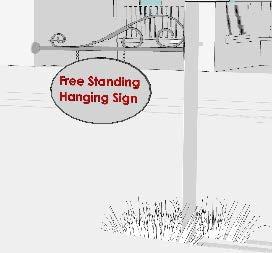
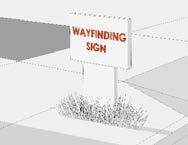
Regulations concerning nonconforming signs may be found in Article V. Zoning, Section 3.16 of this Ordinance.
SECTION 5. NONCONFORMITIES
[THIS PAGE IS INTENTIONALLY BLANK.]
ARTICLE II. DISTRICTS
SECTION 1. GENERAL PROVISIONS
SECTION 1 GENERAL PROVISIONS
1. ESTABLISHMENT OF ZONING DISTRICTS
In order to regulate and restrict the location and use of land and structures for trade, industry, residence, and for other purposes; to regulate and restrict the location, height, and size of structures hereafter erected or structurally altered; to regulate the size of yards, and other open space; and to regulate the density of population, these zoning districts are hereby established:
Agricultural (AZD)
1:30 units per acre
Resource Conservation District (RCD) 1:20 units per acre Critical Area
Rural Character (RC) 1:20 units per acre
Critical Area Residential (CAR) 1:1 unit per acre Critical Area
Community Residential (CR) 1:1 unit per acre
Village (V) 8 units per acre
Intense Village (IV) 12 units per acre
Commercial (C)
Commercial Critical Area (CCA)
Area
Marine (M) 2 units per acre Critical Area
Employment Center (EC)
1:20 units per acre*
*intra-family transfer
Employment Center Critical Area (ECCA) 1:20 units per acre*
Mixed Use Development (MXD)
Mixed Use Development Critical Area (MXDCA)
*intra-family transfer Critical Area
12 dwelling units per acre for entire District
12 dwelling units per acre for entire District Critical Area
2. CRITICAL AREA ZONING DISTRICTS GENERALLY
The 14 zoning districts in this Ordinance comprise two categories. The first category is the zoning districts for land located in the State of Maryland’s Critical Area for the Chesapeake and Atlantic Coastal Bays. These are the RCD, CAR, CCA, M, ECCA, and MXDCA. State of Maryland Critical Area laws and regulations apply in these districts The remaining districts are outside the Critical Area Critical Area law and regulations do not apply; other laws and regulations such as Forest Conservation regulations apply. The Environmental Regulations are set forth in Article VI
3. ESTABLISHMENT OF CRITICAL AREA LINE
The Critical Area Line shall be shown on the map designated as the “Critical Area Line Map of Kent County, Maryland” adopted by the County Commissioners. Such map delineates the Critical Area and shall be used to determine if such land is located within the Critical Area. For any land referenced to be within the Critical Area according to the “Critical Area Line Map of Kent County” one must follow the Critical Area requirements and regulations as follows:
(A) If referenced on the “Zoning Map” as a Critical Area zoning district, then the established zoning district must be adhered by.
(B) If according to the “Critical Area Line Map” the land is within the Critical Area then the requirements and regulations of the most similar Critical Area zoning district and the established Critical Area designation must be followed. This includes Title 27 of the Code of Maryland Regulations (COMAR).
(C) This Section shall remain in effect while Kent County undertakes its Comprehensive Rezoning and Update process, which will result in a new comprehensive Ordinance and “Zoning Map.” The “Critical Area Line Map” will be incorporated into the “Zoning Map” and will no longer be a stand-alone map.
(D) The Critical Area Line Map may be amended by the County Commissioners in compliance with amendment provisions in this Ordinance, the Maryland Critical Area Law, and COMAR Title 27.
(E) The Critical Area Boundary line was updated on April 27, 2021, and new mapping designations associated with any newly included Critical Area shall meet the standards of COMAR 27.01.115.
4.
INTERPRETATION OF ZONING DISTRICT BOUNDARIES
Where uncertainties exist with respect to the district boundary, the following applies:
(A) Where a boundary is given a position within a street, alley, or easement, the boundary shall be deemed to be the center of the right of way of the street, alley, or easement
(B) If the actual location of a street, alley, or easement varies from the location shown on the map, the actual location shall control.
(C) Where a boundary is shown as being located a specific distance from a street or other physical feature, this distance shall control.
(D) Where the district boundary approximately coincided with lot lines, the lot line shall be construed to be the district boundary unless otherwise indicated.
(E) Where district boundaries do not coincide with lot lines and streets, and where no dimensions are shown, the location of the boundary shall be determined by use of the scale shown on the map.
SECTION 1. GENERAL PROVISIONS
(F) Where a property is split by a zoning boundary including special districts, the rules of the zone shall apply to that portion of the land located in each district.
SECTION 2
AGRICULTURAL
ZONING DISTRICT (AZD)
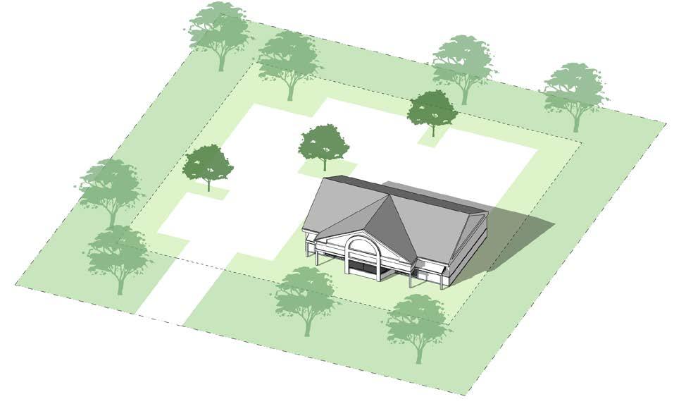
2.1 STATEMENT OF INTENT
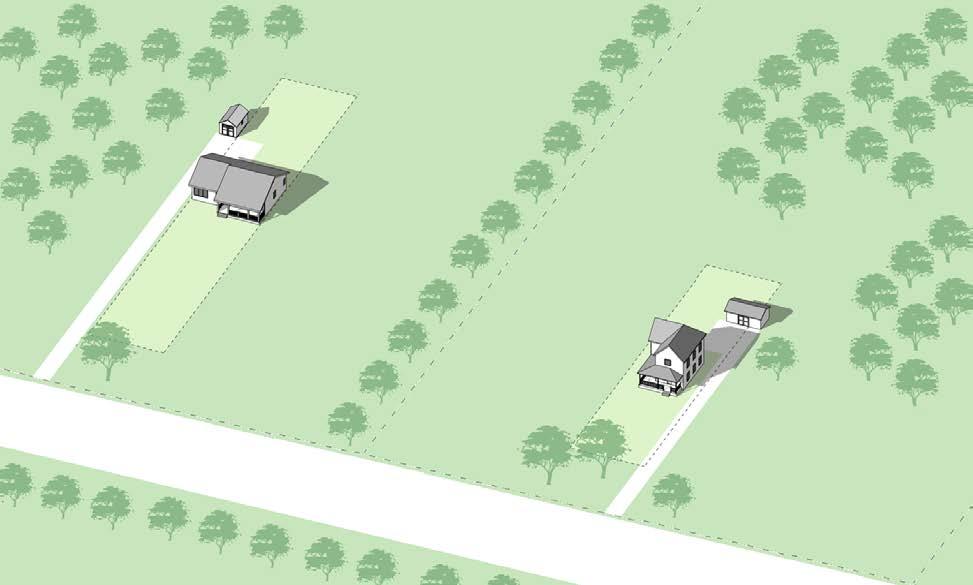
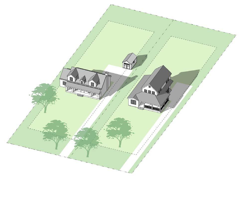
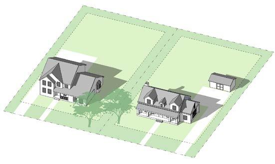
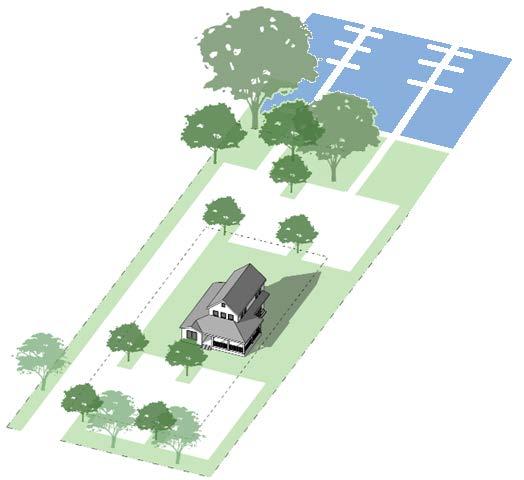
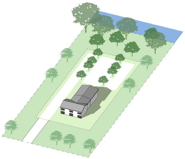
The purpose of the Agricultural Zoning District is to encourage the use of agricultural land for farming and other agricultural businesses and to limit the use of these lands for non-agricultural purposes. Agriculture, including animal husbandry on properties at least 20 acres or larger in size, is the preferred and primary use in the Agricultural Zoning District. In general, the District will consist of large contiguous areas predominantly devoted to agriculture or forestry and principally composed of Class I, II, and III soils. The District will contain some sensitive areas not well suited to agriculture to provide large contiguous areas. The sum of these areas consists of enough land to help maintain a derived-demand market for the necessary agricultural support services in the County. In addition, the District is to provide for farm, home occupations, and cottage industries that are compatible with agriculture as a means to further diversify the County’s economy.
Figure 1: Diagram illustrating the desired, general character of the Agricultural Zoning District.
2.2 PERMITTED USES AND STRUCTURES
A building or land shall be used only for the following Detailed limitations and standards for these uses may be found in Article III. Administrative special exceptions are indicated by letter “A.” “B” indicates exceptions that require only Board of Appeals review. All other exceptions require Planning Commission and Board of Appeals reviews per Article IV.
Uses in Agricultural Zoning District (AZD)
Article III lists requirements for permitted uses and conditions related to special exceptions
Permitted by right
Permitted by right on farm s only Special Exception
Accessory Use on farm s only
Accessory Use on all properties
Accessory dwelling unit X
Accessory farm buildings, including barns, cribs, stables, sheds, tool rooms, shops, bins, tanks, and silos X
Accessory farm dwellings X
Accessory off-street parking and loading of non-commercial vehicles that have current licenses and are operable X
Accessory off-street parking of one commercial vehicle X
Accessory open or enclosed storage of farm materials, products, equipment, fertilizer or chemicals, or vehicles, located at least 200 feet from all property lines X
Accessory residential storage structures with a ground floor area of more than 2,000 square feet or a height that exceeds the height of the primary residential structure on parcels less than 5 acres A
Accessory roadside stand for the sale of farm products X
Accessory structures in a front yard of through or corner lots A
Adaptive reuse of existing structures in AZD, located on parcels under 20 acres A
Adaptive reuse of historic structures for uses not otherwise listed X
Accessory sheds on properties less than 20 acres in area A
Airports, landing fields, helistops, or heliports X
Agriculture X
Agritourism on farms, defined in Article VII X
Animal, husbandry, animal feeding operations (AFO) X
Animal husbandry, aquaculture X
Animal husbandry, farms, including horses X
Animal husbandry, horses, more than four, on non-farms X
Animal husbandry, poultry houses (on farms only) X
SECTION 2. AGRICULTURAL ZONING DISTRICT (AZD)
Uses in Agricultural Zoning District (AZD)
Article III lists requirements for permitted uses and conditions related to special exceptions
by
Animal husbandry, poultry houses on parcels where the owner cannot handle the waste generated X
Animal husbandry, raising of limited livestock and fowl X
Animal husbandry, raising of small animals, commercial, including birds, bees, fish, rabbits, or other creatures, but not including dog kennels. X
Animal husbandry, special – backyard chickens X
Animal husbandry, special – small sheep or goats X
Animal husbandry, stable - private X
Animal husbandry, stable - commercial X
Appurtenant signs X
Assisted living facilities with five to eight beds A
Assisted living facilities with no more than four beds X
Camp, day or boarding, private or commercial, but not recreational vehicle or migrant labor camps, for the purpose of conserving and enjoying the natural resources. X Cemetery, including crematorium and mausoleum X
Circus or carnival, midways and amusement parks, maze fields and other temporary recreational uses, for a specified period X
Cottage industries, tradesmen and artisan shops A
Country inns X
Country stores X
Day care groups A
Day care homes X
Dog kennels, commercial X
Erosion and flood control structures X
Exposition center or fairgrounds B
Farm brewery, as defined by the State of Maryland X
Farm employee housing B
Golf courses, public or private X
Greenhouses, wholesale or retail X
Guest house, one, but not including mobile homes X
Home occupations in main or accessory buildings X
Hunting blinds, pits, or preserves X
Hunting trailer, one, temporary X
SECTION 2. AGRICULTURAL ZONING DISTRICT (AZD)
Uses in Agricultural Zoning District (AZD)
Article III lists requirements for permitted uses and conditions related to special exceptions
by
Livestock auction houses, located on farms in AZD X
Migrant labor camps X
Multi-Family and Two-Family Dwellings, in AZD X
Parking of commercial vehicles on a farm X
Personal wireless facility towers X
Personal wireless facilities, collocated on existing towers X
Private garages, swimming pools, game courts, and other
customary outbuildings and structures X
Private schools X
Public and private forests, wildlife reservations and similar conservation projects X
Public and private parks and playgrounds for the purpose of conserving and enjoying natural resources. X
Public landings B
Public uses, buildings, and utilities X
Railroad right of ways X
Retreats X
Rifle and pistol ranges B
Roadside stands X
Rural inns X
Sand and gravel pits, including excavation or extraction X
Sanitary landfill or rubblefill, public X
Satellite dish, private, with an antenna of 3 feet or less in diameter X
Satellite dish, private, with an antenna exceeding 3 feet in diameter X
Sawmills and mulching operations, temporary, for cutting timber and landscaping materials grown on the premises X
School buses, parked, limited to five X
School buses, parked, limited to two X
Single family dwellings X
Short-term vacation rentals (STVR) X
Solar energy systems, small X
Solar energy systems, utility scale X
Storage of boats, campers, boat trailers, and camper trailers X
SECTION 2. AGRICULTURAL ZONING DISTRICT (AZD)
Uses in Agricultural Zoning District (AZD)
Article III lists requirements for permitted uses and conditions related to special exceptions Permitted by right Permitted by right on farm s only Special Exception Accessory Use on farm s only Accessory Use on all properties
Structures for the buying, processing, and/or sale of animal products, commercial, located at least 600 feet from all property lines X
Structures for the buying, processing, and/or sale of nonanimal farm products related to agriculture no more than 10,000 square feet in floor area X
Structures for the buying, processing, and/or sale of nonanimal farm products related to agriculture, over 10,000 square feet in floor area but less than 50,000 square feet in area B
Temporary MET Tower of any height X
Veterinary hospitals or clinics and animal shelters X Waste management structures, where not otherwise stipulated in this Ordinance X Wedding venues on farms with Board of Appeals approval X
Wind energy systems, small X
Wind energy systems, small, accessory X
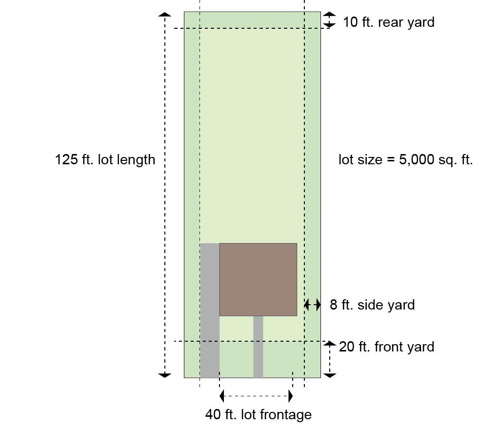
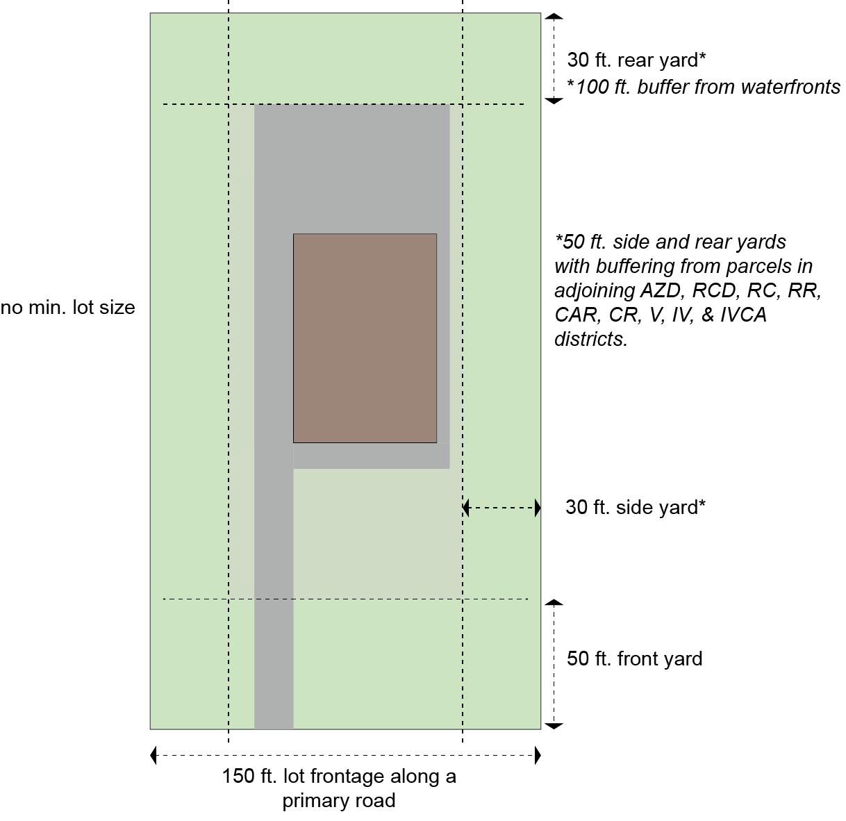
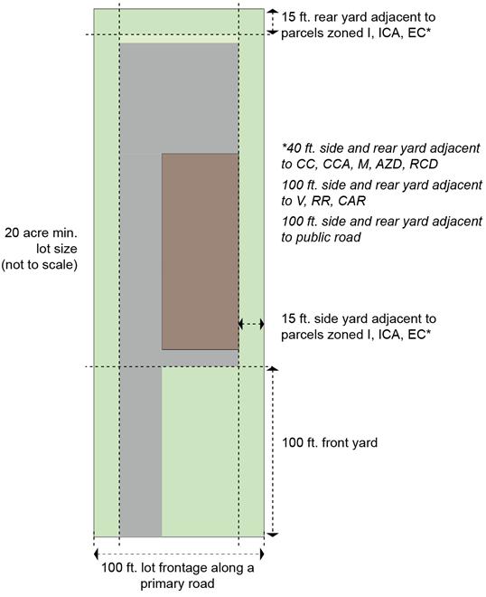
2.3 DENSITY, AREA, HEIGHT, WIDTH AND YARD REQUIREMENTS
STANDARDS FOR THE SUBDIVISION OF LOTS
Gross density (dwelling units/acre) 0.033 (1/30)1, 6
Minimum lot size
- On-site individual septic system ¾ acre
- Community sewage system ½ acres
Maximum lot size N/A
Minimum lot width 75 feet
Maximum percentage of property in lots 10%2
Maximum lots fronting on existing public road 23
STANDARDS FOR BUILDING AND STRUCTURE HEIGHT, WIDTH, AND PLACEMENT
Minimum yard
- Front (primary road) 100 feet
- Front (all other roads) 75 feet
- Side 15 feet
- Rear 30 feet
- Waterfront 100 feet
- Accessory structures on farms in the side and rear yard 25 feet
- Accessory residential structures in rear yard
Maximum structure height4
- Primary Residential or Agricultural structure
- Accessory Residential Structure (a special exception may be granted to exceed max)
- Fence height5 - Security
Agricultural
Ornamental
FOOTNOTES
feet
of existing primary residential structure
1 Accessory dwelling units do not count toward the density calculation in AZD.
2 10% RULE: Parcels 100 acres or larger do not count toward the maximum developed percentage of the property. Lot line adjustments to lots approved prior to August 19, 2003, are not subject to the 10% Rule.
3
4
Parcels created before December 3, 2002, do not count toward the two permitted road front parcels. The Planning Commission may waive this requirement, if the proposal meets the waiver requirements in this Ordinance.
Height of structures may be further restricted by the Kent County Airport Safety Requirements as defined in this Ordinance. Except in an area defined as the Kent County Airport Safety Area, the height limitations do not apply to: belfries; ornamental towers and spires; church spires; public monuments; commercial radio, personal wireless facility, and television towers less than 200 feet in height; stage towers or scenery lofts; tanks; conveyors; silos and corn dryers; elevator bulkheads; fire towers; water towers; stand pipes; and flag poles.
5 Fences do not need to meet the yard requirements.
6 Agricultural Easement Program – Nothing in this regulation shall limit the ability of a participant in the Agricultural Easement Program to convey real property impressed with an easement to his or her child provided the easement was recorded with the Kent County Clerk of Circuit Court prior to October 1, 2003.
SECTION 2. AGRICULTURAL ZONING DISTRICT (AZD)
Figure 2: Regulatory diagram of a lot in the Agricultural Zoning District.
SECTION 3
RESOURCE CONSERVATION DISTRICT (RCD)
3.1 STATEMENT OF INTENT
1. This district is intended to:
(A) Conserve, protect, and enhance the overall ecological values of the Critical Area, its biological productivity, and its diversity;
(B) Provide adequate breeding, feeding, and wintering habitats for those wildlife populations that require the Chesapeake Bay, its tributaries, or coastal habitats to sustain populations of those species;
(C) Conserve the existing developed woodlands and forests for the water quality benefits that they provide; and
(D) Conserve the land and water resource base necessary to maintain and support such uses as agriculture, forestry, fisheries’ activities, and aquaculture
2. It includes areas characterized by nature-dominated environments (that is, wetlands, forests, abandoned fields) and resource-utilization activities (that is, agriculture, forestry, fisheries’ activities, or aquaculture).
3. RCD is the Critical Area complementary district to the Agricultural Zoning District (AZD) Regulations are intended to mirror the AZD and provide for a Critical Area version of AZD.
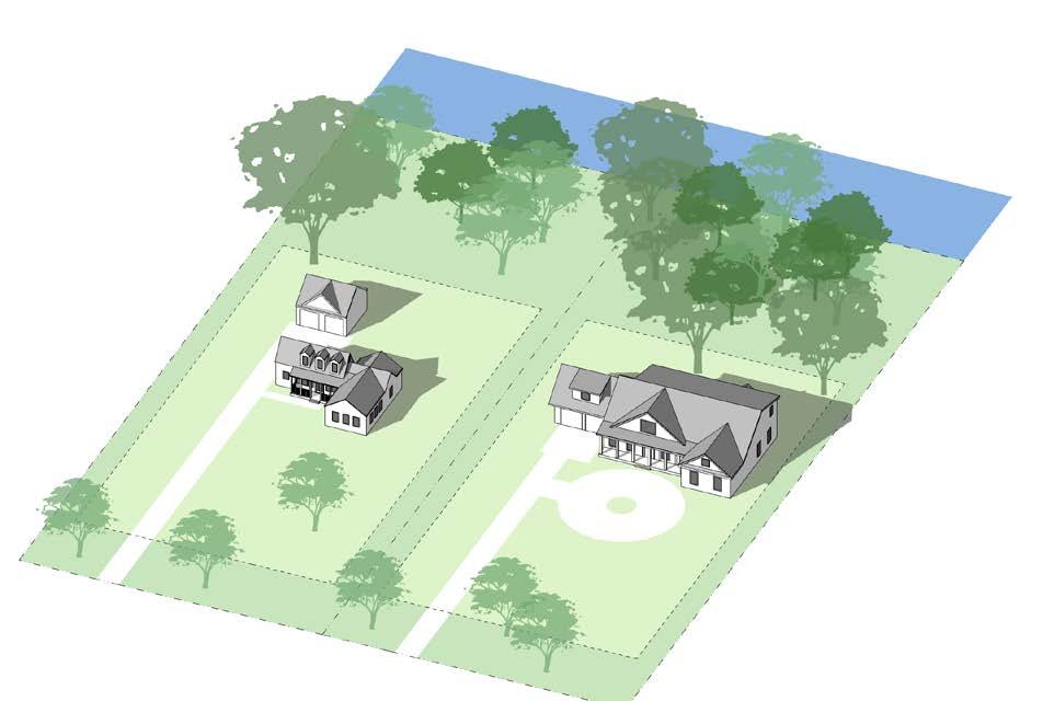
3: Diagram illustrating the desired character of the Resource Conservation District.
Figure
3.2 PERMITTED USES AND STRUCTURES
A building or land shall be used only for the following Detailed limitations and standards for these uses may be found in Article III. Administrative special exceptions are indicated by letter “A.” “B” indicates exceptions that require only Board of Appeals review. All other exceptions require Planning Commission and Board of Appeals reviews per Article IV.
Uses in the Resource Conservation District (RCD)
Article III lists requirements for permitted uses and conditions related to special exceptions Permitted by right Permitted by right on farm s only
Accessory Use on farm s only
Accessory Use on all properties
Accessory dwelling unit X
Accessory farm buildings, including barns, cribs, stables, sheds, tool rooms, shops, bins, tanks, and silos X
Accessory farm dwellings X
Accessory off-street parking and loading of non-commercial vehicles that have current licenses and are operable X
Accessory off-street parking of one commercial vehicle X
Accessory open or enclosed storage of farm materials, products, equipment, fertilizer or chemicals, or vehicles, located at least 200 feet from all property lines X
Accessory roadside stand for the sale of farm products X
Accessory residential storage structures with a ground floor area of more than 2,000 square feet or a height that exceeds the height of the primary residential structure on parcels less than 5 acres A
Accessory structures in the front yard requirement of waterfront parcels A
Accessory structures in front yard of a through or corner lot A
Adaptive reuse of historic structures for uses not otherwise listed X
Agriculture X
Agritourism on farms, defined in Article VII X
Animal husbandry, aquaculture X
Animal husbandry, farms, including horses X
Animal husbandry, horses, more than four, on non-farms X
Animal husbandry, poultry houses X
Animal husbandry, special – backyard chickens X
Animal husbandry, special – small sheep or goats X
Animal husbandry, stable - private X
Animal husbandry, stable - commercial X
Uses in the Resource Conservation District (RCD)
Article III lists requirements for permitted uses and conditions related to special exceptions
Permitted by right Permitted by right on farm s only Special Exception
Accessory Use on farm s only
Accessory Use on all properties
Appurtenant signs X
Camp, day or boarding, private or commercial, but not recreational vehicle or migrant labor camps, for the purpose of conserving and enjoying the natural resources X
Campgrounds existing and in use as of August 1, 1989 X
Conference center X
Existing Conference centers, resorts, retreats, hotels, and motels existing and in use as of August 1, 1989 X
Convalescent, group, or homes for the aged if located in dwellings existing as of December 1, 1985 X
Country Inn X
Day care groups A
Day care homes X
Dog kennel, fox hunting club, pursuant to licensure requirements set forth in Chapter 64 of The Public Local Laws of Kent County, Maryland X
Existing permitted marinas X
Exposition center or fairgrounds B
Farm employee housing B
Golf courses, public or private X
Home occupations in main or accessory buildings X
Hunting blinds, pits, or preservers X
Hunting trailer, one, temporary X
Personal wireless facility towers X
Personal wireless facilities, collocated on existing towers X
Private clubs B
Private garages, swimming pools, game courts, and other customary outbuildings and structures X
Private piers, community piers, and private shared piers X
Public and private forests, wildlife reservations and similar conservation projects X
Public and private parks and playgrounds for the purpose of conserving and enjoying the natural resources. X
Public landings B
Public uses, buildings, and utilities X
Railroad right of ways X
Uses in the Resource Conservation District (RCD)
Article III lists requirements for permitted uses and conditions related to special exceptions Permitted by right
by right on farm s only
Resorts X
Retreats X
s only Accessory
Roadside stands X
Sand and gravel pits, including excavation or extraction X
Satellite dish, private, with an antenna exceeding 3 feet in diameter X
Satellite dish, private, with an antenna of 3 feet or less in diameter X
School buses, parked, limited to two X
Short-term vacation rentals (STVR) X
Single family dwellings X
Solar energy systems, small X
Solar energy systems, utility scale X
Storage of boats, campers, boat trailers, and camper trailers X
Temporary MET Tower of any height X
Tie-out pilings of private piers, community piers, and private shared piers X
Waste management structures, where not otherwise stipulated in this Ordinance X
Wedding venues on farms with Board of Appeals approval X
Wind energy systems, small X
Wind energy systems, small, accessory X
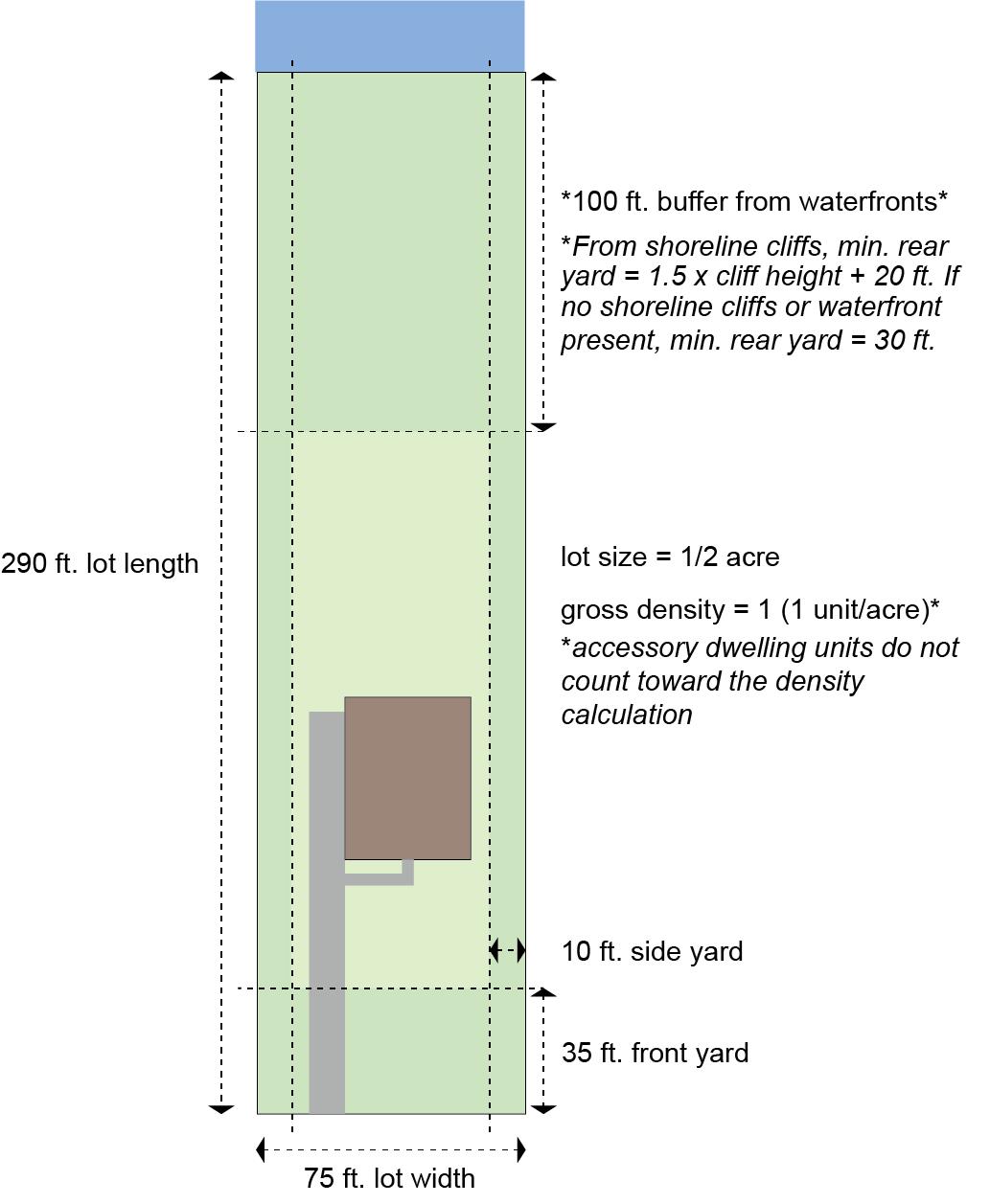
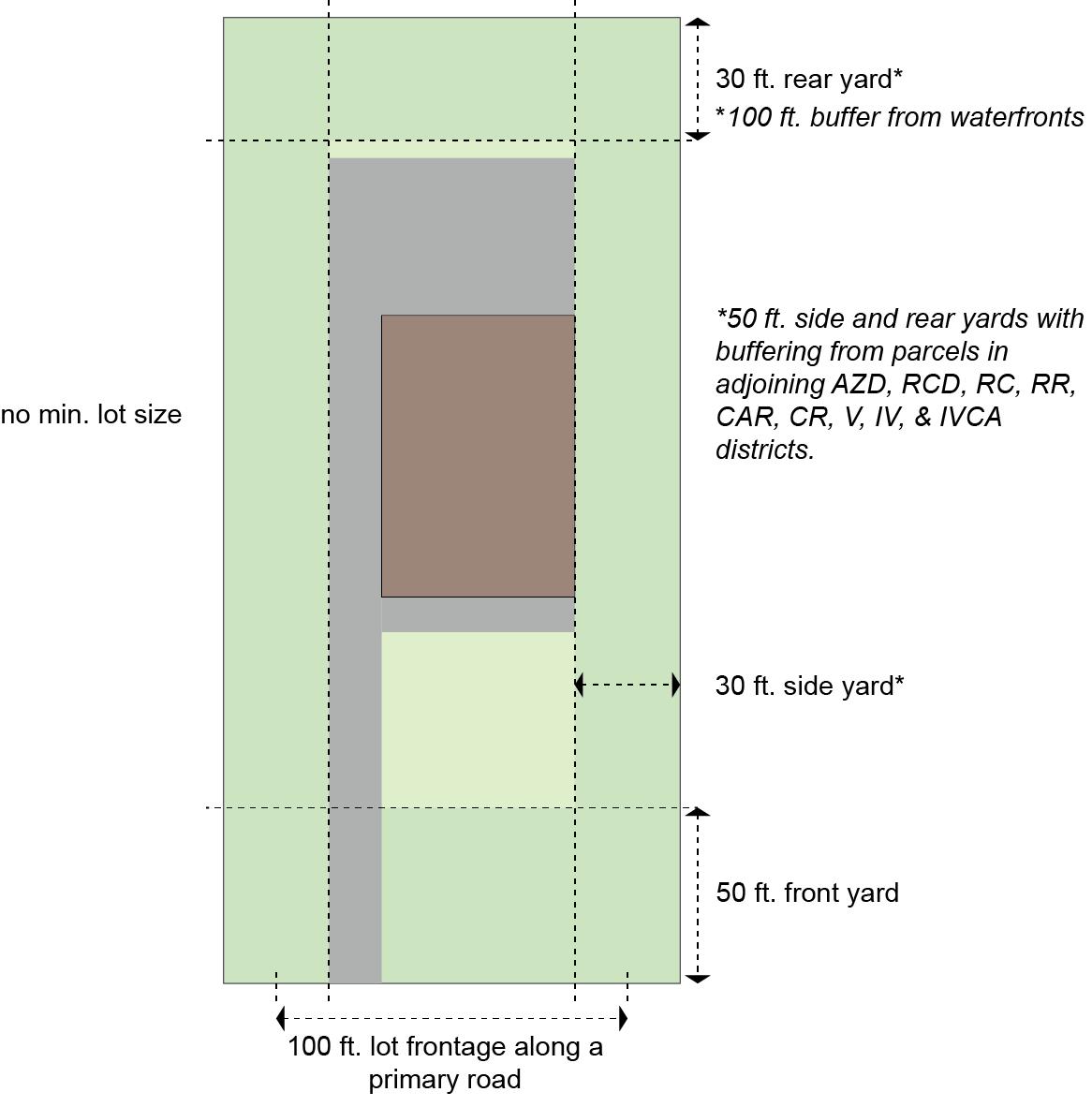
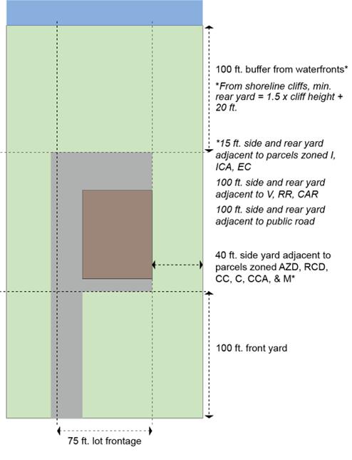
3.3 DENSITY, AREA, HEIGHT, WIDTH AND YARD REQUIREMENTS
STANDARDS FOR THE SUBDIVISION OF LOTS
Gross density (dwelling units/ac) 1 dwelling unit per 20 acres1,2
Minimum lot size
- On-site individual septic system ¾ acre
- Community sewage system ½ acre
Minimum lot width
STANDARDS FOR BUILDING AND STRUCTURE HEIGHT, WIDTH, AND PLACEMENT
Minimum yard
- Front 50 feet
- Side 15 feet
- Rear 30 feet
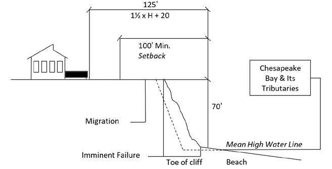
- Shoreline cliff 1.5 x cliff height + 20 feet
- Waterfront Minimum 100-foot buffer
- Accessory structures on farms in the side and rear yard 25 feet
- Accessory residential structures in rear yard
Maximum structure height3
- Primary Residential or Agricultural structure
- Accessory Residential Structure (a special exception may be granted to exceed max) Height of existing primary residential structure
- Fence height4 -
1 Parcels of more than one acre improved by more than one dwelling unit, existing as of December 1, 1985, and not abandoned for more than one year, may be subdivided into parcels of land not less than one-half (½) acre each for each dwelling unit situated on the one-half (½) acre, or more, being subdivided.
2 Accessory dwelling units that comply with Article III do not count toward the density calculation.
3 Except in an area defined as the Kent County Airport Safety Area, the height limitations do not apply to: belfries; ornamental towers and spires; church spires; public monuments; commercial radio, personal wireless facility, and television towers less than 200 feet in height; stage towers or scenery lofts; tanks; conveyors; silos and corn dryers; elevator bulkheads; fire towers; water towers; standpipes; and flag poles.
4 Fences do not need to meet the yard requirements.
Figure 4: Regulatory diagram of a lot in the Resource Conservation District.
SECTION 4
RURAL CHARACTER DISTRICT (RC)
4.1 STATEMENT OF INTENT
The purpose of this district is to provide for the local market demand for rural lots, including large estate lots on 20 acres or more, in a manner that maintains rural character and in a location that minimizes conflicts with agriculture. The District may function as a transition between the incorporated towns, villages, residential developments, and the Agricultural Zoning District. To maintain their rural character, developments will follow strict design standards for protecting significant rural features, preserving scenic views, and historic structures as well as designing with topography and sensitively locating new buildings. Recreational uses such as golf courses, racquet courts, and stables are appropriate in this district. Public water and sewer may not be extended into this district except to correct a public health emergency.
Figure 5: Diagram illustrating the desired character in the Rural Character District.
SECTION 4. RURAL CHARACTER DISTRICT (RC)
4.2 PERMITTED USES AND STRUCTURES
A building or land shall be used only for the following. Detailed limitations and standards for these uses may be found in Article III. Administrative special exceptions are indicated by letter “A.” “B” indicates exceptions that require only Board of Appeals review. All other exceptions require Planning Commission and Board of Appeals reviews per Article IV.
Uses in Rural Character District (RC)
Article III lists requirements for permitted uses and conditions related to special exceptions
Permitted by right
Permitted by right on farm s only
Special Exception
Accessory Use on farms only
Accessory Use on all properties
Accessory dwelling unit X
Accessory farm buildings, including barns, cribs, stables, sheds, tool rooms, shops, bins, tanks, and silos X
Accessory farm dwellings X
Accessory off-street parking and loading of noncommercial vehicles that have current licenses and are operable X
Accessory off-street parking of one commercial vehicle X
Accessory open or enclosed storage of farm materials, products, equipment, fertilizer or chemicals, or vehicles X
Accessory residential storage structures with a ground floor area of more than 2,000 square feet or a height that exceeds the height of the primary residential structure on parcels less than 5 acres A
Accessory structures in a front yard of through or corner lot A
Adaptive reuse of historic structures for uses not otherwise listed X
Agriculture X
Animal husbandry, aquaculture X
Animal husbandry, farms, including horses X
Animal husbandry, horses, more than four, on non-farms X
Animal husbandry, raising of limited livestock and fowl X
Animal husbandry, raising of small animals, commercial, including birds, bees, fish, rabbits, or other creatures, but not including dog kennels. X
Animal husbandry, special – backyard chickens X
Animal husbandry, special – small sheep or goats X
Animal husbandry – stable private X
Animal husbandry – stable commercial X
Uses in Rural Character District (RC)
Article III lists requirements for permitted uses and conditions related to special exceptions
SECTION 4. RURAL CHARACTER DISTRICT (RC)
Permitted by right
Permitted by right on farm s only Special Exception
Airports, landing fields, helistops, or heliports X
Accessory Use on farms only Accessory Use on all properties
Appurtenant signs X
Assisted living facilities with five to eight beds A
Assisted living facilities with no more than four beds X
Camp, day or boarding, private or commercial, but not recreational vehicle or migrant labor camps, for the purpose of conserving and enjoying the natural resources X
Cemetery, including crematorium and mausoleum X
Conference center X
Cottage industries, tradesmen, and artisan shops A
Country inns X
Country stores X
Day care groups A
Day care homes X
Dog kennels, commercial B
Exposition center or fairgrounds B
Golf courses, public or private X
Greenhouses, wholesale or retail X
Guest house, one, but not including mobile homes X
Home occupations in main or accessory buildings X
Hunting blinds, pits, or preservers X
Hunting trailer, one, temporary X
Outdoor Retreat X
Parking of commercial vehicles on a farm X
Personal wireless facility towers X
Personal wireless facilities, collocated on existing towers X
Private clubs B
Private garages, swimming pools, game courts, and other customary outbuildings and structures X
Private schools X
Public and private forests, wildlife reservations and similar conservation projects X
Public and private parks and playgrounds for the purpose of conserving and enjoying the natural resources. X
Public landings B
Public uses, buildings, and utilities X
Uses in Rural Character District (RC)
Article III lists requirements for permitted uses and conditions related to special exceptions
SECTION 4. RURAL CHARACTER DISTRICT (RC)
Permitted by right
Permitted by right on farm s only Special Exception
Raising of small animals, commercial, including birds, bees, fish, rabbits or other creatures, but not including dog kennels X
Recreational facilities, privately or commercially owned X
Resorts X
Retreats X
Accessory Use on farms only
Accessory Use on all properties
Roadside stands X
Rural inns X
Satellite dish, private, with an antenna exceeding 3 feet in diameter X
Satellite dish, private, with an antenna of 3 feet or less in diameter X
School buses, parked, limited to five X
School buses, parked, limited to two X
Short-term vacation rentals (STVR) X
Single family dwellings X
Solar energy systems, small X
Storage of boats, campers, boat trailers, and camper trailers X
Temporary MET Tower of any height X Wind energy systems, small X
Wind energy systems, small, accessory X
4.3 DENSITY, AREA, HEIGHT, WIDTH AND YARD REQUIREMENTS
STANDARDS FOR THE SUBDIVISION OF LOTS
Number of lots (dwelling units/acre)
Minimum lot size
1 dwelling unit per 20 acres1
STANDARDS FOR BUILDING AND STRUCTURE HEIGHT, WIDTH, AND PLACEMENT
Minimum yard
- Front
- Side
-
- Waterfront
- Accessory structures on farms in the side and rear yard
- Accessory residential structures in rear yard
Maximum structure height2
feet
- Primary Residential or Agricultural structure 38 feet
Accessory Residential Structure (a special exception may be granted to exceed max)
- Fence3 -
of existing primary residential structure
1 Accessory dwelling units are not counted toward permitted density.
2 Height of structures may be further restricted by the Kent County Airport Safety Requirements as defined in SECION 33.4 ZONING DISTRICT SPECIFIC DESIGN
STANDARDS of this Ordinance. Except in an area defined as the Kent County Airport Safety Area, the height limitations do not apply to: belfries; ornamental towers and spires; church spires; public monuments; commercial radio, personal wireless facility, and television towers less than 200 feet in height; stage towers or scenery lofts; tanks; conveyors; silos and corn dryers; elevator bulkheads; fire towers; water towers; stand pipes; and flag poles.
3 Fences do not need to meet the yard requirements.
Figure 6: Regulatory diagram of a lot in the Rural Character District.
SECTION 5 CRITICAL AREA RESIDENTIAL (CAR)
5.1 STATEMENT OF INTENT
This district is intended to allow low density residential development in areas where the impact on the natural environment is minimal. The purpose of this district is to maintain, or if possible to improve, the quality of runoff and groundwater entering the Chesapeake Bay and its tributaries and to maintain existing areas of natural habitats while allowing limited residential development that conforms to environmental standards and that reflects the scale and character of existing development. These areas must have one of the following characteristics:
(A) Housing density ranges from one dwelling unit per five acres, up to four dwelling units per acre.
(B) Areas not dominated by agriculture, wetlands, forest, barren land, surface water or space; or
(C) Areas having public sewer or water, or both.
(D) Areas meeting the conditions of an Intense Development Area but less than 20 acres in size.
The Critical Area Residential district is complementary to the Community Residential district (CR). Regulations are intended to mirror the CR and to provide for a Critical Area version of the CR.
Figure 7: Diagram illustrating the desired character in the Critical Area Residential District.
5.2 PERMITTED USES AND STRUCTURES
A building or land shall be used only for the following. Detailed limitations and standards for these uses may be found in Article III. Administrative special exceptions are indicated by letter “A.” “B” indicates exceptions that require only Board of Appeals review. All other exceptions require Planning Commission and Board of Appeals reviews per Article IV.
Uses in Critical Area Residential (CAR)
Article III lists requirements for permitted uses and conditions related to special exceptions
Accessory dwelling unit X
Accessory off-street parking and loading of non-commercial vehicles that have current licenses and are operable X
Accessory off-street parking of one commercial vehicle X
Accessory residential storage structures with a ground floor area of more than 2,000 square feet or a height that exceeds the height of the primary residential structure on parcels less than 5 acres A
Accessory structures in the front yard requirement of waterfront parcels A
Accessory structures in a front yards of a through or corner lot A Agriculture X
Animal husbandry, aquaculture X
Animal husbandry, farms, including horses X
Animal husbandry, horses, more than four, on non-farms X
Animal husbandry, raising of small animals, commercial, including birds, bees, fish, rabbits, or other creatures, but not including dog kennels. X
Animal husbandry, special – backyard chickens X
Animal husbandry, special – small sheep or goats X
Animal husbandry, stable - private X
Animal husbandry, stable - commercial X
Airports, landing fields, helistops, or heliports X
Appurtenant signs X
Assisted living facilities with nine to sixteen beds X
Assisted living facilities with five to eight beds A
Assisted living facilities with no more than four beds X
Camp, day or boarding, private or commercial, but not recreational vehicle or migrant labor camps, for the purpose of conserving and enjoying the natural resources X
Cemetery, including crematorium and mausoleum X
Conference center X
Uses in Critical Area Residential (CAR)
Article III lists requirements for permitted uses and conditions related to special exceptions
Cottage industries, tradesmen, and artisan shops A
Country inns X
Day care groups A
Day care homes X
Dog kennels, commercial B
Golf courses, public or private X
Greenhouses, wholesale or retail X
Home occupations in main or accessory buildings X
Private clubs B
Private garages, swimming pools, game courts, and other customary outbuildings and structures X
Private piers, community piers, and private shared piers X
Private schools X
Public and private forests, wildlife reservations and similar conservation projects X
Public and private parks and playgrounds for the purpose of conserving and enjoying the natural resources. X
Public landings B
Public uses, buildings, and utilities X
Recreational facilities, privately or commercially owned X
Resorts X
Retreats X
Roadside stands X
Sand and gravel pits, including excavation or extraction X
Satellite dish, private, with an antenna exceeding 3 feet in diameter X
Satellite dish, private, with an antenna of 3 feet or less in diameter X
School buses, parked, limited to two X
Short-term vacation rentals (STVR) X
Single family dwellings X
Solar energy systems, small X
Storage of boats, campers, boat trailers, and camper trailers X
Temporary MET Tower of any height X
Tie-out pilings of private piers, community piers, and private shared piers X
Wind energy systems, small X
5.3 DENSITY, AREA, HEIGHT, WIDTH AND YARD
STANDARDS FOR THE SUBDIVISION OF LOTS
REQUIREMENTS
Gross density (dwelling units/acre) 1 dwelling unit per acre1
Minimum lot size
Minimum
STANDARDS FOR BUILDING AND STRUCTURE HEIGHT, WIDTH, AND PLACEMENT
Minimum yard
- Front
- Side
- Rear 30 feet
- Waterfront Minimum 100-foot buffer or modified buffer2
- Shoreline cliff 1.5 x cliff height + 20 feet
- Accessory structures on farms in the side and rear yard 25 feet
- Accessory residential structures in rear yard Side 5 feet Rear 5 feet
Maximum structure height3
- Primary Residential or Agricultural structure 38 feet
Accessory Residential Structure (a special exception may be granted to exceed max) Height of existing primary residential structure
- Fence4
-
1 Accessory dwelling units are not included in density calculations.
2 Modifications for structures existing prior to April 12, 1988, may be permitted as per Article VI.
3 Except in an area defined as the Kent County Airport Safety Area, the height limitations do not apply to: belfries; ornamental towers and spires; church spires; public monuments; commercial radio, personal wireless facility, and television towers less than 200 feet in height; stage towers or scenery lofts; tanks; conveyors; silos and corn dryers; elevator bulkheads; fire towers; water towers; standpipes; and flag poles.
4 Fences do not need to meet yard requirements.
Figure 8: Regulatory diagram of a lot in the Critical Area Residential District.
SECTION 6 COMMUNITY RESIDENTIAL (CR)
6.1 STATEMENT OF INTENT
The purpose of this district is to provide for single family residential development in areas of existing residential development, together with facilities and accessory uses normally compatible with residential surroundings, and at the same time to permit agricultural uses and to preserve open spaces and rural character. This district is located in areas near existing rural development, neighborhood developed areas, villages and incorporated towns. This district combines the former Community Residential (CR) district with the Rural Residential (RR) district, while retaining the higher density of CR at 1 unit per acre, as opposed to the lower density of RR at 1 unit per three acres. The permitted uses of both have been combined with all the uses being preserved.
Figure 9: Diagram illustrating the desired character of the Community Residential District.
6.2 PERMITTED USES AND STRUCTURES
A building or land shall be used only for the following. Detailed limitations and standards for these uses are found in Article III. Administrative special exceptions are indicated by letter “A.” “B” indicates exceptions that require only Board of Appeals review. All other exceptions require Planning Commission and Board of Appeals reviews per Article IV.
Uses in Community Residential (CR)
Article III lists requirements for permitted uses and conditions related to special exceptions.
by
Accessory dwelling unit X
Accessory farm buildings, including barns, cribs, stables, sheds, tool rooms, shops, bins, tanks, and silos X
Accessory farm dwellings X
Accessory off-street parking and loading of non-commercial vehicles that have current licenses and are operable X
Accessory off-street parking of one commercial vehicle X
Accessory open or enclosed storage of farm materials, products, equipment, fertilizer or chemicals, or vehicles X
Accessory residential storage structures with a ground floor area of more than 2,000 square feet or a height that exceeds the height of the primary residential structure on parcels less than 5 acres A
Accessory structures in a front yard of a through or corner lot A
Adaptive reuse of historic structures for uses not otherwise listed X Agriculture X
Animal husbandry, aquaculture X
Animal husbandry, farms, including horses X
Animal husbandry, horses, more than four, on non-farms X
Animal husbandry, raising of limited livestock and fowl X
Animal husbandry, raising of small animals, commercial, including birds, bees, fish, rabbits, or other creatures, but not including dog kennels. X
Animal husbandry, special – backyard chickens X
Animal husbandry, special – small sheep or goats X
Animal husbandry, stable private X
Animal husbandry, stable commercial X
Airports, landing fields, helistops, or heliports X
Appurtenant signs X
Assisted living facility with nine to sixteen beds X
Uses in Community Residential (CR)
Article III lists requirements for permitted uses and conditions related to special exceptions
Assisted living facilities with five to eight beds A
Assisted living facilities with no more than four beds X
Camp, day or boarding, private or commercial, but not recreational vehicle or migrant labor camps, for the purpose of conserving and enjoying the natural resources X
Cemetery, including crematorium and mausoleum X
Conference center X
Cottage industries, tradesmen, and artisan shops A
Country inns X
Country stores X
Day care groups A
Day care homes X
Dog kennels, commercial B
Golf courses, public or private X
Greenhouses, wholesale or retail X
Guest house, one, but not including mobile homes X
Home occupations in main or accessory buildings X
Houses of worship X
Hunting trailer, one, temporary X
Keeping of backyard chickens X
Outdoor Retreats B
Parking of commercial vehicles on a farm X
Private clubs B
Private garages, swimming pools, game courts, and other customary outbuildings and structures X
Private schools X
Public and private forests, wildlife reservations and similar conservation projects X
Public and private parks and playgrounds for the purpose of conserving and enjoying the natural resources. X
Public landings B
Public utilities and structures X
Recreational facilities, privately or commercially owned X
Resorts X
Retreats X
Uses in Community Residential (CR)
Article III lists requirements for permitted uses and conditions related to special exceptions
Permitted by right Special Exception
Accessory Use on farm s only
Accessory Use on all properties
Roadside stands X
Rural inns X
Satellite dish, private, with an antenna exceeding 3 feet in diameter X
Satellite dish, private, with an antenna of 3 feet or less in diameter X
School buses, parked, limited to five X
School buses, parked, limited to two X
Short-term vacation rentals (STVR) X
Single family dwellings X
Solar energy systems, small X
Storage of boats, campers, boat trailers, and camper trailers X
Temporary MET Tower of any height X
Wind energy systems, small X
Wind energy systems, small, accessory X
6.3 DENSITY, AREA, HEIGHT, WIDTH AND YARD
STANDARDS FOR THE SUBDIVISION OF LOTS
REQUIREMENTS
Gross density (dwelling units/acre) 1 dwelling unit per acre1
Minimum lot size
STANDARDS FOR BUILDING AND STRUCTURE HEIGHT, WIDTH, AND PLACEMENT
Minimum yard
- Front
-
-
- Waterfront
- Accessory structures on farms in the side and rear yard
- Accessory residential structures in rear yard
Maximum structure height2
- Primary Residential or Agricultural structure 38 feet
Accessory Residential Structure (a special exception may be granted to exceed max) Height of existing primary residential structure
- Fence3 - Security
1 Accessory dwelling units are not included in density calculations. 2 Height of structures may be further restricted by of the Kent County Airport Safety Requirements as defined in this Ordinance. Except in an area defined as the Kent County Airport Safety Area, the height limitations do not apply to: belfries; ornamental towers and spires; church spires; public monuments; commercial radio, personal wireless facility, and television towers less than 200 feet in height; stage towers or scenery lofts; tanks; conveyors; silos and corn dryers; elevator bulkheads; fire towers; water towers; stand pipes; and flag poles.
3 Fences do not need to meet yard requirements.
Figure 10: Regulatory diagram of a lot in the Community Residential District.
SECTION 7 VILLAGE DISTRICT (V)
7.1 STATEMENT OF INTENT
1. The purpose of this district is to provide for high quality residential, neighborhood business, and office development. In those areas served by public water and sewer, this zone will be characterized by a wide variety of housing types, densities, and uses. In those areas without public utilities, this zone will be largely single family and some business uses with the possibility of multi-family residential.
2. This district is created to:
(A) Encourage planned neighborhoods of residential development in existing towns and communities with access to major thoroughfares.
(B) Permit a variety of housing types including accessory dwelling units
(C) Provide incentives for residential development by allowing variations in lot size, density, frontage, and yard requirements.
(D) Encourage compact development and promote economic development.
(E) Promote village-scale mixing of uses and the development of non-residential uses that complement and enhance the character, vitality, attractiveness, and walkability of the community as a place to live and work including expanding existing businesses
(F) Encourage designs that allow for infill and create development that is compatible with the character of existing buildings.
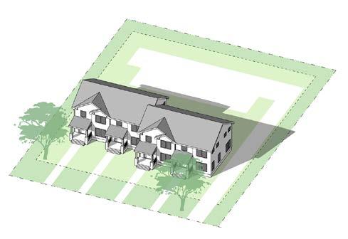
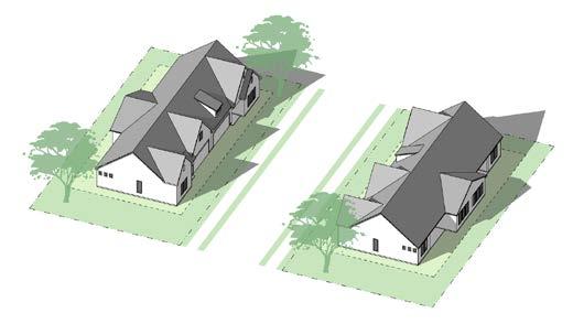
Figure 11: Diagram illustrating the desired character of single-family housing developments in the Village District.
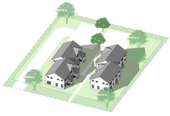
Figure 12: Diagram illustrating the desired character of multi-family housing developments in the Village District.
7.2 PERMITTED USES AND STRUCTURES
A building or structure shall be used only for the following Detailed limitations and standards for these uses are found in Article III. Administrative special exceptions are indicated by letter “A.” “B” indicates exceptions that require only Board of Appeals review. All other exceptions require Planning Commission and Board of Appeals reviews per Article IV.
Uses in Village District (V)
Article III lists requirements for permitted uses and conditions related to special exceptions.
Accessory dwelling unit X
Accessory off-street parking of one commercial vehicle X
Accessory structures in the front yards of through or corner lots A
Accessory vehicle parking X
Adaptive reuse of historic structures for uses not otherwise listed X Agriculture X
Animal husbandry, special – backyard chickens X
Animal husbandry special – small sheep or goats X
Appurtenant signs X
Assisted living facilities with no more than four beds X
Automobile service stations, but not including repair X
Boat sales, boat and outboard motor repairs and boat storage X
Cemetery, including crematorium and mausoleum X
Convalescent, nursing, or group homes for the aged - five or more beds X
Curio shops, craft shops, antique stores, and similar uses X
Data processing centers X
Day care groups A
Day care homes X
Existing commercial or industrial uses and structures in the Village District X
Financial institutions X
Fire and rescue stations X
Funeral homes X
Home and business services such as grounds care, janitorial, exterminators, landscaping, and other repair and maintenance services, but not septic tank maintenance and excavation, subject to site plan review X
Home occupations in main or accessory buildings X
Hospitals, Rehabilitation Facilities, or Other Similar Institutions X
Houses of worship X
Indoor movie theaters, playhouses, and dinner theaters X
Uses in Village District (V)
Article III lists requirements for permitted uses and conditions related to special exceptions.
SECTION 7. VILLAGE DISTRICT (V)
Permitted by right Special Exception Accessory Use on all properties
Marine supply store including indoor outboard motor sale X
Mobile home parks X
Multi-family dwellings X
Neighborhood retail businesses X
Offices X
Outdoor recreation, miniature golf, but not golf courses X
Personal service establishments X
Personal wireless facilities, collocated on existing towers X
Printing and publishing X
Private clubs B
Private garages, swimming pools, game courts, and other customary outbuildings and structures X
Private schools X
Public uses, buildings, and utilities X
Recreational uses indoor, commercial X
Restaurants without drive through facilities X
Retreats X
Rooming, boarding, and lodging houses X
Rural inns X
Satellite dish, private, with an antenna exceeding 3 feet in diameter X
Satellite dish, private, with an antenna of 3 feet or less in diameter X
School bus parking lot X
School buses, parked, limited to two X
Self-storage X
Septic tank maintenance and excavation, subject to site plan review X
Short-term vacation rentals (STVR) X
Single family dwellings X
Solar energy systems, small X
Storage of boats, campers, boat trailers, and camper trailers X
Temporary MET Tower of any height X
Town houses X
Two-family dwellings X
Uses and structures which are customarily accessory and clearly incidental and subordinate to the permitted use X
Wind energy systems, small X
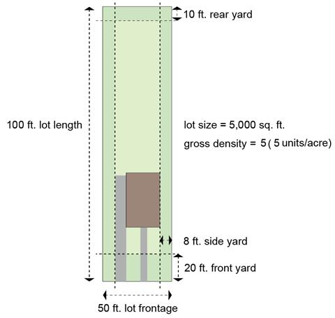
7.3 DENSITY, AREA, HEIGHT, WIDTH, AND YARD REQUIREMENTS FOR ALL NEW CONSTRUCTION AND ADDITIONS EXCEPT FOR TWO-FAMILY, TOWNHOUSE, AND MULTI-FAMILY USES
STANDARDS FOR THE SUBDIVISION OF LOTS– SINGLE-FAMILY, COMMERCIAL, MIXED-USE Gross
STANDARDS FOR BUILDING AND STRUCTURE HEIGHT, WIDTH, AND PLACEMENT
Minimum yard
- Front
- Side 8 feet
- Rear 10 feet
- Accessory residential structures in rear yard
Maximum structure height1
- Commercial
- Primary Residential
- Accessory Residential Structure (a special exception may be granted to exceed max)
- Fence2
FOOTNOTES
1 Height of structures may be further restricted by of the Kent County Airport Safety Requirements as defined in this Ordinance. Except in an area defined as the Kent County Airport Safety Area, the height limitations do not apply to: belfries; ornamental towers and spires; church spires; public monuments; commercial radio, personal wireless facility, and television towers less than 200 feet in height; stage towers or scenery lofts; tanks; conveyors; silos and corn dryers; elevator bulkheads; fire towers; water towers; stand pipes; and flag poles.
2 Fences do not need to meet yard requirements.
Figure 13: Regulatory diagram of a lot with single-family housing in the Village District.
SECTION 7. VILLAGE DISTRICT (V)
7.4 DENSITY, AREA, HEIGHT, WIDTH, AND YARD REQUIREMENTS FOR ALL NEW CONSTRUCTION AND FOR ANY ADDITIONS TO TWO-FAMILY, TOWNHOUSE, AND MULTI-FAMILY USES
STANDARDS FOR THE SUBDIVISION OF LOTS – TWO-FAMILY, TOWNHOUSE, MULTI-FAMILY
STANDARDS FOR BUILDING AND STRUCTURE HEIGHT, WIDTH, AND PLACEMENT
Minimum yard
- Front 20 feet
- Side 12 feet; none in between connected units
- Rear 20 feet
- Accessory residential structures in rear yard
Maximum Primary structure height1
- Two-Family
- Townhouse
-
- Accessory Residential Structure (a special exception may be granted to exceed max)
- Fence2
of existing primary
structure
Parking Location
1 Height of structures may be further restricted by of the Kent County Airport Safety Requirements as defined in this Ordinance. Except in an area defined as the Kent County Airport Safety Area, the height limitations do not apply to: belfries; ornamental towers and spires; church spires; public monuments; commercial radio, personal wireless facility, and television towers less than 200 feet in height; stage towers or scenery lofts; tanks; conveyors; silos and corn dryers; elevator bulkheads; fire towers; water towers; stand pipes; and flag poles.
2 Fences do not need to meet yard requirements.
14: Regulatory diagram of a lot with multi-family housing in the Village District.
Figure
SECTION 8 INTENSE VILLAGE DISTRICT (IV)
8.1 STATEMENT OF INTENT
The purpose of this district is to provide for a high-quality and well-designed mix of commercial, office, and residential areas with an emphasis on uses and intensities that make efficient use of public facilities and limit sprawling development. It is intended that residences, shops, and offices are in close proximity to each other, as is found in the traditional village pattern, and that the resulting mix of uses form lively, prosperous neighborhoods that serve as an attractive place to live, work, shop, and play. The district may act as a transition between town and the more rural areas of the County. Buildings in this district shall be oriented to the street and provision made for pedestrian access so that the character of the area is interpreted as pedestrian.
This district is intended to be used sparingly and in areas where high-density residential projects as well as more intense concentrations of commercial uses are desired. A new sub-section has been added to allow up to 12 units per acre for two-family dwellings, townhouses, and multifamily dwelling uses. New designations are appropriate in growth areas or near boundaries of municipalities as well as near the boundaries of existing developments in unincorporated areas.
Figure 15: Diagram illustrating the desired character of two-family housing development in the Intense Village District.
Figure 16: Diagram illustrating the desired character of multi-family housing developments in the Intense Village District.
8.2 PERMITTED USES AND STRUCTURES
A building or land shall be used only for the following Detailed limitations and standards for these uses are found in Article III. Administrative special exceptions are indicated by letter “A.” “B” indicates exceptions that require only Board of Appeals review. All other exceptions require Planning Commission and Board of Appeals reviews per Article IV.
Uses in Intense Village District (IV)
Article III lists requirements for permitted uses and conditions related to special exceptions.
Accessory dwelling unit X
Accessory employee housing X
Accessory off-street parking of one commercial vehicle X
Accessory structures in the front yards of through or corner lots A
Accessory vehicle parking X
Adaptive reuse of historic structures for uses not otherwise listed X
Animal husbandry, special – backyard chickens X
Appurtenant signs X
Assisted living facilities with no more than four beds X
Automobile repair X
Automobile service stations X
Car wash X
Cemetery, including crematorium and mausoleum X
Conference center X
Convalescent, nursing, or group homes for the aged with 5 or more beds X
Cottage industries, tradesmen and artisan shops A
Country inns X
Day care groups A
Day care homes X
Financial institutions X
Fire and rescue stations X
Funeral homes X
Home and business services such as grounds care, janitorial, exterminators, landscaping, and other repair and maintenance services, but not septic tank maintenance and excavation, subject to site plan review X
Home occupations in main or accessory buildings X
Hospitals, rehabilitation facilities, and similar institutions for human care X
Hotels and motels X
Houses of worship X
Uses in Intense Village District (IV)
Article III lists requirements for permitted uses and conditions related to special exceptions.
Permitted by right Special Exception Accessory Use on all properties
Indoor movie theaters, playhouses, and dinner theaters X
Laundromat X
Multi-family dwellings X
Neighborhood retail businesses X
Offices X
Outdoor entertainment X
Outdoor recreation, miniature golf, but not golf courses X
Personal service establishments X
Personal wireless facilities, collocated on existing towers X
Printing and publishing X
Private clubs B
Private garages, swimming pools, game courts, and other customary outbuildings and structures X
Private schools X
Public uses, buildings, and utilities X
Pubs, taverns, and bars, including open air facilities X
Recreational uses, indoor, commercial X
Resorts X
Restaurants without drive through facilities X
Rooming, boarding, and lodging houses X
Satellite dish, private, with an antenna of 3 feet or less in diameter X
Satellite dish, private, with an antenna exceeding 3 feet in diameter X
School bus parking lot X
School buses, parked, limited to two X
Self storage X
Septic tank maintenance and excavation X
Short-term vacation rentals (STVR) X
Single family dwellings X
Solar energy systems, small X
Storage of boats, campers, boat trailers, and camper trailers X
Temporary MET Tower of any height X
Town houses X
Two-family dwellings X
Uses and structures which are customarily accessory and clearly incidental and subordinate to the permitted use X
Wind energy systems, small X
8.3 DENSITY , AREA, HEIGHT, WIDTH, AND YARD REQUIREMENTS FOR ALL NEW CONSTRUCTION AND ANY ADDITIONS EXCEPT FOR TWO-FAMILY, TOWNHOUSE, AND MULTI-FAMILY USES
STANDARDS FOR THE SUBDIVISION OF LOTS – SINGLE-FAMILY, COMMERCIAL, MIXED-USE
Gross density (dwelling units/acre) 8 dwelling units per acre
Minimum lot size 5,000 square feet
Minimum lot frontage 40 feet – or set during formal site plan review
STANDARDS FOR BUILDING AND STRUCTURE HEIGHT, WIDTH, AND PLACEMENT
Minimum yard
- Front 20 feet – or set during formal site plan review
- Side 8 feet – or set during formal site plan review
- Rear 10 feet – or set during formal site plan review
- Accessory residential structures in rear yard
Maximum structure height1
- Commercial
-
- Accessory Residential Structure (a special exception may be granted to exceed max)
- Fence2
1 Height of structures may be further restricted by of the Kent County Airport Safety Requirements as defined in this Ordinance. Except in an area defined as the Kent County Airport Safety Area, the height limitations do not apply to: belfries; ornamental towers and spires; church spires; public monuments; commercial radio, personal wireless facility, and television towers less than 200 feet in height; stage towers or scenery lofts; tanks; conveyors; silos and corn dryers; elevator bulkheads; fire towers; water towers; stand pipes; and flag poles.
2 Fences do not need to meet yard requirements.
Figure 17: Regulatory diagram of a single-family housing lot in the Intense Village District.
8.4 DENSITY, AREA, HEIGHT, WIDTH, AND YARD REQUIREMENTS FOR ALL NEW CONSTRUCTION AND ADDITIONS TO TWOFAMILY, TOWNHOUSE, AND MULTI-FAMILY USES
STANDARDS FOR THE SUBDIVISION OF LOTS – TWO-FAMILY, TOWNHOUSE, MULTI-FAMILY
Minimum lot frontage 30 feet – or set during formal site plan review
STANDARDS FOR BUILDING AND STRUCTURE HEIGHT, WIDTH, AND PLACEMENT
Minimum yard
- Front 20 feet – or set during formal site plan review
- Side 6 feet – or set during formal site plan review
- Rear 20 feet – or set during formal site plan review
- Accessory residential structures in rear yard
Maximum structure height1
- Two-Family
- Townhouse
- Multi-Family
- Accessory Structure (a special exception may be granted to exceed max) Height of existing primary residential structure
- Fence2 - Security
Ornamental
Parking Location Rear yard only
1 Height of structures may be further restricted by of the Kent County Airport Safety Requirements as defined in this Ordinance. Except in an area defined as the Kent County Airport Safety Area, the height limitations do not apply to: belfries; ornamental towers and spires; church spires; public monuments; commercial radio, personal wireless facility, and television towers less than 200 feet in height; stage towers or scenery lofts; tanks; conveyors; silos and corn dryers; elevator bulkheads; fire towers; water towers; stand pipes; and flag poles.
2 Fences do not need to meet yard requirements.
18: Regulatory diagram of a multi-family housing lot in the Intense Village District.
Figure
SECTION 9 COMMERCIAL DISTRICT
9.1 STATEMENT OF INTENT
The purpose of this district is to provide appropriate locations for a broad range of commercial activities such as retail, wholesale, and contracting activities, which are primarily oriented to highway locations and which may include services and destination retail. Consequently, the district is located along major arterial highways or at the intersections of State and/or County highways. It is further intended that this District shall be for the purpose of limiting sprawl by providing sites with adequate frontage and depth to permit controlled access to public streets. Because these uses are subject to public view, which is of concern to the whole community, they should provide an appropriate appearance, controlled traffic movement, ample landscaping, and protect adjacent properties from the traffic and visual impacts associated with the commercial activity. Whenever possible, frontage of the district shall not exceed depth.
This district combines the former Commercial district and Crossroads Commercial (CC). The permitted uses have been combined. Uses allowed only within the US 301 Corridor are specified.
Figure 19: Diagram illustrating the desired character of the Commercial District.
9.2 PERMITTED USES AND STRUCTURES
A building or land shall be used only for the following, subject to site plan review for proposed new uses by the Planning Commission or where applicable the Planning Director. Detailed limitations and standards for these uses may be found in Article III Administrative special exceptions are indicated by letter “A.” “B” indicates exceptions that require only Board of Appeals review. All other exceptions require Planning Commission and Board of Appeals reviews per Article IV.
Uses in Commercial District
Article III lists requirements for permitted uses and conditions related to special exceptions
by
Accessory employee housing X
Accessory truck parking X
Accessory uses and structures normally associated with permitted uses and not otherwise listed
Appurtenant signs
Automobile sales, service, and rental
Automobile service stations
Boat building and boat repair
Building materials sales
Car wash provided the wastewater is recycled
Circus or carnival, midways and amusement parks, maze fields and other temporary recreational uses, for a specified period
Class D Alcohol Retail Business, as defined by the State of Maryland X Cottage industries, tradesmen, and artisan shops A Country inns X
Data processing centers
Distribution centers and warehousing
Financial institutions X
Financial institutions in the Route 301 Corridor with drive-in facilities X Fire and rescue stations X
Home and business services such as grounds care, cleaning, exterminators, landscaping, and other repair and maintenance services X
Hotels and motels
Machinery and equipment sales, service, and rental
Manufacture, processing, fabrication, and assembly of products
Manufacture, processing and assembling of food products X
Uses in Commercial District
Article III lists requirements for permitted uses and conditions related to special exceptions
Permitted by right Special Exception Accessory Use on all properties
Microbrewery, as defined by the State of Maryland X
Mini storage facilities X
Modular building sales X
Offices – administrative, business, sales, and professional X
Personal wireless facility towers X
Personal wireless facilities, collocated on existing towers X
Public uses, buildings, and utilities X
Radio and television tower, commercial X
Recreational facilities, privately or commercially owned X
Restaurants without drive through facilities X
Retail businesses with less than 60,000 square feet of gross floor area X
Retail businesses with more than 60,000 square feet of gross floor area X
Retail businesses located in the Route 301 Corridor X
Retail businesses in the Route 301 Corridor with drive-in facilities X
Retail nurseries and greenhouses X
Roadside stands X
Self-storage centers X
School bus parking lot X
School buses, parked, limited to two X
Shopping Centers X
Single family dwellings A
Storage of office supplies or merchandise re to a permitted use X
Solar energy systems, small X
Solar energy systems, utility scale X
Temporary MET Tower of any height X
Truck parking lot X
Truck stops X
Truck terminals X
Veterinary hospitals and offices X
Wind energy systems, small X
Wind energy systems, small, accessory X
SECTION 9. COMMERCIAL DISTRICT
9.3 DENSITY, AREA, HEIGHT, WIDTH, AND YARD REQUIREMENTS
STANDARDS FOR THE SUBDIVISION OF LOTS
Minimum lot size NA
Minimum frontage
- Public road 100 feet
STANDARDS FOR BUILDING AND STRUCTURE HEIGHT, WIDTH, AND PLACEMENT
Minimum yard
- Front
- Side and Rear yard
50 feet
50 feet with buffering from adjoining AZD, RCD, RC, RR, CAR, V, IV
30 feet from C, CCA, M, EC, ECCA, which may be reduced to 0 if emergency and maintenance vehicle access are acceptably addressed and if the adjoining property is a compatible use
- Waterfront 100 feet
Height1
- Industrial structures
45 feet
- Industrial structures in 301 Corridor 60 feet
- Commercial structure
- Residential structure
- Fence2
feet
feet
1 Except in an area defined as the Kent County Airport Safety Area, the height limitations do not apply to: belfries; ornamental towers and spires; church spires; public monuments; commercial radio, personal wireless facility, and television towers less than 200 feet in height; stage towers or scenery lofts; tanks; conveyors; silos and corn dryers; elevator bulkheads; fire towers; water towers; stand pipes; and flag poles.
2 Fences do not need to meet yard requirements.
SECTION 9. COMMERCIAL DISTRICT
Figure 20: Regulatory diagram of a lot in the Commercial District.
SECTION 10 COMMERCIAL CRITICAL AREA (CCA)
10.1 STATEMENT OF INTENT
The purpose of this district is to accommodate commercial and service activities that are not normally located in central business concentrations. These uses are primarily oriented to highway locations and include services and destination retail. Consequently, the district is located along major arterial highways. It is further intended that this District shall be for the purpose of limiting sprawling development by providing sites with adequate frontage and depth to permit controlled access to public streets. Because these uses are subject to public view, which is of concern to the whole community, they should provide an appropriate appearance, controlled traffic movement, ample landscaping, and protect adjacent properties from the traffic and visual impacts associated with the commercial activity. Whenever possible, frontage of the district shall not exceed depth. The Commercial Critical Area (CCA) district is complementary to the Commercial (C) district. Regulations are intended to mirror the C district and provide a Critical Area version of C district.
Figure 21: Diagram illustrating the desired character of the Commercial Critical Area District.
10.2 PERMITTED USES AND STRUCTURES
A building or land shall be used only for the following, subject to site plan review by the Planning Commission, or where applicable the Planning Director. Detailed limitations and standards for these uses are found in Article III. Administrative special exceptions are indicated by letter “A.” All other exceptions require Planning Commission and Board of Appeals reviews per Article IV.
Uses in Commercial Critical Area (CCA)
Article III lists requirements for permitted uses and conditions related to special exceptions.
Permitted by right Special Exception
Accessory Use on all properties
Accessory employee housing X
Accessory truck parking X
Accessory uses and structures normally associated with permitted uses X Agriculture X
Appurtenant signs X
Automobile sales, service, and rental X
Boat building and boat repair X
Building materials sales X
Circus or carnival, midways and amusement parks, maze fields and other temporary recreational uses, for a specified period X
Cottage industries, tradesmen and artisan shops A
Financial institutions X
Financial institutions in the Route 301 Corridor with drive-in facilities X
Hotels and motels X
Machinery and equipment sales, service, and rental X
Mini storage facilities X
Offices – administrative, business, sales, and professional X
Personal wireless facility towers X
Personal wireless facilities, collocated on existing towers X
Public uses, buildings, and utilities X
Recreational facilities, privately or commercially owned X
Restaurants without drive through facilities X
Retail businesses located in the Route 301 Corridor X
Retail businesses in the Route 301 Corridor with drive-in facilities X
Single family dwellings A
Solar energy systems, small X
Solar energy systems, utility scale X
Temporary MET Tower of any height X
Truck stops X
Wind energy systems, small X
Wind energy systems, small, accessory X
10.3 DENSITY, AREA, HEIGHT, WIDTH, AND YARD REQUIREMENTS
STANDARDS FOR THE SUBDIVISION OF LOTS
Minimum lot size NA
Minimum frontage
- Public road 100 feet
STANDARDS FOR BUILDING AND STRUCTURE HEIGHT, WIDTH, AND PLACEMENT
Minimum yard
- Front 50 feet
- Side and Rear yard 50 feet with buffering from adjoining AZD, RCD,RC, CAR, CR, V, IV 30 feet from C, CCA, M, EC, ECCA, which may be reduced to 0 if emergencyand maintenance vehicle access are acceptably addressed and if the adjoining property is a compatible use
- Waterfront Minimum 100-foot buffer or modified buffer1 Height2
- Commercial structure
-
- Fence3
-
1 Modifications for structures existing prior to April 12, 1988, may be permitted per regulations set forth in Article VI.
2 Except in an area defined as the Kent County Airport Safety Area, the height limitations do not apply to: belfries; ornamental towers and spires; church spires; public monuments; commercial radio, personal wireless facility, and television towers less than 200 feet in height; stage towers or scenery lofts; tanks; conveyors; silos and corn dryers; elevator bulkheads; fire towers; water towers; standpipes; and flag poles.
3 Fences do not need to meet yard requirements.
Figure 22: Regulatory diagram of a lot in the Commercial Critical Area District.
SECTION 11. MARINE DISTRICT (M)
SECTION 11 MARINE DISTRICT (M)
11.1 STATEMENT OF INTENT
The purpose of this district is to provide land for full-service marinas, including out-of-water boat storage, repair, and other services normally associated with marinas. Marine industrial uses, including boat building, are permitted in appropriate locations subject to applicable sanitation and pollution laws and ordinances. Retrofitting of stormwater management is encouraged and standards are provided to improve the quality of runoff that enters the Chesapeake Bay and its tributaries. It is important to note that not all existing marinas would need to be zoned Marine.
The Marine District is intended to: 1) improve the quality of runoff from developed areas that enters the Chesapeake Bay or its tributary streams; 2) accommodate additional mixed-use development provided that water quality is not impaired; 3) minimize the expansion of intensely developed areas into portions of the Critical Area designated as habitat protection areas and resource conservation areas; 4) conserve and enhance fish, wildlife, and plant habitats to the extent possible within intensely developed areas; and, 5) encourage the use of retrofitting measures to address existing stormwater management problems.
Figure 23: Diagram illustrating the desired character of the Marine District.
ARTICLE II. DISTRICTS
SECTION 11. MARINE DISTRICT (M)
11.2 PERMITTED USES AND STRUCTURES
A building or land shall be used only for the following, subject to site plan review by the Planning Commission or where applicable the Planning Director. Detailed limitations and standards for these uses are found in Article III Administrative special exceptions are indicated by letter “A.” “B” indicates exceptions that require only Board of Appeals review. All other exceptions require Planning Commission and Board of Appeals reviews per Article IV
Uses in Marine District (M)
Article III lists requirements for permitted uses and conditions related to special exceptions.
Permitted by right
Special Exception
Accessory Use on all properties
Accessory employee housing X
Adaptive reuse of historic structures for uses not otherwise listed A
Airports, landing fields, helistops, or heliports X
Appurtenant signs X
Bath houses, pump out structures, and other accessory structures normally associated with permitted uses X
Boat building and boat repair, located at least 100 feet from any residential district X
Boat docks, piers and wharves X
Boat rental, sales, supplies, instruction, and other services customarily associated with a full-service marina X
Boat sales, boat and outboard motor repairs and boat storage X
Boat storage, out of water X
Country inns X
Dormitories for employees B
Dredge spoil sites X
Erosion and flood control structures X
Existing conference centers, resorts, retreats, hotels, and motels X
Fuel storage and sale for marine purposes only X
Marinas X
Multi-level boat storage X
Off-street parking and loading, including the parking of commercial vehicles related to the operation of an on-site business X
Private clubs B
Private destination/residence clubs X
Public landings X
Public utility lines and accessory structures X
Pubs, taverns, and bars, including open air facilities X
Restaurants without drive through facilities X
Uses in Marine District (M)
Article III lists requirements for permitted uses and conditions related to special exceptions.
ARTICLE II. DISTRICTS
SECTION 11. MARINE DISTRICT (M)
Permitted by right Special Exception Accessory Use on all properties
Satellite dish with an antenna exceeding 3 feet in diameter X
Satellite dish, private, with an antenna of 3 feet or less in diameter X
Seafood processing X
Solar energy systems, small X
Stores or shops for the conduct of retail sales X
Temporary MET Tower of any height X
Wind energy systems, small, accessory X
11.3 DENSITY, HEIGHT, WIDTH, BULK AND FENCE REQUIREMENTS
STANDARDS FOR THE SUBDIVISION OF LOTS
Minimum
STANDARDS FOR BUILDING AND
-
SECTION 11. MARINE DISTRICT (M)
Figure 24: Regulatory diagram of a lot in the Marine District.
SECTION 12 EMPLOYMENT CENTER DISTRICT (EC)
12.1 STATEMENT OF INTENT
Employment Center districts are intended to include a mix of light industrial, office, and other employment uses as well as commercial planned developments that are environmentally sound, sustainable, and compatible with adjacent uses. They are further defined as areas devoted to industrial, office, and employment uses which present an attractive appearance, provide for flexibility, and complement surrounding land use character by means of appropriate design of buildings, service areas, and landscape treatments.
It is intended that Employment Center districts be located in areas having one or more major highways, and/or access to rail, and complementary to surrounding development. Light industrial uses may include those uses which manufacture, process, store, package, or distribute goods and materials, and are, in general, dependent on raw materials that are refined elsewhere.
Employment Center districts in the Route 301 Corridor permit buildings with larger footprints and increased buildings heights, in order to provide for the desired economic development in the Route 301 growth area, as envisioned by the Kent County Comprehensive Plan.
Figure 25: Diagram illustrating the desired character of the Employment Center District.
12.2 PERMITTED USES AND STRUCTURES
For every commercial and industrial structure and use erected, reconstructed, altered, or enlarged after the effective date of this Ordinance, a site plan shall be filed. No building permit shall be issued until said site plan is approved by the Planning Commission or where applicable the Planning Director. Detailed limitations and standards for uses may be found in Article III. Special exceptions require Planning Commission and Board of Appeals reviews per Article IV.
Uses in Employment Center District (EC)
Article III lists requirements for permitted uses and conditions related to special exceptions.
Permitted by right Special Exception
Accessory Use on all properties
Accessory employee housing X Agriculture X
Airports, landing fields, helistops, or heliports X
Animal shelters X
Blacksmith, welding and machine shops X
Boat building and boat repair X
Boat storage, out-of-water X
Data processing centers X
Day care groups X
Distribution centers and warehousing X
Excavation, landscaping, or other contractor’s yard X
Manufacture of concrete and ceramics products, commercial sawmills, sewage treatment plants, recycling facilities, and lumberyards X
Manufacture, processing, and distribution of hot mix asphalt X
Manufacture, processing, fabrication, and assembly of products X
Offices X X
Personal wireless facilities, collocated on existing towers X
Personal wireless facility towers X
Production of biofuels (formerly in the Industrial zoning district only) X
Public uses, buildings, and utilities X
Public utility buildings, structures, water treatment plants, and transmission lines X
Radio and television tower, commercial X
Restaurants without drive through facilities X
Restaurants with drive through facilities in the Route 301 Corridor X
Retail businesses with less than 60,000 square feet of gross floor area X
Retail businesses with more than 60,000 square feet of gross floor area X
Retail businesses in the Route 301 Corridor X
Uses in Employment Center District (EC)
Article III lists requirements for permitted uses and conditions related to special exceptions
Permitted by right Special Exception Accessory Use on all properties
Retail businesses in the Route 301 Corridor with drive-in facilities X
Retail sales of products produced on-site X
Self-storage centers X
Single family dwelling, one per existing property X
Solar energy systems, small X
Solar energy systems, utility scale X
Storage and office trailers, temporary during construction X
Temporary MET Tower of any height X
Truck terminal X
Uses and structures which are customarily accessory and clearly incidental and subordinate to the permitted use X
Vocational and trade schools X
Wind energy systems, small X
Wind energy systems, small, accessory X
12.3 DENSITY, HEIGHT, WIDTH, BULK, AND FENCE REQUIREMENTS
STANDARDS FOR THE SUBDIVISION OF LOTS
Gross density (dwelling units/ acre) 1 dwelling unit per 20 acres1
Maximum residential lot
Minimum
STANDARDS FOR BUILDING AND STRUCTURE HEIGHT, WIDTH, AND PLACEMENT
Minimum yard
- Front
- Existing Primary road
feet
- Other roads As approved during subdivision review
- Side and Rear
- Adjacent to ECCA 15 feet
- Adjacent to C, CCA, M, AZD, RCD 40 feet
- Adjacent to V, CR, CAR 100 feet
- Adjacent to public road 100 feet2
Height
- Industrial structure
- Industrial structure in 301 Corridor
- Residential structure
- Towers, silos, etc.
- Fence4 -
feet
- Other industrial buildings
- Route 301 Corridor
- Other locations
1 Intrafamily transfers only
sq. ft.
2 May be reduced or increased during site plan review
3 Except in the Airport Safety Zone
4 Fences do not need to meet the yard requirements.
Figure 26 Regulatory graphic of a lot in the Employment Center District.
SECTION 13 EMPLOYMENT CENTER CRITICAL AREA (ECCA)
13.1 STATEMENT OF INTENT
This district is intended to provide for a range of light industrial, office, and other employment uses which are environmentally sound, sustainable, and compatible with adjacent uses. Furthermore, the district is primarily limited to light manufacturing and support businesses. Light industries include those which manufacture, process, store, package or distribute goods and materials and are, in general, dependent on raw materials refined elsewhere. The ECCA District is intended to: 1) improve the quality of runoff from developed areas that enters the Chesapeake Bay or its tributary streams; 2) accommodate additional mixed-use development provided that water quality is not impaired; 3) minimize the expansion of intensely developed areas into portions of the Critical Area designated as habitat protection areas and resource conservation areas; 4) conserve and enhance fish, wildlife, and plant habitats to the extent possible within intensely developed areas; and 5) encourage the use of retrofitting measures to address existing stormwater management problems.
The ECCA zoning district is intended to be complementary to the Employment Center (EC) zoning district. Regulations are intended to mirror the EC and provide for a Critical Area version of EC.
Figure 27 Diagram illustrating the desired character of the ECCA District.
13.2 PERMITTED PRINCIPAL USES AND STRUCTURES
For every industrial structure and use erected, reconstructed, altered, or enlarged after the effective date of this Ordinance, a site plan shall be filed. No building permit shall be issued until said site plan is approved by the Planning Commission, or where applicable the Planning Director. Detailed limitations and standards for these uses may be found in Article III. Special exceptions require Planning Commission and Board of Appeals reviews per Article IV.
Uses in Employment Center Critical Area (ECCA)
Article III lists requirements for permitted uses and conditions related to special exceptions.
Permitted by right Special Exception
Accessory Use on all properties
Accessory employee housing X
Agriculture X
Airports, landing fields, helistops, or heliports X
Blacksmith, welding and machine shops X
Boat building and boat repair X
Boat storage, out of water X
Excavation, landscaping and other contractors’ yard X
Day care groups X
Distribution centers and warehousing X
Manufacture of concrete and ceramics products, commercial sawmills, sewage treatment plants, recycling facilities, and lumberyards X
Manufacture, processing, fabrication, and assembly of products X
Offices X
Personal wireless facilities, collocated on existing towers X
Public utility buildings, structures, water treatment plants, and transmission lines X
Restaurants without drive through facilities X
Retail sales of products produced on-site X
Single family dwelling, one per existing property X
Solar energy systems, small X
Storage and office trailers, temporary during construction X
Temporary MET Tower of any height X
Transmission towers X
Uses and structures which are customarily accessory and clearly incidental and subordinate to the permitted use X
Vocational and trade schools X
Wind energy systems, small X
Wind energy systems, small, accessory X
13.3
DENSITY,
HEIGHT, WIDTH, BULK, AND FENCE
STANDARDS FOR THE SUBDIVISION OF LOTS
REQUIREMENTS
Gross density (dwelling units/ acre) 1 dwelling unit per 20 acres1 Maximum residential lot
- Other roads
- Adjacent to EC
- Adjacent to AZD, RCD, C, CCA, M
- Adjacent to CAR, CR, V, IV
feet4
feet4
- Adjacent to public road 100 feet3
- Waterfront Minimum 100 ft. buffer or modified buffer5
- Shoreline cliff 1.5 x cliff height + 20 ft. STANDARDS FOR BUILDING AND STRUCTURE
1 Intrafamily transfers only.
2 May be reduced or increased during site plan review.
3 As approved during subdivision review.
4 When a side or rear lot line coincides with a side or rear lot line of a property located in a non-employment center zone, the required yard shall be landscaped and screened and shall be unoccupied by buildings, structures, or parking area.
5 Buffers in designated areas may be modified according to the standards in Article VI.
6 Additional height restrictions may apply to properties in Airport Safety Zones.
07/25/2025
Figure 28: Regulatory diagram of a lot in the ECCA District
SECTION 14 MIXED-USE DEVELOPMENT (MXD)
14.1 STATEMENT OF INTENT
1. The Mixed-Use Development District promotes the principles of Smart Growth and numerous policies of the Kent County Comprehensive Plan for growth areas, including the US Route 301 Corridor, by combining the uses permitted in the Commercial District, Employment Center District, and Intense Village District.
2. The purpose of this district is to facilitate a range of commercial, residential, and mixeduse development as envisioned by the Kent County Comprehensive Plan for growth areas, including the US Route 301 Corridor.
3. This district is intended to accommodate a high-quality and well-designed mix of uses which are environmentally sound, sustainable, and developed at intensities that limit sprawling development and make efficient use of land and public facilities.
14.2 DISTRICT MASTER PLAN AND MIXED-USE DEVELOPMENT STANDARDS
1. Any development within the district of any phase, development tract, or individual lot shall be planned to generally conform to a District Master Plan for the Mixed-Use Development District and shall be approved by the Planning Commission. This District Master Plan shall be prepared as conceptual diagrams encompassing the entire MixedUse District that illustrate the planning intent and generalized locations for the following: land uses and potential alternate land uses; connectivity to be provided by major thoroughfares, primary roads, and collector streets, including potential alternate locations for such streets, pedestrian and bicycle circulation network, and trails; and open space including parks, active recreational facilities, and natural features to be preserved.
2. To ensure flexibility by allowing for development within the district to respond to the changing market conditions, the District Master Plan is intended to evolve over time with potential updates or revisions as each phase or tract is developed. Updates or revisions to the Mixed-Use District Master Plan shall be approved by the Planning Commission.
3. The key elements to be illustrated in the District Master Plan include the following:
(A) Land Use Concept Plan showing generalized land use designations, including potential alternate land use designations, for all lands encompassing the entire district, which may evolve over time with updates and revisions.
(B) Connectivity Plan showing the street network, including potential alternate networks, of major thoroughfares, primary streets, and collector streets (whether public or private), pedestrian and bicycle circulation network, and a primary trail network, encompassing the entire district as well as connectivity to areas outside the district, which may evolve over time with updates and revisions.
(C) Open Space Plan showing generalized locations for lands to be designated as parks, open spaces, and natural features encompassing the entire district,
which may evolve over time with potential updates or revisions. This includes parks, plazas, squares, greens, and linear greenway linkages (whether public or private with public access); active recreation facilities such as playgrounds, sport courts, indoor recreation uses, and playing fields; and natural features such as wooded areas, waterways, and wetlands, and which may include buffers, critical areas, conservation easements, forest conservation areas, and other environmental features.
4. Development of any phase, tract, or individual lot shall include a Land Use Concept Plan, Connectivity Plan, Open Space Plan, and Phasing Plan for the specific development in relation to adjacent and nearby portions of the Mixed-Use Development District that generally conforms to the District Master Plan as required herein. The Land Use Concept Plan, Connectivity Plan, Open Space Plan, and Phasing Plan should be prepared as conceptual diagrams that illustrate how the development of any phase, tract, or individual lot relates to the District Master Plan and the environs surrounding the district.
5. Development of any phase, tract, or individual lot shall include a set of Mixed-Use Development Critical Area Standards compiled from applicable standards in Article IV, §§ 3.6 through 3.9. The Mixed-Use Development Critical Area Standards including any specific Design Guidelines and Standards shall be approved by the Planning Commission
6. The Mixed-Use Development District shall be required to provide a minimum of fifteen percent (15%) open space. The open space provided, platted, and recorded in the Land Records of Kent County, Maryland from multiple phases or tracts whether or not they are under single ownership, control, or agreement between owners at time of development, and whether such phases or tracts are contiguous or non-contiguous to each other, can be combined to meet the minimum fifteen percent (15%) open space requirement for the combined area of such phases or tracts with the same Mixed Use Development District.
7. In the Mixed-Use Development District, the definition of land qualifying as open space includes the following: parks, plazas, squares, greens, and linear greenway linkages (whether public or private with public access), excluding parking areas and rights-of-way for automobile use; active recreational facilities such as playgrounds, sport courts, and playing fields; and natural features such as wooded areas, waterways, and wetlands, and which may include buffers, critical areas, conservation easements, forest conservation areas, and other environmental features.
14.3 PERMITTED PRINCIPAL USES AND STRUCTURES
For every structure and use erected, reconstructed, altered, or enlarged after the effective date of this Ordinance, a site plan shall be filed. No building permit shall be issued until said site plan is approved by the Planning Commission, or where applicable the Planning Director. Detailed limitations and standards for these uses may be found in Article III. Special exceptions require Planning Commission and Board of Appeals reviews per Article IV.
Uses in Mixed-Use Development (MXD)
Article III lists requirements for permitted uses and conditions related to special exceptions.
Permitted by right Special Exception
Accessory Use on all properties
Accessory dwelling unit X
Accessory employee housing X
Accessory off-street parking of one commercial vehicle X
Accessory structures in the front yards of through or corner lots X
Accessory truck parking X
Accessory vehicle parking X
Adaptive reuse of historic structures for uses not otherwise listed X
Agriculture X
Agritourism on farms, defined in Article VII X
Airports, landing fields, helistops, or heliports X
Animal husbandry, special – backyard chickens X
Animal shelters X
Appurtenant signs X
Assisted living facilities with five to eight beds X
Assisted living facilities with no more than four beds X
Automobile repair X
Automobile sales, service, and rental X
Automobile service stations X
Blacksmith, welding and machine shops X
Boat building and boat repair X
Boat sales, boat and outboard motor repairs and boat storage X
Building materials sales X
Car wash X
Cemetery, including crematorium and mausoleum X
Circus or carnival, midways and amusement parks, maze fields and other
temporary recreational uses, for a specified period X
Class D Alcohol Retail Business, as defined by the State of Maryland X
Uses in Mixed-Use Development (MXD)
Article III lists requirements for permitted uses and conditions related to special exceptions.
Permitted by right Special Exception Accessory Use on all properties
Conference center X
Convalescent, nursing, or group homes for the aged with five or more beds X
Cottage industries, tradesmen and artisan shops X
Country inns X
Data processing centers X
Day care groups X
Day care homes X
Distribution centers and warehousing X
Excavation, landscaping, and other contractor’s yard X
Financial institutions located within the Route 301 Corridor are permitted with drive-in facilities as special exceptions X
Fire and rescue stations X
Funeral homes X
Home and business services such as grounds care, cleaning, exterminators, landscaping, and other repair and maintenance services X
Home occupations in main or accessory dwellings X
Hospitals, rehabilitation facilities, and similar institutions for human care X
Hotels and Motels X
Houses of worship X
Indoor movie theaters, playhouses, and dinner theaters X
Machinery and equipment sales, service, and rental X
Manufacture of concrete and ceramics products, commercial sawmills, private sewage treatment plants, recycling facilities, and lumberyards X
Manufacture, processing, fabrication, and assembly of products including research and development companies X
Manufacture, processing, and distribution of hot mix asphalt X
Microbrewery, as defined by the State of Maryland X
Mixed-Use buildings X
Modular building sales X
Multi-family dwellings X
Offices X
Outdoor retreat X
Outdoor entertainment X
Outdoor recreation, miniature golf, but not golf courses X
Personal service establishments X
Uses in Mixed-Use Development (MXD)
Article III lists requirements for permitted uses and conditions related to special exceptions.
Permitted by right Special Exception Accessory Use on all properties
Personal wireless facilities, collocated on existing towers X
Personal wireless facility towers X
Printing and publishing X
Private clubs X
Private schools X
Production of biofuels X
Public uses, buildings, and utilities X
Pubs, taverns, and bars, including open air facilities X
Radio and television tower, commercial X
Recreation uses, indoor, privately or commercially owned X
Resorts X
Restaurants without drive through facilities X
Restaurants with drive through facilities in the Route 301 Corridor X
Retail businesses located within the Route 301 Corridor are permitted without size limits X
Retail businesses located within the Route 301 Corridor are permitted with drive-in facilities as special exceptions X
Retail nurseries and greenhouses X
Retail sales of products produced on-site X
Retreats X
Rooming, boarding, and lodging houses X
Satellite dish, private, with an antenna of 3 feet or less in diameter X
Satellite dish, private, with an antenna exceeding 3 feet in diameter X
School bus parking lot X
School buses, limited to two, parked X
Self-storage X
Single-family dwellings X
Solar energy systems, small X
Solar energy systems, utility scale X
Storage and office trailers, temporary during construction X
Storage of boats, campers, boat trailers, and camper trailers X
Structures for the buying, processing, and sale of non-animal farm products related to agriculture of no more than 10,000 square feet in floor area X
Structures for the buying, processing, or sale of non-animal farm products related to agriculture, over 10,000 square feet in floor area X
Uses in Mixed-Use Development (MXD)
Article III lists requirements for permitted uses and conditions related to special exceptions.
SECTION 14. MIXED-USE DEVELOPMENT (MXD) 07/25/2025
Permitted by right Special Exception Accessory Use on all properties
Temporary MET Tower of any height X Townhouses X
Truck stops X
Truck Terminals X
Two-family dwellings X
Uses and structures which are customarily accessory and clearly incidental and subordinate to the permitted use X
Veterinary hospitals and offices without open kennels X
Vocational and trades schools, including training facilities X
Roadside stands X
Wind energy systems, small X
Wind energy systems, small, accessory X
14.4 DENSITY, AREA, HEIGHT, WIDTH, AND YARD REQUIREMENTS FOR RESIDENTIAL USES, INCLUDING MIXED-USE BUILDINGS
STANDARDS FOR THE SUBDIVISION OF LOTS
Gross density (dwelling units/acre)
Minimum lot size1
- Single-Family dwelling
- Two-Family dwelling
12 dwelling units per acre for the entire District; Net densities for each residential use may vary by individual development phase, tract, or lot
6,000 square feet to 2,500 square feet
3,500 square feet
- Townhouse 2,000 square feet
- All other uses 4,000 square feet
Minimum lot frontage1
- Single-Family dwelling
60 feet
- Two-Family dwelling 35 feet (each dwelling)
- Townhouse 20 feet (each dwelling)
- All other uses
30 feet
STANDARDS FOR BUILDING AND STRUCTURE HEIGHT, WIDTH, AND PLACEMENT
Minimum yard
- Front 20 feet; 10 feet to front porch
- Side 10 feet; none in between attached units
- Rear 20 feet
- Accessory structures in side or rear yard
- Side 5 feet - Rear 5 feet
Maximum height2
- Single-Family dwelling 38 feet
- Two-Family dwelling 38 feet
- Town house 40 feet
- Multi-family and Mixed-use 55 feet
- All other uses 38 feet
- Fence3
- Security 8 feet
- Agricultural 5 feet - Ornamental
1 As approved during subdivision review
2 Except in the Airport Safety Zone
3 Fences do not need to meet the yard requirements.
14.5 DENSITY, AREA, HEIGHT, WIDTH, AND YARD REQUIREMENTS FOR NON-RESIDENTIAL USES
STANDARDS FOR THE SUBDIVISION OF LOTS
Minimum lot size N/A
Minimum lot frontage
Minimum lot frontage industrial uses
STANDARDS FOR BUILDING AND STRUCTURE
Minimum yard
- Front
- Side and Rear
- Front for Industrial uses
- Side and Rear for industrial uses
- Accessory structures in Side or Rear yard
- Side
feet
WIDTH, AND PLACEMENT
feet1
feet1
feet - Rear
Maximum height
- Commercial structure
- Industrial structure in Route 301 Corridor
- Towers, silos, etc. 2
- All other structures
- Fence3 - Security
feet
feet
feet
feet
feet
Maximum building footprint
- All structures
1 Or, as approved during site plan review by the Planning Commission
2 Except in the Airport Safety Zone
3 Fences do not need to meet the yard requirements.
Note: There is no illustrative regulatory diagram for the Mixed-Use Development District.
SECTION 15 MIXED-USE DEVELOPMENT CRITICAL AREA (MXDCA)
15.1 STATEMENT OF INTENT
1. The purpose of this district is to facilitate a range of commercial, residential, and mixeduse development as envisioned by the Kent County Comprehensive Plan for growth areas, including the US Route 301 Corridor, where growth areas are located in the Critical Area.
2. This district is intended to accommodate a high-quality and well-designed mix of uses which are environmentally sound, sustainable, and developed at intensities that limit sprawling development and make efficient use of land and public facilities.
3. It is further intended that this district shall be for the purpose of limiting sprawling development by providing sites with adequate frontage and depth to permit controlled access to public streets. Because these uses are subject to public view, they should provide an appropriate appearance, controlled traffic movement, ample landscaping, and protect adjacent properties from the traffic and visual impacts associated with the commercial activity. Whenever possible, frontage of the lots shall not exceed their depth.
15.2 DISTRICT MASTER PLAN AND MIXED-USE DEVELOPMENT STANDARDS
1. Any development within the district of any phase, development tract, or individual lot shall be planned to generally conform to a District Master Plan for the Mixed-Use Development District and shall be approved by the Planning Commission. This District Master Plan shall be prepared as conceptual diagrams encompassing the entire MixedUse Development District and/or Mixed-Use Development Critical Area that illustrate the planning intent and generalized locations for the following: land uses and potential alternate land uses; connectivity to be provided by major thoroughfares, primary roads, and collector streets, including potential alternate locations for such streets, pedestrian and bicycle circulation network, and trails; and open space including parks, active recreational facilities, and natural features to be preserved.
2. To ensure flexibility by allowing for development in the district to respond to the changing market conditions, the District Master Plan is intended to evolve over time with potential updates or revisions as each phase or tract is developed. Any updates or revisions to the Mixed-Use District Master Plan shall be approved by the Planning Commission.
3. Development of any phase, tract, or individual lot shall include a Land Use Concept Plan, Connectivity Plan, Open Space Plan, and Phasing Plan for the specific development in relation to adjacent and nearby portions of the Mixed-Use Development District that generally conforms to the District Master Plan as required herein. The Land Use Concept Plan, Connectivity Plan, Open Space Plan, and Phasing Plan should be prepared as conceptual diagrams that illustrate how the development of any phase, tract, or individual lot relates to the District Master Plan and the environs surrounding the district.
4. Development of any phase, tract, or individual lot shall include a set of Mixed-Use Development Critical Area Standards compiled from applicable standards in Article IV, §§
SECTION 15. MIXED-USE DEVELOPMENT CRITICAL AREA (MXDCA)
3.6 through 3.9. The Mixed-Use Development Critical Area Standards including any specific Design Guidelines and Standards shall be approved by the Planning Commission.
5. In MXDCA, provide a minimum of 40% open space on each parcel of land based on the Critical Area portion of each original parcel that was granted growth allocation by the Critical Area Commission on April 23, 2025 under the County’s comprehensive rezoning process. The reserved 40% open space may be located across the Critical Area portion of any of the three original parcels
15.3 PERMITTED PRINCIPAL USES AND STRUCTURES
For every structure and use erected, reconstructed, altered, or enlarged after the effective date of this Ordinance, a site plan shall be filed. No building permit shall be issued until said site plan is approved by the Planning Commission, or where applicable the Planning Director. Detailed limitations and standards for these uses may be found in Article III. Special exceptions require Planning Commission and Board of Appeals reviews per Article IV.
Uses in Mixed-Use Development Critical Area (MXDCA)
Article III lists requirements for permitted uses and conditions related to special exceptions. Permitted by right Special Exception Accessory Use on all properties
Accessory dwelling unit X
Accessory employee housing X
Accessory off-street parking of one commercial vehicle X
Accessory structures in the front yards of through or corner lots X
Accessory truck parking X
Accessory vehicle parking X
Adaptive reuse of historic structures for uses not otherwise listed X
Agriculture X
Agritourism on farms, defined in Article VII X
Airports, landing fields, helistops, or heliports X
Animal husbandry, special – backyard chickens X
Animal shelters X
Appurtenant signs X
Assisted living facilities with five to eight beds X
Assisted living facilities with no more than four beds X
Automobile repair X
Automobile sales, service, and rental X
Automobile service stations X
Blacksmith, welding and machine shops X
Boat building and boat repair X
Boat sales, boat and outboard motor repairs and boat storage X
Building materials sales X
Car wash X
Cemetery, including crematorium and mausoleum X
Circus or carnival, midways and amusement parks, maze fields and other temporary recreational uses, for a specified period X
Class D Alcohol Retail Business, as defined by the State of Maryland X
Uses in Mixed-Use Development Critical Area (MXDCA)
Article III lists requirements for permitted uses and conditions related to special exceptions.
Permitted by right Special Exception Accessory Use on all properties
Conference center X
Convalescent, nursing, or group homes for the aged with five or more beds X
Cottage industries, tradesmen and artisan shops X
Country inns X
Data processing centers X
Day care groups X
Day care homes X
Distribution centers and warehousing X
Excavation, landscaping, and other contractor’s yard X
Financial institutions located within the Route 301 Corridor are permitted with drive-in facilities as special exceptions X
Fire and rescue stations X
Funeral homes X
Home and business services such as grounds care, cleaning, exterminators, landscaping, and other repair and maintenance services X
Home occupations in main or accessory dwellings X
Hospitals, rehabilitation facilities, and similar institutions for human care X
Hotels and Motels X
Houses of worship X
Indoor movie theaters, playhouses, and dinner theaters X
Machinery and equipment sales, service, and rental X
Manufacture, processing, fabrication, and assembly of products including research and development companies X
Microbrewery, as defined by the State of Maryland X
Mini storage facilities X
Mixed-Use buildings X
Modular building sales X
Multi-family dwellings X
Offices X
Outdoor retreat X
Outdoor entertainment X
Outdoor recreation, miniature golf, but not golf courses. X
Personal service establishments X
Personal wireless facilities, collocated on existing towers X
Personal wireless facility towers X
Uses in Mixed-Use Development Critical Area (MXDCA)
Article III lists requirements for permitted uses and conditions related to special exceptions.
Permitted by right Special Exception Accessory Use on all properties
Printing and publishing X
Private clubs X
Private schools X
Public uses, buildings, and utilities X
Pubs, taverns, and bars, including open air facilities X
Radio and television tower, commercial X
Recreation uses, indoor, privately or commercially owned X
Resorts X
Restaurants without drive through facilities X
Restaurants with drive through facilities in the Route 301 Corridor X
Retail businesses located within the Route 301 Corridor are permitted without size limits X
Retail businesses located within the Route 301 Corridor are permitted with drive-in facilities as special exceptions X
Retail nurseries and greenhouses X
Retail sales of products produced on-site X
Retreats X
Rooming, boarding, and lodging houses X
Satellite dish, private, with an antenna of 3 feet or less in diameter X
Satellite dish, private, with an antenna exceeding 3 feet in diameter X
School bus parking lot X
School buses, limited to two, parked X
Self-storage X
Single-family dwellings X
Solar energy systems, small X
Solar energy systems, utility scale X
Storage and office trailers, temporary during construction X
Storage of boats, campers, boat trailers, and camper trailers X
Structures for the buying, processing, and sale of non-animal farm products related to agriculture of no more than 10,000 square feet in floor area X
Structures for the buying, processing, or sale of non-animal farm products related to agriculture, over 10,000 square feet in floor area X
Temporary MET Tower of any height X
Townhouses X
Truck stops X
SECTION 15. MIXED-USE DEVELOPMENT CRITICAL AREA (MXDCA)
Uses in Mixed-Use Development Critical Area (MXDCA)
Article III lists requirements for permitted uses and conditions related to special exceptions.
Permitted by right Special Exception Accessory Use on all properties
Truck Terminals X
Two-family dwellings X
Uses and structures which are customarily accessory and clearly incidental and subordinate to the permitted use X
Veterinary hospitals and offices without open kennels X
Vocational and trades schools, including training facilities X
Roadside stands X
Wind energy systems, small X
Wind energy systems, small, accessory X
15.4 DENSITY, AREA, HEIGHT, WIDTH, AND YARD REQUIREMENTS FOR RESIDENTIAL USES, INCLUDING MIXED-USE BUILDINGS
STANDARDS FOR THE SUBDIVISION OF LOTS
Gross density (dwelling units/acre)
Minimum lot size1
- Single-Family dwelling
12 dwelling units per acre for the entire District; Net densities for each residential use may vary by individual development phase, tract, or lot
6,000 square feet to 2,500 square feet
- Two-Family dwelling 3,500 square feet
- Townhouse 2,000 square feet
- All other uses 4,000 square feet
Minimum lot frontage1
- Single-Family dwelling 60 feet
- Two-Family dwelling 35 feet (each dwelling)
- Townhouse 20 feet (each dwelling)
- All other uses
30 feet
STANDARDS FOR BUILDING AND STRUCTURE HEIGHT, WIDTH, AND PLACEMENT
Minimum yard
- Front 20 feet; 10 feet to front porch
- Side 10 feet; none in between attached units
- Rear 20 feet
- Accessory structures in side or rear yard
- Side 5 feet
- Rear 5 feet
Maximum height2
- Single-Family dwelling 38 feet
- Two-Family dwelling 38 feet
- Town house 40 feet
- Multi-family and Mixed-use 55 feet
- All other uses 38 feet
- Fence3
- Security 8 feet
- Agricultural 5 feet
- Ornamental
1 As approved during subdivision review
2 Except in the Airport Safety Zone
3 Fences do not need to meet the yard requirements.
15.5 DENSITY, AREA, HEIGHT, WIDTH, AND YARD REQUIREMENTS FOR NON-RESIDENTIAL USES
STANDARDS FOR THE SUBDIVISION OF LOTS
Minimum lot size
Minimum lot frontage
Minimum lot frontage industrial uses
STANDARDS FOR BUILDING AND STRUCTURE
Minimum yard
- Front
- Side and Rear
- Front for Industrial uses
- Side and Rear for industrial uses
- Accessory structures in Side or Rear yard
- Side
- Rear
Maximum height
- Commercial structure
- Industrial structure in Route 301 Corridor
- Towers, silos, etc. 2
- All other structures
- Fence3
feet
feet
feet
WIDTH, AND PLACEMENT
-
1 Or, as approved during site plan review by the Planning Commission
2 Except in the Airport Safety Zone
3 Fences do not need to meet the yard requirements.
Note: There is no illustrative regulatory diagram for the Mixed-Use Development Critical Area District.
ARTICLE III. USES
SECTION 1. GENERAL PROVISIONS
SECTION 1 GENERAL PROVISIONS
1. For the purposes of this Ordinance, permitted uses are listed for the various zoning districts in the applicable matrices included for each zoning district in Article II.
2. Unless the contrary is clear from the context of the lists or other regulations of this Ordinance, uses not specifically listed in a zoning district matrix are prohibited. Uses listed are to be interpreted as inclusively as may be reasonable.
3. When listed uses are indicated in the applicable zoning district matrix as being permitted by right or as accessory uses permitted by right, then the conditions below are required for the use to operate.
4. When listed uses are indicated in the applicable zoning district matrix as being permitted by special exception, then the conditions below are required to be evaluated by the approving authority, which in some cases is the Board of Appeals and in other cases the Planning Director, or the Planning Director’s designee. When required, the Planning Commission makes recommendations to the Board of Appeals on special exceptions. The list for each of these categories is found in Article IV under the Special Exceptions section.
SECTION 2 LAND USES AND ACCESSORY USES AND STRUCTURES
A building or land will be used only for the following purposes, when indicated as such on each district’s table of permitted uses and structures, and subject to any listed conditions:
1. Accessory dwelling unit, one, in principal or accessory structures. Accessory dwelling units do not count against the density of the zoning district. Such use will be permitted as accessory uses in AZD, RCD, RC, CAR, CR, and V only when all of the following conditions are satisfied:
(A) The property owner resides on the premises.
(B) The accessory dwelling unit is subordinate to the principal dwelling in size and appearance.
(C) The accessory dwelling unit may not be subdivided or conveyed separately from the primary dwelling unit. The accessory dwelling unit may be rented.
(D) The appearance of the structure and property remains that of a single-family dwelling
(E) If the entrance to the accessory dwelling unit is separate from that of the primary dwelling, the entrance to the accessory dwelling unit will be from the side or rear yard
(F) One parking space is provided in the rear yard for the accessory dwelling unit
(G) The structure meets all applicable Kent County Codes, including the building code, and Health Department regulations.
Such use will be permitted as an accessory use in RCD only when all of the following additional conditions are satisfied:
(H) The accessory dwelling unit is located within the primary dwelling unit, or its entire perimeter is within 100 feet of the primary dwelling unit.
(I) The accessory dwelling unit does not exceed 900 square feet in total enclosed area.
(J) If the accessory dwelling unit is located within the primary dwelling unit, it will not increase the amount of lot coverage already attributed to the primary dwelling unit by more than 900 square feet.
2. Accessory employee housing. Such use will be permitted as an accessory use in the M, EC, ECCA, MXD, and MXDCA only when the accessory employee housing is used for persons permanently employed on the premises. Such use will be limited to two housing units.
3. Accessory farm buildings, including barns, cribs, stables, sheds, tool rooms, shops, bins, tanks, and silos, but not animals. No buildings are permitted in the buffer or stream protection corridor.
4. Accessory farm dwellings. Such uses are limited to one dwelling on all farms, except that two dwellings will be permitted on farms with at least 50 tillable acres In the RCD, the total number of dwellings will not exceed one dwelling per 20 acres. These dwellings will share a common entrance and will be occupied by permanent employees of the farm or immediate members of the family owning or operating the farm. All accessory farm dwellings will be landscaped and screened from adjacent properties. In the RCD, RC, and CR, accessory farm dwellings may not be mobile homes.
5. Accessory open or enclosed storage of farm materials, products, equipment, fertilizer or chemicals, or vehicles Such storage is in connection with the farming operation of the owner. All of the following uses will be located at least 200 feet from all property lines:
(A) Assembly of equipment, in a totally enclosed building not exceeding 10,000 square feet in size, and repair of all equipment normally used in agriculture
(B) Storage of grain, flour, and feed blending and packaging, including milling, drying, and storing.
(C) Petroleum storage. Petroleum storage will not exceed 10,000 gallons and is subject to applicable safety codes, ordinances, and statutes.
6. Accessory off-street parking and loading of non-commercial vehicles that have current licenses and are operable.
7. Accessory off-street parking of one commercial vehicle. Such use will be permitted as an accessory use only when all of the following conditions are satisfied:
(A) In the AZD, RCD, RC, CAR, and CR Districts, the vehicle is parked only in the rear yard
(B) In the V and IV Districts, the vehicle is only parked in the side or rear yard of dwellings.
(C) The vehicle is used by the occupant of the dwelling
(D) The vehicle does not exceed 16,000 pounds manufacturer’s gross vehicle weight.
(E) No major repair is conducted on-site.
(F) No engines may run when parked on-site. Electrical refrigeration units may run.
(G) Honey wagons, sanitation, garbage, or other trucks used to transport odorous, flammable, or hazardous materials are prohibited.
(H) The vehicle has a current license and is operable.
8. Accessory roadside stand for the sale of farm products.
9. Accessory residential storage structures with a floor area of more than 2,000 square feet or a height that exceeds the height of the primary residential structure on parcels less than 5 acres. When special exception approval is required in the district matrix, this may be reviewed via an administrative special exception process.
10. Accessory sheds on properties with only agricultural uses, which are less than 20 acres.
11. Accessory structures in the front yard of through or corner lots. When special exception approval is required in the district matrix, this may be reviewed via an administrative special exception process
12. Accessory structures in the front yard requirement of waterfront parcels require a special exception, except for swimming pools, swimming pool equipment, and related structures which may be permitted without special exception. When special exception approval is required in the district matrix, this may be reviewed via an administrative special exception process.
13. Accessory truck parking.
14. Accessory uses and structures normally associated with permitted uses and not otherwise listed.
15. Accessory vehicle parking Such use will be limited to those vehicles used as a part of principal permitted uses or approved special exceptions provided the vehicles have current licenses and are operable. Parking areas will be approved during site plan review.
16. Adaptive reuse of existing structures in AZD for uses not otherwise permitted, located on parcels under 20 acres.
(A) The site will have access to a public road adequate for the traffic generated;
(B) The proposed use will not generate traffic of a type or amount inappropriate for access roads and the surrounding area;
(C) The use does not require road improvements detrimental to the character of the area;
(D) The number of dwellings will not exceed the density permitted in the district in which the structure is located;
(E) The proposed use does not create an unacceptable impact by way of noise, odor, noxious materials or other nuisances; and
(F) Landscaping is in keeping with the character of the building or location
(G) Additions, enlargements, or expansions of the adaptive use are not permitted.
(H) Additional buildings may not be constructed as part of this special exception.
(I) This may be reviewed via an administrative special exception process.
17. Adaptive reuse of historic structures for uses not otherwise permitted. Such uses are subject to the following conditions:
(A) Structures will be listed in the Kent County Historic Site Survey or approved as a historically significant structure by the Planning Commission;
(B) It is shown that exterior changes to site structures will be minimized. Enlargements will be designed in keeping with the character of the building;
(C) Landscaping is in keeping with the character of the building;
(D) The site will have access to a public road adequate for traffic generated;
(E) The proposed use will not generate traffic of a type or amount inappropriate for all access roads and the surrounding area;
(F) The use does not require road improvements detrimental to the character of the area;
(G) The number of dwellings will not exceed the density permitted in the district in which the structure is located;
(H) The proposed use does not create an unacceptable impact by way of noise, odor, noxious materials or other nuisances; and
(I) In RCD, adaptive reuse projects will be limited to non-commercial and nonindustrial uses
18. Agriculture. An agriculture use may include horticultural, hydroponics, general farming, orchards, groves, or nurseries for the growing or propagation of plants, trees, and shrubs. All farming activities related to animals are regulated as animal husbandry (see categories below), which are permitted individually as separate, specific uses within zoning districts.
19. Agritourism as defined in Article VII of this Ordinance. A site plan review will be required.
20. Airports, landing fields, helistops, or heliports. Such uses will be permitted as special exceptions only when all of the following conditions are satisfied:
(A) Flight obstructions, such as towers, chimneys, other tall structures, or natural obstructions, do not fall within the approach zone to any proposed runway or landing strips of the landing field or airport; and
(B) The use complies with the recommendations of the Federal and State Aviation Authorities; and
(C) Runways are designed to minimize the approach and takeoff areas over residential areas; and
(D) Applications for special exceptions for private airstrips, heliports, and helistops will comply with the following:
i. The takeoff and landing flight path will be a minimum of 1,000 feet in any direction from any residence or public building; and
ii. The takeoff and landing path of the aircraft will have a minimum of 250 feet vertical clearance over surrounding property unless a navigation easement is reached with the affected property owners for a lesser clearance; and
iii. No business such as the sale or leasing of aircraft, maintenance, or flight instructions will be permitted; and
iv. The applicant will maintain a flight operation’s log that will be open for inspection by representatives of the Department; and
v. Approvals will be for a period not to exceed 5 years.
21. Animal husbandry, animal feeding operations (AFO). Such use will be permitted as special exception only when all of the following conditions are satisfied:
(A) All buildings, corals, and waste management structures are 600 feet from the nearest property line.
(B) No part of the operation will be in the 100-year floodplain.
(C) The operation is managed according to both a waste management plan and a nutrient management plan..
When in the opinion of the Board of Appeals, Planning Commission, or Planning Director additional review is needed by an outside agency, the application, waste management plan, and nutrient management plan may be forwarded to the other appropriate agency, such as the United States Department of Agriculture (USDA) - National Resources Conservation Service (NCRS), or the Maryland Department of the Environment (MDE), or the Maryland Department of Agriculture (MDA).
As part of the County’s own review process, the County may approve an animal feeding operation (AFO) for zoning prior to the AFO receiving all required State agency approvals with the condition that required State approvals be obtained.
Applicants may refer to AFO Size Categories chart for additional information, as published by Maryland Department of the Environment, Land and Materials Administration, Animal Feeding Operation Division (see mde.maryland.gov).
(D) Sediment and stormwater management plans are approved by the appropriate agency and are implemented.
(E) To assure continued compatibility with the surrounding area, the Board may place additional restrictions on the following:
i. Screening and landscaping from adjacent properties and public roads
ii. Exterior displays, lighting, and signs
iii. The location of access routes to the site, both on and off-site
iv. The type of waste disposal, e.g. injection, disk etc.
v. Monitoring wells and surface water testing where appropriate
vi. Manner and route of moving waste from one site to another
vii. Waste and nutrient management plans for properties receiving waste
22. Animal husbandry, aquaculture, including accessory processing and sales.
Where permitted by special exception, the following conditions will be satisfied:
(A) Open or uncovered storage of shells, bones, and refuse does not occur on site; and
(B) No curing or smoking occurs on site; and
(C) All structures for processing and all disposal areas for materials and byproducts of processing are a minimum of 600 feet from all property lines; and
(D) Seafood processing facilities and disposal areas are not in the 100-year floodplain; and
(E) The operation has received a permit from the Maryland Department of Natural Resources (DNR); and
(F) Parking, processing and disposal areas are screened from adjacent properties and public roads; and
(G) Access roads are capable of handling the type of traffic generated by the operation.
23. Animal husbandry, farm, including horses – this use includes keeping, dairying, or raising for sale animals, fish, birds, horses, or reptiles on 20 acres or more. Such use is permitted only when all of the following conditions are satisfied:
(A) Such use is only permitted on a farm of 20 acres or more.
(B) Such use will not include poultry houses or animal feeding operations (AFO)
(C) Nutrient management plans per State of Maryland nutrient management laws are required for all animal husbandry uses; however, the Planning Director may set aside the requirement for a nutrient management plan for 4-H and FFA projects.
(D) A waste management plan may be required for building permit purposes. If so, the applicant will prepare a waste management plan that demonstrates that the facility will be operated in a safe and environmentally sound manner and will not create a hazard to the surrounding area and waterways.
24. Animal husbandry, horses, more than four, on non-farms – More than four horses and mules on a single property less than 20 acres in size. Such use will be permitted as special exception only, when all of the following conditions are satisfied:
(A) There will be no more than one horse or mule per acre of land. Only available pasture acreage will be used to compute the number of horses and/or mules allowed on a parcel.
(B) No waste management facility or structure for the keeping of animals is in the 100-year floodplain.
(C) The feeding and watering of animals are conducted a minimum of 50 feet from any body of water, including tributary streams and wetlands.
(D) A waste management plan may be required for building permit purposes. If so, the applicant will prepare a waste management plan that demonstrates that the facility will be operated in a safe and environmentally sound manner and will not create a hazard to the surrounding area and waterways.
When in the opinion of the Board of Appeals, Planning Commission, or the Planning Director, that additional review is needed by an outside agency, the application and accompanying waste and nutrient management plan may be forwarded to the Maryland Department of the Environment or any other appropriate agency.
25. Animal husbandry, poultry houses on farms only. Such uses are subject to the following conditions:
(A) Poultry houses may only be located on farms that are 20 acres or more in area.
(B) Poultry houses, waste management facilities, composters, and the area for the disposal of animals will be a minimum of 600 feet from all property lines.
(C) No poultry house, waste management facility or composter will be in the 100year floodplain
(D) The operation is managed according to waste and nutrient management plans, approved by the Natural Resources Conservation Service, University of Maryland Extension Service, and the Kent County Health Department. Where the phosphorus index, developed by the University of Maryland, indicates that phosphorous is a problem or has the potential to become a problem, the plan
will use phosphorus based nutrient management. When in the opinion of the Planning Director additional review is necessary from an outside agency, the Planning Director may forward the plan to the Maryland Department of the Environment or any other appropriate agency.
Land in Kent County owned by the owner/operator of the poultry house will be able to handle the manure and waste generated. The acreage requirements identified in the approved waste and nutrient management plan will be used to determine if an operation meets this requirement.
(E) Manure storage sheds and composter appropriate to the size of the operation will be included and will be constructed prior to receiving the first flock of chickens.
26. Animal husbandry - poultry houses on parcels where the owner cannot handle the waste generated by the poultry houses in AZD provided:
(A) All buildings and waste management structures are 600 feet from the nearest property line.
(B) No part of the operation shall be in the 100-year floodplain.
(C) The operation is managed according to a waste and nutrient management plan approved by the Natural Resources Conservation Service, the University of Maryland Extension Service, and the Kent County Health Department. Where the phosphorus index, developed by the University of Maryland, indicates that phosphorus is a problem or is likely to become a problem, the plan shall use phosphorus based nutrient management. When in the opinion of the Board of Appeals, Planning Commission, or Planning Director additional review is needed by an outside agency, the application and waste and nutrient management plan may be forwarded to the Maryland Department of the Environment or any other appropriate agency.
(D) Sediment and stormwater management plans are approved by the appropriate agency and are implemented.
(E) The applicant shall prepare a management plan that demonstrates that the poultry houses will be operated in a safe and environmentally sound manner and will not create a hazard to the surrounding area and waterways.
(F) To assure continued compatibility with the surrounding area, the Board may place additional restrictions on the following:
i. Screening and landscaping from adjacent properties and public roads
ii. Exterior displays, lighting, and signs
iii. The location of access routes to the site, both on and off-site
iv. The type of waste disposal, e.g., injection, disk, etc.
v. Monitoring wells and surface water testing where appropriate
vi. Manner and route of moving waste from one site to another
vii. Waste and nutrient management plans for properties receiving waste
27. Animal husbandry, raising of limited livestock and fowl – this use does not include commercial animal feeding operations (AFO) or poultry houses. Such uses will be permitted as special exception only when all of the following conditions are satisfied:
(A) All buildings for the housing of animals are 200 feet from the property line.
(B) Waste management structures are 600 feet from the nearest property line.
(C) No part of the operation will be in the 100-year floodplain.
(D) Nutrient management plans per State of Maryland nutrient management laws are required for all animal husbandry uses; however, the Planning Director may set aside the requirement for a nutrient management plan for 4-H and FFA projects.
When in the opinion of the Board of Appeals, Planning Commission, or Planning Director additional review is needed by an outside agency, the application and waste and nutrient management plan may be forwarded to the Maryland Department of the Environment or any other appropriate agency.
(E) Sediment and stormwater management plans are approved by the appropriate agency and are implemented.
(F) The applicant will prepare a management plan that demonstrates that the facility will be operated in a safe and environmentally sound manner and will not create a hazard to the surrounding area and waterways.
(G) To assure continued compatibility with the surrounding area, the Board may place additional restrictions on any number of the following:
i. Screening and landscaping from adjacent properties and public roads
ii. Exterior displays, lighting, and signs
iii. The location of access routes to the site, both on and off-site
iv. The type of waste disposal, e.g. injection, disk, etc.
v. Monitoring wells and surface water testing where appropriate
vi. Manner and route of moving waste from one site to another
vii. Waste and nutrient management plans for properties receiving waste
28. Animal husbandry, raising of small animals, commercial, including birds, bees, fish, rabbits, or other creatures, but not including dog kennels.
29. Animal husbandry, special – backyard chickens. Such uses will be permitted as accessory uses only when all of the following conditions are satisfied:
(A) Backyard chickens are defined as females of the species Gallus gallus domesticus kept for non-commercial purposes. The keeping of males of the species is not permitted.
(B) The maximum number of chickens, 4 months or older, permitted on any lot is determined by lot size:
i. No chickens are permitted on a lot of less than ¼ acre;
ii. No more than 5 chickens are permitted on a lot of ¼ acre to 1 acre;
iii. No more than 8 chickens are permitted on lots of more than 1 acre.
(C) The area for keeping backyard chickens will be enclosed in such a fashion that the chickens are confined and not able to leave the owner’s property. Backyard chickens will be provided with a covered, predator-proof coop or cage that is well ventilated. Hens will have access to an outdoor enclosure that is adequately fenced to contain the birds on the property.
(D) Structures (coops) for the housing of backyard chickens will meet the permitting requirements of this Ordinance. For movable coops, the permit application will show the area in which the coop will be moved. A copy of the Maryland Poultry Registration Form will accompany the building permit application.
(E) Coops will be setback a minimum of 15 feet from any property line.
(F) Coops may be placed in rear yards only.
(G) Each coop will be kept clean and free of odors and materials that can attract vermin. Feed will be kept in secure containers so as not to attract vermin.
(H) Waste will be composted or removed from the property
(I) The outdoor slaughtering of chickens is not permitted
30. Animal husbandry, special – sheep or goats, kept for noncommercial purposes, will be:
(A) The maximum number of sheep or goats permitted on any lot is determined by lot size:
i. No sheep or goats are permitted on a lot of less than two acres.
ii. A maximum of three small ruminants per acre of grazable area within the lot is permitted with a maximum of eight total.
(B) Outdoor enclosures will be adequately fenced to contain the animals on the property.
(C) Structures for the housing of animals should meet the permitting requirements of the Ordinance.
(D) Shelter should be setback a minimum of 40 feet from any property line, in rear yards only, and kept clean and free from odors and materials that can attract vermin.
(E) A waste management plan may be required for building permit purposes. If so, the applicant will prepare a waste management plan that demonstrates that the facility will be operated in a safe and environmentally sound manner and will not create a hazard to the surrounding area and waterways.
When in the opinion of the Planning Director additional review is necessary from an outside agency, the Planning Director may forward the plan to the Maryland Department of the Environment or any other appropriate agency.
(F) Feed will be kept in secure containers so as not to attract vermin.
(G) Bedding and waste materials will be composted or removed from the property.
(H) The outdoor slaughtering of sheep or goats is not permitted.
(I) For sheep or goats brought into the State of Maryland, owners will be referred to the University of Maryland Extension
31. Animal husbandry, stable - commercial. Such use is subject to the following conditions:
(A) The lot is 20 acres or more; and
(B) Any structure for the keeping or feeding of animals and waste management structures will be a minimum of 400 feet from any property line; and
(C) No waste management facility or structure for the keeping of animals is in the 100-year floodplain; and
(D) The feeding and watering of animals are conducted a minimum of 100 feet from tidal water and tributary streams, both tidal and non-tidal, and 50 feet from non-tidal wetlands; and
(E) Nutrient management plans per State of Maryland nutrient management laws are required for all animal husbandry uses; however, the Planning Director may set aside the requirement for a nutrient management plan for 4-H and FFA projects.
(F) A waste management plan may be required for building permit purposes. If so, the applicant will prepare a waste management plan that demonstrates that the facility will be operated in a safe and environmentally sound manner and will not create a hazard to the surrounding area and waterways.
32. Animal husbandry, stable - private. Such use is subject to the following conditions:
(A) The lot will be two acres or more; and
(B) Any structure for the keeping of animals will be located a minimum of 100 feet from any property line; and
(C) There will be no more than one horse per acre of land. Only available pasture acreage will be used to compute the number of horses allowed on a parcel; and
(D) A waste management plan may be required for building permit purposes. If so, the applicant will prepare a waste management plan that demonstrates that the facility will be operated in a safe and environmentally sound manner and will not create a hazard to the surrounding area and waterways.
(E) When in the opinion of the Planning Director additional review is necessary from an outside agency, the Planning Director may forward the plan to the Maryland Department of the Environment or any other appropriate agency. Animal shelters. An animal shelter use is permitted only as defined by the County Code of Public Laws.
33. Appurtenant signs. Such uses will be in accordance with Article V.
34. Assisted living facility with nine to sixteen beds.
(A) The property owner or facility manager resides on the premises.
(B) The rooms for the use are not designed or constructed to be separate dwelling units and may not be sold as separate dwelling units.
(C) The appearance of the structure and property remain that of a residential use so that the average neighbor is unaware of the assisted living facility’s existence.
(D) The structure meets all applicable Kent County codes, including the building code, and Health Department requirements.
(E) The applicant has received approval from the appropriate State of Maryland agencies.
(F) The facility does not create an unacceptable environmental impact by way of noise, odor, noxious materials, or other nuisances.
(G) The facility does not generate traffic of a type or inappropriate amount for all access roads and the surrounding area. It does not require road improvements detrimental to the character of the area.
(H) The property is served by public sewer.
(I) The parcel must be at least five acres in size.
35. Assisted living facilities with five to eight beds. When special exception approval is required, this may be reviewed via an administrative special exception process Such use is permitted as a special exception only when all of the following criteria are satisfied:
(A) The property owner resides on the premises; and
(B) The assisted living facility is subordinate and accessory to the principal dwelling in size and appearance and is in the same structure as the principal dwelling
unit. Expansions will be designed in keeping with or to enhance the character of the other buildings; and
(C) The rooms for the use are not designed or constructed to be separate dwelling units and may not be sold as separate dwelling units; and
(D) The appearance of the structure and property remain that of a single family dwelling so that the average neighbor is unaware of the assisted living facility’s existence; and
(E) The structure meets all applicable Kent County Codes, including the building code, and Health Department requirements; and
(F) The applicant has received approval from the appropriate State of Maryland agencies; and
(G) The facility does not create an unacceptable environmental impact by way of noise, odor, noxious materials, or other nuisances.
36. Assisted living facilities with no more than four beds. Such use is permitted as an accessory use only when all of the following criteria are satisfied:
(A) The property owner resides on the premises
(B) The assisted living facility or group home is subordinate and accessory to the principal dwelling in size and appearance and is in the same structure as the principal dwelling unit
(C) The rooms for the use are not designed or constructed to be separate dwelling units and may not be sold as separate dwelling units.
(D) The appearance of the structure and property remain that of a single family dwelling.
(E) The structure meets all applicable Kent County Codes, including the building code and Health Department requirements.
37. Automobile repair. Such use is permitted as a special exception only when automobiles waiting for repair are stored in a building or in the rear yard and screened from adjacent properties.
38. Automobile service stations, not including auto repair An automobile service station use is subject to site plan review. Such use is permitted as a special exception only when major repairs or bodywork are not conducted onsite.
39. Automobile sales, service, and rental
40. Bath houses, pump out structures, and other accessory structures normally associated with permitted uses.
41. Blacksmith, welding and machine shops. For a blacksmith, welding and machine shop use, outdoor storage of materials is prohibited unless otherwise approved by the Planning
Commission and subject to such conditions as may be determined by the Planning Commission
42. Boat building and boat repair A boat building and boat repair use will be located at least 100 feet from any primarily residential district.
43. Boat docks, piers and wharves. Boat docks, piers and wharves will not exceed 25% of the waterway, or the edge of the channel, whichever is less
44. Boat rental, sales, supplies, instruction, and other services customarily associated with a full-service marina.
45. Boat sales, boat and outboard motor repairs and boat storage. Boat sales, boat and outboard motor repairs and boat storage uses will be permitted only when all of the following conditions are satisfied:
(A) The property will front on two public roads;
(B) All repairs are conducted inside a building;
(C) The storage area and repair access area will be screened on all sides with wood fencing a minimum of 6 feet in height;
(D) The repair shop building and the storage and repair access area will be set back at least 100 feet from adjacent properties that are zoned for residential use;
(E) The open area for display of boats will be limited to 3,000 square feet in size; and
(F) This use is subject to site plan review.
46. Boat storage, out-of-water boat storage. In the M District, this use does not include multilevel boat storage.
47. Building materials sales.
48. Camp, day or boarding, private or commercial, but not recreational vehicle or migrant labor camps, for the purpose of conserving and enjoying natural resources.
49. Campgrounds Campgrounds include only those campgrounds existing and in use as of August 1, 1989, in the Resource Conservation District. It is the intent of this section to provide for the continued existence and operation as well as the intensification or expansion of campgrounds existing and in use as of August 1, 1989, in the RCD. It is not the intent to permit the creation of new campgrounds, but rather to protect those enterprises that existed in the RCD on August 1, 1989. Any expansion or intensification of an existing campground, including the addition of sites or conversion of existing sites to allow for additional recreational vehicles, will require growth allocation.
50. Car wash. A car wash use will require that the waste water is recycled. Such use is permitted as a special exception only when the following conditions are satisfied:
(A) The car wash is designed to allow adequate traffic flow for cars to enter and exit the facility safely; and
(B) Single bay facilities with automated brushes and multiple bay self service facilities will provide a space for the parking of one car per bay to be used as a dry down area. Facilities using a conveyor or chain drag system for moving motor vehicles through the washing area will provide space at the building exit for three times the number of vehicles that can be accommodated at one time within the structure; and
(C) Vacuum facilities will comply with the setbacks for a primary structure in the applicable zoning district; and
(D) Appropriate permits are obtained from the State of Maryland.
51. Cemetery, including crematorium and mausoleum. Such use will be permitted only when all of the following conditions are satisfied:
(A) Burial plots will be 10 feet from all property lines. Buildings will comply with the yard requirements for the applicable zoning district.
(B) Mausoleums will be a minimum of 75 feet from a public road and 50 feet from the side and rear property lines.
(C) Crematoriums will be 200 feet from all property lines.
(D) In the IV District, such uses will be permitted only when accessory to a house of worship located on the same parcel.
52. Circus or carnival, midways and amusement parks, maze fields and other temporary recreational uses, for a specified period. The Planning Director may require a site plan and place conditions as may be appropriate to assure the compatibility of the temporary recreational use.
53. Class D Alcohol Retail Business, as defined by the State of Maryland.
54. Conference center. Such use will be permitted as a special exception only when the following conditions have been satisfied:
(A) In the IV District, the project will collectively consist of 15 acres but not more than 750 acres. In RCD, RR, RC, and CAR, the project will collectively consist of at least 50 acres but not more than 750 acres.
(B) The conference center will consist of 100 but not more than 225 guest rooms.
(C) At least 100 square feet of meeting space will be provided per guest room.
(D) Permanent theme parks, amusement parks, and/or stadiums are prohibited.
(E) Where applicable, the applicant has applied for growth allocation from the County. Special exception approval will not be valid without the granting of growth allocation.
(F) The Board will make specific findings on the availability of public and governmental services. Proposed improvements will be appropriate to the character of the area.
(G) Where they exist, historic structures will be incorporated into the overall project.
(H) Significant view corridors, both from the site and onto the site will be preserved in so much as possible.
(I) The height of all structures will not exceed 38 feet.
(J) The design of the conference center and accessory uses will reflect and complement the rural character of the area or neighborhood.
(K) The number of dwelling units will not exceed that which is permitted in the applicable zoning district. Dwelling units may be detached or attached.
(L) Continuous residential lot development aligned with golf course fairways will be prohibited within the Critical Area and discouraged elsewhere.
(M) Parking lots will be landscaped as required for commercial developments.
(N) Permitted accessory uses, subject to the approval of the Board of Appeals, including restaurants; recreational facilities such as tennis courts and swimming pools; spas; retail use provided the establishments are in the main building with the entrance to the retail use from the inside the building; stables but not an equestrian center; other recreation amenities but not including trap, skeet, clay birds, paint ball or other similar firearm activities; piers; and other accessory uses that are customarily associated with a conference center. The applicant will describe all proposed accessory uses in the application for a special exception. The Board of Appeals may deny or limit the size and extent of accessory uses
(O) The number of slips on the accessory pier will not exceed 20% of the number of guest rooms and the use of the slips will be limited to use by those using the conference facilities. Accessory piers will meet all requirements applicable to marinas such as pump outs, restrooms, and showers.
(P) All structures will comply with the minimum 100-foot buffer and will be 200 feet from all side and rear property lines, whichever is greater.
(Q) A golf course will meet all the requirements found in this Article III
(R) In RCD, RC, RR, and CAR, at least 60% of the property will be in open space.
(S) The Board of Appeals may place additional restrictions on the following:
i. Additional yard requirements for all structures, including patios and places of public assembly
ii. Lighting
iii. Landscaping and screening
iv. Outdoor activities, outdoor music, and their hours of operation
v. Access
(T) Application for a conference center will include a sketch plan and renderings of all primary and each type of accessory structure
55. Contractors’ yard See Excavation, landscaping, and other contractor’s yard
56. Convalescent, group, or homes for the aged if located in dwellings existing as of December 1, 1985, in RCD, provided exterior changes are minimized and extension or enlargement of principle and accessory structures may not exceed 50% of the gross floor area of each individual building. Extensions or enlargements shall be approved by the Board of Appeals.
57. Convalescent, nursing, or group homes for the aged with five or more beds.
58. Cottage industries, tradesmen and artisan shops. Such uses will be permitted as an administrative special exception only when all of the following conditions are satisfied:
(A) Except on farms, the cottage industry will be secondary to the use of the property for dwelling purposes and will be less than 60% of the living area, 2,000square feet, or in an existing accessory structure, whichever is greater. The square footage limitation includes outdoor storage areas but not required parking. Additional area may be granted via review by the Board of Appeals.
(B) On farms, the cottage industry will be secondary to the farm The cottage industry is limited to 4,000 square feet in size or an existing building, whichever is greater. The square footage limitation includes outdoor assembly and storage areas but not required parking. Additional area may be granted via review by the Board of Appeals.
(C) The use is secondary in scope to the residential or agricultural use of the property.
(D) The buildings associated with the use are not visually intrusive or inappropriate to their setting. New buildings and expansions will be designed in keeping with or to enhance the character of the other buildings.
(E) The cottage industry does not create an unacceptable environmental impact by way of noise, odor, noxious materials, or other nuisances.
(F) The cottage industry does not generate traffic of a type or amount inappropriate for all access roads and the surrounding area. It does not require significant road improvements detrimental to the character of the area.
(G) Sureties required by the Department may be set aside by the Planning Director.
(H) The following uses will not be allowed:
i. Any activity that may reasonably be expected to result in excessive noise, smoke, dust, odors, heat, or glare beyond that which is common to the zoning district. The proposed use will conform to the maximum permissible sound levels in Article III for Employment Center uses;
ii. Use or manufacture of products or operations that are dangerous in terms of risk of fire, explosion, or hazardous emissions; and,
iii. Any other use deemed incompatible with a residential or agricultural area.
59. Country inns. A country inn use is subject to site plan review. Such uses will be permitted as special exception only when all of the following conditions are satisfied:
(A) Such structures have existed prior to August 1, 1989, except on properties with more than 25 acres in the Marine District.
(B) The number of rooming units provided on the site is limited to fifteen excluding resident management quarters.
(C) Boarding and dining facilities in AZD, RCD, RC, CR, CAR, IV, C, and M may be permitted only when attendant to rooming units and further provided that such facilities are limited to a maximum seating capacity of forty persons. Such dining facilities may be provided to patrons other than boarders. No dining facility will be permitted in RCD.
(D) The site has access to a public road. This access will be capable of supporting the passage of emergency vehicles. The Board may require improvements to existing access roads.
(E) There will be sufficient acreage for the proposed use and activities.
(F) Extension or enlargement of principal and accessory structures including the addition of new structures and new buildings are permitted, and they should maintain features and character that are consistent with the structures already located on the campus of the permitted use that existed as of August 1, 1989. Extensions or enlargements shall be approved by the Board of Appeals.
(G) Adequate landscaping will be provided to screen all parking areas from adjoining residential properties. Landscaping or screening proposed will be shown on a site plan as required by this Ordinance.
60. Country stores. Country stores will be located only along primary and secondary roads. Such uses will be permitted as special exception only when all of the following conditions are satisfied:
(A) The structure existed prior to August 1, 1989.
(B) Property on which the store is located will abut upon and have safe access to a primary or secondary road as shown on the Major Thoroughfare Map.
(C) Extension or enlargement of the principal and accessory structures does not exceed 50% of the gross floor area of each building above that which existed as of August 1, 1989. Extensions or enlargements shall be approved by the Board of Appeals.
61. Curio shops, craft shops, antique stores, and similar uses. Such uses will be consistent with the character of the town area. Such uses will be limited to a gross floor area of 1,500 square feet per individual building. New construction will require site plan review.
62. Data processing centers. Such uses are subject to site plan review.
63. Detached single family dwellings – see also Single family dwellings in this section.
64. Day care groups. When special exception approval is required, this may be reviewed via an administrative special exception process Such uses will be permitted as a special exception only when all of the following conditions are satisfied:
(A) Outdoor activity areas are fenced and screened.
(B) Two drop-off/pick-up parking spaces are provided.
(C) Structured play areas for active play or play structures are not in the front yard and are 10 feet from the side or rear property line.
(D) The structure retains its residential character, if located in a residential setting.
(E) Day care groups in the RCD will be permitted only in dwellings existing prior to December 1, 1985.
65. Day care homes. Such uses will be permitted as accessory uses only when all of the following conditions have been satisfied:
(A) Outdoor play areas are fenced and screened.
(B) Structured areas for active play or play structures will not be in the front yard and will be a minimum of 10 feet from the side or rear property line.
(C) One drop off / pickup space is provided.
(D) Structural or decorative additions will be designed to be compatible with the residential character of the neighborhood, if located in a residential setting
66. Distribution centers and warehousing Distribution and warehousing uses are permitted only when any single building footprint does not exceed 75,000 square feet in size. The restriction on building footprint does not apply to the EC, MXD, or MXDCA in the Route 301 corridor. In reviewing the site plan, the Planning Commission, or where applicable the Planning Director, will consider the following:
(A) The impact of the proposed business or industry on existing or planned public facilities.
(B) The impact of the operation of the facility on the surrounding area.
(C) The health, safety, and welfare of employees and residents of the neighborhood.
(D) In so far as possible, all uses will be conducted entirely within a completely enclosed structure or be completely screened. Outdoor storage of materials and unfinished products is prohibited unless otherwise approved by the
Planning Commission and subject to such conditions as may be determined by the Planning Commission during the site plan review process Screening for requests that involve only outdoor storage may be approved by minor site plan.
67. Dog kennels, commercial. Such uses will be permitted by special exception or as an accessory use only when all of the following conditions are satisfied:
(A) Any open dog pens, runs, cages, or kennels will be at least 200 feet from any side or rear lot line.
(B) The operation is managed according to waste and nutrient management plans approved by the Natural Resources Conservation Service, the University of Maryland Cooperative Extension Service, and the Kent County Health Department.
68. Dog kennel, fox hunting club, pursuant to licensure requirements set forth in Chapter 64 of The Public Local Laws of Kent County, Maryland.
69. Dormitories for employees. Such uses will be permitted by special exception only when all of the following conditions are satisfied:
(A) The structure meets the design standards for multi-family residential development as set forth in applicable regulations in Article V of this Ordinance.
(B) The structure is screened, if possible, from adjacent roads, waterways, and properties.
(C) The applicant proves that the structure is necessary to house employees.
(D) Residents are limited to employees of the marina.
(E) Dormitories are not in the minimum 100-foot buffer.
70. Dredge spoil sites. Such uses will be permitted as special exception only when all of the following conditions are satisfied:
(A) The site does not receive dredge spoils that exceed 100,000 cubic yards per existing parcel as of the date of the adoption of this ordinance unless used in conjunction with an approved surface mine reclamation. The disposition of dredge spoils used in conjunction with a surface mine reclamation will have all permits required by the State of Maryland and the application will demonstrate that measures are provided to protect the groundwater, stabilize pH, and to generally protect the environment of the area.
(B) Material is limited to clean dredge spoil which is tested according to the regulations of the State of Maryland.
(C) Prime farmland is not used for a dredge spoil site
71. Excavation, landscaping, or other contractor’s yard Such use includes outdoor storage of the contractor’s equipment and equipment parts; temporary stockpiling of soils, sand, gravel, stone, recyclable brick, concrete, blacktop materials, pipes, iron, tires, and tanks
Such use will only be permitted when all of the following conditions are satisfied:
(A) The contractor’s yard permit area will be larger than two (2) acres and smaller than twenty (20) acres.
(B) The contractor’s yard will not be visible year-round from an adjacent parcel of land or public road. The contractor may use natural topography and vegetation or may construct berms or plant vegetation to satisfy this requirement.
(C) Storage of tires and equipment will be limited to contractor’s own excavation yard use.
(D) Temporary storage of pipe, iron, and tanks, which are not part of the contractor’s equipment, will not exceed two years.
72. Existing commercial or industrial uses and structures in the Village District. It is the intent of this Section to provide for the continued existence and operation as well as the reasonable expansion of commercial and industrial uses which exist in the Village District, provided that such uses or structures do not constitute a nuisance or a source of significant environmental pollution. It is not the intent hereof to allow the creation of new commercial or industrial uses which are not permitted under this Section, but rather to protect those enterprises which existed in the Village District as of August 1, 1989. An expansion will require site plan review.
73. Existing permitted marinas in the Resource Conservation District – It is the intent of this section to provide for the continued existence and operation as well as the reasonable expansion of marinas in the RCD zoned areas of the County, provided that such uses do not constitute a nuisance or a source of significant environmental pollution. It is not the intent to allow the creation of new marinas, but rather to protect those enterprises which existed in the RCD on April 12, 1988. An expansion will require site plan review by the Planning Commission or where applicable the Planning Director. After development there will be a net improvement in water quality at or leaving the site. All marinas in the RCD will comply with all regulations in Article II, Section 11 and Article VI, Section 2
74. Existing conference centers, resorts, retreats, hotels, and motels, existing and in use as of August 1, 1989. It is the intent of this section to provide for the continued existence and operation as well as the expansion of conference centers, resorts, retreats, hotels, and motels existing and in use as of August 1, 1989. It is not the intent to permit the creation of new conference centers, resorts, retreats, hotels, or motels, but rather to protect those enterprises that existed in the Resource Conservation District on August 1, 1989. An expansion will require site plan review by the Planning Commission and will require a net improvement in water quality at or leaving the site and may require growth allocation.
75. Exposition center or fairgrounds. Such uses will be permitted as special exception only when all of the following conditions are satisfied:
(A) The fair ground or exposition center does not result in the development of a major sports arena for football, baseball, drag racing, motor cross, auto racing, or other major sports activities.
(B) In the RCD, such uses will be temporary. The Planning Director may require a site plan and place conditions as may be appropriate to assure the compatibility of the temporary recreational use.
76. Farm brewery, as defined by the State of Maryland.
77. Financial institutions. Such uses are subject to site plan review.
78. Financial institutions located within the Route 301 Corridor are permitted with drive-in facilities as special exceptions
79. Fire and rescue stations. Such uses are subject to site plan review.
80. Fuel storage and sales for marine purposes only.
81. Funeral homes. Such uses are subject to site plan review.
82. Golf courses, public or private. Such uses will be permitted as special exceptions only when all of the following conditions are satisfied:
(A) The golf course is at least a regulation par 72, 18-hole golf course.
(B) The course is managed according to a water conservation plan that addresses water use, including irrigation, and the recapture and reuse of water sources. Irrigation will be the minimum necessary for the operation and maintenance of the course and associated facilities.
(C) The course is managed according to integrated pest management and nutrient management plans approved by the University of Maryland Extension Service and the Natural Resources Conservation Service.
(D) The site will have access to a public road that can handle the traffic generated by the operation and access of emergency vehicles. The Board of Appeals may require improvements to existing access roads. Should improvements be required, a bond, irrevocable letter of credit, or other surety will be posted running to the County Commissioners.
(E) The course, including the layout and routing of holes, will be designed to preserve and maintain to the extent possible natural topography, significant trees and landmarks, vegetation, and cover. Wildlife corridors will be preserved and enhanced whenever possible.
(F) Buffers, no-mow, and no-spray zones will be adjacent to existing or created wetlands, water bodies, and habitat areas. Native grasses and vegetation will be used within these zones.
(G) A 100-foot landscaped area from tees, greens, and fairways will be provided along adjacent property lines. Landscaping will be designed to complement other landscaping occurring naturally on the site. Whenever possible, existing vegetation will be incorporated into the landscape plan.
(H) The golf course and driving range will not include lighting. Lighting of the clubhouse, parking, and other areas will be the minimum necessary for the
safety and security of the operation, its employees, and its customers. Lighting fixtures will not exceed 18 feet in height unless mounted on a building and will be designed to avoid glare onto adjacent properties and roadways and will not interfere with traffic or create a traffic hazard. Lighting will be shielded, color corrected, and dark-sky compliant.
(I) Parking lots will comply with the landscaping and screening standards per Article V of this Ordinance.
(J) Whenever possible, historic buildings should be restored and used as a part of the operation.
(K) To assure continued compatibility with the surrounding area, the Board may place additional restrictions on the following:
i. Proposed method of irrigation
ii. The location of the driving range, holes, cart ways, tees, fairways, roughs, water hazards, maintenance facilities, irrigation, and pumping station
iii. Accessory uses such as clubhouses, restaurants, bars, day care, pro shops, pools, tennis courts, comfort facilities, maintenance facilities, golf cart storage, driving range, sod farm for golf course, practice holes, practice putting green, and parking.
iv. In RCD the following accessory uses will require growth allocation: clubhouses, restaurants, bars, day care, pro shops, pools, tennis courts, comfort facilities, golf cart storage and parking.
(L) Within the RCD, the golf course is developed in accordance with the official guidance adopted by the Critical Area Commission on August 3, 2005, excluding main buildings and/or structures such as the clubhouse, pro-shop, parking lot, etc.
83. Greenhouses, wholesale, or retail In the RC, CAR, and CR Districts, structures will be located at least 200 feet from any property line and will be adequately landscaped.
84. Guest house, one, but not including mobile homes. Such use will be permitted as an accessory use only when all of the following conditions are satisfied:
(A) The house is used exclusively for non-paying guests; and
(B) No house will be used as a permanent residence nor be rented or sold separately from the principal dwelling.
85. Home and business services such as grounds care, cleaning, exterminators, landscaping, and other repair and maintenance services. Such uses are subject to site plan review. Such uses do not include septic tank maintenance and excavation.
86. Home occupations in main or accessory buildings.
(A) Intent – The conduct of business in residential units may be permitted under the provisions of this section. It is the intent of this section to:
i. Ensure the compatibility of home occupations with other uses permitted in the residential districts;
ii. Maintain and preserve the character of residential neighborhoods by regulating the operation of home occupations;
iii. Guarantee to all residents freedom from excessive noise, excessive traffic, nuisance, fire hazard, and other possible effects of commercial uses being conducted in residential areas; and,
iv. Promote the efficient use of public services and facilities by assuring these services are provided to the residential population for which they were planned and constructed, rather than to new commercial uses.
(B) Conditions - Such home occupations in main or accessory buildings will be permitted as accessory uses only when all of the following conditions are satisfied:
i. A home occupation will be incidental to the use of a dwelling unit for residential purposes and will be conducted only by members of the family residing in the dwelling unit plus no more than one non-resident assistant or employee.
ii. There will be no outdoor storage of materials or products on the premises.
iii. The home occupation will not cause any external effect associated with the home occupation, such as increased noise, excessive lighting, or offensive odor, which is incompatible with the characteristics of the residential zone. There will be no illegal discharge of any materials, fluids, or gases into the sewer system or any other manner of discharging such items in violation of any applicable government code.
iv. No traffic will be generated by such home occupation in greater volumes than would normally be expected in a residential neighborhood, and any need for parking generated by the conduct of such home occupation will be met off the street and other than in a required front yard
(C) De Minimus impact uses Home occupations with impacts no greater than those of expected and customary activities at any single-family home, for example, crafting, which are then offered for online sales only. In such cases, a use permit may be issued to document the de minimus impact use at the site.
87. Hospitals, rehabilitation facilities, and other similar institutions for human care. Such use does not include animal hospitals
88. Hotels and motels. Such uses are subject to site plan review.
89. Houses of worship. New construction of such uses will require site plan review. Houses of worship will be permitted as special exception only when all of the following conditions are satisfied:
(A) Outdoor public announcement systems and drive in facilities are prohibited.
(B) The Board specifically approves accessory uses. In no case will an accessory use be of a type and scale that is normally found in commercial operations.
(C) Parking areas will be screened and landscaped according to the standards found in Article V.
(D) Any new day care use may be permitted as an accessory use without special exception approval for such uses proposed within existing buildings without additions. Projects that require additions or new buildings are a new special exception, and such projects will be reviewed as a new or amended application.
90. Hunting blinds, pits, or preserves but not including trailers and mobile homes.
91. Hunting trailer, one, temporary. Such use will be permitted as an accessory use only when all of the following conditions are satisfied:
(A) The trailer is installed continually but not longer than from September 1 to the following May 31.
(B) The trailer is a minimum of 150 feet from all property lines and not in the buffer or stream protection corridor
(C) Such a trailer will be located around existing buildings and out of sight.
(D) The trailer cannot be used for permanent living accommodations
92. Indoor movie theaters, playhouses, and dinner theaters. Such uses are subject to site plan review.
93. Livestock auction houses on properties that exceed 20 acres in size with site plan review
94. Machinery and equipment sales, service, and rental
95. Manufacture, processing, fabrication, and assembly of products. These uses include, but are not limited to, scientific and precision instruments, photographic equipment, communications equipment, computation equipment, drugs, medicines, pharmaceuticals, household appliances, toys, sporting and athletic goods, glass products, electric lighting and wiring equipment, service industry machines, lithographic and printing processes, industrial controls, radio and TV receiving sets, watches and clocks, bags and containers, sanitary paper products, optical goods, electrical machinery, prefabricated and modular housing and components, dairy product feed and grain, baked and confectioners’ goods, farm machinery, frozen food processing, packing plants, animal and seafood processing, fruit and vegetable processing, canning and storage. In the C District, no manufacture, processing, fabrication, and assembly of products use may be conducted except within the US Route 301 Corridor.
These uses in all locations may also include businesses and industries, including research and development companies, of a similar nature to those listed above, subject to review and approval by the Planning Director. In review of a proposed use, the Planning Director will consider the following:
(A) The impact of the proposed business or industry on existing or planned public facilities; and
(B) The impact of the operation of the facility on the surrounding area; and
(C) The health, safety, and general welfare of employees and residents of the neighborhood.
96. The manufacture, processing, and assembling of food products in the C district, to include baked and confectioners’ goods, frozen food processing, fruit and vegetable processing, canning and storage, or businesses of a similar nature, excluding animal and seafood processing, will be permitted as a special exception only when all of the following conditions are satisfied:
(A) That in reviewing the site plan and determining the suitability of the proposed location, the Planning Commission will find all of the following:
i. Existing or planned public facilities are adequate to handle the usage generated by the business. The use does not require improvements to public facilities detrimental to the character of the area.
ii. The proposed use does not create an unacceptable impact on the surrounding area by way of noise, odor, noxious materials, or other nuisances. The Planning Commission may require a Certified Engineer’s Report describing the proposed operation, all machines, processes, products and byproducts, stating the nature and expected levels of emissions or discharge to land, air, water or liquid, solid, or gaseous effluent and electrical impulses, vibrations and noise under normal business and the specifications or treatment methods and mechanisms to be used to control such emissions or discharge.
iii. The health, safety, and general welfare of employees and residents of the neighborhood will be protected.
(B) All uses will be conducted within a completely enclosed structure. Outdoor storage of materials and unfinished products is prohibited.
(C) The business does not exceed 10,000 square feet of gross floor area This limitation does not apply to the properties located in the Route 301 Corridor.
97. Manufacture of concrete and ceramics products, commercial sawmills, private sewage treatment plants, recycling facilities, and lumberyards Such use will be located at least 400 feet from any primarily residential district boundary. Outdoor storage of materials is prohibited unless otherwise permitted by the Planning Commission and subject to conditions as may be determined by the Planning Commission during site plan review.
98. Manufacture, processing, and distribution of hot mix asphalt (a.k.a. bituminous concrete or asphalt concrete) Such use will include the storage of raw materials on-site Such use will not include the refining of asphalt cement on the site. Such use will not be located further than two miles from Route 301.
99. Marinas Such uses are subject to site plan review
100. Marine supply store including indoor outboard motor sales Such uses are subject to site plan review.
101. Microbrewery, as defined by the State of Maryland.
102. Migrant labor camps.
103. Mixed-Use Buildings with site plan review in the MXD and MXDCA districts.
104. Mobile home parks Such use will be permitted as special exception only when all of the following conditions are satisfied:
(A) The property is served by public water and sewer.
(B) The overall density of the park does not exceed 10 dwelling units per acre.
(C) Each mobile home space will have a minimum area of 4,000 square feet with a minimum width of 40 feet.
(D) Each mobile home space will provide the following yards:
i. Front yard – 20 feet
ii. Side yards – 8 feet
iii. Rear yard – 10 feet
(E) The minimum area of the mobile home park including roads and open space will be 5 acres.
(F) The maximum area of the mobile home park including roads and open space will not exceed 25 acres.
(G) All utilities within the mobile home park will be underground.
(H) A minimum of 4,000 square feet or 100 square feet per unit of common recreation area, whichever is greater, will be provided.
(I) No individual mobile home space will have direct access onto a public or private road outside the mobile home park. Each mobile home space will have direct access to an internal road.
(J) Storage of unoccupied and/or damaged mobile homes is prohibited.
(K) The mobile home park will not be visible year round from adjacent properties and the public road.
(L) A minimum 20-foot vegetative screen is provided between the mobile home park and adjacent properties and the public road.
(M) The mobile home park has direct access onto a public road
(N) A single mobile home on a site is not eligible to be a mobile home park.
105. Modular building sales. Such use does not include the storage of modular buildings.
106. Multi-Family and Two-Family Dwellings in AZD. Such uses will be permitted only when all of the following conditions are satisfied:
(A) The multi-family or two-family dwellings existed on the property prior to August 1, 1989;
(B) The sale or lease of at least 50% of the multi-family or two-family dwellings is restricted to an amount affordable to individuals or families earning no greater than 100% of the County median income as determined by the United States Census Bureau;
(C) The dwellings are served by public water and sewerage service;
(D) The minimum site area will be five (5) acres; and
(E) If subdivision approval is sought: (1) minimum lot size, setback and yard requirements, maximum height of structures, and off-street parking requirements will be determined by the Planning Commission; (2) open space will be provided as required in Article IV; (3) forest conservation requirements will be satisfied; and (4) site access standards will be met in so far as possible.
107. Multi-family dwellings. Such uses are subject to site plan review.
108. Multi-Family and Two-Family Dwellings in AZD. Such uses will be permitted only when all of the following conditions are satisfied:
(A) The multi-family or two-family dwellings existed on the property prior to August 1, 1989;
(B) The sale or lease of at least 50% of the multi-family or two-family dwellings is restricted to an amount affordable to individuals or families earning no greater than 100% of the County median income as determined by the United States Census Bureau;
(C) The dwellings are served by public water and sewerage service;
(D) The minimum site area will be five (5) acres; and
(E) If subdivision approval is sought: (1) minimum lot size, setback and yard requirements, maximum height of structures, and off-street parking requirements will be determined by the Planning Commission; (2) open space will be provided as required in Article IV; (3) forest conservation requirements will be satisfied; and (4) site access standards will be met in so far as possible.
109. Multi-level boat storage. Such use will be permitted as a special exception only when all of the following conditions are satisfied:
(A) The use excludes dinghy storage.
(B) The building is enclosed on three sides.
(C) The open end of the building does not face the road.
(D) The building is 100 feet from all property lines.
(E) The building does not exceed 55 feet in height, 100 feet in length, and 6,000 square feet in ground floor area.
(F) Trailers are not stored on the premises.
(G) Appropriate sanitary and pump out facilities are available on site.
(H) Boat ramps, lifts, railways, or other facilities for access to the water are available on site In no case will a boat cross a public road to access the water.
110. Neighborhood retail businesses in the Village and Intense Village districts Neighborhood retail businesses are those businesses which supply household commodities on the premises such as groceries, meats, dairy products, baked goods, or other foods, drugs, notions, flowers or hardware. All retail sales will be conducted entirely within a building, except where otherwise approved by the Planning Commission Other uses and structures which meet the criteria specified above may be approved by the Department. Neighborhood retail businesses will require a site plan All neighborhood retail business buildings are limited to a footprint of 10,000 square feet.
111. Off-street parking and loading, including the parking of commercial vehicles related to the operation of an on-site business.
112. Offices Such uses are subject to site plan review
113. Outdoor entertainment
114. Outdoor recreation, miniature golf, but not golf courses.
115. Outdoor retreat in CR, RR, RC, MXD, and MXDCA, as a special exception, provided:
(A) The project shall be located on a parcel of at least ten acres.
(B) The number of guest units provided on the site is limited to fifteen excluding resident management quarters. There shall be a maximum of twenty structures, including the guest units, on any permitted site.
(C) Dining services may be provided only to guests.
(D) The site has access to a public road. This access must be capable of supporting the passage of emergency vehicles. The Board may require improvements to existing access roads.
(E) There shall be sufficient acreage for the proposed use and activities.
(F) Adequate landscaping shall be provided to screen all parking areas from adjoining residential properties. Landscaping or screening proposed shall be shown on a site plan as required by this ordinance.
(G) The use and occupancy of the guest units is inherently transient and guest occupancy shall be limited to two weeks.
(H) All new accessory uses and outdoor retreat structures shall be setback a minimum of 100 feet from any adjacent property line.
(I) The Planning Commission and Board of Appeals shall place conditions or restrictions on events as may be appropriate to assure the compatibility of the use within a district or location.
(J) All structures shall meet all applicable Kent County codes, including the building code, and health department regulations.
116. Parking of commercial vehicles on a farm. Such uses will be permitted as accessory uses only when all of the following conditions are satisfied:
a. The vehicles are related to the operation of the farm or three non-farm related vehicles.
b. The vehicles are parked around existing buildings. Non-farm related vehicles cannot be parked on farms without buildings
c. The vehicles have current licenses and are operable.
117. Personal service establishments For the purposes of this ordinance, such uses will mean those which perform services on the premises for persons residing in adjacent residential areas such as shoe repair, dry cleaners, tailors, laundromats, beauty parlors, barber shops, and the like. All personal service uses will be conducted entirely within a building. Other uses and structures which meet the criteria specified above may be approved by the Department. Personal service activities require site plan review.
118. Personal wireless facilities, collocated on existing towers. Such uses will be collocated on existing towers, water towers, electrical transmission towers, fire towers, silos, grain dryers, or other structures. The height of the existing structure will not be above that permitted by this Ordinance
119. Personal wireless facility towers, commercial radio, and television towers. Such uses will be permitted as special exception only when all of the following conditions are satisfied:
(A) The applicant demonstrates that the alternatives of consolidating the facility on an existing tower structure or incorporating the facility on a structure or water tower have been fully exhausted.
(B) The applicant demonstrates a public need for the tower.
(C) As part of applications for personal wireless facility towers only, the applicant demonstrates a comprehensive approach to facilities with a goal of minimizing the number of sites required.
(D) The height of the tower, including antennas and appurtenances will not exceed 199 feet unless a variance is granted.
(E) All towers and their accessory buildings will comply with the building setback provisions of the applicable zoning district. In addition, the minimum from the ground base of any tower to any property line, road, or public recreational area will be the height of the tower including any antennas or other appurtenances. This setback is considered a “fall zone.” The Board of Appeals may reduce the fall zone by 50% of the required distance if it finds that a substantially better design will result from such a reduction. In making such a finding, the Board will consider both the visual and safety impacts of the proposed use.
(F) Monopoles or lattice towers will be the preferred tower structure in the County.
(G) The appearance of the tower structure will be minimized by the reasonable use of commercially available technology to reduce visual impact, with specific reference to size, color, and silhouette properties.
(H) Equipment shelters will be designed consistent with traditional Eastern Shore architectural styles and materials with a pitched roof of at least 10/12. The shelters will be camouflaged behind an effective year-round buffer of existing dense vegetation that exceeds the height of the proposed buildings The Planning Commission may set aside the requirements for shelter design when it finds that the existing vegetation will provide adequate year-round screening of the buildings.
(I) The tower will be sited within or adjacent to mature dense tree growth and understory vegetation that provides an effective year-round visual buffer and should only be considered elsewhere on the property when technical or aesthetic reasons indicate there are no other preferable locations. Where necessary, the Board will require the installation of a vegetated buffer of sufficient height and depth to create an effective year-round visual buffer.
(J) Towers will be lit only if required by the FAA. Lighting of equipment shelters and other facilities on site will be shielded from other properties.
(K) Signs will be limited to identify the property owner, emergency contact, and to warn of danger.
(L) As part of applications for personal wireless facility towers only, a tower will not be within a 5-mile radius of any existing towers used for personal wireless facilities unless the applicant demonstrates a public need due to capacity or other service limitations.
(M) The tower will be used continuously. In the event the tower ceases to be used for a period of six months, the approval will terminate. The property owner will insure the tower removal within ninety days after the termination.
(N) The facility will comply with all FCC and ANSI standards.
(O) The applicant will demonstrate that a tower will not unreasonably interfere with the view of, or from, sites of significant public interest such as public parks,
a national or state designated scenic byway, a structure listed in the Kent County Historic Site’s survey, an historic district, or the Chesapeake Bay and its tributaries.
(P) All applications for approval of a tower will include:
i. A description of the facility and proposed licensed carriers. A licensed carrier will be the applicant, the co-applicant, or have a binding agreement with the tower company.
ii. Coverage maps showing the area to be served by the proposed facility and the coverage available under existing facilities, approved facilities, and other appropriate structures.
iii. A master plan of the applicants proposed communications network for the entire county.
iv. Siting elevations, existing photography, and a photo simulation from all directions.
v. Coverage, interference, and capacity analysis. The Director of Emergency Management may review the interference analysis.
vi. A copy of all reports required by or provided to the Federal Communications Commission including, but not limited, to the Environmental Assessment, NEPA Review, and SHPO Review.
vii. Computer modeling used in selecting the site.
viii. A narrative that explains how the site will not unreasonably interfere with the view of, or from, sites of significant public interest such as public parks, a national or State designated scenic byway, a structure listed in the Kent County Historic Site’s survey, an historic district, or the Chesapeake Bay and its tributaries.
120. Printing and publishing. Such use will be permitted as a special exception only when the operation is in compliance with the regulations of the State of Maryland.
121. Private clubs. When located in the RCD, such uses will be limited to 15% lot coverage.
122. Private destination/residence clubs in the Marine zoning district only. Such uses are subject to the following conditions:
(A) The aggregate Marine zoned property will consist of four (4) or more acres.
(B) The facilities for such overnight accommodations will pay the appropriate County taxes,including taxes payable under Chapter 152 of the Code of Public Local Laws of Kent County.
(C) The facilities for overnight accommodations will use a reservation system.
(D) Permitted accessory uses may include clubhouse, restaurants, cafés or other dining facilities; bars, pubs or taverns; recreational facilities, such as tennis
courts, swimming pools, and spas and other accessory uses that are customarily associated with a lodging facility. The permitted accessory uses will not include trap, skeet, clay birds, paint ball, or other similar firearm activities. The applicant will describe all proposed accessory uses in the application for site plan. Recreational facilities will be at least twenty-five (25) feet from the nearest property line
(E) Where they exist, listed historic structures will be incorporated into the overall project.
(F) Significant view corridors, both from the site and onto the site, will be preserved as far as possible.
(G) The height of all structures will not exceed thirty-eight (38) feet.
(H) Parking lots will be landscaped as required for commercial developments per Article V of this Ordinance.
(I) The approval of such a facility for overnight accommodations will not impose restrictions that will preclude the use of the marina and property for commercial marine uses permitted in the Marine Zoning District, including boat building, storage, and repair; however, the continuation of these uses will not be required. The maintenance and continuation of boat slips will be required.
(J) The County may require connection to a public sewer system, if and when such system is available.
(K) Campgrounds, mobile homes, recreational vehicle and manufactured home parks will not be considered private destination or residence clubs.
123. Private garages, swimming pools, game courts, and other customary outbuildings and structures. Such uses will be permitted as accessory uses only when all of the following conditions are satisfied:
(A) On parcels less than five acres, accessory structures do not exceed 2,000 square feet or the height of the primary residential structure. Where an accessory structure is proposed to exceed 2,000 square feet or the height of the primary residential structure on a parcel of less than five acres, it may be permitted if granted an administrative special exception
(B) Accessory sheds may be located in the rear yard of a waterfront property, no closer than five feet to any road, via an administrative special exception.
(C) Swimming pools, swimming pool equipment, and related structures may be located in the front yard of a waterfront property and may be permitted without submittal for an administrative special exception.
124. Private piers, community piers, and private shared piers. Such uses will be permitted as accessory uses only when all of the following conditions are satisfied:
(A) The private pier, community pier, or private shared pier does not exceed 25% of the width of the waterway, the edge of the channel, or 150 feet in length, whichever is less.
(B) The private pier, community pier, or private shared pier is subject to the stipulations of Article VI of this Ordinance.
(C) Regulations governing community piers may be found in Article VI
125. Private schools
126. Production of biofuels. Such use will be permitted as special exception only when all of the following conditions are satisfied:
(A) The facility will be located within the US Route 301 Corridor
(B) The applicant demonstrates a clear, identifiable market for the byproducts of the facility.
(C) The operation does not disturb the minimum 100-foot buffer or stream protection corridor
(D) The operation does not adversely affect a non-tidal wetland directly or hydrologically.
(E) To assure continued compatibility with the surrounding area, the Board may place additional restrictions on the following:
i. Screening and landscaping from adjacent properties and public roads
ii. Exterior displays, lighting, and signs.
iii. The location of access routes to the site, both onsite and off-site.
127. Public and private forests, wildlife reservations, and similar conservation projects.
128. Public and private parks and playgrounds for the purpose of conserving and enjoying natural resources For the purposes of this Ordinance, such uses will include both active and passive parks owned and operated by Kent County, the State of Maryland, or federal government, but will not include any commercial play fields for football, baseball, and any other major sports activities such as motocross or drag racing fields. These latter uses are prohibited throughout Kent County.
129. Public landings Such uses will be permitted as special exception only when all of the following conditions are satisfied:
(A) Adequate sanitary facilities exist.
(B) Service facilities are to the extent possible outside the 100-foot buffer.
(C) Permeable surfaces are used to the extent practicable, if no degradation of groundwater would result.
(D) Disturbance to natural vegetation is minimized.
(E) Areas for passive recreation, such as nature study, and for education, may be permitted in the buffer within the Resource Conservation Areas, if service facilities for these uses are outside the buffer.
130. Public uses, buildings, and utilities. Public buildings include but are not limited to schools, offices, parks, playgrounds, and roads funded, owned, and operated by local, State, or federal agencies. Public utilities are water, sewer, electric, gas, oil, and communication facilities owned and operated by the Kent County Department of Public Works or another public utility. Public utilities improvements located on sites and in the public rights-of-way include substations, poles, lines, transformers, underground pipes, meters, treatment facilities, pumping stations, and appurtenances but not overhead transmission towers. The following items require site plan review: schools, offices, playgrounds, treatment facilities, water towers, substations, and transformers; distribution/transmission improvements do not require special exceptions
131. Public utility buildings, structures, water treatment plants, and transmission lines in Employment Center and ECCA. Such uses do not include transportation facilities and utility transmission facilities, except those necessary to serve permitted uses, or where regional or interstate facilities will cross tidal waters (utility transmission facilities do not include power plants); and such uses do not include permanent sludge handling, storage, and disposal facilities, other than those associated with wastewater treatment facilities. However, agricultural or horticultural use of sludge under appropriate approvals when applied by an approved method at approved application rates may be permitted in the Critical Area, except in the 100-foot buffer
132. Public utility lines and accessory structures in Marine districts. Such uses will comply with the following conditions:
(A) The structures are screened from the road and adjacent properties; and
(B) In so far as possible, structures are located to maintain significant views; and
(C) In so far as possible, structures are not visually intrusive to the neighborhood.
133. Pubs, taverns, and bars, including open air facilities Such uses will be permitted as special exception only when all of the following conditions are satisfied:
(A) The project is designed to minimize impact on neighboring properties, particularly residential properties either with open space, landscaping, or structure design.
(B) Measures are taken to limit any adverse effects of the use on development of the surrounding area due to noise, odor, traffic, lights, or any other reason.
(C) Loading areas, dumpsters, and other unsightly site elements will be screened from adjacent properties and the public view.
134. Radio and television towers, commercial. See personal wireless facility towers.
135. Railroad right of ways. Such use includes a strip of land with tracks and auxiliary facilities for track operations; but such use does not include passenger stations, freight terminals,
switching and classification yards, repair shops, round houses, interlocking towers, and fueling, sanding, and watering stations. Such use will be permitted in the RCD only when such use existed as of April 12, 1988.
136. Recreational facilities, privately or commercially owned. Such uses do not include major sports arenas for football, baseball, drag racing, motocross, or other major sports activities. These latter uses are prohibited throughout Kent County.
137. Recreational uses, indoor, commercial. Such use includes game courts, swimming pools, and other like recreational facilities and is subject to site plan review.
138. Resorts. Such uses will be permitted as special exception only when all of the following conditions are satisfied:
(A) The parcel(s) on which the resort is proposed will be at least 250 acres.
(B) The resort will not exceed 750 acres.
(C) The resort has at least 40 but not more than 225 guest rooms.
(D) The project includes a regulation par 72, 18-hole golf course. The golf course will meet all the requirements found in this Ordinance.
(E) Permanent theme parks, amusement parks, and/or stadiums are prohibited.
(F) Where applicable, the applicant has applied for growth allocation from the County. Special exception approval will not be valid without the granting of growth allocation.
(G) The Board will make specific findings on the availability of public and governmental services.
(H) Where they exist, historic structures will be incorporated into the overall project.
(I) Significant view corridors, both from the site and onto the site will be preserved in so much as possible.
(J) The height of all structures will not exceed 38 feet.
(K) The design of the resort and accessory uses will reflect and complement the rural character of the area.
(L) The number of dwelling units will not exceed that which is permitted in the applicable zoning district. Dwelling units may be detached or attached.
(M) Continuous residential lot development aligned with golf course fairways will be prohibited within the Critical Area and discouraged elsewhere.
(N) Parking lots will be landscaped as required for commercial developments in Article V of this Ordinance.
(O) Permitted accessory uses include restaurants, recreational facilities such as tennis courts and swimming pools; spas; retail use provided the establishments
are in the main building with the entrance to the retail use from the inside the building; stables, equestrian center, other recreation amenities but not including trap, skeet, clay birds, paint ball or other similar firearm activities, piers and; other accessory uses that are customarily associated with a resort The applicant will describe all proposed accessory uses in the application for a special exception. The Board of Appeals may deny or limit the size and extent of accessory uses.
(P) The number of slips on the accessory pier is limited to 25% of the number of guest rooms and is limited to use by those using the resort facilities. Accessory piers will meet all requirements applicable to marinas such as pump outs, restrooms, and showers.
(Q) All structures will comply with the minimum 100-foot buffer from mean high tide and 500 feet from all side and rear property lines whichever is greater.
(R) In RCD, RC, RR, and CAR at least 60% of the property will be in open space. A golf course will be considered open space. However, additional open space beyond that provided by the golf course is required.
(S) The Board of Appeals may place additional restrictions on the following:
i. Additional yard requirements for all structures, including patios, and places of public assembly
ii. Lighting
iii. Landscaping and screening
iv. Outdoor activities, outdoor music, and their hours of operation
v. Access
(T) Application for a resort will include a sketch plan and renderings of all primary and each type of accessory structure.
139. Restaurants without drive through facilities. Such uses are subject to site plan review.
140. Restaurants with drive through facilities in the Route 301 Corridor. Such uses are subject to special exception use approval by the Planning Commission and the Board of Appeals.
141. Retail businesses with less than 60,000 square feet of gross floor area Such uses will be permitted only when all of the following conditions are satisfied:
(A) All retail sales and/or storage will be conducted entirely within a building except where otherwise approved by the Planning Commission on a site plan
(B) The building size does not exceed 60,000 square feet of gross floor area
(C) In the M District, such uses will be accessory to a principal use and may include the sale of groceries, beverages, food, clothing, marine supplies, and similar products.
142. Retail businesses with more than 60,000 square feet of gross floor area. Such uses will be permitted as special exception only when all of the following conditions are satisfied:
(A) The proposed development will not adversely affect existing commercial centers and businesses as demonstrated by an economic impact study.
(B) The traffic impact will not lower the level of service more than one level of service or in any case below Level of Service C as demonstrated by a traffic impact study.
(C) The proposed development will not adversely affect the environment as demonstrated by an environmental impact study.
(D) All retail sales and/or storage will be conducted entirely within a building except where otherwise approved by the Planning Commission
(E) The Planning Commission has reviewed the preliminary site plan
(F) The Board of Appeals may place additional restrictions on the following:
i. Additional yard requirements for all structures
ii. Lighting
iii. Landscaping and screening
iv. Access
(G) The application will include a preliminary plan and renderings of all primary and accessory structures.
143. Retail businesses located within the Route 301 Corridor are permitted without size limits.
144. Retail businesses located within the Route 301 Corridor are permitted with drive-in facilities as special exceptions.
145. Retail nurseries and greenhouses.
146. Retail sales of products produced on-site in the EC, ECCA, MXD, and MXDCA.
147. Retreats. Such uses will be permitted as special exception only when all of the following conditions are satisfied:
(A) The project will collectively consist of at least 15 acres.
(B) In AZD, the retreat uses buildings that existed prior to August 1, 1989. Buildings are limited to a 50% expansion of the gross floor area of each individual building above that which existed as of August 1, 1989.
(C) The retreat has at least 10 but not more than 40 guest rooms.
(D) Permanent theme parks, amusement parks, and/or stadiums are prohibited.
(E) Where applicable, the applicant has applied for growth allocation. Special exception approval will not be valid without the granting of growth allocation.
(F) The Board will make specific findings on the availability of public and governmental services.
(G) Where they exist, historic structures will be incorporated into the overall project.
(H) Significant view corridors, both from the site and onto the site will be preserved in so much as possible.
(I) The height of all structures will not exceed 38 feet.
(J) The design of the retreat and accessory uses will reflect and complement the rural character of the area.
(K) One residential unit for use by an employee of the retreat may be provided.
(L) Permitted accessory uses include kitchen and dining facilities for guests only, recreational facilities such as tennis courts and swimming pools; spas; other recreation amenities but not including trap, skeet, clay birds, paint ball or other similar firearm activities, piers; and other accessory uses that are customarily associated with a retreat The applicant will describe all proposed accessory uses in the application for a special exception. The Board of Appeals may deny or limit the size and extent of accessory uses
(M) The number of slips on an accessory pier may not exceed 5.
(N) The retreat will be limited to 10 buildings In AZD, the retreat is limited to existing buildings.
(O) All structures will comply with the minimum 100-foot buffer. Primary buildings will be 100 feet from all property lines or comply with the minimum 100-foot buffer, whichever is greater. Accessory structures may be 5 feet from the rear or side property line.
(P) At least 60% of the property will be in open space.
(Q) Parking lots will be landscaped as required for commercial developments in Article V of this Ordinance.
(R) The Board of Appeals may place additional restrictions on the following:
i. Additional yard requirements for all structures, including patios and places of public assembly
ii. Lighting
iii. Landscaping and screening
iv. Outdoor activities and outdoor music and their hours of operation
v. Access
(S) The application for a retreat will include a sketch plan and renderings of all primary and each type of accessory building and structure
148. Rifle and pistol ranges. Such uses will include trap and skeet shooting, sporting clays, or similar activities such as paint ball, and may include accessory snack bars and retail sales of shooting supplies and equipment, commercial or private club. Such uses will be permitted as special exception only when all of the following conditions are satisfied:
(A) The surrounding area is predominately undeveloped.
(B) Such uses will be for the period of time as determined by the Board. However, outdoor night shooting is prohibited at rifle and pistol ranges.
(C) Proposed accessory uses, such as stores, snack bars, and recreational vehicle parking are included in the application and specifically approved by the Board.
149. Roadside stands. Such uses will be permitted as accessory uses only when all of the following conditions are satisfied:
(A) Such roadside stands offer for sale only locally grown fresh agricultural products in season.
(B) Such roadside stands are operated by the owner, lessee, or tenant of the premises upon which such stand is located.
(C) Adequate off-street parking will be provided.
(D) Such stands will be completely removed at the end of the local fresh produce season.
150. Rooming, boarding, and lodging houses.
151. Rural inns. Such uses will be permitted as special exceptions only when all of the following conditions are satisfied:
(A) The project will collectively consist of at least 20 acres.
(B) In AZD, the Rural Inn uses buildings that existed prior to August 1, 1989. Buildings are limited to a 50% expansion of the gross floor area of each individual building above that which existed as of August 1, 1989.
(C) The Rural Inn has at least 10 but not more than 25 guest rooms. Overnight lodging will not exceed 45 consecutive days.
(D) Permanent theme parks, amusement parks, and/or stadiums are prohibited.
(E) The Board will make specific findings on the availability of public and governmental services.
(F) Where they exist, historic structures will be incorporated into the overall project.
(G) Significant view corridors, both from the site and onto the site will be preserved in so much as possible.
(H) The height of all structures will not exceed 38 feet.
(I) The design of the Rural Inn and accessory uses will reflect and complement the rural character of the area.
(J) Two residential units for use by employees of the Rural Inn may be provided.
(K) Permitted accessory uses include kitchen and dining facilities. Dining facilities may be provided to patrons in addition to guests registered for overnight lodging provided seating will not exceed 40 seats over and above those seats needed to accommodate the maximum number of lodging guests based on two (2) individuals per room; recreational facilities such as tennis courts and swimming pools; other recreational amenities but not including trap, skeet, clay birds, paint ball or other similar firearm activities; and other accessory uses that are customarily associated with a Rural Inn. The applicant will describe all proposed accessory uses in the application for a special exception. The Board of Appeals may deny or limit the size and extent of accessary uses.
(L) The Rural Inn may not exceed 15 buildings. In AZD, the Rural Inn is limited to existing buildings.
(M) At least 60% of the property will be in open space.
(N) Parking lots will be landscaped as required for commercial developments in Article V of this Ordinance.
(O) All building associated with the principal uses of the Rural Inn, as well as the permitted accessory uses listed in paragraph (k) of this subsection, will be a minimum of 100 feet from all property lines.
(P) The Board of Appeals may place additional restrictions on the following:
i. Additional yard requirements for all structures, including patios and places of public assembly
ii. Lighting
iii. Landscape and screening
iv. Outdoor activities and outdoor music and their hours of operation
v. Access
vi. Location and hours of operation of kitchen and dining facilities open to the public
(Q) The application for a Rural Inn will include a sketch plan and renderings of all primary and each type of accessory building and structure
152. Sand and gravel pits, excavation, or extraction Such use does not include the removal of sod, and excavation for foundations, swimming pools, soil and water conservation practices, and those removals approved in connection with farm use, street construction, subdivision or planned residential development. Such use will be permitted as special exception only when all of the following conditions are satisfied:
(A) Material is not brought from off-site for processing, mixing, or similar uses
(B) The excavation or extraction operation will be controlled to offer reasonable protection to surrounding properties and the neighborhood, particularly as regards to use of residential streets for access to the site.
(C) There are no known threatened or endangered species, areas of specific value, or rare assemblages of species or other vital habitat at the site
(D) In RCD and CAR, highly erodible soils are not disturbed at the site
(E) The operation will not disturb for future use prime agricultural lands or forest and developed woodlands of more than one acre.
(F) The operation will not degrade water quality
(G) The operation does not disturb the minimum 100-foot buffer or stream protection corridor.
(H) The operation is under an approved operating and restoration plan from the State of Maryland
(I) The operation does not adversely affect a non-tidal wetland directly or hydrologically.
(J) The location of the excavation or extraction with respect to property lines, the depth of excavation, and relation to the water table or flood criteria and the slope of the sides of the excavation will be controlled to prevent a continuing, unsightly, hazardous, or wasteful condition of the land.
(K) In reviewing and approving surface mining activities in the Critical Area, Kent County shall:
i. Designate each portion of the Critical Area that is unsuitable for surface mining and prohibit surface mining in those locations, including those listed in COMAR 27.01.07. §03 (B); and
ii. Prohibit the location of a wash plant within the buffer in accordance with COMAR 27.01.09.
153. Sanitary landfill or rubble fill. Such use will be permitted as a special exception only when the use is owned or managed by Kent County in AZD and provides a 100-foot-deep vegetative screen along all property lines.
154. Satellite dish, private, with an antenna exceeding 3 feet in diameter. Such use will be permitted as an accessory use only when all of the following conditions are satisfied:
(A) No antenna will exceed an overall diameter of 12 feet or an overall height of 15 feet above existing grade.
(B) The antenna will be permanently ground-mounted. An antenna will not be installed on portable or moveable structures
(C) The antenna will be totally screened along the non-receptive axis, and low-level ornamental landscaping will be installed along the reception window axis of the base of the antenna. Screening may consist of fencing or a variety of plant types. Screening may be set aside when the antenna is located 100 feet from all property lines, or the antenna is not visible or intrusive to the neighborhood.
(D) In, RC, CAR, and CR: The final installation should be blended carefully with the surrounding landscape.
155. Satellite dish, private, with an antenna of 3 feet or less in diameter. Such use will be permitted as an accessory use only when all of the following conditions are satisfied:
(A) Satellite dish use will not be installed on portable or movable structures.
(B) In the RCD, the satellite dish is located only in the rear yard.
156. Sawmills, temporary, for cutting timber grown on the premises
157. School bus parking lot Such use will be permitted as special exception only when all of the following conditions are satisfied:
(A) No part of the school bus parking facility will be in the 100-year floodplain.
(B) Areas for school bus parking, fueling, or repair are a minimum of 100 feet from any residence.
(C) Areas for school bus parking are 100 feet from wetlands
(D) Areas for school bus repair are enclosed in a building. Outdoor repair or storage of materials or products is prohibited.
(E) All buses will have current licenses and be operable.
(F) The Board determines that all access roads are capable of handling the traffic generated and that a safe route for school buses traveling to and from the facility is provided.
(G) Areas for parking and cartways are paved.
(H) The site is screened from adjacent properties and public roads
(I) Adequate restroom facilities will be provided.
158. School buses, limited to five on farms in AZD Such uses will be permitted as accessory uses only when the buses are parked around existing buildings and the buses have current licenses and are operable
159. School buses, limited to two, parked. Such uses will be permitted as accessory uses only when all of the following conditions are satisfied:
(A) The school buses are parked only in the rear or side yard of the dwelling or dwellings on the lot.
(B) The school buses are owned or operated by the occupants of the dwelling or dwellings on the lot.
(C) The school buses have current licenses and are operable.
(D) In the AZD, RCD, RC, CAR, CR, V, and IV Districts, the number of school buses parked per lot is limited to two.
(E) In the C District, the number of school buses parked per lot is limited to three.
160. Seafood processing. Such use includes wholesale and retail sales of seafood products. Such use will be permitted as special exception only when all of the following conditions are satisfied:
(A) Open or uncovered storage of shells, bones, and refuse does not occur on site.
(B) No curing or smoking occurs on site.
(C) All structures for processing and all disposal areas for materials and byproducts of processing are a minimum of 300 feet from all property lines and 600 feet from primarily residential district boundaries.
(D) Seafood processing facilities and disposal areas are not in the 100-year floodplain
(E) The operation is managed according to a management plan approved by the Natural Resources Conservation Service, University of Maryland Extension Service, and the Kent County Health Department.
(F) Parking, processing, and disposal areas are screened from adjacent properties and public roads.
(G) Access roads are capable of handling the type of traffic generated by the operation.
161. Self-storage. Self-storage uses will be permitted only when all of the following conditions are satisfied:
(A) In the V District, no self-storage use may have more than 30 self-storage units in 1 building, and no self-storage unit may exceed 100 square feet of floor space; and
(B) In the V District, any property used for self-storage will front on 2 public roads; and
(C) The front façade of the center and any other façade visible from adjoining public roads will reflect the scale, materials and design features common to residential or historic structures in the County; and
(D) Self-storage uses are subject to site plan review.
162. Septic tank maintenance and excavation.
(A) Buildings associated with the use are not visually Intrusive or inappropriate to the setting.
(B) New buildings and expansions shall be designed in keeping with or to enhance the character of other buildings on the property or adjacent to the property.
(C) All vehicles and equipment associated with the business must be kept within a building or screened from the view of public roads and adjacent properties.
All fences and landscaping must be approved by the Planning Commission as part of site plan review.
163. Short-term vacation rentals (STVR). Kent County hotel rental taxes will be paid for each unit, and the required monthly report will be filed by any establishment that provides sleeping accommodations for compensation for a period not exceeding four months.
164. Single family dwelling
(A) A building constructed on site, designed and occupied exclusively by one family.
(B) Mobile homes, bearing a valid HUD certification number, when provided with permanent foundations; permanent connections to utilities; and which meets zoning and environmental regulations in this Ordinance, will be treated in the same manner as a site-built building. In order to be considered real property, in addition to the above a mobile home must meet the following conditions:
i. The ownership interests of the manufactured home and the parcel of land it is affixed to are identical; and
ii. An affidavit of affixation has been recorded with the Clerk of the Court of the County in which the parcel of real property is located.
(C) Factory-constructed homes, other than mobile homes, when provided with permanent foundations; permanent connections to utilities; required fire sprinklers; and reviewed, inspected, and approved as buildings utilizing lifesafety codes, and which meet required zoning and environmental regulations in this Ordinance, will be treated in the same manner as a site-built building.
165. Single family dwelling, one per existing property, in Employment Center and ECCA, subject to the yard requirements found in the Agricultural Zoning District, provided however, that bona fide intrafamily transfers may be permitted (thus exceeding the one single family dwelling per existing property requirement) under the following conditions:
(A) The owner of the parcel or the proposed parcel will attest, in writing, to the bona fide family relationship and that the intent of the subdivision/use is not for ultimate transfer to a third party.
(B) Any deed for a lot that is created by a bona fide intrafamily transfer will contain the covenant stating that the lot is created subject to the provisions of this section and that the provisions of this section will control as long as the property continues to be zoned for industrial uses.
(C) A lot created by a bona fide intrafamily transfer may not be conveyed subsequently to any person other than a member of the owner’s immediate
family except under the following situations, as determined by the Kent County Planning Commission:
i. The lot was created as a part of bona fide intrafamily transfer and not with the intent of subdividing the original parcel of land for purposes of ultimate transfer to a third party; and
ii. The owner of the transferred property dies; or
iii. A change of circumstances has occurred since the original transfer was made that is consistent with the intent of this ordinance.
(D) This subsection will not prevent the conveyance of such a lot to a third party as security for a mortgage or deed of trust, or subsequent conveyances resulting from a foreclosure.
(E) The maximum lot size will be two acres.
(F) Any deed or subdivision plat for a lot created by a bona fide intrafamily transfer will contain a statement that the adjacent property is zoned for industrial uses.
(G) The parcel is created for the construction of a primary residence only.
(H) This provision applies to those individuals owning industrially zoned land prior to July 7, 1994 Subsequent owners of industrial zoned land will be limited to one single family dwelling.
166. Solar energy systems, small. Such uses will be permitted as accessory uses only when all of the following conditions are satisfied:
(A) Tree removal will be minimized, and any removal will be mitigated in accordance with the Critical Area Program requirements, or, if no Critical Area Program is in place in that location, tree removal will be mitigated at a ratio of one tree planted for each tree removed or as required in Article VI, whichever is greater.
(B) All solar collection devices will register with the Office of Emergency Services and will submit a map noting the location of the solar collection devices and the panel disconnect.
(C) The total height of solar collection systems will comply with the height requirements of the zoning district in which they are located.
(D) The area of solar panel arrays may not exceed 5 acres. The area of the solar panel arrays shall be measured as the area within the solar panel arrays’ security fence.
167. Solar energy systems, utility scale in the Employment Center zoning district Such uses will be permitted by right, but only when all of the following conditions are satisfied:
(A) A solar collection device or combination of devices are designed and located to avoid glare or reflection onto adjacent properties and adjacent roadways and will not interfere with traffic or create a safety hazard.
(B) Screening, capable of providing year-round screening, is provided per all the requirements in Article V
(C) Roof-mounted solar collection devices will not extend more than 15 feet from the top of the roof. The total height of the building, including the solar collection devices, will comply with the height regulations
(D) Solar collection devices not mounted on roofs will not exceed 45 feet in height.
(E) All solar collection devices will register with the Kent County Office of Emergency Services and will submit a map noting the location of the solar collection devices and the panel disconnect.
(F) All solar energy systems will meet the Countywide standards in Article V.
168. Solar energy systems, utility scale, in the AZD and RCD will be permitted as special exception only when all of the following conditions are satisfied:
(A) The use takes place on a farm, as defined by this Ordinance.
(B) A solar collection device or combination of devices are designed and located to avoid glare or reflection onto adjacent properties and adjacent roadways and will not interfere with traffic or create a safety hazard.
(C) Screening, capable of providing year-round screening, is provided per all the requirements of Article V.
(D) Roof-mounted solar collection devices will not extend more than 15 feet from the top of the roof. The total height of the building, including the solar collection devices, will comply with the height regulations established for each zoning district.
(E) Solar collection devices not mounted on roofs will not exceed 38 feet in height.
(F) The solar collection system will be incidental to the use of the farm.
(G) Installation of the solar collection system will not adversely impact adjacent properties.
(H) All structures associated with the solar collection system will be neither visually intrusive nor inappropriate to their setting.
(I) All solar collection devices will register with the Office of Emergency Services and will submit a map noting the location of the solar collection devices and the panel disconnect.
(J) Other than wire size, there will be no alteration of utility infrastructure to accommodate the system.
(K) The area of solar panel arrays may not exceed 5 acres The area of the solar panel arrays shall be measured as the area within the solar panel arrays’ security fence Adjacent properties will not aggregate solar collection panels to achieve an area exceeding 5 acres.
(L) In AZD, only the five-acre maximum area of solar panel arrays, as measured in Subsection K. above, is considered development and counted toward the maximum percentage of the property in lots.
(M) Tree removal will be minimized, and any removal will be mitigated in accordance with the Critical Area Program and the Forest Conservation Act
(N) The applicant will demonstrate that a utility scale solar energy system will not unreasonably interfere with the view of, or from, sites of significant public interest such as public parks, a national or state designated scenic byway, a structure listed in the Kent County Historic Site Survey, an historic district, or the Chesapeake Bay and its tributaries.
(O) All solar energy systems will meet the Countywide standards in Article V.
169. Solar energy systems, utility scale, in C, and CCA, will be permitted as special exception only when all of the following conditions are satisfied:
(A) A solar collection device or combination of devices are designed and located to avoid glare or reflection onto adjacent properties and adjacent roadways and will not interfere with traffic or create a safety hazard.
(B) Screening, capable of providing year-round screening, is provided per all the requirements in Article V.
(C) Roof mounted solar collection devices will not extend more than 15 feet from the top of the roof. The total height of the building, including the solar collection devices, will comply with the height regulations established for each zoning district.
(D) Solar collection devices not mounted on roofs will not exceed 45 feet in height
(E) All solar collection devices will register with the Office of Emergency Services and will submit a map noting the location of the solar collection devices and the panel disconnect.
(F) The applicant will demonstrate that a utility scale solar energy system will not unreasonably interfere with the view of, or from, sites of significant public interest such as public parks, a national or state designated scenic byway, a structure listed in the Kent County Historic Site Survey, an historic district, or the Chesapeake Bay and its tributaries.
(G) All solar energy systems will meet the Countywide standards in Article V.
170. Storage and office trailers, temporary during construction.
171. Storage of boats, campers, boat trailers, and camper trailers. Such use will be permitted as an accessory use only when all of the following conditions are satisfied:
(A) The storage is located in the rear yard, except that:
i. In the RCD and CAR Districts, the storage may be located on the waterfront side of the principal use; and
ii. Storage of boats in the buffer is permitted only if water-dependent to the subject site; and
iii. In the RC and RR Districts, the storage may be located in the side yard.
(B) The vehicle or trailer is titled under the name of the property owner or occupant.
(C) The vehicle or trailer is operable and has current licenses.
172. Stores or shops for the conduct of retail sales in the Marine zoning district. Such use may include the sale of groceries, beverages, food, clothing, marine supplies, and similar shops and stores.
173. Structures for the buying, processing, and sale of animal products in AZD, commercial Such use will be permitted as special exception only when all of the following conditions are satisfied:
(A) Structures, retention, and disposal areas will be 600 feet from the nearest property line.
(B) The front of the site will be appropriately landscaped.
(C) All activities will be completely enclosed.
(D) The operation is managed according to a waste management plan approved by the Natural Resources Conservation Service, University of Maryland Extension Service, and the Kent County Health Department.
174. Structures for the buying, processing, and sale of non-animal farm products related to agriculture of no more than 10,000 square feet in floor area Such use excludes any animal products but includes seed and fertilizer sales. The total square footage of the buildings occupied for such use will not exceed 10,000 square feet; the 10,000 square foot restriction applies only to those structures associated with the approved business and not to structures normally associated with permitted agricultural operations. Structures for the buying, processing, and sale of farm products are subject to site plan review by the Planning Commission or where applicable the Planning Director.
175. Structures for the buying, processing, or sale of non-animal farm products related to agriculture, over 10,000 square feet in floor area. Such uses may include the sale of fertilizer and seed but may not include animal products and may not exceed 50,000 square feet in floor area.
176. Temporary MET Tower of any height. Such use will be permitted as an accessory use only when all of the following conditions are satisfied:
(A) The tower is erected for no more than 12 months.
(B) Any free-standing structure is located a minimum of three times its total height from a property line.
(C) Towers are not readily climbable from the ground up to 12 feet.
177. Tie-out pilings of private piers, community piers, and private shared piers. Such uses will be installed at a distance not to exceed 25% of the width of the waterway, the edge of the channel, or 180 feet from the mean high-water mark, whichever is less, for the exclusive mooring use by tall ships as safe harbors from hurricanes and other severe weather-related threats. Such uses will be permitted as special exception only when all of the following conditions are satisfied:
(A) Private piers, community piers, and private shared piers in RCD and CAR are subject to the stipulations and regulations of Article VI of this Ordinance.
(B) No portion of a pier consisting of any combination of non-floating fixed platforms, and/or floating structures, with decking extending out over the water to provide pedestrian access, may exceed 25% of the width of the waterway, the edge of the channel, or 150 feet in length, whichever is less.
(C) Any tie-out pilings installed more than 150 feet from the mean high-water mark will be for the exclusive mooring use by tall ships and for no other use.
(D) The term “tall ships” means any large traditionally rigged sailing vessels, including schooners, which are federally documented with home ports located in Kent County, Maryland.
(E) The term “hurricanes and other severe weather-related threats” means weather events which are the subjects of a Tropical Storm Watch, Tropical Storm Warning, Hurricane Watch, or Hurricane Warning issued by the National Oceanic and Atmospheric Administration.
178. Townhouses. Such uses are subject to site plan review.
179. Transmission towers. Such uses include cellular towers. See Personal Wireless categories.
180. Truck stops. Such uses will be permitted as special exception only when all of the following conditions are satisfied:
(A) No part of the truck parking facility will be in the 100-year floodplain
(B) Areas for truck parking, fueling, or repair are a minimum of 300 feet from any primarily residential district.
(C) Areas for truck parking are 100 feet from wetlands.
(D) Areas for truck repair are enclosed in a building.
(E) The Board determines that all access roads are capable of handling the traffic generated and that a safe route for trucks traveling to and from the facility is provided.
(F) Areas for parking and cartways are paved.
(G) The site is screened from adjacent properties. The front yard and all areas adjacent to public roads will be extensively landscaped.
(H) Adequate restroom facilities, driver rooms, and telephones will be provided.
181. Truck terminals. Such uses are subject to the following conditions:
(A) Truck terminals are limited to 20 trucks, except that the limitation on the number of trucks does not apply to Employment Center districts in the Route 301 corridor; and
(B) The parking and loading area of a truck terminal will be fenced, screened, and located at least 400 feet from any primarily residential district boundary and 100 feet from all property lines.
Truck terminals will be permitted as a special exception only when all of the following conditions are satisfied:
(A) No part of the truck parking facility will be in the 100-year floodplain.
(B) Areas for truck parking, fueling, or repair are a minimum of 100 feet from any primarily residential district.
(C) Areas for truck parking are at least 100 feet from wetlands
(D) Areas for truck repair are enclosed in a building
(E) The Board determines that all access roads are capable of handling the traffic generated and that a safe route for trucks traveling to and from the facility is provided.
(F) Areas for parking and cartways are paved.
(G) The site is screened from adjacent properties and public roads
(H) Adequate restroom facilities will be provided.
182. Two-family dwellings.
183. Uses and structures which are customarily accessory and clearly incidental and subordinate to the permitted uses in the EC, ECCA, MXD, MXDCA districts
184. Veterinary hospitals or clinics and animal shelters, as defined by the County Code of Public Laws. Such uses will ensure that all open kennels will be at least 200 feet from all property lines, unless otherwise approved by the Planning Commission via a site plan review
185. Veterinary hospitals and offices without open kennels
186. Vocational and trade schools, including training facilities
187. Waste management structures in AZD and RCD where not otherwise stipulated in this Ordinance. Such uses will be permitted as accessory uses only when all of the following conditions are satisfied:
(A) Waste management structures will be a minimum of 600 feet from all property lines.
(B) No waste management structure will be in the 100-year floodplain.
(C) The operation is managed according to waste and nutrient management plans, approved by the Natural Resources Conservation Service, University of Maryland Extension Service, and the Kent County Health Department.
188. Wedding venues on farms with a special exception approved by the Board of Appeals.
189. Wind energy systems, small, where the height of the wind energy system exceeds 80 feet and/or is located on a parcel less than 20 acres Such uses will be permitted as a special exception only when all of the following conditions are satisfied:
(A) Within the AZD, RCD, RC, CAR and CR, the height of the wind energy systems exceeds 80 feet, or the wind energy systems are located on parcels less than 20 acres.
(B) If an alternative energy source can produce equal energy, then that should be used rather than a tall tower which impacts the landscape.
(C) If co-location with a personal wireless facility is proposed, then a need for a personal wireless facility tower will be documented and all appropriate studies submitted. In addition, the proposed tower will comply with all standards for both wind turbines and personal wireless facilities.
(D) The applicant will provide a report documenting that the wind energy system does not significantly impact migratory bird pathways.
(E) The wind energy system will not be located within the air path of a private or public airstrip.
(F) The height of the structure to the tip of the blade at its highest point does not exceed 120 feet.
(G) A small energy system will not have more than one wind turbine per parcel.
(H) Monopoles or lattice towers will be the preferred tower structure in the County.
(I) Guy wires are strictly prohibited.
(J) Small wind energy systems may not be located within the buffer or within a stream protection corridor.
(K) Small wind energy systems will not be artificially lit unless such lighting is required by the Federal Aviation Administration.
(L) Small wind energy systems will be galvanized steel, brushed aluminum finish, or a non-garish color or finish that conforms to the environment and architecture of the community, unless Federal Aviation Administration regulations require otherwise.
(M) All signs, including flags, streamers, and decorative items, both temporary and permanent, are prohibited on a small wind energy system except the manufacturer or installer’s identification or appropriate warning signs or placards.
(N) Any free-standing structure is located a minimum of 1.5 times its total height from a property line.
(O) Either towers are not readily climbable from the ground up to 12 feet or are fenced.
(P) All access doors to towers and electrical equipment will be lockable.
(Q) Appropriate warning signage is placed on the tower and electrical equipment.
(R) The blade tip at its lowest point has a ground clearance of at least 25 feet.
(S) Any small wind energy system that is not operable for a period of 12 consecutive months or more will be removed at the landowner’s expense.
(T) Small wind energy systems will be sited in a manner that does not result in significant shadow flicker
(U) Small wind energy systems, including wind turbine and tower, will comply with all applicable construction and electrical codes.
(V) Audible sound due to wind turbine operations will not exceed 55 dB(A) except during short-term events such as utility outages and/or severe windstorms. The sound level will be measured at ground level at the property line.
(W) Any small wind energy system found to be unsafe will be repaired by the property owner to meet these regulations and any applicable federal, State, and local safety standards or be physically removed within 90 days.
(X) The applicant will demonstrate that a small wind energy system will not unreasonably interfere with the view of, or from, sites of significant public interest such as public parks, a national or state designated scenic byway, a structure listed in the Kent County Historic Sites Survey, an historic district, or the Chesapeake Bay and its tributaries.
(Y) The following submittals are required for approval:
i. Site plan, at a standard scale, to adequately show: (1) Property lines and dimensions of subject property; (2) property lines and owner information for all abutting properties; (3) Locations of all existing buildings, structures, and underground and overhead utilities on the subject property; (4) locations of all existing buildings on abutting properties; (5) location of the proposed small wind energy system with distances to show required setbacks; (6) certification by a licensed professional engineer or property owner that the information shown on the site plan is accurate, and (7) a shadow flicker study documenting that the project will not result in significant shadow flicker.
ii. The small wind energy system manufacturer’s specification sheet, including photograph, sound analysis and mounting recommendations.
iii. Engineered drawings showing the small wind energy system structure, including the tower, turbine, base and footings, and an engineering analysis showing compliance with the International Building Code certified by a licensed professional engineer This analysis may be supplied by the manufacturer.
iv. Siting elevations, existing photography, and a photo simulation from all directions.
v. Any additional information as may be required by the Board of Appeals as appropriate to demonstrate compliance with the regulations.
vi. A narrative that explains how the site will not unreasonably interfere with the view or, or from, sites of significant public interest such as public parks, a national or state designated scenic byway, a structure listed in the Kent County Historic Sites Survey, an historic district, or the Chesapeake Bay and its tributaries.
190. Wind energy systems, small, accessory. Such uses will be permitted as accessory uses only when all of the following conditions are satisfied:
(A) The height of the structure to the tip of the blade at its highest point does not exceed 80 feet.
(B) Any system is located a minimum of three times its total height from a property line.
(C) Towers are not readily climbable from the ground up to 12 feet.
(D) All access doors to towers and electrical equipment will be lockable.
(E) Appropriate warning signage is placed on the tower and electrical equipment.
(F) The blade tip at its lowest point had a ground clearance of at least 25 feet.
(G) Wind turbines and towers maintain a galvanized steel, brushed aluminum finish, or a non-garish color.
(H) Any small wind energy system that is not operational for a period of 12 consecutive months or more will be removed at the landowner’s expense.
(I) In the C, CCA, M, EC, and ECCA Districts, such use is limited to one tower.
[THIS PAGE IS INTENTIONALLY BLANK]
ARTICLE IV. PROCESSES
SECTION 1 GENERAL PROVISIONS
1.1 STATEMENT OF INTENT
These provisions are intended to provide general standards for all review and approval processes in this Ordinance, in order to streamline and standardize the process and public notice. A Section is provided for each process type; elements in common are addressed in this Section.
The Goals and Objectives below are specifically included as part of the review of subdivisions and site plans. The remaining processes have other standards delineated in their individual sections. Although not directly linked to all other formal reviews, these Goals and Objectives provide an overview of the spirit and intent of this Ordinance approach to development in general.
1.2 GOALS
1. These procedures are to protect the health, safety, convenience, and general welfare of the inhabitants of the County. Subdivision and site plan review regulates the development of sites and structures in a manner which considers the following concerns and, where necessary, requires modification of development proposals to eliminate or minimize potential problems and nuisances. The principal areas of concern are:
(A) The balancing of landowners’ rights to use their land, with the corresponding rights of abutting and neighboring landowners to live without undue disturbances (noise, smoke, fumes, dust, odor, glare, stormwater runoff, etc.);
(B) The convenience and safety of vehicular and pedestrian movements within the site, and in relation to adjacent areas or roads;
(C) The adequacy of disposal methods and protection from pollution of surface or groundwater; and;
(D) The protection of historic, natural, and environmental features on the site under review and in adjacent areas.
1.3 OBJECTIVES
1. At each stage of the development review of subdivision plats and site plans, the Planning Commission, Planning Director, or the Planning Director’s designee shall review the applicant’s submitted development proposal and supporting documents, taking into consideration the reasonable fulfillment of the following objectives: FOR SUBDIVISIONS
(A) Conformance with the Comprehensive Plan.
(B) Conformance with the provisions of all applicable rules and regulations of county, State, and federal agencies.
(C) Convenience and safety of both vehicular and pedestrian movement within the site and in relation to adjoining ways and properties.
(D) Reasonable demands placed on public services and infrastructure.
(E) Adequacy of methods for sewage and refuse disposal, and the protection from pollution of both surface waters and groundwater. This includes minimizing soil erosion both during and after construction.
(F) Minimizing the area over which existing vegetation is to be removed. Where tree removal is required, special attention shall be given to planting of replacement trees.
(G) The applicant’s efforts to integrate the proposed development into the existing landscape through design features such as vegetative buffers, roadside plantings, and the retention of open space and agricultural land.
(H) The building setbacks, area, and location of parking, architectural compatibility, signage, and landscaping of the development, and how these features harmonize with the surrounding townscape and the natural landscape.
ADDITIONAL OBJECTIVES FOR SITE PLANS
(I) Provisions for the off-street loading and unloading of vehicles incidental to the normal operation of the establishment, adequate lighting, and internal traffic control.
(J) Protection of abutting properties and County amenities from any undue disturbance caused by excessive or unreasonable noise, smoke, fumes, dust, odors, glare, stormwater runoff, etc.
(K) The applicant’s efforts to design the development to complement and enhance the rural and historic nature of the County including incorporating into the project forms and materials that reflect the traditional construction patterns of neighboring communities.
1.4 CRITICAL AREA COMMISSION REVIEW AND COMMENT REQUIRED
1. As required by the State of Maryland, Kent County will send copies of applications for all developments, subdivisions, and site plans, wholly or partially within the Critical Area, as specified in COMAR 27.03.01.04 to the Critical Area Commission for review and comment. This includes all applicable projects located in the RCD, CAR, CCA, M, ECCA, and MXDCA zoning districts.
2. Until Kent County has received notice of receipt from the Critical Area Commission or the appropriate waiting period per the State of Maryland has expired, the County may not approve an application that has been sent to the Critical Area Commission for notification.
3. Per the State of Maryland, any action by Kent County in violation of these State-required procedures shall be void.
1.5 TECHNICAL ADVISORY COMMITTEE (TAC)
1. Applications shall be filed with the Department on an official application form, together with the fee prescribed by County Commissioners, a narrative including a Citizen Participation Plan or “CPP” (please refer to the Department for a CPP brochure) and all supporting documents as required in the sections below for each specific process.
2. A pre-submission conference with the Department is recommended but not required.
3. The Department will schedule the project for the next, monthly meeting of the Technical Advisory Committee and circulate the completed application and all supporting documents to the various agency members of the Technical Advisory Committee.
4. The Technical Advisory Committee will review the proposal and submit formal comments to the applicant. The Department will provide a summary of the comments submitted.
5. Plot Plans regulated by Section 3 are not reviewed by the Technical Advisory Committee.
6. Waivers regulated by Section 6 are not reviewed by the Technical Advisory Committee.
1.6 PUBLIC NOTICE
This public notice section relates to approval processes described within this Article including subdivisions, site plans, special exceptions, variances, waivers, and permits. The zoning text amendment process for this Ordinance is in Article I and refers to this section. Waivers in Section 6 do not require public notice beyond that already given for subdivisions and site plans. Building permits in Section 7 do not require public notice. Minor processes require follow-up notice, while major processes, special exceptions, and variances require advance notice This Ordinance does not regulate the comprehensive rezoning process.
For clarification, when this Ordinance refers to public hearings, these are required to be noticed in the newspaper as public hearings indicating the date, time, and place of the hearing, as opposed to public meetings for which a newspaper notice is not required.
1. MAILED NOTICE
(A) For MINOR processes only (subdivision and site plan), the Department will send a notice by regular mail of the proposed project, after TAC review, to adjacent property owners using the address of record from the Maryland Department of Assessments and Taxation. Adjacent property owners have ten days from the date on the notice to comment on the project. No other notice is required.
(B) For MAJOR subdivisions, MAJOR site plans, special exceptions, and variances, at least twenty (20) days before the initial meeting of the Planning Commission or the hearing by the Board of Appeals on variances special exceptions, and nonconformities, the Department will send written notice by regular mail to adjacent property owners, which briefly describes the proposal and uses the address of record with the Maryland Department of Assessments and Taxation.
(C) For any three-part development review processes in Section 1.7 or any combination sub-set thereof, notice is only provided at the initial step, except for delays per § 5 below.
2. POSTING THE SUBJECT PROPERTY
(A) For MAJOR subdivisions, MAJOR site plans, special exceptions, and variances, the Department will post the subject property in a conspicuous manner with a sign within a reasonable timeframe of the mailing. Properties will only be posted one time.
(B) For any three-part development review processes in Section 1.7 or any combination sub-set thereof, notice is only provided at the initial step, except for delays per § 5 below.
(C) After issuance, building permits require a placard to be posted by the applicant.
3. NEWSPAPER ADVERTISMENTS
(A) All hearings for special exceptions, variances, and nonconformities by the Board of Appeals shall be advertised in the newspaper of record in advance of the hearing.
(B) All hearings for administrative-type special exceptions and variances shall be advertised in the newspaper of record in advance of the hearing.
(C) Before granting final approval of a major subdivision on land designated as Tier III on the County Septic Tier Map, the Planning Commission shall hold a public hearing advertised in the newspaper of record in advance of the hearing
(D) Review of proposed zoning text amendments by the Planning Commission may be advertised in the newspaper of record in advance of the hearing, at the discretion of the Department, depending on the substance of the matter Housekeeping and non-substantive matters need not incur advertising costs.
4. DIGITAL NOTICE
The Department will post online all agendas, minutes, and packets in a timely fashion.
5. LONG DELAYS BETWEEN MEETINGS
In any case, where a proposal has not appeared before the Planning Commission or the Board of Appeals for six months, the Department will send another notice by regular mail regarding the proposed project to the adjacent property owners as specified above. No other re-notification is required including property posting or newspaper advertisements.
1.7 SUBDIVISION AND SITE PLAN PROCESSES
1. ADMINISTRATIVE REVIEW
For MINOR processes only, the Planning Director, or Planning Director’s designee, has the authority to approve, approve with conditions, or disapprove projects. At the Director’s
discretion, a minor project may be submitted to the Planning Commission for approval. The Planning Director, or Planning Director’s designee, shall consider and prepare findings of fact concerning the reasonable fulfillment of the goals and objectives listed in §1.2 and 1.3 In the absence of a Planning Director, the Planning Commission shall approve, approve with conditions, or disapprove minor projects. Minor projects comprise only one step.
2. DECISIONS BY PLANNING COMMISSION
For all other subdivisions and site plan reviews, a MAJOR process is required. Applicants submit projects for review in three stages including stormwater management as follows.
(A) CONCEPT
i. After determining that the application is substantially complete, the Department will place the project on the appropriate meeting of the Planning Commission for concept review. The concept review process will review at a conceptual level, the feasibility, design, conceptual stormwater management, and environmental characteristics of the proposal based on the standards set forth in this Ordinance, the Comprehensive Plan, with the understanding that additional technical engineering, design material, survey work, and preparation of other documents will be submitted for review at later steps in the review process.
ii. The Planning Commission shall comment and provide guidance as to the feasibility, design, and environmental characteristics of the proposal based on the standards set forth in this Ordinance, the Comprehensive Plan and taking into consideration the reasonable fulfillment of the goals and objectives listed in §1.2 and 1.3 above.
(B) PRELIMINARY
i. After determining the preliminary application is substantially complete, the Department will place the project on the appropriate meeting of the Planning Commission for preliminary review. The preliminary review process will review the project for compliance with the Ordinance, Comprehensive Plan, and its feasibility, environmental, and design characteristics based a specific proposal that complies with the requirements for a preliminary review. At this stage, the applicant shall demonstrate adequate provisions for water supply and sewage disposal, proposed methods for fire protection, preliminary stormwater management, and Forest Conservation Plans
ii. The Planning Commission may approve, approve with conditions, or disapprove the preliminary project taking into consideration and making findings concerning the reasonable fulfillment of the goals and objectives listed in §1.2 and 1.3 above. Conditional approval of the preliminary project shall include a complete list and clear explanation of all conditions. Denial of the preliminary project shall include a listing of reasons for denial. If the
1.8
Planning Commission determines that more information is required for a decision to be made on the proposal, the Planning Commission may defer its consideration of the project, until such information is furnished.
(C) FINAL
i. After determining that the final project and supporting documents including all required estimates of sureties are substantially complete, the Department will place the project on the appropriate meeting of the Planning Commission for final review. The final review process will review the final project and supporting documents for compliance with all applicable regulations and shall include approved final plans, deed restrictions, conservation easements, irrevocable letters of credit or other sureties as acceptable to the County Commissioners of Kent County, and any other reports or studies as necessary. The Planning Commission attorney will review legal documents
ii. The Planning Commission shall take into consideration and make findings concerning the reasonable fulfillment of the goals and objectives listed in §1.2 and 1.3
(D) COMBINATIONS
Where deemed appropriate by the Planning Commission, the final project may be combined with a preliminary project. In unusual cases where there is a minor impact on the community, with approval of the Planning Director, the concept, preliminary, and final projects may be combined
(E) PLOT PLAN EXCEPTION
Single family dwellings, residential accessory uses and accessory structures associated with a single family dwelling, agricultural buildings on farms in AZD, and alterations and remodeling of these types of existing structures, and other projects are eligible for Plot Plan review. Such projects have minor impacts and require less information for review Plot plans are reviewed and approved by the Planning Director or the Planning Director’s designee without Public Notice. This process is handled as a building permit review and not a formal site plan
FINAL SUBMISSIONS
1. The applicant shall submit to the Department, at least two mylars and three paper copies of the approved final subdivision drawings, or three paper copies of approved final site plan drawings for signatures and copies of any deed restrictions, covenants, or easements. If deemed necessary, the Planning Director may require additional paper copies of any documents.
2. One paper copy of the approved drawings shall remain on file in the Department. Other paper copies of the signed documents shall be distributed to the Kent County Health Department and other applicable agencies.
3. Applicants are responsible for recording approved subdivisions and easements in the Land Records with the Clerk of the Circuit Court and submitting proof to the Department following recordation. Lot line adjustments are subdivision documents; site plans are not recorded.
1.9 SPECIAL EXCEPTIONS AND VARIANCES
1. After receiving a substantially complete application for a special exception, administrative special exception, variance, or administrative variance, the Department will schedule the application for the next Technical Advisory Committee, and after a recommendation by the TAC that the project may proceed, an administrative hearing, or a review by the Planning Commission, and/or hearing before the Board of Appeals will be scheduled, as may be appropriate. Such applications are advertised as hearings of the Board of Appeals or as an administrative hearing, and information on the Planning Commission will be included in the mailed notices, if the Planning Commission will make recommendations.
2. For administrative processes, a signed decision will be provided to the applicant by the end of 30 days following the date of the meeting. Building permits on file or submitted after the hearing may be reviewed and processed; however, permits cannot be issued, at a minimum, until thirty (30) days after the date of the hearing when the decision is made, per the Appeals process in Section 1.15 below. In some cases, if a decision is not made at the public hearing, then the date for appeal purposes is the date of the signature on the decision.
3. For all decisions in the Critical Area:
(A) Within ten working days after a written decision is signed and issued regarding a variance and/or special exception application, the Critical Area Commission shall receive a copy of the decision.
(B) The Department shall not issue a permit for the activity that was the subject of the variance or special exception until the applicable 30-day appeal period has elapsed following the issuance of the signed, written decision.
1.10 DECISIONS BY BOARD OF APPEALS
1. Each case shall be decided, and a decision issued no later than 30 days after the hearing is concluded. The decision shall be in writing and be signed by the Board of Appeals per its bylaws. This decision shall be based on competent and substantial evidence and when applicable shall contain findings as to whether the applicant has overcome the presumption that development in the Critical Area does not conform to this Ordinance or Critical Area Law. With due regard of the person’s experience, technical competence, and specialized knowledge, the written findings may be based on evidence introduced and
SECTION 1. GENERAL PROVISIONS
testimony presented by the applicant, any government agency, or any other person deemed appropriate by the Board.
2. The Department will email a copy of the decision to the applicant
3. For all decisions in the Critical Area:
(A) Within ten working days after a written decision is signed and issued regarding a variance and/or special exception application, the Critical Area Commission shall receive a copy of the decision.
(B) The Department shall not issue a permit for the activity that was the subject of the variance or special exception until the applicable 30-day appeal period has elapsed following the issuance of the signed, written decision.
4. In accordance with Natural Resource Article §8-1808, Critical Area variances must be tied to written decisions.
5. The decision will be made part of the public record of the proceedings on file in the Department.
1.11 WAIVERS
The Planning Commission, or where applicable County staff, are authorized to approve waivers as a form of alternative compliance for specific aspects of a project, as set forth in Section 6 on waivers below. Waivers are not variances nor are they special exceptions. Waivers are set forth in their own section; they are not advertised, nor are they noticed. Waivers are a stand-alone process. Waivers are subject to appeal per §1.15 below.
1.12 LAPSE OF APPROVALS
The date of approval related to lapses is the date of the administrative action taken. This includes meeting dates of the Technical Advisory Committee, Planning Commission, or Board of Appeals, when these are the last formal step in an approval, or where a formal decision is signed, the date of the signed decision. In determining the date related to lapses, the latest date possible is used.
1. SUBDIVISIONS: SIX MONTHS
Signed plats shall be recorded by applicants within six months of approval, or they expire after six months, unless otherwise extended. All sureties shall be received, and proof of all required recordation submitted to the Department, prior to signing by the County.
2. SITE PLANS: TWO YEARS
After site plan projects have been approved, said approval will lapse after the expiration of two years, if no substantial action has taken place in accordance with the approved project for which said approval was granted. Completion of footings are considered to constitute such an action in the State of Maryland. Final site plan drawings shall be submitted for signature within the two-year timeframe All sureties shall be received, and
SECTION 1. GENERAL PROVISIONS
proof of all required recordation submitted to the Department, prior to signing by the County If a project is not constructed and final inspection and/or certificate of occupancy obtained after two years, the site plan expires. In some circumstances, major code changes could require modifications to a site plan to be undertaken when life/safety issues are involved.
3. VARIANCES: ONE YEAR
After a variance has been granted, said approval will lapse after the expiration of one year if no substantial action has taken place in accordance with the approved plan for which such variance was granted, or if the decision does not specify a period longer than one year for good cause shown. Adopted decisions may grant longer periods, as appropriate.
4. SPECIAL EXCEPTIONS: TWO YEARS
Approval of a special exception granted under this Article shall be valid for two years after the date of approval and thereafter shall become null and void unless construction or use is substantially underway during said two-year period, or unless the Board of Appeals, or where applicable the Planning Director, approves an extension before the expiration of said two-year period. When provided with sufficient evidence, the Board, or where applicable the Planning Director, may grant a special exception for a longer period.
SPECIAL EXCEPTION: RECONSIDERATION, ONE YEAR LIMIT
Whenever an application for a special exception has been denied by the Board, such application, or one substantially similar, shall not be reconsidered sooner than one year after the previous denial.
5. APPROVALS PRIOR TO ORDINANCE ADOPTION: SIX MONTHS
Drawings approved prior to adoption of this Ordinance, which would no longer comply with newly adopted provisions due to changes in said provisions, shall be signed or recorded within six months after the date of adoption, or expire, unless otherwise extended.
6. WAIVERS
Waivers are granted as part of the approval in another process. Waiver approvals lapse when project approval lapses. For example, a waiver by the Planning Commission granted as part of a concept site plan, preliminary site plan, or final site plan would lapse in tandem with the lapse of said approved site plan; a stormwater waiver would lapse when the building permit by which it was administratively approved lapses.
7. BUILDING PERMITS
A building permit will be valid for six months from the date issued. Each request for an inspection extends the building permit for six additional months. A six-month extension may be granted at any time by the Planning Director, or the Planning Director’s designee. An extension may be granted after expiration. More than one extension may be granted.
1.13 EXTENSIONS FOR SUBDIVISIONS AND SITE PLAN APPROVALS
1. Approved projects under appeal will be automatically extended for twelve months without a request from the applicant. Projects may receive more than one extension.
2. When the applicant can show that the project is in the process of obtaining permits from County, State, or federal agencies and that these permits have been pursued diligently, or other mitigating circumstances, the Planning Commission may grant a 12-month extension. A project may receive more than one extension. Extensions may be approved following expiration as may be needed at the discretion of the Planning Commission depending on the circumstances involved
1.14 AMENDMENTS
1. MINOR: A project approved under this Ordinance or under any prior Ordinance, including any conditions or guarantees attached to its approval, may be amended in accordance with this section. If the Planning Director determines that the proposed amendment does not represent a significant change from the use or character of a project as originally approved or in previously approved amendments, the Planning Director may approve the amendment after the amendment is reviewed by the Technical Advisory Committee.
2. MAJOR: If the Planning Director determines that the amendment represents a significant change from the use or character of the original project and any previously approved amendments, or that the amendment requires more detailed review, the amendment may be regarded as an original application and follow the procedures for the review of a new project.
3. PARTIAL: If the Planning Director determines that an amendment represents changes to only one portion or phase of a project, such as changes to a single building on a site plan with more than one building, then the revised portion or phase may be submitted and reviewed as either a major or minor amendment.
4. VARIANCES: The procedure for the amendment of an approved variance or a request for a change of conditions attached to an approval shall be the same as for a new application.
5. SPECIAL EXCEPTIONS: The procedure for amendment of an approved special exception use, including extension, enlargement, or expansion of principal and accessory structures and/or the addition of new structures and buildings, or a request for a change of conditions attached to an approval, will be the same for a new application.
1.15 APPEALS
1. Within thirty (30) days of any Planning Commission decision, any person aggrieved by a decision of the Planning Commission may file a notice of appeal with the Circuit Court.
2. Within thirty (30) days of any decision of the Board of Appeals, any person aggrieved by a decision of the Board of Appeals may file a notice of appeal with the Circuit Court.
3. Within thirty (30) days of any decision or determination by the Planning Director, Planning Director’s designee, a member of the Department, or the Technical Advisory Committee, including stormwater management waivers, any person may appeal the decision to the Kent County Board of Appeals Appeals are handled as a public meeting and noticed pursuant to the requirements above.
1.16 STANDING
1. In accordance with Natural Resources Article, §8-1808(d)(2), Annotated Code of Maryland, if a person meets the threshold standing requirements under federal law, the person shall have standing to participate as a party in a local administrative proceeding.
2. If a person meets the threshold standing requirements under federal law, the person shall have standing to participate as a party in a local administrative proceeding.
3. A person that has standing under subparagraph 2 of this paragraph (above) may:
(A) Participate as a party in an administrative proceeding at a board of appeals even if the person was not a party to the original administrative proceeding; and
(B) Petition for judicial review and participate as a party even if the person was not a party to the action which is the subject of the petition.
1.17 EMERGENCY PROVISIONS
Subject to any declaration by the County, State, or federal government of an emergency, or by the order of any Court of competent jurisdiction, or by written decision by County staff with good cause shown, any of these general provisions, deadlines, timelines, extensions, and any other requirements may be suspended or altered to provide for contingencies, as may be needed.
SECTION 2 SUBDIVISIONS
2.1 STATEMENT OF INTENT
Subdivision review has been established for the purpose of guiding and accomplishing the coordination and harmonious development of the unincorporated area of Kent County, in order to promote the health, safety, and welfare of the residents of the County. Subdivision review is required to ensure that new development complies with the Comprehensive Plan, this Ordinance, and other various agency requirements.
1. Any owner who subdivides land into lots, blocks, streets, alleys, public ways, or public grounds shall prepare a plat of subdivision to be made in accordance with the regulations set forth herein and the laws of the State of Maryland and shall record a copy of the plat with the Kent County Clerk of Court.
2. A plat of subdivision shall not be recorded by the Clerk of Court until the plat is approved by the Kent County Planning Commission or, where applicable the Planning Director.
3. No parcel of land in a subdivision created after December 23, 1969, shall be transferred, sold, or offered for sale, nor will a building permit be issued for any structure thereon, until a plat of subdivision is recorded with the Kent County Clerk of Court.
2.2 CRITICAL AREA COMMISSION REVIEW AND COMMENT REQUIRED
1. As required by the State of Maryland, Kent County will send copies of applications for all developments, subdivisions, and site plans, wholly or partially within the Critical Area, as specified in COMAR 27.03.01.04 to the Critical Area Commission for review and comment. This includes all applicable projects located in the RCD, CAR, CCA, M, ECCA, and MXDCA zoning districts.
2. Until Kent County has received notice of receipt from the Critical Area Commission or the appropriate waiting period per the State of Maryland has expired, the County may not approve an application that has been sent to the Critical Area Commission for notification.
3. Per the State of Maryland, any action by Kent County in violation of these State-required procedures shall be void.
2.3 YIELD CALCULATIONS FOR ORIGINAL TRACTS
All subdivision submittals shall include yield calculations based on the subsections below:
1. LOT COUNT DETERMINATION. All lots, parcels, tracts, sites, and other divisions of land recorded after December 23, 1969, from an original lot, tract, or parcel of land described in the Land Records of Kent County, will be counted in determining the number of lots in a subdivision An original/remainder lot is also counted in determining the number of lots.
2. NON-CRITICAL AREA DENSITY Outside the Chesapeake Bay Critical Area, all lots, parcels, sites, and other divisions of land recorded after August 1, 1989, from an original lot, tract,
SECTION 2. SUBDIVISIONS
or parcel of land described in the Land Records of Kent County, will be counted in determining the permitted density of a parcel of land.
3. CRITICAL AREA DENSITY Within the Chesapeake Bay Critical Area, all lots, parcels, sites, and other divisions of land recorded after December 1, 1985, will be counted in determining the permitted density of a parcel of land.
4. ORIGINAL PARCEL. The original parcel is counted when determining density both within and outside the Chesapeake Bay Critical Area, per section 2 and 3 immediately above.
2.4 TYPES OF SUBDIVISIONS
1. LOT LINE ADJUSTMENTS (LLA)
Lot line adjustments between adjoining property owners and within single properties, which do not create additional building lots are reviewed and may be approved by the Planning Director, or Planning Director’s designee, and are subject to the following:
(A) Transfer of these lots is not counted in determining the number of lots in a subdivision.
(B) Drawing requirements are at the discretion of the Planning Director but may not exceed those required for a minor subdivision
(C) Procedures shall be the same as that for a minor subdivision and minor project
(D) Lot Line Adjustments to property in the Agricultural Zoning District, which has not been the subject of a subdivision action that was approved after August 19, 2003, which created new lots, will not be subject to the restrictions of the 10% Rule as set forth under Article II, Section 2, § 2.3, “Maximum percentage of property in lots.”
(E) Lot consolidation and reconfiguration provisions in Article VI. Section 2.15 for nonconforming parcels or lots within the Critical Area.
2. MINOR SUBDIVISIONS
Minor subdivisions contain seven or fewer lots, sites, parcels, tracts, or other divisions of land from the original lot, per §2.2, 1. LOT COUNT DETERMINATION (above). The Planning Director, or Planning Director’s designee, may approve minor subdivisions following Technical Advisory Committee review. At the Director’s discretion, a minor subdivision may be submitted to the Planning Commission for approval. In the absence of a Planning Director, the Planning Commission shall approve, approve with conditions, or disapprove minor subdivisions.
Note: Private roads are only allowed in minor subdivisions. A private road may serve no more than seven (7) parcels unless granted a waiver. Private roads shall comply with the Kent County Road Design and Construction Standards. Please see Subdivision Design Requirements section below.
3. MAJOR SUBDIVISIONS
Major subdivisions contain eight or more lots, parcels, sites, tracts, or other divisions of land from the original lot, per §2.2, 1. LOT COUNT DETERMINATION (above). The Technical Advisory Committee reviews and the Planning Commission approves major subdivisions at three stages - Concept, Preliminary, and Final.
4. SPECIAL INSTRUCTIONS FOR RESUBDIVISIONS
When recording resubdivisions or combining lots in recorded subdivisions, letters rather than numbers should be used to indicate lots whose boundary and area have been affected. The numerical sequence shall remain intact to avoid confusion in the future.
2.5 SPECIAL CIRCUMSTANCES - INTRAFAMILY TRANSFERS IN THE CRITICAL AREA
1. A bona fide intrafamily transfer will be permitted only from parcels of land in the Resource Conservation District that:
(A) Were of record on March 1, 1986;
(B) Are seven (7) acres or more and less than sixty (60) acres in size.
2. Land shall be subdivided as indicated:
(A) A parcel that is seven (7) acres or more and less that twelve (12) acres in size may be subdivided into two lots;
(B) A parcel that is twelve (12) acres of more and less than sixty (60) acres in size may be subdivided into three lots. The lots may be created at different times.
3. As a condition of approval, the following will be required:
(A) The owner of the subdivided parcel attests to the bona fide family relationship and that the intent is not for ultimate transfer to a third party.
(B) Any deed for a lot that is created by a bona fide intrafamily transfer shall contain a covenant stating that the lot is created subject to the provisions of this section.
(C) A lot created by a bona fide intrafamily transfer shall not be conveyed subsequently to any person other than a member of the owner’s immediate family except under procedures established herein
(D) This subsection does not prevent the conveyance of the lot to a third party as security for a mortgage or a deed of trust, or subsequent conveyance resulting from a foreclosure.
4. Subsequent conveyance of lots to persons other than immediate family members:
(A) The lot was created as a part of a bona fide intrafamily transfer and not with the intent of subdividing the original parcel of land for purposes of ultimate transfer to a third party; and
ARTICLE IV. PROCESSES
SECTION 2. SUBDIVISIONS
(B) The owner of the transferred property dies; or
(C) A change in circumstances has occurred since the original transfer was made that is not inconsistent with the Critical Area Law and that warrants an exception, or other circumstances that are consistent with the Critical Area Law and the Critical Area Law Criteria to maintain land areas necessary to support the protective uses of agriculture, forestry, open space, and natural habitats in Resource Conservation Areas warrant an exception as determined and approved by the Planning Commission.
2.6 SUBMITTAL REQUIREMENTS
Minor and Major subdivisions have similar requirements. Please see chart below for submittals.
The following documents are required to be submitted along with an application for subdivision 1. NARRATIVE ITEMS LIST FOR WRITTEN DESCRIPTIONS
All applications shall contain a narrative. The applicant shall provide a narrative that addresses the following. The Planning Director may not require some elements of the narrative that are not applicable to the proposed subdivision.
(A) Name and address of the landowner, the developer and/or representative, if different from the owner.
(B) Street address, tax map, parcel number, and subdivision if any.
(C) Zoning of the site.
(D) Current and proposed use of the property.
(E) An explanation of the viewshed, open space, and conservation analysis undertaken during the design of the site plan
(F) How the proposed development complies with the Comprehensive Plan and the design and environmental standards of this Ordinance
(G) Proposed type of water and sewer service.
(H) The proposed development schedule and phases of development for all proposed construction.
(I) A statement of provisions for ultimate ownership and maintenance of all parts of the development including streets, structures, and open space
(J) Critical Area and/or non-Critical Area density calculations based on the original parcel and subdivision history of the original parcel dating back to December 23, 1969.
(K) Proposed lot coverage for the subdivision and where applicable, lot coverage allotted to each lot.
(L) Citizen Participation Plan (please refer to the Department for a CPP brochure) Citizen Participation meetings are held once, prior to initial project submittal.
(M) Analysis of the cost of providing local government services to the proposed subdivision.
2. PREVIEW ITEMS LIST FOR PLANS
(A) Scale – 1 inch = 100 feet or greater detail. The Planning Director may authorize the use of a different or not require a scale drawing, if, in the Director’s opinion, the information shown on the plat can be presented with equal clarity by the use of a different scale or drawing.
(B) North arrow
(C) Vicinity Map, with site location clearly marked.
(D) Surveyor’s signature and seal.
(E) Title Block that includes:
i. Subdivision name
ii. Names of owners of record and where applicable, names of developer, architect, surveyor, planner, and/or engineer
iii. Location by Street Address, Election District, County and State
iv. Date of plan and all revisions
(F) Names of adjoining property owners with Liber and Folio or name, recording reference, and lot numbers of adjoining recorded subdivision.
(G) Property boundaries and boundary survey.
(H) Critical Area and/or non-Critical Area density calculations based on the original parcel and subdivision history of the original parcel dating back to December 23, 1969.
(I) Where applicable, the Critical Area boundary and any required Buffer; Stream Protection Corridor; Habitat Protection Area; Forest Stand Delineation and Forest Conservation Plan; 100-year floodplain boundary, flood elevation and the Airport Safety Zone.
(J) For any subdivision approved within the Agriculture Zoning District and/or the Resource Conservation District, or abutting an existing agricultural operation, the plat shall contain a statement on the plat acknowledging the existence of Chapter 84 “Farming” of the Local Public Laws of Kent County, Maryland.
(K) Existing features, whether natural or manmade, that may influence the design of the project including but not limited to the following:
i. Natural features to be preserved in accordance with these regulations
ii. Slopes in excess of 15% separate from those in excess of 25%
iii. Watercourses, including both perennial and intermittent streams
iv. Forest, tree groves, and significant trees
v. Outstanding natural topographic features
vi. Tidal, State, and private, and non-tidal wetlands
vii. Scenic, cultural and/or historic areas
viii. Existing buildings, parking, and other impervious surfaces
(L) Proposed layout of streets, lots (including estimate dimensions and lot area), stormwater management areas, forest conservation areas, and open space.
(M) A tabulation of the following:
i. Total acreage
ii. Acreage in 100-year floodplain
iii. Acreage in Critical Area
iv. Acreage in recreation and open space
v. Acreage in forest, if applicable delineated as inside and outside the Critical Area
vi. Acreage of proposed clearing in the Critical Area
vii. Acreage of existing and proposed lot coverage in the Critical Area
viii. Acreage in lots and streets
(N) Location of any municipal or corporate limits, election district lines, or Critical Area boundaries close to or crossing the tract.
3. SUMMARY ITEMS LIST FOR PLANS
(A) Signature Blocks for Director of Planning, Kent County Health Officer, and where applicable, the Director of Water and Wastewater Services.
Note: Preliminary Plats DO NOT need to include Signature Blocks for the Director of Planning, Kent County Health Officer, and the Director of Water and Wastewater Services.
(B) Easements, covenants, right of ways, Public Drainage Association ditches, and stormwater management structures and devices and the purpose for which these easements, covenants, and rights-of way were established.
(C) Boundary of subdivision shown in heavy outline.
(D) Distances of courses to hundredths of a foot.
(E) Bearings accurate to one second.
(F) Location, width, and names of existing or proposed roads within or abutting the subdivision.
(G) Identification of private roads.
(H) Curve data in tabular form, if applicable.
(I) Area of each lot in acres and thousandths.
(J) No distance marked “more or less” except mean high water.
(K) Location and description of all monuments and markers as required.
(L) Location of water and sewer, or septic reserve area and well, where applicable.
(M) Where applicable, statement: “Private roads are not the responsibility of Kent County.”
(N) Width of waterway, depth measurements, channel, adjacent piers, or landings, and 25% of the waterway, where applicable.
(O) Topography, if required by the Planning Director.
4. DETAILED ITEMS LIST FOR PLANS
(A) Topography via field survey work or LiDAR (Light Detection and Ranging) and a boundary survey. The Planning Director, or the Planning Director’s designee, may not require submittal of field topography. When field topography is not required for submittal, then a written explanation shall accompany the plat.
(B) Soil classifications mapped, if required for stormwater management review.
(C) Sewer, water mains, culverts, fire hydrants, power transmission towers and the approximate location, pipe size, and direction of flow of each underground utility that exists in or is contiguous to the property.
(D) The location, width, and name of each existing or proposed street or alley within or abutting the subdivision.
(E) Layout of all existing and proposed lots including:
i. Lot numbers
ii. Scaled areas
iii. Scaled dimensions
(F) Location, dimensions, and areas of property reserved for public or community use, where applicable
(G) A tabulation of the following:
i. Total number of lots
ii. Acreage of each lot
iii. Acreage in 100-year floodplain
iv. Acreage in Critical Area
v. Acreage in recreation and open space
vi. Acreage in forest
vii. Acreage of existing and proposed forest
viii. Total area of roadways and other lands to be dedicated.
ix. Total acreage of subdivision
(H) Conceptual and schematic plans for:
i. Water and sewer services
ii. The storm drainage system, including the overall drainage area
iii. Grading and sediment control measures
iv. Landscaping
v. Forest Conservation Plan
(I) Proof that the required utilities, i.e., electric and telephone, are available to the proposed development
(J) The method and type of sewer and water service.
(K) Where applicable, the width of waterway, depth measurements, channel, adjacent piers, or landings, and 25% of the waterway.
(L) Delineation of development staging, if any.
5. CONCLUDING ITEMS LIST FOR PLANS
(A) Signature Blocks for the Chairman of the Kent County Planning Commission, Director of Planning, Health Officer, Kent Soil & Water Conservation District Director, and where applicable, Director of Water and Wastewater Services.
ARTICLE IV. PROCESSES
SECTION 2. SUBDIVISIONS
(B) Owner’s certification and dedication.
(C) Location and description of all monuments and markers as required by the Annotated Code of Maryland.
(D) Final landscape, forest conservation, stormwater management, sediment control and other applicable improvement plans.
(E) Deed restrictions and Public Works Agreements.
(F) Signed Forest Conservation deeds, covenants, and easement for recordation.
(G) Signed Stormwater Management easements and maintenance requirements
(H) All sureties required by Public Works, Health Department, and the Department.
2.7 SUBDIVISION DESIGN REQUIREMENTS
ZONING REGULATIONS
1. Subdivisions shall comply with requirements in Article V. Zoning Regulations that include General Provisions, Parking and Loading, Signage Provisions, and Standards for UtilityScale Solar Energy Systems. Additional requirements are included in the sections below.
ENVIRONMENTAL REGULATIONS
2. Subdivisions shall comply with requirements in Article VI. Environmental Regulations that include General Provisions, Forest Interior Birds, Habitat Protection Areas, Shoreline and Cliff Areas, Water Dependent Uses, Critical Areas, Forest Conservation, Erosion and Sediment Control, Stormwater Management, and Floodplain Management. Additional requirements are included in the sections below.
LAYOUT
3. All reasonable efforts should be made to protect adjacent residential areas from nuisances that could occur in commercial, industrial, and marine subdivisions by providing adequate depth in parcels adjacent to residential zoning.
4. Proposed street layout, blocks, and parcels shall be suitable in area and dimension for the type of development anticipated.
5. The total area of lots shall be sufficient to provide adequate space for off-street parking, loading, landscaping, and other facilities.
6. Whenever possible, subdivisions shall be designed to minimize adverse impacts on nearby agricultural operations
7. The lot arrangement, design, and orientation of subdivisions shall be such that lots will provide satisfactory building sites, properly related to topography, the character of surrounding development, and avoid facing the rear of properties to the existing roadways as much as possible.
8. Topography, tree cover, and natural drainage ways will be treated as fixed determinants of road and lot configuration rather than malleable elements that can be changed to follow a preferred development scheme.
OPEN SPACE
9. When required by the relevant zoning district(s), proposed open space inside subdivisions shall provide for connections to existing, planned, or platted open space on adjacent tracts, unless proposed connections of open space are found by the Planning Commission to be unnecessary for the coordination of development between the subdivision and such adjacent tract.
10. Whenever possible, in residential subdivisions where open space is required, the majority of lots designed for houses shall abut on undivided open space.
11. Open space, playgrounds, or other recreational areas shall be set aside at a rate of 1/10 acre per dwelling unit. Playground equipment is to be indicated on the plans. If the land is not of significant quality and size for the purpose of providing or developing parks and recreational facilities, the Planning Commission, or where applicable the Planning Director, may permit a developer to pay a fee equal to the assessed value of the area of the land required for open space and the value of the appropriate equipment, estimated by an independent third-party, in lieu of providing land and equipment for recreational purposes. Recreational land required within a subdivision will be located so as to be reasonably accessible from all lots in the subdivision in accordance with the following:
(A) Steep slopes, streams, lakes, watercourses, and floodplains may constitute up to 40% of the recreational land.
(B) At least 60% of the recreational land will be suitable for dry ground recreational use.
12. Only in CR, Major subdivisions will include 40% of the adjusted tract acreage in open space unless all of the parcels are 10 acres or more in size. The adjusted tract acreage will be determined by subtracting the acreage in slopes over 25%, tidal and non-tidal wetlands, required buffers, and stormwater management areas. The Planning Commission may set aside this requirement when the total amount of open space, including steep slopes, wetlands, buffers, and stormwater management areas exceeds 60% of the site. When all of the parcels in the subdivision exceed 10 acres in size, the developer shall pay a fee of for each lot in lieu of providing land for recreational purposes, as calculated in §11 above
LANDSCAPING - STREET TREES
13. Required. Street trees shall be included in each subdivision Street trees may be clustered, evenly spaced, or when building envelopes are within 20 feet of the public road right of way, as front yard landscape trees. The number of trees will be calculated as follows:
(A) Small trees (trees less than 25 feet in height at maturity) – 1 per 25 linear feet of lot or open space along public or private roads
(B) Medium or large trees (25 feet or taller at maturity) – 1 per 40 linear feet of lot or open space along public or private roads
14. Standards. At the time of planting, deciduous trees will have at least a 2-3-inch caliper at 6 inches above grade; coniferous trees will be at least 5 to 6 feet in height.
15. Exemption. Where existing trees serve as street trees, the Planning Commission, or where applicable the Planning Director, may accept them as street trees.
ROADWAYS
16. New public roads shall be provided with a minimum of 50 feet total right-of-way; planned roads designated as requiring additional right-of-way will be provided by the proposal.
17. Where a subdivision adjoins or embraces any part of a major thoroughfare as designated on the Kent County Major Thoroughfare Map, the layout of such subdivision will provide for the platting and dedication of such part of the major thoroughfare in the location and at the width indicated on the major thoroughfare plan, except that the subdivider will not be required to dedicate that part of such major thoroughfare in excess of eighty (80) feet in width of the subdivider’s own property.
18. Where deemed desirable to the layout of the subdivision and adjoining area, the Planning Commission may require the platting and dedication of one or more collector streets or parts thereof, to serve the subdivision.
19. The Department will review and approve street names proposed by applicants. A street name may not be approved if it duplicates or is too similar to the name of another roadway in the County or in one of the five incorporated Towns.
20. Every lot will abut and have access to a public road or approved private road.
21. Lots adjoining major thoroughfares and railroad lines should be designed with extra depth and provision for an appropriate means of buffer or deeper building setbacks.
22. Where land in a subdivision adjoins a railroad line, the street layout shall make allowance for future grade separated railroad crossings at appropriate locations by providing extra street right of way widths for such crossings and by restricting intersecting streets at locations where they would cause interference with necessary approaches to such crossings
23. Proposed streets in a subdivision shall provide for the continuation of existing, planned, or platted streets on adjacent tracts, unless such continuation will be prevented by topography or other physical feature or unless such extension is found by the Planning Commission to be unnecessary for the coordination of development between the subdivision and such adjacent tract.
24. Where the Planning Commission deems it desirable or necessary to provide access to adjacent tracts not presently subdivided, proposed streets in the subdivision shall be extended to the boundary lines with such tracts.
SECTION 2. SUBDIVISIONS
25. Private roads are permitted only in minor subdivisions and are subject to the following conditions:
(A) Each road will serve no more than seven parcels. In the event that an eighth parcel is created, the eighth parcel and all further divisions of land will front on a public road.
(B) The subdivision will provide a 50-foot right-of-way for each private road.
(C) The construction of all lanes and private roads will adhere to the requirements established by the Kent County Department of Public Works and sediment control and stormwater management regulations.
(D) The plat shall identify all private roads and shall state: “The road is private and not the responsibility of Kent County.”
(E) The deed and contract of sale of all lots in the subdivision shall state: “The road is private and not the responsibility of Kent County.”
SHORELINE AND CLIFF AREAS
26. Subdivisions shall meet the provisions set forth in Article VI, Section 4, related to conditions for new subdivisions and existing lots of three acres or greater
SUBDIVISIONS IN VILLAGE AND INTENSE VILLLAGE – ADDITIONAL REQUIREMENTS
27. New developments should be an extension of the overall village development pattern rather than stand in contrast to it.
28. New designs should consist of small, understandable neighborhood segments rather than a single, large suburban theme.
29. New developments should reflect the unordered, historical growth of the village and avoid the cookie-cutter sameness of many new residential subdivisions.
30. Any opportunities for a strong, central focus should be studied and developed. These central places are usually a key to establishing community identity.
31. The types of open space provided should be a reflection of how passive and active open spaces are now used in the village, whether they are adequate, and how they may be complemented.
32. Strong provisions should be made for walking as opposed to vehicular connections both within and outside of the new community.
33. Street widths and alignments should be carefully scaled to neighborhood size and be patterned after the character of existing residential streets.
34. The streetscape of new developments should be designed in detail to avoid repetitious setbacks, driveways, elevations, and landscaping; and,
35. When deemed necessary by the Planning Commission, or where applicable the Planning Director, unobstructed easements of at least 10 feet shall be provided to facilitate
ARTICLE IV. PROCESSES
SECTION 2. SUBDIVISIONS
walkways to commercial facilities, community areas, schools, parks, playgrounds, or other public areas.
36. New developments should carefully study and reflect the physical diversity of the existing village in regard to the mixture of housing types; a mixture of housing styles; and a mixture of lot sizes and shapes.
AIRPORTS – NOTE: NO AIRPORT SAFETY ZONE IS ADOPTED IN KENT COUNTY, MARYLAND.
This section applies to properties that fall within the Kent County Airport Safety Zone as designated on the Kent County Airport Safety Zone Map. The Kent County Airport Safety Zone Map is incorporated into and made a part of this Ordinance. It is the purpose of this section to promote the public safety of the residents and visitors of Kent County by prohibiting to the extent possible, the creation or establishment of obstructions that are a hazard to air navigation.
1. No new ponds shall be constructed within 5,000 feet of the runway.
2. No new solid waste disposal sites will be permitted within 5,000 feet of any publicly licensed airport. New solid waste disposal sites will not be permitted within the limits of the airport safety zone if the FAA determines the site to be a hazard.
3. Developments which produce lights, illumination, or other visual hazards or which produce electronic interference with airport/airplane navigation signals are subject to the standards specified in the FAA procedure manual 7400-2C.
4. Except as otherwise provided in this Ordinance, no structure shall be erected, altered, or maintained and no tree or other vegetation will be allowed to grow in excess of the height limitations as designated on the Kent County Airport Safety Zone Map.
SECTION 3. SITE PLANS
SECTION 3 SITE PLANS
3.1 STATEMENT OF INTENT
Site Development Plans are required to ensure development complies with the Comprehensive Plan, this Ordinance and various agency requirements, thereby promoting the health, safety, and general welfare of Kent County’s residents.
3.2 PARCEL OF RECORD - ONE MAIN STRUCTURE
Every new structure or any structure that is relocated shall be on a parcel of record; in no case will there be more than one main structure on a single parcel in a primarily residential district, except for accessory dwelling units, or unless otherwise provided by this Ordinance.
3.3 CRITICAL AREA COMMISSION REVIEW AND COMMENT REQUIRED
1. As required by the State of Maryland, Kent County will send copies of applications for all developments, subdivisions, and site plans, wholly or partially within the Critical Area, as specified in COMAR 27.03.01.04 to the Critical Area Commission for review and comment. This includes all applicable projects located in the RCD, CAR, CCA, M, ECCA, and MXDCA zoning districts.
2. Until Kent County has received notice of receipt from the Critical Area Commission or the appropriate waiting period per the State of Maryland has expired, the County may not approve an application that has been sent to the Critical Area Commission for notification.
3. Per the State of Maryland, any action by Kent County in violation of these State-required procedures shall be void.
3.4 TYPES OF SITE PLANS
1. PLOT PLAN – FOR PROJECTS EXEMPT FROM TECHNICAL ADVISORY COMMITTEE REVIEW
One single family dwelling, residential accessory uses and accessory structures associated with a single-family dwelling, agricultural buildings on farms, and alterations and remodeling of such existing structures may be eligible for a Plot Plan review process. These projects have relatively minor impacts and thus require less information. Plot plans are reviewed and approved by the Planning Director or the Planning Director’s designee.
The following minor, non-residential projects may also be eligible for Plot Plan review:
(A) Changes to internal parking lot layouts involving only changes to painted lines
(B) Changes to landscaped areas that do not reduce credit amounts for plantings and if changes do not affect specific conditions placed by Planning Commission.
(C) Freestanding signs – new, altered, and relocated, when only signs are involved.
(D) Other minor projects where no other agency review will be needed or required.
SECTION 3. SITE PLANS
In most cases, Plot Plans are not reviewed by the Technical Advisory Committee (TAC), and sealed drawings are not required; however, at the Planning Director’s discretion, TAC review and sealed drawings may be required, depending on project scope and complexity.
Pursuant to State Law, projects eligible for Plot Plan review may not be exempted from stormwater management review, if Limits of Disturbance (LOD) exceed 5,000 square feet
2.
MINOR SITE PLAN – FOR PROJECTS EXEMPT FROM STORMWATER MANAGEMENT
The following uses and developments are eligible for Minor Site Plan review. These projects have less impact on the community, require less information, and may be allowed a modified review and approval process, which is exempt from stormwater management. The Technical Advisory Committee reviews these projects. The Planning Director, or Planning Director’s designee, may approve minor site plans. At the Director’s discretion, a minor site plan may be submitted to the Planning Commission for approval. In the absence of a Planning Director, the Planning Commission shall approve, approve with conditions, or disapprove minor site plans. Minor site plan eligibility includes:
(A) Adaptive Reuse Projects with additions to buildings and/or changes to site layouts with a Limit of Disturbance (LOD) of less than 5,000 square feet.
(B) Changes of use that do not include building additions or changes to site layout.
(C) Changes in vehicular access points in an existing non-residential or multi-family development with a Limit of Disturbance (LOD) of less than 5,000 square feet.
(D) A new Duplex on a single lot with a Limit of Disturbance (LOD) of less than 5,000 square feet.
(E) A non-residential addition that increases the size of the existing building with a Limit of Disturbance (LOD) of less than 5,000 square feet.
(F) A new non-residential building with a Limit of Disturbance (LOD) of less than 5,000 square feet.
(G) Special exceptions with additions to buildings and/or changes to site layouts with Limits of Disturbance (LOD) of less than 5,000 square feet. 3. MAJOR SITE PLAN – FOR REVIEW BY ALL AGENCIES AND STORMWATER MANAGEMENT
Commercial and industrial development, multi-family dwellings, special exceptions, public facilities, and quasi-public facilities require major site plan review including concept plan, preliminary site plan, and final site plan. The Technical Advisory Committee reviews these projects. The Planning Commission reviews and approves major site plans Major site plans include all projects that are not eligible for the minor site plan review process above.
ARTICLE IV. PROCESSES
SECTION 3. SITE PLANS
3.5 SUBMITTAL REQUIREMENTS
MINOR AND MAJOR SITE PLANS
Minor and Major site plans have similar requirements. Please see chart below for submittals.
The following documents are required to be submitted along with an application for site plans.
1. NARRATIVE LIST ITEMS FOR WRITTEN DESCRIPTION
All applications for site plans shall contain a narrative. The applicant shall provide a narrative that addresses the following. The Planning Director may not require elements of the narrative that are not applicable to the proposed project.
(A) Name and address of the landowner, the developer and/or representative, if different from the owner.
(B) Street address, tax map, parcel number, and subdivision if any.
(C) Zoning of site
(D) Current and proposed use of the property.
(E) An explanation of the viewshed, open space, and conservation analysis undertaken during the design of the site plan
(F) How the proposed development complies with the Comprehensive Plan and the design and environmental standards of this Ordinance.
(G) Proposed type of water and sewer service.
(H) Number of employees.
(I) The proposed development schedule and phases of development for all proposed construction.
(J) A statement of provisions for ultimate ownership and maintenance of all parts of the development including streets, structures, and open space.
(K) Critical Area density calculations based on the original parcel.
(L) For water dependent uses and facilities in the Critical Area, the narrative will include the documentation as required in Article VI, Section 2, §2.14.6.
SECTION 3. SITE PLANS
(M) For any site plan that includes proposed manufacturing or industrial uses:
i. The type of raw materials, waste products, and other by-products associated with the process.
ii. The identity of all chemicals and solids to be discharged into the sewage system.
iii. The type and amount of traffic expected to be generated by the operation.
iv. The proposed hours of operation.
v. The proposed architectural design (graphic or narrative) of all structures
(N) Citizen Participation Plan or “CCP” (please refer to the Department for a CPP brochure) Citizen Participation meetings are held once, prior to initial project submittal. Citizen Participation Plans are not required for Plot Plans
2. PREVIEW LIST ITEMS FOR PLANS
(A) Scale – 1 inch = 100 feet or greater detail. The Planning Director may authorize the use of a different scale or not require a scale drawing, if, in the Director’s opinion, the information shown on the plat can be presented with equal clarity by the use of a different scale or drawing.
(B) North arrow
(C) Vicinity map, with site location clearly marked.
(D) Title Block that includes:
i. Names of owners of record and where applicable, names of developer, architect, surveyor, planner, and/or engineer
ii. Location by Street Address, Election District, County and State
iii. Date of plan and all revisions
(E) Names of adjoining property owners with Liber and Folio or name, recording reference, and lot numbers of adjoining recorded subdivision
(F) Property boundaries.
(G) Where applicable, the Critical Area boundary and any required Buffers; Stream Protection Corridor; Habitat Protection Area; Forest Stand Delineation; 100year floodplain boundary and flood elevation.
(H) Existing features, whether natural or manmade, that may influence the design of the project including but not limited to the following:
i. Natural features to be preserved in accordance with these regulations
ii. Slopes in excess of 15% separate from those in excess of 25%
SECTION 3. SITE PLANS
iii. Watercourses, including both perennial and intermittent streams
iv. Forest, tree groves, and significant trees
v. Outstanding natural topographic features
vi. Tidal, State, and private, and non-tidal wetlands
vii. Scenic, cultural and/or historic areas
viii. Existing buildings, parking, and other impervious surfaces
(I) Proposed use, street layout, parking and loading areas, building setback lines, building location, if known, and recreation and open space areas.
(J) Conceptual stormwater management.
(K) Optional: Photographs of similar projects and/or previous work for reference.
3. SUMMARY LIST ITEMS FOR PLANS
(A) Signature Blocks for Director of Planning, Kent County Health Officer, and where applicable, the Director of Water and Wastewater Services.
Note: Preliminary Site Plans DO NOT need to include Signature Blocks for the Director of Planning, Kent County Health Officer, and the Director of Water and Wastewater Services.
(B) Easements, covenants, right of ways, Public Drainage Association ditches, and stormwater management structures and devices and the purpose for which these easements, covenants and rights-of way were established
(C) Existing and proposed lot coverage, existing forest and proposed clearing and soils.
(D) The layout of all the proposal with the following:
i. Location, height and dimensions of buildings and lots
ii. The proposed use
iii. Proposed setbacks
iv. Proposed driveways, parking, and loading areas including the number of spaces
v. Areas reserved for public use, recreation, open space, utilities, other easements
vi. Stormwater management for Limits of Disturbance (LOD) that exceed 5,000 square feet
vii. Signs and lighting
(E) A tabulation of the following:
i. Total acreage
ii. Acreage in 100-year floodplain
iii. Acreage in the Critical Area
iv. Acreage in recreation and open space
v. Acreage of impervious surfaces
vi. Acreage of forest coverage in the Critical Area
vii. Acreage of proposed clearing in the Critical Area
viii. Acreage of existing and proposed lot coverage in the Critical Area
ix. The total number of dwelling units or building types
x. Total area of buildings
xi. The number and type of multi-family units for each structure and the total number of units with the subtotal of each type
xii. The total number of parking and loading spaces, the number of parking and loading spaces in each off-street parking area, and total of number of handicap parking spaces
xiii. Where applicable, maximum number of employees
(F) Location of any municipal or corporate limits, election district line, or Critical Area boundary close to or crossing the tract.
(G) Proof that the required utilities, i.e., electric and telephone are available to the proposed development
(H) The method and type of sewer and water service.
(I) The current zoning classifications.
(J) Width of waterway, depth measurements, channel, adjacent piers, or landings, and 25% of the waterway
(K) Front, side, and rear elevations of all exterior walls, where applicable.
(L) Traffic Study may be required by the Planning Commission or Planning Director
Note: Minor Site Plans shall include stormwater management for Limits of Disturbance (LOD) that exceed 5,000 square feet. These plans are divided into three phases for other site plans.
4. DETAILED LIST ITEMS FOR PLANS
(A) Topography via field survey work or LiDAR (Light Detection and Ranging) and a boundary survey. The Planning Director, or the Planning Director’s designee, may not require submittal of field topography.
SECTION 3. SITE PLANS
(B) Soil classifications mapped
(C) Sewer, water mains, culverts, fire hydrants, power transmission towers and the approximate location, pipe size, and direction of flow of each underground utility that exists in or is contiguous to the property.
(D) Where applicable, approved septic and septic reserve areas and well locations
(E) The location, width, and name of each existing improved or unimproved street or alley within 200 feet of the proposal.
(F) Conceptual and schematic plans for:
i. Water and sewer services
ii. The storm drainage system, including the overall drainage area.
iii. Grading and sediment control measures
iv. Landscaping
(G) Preliminary stormwater management.
(H) Delineation of development staging, if any.
5. CONCLUDING LIST ITEMS FOR PLANS
(A) Signature Blocks for the Chairman of the Kent County Planning Commission, Director of Planning, Health Officer, Kent Soil & Water Conservation District Director, and where applicable, Director of Water and Wastewater Services
(B) Location and description of all monuments as may be required.
(C) No distances marked “approximate” except mean high water.
(D) The exact dimensional layout of the project including buildings, parking, loading spaces, driveways, use, all easements, etc.
(E) Registered surveyor’s, architect’s, and/or engineer’s signature and seal.
(F) All landscaping, lighting, and signage.
(G) Renderings and elevations, if applicable, including signs
(H) Deed restrictions and Public Works Agreements
(I) Signed Forest Conservation deeds, covenants, and easement for recordation.
(J) Signed Stormwater Management easements and maintenance requirements.
(K) All sureties required by Public Works, Health Department, and the Department, such as bonds, irrevocable letters of credit, or other surety accepted by the County Commissioners of Kent County
SECTION 3. SITE PLANS
6. PLOT PLANS – LIMITED SUBMITTAL ITEMS
This information shall be presented in a clear and legible manner but does not have to be to scale. The Planning Director or the Director’s Designee may determine if any information is not needed.
(A) Plat showing existing and proposed topography, location and dimensions of the lot, lot and block number, and name of subdivision, if any.
(B) Road name(s), width of right of way, centerline, road widths, and grades.
(C) Front, side, and rear yard widths, and easements
(D) Sediment control measures and limit of work.
(E) Discharge and storm drainage measures including rights and easements
(F) Stormwater management plans and calculations for any Limit of Disturbance (LOD) that exceeds 5,000 square feet.
(H) Critical Area boundary and acreage in the Critical Area
(I) Location of existing and proposed structures, new construction, driveways, other access, septic systems, and wells including the distance to all property lines.
(J) Where applicable, areas of afforestation and/or forest retention.
(K) Where applicable, the width of the waterway, location of the channel, riparian right lines, tidal wetlands, State, and private, and non-tidal wetlands
(L) Where applicable, existing and proposed impervious surface coverage, existing forest and proposed clearing, the minimum 100-foot buffer, topography, and soils.
3.6 GENERAL DESIGN STANDARDS – ALL ZONING DISTRICTS
The general design standards are re-organized into five categories: design guidelines for projects in all districts with additional guidelines for residential districts (AZD, RCD, RC, CAR, and CR), small-scale commercial and mixed-use districts (C, CCA, V, and IV), and large-scale commercial and industrial districts (M, EC, ECCA-IDA). These required design standards are CUMULATIVE. MXD and MXDCA proposals must draw from and combine applicable standards based on uses. All projects proposed for Plot Plan or Site Plan review shall comply with the following standards.
SITE ACCESS
Site access shall be subject to the following regulations to help ensure vehicle and pedestrian safety and alleviate congestion:
1. Safe Access. The applicant will demonstrate that access to the project is adequate and the roads which will be impacted have the capacity to handle the traffic generated by the proposed project and will not endanger the safety of the general public.
2. Planned Access. Where a proposed road is designated on an approved County or State map, site plans for development adjacent to the designated roadway will include provisions for future access to the roadway.
3. Consolidated Access. All site plans will provide access for projects to a public or approved private road, and access will be consolidated whenever possible.
4. Elevated Access. Whenever possible, roads will be constructed above the elevation of the 100-year floodplain.
5. Multimodal Access. Pedestrian and bicycle links to adjacent developments, recreational facilities, and other public or semi-public uses will be provided whenever possible.
6. ADA Access. The design and construction of walkways and bicycle paths will be evaluated on the basis of safety, accessibility, and suitability, for use by motor-impaired individuals, and surface suitability in terms of anticipated use and maintenance requirements, per the 2010 ADA Standards for Accessible Design, as may be amended from time to time.
7. Primary Access. Where property abuts a primary, secondary, or collector road, access shall be by way of the secondary or collector road. Exceptions to this rule will be instances where the Planning Commission, or where applicable the Planning Director, determines that direct access onto the primary road would promote traffic safety.
8. Shared Access. Where one or more contiguous parcels abutting a primary road are under single ownership and any one of the parcels abuts a secondary road or collector road, access to all of the parcels of the parcels under single ownership shall be by way of the secondary or collector road. Exceptions to this rule shall be instances when the Planning Commission, or where applicable the Planning Director, determines that direct access onto the primary road would promote traffic safety.
9. Limited Access. Only one direct access approach onto a primary road from an individual parcel of record as of August 1, 1989, will be permitted unless the Planning Commission, or where applicable the Planning Director, finds one of the following:
(A) The Planning Commission may, with approval of the State Highway Administration or Kent County Public Works Department, approve additional access if the additional access is deemed to be significantly beneficial to the safety and operation of the highway; or, if allowing only one access approach would be a safety hazard or increase traffic congestion;
(B) The Planning Commission may approve access when the parcel is bisected by steep slopes, bodies of water, or other topographic features in a manner as to render some portion of the property inaccessible without additional road access.
SECTION 3. SITE PLANS
LIGHTING
10. Dark sky. Lighting will be dark-sky compliant, emitting no light above the horizontal plane.
11. Color-corrected. Lighting will use bulbs with a CRI (Color Rendering Index) of 90 or above.
12. Glare-free. Lighting will be designed to avoid glare onto adjacent properties, roadways, and any waterway. Lighting will not interfere with traffic or create a safety hazard.
13. Safety-oriented. Lighting will be sufficient to provide for the safety and security of businesses, employees, and customers
14. Height Limit. Lighting will be designed at the human scale and will not exceed 18 feet in height, unless mounted on a building. The Planning Commission, or where applicable the Planning Director, may set aside the height limitation.
ZONING REGULATIONS
15. Site plans shall comply with requirements in Article V. Zoning Regulations that include General Provisions, Parking and Loading, Signage Provisions, and Standards for UtilityScale Solar Energy Systems. Additional requirements are included in the sections below
ENVIRONMENTAL REGULATIONS
16. Site plans shall comply with requirements in Article VI. Environmental Regulations that include General Provisions, Forest Interior Birds, Habitat Protection Areas, Shoreline and Cliff Areas, Water Dependent Uses, Critical Areas, Forest Conservation, Erosion and Sediment Control, Stormwater Management, and Floodplain Management. Additional requirements are included in the sections below.
3.7 GENERAL DESIGN STANDARDS – RESIDENTIAL (AZD, RCD, RC, CAR, AND CR)
In addition to the All-Zoning Districts Design Standards set forth above, all projects proposed for Plot Plan or Site Plan in this review category review will also comply with the following additional standards.
1. Purpose. The purpose of these standards is to give a sense of the physical aspects of the County’s environment to those contemplating new development in the community. Pertinent to this physical appearance is the design of the site, buildings and structures, plantings, signs, street hardware, and miscellaneous other objects observed by the public. These standards are not intended to restrict imagination, innovation, or variety, but rather assist in focusing on design principles which can produce creative solutions that will develop a satisfactory visual appearance within the County, preserve taxable values, and promote the public health, safety, and welfare.
2. For AZD and RCD Zoning Districts only. Agriculture is the preferred use in these districts; agricultural operations in all districts are protected by the Kent County Right-to-Farm Law.
3. Good Stewardship. The reuse of existing buildings is encouraged.
4. Conservation-based Design Principles. The landscape shall be preserved in its natural state, in so far as possible, by minimizing tree and soil removal.
(A) Any grade changes shall be in keeping with the general appearance of neighboring development areas.
(B) Buildings are encouraged to be located so as to maintain maximum natural topography and cover.
(C) Topography, tree cover, and natural drainage ways shall be treated as fixed determinants rather than malleable elements that can be changed to follow a preferred development scheme.
(D) Whenever possible, development shall be outside the floodplain.
(E) Internal streets, roadways, and lanes shall be designed and located in a manner so as to maintain and preserve natural topography, cover, significant landmarks, and trees; to minimize cut and fill; and to preserve and enhance views and vistas on and off the subject parcel.
(F) Proposed development shall be related harmoniously to the terrain and to the use, scale, and architecture of existing buildings in the vicinity that have functional or visual relationships to the proposed buildings
5. Preservation. Whenever possible, adverse effects on historic, traditional, or significant uses and structures shall be minimized, whether these exist on the site or on adjacent properties.
6. Open Space All open space (landscaped and usable) shall be designed to add to the visual amenities of the area by maximizing its visibility to persons passing the site or overlooking it from nearby properties. Open space and naturally vegetative areas will be located, insofar as possible, so as to connect and expand existing greenways on adjacent sites.
7. Signs. The color, size, height, lighting, and landscaping of appurtenant signs and structures shall be evaluated for compatibility with the local architectural motif and the maintenance of views and vistas of natural landscapes, recognized historic landmarks, parks, and landscaping.
8. Rural Design. Whenever possible, proposed developments should incorporate design elements such as single loaded streets, reverse curves, terminal vistas of open space, and foreground meadows.
9. Public Utilities. Where public water and sewer services are available, then connection to public water and sewer systems may be required by the Planning Commission.
10. Supplemental The Planning Commission or the Planning Director may require additional standards and requirements to those stated in this Article as are necessary for the protection of the environment and the health and safety of the residents of the County.
SECTION 3. SITE PLANS
3.8 GENERAL DESIGN STANDARDS – SMALL-SCALE COMMERCIAL AND MIXEDUSE DESIGN STANDARDS (C, CCA, V AND IV)
In addition to the All-Zoning Districts Design Standards and Residential Design Standards set forth above, all projects proposed for Plot Plan or Site Plan in this review category review will also comply with the following additional standards.
SITE DESIGN
1. Purpose. The purpose of imposing regulations governing building arrangement and site design is to help protect significant environmental and historic features, promote a sense of neighborhood and community identity and reduce the visual impact of high-density development on the surrounding area.
2. Street Relationship. Where existing buildings express a traditionally modest (pre-zoning) front setback, creating a characteristically close relationship with the street (as in village and town centers and along their approach roads), it is highly desirable to continue this pattern in order to retain the area’s character. Therefore, the setback of new construction should harmonize with the average setbacks of existing buildings
3. Setback Variety. Outside the areas of generally uniform building setbacks (where existing structures are at various distances from the roadway), front setbacks may vary to a greater degree, and principal buildings will generally be within 40 feet and no closer than 20 feet to the front line unless there are substantial counterbalancing considerations (such as irregular topography, wetlands, or the preservation of natural rural features, including pastures, crop land, meadows, or timber stands).
4. Site Preservation. Where significant trees, groves, waterways, historic, archeological, or prehistoric sites or unique habitats are within the property boundaries of a proposed project, the Planning Commission, or where applicable the Planning Director, may require that every possible means will be provided to preserve these features. In addition to identifying existing natural features per this Ordinance, an inventory of existing on-site historic and archeological features may be required.
5. Building Variety Projects should reflect the unordered, historical growth of the village and avoid the cookie-cutter sameness of many new residential subdivisions.
6. Pedestrian Emphasis. Strong provisions should be made for walking as opposed to vehicular connections both within and outside of the new community.
7. Streetscape Variety. The streetscape of projects should be designed in detail to avoid repetitious setbacks, driveways, elevations, and landscaping.
8. Design Diversity. Projects should carefully study and reflect the physical diversity of the existing village in regard to the mixture of housing types; a mixture of housing styles; and a mixture of lot sizes and shapes.
9. Supplemental. The Planning Commission or the Planning Director may require additional standards and requirements to those stated in this Article as are necessary for the protection of the environment and the health and safety of the citizens of the County.
BUILDING DESIGN
10. Sense of Place. Buildings should be designed to enhance the community’s sense of place by varying building massing and roof treatments, and by using building components and architectural design that emphasize the human scale. Commercial establishments are encouraged to limit the visual impression of height by the use of roof treatments and varying the plane of exterior walls. Projects should be an extension of the overall village development pattern rather than stand in contrast to it.
11. Context Sensitive. New construction throughout the village should be compatible with the surrounding properties, in terms of formal characteristics such as height, massing, roof shapes and window proportions. When new construction is surrounded by existing historic buildings, building height and exterior materials will be harmonious with those of adjacent properties.
12. Human Scale. New buildings should not create large, bulky, masses but should be scaled down into groupings of smaller attached structures and modules that reflect proportions similar to historic buildings. Methods used to create intervals that reflect and respect historic structures include but are not limited to the following:
(A) Façade modulation – stepping back or extending forward a portion of a façade
(B) Repeating window patterns at established intervals.
(C) Providing a balcony or bay window at established intervals.
(D) Changing the roofline by alternating dormers, stepped roofs, gables, or other roof elements.
(E) Use of landscaping and architectural detailing at the ground level.
Structure 1, Utilizes building massing
Structure 2, Does not utilize building massing
The above structures are the same height and width and are drawn to the same scale.
13. Materials. Building designs will be encouraged to utilize traditional materials (brick or wood) and contemporary interpretations of earlier styles.
14. Identity-building. The design of new buildings, building additions, alterations, and façade renovations should reflect the positive aspects of the existing design features of the County. Buildings should complement and improve the overall environment of the area
15. Orientation and Scale. The proposed building orientation will respect the orientation and scale of surrounding buildings and where deemed necessary by the Planning Commission serve as an orderly transition to a different scale.
16. Rooftop Screening. All rooftop equipment will be screened from public view by screening material of the same nature as the building’s basic building materials.
17. Multi-Family projects:
(A) To avoid monotonous linear development, multi-family development will be in small clusters designed as neighborhood units. A cluster will not include more than 30 units.
(B) In multi-family development, the number of units in a row is to be limited to a maximum of eight.
(C) Offsets at party walls and/or front and rear facades or similar devices are required to visually reduce building mass and create individualized spaces (courtyards, seating areas, etc.) for all multi-family projects. Drawings of the building elevations will be required. The Planning Commission, or where applicable Planning Director, may set aside this requirement.
COMMERCIAL DESIGN
18. Local Design. Corporate or trademark architecture will not be permitted.
19. Massing. Varied building massing is encouraged to enhance the community’s sense of place.
20. Street Relationship. Commercial building projects and buildings in shopping centers are encouraged to be arranged in varied clustered masses related closely to the road.
21. Projections and Porches. Arches, porches, arcades, overhangs, roofs, and varying façade setbacks are encouraged on buildings and shopping centers.
22. Scale. The scale within a shopping center will be consistent throughout the center. Where anchor or major tenants require larger building areas, the larger scale of these units will be broken down into comparable to the predominant unit in the development. The placement of anchor stores will consider the overall balance of the center.
23. Fenestration. Commercial establishments, offices, and financial institutions emphasize personal service as their primary products. These structures should reflect personal service by their architectural design which is at a human scale at entries and interior spaces. Building components such as windows, wooden doors, and decorative trim should emphasize the human scale in coordination with each other and the building scale.
24. Articulation. Each unit of development, and the total development, will create an environment of desirability and stability. Commercial establishments are encouraged to limit the visual impression of height by the use of roof treatments and varying the plane of exterior walls.
25. Display Areas. Whenever possible, display areas should be incorporated into the overall design of the site. Display areas will not be in the front yard setback.
26. Auxiliary Facilities and Functions. Loading docks, trash collection, and similar facilities and functions will be incorporated into the overall design of the building and landscaping so that the visual and acoustic impacts of these functions are fully contained and out of view from adjacent properties and public streets.
LANDSCAPE - GENERAL
27. Total Requirement. A minimum area of 15% of each new or redeveloped site, excluding single family dwellings, will be landscaped. Landscaping within the parking areas and screening may be counted toward this requirement. The front yard will be landscaped and maintained in a neat and attractive condition.
28. Maintenance. Sites will be permanently maintained in good condition with at least the same quality and quantity of landscaping as originally proposed.
29. Professionals. The landscape plan will be prepared by a registered professional forester, landscape architect, or other professional with equivalent experience and qualifications.
30. Exemptions. The Planning Commission, or where applicable the Planning Director, may reduce or set aside the landscape requirement when it is demonstrated that the spirit and intent of the requirement are accomplished through other means, or the nature of the change does not require additional landscaping.
LANDSCAPE – PERIMETER AND SCREENING
31. Purpose. Yards, fences, walls, or vegetative screening will be provided where needed to protect residential districts or public streets from undesirable views, lighting, noise, or other off-site influences. In particular, outdoor storage, extensive off-street parking areas, and service areas for loading and unloading vehicles, and for storage and collection of refuse and garbage will be effectively screened.
32. Screening is required to protect adjoining properties and roadways from noise, glare, and uses which are visually incompatible with neighboring land uses. Screening is required:
(A) On sites which involve loading or unloading (including the storage of vehicles and boats), trash, or disposal areas and where accessory buildings and structures are adjacent to residential properties.
(B) Where exterior storage areas are visible from roadways, sidewalks, or nearby residential properties.
(C) When noise not typically occurring in residential areas is expected to project onto nearby properties.
(D) To screen parking areas, but not approved display areas, from motorists, pedestrians, and adjoining residential properties.
(E) Where the commercial or industrial site abuts a residential district or a primary or secondary road.
(F) Where the Planning Commission determines that additional screening is necessary to protect properties in the area.
33. Integration. Landscaped screens will be designed to complement other landscaping occurring naturally on the site, planted previously, or approved as a part of a site plan. Whenever possible, existing vegetation and landform will be used to create screens.
34. Duration. The screen will be capable of providing year-round screening.
35. Noise. When noise is likely to be a factor, the screen will be of sufficient construction to be an effective noise buffer.
36. Components. Screening will consist of trees and plants, and may include masonry, or wooden fencing used with or without berms Screening will consist of a functional and well-designed combination of the following:
(A) Vegetative ground cover
(B) Coniferous and deciduous shrubs, specimens of which will reach and maintain a minimum height of five (5) feet of full vegetative growth and which measure a minimum of three (3) feet in height at the time of planting and are expected to attain a minimum height of five (5) feet within three (3) years.
(C) Coniferous and deciduous trees, species and sizes of which will be chosen to best accomplish an adequate screen (i.e., evergreens used for visual screening, deciduous trees for seasonal screening).
37. Substitutions. Natural slopes and existing vegetation may be substituted for some or all of the requirements above, provided that these features serve to screen the area from adjoining properties and roadways. The Planning Commission, or where applicable the Planning Director, will determine the acceptability of using existing slopes and vegetation for this purpose. The Planning Commission, or where applicable the Planning Director, may set aside screening where it is physically impossible to accomplish.
38. Maintenance. Screening and fencing will be maintained in good condition and (with) in at least the same quality and quantity as initially approved.
3.9
1. General Standards. Projects in the Marine district will comply with the Design Standards for All Zoning Districts and enumerated items 3-7 from the Residential Design Standards
2. Overall Landscape Requirement A minimum area of 10% of each new development will be landscaped. Buffers and screening count in the calculation of the landscaped area. This may be set aside by the Planning Commission or where applicable the Planning Director. All projects will meet the landscape requirements in the Design Standards above for Perimeters and Screening as well as the requirements set forth in Article V for Parking and Loading. All projects will comply with the General Landscape Requirements in the section above.
3. Specific Design. Private Destination / Residence Clubs will comply with the Mixed-Use Design Standards for Site Design and Building Design as well as Landscape requirements.
EMPLOYMENT CENTER AND ECCA-IDA DESIGN STANDARDS
In addition to the All-Zoning Districts Design Standards, Residential Design Standards, Small-Scale Commercial and Mixed-Use Design Standards set forth above, all projects proposed for Site Plan in this review category review will also comply with the following additional standards.
4. Overall Landscape Requirement. There is no minimum area of landscaping beyond the landscape requirements set forth in the Design Standards above for Perimeters and Screening, as well as the requirements set forth in Article V for Parking and Loading. All projects will comply with all landscape requirements in all Design Standards above.
5. Curb Cut Limitations. Projects in any Employment Center zoning district will not create or be a continuation of highway strip development with multiple access points or curb cuts within 3,000 feet of each other on a State or County Road, in so far as possible. The Planning Commission may waive this requirement, per the standards provided under the Waivers section below.
6. Enclosed Structures. In so far as possible, all uses will be conducted within a completely enclosed structure or be completely screened. Outdoor storage of materials and unfinished products is prohibited unless otherwise approved by the Planning Commission and subject to such conditions as may be determined by the Planning Commission Finished or semi-finished products manufactured on the premises may be stored in the open if screened from the street and adjacent uses.
7. Traffic Flow Principal vehicular access points will be designed to encourage smooth traffic flow with controlled turning movements and minimum hazards to vehicular or pedestrian traffic. Storage, turn lanes, or traffic dividers may be required by the Planning Commission where existing or anticipated heavy flows indicate need.
8. Public Utilities. Where public water and sewer are available, then connections to public water and sewer systems are mandatory
PERFORMANCE STANDARDS FOR INDUSTRIAL AND MANUFACTURING USES
9. General. Designs for newly proposed uses will meet the following performance standards.
ARTICLE IV. PROCESSES
SECTION 3. SITE PLANS
10. Points of measurement to determine compliance with performance standards will be the property lot line or zoning line nearest the source that is the subject of measurement.
11. Noise All sources of noise (except those not under direct control of occupant of use, such as vehicles), will not create sound or impact noise levels in excess of the values specified below when measured at the points indicated. In addition, between 7:00 P.M. and 7:00 A.M., the permissible sound levels at a residential district boundary adjoining Employment Center Districts, will be reduced by five decibels in each octave band and in the overall band for impact noises.
(A) Noise will be measured by means of a sound level meter and octave band analyzer, calibrated in decibels (re 0.0002 microbar), and will be measured at the nearest lot line from which the noise level radiates. Impact noises will be measured by means of an impact noise analyzer. Impact noises are those whose peak values fluctuate more than six decibels from the steady values indicated on the sound level meter set at fast response.
(B) Decibel – A measurement of the intensity (volume) of a sound.
(C) Octave band – A prescribed interval of sound frequencies which classifies sound according to its pitch.
(D) Preferred frequency octave bands – A stigmatized series of octave bands prescribed by the American Standards Association in Sel. 6-1970 Preferred Frequencies for Acoustical Measurements.
(E) Sound level meter – An electronic instrument which includes a microphone, an amplifier, and an output meter which measures noise and sound pressure levels in a specified manner. It may be used with the octave band analyzer that permits measuring the sound pressure level in discrete octave bands.
MAXIMUM PERMITTED SOUND LEVELS (Decibels)
(F) Vibration The product of displacement in inches times the frequency in cycles per second of earthborn vibrations from any activity will not exceed the values
SECTION 3. SITE PLANS
specified below when measured at the points indicated. Earthborn vibrations will be measured by means of a three-component recording system, capable of measuring vibration in three mutually perpendicular directions. The displacement will be the maximum instantaneous vector sum of the amplitude in the three directions.
MAXIMUM PERMITTED VIBRATIONS (INCHES PER SECOND) AREA OF MEASUREMENT
12. Glare. No direct or sky reflected glare, whether from flood lights or from high temperature processes such as combustion, welding or otherwise, is to be visible beyond the lot line, except for signs, parking lot lighting and other lighting permitted by this Ordinance or required by any other applicable regulation, ordinance, or law.
13. Air pollution The rules and regulations of the State of Maryland will apply.
14. Water pollution The rules and regulations of the State of Maryland will apply.
15. Radioactivity. There will be no radioactive emission which would be dangerous to the health and safety of persons on or beyond the premises where such radioactive material is used. Determination of existence of such danger and the handling of radioactive materials, the discharge of such materials into the atmosphere and streams or other water, and the disposal of radioactive wastes will be by reference to and in accordance with applicable current regulations of the governments of the United States and Maryland.
16. Electrical interference. There will be no electrical disturbance emanating from any lot that would adversely affect the operation of any equipment on any other lot or premises.
17. Smoke and particulate matter limitations
(A) General limitations In addition to the performance standard specified hereinafter, the emission of smoke or particulate matter in such manner or quantity as to be detrimental to or endanger the public health, safety, comfort, or welfare is hereby declared to be a public nuisance and will henceforth be unlawful.
(B) Particulate matter emission caused by the wind from open storage areas, yards, roads, etc., within lot lines will be kept to a minimum by appropriate landscaping, paving, wetting, or other means.
(C) For the purposes of determining the density or equivalent opacity of smoke, the Ringelmann Chart as adopted and published by the United States Bureau of Mines in Circular No. 8333 (7718) will be employed.
(D) Permitted smoke emission. Within 1,000 feet of a residence or commercial zoning district boundary line, the emission of visible smoke from any vent, stack, chimney, or combustion process, darker than Ringelmann No.2 for a period or periods aggregating more than 4 minutes in any 60-minute period will not be permitted.
18. Toxic matter limitations. In any Employment Center District, toxic materials which are released will not exceed 10% of the maximum permissible airborne concentration allowed an industrial worker when measured at any point beyond the lot line, either at ground level or habitable elevation, whichever is more restrictive. When maximum permissible airborne concentrations of toxic materials allowed an industrial worker are not contained in the most recent list of Threshold Limit Values published by the American Conference of Governmental Industrial Hygienists, the applicant will satisfy the County Health Officer that proposed levels will be safe to the general population.
19. Odorous matter limitations The release of odorous matter from any Employment Center District across residential or commercial district boundary lines will be so controlled that at ground level or at habitable elevations the concentration will not exceed the odor threshold lines. Further, the release of odorous matter across lot lines will not become a nuisance or source of discomfort to neighboring uses. As a guide in determining qualities of offensive odors, Table III (Odor Thresholds), Chapter 5, Air Pollution Abatement Manual, by Manufacturing Chemists Association, Inc., as amended, may be used.
20. Certified engineer’s report - first submittal. The applicant for a grading permit, sediment control permit, or building permit for uses in an Employment Center District, or applicants for variances to the district will be required to submit proof that the uses proposed will not cause violations of Federal, State or County laws or regulations. For industrial uses which will produce emissions of pollutants to the waters or air of the County, this proof will include measurements of the ambient water and air quality as well as documentation in the form of figures that the additional planned and proposed industrial use will not cause the violation of either ambient or source standards outlined by the laws and regulations of the Federal, State, or County governments.
21. Certified engineer’s report - additional submittals required. Each future occupant of an industrial character will submit to the County as a part of final site development plan approval, a certified engineer’s report describing: the proposed operation, all machines, processes, products and by-products, stating the nature and expected levels of emission or discharge to land, air, water or liquid, solid, or gaseous effluent and electrical impulses, vibrations and noise under normal operations and the specifications or treatment methods and mechanisms to be used to control such emission or discharge.
22. Expansion, modification, or enlargement. Existing industrial uses will be permitted to continue and to expand, enlarge or modify provided that the industry continues to comply with the performance standards. Existing industrial uses that do not conform to the performance standards will be permitted to expand, modify, or enlarge provided the expansion, modification, or enlargement does not increase the degree of
ARTICLE IV. PROCESSES
SECTION 3. SITE PLANS
nonconformance and that the applicant submits a statement that identifies measures to bring the industry into compliance. When the Planning Commission finds that an existing industry is not making a good faith effort to comply with the performance standards, the Planning Commission may deny an application for expansion, modification, or enlargement and may initiate an enforcement action.
SECTION 4 SPECIAL EXCEPTIONS
4.1 STATEMENT OF INTENT
Special Exception uses are allowed and presumed to be compatible with other permitted uses in a zoning district; however, a review process is required to evaluate whether the particular use proposed at a particular location would have any adverse effects above and beyond those inherently associated with such a use irrespective of its location within the zoning district and to ensure that development complies with the Comprehensive Plan, this Ordinance and various agency requirements, thereby promoting the health, safety, and general welfare of Kent County’s residents.
4.2 CRITICAL AREA COMMISSION REVIEW AND COMMENT REQUIRED
1. As required by the State of Maryland, Kent County will send copies of applications for all developments, subdivisions, and site plans, wholly or partially within the Critical Area, as specified in COMAR 27.03.01.04 to the Critical Area Commission for review and comment. This includes all applicable projects located in the RCD, CAR, CCA, M, ECCA, and MXDCA zoning districts.
2. Until Kent County has received notice of receipt from the Critical Area Commission or the appropriate waiting period per the State of Maryland has expired, the County may not approve an application that has been sent to the Critical Area Commission for notification.
3. Per the State of Maryland, any action by Kent County in violation of these State-required procedures shall be void.
4.3 TYPES OF SPECIAL EXCEPTIONS
1. Administrative Special Exceptions.
The Planning Director or the Planning Director’s designee will have the right, but not the obligation, to hear and decide the following special exceptions when indicated as special exceptions in individual zoning districts:
(A) Accessory residential structures with a footprint of more than 2,000 sf
(B) Accessory sheds on properties less than 20 acres in size
(C) Accessory structures in the front yard requirement of waterfront parcels
(D) Accessory structures in a front yard of through or corner lots
(E) Adaptive reuse of existing structures in AZD, located on parcels under 20 acres
(F) Assisted living facilities with five to eight beds
(G) Cottage industries, tradesmen, and artisan shops
(H) Day care group
ARTICLE IV. PROCESSES
SECTION 4. SPECIAL EXCEPTIONS
(I) Single family dwellings
2. Special Exceptions evaluated by the Boards of Appeal after Planning Commission review.
(A) Adaptive reuse of historic structures for uses not otherwise listed
(B) Agritourism on farms, as defined in Article VII
(C) Aquaculture
(D) Airport, landing field, heliport, or helistop, public or private
(E) Animal husbandry – all categories requiring special exception approval
(F) Assisted living facility with nine to sixteen beds
(G) Attached retail businesses
(H) Automobile repair
(I) Automobile service stations
(J) Boat building, repairs, and sales
(K) Car wash
(L) Cemetery, including crematorium and mausoleum
(M) Conference center
(N) Convalescent, nursing, or group homes for the aged with five or more beds
(O) Country inn
(P) Country stores
(Q) Dredge spoil site
(R) Excavation, landscaping, and other contractor’s yard
(S) Farm Employee Housing
(T) Golf courses, public or private
(U) Hospitals, rehabilitation facilities, or other similar institutions for human care
(V) Houses of worship
(W) The manufacture, processing, and assembling of food products to include baked and confectioners’ goods, frozen food processing, fruit and vegetable processing, canning and storage, or businesses of a similar nature, excluding animal and seafood processing.
(X) Livestock auction houses, located on farms
(Y) Migrant labor camps
(Z) Mobile home parks
(AA) Multi-level boat storage
ARTICLE IV. PROCESSES
SECTION 4. SPECIAL EXCEPTIONS
(BB) Outdoor entertainment
(CC) Outdoor recreation, miniature golf, but not golf courses
(DD) Outdoor Retreats
(EE) Personal wireless facility tower
(FF) Poultry houses on parcels where the owner cannot handle the waste generated (GG) Printing and publishing (HH) Private schools
(II) Production of biofuels
(JJ) Public uses, buildings, utilities and structures
(KK) Pubs, taverns, and bars
(LL) Radio and television tower, commercial (MM) Recreational facilities
(NN) Resorts
(OO) Restaurants with drive through facilities in the Route 301 Corridor (PP) Retail businesses
(QQ) Retreats
(RR) Rural Inns
(SS) Sand and gravel pits
(TT) Sanitary landfill or rubble fill
(UU) School bus parking lot
(VV) Seafood processing
(WW) Septic tank maintenance and excavation
(XX) Shopping centers
(YY) Solar energy systems, utility
(ZZ) Solar energy systems, utility scale on farms
(AAA) Structures for the buying, processing, and sale of animal products
(BBB) Tie-out pilings of private piers, community piers, and private shared piers, installed at a distance not to exceed 25% of the width of the waterway, the edge of the channel, or 180 feet from the mean high-water mark, whichever is less, for the exclusive mooring use by tall ships as safe-harbors from hurricanes and other severe weather-related threats.
(CCC) Truck parking lot
(DDD) Truck stops
(EEE) Truck terminals
(FFF) Weddings on farms as commercial enterprises
(GGG) Wind energy systems, small
(HHH) Wind energy systems, small, with a height that exceeds 80 feet or on a lot less than 20 acres
3. Special Exceptions evaluated by the Board of Appeals only.
(A) Dog kennels, commercial
(B) Dormitories for employees
(C) Exposition center or fairgrounds
(D) Farm employee housing
(E) Private clubs
(F) Public landings
(G) Rifle and pistol ranges
(H) Structures for the buying, processing, and sale of farm products in structures that exceed 10,000 square feet but are less than 50,000 square feet
4.4 CRITERIA FOR GRANTING SPECIAL EXCEPTIONS
A special exception may not be authorized, unless the Board of Appeals, or where applicable the Planning Director, finds that the establishment, maintenance, or operation of the special exception meets the standards set forth in this Section. The burden of proof is on the applicant to bring forth the evidence and the burden of persuasion on all questions of fact which are determined by the Board or where applicable the Planning Director.
Unless otherwise specified in this Section or as a condition of approval, the height, yard, lot area, design, environmental, parking, and sign requirements will be the same as other uses in the district in which the special exception is located.
The Board, or where applicable the Planning Director, shall make findings on the following where appropriate:
1. The nature of the proposed site, including its size and shape and the proposed size, shape, and arrangement of structures;
2. Traffic Patterns;
3. Nature of surrounding area;
4. Proximity of dwellings, houses of worship, schools, public structures, and other places of public gathering;
5. The impact of the development or project on community facilities and services;
6. Preservation of cultural and historic landmarks, significant natural features and trees;
7. Probable effect of noise, vibration, smoke and particulate matter, toxic matter, odor, fire or explosion hazards, or glare upon surrounding properties;
8. The purpose and intent of this Ordinance as set forth in Article II;
9. Design, environmental, and other standards of this Ordinance as set forth in Article V;
10. The most appropriate use of land and structure;
11. Conservation of property values;
12. The proposed development’s impact on water quality;
13. Impact on fish, wildlife and plant habitat;
14. Consistency with the Comprehensive Plan and this Ordinance;
15. Consistency with the Critical Area Program; and
16. Compatibility with existing and planned land use as described in the Comprehensive Plan and this Ordinance.
4.5 CONDITIONS AND GUARANTEES FOR SPECIAL EXCEPTIONS
1. Prior to the granting of any special exception, the Board, or where applicable the Planning Director, may impose such conditions and restrictions upon the establishment, location, construction, maintenance, and operation thereof as deemed necessary to reduce or minimize any effect of such use upon other property in the neighborhood, and to secure compliance with the standards and requirements specified in this Ordinance.
2. Special Exception uses will be evaluated using the specific conditions in Article III Uses.
3. General conditions or restrictions may also include but are not limited to the following:
(A) Hours of operation
(B) Permitted expansion
(C) On-premises sales
(D) Exterior display, lighting, storage, signs, and other indicators or appearance of a business that may detract from the general character of the area
(E) Location of parking
(F) Increased setbacks and screening
(G) Landscaping
(H) The size and type of equipment
(I) The number of clients allowed on premises at one time or class size
(J) Accessory vehicles
(K) Accessory uses
(L) Letters of credit, bonds, or other surety, except relating to Cottage industries, tradesmen, and artisan shops, which may be set aside by the Planning Director
4. The Board of Appeals may hire expertise as may be needed to provide advice and assist in its decision-making. In its recommendation, the Planning Commission may recommend that additional expertise is warranted.
5. The Board, or where applicable the Planning Director, may require such evidence and guarantees as it deems necessary as proof that the conditions imposed in connection with a special exception will be implemented. Failure to comply with such conditions or restrictions imposed will constitute a violation of this Ordinance and the Department may revoke permits issued under the special exception.
6. Amendments to special exceptions are addressed in Article IV, Section 1.14. §5.
SECTION 5. VARIANCES
SECTION 5 VARIANCES
5.1 STATEMENT OF INTENT
The granting of variances will comply, as nearly as possible, in every respect to the spirit, intent, and purpose of this Ordinance; variances are granted to (a) relieve unwarranted hardships or other injustices arising out of the strict application of the provisions of this Ordinance and (b) for reasons of demonstrable practical difficulties, as distinguished from variations sought for purposes or reasons of convenience, profit, or caprice.
5.2 REASONABLE ACCOMODATIONS FOR PERSONS ENCOUNTERING DISABILITY
Any request for reasonable accommodations as a result of a disability shall meet the standards for disability as defined in the Americans with Disabilities Act (ADA), 42 U.S.C. §§ 12101 et seq. The County may require removal of a structure that was installed or built to accommodate a physical disability and require restoration when the accommodation permitted by this paragraph is no longer necessary
5.3 CRITICAL AREA COMMISSION REVIEW AND COMMENT REQUIRED
1. As required by the State of Maryland, Kent County will send copies of applications for all developments, subdivisions, and site plans, wholly or partially within the Critical Area, as specified in COMAR 27.03.01.04 to the Critical Area Commission for review and comment. This includes all applicable projects located in the RCD, CAR, CCA, M, ECCA, and MXDCA zoning districts.
2. Until Kent County has received notice of receipt from the Critical Area Commission or the appropriate waiting period per the State of Maryland has expired, the County may not approve an application that has been sent to the Critical Area Commission for notification.
3. Per the State of Maryland, any action by Kent County in violation of these State-required procedures shall be void.
5.4 TYPES OF VARIANCES
1. Administrative Zoning Variances
The Planning Director, or Planning Director’s designee, may authorize, upon application, variances from the yard (front, side, or rear), but not buffer in an amount that does not exceed 50% of the required yard for the applicable zoning district. Height, parking, sign, and loading requirements may be varied up to 50% of limits. At the Director’s discretion, any variance of this nature may be submitted to the Board of Appeals for approval.
2. Administrative Critical Area Variances
The Planning Director, or Planning Director’s designee, may authorize, upon application, variances from (1) the buffer requirements on parcels that existed on or before December 1, 1985, in order to repair, replace, or install septic systems for the applicable zoning
SECTION 5. VARIANCES
district when there is tree clearing, and (2) developed woodland clearing limits on lots greater than one-half acre up to one acre. At the Director’s discretion, any variance of this nature may be submitted to the Board of Appeals for approval.
3. Zoning and Critical Area Variances
The Kent County Board of Appeals may authorize, upon application, variances from the yard (front, side, or rear), height, bulk, parking, sign, loading, shoreline cliff, 15% slope, pier length, impervious surface, stream protection corridor, forest conservation retention provisions, buffer requirements, and any non-use-related provision of this Ordinance.
4. Floodplain Variances
The Kent County Board of Appeals may authorize, upon application, variances from the floodplain provisions of this Ordinance. Such granting of a variance will comply, as nearly as possible, in every respect to the spirit, intent, and purpose of the floodplain regulations and sound floodplain management.
5. Stormwater Management Variances
The Kent County Board of Appeals may grant a written variance from the stormwater requirements found in this Ordinance. A written request for variance will be provided to the County and will state the specific variances sought and reasons for their granting. The County will evaluate the cumulative effects of other developments that are relinquished from the requirements of stormwater management.
5.5 CRITERIA FOR ZONING VARIANCES
1. In order to grant a variance, the following shall be found:
(A) That the variance will not cause a substantial detriment to adjacent or neighboring property.
(B) That the variance will not change the character of the neighborhood or district.
(C) That the variance is consistent with the Comprehensive Plan and the general intent of this Ordinance.
(D) That the practical difficulty or other injustice was caused by the following:
i. Some unusual characteristics of size or shape of the property;
ii. Extraordinary topographical or other condition of the property;
iii. The use or development of property immediately adjacent to the property, except that this criterion will not apply in the Critical Area
(E) That the practical difficulty or other injustice was not caused by the applicants’ own actions.
(F) In considering an application for a variance, the reasonable use of the entire parcel or lot for which the variance is requested will be considered.
(G) The cause of a variance request may be considered, and if a variance request is the result of actions by the applicant, including whether commencement of development activity occurred before an application for a variance was filed.
5.6 CRITERIA FOR CRITICAL AREA VARIANCES
1. In order to grant a variance, the following shall be found:
(A) The granting of a variance will be in harmony with the general spirit and intent of the Critical Area Law and the regulations adopted by Kent County;
(B) That the granting of a variance will not adversely affect water quality or adversely impact fish, wildlife, or plant habitat.;
(C) That the application for a variance will be made in writing with a copy provided to the Critical Area Commission;
(D) That the strict application of this Ordinance would produce an unwarranted hardship;
(E) Such hardship is not shared generally by other properties in the same zoning district and the same vicinity;
(F) The authorization of such variance will not be a substantial detriment to adjacent property and that the character of the district will not be changed by the granting of the variance;
(G) That a literal interpretation of this Ordinance deprives the applicant of rights commonly enjoyed by other properties in similar areas within the Critical Area of Kent County;
(H) That the granting of a variance will not confer upon an applicant any special privilege that would be denied by this Ordinance to other lands or structures;
(I) Due to special features of a site, or special conditions or circumstances peculiar to the applicant’s land or structure, a literal enforcement of this Ordinance would result in unwarranted hardship to the applicant;
(J) The Board of Appeals finds that the applicant has satisfied each one of the variance provisions;
(K) Without the variance, the applicant would be deprived of a use of land or a structure permitted to others in accordance with the provisions of the critical area program.
(L) In considering an application for a Critical Area variance, it is presumed that the specific development activity in the Critical Area that is subject to the application and for which a variance is required does not conform with the general purpose and intent of this Ordinance and the Critical Area Law.
SECTION 5. VARIANCES
(M) The cause of a variance request may be considered, and if a variance request is the result of actions by the applicant, including whether commencement of development activity occurred before an application for a variance was filed.
(N) The variance request does not arise from any conforming or non-conforming condition on any neighboring property.
(O) In accordance with Natural Resource Article §8-1808, Critical Area variances must be tied to written decisions.
(P) AFTER-THE-FACT REQUESTS
i. Kent County may not accept an application of a variance to legalize a violation, including an unpermitted or otherwise authorized structure or other development activity until the local jurisdiction:
1. Issues a notice of violation; and
2. Assesses an administrative or civil penalty for the violation.
ii. Kent County may not issue a permit, approval, variance, or special exception to legalize a violation of this subtitle unless an applicant has:
1. Fully paid all administrative, civil and criminal penalties imposed under Natural Resources Article, §8-1808(c)(l), Annotated Code of Maryland;
2. Prepared a restoration or mitigation plan, approved by the local jurisdiction, to abate impacts to water quality or natural resources as a result of the violation; and
3. Performed the abatement measures in the approved plan in accordance with the local Critical Area program.
iii. If the Board denies the requested after-the-fact variance, then Kent County shall:
1. Order removal or relocation of any structure; and
2. Order restoration of the affected resources.
5.7 CONDITIONS FOR ZONING AND CRITICAL AREA VARIANCES
1. In granting a variance, the Board may choose or not choose to limit the approval by such conditions as the case may require, including but not limited to, the imposition of the following specifications:
(A) No outside signs or advertising structures except professional or directional signs.
(B) Limitation of signs as to size, type, color, location, or illumination.
(C) Amount, direction, and location of outdoor lighting.
ARTICLE IV. PROCESSES
SECTION 5. VARIANCES
(D) Amount and location of off-street parking and loading spaces.
(E) Cleaning or painting.
(F) Roof type.
(G) Construction and materials.
(H) Connected or disconnected to other buildings.
(I) Exits or entrances, doors, and windows.
(J) Paving, shrubbery, landscaping, ornamental or screening fences, walls, or hedges.
(K) Time of day or night for operating.
(L) No structural changes.
(M) Control or elimination of smoke, dust, gas, noise, or vibration caused by operations.
(N) Requirements for termination of a use based on lapse of time or such other conditions as the Board may specify.
5.8 CRITERIA FOR FLOODPLAIN VARIANCES
1. In order to grant a variance, the Board shall find:
(A) There is a good and sufficient cause for granting the variance.
(B) That the failure to grant a variance would result in exceptional hardship (not economic) to the applicant.
(C) That the granting of the variance would not result in increased flood heights, additional threats to public safety, extraordinary public expense, create nuisances, cause fraud, or victimization of the public.
(D) That any variance including the placement of fill which encroaches on the floodway will not result in any increase in the 100-year flood levels.
(E) That the variance is the minimum necessary, considering the flood hazard, to afford relief.
(F) That the Board has received comments from the Maryland Department of the Environment.
(G) That no new buildings will be constructed in the floodway.
(H) That in the Coastal High Hazard Area, no fill for structural support is proposed.
(I) For a functionally dependent use that there is sufficient proof that the structure cannot perform its intended function unless it is in close proximity to the water and may require wet floodproofing which allows the structure to flood without significant damage.
(J) Reconstruction, rehabilitation, or restoration of historic structures, provided the variance is the minimum necessary and the structure will retain its listing on the Historic Register, Inventory, or Survey.
5.9 CONDITIONS FOR FLOODPLAIN VARIANCES
1. In granting a variance, the Board may choose or not choose to limit the approval by such conditions as the case may require, including but not limited to, the imposition of the following specifications:
(A) That a record of the variance and any conditions are recorded with the Kent County Clerk of Court.
(B) That a letter will be sent to the applicant which explains the increased risk of life and property as a result of the variance and that the cost of Federal Flood Insurance will be commensurate with the increased risk, with rates up to $25 per $100 of insurance coverage.
(C) The Board will maintain a record of all variance procedures which will be available for review by FEMA
(D) The Planning Director, or the Planning Director’s designee, will notify, in writing, any applicant to whom a variance is granted to construct or substantially improve a building or structure with its lowest flood below the elevation required by these regulations that the variance is to the floodplain management requirements of these regulations only and that the cost of Federal Flood Insurance will be commensurate with the increased risk, with rates up to $25 per $100 of insurance coverage.
5.10 CRITERIA FOR STORMWATER VARIANCES
1. In order to grant a variance, the County shall find the following:
(A) Exceptional circumstances exist applicable to the site such that strict adherence to the provisions of this ordinance will result in unnecessary hardship and not fulfill the intent of this Ordinance.
(B) Implementation of environmental site design (ESD) to the maximum extent practicable (MEP) has been investigated thoroughly.
SECTION 6 WAIVERS
6.1 STATEMENT OF INTENT
1. Waivers are intended to provide an in-review approval process for specific provisions that are considered to be alternative compliance as opposed to variation requiring a variance Waivers are not advertised as public hearings but can be included as part of a noticed public meeting, if applicable, and noted on the public agenda for review. Waivers may be granted by the Planning Commission during subdivision or site plan reviews, or where applicable by the County staff for stormwater management during the building permit review process. The building permit review process is neither advertised nor noticed.
Note: This process has been re-structured. Some waivers had previously been structured like variances that could be granted by the Planning Commission. The Board of Appeals is the appropriate body to grant variances. Since waivers relate to standards for the design of projects, waivers are re-structured as a design-based, alternative compliance process.
Note: Forest conservation retention alterations now require a variance to be granted by Board of Appeals. Forest conservation retention provisions are not a design-related issue.
6.2 TYPES OF WAIVERS AND CRITERIA– PLANNING COMMMISSION WAIVERS
1. DATA PROCESSING CENTERS
- ALTERNATE DESIGN
Upon the affirmative recommendation of the Planning Director, applicants may present for approval to the Planning Commission an alternate design solution to the general design standards in Section 3 above. Applicants will include a separate written narrative that explains how the proposed alternative design solution differs from requirements and the reasons for the changes proposed. The Planning Commission may require additional standards and requirements for the protection of the environment and the health and safety of the residents of the County.
2. CURB CUTS IN THE EMPLOYMENT CENTER DISTRICT
The Planning Commission may authorize waivers in EC and ECCA-IDA for multiple access points or curb cuts within 3,000 feet of each other on a State or County Road, within the boundaries of a single project and also among different highway strip developments.
3. SUBDIVISION/PRIVATE ROADS/ROAD FRONT LOTS/ DESIGNATED DESIGN
STANDARDS
The Planning Commission may authorize waivers of the design aspects of subdivisions, private roads, road front lots, and certain designated design standard provisions of this Ordinance in order to provide for alternative compliance for design standards
4. PARKING LOT DESIGN
The Planning Commission may approve alternate designs for shared parking, parking lot designs, and parking lot landscaping provisions found in Article V, Section 2.
5. CRITERIA FOR WAIVERS
The Planning Commission may approve a waiver requested under one of the categories above for alternative compliance, when the Planning Commission finds the following:
(A) That the waiver is consistent with the Comprehensive Plan, and where applicable the adopted Major Thoroughfare Map for the County or similar instrument, and the general intent of this Ordinance.
(B) That the waiver will not cause any known substantial detriment to adjacent or neighboring properties.
(C) That the waiver will not create a safety hazard or increase traffic congestion.
(D) The waiver is not sought for reasons of convenience, profit, or caprice.
In granting waivers, the Planning Commission may require such conditions as will, in its judgement, substantially secure the objectives of the provisions so waived.
6.3 TYPES OF WAIVERS AND CRITERIA - STORMWATER MANAGEMENT WAIVERS
(A) The County may grant a waiver of the stormwater management requirements for individual developments based on a case-by-case review. A written waiver request will be submitted by the applicant containing descriptions, drawings and any other information that is necessary to evaluate the proposed development and demonstrate that ESD has been implemented to the MEP. A separate written request will be required in accordance with the provisions of this section if there are subsequent additions, extensions or modifications to a development receiving a waiver
(B) Except as provided in this Section, waivers of stormwater quantitative control may be granted only to those projects that can conclusively demonstrate that:
i. The project is within an area where a watershed management plan has been developed consistent with this Ordinance
ii. If the project is not in an area where a watershed management plan has been developed consistent with this Ordinance, waivers may be granted to proposed development projects provided the applicant has demonstrated that ESD has been implemented to the MEP: (1) That have direct discharges to tidally influenced receiving waters; and (2) When the County determines that circumstances exist that prevent the reasonable implementation of quantity control practices.
(C) Except as provided in this Section, if watershed management plans consistent with this Ordinance have not been developed, stormwater management quantitative control waivers may be granted to the following projects provided the applicant has demonstrated that ESD has been implemented to the MEP:
i. Projects that have direct discharge to tidally influenced receiving waters:
ii. Infill development located in a Priority Funding Area where the economic feasibility of the project is tied to the planned density, and where implementation of the 2009 regulatory requirements would result in a loss of the planned development density provided that: (1) Public water and sewer and stormwater conveyance exist; (2) The quantitative waiver is only applied to the project for the impervious cover that previously existed on the site; (3) ESD to the MEP is used to meet the full water quality treatment requirements for the entire development; and (4) ESD to the MEP is used to provide full quantity control for all new impervious surfaces: or
(D) When the approving agency determines that circumstances exist that prevent the reasonable implementation of quantity control practices.
(E) Waivers of stormwater management qualitative control may be granted only to those projects that can conclusively demonstrate that:
i. The project is an in-fill development where ESD has been implemented to the MEP and other BMPs are not feasible.
ii. The project is a redevelopment that satisfies the requirements of this Ordinance; or
iii. Sites where the County determines that circumstances exist that prevent the reasonable implementation of ESD to the MEP.
(F) Stormwater management quantitative and qualitative control waivers may be granted for phased development projects if a system designed to meet the 2000 regulatory requirements and the Kent County Stormwater Management Ordinance for multiple phases has been constructed by May 4, 2010. If the 2009 regulatory requirements cannot be met for future phases constructed after May 4, 2010, all reasonable efforts to incorporate ESD in future phases will be demonstrated.
(G) Waivers will only be granted when it has been demonstrated that ESD has been implemented to the MEP and will:
i. Be on a case-by-case basis;
ii. Consider the cumulative effects of the Kent County waiver policy.
iii. Reasonably assure the development will not adversely impact stream quality.
(H) Kent County may develop quantitative waiver and redevelopment provisions for stormwater management that differ from the requirements of this Ordinance as a part of an overall watershed management plan. Watershed management plans developed for this purpose will, at a minimum:
i. Include detailed hydrologic and hydraulic analyses to determine hydrographic timing;
ii. Evaluate both quantity and quality management and opportunities for ESD implementation;
iii. Include cumulative impact assessment of current and proposed watershed development;
iv. Identify existing flooding and receiving stream channel conditions;
v. Be conducted at a reasonable scale determined by the County;
vi. Specify where on-site or off-site quantitative and qualitative stormwater management practices are to be implemented;
vii. Be consistent with the General Performance Standards for Stormwater Management in Maryland found in the Design Manual; and
viii. Be approved by the Maryland Department of the Environment
SECTION 7 PERMITS, FEES, AND ENFORCEMENT
7.1 STATEMENT OF INTENT
The purpose of this section is to set forth the procedures for permits, fees, code enforcement, and interpretations of this Ordinance The powers and duties of the Department are specified herein insofar as the administration of this Ordinance is concerned.
7.2 GENERAL
1. The Department is hereby vested with the duty and authority to grant approvals and issue building permits. All approvals and permits will conform with the provisions of this Ordinance, and no approval of a permit will be granted for any structure, use, subdivision, grading, or other development or purpose that would constitute a violation of this Ordinance. Any approval or permit granted or issued in conflict with this Ordinance will be null and void.
2. Whenever in the course of administration and enforcement of this Ordinance, it is necessary to make any administrative decision, unless other standards are provided in this Ordinance, the decision will be consistent with the spirit and intent of this Ordinance
7.3 CRITICAL AREA COMMISSION REVIEW AND COMMENT REQUIRED
1. As required by the State of Maryland, Kent County will send copies of applications for all developments, subdivisions, and site plans, wholly or partially within the Critical Area, as specified in COMAR 27.03.01.04 to the Critical Area Commission for review and comment. This includes all applicable projects located in the RCD, CAR, CCA, M, ECCA, and MXDCA zoning districts.
2. Until Kent County has received notice of receipt from the Critical Area Commission or the appropriate waiting period per the State of Maryland has expired, the County may not approve an application that has been sent to the Critical Area Commission for notification.
3. Per the State of Maryland, any action by Kent County in violation of these State-required procedures shall be void.
7.4 PERMITS
1. No building or structure shall be erected, constructed, altered, moved, converted, extended, enlarged, or demolished until a building or demolition permit is obtained from the Department. The permit shall be valid for six months from the date issued. Six-month extensions may be granted by the Department, both before and after permit expiration. All buildings and structures will comply with the requirements of this Ordinance.
2. Change or alternation of the use of any building, structure, or land will not be permitted until a permit is obtained from the Department.
3. All applications for building and use permits will include a diagram showing the actual shape and size of the parcel, the location and size of the building or structure, and such information as may be required by the Department to assure compliance with and to provide enforcement of this Ordinance.
4. No person will do any grading, clearing, stripping, excavating, filling of land; forest harvesting; creating any borrow pits, spoil areas, quarries, material processing facilities, or other facilities, without first obtaining a permit from the Department except as otherwise listed as an exemption in this Ordinance.
5. A grading or building permit may not be issued for any parcel or lot unless a stormwater management plan has been approved by the County, which meets the requirements of this ordinance, the Design Manual, and the policies adopted by Kent County for redevelopment Where appropriate, a building permit may not be issued without:
(A) Recorded easements for the stormwater management facility and easements to provide adequate access for inspection and maintenance from a public right of way.
(B) A recorded stormwater management maintenance agreement.
(C) A performance bond, an irrevocable letter of credit or other surety.
(D) Permission from adjacent property owners, as may be required.
6. The Planning Director may place any condition on a permit that is deemed necessary to assure compliance with and to provide enforcement of this Ordinance.
7. After approval of the permit, no changes of any kind will be made to the plans, permit, specification, or other document without written approval from the applicable County official with authority to review and approve applications for building permits
7.5 FEES
1. The Kent County Board of County Commissioners may establish a schedule of fees and a collection procedure related to the submittal of applications and other matters pertaining to this Ordinance. Upon application, the County Commissioners may waive County fees.
2. No permits will be issued nor final actions taken related to subdivisions, site plans, special exceptions, variances, waivers, appeals, or other matters pertaining to this Ordinance, unless the applicable fee, if any, has been paid in full. Staff may begin an internal review at its discretion, prior to fees being paid, if a determination of payment is under review.
3. Building permit fees may be set aside by the Planning Director or the Planning Director’s designee upon review and with the cause noted in writing in the file for the following:
(A) Building permit extensions if regulations have not changed since last review.
(B) Building permits for governmental agencies including local, State, and federal.
(C) Building permits for nonprofits and charities for bona fide charitable activities.
(D) Building permits for grant projects where the County is a sponsor/participant.
(E) Circumstances related to errors and omissions not on the part of the applicant.
7.6
ENFORCEMENT
1. It will be the duty of the Planning Director to enforce the provisions of this Ordinance and to refuse to issue any permit or approve any minor site plan, minor subdivision, special exception, variance, erosion and sediment control permit, stormwater management plan, or forest conservation plan that would violate the provisions of this Ordinance. It will be the duty of all officers and employees to assist the enforcing officer by reporting to the enforcing officer any seeming violation of this Ordinance.
2. The Planning Director or the Planning Director’s designee is authorized and directed to institute any appropriate action to correct violations of this Ordinance.
3. It shall be unlawful to erect, construct, reconstruct, alter, repair, convert, demolish or maintain any building or structure; use any property, building, or sign in violation of any regulation in, or any provision of this Ordinance, or any amendment or supplement lawfully adopted by the County Commissioners; to fail to comply with an approved site plan for a property; to fail to comply with any requirement or condition imposed by the Board of Appeals or Planning Commission; or violate the provisions of the Critical Area, floodplain, subdivision, sediment control, stormwater management, or forest conservation provisions of this Ordinance. Any person, firm, corporation, or other legal entity violating a provision of this Ordinance, or amendments thereto, shall be deemed guilty of a violation and upon conviction shall be fined according to the preset fine adopted by the County Commissioners of Kent County. Each and every day during which such violation occurs or continues may be deemed a separate offense.
4. The Planning Director is authorized to treat any violation as a civil violation, in which event the Planning Director, or the Planning Director’s designee, will deliver a citation to the person believed to have committed a civil violation. A copy of the citation will be retained by the Department and bear certification attesting to the truth of the matters set forth. The citation will contain:
(A) The name and address of the person charged;
(B) The nature of the violation;
(C) The place where and the time when the violation occurred;
(D) The amount of the fine assessed;
(E) The manner, location, and time in which the fine may be paid; and
(F) The person’s right to elect to stand trial for the violation.
5. The preset fine will not be less than $100.00 nor more than $500.00 for zoning violations. The preset fine will not exceed $5,000.00 for violation of the floodplain and subdivision provisions of this Ordinance, and $1,000.00 plus $0.30 a square foot for forest
conservation. Non-compliance fees for violation of the forest conservation provisions of this Ordinance will be deposited in the forest conservation fund and may be used by the County for purposes related to implementing the forest conservation objectives of this Ordinance. Every day the violation continues may be considered a separate offense.
6. Within the Critical Area, in addition to any other penalty applicable under state law, a person who violates a provision pertaining to the Critical Area is subject to a fine not to exceed $10,000.00. In determining the amount of the penalty to be assessed, the following may be considered:
(A) The gravity of the violation;
(B) Any willfulness of negligence involved in the violation;
(C) The environmental impact of the violation.
7. Fines will not exceed $5,000 for each stormwater management violation and nor exceed $50,000 for numerous onsite violations. Each day that a violation continues will be considered a separate offense.
8. Penalties for violations of erosion and sediment control
(A) Any person who violates any provision of the erosion and sediment control provisions of this Ordinance is guilty of a misdemeanor, and upon conviction in a Court of competent jurisdiction is subject to a fine not to exceed $10,000 for each violation with costs imposed in the discretion of the Court. Each day upon which the violation occurs constitutes a separate offense.
(B) Any agency whose approval is required under this Ordinance, or any interested person may seek an injunction against any person who violates or threatens to violate any provision of this Ordinance.
(C) In addition to any other sanction under this Ordinance, a person who fails to install or to maintain erosion and sediment controls in accordance with an approved plan will be liable to Kent County or the State in a civil action, for damages in an amount equal to double the cost of installing or maintaining the controls.
(D) Any governing authority that recovers damages in accordance with this subsection will deposit them in a special fund, to be used solely for (1) correcting to the extent possible the failure to implement or maintain erosion and sediment controls, and (2) administration of the sediment control program.
9. The person who receives a citation may elect to stand trial for the offense by filing with the Department a notice of intent to stand trial. The notice to stand trial will be given at least 5 days before the date of payment as set forth in the citation. Upon receipt of the notice of intent to stand trial, the County Attorney will forward to the District Court of Kent County a copy of the citation and notice of intent to stand trial. On receipt of the same, the District Court will schedule the case for trial and notify the defendants of the
trial date. All fines, penalties, or forfeitures collected by the District Court for violations of this Ordinance will be remitted to Kent County.
10. If a person who receives a citation for violations fails to pay the fine by the date of the payment set forth on the citation and fails to file notice of intention to stand trial, formal notice of the violation will be sent to the owner’s last known address. If the citation is not satisfied within 15 days from the date of notice, the person is liable for an additional fine not to exceed twice the original fine. If after 35 days the citation is not satisfied, the Department may request adjudication of the case through the District Court. The District Court will schedule the case for trial and summon the defendant to appear.
11. Adjudication of a violation under paragraphs 4 through 7 of this section is not a criminal conviction nor does it impose any civil disabilities ordinarily imposed by a criminal conviction.
12. In any proceeding before the District Court, the violation will be prosecuted in the same manner and to the same extent as set forth for municipal infractions under Md. Code Ann. Local Government §§6-108 through §§6-115. The County Commissioners may authorize either the County Attorney, the Attorney for the Planning Commission, or any other designated attorney to prosecute any violation
13. If a person is found by the District Court to have committed a civil zoning violation, the person will be liable for the cost of the proceedings in the District Court. All zoning certificates and building permits will be revocable subject to the continued compliance with all requirements and conditions of this and other applicable laws and regulations.
14. The imposition of a fine or penalty for any violation of this Ordinance will not excuse the violation or permit it to continue, and all such violations will be corrected within a reasonable time.
15. The Planning Director, or the Planning Director’s designee, may issue a stop work order against a person who violates a provision of this Ordinance, or any approval granted under this Ordinance.
16. The Planning Director, or the Planning Director’s designee, may revoke an approved Forest Conservation Plan if the Planning Director finds that:
(A) A provision of the plan has been violated;
(B) Approval of the plan was obtained through fraud, misrepresentation, a false or misleading statement, or omission of a relevant or material fact; or
(C) A change in the development or in the condition of the site necessitates preparation of a new or amended plan.
17. Enforcement procedures for violations in the Critical Area:
(A) For any violation that requires a variance to this Ordinance, Kent County shall follow the after-the-fact variance provisions in this Ordinance or within COMAR 27.01.12 §.06.
(B) The County shall not issue any permit, approval, variance, or special exception, to authorize the activity that is the subject of the violation, unless the person seeking the permit has:
i. Fully paid all penalties as set forth in this Article.
ii. Prepared a restoration or mitigation plan, approved by the County, to mitigate impacts to water quality or natural resources due to the violation;
iii. Performed the mitigation measures in the approved plan in accordance with the County’s regulations; and
iv. Unless an extension of time is approved by the County because of adverse planting conditions, within 90 days of the issuance of a permit, approval, variance, or special exception for the affected property, any additional mitigation required as a condition of approval for the permit, approval, variance, or special exception shall be completed.
18. Enforcement procedures for violations of the sediment control provisions of this Ordinance will be as follows:
(A) When the inspection agency or an inspector determines that a violation of the approved erosion and sediment control plan has occurred, the inspector will notify the on-site personnel or the permittee in writing of the violation, describe the required corrective action and the time period in which to have the violation corrected.
(B) If the violation persists after the date specified for corrective action in the notice of violation, the inspection agency will stop work on the site The inspection agency will determine the extent to which work is stopped, which may include all work on the site, except that work necessary to correct the violations.
(C) If reasonable efforts to correct the violation are not undertaken by the permittee, the inspection agency will refer the violation for legal action.
(D) The Department may deny the issuance of any permits to an applicant when it determines that the applicant is not in compliance with the provisions of a building or grading permit or approved erosion and sediment control plan
(E) Any step in the enforcement process may be taken at any time, depending upon the severity of the violation.
(F) If a person is working without a permit, the inspection agency will stop work on the site except activity necessary to provide erosion and sediment control.
(G) The Department may suspend or revoke any grading or building permits after providing written notification to the permittee based on any of the following reasons:
i. Any violation(s) of the terms or conditions of the approved erosion and sediment control plan or permit.
ii. Non-compliance with violation notices or stop work orders issued.
iii. Changes in site characteristics upon which plan approval and permit issuance was based.
iv. Any violation(s) of this Ordinance or any rules and regulations adopted under it.
(H) The Department will receive complaints and initiate enforcement procedures when violations are confirmed. Any complaint received will be acted upon, routinely within three (3) working days or as soon as is reasonably possible and the complainant will be notified of any action or proposed action routinely within seven (7) working days of receipt of the complaint.
19. Enforcement procedures for violations of the stormwater management provisions of this Ordinance consists of any one or a combination of the following actions:
(A) When the inspection agency or an inspector determines that a violation of the approved stormwater management plan has occurred, the inspector will notify the on-site personnel or the permittee in writing of the violation, describe the required corrective action and the time period in which to have the violation corrected.
(B) A stop work order will be issued for the site by the County if the violation persists.
(C) Bonds or securities will be withheld, or the case may be referred for legal action.
(D) A civil action may be brought against any person in violation of the stormwater provisions of this Ordinance or the Design Manual.
(E) Any step in the enforcement process may be taken at any time according to the severity of the violation.
(F) Any person convicted of violating the provisions of this Ordinance will be guilty of a misdemeanor, and upon conviction thereof, will be subject to a fine of not more than $5000 for each violation with costs imposed not to exceed $50,000. Each day the violation continues will be a separate offense.
(G) Kent County may institute injunctive, mandamus, or other appropriate action or proceedings of law to correct violations.
i. The Department may deny the issuance of any permits to an applicant when it determines that the applicant is not in compliance with the provisions of a building or grading permit or approved erosion and sediment control plan.
ii. Any step in the enforcement process may be taken at any time, depending upon the severity of the violation
iii. If a person is working without a permit, the inspection agency will stop work on the site except activity necessary to provide erosion and sediment control.
iv. The County may suspend or revoke any grading or building permits after providing written notification to the permittee based on any of the following reasons: (1) Any violation(s) of the terms or conditions of the approved erosion and sediment control plan or permit; (2) Non-compliance with violation notices or stop work orders issued; (3) Changes in site characteristics upon which plan approval and permit issuance was based; or, (4) Any violation(s) of this Ordinance or any rules and regulations adopted under it.
v. The County will receive complaints and initiate enforcement procedures when violations are confirmed. Any complaint received will be acted upon routinely within three (3) working days or as soon as is reasonably possible and the complainant will be notified of any action or proposed action routinely within seven (7) working days of receipt of the complaint.
20. In addition to the aforementioned provisions, the County may also seek an injunctionto bring about the discontinuance of illegal uses, and/or the removal of illegal buildings, structures, additions, alterations, or structural changes, and/or the discontinuance of any illegal work or activity being done or may take any other action authorized by this Ordinance.
21. The Planning Director or the Planning Director’s designee is hereby authorized to enter upon any open land in Kent County for the purpose of enforcing and implementing this Ordinance.
SECTION 8
HISTORIC PRESERVATION DOCUMENTATION
1. A demolition permit may not be issued for any parcel or lot unless a historic structure review has been completed in accordance with the following process:
(A) TIER 1.
The Planning Director, or Planning Director’s designee, will determine if the structure meets the definition of a historic structure, based on the public information readily available in the public record and any applicant statements.
(B) TIER 2.
i. If the structure is found to be more than seventy-five (75) years old or otherwise thought to be of historic significance, then the permit will require the following documentation:
1. The applicant will provide a basic floor plan that includes interior and exterior dimensions of the structure(s); and
2. The Department will conduct a site inspection for the purpose of photographing the historic structure(s), which may include the exterior and interior of the structure(s).
The Chair of the Historic Preservation Commission, or the Chair’s designee, may accompany staff on the site inspection.
ii. Subject to the review of documentation, the Planning Director, or the Planning Director’s designee, in consultation with the Chair of the Historic Preservation Commission, or the Chair’s designee, will determine if Tier 3 review and documentation is required. The decision will be made by the Planning Director, or the Planning Director’s designee, with the advice of the Chair, or the Chair’s designee, within 30 days of the receipt of the required floor plan by the Department.
Note: This is intended to provide clarity for any appeal that may be filed The appeal would be from a decision of the Planning Director instead of an appeal from a joint decision by a member of staff and a County board Alternately, if preferred, a decision could be rendered by the HPC Board.
(C) TIER 3.
i. Pursuant to a determination of historic significance, Tier 3 review and documentation will be completed by staff within 45 days of the Tier 2 determination, which may result in completion of a Maryland Inventory of Historic Places form developed by the Maryland Historical Trust.
ii. Tier 3 review and documentation will consist of the following:
1. Photographs of exterior details, including but not limited to features such as chimneys, wall coverings, windows, and doors;
2. Photographs of any outbuildings;
3. Access to the interior will be granted in order to obtain detailed photographs of the interior spaces to capture any unique elements in the rooms that may help date the structure, including but not limited to woodwork, window surrounds, fireplaces, stairways, mantels, doors, and newel posts, and
4. Overall measurements of the structure.
Applicants will make any hazards known, and staff and/or Historic Preservation Commission board members will enter structures only with the subject property owner’s written or verbal permission.
iii. The Historic Preservation Commission will review the documentation.
(D) Failure to complete Tier 3 documentation within 45 days of the Tier 2 determination will not delay the issuing of a permit unless another agency with review authority has failed to approve the permit or an extension is granted by the property owner. Failure of the applicant to grant interior access within the review time will not result in the issuing of a permit.
(E) Emergency provisions. These requirements may be set aside or modified by the Planning Director, or the Planning Director’s designee, when a structure is deemed to be an imminent threat to health, safety, and welfare of the adjoining properties and persons.
ARTICLE V. ZONING REGULATIONS
ARTICLE V. ZONING REGULATIONS
SECTION 1. GENERAL PROVISIONS
SECTION 1 GENERAL PROVISIONS
1.1 STATEMENT OF INTENT
The purpose of this section is to set forth zoning regulations to supplement the dimensional, use, and other zoning-type regulations appearing elsewhere in this Ordinance.
1.2 ACCESSORY STRUCTURES; PRIOR CONSTRUCTION
1. No accessory structure will be constructed more than six months prior to the construction of the main structure. No accessory structure will be used for more than six months unless the main structure is also being used or is under construction. Extensions may be granted by the Planning Director or Planning Director’s designee for cause shown.
2. The Planning Director, or Planning Director’s designee, may grant a one (1) year extension to allow accessory structures, which were legal, conforming structures and where the existence of the structure will not result in a nuisance to the neighborhood, to remain following the demolition of the main structure
1.3 REDUCTION OF HEIGHT, BULK, AREA
No parcel area or lot dimension, if specifically required, will be reduced below the requirement of this Ordinance unless otherwise provided for by this Ordinance. The minimum yards, required parking, and mandatory loading spaces required by this Ordinance will not be encroached upon unless otherwise provided by this Ordinance. Setbacks may be varied as set forth in the districts.
1.4 MODIFICATION OF HEIGHT REGULATIONS
1. Except within an area defined as an Airport Approach Zone by the Federal Aviation Agency or in the Kent County Airport Safety Area, the height limitations of this Ordinance will not apply to:
Belfries
Church spires
Conveyors
Elevator bulkheads
Fire towers
Flag poles
Personal wireless facility, commercial radio, and television towers less than 200 feet in height
Ornamental towers and spires
Public monuments
Silos and corn dryers
Stage towers or scenery lofts
Tanks
Water towers and stand pipes
Wind energy systems, small, with a height not to exceed 80 feet unless a special exception is granted
2. Except within an area defined as an Airport Approach Zone by the Federal Aviation Agency or the Kent County Airport Safety Area, public, semi-public or service buildings, hospitals, and institutions or schools, when permitted in a district, may be erected to a height not exceeding 60 feet and houses of worship may be erected to a height not exceeding 75 feet when the required side and rear yards are each increased by at least one foot for
ARTICLE V. ZONING REGULATIONS
SECTION 1. GENERAL PROVISIONS
each one foot of additional building height above the height regulations for the district in which the building is located.
1.5 YARDS AND OPEN SPACE GENERALLY
1. Whenever a lot abuts upon a public alley, one-half of the alley width may be considered as a portion of the required yard.
2. Every part of a required yard will be open to the sky, except as authorized by this Article, and except ordinary projections of sills, belt courses, window air conditioning units, chimneys, cornices, and ornamental features which may project to a distance not to exceed 24 inches into a required yard but not into a required buffer
3. More than one main building may be located upon a lot or tract in the following instances:
(A) Institutional buildings
(B) Public or semi-public buildings
(C) Multi-family dwellings
(D) Commercial or industrial buildings
(E) Homes for the aged, such as convalescent, nursing, or group homes
(F) Permitted agricultural and marine uses
4. The provisions of this exception will not be construed to allow the location or erection of any building or portion of a building outside of the buildable area of the lot.
1.6 FRONT YARDS
1. Where an official line has been established for the future widening or opening of a street or major thoroughfare upon which a lot abuts, then the depth of a front or side yard will be measured from such official line. Unless otherwise provided, the right of way of any arterial street, so designated on the Major Thoroughfare Map will be assumed to extend 40 feet on each side of the center line of the existing right of way for the purpose of measuring front yards required by this Ordinance.
2. On through lots, the required front yard will be provided on each street
3. There will be a front yard of at least 15 feet on the side street of a corner lot in any district; provided, however, that the buildable width of a lot existing as of August 1, 1989, of this Ordinance will not be reduced to less than 28 feet.
1.7 REAR YARDS
Open or lattice-enclosed fire escapes, outside stairways, balconies opening upon fire towers, and the ordinary projections of chimneys and flues may project into the required rear yard for a distance of not more than five (5) feet, but only where the same are so placed as not to obstruct light and ventilation.
1.8 ACCESSORY BUILDINGS AND STRUCTURES
Except as herein provided, no accessory building will project beyond a required yard line along any street. Farm accessory buildings will be a minimum of twenty-five feet from the side and rear property lines.
1.9 OPEN SPACE
The boundaries of open space areas will be treated as property lines in determining required rear and side yard setbacks. At least 50% of the required open space will be contained as a single visually identifiable area exclusive of connecting corridors or pathways and in no case be less than 50 feet in width nor 5,000 square feet in area. In the Critical Area, land and water areas are retained in an essentially undeveloped state.
1.10 VISIBILITY TRIANGLES ADJACENT TO INTERSECTIONS
1. In order to promote a safe pedestrian and vehicular environment, a visibility triangle is established at each street intersection.
(A) The visibility triangle is defined by a triangle, two legs of which are measured from the intersection of the back of the curb line or pavement edge (if there is no curb) extended.
(B) The legs of the triangle are based on the posted speed limit of that street.
i. A street with a posted speed limit of greater than 30 miles per hour shall have a 100-foot leg.
ii. A street with a posted speed limit of up to and including 30 miles per hour shall have a 50-foot leg.
(C) The length of any leg shall be halved if the street has a control feature, such as a stop sign, yield sign, or traffic signal.
2. Within the visibility triangle, no obstruction is allowed that would significantly obstruct or impede vision through the visibility triangle between a height of two feet and ten feet above the grade of the curb or pavement edge (if there is no curb).
3. Examples of obstructions include:
(A) any fence, wall, shrub, berm, or sign taller than two feet;
(B) any evergreen tree;
(C) any deciduous tree with branches extending from the trunk between three feet and ten feet;
(D) any parking of vehicles; and,
(E) any other permanent or temporary structure or item determined by the County engineer to be a visual obstruction.
4. The following shall not be considered an obstruction:
SECTION 1. GENERAL PROVISIONS
(A) a building conforming to the setback requirements of this Ordinance;
(B) utility poles and street light poles; and,
(C) traffic control equipment including control boxes, traffic signs, and traffic signal poles.
5. For unique situations due to topography, street alignment, or other physical condition, the County engineer may require as part of site development plan approval, alternative dimensions to the triangle to ensure a safe clear area at street intersections.
SECTION 2 OFF-STREET PARKING AND LOADING
2.1 STATEMENT OF INTENT
The purpose of this section is to set forth flexible standards for parking and loading and to ensure adequate parking for permitted uses.
2.2 PARKING REQUIRED
1. No building, structure, or premises will be erected, unless off-street parking, consistent with the provisions of this section, is provided. The number of parking spaces provided onsite for a project will be determined according to the flexible standards set forth in this section.
2. Accessible parking spaces are required to be provided on the shortest accessible route to the accessible entrance. Spaces will be provided to meet the current federal requirements as set forth in 2010 ADA Standards for Accessible Design, as amended from time to time.
2.3 SHARED PARKING
1. The Planning Commission will use the use-based parking standards below as guidelines and may allow up to fifty percent (50%) fewer total number of required spaces where one or more of the following situations apply:
(A) Two or more uses share parking in such a way that the hours or days of peak use are different, and less total spaces will provide for all uses adequately.
(B) Clients of uses are such that a reduced number of spaces is appropriate, such as a neighborhood grocery, a business frequented by pedestrians, etc.
(C) The use is water dependent or water related to an extent that most of the activity would be from the water, such as a fish processing facility without a retail outlet. Parking for employees and visitors would still be required.
(D) Employees are residents of the structure, such as in a home occupation.
(E) Display areas approved by the Planning Commission will not be included in the tabulation of parking spaces.
2. The applicant and the Planning Commission may agree to a reduced number of parking spaces below the use-based ratios below with the agreement and condition that if more spaces are required in the future because of miscalculation, unanticipated growth, or other error, those spaces and associated maneuvering area will be provided by the applicant. The Planning Commission may require that additional open space be kept for this purpose. An agreement will be drafted to this effect. The Planning Commission may also limit the maximum number of parking spaces above the number required through site plan review to encourage innovative design and safe and efficient vehicular and pedestrian circulation.
2.4 USE-BASED RATIOS
USE TYPE
PARKING SPACES
Assembly Halls 1 per 3 seats
Automobile Sales
Banks
1 per every 300 sq. ft gross floor area and 1 per each employee and 1 per service bay.
1 per 250 sq. ft. of gross floor area
Commercial Riding Academies, Stables 1 per 2 horse stalls
Community Centers, Civic Clubs, Museums 1 per 150 sq. ft. of gross floor area
Convalescent Home
Country inns, Tourist Homes, Courts, Motels, Hotels
1 per 5 patient beds.
1 per guest unit, plus 1 per employee
Data Processing Centers 1 per employee at maximum occupancy
Funeral Home, Mortuary
Golf Course
Hospital
Houses of worship
Industrial uses, warehousing
Kennel
1 per 150 sq. ft. of gross floor area
5 per green and 50% of the requirement for accessory uses, if on-site
1 per 2 patient beds
1 per 5 seating spaces
1 per 2 employees in principal shift
1 per 400 sq. ft of gross floor area but not less than 4
Laundromat 1 per 2 washer/dryer units
Lodging, Rooming, or Boarding houses,
Bed & breakfast 1 per guest unit, plus 1 per employee
Marinas, multi-level boat storage building, public landings
Office Buildings
Private clubs
Professional offices, clinics
1 per slip, plus 1 per every 2 full time employees
1 per 400 sq. ft. of gross floor area
1 per 5 members
2 per professional person
Residential, Multi-family, Townhouses 1 per unit, plus 1 space for each bedroom in the dwelling
Residential, Single-Family and Duplex 1.50 per dwelling unit
Restaurants or establishments for on premises consumption of food, or beverages 1 per 150 sq. ft. of floor area, minimum of 3 spaces
Retail or wholesale stores
1 per 250 sq. ft. of gross floor area
2.5 DIMENSIONAL STANDARDS
Parking space dimensions
-Parallel parking
-Other than parallel parking
Parking aisle dimensions
-One-way parallel parking
-Two-way parallel parking
-One-way other than parallel parking
-Two-way other than parallel parking
2.6 OFF-STREET LOADING
Width: 8 ft. min.
Length: 22 ft. min.
Width: 9 ft. min.
Length: 20 ft. min.
Width: 10 ft. min.
Width: 16 ft. min.
Width: 15 ft. min.
Width: 20 ft. min.
Any building or part thereof having a gross floor area of 5,000 square feet or more and which is to be occupied by manufacturing, storage, warehousing, wholesale or retail store, hotel, restaurant, industrial, funeral home, or other uses requiring the receipt or dispatch of materials by vehicles, will provide a minimum of one off-street loading space plus one additional space for each 20,000 square feet of gross floor area or major fraction thereof in excess of the first 20,000 square feet. Each loading space will be a minimum of 12 feet in width, 45 feet in length and with a clear height of not less than 14 feet.
2.7 BICYCLE PARKING
No new commercial, industrial, marine or multi-family residential use will be erected, unless bicycle parking at a rate of one bicycle parking space per 20 required auto parking spaces is provided. Bicycle parking spaces will be visible and convenient to cyclists. Bicycle parking requirements may be met by providing lockers or racks inside a building, adjacent to the building, in an accessory parking lot, or underneath an awning or marquee. A bicycle parking space will be a minimum of six feet long by one foot wide and if enclosed a minimum of four feet high.
2.8 PARKING LOT DESIGN
1. Pedestrian orientation. Parking lot design will reflect the fact that once people step out their cars, they become pedestrians. Parking lots will be designed not only to facilitate efficient vehicle circulation but to also permit smooth pedestrian circulation.
2. Bicycle accommodation. Provision for safe and efficient bicycle circulation and parking should be included in the overall design of the parking lot.
3. Traffic flow. Sites will be designed to prevent awkward or dangerous vehicular flow.
4.
Location. Parking lots will be located as much as possible to the rear of buildings. Parking lots may not be located in between the front property line and the primary building except (a) for public recreational facilities in which the parking lot is a minimum of 200 feet from the front property line and existing public roads, and (b) in the Marine district.
5. Cross-access Whenever possible, parking lot design will provide for connections to adjacent parcels where uses are compatible.
6. Building entrances. Marked walkways, separated from vehicular traffic, will be provided at the entrances of establishments.
7. Pedestrian Accommodations.
(A) Sites will be designed to discourage pedestrians and vehicles from sharing the same pathways.
(B) Sidewalks at least eight feet wide will be provided along all sides of the parking lot that abuts a public street.
(C) Internal pedestrian walkways are distinguished from paved surfaces through the use of special pavers, bricks, scored concrete, or other materials that will clearly identify the pedestrian walkways.
(D) Sidewalks will be provided along the full length of any building abutting public parking areas.
8. Large Lots Parking areas with 80 automotive spaces or more will provide:
(A) Walkways running parallel to the parking rows every four rows and walkways running perpendicular to the parking rows every 20 spaces.
(B) Continuous internal pedestrian walkway from the perimeter sidewalk to the principal customer entrance. The walkway will be at least eight feet in width and will feature landscaping and other pedestrian amenities.
(C) Weather protection features such as awnings extending a minimum of 30 feet from all customer entrances.
2.9
PARKING LOT LANDSCAPING
1. Required. At least 10% of parking areas where more than ten parking spaces are provided will be landscaped. Perimeter screening does not count toward parking area landscaping.
2. Large Lots To avoid large expanses of paving in parking areas with 80 automobile parking spaces or more, the following provisions will apply:
(A) A row will not contain more than twelve 12 spaces without a landscaped island of at least the size of one parking space.
(B) The ends of parking rows will contain an island a minimum of six feet wide adequately landscaped with shade trees, ground cover, and shrubs.
SECTION 2. OFF-STREET PARKING AND LOADING
(C) Double rows of parking will be separated by a minimum six-foot planting strip adequately landscaped with shade trees and shrubs.
3. Screening Parking areas will be screened from the view of motorists, pedestrians, and adjoining residential properties with a vegetative screen or landscaped berm. The height of the bermwill be approximately 3 feet. The width of the berm will be at least twice the height. The vegetative screen will have the potential of reaching a height of at least 3 feet within five years. The width of the landscaped area will be 4 feet or wider. Perimeter screening willnot restrict sight distance needed for vehicular or pedestrian safety.
4. Context. Natural slopes and existing vegetation may be substituted for some or all of the requirements above, provided that these features serve to screen the parking area from motorist, pedestrians, and adjoining property owners. Perimeter screening may be waived per Article IV, Section 6, where it is physically impossible to accomplish.
2.10 DELIVERY TRUCKS AND TRASH COLLECTION VEHICLES
1. Loading and unloading spaces for delivery trucks will not block major pedestrian ways, the passage of other vehicles on the service drive or major pedestrian ways, or create blind spots when trucks are loading and unloading.
2. Trash boxes, containers for recycling and food composting, and dumpsters will be accessible to collection trucks when all vehicle parking spaces are filled.
2.11 WAIVERS
1. Alternate designs for shared parking, parking lot design, and parking lot landscaping may be approved via the waiver process set forth in Article IV, Section 6.
SECTION 3. SIGNS
SECTION 3 SIGNS
3.1 STATEMENT OF INTENT
1. COMMUNITY CHARACTER
The purpose of this section is to establish minimum regulations for the design and display of signs. The regulations and standards provide sufficient identification of property while preserving the overall attractiveness of the County. The intent of the County enacting this section is to: (A) encourage the effective use of signs; (B) maintain and enhance the aesthetic environment of the County while avoiding visual clutter; (C) promote the use of signs to identify buildings and geographic areas; (D) improve pedestrian and vehicle traffic safety; and (E) promote the compatibility of signs with the surrounding land uses.
2. CONTENT-NEUTRAL REVIEW
For the purposes of regulating signs in Kent County, the message of any sign will not be considered in any review. All reviews are content-neutral. Throughout this section of the Ordinance, there are sign types and sign descriptions that are intended to clarify the potential utility of signs for applicants. As long as proposed signs on a property comply with the requirements related to the number of signs, sign area, height, illumination, time restrictions, location, relative placement, and obscenity, such signs may be permitted. Issues related to color, design, and materials are subject to review and may be regulated. Prohibited signs are not permitted. Political signs are regulated by the State of Maryland. No signs may be erected on any property, unless the property owner of record consents.
3.2 DEFINED TERMS WITHOUT GRAPHICS
The following defined terms are used in this section:
1. Sign: Any letters, figures, design, symbol, trademark, logo, or illuminating device intended to attract attention to any place, subject, person, firm, corporation, public performance, article, machine, or merchandise, whatsoever, and visible out of doors for advertising purposes. This does not include an official court or public notice, nor the flag, emblem or insignia of a government, school, or religious group, when displayed for official purposes.
2. Common Development: A parcel or combination of parcels that are dependent upon one another for access, parking, and/or utilities and that share a common development plan
3. Electronic Message Center (EMC): An electrically activated changeable copy sign having variable graphic capabilities and programmed by computer. EMCs provide the public with information such as federally required information for gas stations and public information regarding public events held on site by quasi-public/institutional uses and fire companies.
4. Manually Changeable Copy: Previously regulated as a separate sign subcategory, any sign may contain manually changeable copy. Sign area is regulated under the overall sign type.
5. Portable or Temporary Sign: Any sign that is not permanently attached to the ground or a structure including banners, sandwich board signs, yard signs, and signs on vehicles
SECTION 3. SIGNS
3.3 DEFINED TERMS WITH GRAPHICS
The example graphics below are illustrative only. They represent possibilities for the appearance of sign types that are allowed on private property within the County. Images are non-regulatory.
1. GROUND-MOUNTED SIGNS and MONUMENT-TYPE SIGNS
Sign
Agricultural:
GroundMounted Sign
Agricultural: MonumentType Sign
A two-sided sign attached to poles, posts, or similar supports, which advertises products raised on the premises, agricultural industries, and agritourism. These signs are often placed near public roads or at the entrances to farm lanes and may be landscaped.
A two-sided sign mounted on a permanent base, which is not attached or dependent on another structure, pole, post, or similar support. Such signs are often landscaped and may be coordinated with the architectural treatments of nearby structures.
Subdivision: MonumentType Sign
A one-sided monument sign that contains only one distinct sign area on the sign face for the purpose of identifying the entrance of a subdivision along a public road. They are often generously landscaped.
2. BUILDING-MOUNTED SIGNS
Sign
Window Sign
Wall Sign
A permanent sign that is painted on or mounted to a window, or that is hung directly inside a window. Neon window signs are included in this category. Temporary paper signs in windows and temporary banner signs are not included in this category.
A flat, permanent sign that is attached and parallel to an exterior wall, and projects no more than 12 inches from the wall. It may be painted, made of individual letters, or a cabinet-type sign on a wall surface or erected and confined within the limits of the wall surface of a building or structure. The sign is located against the wall, and it displays only one sign surface.
Projecting Sign
A sign that projects no more than 36 inches from and is supported by a wall of a building or structure. This includes a marquee sign. The sign is located against a wall, and it displays more than one sign surface. All surfaces are calculated for signage area, except when parallel faces are within 24 inches of each other
3. DETACHED SIGNS and INCIDENTAL SIGNS
Sign Type Definition
Freestanding Sign
Directional Sign
A sign that is not attached to a building but rather a supporting structure attached to the ground. These signs may be ground-mounted or pole-mounted. They are often made of high-quality materials and well landscaped. Signs located on the All-American Road are encouraged to include relevant branding.
A sign that directs the public towards a site entrance and is visible from a public right-of-way, or any sign that provides traffic regulation on private property. These signs are private and for information only, and they cannot be enforced by local law enforcement.
Example Graphic
Address Sign - and -
Building Sign
A sign that is located on a wall immediately adjacent to the entrance of a building or in a yard area. These signs are often used to identify a property address or to provide other information about an activity or use that occurs on the property for the general public.
3.4 ILLUMINATION
1. No sign may be illuminated except when using external lighting, where the source of light is external to, and independent of, the sign structure, and illumination radiates toward the message area and away from the viewer. This includes goose neck, linear sign lights, and ground mounted spotlights. Interior illumination of signs is not permitted in any case.
2. The light from any illuminated sign will be so shaded, shielded, or directed that the light intensity or brightness will not be objectionable to surrounding areas.
3.No sign will have blinking, flashing, or fluttering lights, or any other illuminating device which has a changing light intensity, brightness, or color.
4. Beacon lights are not permitted.
5. No colored lights will be used at any location or in any manner so as to be confused with or construed as traffic control devices.
6. Neither the direct, nor the reflected light from primary light sources will create a traffic hazard to operators of motor vehicles on public thoroughfares.
7. No exposed reflective type bulbs, no strobe light, nor incandescent lamp which exceeds 15 watts will be used on the exterior surface of any sign so as to expose the face of the bulb, light, or lamp to any public street or adjacent property.
8. All new lighting for signs will be dark-sky compliant and use LED fixtures with automatic, light-sensitive shut-off technology that will turn off all sign lighting during daylight hours.
3.5 ELECTRONIC MESSAGE CENTER (EMC)
1. Electronic message centers is permitted as a component of permitted signage for gasoline stations, quasi-public/institutional uses, and fire companies. One sign of equal or less sign area and height, which is not an EMC, is permitted in lieu of the EMC, but not both signs
2.No sign containing an electronic message center will be located within 125 feet of any signalized intersection as measured from the point where the existing right-of-way lines of the intersecting streets meet. In a case where a rounded or cut property corner exists, this measurement will be taken from the point of the intersection of the existing rights-ofway lines, as extended. The distance will be measured along the right-ofway line from the point of intersection. (See graphic illustration.)
3. Any electronic message center that is located within 300 feet of any residential use will be required to automatically turn off between the hours of 11:00 p.m. and 6:00 a.m. daily.
4. An electronic message sequence will be accomplished by means of fading or dissolving but will not scroll, travel, or flash. A transition sequence will be completed in no less than eleven (11) seconds.
5. No portion of any sign may change its message or background in a manner or by a method of display characterized by motion, other than fading or dissolving, or pictorial imagery or depicts action or a special effect to imitate movement, or the presentation of pictorials or graphics displayed in a progression of frames that give the illusion of motion or the illusion of moving objects, moving patterns or bands of light or expanding or contracting shapes.
6. Electronic message centers will be designed to freeze the display in one static position, display a full black screen, or turn off completely in the event of any malfunction.
7. Portable electronic message signs are prohibited. No electronic message center will be permitted to be included as part of any sign that will be erected for a limited timeframe.
8. Digital road signs, electronic traffic signs, and other variable message signs that provide real-time information to drivers, erected by governmental bodies and agencies including the State, County, and other local governments are not electronic message centers.
3.6 . PERMITTED SIGNS Rural = AZD, RCD, and on any bona fide f arm Residential = RC, CAR, and CR Business = C, CCA, EC, ECCA, M
Village = V , IV Options are chosen by applicant; they are not based on sizes Special = Special exception uses when approved by the Board of Appeals and existing businesses in districts where they are no longer operat ing as permitted uses
BUILDINGS WITH A GROSS FLOOR AREA LESS THAN 20,000 SQUARE FEET Medium wall sign : PER ESTABLISHMENT:
WITH A GROSS FLOOR AREA EQUAL TO OR GREATER THAN 20,000 SQUARE FEET
wall sign : PER ESTABLISHMENT: 1.5 sq ft per linear foot of front façade with a max of … ( Signage c olor s to be approv ed by Planning Commission ; not eligible for bonus ; see footnote † )
C. DETACHED SIGNS and INCIDENTAL SIGNS
sign : identifying three o r more establishments within a common
signs (number not limited)
of any Nation, State, County, or Municipality
signs –danger, no trespassing , no hunting , and other
OVERALL SIGN AREA ALLOWANCE FOR ANY SINGLE BUILDING † 1.5 square feet per linear foot of building frontage and no more than:
† Buildings with a gross floor area equal to or greater than 20,000 square feet are exempt from the singlebuildin g maximum sign area limitation above.
3.7 CRITERIA FOR BONUS SIGN AREA
To encourage design excellence, the maximum sign areas in the Rural, Residential, Business, and Village categories may be increased by the percentages outlined below. A separate bonus is granted for compliance with each of these criteria and the area is cumulative, but the percentage is based on the original sign area. In no case will the overall sign area exceed 64 square feet.
1. Detached signs, both pole-mounted and monument-type, may be increased as follows:
(A) Twenty (20) percent when the sign is constructed of solid wood and uses colors approved by the Planning Commission
(B) Ten (10) percent when a directory sign utilizes uniform coloring and lettering for all establishments listed in the directory with an exception for one major facility.
(C) Twenty (20) percent when the sign is installed in a landscaped planter having an area twice the area of the resultant sign and the entire area is approved by the Planning Commission.
(D) Fifteen (15) percent when the sign is not designed or used with illumination, only indirect lighting is permitted.
(E) Twenty (20) percent when the sign uses a pedestal or monument base and does not exceed 5 feet in height.
2. Wall signs may be increased as follows, if they project less than 12 inches from the wall:
(A) Ten (10) percent when all the lettering and background is uniform in style and color for signs in a shopping center or for any three consecutive separate establishments.
(B) Fifteen (15) percent if the sign is not designed or used with any illumination, only indirect lighting is permitted
(C) Five (5) percent if the sign design compliments and utilizes the architectural details of the facade, particularly with respect to historic structures.
3. Temporary signs may be increased by the Planning Commission for project construction.
3.8 SIGN PERMIT REQUIRED GENERALLY
Except for the signs listed below, which may be erected without obtaining a permit, every person desiring to erect a sign will first obtain a sign permit along with all other permits required by law.
3.9 REGULATED SIGNS NOT REQUIRING A SIGN PERMIT
GROUND-MOUNTED and MONUMENT-TYPE SIGNS
1. In keeping with the content-neutral approach, new or replacement sign copy, including repainting and new cabinet faces will not require a sign permit, as long as the calculated sign area remains unchanged. Changes to electrical equipment will require an inspection.
SECTION 3. SIGNS
BUILDING-MOUNTED SIGNS – THIS SUB-SECTION GRANTS ADDITIONAL SIGNS AND SIGN AREA
1. Temporary paper signs in windows that occupy less than 30 percent of each window area.
2. Painted logos, decals, or other informational symbols, such as credit card logos, directly inside of, or on the surface of, a window and/or door on the ground floor of a building, if the area of such informational signs is less than five (5) percent of the area of the window.
3. In keeping with the content-neutral approach, new or replacement sign copy, including repainting and new cabinet faces will not require a sign permit, as long as the calculated sign area remains unchanged. Changes to electrical equipment will require an inspection.
DETACHED and INCIDENTAL SIGNS
1. Address signs, building signs, flags, warning signs, and non-illuminated directional signs
2. Portable or Temporary signs displayed for 60 days or less within any given calendar year.
3. In keeping with the content-neutral approach, new or replacement sign copy, including repainting and new cabinet faces do not require a sign permit, as long as the calculated sign area remains unchanged. Changes to electrical equipment will require an inspection
3.10 SIGNS EXEMPT FROM ANY REVIEW AND NOT SUBJECT TO THIS SECTION
The signs listed below may be erected without any review and are not subject to this sign section.
1. Federal, State, and County program-related interpretative signs for farmland preservation and archeological, cultural, and historic programs such as byways and All American Roads.
2. Public signs representing a public interest, erected by, or on the order of a public official.
3. Temporary public notices for public meetings and public hearings, erected by the County.
4. Traffic and information signs erected in the public rights-of-way by a governmental body.
3.11 HOW TO MEASURE SIGN DIMENSIONS
1. Sign Height Measurement
The height of a sign will be measured from the higher of (1) the natural grade immediately adjacent to or directly beneath the sign base, which will not be raised so as to create additional sign height, or (2) the height of the roadway crown of the adjacent street which the sign faces, to the highest point of the sign structure, including the bracket, supports, and any sign face surrounds. The above diagram illustrates sign height measurement.
2. Sign Area Measurement
(A) For signs mounted on a freestanding background or projecting from a building, the entire area of the framework or background of the sign is calculated as the sign area, including any material or color forming the sign face or background used to differentiate the sign from the sign structure against which it is placed. Sign area does not include any supporting framework or bracing unless such framework or bracing is part of the message or sign face. (Diagram “A” below).
(B) For signs consisting of freestanding letters or features attached to a wall or monument, the sign area is calculated as the total area of an imaginary rectangle that contains all letters or features of the sign. (Diagram “B” below).
(C) Other computations Only one side of a double-faced sign is included in the computation of sign area, when the two sign faces are placed back-to-back, so both are no more than 24 inches apart at their furthest distance The area of a cylindrical sign is computed by multiplying one-half of the circumference by the height of the sign Regular geometric shapes may be calculated using formulas
3.12 SIGN LOCATION AND SAFETY
1. All ground-mounted signs will be setback no less than five feet from the right-of-way line.
2. All supports and wiring for building-mounted signs will be concealed from public view.
3. Signs will not be situated so they interfere with the movement or visibility for pedestrians, cyclists, or motorists, or so they obstruct views of traffic signals or other traffic devices.
4. Signs and their supporting structures will not interfere with public utility equipment or communication lines/equipment that are either above or below the grade.
5. At a minimum, signs shall not be located within the visibility triangle adjacent to the intersection of any streets Wall signs and any other signs that are placed flat against a building wall are not subject to this requirement.
3.13 PROHIBITED SIGNS GENERALLY
Except as otherwise provided, the following signs are prohibited:
1. Signs including all billboards, outdoor advertising structures, poster panels, and signs of any type, which advertise products or services that are not available on the premises.
2. Signs that visually simulate an official traffic control device, warning sign, or regulatory sign, or which hide from view any traffic control device, signal, or public service sign
3. Signs that interfere with road or highway visibility or obstruct or otherwise interfere with the safe and orderly movement of traffic or which otherwise pose a hazard to traffic.
4. Signs in the form of pennants, balloons, streamers, ribbons, spinners, strings of lights, airor gas-filled figures, or other devices that are moved by wind, machine, or human activity.
5. Signs on public rights-of-way other than publicly owned or maintained signs and signs pertaining to railroad crossings.
6. Signs containing obscene statements, words, symbols, or graphic depictions that may be construed to offend public morals or decency.
7. Signs that emit or utilize, in any manner, any kind of sound that is produced by the sign.
8. Signs attached to a fire escape or that obstruct any fire escape, any means of egress, or ventilation, or will prevent free passage from one part of a roof to any other part.
9. Signs, other than approved Electronic Message Centers, that change color(s), flash, blink, oscillate, or intimate movement through lighting effect(s) or the use of video display of any kind, and in any way visible from the right-of-way or any other adjacent properties
10. Signs painted or affixed on the roof of a building or supported by posts, poles, uprights, or braces extending from or attached to the roof of a building or projected above the roof of a building or above the parapet. Signs that extend above any eave line are prohibited.
11. Signs attached to a fence, wall, gazebo, antenna, other sign, tree or other vegetation, or to any public structure such as a utility pole or lamppost.
3.14 SIGN MAINTENANCE
All signs will be maintained in safe structural condition, in compliance with all applicable building, life safety, and electrical codes, and in conformance with this section at all times. Maintenance includes replacement of defective bulbs, parts, materials, painting, repainting, cleaning, and any other act required for maintenance of signs. If a sign is not adequately maintained or kept in good repair, the County may require its removal, utilizing the provisions in the section below.
3.15 REMOVAL OF UNSAFE, UNLAWFUL, OR ABANDONED SIGNS
1. Upon written notice by the County, the property owner of record where a sign is located will remove the sign, if it is unsafe, was unlawfully erected in violation of this section after August 1, 1989, or the permitted use related to the sign has been abandoned or vacated
2. After 30 days from the date of the notice, the County may remove or cause to be removed at the expense of the property owner, any sign that is not in compliance with this section
3. If any sign poses an immediate threat to public safety, it may be removed immediately.
3.16 LEGAL, NONCONFORMING SIGNS
1. A sign will be considered a legal, nonconforming sign if it:
(A) Does not conform to one or more of the sign regulations in this section; and,
(B) Existed on the effective date of this Ordinance; and either conformed to the regulations of, or was considered to be a legal, nonconforming sign by the Land Use Ordinance in effect on the day before the effective date of this Ordinance.
2. A prohibited sign existing on August 1, 1989, is considered a legal, nonconforming sign.
3. A legal, nonconforming sign may be retained in place, if the following conditions are met:
(A) The legal, nonconforming sign is not expanded, structurally altered, relocated, completely replaced, or removed except to bring the legal, nonconforming sign into some greater compliance with the sign regulations of this section; and
(B) The legal, nonconforming sign is maintained in good condition and repair.
4. A legal, nonconforming sign damaged or destroyed by Act of God or other circumstances beyond the control of the owner of the sign may be repaired, relocated, or replaced.
5. A question of the legal, nonconforming status of a sign is decided by the Board of Appeals in a public meeting with public notice given, per the requirements for notice in Article IV, Section 1.6
6. With thirty (30) days of any decision or determination by any member of the Department on signs, any person may appeal the decision to the Kent County Board of Appeals.
3.17 RELOCATION OF LEGAL, NONCONFORMING SIGNS
A nonconforming sign may be relocated for road or sidewalk construction, purchases of right-ofway, or other utility or transportation projects initiated by the County or any other public agency.
SECTION 4 STANDARDS FOR UTILITY-SCALE SOLAR ENERGY SYSTEMS
4.1 SETBACKS TO ACCOMMODATE REQUIRED LANDSCAPE BUFFER
1. 100 feet from any lot line.
2. 150 feet from the nearest wall of any residential unit.
3. Setbacks shall be measured from the property boundary to the nearest solar array or accessory equipment, buildings, or facilities that generate, maintain, operate, manage, distribute, and transmit electricity; and may not apply to any interconnection tie line or facility that connects a solar energy generating station to the electric system
4.2 INSTALLATION AND MAINTENANCE STANDARDS
Solar arrays shall be constructed and maintained according to the following:
1. If solvents are required for cleaning of the solar modules, they must be biodegradable. Any unused solvents must be removed from the subject parcel.
2. All broken or waste solar modules shall be removed from the site subject parcel within 30 days of being taken out of service, including any leaching panels, and the subject parcel shall be maintained in good order.
3. All wiring not on the solar arrays shall be underground except when necessary to connect to the public utility.
4. Transmission wires to connect the project to the utility infrastructure shall not cross a roadway overhead.
5. Any required utility right of way shall be secured through an easement, lease, service agreement or other legally binding document.
6. The solar array shall be enclosed by a perimeter fence or other appropriate barrier. The fence or barrier shall:
(A) Secure the facility at all times to prevent unauthorized persons or vehicles from gaining access.
(B) All access gates will provide a sign that identifies the responsible parties or owners with current contact information.
7. Noise generated by the facility shall be limited by the project design to 65 dBA measured at the property line, to be indicated on the site plan by the engineer, except when a backup generator is needed for maintenance. Construction on the site is exempt from this standard.
8. Solar arrays, including the electrical and mechanical components, shall conform to relevant and applicable local, State, and national codes.
9. To protect adjacent properties, and not interfere with roadways or create a safety hazard, evidence shall be provided that the solar panels are designed to avoid glare and/or
reflection with anti-reflective coating or non-glare technology and, if necessary, have been evaluated with a solar glare hazard and analysis tool.
10. Non-array uses such as power storage are permitted as may be allowed by State Law
4.3
LANDSCAPE BUFFER FOR UTILITY-SCALE SOLAR ENERGY SYSTEMS
1. Any utility scale solar facility shall comply with the requirements of the Forest Conservation Act. Reforestation planting may be incorporated as landscaping.
2. The gross usable area for panels will exclude wetland areas that are regulated by the Maryland Department of the Environment or the U.S. Department of the Interior. Impacts associated with access or interior roads and utility crossings shall only be permitted if the applicant provides the necessary State or federal authorizations for any disturbances.
3. A buffer or vegetative screening shall be provided:
(A) Along all property lines; and,
(B) Shall be not more than thirty-five (35) feet in width; and,
(C) Shall be provided along locations of the exterior boundary for the solar energy generating station where existing wooded vegetation of fifty (50) feet or more in width does not exist; or,
(D) An alternative location within the boundary for the solar energy generating station, if the owner demonstrates that the alternative location would maximize the visual screening.
4. The buffer or vegetative screening shall:
(A) Provide for four–season visual screening of the solar energy generating station;
(B) Be placed between any fencing and the public view;
(C) Include multilayered, staggered rows of overstory and understory trees and shrubs that:
i. Are a mixture of evergreen and deciduous vegetation;
ii. Are predominantly native to the region;
iii. Are more than four (4) feet in height at planting;
iv. Are designed to provide screening or buffering within five (5) years of planting;
v. May not be trimmed to stunt upward or outward growth or to otherwise limit the effectiveness of the visual screen;
vi. Conform to the plant size specifications established by the American Standard for Nursery Stock (ANSI Z60.1);
vii. Are specified in a landscaping plan prepared by a qualified professional landscape architect;
(D) Be installed as early in the construction process as practicable and before the activation of the proposed solar energy generating station;
(E) Preserve to the maximum extent practicable and supplemented with new plantings where necessary, any forest or hedgerow that exists at a location where visual screening or landscape buffering is required; and
(F) Shall be maintained with a 90% survival threshold for the life of the solar energy generating station through a maintenance agreement that includes a watering plan.
5. With respect to the site on which a solar energy generating station is proposed for construction, the owner of the solar energy generating station:
(A) Shall minimize grading to the maximum extent possible;
(B) May not remove topsoil from the parcel, but may move or temporarily stockpile topsoil for grading;
(C) To maintain soil integrity, shall plant native or noninvasive naturalized vegetation and other appropriate vegetative protections that have a 90% survival threshold for the first three years of the life of the solar energy generating station;
(D) Shall limit mowing and other unnecessary landscaping;
(E) May not use herbicides except to control invasive species in compliance with the Department of Agriculture’s weed control program;
(F) Shall post for the first five (5) years of the life of the solar energy generating station a landscaping bond equal to 100% of the total landscaping cost with the County in which the solar energy generating station is located.
(G) Three (3) years after posting the bond, if, on inspection, the vegetative protections meet a 90% survival threshold, 50% of the landscaping bond shall be released
(H) Following the 50% release of the landscaping bond, the remaining landscaping bond shall be held for an additional two (2) years and, on further inspection and confirmation that the vegetative protections continue to meet a 90% survival threshold, shall then be released.
4.4 IRRIGATION REQUIRED
Irrigation shall be provided to assist in maintaining plant materials in a healthy condition for all newly created landscape buffer areas. Plants shall be watered in a manner adequate to ensure establishment and survival. The landscape plan shall include a watering schedule appropriate for the proposed plantings, which may include service by on-site irrigation or water truck, until the plant material is sufficiently established to survive on natural soil moisture. An irrigation system is subject to the following:
1. The irrigation system shall be designed to prevent runoff, low head drainage, overspray, or other similar conditions where irrigation water flows onto nontargeted areas such as adjacent properties, roadways, or structures.
2. All automatic irrigation systems shall be designed to minimize water usage and shall be manually shut off during water emergencies or water rationing periods.
3. An alternative form of irrigation for a particular site may be approved through the applicable review process upon determining that underground irrigation is not necessary or available for the type of plant material being proposed.
4.5 MAXIMIMUM HEIGHT – HEIGHT LIMITATION SET BY MARYLAND STATE LAW
A proposed utility-scale solar energy system and any accessory structures associated with the station must have an average height of not more than fifteen (15) feet.
4.6 MAINTENANCE AGREEMENT REQUIRED
A maintenance agreement for the landscape plan shall be provided with a surety or other financial assurance to cover replacement of the plantings and irrigation systems. All plantings shall be maintained in a live, healthy condition for the duration of the solar array life and shall be replaced by the solar array operator as necessary with appropriately sized plant material as necessary to maintain all required buffering standards.
4.7 LANDSCAPE SURETY REQUIRED
The surety may be provided on a phased basis per the landscape phasing plan and shall be held by the County for a period of three years following planting, after which the County, upon satisfactory inspection of the landscape buffer may release 50% of the surety, and the remaining 50% may be released after an additional two years. The County then reserves the right to inspect and require replacement for the duration of the solar array.
4.8 PROJECT ENTRANCE REQUIREMENTS
Entrances to the project should be designed to ensure that neighboring properties, public rightsof ways and roads are not exposed to an unscreened view through the entranceway. The use of a wire mesh or chain-link gate or fence with vinyl interwoven strips is not acceptable.
4.9 COMPLIANCE WITH FEDERAL AND STATE REQUIREMENTS
The project shall comply with all applicable federal and State regulations, including by not limited to obtaining a Certificate of Public Convenience and Necessity from the Public Service Commission if required, and in the removal and disposal of the utility scale solar array and all of its components.
4.10 COMPLIANCE WITH ALL OTHER PUBLIC LAWS OF KENT COUNTY
The project shall comply with all other applicable regulations, as contained in the Public Laws of Kent County.
4.11 PROJECT BONDING REQUIREMENTS FOR PROJECTS THAT ARE NOT BONDED WITH THE STATE OF MARYLAND PURSUANT TO STATE LAW
The Project shall comply with the bond-related requirements below:
1. A bond, surety letter, or other financial instrument for removal of all solar-related structures and non-vegetative improvements on the site and for the restoration of the site to its pre-project condition shall be submitted, to be based on bona fide written estimates prepared by third-party consultants;
2. The cost estimate shall address provisions for the safe removal and proper disposal of all components of the project, including any components containing hazardous or toxic materials including leachates;
3. An estimate for review by County shall be submitted;
4. Bond shall be maintained for the life of the project;
5. Bonding may be in coordination with other required bonding by the State of Maryland, PSC, PULJ, PPRP, etc.;
6. In the event that no other bonding is required, then a bond in favor of the County shall be required;
7. Said bonding shall include an escalator provision based on changes to the cost of restoration, which shall be evaluated and updated every five years;
8. Said bond shall be for 125% of the above estimate(s) and/or updated estimate(s) from five-year reviews;
9. Said bond shall be redeemable by the County upon a finding that the project has been abandoned, with or without notice from project operators, if project has, in fact, been abandoned by its operators; and
10. The Project will be considered to be abandoned, if there is no electric generation provided to the grid for a period of twelve (12) consecutive months.
07/25/2025
SECTION 4. STANDARDS FOR UTILITY-SCALE SOLAR ENERGY SYSTEMS
[THIS PAGE IS INTENTIONALLY BLANK]
ARTICLE VI. ENVIRONMENTAL REGULATIONS
ARTICLE VI. ENVIRONMENTAL REGULATIONS
SECTION 1. GENERAL PROVISIONS
SECTION 1 GENERAL PROVISIONS
1.1 STATEMENT OF INTENT
The purpose of these standards is to provide for the proper stewardship of the County’s natural resources. Specifically, it is the overall goal of the County to maintain the quality of the County’s ecosystem in the face of continuing activity, growth, and change. In general, the regulations in Article VI are requirements set forth by the State of Maryland in the Maryland Code (State law) and regulations adopted by various State agencies in the Code of Maryland Regulations (COMAR). In some cases, there are formal processes by which exceptions may be granted, but in most cases these regulations are requirements, and the County is charged by the State with enforcing them.
1.2 MARYLAND CRITICTAL AREA AND NON-CRITICAL AREA REGULATIONS
The 12 zoning districts in this Ordinance comprise two categories. The first category is the zoning districts for land located in the State of Maryland’s Critical Area for the Chesapeake and Atlantic Coastal Bays. These are the RCD, CAR, CCA, M, and ECCA. State of Maryland Critical Area regulations apply in these zoning districts. The remaining districts are outside the Critical Area. Critical Area regulations do not apply; Forest Conservation regulations apply. Blue highlighted Sections apply only to Critical Area zoning districts. Green highlighted Sections apply only to nonCritical Area zoning districts. Sections with no highlighting apply to all zoning districts.
Article VI
Environmental Regulations
Applicability
Section 1. General Provisions
Section 2. Critical Area Program
Section 3. Forest Conservation Act
Section 4. Erosion & Sediment Control
Section 5. Stormwater Management
Section 6. Floodplain Management*
* For properties located in a floodplain
1.3 GENERAL ENVIRONMENTAL STANDARDS
These regulations apply to all properties in all zoning districts and for all processes in Article IV. Additional standards, as found in Section 2, may also apply to properties within the Critical Area. Applicants are required to identify the subject matter listed below and address all relevant issues.
1. Agriculture. Whenever possible, agricultural operations will follow agricultural best management practices, and property owners are encouraged to develop and implement soil conservation and water quality plans, nutrient, and pest management plans.
2. Anadromous fish.
(A) Concrete riprap or other artificial surfaces will not be installed on the bottom of natural streams unless it can be demonstrated that water quality and fishery habitat will be improved.
(B) Physical alteration of a stream, including but not limited to channelization, that interferes with the movement of fish will be prohibited.
(C) The construction or placement of dams or other structures that would interfere with or prevent the movement of spawning fish or larval forms in streams will be prohibited.
(D) Where practical, the removal of existing barriers is encouraged. Construction, repair, or maintenance activities associated with bridges or other stream crossings or with utilities and roads which require disturbance to the buffer or stream protection corridor, or which occur in stream will be prohibited between March 1 and May 15.
3. Forest Interior Dwelling Birds. New development will minimize impact on forest interior dwelling birds. Whenever possible, riparian forest will be expanded.
4. Natural heritage areas and locations considered for Areas of Critical State Concern will be preserved whenever possible. These areas are identified in Section 3.
5. Non-tidal wetlands. Non-tidal wetlands will be protected according to the regulations of the State of Maryland, Army Corps of Engineers, United States Fish and Wildlife Service, Environmental Protection Agency, and all other applicable State and Federal Regulations.
6. Poorly drained and flood-prone property. When possible, land subject to poor drainage or periodic flooding will not be developed for any use that might involve danger to health, life, or property or aggravate floods. If developed, the property owner will agree to make any improvements necessary to render the property safe for development
7. Threatened and endangered species and species in need of conservation will be checked and noted by the applicant before any approvals are granted by the Planning Director, or Planning Director’s designee, or Planning Commission. The Federal or State guidelines (whichever is stricter) for habitat protection will be followed during development. Plans will also include provisions for continuance of the habitat protection after development This can include conservation easements, cooperative agreements, special provisions in forest management plans, and donation or sale to a third party.
8. Tributary Streams New development or redevelopment will provide a 100-foot naturally vegetated stream protection corridor along all tributary streams to protect such streams and the natural course and riparian habitat of these streams, habitat protection areas, or any other significant habitat identified by the Department. New development activities,
SECTION 1. GENERAL PROVISIONS
including structures, parking areas, septic systems, and similar impervious surfaces will not be permitted in the stream protection corridor Roads that cross the stream protection corridor will be minimized.
The Planning Commission may modify the stream protection corridor when the following can be demonstrated that: (a) a reduced corridor achieves significant water quality and habitat improvements equal to the required corridor; (b) more than 50% of the corridor on the site is impervious or more than 75% of the corridor on the site is disturbed with stone, septic systems, decks, or other obvious human impacts; and, (c) the site will include all contiguous parcels under single ownership.
9. Vegetation. Development will minimize the removal of vegetation, protect remaining vegetation, replace removed vegetation onsite, and plant permeable areas, if practicable. Native plants are preferred and, in some cases, required by State law.
10. Wildlife corridors will be created whenever feasible. Fragmentation of natural habitat areas is prohibited in any residential zoning district, and fragmentation of natural habitat areas will be minimized in all other zoning districts. Hedgerows are desirable as buffers.
SECTION 2
CRITICAL AREA PROGRAM
2.1 PURPOSE AND GOALS
1. The General Assembly enacted the Critical Area Act for the following purposes.
(A) To establish a resource protection program for the Chesapeake Bay and Atlantic Coastal Bays and their tributaries by fostering more sensitive development activity for certain shoreline areas so as to minimize impacts to water quality and natural habitats; and
(B) To implement a resource protection program on a cooperative basis between the State and affected local governments, with local governments establishing and implementing their programs in a consistent and uniform manner subject to State Criteria and oversight.
2. The goals of the Kent County Critical Area Program are to accomplish the following:
(A) Minimize adverse impacts on water quality that result from pollutants that are discharged from structures or run off from surrounding lands;
(B) Conserve fish, wildlife, and plant habitat; and
(C) Establish land use policies for development in the Critical Area which accommodate growth as well as address the environmental impacts that the number, movement, and activities of people may have on the area.
2.2 IMPLEMENTATION
1. Notwithstanding any provision in this ordinance, or the lack of a provision in this ordinance, all of the requirements of Natural Resources Article 8-1801 through 8- 1817 and COMAR Title 27 shall apply to, and be applied by, Kent County as minimum standards.
2. In the case of conflicting provisions, the more restrictive provision applies.
2.3 CRITICAL AREA DESIGNATIONS
1. The extent of the Critical Area shall include:
(A) All waters of and lands under the Chesapeake Bay and its tributaries to the head of tide, and all state and private wetlands designated under Title 16 of the Environment Article of the Annotated Code of Maryland; and
(B) All land and water areas within 1,000 feet beyond the landward boundaries of state or private wetlands and the heads of tides designated under Title 16 of the Environment Article of the Annotated Code of Maryland.
2. Within the designated Critical Area, all land is assigned one of the following land classifications, based on land uses and development in existence on December 1, 1985.
(A) Resource Conservation Area (RCA).
i. Resource Conservation Areas are those areas characterized by naturedominated environments (that is, wetlands, forest and abandoned fields) and resource-utilization activities (that is, agriculture, forestry, fisheries’ activities or aquaculture). As of December 1, 1985, these areas had at least one of the following features:
1. Density was less than one dwelling unit per 5 acres; or
2. Dominant land use was in agriculture, wetland, forest, barren land, surface water, or open space.
ii. Zoning districts within the Resource Conservation Area of the Critical Area
1. Resource Conservation (RCD)
(B) Limited Development Area (LDA).
i. Limited Development Areas are those areas which are currently developed in low or moderate intensity uses. They also contain areas of plant and animal habitats, and the quality of runoff from these areas has not been substantially altered or impaired. As of December 1, 1985, these areas had at least one of the following features:
1. Housing density ranging from one dwelling unit per 5 acres up to four dwelling units per acre;
2. Areas not dominated by agriculture, wetland, forest, barren land, surface water or open space;
3. Areas meeting the conditions of an intense development area but not concentrated in an area of at least 20 acres; or
4. Areas having public sewer or public water or both.
ii. Zoning districts within the Limited Development Area:
1. Critical Area Residential (CAR)
2. Commercial Critical Area (CCA)
3. Employment Center Critical Area (ECCA)
(C) Intensely Developed Area (IDA).
i. Intense Development Areas are those areas where residential, commercial, institutional and/or industrial developed land uses predominate and where relatively little natural habitat occurs. As of December 1, 1985, these areas had at least one of the following features:
1. Housing density equal to or greater than four dwelling units per acre;
2. Industrial, institutional, or commercial uses concentrated in the area; or
3. Public sewer and water collection and distribution systems were currently serving the area and housing density was greater than three dwelling units per acre; and
4. These areas are concentrated in an area of at least 20 acres.
ii. Zoning districts within the Intense Development Area of the Critical Area:
1. Marine (M)
2. Mixed Use District – Critical Area
iii. Uses or parcels that have received growth allocation:
1. Conference centers, resorts, retreats, campgrounds, and other uses that have received growth allocation.
2. Commercial Critical Area parcels that have received growth allocation.
2.4 DEVELOPMENT STANDARDS
1. Lot Coverage in an LDA or RCA
Except as otherwise stated below, lot coverage shall not exceed 15% of a lot or parcel, or that portion of a lot or parcel that is designated LDA or RCA.
(A) Additional lot coverage in the LDA or RCA is permitted if official documentation (plats, deed records) demonstrates that the lot existed on December 1, 1985. Lot coverage for such lots shall be limited as shown below.
Lot Size (square feet)
0 to 8,000
8,001 to 21,780
Maximum Lot Coverage
25% of parcel plus 500 square feet
31.25% of parcel
21,781 to 36,300 5,445 square feet
36,301 to 43,560 No increase over 15%
(B) If an individual lot one acre or less in size is part of a subdivision approved after December 1, 1985, the total lot coverage for the entire subdivision may not exceed 15%, and the lot coverage of an individual lot may not exceed 25%.
(C) Lots impacted by 2008 revisions to impervious surface limits. A lot or parcel not in compliance with the lot coverage requirements, but legally developed as of July 1, 2008, in accordance with the impervious surface requirements in effect at the time of construction, is legally nonconforming for purposes of lot coverage requirements.
2. Steep Slopes
(A) Development on slopes 15 percent or greater, as measured before development, shall be prohibited unless the project is the only effective way to maintain or improve the stability of the slope.
(B) Development on slopes 15 percent or greater that are over six feet vertically as measured before development shall require a variance from the Board of Appeals.
3. Clearing in an LDA or RCA
(A) Forest clearing for lots created before December 1, 1985.
i. Lots one-half acre or less. Forest clearing on lots that are one-half acre or less in size and that were in existence on or before December 1, 1985, shall be limited to the minimum necessary to accommodate a house or other structure, initial septic system, driveway, and reasonable amount of yard or required parking, but the clearing may not exceed 6,534 square feet. Clearing above 6,534 square feet requires a variance.
ii. Lots greater than one-half acre. Forest clearing on lots that are greater than one-half acre in size that were in existence on or before December 1, 1985, shall be limited to the minimum necessary to accommodate a house or other structure, initial septic system, driveway, and reasonable amount of yard or required parking and may not exceed 20% of the forest, except that the Department of Planning, Housing, and Zoning may approve clearing up to 30% for the installation of a required septic system. Clearing above 30% requires a variance.
(B) Developed woodland clearing for lots created before December 1, 1985.
i. Lots one-half acre or less. Developed woodland clearing on lots that are one-half acre or less in size and that were in existence on or before December 1, 1985, shall be limited to the minimum necessary to accommodate a house or other structure, initial septic system, driveway, and reasonable amount of yard or required parking.
ii. Lots greater than one-half acre up to one acre. Developed woodland clearing on lots that are greater than one-half acre and up to one acre in size that were in existence on or before December 1, 1985, shall be limited to the minimum necessary to accommodate a house or other structure, initial septic system, driveway, and reasonable amount of yard or required parking, and may not exceed 30% without an administrative variance.
iii. Lots greater than one acre. Developed woodland clearing on lots that are greater than one acre in size that were in existence on or before December 1, 1985, shall be limited to the minimum necessary to accommodate a house or other structure, initial septic system, driveway, and reasonable
amount of yard or required parking, and may not exceed 30% without a variance.
(C) Clearing for subdivisions created after December 1, 1985. Clearing of subdivisions created after December 1, 1985, may not exceed 30% of the forest or developed woodland without a variance.
4. Clearing mitigation and afforestation.
(A) Applicability. This section applies to afforestation and mitigation for clearing of forest or developed woodland for development on all lots located in the LDA and RCA. This section also applies to any property zoned Mixed Use Development Critical Area District (MXDCA) that was granted growth allocation by the Critical Area Commission on April 23, 2025, under the County’s comprehensive rezoning process.
(B) Forest mitigation for lots created before December 1, 1985. Forest clearing on lots in the critical area that were in existence before December 1, 1985 is subject to forest mitigation as follows.
i. Lots one-half acre or less. Forest mitigation on lots that are one-half acre or less in size shall equal the area to be cleared.
ii. Lots greater than one-half acre. Forest mitigation on lots that are greater than one-half acre in size for clearing less than 20% shall equal the area to be cleared. Mitigation for clearing between 20% and 30% shall be calculated at a rate of 1.5 times the area to be cleared.
(C) Developed woodland mitigation for lots created before December 1, 1985. Developed woodland clearing on lots in the critical area that were in existence before December 1, 1985 is subject to developed woodland mitigation as follows.
i. Lots one-half acre or less. Developed woodland mitigation on lots onehalf acre or less in size shall equal the area to be cleared.
ii. Lots greater than one-half acre and up to one acre. Developed woodland mitigation on lots that are greater than one-half acre and up to one acre in size shall equal the area to be cleared.
iii. Lots greater than one acre. Developed woodland mitigation greater than one acre in size with less than 30% clearing shall equal the area to be cleared.
(D) Mitigation for subdivisions created after December 1, 1985. Mitigation for subdivisions created after December 1, 1985 for clearing less than 20% shall equal the area to be cleared. Mitigation for clearing between 20% and 30% shall be calculated at a rate of 1.5 times the area to be cleared.
(E) Mitigation for variances to clearing limitations. Mitigation for variances to the required clearing limitations shall be calculated at a rate of three times the additional area to be cleared granted by the variance decision.
(F) If an applicant is authorized to clear any percentage of forest or developed woodland, the remaining percentage shall be maintained through recorded, restrictive covenants or similar instruments approved by the County.
(G) Replacement of trees shall be of a species similar to that which was removed or a species appropriate to the replanting site.
(H) If the acreage of the site limits the application of reforestation requirements, forest may be created on other lands in the Critical Area including County lands or a fee in an amount determined by the Maryland Department of Natural Resources to be the equivalent to the value of the required forest may be paid to the County Commissioners of Kent County. These funds shall be placed in a dedicated fund used to ensure the restoration or establishment of an equivalent forest area in the Critical Area or riparian areas.
(I) Afforestation on a site with less than 20% forest or developed woodland. For a site with less than 20% forest or developed woodland, afforestation shall occur to the extent required in the following table and be maintained through protective easements.
New subdivision or new development on a vacant lot
Substantial alteration, new lot with an existing dwelling unit or the conversion of a land use on a parcel or lot to another land use
Afforestation equal to 20% of the site, except as specified in Article VI, Section 2.16.4(E) for renewable energy generating stations.
Afforestation based on total lot coverage, not to exceed 20% of the site
Addition or accessory structure Afforestation based on net increase in lot coverage, not to exceed 20% of the site
(J) Reforestation and afforestation planting. Reforestation and afforestation planting shall be established first within the 100-foot buffer, if feasible, and shall include a combination of native species of trees, shrubs, and ground cover approved by the Department of Planning, Housing, and Zoning, or, for land within the buffer, in accordance with COMAR, Title 27.
(K) Clearing in violation of the law. Forests, woodlands, woody vegetation, or individual non-hazardous trees cleared without a grading permit or other required approval, or in excess of allowed clearing limits, shall be replanted at three times the area of the cleared forest, woodlands or woody vegetation, and
for individual trees cleared, three times the number of individual trees cleared, or a fee in an amount determined by the Maryland Department of Natural Resources to be the equivalent to the value of the required forest may be paid to the County Commissioners of Kent County. These funds shall be placed in a dedicated fund used to ensure the restoration or establishment of an equivalent forest area in the Critical Area or riparian areas.
(L) In addition, all proposed development shall meet the following standards applicable to forest or developed woodland clearing:
i. Sediment, erosion and grading permits shall be issued before forest or developed woodland is cleared. Forest cleared prior to obtaining permits or that exceeds the maximum area allowed shall be replanted at three times the acreage of the cleared forest.
ii. Subject to the approval of the County, owners or developers shall provide surety suitable to ensure that any plantings that die within twenty-four (24) months of installation shall be replaced.
2.5 TIMBER HARVEST
1. Forest management plans shall be required for all timber harvest occurring within any one-year interval and which affect one or more acres in forest and developed woodlands in the Critical Area. The plans shall be prepared by a registered professional forester and be reviewed and approved by the Maryland Forest, Park and Wildlife Service through the District Forestry Boards and the project forester. Plans shall be filed with the Department of Planning and Zoning.
2. Plans shall include measures to protect surface and ground water quality and identify whether the activities will disturb or affect Habitat Protection Areas as set forth in this Ordinance or identified on the Habitat Protection Areas Map.
3. The plans shall include protective measures for Habitat Protection Areas and shall provide for the continuity of habitat. The plans shall address mitigation through forest management techniques which include scheduling size, timing, and intensity of harvest cuts, afforestation, and reforestation.
4. The cutting and clearing of trees within the minimum 100-foot buffer are permitted provided that:
i. Existing riparian forests of 300 x 300 feet or more and forest areas used by forest interior dwelling birds and other wildlife species shall be managed according to the guidelines developed by the Maryland Department of Natural Resources.
ii. When timber harvesting is being considered, a site survey for forest interior dwelling birds shall be done. The Planning Director may waive a site survey for forest interior dwelling birds provided the site is managed for all for all forest interior dwelling bird species. Cutting and building shall be restricted to safe times.
The date range is from April 1 through August 31 for properties where specific species have not been identified
iii. During timber harvest, corridors of existing forest or woodland vegetation shall be maintained to provide effective connections between wildlife habitat areas.
iv. Commercial harvesting by selection or by clear-cutting of Loblolly Pine and Tulip Poplar may be permitted to within 50 feet of the landward edge of the mean high water line of tidal water and perennial tributary streams or the edge of the tidal wetlands provided that the cutting does not occur in the Habitat Protection Areas and that cutting is conducted pursuant to the requirements of the sediment control and non-tidal wetlands requirements of this Ordinance and in conformance with a buffer management plan prepared by a registered forester and approved by the Department of Natural Resources. The plan shall be required for all commercial harvests within the minimum 100-foot buffer regardless of the size of the area to be cut and shall contain the following minimum requirements:
1. That disturbance to the stream banks and shorelines shall be avoided.
2. That the area disturbed or cut shall be replanted, or allowed to regenerate in a manner that assures the availability of cover and breeding sites for wildlife, and reestablishes the wildlife corridor function of the buffer; and
3. That the cutting does not involve the creation of logging roads and skid trails within the minimum 100-foot buffer.
5. Commercial harvesting of trees by any method may be permitted to the edge of intermittent streams if the cutting and removal is done in accordance with a Buffer Management Plan approved by the Department of Natural Resources Forester.
2.6 AGRICULTURE
1. Agriculture
No new agricultural land shall be created by:
(A) Draining, filling, or diking any palustrine wetlands that have a seasonally flooded or wetter water regime unless the impact is mitigated.
(B) Clearing of forest or woodland on soils with a slope greater than 15% or on soils with a K Value greater than 0.35 and slope greater than 5%.
(C) Clearing of existing natural vegetation within the buffer.
(D) Clearing of forest if the clearing will affect water quality or habitat protection areas as designated in this Ordinance.
2. Current Plans
(A) In accordance with COMAR 27.01.06, each agricultural operation shall have in place and be implementing a current:
i. Soil conservation and water quality plan and ii. Nutrient management plan prepared by a certified nutrient management consultant or certified farm operator in accordance with COMAR 15.20.04.07 and .08.
(B) In the absence of (A) above, any development must comply with general critical area development standards as specified in Section 2.4 of this Article.
2.7 THE BUFFER
1. Purpose. The Buffer is a habitat protection area that shall be established and managed to achieve or enhance the following functions:
i. Remove or reduce the sediments, nutrients, and potentially harmful or toxic substances in runoff entering the Chesapeake Bay and its tributary streams;
ii. Minimize the adverse effects of human activities on wetlands, shorelines, stream banks, tidal waters, and aquatic resources;
iii. Maintain an area of transitional habitat between aquatic and upland ecological communities;
iv. Maintain the natural environment of streams;
v. Protect riparian wildlife habitat; and
vi. Maintain natural vegetation.
2. Applicability and Delineation
An applicant for a development activity or a change in land use shall apply all the required standards as described below. The Buffer shall be delineated in the field and shall be shown on all applications as follows:
(A) A Buffer of at least 100 feet is delineated, and expanded as described in 2 7.2(C), based on existing field conditions landward from:
i. The mean high-water line of a tidal water;
ii. The edge of each bank of a tributary stream; and
iii. The upland boundary of a tidal wetland.
(B) Applications for subdivision or site plan approval located on land located within the RCA shall include a minimum Buffer of at least 200 feet from tidal waters or tidal wetlands, and 100 feet from a tributary stream, excluding for subdivisions only, one parent parcel, where the buffer may be 100 feet wide.
i. The 200-foot Buffer may be reduced if strict application of the 200-foot Buffer would preclude the creation of a new lot either by subdivision at a density of one dwelling unit per 20 acres, or through an intrafamily transfer subdivision.
ii. The reduced Buffer shall be the minimum necessary to accommodate a dwelling and a sewage reserve area, as determined by the Planning Director, but no less than 100 feet.
(C) For properties zoned RCD prior to receiving growth allocation for rezoning as MXDCA, there shall be a 300-foot setback from the landward edge of tidal wetland and tidal waters. This setback may be reduced if:
i. The property is owned by the County;
ii. The development is for an essential County or municipal wastewater treatment facility that requires access to surface waters;
iii. Mitigation is provided for:
1. All forest clearing within the 300-foot setback at a 3:1 ratio
2. Any new lot coverage at a 1:1 ratio; or
3. An equivalent offset for forest clearing and new lot coverage.
(D) The Buffer shall be expanded beyond 100 feet as described in 2.7.2(A) above, and beyond 200 feet as described in 2 7.2(B) above, to include and extend beyond contiguous sensitive areas, such as soils with slopes 15% or greater, hydric soils, or highly erodible soils.
i. The Buffer shall be expanded for slopes of 15% or greater (steep slopes) in accordance with the following. Also see "Buffer Expansion" as defined in Article VII
1. If a steep slope is contained completely within the Buffer, Buffer expansion is required only to provide a Buffer of at least 25 feet from the top of the slope.
2. If a steep slope is partially within or contiguous to the Buffer, the Buffer shall be expanded four feet for every 1% of slope beyond the required Buffer, or 25 feet from the top of the slope, whichever is greater in extent, except as provided in Subsection3 below.
3. The Planning Commission may approve a Buffer expansion limited to 25 feet from the top of the slope, even if greater expansion would be required based on the Subsection 2 above, if the Planning Commission determines that the slope has one or more of the following characteristics:
a. Steep slopes less than 6 feet vertically as measured before development, such as agricultural ditches;
b. Steep slopes that are isolated and less than 10,000 square feet in area, irrespective of property lines;
c. Steep slopes with width of less than 25 feet where the slope crosses the 100-foot Buffer boundary; or
d. Similar characteristics exist that result in a narrow and/or isolated area of steep slopes.
ii. The following criteria shall be used to measure the expanded Buffer for highly erodible soils or hydric soils contiguous to the Buffer:
1. For a nontidal wetland of special state concern, expand the Buffer to include the upland boundary of the wetland and its regulated 100-foot Buffer;
2. For other nontidal wetlands, expand the Buffer to include the upland boundary of the nontidal wetland;
3. For highly erodible soils or hydric soils with a slope of 5% or greater, expand the Buffer to the lesser of the landward edge or 300 feet, including the Buffer width required under Subsection 2(B) above.
iii. If the Buffer is contiguous to hydric or highly erodible soils on a slope less than 15%, and the Buffer is on a lot created before January 1, 2010, development activity may be approved in the expanded Buffer if:
1. The development activity is in the expanded portion of the Buffer, but not in the Buffer required under Subsection 2(B) above;
2. The Buffer occupies at least 75% of the lot or parcel; and
3. Mitigation occurs at a 2:1 ratio, based on the lot coverage of the proposed development activity that is in the expanded Buffer.
(E) In Modified Buffer Areas, under certain conditions, Buffer setbacks may vary in accordance with provisions set forth in this Ordinance
3. Maintaining the Buffer
(A) The Buffer shall be maintained in natural vegetation and managed to achieve or enhance the functions stated in Subsection 1 above.
(B) New development activities, including structures, fences with footers, roads, parking areas and other impervious surfaces, mining and related facilities, or septic systems, are not permitted in the Buffer, except for those necessarily associated with water-dependent facilities or individual private piers.
(C) Lot coverage in the Buffer may not exceed the minimum amount necessary for water-dependent facilities, regardless of the Critical Area classification or the size of the parcel or lot, except:
i. In Modified Buffer Areas;
ii. If a variance is granted in accordance with this Ordinance
(D) Cutting, clearing, and removal of existing vegetation, including understory trees, shrubs and ground cover within the Buffer is prohibited except as authorized by a Buffer Management Plan.
(E) Existing areas of public access to the shoreline, such as footpaths, scenic drives, and other public recreational facilities, shall be maintained, with new facilities encouraged in the IDA.
(F) Vegetation may be removed for one pathway to the shore or piers, subject to the approval of a Buffer Management Plan.
i. The pathways shall be:
1. Direct and no longer than necessary;
2. No wider than six feet; and
3. Constructed to maintain as much canopy as possible.
ii. Pathway surfaces shall be:
1. Grass or similar low vegetation, stabilized only with pervious wood chips or,
2. Materials such as boards, asphalt, or gravel, provided that mitigation is provided, in accordance with a buffer management plan, that covers two times the area of the hard surfaced pathway.
iii. In areas of steep slopes, wooden stairways may be constructed as approved by the Planning Director.
7. Normal and customary maintenance of lawns located in the Buffer may continue until approval of a development activity requiring a buffer management plan.
4. Buffer establishment.
(A) The requirements of this regulation are applicable to:
i. A development or redevelopment activity that occurs on a lot or parcel that includes a Buffer to tidal waters, a tidal wetland, or a tributary stream if that development or redevelopment activity is located outside the Buffer; and
ii. The approval of a subdivision that includes a Buffer to tidal waters, a tidal wetland, or a tributary stream.
(B) If an applicant for a subdivision of a lot uses or leases the lot for an agricultural purpose, the applicant:
i. Shall submit a Buffer Management Plan under Section G of this Part which must be approved prior to recordation of the subdivision plat.
ii. If authorized by the local jurisdiction, may delay implementation of the buffer management plan until the use of the lot is converted to a nonagricultural purpose.
(C) The requirements of this regulation are not applicable to an in-kind replacement of a structure.
SECTION 2. CRITICAL AREA PROGRAM
(D) An applicant shall establish the Buffer in vegetation in accordance with the table below and Section E of this Part; and to provide a Buffer Management Plan under Section G of this Part for the following types of applications:
i. A subdivision;
ii. Conversion from one land use to another land use on a lot or a parcel; or
iii. Development on a lot or a parcel created before January 1, 2010.
(E) When the Buffer is not fully forested or is not fully established in existing, naturally occurring woody or wetland vegetation, an applicant shall establish the buffer to the extent required in the following table:
BUFFER ESTABLISHMENT REQUIREMENTS
Development Category
New development on a vacant lot created prior to April 12, 1988
New development on vacant lot created after April 12, 1988
New subdivision or new lot
New lot with an existing dwelling unit
Conversion of a land use on a parcel or lot to another land use
Addition or accessory structure
Substantial alteration (total footprint is increased by 50% or more)
Extent of buffer establishment required
Establish the buffer based on total lot coverage outside the buffer
Fully establish the buffer
Fully establish the buffer
Establish the buffer based on total lot coverage outside the buffer
Fully establish the buffer
Establish the buffer based on net increase in lot coverage outside the buffer
Establish the buffer based on total lot coverage outside the buffer
(F) Any lot coverage removed from the Buffer may be deducted from the total cumulative amount of establishment required if:
i. The lot coverage existed before the date of local program adoption or was allowed by local procedures; and
ii. The total area is stabilized.
5. Mitigation for impacts to the Buffer.
An applicant for a development activity that includes disturbance to the Buffer shall mitigate for impacts to the Buffer and shall provide a Buffer Management Plan in accordance with the standards set forth in this Part.
(A) All authorized development activities shall be mitigated based on the ratios noted in the table below, in addition to the area of canopy coverage removed for an individual tree, developed woodland or forest:
BUFFER MITIGATION RATIOS
Activity
Septic on a lot created before April 12, 1988, if located in existing grass or if clearing is not required
Septic system in a forest or developed woodland on a lot created before April 12, 1988, if clearing is required
(B) For the removal of a dead tree, the affected area shall be stabilized with native groundcover or other native vegetation as necessary.
(C) The removal of a diseased, dying, invasive, or hazardous tree shall be mitigated with one tree of at least ¾-inch caliper for each tree removed or the affected area shall be stabilized in native woody vegetation if a tree cannot be replanted due to space constraints.
(D) Any lot coverage removed from the Buffer may be deducted from the total cumulative amount of mitigation required if:
i. The lot coverage existed before the date of local program adoption or was allowed by local procedures; and
ii. The total area is stabilized.
(E) Planting for mitigation shall be planted onsite within the Buffer. If mitigation planting cannot be located within the Buffer, then plantings may be allowed in the following order of priority:
i. On-site and adjacent to the Buffer; and
ii. On-site elsewhere in the Critical Area.
(F) The installation or cultivation of new lawn or turf in the Buffer is prohibited.
(G) As applicable to a site, an applicant shall restore any area in the Buffer that is temporarily disturbed by a development activity to pre-disturbance conditions.
6. Buffer planting standards.
An applicant that is required to plant the Buffer to meet establishment or mitigation requirements shall apply the following planting credits and standards:
(A) If planting to meet a mitigation requirement, the following combination of plantings may be used:
i. If required to plant less than 1 acre, the entire requirement must be met using landscape stock as noted in the Planting Credits table below.
ii. If required to plant 1 acre or more, at least 50% of the planting requirement may be met in landscape stock per the table below and the remainder may be met in flexible stock per the Planting Credits table.
(B) If planting to meet an establishment requirement, the following combination of plantings may be used:
i. If required to plant less than ¼ acre, the entire requirement must be met using landscape stock per the Planting Credits table.
ii. If required to plant at least ¼ acre and up to 1 acre, at least 25% of the requirement must be met using landscape stock per the Planting Credits table and the remainder may be met in flexible stock per the Planting Credits table
iii. If required to plant more than 1 acre, at least 10% of the requirement must be met using landscape stock per the table below and the remainder may be met in flexible stock per the Planting Credits table
(C) Per COMAR 27.01.09.01-2, a variance to the planting and mitigation standards of this Ordinance is not permitted.
7. Planting credits.
(A) If required to plant using landscape stock, the following planting sizes and credit shall be used and shall be 100 percent guaranteed for at least 2 years after planting is completed:
Herbaceous perennial 1 quart or based on the area covered by plugs or seed mix 2 10%
Planting Cluster A
(For less than ½ acre of planting)
Planting Cluster B
(For less than ½ acre of planting)
1 canopy tree; and 3 large shrubs or 6 small shrubs of size listed above
2 understory trees; and large shrubs or 6 small shrubs of size listed above
300 Not applicable
350 Not applicable
(B) The County may authorize an applicant to increase the percentage of large shrubs, small shrubs, or herbaceous perennials if:
i. The Buffer has existing canopy coverage of at least 50 percent; or
ii. There are verified site constraints that preclude canopy plantings, including severely eroding slopes, saltwater intrusion, predominately sandy soils, or unconsolidated fill.
(C) The following flexible planting stock may be used if authorized under other sections of this Part:
FLEXIBLE PLANTING STOCK
Stock Size of Trees Only
8. Required Submittal of Buffer Management Plans.
An applicant that is required to plant the Buffer to meet establishment or mitigation requirements shall submit a Buffer Management Plan in accordance with COMAR 27.01.09.01-3. The provisions of this Part do not apply to maintaining an existing grass lawn or an existing garden in the Buffer.
(A) Any permit for a development activity that requires Buffer establishment or Buffer mitigation will not be issued until a Buffer Management Plan is approved by the Department of Planning, Housing, and Zoning.
(B) An applicant may not obtain final approval of a subdivision application until the Buffer Management Plan has been reviewed and approved by the Department of Planning, Housing and Zoning pursuant to the provisions in Article IV.
(C) The Department of Planning, Housing and Zoning may not approve a Buffer Management Plan unless:
i. The plan clearly indicates that all planting standards under Section 2.7.6 of this Part will be met; and
ii. Appropriate measures are in place for the long-term protection and maintenance of all Buffer areas.
(D) For a Buffer Management Plan that is the result of an authorized disturbance to the Buffer, a permit authorizing final use and occupancy will not be issued until the applicant:
i. Completes the implementation of a Buffer Management Plan; or
ii. Provides financial assurance to cover the costs for:
1. Materials and installation; and
2. If the mitigation or establishment requirement is at least 5,000 square feet, long-term survivability requirements as set forth in COMAR 27.01.09.01-2.
(E) Concurrent with recordation of a subdivision plat, an applicant shall record a protective easement for the Buffer.
(F) If an applicant fails to implement a Buffer Management Plan, that failure shall constitute a violation of this Ordinance. A permit for any development activity will not be issued for a property that has the violation.
(G) An applicant of a subdivision or of a site plan for a multifamily, commercial, industrial, or institutional use shall post permanent signs prior to final recordation in accordance with COMAR 27.01.09.01-2.
(H) Buffer management plans that include natural regeneration shall follow the provisions of COMAR 27.01.09.01-4.
9. Fee-in-lieu of Buffer mitigation.
A fee in-lieu for mitigation will be collected if the planting requirements of 2.7.5 of this Part cannot be fully met onsite, in accordance with the following standards:
(A) Fee-in-lieu monies shall be collected and held in a special fund, which may not revert to the County’s general fund;
(B) Fee-in-lieu shall be assessed at $1.50 per square foot of required Buffer mitigation;
(C) A portion of fee-in-lieu money can be used for management and administrative costs; however, this cannot exceed 20% of the fees collected; and
(D) Fee-in-lieu monies shall be used for the following projects:
i. To establish the Buffer on sites where planting is not a condition of development or redevelopment;
ii. For water quality and habitat enhancement projects as approved by the Critical Area Commission or by agreement between Kent County and the Critical Area Commission.
2.8 MODIFIED BUFFER AREA PROVISIONS
1. Applicability
(A) Modified Buffer Areas (MBAs) are areas of the 100-foot Buffer that have been mapped by Kent County and approved by the Critical Area Commission.
(B) The purpose of MBAs is to accommodate limited use of the Buffer under the provisions of this Section, while protecting water quality and wildlife habitat to the greatest extent possible.
2. Mapping Standards
The following standards shall apply for the mapping of new Modified Buffer Areas:
(A) Only lots of record as of December 1, 1985, are eligible for mapping as Modified Buffer Areas (MBAs).
(B) The parcel or lot being considered for MBA status shall contain a Buffer that was significantly impacted by development at the time of program adoption and that prevents the Buffer from fulfilling its functions.
(C) Developed parcels or lots shall contain a Buffer intrusion by the principal structures (excluding utilities or septic systems).
(D) Undeveloped or vacant parcels or lots (i.e., infill) may be designated as a MBA if development within the Buffer cannot be avoided based on the size of the parcel or lot, area of the parcel or lot within the Buffer, or the surrounding pattern of development.
(E) If only part of a parcel or lot meets the criteria for designation as a Modified Buffer Area, then only portions of the parcel or lot shall be designated as a Modified Buffer Area. The portion of the parcel designated as a Modified Buffer Area will be subject to the Modified Buffer Area requirements. Portions of the property that are not designated as a Modified Buffer Area shall comply fully with the 100-foot Buffer restrictions.
(F) Any proposal by the County for designation of an area as a MBA shall include, at a minimum, a written evaluation and supporting reasons which demonstrate
the degree to which the proposed MBA does not perform each of the following Buffer functions:
i. Provide for the removal or reduction of sediments, nutrients, and potentially harmful or toxic substances in runoff entering the Bay and its tributaries;
ii. Minimize the adverse effects of human activities on wetlands, shorelines, stream banks, and aquatic resources;
iii. Maintain an area of transitional habitat between aquatic and upland communities;
iv. Maintain the natural environment of streams; and
v. Protect riparian wildlife habitat.
3. Development standards in Modified Buffer Areas (MBA)
The following development standards apply to all applications for development activity in a MBA:
(A) New development or redevelopment activities, including structures, roads, parking areas and other lot coverage or septic systems are not permitted in the Buffer unless the applicant can demonstrate that there is no feasible alternative and the Planning Director finds that efforts have been made to minimize Buffer impacts.
(B) Development and redevelopment activities shall be located as far as possible from mean high tide, the landward edge of tidal wetlands, or the edge of tributary streams.
(C) Variances to other local setback requirements have been considered before additional intrusion into the Buffer.
(D) Convenience or expense are not factors to consider when evaluating the extent of allowable impacts to the Buffer.
(E) Development may be located in the Buffer and shall meet the setback lines as described below. Structures on adjacent properties shall not be used to determine the setback line.
(F) Development and redevelopment may not impact any Habitat Protection Area (HPA) other than the Buffer, including nontidal wetlands, other State or federal permits notwithstanding.
(G) Modified Buffer Area designation shall not be used to facilitate the filling of tidal wetlands that are contiguous to the Buffer or to create additional buildable land for new development or redevelopment.
(H) No natural vegetation may be removed in the Buffer except that required by the proposed construction.
(I) Mitigation shall be provided as follows:
i. Natural forest vegetation of an area twice the extent of the footprint of the development activity within the 100-foot Buffer shall be planted on site in the Buffer or at another location, preferably on-site, approved by the Planning Director
ii. Applicants who cannot fully comply with the planting requirement in (i) above, may use offsets to meet the mitigation requirement. Offsets include the removal of an equivalent area of existing impervious surfaces in the Buffer, the construction of Best Management Practices for stormwater, wetland creation or restoration, or other measures that improve water quality or habitat.
iii. Applicants who cannot comply with either the planting or offset requirements in (a) or (b) above shall pay a fee-in-lieu at a rate of $1.50 per square foot.
iv. Any fees-in-lieu collected under these provisions shall be placed in an account that will assure their use only for projects within the Critical Area to enhance wildlife habitat, improve water quality, or otherwise promote the goals of the County’s Critical Area Program.
v. Any required mitigation or offset areas shall be protected from future development through an easement, development agreement, plat notes or other instrument and recorded among the land records of the County.
4. In the case of commercial, industrial, institutional, recreational, and multi-family residential development or redevelopment, the following additional standards apply:
(A) New development shall not be located closer to the water (or edge of tidal wetlands) than the local setback for the zoning district or 50 feet, whichever is greater. The 50-foot setback shall be maintained for all subsequent development or redevelopment of the property.
(B) Redevelopment shall not be located closer to the water (or edge of tidal wetlands) than the local setback for the zoning district or 25 feet, whichever is greater.
i. Existing structures located within the setback may remain or a new structure may be constructed on the footprint of an existing structure or lot coverage.
ii. Opportunities to establish a 25-foot setback should be maximized.
(C) In addition to any required mitigation, a forested or landscaped buffer yard, 25 feet wide, shall be established on the project site between the development and the distance to the water. This buffer yard shall be densely planted with trees and shrubs in accordance with the Required Buffer Yard Planting table.
SECTION 2. CRITICAL AREA PROGRAM
(D) In the case of redevelopment, the County may approve appropriate modifications to the width of the planted buffer yard on a case-by-case basis where existing structures or those rebuilt on an existing footprint limit the area available for planting.
REQUIRED BUFFER YARD PLANTING
Area Quantity and Stocking
For every 100 linear feet of buffer yard
5 Trees and
10 Understory Trees/Large Shrubs, and
30 Small Shrubs and
40 Herbaceous Plants, Grasses, etc.
Suggested Species
White or Red Oak, Pin Oak, Willow Oak, Red Maple, American Holly, Eastern Red Cedar
Wild Columbine, Butterflyweed, Common Milkweed, Asters
5. In the case of single-family residential development or redevelopment, the following additional standards apply:
(A) New development and redevelopment shall not be located closer to the water (or the edge of tidal wetlands) than principal structures on adjacent properties or the local setback for the zoning district, whichever is greater. Except as described below, new development or redevelopment shall be located no less than 50 feet from the water (or the edge of tidal wetlands).
(B) Existing principal or accessory structures in the Buffer may be replaced in-kind in the same footprint. If a replacement structure is expanded, the development shall comply with the setback requirement.
(C) New accessory structures may be permitted in the Buffer in accordance with the following setback requirements:
i. New accessory structures may be located closer to the water or edge of tidal wetlands than the principal dwelling only if it has been determined by the Planning Director or the Director’s designee that there are no other locations for the accessory structures.
ii. The area of the accessory structures within the Buffer shall be minimized and the cumulative total area of all new and existing accessory structures
on the property shall not exceed 500 square feet within 50 feet of the water and 1,000 square feet total.
iii. In no case shall new accessory structures be located less than 25 feet from the water (or edge of tidal wetlands).
2.9 FOREST INTERIOR BIRDS
1. No outdoor construction activities are permitted during safe dates in areas with forest interior dwelling bird species identified by the State of Maryland. Areas are identified online by Maryland’s Environmental Resources and Land Information Network (MERLIN). Safe dates or nesting times for breeding species of forest interior dwelling birds are set forth in the guidance found in the Critical Area Commission publication entitled, A Guide to the Conservation of Forest Interior Dwelling Birds in the Chesapeake Bay Critical Area, dated June 2000, and as may be subsequently amended.
2. The Planning Director may set aside a site survey for forest interior dwelling birds provided the forest is managed for all forest interior dwelling bird species. In such cases, the date range for no construction is from April 1 through August 31 for properties where specific species have not been identified.
3. Existing riparian forest of 300-feet by 300-feet or more, and forest areas used by forest interior dwelling birds and other wildlife species will be managed according to the guidelines developed by the Maryland Department of Natural Resources and the Critical Area Commission. Whenever possible, riparian forest will be expanded.
2.10 HABITAT PROTECTION AREAS
1. All Habitat Protection Areas, buffers, and protective zones will be protected by property owners during development and at all other times. All property owners and applicants for new development are required to identify species and areas as specified below and to protect them. Plans will address protection strategies.
2. The Habitat Protection Areas in Kent County include:
(A) Colonial water bird nesting sites, and historic waterfowl staging and concentrations areas in tidal water, tributary streams or tidal and non-tidal wetlands;
(B) Riparian forest, forested areas of 50 acres or more, and forest corridors connecting them;
(C) Anadromous fish spawning areas, threatened and endangered species, and Species in Need of Conservation with their habitat;
(D) Non-tidal wetlands and the minimum 100-foot buffer;
(E) Other areas which, because of their unique wildlife habitat types and plant communities, are of local significance. These are managed to protect the unique habitat or community. The maps identifying these areas are maintained
by the Department of Natural Resources, Wildlife and Heritage Service. The inventory was last updated in July 2024.
i. Big Marsh
ii. Codjus Cove
iii. East Betterton
iv. Fairlee Neck Shore
v. Howell Point Cliff
vi. Jacobs Creek
vii. Lower Mills Branch
viii. Mitchell Bluff
ix. Shell Point
x. Shewsbury Neck Cliff
xi. Still Pond Neck
xii. Turner Creek Neck East
xiii. Turner Creek Neck West
xiv. Turner Creek Point
xv. Woodland Creek
xvi. Worton Point North
xvii. Worton Point South
xviii. Locally Significant Habitat: Lloyd Creek Marshes
xix. Colonial Waterbirds: Great Blue Heron Colony
(F) Any other Natural heritage areas, as may be designated by the State of Maryland, and locations considered for Areas of Critical State Concern
3. All roads, bridges and utilities that must cross a Habitat Protection Area will be located, designed, constructed, and maintained so as to provide maximum erosion protection and minimize negative impacts to wildlife, aquatic life and their habitats and maintain hydrologic processes and water quality. Roads, bridges, or utilities will not be located in any Habitat Protection Area unless no feasible alternative exists. All development activities that must cross or affect streams shall be designed to:
(A) Reduce increases in flood frequency and severity that are attributable to development;
(B) Retain tree canopy so as to maintain stream water temperature within normal variation;
(C) Provide a natural substrate for stream beds; and
(D) Minimize adverse water quality and quantity impacts of stormwater.
4. Natural heritage areas and locations considered for Areas of Critical State Concern will be preserved whenever possible in accordance with the recommendations of the Department of Natural Resources.
5. During and after development in forested areas, corridors of existing forest, or woodland vegetation will be maintained to provide effective connections between wildlife habitat areas.
2.11 THREATENED AND ENDANGERED SPECIES AND SPECIES IN NEED OF CONSERVATION
1. Any development shall include a statement on the type and location of any threatened or endangered species or species in need of conservation on the property, and any recommendation for maintaining and protecting that habitat from the Department of Natural Resources.
2. Threatened or endangered species and species in need of conservation shall be checked and noted by the developer before any approvals can be granted by the Planning Director or the Planning Commission.
3. The Federal or State guidelines (whichever is stricter) for habitat protection shall be followed during development. Plans shall include provisions for the continuance of the habitat protection after development. This can include conservation easements, cooperative agreements, special provisions in forest management and soil conservation plans, and donation to a third party.
2.12 SHORELINE AND CLIFF AREAS
1. SPECIAL PURPOSE: The shoreline cliff setback is designed to allow development in a manner that will protect the property and the lives of residents and protect the scenic integrity of the shoreline.
2. NEW SUBDIVISIONS
AND EXISTING LOTS OF THREE ACRES OR GREATER
(A) All structures will be a sufficient distance from the cliff to ensure protection of structures and to allow for natural erosion and/or cliff failure with enough setback to be able to employ the use of conventional erosion control measures.
(B) The minimum setback for a shoreline cliff is as follows:
i. For each foot of rise above the mean high-water line (MHW), a one and one-half foot setback from the toe of the cliff measured landward plus 20 feet to the house site is required.
ii. The elevation measured will be the highest point on the lot fronting the water or measured in a direct line from the house placement to the cliff and water for large lots (one acre or more) with extensive water frontage
(C) When these conditions conflict with other waterfront yard requirements of this Ordinance, the stricter will apply.
2.13 SHORE EROSION PROTECTION WORKS
The purpose of this Section is to encourage the protection of rapidly eroding portions of the shoreline in the County by public and private landowners. When such measures can effectively and practically reduce or prevent shoreline erosion, the use of nonstructural shore protection measures will be encouraged to conserve and protect plant, fish, and wildlife habitat. The following criteria will be followed when selecting shore erosion protection practices:
1. Nonstructural practices will be used whenever possible.
2. Structural measures will be used only in areas where nonstructural practices are impractical or ineffective.
3. Where structural measures are required, the measure that best provides for the conservation of fish and plant habitat and which is practical and effective will be used.
4. If significant alteration of the characteristics of a shoreline occurs, the measure that best fits the change may be used for sites in that area.
5. All shore erosion control activities or projects shall meet the requirements of COMAR 26.24.02 and COMAR 26.24.04. The following process shall be followed upon identifying a shore erosion protection practice:
(A) Kent County shall require any authorized shore erosion control project to submit a Buffer Management Plan.
(B) The Buffer Management Plan shall meet the requirements of COMAR 27.01.09 and the Buffer provisions (2.7) within this Ordinance.
(C) A copy of the approved Buffer Management Plan shall be forwarded to the Critical Area Commission.
2.14 WATER DEPENDENT FACILITIES
The following regulations will apply to boathouses, boat docks, piers, marinas, and wharves Review by the Department of new water dependent facilities and changes to any existing facilities is required, using the standards at the end of this Section under REQUIRED REVIEW
1. GENERAL REQUIREMENTS
(A) Projections of docks, wharves, and piers into waterways beyond the waterway line, lot lines, or established bulkhead lines will be limited by applicable County ordinances, State laws, and applicable regulations of the United States Army Corps of Engineers.
(B) Groins, levees, bulkheads, pilings, breakwaters, and other similar structures will be erected and maintained in accordance with applicable location and construction standards of the County, State, and the United States Army Corps of Engineers.
(C) New water-dependent facilities will be located so as to prevent disturbance to sites of significance to wildlife such as historic aquatic staging and concentration areas for waterfowl, shellfish beds, finfish nursery areas, and submerged aquatic vegetation beds.
2. PRIVATE BOATHOUSES
(A) Boathouses that extend channel ward of mean high tide (boathouses over water) are prohibited. Boathouses will not be permitted in areas where such would obstruct the view of those using the waterway so as to endanger navigation.
(B) A boathouse may not be used as a dwelling, guest house, or servants’ quarters.
(C) No boathouse may be closer to the side property line than the required side yard width of the zoning district in which it is located.
(D) No private boathouse will occur within 100 feet of any private pier or other boathouse on the same side of a body of water, except in the case where this would deny a property owner the right to a boathouse
(E) It will not be permitted for the owner or owners of a boathouse to receive compensation for use of their private boathouse.
3. PRIVATE DOCKS, PIERS, and WHARVES
(A) It will not be permitted for the owner or owners of a private pier to receive compensation for use of their private pier.
(B) No private pier will occur within 100 feet of any other private pier or boathouse on the same side of a body of water, except in the case where this would deny a property owner the right to a single pier.
(C) A pier may not be closer to the side property line than the required side yard width of the district in which it is located. A pier will not be closer to the side line or its extension over water than the required side yard width of the zoning district in which it is located.
(D) Dwellings and other non-water dependent facilities are prohibited on piers.
(E) It will be permissible for adjacent property owners to construct a single shared pier. The right of ownership and access to such pier will be set forth in a property document that runs to the benefit of the owners of the pier, their heirs and assigns and will be executed by the owners and recorded with the Kent County Clerk of Court and a copy filed with the Department prior to such construction.
(F) If a shared pier or a community pier is allowed, then no other piers will be permitted on the property of such owners. In the event such piers are removed or destroyed beyond use and not rebuilt or re-established within one year, then the agreement for such piers will become void. However, the one-year requirement can be extended if extenuating circumstances can be demonstrated to the County by the property owner
(G) A community pier, for the use of three or more property owners, will be permissible provided the site plan demonstrates that such pier does not adversely affect neighboring property owners or the public interest. The site plan will show all properties in the neighborhood, including the owners of the community pier and their access to such pier. The ownership and access will further be set forth in a proper document that runs to the benefit of owners of the pier, their heirs and assigns, and will be executed by all owners and recorded with the Kent County Clerk of Court and a copy filed with the Department. Sanitary facilities approved by the Kent County Health Department will be provided except where other acceptable facilities are available.
(H) The following will apply to community piers, shared slips, and other related non-commercial boat docking and storage facilities:
i. New or expanded community piers, shared slips, marinas and other noncommercial boat-docking and storage facilities may be permitted in the minimum 100-foot buffer subject to the requirements of this Section; and
ii. Provided that:
1. These facilities may not offer food, fuel, or other goods and services for sale and will provide adequate and clean sanitary facilities;
2. The facilities are community-owned and established and operated for the benefit of the residents of a platted and recorded riparian subdivision;
3. The facilities are associated with a residential development approved by Kent County for the Critical Area and consistent with all criteria and County regulations for the Critical Area;
4. Disturbance to the buffer is the minimum necessary to provide a single point of access to the facilities;
5. If community piers, slips, or moorings are provided as part of the new development, private piers in the development are not allowed; and
6. Sanitary Facilities and pump-outs will be provided on-site, except where other acceptable facilities are available.
iii. Provided that adverse effects on water quality, fish, plant, and wildlife habitat are minimized; and
iv. The number of slips, piers, or mooring buoys permitted at the facility will be the lesser of the options below:
1. One slip for each 50 feet of shoreline in a subdivision in the Intensely Developed Areas (IDA) or Limited Development Areas (LDA).
2. One slip for 300 feet of shoreline in a subdivision in Resource Conservation Areas (RCA).
3. A density of slips, shared slips, or piers, to platted lots or dwellings in a subdivision in the Critical Area according to the following schedule:
Platted Lots or Dwellings in the Critical Area Slips
5 to 15
One for each lot
16-40 15 or 75% whichever is greater
Over 40 30 or 50% whichever is less 4.
PUBLIC BEACHES
Public beaches or other public water-oriented recreation areas including, but not limited to publicly owned boat launching and docking facilities and fishing piers may be permitted in the buffer provided:
(A) Adequate sanitary facilities exist;
(B) Service facilities are to the extent possible, located outside the buffer;
(C) Permeable surfaces are used to the extent practicable, if no degradation of groundwater would result.
(D) Disturbance to natural vegetation is minimized; and
(E) Areas for passive recreation, such as nature study, hunting and trapping, may be permitted in the buffer within Resource Conservation Areas (RCA), if service facilities for these uses are located outside of the buffer.
5. WATER-DEPENDENT RESEARCH FACILITIES
Water-dependent research facilities or activities operated by State, federal, or local agencies, or water-dependent educational institutions, may be permitted in the buffer
Commercial water-dependent fisheries facilities including, but not limited to, structures for crab shedding, fish off-loading docks, shellfish culture operations, and shore-based facilities necessary for aquaculture operations and fisheries activities, may be permitted in the buffer. A facility or activity that supports water quality restoration in the Chesapeake Bay or its watershed.
7. COMMERCIAL MARINAS
In this Ordinance, marinas are facilities operated as businesses and regulated as such.
(A) New and existing marinas will meet the sanitary requirements of the Maryland Department of the Environment.
(B) New marinas will establish a means of minimizing the discharge of bottom wash waters into tidal waters.
(C) All new development and redevelopment will reduce pollutant loadings coming off the site by at least 10%. Pollutant loads will be calculated based on the Critical Area 10% Rule Guidance Manual. All sites will comply with the stormwater management qualitative control measures found in Section 9 of this Article VI.
(D) New and expanding marinas will provide pump-outs for boat holding tanks. Adequate signs will be posted to make boaters aware of the service available.
(E) New marinas and expanding marinas will provide facilities for recycling or proper disposal of oil, anti-freeze, paint thinner, and other toxic or hazardous substances associated with the type of facility being developed.
(F) Activities will not significantly alter existing water circulation patterns or salinity regimes.
(G) The water body upon which these activities are proposed will have adequate flushing characteristics in the area.
(H) Disturbances to wetlands, submerged aquatic plant beds, or other areas of important aquatic habitats will be minimized and mitigated.
(I) Shellfish beds will not be disturbed or be made subject to discharge that will render them unsuitable for harvesting.
(J) Dredging will be conducted in a manner, and using a method which causes the least disturbance to water quality and aquatic and terrestrial habitats in the area immediately surrounding the dredging operation or within the Critical Area, generally.
(K) Dredged spoil will not be placed within the buffer or elsewhere in that portion of the Critical Area which has been designated as a Habitat Protection Area except as is necessary for:
i. A beneficial use approved by the Board of Public Works or the Department of the Environment, such as
1. Backfill for permitted shore erosion protection measures;
2. Use in approved vegetated shore erosion projects;
3. Beach nourishment.
4. Restoration of an island;
5. The creation, restoration, or enhancement of a wetland, or a fish, wildlife, or plant habitat; or
6. Any other approved beneficial use; or
ii. Placement in an area that was approved for the disposal of channel maintenance dredged material before June 11, 1988.
(L) Interference with the natural transport of sand will be minimized.
8. REQUIRED REVIEW
(A) The Department will review all applications for water-dependent facilities in order to determine that:
i. The activities will not significantly alter existing water circulation patterns or salinity regimes;
ii. The water body upon which these activities are proposed will have adequate flushing characteristics in the area;
iii. Disturbances to wetlands, submerged aquatic plant beds, or other areas of important aquatic habitats will be minimized and mitigated;
iv. Adverse impacts to water quality that may occur as a result of these activities, such as non-point source runoff, sewerage discharge from land activities or vessels, or from boat cleaning and maintenance operations will be minimized;
v. Shellfish beds will not be disturbed or be made subject to discharge that will render them unsuitable for harvesting;
vi. Dredging will be conducted in a manner, and using a method, which causes the least disturbance to water quality and aquatic and terrestrial habitats in the area immediately surrounding the dredging operation or within the Critical Area generally;
vii. Dredged spoil will not be placed within the buffer or elsewhere in that portion of the Critical Area which has been designated as a Habitat Protection Area unless the Board of Appeals grants a special exception and only as is necessary for:
1. Backfill for permitted shore erosion protection measures;
2. Use in approved vegetated shore erosion projects;
3. Placement on previously approved channel maintenance spoil disposal areas; and
4. Beach nourishment.
viii. Interference with the natural transport of sand will be minimized;
ix. Information necessary for evaluating dredge spoil applications if not available locally, will be obtained from appropriate State and federal agencies.
(B) The Department may also require signed and sealed drawings from a professional land surveyor or an engineer certifying that the requirements above have been satisfied. The Department may also engage third-party professionals to review the drawings to ensure compliance with the regulations in this Section, this Ordinance in general, and any applicable federal, State, or other laws, rules, and regulations. The costs for any third-party professionals will be paid by the applicant or property owner of record.
2.15 LOT CONSOLIDATION AND RECONFIGURATION
1. Applicability.
The provisions of this part apply to a consolidation or a reconfiguration of any nonconforming legal parcel or lot that predates adoption of the local program. These provisions do not apply to the reconfiguration or consolidation of parcels or lots which are conforming or meet all Critical Area requirements. Nonconforming parcels or lots include:
(A) Those for which a Critical Area variance is sought or has been issued; and
(B) Those located in the Resource Conservation Area and are less than 20 acres in size.
2. Procedure.
(A) An applicant seeking a parcel or lot consolidation, or reconfiguration shall provide the required information in Section 3 below to the County.
(B) The County may not approve a proposed parcel or lot consolidation or reconfiguration without making written findings in accordance with Section 4 below and COMAR 27.01.02.08.F.
(C) The County shall issue a final written decision or order granting or denying an application for a consolidation or reconfiguration.
(D) After a final written decision or order is issued, the County shall send a copy of the decision or order and a copy of any approved development plan to the Commission within 10 business days.
(E) The County may not issue a building permit until the appeal time has expired.
3. Application.
An application for the consolidation or reconfiguration of any nonconforming legal parcel of land or recorded legally buildable lot shall contain at least the following information:
(A) The date of recordation of each legal parcel of land or legally buildable lot to be consolidated or reconfigured;
(B) A plan drawn to scale that shows all existing and proposed lot or parcel boundaries;
(C) Information sufficient for the County to make the findings set forth in Section 4 below, and
(D) A table that lists the number of all legal parcels of land or recorded, legally buildable lots and the number of proposed lots or parcels or dwelling units to be derived.
4. Standards.
The Planning Director, or designee, shall review a proposed lot consolidation or reconfiguration and will make written findings that each one of the following standards has been met:
(A) The proposed consolidation or reconfiguration will result in no greater number of lots, parcels, or dwelling units in the Critical Area than the existing configuration would allow;
(B) In the Limited Development Area or Resource Conservation Area, the proposed lot consolidation or reconfiguration:
i. Will result in no greater lot coverage than the existing configuration would allow; and
ii. Will result in no greater impact to a steep slope than the existing configuration would allow, if that steep slope is located outside the buffer or expanded buffer.
(C) The proposed consolidation or reconfiguration does not:
i. Create an additional riparian lot or parcel, waterfront lot, or any other lot or parcel deeded with water access; or
ii. Intensify or increase impacts associated with riparian access;
(D) The proposed consolidation or reconfiguration does not create:
i. A lot or parcel or portion of a lot or parcel that will serve development activities outside the Critical Area; or
ii. A Resource Conservation Area lot or parcel that serves development activities in the Intensely Developed Area or Limited Development Area;
(E) The proposed consolidation or reconfiguration identifies each Habitat Protection Area and if impacts to a Habitat Protection Area are proposed, the proposal demonstrates that:
i. No greater impact to a Habitat Protection Area would result than the impact that would have resulted from the existing lot configuration;
ii. Adverse impacts to a Habitat Protection Area are minimized; and
iii. Protective measures and restoration measures are included that provide for the least possible impact;
(F) The proposed consolidation or reconfiguration provides:
i. Stormwater management for all proposed development activities; and
ii. Benefits to fish, wildlife, and plant habitat that are clearly identified.
(G) The proposed consolidation or reconfiguration fully complies with the afforestation and reforestation requirements in COMAR 27.01.05 and 27.01.09, unless clearing is necessary to avoid a habitat protection area.
2.16 RENEWABLE ENERGY GENERATING SYSTEMS
1. Applicability.
(A) The requirements of this Part are applicable to all renewable energy generating systems located in the Critical Area.
(B) In accordance with COMAR 27.01.14.02, these provisions may not be construed to limit the authority of the Public Service Commission under Public Utilities Article §7-207, Annotated Code of Maryland.
2. Application requirements.
(A) An applicant for a utility scale solar energy system producing more than two megawatts of electricity, in a Resource Conservation Area, shall provide a site
plan that addresses the requirements of COMAR 27.02.07 and includes the following:
i. Calculations of any required reservation of resource conservation area density development rights; and
ii. The identification and location of property restrictions including the boundary and area of a conservation easement, restrictive covenant, or other protective instrument.
3. General provisions.
(A) On or after April 1, 2021, the County may authorize:
i. A utility scale solar energy system within the Critical Area in accordance with this Section;
ii. A utility scale solar energy system producing more than two megawatts of electricity in the resource conservation area without growth allocation in accordance with Article VI, Section 2.16.4; and
iii. A small residential accessory solar energy generating system in the Buffer or in a Modified Buffer Area if:
1. There is not an alternative location outside the Buffer;
2. The lot is 1/4 acre or less in size and created before April 12, 1988; and
3. Mitigation is required at a 1:1 ratio.
(B) In addition to meeting the requirements of this Section, Kent County may not authorize growth allocation to accommodate a utility scale solar energy system in the limited development area or the resource conservation area.
(C) Except for a regulated activity that is authorized by the Maryland Department of the Environment in accordance with COMAR 26.23.02, Kent County may not authorize utility scale solar energy system:
i. In a habitat protection area designated under COMAR 27.01.09; or
ii. On a steep slope or a highly erodible soil.
(D) In accordance with COMAR 27.01.14, a variance, modification, waiver, or other approval that alters the requirements of this Section may not be granted.
4. Criteria for a solar energy generating system.
The provisions of this section are applicable to a utility scale solar energy system in an intensely developed area, a limited development area, and a resource conservation area:
(A) The area of a solar panel shall not count as lot coverage and:
i. For a utility scale solar energy system producing two megawatts or less of electricity, the solar panels shall be:
1. Located over existing, legally developed lot coverage as described in Natural Resources Article, §8-1808.3, Annotated Code of Maryland; or
2. Elevated above the ground and the area under the solar panels is maintained as an area of existing grass, established grass, or other natural vegetation, or as an agricultural use; and
ii. For a utility scale solar energy system producing more than two megawatts of electricity, the solar panels shall be:
1. Located over existing, legally developed lot coverage; or
2. Elevated above the ground and the area under the solar panel is maintained in accordance with the planting plan requirements of Section 6 below as:
a. Pollinator habitat;
b. Native vegetation other than pollinator habitat; or
c. An agricultural use.
(B) The Buffer shall be measured and delineated in accordance with COMAR 27.01.09.01.E(3)-(7) and Article VI, Section 2.7 of this Ordinance and:
i. Unless there is no feasible alternative, access through the Buffer to the project area is prohibited;
ii. When there is no feasible alternative to access through the buffer, one point of access through the buffer to the project area may be authorized. Where a project includes noncontiguous parcels, the number of access points through the buffer shall be minimized;
iii. Mitigation for disturbance to the Buffer is required at a 2.5:1 ratio; and
iv. A buffer management plan shall be provided in accordance with COMAR 27.01.09.01-3.
(C) Except when a project area is in an IDA, clearing of forest and developed woodlands shall be minimized and not exceed the following:
i. In a LDA, clearing of forest and developed woodlands is limited to 20 percent of the entirety of the forest and developed woodlands on the parcel or parcels on which the project area is located; and
ii. In a RCA, clearing of forest is limited to 10 acres or 20 percent of the entirety of the forest and developed woodlands on the parcel or parcels on which the project area is located, whichever is less.
(D) In an IDA, LDA, and RCA, mitigation for cleared forest and developed woodlands shall be provided on at least an equal area basis.
(E) For a utility scale solar energy system producing more than two megawatts of electricity, on-site or off-site planting shall be in accordance with the following:
i. 15 percent of the total project area in a limited development area; and ii. 20 percent of the total project area in a resource conservation area.
(F) A planting plan shall be provided in accordance with Section 6 below.
(G) Stormwater management shall be provided in accordance with Environment Article, §§4-201 4-215, Annotated Code of Maryland, and COMAR 26.17.02.
(H) A decommissioning plan shall be required if one is not otherwise required as a result of obtaining a Certificate of Public Convenience and Necessity from the Public Service Commission.
5. Criteria for a utility scale solar energy system producing more than two megawatts of electricity in the resource conservation area.
These provisions apply to a utility scale solar energy system producing more than two megawatts of electricity in the RCA in addition to the requirements under Section 3 above:
(A) Except for access allowed in accordance with Section 3 above and in accordance with the provisions in COMAR 27.01.06, forest clearing shall be restricted within 300 feet beyond the landward boundary of tidal waters or tidal wetlands, or the edge of each bank of a tributary stream.
(B) In addition to any applicable local land recordation requirements, a Reservation of Resource Conservation Area Density Rights Agreement shall be recorded in the County land records that reserves RCA density rights associated with the project as follows:
i. The number of density rights reserved is equal to:
1. The permitted RCA density associated with the project area of each parcel as calculated under Natural Resources Article, §8- 1808.1(e), Annotated Code of Maryland, and COMAR 27.01.02.05C(4); and
2. The number of density rights that are attributable to the project area, with a minimum of one density right reserved.
(C) The Reservation of Resource Conservation Area Density Rights Agreement shall remain in effect until:
i. The decommissioning plan, as required in Section 4(H), has been implemented and completed; and
ii. The termination of the Reservation of Resource Conservation Area Density Rights Agreement is reflected in the land records.
(D) The remaining land unencumbered by the utility scale solar energy generating system or lands not otherwise restricted by the Reservation of Resource Conservation Area Density Rights Agreement may be developed in accordance with Natural Resources Article, §8-1808.1, Annotated Code of Maryland, and COMAR 27.01.02.05C(4).
(E) A lot, a parcel, or a portion of a lot or parcel is not eligible for a utility scale solar energy system producing more than two megawatts of electricity if the density rights associated with that lot, parcel, or portion of a lot or parcel have been:
i. Utilized for an intrafamily transfer;
ii. Transferred through a transfer of development rights program;
iii. Preserved or conserved through an easement; or
iv. Otherwise reserved in association with an area of land to be utilized for the solar energy generating system.
6. Planting plan requirements.
(A) The Department of Planning, Housing, and Zoning shall require a planting plan for:
i. The area to be vegetated under the solar panels; or
ii. Replanting required in Section C (4) and (5).
(B) The County may consider the constraints and opportunities presented by a project area and authorize planting or other mitigation to address the requirements of Sections C (4) and (5) from any of the following options:
i. Planting on-site in one of the following planting areas:
1. The area within 300 feet beyond the landward boundary of tidal waters or tidal wetlands, or the edge of each bank of a tributary stream;
2. Contiguous to or within a designated forest interior dwelling bird habitat; or
3. A wildlife corridor; or
ii. Based on a signed agreement with the Critical Area Commission:
1. Planting off-site in accordance with the options specified in Section 6(B)i above;
2. Create a wetland migration area, nonstructural shoreline erosion control project, or other nature-based practice that naturally adjusts to changing environmental conditions through the lifespan of the practice and is designed to address future sea level rise, precipitationinduced flooding, or other climate change impacts;
3. Create, restore, or enhance a nontidal wetland that results in habitat and water quality benefits provided it is authorized by the Maryland Department of the Environment; or
4. Other alternative mitigation options that include provisions for Commission review; or
iii. Collect a fee in lieu in accordance with Section 7 below.
(C) Any general landscape screening requirements for an energy generating system shall not be included as part of the mitigation planting required in Section C.
(D) Long-term maintenance of the plantings through financial assurance measures shall be provided.
(E) All planting shall be in accordance with this ordinance’s reforestation and planting plan requirements, including protecting all planted areas through conservation easements, restrictive covenants, or other protective instruments.
7. Fee-in-lieu.
The County may elect to collect a fee-in-lieu based on the following standards:
(A) The fee shall be set at a $1.50 per square foot of mitigation as required in Section 6.
(B) The fee shall cover the cost associated with administration, acquisition, planting, monitoring, and maintenance for the required mitigation or required planting requirements of Section C (4) and (5).
(C) The fee shall be held in a separate account independent of other Critical Area funds, which may not revert to the general fund
(D) The fee shall not be used to meet other landscaping requirements; and
(E) The County shall use the fees to accomplish:
i. Off-site plantings in accordance with the options provided in Section E (2) (a); or
ii. Other water quality and habitat enhancement projects provided in Section E (2) (b), and as described in a local Critical Area program approved by the Commission or in an agreement between the local jurisdiction and the Commission.
2.17
DEVELOPMENT RIGHTS THAT PREDATE THE CRITICAL AREA PROGRAM
1. Except as otherwise provided, the types of land described in the following subsection may be developed in accordance with the density requirements in effect prior to the adoption of the Kent County Critical Area Program.
2. A single lot or parcel of land that was legally of record on the date of the program approval will be permitted to be developed with a single-family dwelling, if a dwelling is not already placed there, notwithstanding that such development may be inconsistent with the density provisions of the approved programs:
(A) Any land on which development activity has progressed to the point of the pouring of foundation/ footings or the installation of structural members;
(B) Any legal parcel of land, not being part of a recorded or approved subdivision, that was recorded as of December 1, 1985, and land that was subdivided into recorded, legally buildable lots, where the subdivision received the County’s final approval prior to December 1, 1985.
(C) Land that was subdivided into recorded, legally buildable lots, where the subdivision received the County’s final approval after December 1, 1985, provided that either development of such land conforms to the Critical Area criteria in this Ordinance and the other necessary regulations, or the area of the land is counted by the County against the growth increment permitted under COMAR 27.01.02.06.
(D) Nothing in this section will be interpreted as altering any requirements for development activities as set forth in Articles II and V of this Ordinance for habitat protection areas and water-dependent facilities.
(E) Kent County encourages the consolidation or reconfiguration of these lots to bring these lands into conformance with the critical area program.
2.18 GROWTH ALLOCATION
Applications for Growth Allocation will be consistent with the County’s Growth Allocation policy and the provisions found in COMAR.
2.19 LOCAL DEVELOPMENT PROJECTS
Applications for Local Development Projects will be consistent with provisions found in COMAR.
2.20
CRITICAL AREA COMMISSION REVIEW AND COMMENT REQUIRED
1. As required by the State of Maryland, Kent County will send copies of applications for all developments, subdivisions, and site plans, wholly or partially within the Critical Area, as specified in COMAR 27.03.01.04 to the Critical Area Commission for review and comment. This includes all applicable projects located in the RCD, CAR, CCA, M, and ECCA-LDA zoning districts.
2. Until Kent County has received notice of receipt from the Critical Area Commission or the appropriate waiting period per the State of Maryland has expired, the County may not process an application that has been sent to the Critical Area Commission for notification.
3. Per the State of Maryland, any action by Kent County in violation of these State-required procedures shall be void.
SECTION 3 FOREST CONSERVATION ACT
3.1 STATEMENT OF INTENT
The purpose of this Section is to conserve the forests of Kent County. Forests and individual trees greatly contribute to the quality of life in Kent County, the health of the natural ecosystem, and the health and welfare of the citizens of Kent County. The County’s economic health depends heavily on its natural resources of which forests are a major component. It is not the intent of the law to place unreasonable restrictions on development. Rather it aims to maximize the benefits of forest in a cooperative effort with development, thereby limiting the loss of forested land in Kent County and improving the environment of both developed and undeveloped areas. In this Section, the County adopted standards that are more stringent than the State of Maryland.
3.2 APPLICABILITY
This Section applies in AZD, RC, CR, V, IV, C, and EC, to minor and major site plans, subdivisions, public utilities not otherwise exempt, and all grading permits for any disturbed area over 40,000 square feet excluding land in the Critical Area (§§8-1801–1817, Annotated Code of Maryland).
3.3 EXEMEPTIONS
This Section also does not apply to the following:
1. Highway construction activities under Natural Resources Article, Section 5-103, Annotated Code of Maryland.
2. Commercial logging and timber harvesting operations, including harvesting conducted subject to the Forest Conservation and Management Program under Tax Property Article, Section 8-211, Annotated Code of Maryland, that are completed after July 1, 1991 on property which:
(A) Has not been the subject of application for a grading permit for development within five years after the logging or harvesting operation; and
(B) Is the subject of a Declaration of Intent as provided for in Section 8.3 of this Ordinance.
3. Agricultural activities, not resulting in a change in land use category, including agricultural support buildings and other related activities constructed using best management practices provided that no more than 40,000 square feet of forest is cleared within a oneyear period. A person clearing 40,000 square feet or greater of forest within a one-year period may not receive an exemption unless the person files a Declaration of Intent which includes:
(A) A statement that the landowner or the landowner’s agent will practice agriculture on that portion of the property for five years from the date of the declaration; and
(B) A sketch of the property which shows the area to be cleared.
4. The cutting or clearing of a public utility right of way licensed under Public Utility Companies, §§7-207 and 7-208 or 7-205, Annotated Code of Maryland, or land for electric generating stations licensed under Public Utility Companies, §§7-207 and 7-208 or 7-205
Annotated Code of Maryland, provided:
(A) Certificates of public conveniences and necessity have been issued in accordance with Natural Resources Article §5-1603(f), Annotated Code of Maryland; and
(B) Cutting or clearing of the forest is conducted to minimize the loss of forest
5. Routine maintenance or emergency repairs of the public utility right of way licensed under Public Utility Companies, §§7-207 and 7-208 or 7-205, Annotated Code of Maryland.
6. Routine maintenance or emergency repairs of public utility right of way not subject to Section 8.2 (4) of this Ordinance, provided:
(A) The right of way existed prior to January 5, 1993; or
(B) The right of way’s initial construction was approved after January 5, 1993.
7. Non-coal surfacing mining regulated under Environment Article, Title 15, Subtitle 8, Annotated Code of Maryland.
8. An activity required for the purpose of constructing a dwelling intended for the use of the owner or a child of the owner, if the activity:
(A) Does not result in the cutting, clearing, or grading of more than 20,000 square feet of forest; and
(B) Is the subject of a Declaration of Intent filed in the Department which states that a transfer in ownership may result in the loss of the exemption.
9. A real estate transfer to provide a security, leasehold, or other legal or equitable interest, including a transfer of title, of a portion of a lot or parcel if:
(A) The transfer does not involve a change in land use, or new development or redevelopment with associated land disturbing activities.
(B) Both the grantor and grantee file a Declaration of Intent.
10. An activity on a property that has more than 50% of its acreage within the Chesapeake Bay Critical Area
11. A residential construction activity conducted on an existing single lot of any size of record at the time of application, or a linear project not otherwise exempted under this section, if the activity:
(A) Does not result in the cumulative cutting, clearing, or grading of more than 20,000 square feet of forest; and
(B) Does not result in the cutting, clearing, or grading of a forest that is subject to the requirements of a previous forest conservation plan approved under this ordinance; and
(C) Is the subject of a Declaration of Intent filed in the Department which states that a transfer in ownership may result in the loss of the exemption
12. An activity on a previously developed area covered by impervious surface and located in a Priority Funding Area.
13. Maintenance or retrofitting of a stormwater management structure that may include clearing of vegetation or removal and trimming of trees, if the maintenance or retrofitting is within the original limits of disturbance for construction of the existing structure, or within any maintenance easement for access to the structure.
14. A stream restoration project for which the applicant for a grading or sediment control permit has executed a binding maintenance agreement of at least five years with the affected property owner or owners.
3.4 FOREST CONSERVATION STANDARDS
1. In AZD, RC, CR, and C:
(A) A parcel with less than 20% of its net tract area in forest cover will be afforested to 20% of its net tract area
(B) Forest on parcels with less than 20% of its net tract area in forest may be cut or cleared provided: the afforestation required to achieve the 20% afforestation level is determined prior to any clearing of forest; and the afforestation area consists of two (2) times the total surface area cleared and the area needed to achieve the 20% afforestation level before clearing occurred. For example, the afforestation area for a project with a net tract area of one hundred acres with ten (10) acres of existing forest of which five (5) acres are to be cleared is twenty (20) acres ten (10) acres to achieve the required afforestation level and ten (10) acres to replace the forest cleared.
(C) A parcel with more than 50% of its net tract area in forest may be cut or cleared provided reforestation occurs at a rate of one-quarter (1/4) acre planted for each acre removed above 50% of the net tract area or at a rate of two (2) acres planted for every acre removed below 50% of the net tract area. Forest retained over 50% of the net tract area is credited toward the required reforestation. For example, a project with a net tract area of one hundred (100) acres and an existing forest of sixty (60) acres that proposes to clear twenty (20) acres, the reforestation area is 22.5 acres.
2. In V, IV, and EC
(A) A parcel with less than 15% of its net tract area in forest cover will be afforested to 15% of its net tract area.
(B) Forest on parcels with less than 15% of its net tract area in forest may be cut or cleared provided: the afforestation required to achieve the 15% afforestation level is determined prior to any clearing of forest; and the afforestation area consists of two (2) times the total surface area cleared and the area needed to achieve the 15% afforestation level before clearing occurred. For example, the afforestation area for a project with a net tract area of one hundred acres with ten (10) acres of existing forest of which five (5) acres are to be cleared is fifteen (15) acres five (5) acres to achieve the required afforestation level and ten (10) acres to replace the forest cleared.
(C) A parcel with more than 15% of its net tract area in forest may be cut or cleared provided reforestation occurs at a rate of one-quarter (1/4) acre planted for each acre removed above 15% of the net tract area or at a rate of two (2) acres planted for every acre removed below 15% of the net tract area Forest retained over 15% of the net tract area is credited toward the required reforestation. For example, a project with a net tract area of one hundred (100) acres and an existing forest of thirty (30) acres of which twenty (20) acres will be cleared, requires a reforestation area of 13.75 acres.
3. In all non-Critical Area zoning districts – AZD, RC, CR, V, IV, C, and EC:
(A) The following trees, shrubs, plants, and specific areas are considered a priority for retention and protection and will be left in an undisturbed condition unless the applicant demonstrates, to the satisfaction of the Department, that reasonable efforts have been made to protect them and the plan cannot be reasonably altered.
i. Trees, shrubs, and plants in sensitive areas including the non-tidal 100-year floodplain, intermittent and perennial stream protection corridors, steep slopes, non-tidal wetlands, and critical habitats; and
ii. Contiguous forest that connects the largest undeveloped or most vegetated tracts of land within and adjacent to the site.
(B) The following trees, shrubs, plants, and specific areas are considered a priority for retention and protection and will be left in an undisturbed condition unless the applicant demonstrates, to the satisfaction of the Planning Commission, that the applicant qualifies for a waiver in accordance with Article IV.
i. Trees, shrubs, and plants that are determined to be rare, threatened, or endangered under:
1. The Federal Endangered Species Act of 1973 in 16 U.S.C. §§1531—1544 and in 50 CFR 17;
2. The Maryland Nongame and Endangered Species Conservation Act, Natural Resources Article, §§10-2A-01 10-2A-09, Annotated Code of Maryland; and
3. COMAR 08.03.08
ii. Trees that are associated with an historic structure or site, or trees that have been designated by the state or county as a national, state, or county champion tree; and
iii. Any tree having a diameter, measured at 4.5 feet above the ground, of:
1. Thirty inches or more; or
2. Seventy-five (75%) or more of the diameter, measured at 4.5 feet above the ground, of the current State Champion tree of that species as designated by the Department of Natural Resources.
(C) The required reforestation or afforestation may be accomplished on-site, offsite, by contributing to a forest bank in the same watershed or by contributing to the Kent County Reforestation Fund. The preferred method of afforestation or reforestation is on-site or forest banking.
(D) Whenever possible and appropriate, afforestation and reforestation will include native species.
3.5 ADDITIONAL STANDARDS FOR NON-TIDAL WETLANDS
A regulated activity is subject to the following requirements in AZD, RC, CR, V, IV, C, and EC:
1. For the purposes of delineation, permitting, and mitigation, areas determined to be nontidal wetlands under COMAR 08.05.04 will be regulated under COMAR 08.05.04 or this ordinance, whichever is more stringent.
2. For the purposes of calculating reforestation mitigation under this Ordinance, a forested non-tidal wetland permitted to be cut or cleared and required to be mitigated under COMAR 08.05.04 will be shown on the Forest Conservation Plan and subtracted on an acre for acre basis from the total amount of forest to be cut or cleared as part of a regulated activity
3. Non-tidal wetlands will be considered priority areas for retention and replacement.
4. Forested non-tidal wetland identification and delineation should be included at the earliest stage of planning to assist the applicant in avoidance and reduction of impacts to the non-tidal wetlands and to avoid delay in the approval process.
3.6 TYPES OF SUBMITTALS
1. Declaration of Intent
(A) A person seeking an exemption under this sub-section 7.3 will file a Declaration of Intent with the Department.
(B) A Declaration of Intent is effective for five years.
(C) The existence of a Declaration of Intent does not preclude:
i. An exempted activity on a property subject to a Declaration of Intent if the activity: (1) Does not conflict with the purpose of any existing Declaration of Intent, and (2) Complies with the applicable requirements for an exempted activity.
ii. A regulated activity on the area covered by the Declaration of Intent However, if the activity occurs within five years of the effective date of the Declaration of Intent: (1) There will be an immediate loss of exemption, or (2) There may be a non-compliance action take by the Department, as appropriate, under this Ordinance, or
iii. A regulated activity on that area of the property not covered under the Declaration of Intent if the requirements of this Ordinance are satisfied.
2. TWO TYPES of Forest Stand Delineations
(A) Simplified Forest Stand Delineation
i. A simplified Forest Stand Delineation (SFSD) may be submitted when forest cover is not disturbed during a construction activity and the area is under a long-term protective agreement.
ii. A simplified Forest Stand Delineation will be submitted at the time of concept site plan and concept subdivision review. A SFSD will be used to determine the most suitable and practical areas for conservation.
iii. The delineation will be prepared by a registered surveyor, licensed forester, licensed landscape architect, or other qualified professional who meets the requirements of COMAR 08.19.06.01B. A simplified Forest Stand Delineation will meet the requirements found in this Section. The Planning Director may permit the Forest Stand Delineation to be combined with the site or subdivision plan.
(B) Forest Stand Delineation
i. A Forest Stand Delineation (FSD) will be submitted at preliminary site plan or subdivision review, and before application for a grading or sediment control permit unless sub-section (A) above applies. A FSD will be submitted with the application for minor site plan or minor subdivision approval unless sub-section (A) above applies.
ii. The delineation will be prepared by a licensed forester, licensed landscape architect or other qualified professional who meets the requirements of COMAR 08.19.06.01B and will meet the requirements for a Forest Stand Delineation found in this Section
iii. The delineation will be used to determine the most suitable and practical areas for forest conservation.
iv. An approved Forest Stand Delineation may remain in effect for a period not longer than 5 years.
3.
TWO STAGES of Forest Conservation Plans
(A) At the time of application for preliminary subdivision and site plan review, the applicant will submit a preliminary Forest Conservation Plan. The review of the Forest Conservation Plan will be concurrent with the review of the preliminary subdivision or site plan
(B) A final conservation plan will be submitted with:
i. Minor and final subdivision plan
ii. Minor and final site plan
iii. Application for a grading and sediment control permit
(C) Both preliminary and final Forest Conservation Plans will be prepared by a licensed forester, licensed landscape architect or other qualified professional who meets the requirements of COMAR 08.19.06.01B. If forest is not going to be disturbed, a registered surveyor may prepare preliminary and final Forest Conservation Plans. Preliminary and final Forest Conservation Plans will meet the requirements of this Section
(D) The preliminary Forest Conservation Plan may be modified during the review process.
(E) Where deemed appropriate by the Planning Director, the preliminary and final conservation plans may be incorporated into other plans and plats required by this Ordinance.
(F) If existing forest on the site subject to a Forest Conservation Plan cannot be retained, the applicant will demonstrate to the satisfaction of the Department:
i. How techniques for forest retention have been exhausted;
ii. Why the priority forests and priority areas specified in the design standards of the zoning districts cannot be left in an undisturbed condition: (1) If priority forests and priority areas cannot be left undisturbed, how the sequence for afforestation or reforestation will be followed in compliance with Natural Resources Article, §5-1607, Annotated Code of Maryland; (2) Where on the site in priority areas, afforestation or reforestation will occur in compliance with Natural Resources Article, §5-1607, Annotated Code of Maryland; and (3) How the disturbance to the priority forests and priority areas specified in the design standards of the zoning districts qualifies for a waiver.
(G) If the applicant proposes to make a payment into the local forest conservation fund instead of afforestation or reforestation, the applicant will demonstrate to the satisfaction of the Department that the requirements for afforestation or reforestation on-site or off-site cannot be reasonably accomplished
3.7 SUBMITTAL REQUIREMENTS
1. SIMPLIFIED FOREST STAND DELINEATION
A simplified Forest Stand Delineation will include:
(A) Topographic map delineating intermittent and perennial streams and steep slopes over twenty-five percent (25%).
(B) Soils map delineating soils with structural limitations, such as, hydric soils, or soils with a soil K Value greater than 0.35 on slopes of fifteen percent (15%), or more.
(C) Location of 100-year non-tidal floodplains.
(D) Property boundaries
(E) Map showing existing forest cover verified by field inspection.
(F) Other information that the Department determines is necessary to implement forest conservation.
2. FOREST STAND DELINEATION
A Forest Stand Delineation will include the following:
(A) Stand summary sheets that include a summary of the data collected at individual sampling sites including the following:
i. Dominant species and forest association
ii. Site class of dominant tree
iii. Total number of tree species
iv. Number of trees per acre
v. Common understory species
vi. Forest structure rating
(B) A Forest Stand Delineation Map
i. North arrow
ii. Property boundaries
iii. Perennial and intermittent streams and their required stream protection corridors
iv. Topography
v. Soils, highlighting hydric and soils with a K Value over 0.35 on slopes of fifteen percent (15%) or more.
vi. Current forest and unforested areas, including species, location, size of trees and showing dominant and co-dominant forest types
vii. Forest stand locations
viii. Tree lines extending off-site
ix. Steep slopes
x. Field sampling points
xi. Prime agricultural soils
xii. Critical habitats
xiii. Adjacent land uses
xiv. Cultural features
xv. Historic sites
xvi. Non-tidal 100-year floodplain
xvii. Non-tidal wetlands
xviii. Vicinity Map at a scale of 1:2000 which indicates major roads, land uses, and forest cover within one square mile of the site.
(C) A written summary of forest stand conditions
i. Stand Condition: (1) Stand structure (dominant species and understory species); (2) Forest structure; (3) Retention potential; (4) Comments on evidence of past management
ii. Environmental Features: (1) Non-tidal floodplains; (2) Hydric soils; (3) Nontidal wetlands; (4) Stream protection corridors; (5) Critical habitats; (6) Steep slopes and soils with a K Value which exceeds 0.35 on slopes of fifteen percent (15%) or more; (7) Cultural features; (8) Historic sites; (9) Adjacent land uses; (10) Specimen trees and champion trees
(D) Other information may be required if the Department determines it is necessary to implement this Ordinance.
3. PRELIMINARY FOREST CONSERVATION PLAN
A preliminary Forest Conservation Plan will include the following:
(A) The approved Forest Stand Delineation
(B) A table listing:
i. Net tract area
ii. Area of forest conservation required
iii. Area of forest conservation, both on- and off-site provided by the developer
iv. Afforestation and reforestation plan
1. Plat, drawn at the same scale as the preliminary plan which indicates:
2. Areas designated for forest retention
3. Areas designated for reforestation
4. Areas designated for afforestation
5. Limits of disturbance
6. Stockpile areas
v. Construction schedule, showing the sequence of forest conservation
vi. Five-year maintenance agreement
vii. A narrative on how the requirements for forest conservation have been addressed
viii. Forest Conservation Worksheet
(C) Other information the Department determines is necessary to implement forest conservation.
4. FINAL FOREST CONSERVATION PLAN.
A final Forest Conservation Plan will include the following:
(A) The approved Forest Stand Delineation
(B) A Forest Conservation Worksheet. A worksheet and instructions for its completion may be found in the Forest Conservation Technical Manual
(C) A Forest Conservation Map which clearly indicates the following:
i. Forest retention areas (with priority rating)
ii. Reforestation areas
iii. Afforestation areas
iv. Protective devices, including specifications
v. Limits of disturbance
vi. Stockpile areas
(D) Construction Schedule, including the sequence of reforestation areas, afforestation areas, maintenance and protective measures to be employed at the site.
(E) Forest Protection Plan that addresses:
i. Pre-construction activities including stress reduction and temporary and permanent protective devices.
ii. Future protection measures
(F) Reforestation and Afforestation Plans, which include:
i. Narrative evaluation of sequential analysis of reforestation and afforestation methods.
ii. Planting plan which includes: (1) Summary of site assessment and preparation; (2) Target species for reforestation; (3) Plant materials table including plant material source, species, number of plants, size of plants. Methods found in the Forest Conservation Technical Manual will be used to determine species selection and site stocking.
(G) Incorporate a binding 5-year maintenance agreement as specified in COMAR 08.19.05.01 which includes:
i. Watering, and
ii. A reinforcement planting provision if survival rates fall below required standards, as provided in the Forest Conservation Technical Manual, and
iii. Name and contact information for company or individual responsible for tree care.
(H) Long term binding protective agreement, that:
i. Provides protection for areas of forest conservation, including areas of afforestation, reforestation, and retention, and
ii. Limits uses in areas of forest conservation to those uses designated and consistent with forest conservation including recreational activities and forest management practices used to preserve forest.
iii. A narrative on how the general provisions of forest conservation found in this Ordinance have been addressed.
(I) Table listing:
i. Net tract area
ii. Area of forest conservation required
iii. Area of forest conservation provided both on and off-site
(J) Other information that the Department determines is necessary to implement forest conservation
3.8 FOREST
CONSERVATION FUND
1. A forest conservation fund is established that meets the requirements of Natural Resources Article, §5-1610(h-1), Annotated Code of Maryland.
2. When the Department determines that the requirements for reforestation or afforestation on-site or off-site cannot be reasonably accomplished and credits generated by a forest mitigation bank in the same County or watershed are not available, the applicant will contribute money into the forest conservation fund.
(A) For a project inside a Priority Funding Area, at a rate of 40.0 cents per square foot of the area of required planting with the amount adjusted by the Department of Natural Resources based on the previous year’s inflation rate; and
(B) For a project outside a Priority Funding Area, at a rate of 50.0 cents per square foot of the area of required planting with the amount adjusted to be 20% higher than the rate set under item 2 (A) of this sub-section
3. The money will be paid prior to final approval.
4. Money deposited in the local forest conservation fund:
(A) May be spent on the costs directly related to reforestation and afforestation, including site identification, acquisition, preparation, and maintenance of existing forests and achieving urban canopy goals.
(B) Will be deposited in a separate forest conservation fund; and
(C) May not revert to the general fund
5. The County will accomplish the reforestation or afforestation for the equivalent number of acres, or forest land acquisition for which the money is deposited within two years or three growing seasons, whichever is the greater time period after receipt of the money.
6. Reforestation, afforestation, forest easement purchase, or forest land acquisition paid for by this fund will occur in Kent County or its municipalities and in the same watershed in which the project is located.
7. If the reforestation, afforestation, forest easement purchase, or forest land acquisition cannot be reasonably accomplished in the same watershed in which the project is located, the reforestation, afforestation, forest easement purchase, or forest land acquisition will occur within the same county or watershed in the state in which the project is located.
3.9 FOREST PROTECTIVE DEVICES
1. Before cutting, clearing, grading, or construction begins on a site, the applicant will demonstrate to the Department that protective devices have been established.
2. Protective device standards are found in the Forest Conservation Technical Manual.
3.10 BONDS
1. A person required to conduct afforestation or reforestation will furnish financial security in the form of a bond, an irrevocable letter of credit, or other security approved by the County Commissioners of Kent County. The surety will:
(A) Assure that the afforestation, reforestation, and the associated maintenance agreement are conducted and maintained in accordance with the approved Forest Conservation Plan.
(B) Be in an amount that is 125% of the estimated cost of reforestation or afforestation as determined by the Department.
(C) Be in a form and content approved by the Department.
2. After two growing seasons, an applicant may request reduction of the amount of the bond or other financial security by submitting a written request to the Department with a justification for reducing the bond or other financial surety amount, including estimated or actual costs to ensure afforestation or reforestation requirements are met.
(A) The Department will determine whether a lesser amount is sufficient to cover the cost of afforestation or reforestation, taking into account such factors as the number of acres, proposed method of afforestation or reforestation, cost of planting materials, and maintenance costs.
(B) If after four growing seasons the plantings associated with the afforestation or reforestation meet or exceed the standards of the Kent County Forest Conservation Technical Manual, the amount of the bond, letter of credit, surety bond, or other security will be returned or released.
3.11 STATE FUNDS
1. A local agency or persons using state funds making application to conduct a regulated activity will submit the subdivision, construction, grading, or sediment control plan to the Department who will notify the Department of Natural Resources within fifteen (15) days of receipt of the plan or project.
2. Within fifteen (15) days of receipt of notice from the Department, the Department of Natural Resources will:
(A) Determine whether the project has impact on significant forest resources; and
(B) Notify the Department whether the project is subject to the State Program.
3. If the Department of Natural Resources determines that the project is subject to the State program:
(A) The time limit for approval of the Forest Stand Delineation and preliminary and final Forest Conservation Plan will begin when the Department of Natural Resources receives the necessary documents from the Department;
(B) The Department may not approve a subdivision or site plan or issue the grading or sediment control permit until the Maryland Department of Natural Resources notifies the county that the standards and requirements of the State program have been satisfied.
4. If the Department of Natural Resources determines the project need not be reviewed under the state program, the time limit for approval of the Forest Stand Delineation and Forest Conservation Plan under the Kent County Plan begins when the Department receives notice from the Department of Natural Resources.
3.12 FOREST MITIGATION BANKS
1. Payment by credits from a forest mitigation bank
(A) When the Department determines that the requirements for reforestation or afforestation on-site or off-site cannot be reasonably accomplished, the applicant may contribute credits from a forest mitigation bank. A credit is required for each tenth of an acre of an area of required planting.
(B) The credits will be debited from an approved forest mitigation bank prior to final approval.
2. Establishing forest mitigation banks
(A) A person may create a forest mitigation bank from which applicants may purchase credits to meet the afforestation and reforestation requirements of this ordinance.
(B) The forest mitigation bank will:
i. Afforest or reforest an area of land in accordance with a Forest Mitigation Bank Agreement;
ii. Be protected by an easement, deed restrictions, or covenants which require the land in the bank to remain forested in perpetuity and are enforceable by the Department and the Department of Natural Resources;
iii. Limit the use of the land in the bank to those activities which are not inconsistent with forest conservation such as recreational activities, forest management under a forest conservation and management program under Tax Property Article, §8-211, Annotated Code of Maryland, or activities specified in a forest management plan prepared by a licensed forester and approved by the Department;
iv. Use native plant materials for afforestation or reforestation unless inappropriate; and
v. Cause trees to be planted which: (1) Establish or enhance forested buffers adjacent to intermittent and perennial streams and coastal bays to widths of at least 50 feet; (2) Establish or increase existing forested corridors, which, where practical, should be a minimum of 300 feet in width to facilitate wildlife movement, to connect existing forests within or adjacent to the site; (3) Establish or enhance forest buffers adjacent to critical habitats where appropriate; (4) Establish or enhance forested areas in 100year floodplains; (5) Stabilize slopes of 25 percent or greater; (6) Stabilize slopes of 15 percent or greater with a soil k value greater than 0.35 including the slopes of ravines or other natural depressions; (7) Establish buffers adjacent to areas of differing land use where appropriate, or adjacent to highways or utility rights-of-way; or (8) Establish forest areas
adjacent to existing forests to increase the overall area of contiguous forest cover, when appropriate.
(C) A person proposing to create a forest mitigation bank will submit to the Department:
i. A completed application on a form approved by the Department which has been signed by an authorized individual;
ii. Forest mitigation bank plan which contains a: (1) Vicinity map of the proposed mitigation bank site; (2) Simplified forest stand delineation that meets the requirements for such delineations in this Section; (3) Detailed afforestation or reforestation plan, which will include a timetable and description of the site and soil preparation needed, species, size, and spacing to be utilized, prepared by a licensed Maryland forester, a licensed landscape architect, or a qualified professional who meets the requirements stated in COMAR 08.19.06.01a; and (4) Proposed 2-year maintenance agreement that includes: (4a) Watering plans; (4b) Fertilizing plans; (4c) Control of competing vegetation; (4d) Protection from disease pest, and mechanical injury; (4e) Replanting provisions when survival fall below acceptable levels; (4f) Name of company or individual responsible for tree care
iii. Copy of the deed to the property;
iv. Survey or other legally sufficient description of the bank site for inclusion in the deeds of easement, deed restrictions, or covenants;
v. Title report or other assurance that: (1) The property is not encumbered by any covenants or other types of restrictions which would impair the property's use as a forest mitigation bank; and (2) There is legally sufficient access to the forest mitigation bank site which can be used by the Department and its assignees to inspect the forest mitigation bank; and
vi. Description of the system to be used by the person owning and operating the forest mitigation bank to identify and keep track of which portions of the bank have been debited to meet an applicant's offsite afforestation or reforestation requirements.
(D) The owner of an approved forest mitigation bank will enter into an agreement with the Department which contains: i. The approved reforestation or afforestation plan; ii. The approved system for marking and tracking which portions of the bank have been debited; and iii. An acknowledgment that the bank may not debit any portion of the afforested or reforested land until two (2) years of successful growth has been achieved unless the banker has posted a bond or alternate form of security.
SECTION 4. EROSION & SEDIMENT CONTROL
SECTION 4 EROSION & SEDIMENT CONTROL
4.1 STATEMENT OF INTENT
1. The purpose of this Ordinance is to protect, maintain, and enhance the public health, safety, and general welfare by establishing minimum requirements and procedures to control the adverse impacts associated with land disturbances. The goal is to minimize soil erosion and prevent off-site sedimentation by using soil erosion and sediment control practices designed in accordance with the Code of Maryland Regulations (COMAR) 26.17.01, the 2011 Maryland Standards and Specifications and the Stormwater Management Act of 2007. Implementing this Ordinance will help reduce the negative impacts of land development on water resources, maintain the chemical, physical, and biological integrity of streams, and minimize damage to public and private property.
2. The provisions of this Ordinance pursuant to Title 4, Environment Article, Subtitle 1, Annotated Code of Maryland will apply to all land grading occurring within Kent County. The application of this Ordinance and the provisions expressed herein will be the minimum erosion and sediment control requirements and will not be deemed a limitation or repeal of any other powers granted by State Statute.
3. No person will disturb land without implementing soil erosion and sediment controls in accordance with the requirements of this Ordinance and the Standards and Specifications except as provided within this Section.
4.2 APPLICABILITY
1. A permit will be obtained for any grading, clearing, stripping, excavating, filling of land, or forest harvesting. A permit will also be obtained for the creation of borrow pits, spoil areas, quarries, material processing facilities, or any other facilities.
2. A permit will not be required for the following, subject to compliance with the requirements of the Department of the Environment, relating to sediment control plans approved by the Kent Soil and Water Conservation District:
(A) Outside the Chesapeake Bay Critical Area, agricultural land management operating according to best management practices in Maryland.
(B) In the Chesapeake Bay Critical Area, agricultural land management operating according to an approved soil and water conservation plan approved by the Kent Soil and Water Conservation District. Landowners who have signed up as conservation district cooperators but do not have a conservation plan developed for them by the District will be exempt from the requirements of this Section, if best management practices are used.
(C) Clearing or grading of land, provided that:
i. The aggregate of area(s) affected or bared at any one time does not exceed five thousand (5,000) square feet; and
SECTION 4. EROSION & SEDIMENT CONTROL
ii. The grading does not involve a quantity of materials in excess of one hundred (100) cubic yards.
(D) State and federal projects that are reviewed and enforced by the Maryland Department of the Environment.
4.3 PROCEDURES
A person making an application for a Sediment Control Permit will submit to the Department the following:
1. Application
2. One original and five copies of the erosion and sediment control plan, including specifications and timing schedules.
3. Fee
4. A bond, if required under this Section
4.4 GENERAL REQUIREMENTS
1. Permits issued under this Section do not relieve the owner of responsibility for securing required permits for work to be done which is regulated by any other applicable code, act, or County ordinance. This Section will not preclude the inclusion in other permits of more stringent regulations or requirements concerning sediment control.
2. Standard sediment control plans and provisions may be approved for single family dwellings and other minor projects. A plan will be approved prior to the issuance of a grading or building permit.
3. The Kent Soil and Water Conservation District may prepare sediment control plans for agricultural projects such as barns, chicken houses, dairy operations or other agricultural buildings.
4. A copy of the current approved plan will be kept at the construction site.
5. Prior to the issuance of a grading permit, copies of the plan will be referred by the Department to the Kent Soil and Water Conservation District for approval. Where applicable, the Maryland Department of the Environment may also review any plans that may require a water resources permit. Where deemed necessary, the Maryland Department of the Environment may also serve Kent County and the Kent Soil and Water Conservation District as a technical authority in erosion and sediment control. The Soil and Water Conservation District will notify the Department of its recommendations and/or approval.
6. Major modifications of the approved grading plans will be submitted to the Department and reprocessed in the same manner as the original plan. Field modifications of a minor nature may be authorized by the Department provided that written authorization is given
SECTION 4. EROSION & SEDIMENT CONTROL
to the applicant performing work pursuant to this Section, with copies forwarded in a timely manner to the Kent Soil and Water Conservation District.
7. The permit and inspection fee will be paid to the Department and will be determined by the Department after consultation with the Kent Soil and Water Conservation District. The fee for a permit authorizing additional work will be the difference between the fee paid for the original permit and the fee required for the entire sediment control project.
8. If the land area for which the grading is proposed lies within the floodway of any stream or watercourse, the Department will deny a sediment control permit, unless such grading is authorized or permitted by the Maryland Department of the Environment in accordance with its rules and regulations.
9. In granting any permit pursuant to this Section, the Department may impose conditions that may be reasonably necessary to prevent the creation of a nuisance or unreasonable hazard to persons or to public or private property. Such conditions include but are not limited to:
(A) Improvement of any existing grading to meet the standards required under this Section for new grading and for sediment control.
(B) Designation of easements for drainage facilities and for the maintenance of slopes, erosion control facilities, and storm water management structures or devices.
(C) Adequate control of dust by watering or other control methods acceptable to the Department and in conformance with applicable air pollution ordinances.
10. The Department will have the right to deny issuance of a grading permit when the proposed grading would cause hazards adverse to the public safety and welfare.
11. For steep banks along the shorelines that are actively eroding and ten feet in height or more, the Department may elect not to issue a permit for the construction of a dwelling or any other substantial building.
12. Sediment control permit s expire after three years unless construction of the project has begun.
13. Approved erosion and sediment control plans remain valid for three (3) years from the date of approval, except surface mines (e.g., sand and gravel pits) and landfill plans, which remain valid for five (5) years from the date of approval
14. Following initial disturbance or re-disturbance, permanent or temporary stabilization on areas not under active grading will be completed within:
(A) Three calendar days as to the surface of all perimeter dikes, swales, ditches, perimeter slopes, and all slopes greater than three horizontal to one vertical (3:1).
(B) Seven days as to other disturbed or graded areas on the project site
15. The permittee will fully perform and complete all of the work required to be done pursuant to the grading within the time limit specified in the grading permit. If an applicant is unable to complete the work in the specified time, the applicant will submit a written request for an extension to the Department that explains the need for the requested extension.
16. All permits issued for sand, gravel, or clay pits and rock quarries or any other mining or material processing operations involving excavation and/or stockpiling of soil, rock, or other materials will lapse one year after termination of active, productive (i.e. actually removing material whether at a profit or not and whether stockpiled or sold) and continuous operations as determined by the Department. Said permits will be reviewed by the Department for compliance in accordance with the approved grading plan.
17. Neither the issuance of a permit under the provisions of this Section nor the compliance with the provisions hereto or with any condition imposed by the Department will relieve any person from any responsibility for damage to persons and/or property.
18. During grading control operations the permittee will be responsible for the prevention of damage to any public utilities or services within the limits of grading and along any routes of travel of equipment. No person will grade on land so close to property lines as to endanger any adjoining public street, sidewalk, alley, or any other public or private property without supporting and protecting such property from settling, cracking, or other damage. Grading can occur on adjacent property if grading rights are secured from the property owner. Storm drains will terminate in an acceptable outfall. Kent County, Maryland will not be responsible for any drainage damage to downstream properties for failure of any work to be done pursuant to this Section.
19. No soil, miscellaneous debris, or other spilled or dumped material is to be deposited in floodplains, watercourses, public streets, highways, sidewalks, or other public thoroughfares during transit or operation.
20. The owner of any property on which grading or other work has been done under the provisions of this Section will maintain and/or promptly repair or restore all graded surfaces, erosion control measures, vegetative covers and/or other protective measures if disturbed or destroyed during the course of operations. Repair and restoration will be in conformance with the approved plans until permanent measures are accepted by the Department.
4.5 STEEP SLOPE REQUIREMENTS
1. Development may occur within steep slope areas provided that a minimum of 30% of the lot or parcel upon which the principal structure is to be situated is less than 10% grade and is contiguous to a road meeting Kent County design standards. The extent of cutting and filling that will be permitted on any lot will be based on the soil conditions at the site and as determined by the Department upon recommendation of the Kent Soil and Water Conservation District. Construction on piling and/or supports will be permitted.
SECTION 4. EROSION & SEDIMENT CONTROL
2. All roads and streets will be placed as close to the contour as possible, to minimize cutting and filling.
3. The construction of all structures will be preceded by the installation of storm drainage system(s) and stabilization measures.
4. In the case of a single lot development within such areas where no central storm drainage system exists, runoff from driveways, roofs, and other improved surfaces will be diverted and carried to an acceptable outlet by one or a combination of the following methods: filtration beds, subsurface dry wells, storm drainage systems and/or underground conduit systems or other adequate or protected outlets.
4.6 VEGETATIVE REQUIREMENTS
Vegetative erosion and sediment control measures will include, but not be limited to, the following:
1. Following initial soil disturbance or re-disturbance, permanent or temporary stabilization on areas not under active grading will be completed within:
(A) Three calendar days as to the surface of all perimeter dykes, swales, ditches, perimeter slopes, and all slopes greater than three to one (3:1).
(B) Seven days as to all other disturbed or graded areas on the project site.
2. All projects must comply with the provisions set forth in the 2011 Maryland Standards and Specifications for Erosion and Sediment Control, and as may be amended https://mde.maryland.gov/programs/water/stormwatermanagementprogram/pages/es c_standards.aspx
4.7 REVIEW AND APPROVAL OF EROSION AND SEDIMENT CONTROL PLANS
1. A person may not grade land without an erosion and sediment control plan approved by the Kent Soil and Water Conservation District.
2. The Kent Soil and Water Conservation District will review erosion and sediment control plans to determine compliance with this Ordinance and the 2011 Maryland Standards and Specifications for Soil Erosion and Sediment Control prior to approval. In approving the plan, the approving agency may impose such conditions that may be deemed necessary to ensure compliance with the provisions of this Ordinance, COMAR 26.17.01, the 2011 Maryland Standards and Specifications for Soil Erosion and Sediment Control, and the preservation of public health and safety.
3. At a minimum, a concept plan will include the mapping of natural resources and sensitive areas including highly erodible soils and slopes greater than 15% as well as information required under Stormwater Management. These areas are to remain undisturbed, or an explanation will be included with either the concept or site development plan describing enhanced protection strategies for these areas during construction.
4. A site development plan submittal will include all concept plan information and indicate how proposed erosion and sediment control practices will be integrated with proposed stormwater management practices. The latter is to be done through a narrative and an overlay plan showing both Environmental Site Design (ESD) and erosion and sediment control practices. An initial sequence of construction and proposed project phasing to achieve the grading unit restriction should be submitted at this time.
5. An applicant will submit a final erosion and sediment control plan to the approving agency for review and approval. The plan will include all of the information required by the concept and site development plans as well as any information in Section 8 8 not already submitted.
6. A final erosion and sediment control plan will not be considered approved without the inclusion of the signature and date of signature of the approving agency on the plan.
7. Approved plans remain valid for three (3) years from the date of approval unless extended or renewed by the approving agency, except surface mines (e.g., sand and gravel pits) and landfill plans, which remain valid for five (5) years from the date of approval.
4.8 CONTENTS OF EROSION AND SEDIMENT CONTROL PLANS
1. An applicant is responsible for submitting erosion and sediment control plans that meet the requirements of the approving agency, this Section, Stormwater Management, and the Standards and Specifications. The plans will include sufficient information to evaluate the environmental characteristics of the affected areas, the potential impacts of the proposed grading on water resources, and the effectiveness and acceptability of measures proposed to minimize soil erosion and off-site sedimentation.
2. At a minimum, applicants will submit the following information:
(A) A letter of transmittal and/or application;
(B) Name, address, and telephone number of:
i. The owner of the property where the grading is proposed;
ii. The developer; and
iii. The applicant;
(C) A vicinity map indicating north arrow, scale, site location, and other information necessary to easily locate the property;
(D) Drainage area map(s) at a 1” = 200’ minimum scale showing existing, interim, and proposed topography, proposed improvements, standard symbols for proposed sediment control features, and pertinent drainage information including provisions to protect downstream areas from erosion for a minimum of 200 feet downstream or to the next conveyance system;
(E) The location of natural resources, wetlands, floodplains, highly erodible soils, slopes 15% and steeper, and any other sensitive areas;
SECTION 4. EROSION & SEDIMENT CONTROL
(F) A general description of the predominant soil types on the site, as described by the appropriate soil survey information available through the local soil conservation district or the USDA Natural Resources Soil Conservation Service;
(G) Proposed stormwater management practices;
(H) Erosion and sediment control plans including:
i. The existing topography and improvements as well as proposed topography and improvements at a scale between 1” = 10’ and 1” = 50’ with 2-foot contours or another approved contour interval. For projects with more than minor grading, interim contours may also be required;
ii. Scale, project and sheet title, and north arrow on each plan sheet;
iii. The limit of disturbance (LOD) including: (1) Limit of grading (grading units, if applicable); and (2) Initial, interim, and final phases;
iv. The proposed grading and earth disturbance including: (1) Total disturbed area; (2) Volume of cut and fill quantities; and (3) Volume of borrow and spoil quantities;
v. Storm drainage features, including: (1) Existing and proposed bridges, storm drains, culverts, outfalls, etc.; (2) Velocities and peak flow rates at outfalls for the two-year and ten-year frequency storm events; and (3) Site conditions around points of all surface water discharge from the site;
vi. Erosion and sediment control practices to minimize on-site erosion and prevent off-site sedimentation including: (1) The salvage and reuse of topsoil; (2) Phased construction and implementation of grading unit(s) to minimize disturbances, both in extent and duration; (3) Location and type of all proposed sediment control practices; (4) Design details and data for all erosion and sediment control practices; and (5) Specifications for temporary and permanent stabilization measures including, at a minimum: (5a) The “Standard Stabilization Note” on the plan stating: (5a1) “Following initial soil disturbance or re-disturbance, permanent or temporary stabilization will be completed within: (5a-2) Three calendar days as to the surface of all perimeter dikes, swales, ditches, perimeter slopes, and all slopes steeper than 3 horizontal to 1 vertical (3:1); and (5a3) Seven calendar days as to all other disturbed or graded areas on the project site not under active grading.” (5b) Details for areas requiring accelerated stabilization; and (5c) Maintenance requirements as defined in the Standards and Specifications;
vii. A sequence of construction describing the relationship between the implementation and maintenance of controls, including permanent and temporary stabilization, and the various stages or phases of earth disturbance and construction. Any changes or revisions to the sequence of construction will be approved by the approving agency prior to proceeding
SECTION 4. EROSION & SEDIMENT CONTROL
with construction. The sequence of construction, at a minimum, will include the following: (1) Request for a pre-construction meeting with the appropriate enforcement authority; (2) Clearing and grubbing as necessary for the installation of perimeter controls; (3) Construction and stabilization of perimeter controls; (4) Remaining clearing and grubbing within installed perimeter controls; (5) Road grading; (6) Grading for the remainder of the site; (7) Utility installation and connections to existing structures; (8) Construction of buildings, roads, and other construction; (9) Final grading, landscaping, and stabilization; (10) Installation of stormwater management measures; (11) Approval of the appropriate enforcement authority prior to removal of sediment controls; and (12) Removal of controls and stabilization of areas that are disturbed by removal of sediment controls.
viii. A statement requiring the owner/developer or representative to contact the inspection agency or its agent at the following stages of the project or in accordance with the approved erosion and sediment control plan, grading permit, or building permit: (1) Prior to the start of earth disturbance; (2) Upon completion of the installation of perimeter erosion and sediment controls, but before proceeding with any other earth disturbance or grading; (3) Prior to the start of another phase of construction or opening of another grading unit; and (4) Prior to the removal of sediment control practices;
ix. Certification by the owner/developer that any clearing, grading, construction, or development will be done pursuant to the approved erosion and sediment control plan. The certification will also require that the responsible personnel involved in the construction project have a Certificate of Training at an MDE approved training program for the control of erosion and sediment prior to beginning the project. The Certificate of Training for Responsible Personnel may be waived by the approving agency on any project involving four or fewer residential lots. Additionally, the owner/developer will allow right of entry for periodic on-site evaluation by the approving agency, Department, the inspection agency, and/or MDE; and
x. Certification by a professional engineer, land surveyor, landscape architect, architect, or forester (for forest harvest operations only) registered in the State that the plans have been designed in accordance with erosion and sediment control laws, regulations, and standards, if required by the approving agency or the Maryland Water Management Administration.
(I) Any additional information or data deemed appropriate by the approving agency.
3. All plans will conform to the following terms and conditions:
SECTION 4. EROSION & SEDIMENT CONTROL
(A) The development will be fitted to the topography and soils so as to create the least erosion potential.
(B) Natural vegetation will be retained and protected wherever possible.
(C) Only the smallest practical area will be exposed for the shortest practical period of time.
(D) Erosion control practices (such as interceptor ditches, berms, terraces, contour ripping, soil erosion checks and sediment basins) will be installed to minimize soil and water losses.
(E) Temporary vegetation and/or mulching will be used to protect critical areas exposed during the time of development.
(F) During and after development, provisions will be made to effectively accommodate the increased runoff caused by changeable soil and surface conditions and not cause siltation, destruction, or deterioration of the receiving stream.
(G) Permanent vegetation and structures will be installed in the development as soon as the season permits.
4.9 SECURITIES
1. A grading permit will not be issued for grading involving the movement of more than 1,000 cubic yards of soils unless the permittee will post with the Department a performance bond, letter of credit or other surety. The bond, irrevocable letter of credit or other surety will be in a form approved by the County Attorney and in an amount not less than the total estimated cost of the erosion control and stabilization of the site. Said estimated cost will be that which is approved by the Department or in consultation with the Kent Soil and Water Conservation District after reviewing the cost estimates proposed by the applicant’s acceptable engineer, land surveyor, or architect and submitted with the grading permit application.
2. The bond, irrevocable letter of credit or other surety will include the following provisions:
(A) The applicant will comply with all of the provisions of this Ordinance and all other applicable laws and ordinances.
(B) The applicant will comply with all of the terms and conditions of the grading permit.
(C) Any extension of completion time under this Section will not release the applicant or surety on the bond, irrevocable letter of credit, or other surety.
(D) Upon default, the applicant and surety will continue to be firmly bound under a continuing obligation for payment of one of the following at the election of the surety:
SECTION 4. EROSION & SEDIMENT CONTROL
i. All costs and expenses necessary to complete the work in accordance with the approved plans and specifications (or any approved modification thereof).
ii. All necessary costs and expenses or liabilities which may be incurred to stabilize in accordance with a stabilization plan for erosion control presented by the surety and approved by Kent County.
iii. Payment of the full amount of the bond to Kent County to perform the work necessary. If the cost for restoration of the site to meet the minimum requirements of this Section (with particular emphases on stability, safety, drainage, and erosion control) exceeds the amount of the bond, the permittee will continue to be firmly bound under a continuing obligation for payment of all excess cost and expenses incurred by the county.
3. The bond, irrevocable letter of credit or other surety will remain in full force and effect until the completion of the work to the specifications required. If all work of the permit is not completed within the time specified therein, or as otherwise provided for in this Section or violates any other term or condition, payment in full to Kent County may be ordered. The funds so received will be used by the County to defray the cost of restoration of the site. Upon approval of a certificate of completion, the bond, irrevocable letter of credit or other surety will be released.
4.10 HAZARDOUS CONDITIONS
1. If the Department determines that an excavation, embankment, or a fill endangers or adversely affects the safety or stability of any public or private property, as determined from the guidelines of this Ordinance, the Planning Director, or the Planning Director’s designee, will promptly notify in writing the owner (or other persons in control) of the property upon which the condition exists.
2. If the correction is not commenced in accordance with the provisions of the Ordinance within the period of time specified in the notice, the owners (or other persons in control) will be subject to the penalties set forth in this Ordinance.
4.11 INSPECTIONS
1. All work will be inspected by the Department according to the following schedule.
(A) Clearing and grubbing for those areas necessary for installation of perimeter controls.
(B) Completion of perimeter controls.
(C) Remaining clearing and grubbing.
(D) Road grading
(E) Grading for remainder of the site.
(F) Utility and storm drain installation.
(G) Final grading, landscaping, or stabilization.
(H) Removal of controls and maintenance.
(I) At other times determined by the Department.
(J) Every two weeks, for compliance with approved sediment control plans.
2. It will be a condition of every grading or building permit that the inspection agency has the right to enter the property periodically to inspect for compliance with the approved erosion and sediment control plan and this Ordinance.
3. Inspection Procedure. Work approved will not proceed until the Department inspects the site and approves the work previously completed or notifies the permittee otherwise. Upon notification from the permittee, the Department will inspect the site and notify the permittee of its approval or rejection within forty-eight (48) hours (exclusive of Saturdays, Sundays, and Holidays). If the inspector does not make an inspection within the specified time period, work may proceed without presumption of approval at the risk of the permittee. The Department will have the right to waive inspections except final inspection as necessary.
4. Inspection Reports.
(A) Written reports: Structural erosion and sediment control measures will include, but not be limited to, those described and depicted in the booklet entitled “Standards and Specifications for Soil Erosion Control” as approved by the Maryland Department of the Environment. This booklet, as currently amended, is readily available at offices of the Department, 400 High Street, Chestertown, Maryland; Kent Soil and Water Conservation District, Chestertown, Maryland; Natural Resources Conservation Service, Chestertown, Maryland; and the Maryland Department of the Environment.
(B) Written inspection reports will be completed by the inspector for all inspections. The reports will include, at minimum: (1) Date and location of site inspection; (2) Degree of plan implementation; (3) Deficiencies of plan or practice; (4) Enforcement action taken, if any; (5) A time frame for corrective measures
5. When required by the Department, inspections and testing will be performed under the direction of an engineer, land surveyor or architect who will certify all inspection reports and tests results. Such reports will include certification by an engineer for the adequacy of:
(A) Cleared areas and benched or keyed surfaces prepared to receive fills.
(B) Removal of unsuitable materials.
(C) Construction of erosion control or drainage devices, buttress fills, under-drains, retaining walls, and other grading appurtenances.
(D) The degree of compaction where tests are performed.
6. All certified inspection reports and certified test results will be periodically submitted to the Department, during the performance of the work.
7. Final Reports. The Department will maintain permanent files on their respective inspections. Upon completion of permitted work, the Department will require the following for these files and will also require copies for the Kent Soil and Water Conservation District.
(A) An as-built original plan by a land surveyor or engineer and showing all improvements and final grades with red line alterations allowed.
(B) Certification by the owner that all grading, drainage, erosion control measures, and facilities and vegetative measures have been completed in conformance with the approved plans and specifications.
(C) A report summarizing the inspection reports, field and laboratory tests and locations of tests.
8. Final Inspection Request The permittee or the permittee’s agent will notify the Department when the grading operation is ready for final inspection. Final approval will be given in a timely manner when all work (including installation of all drainage structures and erosion protective devices) has been completed as well as the required vegetative stabilization and the required reports have been submitted.
9. The Department may also require signed and sealed drawings from a professional land surveyor or engineer, certifying that the requirements above have been satisfied. The Department may also engage third-party professionals to review the drawings to ensure compliance with the regulations in this Section, this Ordinance in general, and any applicable federal, State, or other laws, rules, and regulations. The costs for any thirdparty professionals will be paid by the applicant or property owner of record.
SECTION 5 STORMWATER MANAGEMENT
5.1 STATEMENT OF INTENT
The purpose of this ordinance is to protect, maintain and enhance the public health, safety and general welfare by establishing minimum requirements and procedures to control the adverse impacts associated with increased stormwater runoff. The goal is to manage stormwater by using environmental site design (ESD) to the maximum extent practicable (MEP) to maintain after development as nearly as possible, the predevelopment runoff characteristics, and to reduce stream channel erosion, pollution, siltation, and sedimentation, and local flooding, and use appropriate structural best management practices (BMP) only when necessary. This will restore, enhance, and maintain the chemical, physical, and biological integrity of streams, minimize damage to public and private property and reduce the impacts of land development.
5.2 AUTHORITY; EXPLANATION OF PROVISIONS
The provisions of this ordinance pursuant to the Environment Article, Title 4, Subtitle 2, Annotated Code of Maryland, 2009-replacement volume, are adopted under the Code of Public Local Laws of Kent County and will apply to all development or redevelopment occurring within the unincorporated area of Kent County. The application of this ordinance and the provisions expressed herein will be the minimum stormwater management requirements and will not be deemed a limitation or repeal of any other powers granted by state statute. The County will be responsible for the coordination and enforcement of the provisions of this Ordinance. Any development that has not received final approval for erosion and sediment control and stormwater management plans by May 4, 2010, will comply with the 2010 revised Ordinance, unless the development or redevelopment is granted an administrative waiver under this Section.
5.3 INCORPORATION BY REFERENCE
1. The 2000 Maryland Stormwater Design Manual, Volumes I & II (Maryland Department of the Environment, April 2000 and as may be amended), will be incorporated by reference and will serve as the official guide for stormwater management principles, methods, and practices.
2. The USDA Natural Resources Conservation Service Maryland Conservation Practice Standard Pond Code 378 (January 2000 and as may be amended) will be incorporated by reference.
5.4 LEGACY APPROVAL
1. DEFINITIONS APPLICABLE TO LEGACY APPROVALS. For the purpose of determining the legacy approval of development stormwater management plans as set forth in this Section certain words are hereby defined.
(A) Administrative Waiver: A decision by Kent County pursuant to this Ordinance to allow the construction of a development to be governed by the stormwater
management ordinance in effect as of May 4, 2009. An administrative waiver is distinct from a waiver granted pursuant to Article IV Processes.
(B) Approval: A documented action by Kent County following a review to determine and acknowledge the sufficiency of submitted material to met the requirements of a specified stage in a local development review process. Approval does not mean acknowledgment by Kent County that material has been received for review.
(C) Final Project Approval: Approval of the final stormwater management plan and erosion and sediment control plan required to construct a project’s stormwater management facilities. Final approval also includes securing the bonding or financing for final development plans if required as a prerequisite for approval.
(D) Preliminary Project Approval: Approval of the preliminary development plan that includes at a minimum:
i. The number of planned dwelling units or lots
ii. The proposed project density
iii. The proposed size and location of all land uses for the project
iv. A plan that identifies: (1) The proposed drainage patterns; (2) The location of all points of discharge from the site; and (3) The type, location, and size of all stormwater management measures based on sitespecific stormwater management requirement computations.
v. Any other information required by Kent County including but not limited to: (1) The proposed alignment, location and construction type and standard for all roads, access ways, and areas of vehicular traffic; (2) A demonstration that the methods by which the development will be supplied with water and wastewater services are adequate; and (3) The size, type, and general location of all proposed wastewater and water system infrastructure
2. ADMINISTRATIVE WAIVERS Kent County may grant an administrative waiver to a development that received a preliminary project approval prior to May 4, 2010. Administrative waivers expire according to this Section and may be extended. Kent County may impose such conditions upon the approval of an administrative waiver deemed necessary to secure compliance with the spirit and intent of this Ordinance.
3. EXPIRATION OF ADMINISTRATIVE WAIVERS Except as provided for in this Section, an administrative waiver will expire on May 4, 2013, if the development does not receive final project approval prior to May 4, 2013, or May 4, 2017, if the development receives final approval prior to May 4, 2013. All construction authorized pursuant to an administrative waiver will be completed by May 4, 2017, unless otherwise extended. Administrative waivers which receive an extension will expire according to the requirements of this Section
4. EXTENSION OF ADMINISTRATIVE WAIVERS
(A) In order to grant an extension to an administrative waiver, Kent County will find the following: (1) the project received preliminary project approval prior to May 4, 2010; and (2) the project was subject to a Development Rights and Responsibilities Agreement, a Tax Increment Financing Approval, or an annexation agreement.
(B) Administrative waivers which receive an extension will expire with the expiration of the Developers Rights and Responsibilities Agreement, the Tax Increment Financing approval or the Annexation agreement.
5.5 SCOPE
No person will develop any land for residential, commercial, industrial, or institutional uses or redevelop land without having provided for appropriate stormwater management measures that control or manage runoff from such developments, except as provided in this section. Stormwater management measures will be designed consistent with the Design Manual and constructed according to an approved plan for new development or polices stated in Section 9.7 below for redevelopment.
5.6 EXEMPTIONS
The following development activities are exempt from the provisions of this Section and the requirements of providing stormwater management:
1. Normally accepted agricultural land management activities and BMPs, (i.e. waterways, ponds, etc.)
2. Additions or modifications to existing single family detached residential structures provided that these additions or modifications do not disturb over 5,000 square feet of land.
3. Developments that do not disturb over 5,000 square feet of land.
4. Land development activities that the Maryland Department of the Environment determines will be regulated under specific state laws, which provide for managing stormwater runoff.
5.7 REDEVELOPMENT
This Section applies to any construction, alteration, or improvement performed on sites where existing land use is commercial, industrial, institutional, or multi-family residential and existing site impervious area exceeds forty (40) percent.
1. Stormwater management plans are required by Kent County for all redevelopment, unless otherwise specified by watershed management plans developed according to this Ordinance. Stormwater management measures will be consistent with the Design Manual.
2. All redevelopment designs will:
(A) Reduce impervious surface area within the limit of disturbance (LOD) by at least 50% according to the Design Manual;
(B) Implement ESD to MEP to provide water quality treatment for at least 50% of the existing impervious surface area within the limit of disturbance; or
(C) Use a combination of 9.7 2a and 2b of this Ordinance for at least 50% of the existing site impervious area.
3. Alternative stormwater management measures may be used to meet the requirements of this Section, if the applicant satisfactorily demonstrates to the County that impervious area reduction has been maximized and ESD has been implemented to the MEP. Alternative stormwater management measures include, but are not limited to:
(A) An on-site structural BMP;
(B) An off-site BMP to provide water quality treatment for an area equal to or greater than 50% of the existing impervious area; or
(C) A combination of impervious area reduction, environmental site design implementation, and an on-site or off-site structural Best Management Practice for an area equal to or greater than 50% of the existing site impervious surface area within the limit of disturbance.
4. Kent County may develop separate policies for providing water quality treatment for redevelopment projects if the requirements of this sub-section cannot be met. Any separate redevelopment policy will be reviewed and approved by the Maryland Department of the Environment and may include but not be limited to:
(A) A combination of ESD and an on-site or offsite structural BMP;
(B) Retrofitting including existing BMP upgrades, filtering practices and offsite ESD implementation;
(C) Stream restoration in the same 12-digit watershed as the proposed development and an area restored equivalent to the area required for treatment.
(D) Pollution trading with another entity.
(E) Payment of a fee in lieu; or
(F) A partial waiver of the treatment requirements if ESD is not practicable.
5. The determination of alternatives available may be made by Kent County at the appropriate stage in the development review process. Kent County will consider the prioritization of alternatives in this Section, after it has been determined that it is not practicable to meet the 2009 regulatory requirements using ESD. In deciding the alternatives that may be required, Kent County may consider factors including but not limited to the following:
(A) Whether the project is in an area targeted for development incentives such as a Priority Funding Area;
(B) Whether the project is necessary to accommodate growth consistent with the Comprehensive Plan; or
(C) Whether bonding or other financing mechanisms have been secured based on an approved development plan.
6. Stormwater management will be addressed according to the new development requirements in the Design Manual for any net increase in impervious areas.
5.8 STORMWATER MINIMUM CONTROL STANDARDS
Stormwater management will be accomplished for all new development according to the minimum requirements established in this Section and the Design Manual as follows:
1. All planning techniques, nonstructural practices, and design methods specified in the Design Manual will be used to implement ESD to the MEP. The use of environmental site design planning techniques and treatment practices will be exhausted before any structural BMP is implemented. Stormwater management plans for development projects subject to this Ordinance will be designed using ESD sizing criteria, recharge volume, water quality volume, and channel protection storage volume criteria according to the Design Manual. The MEP standard is met when channel stability is maintained, predevelopment groundwater recharge is replicated, nonpoint source pollution is minimized, and structural stormwater management practices are used only if determined to be absolutely necessary.
2. Control of the 10-year frequency storm event is required according to the Design Manual if the County determines that additional stormwater management is necessary because historical flooding problems exist and downstream floodplain development and conveyance system design cannot be controlled.
3. Kent County may require more than the minimum control requirements specified in this Ordinance if hydrologic or topographic conditions warrant or if flooding, stream channel erosion, or water quality problems exist downstream from a proposed project.
4. Alternate minimum control requirements may be adopted subject to approval by the Maryland Department of the Environment. The Maryland Department of the Environment will require a demonstration that alternative requirements will implement ESD to the MEP and control flood damages, accelerated stream erosion, water quality and sedimentation. Comprehensive watershed studies may also be required.
5. Stormwater management and development plans where applicable, will be consistent with adopted and approved watershed management plans or flood management plans as approved by the Maryland Department of the Environment in accordance with the Flood Hazard Management Act of 1976.
5.9 STORMWATER MANAGEMENT MEASURES
The ESD planning techniques and practices and structural stormwater management measures established in this Ordinance and the Design Manual will be used, either alone or in combination in a stormwater management plan The applicant will demonstrate that ESD has been implemented to the MEP before the use of a structural Best Management Plan is considered in developing the stormwater management plan
1. ENVIRONMENTAL SITE DESIGN TECHNIQUES AND PRACTICES
(A) The following planning techniques will be applied according to the Design Manual to satisfy the applicable minimum control requirements established in SECTION 5.8:
i. Preserving and protecting natural resources
ii. Conserving natural drainage patterns
iii. Minimizing impervious areas
iv. Reducing runoff volume
v. Using ESD practices to maintain 100% of the annual predevelopment groundwater recharge volume
(B) The following ESD practices will be designed according to the Design Manual to satisfy the applicable minimum control requirements established in SECTION 5.8
i. Disconnection of rooftop runoff
ii. Disconnection of non-rooftop runoff
iii. Sheet flow to conservation areas
iv. Rainwater harvesting, including rain barrels, rainwater tanks, and cisterns.
v. Submerged gravel wetlands
vi. Landscape infiltration
vii. Infiltration berms
viii. Dry wells
ix. Micro-bioretention
x. Rain gardens
xi. Swales
xii. Enhanced Filters
xiii. Any practice approved by the Maryland Department of Environment
(C) The use of ESD planning techniques and treatment practices specified in this Section will not conflict with existing State law or local ordinances, regulations, or policies. The County will modify ordinances and codes to eliminate any impediments to implementing ESD to the MEP according to the Design Manual
2. STRUCTURAL STORMWATER MANAGEMENT MEASURES
(A) The following structural stormwater management practices will be designed according to the Design Manual to satisfy the applicable minimum control requirements established SECTION 5.8:
i. Stormwater management ponds
ii. Stormwater management wetlands
iii. Stormwater management infiltration
iv. Stormwater management filtering systems
v. Stormwater management open channel systems
(B) When selecting structural stormwater management practices, the applicant will consider the performance criteria specified in the Design Manual with regard to general feasibility, conveyance, pretreatment, treatment and geometry, environment and landscaping, and maintenance.
(C) Structural stormwater management practices will be selected to accommodate the unique hydrologic or geologic regions of the State.
3. ALTERNATIVE PRACTICES AND MEASURES. Alternative ESD planning techniques and treatment practices and structural stormwater measures may be used for new development runoff control if the practices and measures meet the performance criteria in the Design Manual and all subsequent revisions and are approved by the Maryland Department of Environment. Practices used for redevelopment projects will be approved by the County.
4. RECORDATION OF PRACTICES AND MEASURES. ESD techniques and treatment practices and structural stormwater management measures used to satisfy the minimum requirements in SECTION 5.8 will be recorded in the land records of Kent County and remain unaltered by subsequent property owners. Prior approval from the County will be obtained before any stormwater management practice is altered.
5. MODIFICATION. For purposes of modifying the minimum control requirements or design criteria, the applicant will submit an analysis to the County of the impacts of stormwater flows downstream in the watershed. The analysis will include hydrologic and hydraulic calculations necessary to determine the impact of hydrographic timing modifications of the proposed development upon a dam, highway, structure, or natural point of restricted stream flow. The point of investigation will be established with the concurrence of the County downstream of the first downstream tributary whose drainage area equals or exceeds the contributing area to the project or stormwater management facility.
5.10 SPECIFIC DESIGN CRITERIA
The basic design criteria, methodologies, and construction specifications, subject to the approval of Kent County and the Maryland Department of Environment will be those of the Design Manual.
5.11 STORMWATER MANAGEMENT PLANS - REVIEW AND APPROVAL
1. For any proposed development a phased stormwater management plan will be submitted to the County for review and approval. Unless otherwise determined by the County, plans will be submitted for the concept, site design, and final stormwater management construction. When deemed appropriate by the County due to minor cumulative impacts of the development and when the applicant has demonstrated that ESD standards have been met to the MEP, the site design and final stormwater management construction may be combined. Site plans, subdivisions, and building permits with a total proposed lot coverage of 15% and total land disturbance less than 20,000 square feet may combine all review phases when the applicant has demonstrated that ESD standards have been met to the MEP using the Standard Plan. Sites Plans and building permits that meet the criteria outlined on the Standard Stormwater Plan may utilize the Standard Stormwater Management Plan
2. Conceptual stormwater management plans should be submitted with conceptual site or subdivision plans and will include sufficient information for an initial assessment of the proposed project and proposed stormwater. The concept review process will review at a conceptual level, the feasibility, design and environmental characteristics of the proposal with a goal to ensure that significant natural areas are protected and to determine if stormwater management can be provided according the Stormwater Management Measures identified in SECTION 5.9
3. Following conceptual approval and where applicable in conjunction with the preliminary site or subdivision plan, the applicant will submit a site development plan. The site development plan will include detailed designs for stormwater management and erosion and sediment control. The site development plan process will review the plan to ensure that all options for implementing ESD have been exhausted and comments received during conceptual review have been incorporated into the site development plan.
4. Following site development plan approval and where applicable in conjunction with the final site or subdivision plan and the sediment and erosion control plan, the applicant will submit a final stormwater management plan. The final stormwater management plan will include stormwater construction drawings accompanied by a report that includes sufficient information to evaluate the effectiveness of the proposed runoff control design. The final stormwater plan process will review the plan and supporting documents for compliance with all applicable regulations and to ensure that when structural practices are used, all reasonable options for implementing ESD have been exhausted.
5. The County will perform a comprehensive review of the stormwater management plans for each phase of the site design. Coordinated comments will be provided for each plan phase that reflects input from all appropriate agencies including but not limited to the
Kent Soil and Water Conservation District, the Department of Planning, Housing, and Zoning, and the Department of Public Works. All comments will be addressed and reflected in the next phase of project design.
6. The stormwater management plan will not be considered approved without the inclusion of the signature and date of the signature of the Kent County designee for approval of stormwater management plans.
5.12
CONTENTS OF STORMWATER MANAGEMENT PLANS
1. CONCEPT PLAN. A concept stormwater management plan will include:
(A) Scale of 1 inch = 100 feet or greater detail
(B) Vicinity map with site location clearly marked
(C) North arrow
(D) Existing natural features, water and other sensitive resources
(E) Topography
(F) Natural drainage patterns
(G) Anticipated location of all proposed impervious areas, buildings, roadways, parking, sidewalks, utilities, and other site improvements
(H) Location of the proposed limit of disturbance, erodible soils, steep slopes, and areas to be protected during construction
(I) Preliminary estimates of stormwater management requirements, the selection and location of ESD practices to be used, and the location of all points of discharge from the site
(J) A narrative that supports the concept design and describes how ESD will be implemented to the MEP
(K) Any other information required by the County
2. SITE DEVELOPMENT PLAN A site development plan will include:
(A) Scale of 1 inch = 100 feet or greater detail
(B) Vicinity map with site location clearly marked
(C) North arrow
(D) All the information provided in the concept stormwater management plan
(E) Final layout
(F) Exact impervious area locations and acreages
(G) Proposed topography
(H) Delineated drainage areas at all points of discharge from the site
(I) Stormwater volume computations for ESD and quantity control
(J) Preliminary erosion and sediment control plan that contains the construction sequence, any phasing necessary to limit earth disturbances and impacts to natural resources and an overlay showing the types and locations of ESD and erosion and sediment control practices to be used
(K) A narrative that supports the site development design, describes how ESD will be used to meet the minimum control requirements, and justifies any proposed structural stormwater management measures
(L) Any other information required by the County
3. FINAL STORMWATER PLAN. A final stormwater plan will be of sufficient detail to permit all stormwater management approvals and permits to be issued and will include:
(A) Final erosion and sediment control plans submitted according to COMAR 26.17.01.05
(B) Include construction drawings
(C) A report that includes sufficient information to evaluate the effectiveness of the proposed runoff and control design. The report will include but is not limited to the following:
i. Geotechnical investigations including soil maps, borings, site specific recommendations, and any additional information necessary for the final stormwater management design
ii. Drainage area maps depicting predevelopment and post development runoff flow path segmentation and land use
iii. Hydrologic computations of the applicable ESD and unified sizing criteria according to the Design Manual for all points of discharge from the site
iv. Hydraulic and structural computations for all ESD practices and structural stormwater management measures to be used
v. Narrative that supports the final stormwater management design
vi. Any other information required by the County
(D) Construction drawings that include but are not limited to the following:
i. Vicinity Map
ii. North arrow
iii. Existing and proposed topography
iv. Proposed drainage areas including areas necessary to determine downstream analysis for proposed stormwater management facilities
v. Proposed improvements including the location of buildings and other structures, impervious surfaces, storm drainage facilities, and all grading
vi. Location of existing and proposed structures and utilities
vii. Existing and proposed easements and rights-of-ways
viii. Delineation of 100-year floodplains and onsite tidal and non-tidal wetlands, where applicable
ix. Structural and construction details including representative crosssections for all components of the proposed drainage system or systems and stormwater management facilities
x. All necessary construction specifications
xi. h) Sequence of construction
xii. Data for total site area, disturbed area, new impervious areas, and total impervious areas
xiii. Table showing the ESD and unified sizing criteria volumes required in the Design Manual
xiv. Table of materials to be used for stormwater management facility planting
xv. All soil boring logs and locations
xvi. Inspection and maintenance schedule
xvii. Owner’s certification that all stormwater management construction will be done according to the approved stormwater management plan.
xviii. As-built certification signature block to be executed after project completion
xix. Any other information required by the County
(E) When the stormwater management plan involves direction of some or all runoff off the site, it is the responsibility of the applicant to obtain from the adjacent property owners any easements or other necessary property interests concerning flowage of water. Approval of a stormwater management plan does not create or affect any right to direct runoff onto adjacent property without the property owner’s permission.
5.13 PREPARATION OF STORMWATER MANAGEMENT PLANS
1. Stormwater management plans will be prepared by a professional engineer, professional land surveyor, or landscape architect licensed in the State of Maryland.
2. If a stormwater BMP requires either a dam safety permit from the Maryland Department of the Environment or small pond approval by the Kent Soil and Water Conservation District, the stormwater management plan will be prepared by a professional engineer licensed in Maryland.
5.14 PERMITS
A grading or building permit may not be issued for any parcel or lot unless final erosion and sediment control and stormwater management plan has been approved County as meeting all the requirements of this Ordinance and the Design Manual. Where appropriate, a building permit may not be issued without:
1. Recorded easements for the stormwater management facility and easements to provide adequate access for inspection and maintenance from a public right of way
2. A recorded stormwater management maintenance agreement as described in SECTION 5.22.
3. A performance bond, an irrevocable letter of credit or other surety; as described in this Ordinance.
4. Permission from adjacent property owners, as may be required.
5.15 PERMIT AND REVIEW FEES
1. The County Commissioners will establish a schedule of fees and collection procedure for stormwater management review and permits. Permits fees will be based on the relative complexity of the project and may cover the cost of plan review, administration and management of the permit process, and inspection of all projects subject to this Ordinance.
2. No permits will be issued, nor action taken on amendments or other matters pertaining to this Ordinance, until the fee has been paid in full.
5.16 SUSPENSION AND REVOCATION
Any grading or building permit issued by Kent County may be suspended or revoked after written notice is given to the permittee for any of the following reasons:
1. Any violation(s) of the conditions of the stormwater management plan approval.
2. Changes in site runoff characteristics upon which an approval or waiver was granted.
3. Construction is not in accordance with the approved plans.
4. Non-compliance with correction notice(s) or stop-work order(s) issued for the construction of the stormwater management practice.
5. An immediate danger exists in a downstream area in the opinion of the County.
5.17 CONDITIONS FOR APPROVAL
In granting the plan approval, the County may impose such conditions thereto as may be deemed necessary to ensure compliance with the provisions of this Ordinance and the preservation of the public health and safety.
5.18 PERFORMANCE BONDS
The developer is required to obtain a surety, irrevocable letter of credit, or other means of security acceptable to Kent County and payable to the County Commissioners of Kent County, prior to the issuance of any building and/or grading permit for construction of a development requiring stormwater management. The amount of the security will not be less than 125% of the total estimated construction cost of all stormwater management facilities and practices. The security so required in this Section will include provisions relative to forfeiture for failure to complete work specified in the approved stormwater management plan, compliance with all the provisions of this Section and other applicable laws and regulations, and any time limitations. The security will not be fully released without a final inspection of the completed work by Kent County, submission of “as-built” plans, and certification of completion by the County, that all stormwater management facilities and practices as being in compliance with the approved plan and the provisions of this Section. A provision may be made for partial release of the amount of the bond pro-rata upon completion and acceptance of the various stages of development as specifically delineated, described, and scheduled on the required plans and specifications. The provision for partial release of the surety will be specified by Kent County in writing prior to stormwater management plan approval. The developer will notify the County upon completion of each stage that is ready for inspection.
5.19 INSPECTIONS
1.
INSPECTION SCHEDULE AND REPORTS
(A) The owner/developer will notify the County at least 48 hours before beginning any work in conjunction with site development, the stormwater management plan and completion of construction.
(B) Regular inspections will be made and documented for each ESD planning technique and practice at the stages of construction specified in the Design Manual by Kent County, its authorized representative, or a certified engineer license in the State of Maryland. At a minimum, all ESD and other nonstructural practices will be inspected upon completion of final grading, the establishment of permanent stabilization, and before issuance of use and occupancy approval.
(C) Written reports will be prepared for every inspection and will include:
i. The date and location of the inspection
ii. Whether construction was in compliance with the approved stormwater management plan
iii. Any variations from the approved construction specifications
iv. Any violations that exist
(D) The owner/developer and on-site personnel will be notified in writing when violations are observed. Written notification will describe the nature of the violation and the required corrective action.
(E) Work will not proceed until the work previously complete is approved by the appropriate inspector and the inspector furnishes the developer with the results of the inspection reports. The inspector should provide copies of the inspection report to the developer as soon as possible after completion of each required inspection.
2. INSPECTION REQUIREMENTS DURING CONSTRUCTION
At a minimum, regular inspections will be made and documented at the following specific stages of construction:
(A) Ponds:
i. Upon completion of excavation to sub-foundation and when required, installation of structural supports or reinforcement for structures including but not limited to: (1) Core trenches for structural embankments; (2) Inlet and outlet structures, anti-seep collars or diaphragms, and watertight connectors; (3) Trenches for enclosed storm drainage facilities
ii. During placement of structural fill, concrete, and installation of piping and catch basins
iii. During backfill of foundations and trenches
iv. During embankment construction
v. On completion of final grading, establishment of permanent stabilization
(B) Wetlands - At all stages specified for pond construction, during and after wetlands reservoir planting, and during the second growing season to verify a vegetation survival rate of at least 50%.
(C) Infiltration trenches:
i. During excavation to subgrade
ii. During placement and backfill of under drain systems and observation wells
iii. During placement of geotextiles and all filter media
iv. During construction of appurtenant conveyance systems such as diversion structures, pre-filters and filters, inlets, outlets, and flow distribution structures
v. Upon completion of final grading and establishment of permanent stabilization
(D) Infiltration basins - At all stages specified for pond construction, during placement of and backfill of under drainage system.
(E) Filtering Systems:
i. During excavation to subgrade
ii. During placement and backfill of under drain systems
iii. During placement of geotextiles and all filter media
iv. During construction of appurtenant conveyance systems such as diversion structures, pre-filters, and filters, inlets, outlets, and flow distribution structures
v. Upon completion of final grading and establishment of permanent stabilization
(F) Open Channel Systems:
i. During excavation to subgrade
ii. During placement and backfill of under drain systems for dry swales
iii. During installation of diaphragms, check dams, or weirs
iv. Upon completion of final grading and establishment of permanent stabilization
(G) Environmental Site Design Practices – At the stage of construction specified in the Design Manual for each ESD planning technique and practice and at a minimum upon completion of final grading, the establishment of permanent stabilization and before issuance of use and occupancy approval.
5.20 AS-BUILT PLANS
Once construction is complete, “as-built” plan certification will be submitted by a professional engineer or professional land surveyor licensed in the State of Maryland to ensure that ESD techniques, treatment practices, and structural stormwater management practices and conveyance systems comply with the specifications contained in the approved plan. The “asbuilt” plan will compare the approved plan with what was constructed. As-built plans shall certify that all constructed elements conform to the dimensions, intent, and function of the approved plan, denoting any deviations in constructed elements and/or existing conditions of the property. At a minimum, “as-built” certification will include a set of drawings comparing the approved plan with what was constructed. Other information will be submitted as required by the County.
The Department may also engage third-party professionals to review said drawings to ensure compliance with the regulations in this Section, this Ordinance in general, and any applicable federal, State, or other laws, rules, and regulations. The costs for any third-party professionals will be paid by the applicant or property owner of record of the subject property.
5.21 NOTICE TO THE MARYLAND DEPARTMENT OF THE ENVIRONMENT
Within 45 days of construction, the County will submit a notice of construction completion to the Maryland Department of the Environment on a form supplied by the Maryland Department of
the Environment for each structural stormwater management practice. The type, number, total drainage area, and total impervious area treated by all ESD techniques and practices will be reported to the Maryland Department of the Environment. A notice of construction completion will be sent to the Kent Soil and Water Conservation District when BMPs requiring District approval are constructed.
5.22 MAINTENANCE
1. Maintenance Inspection
(A) The County will ensure that preventive maintenance is performed by inspecting all ESD treatment systems and structural stormwater management measures. Inspections will occur during the first year of operation and then at least once every three years thereafter. A maintenance agreement between the property owner and Kent County will be executed for privately owned ESD treatment practices and structural stormwater management measures as described in this Section.
(B) Inspection reports will be maintained by the County for all ESD treatment systems and structural stormwater management measures. Inspection reports will include the following:
i. Date of inspections and names of inspectors
ii. An assessment of the quality of the stormwater management system related to ESD treatment practice efficiency and the control of runoff to the MEP
iii. The condition of: (1) vegetation or filter media; (2) fences or other safety devices; (3) spillways, valves, or other control structures; (4) slopes, embankments, and safety benches; (5) reservoir or treatment areas; (6) inlet and outlet channels or structures; (7) underground drainage; (8) sediment and debris accumulation in storage or forebay areas; (9) any nonstructural practice to the extent possible; (10) any other item that could affect the proper function of the stormwater management system
iv. Description of needed maintenance
(C) After notification is provided to the owner of the inspection results, the owner will have 30 days, or other time frame to which the County, and the owner mutually agree to correct the deficiencies. The County will then conduct an inspection to ensure completion of the repairs.
(D) Failure to complete the repairs or repairs found to be improperly completed will be considered violations and subject to the provisions of this Ordinance.
(E) If, after an inspection by the County, the condition of a stormwater management facility presents an immediate danger to the public health or safety, because of an unsafe condition or improper construction, or poor
maintenance, the County, will take such action as may be necessary to protect the public and make the facility safe. Any cost incurred by the County will be assessed against the owner(s).
2. Maintenance Agreement
(A) Prior to the issuance of any building permit for which stormwater management is required, the County will require the applicant or owner to execute an inspection and maintenance agreement binding on all subsequent owners of land served by the private stormwater management facility. Such agreement will provide for access to the facility at reasonable times for regular inspection by the County, and for regular or special assessments of property owners to ensure that the facility is maintained in proper working condition to meet design standards and any provisions established.
(B) The agreement will be recorded by the applicant and/or owner with the Kent County Clerk of Court. A copy of the recorded agreement will be returned to the Department.
(C) The agreement will also provide that if, after notice by the County, to correct a violation requiring maintenance work, satisfactory corrections are not made by the owner(s) within a reasonable period of time (thirty (30) days maximum), the County, may perform all necessary work to place the facility in proper working condition. The owner(s) of the facility will be assessed the cost of the work and any penalties, and there will be a lien on the property, which may be placed on the tax bill and collected as ordinary taxes by Kent County.
3. Maintenance Responsibility
(A) The owner of the property on which work has been done pursuant to this Ordinance for private stormwater management facilities, or any other person or agent in control of such property, will maintain in good condition and promptly repair and restore all ESD practices, state grade surfaces, walls, drains, dams and structures, vegetation, erosion and sediment control measures, and other protective devices in perpetuity. Such repairs or restoration and maintenance will be in accordance with previously approved or newly submitted plans.
(B) A maintenance schedule will be developed for the life of any stormwater management facility or system of ESD practices and will state the maintenance to be completed, the time period for completion and who will perform the maintenance. This maintenance schedule will be on the stormwater management plan.
SECTION 6 FLOODPLAIN MANAGEMENT
6.1 STATEMENT OF INTENT
The purpose of the floodplain management Section is to provide a unified, comprehensive approach to floodplain management which addresses the natural floodplain functions and encourages the use of appropriate construction practices that prevent or minimize flood damage. In combination with the floodplain design standards found in Article II of this Ordinance, these regulations address the requirements of the Federal and State programs concerned with floodplain management; namely: the National Flood Insurance Program (44 CFR 59-79), the Maryland Waterway Construction Permit Program for Non-tidal Floodplains, the Maryland Tidal and Non-tidal Wetlands Permit Programs, the U.S. Army Corps of Engineers’ Section 10 and 404 Permit Programs, and the Maryland Coastal Zone Management Program.
6.2 ESTABLISHMENT OF FLOODPLAIN DISTRICT
1. Identification of flood zones. The regulatory floodplain will be those areas of Kent County, Maryland, which are subject to the 1-percent annual chance (100-year) flood as delineated on the most recent revision of the community's Flood Insurance Rate Maps (FIRMs) and Flood Insurance Study (FIS) for Kent County, Maryland and incorporated areas dated June 9, 2014 prepared by the Federal Emergency Management Agency (FEMA). Areas along non-tidal streams that do not have FEMA delineations as described above are subject to regulation by this Ordinance and the State.
2. The Flood Insurance Rate Maps (FIRMs) and Flood Insurance Studies (FIS), and all notations, dimensions, references, and symbols thereon, will be considered a part of this Ordinance and will be filed as a part of this Ordinance with the Department. Copies of the FIRMs and FIS will be available for inspection in the Department.
3. The floodplain will be comprised of the following subdivisions:
(A) Non-tidal floodplains: These consist of the floodway and floodway fringe Nontidal floodplains may have detailed engineering study data, profiles, and water surface elevations or may have approximate delineations only. For development in Special Flood Hazard Areas of non-tidal waters of the State with Base Flood Elevations (BFE) but no designated floodways, the cumulative effect of all past and projected development will not increase the BFE by more than 1 foot.
(B) Tidal floodplains: Those areas subject to coastal or tidal flooding by the 1percent annual chance (100-year) flood. These areas are flooded due to high tides, hurricanes, tropical storms and steady on-shore winds.
(C) Coastal high hazard areas: Those areas subject to coastal or tidal flooding with the addition of high velocity water and wind action. These areas are designated as V-Zones on the Flood Insurance Rate Maps
(D) Shallow Flood Zones (Zone AO): Those areas of shallow flooding, with flood depths of 1 to 3 feet (usually areas of ponding or sheet flow on sloping terrain), with or without BFEs of designated flood depths.
4. Floodplain Zone Determination.
(A) The Planning Director or Planning Director’s designee will determine the floodplain zone in which the development activity is proposed using the FIRMs and FIS if applicable. Without prior approval from FEMA, the community will use no other data to enforce floodplain management regulations. Where map boundaries and elevations disagree, elevations prevail, with approval from FEMA through the issuance of a Letter of Map Change or Amendment.
(B) The Planning Director of the Planning Director’s designee will submit to FEMA, or require applicants to submit to FEMA, data and information necessary to maintain FIRMs, including hydrologic and hydraulic engineering analyses prepared by or for Kent County, within six months after such data and information becomes available if the analyses indicate changes in Base Flood Elevations or boundaries.
5. Approximate Floodplain Determination. For development proposed in the approximate floodplain (no water surface elevations or floodway data provided), the applicant will use the best available information to determine the elevation of the 1-percent annual chance (100-year) flood and the extent of the floodway, and will delineate these on the site plan submitted for approval. For new subdivisions, the applicant will have the 1-percent annual chance (100-year) flood elevations certified by a registered professional engineer based on hydrologic and hydraulic analyses which include a floodway analysis.
6. Unmapped Streams. In cases in which development is proposed in the vicinity of unmapped streams which have no delineated 1-percent annual chance (100-year) floodplain, a 100-foot flood protection setback from the banks of the stream will be used. State permits may be required and applicants are advised to seek a determination from the State.
6.3 DEVELOPMENT REGULATIONS
1. General. In order to prevent excessive flood damage, to determine whether proposed activities will be reasonably safe from flooding, to implement construction methods and practices which minimize flood damage, and to allow for the protection of the natural and beneficial floodplain functions, all development, new construction, and substantial improvements to existing structures in all floodplain zones will comply with the requirements of this Section and those found in Article II. In the event that a structure is in more than one (1) zone, the more stringent provision will apply to the entire structure
2. Watercourses In all floodplain zones, any development which proposes to alter a watercourse will obtain a variance. All conditions for encroachment in the floodway will
be met and adverse impacts to aquatic resources will be minimized. Adjacent communities and property owners, the U.S. Army Corps of Engineers, FEMA, and MDE will be notified by the applicant prior to any modification of a watercourse. Any activity falling within the 100-year non-tidal floodplain may require a waterway construction permit from the Maryland Department of the Environment.
3. Non-tidal and Tidal Floodplains (Zones A, AE, and A1-30)
(A) General development will not occur in the floodplain where alternative locations exist. Before a permit is issued, the applicant will demonstrate that new structures cannot be located out of the floodplain and that encroachments onto the floodplain are minimized
i. Basements are prohibited. Enclosures below the Flood Protection Elevation (three feet above the elevation of the 1-percent annual chance (100-year) flood) will be constructed with water equalizing vents to meet the specification found in SECTION 6.4.
ii. The elevation of the lowest floor of all new or substantially improved structures, including manufactured homes, will be elevated to or above the Flood Protection Elevation (three feet above the elevation of the 1-percent annual chance (100-year) flood). In non-tidal floodplains, horizontal expansions which increase the footprint and that are less than substantial will also have the lowest floor elevated to or above the Flood Protection Elevation. A registered surveyor or professional engineer will certify elevation of the lowest floor on the Elevation Certificate after the lowest floor is in place. An elevation certificate should be submitted at the time of finished construction prior to any certificate of occupancy being issued.
iii. Improvements in tidal floodplains which are less than substantial will be constructed to minimize damage during flooding or will be elevated to the greatest extent possible.
i. All new or substantially improved non-residential structures will either be elevated as required for residential structures or will be floodproofed. Basements are prohibited. Enclosures below the Flood Protection Elevation (three feet above the elevation of the 1-percent annual chance (100-year) flood) will be constructed with water equalizing vents to meet the specification found in SECTION 6.4
ii. Horizontal expansions in the non-tidal floodplain which increase the footprint and that are less than substantial will also have the lowest floor elevated to or above the Flood Protection Elevation (three feet above the elevation of the 1-percent annual chance / 100-year flood).
iii. In non-tidal floodplains, basements and floodproofing are prohibited.
iv. Floodproofing designs will insure that areas below the Flood Protection Elevation (three feet above the elevation of the 1-percent annual chance (100-year) flood) are watertight with walls substantially impermeable to the passage of water and with structural components capable of resisting hydrostatic and hydrodynamic loads and effects of buoyancy.
v. When the floodproofing option is chosen, a Floodproofing Certificate will be completed by a registered professional engineer or architect. If a Floodproofing Certificate is not provided, then an Elevation Certificate will be completed by a registered surveyor or professional engineer.
(D) Fill
i. An applicant will demonstrate that the fill will not affect the flood storage capacity or increase flooding onto neighboring properties.
ii. In the event that structures on adjacent properties are known or determined to be subject to flooding under current conditions, the Planning Director or the Planning Director’s designee may require submission of hydrologic and hydraulic analysis of the effects of the proposed fill. All fill will meet the standards set forth in this Ordinance.
(E) Subdivisions
i. Non-tidal floodplains. To avoid flood damage and to protect the natural and beneficial floodplain functions, new flood-prone building sites will not be permitted in non-tidal floodplains. Each new lot will have a suitable building site outside the floodplain. Whenever possible, development should be located outside the floodplain. An access road, constructed above the elevation of the 1-percent annual chance (100-year) floodplain will be provided.
ii. The applicant will submit a plan which demonstrates that all building sites located outside of the 100- year floodplain, and that the floodplain areas are protected in their natural state.
iii. Tidal floodplains. New subdivisions in tidal floodplains will be designed to develop land outside the floodplain whenever possible. An access road constructed above the elevation of the 1-percent annual chance (100-year) flood will be provided whenever possible.
iv. Subdivision proposals and development proposals will minimize flood damage and have adequate drainage paths provided to reduce exposure to flood hazards and to guide floodwaters around and away from proposed structures.
4. Floodway
(A) Floodways will be preserved to carry the discharge of the 1-percent annual chance (100-year) flood Floodways present increased risks to human life and property because of their relatively faster and deeper flowing waters. In a regulatory floodway, any encroachment is prohibited which would cause any increase in the base flood level unless hydrologic and hydraulic analyses prove that the proposed encroachment would not increase flood levels during the base flood discharge.
(B) Fill will not be permitted.
(C) New structures will not be permitted.
(D) New development will not be permitted where alternatives exist elsewhere or if any increase in the water surface elevations of the 1-percent annual chance (100-year) flood will occur.
(E) Development in the floodway which may result in any increase in water surface elevations or change to the floodway will be submitted to FEMA for a conditional letter of map revision. Hydrologic and hydraulic analysis on existing floodway models and performed in accordance with standard engineering practices and certified by a registered professional engineer will be submitted. Failure to receive this conditional letter of map revision will be grounds for denial of a permit.
(F) Alternative analysis requirement. An alternative analysis will be submitted to the Department before a permit will be issued. The alternative analysis will demonstrate that:
i. No reasonable alternative exists outside the floodway
ii. Encroachment in the floodway is the minimum necessary.
iii. The development will withstand the 1-percent annual chance (100-year) flood without significant damage.
iv. The development will not increase downstream or upstream flooding or erosion
(G) Existing structures. Existing structures in the floodway will be substantially improved only by variance and if they can be brought into conformance with this Ordinance without increasing the footprint. Minor additions (less than substantial) will be elevated to the Flood Protection Elevation (three feet above the flood elevation) on pilings or columns. In the event of substantial damage or replacement, the applicant will submit an alternative analysis to determine if the structure can be relocated to a less hazardous site. Where replacement structures cannot be relocated, they will be limited to the footprint of the previous structure and will comply with the elevation requirements of this Ordinance. Permits for incremental improvements and additions will be tracked by the Department, and if cumulative improvements constitute
substantial improvement, no further permits may be issued unless the structure conforms to the provisions of this Ordinance.
(H) Maintenance of natural channel. The natural watercourse will be maintained for protection of aquatic resources. A variance is required for alteration of watercourses. Any variance issued will assure that the conditions for encroachment in the floodway are met, adverse impacts to aquatic resources are minimized, and the public good outweighs the adverse impacts. The provisions of SECTION 6.3.2 pertaining to altering a watercourse will be met.
(I) Obstructions. Structures or fill which may impede, retard, or change the direction of the flow of floodwaters, or any materials that may be carried downstream to cause damage will not be placed in the floodway. Fences, except two wire fences, will not be placed in the floodway
(J) Construction of roads, bridges, culverts, dams and in-stream ponds. Construction of roads, bridges, culverts, dams and in-stream ponds in non-tidal waters of the State will not be approved unless they comply with this Section and the applicant has received a permit from MDE.
5. Coastal high hazard areas (V-Zones and Coastal A Zones)
(A) New development will not be permitted in the Coastal High Hazard Area where the action of wind and waves, in addition to tidal flooding, is a factor unless the applicant demonstrates that:
i. No reasonable alternative exists outside the Coastal High Hazard Area;
ii. The encroachment into the Coastal High Hazard Area is the minimum necessary;
iii. The development will withstand the 100-year wind and water loads without damage;
iv. The development will not create an additional hazard to existing structures; and
v. Any natural dune system will not be disturbed.
(B) New and substantially improved structures.
i. All new or substantially improved structures will be elevated on adequately anchored pilings or columns to resist flotation, collapse, and lateral movement due to the effects of the one-hundred-year water loads and wind loads acting simultaneously on all building components. Water loading values will be those associated with the base flood, and wind loading values will be those required by local building standards. The bottom of the lowest horizontal structural member supporting the lowest floor will be elevated to three feet above the Base Flood Elevation. A registered professional engineer or architect will certify that building designs, elevations and anchoring have been designed to withstand the
water and wind loads. The use of slabs or other at grade foundation systems will be prohibited.
ii. The space below the Flood Protection Elevation (three feet above the elevation of the 1-percent annual chance (100-year) flood) will be free of obstruction or may be enclosed with open wood lattice, insert screening or breakaway walls.
iii. Breakaway walls will be designed to collapse under a wind and water load less than would occur during the 1-percent annual chance (100-year) flood, and have a design safe loading resistance of not less than ten pounds and no more than twenty pounds (20) per square foot. Glass walls will not be considered breakaway walls. Enclosed areas below the Flood Protection Elevation will be used solely for the parking of vehicles, limited storage, and building access. If such areas are enclosed, a Declaration of Land Restrictions will be signed. Electrical, mechanical, and plumbing system components will not be mounted on or penetrate through walls that are designed to break away under flood loads.
(C) Manufactured homes and recreational vehicles Manufactured homes will not be permitted in the Coastal High Hazard Area. Recreational vehicles will meet the requirements of SECTION 6.55
(D) Fill and excavation. Fill will not be used for the structural support of buildings. Excavation under existing structures or excavation within any enclosed space will be prohibited. Minor grading, and the placement of minor quantities of fill, will be permitted for landscaping and for drainage purposes under and around buildings and for support of parking slabs, pool decks, patios, and walkways.
(E) Location of structures. New construction within the reach of mean high tide is prohibited. Alteration of the dune system is prohibited.
(F) Existing structures. Existing structures will not be substantially improved or expanded vertically or horizontally unless the entire foundation system is certified by a professional engineer or architect as capable of supporting the existing building and the proposed improvement during the 1-percent annual chance (100-year) flood as specified in SECTION 6.3.56.55. Permits for incremental improvements will be tracked, and when cumulative improvements constitute substantial improvement, the entire building will comply with SECTION 6.3.56.55.
(G) Decks and patios. In addition to the requirements of the building code or the residential code, decks and patios will be located, designed, and constructed in compliance with the following:
i. A deck that is structurally attached to a building or structure will have the bottom of the lowest horizontal structural member at or above the Flood
Protection Elevation and any supporting members that extend below the design flood elevation will comply with the foundation requirements that apply to the building or structure, which will be designed to accommodate any increased loads resulting from the attached deck.
ii. A deck or patio that is located below the Flood Protection Elevation (three feet above the elevation of the 1-percent annual chance (100-year) flood).will be structurally independent from structures and their foundation systems and will be designed and constructed either to remain intact and in place during base flood conditions or to break apart into small pieces that will not cause structural damage to adjacent elevated structures.
iii. A deck or patio that has a vertical thickness of more than 12 inches or that is constructed with more than the minimum amount of fill that is necessary for site drainage will not be approved unless an analysis demonstrates no harmful diversion of floodwaters or wave run-up and wave reflection that would increase damage to adjacent elevated structures.
iv. A deck or patio that has a vertical thickness of 12 inches or less and that is at natural grade or on fill material that is similar to and compatible with local soils and is the minimum amount necessary for site drainage may be approved without requiring analysis of the impact on diversion of floodwaters or wave run-up and wave reflection.
6. Areas of shallow flooding (Zone AO). In areas of shallow flooding (Zone AO), have the lowest floor (including basement) elevated at least as high above the highest adjacent grade as the depth number specified in feet on the FIRM plus three (3) feet, or at least four (4) feet if a depth number is not specified; and:
(A) Have enclosures below the lowest floor, if any, that comply with the requirements of Section 10.4; or
(B) If proposed to be elevated on fill, meet the limitations on fill in Section 10.3.3.d
7. Critical and Essential Facilities Critical and essential facilities will:
(A) Not be located in coastal high hazard areas (V Zones), Coastal A Zones or floodways.
(B) If located in flood hazard areas other than coastal high hazard areas, Coastal A Zones and floodways, be elevated to the higher of the elevation required by these regulations plus one (1) foot, the elevation required by the building code, or the elevation of the 0.2 percent chance (500-year) flood
6.4 DESIGN STANDARDS
1. Placement of Buildings and Materials – In general, buildings and accessory structures should be located entirely out of the floodplain, out of the flood protection setback, or on land that is least susceptible to flooding. All structures permitted in the floodplain will be oriented so as to offer the least resistance to the flow of floodwaters. Materials which are buoyant, flammable, explosive, hazardous to health, or which at times of flooding may be injurious to human, animal, or plant life, will not be stored below the Flood Protection Elevation (three feet above the elevation of the 1-percent annual chance (100-year) flood).
2. Enclosures below Lowest Floor – Buildings which have been elevated and have fully enclosed areas below the Flood Protection Elevation (three feet above the elevation of the 1-percent annual chance (100-year) flood), as well as garages and accessory structures which are not elevated will be constructed with water equalizing vents which meet or exceed the following standards:
(A) A minimum of two (2) openings on different walls having a total net area of not less than one square (1) inch for every square foot of enclosed area subject to flooding or an engineered opening certified by a licensed professional;
(B) The bottom of all openings will be no higher than one foot above grade; and
(C) Openings may be equipped with screens, louvers, valves, or other coverings or devices provided that they permit the automatic entry and exit of floodwaters to equalize hydrostatic forces on the walls.
(D) Fully enclosed areas below the Flood Protection Elevation (three feet above the elevation of the 1-percent annual chance (100-year) flood) will be used solely for parking of vehicles, access to the building, or limited storage. If such areas are enclosed, a Declaration of Land Restriction will be signed by the applicant.
(E) In coastal high hazard areas, enclosures below the Flood Protection Elevation (three feet above the elevation of the 1-percent annual chance (100-year) flood) will comply with the provisions of SECTION 6.3 and 6.35.
3. Manufactured Homes and Manufactured Home Parks – New manufactured homes and manufactured home parks will be prohibited in the Coastal High Hazard Area and in the floodway. In other floodplain zones, all new, replacement, or substantially improved manufactured homes, whether in a manufactured home park or not, will comply with SECTION 6.3.
(A) Methods of anchoring will include the use of over the top and frame ties to ground anchors. Pilings or columns will be used to maintain the storage capacity of the floodplain. Concrete block support pilings will be reinforced by placing reinforcing bars inside and extending them into the footing, filling the hollows with cement, and using mortar to cement the blocks together. FEMA Publication 85, “Protecting Manufactured Homes from Floods and Other Hazards,” should be consulted for specific recommendations.
(B) Manufactured homes repaired or replaced due to substantial flooding or other causes will be considered new structures and will fully comply with SECTION 6.3.
(C) Owners of manufactured home parks or subdivisions that are partially or fully within the floodplain will file an evacuation plan with the Director of Emergency Management. New manufactured home parks will provide an access road elevated to the Flood Protection Elevation (three feet above the elevation of the 1-percent annual chance (100-year) flood).
4. Anchoring – All structures will be firmly anchored in accordance with acceptable engineering practices to prevent flotation, collapse, and lateral movement during flooding. All air ducts, large pipes and storage tanks located below the Flood Protection Elevation (three feet above the elevation of the 1-percent annual chance (100-year) flood) will be firmly anchored to resist flotation.
5. Utilities
(A) Electric. Distribution panel boxes will be installed at least two (2) feet above the Flood Protection Elevation. All outlets and electrical installations, such as heat pumps, air conditioners, water heaters, furnaces, generators, and distribution systems will be installed at or above the Flood Protection Elevation (three feet above the elevation of the 1-percent annual chance (100-year) flood).
i. Plumbing. Toilets, sinks, showers, water heaters, pressure tanks, furnaces, and other permanent plumbing installations will be installed at or above the Flood Protection Elevation (three feet above the elevation of the 1-percent annual chance (100-year) flood).
ii. Gas and liquid storage Meters and appliances will be installed at or above the Flood Protection Elevation (three feet above the elevation of the 1-percent annual chance (100-year) flood): (1) Underground tanks in flood hazard areas will be anchored to prevent flotation, collapse or lateral movement resulting from hydrostatic loads, including the effects of buoyancy, during conditions of the base flood. (2) Above-ground tanks in flood hazard areas will be anchored to a supporting structure and elevated to or above the Base Flood Elevation, or will be anchored or otherwise designed and constructed to prevent flotation, collapse, or lateral movement resulting from hydrodynamic and hydrostatic loads, including the effects of buoyancy, during conditions of the base flood. (3) In flood hazard areas, tank inlets, fill openings, outlets and vents will be: (3a) At or above the Base Flood Elevation or fitted with covers designed to prevent the inflow of floodwater or outflow of the contents of the tanks during conditions of the base flood; and (3b) Anchored to prevent lateral movement resulting from hydrodynamic and hydrostatic loads, including the effects of buoyancy, during conditions of the base flood
(B) Water supply and sanitary facilities. Water supply distribution and sanitary disposal collection systems will be designed to minimize or eliminate the infiltration and to avoid impairment or contamination of floodwaters into the systems or discharges from the systems into floodwaters and will be located and constructed so as to minimize or eliminate flood damage. On-site sewage disposal systems will meet these same standards.
(C) Other service facilities. In addition to utilities noted in this Section, all other service facilities will be designed and/or located to prevent water entry or accumulation.
6.5 ACCESSORY STRUCTURES
1. Where feasible, accessory structures and garages will be located out of the floodplain or elevated to or above the Flood Protection Elevation (three feet above the elevation of the 1-percent annual chance (100-year) flood). When these measures are not feasible the following will apply:
(A) The floor of the structure will be at or above grade;
(B) The structures will be located, oriented, and constructed so as to minimize flood damage;
(C) The structure will be firmly anchored to prevent flotation; and
(D) The structure will be constructed with flood damage-resistant materials below the Base Flood Elevation.
2. Accessory structures or detached garages, that do not exceed six hundred (600) square feet in size, and used solely for the parking of vehicles and limited storage may be constructed below the Flood Protection Elevation (three feet above the elevation of the 1-percent annual chance (100-year) flood) under the conditions of SECTION 6.8. No machinery, electric devices, or appliances will be located below the Flood Protection Elevation (three feet above the elevation of the 1-percent annual chance (100-year) flood). All interior walls, ceilings and floors located below the Flood Protection Elevation (three feet above the elevation of the 1-percent annual chance (100-year) flood) will remain unfinished. A Declaration of Land Restriction will be signed by the property owner and recorded with the Kent County Clerk of Court. A copy of the recorded document will be attached to the building permit.
3. An accessory structure or garage larger than six hundred (600) square feet in size will be elevated to the proper Flood Protection Elevation (three feet above the elevation of the 1-percent annual chance (100-year) floodplain).
4. Attached Garages
(A) Attached garages, used solely for the parking of vehicles, storage or building access and no more than six hundred (600) square feet in size, are exempt from the elevation requirement but will be elevated to the greatest extent possible.
Attached garages will meet the venting requirements found in this Section. All interior walls, ceilings, and floors below the Flood Protection Elevation (three feet above the elevation of the 1-percent annual chance (100-year) flood) will be unfinished.
(B) No machinery, electrical devices, or appliances will be located below the Flood Protection Elevation (three feet above the elevation of the 1-percent annual chance (100-year) flood). A Declaration of Land Restriction will be signed by the property owner and recorded with the Kent County Clerk of Court. A copy of the recorded document will be attached to the building permit.
5. Recreational Vehicles
(A) Recreational vehicles located within the floodplain may be exempt from the elevation and anchoring requirements provided they are:
i. Located on the site less than one-hundred eighty (180) consecutive days per year;
ii. Fully licensed and ready for highway use; and
iii. Properly permitted.
(B) A recreational vehicle is ready for highway use if it is on its wheels and jacking system, is attached to the site only by quick disconnect type utilities and securing devices, and has no permanently attached additions. If it cannot meet all of these criteria, the recreational vehicle will be considered a manufactured home and is subject to the elevation and construction standards of this Ordinance.
6. Fill
(A) Fill will not be placed in the floodway Fill will not be used for structural support in the Coastal High Hazard Area.
(B) Fill will consist of soil and rock materials only. Dredge material will be used as fill only upon certification of suitability by a registered professional geotechnical engineer. Landfills, rubble fills, dumps, and sanitary fills will not be permitted in the floodplain
(C) Fill used to support structures will be compacted to 95% of the maximum density obtainable by the Standard Proctor Test (ASTM Standard D-698), and its suitability to support structures certified by a registered professional engineer. Fill slopes will be no greater than two horizontal to one vertical. Flatter slopes may be required where velocities may result in erosion
(D) The use of fill will not increase flooding onto or interfere with drainage from neighboring properties.
(E) In the event that structures on adjacent properties are known or determined to be subject to flooding under current conditions, the Planning Director or the
Planning Director’s designee may require submission of hydrologic and hydraulic analysis of the affects of the proposed fill. All fill will meet the standards set forth in this Ordinance.
6.6 PERMITS
1. No development will occur without first obtaining a permit form the Department. This permit will not be valid until all applicable federal or state permits are obtained.
2. Application for a permit will contain, at a minimum, the following information.
(A) Name, address, and phone number of the applicant
(B) Name, address, and phone number of the property owner, if different from that of the applicant
(C) Name, address, and phone number of the contractor
(D) Legal description of the site
(E) Proposed use of the site
(F) Type, dimensions, and estimated cost of the improvement
(G) Site characteristics and improvements
(H) Site plan drawn to scale which shows:
i. Dimensions of the site
ii. Size and location of existing and proposed structures or alterations
iii. Setbacks
iv. Elevation contours in mean sea level (NAVD)
v. Delineation of the 1-percent annual chance (100-year) flood boundary.
vi. Proposed elevation of the lowest floor and method of elevation, if applicable.
(I) A signed agreement stating that the applicant will supply an Elevation Certificate.
(J) For additions or improvements, market value or assessed value of structures before improvement.
(K) Declaration of Land Restriction where applicable.
3. General permits will be granted only after determining that the proposed development will be in compliance with this Ordinance.
4. After approval of a permit, no changes of any kind will be made to the application, permit, plans, specifications, or other documents submitted with the application without the written approval of the applicable county official. A copy of the permit will be displayed at the construction site.
5. During construction, the building inspector will inspect the site to determine that work is in compliance with the permit. Any work not in compliance with the permit will be corrected before any additional work is undertaken.
6. A record of all floodplain permits will be maintained and be available upon request by the Federal Emergency Management Agency or its authorized agent during periodic assessments of the County’s participation in the National Flood Insurance Program. All documents needed to support permit action, such as Elevation Certificates, map amendments or revisions, or variance actions will be available for review during these assessments.
6.7 DAM SAFETY
The condition design criteria, hazard class and danger reach of the dam will be considered when reviewing development downstream of existing or proposed dams. Development within the dam break flood wave will be denied unless the dam meets the standards for a high hazard dam.
6.8 CONDITIONAL PERMITS
A conditional permit may be issued for garages and accessory structures less than six hundred (600) square feet in size, provided:
1. The structure is incidental to the primary structure.
2. It is used solely for limited storage and parking of vehicles.
3. The floor of the structure is constructed at or above grade
4. The structure is located, oriented, and constructed so as to minimize flood damage.
5. The structure is firmly anchored to prevent flotation.
6. The structure meets the requirements of this Section.
7. A Declaration of Land Restriction is recorded with the Kent County Clerk of Court. A copy of the recorded document will be attached to the building permit.
6.9 ENFORCEMENT
1. It will be the duty of the Planning Director of the Planning Director’s designee to perform the function of the Floodplain Administrator and to enforce the provisions of this Ordinance and to refuse to issue any permit or approve any development that would violate the provisions of this Ordinance. It will be the duty of all officers and employees of Kent County to assist in the enforcement of this Ordinance by reporting seeming violations.
2. The Planning Director of the Planning Director’s designee is authorized and directed to institute any appropriate action to correct violations of this Ordinance.
3. Any violation of Section 10 will be subject to the fines and penalties established in this Ordinance.
4. The Federal Insurance Administrator and the State of Maryland will be notified immediately in writing of any structure or property in violation of this Section.
5. The Department may require signed and sealed drawings from a professional licensed surveyor or an engineer, certifying that the requirements above have been satisfied. The Department may also engage third-party professionals to review the drawings to ensure compliance with the regulations in this Section, this Ordinance in general, and any applicable federal, State, or other laws, rules, and regulations. The costs for any thirdparty professionals will be paid by the applicant or property owner of record.
6.10 LIABILITY
1. The degree of flood protection provided by this chapter is considered reasonable for regulatory purposes and is based on engineering experience and scientific methods of study. Floods of greater magnitude may occur or flood heights may be increased by manmade or natural causes. This Section does not imply that flooding will not occur outside of delineated floodplain zones, nor that the permitted development and land uses within the floodplain will be free of flooding and associated flood damage. This Section does not create liability on the part of the County, any officer, or employee thereof for any damage which may result from reliance on this Section.
2. The degree of the flood protection required by these regulations is considered reasonable for regulatory purposes and is based on scientific and engineering considerations. Larger floods can and will occur, and flood heights may be increased by man-made or natural causes. These regulations do not imply that land outside of the Special Flood Hazard Areas or uses that are permitted within such areas will be free from flooding or flood damage.
ARTICLE VII. DEFINITIONS
SECTION 1 GENERAL RULES OF CONSTRUCTION
The following general rules of construction will apply to the regulations of this Ordinance.
1. The singular number includes the plural and the plural the singular, unless the context clearly indicates the contrary.
2. Words used in the present tense include the past and future tense, and the future the present.
3. The word “will” is always mandatory. The word “may” is permissive.
4. The word “building” or “structure” includes any part thereof, and the word “structure” includes the word “building.”
5. Words and terms not defined herein will be interpreted in accordance with their normal dictionary meaning and customary usage.
6. The word “Commission” refers to the Kent County Planning Commission, a seven-member board appointed the County Commissioners.
7. The word “Board” refers to the Board of Appeals, a three-member board appointed by the County Commissioners.
SECTION 2 DEFINITIONS
For the purpose of this Ordinance, certain terms and words are hereby defined.
Acceptable Outfall: The tidewater or that point as determined by the Kent County Soil and Water Conservation District where stormwater can be released to a channel without causing scouring, erosion, or resulting sedimentation to the receiving channel or its floodplain. (Where necessary, the outlet will include structural and vegetative measures to assure non-erosive velocities.)
Accessory Structure: A detached structure on the same parcel as the principal structure or use and which is customarily incidental and subordinate to the principal structure or use, for example, a shed or detached garage.
Accessory Use: One which: (a) is subordinate to and serves a principal structure or principal use; (b) is on the same lot as the principal structure or use served except as otherwise expressly authorized by provisions of this Ordinance; and (c) is customarily incidental to the principal use or structure
Adverse Impact: For purposes of stormwater management, any deleterious effect on waters or wetlands including their quality, quantity, surface area, species, species composition, aesthetics or usefulness for human or natural causes which is or may potentially be harmful or injurious to health, welfare, safety, or property, to biological productivity, diversity, or stability or which unreasonably interferes with the enjoyment of life or property, including outdoor recreation.
Afforestation: The establishment of a forest on an area from which it has always or very long been absent, or the planting of open areas which are not presently in forest cover
Agricultural Easement: A non-possessory interest in land which restricts the conversion of use of the land, preventing nonagricultural uses.
Agricultural Land Management: Those methods and procedures used in the cultivation of land in order to further crops or livestock production and conservation of related soil and water resources. Logging and timber removal operations will not be considered a part of this definition.
Agriculture: Farming activities including plowing, tillage, cropping, installation of best management practices, seeding, cultivating, and harvesting for production of food and fiber products (except commercial logging and timber harvesting operations), sod production, orchards, nurseries, land in government set aside programs, and other products cultivated as part of a recognized commercial enterprise, but not including animal husbandry.
Agritourism: Activities conducted on a farm and offered to the public or to invited groups for the purpose of education, recreation, or active involvement in the farm operation. These activities will be related to agriculture or natural resources and incidental to the primary operation on the site. The term will include hayrides; corn mazes; seasonal petting farms; pumpkin patches; “pick your own” or “cut your own” produce; classes related to agricultural products or skills; harvest festivals; field trips; farm tours; farm museums; picnic and party facilities offered in conjunction with any agritourism activity; food services, including farm to table meals; fishing; hunting; wildlife study; guest farms; and activities or events related to agriculture or natural resources, agricultural products, or agricultural skills.
Animal husbandry: Farming activities permitted as separate uses in specific zoning districts.
Airport: A permanent installation or facility from which aircraft may take off or land, discharge or receive cargo or passengers, be repaired, take on fuel, or be stored, including hangers, terminals, or accessory activities.
Alley: A narrow public thoroughfare not exceeding 16 feet in width, which provides only a secondary means of access to abutting properties and is not intended for general traffic circulation.
Alteration: Any construction or renovation to an existing structure other than repair or addition.
Anadromous Fish: Fish that travel upstream from their primary habitat in the ocean to fresh waters in order to spawn.
Anadromous Fish Spawning Areas: Those streams that are tributary to the Chesapeake Bay where spawning of anadromous species of fish (e.g., rockfish, yellow perch, white perch, and river herring) occurs or has occurred. The streams are designated by the Maryland Department of Natural Resources.
Animal Feeding Operations (AFO): Any tract of land or structure, pen, or corral where cattle, horses, sheep, goats, and/or swine are maintained in close quarters for the purposes of fattening such livestock for final shipment to market. This includes any enterprise used for the production, growing, or holding of agricultural animals regardless of species or number that does not control through ownership sufficient land to allow environmentally safe treatment and disposal of the waste produced by those animals.
Apartment: A part of a building containing cooking and housekeeping facilities, consisting of a room or suite of rooms intended, designed, and used as a residence for an individual or single family
Apartment House: Same as Dwelling, Multi-Family Dwelling.
Applicant: For erosion and sediment control and stormwater management proposes: Any person, firm, or government agency who executes the necessary forms to procure official approval of a project or a permit to carry out construction of a project.
Approved Forest Management Plan: For the purposes of forest conservation outside of the Chesapeake Bay Critical Area, an approved forest management plan is a document, approved by the Department of Natural Resources Forester assigned to Kent County, that operates as a protective agreement for forest conservation as described in Natural Resources Article, Section 5-1607(e)- (f), Annotated Code of Maryland.
Approving Agency: For erosion and sediment control and stormwater management purposes: The entity responsible for the review and approval of erosion and sediment control plans and stormwater management plans.
Aquaculture: (1) The farming or culturing of finfish, shellfish, other aquatic plants or animals, or both, in lakes, streams, inlets, estuaries, and other natural or artificial water bodies or impoundments; (2) Activities include the hatching, cultivating, planting, feeding, raising, and harvesting of aquatic plants and animals and the maintenance and construction of the necessary equipment, buildings, and growing areas; (3) Cultivation methods include, but are not limited to seed or larvae development and grow out facilities, fish pens, shellfish rafts, racks, and long lines, seaweed floats and the culture of clams and oysters on tidelands and subtidal areas. For the purpose of this definition, related activities such as wholesale and retail sales, processing, and product storage are not considered aquacultural practices.
Aquifer: A porous water bearing geologic formation generally restricted to materials yielding an appreciable supply of water.
Architect: A professional with training in architecture and licensed by the State of Maryland.
Area, Gross: The total area of the site subject to no exclusions.
Automobile Repair: Any building, structure, or area used for major automobile repair, body work, or servicing including the accessory sale of fuels, oils, or parts.
Automobile Service Station: Any building, structure, or use of land for the retail sale of automobile fuels, oils, and accessories and where repair service, if any, is incidental.
Barren land: Unmanaged land having sparse vegetation.
Base Flood: The 1-percent annual chance (100-year) flood event as indicated in the Flood Insurance Study, as amended; the elevation of which is used for regulatory purposes in this Ordinance.
Base Flood Elevation: The water surface elevation of the base flood in relation to the datum specified on the community’s Flood Insurance Rate Map. In areas of shallow flooding, the Base Flood Elevation is the highest adjacent natural grade elevation plus the depth number specified in feet on the Flood Insurance Rate Map, or at least four (4) feet if the depth number is not specified.
Basement: An enclosed area which is below grade on four sides.
Bench terrace: A relatively flat area (i.e., less than 2% grade) constructed on sloping land to planned dimensions and grades. Bench terraces are applied along the contour with the length and width controlled by the natural terrain and the required erosion limitations.
Berm: A mound of soil, either natural or manmade, used to obstruct views, noise, direct runoff, or control soil loss.
Best Management Practices (BMP): Conservation practices or systems of practices and management measures that control soil loss and reduce water quality degradation caused by nutrients, animal waste, toxins, and sediment. Agricultural BMPs include, but are not limited to, strip cropping, terracing, contour stripping, grass waterways, animal waste structures, ponds, minimal tillage, grass and naturally vegetated filter strips and proper nutrient application measures. For stormwater management purposes: A structural device or non-structural practice designed to temporarily store or treat stormwater runoff in order to mitigate flooding, reduce pollution, and provide other amenities.
Boarding House: Same as rooming house
Boathouse: A building constructed for the purposes of storing a boat and boat gear.
Breakaway Wall: A wall that is not part of the structural support of a building and is intended to collapse under specific lateral loading forces without causing damage to the supporting foundation system of the building
Buffer: Within the Chesapeake Bay Critical Area, an existing, naturally vegetated area or an area established in vegetation and managed to protect aquatic environments, wetlands, shoreline, and terrestrial environments from man-made disturbances. The buffer includes an area of at least 100 feet, even if that area was previously disturbed by human activity and is immediately landward from mean high water of tidal waters, the edge of each bank of a tributary stream, or the landward boundary of a tidal wetland. The purpose of the buffer is to: (1) Provide for the removal or reduction of sediments, nutrients, and potentially harmful or toxic substances in runoff entering the Bay and its tributaries; (2) Minimize the adverse effects of human activities on wetlands, shorelines, stream banks, tidal waters and aquatic resources; (3) Maintain an area of transitional habitat between aquatic and upland communities; (4) Maintain the natural environment or streams; and (5) Protect riparian wildlife habitat. (6) The buffer will be expanded for slopes of 15% or
more, hydric soils, or highly erodible soils whose development or disturbance may impact streams, wetlands, or aquatic environments.
Buffer Management Plan: means a narrative, graphic description, or plan of the Buffer that is necessary when an applicant proposes a development activity that will: (1) affect a portion of the Buffer; (2) alter Buffer vegetation; or (3) Require the establishment of a portion of the Buffer in vegetation. Buffer Management Plan includes a major Buffer Management Plan, a minor Buffer Management Plan, or a Simplified Buffer Management Plan as described in this Ordinance.
Buffer Yard: means an area at least 25 feet wide, located between development activity and tidal waters, tidal wetlands, or a tributary stream, planted with vegetation consisting of native canopy trees, understory trees, shrubs, and perennial herbaceous plants that is used in Modified Buffer Areas to provide water quality and habitat benefits. This area is to be managed and maintained in a manner that optimizes these benefits.
Buildable Area: The area of that part of the lot not included within the yards, open space, or environmental areas herein required.
Buildable Width: The width of the lot not included within the yards, open space, or environmental areas herein required.
Building: Any structure having a roof supported by columns or walls for the housing or enclosure of persons or property.
Building, Totally Enclosed: Any building having no outside openings other than ordinary doors, windows, and ventilators.
Building, Height of: The vertical distance from the average elevation of finished ground surface around the building to the highest point of the coping of a flat roof, or to the deck line of the highest point of coping or parapet of a mansard roof, or to the mean height level between the eaves and ridge for gable, hip, shed, and gambrel roofs. When the highest wall of a building with a shed roof is within 30 feet of a street, the height of such building will be measured to the highest point of coping or parapet.
Building Line: A line within a lot, so designated on a plat of subdivision, between which line and the street line of any abutting street, no building or structure may be erected.
Flat
Gambrel
Mansard
Hip
Gable
Shed
Bulk: A term used in this Ordinance to describe the size and shape of a building or structure and its relationship to other buildings, to the lot area for a building, and to open spaces and yards.
Caliper: The diameter of a tree measured at six inches above grade.
Camp, Boarding: As for day camp, except that uses and structures for the lodging of guests will be permitted in locations appropriate for extensive outdoor recreation.
Camp, Day: A lot, tract, or parcel of land operated as a resource utilization enterprise in which seasonal facilities, boating, fishing, swimming, outdoor sports, and activities incidental and relating to the foregoing but not including miniature golf, golf courses, golf driving ranges, mechanical amusement devices, or permanent structures for the housing of guests.
Campground: Any area or tract of land owned by a single entity to which accommodations for temporary and not year-round occupancy are located or may be placed including cabins, tents, recreational vehicles, and campers, and which is used for recreational purposes and retains an open air or natural character.
Canopy: A detachable, roof-like cover supported from the ground, or deck, or walls, of a building for the protection from the sun.
Canopy tree: means a tree that, when mature, reaches a height of at least 35 feet.
Certificate of Occupancy or Use: A permit to legally occupy or use a building for the intended purpose.
Certification: A signed, written statement that specific conditions, inspections, or tests (when required) have been performed and that such comply with the applicable requirements of this Ordinance.
Champion of the State: In terms of forest conservation, a tree that appears in the State Forest Conservation Manual list of State Champion trees.
Champion Tree: The largest tree of its species within the United States, the State, County, or a municipality.
Channel: That part of the waterway where the largest class vessel that could use such waterway is required to navigate because of shallowness of water on both sides of such part, or as delineated on an approved plan or navigational chart.
Channel Protection Storage Volume: The volume used to design structural management practices to control stream channel erosion. Methods for calculating the channel protection storage volume are specified in the 2000 Maryland Stormwater Design Manual, Volumes I and II, and as amended.
Clear-cutting: The removal of the entire stand of trees in one cutting with tree reproduction obtained by natural seeding from adjacent stands or from trees that were cut, from advance regeneration or stump spouts, or from planting of seeds or seedlings by man.
Clearing: The removal of trees and/or brush from the land but which will not include the ordinary mowing of grass.
Cliff Height: The distance measured from mean high tide to the top of the bank.
Clinic: A building or a portion thereof designed for and used by two or more physicians, surgeons, dentists, psychiatrists, physiotherapists, or practitioners in related specialties, or a combination of persons in these professions, but not including lodging of patients overnight.
Club, Private: Buildings and facilities owned or operated by a corporation, association, person, or persons for social, educational, or recreational purposes, but not primarily to render service which is normally carried on as a business.
Cluster Development: Within the Critical Area, a residential development in which dwelling units are concentrated in a selected area or selected areas of the development tract so as to provide a natural habitat or other open space uses on the remainder.
Coastal high hazard areas: Those areas subject to coastal or tidal flooding with the addition of high velocity water and wind action. These areas are designated as a V-Zone on the Flood Insurance Rate Map.
Coastal A Zone: An area within a special flood hazard area, landward of a coastal high hazard area (V Zone) or landward of a shoreline without a mapped coastal high hazard area, in which the principal source(s) of flooding are astronomical tides and storm surges, and in which, during base flood conditions, the potential exists for breaking waves with heights greater than or equal to 1.5 feet. The inland limit of the Coastal A Zone may be delineated on FIRMs as the Limit of Moderate Wave Action (LiMWA).
Collector Street: A street which is intended to collect traffic from minor streets within a neighborhood or a portion thereof and to distribute such traffic to major thoroughfares, in addition to providing access to properties abutting thereon.
Colonial Water Birds: Herons, egrets, terns, and glossy ibis. For the purpose of nesting, these birds congregate (i.e., colonize) in relatively few areas, at which time, the regional populations of these species are highly susceptible to local disturbances.
Commercial Logging and Timber Harvesting Operations: The cutting and removing of tree stems from a site for commercial purposes; leaving the root mass intact, includes all commercial operations done by companies and private individuals for economic gain.
Community Piers: Boat docking facilities associated with subdivisions and similar residential areas, and with condominiums, apartments, and other multi-family dwelling units. Private piers are excluded from this definition.
Compaction: Desiccation (drying up) of a soil or rock fill by mechanical or other procedures.
Concept Plan: For stormwater management purposes: The first of three plan approvals that includes information necessary to allow an initial evaluation of a proposed project.
Conference Center: A year-round facility with staff, equipment, and support services dedicated to providing an environment that will support and facilitate meetings. A minimum of 100 square feet of meeting space is provided per guest room. Dedicated meeting rooms are separate from living and leisure areas.
Conservation Easement: A non-possessory interest in land which restricts the manner in which the land may be developed in an effort to reserve natural resources for future use.
Consolidation: In the Critical Area, a combination of any legal parcels of land or recorded, legally buildable lots into fewer parcels or lots. "Consolidation" includes any term used by a local jurisdiction for a development application that proposes to combine legal parcels of land or recorded, legally buildable lots into fewer parcels or lots than the number that existed before the application, such as a subdivision, lot line abandonment, boundary line adjustment, re-platting request, or lot line adjustment.
Convalescent Home: A building where regular nursing care is provided for more than one person that is not a member of a family who resides on the premises.
Cottage Industry: Family type businesses which employ less than ten people and manufacture and/or provide services with low-impact to the surrounding area and residents (e.g. low traffic volume, no heavy, noisy or environmentally disruptive machinery to perform tasks, little or no outdoor storage). Often home-based industries utilize telecommunications networks. Cottage industries include, but are not limited to plumbers, electricians, carpenters, and other tradesmen.
Country Inn: An existing building where, for compensation and only by prearrangement for definite periods, lodging and meals are provided. Such uses are limited to fifteen rooming units excluding resident manager quarters.
Country Stores: A retail store or shop which sells general merchandise and food serving the local area.
Courtyard: An open space that may or may not have direct street access and around which is arranged a single building or group of related buildings.
Cover Crop: The establishment of a vegetative cover to protect soils from erosion and to restrict pollutants from entering the waterways Cover crops can be dense, planted crops of grasses or legumes, or crop residues such as corn, wheat, or soybean stubble which maximize infiltration and prevent runoff from reaching erosive velocities.
Critical Area: All lands and waters defined in Md. Code Ann., Natural Resources, §8-1807. These include: (1) All waters of and lands under the Chesapeake Bay and its tributaries to the head of tide and all state and private wetlands designated under Title 16 of the Environmental Article, Annotated Code of Maryland. (2) All lands and water areas within 1,000 feet beyond the landward boundaries of state or private wetlands and the heads of tides designated under Title 16 of the Environmental Article, Annotated Code of Maryland. (3) Modification to these areas through inclusions or exclusions proposed by local jurisdictions and approved by the Commission as specified in Md. Code Ann., Natural Resources § 8-1807.
Critical and Essential Facilities: Buildings and other structures that are intended to remain operational in the event of extreme environmental loading from flood, wind, snow or earthquakes. [Note: See Maryland Building Performance Standards, Section 1602 and Table 1604.5.] Critical and essential facilities typically include hospitals, fire stations, police stations, storage of critical records, facilities that handle or store hazardous materials, and similar facilities.
Critical Habitat Area: A critical habitat for an endangered species and its surrounding protection area. A critical habitat area will (1) Be likely to contribute to the long-term survival of the species; (2) Be likely to be occupied by the species for the foreseeable future; and (3) Constitute habitat of the species that is considered critical under Md. Code Ann., Natural Resources, §4-2a-04 and 10-2a-06.
Critical Habitat for Endangered Species: a habitat occupied by an endangered species as determined or listed under Md. Code Ann., Natural Resources, §4-2a-04 and 10-2a-04.
Crosswalk: A public way intended for pedestrian use and excluding motor vehicles, which cuts across a block in order to furnish improved access to adjacent streets or properties.
Cut: See “excavation”
Day Care Group: A licensed home or agency that regularly provides supervision for nine or more non-related children.
Day Care Home: The provision of supplemental parental care and supervision for eight or fewer non-related children.
Declaration of Intent: (1) A signed and notarized statement by a landowner or the landowner’s agent certifying that the activity on the landowner’s property: (1a) Is for certain activities exempted under this Ordinance or Md. Code Ann., Natural Resources, §5-103 and §§516-1 through 5-1612; (1b) Does not circumvent the requirements of this Ordinance or Md. Code Ann., Natural Resources, §5-103 and §§5-16-1 through 5-1612; and (1c) Does not conflict with the purposes of any other Declaration of Intent (2) The document required under this Ordinance.
Declaration of Land Restriction (Non-conversion Agreement): A form signed by the owner to agree not to convert or modify in any manner that is inconsistent with the terms of the permit and these regulations certain enclosures below the lowest floor of elevated buildings and certain accessory structures. The form requires the owner to record it on the property deed to inform future owners of the restrictions.
Department: The Kent County Department of Planning, Housing, and Zoning, unless otherwise specified.
Demolition/demolish: means the act of pulling down, destroying, removing, or razing a building or structure or commencing the work of total or substantial destruction with the intent of completing the same. For the purposes of Historic structure review, the term “demolition” will not include routine maintenance, interior renovations, removal, or construction of porches, decks, windows, or other types of renovations for which approval is generally not required.
Density: The permitted number of dwelling units per acre of land to be developed.
Design Manual: The 2000 Maryland Stormwater Design Manual, Volumes I and II, and as amended, that serves as the official guide for stormwater management principles, methods, and practices.
Detention Structure: A permanent structure for the temporary storage of runoff that is designed so as not to create a permanent pool of water.
Developed Land: For stormwater management purposes: To change the runoff characteristics of a parcel of land in conjunction with residential, commercial, industrial, or institutional construction or alteration.
Developed Woodland: An area of trees or trees and understory vegetation that is interspersed with residential, commercial, industrial or recreational development.
Developer: A person, partnership, or corporation engaging in organizing the construction of more than one dwelling unit or engaging in organizing the construction of one dwelling unit for occupancy by persons other than the owner, or any type of commercial or industrial development or subdividing of land.
Development: Any construction, reconstruction, modification, extension, or expansion of buildings or structures; placement of manufactured homes; mining; dredging; placement of fill; grading; paving; dumping; storage of equipment or materials; land excavation; land clearing; land improvement; subdivision of land; or any combination thereof.
Development Activities: The construction or substantial alteration of residential, commercial, industrial, institutional, or transportation facilities or structures.
Development Project Completion: For the purposes of afforestation, reforestation, or payment into a forest conservation fund; (1) The release of the development bond, if any; (2) Acceptance of the project’s streets, utilities and public services by the county; or (3) Designation by the County that a: (3a) Development project has been completed, or (3b) Particular stage of a staged development has been completed.
Direct Discharge: The concentrated release of stormwater to tidal waters or vegetated tidal wetlands from new development or redevelopment projects in the Chesapeake Bay Critical Area.
Disturbance: An alteration or change to the land. It includes any amount of clearing, grading, or construction activity. Disturbance does not include gardening or maintenance of an existing grass lawn.
Disturbance, Permanent: In the Critical Area, a material, enduring change in the topography, landscape, or structure that occurs as part of development activity. Permanent disturbance includes: 1) construction or installation of any material that will result in lot coverage; 2) construction of a deck; 3) grading if the area is not restored to its previous vegetative condition immediately after completion of the development activity; 4) clearing of a tree, forest, or developed woodland; and 5) septic system installation, except
on a lot created before April 12, 1988, in which the septic system is located in existing grass or clearing is not required.
Disturbance, Temporary: In Critical Area, a short-term change in the landscape that occurs as part of a development or redevelopment activity. Temporary disturbance does not include activity performed in violation of this Ordinance, but does include: 1) Storage of materials that are necessary for the completion of the development or redevelopment activity; 2) construction of a road or other pathway that is necessary for access to the site of the development or redevelopment activity, if the road or pathway is removed immediately after completion of the development or redevelopment activity and the area is restored to its previous vegetative condition; 3) Grading of a development site, if the area is restored to its previous vegetative condition immediately after completion of the development or redevelopment activity; and 4) installing a septic system on a lot created before April 12, 1988, if the septic system is located in existing grass or clearing is not required. Temporary disturbance does not include a septic system in a forest or developed woodland on a lot created before local program approval, if clearing is required.
Diversion: A channel or ditch and a ridge constructed across a slope so as to intercept and divert surface runoff.
Documented Breeding Bird Areas: Forested areas where the occurrence of interior dwelling birds, during the breeding season, has been demonstrated as a result of on-site surveys using standard biological survey techniques.
Dog Kennel, Commercial: The keeping of any dog or dogs, regardless of number, for breeding, sale, boarding, or treatment purposes, except in an animal hospital or pet shop as permitted by these regulations. The keeping of five or more dogs, six months or older, for any purpose.
Drainage Area: That area contributing runoff to a single point measured in a horizontal plane, which is enclosed by a ridge line.
Drainageway: See “watercourse and/or drainageway”
Dwelling: A building or portion thereof, designed and used primarily for residential occupancy, but not including trailers, mobile homes, hotels, motels, motor lodges, boarding and lodging houses, tourist courts, or tourist homes.
Dwelling Unit: A room or group of rooms occupied or intended to be occupied as separate living quarters by a single family. Within the Critical Area: A single unit providing complete, independent living facilities for at least one person, including permanent provisions for sanitation, cooking, eating, sleeping, and other activities routinely associated with daily life. Dwelling unit includes living quarters for domestic staff or other employees or tenants, an in-law or accessory apartment, a guest house, or a caretaker residence.
Dwelling, Multi-Family: A building designed for and occupied exclusively by three or more families living independently of each other.
Dwelling, Single Family: A building designed for and occupied exclusively by one family
Dwelling, Two-Family: A building designed for and occupied exclusively by two families living independently of each other.
Easement: A grant or reservation by a property owner of the right to use an identifiable piece of land or right for a specified purpose or purposes. For stormwater management purposes: A grant or reservation by a property owner of the right to use an identifiable piece of land or right for a specified purpose or purposes, and which will be included in the conveyance of land affected by such easement
Ecosystem: A more or less self-contained biological community together with the physical environment in which the community’s organisms occur.
Elevation Certificate: A FEMA form on which surveyed elevations and other data pertinent to a property and a building are identified and which shall be completed by a licensed professional land surveyor or a licensed professional engineer, as specified by the Floodplain Administrator. When used to document the height above grade of buildings in special flood hazard areas for which base flood elevation data are not available, the Elevation Certificate shall be completed in accordance with the instructions issued by FEMA. Note: FEMA Form 086-0-33 and instructions are available online.
Embankment or Fill: A deposit of soil, rock, or other materials placed by man.
Endangered Species: Any species of fish, wildlife, or plants which have been designated as such by regulation by the Secretary of the Department of Natural Resources. Designation occurs when the continued existence of these species as viable components of the State’s resources is determined to be in jeopardy. This includes any species determined to be an “endangered species” pursuant to the Federal Endangered Species Act.
Engineer: A person with professional, technical, or practical training, ability, and experience in engineering and licensed in the State of Maryland to practice engineering.
Environmental Site Design (ESD): Using small-scale stormwater management practices, nonstructural techniques, and site planning to mimic natural hydrologic runoff characteristics and minimize the impact of land development on water resources. Methods for designing ESD practices are specified in the Design Manual
Erosion: The process by which the ground surface is worn away by the action of wind or water.
Erosion and Sediment Control: A system of structural and vegetative measures that minimizes soil erosion and off-site sedimentation.
Erosion and Sediment Control Plan: An erosion and sediment control strategy or plan designed to minimize erosion and prevent off-site sedimentation.
Excavation, landscaping, or other Contractor’s Yard: Any land and/or buildings used primarily for the storage of equipment, vehicles, machinery, new or used building materials, paint, pipe, or electrical components used by the owners or occupants of the premises in the conduct of any building trades, building craft, or excavation / construction trade (This definition has been revised to include a wide range of contractors including landscapers).
Excavation or Cut: Any act by which the ground surface is cut into, dug, quarried, uncovered, removed, displaced, or relocated and will include the conditions resulting therefrom.
Excess Stormwater Runoff: In the Critical Area, all increases in stormwater resulting from: (1) An increase in the imperviousness of the site, including all additions to buildings, roads, and parking lots; (2) Changes in permeability caused by compaction during construction or modifications in contours, including the filling or drainage of small depression areas; (3) Alteration of drainageways or regrading of slopes; (4) Destruction of forest; or (5) Installation of collection systems to intercept street flows or to replace swales or other drainageways
Exemption: For stormwater management purposes: Those land development activities that are not subject to the stormwater management requirements contained in this Ordinance. For erosion and sediment control purposes: Those land development activities that are not subject to the erosion and sediment control requirements contained in this Ordinance.
Existing Grade: The vertical location of the existing ground surface prior to excavating or filling.
Extended Detention: A stormwater design feature that provides gradual release of a volume of water in order to increase settling of pollutants and protect downstream channels from frequent storm events. Methods for designing extended detention BMPs are specified in the Design Manual.
Extreme Flood Volume: The storage volume required to control those infrequent but large storm events in which overbank flows reach or exceed the boundaries of the 100-year floodplain.
Family: An individual or individuals living together by joint agreement and occupying a single housekeeping unit with a single primary culinary facility on a non-profit, cost-sharing basis. Domestic servants employed and living on the premises will be considered as part of the family
Farm: A parcel of land not less than 20 acres in size used for agriculture including animal husbandry, and as defined in this Ordinance.
Final Erosion and Sediment Control Plan: The last of three plan approvals that includes the information necessary to allow all approvals and permits relating to erosion and sediment control to be issued by the Approving Agency.
Final Stormwater Management Plan: The last of three plan approvals that includes the information necessary to allow all approvals and permits relating to stormwater management to be issued by the approving agency.
Financial Assurance: A performance bond, letter of credit, cash deposit, insurance policy, or other instrument of security acceptable to the County.
Finished Grade: The final grade or elevation of the ground surface conforming to the proposed design.
Fisheries Activities: Commercial water dependent fisheries facilities including structures for the packing, processing, canning, or freezing of finfish, crustaceans, mollusks, and amphibians
and reptiles and also including related activities such as wholesale and retail sales, product storage facilities, crab shedding, offloading docks, shellfish culture operations, and shore-based facilities necessary for aquaculture operations.
Flood: General and temporary condition of partial or complete inundation of normally dry land areas from overflow of inland or tidal waters, or rapid unusual accumulation of runoff from any source.
Flood Insurance Rate Map (FIRM): Map which depicts the minimum Special Flood Hazard Area to be regulated by this Ordinance.
Flood Insurance Study (FIS): The official report in which the Federal Emergency Management Agency has provided flood profiles, floodway information, and the water surface elevations.
Flood Protection Elevation (FPE): The elevation of the base flood plus three feet freeboard.
Floodplain: (1) A relatively flat or low area adjoining a river, stream, watercourse, or drainageway which is subject to partial or complete inundation; (2) An area subject to the unusual and rapid accumulation or runoff of surface waters from source; or (3) Land typically adjacent to a body of water with ground surface elevations that are inundated by the base flood.
Floodproofing: Any combination of structural and non-structural changes which reduce or eliminate flood damage to improved property.
Floodproofing Certificate: Form supplied by FEMA to certify that a building has been designed and constructed to be structurally dry floodproofed to the Flood Protection Elevation
Floodway: The channel and adjacent land area required to discharge the waters of the 100-year flood of a watercourse without increasing the water surface elevations more than a specified height.
Floodway Fringe: That portion of the floodplain outside of the floodway
Floor Area, Commercial: For Commercial, business, and industrial buildings or buildings containing mixed uses; the sum of the gross horizontal area of the several floors of a building measured from the exterior faces of the exterior walls separating two buildings but not including: (1a) Attic space providing headroom of less than seven feet; (1b) Basement space not used for retailing; (1c) Uncovered steps or fire escapes; (1d) Accessory water towers or cooling towers; and (1e) Accessory off-street loading spaces.
Floor Area, Residential: For Residential buildings: the sum of the gross horizontal areas of the several floors of a dwelling, exclusive of garages, basement, and open porches, measured from the exterior faces of the exterior walls.
Flow Attenuation: Prolonging the flow time of runoff to reduce the peak discharge.
Forest: A biological community dominated by trees and other woody plants covering a land area of 10,000 square feet or greater, includes (1) areas that have at least 100 live trees per acre with at least 50 percent of those trees having a 2-inch or greater diameter at 4.5 feet above the ground and larger; and (2) areas that have been cut but not cleared.
Forest Conservancy District Board: The forestry board created for each State Forest Conservancy District under Md. Code Ann., Natural Resources, §§5-601 through 5-610
Forest Conservation: The retention of existing forest or the creation of new forest
Forest Conservation and Management Agreement: An agreement as stated in the Md. Code Ann., Tax: Property, § 8-211.
Forest Conservation Plan: A plan approved pursuant to the requirements of this Ordinance and the Forest Conservation Technical Manual
Forest Conservation Technical Manual: The technical manual incorporated by reference, used to establish standards of performance required in preparing Forest Stand Delineations and Forest Conservation Plans. See the link below for an online copy of the technical manual https://dnr.maryland.gov/forests/Documents/State-Forest-Consv-Tech-Manual-1.pdf
Forest Cover: The area of a site meeting the definition of forest
Forest Interior Dwelling Birds: Species of birds which require relatively large, forested tracts in order to breed successfully (for example, various species of flycatchers, warblers, vireos, and woodpeckers).
Forest Management: The protection, manipulation, and utilization of the forest to provide multiple benefits, such as timber harvest, water transpiration, wildlife habitat, etc.
Forest Management Plan: A plan establishing best conservation and management practices for a landowner in assessment of the resource values of forested property.
Forest Mitigation Bank: an area of land which has been intentionally afforested or reforested for the express purpose of providing credits for reforestation requirements.
Forest Mitigation Bank Agreement: an agreement entered into by an individual owning a forest mitigation bank and the county which commits the banker to certain procedures and requirements when creating and operating the forest mitigation bank.
Forest Mitigation Bank Plan: a plan submitted for approval of a forest mitigation bank to the county by an individual proposing to establish a forest mitigation bank.
Forest Practice: The alteration of the forest either through tree removal or replacement in order to improve the timber, wildlife, recreational, or water quality values.
Forest Stand Delineation: The methodology for evaluating the existing vegetation on a site proposed for development, as provided in the Forest Conservation Technical Manual.
Fowl: birds which are hunted or kept for food, including Galliformes (such as turkeys, chickens, partridges, and quail) and waterfowl of the order Anseriformes (such as ducks, geese, and swans). See also Livestock and Poultry.
Freeboard: An increment of elevation added to the Base Flood Elevation to provide a factor of safety for uncertainties in calculations, wave actions, subsidence, or other unpredictable effects.
Frontage, Lot: The distance for which the front boundary line of the lot and the street line are coincident.
Frontage, Street: All of the property on one side of a street between two intersecting streets (crossing or terminating), measured along the line of the street, or if the street is deadended, then all of the property abutting on one side between an intersecting street and the dead-end of the street.
Fully established: The Buffer contains as much diverse, native vegetation as necessary to support a firm and stable riparian habitat capable of self-sustaining growth and regeneration.
Garage, Private: A garage used for storage purposes only.
Grade: Grade elevations will be determined by averaging the elevations of the finished ground at all corners and/or principal points in the perimeter wall of the building.
Grading/grade: Any act by which soil is disturbed, including but not limited to, clearing, stripping, stockpiling, excavating, grubbing, scarified, filling, removing root mat or topsoil, or any combination thereof.
Grading Unit: The maximum contiguous area allowed to be graded at a given time. For the purposes of erosion and sediment control, a grading unit is the maximum contiguous area allowed to be graded at a given time and can be established on a site-specific basis
Grain Dryer, Commercial: A facility for drying grain, in which the grain that is dried is primarily supplied by sources other than the owner and/or operator of the facility.
Group Home: A place, home, or institution which is licensed to provide boarding, shelter, and personal services to not more than eight persons, regardless of age, who have a need for supervision or assisted community living based on emotional, mental, physical, familial, or social differences. (Examples of such persons include but will not be limited to the mentally or physically handicapped, alcoholics, elderly, drug-dependent, and juveniles under the jurisdiction of the courts, the Department of Social Services, or the Juvenile Services Administration). Group homes do not include public or private schools organized and operated under Maryland laws, persons related by blood or marriage within the third degree to the custodial person, or to houses of worship, other religious or other public institutions for caring for such persons within the building while parents or other custodial persons are attending services, activities, or meetings.
Growing Season: The period of consecutive frost-free days as stated in the current soil survey for Kent County published by the National Cooperative Soil Survey Program, 16 U.S.C. Section 590 (a): (f).
Guest House: Living quarters within a detached accessory building located on the same premises as the main dwelling. Such quarters not rented or otherwise used as a separate dwelling and having no separate utility or kitchen.
Habitat Protection Area: In the Critical Area, the Buffer, nontidal wetlands, habitats of species in need of conservation, habitat of threatened and endangered species, plant habitats,
wildlife habitats, and anadromous fish propagation waters, as defined in COMAR 27.01.09 and COMAR 26.24.01.02B.
Habitat Protection Plan: A document showing and describing how the purposes and requirements of habitat protection areas will be accomplished.
Hazardous tree: In the Critical Area, a tree with a structural defect, such as a crack, canker, weak branch union, decay, dead wood, root damage, or root disease, that decreases the structural integrity of the tree and which, because of its location, is likely to fall and cause personal injury or property damage, including acceleration of soil erosion; or based on its location in the landscape, a healthy tree that, with continued normal growth, will damage an existing permanent structure or significantly increase the likelihood of soil erosion. A hazardous tree does not include a tree for which the likelihood of personal injury, property damage, or soil erosion can reasonably be eliminated or significantly diminished with routine and proper arboricultural practices, such as regular watering, application of fertilizer or mulch, and pruning; or by relocation of property that is likely to be damaged.
Health Officer: The Health Officer of Kent County.
Highly Erodible Soils: Those soils with a slope greater than 15%; or those soils with a K Value greater than 0.35 and with slopes greater than 5%.
Highest Adjacent Grade: The highest natural elevation of the ground surface, prior to construction, next to the proposed foundation of a structure.
Historic Structures: Any structure, including but not limited to residential, agricultural, civic and commercial buildings, which is equal to or greater than seventy-five years of age, or otherwise deemed to be of historical significance by meeting one or more of the following aspects of Kent County, Maryland or United States History: (1) Association with historic events or activities; (2) Association with persons who are important to the community or to specific developments of history; (3) Embodiment of distinctive characteristics of a type, period, method of construction, or the work of a master; or (4) Potential to provide important information about history or prehistory. (5) For floodplain purposes: Any structure that is: (5a) Individually listed in the National Register of Historic Places (a listing maintained by the U.S. Department of Interior) or preliminarily determined by the Secretary of the Interior as meeting the requirements for individual listing on the National Register; (5b) Certified or preliminarily determined by the Secretary of the Interior as contributing to the historical significance of a registered historic district or a district preliminarily determined by the Secretary to qualify as a registered historic district; or (5c) Individually listed on the Maryland Register of Historic Places.
Historic Waterfowl Staging and Concentration Area: An area of open water and adjacent marshes where waterfowl gather during migration and throughout the winter season. These areas are “historic” in the sense that their location is common knowledge and because these areas have been used regularly during recent times.
Home Occupation: An occupation or business activity which results in a product or service and is conducted in whole or in part in a dwelling unit or accessory structure and is clearly secondary and subordinate to the residential use of the property.
Hospital: A building or group of buildings having room facilities for overnight patients, used for providing services for the inpatient medical or surgical care of sick or injured persons, and which may include related facilities, central service facilities, and staff offices; provided however, that such related facilities will be incidental and subordinate to the main use and will be an integral part of the hospital operation.
Hotel: A building in which lodging or boarding are provided for more than 15 persons, primarily transient, or with more than ten guest rooms, offered to the public for compensation. Ingress and egress to and from all rooms is made through an inside lobby or office supervised by a person in charge at all hours. As such, it is open to the public, in contrast to a boarding, rooming, or lodging house or an apartment house which are herein separately defined. A hotel may include restaurants, taverns, clubrooms, public banquet halls, ballrooms, and meeting rooms.
House of Worship: A building wherein persons regularly assemble for religious worship, and those accessory activities as are customarily associated therein, which building and activities are maintained and controlled by a religious body organized to sustain public worship but not to render a service which is customarily carried on as a business.
Hedgerow: A row or rows of bushes, shrubs, or trees forming a hedge.
Hydric Soils: Soils that are wet frequently enough to periodically produce anaerobic conditions, thereby influencing the species composition or growth, or both, of plants on these soils.
Hydrophytic Vegetation: Those plants cited in “Vascular Plant Species Occurring in Maryland Wetlands” (Dawson, F. et al., 1985) which are described as growing in water or on a substrate that is at least periodically deficient in oxygen as a result of excessive water content (plants typically found in wet areas).
Impervious Surface: A surface that has been compacted or covered with a layer of material so that it is highly resistant to infiltration by water. For stormwater management purposes: Any surface that does not allow stormwater to infiltrate into the ground.
In-kind replacement: In the Critical Area, the removal of a structure and the construction of another structure that is smaller than or identical to the original structure in use, footprint area, width, and length.
Infiltration: The passage or movement of water into the soil surface.
Inspection Agency: The Maryland Water Management Administration or, if enforcement authority has been delegated, Kent County
Intermittent Stream: A stream in which surface water is absent during a part of the year as shown on the most recent 7.5-minute topographic quadrangle published by the United States Geologic Survey as confirmed by field verification.
Intrafamily Transfer: A transfer to a member of the owner’s immediate family of a portion of the owner’s property for the purpose of establishing a residence for that family member.
Intrafamily Transfers, Immediate Family Member: A father, mother, son, daughter, grandfather, grandmother, grandson, or granddaughter.
Island: In street or parking design, a raised area, usually curbed, placed to guide traffic and separate lanes or used for landscaping, signage, or lighting.
Junk: Dilapidated automobiles, trucks, tractors, and other such vehicles and parts thereof, dilapidated wagons, trailers, and other kinds of vehicles and parts thereof, scrap building material, scrap contractor’s equipment, tanks, caskets, appliances, cans, barrels, boxes, drums, piping, bottles, glass, old iron, machinery, rags, paper, excelsior, hair, mattresses, beds or bedding, or any other kind of scrap or waste material which is stored, kept, handled, or displayed.
Jurisdiction: Territory of a county or municipal corporation within which its powers may be exercised.
K Value: The soil erodibility factor in the Universal Soil Loss Equation. It is a quantitative value that is experimentally determined.
Land Surveyor: A person who is licensed as a land surveyor in the State of Maryland.
Land-based aquaculture: In the Critical Area, the raising of fish or shellfish in any natural or manmade, enclosed, or impounded, water body.
Landforms: Features of the earth’s surface created by natural causes.
Landscape Plan: A plan showing the dimensions and details for reforesting an area at least 35 feet wide and covering 2,500 square feet or greater in size or landscaping, using native or indigenous plants when appropriate, and where applicable, and is made a part of an approved Forest Conservation Plan
Large shrub: A shrub that, when mature, reaches a height of at least six feet.
Laundromat: A business that provides washing, drying, and/or ironing machines or dry-cleaning machines for hire to be used by customers on the premises.
Legally developed: All physical improvements to a property that existed before Critical Area Commission approval of a local Program, or were properly permitted in accordance with the provisions of the local Program in effect at the time of construction.
Linear Project: a project which is elongated with nearly parallel sides and is used to transport a utility product or public service not otherwise contained in an application for subdivision, such as electricity, gas, water, sewer, communications, trains, and vehicles. It may traverse fee simple properties through defined boundaries or established easement rights
Limit of Moderate Wave Action (LiMWA): Inland limit of the area affected by waves greater than 1.5 feet during the base flood. Base flood conditions between the VE Zone and the LiMWA will be similar to, but less severe than those in the VE Zone.
Load-Bearing Fill: Any facility, earthwork, or fill placed in a controlled manner to support structural foundations or vehicular traffic, the instability of which would constitute a public hazard or nuisance.
Livestock: domesticated animals that are kept for purposes including meat, leather, wool, or labor, which may include but not be limited to cattle, swine, sheep, horses, mules, or goats. Large ruminants include cattle; small ruminants include sheep and goats; equines include horses and mules. See also Fowl and Poultry
Loading Space: An off-street space or berth within or adjacent to the main building for the standing, loading, or unloading of vehicles.
Lodging house: Same as rooming house.
Lot: A parcel of land whose boundaries have been established by some legal instrument such as a recorded deed or plat and which is recognized as a separate legal entity for the purposes of transferring title.
Lot, Corner: A lot abutting upon two or more streets at their intersection.
Lot, Depth: The average horizontal distance between the front and rear lot lines
Lot, Interior: A lot other than a corner lot
Lot, Through (Double Frontage): A lot having a frontage of two approximately parallel streets or places.
Lot Area: The total horizontal area within the lot lines of the lot.
Lot Coverage: In the Critical Area, the percentage of a total lot or parcel that is: 1) occupied by a structure, accessory structure, parking area, driveway, walkway, or roadway; or 2) covered with gravel, stone, shell, impermeable decking, a paver, permeable pavement, or other any manmade material. Lot coverage includes the ground area covered or occupied by a stairway or impermeable deck. Lot coverage does not include: 1) a fence or wall that is less than one foot in width that has not been constructed with a footer; 2) a walkway in the Buffer or expanded Buffer, including a stairway, that provides direct access to a community or private pier; or 3) a wood mulch pathway; or 4) a deck with gaps to allow water to pass freely
Lot Line: The boundary line of a lot.
Lot Width: The horizontal distance between the side lot lines measured at the front building setback line.
Lowest Floor: In the application of the floodplain regulations, the lowest floor of the lowest enclosed area, including a basement. An unfinished enclosure constructed of flood resistant materials used solely for parking of vehicles, storage, or building access in an area other than a basement, and which is not the lowest floor, as long as it is supplied with water equalizing vents.
MET Tower: A temporary tower erected for the purpose of performing a wind study to determine the optimal location for a wind energy system.
Maintenance Agreement or Guarantee: 1) Any security which may be required and accepted by Kent County to ensure that necessary improvements will function as required for a specified period of time. 2) The short-term management agreement associated with afforestation, reforestation, or landscaping. 3) The long-term management agreement for private roads and stormwater management facilities.
Major Thoroughfare: A street or highway so designated on the Kent County Major Thoroughfare Map.
Manufactured Home: A transportable structure that is built on a permanent chassis and is designed for use with or without a permanent foundation when connected to the required utilities. A mobile home is separately defined below.
Marina: A location for docking or mooring boats and providing services for compensation to boats and the occupants thereof. Marina does not include a community pier or other noncommercial boat docking and storage facility.
Maximum Extent Practicable (MEP): Designing stormwater management systems so that all reasonable opportunities for using ESD planning techniques and treatment practices are exhausted and only where absolutely necessary, a structural BMP is implemented.
Mean High Water Line: The average annual level of high tides at a given location.
Microbrewery: A facility in which beer is brewed for distribution and consumption, and which possesses the appropriate license from the State of Maryland, including tasting rooms on the premises for the consumption of on-site produced beer.
Minor Street: A street other than a major thoroughfare or collector street and intended primarily for providing access to abutting properties.
Mitigation: An action taken to compensate for adverse impacts to the environment resulting from a development activity or a change in land use or intensity.
Mobile Home: A structure, transportable in one or more sections, which when erected on site is 320 square feet or more and is built on a permanent chassis and is designed to be used as a dwelling with or without a permanent foundation when connected to the required utilities and includes plumbing, heating, air conditioning, and electrical systems contained in it. This term will apply to any structure which meets all the requirements of this definition except the size requirement and with respect to which the manufacturer voluntarily files a certification required by the Secretary of HUD and complies with the standards established under the federal act.
Mobile Home Development: Any lot, parcel, or tract, together with required open space, used, designed, maintained, or held out to accommodate mobile homes, whether by rental or ownership and all buildings and structures intended as accessory uses. A mobile home development does not include automobile or mobile home sales lots on which unoccupied mobile homes are parked for inspection and sale. A mobile home development provides for the permanent or long-term location of mobile homes to be occupied as residences.
Mobile Home Park: A mobile home development which is divided into individual sites and solely operated exclusively as a rental project.
Mobile Home Subdivision: A mobile home development which is subdivided into individual lots.
Modified Buffer: An area of 100 feet measured horizontally from mean high tide, the edge of tidal wetlands, or tributary streams and located within a Modified Buffer Area. This modified buffer will include a 25-foot area of existing naturally vegetated area, or an area established in vegetation and managed to protect aquatic environments, wetlands, shoreline, and terrestrial environments from man-made disturbances. Sites with a nonfunctioning buffer will be required to have a modified buffer.
Modified Buffer Area: An area of land where a pattern of residential, industrial, commercial, or recreational development existed in the first 100 feet of the buffer on December 1, 1985, and that, as part of a local program approved by the Critical Area Commission, is shown on a map maintained by the County and is subject to modified development provisions.
Motel, Tourist Home, or Motor Lodge: A building in which lodging, or boarding and lodging, are provided and offered to the public for compensation. As such, it is open to the public in contradistinction to a boarding or lodging house, or a multi-family dwelling; same as a hotel except that the buildings are usually designed to serve tourists traveling by automobile, ingress and egress to rooms need not be through a lobby or office and parking is usually adjacent to the rooms.
Native Plants: Species indigenous to the physiographic area in Maryland where the planting is proposed, including improved cultivars of those species.
Natural Features: Components and processes present in or produced by nature, including, but not limited to, soil types, geology, slopes, vegetation, surface water, drainage patterns, aquifers, recharge areas, climate, floodplains, aquatic life, and wildlife.
Natural Ground Surfaces: The ground surface in its original state before grading, stripping, excavation, or filling.
Natural Heritage Area: Any community of plants or animals which are considered to be among the best Statewide examples of their kind and are designated by regulation by the Department of Natural Resources.
Natural Parks: Areas of natural habitat that provide opportunities for those recreational activities that are compatible with the maintenance of natural conditions.
Natural Regeneration: The natural establishment of trees and other vegetation with at least 400 woody, free-to-grow seedlings per acre, which are capable of reaching a height of at least twenty feet at maturity.
Natural Vegetation: Those plant communities that develop in the absence of human activities.
Nature-dominated: A condition where landforms or biological communities, or both, have developed by natural processes in the absence of human intervention.
Net Tract Area: For forest conservation: (1) Except in agricultural (AZD) and resource (RCD) areas, the total area of a site, including both forested and non-forested areas, to nearest 1/10 acre, reduced by the area where forest clearing is restricted by another local ordinance or program. (2) In agricultural (AZD) and resource (RCD) areas, the part of the total tract for which land use will be changed or will no longer be used for primarily agricultural activities, reduced by the area where forest clearing is restricted by another local ordinance or program. (3) For a linear project, the area of a right-of-way width, new access roads, and storage, or the limits of disturbance as shown on an application for sediment and erosion control approval or in a capital improvements program project description.
New Construction: In terms of floodplain management, structures, including additions and improvements, and the placement of manufactured homes, for which the start of construction (herein defined) commenced on or after April 25, 1975, the initial effective date of the Kent County Flood Insurance Rate Map, including any subsequent improvements, alterations, modifications, and additions to such structures.
NAVD: In terms of floodplain: the North American Vertical Datum of 1988 elevation reference points set by the National Geodetic Survey based on mean sea level.
Nonconformities: (1) Nonconforming Lots: A validly recorded lot which at the time it was recorded fully complied with all applicable laws and ordinances but which does not fully comply with the lot requirements of this Ordinance concerning minimum density, area, or dimension. (2) Nonconforming Structures: A structure or building, not including signs, which lawfully existed on the effective date of this Ordinance but which does not comply with one or more of the development standards for the district in which it is located. (3) A use or activity that was lawful prior to the effective date of this Ordinance but fails to comply with the present requirements of the Ordinance.
Non-Functioning Buffer: A buffer will be considered non-functioning if: (1) More than 50% of the buffer on-site is impervious, or (2) More than 75% of the buffer on the site is disturbed either with stone, decks, septic systems, or other obvious human impacts. The site will include all contiguous parcels under single ownership. (3) The site is located within a Modified Buffer Area. (4) Contiguous buffers of natural vegetation of 100 feet of shoreline are considered functioning buffers.
Non-Point Source Pollution: Pollution generated by diffuse land use activities rather than from an identifiable or discrete facility. It is conveyed to waterways through natural processes, such as rainfall, storm runoff, or groundwater seepage rather than by deliberate discharge. Non-point source pollution is not generally corrected by “end-of-pipe” treatment, but rather, by changes in land management practices.
Non-Renewable Resources: Resources that are not naturally regenerated or renewed.
Non-tidal Floodplains: These floodplains consist of the floodway and floodway fringe. Non-tidal floodplains may have detailed engineering study data, profiles, and water surface elevations, or may have approximate delineations only.
Non-tidal wetlands: (1) Within the Critical Area, those lands, excluding tidal wetlands regulated under Md. Code Ann., Natural Resources, Title 9, where the water table is usually at or near the surface, or lands where the soil or substrate is covered by shallow water at some time during the growing season, and which are usually characterized by one or both of the following: (1a) At least periodically, the lands support predominately hydrophytic vegetation; and (1b) The substrate is predominately undrained hydric soils (2) Excluded from these regulations are farm ponds and other man-made bodies of water whose purpose is to impound water for agriculture, water supply, recreation, or waterfowl habitat purposes. (3) Outside the Critical Area, as defined by the State of Maryland, Army Corps of Engineers, Environmental Protection Agency, Natural Resources Conservation Service, U.S. Fish and Wildlife Service, and any other applicable State or Federal Agency.
Nursing Home: Same as Convalescent Home.
Office of Sediment Control: The Kent County Department of Planning and Zoning for inspection purposes and the Kent Soil and Water Conservation District for plans review purposes
Offsets: Structures or actions that compensate for undesirable impacts.
Off-site: Outside of the limits of the area encompassed by the development or tract.
Off-site Stormwater Management: The design and construction of a facility necessary to control stormwater from more than one development.
On-site: Within the limits of the area encompassed by a development or tract, including an area classified as a 100-year floodplain.
On-site Stormwater Management: The design and construction of systems necessary to control stormwater within an immediate development
One Percent Annual Chance (100-Year) Floodplain: An area along or adjacent to a stream or body of water that is capable of storing or conveying floodwaters during the 100-year frequency flood as shown on the Flood Insurance Rate Map and Flood Insurance Study
One Percent Annual Chance (100-Year) Flood: The base flood, having one chance in hundred (one percent chance) of being equaled or exceeded in any year.
Open Space: Those areas suitable for common recreational use or which provide visual relief to developed areas, exclusive of flood control channel right of ways, areas devoted to parking, vehicular traffic, or private land, and any other area which does not significantly lend itself to the overall benefit of either the particular development or surrounding environment.
Outdoor Retreat: A lot, tract, or parcel of land containing up to fifteen guest units, designed for and utilized for periodic, transient occupancy and not as a permanent residence, and which may contain outdoor recreational accommodations, dining facilities for guests, and bathroom accommodations for guests.
Overbank Flood Protection Volume: The volume controlled by structural practices to prevent an increase in the frequency of out-of-bank flooding generated by development. Methods for calculating the overbank flood protection volume are specified in the Design Manual.
Overburden: In the Critical Area, the strata or material in its natural state, before its removal by surface mining, overlying a mineral deposit, or in between mineral deposits.
Palustrine: All non-tidal wetlands dominated by trees, shrubs, persistent emergent plants, or emergent mosses or lichens and all such wetlands that occur in tidal areas where the salinity due to ocean derived salts is below one-half part per 1,000 parts of water.
Parking, off-street: An all-weather surface area not in a street or alley and having an area of not less than 200 square feet, exclusive of driveways, permanently reserved for the temporary storage of one vehicle and connected with a street or alley by a paved driveway which affords ingress and egress for an automobile without requiring another automobile to be moved.
Perennial Stream: A stream containing surface water throughout an average rainfall year, as shown on the most recent 7.5-minute topographic quadrangle published by the United States Geologic Survey, as confirmed by field verification.
Permanent Construction: Any structure occupying a site for more than 180 days per year.
Permittee: Any persons to whom a permit is issued pursuant to this Ordinance.
Person: Includes, in addition to any other meaning it may have under this chapter, an individual, a corporation, a partnership, the federal government, a county, a municipal corporation, or any other political subdivision of the State, an agency, or any other similar entity whatsoever.
Personal Wireless Facility: Facility for the provision of personal wireless services, as defined by the Telecommunications Act but not including public and commercial radio and television facilities.
Personal Wireless Facility Tower: A tower, including guyed towers, lattice towers, and monopoles, for the purpose of supporting personal wireless facilities.
Physiographic Features: The soils, topography, land slope and aspect, and local climate that influence the form and species composition of plant communities.
Pier: A structure built over the water and supported by pillars, piles, or floats, and used as a landing place, including tie-out pilings.
Pier Length: The straight-line distance between the mean high water mark and the outermost piling.
Planning Commission: The Kent County Planning Commission.
Planning Techniques: For stormwater management purposes: A combination of strategies employed early in the project design to reduce the impact from development and to incorporate natural features into a stormwater management plan.
Plant Habitat: A community of plants commonly identifiable by the composition of its vegetation and its physiographic characteristics.
Plot Plan: A site plan prepared for review of single-family dwellings, accessory uses, and structures, which may include new single-family dwellings, additions and alterations to
single family dwellings, and agricultural structures. These projects have minor impact, require less information, and may be reviewed and approved by the Planning Director or the Planning Director’s designee. Other minor, non-residential projects may be eligible for review by this type of site plan
Port: A facility or area established or designated by the State or local jurisdictions for purposes of water-borne commerce.
Poultry: domesticated fowl to include but not be limited to chickens, ducks, geese, turkeys, and pigeons or doves. See also Fowl and Livestock Premises: A lot, together with all the buildings and structures thereon.
Primary Road: Primary roads are identified on the Kent County Road Classification System map in the Kent County Comprehensive Plan (See the adopted Kent County Comprehensive Plan: https://www.kentcounty.com/planning/compplan).
Priority Funding Area: An area designated as a Priority Funding Area under State Finance and Md. Code Ann., Procurement, §5-7B-02.
Private Destination/Residence Club: Tourist accommodations in one or more buildings owned, co-owned, or operated by a corporation, association, person, or persons, and serving as the temporary abode of persons having a residence elsewhere and offering both pre- and post-arrival concierge service. The use and occupancy of the units circulates among individuals on a periodically recurring basis and is inherently transient.
Private Harvesting: The cutting and removal of trees for personal use.
Private Road: A way for vehicular traffic maintained by private property owners using it.
Professional Offices: Offices for doctors, dentists, attorneys, engineers, land surveyors, counselors, and similar uses as determined by the Department
Project Approvals: The approval of development, other than development by a State or local government agency, in the Chesapeake Bay Critical Area by the appropriate local approval authority. The term includes approval of subdivision plats and site plans; inclusion of areas within floating zones; issuance of variances, special exceptions, and conditional use permits; and issuance of zoning permits. The term does not include building permits.
Protected Lands: A Maryland Agricultural Land Preservation Foundation (MALPF) district or any other agricultural or conservation easement, both public and private.
Public Landing: Areas adjacent to the waters of Kent County and owned by the Kent County Commissioners for use by the public for water related activities, subject to rules and regulations as may be promulgated by the Kent County Commissioners.
Public Utilities: Uses or structures for the public provision, transmission, and distribution of electricity (but not power generation); fuel transmission and distribution (but not manufacture or storage) of gas; potable water treatment and distribution; sewerage collection and treatment; telephone and internet service facilities (not including stations or terminals). This does not include public utility lines and accessory structures.
Public Utility Lines and Accessory structures: Underground gas mains and pipes and underground and overhead electrical and communications wires, cables, pipes, conduits, and their supporting poles, towers, repeaters, boosters, anodes, regulating and measuring devices, and the minor buildings or structures in which they may be housed, but not including major buildings, yards, stations, or substations for transforming, boosting, switching, or pumping purposes, where such facilities are constructed on the ground.
Public Water-Oriented Recreation: Shore-dependent recreation facilities or activities provided by public agencies which are available to the general public.
Recharge Volume: That portion of the water quality volume used to maintain ground water recharge rates at development sites. Methods for calculating the recharge volume are specified in the Design Manual.
Reclamation: The reasonable rehabilitation of disturbed land for useful purposes, and the protection of natural resources of adjacent areas, including water bodies.
Reconfiguration: In the Critical Area, a change of the arrangement of the existing lot or parcel lines of any legal parcel of land or recorded, legally buildable lots. Reconfiguration includes any term used by a local jurisdiction for a development application that proposes to change the arrangement of the existing lot or parcel lines of any legal parcel of land or recorded, legally buildable lot that existed before the application, such as a subdivision, lot line adjustment, boundary line adjustment, re-platting request, or a revision of acreage to increase density.
Recreational Vehicle: A vehicular, portable device, not more than 45 feet in length, built on a chassis designed to be self-propelled or permanently towable by a light duty truck, and used as a temporary dwelling for travel or recreational purposes.
Redevelopment: For stormwater management purposes: Any construction, alteration, or improvement on sites where existing land use is commercial, industrial, institutional, or multi-family residential and existing site impervious area exceeds forty (40) percent. For Critical Area purposes: The process of developing land, which is or has been developed. For purposes of implementing specific provisions of this ordinance, redevelopment (as opposed to new development) means a development activity that takes place on property with pre-development imperviousness (in IDA) or lot coverage (in LDA and RCA) of 15 percent or greater.
Reforestation: The establishment of a forest through artificial reproduction or natural regeneration and including for forest conservation purposes: (1) The creation of a biological community dominated by trees and other woody plants containing at least one hundred live trees per acre with at least 50 percent of those trees having the potential of obtaining a two-inch or greater diameter measured at 4.5 feet above the ground within seven years. (2) Establishment of a forest according to the Forest Conservation Technical Manual (3) Landscaping of areas under an approved landscape plan establishing a forest at least 35 feet wide and covering an area of 2,500 square feet or more. (4) For a linear project involving overhead transmission lines, it may consist of a biological community dominated by trees and woody shrubs with no minimum height or diameter criteria.
Regulated Activity: For application of forest conservation outside of the Critical Area, any of the following activities when that activity occurs on a unit of land which is 40,000 square feet or greater: (1) Subdivision; (2) Grading; (3) An activity that requires a sediment control permit; or (4) Project plan of a State or local agency.
Regulated Grading: Any grading performed with the approval of, and in accordance with, criteria established by this Ordinance.
Regulations: The whole body of regulations, text, charts, diagrams, notations, and references contained in or referred to in this Ordinance.
Renewable Resource: A resource that can renew or replace itself and, therefore, with proper management, can be harvested indefinitely.
Resort: A self-contained facility that serves as a primary attraction for visitors which provides recreational and/ or therapeutic facilities. A resort may also include meeting facilities.
Resource Banking: The restoration, creation, enhancement, and in certain defined circumstances, preservation of a natural resource such as wetlands or forest for the express purpose of compensating for the loss of the natural resource.
Responsible Personnel: Any foreman, superintendent, or project engineer who is in charge of onsite clearing and grading operations or the implementation and maintenance of an erosion and sediment control plan.
Restaurant: An establishment that serves food and beverages primarily to customers seated at tables or counters in a building or designated outdoor seating areas and may include drive through service, when such service is listed as being permitted in a zoning district. This includes cafes, tearooms, and snack bars.
Retail businesses, including shopping centers, are businesses which supply, on the premises, household goods, new automotive parts, agricultural supplies and commodities, sporting goods, and the like including department, outlet, and discount stores.
Retention: In forest conservation, the deliberate holding and protection of existing trees, shrubs, or plants on the site according to established standards as provided in the Kent County Forest Conservation Technical Manual
Retention Structure: A permanent structure that provides for the storage of runoff by means of a permanent pool of water.
Retreat: A small meeting facility in a private, natural area, free from distractions thus allowing meeting participants to focus on the goals and objectives of the meeting.
Retrofitting: The implementation of ESD practices, the construction of structural BMPs, or the modification of an existing structural BMP in a previously developed area to improve water quality over current conditions.
Right-of-way: A strip of land occupied or intended to be occupied by a street, crosswalk, railroad, road, electrical transmission line, gas pipeline, water main, sanitary or storm sewer main, shade trees, or for another special purpose.
Riparian Habitat: A habitat that is strongly influenced by water and which occurs adjacent to streams, shorelines, and wetlands
Riparian rights line An extended property line drawn by a licensed surveyor, which provides for fair and reasonable access to the water from a subject property, while protecting fair and reasonable access to the water from the properties of neighboring property owners.
Roads: Collector, Primary, and Secondary: As shown on the County’s Road Classification System map in the Kent County Comprehensive Plan or Town’s Major Thoroughfare Map (See Comprehensive Plan https://www.kentcounty.com/planning/compplan).
Roadside Stand: A structure designed or used for the display or sale of local agricultural products.
Roadway: That portion of a street or highway available for and intended for use by motor vehicle traffic.
Rooming House: A building where, for compensation and by prearrangement for definite periods, lodging, meals, or lodging and meals are provided for three or more persons but containing no more than five guest rooms or rental units that intended for rental to transients on a day to day or week to week basis, but are not intended for use or used as a permanent dwelling, and where individual units do not include kitchen facilities.
Route 301 Corridor: One of two growth areas in Kent County identified by the Comprehensive Plan, which includes land adjacent to and one mile east and one mile west of the ninemile -long section of U.S. Route 301, as it passes from north to south Through Kent County, Maryland, and adding those properties that are zoned Employment Center and Industrial, which are located along MD 299 in Massey.
Rural Inn: A facility with 10 to 25 guest rooms that are not for use as permanent residences, with on-site management for the purpose of providing overnight lodging to the general public for transient stays of 45 consecutive days or less for compensation and only by prearrangement, and at which limited dining facilities may also be offered for guests and the general public
Sanitary Landfill: A land disposal site employing an engineering method of disposing of solid waste on land in a manner that minimizes environmental hazards by spreading the solid waste to the smallest practical volume and applying and compacting cover at the end of each operating day or more often if required.
Sawmill: A facility where logs or partially processed cants (logs slabbed on one or more sides) are sawn, split, shaved, stripped, chipped, or otherwise processed to produce wood products (but not paper or paper products) not including the processing of timber for use on the same lot by the owner or resident of that lot
Screen: A structure or planting consisting of fencing, berms, and/or deciduous or coniferous trees or shrubs providing a continuous view obstruction within a site or property.
Seasonally Flooded Water Regime: A condition where surface water is present for extended periods, especially early in the growing season, and when surface water is absent, the water table is often near the land surface.
Secondary Road: Secondary roads are identified on the Kent County Road Classification System map in the Kent County Comprehensive Plan (see the adopted Kent County Comprehensive Plan: https://www.kentcounty.com/planning/compplan). Or roads so designated by an incorporated Town.
Sediment: Soils or other surficial materials transported or deposited by the action of wind, water, or artificial means.
Sediment Control Officer: Kent County Planning Director or the Director’s designee or the District Manager of the Kent Soil and Water Conservation District (KSWCD)
Sediment Control Permit: The authorization of an activity regulated under a sediment control plan as provided in the Md. Code Ann., Environment, Title 4.
Seedlings: An unbranched woody plant, less than 24 inches in height and having a diameter of less than ½ inch measured at two inches above the root collar.
Selection: In the Critical Area, the removal of single, scattered, mature trees or other trees from uneven-aged stands by frequent and periodic cutting operations.
Selective Clearing: The careful and planned removal of trees, shrubs, and plants using specific standards and protection measures under an approved Forest Conservation Plan.
Servants’ Quarters: Living quarters within a portion of the main building or in an accessory building on the same lot with the main building used for servants employed on the premises, such quarters having no kitchen facilities or separate utility meters, and not rented or otherwise used as a separated dwelling
Setback: The distance between the street right of way and the line of a building or any projection thereof.
Sewage Sludge: The accumulated semi-liquid or dried solid residue that is deposited from sewage or septage in a wastewater treatment plant, as defined in the COMAR regulations
Sewage Sludge Land Application: The deposition of sewage sludge on the surface or the injection or incorporation of such material into the root zone or soil profile.
Shadow Flicker: The moving shadow created by the sun shining on rotating blades of the wind turbine.
Shopping Center: An integrated development of four or more commercial, retail, or service establishments, either connected or freestanding sharing common parking facilities and common access.
Shoreline Cliff: A steep face of 10 feet or higher with a slope in excess of 60 degrees either vegetated or non-vegetated which borders the Chesapeake Bay, the Chester River, the Sassafras River, or any open water tributary within Kent County.
Sign: See Article V for all sign-related definitions.
Significantly Eroding Areas: Areas that erode 2 feet or more per year.
Site: Any tract, lot, or parcel of land or combination of tracts, lots, or parcels of land which are under one ownership, or are contiguous and in diverse ownership where development is to be performed as a part of a unit, subdivision, or project.
Site Development Plan: For erosion and sediment control and stormwater management purposes: The second of three plan approvals that include the information necessary to allow a detailed evaluation of a proposed project.
Site Plan: A drawing illustrating a proposed development and prepared in accordance with the specifications of Article IV
Site Plan, Major: A site plan which is reviewed and decided upon by the Kent County Planning Commission. This includes all site plans required by this Ordinance that do not meet the criteria for plot plans or minor site plans.
Site Plan, Minor: A site plan which is reviewed and decided upon by the Planning Director, or the Planning Director’s designee, after review by the Technical Advisory Committee.
Slip: That area of the waterway contained within the tie-out pilings, a bulkhead, or a pier, whether covered or not.
Slope: The inclined exposed surface of fill, excavation, or natural terrain.
Small shrub: A shrub that, when mature, reaches a height of up to six feet.
Soil: All earth material of whatever origin that overlies bedrock, and including, but not limited to, the decomposed zone of bedrock which can be readily excavated by mechanical equipment.
Soil Conservation and Water Quality Plans: In the Critical Area, land use plans for farms, which show farmers how to make the best possible use of their soil and water resources while protecting and conserving those resources for the future. It is a document containing a map and related plans that indicate: (1) How the landowner plans to treat a farm unit; (2) Which best management practices the landowner plans to install to treat undesirable conditions; and (3) The schedule for applying those best management practices
Solar Energy System, utility scale: Any device or combination of devices or elements which rely upon direct sunlight as an energy source, including but not limited to any substance or device which collects sunlight for generating energy primarily for use off-site. Energy generated may be used to serve on site power needs.
Solar Energy System, small: Any device or combination or devices or elements which rely upon direct sunlight as an energy source, including but not limited to any substance or device which collects sunlight for generating energy for use on site. The energy output may also be delivered to a power grid to offset the cost of energy on site only, as well as allowing for aggregate metering as defined by the State of Maryland.
Special Flood Hazard Area (SFHA): The land in the floodplain subject to a one percent or greater chance of flooding in any given year. Special Flood Hazard Areas are designated by the Federal Emergency Management Agency in Flood Insurance Studies and on Flood
Insurance Rate Maps as Zones A, AE, AH, AO, A1-30, and A99, and Zones VE and V1-30. The term includes areas shown on other flood maps that are identified in Article VI
Species in Need of Conservation: Those fish, plants, and wildlife whose continued existence as part of the State’s resources are in question and which may be designated by regulation by the Secretary of Natural Resources as in need of conservation pursuant to the requirements of Md. Code Ann., Natural Resources, §10-2A-06, among others.
Stabilization: The protection of exposed soils from erosion by the application of seed and mulch, seed and matting, sod, other vegetative measures, and/or structural means.
Stable, Private: An accessory building, not related to the ordinary operation of a farm, for the housing of not more than four horses or mules owned by a person or persons living on the premises and which horses or mules are not for hire or sale.
Stable Commercial: Any stable for the housing of horses or mules, operated for remuneration, hire, sale, or stabling, or any stable not related to the ordinary operation of a farm, with the capacity for more than four horses or mules, whether or not such stable is operated for remuneration, hire, sale, or stabling.
Standards and Specification: The “2011 Maryland Standards and Specification from Soil Erosion and Sediment Control” or any subsequent revisions.
Start of Construction: For floodplain management, the date of issue of the building permit for any development, including new construction and substantial improvements, provided that the actual start of the construction or improvement was within 180 days of permit issuance. The actual start of construction is the placement of slab or footings, piles, columns, or actual placement of a manufactured home. For substantial improvement, the start of construction is the first alteration of any structural part of the building
Steep Slopes: Slopes of 15% or greater incline.
Stormwater: Water that originates from a precipitation event.
Stormwater Management: (1) For quantitative control, a system of vegetative and structural measures that control the increased volume and the rate of surface runoff caused by man-made changes to the land; and (2) For qualitative control, a system of vegetative, structural, and other measures that reduce or eliminate pollutants that might otherwise be carried by surface runoff.
Stormwater Management Plan: A set of drawings or other documents submitted by a person as a prerequisite to obtain stormwater management approval, which contains all of the information and specifications pertaining to stormwater management
Stormwater Management System: Natural areas, ESD practices, stormwater management measures, and any other structure through which stormwater flows, infiltrates, or discharges from a site
Stream Protection Corridor: A 100-foot naturally vegetated area or an area established in vegetation and managed to protect aquatic environments, wetlands, shoreline, and terrestrial environments from man-made disturbances. The stream protection corridor
will be 100 feet and will be measured horizontally from the top of each normal bank of a perennial or intermittent stream
Stream Restoration Project: an activity that: (1) Is designed to stabilize stream banks or enhance stream function or habitat located within an existing stream, waterway, or floodplain; (2) Avoids and minimizes impacts to forests and provides for replanting on-site an equivalent number of trees to the number removed by the project; (3) May be performed under a separate storm sewer system permit, a watershed implementation plan growth offset, or another plan administered by the State or County to achieve or maintain water quality standards; and (4) Is not performed to satisfy stormwater management, wetlands mitigation, or any other regulatory requirement associated with proposed development activity.
Street: A public or private thoroughfare which affords the principal means of access to abutting property.
Street Line: A dividing line separating a lot, tract, or parcel of land and a contiguous street.
Story: That portion of a building, other than a basement, including between the surface of any floor and the surface of the floor next above it; or if no floor next above it exists, then the space between such floors and the ceiling next above it.
Stripping: Any activity which removes the vegetative surface cover, including tree removal, clearing, grubbing, and storage or removal of topsoil.
Structural Alteration: Any change in the supporting members of a building, footings, bearing walls or petitions, columns, beams, girders, or any substantial change in the roof or exterior walls, excepting such repair as may be required for the safety of the building.
Structural Rock Fills: Fills constructed predominately of rock materials for the purpose of supporting structures
Structure: Anything constructed or erected, the use of which requires a more or less permanent location on the ground or attached to something having a permanent location on the ground, including but not limited to mobile homes, swimming pools, fences with footers or a foundation, gas and liquid storage tanks, backstops for tennis courts, sheds, barns, and pergolas, excluding slabs, driveways, and walkways outside the Critical Area
Subdivider: Any person, individual, firm, partnership, association, corporation, estate, trust, or any other group or combination, acting as a unit, dividing or proposing to divide land so as to constitute a subdivision as defined below and including any agent of the subdivider
Subdivision: The division of a lot, tract, or parcel of land into two or more lots, parcels, sites, or other divisions of land. It includes resubdivision and when appropriate to the context, will refer to the process of subdividing or the land subdivided. Subdivisions will be classified into one of the following: (1) Major Subdivision: Any subdivision containing eight or more lots, parcels, sites, or other divisions of land. (2) Minor Subdivision: Any subdivision containing seven or fewer lots, parcels, sites, or other divisions of land. (3) Adjustment of Lot lines: Adjustment of lot lines between adjoining property owners.
Substantial alteration: In the Critical Area, any repair, reconstruction, or improvement of a principal structure, with a proposed total footprint that is at least 50 percent greater than that of the structure that is the subject of the application.
Substantial Damage: Damage of any origin sustained by a structure whereby the cost of restoring the structure to its before damage condition would equal or exceed 50% of the market value of the structure before the damage occurred.
Substantial Improvement: Any repair, reconstruction, or improvement of a structure, the cost of which equals or exceeds 50% of the market value of the structure (without any land value included) either before the improvement or repair is started; or if the structure has incurred substantial damage and been restored, before the damage occurred. Substantial improvement occurs when the first alteration of any wall, ceiling, floor, or other structural part of the building commences. The minimum repairs needed to correct previously identified violations of local health, safety, or sanitary codes, and alterations to historic structures which do not preclude their continued designation as historic structures are not considered substantial improvements. In floodway and coastal high hazard areas, permits will be tracked by property locations to determine if the cumulative value of improvements constitute substantial improvement of a structure.
Surface Mining: (1a) The breaking of the surface soil in order to extract or remove minerals. (1b) Any activity or process constituting all or part of a process for the extraction or removal of minerals from their original location; (1c) The extraction of sand, gravel, rock, stone, earth, or fill from borrow pits for highway construction purposes or other public facilities. (2) For the purpose of this Ordinance, surface mining includes: (2a) Operations engaged in processing minerals at the site of excavation; (2b) Removal of overburden and mining of limited amounts of any mineral when done for the purpose of prospecting and to the extent necessary to determine the location, quantity, or quality of any natural deposit; and (2c) Mining operations, if the affected land exceeds one acre or more in area.
Swimming Pool: Any portable pool or permanent structure containing a body of water 42 inches or more in depth and 250 square feet or more of water surface area, intended for recreational purposes, including a wading pool but not including an ornamental reflecting pool or fishpond or any other type of pool, located and designed so as not to create a hazard or be used for swimming or wading.
Technical Advisory Committee (TAC): A committee organized to review and comment on subdivision and other development proposals. TAC consists of the following types of agencies and their designated representatives: Planning and Zoning, Public Works, Environmental Health, State Highway Administration, State Forester, , and representatives of other agencies and utilities concerned with development or subdivision review.
Tenant: An occupant of land or premises who occupies, uses, and enjoys real property for a fixed time, usually through a lease arrangement with the property owners.
Tenant House: A farm dwelling, other than the main farmhouse, for occupancy by a person or family associated with the agricultural endeavors on the farm or by a member of the property owner’s immediate family.
Threatened species: Those fish, plants, and wildlife species that appear likely within the foreseeable future to become endangered, and which have been designated as such by regulation by the Secretary of Natural Resources. This includes any species determined to be a “threatened species” pursuant to the Federal Endangered Species Act.
Thinning: A forest practice used to accelerate the growth of quality trees in the shortest interval of time.
Tidal Wetland: Defined as State and private wetlands by the State of Maryland in Md. Code Ann., Natural Resources, Title 9.
Timber Harvesting: a tree-cutting operation affecting 1 or more acres of forest or developed woodland within a 1-year interval that disturbs 5,000 square feet or more of forest floor. It does not include grubbing and clearing of root mass.
Topography: The existing configuration of the earth’s surface including the relative relief, elevation, and position of land features.
Townhouse: A single family dwelling forming one of a group or series of three or more attached single-family dwellings separated from one another by party walls without doors, windows, or other provisions for human visibility.
Tract: Property or unit of land subject to an application for a grading or sediment control permit, subdivision approval, project plan approval, or areas subject to this Ordinance.
Transitional Habitat: A plant community whose species are adapted to the diverse and varying environmental conditions that occur along the boundary that separates aquatic and terrestrial areas.
Transportation Facilities: Anything that is built, installed, or established to provide a means of transport from one place to another.
Tree: A large, branched woody plant having one or several self-supporting stems or trunks that reach a height of at least twenty feet at maturity, and for which the height at planting is measured from the surface of the ground immediately surrounding the tree to the highest tip of the highest branch of the tree.
Tributary Streams: Those perennial and intermittent steams that are so noted on the most recent U.S. Geological Survey 7.5-minute topographic quadrangle maps, or on more detailed maps or studies used at the discretion of Kent County.
Truck Stop: An independent facility catering predominantly to tractor trailers and other large highway vehicles in which highway services such as fuel, food, repair, and similar items are provided.
Truck Terminal: A facility where truck transport goods are transferred, or stored pending transfer, and which may include truck dispatching, parking, and servicing. The terminal cannot be used for permanent or long-term storage of goods.
Understory: The layer of forest vegetation typically located underneath the forest canopy.
Understory tree: A tree that, when mature, reaches a height of 12 to 35 feet.
Unwarranted Hardship: Within the Critical Area, without a variance, an applicant would be denied reasonable and significant use of the entire parcel or lot for which the variance is requested.
Utility Transmission Facilities: Fixed structures that convey or distribute resources, waste, or both, including, but not limited to electrical lines, water conduits, and sewer lines.
Variance: The grant of relief from a term or terms of this Ordinance. For stormwater management purposes: The modification of the minimum stormwater management requirements for specific circumstances such that strict adherence to the requirements would result in unnecessary hardship and not fulfill the intent of this Ordinance.
Violation: For floodplain purposes: Any construction or development in a Special Flood Hazard Area that is being performed without an issued permit. The failure of a building, structure, or other development for which a permit is issued to be fully compliant with these regulations and the conditions of the issued permit. A building, structure, or other development without the required design certifications, the Elevation Certificate, or other evidence of compliance required is presumed to be a violation until such time as the required documentation is provided.
Waiver: For Stormwater Management Purposes: The relinquishment from stormwater management requirements by Kent County for a specific development on a case-by-case review basis: (1) “Qualitative stormwater management waiver” includes water quality volume and recharge volume design parameters. (2) “Quantitative stormwater management waiver” includes channel protection storage volume, overbank flood protection volume, and extreme flood volume design parameter.
Wash Plant: A facility where sand and gravel are washed during processing.
Water-based Aquaculture: In the Critical Area, the raising of fish and shellfish in any natural, open, free-flowing water body.
Water Quality Volume: The volume of water needed to capture and treat the runoff from 90% of the average annual runoff volume at a development site. Methods for calculating the water quality volume are specified in the Design Manual
Water Use Industry: An industry that requires location near the shoreline because it utilizes surface waters for cooling or other internal purposes.
Watercourse and/or Drainageway: Any natural or artificial watercourse (including, but not limited to streams, rivers, creeks, ditches, channels, canals, conduits, culverts, drains, waterways, gullies, ravines, or washes) in which waters flow in a definite direction or
course, either continuously or intermittently; and including any area adjacent thereto which is subject to inundation by reason of overflow or floodwaters.
Water-Dependent Facilities: Those structures or works associated with industrial, maritime, recreational, educational, or fisheries activities that require location at or near the shoreline within the buffer. An activity is water dependent if it cannot exist outside the buffer and is dependent on the water by reason on the intrinsic nature of its operation. These activities include, but are not limited to, ports, the intake and outfall structures of power plants, water use industries, marinas and other boat docking structures, fuel pump or other feel-dispensing equipment on a pier, a sanitary sewage pump or other wastewater removal equipment on a pier, and an office on a pier for managing marina operations, such as monitoring vessel traffic, registering vessels, providing docking services, and housing electrical or emergency equipment related to marina operations; public beaches and other public water-oriented recreation areas, fisheries activities, and any other water-dependent facility or activity that supports water quality restoration in the Chesapeake Bay or its watersheds.
Waterfowl: Birds which frequent and often swim in water, nest, and raise their young near water, and derive at least part of their food from aquatic plants and animals.
Watershed: The total drainage area contributing runoff to a single point. For forest conservation purposes all land lying within an area described as a sub-basin in water quality regulations adopted by the Department of the Environment under COMAR 26.08.02.08.
Waterway: Any body of water, including any creek, canal, river, lake, or bay.
Waterway Line: A line marking the normal division between land and a waterway as established by the Department.
Waterway, Width Measurement: The measurement is made at the shoreline location of the pier and the narrowest width of the waterway from that point including consideration of data and information available from State of Maryland and Army Corps of Engineers.
Wetlands: See “tidal wetlands” and “non-tidal wetlands” .
Wetland migration area: An area that will likely be suitable for future wetland establishment in response to a change in sea level.
Whip: An unbranched woody plant greater than twenty-four inches in height and having a diameter of less than one inch measured at two inches above the root collar.
Wildlife Corridor: A strip of land having vegetation that provides habitat and a safe passageway for wildlife.
Wildlife Habitat: Those plant communities and physiographic features that provide food, water, cover, nesting, foraging, and feeding conditions necessary to maintain populations of animals.
Wind Energy System, small: A wind turbine mounted on a free-standing wind tower or building for the purpose of generating energy for use on site and not for sale and includes
windmills that are used for pumping water or other purposes. However, the energy output may be delivered to a power grid to offset the cost of energy on site
Yacht Club: A yacht club for the purposes of this Ordinance is considered to be a marina
Yard: An open space other than a court, on a lot, and unoccupied and unobstructed from the ground upward, except as otherwise provided in this Ordinance.
Yard, Front: A yard extending across the front of a lot between the side lot lines and being the minimum horizontal distance between the street line and the required front yard line.
(See diagram above.)
On corner lots, the front yard, as determined by the Department, will be considered as one of the following: (a) the yard parallel to the street upon which the lot has its least dimension, or (b) the yard that abuts the primary access to the primary building, or (c) the yard parallel to the address street
For waterfront properties, the front yard is that part of the yard extending across a lot between the side lot lines and being the minimum horizontal distance from the water and the main building The front yard is determined by the location of the main building. In the absence of a building, the front yard is considered to be the 100-foot buffer.
Yard, Rear: A yard extending across the rear of the lot between the side lot lines and measured between the rear lot line and the required rear yard setback
Yard, Side: A yard extending from the front yard to the rear yard and being the minimum horizontal distance between the side lot line and the required side yard setback.