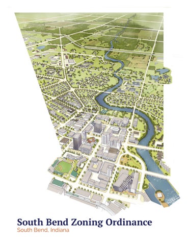
South
Bend Zoning Ordinance
South Bend, Indiana
This page intentionally left blank
Table of Contents
Section
Section
Article
Section
Article
Special Districts
Section
Article 21-05: Overlay Districts
Section
Article 21-09: Site Development
Article 21-12: Administration
Section
Section
Article 21-13: Nonconformities & Enforcement
Table
Table
Table
Table
Table
Table
Table 21-08B: Building Frontage Types Allowed 8-17
Table
Table
Table
Article 21-14: Floodplain
Section
Table 21-10B: Non-Residential Sign Standards 10-11
Table 21-11A: Block Perimeter 11-4
Table 21-12A: Development Review Procedures 12-16
Photo Credit: Images on page 8-8 and page 8-10 lower right are courtesy of ©Sandy Sorlien for the Transect Collection.
This page intentionally left blank
How to Use this Code
1. Find your Property on the Zoning Map
Section 21-01
Identify which zoning district applies to your lot or best matches the character, use, and intent of your project. The Zoning Map may be found on the City of South Bend website.
2. Review and Comply with the Development Standards
Sections 21-02 to 21-10
Understand the character and intent of the zoning district and comply with all the regulations specific to your district.
21-02: Definitions and Measurements
Review this section for definitions of terms found throughout the Ordinance and for explanations of dimensional regulations or measurements that are found in each zoning district.
21-03: Standard Districts or 21-04: Special Districts
Apply all development standards for the applicable zoning district.
21-05: Overlay Districts
If your development is within a Historic Preservation district or the Northeast Neighborhood, comply with the provisions of this section in addition to the standards of the zoning district.
Review the following sections for further information on the development standards:
21-06: Uses
Review this section for all principal and accessory uses that are permitted in your zoning district and identify any additional standards that may apply to the applicable use or uses.
21-07: Access & Parking
Review this section for additional regulations related to pedestrian access, bicycle parking and access, vehicle parking and access, off-street loading, and private streets and alleys.
21-08: Building Standards
Review and apply this section for additional building design regulations. If your building is within a Standard District, you must select which building type applies.
21-09: Site Development
Review this section for additional regulations related to landscape, fences and walls, stormwater, outdoor lighting, and performance standards.
21-10: Signs
Review this section for additional regulations related to signs, including exempt signs, prohibited signs, temporary signs, on-premise signs, off-premise signs, and special use signs.
How to Use this Code, cont .
3. Seek Additional Approvals as Necessary
Sections 21-11 to 21-14
Follow the applicable approval process to prepare all required application materials.
Are you subdividing a lot?
If you want to subdivide your lot, comply with the requirements and follow additional procedures in Section 21-11.02 and Section 21-12.06.
Does your project reconfigure an existing or create a new block or street?
If your development reconfigures the dimension of a block, creates a new block, or includes the addition of a new public or private street, comply with the provisions of Section 21-11.03
Is your project greater than 3 acres?
If your project results in modification of any lot(s) by a single property owner with an aggregate area of 3 acres or more within any 5-year period, comply with the provisions of Section 21-11.03
Does your project require a change in Zoning District?
If your project requires a change to the official zone map, file a petition per the requirements of Section 21-12.07(f)(2)
Does your project require a Special Exception?
If your project requires a special exception, file a petition per the requirements of Section 21-12.07(f)(3)
Does your project require a Variance?
If your project requires a deviation from the development standards, file a petition per the requirements of Section 21-12.07(f)(5)
Does your project fall within a floodplain or wetlands?
If your lot is located within a FEMA designated floorplain, comply with the provisions of Section 21-14
4. Improvement Location Permit
Building Department
Once your project meets all the requirements of this Zoning Ordinance and has received any additional review or approvals, submit your permit application to the Building Department.
Understanding the Development Standards
Zoning District Development Standards
The development standards for zoning districts contained in this Ordinance govern the physical development and form of real estate. The regulations for each zoning district are presented across six pages with the same general format for each district, including the following:
- Intent
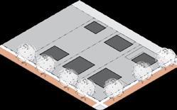
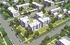
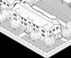
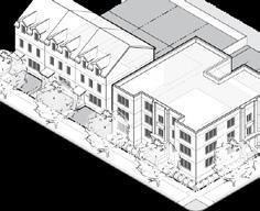
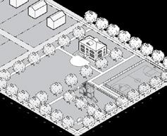
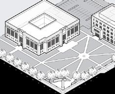
The first page for each zoning district provides a general description and an image illustrating the variety of development that is encouraged in a particular zoning district. This image is intended for illustrative purposes only and does not fully exemplify all of the requirements or possibilities within each zoning district.
- Building Types
If applicable, a list of building types regulates the general types of structures that are allowed within a zoning district. These building types are represented in the illustrative image and described in full detail in Section 21-08.02 The names of the building types are not intended to limit or expand uses allowed within the building.
- Use Table
The second page in each zoning district includes a list of the permitted uses within a district, including those uses allowed by special exception or with additional standards. The full use table, which includes all principal and accessory uses, is located in Section 21-06
- Diagrams & Dimensional Tables
Each zoning district provides eight tables, each with an associated diagram, that describe all dimensional standards for development in that district. Any additional regulations that may apply in other sections of the Ordinance are referenced within the tables.
The regulations provided in each zoning district section are a summary of the requirements. See full sections for the complete set of regulations.
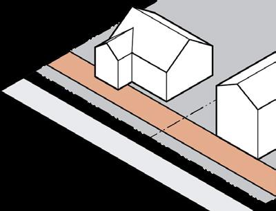
Illustrative Image: Shows the intended character of a zoning district across a neighborhood block
Intent. Provides a general description and characteristics of a zoning district. Building Types. Regulates which types of buildings are allowed within a zoning district.
Understanding the Development Standards
2
3

Uses. Regulates what principal uses are allowed within the zoning district with a reference to the location of use definitions and any additional standards that may apply. Uses may be permitted by right, permitted by right provided they comply with a set of conditions, or permitted only if approved for a special exception.
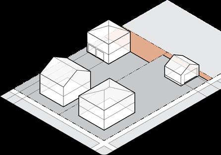
Building Placement. Regulates minimum lot dimensions and where a building is allowed to sit within a lot.
Access & Parking. Regulates how pedestrians and vehicles access a site and where parking may be located.
Understanding the Development Standards


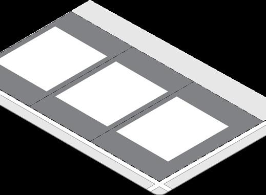
Building Form. Defines the allowed height and form of buildings on a lot.
Building Components: Regulates attached elements and allowed encroachment into any required setbacks.
Building Standards. Regulates facade design, transparency, and materials.
Site Development. Regulates pedestrian access to a building and additional structures located on a lot
Understanding the Development Standards

Landscape. Regulates what type of landscape is required and where it may be located. Signs . Regulate s the type, size, and location of signs on a lot.
This page intentionally left blank
Article 21-01: Introductory Provisions
Sections
Section 21-01.01: Title, Purpose, & Applicability 1-1
Section 21-01.02: Zoning Map & Districts 1-3
Section 21-01.01: Title, Purpose, & Applicability
(a) Title
This Ordinance shall hereinafter be known and cited as “City of South Bend Zoning Ordinance,” and hereinafter referred to as the “Ordinance.”
(b) Statutory Authority
This Ordinance is adopted pursuant to the authority contained in Indiana Code (IC) 36-7-4 et seq.
(1) Whenever any provision of this Ordinance refers to or cites a section of the Indiana Code and that section is later amended or superseded, this Ordinance shall be deemed amended to refer to the amended section or the section that most nearly corresponds to the superseded section.
(c) Purpose of this Ordinance
In adopting this Ordinance, the Council has given reasonable consideration to, among other things: the comprehensive plan; current conditions and the character of current structures and uses in each district; the most desirable use for which the land in each district is adapted; the conservation of property values throughout the City of South Bend; and, responsible development and growth of the City of South Bend, and hereby adopts this Ordinance for the purpose of:
(1) Securing adequate light, air, convenience of access, and safety from fire, flood, and other danger;
(2) Lessening or avoiding congestion in public ways;
(3) Promoting the public health, safety, comfort, morals, convenience, and general welfare;
(4) Guiding the future development of the City of South Bend;
(5) Ensuring that growth be commensurate with and promotive of the efficient and economical use of public funds; and
(6) Otherwise accomplishing the purposes of IC 36-7-4 et seq.
(d) Findings for Adoption of this Ordinance
The Council, in adopting this Ordinance, finds that the Ordinance has paid reasonable regard to:
(1) The general policies and patterns of development set out in the Comprehensive Plan for the City of South Bend, Indiana;
(2) Current conditions and the character of current structures and uses in each district;
(3) The most desirable use for which the land in each district is adapted;
(4) The conservation of property values throughout the City of South Bend; and
(5) The responsible development and growth of the City of South Bend.
(e) Effective Date of Ordinance
This Ordinance shall be effective at 12:01 a.m., on January 1, 2020.
(f) Repealer of Prior Ordinance
Chapter 21 of the Municipal Code of the City of South Bend, Indiana (commonly referred to as the South Bend Zoning Ordinance), as adopted by the Council on the 12th day of April, 2004, and all amendments thereto, are repealed as of the effective date of this Ordinance.
(g) Jurisdiction of this Ordinance
Upon adoption of this Ordinance by the Council and the effective date of this Ordinance, the South Bend Plan Commission shall be the duly authorized Plan Commission for the incorporated areas of the City of South Bend pursuant to the Advisory Planning Law of the Indiana Code, and the Ordinance shall apply to all real property located within the corporate boundaries of the City of South Bend.
(h) Minimum Requirements
In their interpretation and application, the provisions of this Ordinance shall be held to be the minimum requirements for the promotion of the health, safety, comfort, morals, convenience, and the general welfare of the public.
(i) Scope and Application of this Ordinance; Compliance Required
Except as expressly provided otherwise in this Ordinance, no land, building, structure, or improvement may be used or occupied; no building, structure, or improvement may be erected, converted, enlarged, reconstructed, moved, or altered for use; and no lots of record may be established, by subdivision or otherwise, that do not comply with all applicable regulations of this Ordinance.
(j) Eminent Domain – u nited States of America or State of Indiana Owned Property
Nothing in this Ordinance or in any rules, regulations, or orders issued pursuant to this Ordinance shall be deemed to restrict or regulate or to authorize any unit of government, legislative body, Plan Commission, or Board of Zoning Appeals now or hereafter established, to restrict or regulate:
(1) United States of America – the exercise of the power of eminent domain by the United States of America or by any department or agency of the United States of America, or the use of property owned or occupied by the United States of America or any department or agency of the United States of America; or,
(2) State of Indiana – the exercise of the power of eminent domain by the State of Indiana or by any agency of the State of Indiana, or the use of property owned or occupied by the State of
Title, Purpose, & Applicability
Indiana or any agency of the State of Indiana. (For reference, see IC 36-7-4-1104.)
(k) Private Provisions
The provisions of this Ordinance are not intended to nullify, abolish, or repeal any easement, covenant, or other private agreement or restriction.
(l) Conflicting Provisions
In the case of any conflict or inconsistency between two or more provisions of this Ordinance (e.g., the restrictions set forth in an overlay district versus the restrictions set forth in a base district) or any other ordinance of the City of South Bend, the provision which imposes the greater or higher or more restrictive standard of performance shall control.
(m) Severability
It is hereby declared to be the intention of the Council that the sections, paragraphs, sentences, clauses, and phrases of this Ordinance are severable and, if any such section, paragraph, sentence, clause, or phrase is declared unconstitutional or otherwise invalid by any court of competent jurisdiction in a valid judgment or decree, such unconstitutionality or invalidity shall not affect any remaining sections, paragraphs, sentences, clauses, or phrases of this Ordinance because the same would have been enacted without the incorporation into this Ordinance of such unconstitutional or invalid section, paragraph, sentence, clause, or phrase.
(n) Amendments to this Ordinance
In its continuing administration of the purposes set forth in Section 21-01.01(c), the Council may find it reasonable and necessary to propose and adopt amendments to the text of this Ordinance or determine changes to the Zone Maps incorporated into this Ordinance. All such amendments shall be considered and adopted in compliance with IC 36-7-4-600 et seq., the provisions of this Ordinance, and any applicable Rules of Procedure subsequently adopted by the Plan Commission or the Council governing such procedures.
Zoning Map & Districts
Section 21-01.02: Zoning Map & Districts
(a) Districts
The following districts are hereby established for the corporate limits of the City of South Bend, and land within said areas shall be designated on the Official Zone Map by the following symbols:
(c) Retention and Preservation of Record
An Official Zone Map for the City of South Bend shall be maintained by the Zoning Administrator. Unless the prior Official Zone Map has been lost or completely destroyed, the prior Official Zone Map, along with all available records pertaining to its adoption or amendment, shall be retained and preserved in the office of the Plan Commission.
(d) Official Zone Map Changes
If, after adoption of the Official Zone Map, the Common Council, in accordance with the provisions of this Ordinance and the IC 36-7-4-600 et seq., changes any of the district boundaries or other matter portrayed on the Official Zone Map, such changes shall be entered to the electronic format Official Zone Map, which is maintained in the office of the Plan Commission. The working copy of the Official Zone Map shall be available for public inspection and reference during all normal business hours. In the event that the Official Zone Map becomes damaged, destroyed, or lost, staff shall, on an as needed basis, prepare a revised Official Zone Map for review and recommendation by the Plan Commission to the Common Council at a public hearing for which proper notice has been provided. No change of any nature shall be made in the Official Zone Map, or matter shown thereon, except in conformity with the amendment procedures set forth in this Ordinance.
(1) Overlay Districts. Overlay Districts are hereby established for the City of South Bend as set forth in Section 21-05.
(b) Official Zone Map
In order to carry out the purpose of this Ordinance and to allow a variety of uses in different districts which are appropriate in location, arrangement, and density to the character of the individual districts and the establishment of a well considered pattern of development for the City of South Bend, all real property located within the corporate boundaries of the City of South Bend are hereby divided into districts as shown on the Official Zone Map which, together with all explanatory matter, is incorporated by reference and declared to be a part of this Ordinance.
(e) Interpretation of the Official Zone Map
Where uncertainty exists with respect to the boundaries of districts shown on the Official Zone Map, the following rules shall apply to the interpretation of those boundaries:
(1) Boundaries indicated as approximately following platted lot lines shall be construed to follow the platted lot lines.
(2) Boundaries indicated as approximately following the center lines of thoroughfares, highways, streets, or alleys shall be construed to follow the center lines.
(3) Boundaries indicated as approximately following the corporate boundary of the City of South Bend shall be construed as following such corporate boundary of the City of South Bend.
(4) Boundaries indicated as approximately following railroad lines shall be construed to be midway between the main tracks.
(5) Boundaries indicated as approximately following along a public right-of-way which is subsequently vacated shall be construed to follow the center line of the vacated public right-of-way.
(6) Boundaries indicated as approximately following the center lines of streams, rivers, lakes, or other bodies of water shall be construed as following the center lines of such bodies of water.
(7) Boundaries indicated as approximately following floodplain lines shall be construed to follow the floodplain lines. If the floodplain lines are changed, either naturally or as permitted by law, and such floodplain line changes are documented and concurred with by the City Engineer, such boundary shall be construed as moving with such change.
(8) Boundaries indicated as following the contours of certain elevations or soils of a particular type shall be construed as following the actual height or soil contour as determined by accepted surveying practices.
(9) Boundaries indicated as parallel to or extensions of features indicated in the subsections above shall be so controlled.
(10) Distances not specifically indicated on the Official Zone Map shall be determined by the scale of the map.
(11) Where a discrepancy exists between the depictions on the Official Zone Map and the text of a legal description accompanying an ordinance for zone map change duly adopted by the Common Council, the text of the legal description shall control.
(12) Where physical or cultural features existing on the ground do not agree with those shown on the Official Zone Map, or in other circumstances not covered above, the Zoning Administrator shall interpret the boundaries. Any party dissatisfied with the interpretation of the Zoning Administrator may appeal such interpretation to the Board of Zoning Appeals.
(f)
Determination of Land uses Not Listed in this Ordinance
It is recognized that this Ordinance may require interpretation to assign all possible uses to individual districts. Therefore, any use which is not specifically set forth in this Ordinance shall be reviewed by the Zoning Administrator for consistency with the intent set forth in each district and for compatibility with use characteristics typical of uses permitted within those districts. Based upon this review, the Zoning Administrator shall determine the appropriate district for any use which is not specifically set forth herein. In case of disagreement with the determination of the Zoning Administrator in assigning a use to an appropriate district, any aggrieved party may file an appeal with the Board of Zoning Appeals pursuant to the provisions of Section 21-12.03 of this Ordinance. If it is: (i) determined by the Zoning Administrator that a particular use is not permitted in any district provided for in this Ordinance and no appeal of the Zoning Administrator's decision is filed with the Board of Zoning Appeals pursuant to the provisions of Section 21-12.03 of this Ordinance; or, (ii) determined upon appeal that a particular use is not permitted in any district provided for in this Ordinance, then such use shall be deemed to require a variance.
(g)
Zoning of Newly Annexed Land
Any new land annexed into the City of South Bend shall be designated as the zoning district most comparable to the existing zoning district, per discretion of the Zoning Administrator. The selected zoning designation shall be based on which district the land use or building type most typically appears or is most closely related.
Zoning Map & Districts
(h) Conversion to New Districts
For interpretation and administrative purposes, any reference to a previously mapped zoning district shall be replaced with the equivalent zoning district per the following table:
Table 21-01B: Zoning Districts Conversion Symbol Replaces
Standard Districts
Suburban Neighborhood 1 S1 SF1
Suburban Neighborhood 2 S2 MF2
Urban Neighborhood 1 U1 SF2
Urban Neighborhood 2 U2 SF3
Urban Neighborhood 3 U3 MF1
Urban Neighborhood Flex UF OB
Neighborhood Center NC MU, O
Downtown DT CBD
Special Districts
Open Space OS (New)
University U U
Commercial C LB, CB, GB
Industrial I LI, GI
S1
Suburban Neighborhood 1


Intent
The S1 District is established to provide for and maintain suburban neighborhoods in outlying areas of the City.
Typical Characteristics
Primarily single unit residential development.
Buildings with relatively deep setbacks on larger lots.
Attached garages accessed by a driveway from the street.
Larger city blocks with informal character and plantings.
S2
Suburban Neighborhood 2
The S2 District is established to provide for, maintain, and enhance suburban neighborhoods of primarily apartment complexes or houses grouped together outside of the City's core.
A full range of residential development, including single unit, two unit, multi-unit, and ADUs.
Larger size buildings with relatively deep setbacks on larger lots.
Attached garages accessed by a driveway from the street or shared parking areas located in the rear or interior of the lot.
Larger city blocks with informal character and plantings.
U1
Urban Neighborhood 1


The U1 District is established to provide for, promote, and maintain urban neighborhoods located in core and outlying areas of the City.
U2
Urban Neighborhood 2


The U2 District is established to provide for, promote, and maintain the development of diverse housing types in urban neighborhoods located near neighborhood centers in core and outlying areas of the City.
Primarily single and two unit residential development, allowing the addition of ADUs.
Buildings with modest setbacks and inviting building frontages that create a consistent block face along smaller city blocks.
Detached garages located at the rear of the lot, often accessed from an alley.
Pedestrian-oriented scale with sidewalks and street trees.
Primarily single and two unit residential development, allowing up to four units and the addition of ADUs.
Buildings with modest setbacks and inviting building frontages that create a consistent block face along smaller city blocks.
Detached garages accessed from an alley.
Pedestrian-oriented scale with sidewalks and street trees.
The U3 District to provide for, maintain the a full range located near centers and in urban neighborhoods and outlying
Single unit, unit residential together with
Buildings with setbacks and frontages that consistent smaller city
Detached garages parking accessed
Pedestrian-oriented sidewalks and
Building Types
Carriage House
Detached House Duplex
Carriage House
Carriage House Detached House Duplex
Apartment House Stacked Flats
House
Court
Apartment House
Neighborhood 2
Zoning Map & Districts
U3
Urban Neighborhood 3

established promote, and development of types in urban located near centers in core of the City.
two unit development, units and ADUs. modest inviting building create a face along accessed scale with trees.
The U3 District is established to provide for, promote, and maintain the development of a full range of housing types located near neighborhood centers and along major streets in urban neighborhoods in core and outlying areas of the City.
Single unit, two-unit, and multiunit residential development, together with ADUs.
Buildings with modest setbacks and inviting building frontages that create a consistent block face along smaller city blocks.
Detached garages or shared parking accessed from an alley.
Pedestrian-oriented scale with sidewalks and street trees.
UF
Urban Neighborhood Flex


The UF District is established to enhance and support a full range of housing types and small-scale commercial uses found outside neighborhood centers in core and outlying areas of the City.
A mixture of single unit, two unit, multi-unit, and ADUs. Integrates limited smallscale office, commercial, and institutional uses that are compatible in scale.
Buildings with smaller setbacks create a consistent block face along smaller city blocks.
Detached garages or shared parking accessed from an alley.
Pedestrian-oriented scale with sidewalks and street trees.
Carriage House
Detached House
Cottage Court
Duplex
Townhouse
Apartment House
Stacked Flats
MORE URBAN
NC Neighborhood Center


The NC District is established to promote higher intensity, urban neighborhood centers, typically located near the intersection of major streets, in core and outlying areas of the City that are well connected to surrounding neighborhoods.
A mixture of storefront retail, professional offices, and dwelling units located in townhouses, apartment buildings, and in the upper stories or rear of mixed-use buildings.
Buildings with active building frontages set at or close to the sidewalk.
Pedestrian-oriented scale with sidewalks and street trees.
DT Downtown


The DT District is established to promote the development of the downtown region of the City of South Bend as a high intensity urban center for a multi-county region.
A mixture of mid-rise and high rise mixed-use developments including a variety of compatible building types and urban uses.
Buildings with active building frontages set at or close to the sidewalk.
Pedestrian-oriented scale with sidewalks and street trees.
Carriage House
Detached House
Cottage Court
Duplex
Townhouse
Apartment House
Stacked Flats
Shop
Carriage House
Townhouse
Apartment House
Stacked Flats
Shop
Townhouse
Apartment House
Stacked Flats Shop
Mid-Rise/Tower
ZONING DISTRICT OVERVIEW
SPECIAL DISTRICTS
U University

Intent
The OS District is established to promote the development of a range of public shared open spaces dispersed through the City.
Typical Characteristics
Active or passive open spaces, including neighborhood parks, formal greens or plazas, greenways, trails, recreational fields, or natural spaces that accommodate a wide range of ages, physical abilities, and programming.
Buildings and uses that activate and address the open space or support park functions.
Wide sidewalks and pathways for multiple uses surrounded by a formal or informal arrangement of trees and landscaping.
Seating and site amenities that encourage pedestrian use and comfort.

The U District is established to promote the development of major college or university campuses.
CCommercial


The C District is established to provide a location for medium- to high intensity commercial uses that are autooriented, typically located along major corridors at the fringe of the City or as small groupings located outside of neighborhood centers.
I
Industrial
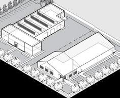
The I District is established to provide a location for mediumto high intensity industrial uses, typically grouped along highways and major streets and separated from residential uses.
A diversity of uses, functions, and facilities that facilitate the highest level of education.
A range of commercial uses which are accessory to or typically associated with a college or university campus, such as a bookstore, hotel, food sales and service, school supplies, and personal services.
Pedestrian-oriented scale with sidewalks and a formal or informal arrangement of trees and landscaping.
Auto-oriented commercial uses that may include outdoor sales or operations.
Buildings located on larger lots and city blocks in a suburban format.
Coordinated to facilitate vehicular and pedestrian access from nearby neighborhoods.
Landscaped to be attractive and provide appropriate buffering to residential uses.
Office/warehouse, distribution, wholesale, assembly, and manufacturing or processing facilities that may require substantial amounts of outdoor storage or operations.
Uses typically generate heavy traffic.
Buildings located on larger lots on bigger city blocks.
Landscaped to be attractive and provide appropriate buffering to other uses.
Zoning Map & Districts established to for mediumindustrial grouped along streets residential distribution, assembly, and processing require of outdoor operations. generate heavy larger lots blocks. attractive appropriate uses.
OVERLAY DISTRICTS
NNZO
Northeast Neighborhood


The HP Overlay District is established to preserve buildings, other structures, and sites of historical, architectural, engineering, and cultural significance in South Bend.
The NNZO Overlay District codifies the recommendations of the Northeast Neighborhood Design Guidelines which are most relevant and applicable to new development in the NNZO.
Chapin Park and Leeper Park
East Wayne Street
Edgewater Place
Lincolnway East
North St. Joseph Street
River Bend
Riverside Drive
Taylor’s Field
West North Shore Drive
Local Landmarks
Establish a comprehensive design approach for the NNZO.
Encourage high-quality design of future buildings and site development that preserves and enhances the character of a traditional neighborhood.
Create a strong, unique neighborhood identity image.
Provide a range of design options to address future development opportunities.
Instill and enforce the sense of “pride of place” among residents, businesses, and property owners.
This page intentionally left blank
Article 21-02: Definitions & Measurements
Sections
Section 21-02.01: Rules of Interpretation 2-1
Section 21-02.02: Definitions 2-2
Section 21-02.03: Measurements ........................ 2-11
Section 21-02.01: Rules of Interpretation
(a) Definitions
Whenever a defined word appears in the Ordinance, its meaning is as set forth in this article. Words not defined in this Ordinance are interpreted in accord with their usual dictionary meaning and customary usage.
(b) Current Versions and Citations
All references to other regulations or manuals in this Ordinance refer to the most current version and citation for those regulations or manuals, unless expressly indicated otherwise. When the referenced regulations or documents have been repealed and not replaced by other regulations or manuals, Ordinance requirements for compliance are no longer in effect.
(c) Text and Graphics
Illustrations, diagrams, and flowcharts are included in this Ordinance to illustrate the intent and requirements of the text. In the case of a conflict between the text and any illustration, diagram, or flowchart, the text controls.
(d) Fractions
Except as otherwise noted, any fraction greater than or equal to 0.5 will be rounded up to the nearest whole number. Any fraction less than 0.5 will be rounded down to the nearest whole number.
(e) Interpretation of Terms or Words
The language of this Ordinance shall be interpreted in accordance with the following regulations.
(1) The word “person” includes a firm, association, organization, partnership, trust, limited liability company, corporation, or other legal entity, as well as an individual.
(2) The present tense includes the future tense, the singular number includes the plural, and the plural
number includes the singular, in each case, if the context so requires.
(3) The word “shall” is mandatory, the word “may” is permissive.
(4) The words “used” or “occupied” include the words “intended,” “designed,” “constructed,” “altered,” or “arranged” to be used or occupied.
(5) The word “lot” includes the words “plot,” “tract,” or “parcel.”
(6) The terms “standards,” “regulations,” and “requirements” are used to mandate a specific course of action or built outcome.
(7) Section headings are provided for ease of use and organization, and shall not be interpreted as regulatory.
(f) Conjunctions
Where a regulation involves two or more items, conditions, provisions, or events connected by the conjunction “and,” “or,” or “either ... or,” the conjunction shall be interpreted as follows:
(1) “And” indicates that all the connected items, conditions, provisions, or events shall apply.
(2) “Or” indicates that the connected items, conditions, provisions, or events may apply singly or in any combination.
(3) “Either ... or” indicates that all the connected items, conditions, provisions, or events shall apply singly but not in combination.
Section 21-02.02: Definitions
The following terms or words used in the text of this Ordinance shall have the following meanings, unless a contrary meaning is (i) required by the context of a particular sentence or phrase; or, (ii) specifically prescribed in a particular sentence or phrase.
AAbandoned. A condition that exists after a voluntary act or failure to act by the owner of a nonconforming use which evidences that the owner neither claims nor retains the right to exercise the nonconforming use.
Access. The manner in which ingress and egress is provided to a lot from a public right-of-way along said lot.
Accessory (Structure, Building, or Use). A subordinate structure, building, or use that is customarily associated with, and is appropriately and clearly incidental and subordinate in use, size, area, and height to the primary structure, building, or use, and is located on the same lot as the primary building, structure, or use.
Administrative Lot Line Adjustment. The process of allowing for an adjustment of a lot line or lines, and easements, as shown on a recorded subdivision, which does not affect any street layout, whether existing or proposed; and does not increase the total number of lots within the area proposed to be replatted.
Alley. A right-of-way used as a secondary means of public access to a lot otherwise abutting upon a street and not intended for traffic other than public services and circulation to and from said lot.
Articulation. Elements in the massing of a building that create changes in the facade surface, which establish visual interest and avoid a flat appearance.
Authorized Agent. Any party duly authorized in writing by the Owner of a subject lot to act on the Owner's behalf with respect to any development petition, including, but not limited to, a petition for zone map change; platting of a subdivision; development plan approval; variance; or vacation of land in a plat.
BBasement. That portion of a building with an interior vertical height clearance of not less than 84 inches and having one-half or more of its interior vertical height clearance below grade level.
Belt Course. A design element aligned horizontally along a building wall, typically a continuous row or layer of stones, tiles, bricks, shingles, or similar materials. Also called a string course or band course.
Block. A tract of land bounded by streets, or by a combination of streets and public parks, cemeteries, railroad rights-of-way, water bodies, or municipal boundary lines.
Block Face. The frontage of a block, which may contain one or more lots, along one side of a public or private street between intersections.
Board of Public Works. The South Bend Board of Public Works.
Board of Zoning Appeals. The South Bend Board of Zoning Appeals.
Buffer. A landscape planting, fence, and/or other component used to provide screening of incompatible uses.
Buildable Area. The area of a lot remaining after the minimum setbacks and lot size requirements of this Ordinance have been met and in which development may occur subject to compliance with all applicable development standards.
Building. Any structure having a roof supported by columns or walls and intended for the shelter, housing, or enclosure of any individual, animal, process, equipment, goods, or materials of any kind or nature.
Building Commissioner. The duly appointed building commissioner for the City of South Bend, Indiana.
Building Coverage. The total ground area within the lot or project covered by the primary structure plus any accessory structures with a roof.
Building Line, Established. A line parallel to any front, corner, side, or rear lot line which passes through the nearest point of any building, excluding a building frontage type.
Building Mass. The relationship between height, width, and depth of a building or structure. A building may consist of a primary form with additional elements attached such as building frontage types (i.e., porch, stoop, or awning), building components (i.e., bay window, balcony, or dormer) or secondary forms (i.e., side or rear building wing or attached garage).
Building Material. Exterior surface materials, exclusive of materials used for windows; doors; roofing; fascia; soffit; balconies; railings; handrails; stairs; foundations; vents; and support beams or columns less than 18 inches in width.
Building Permit. A permit issued by the City of South Bend in compliance with the terms and provisions of the City of South Bend Building Code.
Building Scale. The relationship of a particular building, in terms of building mass, to other nearby and adjacent buildings.
Building Segment. A vertical unit of a building that consists of regularly repeated spatial elements making a vertical division in a structure, commonly defined by the number of window and door openings per floor or by the space between columns and/or piers.
CCaliper. The diameter of a tree trunk, measured in inches, at 6 inches above the ground.
Certificate of Occupancy. A certificate issued by the Building Department authorizing an occupancy under the local building codes and ordinances of the City of South Bend, Indiana.
City Engineer. The City Engineer of the City of South Bend, Indiana.
Commitment. A legally binding, written restriction on the use and development of real estate entered into in connection with a petition for zoning map change, development plan approval, special exception, or variance.
Common Council. The Common Council of the City of South Bend, Indiana.
Comprehensive Plan. The Comprehensive Plan for the City of South Bend or any supplemental or replacement comprehensive plan subsequently recommended by the Plan Commission and adopted by the Common Council pursuant to Indiana law.
Condominium. A building, group of buildings, or portion thereof, in which units are owned individually, and the structure, common areas, or facilities are owned by all the owners on a proportional, undivided basis.
Conforming. The state of being in compliance with the permitted use or development standards regulations of the district to which the real estate is zoned pursuant to this Ordinance.
Cornice. Projecting ornamental molding along the top of a building or wall.
DDevelopment Petition. Any petition or review process required by this Ordinance prior to the issuance of a improvement location permit, including but not limited to petitions for zone map changes, variances, special exceptions, subdivisions, vacations, or development plans.
Development Plan. Specific plans for a lot(s) filed in connection with a development review procedure. A development plan may include, but are not limited to, a site plan, landscape plan, building elevations, signs, and other plans which are reasonably necessary to depict or describe certain information and data as required by this Ordinance
District. Any zoning district or overlay district applicable to a section of the territory within the jurisdiction of this Ordinance.
District, Zoning. A section of the territory within the jurisdiction of this Ordinance for which uniform regulations over the erection, construction, reconstruction, alteration, repair, or use of buildings, structures or land, including, but not limited to permitted uses, height, area, size, and intensity of use of buildings, structures, land, and open spaces about buildings or structures, are established by this Ordinance.
District, Overlay. A section of the territory within the jurisdiction of this Ordinance in which additional requirements are imposed on certain properties within one or more underlying zoning district.
Drive, Interior Access. A way for internal vehicular movement in and around an individual lot or integrated center.
Driveway. A vehicular lane within a lot, or shared between two or more lots, typically providing access from a street or alley to a garage or other parking area.
Dwelling. Any building, or portion of a building, which is designed or used primarily for residential purposes, including a 1 unit dwelling, 2 unit dwelling, and multi-unit dwelling but not including hotels or bed & breakfasts.
Dwelling Unit. A room or group of rooms designed and equipped exclusively for use as living quarters for only one family, including permanent provisions for living, sleeping, eating, cooking, and sanitary facilities per the definition of the Building Code. The term shall include mobile dwellings, modular dwellings, and manufactured dwellings but shall not include recreational vehicles.
FFacade. External face of a building, including the portion of any exterior elevation of a building, extended from grade to the top of the parapet wall or eaves, and extending the entire width of the building elevation. The facade includes all building faces that are oriented toward the lot line to which the building elevation is oriented.
Family. One or more persons related by blood, legal adoption, or marriage, living and cooking together as a single housekeeping unit; or, a number of persons, but not exceeding two, who are not related by blood, legal adoption, or marriage, living and cooking together as a single housekeeping unit, shall be deemed to constitute a family. A person or persons residing with a family as hereinabove defined by reasons of placement by a publicly licensed placement agency shall be considered as members of that family.
Fenestration. The arrangement, proportioning, and design of windows and doors in an exterior wall of a building.
Floor Area, Finished. That portion of floor area constructed, completed, and usable for living purposes with normal living facilities which includes sleeping, dining, cooking, sanitary, or combination thereof. A floor area or portion thereof used only for storage purposes and not equipped with the facilities mentioned above shall not be considered finished floor area.
Easement. A grant by a property owner to the general public and/or public utility or utilities for the use of land for a specifically stated purpose or purposes.
Eaves. The projecting overhang at the lower edge of a roof.
Floor Area, Gross. For dwelling units, the total area, computed on a horizontal plane inclusive of finished basements, attached garages, entrances, hallways, stairways, and other enclosed areas, but exclusive of unfinished basements, cellars, and attics. For commercial or industrial buildings, the sum of all horizontal surface areas of all floors of a building or structure measured from the exterior faces of the exterior walls or from the center line of walls separating abutting buildings or structures.
Floor Area, Main. That portion of the finished floor area located on the first floor of the dwelling unit.
Frontage. The line of contact of an abutting lot with the street right-of-way along a front lot line which allows unobstructed, direct access to the lot.
G
Glare. The harsh appearance of a direct source of light as discernible from adjacent properties and which causes annoyance, discomfort, or loss of visual performance and visibility.
Grade. The average level of the finished surface of the ground 5 feet from the building, structure, or proposed building pad.
H
Historic Landmark. A building, structure, object, district, land use, area, or site of historical significance and designated as an historic landmark on the Historic Preservation Plan or by Ordinance of the Common Council.
Historic Preservation. The research, protection, maintenance, restoration, rehabilitation, reconstruction, or development of historic landmarks and historic preservation districts. For the purposes of this Chapter, this definition shall apply to the preservation of exterior features only.
Historic Preservation Commission. The Historic Preservation Commission of South Bend and St. Joseph County.
Historic Preservation District. A geographically definable area with a significant concentration of buildings, structures, sites, spaces, or objects unified by past events, physical development, design, setting, materials, workmanship, a sense of cohesiveness, or related historic association and designated as an historic preservation district on the Historic Preservation Plan or by Ordinance of the Common Council.
I
Improvement. Any man-made, immovable item which becomes part of, placed upon, or is affixed to real estate.
Improvement Location Permit. A permit stating that the proposed erection, construction, enlargement, or moving of a building or structure, and uses thereof, complies with the provisions of this Ordinance.
Incidental. A minor occurrence or condition which is customarily associated with a permitted use and is likely to ensue from normal operations.
Legally Established. The condition of being in compliance with all applicable development regulations at the time of recording, construction or erection of a lot, building, structure, use, or sign.
Limited Access Highway. See Street, Limited Access Highway.
Loading Area. Any area maintained and intended for the maneuvering and temporary parking of vehicles while transferring goods or materials to and from a facility. Loading area includes the loading space and maneuvering area required to enter the loading space.
Loading, Off-Street. A loading area located completely on a lot and accessed via interior access drives, interior access driveways, access drives, or driveways in which no individual loading spaces gain direct access to a public street or private street.
Loading Space. A hard-surfaced, off-street area used for the temporary parking of a commercial vehicle while transferring goods or materials to and from a facility.
Lot. A piece, parcel, plot, or tract of land designated by its owner or developer to be used, developed, or built upon as a unit under single ownership or control and may consist of a single lot of record or a combination of complete lots of record. For purpose of this definition, the ownership of a lot is further defined to include the person(s) who holds either fee simple title to the property or is a life tenant as disclosed in the records of the St. Joseph County Assessor.


Multiple Frontage Lot
Double Frontage Lot
Lot Area. The total area of a lot bounded on all sides by any front, corner, side, or rear lot line, provided, however, lot area shall not include any area lying within the right-of-way of any public or private street or easement for surface access into the subject lot or adjoining lots; or land reserved for drainage pond, wetland or lands subject to periodic flooding. No part of the minimum lot area required under the commitment, variance grant, or development plan approval may be satisfied by land that is under water.
Lot, Corner. A lot abutting two or more streets at their intersections.
Lot, Double Frontage. A lot abutting two parallel streets, or abutting two streets which do not intersect at the boundaries of the lot.
Lot, Flag. An irregularly shaped lot with a limited amount of street frontage and only a thin strip of land, often consisting primarily of a driveway, connecting the street to a wider part of the lot. On a flag lot, only the wider portion of the lot is used to measure lot width.
Lot, Non-Frontage. A lot with no frontage that is interior to a development.
Lot, Multiple Frontage. A lot abutting three or more streets or public open spaces.
Lot, Interior. A lot which is not a corner lot or a double frontage lot.
Lot Line. The line of separation of a lot from any abutting public right-of-way or adjoining lot.
Lot Line, Corner. The lot line separating a lot from an abutting secondary street or limited access highway.
Lot Line, Front. The lot line separating a lot from an abutting primary street or limited access highway.
Lot Line, Rear. A lot line which is opposite and most distant from the front lot line, or in the case of a triangularly shaped lot, a line 10 feet in length within the lot, parallel to and at the maximum distance from the front lot line.
Lot Line, Side. Any lot line not designated as a front lot line, corner lot line, or rear lot line.
M
Masonry. Wall construction of cut, shaped, or molded units such as stone, brick, concrete, etc.
N
Nonaccess Easement. A public easement along a public right-of-way across which access to the lot is not permitted.
Nonconforming. The state of not being in compliance with the permitted use or development standards regulations of the district to which the real estate is zoned pursuant to this Ordinance.
Nonconforming, Legally Established. Any continuous, lawfully established land use, building, or structure erected, constructed, commenced: (a) prior to the time of adoption, revision, or amendment of this Ordinance but which fails by reason of such adoption, revision, or amendment to conform to the present requirements of the district; (b) pursuant to a granted variance; or, (c) prior to a right-of-way acquisition or access rights acquisition by a governmental entity but which fails by reason of such right-of-way acquisition or access rights acquisition by a governmental entity to conform to the present requirements of the district.
O
Occupancy. The use to which a building or premises is devoted.
Off-Street. An area, typically set aside for parking or loading, which is located on private lot and does not occur in the right-of-way of any public or private street.
On-Street. An area, typically set aside for parking or loading, which is located within the right-of-way of any public or private street.
Open Space. Any property designated, dedicated, or developed for use as a park, civic space, or outdoor open space for passive and active forms of recreation.
Out Lot. For the purposes of subdivisions, the term out lot shall mean a non-buildable portion of a subdivision.
Outdoor Light Fixture. Any outdoor electrically powered illuminating devices, outdoor light or reflective or refractive surfaces, lamps, and similar devices including all parts used to distribute the light or protect the lamp, permanently installed or portable, used for flood lighting, general illumination, or location identification.
PParapet. A low, solid, protective wall or railing along the edge of a roof or balcony.
Parking Area. Any area intended for the temporary storage of motor vehicles including parking spaces and the area allocated to the egress/ingress of motor vehicles to and from the actual parking space.
Parking Lot. An off-street parking area with 4 or more spaces.
Parking, Off-Street. A parking area located completely on a lot typically accessed via interior access drives, access drives, or driveways.
Parking, On-Street. A parking area located partially or completely within the right-of-way of a public or private street.
Permitted Use. The use of land or the use of a building or structure on land which is allowed, either as a matter of right or under limited conditions (i.e., as a special exception, accessory use, home occupation, or temporary use) in the district applicable to the land.
Plan Commission. The South Bend Plan Commission, established pursuant to the Advisory Planning Law (IC 36-7-4 et seq.) of the State of Indiana.
Public. Any property or place designated, dedicated, or developed by or on behalf of a government entity for use of the general population.
Public Realm. All exterior places, linkages, and built form elements that are physically accessible regardless of ownership. The public realm includes, but is not limited to, rights-of-way, greens, squares, plazas, courtyards, paths, sidewalks, and transit stations.
Primary Building. The building in which the principal permitted use of the lot is conducted.
Primary Building Facade. The side of a building facing the primary street or open space, which contains the main building entrance.
Principal Use. A permitted use of land or a permitted use of a building or structure on land which is allowed as a matter of right in the district applicable to the land, subject only to compliance with the development standards applicable to that district.
Private. Any property or place belonging to or designated for the use of one particular person or group of people only, provided for or owned by an individual or a non-government entity.
Project. The development of real estate for any use.
Project Area. The total land area of a site, less area included in: the existing right-of-way or proposed rightof-way of a perimeter street; and, the area included in floodway or other undevelopable portions of the site.
QR
Recreational Vehicle. A vehicular-type portable structure without permanent foundation that can be towed, hauled, or driven and primarily designed as a temporary living accommodation for recreational, camping, and travel use, including, but not limited to travel trailers, truck campers, camping trailers, selfpropelled motor homes, personal watercrafts, and boats.
Right-of-Way. Specific and particularly described land, property, or interest therein devoted to and subject to lawful use, typically as a thoroughfare for passage of pedestrians, vehicles, or utilities, as set forth in a written grant, declaration, or conveyance that is recorded in the Office of the Recorder of St. Joseph County, Indiana.
Right-of-Way, Existing. The total right-of-way width of a street as created or expanded by the most recent grant, declaration, or conveyance that is recorded in the Office of the Recorder of St. Joseph County, Indiana.
Definitions
Right-of-Way, Proposed. The recommended rightof-way width for a street based upon that street's classification in the officially adopted Thoroughfare Plan portion of the City of South Bend Comprehensive Plan.
SSecondary Building Facade. The side facade of a building on a corner lot facing the secondary street, which does not contain the primary building entrance.
Semi-Trailer. A freight trailer, tanker, or other large vehicles or machinery with a forward portion designed to be supported by a fifth wheel device of a truck tractor when in motion.
Setback. The distance measured perpendicularly from the lot line to the closest point of the building facade, structure, sign structure, parking area, or any other permanent improvement.
Sidewalk. A defined pedestrian way which is typically constructed of concrete, separated from and located parallel to the improved surface of a public or private street, and located within a right-of-way of said street.
Sign. Any object, device, display, structure, fixture, placard, announcement, declaration, demonstration, or insignia, or part thereof, used to draw attention; provide direction, information, identification; or advertise, identify, display, direct, or attract attention to an object, person, institution, organization, business, product, service, event or location by any means, including words, letters, figures, design, symbols, fixtures, colors, illumination or projected images.
Special Exception. The use of land or the use of a building or structure on land which is allowed in the district applicable to the land only through the grant of a special exception.
Staff. Shall include: The Building Commissioner; the Zoning Administrator; any employee of the Plan Commission; or, any other employee, attorney, agent, or designee of the City of South Bend related to the review, recommendation, or approval process for development.
Street. Any public or private right-of-way, with the exception of alleys, essentially open to the sky and open and dedicated to the general public for the
purposes of vehicular and pedestrian travel affording access to abutting lot, whether referred to as a street, lane, road, drive, expressway, arterial, thoroughfare, highway, or any other term commonly applied to a right-of-way for said purposes. A street may be comprised of pavement, shoulders, gutters, curbs, sidewalks, parking spaces, and similar features..
Street, Limited Access Highway. A street along which access is restricted due to the acquisition of access rights from adjoining properties by the appropriate governmental agency having jurisdiction over such street.
Street, Primary. The street on which the parcel’s front lot line abuts and address is platted.
Street, Secondary. The street that intersects with the Primary Street on which the parcel’s corner lot line abuts.
Streetwall. The continuation of building facades along a Primary Street.
Structure. Anything constructed or erected, the use of which requires location on the ground, or attachment to something having a fixed location on the ground. Among other things, structures include buildings, mobile homes, fences, walls, parking areas, loading areas, towers, antenna, and signs.
Subdivision. A division of land either by metes and bounds description or by plat, into two or more lots or parcels for the purpose, whether immediate or future, of conveyance, transfer, improvement, or sale. The term “subdivision” shall also include redivision of land or platting of unsubdivided land.
Subdivision, Major. A division of land, over any period of time, into two or more lots or parcels, requiring any new streets, alleys, roads, or involving the extension of any municipal facilities.
Subdivision, Minor. A division of land, over any period of time, into two or more lots or parcels, not requiring any new streets, alleys, roads, or involving the extension of any municipal facilities, and not adversely affecting the development of the remainder of the parcel or any adjoining lot.
Temporary Use. A land use established for a limited and fixed period of time with the intent to discontinue such use upon the expiration of the time period.
Trailer. A non-automotive vehicle designed to be hauled on the road.
Truck. A motor vehicle designed, used, or maintained primarily for the transportation of property.
U
Use. The purpose or activity for which land, buildings, or structures are designed, arranged, or which land, buildings, or structures are occupied or maintained.
Use, Permitted. See Permitted Use.
V
Vacant. A structure or lot that is not occupied or otherwise used for an allowed zoning activity.
Variance. Permission granted by the Board of Zoning Appeals to depart from the literal requirements of this Ordinance.
W
Waiver / Waived. Permission granted in connection with: (a) the approval of a development plan; (b) the approval of a primary plat for a subdivision; or, (c) a special exception, to allow a deviation from the development standards or development requirements of this Ordinance.
Walkway. A defined pedestrian way, typically improved with concrete or asphalt, which provides for pedestrian movement on private property. A walkway may or may not be located in an pedestrian easement.
Yard, Established. An open space, unobstructed to the sky, with the exception of permitted encroachments, extending fully across the lot while situated between the front, corner, side, or rear lot line and an established front, corner, side, or rear building line.
Z
Zoning Administrator. The individual having the responsibility for the interpretation and administration of this Ordinance.
Section 21-02.03: Measurements
The following section explains the regulations established in the tables and diagrams for each zoning district. Refer to 21-03.01 through 21-04.04 for regulations specific to each district.
(a) uses
Principal use tables identify the permitted uses allowed by zoning district, with a reference section listed for specific use definitions and additional standards that may apply.
(1) Land Use Separation. Measurement of distance shall be from the lot line of the lot or out lot occupied by the use, measured in a straight line, without regard for intervening buildings, structures, or objects. If an use is part of a business or industrial center, then all measurements shall be from the perimeter wall of the tenant space.
(b) Building Placement
These regulations define where a building can be situated within a lot.
(1) Lot Size
(A) Lot width is the full horizontal distance measured between lot lines along the minimum front building setback line.
(B) Lot depth is measured as the distance from the midpoint of the front lot line to the midpoint of the rear lot line.

(2) Lot Line Determination. For non-frontage, double frontage, and multiple frontage lots, the Zoning Administrator shall determine which lot lines shall be considered front, corner, side, or rear based on the context of the development.
(3) Building Setbacks. A setback distance is measured perpendicularly from the lot line to the closest exterior wall of a building's facade, exclusive of building frontage type (e.g., porch, stoop). A setback is measured from the greater of an actual or proposed street.
(A) Corner (or Secondary Street) Setback. For all corner lots, one street shall be designated as a primary street frontage and one shall be designated as a secondary street frontage. The Zoning Administrator shall determine which street or streets shall be considered primary and secondary.
(B) Contextual Setback. In order to create consistent setbacks along a block where existing buildings are in front of the required minimum front setback or beyond the maximum front setback, any new building may use the average setback of existing buildings along the same block face.
i. Where less than 25 percent of the lots along a block face have primary buildings, the contextual front setback line shall be determined by the Zoning Administrator.
ii. Where one or more adjacent lots, located along the same block face as the subject lot, vary from the average front setback line by more than 10 feet, the contextual front setback line shall be determined by the Zoning Administrator.


Setbacks


(4) Facade within Setback Zone. This regulation specifies the percentage of the width of the building facade, measured along the adjacent right-of-way line, which shall be located within a setback zone.
(A) On lots with an angled front lot line, the percentage of the facade required within the setback zone may be reduced by the Zoning Administrator provided the reduction is not more than 50 percent of what is required and meets the intent of the Ordinance.
(B) For the purpose of this regulation, the percentage of facade required within a setback zone is applied only to the portion of facade below the top of the 3rd story.
(C) For a multiple frontage lot or double frontage lot, the Zoning Administrator may waive the requirement for a maximum setback on one frontage provided the development meets the intent of the district in which it is located.
(D) For projects containing multiple buildings, only the facades of buildings visible in elevation view from a street shall be used to determine the percentage of the facade within a setback zone.
(5) Building Coverage. Building coverage is measured by dividing the total area of building footprints for all primary and accessory structures by the total lot area. Driveways, walkways, fences, decks/patios less than 30” above grade, above-ground or inground pools, and walls not attached in any way to a roof do not count toward building coverage.
(c) Access and Parking
These regulations allow for parking that supports the function of abutting land uses while preserving the character of neighborhoods.
(1) Required Spaces. Indicates the minimum required number of on-site parking spaces, if any, based on the land use or combination of land uses on an individual lot.


Facade within Setback Zone
(A) Any fractional result shall be rounded up to the next whole number. For example, if a minimum of 2 spaces is required per 1,000 square feet for a 4,200 square foot area, the resulting fraction of 4.2 is rounded up to 5 required parking spaces.
(d) Building Form
These regulations ensure that buildings are in scale with the surrounding context and address the street in a way that reinforces the desired character. A building shall comply with the required height in both feet and stories for the applicable zoning district.
(1) Building Height (Feet). Height is measured as the vertical distance from the average finished grade adjacent to the front of the building to the highest point of the building (typically the peak of the roof).
(A) Elements such as chimneys, cooling towers, elevator bulkheads, mechanical penthouses, stage towers, water towers, radio or television antenna, ornamental towers, cupolas, domes, smoke stacks, steeples, and spires, may exceed the maximum building height, up to 25 feet in height above the roof line.
(B) Parapet walls may exceed the maximum building height, provided such parapet walls do not exceed 4 feet in height above the roof line.
(2) Building Height (Stories).
A story is measured from the finished floor level to the surface of the floor above or, in the case of a one story building, from the finished ground floor level to the surface of the roof.
(A) A half-story is located either completely within the space under a sloping roof or in a visible basement exposed a maximum of one half story above grade. A building incorporating both a half story within the roof and a visible basement shall count the 2 half stories as one full story.
(B) When building height allows for half-stories, the half-story shall be a maximum of 5 feet above grade or calculated between the line of
intersection of roof decking and exterior wall face above the top floor level.
(C) When a lot slopes downward from the front lot line, additional stories do not count toward the maximum number allowed. These stories are only allowed on the lower rear portion of the lot.
(3) Ancillary Dwelling Height Allowance.
The maximum height of a detached ancillary dwelling unit is determined by its distance from the rear lot line and whether or not a rear alley is present.
(e) Building Components
These regulations discuss elements that are commonly attached to a building.
(1) When a building component is allowed to be built into a minimum required setback it is called an encroachment and shall meet all regulations for building components per Section 21-08.01.
(f) Building standards
These regulations define certain attributes that affect a building's appearance and are intended to improve the physical quality of buildings, emphasizing the importance of how buildings relate to the public street.
(1) Facade Transparency.
(A) In order to count towards this requirement, windows and doors shall have clear, transparent glass that has a minimum Visible Light Transmittance (VLT) of 50 percent and a maximum Visible Light Reflectance (VLR) of 25 percent as indicated by the glass manufacturer.
(B) Ground floor transparency is calculated based on the total facade area located between 2 feet and 8 feet above the finished ground floor level.
(C) Upper floor transparency is calculated based on the total facade area located between the surface of any floor to the surface of the floor above it or, if there is no floor above, from the surface of the floor to the surface of the roof.


Ancillary Dwelling Height Allowance - Alley Ancillary Dwelling Height Allowance - No Alley


(g) s ite Development
These regulations affect elements that may be located on a lot, typically detached from the primary building.
(1) Established Yards.
(A) Established yard is the area defined between a lot line and a line running parallel to the nearest point of the building facade oriented to that lot line. An established yard may be different than the required minimum setback.
(2) Fences and Freestanding Walls.
Fences and freestanding walls may be located along any lot line or within any established yard but shall not exceed the height limits regulated by the applicable zoning district.
(A) The height of all fences and walls is measured from the average natural ground level within 2 feet of the base of the fence or wall.
(B) The open space percentage of the fence is calculated by dividing the area of fence that is open or transparent by the total fence area.
(C) An additional 1 foot of height is allowed, above the maximum permitted height, for posts, columns, or light fixtures.
(h) Landscape
Landscape requirements increase the safety, comfort, visual appeal, and sustainability of each individual lot.
(1) See Section 21-09.01 for measurement standards of all required landscaping.
(i) s igns
These regulations determine the size, number, and location of signs used for residential, non-residential, or off-premise uses on a lot.
(1) See Section 21-10.04 for the measurement standards of signs.


Article 21-03:
This page intentionally left blank
S1 Suburban Neighborhood 1

Section 21-03.01: S1 Suburban Neighborhood 1
(a) Intent
The S1 Suburban District is established to provide for and maintain suburban neighborhoods in outlying areas of the City.
The following are typical characteristics of the S1 District:
• Primarily single unit residential development of detached houses. Up to two units per lot may be allowed to provide added value and more effective use of a lot
• Buildings with relatively deep setbacks on larger lots
• Attached garages accessed by a driveway from the street
• Larger city blocks that have a more informal character and plantings
(b) Building types
The following building types are permitted in the S1 District:
Carriage House Detached House Duplex
The names of the building types are not intended to limit or expand uses allowed within the building. See Section 21-08.02 for building type descriptions and regulations.
Limited public and institutional uses shall be incorporated at a scale and character compatible with the surrounding neighborhood.
(c) Principal Uses Use Definition & Standards
Agricultural Community Garden
21-06.01(e)(2) Civic & Institutional Assembly, Neighborhood
College/University 21-06.01(f)(4)
Library/Museum/Cultural Facility
Police/Fire Facilities
Religious Institutions
School, Pre-K/Primary/Secondary
Lodging Bed & Breakfast
Residential
Dwelling, Ancillary
21-06.01(h)(1)
21-06.01(j)(1)
Dwelling, 1 Unit 21-06.01(j)(2)
Dwelling, 2 Units 21-06.01(j)(3)
Group Residence, State Regulated
Entertainment/Recreation Facility, Outdoor
Funeral Services
Transportation Parking Lot
21-06.01(k)(10)
21-06.01(l)(4)
See Section 21-06.01 for all principal use definitions. See Section 21-06.02 for accessory use standards.
Allowed Allowed subject to Conditions Special Exception Use Specific Standards

(d) Building Placement
Setbacks
1 Where existing buildings on a block face are not consistent with the required setbacks, any new building may apply the contextual setback per Section 21-02.03(b)
(e) Access & Parking
Pedestrian Access
A walkway shall connect the sidewalk or driveway to the main entrance.
Bicycle Access
See Section 21-07.02 for Bicycle Parking requirements.
Parking Access
If access is available from an alley which is open to traffic, there shall be no access allowed from the street. If allowed, a maximum of one street curb cut is permitted per street frontage.
Parking Lot Location (Distance from Lot Line)
Side and rear setback shall be 0' when abutting an alley.
Required Spaces
Off-street parking areas are not required for any use. Any off-street parking areas provided, even though not required, shall be developed in compliance with the standards set forth in Section 21-07.03
See Section 21-07 for full access and parking requirements.


(f) Building Form
Building Height
Primary Building (max.) 35' and 2.5 stories
Accessory Building (max.) 1 18'
Accessory buildings shall not be taller than the primary building on a lot.
Building Orientation
Primary facades shall be oriented to a front lot line or open space.
1 Ancillary dwelling units may be built to a maximum height of 26' if located at least 5' from the rear lot line of a lot with a rear alley or at least 20' from the rear lot line of a lot without a rear alley.
(g) Building Components
Allowed Building Frontage Types
Building Entrance
The main entrance shall be located on the front facade, on the corner facade, or on the side facade within 20' of the front facade.
Allowed Encroachments (max.)
Architectural Features
Building Frontage Type
Bay Window ( < 10' wide)
Patio & Decks (under 30") 8' 8'
Building components shall be at least 18" from any lot line.
See Section 21-08.01(g) for building component definitions and additional requirements.
S1 Suburban Neighborhood 1
Building Standards

(h)
Building Standards
Building Materials
There are no restrictions on building materials for residential buildings within the S1 district.
See Section 21-08.01(e) for building material restrictions that shall apply to any non-residential building.
See Section 21-08 for full building standards.
Site Development

Accessory Structures Allowed
(i) Site Development
Accessory Structures/Uses
Accessory Structures 21-06.02(f)(1)
Satellite Dish Antennas 21-06.02(f)(22)
Swimming Pool/Hot Tubs 21-06.02(f)(26)
Allowed Location in Established Yards
Accessory structures shall not be located in any established front or corner yard.
Accessory structures shall comply with all required setbacks but may encroach into a required rear setback up to 5' of the lot line.
See Section 21-06.02 for full accessory use regulations.
Fence/Freestanding Walls Front Corner Side Rear Height (max.) 3' 3' 6' 6'
A fence up to 4' is allowed in an established front or corner yard if fence is greater than 50% open.
See Section 21-09 for full site development requirements.

Trees Allowed
(j) Landscape 2
Streetscape Trees Required
Shade Tree 1 1 tree min. per each full 30' of street frontage
Location Front yard, corner yard, or tree lawn
Foundation Landscape Required 2
Front & Corner Facades
Over 35' Wide 1 shrub per 5' of facade min.
Location Directly adjacent to facade
Parking Lot Screening (of 4 or more spaces)
Parking that is visible from a street/open space, other than an alley, shall be screened by a Type 1 buffer.
Parking that is visible from a side/rear lot line abutting a S1, U1, or U2 district shall be screened by a Type 1 or 2 buffer.
Buffers shall comply with Section 21-09.01(n)
See Section 21-09.01 for full landscape requirements.
1 An existing tree of at least 2" caliper may fulfill this requirement.
2 Residential buildings with 4 or fewer units are exempt from foundation landscape requirements.

Signs Allowed
Building or
Freestanding Sign 1 per street frontage; up to 2 square feet and 4 feet in height
Non-Residential Use
Building Sign Up to 5% of the total area of the building facade
Freestanding Sign 1 per street frontage; up to 32 square feet and 6 feet in height
Freestanding signs may be located in a required setback, provided they are at least 5' from a lot line.
See Section 21-10 for full sign requirements including changeable copy signs, temporary signs, exempt signs, off-premise, and use-specific signs.
(k) Signs
S2 Suburban Neighborhood 2
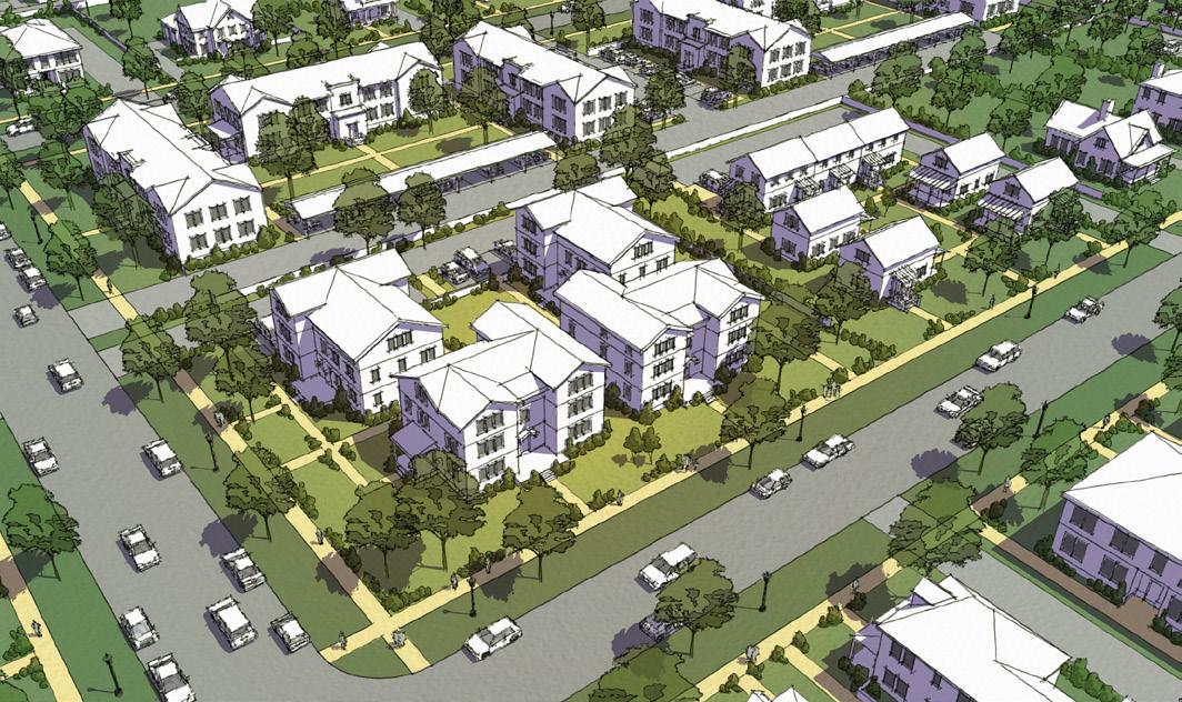
Section 21-03.02: S2 Suburban Neighborhood 2
(a) Intent
The S2 District is established to provide for, maintain, and enhance suburban neighborhoods consisting primarily of apartment complexes or houses grouped together outside of the City's core.
The following are typical characteristics of the S2 District:
• A full range of residential development including single unit, two unit, multi-unit, and ancillary dwelling units that maximize amenities nearby while providing a variety of housing choice
• Larger size buildings with relatively deep setbacks on larger lots
• Attached garages accessed by a driveway from the street or shared parking areas located in the rear or interior of the lot
• Larger city blocks that have a more informal character and plantings
(b) Building types
The following building types are permitted in the S2 District:
Carriage House
Detached House
Cottage Court Duplex
Townhouse
Apartment House
Stacked Flats
The names of the building types are not intended to limit or expand uses allowed within the building. See Section 21-08.02 for building type descriptions and regulations.
Limited public and institutional uses shall be incorporated at a scale and character compatible with the surrounding neighborhood
(c) Principal Uses Use Definition & Standards
Agricultural Community Garden
Civic & Institutional
Neighborhood
College/University
21-06.01(e)(2)
21-06.01(f)(4)
Library/Museum/Cultural Facility 21-06.01(f)(7)
Parks & Open Space 21-06.01(f)(8)
Police/Fire Facilities
Religious Institutions 21-06.01(f)(10)
School, Pre-K/Primary/Secondary
Lodging
Bed & Breakfast
Residential
Dwelling, Ancillary
21-06.01(h)(1)
21-06.01(j)(1)
Dwelling, 1 Unit 21-06.01(j)(2)
Dwelling, 2 Units 21-06.01(j)(3)
Dwelling, Multi-Unit
Dwelling, Mobile Home 21-06.01(j)(6)
Group Residence, State Regulated 21-06.01(j)(7)
Residential Care Facility 21-06.01(j)(8)
Retail & Service
Day Care Center
21-06.01(k)(6)
Entertainment/Recreation Facility, Outdoor 21-06.01(k)(9)
Funeral Services
21-06.01(k)(10)
Transportation Parking Lot 21-06.01(l)(4)
Utilities
Solar Farm 21-06.01(m)(1)
Utilities, Major
Utilities, Minor
Wireless Communications 21-06.01(m)(4)
See Section 21-06.01 for all principal use definitions.
See Section 21-06.02 for accessory use standards.
Key Allowed Allowed subject to Conditions Special Exception Use Specific Standards
S2 Suburban Neighborhood 2


(d) Building Placement
Lot Size
Building Setbacks
All Uses (min.)
Building Coverage
Building Coverage 50% max.
1 Where existing buildings on a block face are not consistent with the required setbacks, any new building may apply the contextual setback per Section 21-02.03(b)
2 Side setback not required between attached dwellings and may be reduced to 10 feet min. for buildings with 4 or fewer dwellings.
(e) Access & Parking
Pedestrian Access
A walkway shall connect the sidewalk or driveway to the main entrance.
Bicycle Access
See Section 21-07.02 for Bicycle Parking requirements.
Parking Access
If access is available from an alley which is open to traffic, there shall be no access allowed from the street.
If allowed, a maximum of one street curb cut is permitted per street frontage.
Parking Lot Location (Distance from Lot Line)
Front & Corner Setback (min.) 25'
Side & Rear Setback (min.) 10'
Side and rear setback shall be 0' when abutting an alley.
Required Spaces
Off-street parking areas are not required for any use.
Any off-street parking areas provided, even though not required, shall be developed in compliance with the standards set forth in Section 21-07.03.
See Section 21-07 for full access and parking requirements.
Form
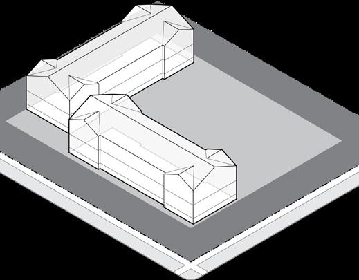
(f) Building Form
Building Height
Primary Building (max.) 40' and 3 stories
Accessory Building (max.) 26'
Accessory buildings shall not be taller than the primary building on a lot.
Building Orientation
Primary facades shall be oriented to a front lot line or open space.
Components

(g) Building Components
Building Entrance
The main entrance shall be located on the front facade, on the corner facade, or on the side facade within 20' of the front facade.
Allowed Encroachments (max.) Front Corner Side Rear
See Section 21-08.01(g) for building component definitions and additional requirements.
Encroachment of Porch
S2 Suburban Neighborhood 2
Building Standards
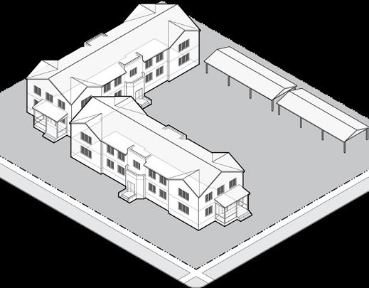
(h) Building Standards
Building Materials
Restrictions on building materials shall apply to all front and corner facades of residential buildings with 5 or more units and non-residential buildings.
Building materials used on the front and corner facades shall extend a minimum depth of 16" along the side facade.
E.I.F.S. is not permitted on the ground floor except as trim.
Standard, fluted, or split face concrete masonry units above the basement level are prohibited as face material. Unfinished metal, plywood, unfinished precast or pouredin-place concrete are prohibited.
Commercial-grade/scale products are prohibited on any residential building facade.
Windows and doors on a ground floor front/corner facade shall have clear, transparent glass that has a min. VLT of 50% and a max. VLR of 25%.
See Section 21-08 for full building standards.

Accessory Structures Allowed
(i) Site Development
Accessory Structures/Uses
Accessory Structures
Mechanical/HVAC
Site Development Key Allowed Not Allowed
Satellite Dish Antennas
21-06.02(f)(1)
21-06.02(f)(14)
21-06.02(f)(22)
Swimming Pool/Hot Tubs 21-06.02(f)(26)
Trash/Recycling Container 21-06.02(f)(27)
Allowed Location in Established Yards
Accessory structures shall not be located in any established front or corner yard.
Accessory structures shall comply with all required setbacks but may encroach into a required rear setback up to 5' of the lot line.
See Section 21-06.02 for full accessory use regulations.
Fence/Freestanding Walls Front Corner Side Rear
Height (max.) 3' 3' 6' 6'
A fence up to 4' is allowed in an established front or corner yard if fence is greater than 50% open.
See Section 21-09 for full site development requirements.

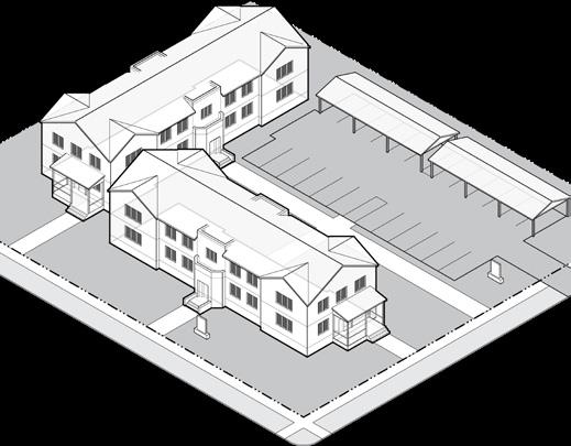
(j) Landscape 2
Streetscape Trees Required
Shade Tree 1 1 tree min. per each full 30' of street frontage
Location Front yard, corner yard, or tree lawn
Foundation Landscape Required 2
Front & Corner Facades
Over 35' Wide 1 shrub per 5' of facade min.
Location Directly adjacent to facade
Buffer Landscape Required 2
Adjacent to S1, U1, or U2 Type 3 buffer
Parking Lot Screening (of 4 or more spaces)
Parking that is visible from a street/open space, other than an alley, shall be screened by a Type 1 buffer.
Buffers shall comply with Section 21-09.01(n)
See Section Section 21-09.01 for full landscape requirements.
1 An existing tree of at least 2" caliper may fulfill this requirement.
2 Residential buildings with 4 or fewer units are exempt from foundation and buffer landscape requirements.
Total Signs Allowed
Residential: 4 or fewer dwellings
Building or
Freestanding Sign 1 per street frontage; up to 2 square feet and 4 feet in height
Residential: 5+ dwelling units
Building or Freestanding Sign 1 per street frontage; up to 32 square feet and 6 feet in height
Non-Residential Use
Building Sign Up to 5% of the total area of the building facade
Freestanding Sign 1 per street frontage; up to 32 square feet and 6 feet in height
Freestanding signs may be located in a required setback, provided they are at least 5' from a lot line.
See Section 21-10 for full sign requirements including changeable copy signs, temporary signs, exempt signs, off-premise, and use-specific signs.
(k) Signs
U1 Urban Neighborhood 1

Section 21-03.03: U1 Urban Neighborhood 1
(a) Intent
The U1 District is established to provide for, promote, and maintain urban neighborhoods located in both the core and outlying areas of the City.
The following are typical characteristics of the U1 District:
• Primarily single and two unit residential development in the form of detached houses, allowing the addition of ancillary dwelling units to give additional value
• Buildings with modest setbacks and inviting building frontages, primarily of stoops and porches, that create a consistent block face along smaller city blocks
• Detached garages located at the rear of the lot, often accessed from an alley
• Pedestrian-oriented scale with sidewalks and regularly spaced street trees
(b) Building types
The following building types are permitted in the U1 District:
Carriage House
Detached House Duplex
The names of the building types are not intended to limit or expand uses allowed within the building. See Section 21-08.02 for building type descriptions and regulations.
Limited public and institutional uses shall be incorporated at a scale and character compatible with the surrounding neighborhood.
(c) Principal Uses
& Institutional
College/University 21-06.01(f)(4)
Library/Museum/Cultural Facility
Religious Institutions
School, Pre-K/Primary/Secondary
Lodging
Bed & Breakfast
Residential
Dwelling, Ancillary
21-06.01(h)(1)
21-06.01(j)(1)
Dwelling, 1 Unit 21-06.01(j)(2)
Dwelling, 2 Units 21-06.01(j)(3)
Group Residence, State Regulated
21-06.01(k)(10)
See Section 21-06.02 for accessory use standards.
Building Placement
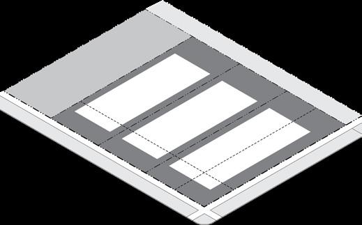

(d) Building Placement Lot Size
Building Setbacks
1 Where existing buildings on a block face are not consistent with the required setbacks, any new building may apply the contextual setback per Section 21-02.03(b)
2 Side setback not required between attached dwellings.
(e) Access & Parking
Pedestrian Access
A walkway shall connect the sidewalk or driveway to the main entrance.
Bicycle Access
See Section 21-07.02 for Bicycle Parking requirements.
Parking Access
If access is available from an alley which is open to traffic, there s hall b e n o a ccess allowed from t he s treet. If allowed, a maximum of one curb cut is permitted per street frontage. A garage facing a street shall be set back not less than 18’.
A garage facing an alley shall be set back 5' from the lot line or not less than 18’.
Parking Lot Location (Distance from Lot Line)
Front & Corner Setback (min.) 5' behind facade, or 12' if no building
Side & Rear Setback (min.) 5'
Side and rear setback shall be 0' when abutting an alley.
Required Spaces
Off-street parking areas are not required for any use. Any off-street parking areas provided, even though not required, shall be developed in compliance with the standards set forth in Section 21-07.03
See Section 21-07 for full access and parking requirements.
Building Components
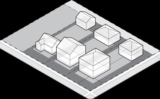

(f) Building Form
Building Height
Primary Building (max.) 35' and 2.5 stories
Accessory Building (max.) 1 18'
Accessory buildings shall not be taller than the primary building on a lot.
Building Orientation
Primary facades shall be oriented to a front lot line or open space.
1 Ancillary dwelling units may be built to a maximum height of 26' if located at least 5' from the rear lot line of a lot with a rear alley or at least 20' from the rear lot line of a lot without a rear alley.
(g) Building Components
Allowed Building Frontage Types
Building Entrance
The main entrance shall be located on the front facade, on the corner facade, or on the side facade within 20' of the front facade.
Allowed Encroachments (max.)
Architectural Features
Building Frontage Type
Bay Window ( < 10' wide)
Patio & Decks (under 30") 8' 8'
Building components shall be at least 18" from any lot line.
See Section 21-08.01(g) for building component definitions and additional requirements.
U1 Urban Neighborhood 1
Building Standards

(h) Building Standards
Facade Transparency (min.)
Ground Floor - Front & Corner Facade 15%
Upper Floor - Front & Corner Facade 15%
Building Materials
There are no restrictions on building materials for residential buildings within the U1 district.
See Section 21-08.01(e) for building material restrictions that shall apply to any non-residential building.
See Section 21-08 for full building standards.
Site Development
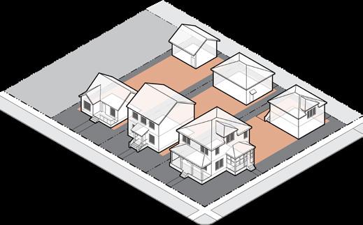
Accessory Structures Allowed
(i) Site Development
Accessory Structures/Uses
Accessory Structures
Mechanical/HVAC
Satellite Dish Antennas
21-06.02(f)(1)
21-06.02(f)(14)
21-06.02(f)(22)
Swimming Pool/Hot Tubs 21-06.02(f)(26)
Allowed Location in Established Yards
Accessory structures shall not be located in any established front or corner yard.
Accessory structures shall comply with all required setbacks but may encroach into a required rear setback up to 5' of the lot line.
See Section 21-06.02 for full accessory use regulations.
Fence/Freestanding Walls Front Corner Side Rear Height (max.) 3' 3' 6' 6'
A fence up to 4' is allowed in an established front or corner yard if fence is greater than 50% open.
See Section 21-09 for full site development requirements.


(j) Landscape 2
Streetscape Trees Required
Shade Tree 1 1 tree min. per each full 30' of street frontage
Location 2 Tree Lawn
Spacing Evenly spaced to extent possible
Foundation Landscape Required 3
Front & Corner Facades
Over 35' Wide 1 shrub per 5' of facade min.
Location Directly adjacent to facade
Parking Lot Screening (of 4 or more spaces)
Parking that is visible from a street/open space, other than an alley, shall be screened by a Type 1 buffer.
Parking that is visible from a side/rear lot line abutting a S1, U1, or U2 district shall be screened by a Type 1 or 2 buffer.
Buffers shall comply with Section 21-09.01(n)
See Section 21-09.01 for full landscape requirements.
1 An existing tree of at least 2" caliper may fulfill this requirement.
2 If a tree cannot be placed in a tree lawn, then required trees may be located in a front or corner established yard.
3 Residential buildings with 4 or fewer units are exempt from foundation landscape requirements.
Signs Allowed
Building or
Freestanding Sign 1 per street frontage; up to 2 square feet and 4 feet in height
Non-Residential Use
Building Sign Up to 5% of the total area of the building facade
Freestanding Sign 1 per street frontage; up to 32 square feet and 6 feet in height
Freestanding signs may be located in a required setback, provided they are at least 5' from a lot line.
See Section 21-10 for full sign requirements including changeable copy signs, temporary signs, exempt signs, off-premise, and use-specific signs.
(k) Signs
U2 Urban Neighborhood 2

Section 21-03.04: U2 Urban Neighborhood 2
(a) Intent
The U2 District is established to provide for, promote, and maintain the development of diverse housing types in urban neighborhoods located near neighborhood centers in both core and outlying areas of the City.
The following are typical characteristics of the U2 District:
• Primarily for single and two unit residential development, allowing up to four units and the addition of ancillary dwelling units to help meet the demand for affordable, urban living
• Buildings with modest setbacks and inviting building frontages, primarily of stoops and porches, that create a consistent block face along smaller city blocks
• Detached garages accessed from an alley
• Pedestrian-oriented scale with sidewalks and regularly spaced street trees
(b) Building types
The following building types are permitted in the U2 District:
Carriage House
Detached House Cottage Court Duplex Townhouse Apartment House
The names of the building types are not intended to limit or expand uses allowed within the building. See Section 21-08.02 for building type descriptions and regulations.
Limited public and institutional uses shall be incorporated at a scale and character compatible with the surrounding neighborhood.
(c) Principal Uses Use Definition & Standards
Agricultural Community Garden
21-06.01(e)(2)
Civic & Institutional Assembly, Neighborhood 21-06.01(f)(1)
College/University
Library/Museum/Cultural Facility
21-06.01(f)(4)
Parks & Open Space 21-06.01(f)(8)
Police/Fire Facilities
Religious Institutions
School, Pre-K/Primary/Secondary
Lodging
Bed & Breakfast
Residential
Dwelling, Ancillary
21-06.01(h)(1)
21-06.01(j)(1)
Dwelling, 1 Unit 21-06.01(j)(2)
Dwelling, 2 Units 21-06.01(j)(3)
Dwelling, Multi-Unit
Group
Retail & Service Day Care Center
21-06.01(k)(6)
Entertainment/Recreation Facility, Outdoor 21-06.01(k)(9)
Funeral Services
Transportation Parking Lot
Utilities
21-06.01(k)(10)
21-06.01(l)(4)
See Section 21-06.02 for accessory use standards.
Building Placement Access & Parking


Minimum Parking Lot Setback
(d) Building Placement
Building Setbacks
1 Where existing buildings on a block face are not consistent with the required setbacks, any new building may apply the contextual setback per Section 21-02.03(b)
2 Side setback not required between attached dwellings.
(e) Access & Parking
Pedestrian Access
A walkway shall connect the sidewalk or driveway to the main entrance.
Bicycle Access
See Section 21-07.02 for Bicycle Parking requirements.
Parking Access
If access is available from an alley which is open to traffic, there shall be no access allowed from the street. If allowed, a maximum of one curb cut is permitted per street frontage.
A garage facing a street shall be set back not less than 18’.
A garage facing an alley shall be set back 5' from the lot line or not less than 18’.
Parking Lot Location (Distance from Lot Line)
Front & Corner Setback (min.) 5' behind facade, or 12' if no building
Side & Rear Setback (min.) 5'
Side and rear setback shall be 0' when abutting an alley.
Required Spaces
Off-street parking areas are not required for any use. Any off-street parking areas provided, even though not required, shall be developed in compliance with the standards set forth in Section 21-07.03
See Section 21-07 for full access and parking requirements.
Pedestrian access to main entrance
Building Form

(f) Building Form
Building Height
Primary Building (max.) 35' and 2.5 stories
Accessory Building (max.) 1 18'
Accessory buildings shall not be taller than the primary building on a lot.
Building Orientation
Primary facades shall be oriented to a front lot line or open space.
1 Ancillary dwelling units may be built to a maximum height of 26' if located at least 5' from the rear lot line of a lot with a rear alley or at least 20' from the rear lot line of a lot without a rear alley.
Building Components
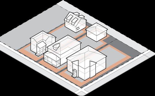
(g) Building Components
Allowed Building Frontage Types
Building Entrance
The main entrance shall be located on the front facade, on the corner facade, or on the side facade within 20' of the front facade.
Allowed Encroachments (max.)
Architectural Features
Building Frontage Type
Bay Window ( < 10' wide) 3' 3' 3' 3'
Patio & Decks (under 30") 8' 8'
Building components shall be at least 18" from any lot line.
See Section 21-08.01(g) for building component definitions and additional requirements.
U2 Urban Neighborhood 2
Building Standards

(h) Building Standards
Facade Transparency (min.)
Ground Floor - Front & Corner Facade 15%
Upper Floor - Front & Corner Facade 15%
Building Materials
There are no restrictions on building materials for residential buildings within the U2 district.
See Section 21-08.01(e) for building material restrictions that shall apply to any non-residential building.
See Section 21-08 for full building standards.
Site Development

Accessory Structures Allowed
(i) Site Development
Accessory Structures/Uses
Accessory Structures
21-06.02(f)(1)
Mechanical/HVAC 21-06.02(f)(14)
Satellite Dish Antennas 21-06.02(f)(22)
Swimming Pool/Hot Tubs 21-06.02(f)(26)
Allowed Location in Established Yards
Accessory structures shall not be located in any established front or corner yard.
Accessory structures shall comply with all required setbacks but may encroach into a required rear setback up to 5' of the lot line.
See Section 21-06.02 for full accessory use regulations.
Fence/Freestanding Walls Front Corner Side Rear
Height (max.) 3' 3' 6' 6'
A fence up to 4' is allowed in an established front or corner yard if fence is greater than 50% open.
See Section 21-09 for full site development requirements.


(j) Landscape 2
Streetscape Trees Required
Shade Tree 1 1 tree min. per each full 30' of street frontage
Location 2 Tree Lawn
Spacing Evenly spaced to extent possible
Foundation Landscape Required 3
Front & Corner Facades
Over 35' Wide 1 shrub per 5' of facade min.
Location Directly adjacent to facade
Parking Lot Screening (of 4 or more spaces)
Parking that is visible from a street/open space, other than an alley, shall be screened by a Type 1 buffer.
Parking that is visible from a side/rear lot line abutting a S1, U1, or U2 district shall be screened by a Type 1 or 2 buffer.
Buffers shall comply with Section 21-09.01(n)
See Section 21-09.01 for full landscape requirements.
1 An existing tree of at least 2" caliper may fulfill this requirement.
2 If a tree cannot be placed in a tree lawn, then required trees may be located in a front or corner established yard.
3 Residential buildings with 4 or fewer units are exempt from foundation landscape requirements.
(k) Signs
Total Signs Allowed
Residential
Building or
Freestanding Sign 1 per street frontage; up to 2 square feet and 4 feet in height
Non-Residential Use
Building Sign Up to 5% of the total area of the building facade
Freestanding Sign 1 per street frontage; up to 32 square feet and 6 feet in height
Freestanding signs may be located in a required setback, provided they are at least 5' from a lot line.
See Section 21-10 for full sign requirements including changeable copy signs, temporary signs, exempt signs, off-premise, and use-specific signs.
Tree Lawn
P Street Trees Allowed PrimaryStreet
U3 Urban Neighborhood 3

Section 21-03.05: U3 Urban Neighborhood 3
(a) Intent
The U3 District is established to provide for, promote, and maintain the development of a full range of housing types located near neighborhood centers and along major streets in urban neighborhoods in core and outlying areas of the City.
The following are typical characteristics of the U3 District:
• Single unit, two unit, and multi-unit residential development, together with ancillary dwelling units, that provides a diversity of housing choices with a range of unit size and affordability
• Buildings with modest setbacks and inviting building frontages, primarily of stoops and porches, that create a consistent block face along smaller city blocks
• Detached garages or shared parking areas accessed from an alley
• Pedestrian-oriented scale with sidewalks and regularly spaced street trees
(b) Building types
The following building types are permitted in the U3 District:
Carriage House
Detached House
Cottage Court
Duplex
Townhouse
Apartment House
Stacked Flats
The names of the building types are not intended to limit or expand uses allowed within the building. See Section 21-08.02 for building type descriptions and regulations.
Limited public and institutional uses shall be incorporated at a scale and character compatible with the surrounding neighborhood.
(c) Principal Uses
(c) Principal Uses (continued)
Library/Museum/Cultural
School, Pre-K/Primary/Secondary
Residential
Dwelling, Ancillary
21-06.01(h)(1)
21-06.01(j)(1)
Dwelling, 1 Unit 21-06.01(j)(2)
Dwelling, 2 Units 21-06.01(j)(3)
Dwelling, Multi-Unit
Group Residence, State Regulated
See Section 21-06.02 for accessory use standards.
U3 Urban Neighborhood 3
Building Placement Access & Parking
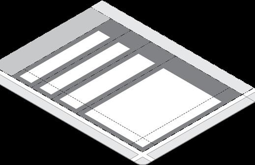

(d) Building Placement
Building Setbacks
1 Where existing buildings on a block face are not consistent with the required setbacks, any new building may apply the contextual setback per Section 21-02.03(b)
2 Side setback not required between attached dwellings.
3 A forecourt per Section 21-08.03(f) may be exempt from this requirement with approval by the Zoning Administrator.
(e) Access & Parking
Pedestrian Access
A walkway shall connect the sidewalk to the main entrance.
Bicycle Access
See Section 21-07.02 for Bicycle Parking requirements.
Parking Access
If access is available from an alley which is open to traffic, there shall be no access allowed from the street.
If allowed, a maximum of one street curb cut is permitted per street frontage.
Parking Lot Location (Distance from Lot Line)
Front & Corner Setback (min.) 5' behind facade, or 12' if no building
Side & Rear Setback (min.) 5'
Side and rear setback shall be 0' when abutting an alley.
Required Spaces
Off-street parking areas are not required for any use.
Any off-street parking areas provided, even though not required, shall be developed in compliance with the standards set forth in Section 21-07.03
See Section 21-07 for full access and parking requirements.
Building Form

Required Setback
(f) Building Form
Building Height
Primary Building (max.) 1 55' and 4 stories
Accessory Building (max.) 26'
Accessory buildings shall not be taller than the primary building on a lot.
Building Orientation
Primary facades shall be oriented to a front lot line or open space.
1 Portions of a primary building in excess of 40’ or 3 stories shall be located at least 40’ from a S1, U1, or U2 District.
Building Components

Zone
(g)
Building Components
Building Entrance
Main entrances shall be prominently located and visible from the primary street or open space.
Allowed Encroachments (max.)
Building Frontage Type
Patio & Decks (under 30") 3' 3'
Building components shall be at least 18" from any lot line.
See Section 21-08.01(g) for building component definitions and additional requirements.
Encroachment of Stoop
U3 Urban Neighborhood 3
Building Standards
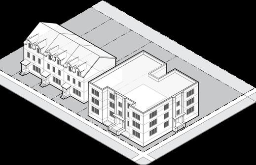
(h)
Building Standards
Facade Transparency (min.)
Ground Floor - Front & Corner Facade 15%
Upper Floor - Front & Corner Facade 15%
Building Materials
Restrictions on building materials shall apply to all front and corner facades of residential buildings with 5 or more units and non-residential buildings.
Building materials used on the front and corner facades shall extend a minimum depth of 16" along the side facade.
E.I.F.S. is not permitted on the ground floor except as trim.
Standard, fluted, or split face concrete masonry units above the basement level are prohibited as face material.
Unfinished metal, plywood, unfinished precast or pouredin-place concrete are prohibited.
Commercial-grade/scale products are prohibited on any residential building facade.
Windows and doors on a ground floor front/corner facade shall have clear, transparent glass that has a min. VLT of 50% and a max. VLR of 25%.
See Section 21-08 for full building standards.
Site Development

Accessory Structures Allowed
(i) Site Development
Accessory Structures/Uses
Accessory Structures
Mechanical/HVAC
Satellite Dish Antennas
Swimming Pool/Hot Tubs
21-06.02(f)(1)
21-06.02(f)(14)
21-06.02(f)(22)
21-06.02(f)(26)
Trash/Recycling Container 21-06.02(f)(27)
Allowed Location in Established Yards
Accessory structures shall not be located in any established front or corner yard.
Accessory structures shall comply with all required setbacks but may encroach into a required rear setback up to 5' of the lot line.
See Section 21-06.02 for full accessory use regulations.
Fence/Freestanding Walls Front Corner Side Rear
Height (max.) 3' 3' 6' 6'
A fence up to 4' is allowed in an established front or corner yard if fence is greater than 50% open.
See Section 21-09 for full site development requirements.
Landscape


(j) Landscape 2
Streetscape Trees Required
Shade Tree 1 1 tree min. per each full 30' of street frontage
Location 2 Tree Lawn
Spacing Evenly spaced to extent possible
Foundation Landscape Required 3
Front & Corner Facades
Over 35' Wide 1 shrub per 5' of facade min.
Location Directly adjacent to facade
Parking Lot Screening (of 4 or more spaces)
Parking that is visible from a street/open space, other than an alley, shall be screened by a Type 1 buffer.
Parking that is visible from a side/rear lot line abutting a S1, U1, or U2 district shall be screened by a Type 1 or 2 buffer.
Buffers shall comply with Section 21-09.01(n)
See Section 21-09.01 for full landscape requirements.
1 An existing tree of at least 2" caliper may fulfill this requirement.
2 If a tree cannot be placed in a tree lawn, then required trees may be located in a front or corner established yard.
3 Residential buildings with 4 or fewer units are exempt from foundation landscape requirements.
Total Signs Allowed
Residential: 4 or fewer dwellings
Building or
Freestanding Sign 1 per street frontage; up to 2 square feet and 4 feet in height
Residential: 5+ dwelling units
Building or
Freestanding Sign 1 per street frontage; up to 32 square feet and 6 feet in height
Non-Residential Use
Building Sign Up to 5% of the total area of the building facade
Freestanding Sign 1 per street frontage; up to 32 square feet and 6 feet in height
Freestanding signs may be located in a required setback, provided they are at least 5' from a lot line.
See Section 21-10 for full sign requirements including changeable copy signs, temporary signs, exempt signs, off-premise, and use-specific signs.
(k) Signs
UF Urban Neighborhood Flex

Section 21-03.06: UF Urban Neighborhood Flex
(a) Intent
The UF District is established to enhance and support a full range of housing types and small-scale commercial uses, found outside neighborhood centers in both core and outlying areas of the City.
The following are typical characteristics of the UF District:
• A mixture of residential development, including single unit, two unit, multi-unit, and ancillary dwelling units that maintains neighborhood stability.
• Integrates limited small-scale office, commercial, and institutional uses that are compatible with the scale and character of the neighborhood
• Buildings with smaller setbacks create a consistent block face along smaller city blocks
• Detached garages or shared parking areas accessed from an alley
• Pedestrian-oriented scale with sidewalks and regularly spaced street trees
(b) Building types
The following building types are permitted in the UF District:
Carriage House
Detached House
Cottage Court
Duplex
Townhouse
Apartment House
Stacked Flats Shop
The names of the building types are not intended to limit or expand uses allowed within the building. See Section 21-08.02 for building type descriptions and regulations.
Limited public and institutional uses shall be incorporated at a scale and character compatible with the surrounding neighborhood.
(c) Principal Uses
Library/Museum/Cultural
School, Pre-K/Primary/Secondary
(c) Principal Uses (continued)
Group Residence, State Regulated
Section 21-06.02 for accessory use standards.
UF Urban Neighborhood Flex
Building Placement Access & Parking

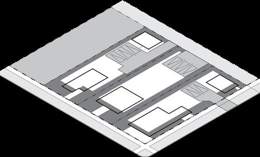
(d) Building Placement
Setbacks
Facade within Setback
Building Coverage
Building Coverage
1 Side setback not required between attached dwellings.
2 Primary buildings on a lot without a rear alley shall have a minimum rear setback of 20' when adjacent to a lot with a ground floor residential use.
3 A forecourt per Section 21-08.03(f) may be exempt from this requirement with approval by the Zoning Administrator.
(e) Access & Parking
Pedestrian Access
A walkway shall connect the sidewalk to the main entrance.
Bicycle Access
See Section 21-07.02 for Bicycle Parking requirements.
Parking Access
If access is available from an alley which is open to traffic, there shall be no access allowed from the street.
If allowed, a maximum of one street curb cut is permitted per street frontage.
Parking Lot Location (Distance from Lot Line)
Front & Corner Setback (min.) 5' behind facade, or 12' if no building
Side & Rear Setback 5'
Side and rear setback shall be 0' when abutting an alley.
Required Spaces
Off-street parking areas are not required for any use.
Any off-street parking areas provided, even though not required, shall be developed in compliance with the standards set forth in Section 21-07.03
See Section 21-07 for full access and parking requirements.
Building Form

Building Components
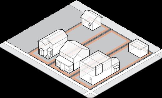
(f) Building Form Building Height
Primary Building (max.) 1 55' and 4 stories
Accessory Building (max.) 26'
Building Orientation
Primary facades shall be oriented to a front lot line or open space
Building Design
Total
1 Portions of a primary building in excess of 40’ or 3 stories shall be located at least 40’ from a S1, U1, or U2 District. (g) Building Components
& Decks (under 30") 3' 3' Building components shall be at least 18" from any lot line. See Section 21-08.01(g) for building component definitions and additional requirements.
UF Urban Neighborhood Flex
Building Standards
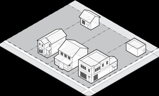
(h)
Building Standards
Facade Transparency (min.)
Ground Floor - Front & Corner Facade 15%
Upper Floor - Front & Corner Facade 15%
Building Materials
Restrictions on building materials shall apply to all front and corner facades of residential buildings with 5 or more units and non-residential buildings.
Building materials used on the front and corner facades shall extend a minimum depth of 16" along the side facade.
E.I.F.S. is not permitted on the ground floor except as trim.
Standard, fluted, or split face concrete masonry units above the basement level are prohibited as face material.
Unfinished metal, plywood, unfinished precast or pouredin-place concrete are prohibited.
Commercial-grade/scale products are prohibited on any residential building facade.
Windows and doors on a ground floor front/corner facade shall have clear, transparent glass that has a min. VLT of 50% and a max. VLR of 25%.
See Section 21-08 for full building standards.
Site Development

Accessory Structures Allowed
(i) Site Development
Accessory Structures/Uses
Accessory Structures
Mechanical/HVAC
Satellite Dish Antennas
Swimming Pool/Hot Tubs
21-06.02(f)(1)
21-06.02(f)(14)
21-06.02(f)(22)
21-06.02(f)(26)
Trash/Recycling Container 21-06.02(f)(27)
Allowed Location in Established Yards
Accessory structures shall not be located in any established front or corner yard and shall comply with all required setbacks.
See Section 21-06.02 for full accessory use regulations.
Fence/Freestanding Walls Front Corner Side Rear
Height (max.) 3' 3' 8' 8'
A fence up to 4' is allowed in an established front or corner yard if fence is greater than 50% open.
See Section 21-09 for full site development requirements.
Landscape
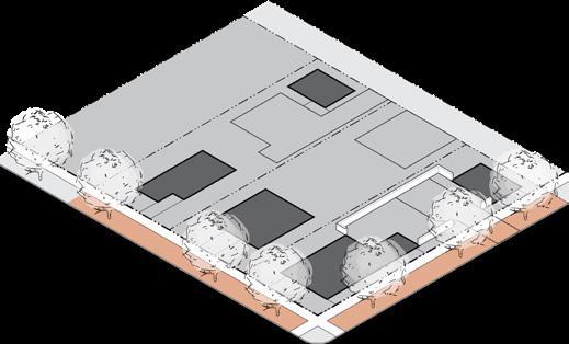

(j) Landscape 2
Streetscape Trees Required
Shade Tree 1 1 tree min. per each full 30' of street frontage
Location 2 Tree lawn
Spacing Evenly spaced to extent possible
Foundation Landscape Required 3
Front & Corner Facades
Over 35' Wide 1 shrub per 5' of facade min.
Location Directly adjacent to facade
Buffer Landscape Required 3
Adjacent to S1 or S2 Type 3 buffer if no street or alley
Parking Lot Screening (of 4 or more spaces)
Parking that is visible from a street/open space, other than an alley, shall be screened by a Type 1 buffer.
Parking that is visible from a side/rear lot line abutting a S1, U1, or U2 district shall be screened by a Type 1 or 2 buffer.
Buffers shall comply with Section 21-09.01(n)
See Section 21-09.01 for full landscape requirements.
1 An existing tree of at least 2" caliper may fulfill this requirement.
2 If a tree cannot be placed in a tree lawn, then required trees may be located in a front or corner established yard.
3 Residential buildings with 4 or fewer units are exempt from foundation and buffer landscape requirements.
(k) Signs
Total Signs Allowed
Residential: 4 or fewer dwellings
Building or Freestanding Sign 1 per street frontage; up to 2 square feet and 4 feet in height
Residential: 5+ dwelling units
Building or Freestanding Sign 1 per street frontage; up to 32 square feet and 6 feet in height
Non-Residential Use
Building Sign Up to 5% of the total area of the building facade
Freestanding Sign 1 per street frontage; up to 32 square feet and 8 feet in height
Freestanding signs may be located in a required setback, provided they are at least 5' from a lot line.
See Section 21-10 for full sign requirements including changeable copy signs, temporary signs, exempt signs, off-premise, and use-specific signs.
Tree Lawn
Street Trees Allowed
Type I Buffer
NC Neighborhood Center

Section 21-03.07: NC Neighborhood Center
(a) Intent
The NC District is established to promote the development of higher intensity, urban neighborhood centers, typically located near the intersection of major streets, in core and outlying areas of the City. The NC District is well connected to surrounding residential neighborhoods.
The following are typical characteristics of the NC District:
• A mixture of storefront retail, professional offices, and dwelling units located in townhouses, apartment buildings, and in the upper stories or rear of mixeduse buildings
• Buildings with active building facades set at or close to the sidewalk
• Pedestrian-oriented scale with wide sidewalks and regularly spaced street trees that creates a walkable environment
(b) Building types
The following building types are permitted in the NC District:
Carriage House Townhouse Apartment House Stacked Flats Shop
The names of the building types are not intended to limit or expand uses allowed within the building. See Section 21-08.02 for building type descriptions and regulations.
(c) Principal Uses Use Definition & Standards Agricultural Community Garden
Civic & Institutional
21-06.01(e)(2)
Assembly, Neighborhood 21-06.01(f)(1) Assembly, General 21-06.01(f)(2)
College/University
Library/Museum/Cultural
Police/Fire Facilities
21-06.01(f)(9)
Religious Institutions 21-06.01(f)(10)
School, Pre-K/Primary/Secondary 21-06.01(f)(11)
Industrial, Manufacturing, & Processing
Industrial, Artisan
Research/Laboratory Facility
Lodging
Bed & Breakfast
21-06.01(g)(1)
21-06.01(g)(4)
21-06.01(h)(1)
Hotel 21-06.01(h)(2)
Office
Professional Offices
Residential
Dwelling, Ancillary
Dwelling, 1 Unit
Dwelling, 2 Units
21-06.01(i)(1)
21-06.01(j)(1)
21-06.01(j)(2)
21-06.01(j)(3)
Dwelling, Multi-Unit 21-06.01(j)(5)
Group Residence
21-06.01(j)(6)
Group Residence, State Regulated 21-06.01(j)(7)
Residential
Building Placement Access & Parking


Parking Lot Setback
(d) Building Placement
Setbacks
Facade within Setback Zone
Building Coverage
Building Coverage
1 If side setback is provided, it shall be a min. of 5'.
2 Primary buildings on a lot without a rear alley shall have a minimum rear setback of 20' when adjacent to a lot with a ground floor residential use.
3 A forecourt per Section 21-08.03(f) may be exempt from this requirement with approval by the Zoning Administrator.
(e) Access & Parking
Pedestrian Access
A walkway shall connect the sidewalk to the main entrance.
Bicycle Access
See Section 21-07.02 for Bicycle Parking requirements.
Parking Access
If access is available from an alley which is open to traffic, there shall be no access allowed from the street.
If allowed, a maximum of one street curb cut is permitted per street frontage.
Parking Lot Location (Distance from Lot Line)
Front & Corner Setback (min.) 5' behind facade, or 12' if no building
Side & Rear Setback 5'
Side and rear setback shall be 0' when abutting an alley.
Required Spaces
Off-street parking areas are not required for any use.
Any off-street parking areas provided, even though not required, shall be developed in compliance with the standards set forth in Section 21-07.03
See Section 21-07 for full access and parking requirements.
Building Form
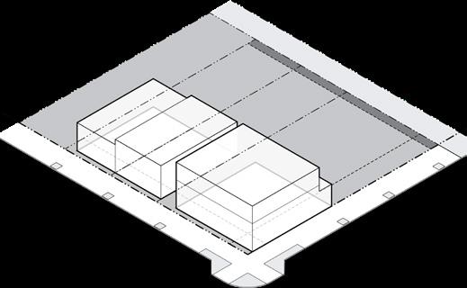
(f) Building Form
Building Height
Primary Building (max.) 1 55' and 4 stories
Primary Front Facade (min.) 16'
Accessory Building (max.) 26'
Building Orientation
Primary facades shall be oriented to a front lot line or open space.
1 Portions of a primary building in excess of 40’ or 3 stories shall be located at least 40’ from a S1, U1, or U2 District.
Building Components

Encroachment of canopy into R.O.W.
(g) Building Components
Building Entrance
Distance between Entries 100' max.
Main entrances shall be prominently located and visible from the primary street or open space.
Allowed Encroachments
Building components may extend into a right-of-way with approval by the Board of Public Works.
See Section 21-08.01(g) for building component definitions and additional requirements.
Building Standards
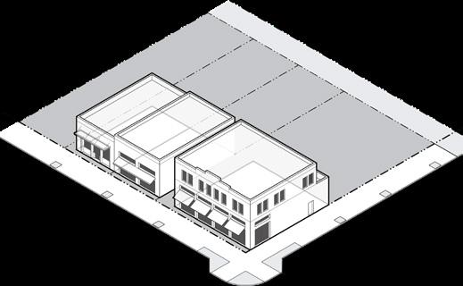
(h)
Building Standards
Facade Transparency (min.)
Ground Floor - Front Facade
Ground Floor - Corner Facade
Floor - Front & Corner Facade
Facade Articulation
Any building greater than 50' wide shall provide vertical articulation into segments no greater than 32' in width and horizontal articulation (base, belt courses, cornice, etc.) to distinguish the ground floor from upper stories.
Building Materials
A minimum of 66% of each front or corner facade shall be constructed of high quality, durable, natural materials, such as stone or brick; wood lap siding; lapped, shingled, or panel fiber cement board siding; and glass. High quality synthetic materials may be approved by the Zoning Administrator. Each front or corner facade shall include at least two architectural elements (e.g., quoins, pilasters, soldier courses, lintels, friezes, cornices, dentils, architraves, etc.).
See Section 21-08.01(e) for all building material standards.
See Section 21-08 for full building standards.
Site Development

Accessory Structures Allowed
(i) Site Development
Accessory Structures/Uses
Accessory Structures
21-06.02(f)(1)
Mechanical/HVAC 21-06.02(f)(14)
Satellite Dish Antennas 21-06.02(f)(22)
Trash/Recycling Container 21-06.02(f)(27)
Allowed Location in Established Yards
Accessory structures shall not be located in any established front or corner yard and shall comply with all required setbacks.
Mechanical equipment and HVAC shall be allowed in front or corner yard if screened per Section 21-06.02(f)(14)
See Section 21-06.02 for full accessory use regulations.
Fence/Freestanding Walls Front Corner Side Rear Height (max.) 3' 3' 8' 8'
A fence up to 4' is allowed in an established front or corner yard if fence is greater than 50% open.
See Section 21-09 for full site development requirements.


(j) Landscape 2
Streetscape Trees Required
Shade Tree 1 1 tree min. per each full 30' of street frontage
Location 2 Tree lawn or tree grates along curb line
Spacing Evenly spaced to extent possible
Buffer Landscape Required 3
Adjacent to S1 or S2 Type 3 buffer if no street or alley
Parking Lot Screening (of 4 or more spaces)
Parking that is visible from a street/open space, other than an alley, shall be screened by a Type 1 buffer.
Parking that is visible from a side/rear lot line abutting a S1, U1, or U2 district shall be screened by a Type 1 or 2 buffer.
Buffers shall comply with Section 21-09.01(n).
See Section 21-09.01 for full landscape requirements.
1 An existing tree of at least 2" caliper may fulfill this requirement.
2 If a tree cannot be placed in a tree lawn, an alternate location may be approved by the Zoning Administrator.
3 Residential buildings with 4 or fewer units are exempt from buffer landscape requirements.
Total Signs Allowed
Residential: 4 or fewer dwellings
Building or Freestanding Sign 1 per street frontage; up to 2 square feet and 4 feet in height
Residential: 5+ dwelling units
Building Sign Up to 10% of the total area of the building facade
Freestanding Sign 1 per street frontage; up to 32 square feet and 8 feet in height
Non-Residential Use
Building Sign Up to 10% of the total area of the building facade
Freestanding Sign 1 per street frontage; up to 32 square feet and 8 feet in height
See Section 21-10 for full sign requirements including changeable copy signs, temporary signs, exempt signs, off-premise, and use-specific signs.
(k) Signs
DT Downtown
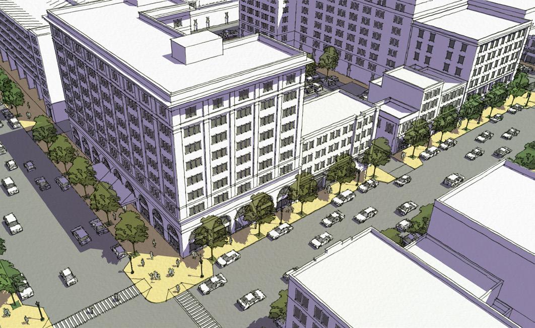
Section 21-03.08: DT Downtown
(a) Intent
The DT District is established to promote the development of the downtown region of the City of South Bend as a high intensity urban center for a multicounty region.
The following are typical characteristics of the DT District:
• A mixture of mid-rise and high rise mixed-use developments, including a variety of compatible building types and urban uses
• Buildings with active building frontages set at or close to the sidewalk
• Pedestrian-oriented scale with wide sidewalks, regularly spaced street trees, and amenities that create a walkable environment
(b) Building types
The following building types are permitted in the DT District:
Townhouse Apartment House Stacked Flats Shop Mid-Rise/Tower
The names of the building types are not intended to limit or expand uses allowed within the building. See Section 21-08.02 for building type descriptions and regulations.
(c) Principal Uses
21-06.01(e)(2) Civic & Institutional
Assembly, Neighborhood 21-06.01(f)(1) Assembly, General
College/University
Library/Museum/Cultural
Police/Fire Facilities 21-06.01(f)(9)
Religious Institutions 21-06.01(f)(10)
School, Pre-K/Primary/Secondary
Industrial, Manufacturing, & Processing Industrial, Artisan
Research/Laboratory Facility
21-06.01(g)(1)
21-06.01(g)(4) Lodging
Bed & Breakfast
21-06.01(h)(1) Hotel 21-06.01(h)(2)
Dwelling, Ancillary
21-06.01(j)(1)
Dwelling, 1 Unit 21-06.01(j)(2)
Dwelling, 2 Units
21-06.01(j)(3)
Dwelling, Multi-Unit 21-06.01(j)(5)
Group Residence
Group Residence, State Regulated
Residential Care
Building Placement Access & Parking


Parking Lot Setback
(d) Building Placement
St. Joseph River/East Race
Facade within Setback Zone
1 If side or rear setback is provided, it shall be a min. of 5'.
2 Primary buildings on a lot without a rear alley shall have a minimum rear setback of 20' when adjacent to a lot with a ground floor residential use that is not in a DT district.
3 A forecourt per Section 21-08.03(f) may be exempt from this requirement with approval by the Zoning Administrator.
(e) Access & Parking
Pedestrian Access
A walkway shall connect the sidewalk to the main entrance.
Bicycle Access
See Section 21-07.02 for Bicycle Parking requirements.
Parking Access
If access is available from an alley which is open to traffic, there shall be no access allowed from the street.
If allowed, a maximum of one street curb cut is permitted per street frontage.
Parking Lot Location (Distance from Lot Line)
Front & Corner Setback (min.) 5' behind facade, or 10' if no building
Side & Rear Setback 0'
Required Spaces
Off-street parking areas are not required for any use.
Any off-street parking areas provided, even though not required, shall be developed in compliance with the standards set forth in Section 21-07.03.
See Section 21-07 for full access and parking requirements.
Building Form
(f) Building Form
Building Height
Primary Building (max.)
West of the St. Joseph River 150' and 12 stories
Between St. Joseph River and East Race Waterway 150' and 12 stories
East of the East Race Waterway 60' and 5 stories
Primary Front Facade (min.) 16'
Accessory Building (max.) 26'
Building Orientation
Primary facades shall be oriented to a front lot line or open space.
Building Components
(g) Building Components
Building Entrance
Distance between Entries 100' max.
Main entrances shall be prominently located and visible from the primary street or open space.
Allowed Encroachments
Building components may extend into a right-of-way with approval by the Board of Public Works.
See Section 21-08.01(g) for building component definitions and additional requirements.
Encroachment of canopy into R.O.W.
Building Standards
(h) Building Standards
Facade Transparency (min.)
Ground Floor - Front & Corner Facade
Upper Floor - Front & Corner Facade
Facade Articulation
Any building greater than 50' wide shall provide vertical articulation into segments no greater than 32' in width and horizontal articulation (base, belt courses, cornice, etc.) to distinguish the ground floor from upper stories.
Building Materials
A minimum of 66% of each front or corner facade shall be constructed of high quality, durable, natural materials, such as stone or brick; wood lap siding; lapped, shingled, or panel fiber cement board siding; and glass. High quality synthetic materials may be approved by the Zoning Administrator. Each front or corner facade shall include at least two architectural elements (e.g., quoins, pilasters, soldier courses, lintels, friezes, cornices, dentils, architraves, etc.).
See Section 21-08.01(e) for all building material standards.
See Section 21-08 for full building standards.
Site Development

Accessory Structures Allowed
(i) Site Development
Accessory Structures/Uses
Accessory Structures
21-06.02(f)(1)
Mechanical/HVAC 21-06.02(f)(14)
Satellite Dish Antennas 21-06.02(f)(22)
Trash/Recycling Container 21-06.02(f)(27)
Allowed Location in Established Yards
Accessory structures shall not be located in any established front or corner yard and shall comply with all required setbacks.
Mechanical equipment and HVAC shall be allowed in front or corner yard if screened per Section 21-06.02(f)(14)
See Section 21-06.02 for full accessory use regulations.
Fence/Freestanding Walls Front Corner Side Rear Height (max.) 3' 3' 8' 8'
A fence up to 4' is allowed in an established front or corner yard if fence is greater than 50% open.
See Section 21-09 for full site development requirements.

(j) Landscape 2
Streetscape Trees Required
Shade Tree 1 1 tree min. per each full 30' of street frontage
Location 2 Tree lawn or tree grates along curb line
Spacing Evenly spaced to extent possible
Buffer Landscape Required 3
Adjacent to S1, S2, U1, or U2 Type 3 buffer if no street or alley present
Parking
Lot Screening (of 4 or more spaces)
Parking that is visible from a street/open space, other than an alley, shall be screened by a Type 1 buffer.
Parking that is visible from a side/rear lot line abutting a S1, U1, or U2 district shall be screened by a Type 1 or 2 buffer.
Buffers shall comply with Section 21-09.01(n).
See Section 21-09.01 for full landscape requirements.
1 An existing tree of at least 2" caliper may fulfill this requirement.
2 If a tree cannot be placed in a tree lawn, an alternate location may be approved by the Zoning Administrator.
3 Residential buildings with 4 or fewer units are exempt from buffer landscape requirements.
Total Signs Allowed
Residential: 4 or fewer dwellings
Building Sign 1 per street frontage; up to 2 square feet and 4 feet in height
Residential: 5+ dwelling units
Building Sign Up to 10% of the total area of the building facade
Non-Residential Use
Building Sign Up to 10% of the total area of the building facade
See Section 21-10 for full sign requirements including changeable copy signs, temporary signs, exempt signs, off-premise, and use-specific signs.
(k) Signs
Article 21-04: Special Districts
Sections
Section
Section 21-04.03: C Commercial ........................ 4-15
Section 21-04.04: I Industrial 4-21
This page intentionally left blank
OS Open Space
Section 21-04.01: OS Open Space
(a) Intent
The OS District is established to promote the development of a range of publicly owned open spaces dispersed throughout the City.
The following are typical characteristics of the OS District:
• Active or passive open spaces, including neighborhood parks, formal greens or plazas, greenways, trails, recreational fields, or natural spaces that accommodate a wide range of ages, physical abilities, and programming
• Buildings and uses that activate and address the open space or support park functions
• Wide sidewalks and pathways for multiple uses surrounded by a formal or informal arrangement of trees and landscaping
• Seating and site amenities that encourage pedestrian use and comfort
(b) principal Uses
See Section 21-06.02 for accessory use standards.
OS Open Space
Building Placement

Access & Parking

(d) Access & Parking
Pedestrian Access
Building Setbacks (min.)
Adjacent to
Adjacent to all other
All parks shall have at least one pedestrian access point from each abutting street.
Paths within the open space shall provide pedestrians with convenient routes between abutting streets, building entrances, and major design features.
Paths may meander to take advantage of view corridors or topographical and landscape features.
Bicycle Access
See Section 21-07.02 for Bicycle Parking requirements.
Parking Lot Location (Distance from Lot Line)
Front & Corner Setback (min.) 12'
Side & Rear Setback (min.) 10'
Required Spaces
Off-street parking areas are not required for any use.
Any off-street parking areas provided, even though not required, shall be developed in compliance with the standards set forth in Section 21-07.03.
See Section 21-07 for full access and parking requirements.
(c) Building Placement
Rear
Building Components Building Form
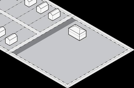

(e) Building Form
Building Height
All Buildings (max.) 35'
Building Orientation
Primary facades shall be oriented to a front lot line or open space.
(f) Building Components
Building Entrance
Main entrances shall be prominently located and visible from the primary street or open space.
Allowed Encroachments
Building components may extend into a right-of-way with approval by the Board of Public Works.
See Section 21-08.01(g) for building component definitions and additional requirements.
Building Standards

(g) Building Standards
Building Materials
Restrictions on building materials shall apply to all front and corner facades of non-residential buildings.
Building materials used on the front and corner facade shall extend a minimum depth of 16" along the side facade.
E.I.F.S. is not permitted on the ground floor except as trim.
Standard, fluted, or split face concrete masonry units above the basement level are prohibited as face material.
Unfinished metal, plywood, unfinished precast or pouredin-place concrete are prohibited.
Windows and doors on a ground floor front/corner facade shall have clear, transparent glass that has a min. VLT of 50% and a max. VLR of 25%.
See Section 21-08 for full building standards.
Site Development

(h) Site Development
Accessory Structures/Uses Accessory
See Section 21-06.02 for full accessory use regulations.
Fence/Freestanding Walls Front Corner Side Rear Height (max.) 3' 3' 8' 8'
A fence up to 4' is allowed in an established front or corner yard if fence is greater than 50% open.
A fence up to 8' max. is allowed to enclose maintenance facilities, storage, or other utilities.
An open fence enclosing a game court may be erected to a maximum of 12' in height.
See Section 21-09 for full site development requirements.
Landscape Signs
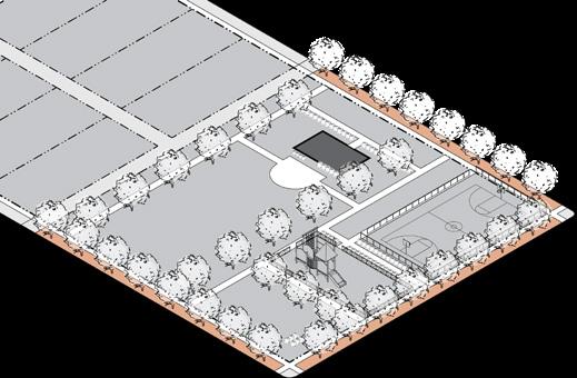
(i) Landscape 2
Streetscape Trees Required
Shade Tree 1 1 tree min. per each full 30' of street frontage
Location 2 Tree lawn
Spacing Evenly spaced to extent possible
Foundation Landscape Required 3
Front & Corner Facades
Over 35' Wide 1 shrub per 5' of facade min.
Location Directly adjacent to facade
Buffer Landscape Required
Adjacent to S1 Type 3 buffer if no street or alley
Parking Lot Screening (of 4 or more spaces)
Parking that is visible from a street/open space, other than an alley, shall be screened by a Type 1 buffer.
Parking that is visible from a side/rear lot line abutting a S1, U1, or U2 district shall be screened by a Type 1 or 2 buffer.
Buffers shall comply with Section 21-09.01(n)
See Section 21-09.01 for full landscape requirements.
1 An existing tree of at least 2" caliper may fulfill this requirement.
2 If a tree cannot be placed in a tree lawn, an alternate location may be approved by the Zoning Administrator.
3 The Zoning Administrator may waive the requirement for foundation landscape if a building is located more than 50' from the street.

(j) Signs
Total Signs Allowed
Building Sign Up to 10% of the total area of the building facade
Freestanding Sign 1 per street frontage; up to 64 square feet and 8 feet in height
Freestanding signs may be located in a required setback, provided they are at least 5' from a lot line.
See Section 21-10 for full sign requirements including changeable copy signs, temporary signs, exempt signs, off-premise, and use-specific signs.

Section 21-04.02: U University
(a) Intent
The U District is established to promote the development of major college or university campuses.
The following are typical characteristics of the U District:
• A diversity of uses, functions, and facilities that facilitate the highest level of education
• A range of commercial uses which are accessory to or typically associated with a college or university campus, such as a bookstore, hotel, food sales and service, school supplies, and personal services.
• Pedestrian-oriented scale with sidewalks and a formal or informal arrangement of trees and landscaping.


(c) Building Placement
Building Setbacks (min.)
Adjacent to S1, S2, U1, or U2 25' 25' 10' 20'
Adjacent to all other zones 10'
(d) Access & Parking
Pedestrian Access
A walkway shall connect the sidewalk to the main entrance.
Bicycle Access
See Section 21-07.02 for Bicycle Parking requirements.
Parking Lot Location (Distance from Lot Line)
Front & Corner Setback (min.) 12'
Side Setback 10'
Rear Setback 20'
Required Spaces
Off-street parking areas are not required for any use. Any off-street parking areas provided, even though not required, shall be developed in compliance with the standards set forth in Section 21-07.03.
See Section 21-07 for full access and parking requirements.

(e) Building Form
Building Height
All Buildings (max.) None
If a portion of any lot line is across from a district that permits 1 unit dwellings, the maximum height shall not exceed 35 feet plus one additional foot of building height for each additional foot of setback provided.
Building Orientation
Primary facades shall be oriented to a front lot line, open space, or pedestrian pathway.

(f) Building Components
Building Entrance
Main entrances shall be prominently located and visible from the primary street or open space.
Allowed Encroachments (max.) Front Corner Side Rear
Architectural Features 3' 3'
Building Frontage Type 10' 10'
See Section 21-08.01(g) for building component definitions and additional requirements.
U University
Building Standards

(g) Building Standards
Building Materials
Restrictions on building materials shall apply to all front and corner facades of non-residential buildings.
Building materials used on the front and corner facade shall extend a minimum depth of 16" along the side facade.
E.I.F.S. is not permitted on the ground floor except as trim. Standard, fluted, or split face concrete masonry units above the basement level are prohibited as face material. Unfinished metal, plywood, unfinished precast or pouredin-place concrete are prohibited.
Commercial-grade/scale products are prohibited on any residential building facade.
Windows and doors on a ground floor front/corner facade shall have clear, transparent glass that has a min. VLT of 50% and a max. VLR of 25%.
See Section 21-08 for full building standards.
Site Development

Accessory Structures Allowed
(h) Site Development
Accessory Structures/Uses
Accessory
Allowed Location in Established Yards
Accessory structures shall not be located in any established front or corner yard.
Accessory structures shall comply with all required setbacks but may encroach into a required rear setback up to 5' of the lot line.
See Section 21-06.02 for full accessory use regulations.
Fence/Freestanding Walls Front Corner Side Rear Height (max.) 3' 3' 8' 8'
A fence up to 4' is allowed in an established front or corner yard if fence is greater than 50% open.
A fence up to 8' max. is allowed to enclose maintenance facilities, storage, or other utilities.
An open fence enclosing a game court may be erected to a maximum of 12' in height.
See Section 21-09 for full site development requirements.

(i) Landscape 2
Streetscape Trees Required
Shade Tree 1 1 tree min. per each full 30' of street frontage
Location 2 Tree lawn
Spacing Evenly spaced to extent possible
Foundation Landscape Required 3
Front & Corner Facades
Over 35' Wide 1 shrub per 5' of facade min.
Location Directly adjacent to facade
Buffer Landscape Required
Adjacent to S1, S2, U1, or U2 Type 3 buffer if no street or alley present
Parking Lot Screening (of 4 or more spaces)
Parking that is visible from a street/open space, other than an alley, shall be screened by a Type 1 buffer.
Parking that is visible from a side/rear lot line abutting a S1, U1, or U2 district shall be screened by a Type 1 or 2 buffer.
Buffers shall comply with Section 21-09.01(n)
See Section 21-09.01 for full landscape requirements.
1 An existing tree of at least 2" caliper may fulfill this requirement.
2 If a tree cannot be placed in a tree lawn, an alternate location may be approved by the Zoning Administrator.
3 The Zoning Administrator may waive the requirement for foundation landscape if a building is located more than 50' from the street.

(j) Signs
Total Signs Allowed
Building Sign Up to 10% of the total area of the building facade
Freestanding Sign 1 per street frontage; up to 64 square feet and 8 feet in height
Freestanding signs may be located in a required setback, provided they are at least 5' from a lot line.
See Section 21-10 for full sign requirements including changeable copy signs, temporary signs, exempt signs, off-premise, and use-specific signs.

Section 21-04.03: C Commercial
(a) Intent
The C District is established to provide a location for medium- to high-intensity commercial uses that are auto-oriented, typically located along major corridors at the fringe of the City or as small groupings located outside of neighborhood centers.
The following are typical characteristics of the C District:
• Auto-oriented commercial uses that may include outdoor sales or operations
• Buildings located on larger lots and city blocks in a suburban format
• Coordinated to facilitate vehicular and pedestrian access from nearby neighborhoods
• Landscaped to be attractive and provide appropriate buffering to residential uses
(b) principal Uses
Agricultural Plant Agriculture
21-06.01(e)(1) Community Garden 21-06.01(e)(2)
Civic & Institutional
Assembly, Neighborhood 21-06.01(f)(1)
Assembly, General
College/University 21-06.01(f)(4)
Correctional
Library/Museum/Cultural Facility 21-06.01(f)(7)
Parks & Open Space 21-06.01(f)(8)
Police/Fire Facilities
21-06.01(f)(9)
Religious Institutions 21-06.01(f)(10)
School, Pre-K/Primary/Secondary 21-06.01(f)(11)
Industrial, Manufacturing, & Processing
Industrial, Artisan
21-06.01(g)(1)
Research/Laboratory Facility 21-06.01(g)(4)
Lodging
Bed & Breakfast
Office Professional Offices
Animal
Drive-Through Facility
21-06.01(h)(1)


(c) Building Placement
Lot Size
Building Setbacks (min.)
Adjacent to S1, S2, U1, U2, U3, or UF
Adjacent to all other zones
(d) Access & Parking
Pedestrian Access
A walkway shall connect the sidewalk to the main entrance.
Bicycle Access
See Section 21-07.02 for Bicycle Parking requirements.
Parking Access
If access is available from an alley which is open to traffic, there shall be no access allowed from the street. If allowed, a maximum of one street curb cut is permitted per street frontage. Lots with large frontages may be granted a second street curb cut per the latest standards adopted by the Board of Public Works.
Parking Lot Location (Distance from Lot Line)
Parking is not allowed within any required building setback.
Required Spaces
Off-street parking areas are not required for any use. Any off-street parking areas provided, even though not required, shall be developed in compliance with the standards set forth in Section 21-07.03
See Section 21-07 for full access and parking requirements.
Components
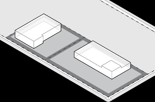
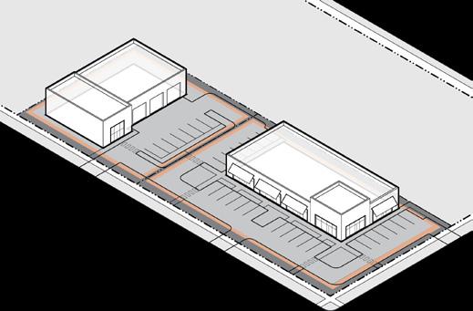
(e) Building Form
Building Height
All Buildings (max.) 1 55'
Accessory Building (max.) 26'
Building Orientation
Primary facades shall be oriented to a front lot line or open space.
1 Portions of a primary building in excess of 40’ or 3 stories shall be located at least 40’ from a S1, U1, or U2 District.
(f) Building Components
Building Entrance
Main entrances shall be prominently located and visible from the primary street or open space.
Allowed Encroachments (max.) Front Corner Side Rear
Architectural Features 3' 3' 3' 3'
See Section 21-08.01(g) for building component definitions and additional requirements.
C Commercial
Building Standards
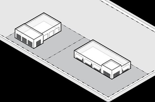
(g) Building Standards
Facade Transparency (min.)
Ground Floor - Front Facade 40%
Ground Floor - Corner Facade 1 20%
Building Materials
A minimum of 66% of each front or corner facade shall be constructed of E.I.F.S. or high quality natural materials, such as stone or brick; wood lap siding; fiber cement board siding; and glass. High quality synthetic materials may be approved by the Zoning Administrator. E.I.F.S. may constitute a maximum of 66% of the ground floor facade.
Building materials used on the front and corner facades shall extend a minimum depth of 16" along the side facade. Standard, fluted, or split face concrete masonry units above the basement level are prohibited as face material. Unfinished metal, plywood, unfinished precast or pouredin-place concrete are prohibited.
Windows and doors on a ground floor front/corner facade shall have clear, transparent glass that has a min. VLT of 50% and a max. VLR of 25%.
See Section 21-08 for full building standards.
1 If a building is located more than 50’ from the corner lot line, the Zoning Administrator may waive this requirement if the transparency is not needed to meet the intent of this ordinance.
Site Development

Accessory Structures Allowed
(h) Site Development
Accessory Structures/Uses
Accessory Structures
Drive-Through
21-06.02(f)(1)
21-06.01(k)(7)
Mechanical/HVAC 21-06.02(f)(14)
Satellite Dish Antennas 21-06.02(f)(22)
Trash/Recycling Container 21-06.02(f)(27)
Allowed Location in Established Yards
Accessory structures shall not be located in any established front or corner yard.
Accessory structures shall comply with all required setbacks but may encroach into a required rear setback up to 5' of the lot line.
See Section 21-06.02 for full accessory use regulations.
Fence/Freestanding Walls Front Corner Side Rear
Height (max.) 3' 3' 8' 8'
A fence up to 4' is allowed in an established front or corner yard if fence is greater than 50% open.
See Section 21-09 for full site development requirements.
Landscape
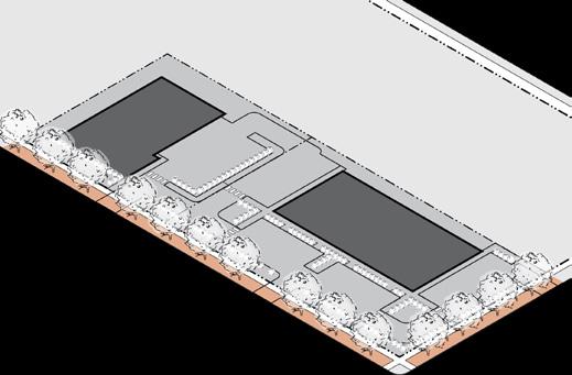
(i) Landscape 2
Streetscape Trees Required
Shade Tree 1 1 tree min. per each full 30' of street frontage
Location 2 Tree lawn
Spacing Evenly spaced to extent possible
Foundation Landscape Required 3
Front & Corner Facades
Over 35' Wide 1 shrub per 5' of facade min.
Location Directly adjacent to facade
Buffer Landscape Required
Adjacent to S1, S2, U1, U2, U3, or UF Type 3 buffer if no street or alley present
Parking Lot Screening (of 4 or more spaces)
Parking that is visible from a street/open space, other than an alley, shall be screened by a Type 1 buffer.
Parking that is visible from a side/rear lot line abutting a S1, U1, or U2 district shall be screened by a Type 1 or 2 buffer.
Buffers shall comply with Section 21-09.01(n)
See Section 21-09.01 for full landscape requirements.
1 An existing tree of at least 2" caliper may fulfill this requirement.
2 If a tree cannot be placed in a tree lawn, an alternate location may be approved by the Zoning Administrator.
3 The Zoning Administrator may waive the requirement for foundation landscape if a building is located more than 50' from the street.
Signs
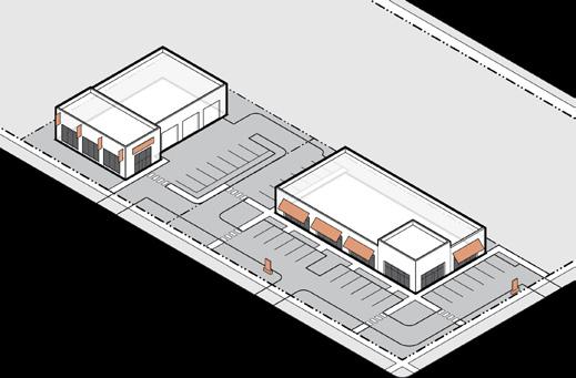
Total Signs Allowed
Building Sign Up to 10% of the total area of the building facade
Freestanding Sign 1 1 per street frontage; up to 100 square feet 2 and 15 feet in height 3
Freestanding signs may be located in a required setback, provided they are at least 5' from a lot line.
See Section 21-10 for full sign requirements including changeable copy signs, temporary signs, exempt signs, off-premise, and use-specific signs.
1 If lot frontage is greater than 500', then additional signs are allowed at a rate of one sign for every 500' of additional frontage, or portion thereof. Total sign area may be combined into one larger sign or divided between multiple signs with a minimum separation of 100'.
2 Sign area of a multi-tenant sign may increase to 140 square feet maximum. If lot frontage is greater than 500', the sign area of a multi-tenant sign shall increase to 300 square feet maximum.
3 Sign height may increase to 30' max. for a multi-tenant sign or 35' max. when oriented to a limited access highway.
(j) Signs
Tree Lawn
Section 21-04.04: I Industrial
(a) Intent
The I District is established to provide a location for medium to high intensity industrial uses, typically grouped along highways and major streets and separated from residential uses.
The following are typical characteristics of the I District:
• Office/warehouse, distribution, wholesale, assembly, and manufacturing or processing facilities that may require substantial amounts of outdoor storage or operations
• Uses typically generate heavy traffic
• Buildings located on larger lots on bigger city blocks
• Landscaped to be attractive and provide appropriate buffering to other uses
(b) principal Uses Use Definition & Standards
Agricultural
Plant Agriculture
Community Garden
21-06.01(e)(1)
21-06.01(e)(2)
Indoor Food Production 21-06.01(e)(3)
Civic & Institutional
Assembly, Neighborhood
Assembly, General
21-06.01(f)(1)
21-06.01(f)(2)
Cemetery 21-06.01(f)(3)
College/University 21-06.01(f)(4)
Correctional Facility 21-06.01(f)(5)
Hospital 21-06.01(f)(6)
Library/Museum/Cultural Facility
21-06.01(f)(7)
Parks & Open Space 21-06.01(f)(8)
Police/Fire Facilities
Religious Institutions
School, Pre-K/Primary/Secondary
21-06.01(f)(9)
21-06.01(f)(10)
21-06.01(f)(11)
Zoo 21-06.01(f)(12)
Industrial, Manufacturing, & Processing
Industrial, Artisan
21-06.01(g)(1)
Industrial, Heavy 21-06.01(g)(2)
Industrial, Light
Research/Laboratory Facility
Warehouse/Distribution Facility
Waste Processing/Recycling Facility
Lodging
Bed & Breakfast
21-06.01(g)(3)
21-06.01(g)(4)
(b) Principal Uses (continued)
(continued)
Animal Care Establishment
21-06.01(h)(1)
Building Placement Access & Parking

(c) Building Placement
Lot Size
Lot Width 100' min.
Building Setbacks (min.) Front Corner Side Rear
Adjacent to S1, S2, U1, U2, U3, or UF 30' 30' 50' 50'
Adjacent to all other zones 15' 15' 10' 10'
Building Coverage
Building Coverage
(d) Access & Parking
Pedestrian Access
A walkway shall connect the sidewalk to the main entrance.
Bicycle Access
See Section 21-07.02 for Bicycle Parking requirements.
Parking Access
A maximum of one street curb cut is permitted per street frontage. Lots with large frontages may be granted a second street curb cut per the latest standards adopted by the Board of Public Works.
Parking Lot Location (Distance from Lot Line)
Parking is not allowed within any required building setback.
Required Spaces
Off-street parking areas are not required for any use.
Any off-street parking areas provided, even though not required, shall be developed in compliance with the standards set forth in Section 21-07.03.
See Section 21-07 for full access and parking requirements.
Building Components Building Form

Setback
(e) Building Form
Building Height
All Buildings (max.) 1 60'
Building Orientation
Primary facades shall be oriented to a front lot line or open space
1 The setback for any portion of a building or structure that is over 35' in height shall be increased by 1' for each foot of height above 35'.

Zone
(f) Building Components
Building Entrance
Main entrances shall be prominently located and visible from the primary street or open space.
Allowed Encroachments (max.) Front Corner Side Rear
Architectural Features 3' 3' 3' 3'
See Section 21-08.01(g) for building component definitions and additional requirements.
Building Standards

PrimaryStreet
SecondaryStreet
(g) Building Standards
Building Materials
Restrictions on building materials shall apply to all front and corner facades of non-residential buildings.
Building materials used on the front and corner facades shall extend a minimum depth of 16" along the side facade. E.I.F.S. may constitute a maximum of 66 percent of the ground floor facade.
Standard, fluted, or split face concrete masonry units above the basement level are prohibited as face material. Unfinished metal, plywood, unfinished precast or pouredin-place concrete are prohibited.
See Section 21-08 for full building standards.
Site Development
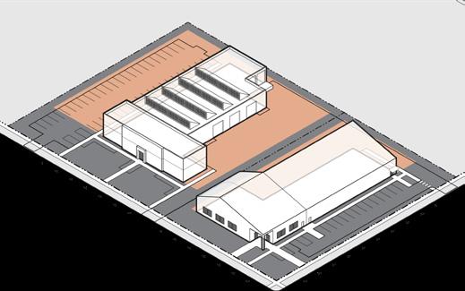
PrimaryStreet
Accessory Structures Allowed
(h) Site Development
Accessory Structures/Uses
Accessory Structures
SecondaryStreet
21-06.02(f)(1)
Drive-Through 21-06.01(k)(7)
Mechanical/HVAC 21-06.02(f)(14)
Satellite Dish Antennas 21-06.02(f)(22)
Trash/Recycling Container 21-06.02(f)(27)
Allowed Location in Established Yards
Accessory structures shall not be located in any established front or corner yard.
Accessory structures shall comply with all required setbacks but may encroach into a required rear setback up to 5' of the lot line.
See Section 21-06.02 for full accessory use regulations. Fence/Freestanding Walls Front Corner Side Rear Height (max.) 4' 4' 10' 10'
A fence up to 6' is allowed in an established front or corner yard if fence is greater than 50% open.
See Section 21-09 for full site development requirements.
Landscape

(i) Landscape 2
Streetscape Trees Required
Shade Tree 1 1 tree min. per each full 30' of street frontage
Location 2 Tree lawn
Spacing Evenly spaced to extent possible
Foundation Landscape Required 3
Front & Corner Facades
Over 35' Wide 1 shrub per 5' of facade min.
Location Directly adjacent to facade
Buffer Landscape Required
Adjacent to S1, S2, U1, U2, U3, or UF Type 3 buffer if no street or alley present
Parking Lot Screening (of 4 or more spaces)
Parking that is visible from a street/open space, other than an alley, shall be screened by a Type 1 buffer.
Parking that is visible from a side/rear lot line abutting a S1, U1, or U2 district shall be screened by a Type 1 or 2 buffer.
Buffers shall comply with Section 21-09.01(n)
See Section 21-09.01 for full landscape requirements.
1 An existing tree of at least 2" caliper may fulfill this requirement.
2 If a tree cannot be placed in a tree lawn, an alternate location may be approved by the Zoning Administrator.
3 The Zoning Administrator may waive the requirement for foundation landscape if a building is located more than 50' from the street.
Signs
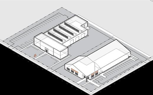
Total Signs Allowed
Building Sign Up to 10% of the total area of the building facade
Freestanding Sign 1 1 per street frontage; up to 100 square feet 2 and 15 feet in height 3
Freestanding signs may be located in a required setback, provided they are at least 5' from a lot line.
See Section 21-10 for full sign requirements including changeable copy signs, temporary signs, exempt signs, off-premise, and use-specific signs.
1 If lot frontage is greater than 500', then additional signs are allowed at a rate of one sign for every 500' of additional frontage, or portion thereof. Total sign area may be combined into one larger sign or divided between multiple signs with a minimum separation of 100'.
2 Sign area of a multi-tenant sign may increase to 140 square feet maximum. If lot frontage is greater than 500', the sign area of a multi-tenant sign shall increase to 300 square feet maximum.
3 Sign height may increase to 30' max. for a multi-tenant sign or 35' max. when oriented to a limited access highway.
(j) Signs
Article 21-05:
Overlay Districts
Sections
Section 21-05.01: HP Historic Preservation Overlay 5-2
Section 21-05.02: NNZO Northeast Neighborhood Zoning Overlay .............................. 5-3

Section 21-05.01: HP Historic Preservation Overlay
(a) Intent
The HP Overlay District is established to preserve buildings, other structures, and sites of historical, architectural, engineering, and cultural significance in South Bend.
(b) Applicability
Any construction, reconstruction, alteration, demolition, or moving of any exterior feature of any building, structure, or use in the HP Overlay District, in a historic preservation district, or designated as a historic landmark shall comply with the standards of this section.
(c) Relation to Other Zoning Ordinance standards
HP is a zoning overlay that does not change the underlying base zoning but does include additional standards for these areas.
(d) General Provisions
A certificate of appropriateness issued by the Historic Preservation Commission shall be required prior to the construction, reconstruction, alteration, demolition, or moving of any exterior feature of any building, structure, or use in the HP Overlay District. Preservation standards are available on the Historic Preservation Commission website.
NNZO Northeast Neighborhood Zoning Overlay
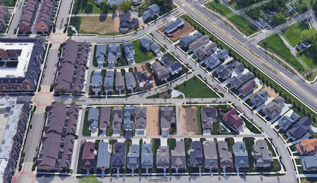
Section 21-05.02: NNZO Northeast Neighborhood Zoning Overlay
(a) Intent
The NNZO District is established to accomplish the following purposes:
(1) To establish a comprehensive design approach for the NNZO;
(2) To encourage high-quality design of new buildings and site development that preserves and enhances the character of a traditional neighborhood;
(3) To create a strong, unique neighborhood identity;
(4) To provide a range of design options to address future development opportunities; and,
(5) To instill and enforce the sense of “pride of place” among residents, businesses, and property owners.
(b) Applicability
Notwithstanding any provision elsewhere in the South Bend Zoning Ordinance to the contrary, all new development within the NNZO shall be subject to the regulations of this section.
(1) New Development. The regulations contained in this NNZO shall be applicable to all new construction on real property located within the area designated as the Northeast Neighborhood Zoning Overlay District on the Zoning Map for the City of South Bend. In order to assure the compatibility of new development within the NNZO area with that of the surrounding community, any new building, structure, or sign within the NNZO shall be subject to the regulations contained in this overlay.
(2) Renovations and Expansion of Existing Buildings. Renovations or expansions of existing buildings, structures, or signs are not subject to the regulations of this NNZO but shall be subject to all applicable regulations of the underlying zoning district.
(c) Relationship to the Zoning Ordinance
The NNZO provides more comprehensive standards for this area. All development shall meet the standards of this NNZO and the underlying zoning district. In the case of conflict between the provisions of this NNZO and other provisions of this zoning ordinance, the more restrictive provision shall prevail.
(d) Uses
(1) Accessory Uses
(A) Trash Containers. Residential trash containers shall not be stored in an established front or corner yard.
(e) Access & Parking
(1) If an alley is not present, off-street parking areas for corner lots shall have access from the secondary street.
(2) All off-street parking areas, except for residential buildings with 4 or fewer units, shall be located in an established rear yard.
(3) Where alleys are used as a means for two-way access to and from off-street parking areas for a nonresidential use, the width of such alleys shall be at least 18 feet wide.
(f) Building standards
(1) Building Design
(A) The front or corner facades of a building shall have a maximum facade transparency of 75 percent for the ground floor and 40 percent for upper floors.
(B) Door and window shapes shall be primarily rectangular (oriented vertically), or square. Horizontally oriented windows with vertical divisions may be used when consistent with the building’s architectural style and character. Round, hexagon, and octagonal shaped windows shall only be used as accents.
(C) If a parapet is more than 4 feet in height above the roof line, it shall be of a uniform height all the way around the roof.
(D) All residential buildings shall use an identifiable architectural style or combination of styles that incorporate elements and details that remain consistent with that style. Modern Style building facades are prohibited.

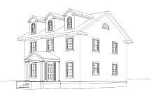
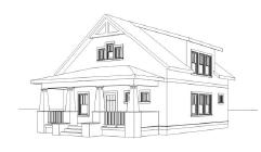
American Foursquare Style
Colonial Revival Style
Craftsman Style
NNZO Northeast Neighborhood Zoning Overlay


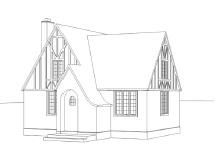
(E) All sides of any freestanding single-user retail & service building shall include four-sided design (i.e., be designed and detailed with each facade having the same level with similar materials and details).
(2) Building Materials
(A) Roofs, if sloped, shall be clad in cedar wood shake, fiberglass shingles, asphalt shingles, real or synthetic slate shingles, clay tile, prefinished pre-stamped metal shingles, or solar shingles or tiles. Prefinished metal standing seam roofing may be used for accent roofing, such as above window projections and open-air porches, stoops, and overhangs.
(B) Bright colors shall not be used as a primary building color but may be used for subtle trim accents in amounts not to exceed 10 percent of the facade area.
(C) Window-mounted air conditioning units and wall or in-wall mounted air conditioning condensing equipment shall not be placed on facades facing a street, open space, or walkway.
(D) Security devices such as solid metal security gates, metal roll-down windows, coiling shutters, and link/grill systems shall not be installed on front or corner facades, except where such devices are at least 50 percent transparent and located wholly behind a window or door, when viewed from the street or open space.
(E) On residential building facades, cinder/concrete block, metal, plywood, and unfinished precast or poured-in-place concrete shall not be used. However, concrete or concrete masonry is permitted on basement foundation walls between the ground floor sill plate and grade.
(F) On commercial and mixed-use facades visible from streets, sidewalks, and parking areas, no more than 10 percent of the facade shall be comprised of one or a combination of the following materials: stucco, smooth/textured synthetic plaster, wood trim, metal, decorative block, “renaissance stone,” exterior insulation and finish systems (E.I.F.S.), unfinished pre-cast concrete panels, and poured-in-place concrete.
(G) On commercial and mixed-use facades, window frames shall be constructed of painted or clad wood or metal.
Modern Style
Prairie Style
Tudor Style
(H) On commercial and mixed-use facades, vents, gutters, downspouts, flashings, electrical conduits, and other similar elements shall be painted to match the adjacent surface unless being used expressly as an accent material.
(3) Facade Articulation
(A) All commercial and mixed-use buildings, regardless of zoning district, shall be developed to the facade articulation standards of the NC District per the provisions of Section 21-08.01(f)
(4) Building Components
(A) Garage
i. In a S1, U1, or U2 district, the total capacity of a garage, garages, or carports, in combination, whether attached or detached, shall not exceed 2 vehicles.
ii. When an alley is present, garage doors shall not face the primary or secondary street. When an alley is not present, garages on a corner lot shall not face a primary street. When an alley is not present and the garage door on an attached garage faces a primary street, the garage door shall be set back a minimum of 20 feet behind the front building facade. When present, no more than one double or two single garage doors shall face any primary or secondary street; however, no garages for a multi-unit dwelling shall face a primary street.

iii. Garages shall incorporate roof types that match the roof type of the primary building. Where appropriate to the design, dormers may be included.
NNZO Northeast Neighborhood Zoning Overlay
(5) Building Types
(A) Carriage House, Detached House, Cottage Court, or Duplex
i. Roof type shall be gabled or hipped. Flat roof forms may only be used for building frontage types and on the secondary additive form.
(B) Townhouse
i. Roof type shall be gabled or hipped. Flat roof forms may only be used for building frontage types.
ii. Units along a street at the end of a row of townhouses oriented to an open space shall have a frontage type oriented to the street.
(C) Apartment House or Stacked Flats
i. Roof type shall be gabled, hipped, or flat.
ii. Main entrances shall be prominently located on the front facade.
(D) Shop or Mid-Rise/Tower
i. Roofs shall be hipped, gabled, or flat with a parapet.
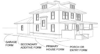

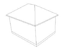
Gabled Roof
Building Forms
Hipped Roof
(6) Building Frontage Types
(A) Porch
i. A porch shall cover a minimum of 50 percent of the primary house form.
(B) Stoop
i. A stoop shall cover a min. of 30 percent of the primary house form.
(C) Forecourt
i. A building with a forecourt frontage type shall additionally have a porch, stoop, or gallery frontage type on its ends facing a primary street.
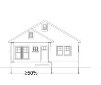
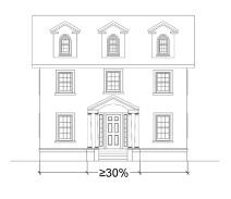
(g) s ite Development
(1) Landscape, Fences, & Walls
(A) Any portion of a fence that exceeds 5 feet in height shall consist of a decorative element that is at least 50 percent open.
(B) Chain-link fencing shall be prohibited.
(C) For attached dwelling units, if fencing is provided in the front yard, such fencing shall be of a single, unified design for all units within a project.
(D) When a masonry wall is used as part of a Type 1 Buffer, the wall shall incorporate the same or complementary materials and detailing as adjacent buildings and streetscape.
(E) Walls shall be consistent with the building’s architectural style and character.
(h) s igns
(1) Signs shall comply with the standards of the underlying district, except that any one sign shall not exceed 100 square feet in surface area.
(i) Neighborhood & s ubdivision Design
(1) Maximum Lot Width. The maximum lot width of lots for residential buildings with 4 or fewer units shall not exceed 70 feet.
Stoop
Porch
Article 21-06: Uses Sections
Section 21-06.01: Principal Uses 6-1
Section 21-06.02: Accessory Uses and Structures 6-21
Section 21-06.03: Temporary Uses and Structures ..... 6-29
Section 21-06.01: Principal Uses
(a) Intent
This section classifies the uses allowed by zoning district in order to identify the activities that support the health, safety, and welfare of the people that live and work in all areas of South Bend. This section includes use definitions and any standards that may apply to a specific use.
(b) Applicability
No building, structure, or land shall be used in any way other than an activity or use that is permitted in the applicable zoning district.
(c) General Provisions
(1) A site may contain more than one principal use, so long as each principal use is allowed in the zone.
(2) If a use is not listed but is similar in nature and impact to a use that is listed, the Zoning Administrator may interpret the use as permitted and shall issue a written interpretation indicating which use category will be used
(3) All uses shall meet any applicable federal, state, and local requirements, including, but not limited to, licensing, health, safety, and building and fire code requirements.
(d) Table of Principal Uses
(1) Allowed ( ). These uses are permitted by right in the districts in which they are listed provided that they comply with the development standards of that district.
(2) Allowed subject to Conditions ( ). These uses are permitted by right in the districts in which they are listed, provided that they comply with the development standards of that district and with any standards that are listed specific to that use.
(3) Special Exceptions ( ). These uses are allowed only if reviewed and approved for a special exception in accordance with the procedures of Section 21-12.07(f)(4) In addition, they shall comply with the development standards of the district in which they are located and any applicable additional standards associated with the use.
(4) Prohibited Use. Uses without a symbol are prohibited in the district because they are considered incompatible with the intent of the district.
(5) Use Specific Standards ( ). These uses shall comply with specific standards that apply to that use. The definition and use specific standards are located in the section referenced in the final column of Table 21-06A Except as noted, these use specific standards apply in any district.
(6) Definitions. All uses are defined in the sub-sections following Table 21-06A , listed alphabetically within their general use category.
21-06.01(e): Agricultural
(1) Plant Agriculture
A commercial agricultural operation of any size that grows horticultural or nursery stock or fruits, vegetables, grain, or other agricultural crops outdoors.
(2) Community Garden
A space where food, trees, and other plants are grown for personal, group, shareholder, or lessee use, or for donation, including for educational, recreational, and beautification purposes. Community gardens may be divided into separate plots for cultivation by one or more individuals or may be farmed collectively by members of the group and may include common areas maintained or used by community group members.
(A) Standards:
(i) No more than one stand selling and/or distributing agriculture and horticultural products produced on site shall be provided.
(3) Indoor Food Production
A commercial operation that produces fruits, vegetables, grain, or other agricultural crops; horticultural or nursery stock; or aquaculture in a permanent indoor facility. Includes greenhouses. Excludes retail sales of products.
21-06.01(f): Civic & Institutional
(1) Assembly, Neighborhood
A smaller-scale facility that has organized services, meetings, events, or programs to benefit, educate, entertain, or promote discourse in a public or private setting indoors. Includes such uses as community centers, recreation centers, meeting or lecture halls, exhibition rooms, or auditoria. If an assembly use is ancillary to another principal use, and has a gross floor area of less than 5,000 square feet, it is considered part of that use and is not considered a separate principal use. Excludes religious institutions.
(A) Standards:
(i) Neighborhood assembly uses shall not exceed 20,000 square feet of gross floor area.
(2) Assembly, General
A large-scale facility that has organized services, meetings, events, or programs to benefit, educate, entertain, or promote discourse in a public or private setting, indoors or outdoors. Includes such uses as community centers, recreation centers, meeting or lecture halls, exhibition rooms, auditoria, arenas, stadia, and fairgrounds. Excludes religious institutions and uses classified as Assembly, Neighborhood.
(3) Cemetery
Land or structures dedicated for the internment of human or animal remains.
(4) College/University
A post-secondary institution, public or private, for higher learning that grants associate, bachelor, masters, or doctoral degrees. Includes theological schools. Includes related ancillary facilities, such as cafeterias, restaurants, retail, indoor or outdoor recreational facilities, research facilities, and similar uses.
(5) Correctional Facility
A jail, prison, or other similar place of incarceration of adults or minors owned by the government. Includes related ancillary facilities, such as cafeterias, classrooms, and recreational facilities.
(6) Hospital
A licensed facility that provides health, medical, or surgical care to the sick or injured, often on an inpatient basis. Includes related ancillary facilities, such as laboratories, outpatient clinics, pharmacies, cafeterias, gift shops, training facilities, classrooms, central service facilities, heliports, and offices integral to function of the facility.
(7) Library/Museum/Cultural Facility
A facility open to the general public for cultural services and exhibitions. Includes such uses as museums, cultural centers, historical societies, and libraries operated by a government or nonprofit establishment. Includes related ancillary uses, such as classrooms, meeting rooms, retail, offices, or food service.
(A) Standards:
(i) In a S1, S2, U1, U2, U3, or UF district, library/ museum/cultural facility uses shall not exceed 10,000 square feet of gross floor area.
21-06.01(f): Civic & Institutional (continued)
(8) Parks & Open s pace
An open outdoor space, public or private, designed for active or passive recreational use or natural resources protection. Includes such uses as parks, plazas, greens, botanical or ornamental gardens, playfields and game courts, playgrounds, and monuments. Includes related ancillary facilities, such as picnic areas, gazebos, ziplines, and swimming pools. Excludes golf courses and skate parks, which are considered an Entertainment/Recreation Facility, Outdoor use.
(9) Police/Fire Facilities
A facility operated by a public safety agency, including such uses as fire stations and firefighting training facilities, police and sheriff substations and headquarters, emergency medical services substations, and public safety communication centers.
(10) Religious Institutions
A facility devoted primarily to the purpose of divine worship. Includes related ancillary uses, which are subordinate to and commonly associated with the religious institution use, such as schools and instructional facilities, daycare centers, and social uses.
(11) School, Pre-K/Primary/Secondary
A public, private, or parochial institution offering instruction at the preschool through high school levels with a full range of curricular programs. Includes related on-site ancillary facilities, such as cafeterias, gymnasiums, theaters, playgrounds, and athletic facilities.
(12) Zoo
A facility for the exhibition and viewing of animals. Includes related ancillary uses, such as retail and restaurants.
21-06.01(g): Industrial, Manufacturing, & Processing
(1) Industrial, Artisan
A manufacturing use involving small-scale production, assembly, and/or repair with no noxious by-products. Includes such uses as bakeries, confectioners, breweries, metalworking, woodworking, and maker
spaces. Includes related ancillary uses and facilities, such as a retail, restaurant, showroom, offices, storage, sales, and distribution of products.
(A) Standards:
(i) Artisan industrial uses shall not exceed 15,000 square feet of gross floor area.
(ii) Outdoor storage is prohibited, except in a C or I district. See Section 21-06.02(f)(25) for additional outdoor storage regulations.
(iii) Deliveries or pick-ups related to the use are limited to parcel and small freight carriers, except in a C or I district.
(2) Industrial, Heavy
A facility for the processing, manufacturing, compounding, or storage of materials, products, or energy, where the scale and method of operation may produce significant external impacts detectable beyond the lot lines of the property. External impacts include noise, heat, glare, dust, smoke, fumes, odor, vibration, and/or other noxious by-products. May regularly employ hazardous material or produce hazardous by-products, may include outdoor storage areas, and may have activities that take place outside of structures. Includes such uses as outdoor storage yards, junkyards, salvage yards, foundries, steel mills, and asphalt and concrete product manufacturing.
(A) Standards:
(i) A Type 4 buffer, designed per Section 2109.01(n), shall be provided along the entire side and rear lot lines that abut a lot in any zone other than an I district.
(ii) Outdoor storage is not permitted within an established front or corner yard.
(iii) See Section 21-06.02(f)(25) for additional outdoor storage regulations.
21-06.01(g): Industrial, Manufacturing, & Processing (continued)
(3) Industrial, Light
A facility for the processing or manufacturing of products or parts, including fabrication, assembly, treatment, and packaging of such products, and the incidental storage, sales, and distribution of such products, provided that all manufacturing processes are contained entirely within a fully enclosed building. Any heat, glare, dust, smoke, fumes, odors, or vibration are confined to the building, and little or no external impacts are detectable beyond the lot lines of the property.
(A) Standards:
(i) A Type 3 buffer, designed per Section 2109.01(n), shall be provided along the entire side and/or rear lot line that abuts a lot in a S1, S2, U1, U2, U3, UF, OS, or U district.
(ii) Outdoor storage is not permitted within an established front or corner yard.
(iii) See Section 21-06.02(f)(25) for additional outdoor storage regulations.
(4) Research/Laboratory Facility
A facility where testing, research, and development is conducted in industries such as biotechnology, pharmaceuticals, medical instrumentation or supplies, communication and information technology, vehicle components, and electronics and instrumentation. Other than prototype development, excludes the manufacturing, fabrication, processing, or sale of products.
(5) Warehouse/Distribution
A facility for the storage, transfer, wholesaling, and distribution of goods. If a warehouse/distribution use is ancillary to another principal use, and has a gross floor area of less than 10,000 square feet, it is considered part of the principal use and is not considered a separate principal use.
(A) Standards:
(i) A Type 3 buffer, designed per Section 2109.01(n), shall be provided along the entire side
and/or rear lot line that abuts a lot in a S1, S2, U1, U2, U3, UF, OS, or U district.
(ii) Outdoor storage is not permitted within an established front or corner yard.
(iii) See Section 21-06.02(f)(25) for additional outdoor storage regulations.
(6) Waste Processing/Recycling Facility
A facility for the collection, storage, and transfer of solid waste, which may include the collection, storage, processing, and transfer of recyclables, and organic and yard waste. Excludes salvage yards, industrial or sanitary landfills, and waste incineration facilities.
(A) Standards:
(i) A Type 4 buffer, designed per Section 2109.01(n), shall be provided along the entire side and rear lot lines that abut a lot in any zone other than an I district.
(ii) Outdoor storage is not permitted within an established front or corner yard.
(iii) See Section 21-06.02(f)(25) for additional outdoor storage regulations.
21-06.01(h) Lodging
(1) Bed & Breakfast
A dwelling that provides temporary lodging for compensation in guest rooms with no in-room cooking facilities. Includes related ancillary facilities, such as dining and meeting rooms.
(A) Standards:
(i) The dwelling shall be the primary residence of the owner.
(ii) The bed and breakfast shall not alter the character of the dwelling as a residence.
(iii) No more than five guest rooms, and no more than ten guests at any one time, are permitted.
(iv) Occupancy by any one guest shall not exceed 30 cumulative nights within any 3-month period.
21-06.01(h) Lodging (continued)
(2) Hotel
A facility that provides temporary lodging, in one or more buildings, for compensation. Includes related ancillary facilities, such as dining facilities, meeting rooms, and other incidental services
(A) Standards:
(i) Rooms shall be accessed from the interior of the building, including from interior courtyards, lobbies, or halls.
(ii) A bathroom shall be provided for each room.
(iii) In a UF district, hotels shall have no more than 5 guest rooms.
21-06.01(i) Office
(1) Professional Offices
A facility for the processing, manipulation, or application of information or professional expertise, including by businesses, nonprofit organizations, and the government. When such facility offers services to the public, they are typically provided at set appointments or meeting times, not on a walk-in basis.
21-06.01(j) Residential
(1) Dwelling, Ancillary
A dwelling unit that is subordinate and incidental to a primary building on the same lot. An ancillary dwelling unit may be detached or attached to the primary building.
(A) Standards:
(i) Only one ancillary dwelling is allowed per lot.
(ii) In a S1 or U1 district, the owner(s) of the lot upon which the ancillary dwelling is located shall occupy at least one of the dwelling units on the premises.
(iii) The finished floor area of an ancillary dwelling shall be no more than 75 percent of the finished floor area of the primary dwelling or 800 square feet, whichever is less. If the ancillary dwelling unit is accessory to a nonresidential use, it shall be no more than 1,200 square feet.
(iv) A detached ancillary dwelling, if located in any standard district, shall comply with the regulations for a carriage house, as defined in Section 21-08.02(d).
(v) A detached ancillary dwelling shall only be located in an established rear yard and shall comply with all required building setbacks, except that an ancillary dwelling may encroach into a required rear setback up to within 5 feet of the rear lot line.
(vi) A detached ancillary dwelling shall not be taller in feet than the primary building on the lot and shall meet all accessory height requirements of the applicable zoning district.
(vii) If a separate entrance is provided for an attached ancillary dwelling, it shall be located on the side facade, rear facade, or be setback at least 20 feet if located on a front or corner facade.
(2) Dwelling, 1 Unit
A structure that contains only one dwelling unit.
(A) Standards:
(i) In a NC or DT district, a dwelling unit shall not be located directly along the street frontage, except for an existing Detached House building type that has not been converted previously to a non-residential use. The dwelling unit may be on an upper floor of the building or behind another ground floor, non-residential principal use.
21-06.01(j) Residential (continued)
(3) Dwelling, 2 Units
A primary building that contains two dwelling units on the same lot.
(A) Standards:
(i) In a NC or DT district, a dwelling unit shall not be located directly along the street frontage, except for an existing Detached House building type that has not been converted previously to a non-residential use. Dwellings may be on upper floors of the building or behind another ground floor, non-residential principal use..
(4) Dwelling, Mobile Home
A movable or portable dwelling unit that (i) is fabricated in one or more modules at a location other than the home site, by assembly-line type production techniques or by other construction methods unique to an off-site manufacturing process; (ii) is designed for occupancy by one family; (iii) is erected or located as specified by the City of South Bend Building Code; and, (iv) was either constructed prior to June 15, 1976; or, constructed subsequent to or on June 15, 1976 and bears a seal, certifying that it was built in compliance with the Federal Mobile Home Construction and Safety Standards law.
(5) Dwelling, Multi-Unit
A structure that contains three or more dwelling units on the same lot.
(A) Standards:
(i) In a U2 district, a multi-unit dwelling shall have no more than four dwelling units.
(ii) In a U2 district, a conversion to add one or more dwelling units, other than an ancillary dwelling, to an existing structure shall require a special exception.
(6) Group Residence
A residential facility providing any combination of food, shelter, personal care, social services, counseling services, or transportation to residents; or a residential facility providing common living areas such as a kitchen, living room, dining room, or recreation rooms. Includes uses such as boarding houses, domestic
violence shelters, homeless shelters, halfway houses, or any other residential facility for individuals which do not qualify as a family or any other form of residential facility expressly provided for in this Ordinance.
(7) Group Residence, state Regulated
A residential facility regulated by IC 12-28-4 et seq.
(8) Residential Care Facility
A licensed care facility that provides 24-hour medical or non-medical care to persons in need of personal services, supervision, protection, or assistance essential for sustaining the activities of daily living. Includes such uses as nursing homes, convalescent homes, independent living, assisted living, continuum of care, and hospice facilities.
(9) s hared Housing
A dwelling unit located within a mixed use or multiunit dwelling occupied by unrelated persons living as a single housekeeping unit, provided that the number of occupants does not exceed twice the number of bedrooms, and that the total number of occupants does not exceed four regardless of the number of bedrooms.
21-06.01(k) Retail & Service
(1) Adult Business
Businesses including, but not limited to, the following: Adult bookstore, adult cabaret (a.k.a. class B cabaret), adult drive-in theater, adult motion picture theater, adult mini motion picture theater, adult motion picture arcade, adult live entertainment arcade, adult motel or adult service establishment.
(A) Location. An adult business shall not be located within 500 feet of any:
(i) Other adult business;
(ii) District within the City of South Bend, St. Joseph County, or the City of Mishawaka which allows any residential use as a principal use, other than an ancillary dwelling unit;
(iii) Lot being legally established for a residential use, religious institution use, school use, or parks and open space use;
21-06.01(k) Retail & Service (continued)
(B) Definitions. For the purposes of this section, the following terms have the following meanings:
(i) Adult Bookstore. An establishment having as a preponderance of its stock in trade or its dollar volume in trade, books, magazines, periodicals, or other printed matter, or photographs, films, motion pictures, video cassettes, slides, tapes, records, or other forms of visual or audio representations which are distinguished or characterized by their emphasis on matter depicting, describing, or relating to specified sexual activities or specified anatomical areas.
(ii) Adult Cabaret (a.k.a. Class B Cabaret). Any cabaret, nightclub, bar, tavern, restaurant, or similar establishment, which features:
i. Persons who appear in a state of seminudity;
ii. Live performances by topless or bottomless dancers, go-go dancers, exotic dancers, strippers, or similar entertainers where such performances are distinguished or characterized by the exposure of specified anatomical areas or by emphasis on specified sexual activities;
iii. Films, motion pictures, video cassettes, slides, or other photographic reproductions which are characterized by the depiction or description of specified sexual activities or specified anatomical areas for observation by patrons; or,
iv. Persons who engage in lewd, lascivious, or erotic dancing or performances that are intended for the sexual interests or titillation of an audience or customers.
(iii) Adult Business. An Adult Bookstore, Adult Motion Picture Theater, Adult Mini Motion Picture Theater, Adult Motion Picture Arcade, Adult Cabaret (a.k.a. Class B Cabaret), Adult Drive-in Theater, Adult Live Entertainment Arcade, Adult Motel, or Adult Service Establishment.
(iv) Adult Drive-In Theater. An open lot or part thereof, with appurtenant facilities, devoted primarily to the presentation of motion pictures, films, theatrical productions, and other forms of visual productions, for any form of consideration, to persons in motor vehicles or on outdoor seats in which a preponderance of the total presentation time is devoted to the showing of materials distinguished or characterized by an emphasis on matter depicting, describing, or relating to specified sexual activities or specified anatomical areas for observation by patrons.
(v) Adult Live Entertainment Arcade. Any building or structure which contains or is used for commercial entertainment where the patron directly or indirectly is charged a fee to view from an enclosed or screened area or booth a series of live dance routines, strip performances, or other gyrational choreography which performances are distinguished or characterized by an emphasis on specified sexual activities or by exposure of specified anatomical areas.
(vi) Adult Mini Motion Picture Theater. An enclosed building with a capacity of more than 5 but less than 50 persons, used for presenting films, motion pictures, video cassettes, slides, or similar photographic reproductions in which a preponderance of the total presentation time is devoted to the showing of materials which are distinguished or characterized by an emphasis on matter depicting, describing, or relating to specified sexual activities or specified anatomical areas for observation by patrons therein.
(vii) Adult Motel. A hotel, motel, or similar establishment offering public accommodations for any form of consideration which provides patrons, upon request, with closed-circuit television transmissions, films, motion pictures, video cassettes, slides, or other photographic reproductions which are distinguished or characterized by an emphasis upon the depiction or description of specified sexual activities or specified anatomical areas.
21-06.01(k) Retail & Service (continued)
(viii) Adult Motion Picture Arcade. Any place to which the public is permitted or invited wherein coin or slug-operated or electronically, electrically, or mechanically controlled still or motion picture machines, projectors, or other image-reducing devices are maintained to show images to 5 or fewer persons per machine at one time, and where the images so displayed are distinguished or characterized by an emphasis on depicting or describing specified sexual activities or specified anatomical areas.
(ix) Adult Motion Picture Theater. An enclosed building with a capacity of 50 or more persons used for presenting films, motion pictures, video cassettes, slide, or similar photographic reproductions in which a preponderance of the total presentation time is devoted to showing of materials which are distinguished or characterized by an emphasis on matter depicting, describing, or relating to specified sexual activities or specified anatomical areas for observation by patrons therein.
(x) Adult Service Establishment. Any building, structure, premises, or other facility, or any part thereof, under common ownership or control which provides a preponderance of services involving specified sexual activities or display of specified anatomical areas.
(xi) Enlargement Of An Adult Business. An increase in the size of the building, structure, or premises in which the adult business is conducted by either construction or use of: (1) an adjacent building; (2) an additional building; or, (3) the construction or use of any portion of an adjacent building or additional building, whether located on the same or an adjacent lot or parcel of land.
(xii) Establishing An Adult Business. Any of the following:
i. The opening or commencement of an adult business as a new business;
ii. The conversion of an existing business, whether or not an adult business, to any of the adult businesses defined herein;
iii. The addition of any of the features of one or more of the adult businesses defined herein to an existing business;
iv. The addition of any of the adult businesses defined herein to any other existing adult business; or,
v. The relocation of any adult business
(xiii) Nonconforming Adult Use: Any building, structure, or land legally established as an adult business prior to the effective date of this Ordinance, but which would be prohibited, regulated, or restricted under the provisions of this Ordinance.
(xiv) Reconstruction Of An Adult Business. The rebuilding or restoration of any nonconforming adult business use which was damaged or partially destroyed by an exercise of the power of eminent domain, or by fire, flood, wind, explosion, or other calamity or act of God if the damage or destruction exceeds 50 percent of the fair market value of the building, structure, or the facilities affected.
(xv) Resumption :.The reuse or reoccupation of a nonconforming adult business use which has been discontinued for a period of 6 or more consecutive months.
(xvi) Services Involving Specified Sexual Activities Or Display Of Specified Anatomical Areas (as used to define an Adult Service Establishment). Any combination of 2 or more of the following activities:
i. The sale or display of books, magazines, periodicals or other printed matter, or photographs, films, motion pictures, video cassettes, slides, tapes, records, or other forms of visual or audio representations which are characterized by an emphasis upon the depiction or description of specified sexual activities or specified anatomical areas;
21-06.01(k) Retail & Service (continued)
ii. The presentation of films, motion pictures, video cassettes, slides, or similar photographic reproductions which are distinguished or characterized by an emphasis upon the depiction or description of specified sexual activities or specified anatomical areas for observation by patrons;
iii. The operation of coin or slug operated or electronically, electrically or mechanically controlled still or motion picture machines, projectors, or other image producing devices to show images to 5 or fewer persons per machine at any one time and where the images so displayed are distinguished or characterized by an emphasis on depicting or describing specified sexual activities or specified anatomical areas; or,
iv. Live performances by topless or bottomless dances, go-go dancers, exotic dancers, strippers, or similar entertainers, where such performances are distinguished or characterized by an emphasis on specified sexual activities or specified anatomical areas.
(xvii) Specified Anatomical Areas: Any of the following:
i. Less than completely and opaquely covered human genitals, pubic region, buttocks, anus, or female breasts below a point immediately above the top of the areolae; or,
ii. Human male genitals in a discernibly turgid state, even if completely and opaquely covered.
(xviii) Specified Sexual Activities: Any of the following:
i. Human genitals in a state of sexual stimulation or arousal;
ii. Acts of human masturbation, sexual intercourse, or sodomy;
iii. Fondling or other erotic touching of human genitals, pubic regions, buttocks, or female breasts;
iv. Flagellation or torture in the context of a sexual relationship;
v. Masochism, erotic or sexually oriented torture, beating, or the infliction of pain;
vi. Erotic touching, fondling, or other such contact with an animal by a human being; or,
vii. Human excretion, urination, menstruation, or vaginal or anal irrigation as part of or in connection with any of the activities set forth in (i) through (vi) above.
(xix) Structural Alteration Of An Adult Business: Any change which would prolong the life of the supporting members of a building or structure such as bearing walls, columns, beams, or girders, except such changes as are ordered made pursuant to the provisions of the Unsafe Building Law, IC 36-7-9-1, and any amendments thereto.
(C) Exterior Display for Adult Businesses.
(i) No adult business shall be conducted in any manner that permits the observation of any material depicting, describing, or relating to specified sexual activities or specified anatomical areas by display, decorations, sign, show window, or other opening from any public right-of-way.
(ii) Not more than one wall sign shall be permitted for an adult business and such sign shall be permitted only on the front facade of the building. In addition to the one permitted wall sign, an adult business may be permitted not more than one freestanding sign per Section 21-10.05(e). All other sign structures shall be prohibited.
21-06.01(k) Retail & Service (continued)
(iii) The sign surface area of a wall sign for an adult business shall not exceed 16 square feet. The maximum sign surface area of a freestanding sign, where permitted, shall not exceed 48 square feet.
(iv) Signs and sign structures may be illuminated, provided, however, such illumination shall not be by way of exposed neon, exterior lighting (e.g., spot or flood lights) or any flashing or animated lights (either interior to the sign, on the exterior of the sign, or as a border to the sign).
(2) Animal Care Establishment
A business which provides care for domestic animals. Includes such uses as veterinary offices, pet grooming facilities, pet resorts/hotels, animal training facilities, animal rescue shelters, kennels, and pet boarding facilities where animals are boarded during the day or for overnight stays.
(A) Standards:
(i) In a UF, NC, or DT district, no animal care activity shall take place outdoors.
(ii) Outdoor exercise areas shall not be located in an established front or corner yard.
(iii) Any outdoor animal care activity, including exercise areas, located within 100 feet from a S1, S2, U1, U2, U3, or UF district shall be screened with a Type 3 buffer designed per Section 21-09.01(n)
(3) Bar/Tavern
An establishment primarily engaged in the sale or dispensing of alcoholic beverages by the drink for on-site consumption. May include related ancillary activities, such as the sale of packaged liquor, the availability of food for on-site consumption, and live entertainment that is clearly incidental and subordinate to the bar/tavern use.
(4) Beer/Wine/Liquor s ales
An establishment whose primary business, in terms of gross floor area or sales, is the sale of alcoholic beverages for off-site consumption.
(5) Commercial s chool
A school that teaches industrial, vocational, clerical, managerial, commercial, artistic, or other select skills; conducts a commercial enterprise, such as a driving school; or a privately operated school that does not offer a complete educational curriculum.
(6) Day Care Center
A business that provides licensed care in a protective setting for children or elderly or disabled adults for less than 24 hours per day. Includes Class II child care homes as defined by IC 12-7-2. Excludes licensed Class I child care homes as defined by IC 12-7-2, which are permitted in all districts.
(7) Drive-Through
Facility
A facility that dispenses goods through an attendant window or automated machine to persons remaining in or on motor vehicles in a designated drive aisle. A drive-through may or may not be in conjunction with another principal use.
(A) Standards:
(i) A drive-through is determined by the entire length of the operation including the required waiting spaces to the services/pick-up window.
(ii) No portion of a drive-through facility shall be located between the front facade and front lot line or the corner facade and corner lot line.
(iii) A drive-through facility shall not cause any interference to a public right-of-way or conflict with safe movement along sidewalks or walkways, to building entrances or exits, or to required parking spaces.
(iv) A drive-through facility shall have a minimum width of 10 feet measured from the farthest point of projection of a drive-through facility from the building or structure.
(v) Except in a NC or DT district, a drive-through facility shall have a bail out capability for all vehicles which have entered the drive through lane. When provided, a bail out lane shall have a minimum width of 10 feet measured from and running parallel to the full length of the drive through lane. If a bail out lane also serves
Principal Uses
21-06.01(k) Retail & Service (continued)
as an interior access drive providing access to parking spaces, the bail out lane / interior access drive shall be limited to a one-way traffic pattern following the direction of the drive through lane.
(vi) A drive-through facility shall provide at least three waiting spaces, at a minimum depth of 18 feet, prior to the first occurrence of any ordering, pick up or service facility.
(vii) A drive-through facility shall provide sufficient room for at least one waiting space after exiting the last pick-up or service facility.
(viii) A Type 1 buffer, designed per Section 2109.01(n), shall be provided along the entire front and corner yard lot lines not occupied by buildings.
(ix) In a C or I district, a Type 2 buffer, designed per Section 21-09.01(n), shall be provided along the entire side and rear lot lines that abut a lot in a S1, S2, U1, U2, U3, UF, OS, or U district not separated by an alley.
(x) A drive-through canopy shall be consistent in design and materials with the primary building, shall be neutral colored, and shall have masonry support columns.
(8) Entertainment/Recreation Facility, Indoor
A facility for leisure uses conducted within an enclosed building. Includes such uses as amusement centers, arcades, bowling alleys, casinos, live and movie theaters, music venues, pool halls, skating and roller rinks and facilities, and tumbling centers. Includes related ancillary uses, such as food service. Excludes Assembly uses.
(9) Entertainment/Recreation Facility, Outdoor
A facility for leisure uses conducted outdoors or within partially enclosed structures. Includes such uses as amusement parks, batting cages, campgrounds, drive-in movie theaters, fairgrounds, golf courses, miniature golf courses, golf driving ranges, recreational vehicle parks, skating parks, and tennis clubs. Includes related ancillary uses, such as food service. Excludes Assembly uses.

Drive-Through Layout
(10) Funeral s ervices
A facility where the deceased are prepared for burial display and for rituals before burial or cremation. Includes such facilities as chapels, funeral homes, crematoriums, and showrooms for the display and sale of caskets, vaults, urns, and other items related to burial services.
21-06.01(k) Retail & Service (continued)
(11) Gas station
A facility engaged in the retail sales of personal or commercial vehicle fuels.
(A) Standards:
(i) Gasoline dispensers and pump island canopies shall not be located within any minimum required setback. In a NC or DT district, gasoline dispensers and pump island canopies shall not be located in an established front or corner yard.
(ii) Gas stations shall not cause any interference to a public right-of-way or conflict with safe movement along sidewalks or walkways, to building entrances or exits, or to required parking spaces.
(iii) The site design of any gas station shall provide for the safe and efficient ingress and egress to the site for fuel delivery vehicles and an area for such fuel delivery vehicles to park while unloading which does not interfere with or impede ingress or egress to or from any public street, required parking spaces, or any gasoline sales area.
(iv) A Type 1 buffer, designed per Section 21-09.01(n), shall be provided along the entire front and corner yard lot lines not occupied by buildings.
(v) A Type 2 buffer, designed per Section 21-09.01(n), shall be provided along the entire side and rear lot lines that abut a lot in a S1, S2, U1, U2, U3, UF, OS, or U district not separated by an alley.
(vi) A gas station canopy shall be consistent in design and materials with the primary building, shall be neutral colored, and shall have masonry support columns.
(12) Medical/Dental Clinic
A facility for physicians, dentists, chiropractors, physical therapists, mental health practitioners, or other licensed healthcare practitioners to examine and treat persons on an outpatient basis.


Gas station layout for a suburban location
Gas station layout for an urban location
Type 1 Buffer
21-06.01(k) Retail & Service (continued)
(13) Personal Care & services
A business engaged in hairdressing, cosmetology, or other similar services. Includes such uses as barber shops, beauty shops, nail salons, and massage parlors.
(14) Private Club/Lodge
A facility for an organization, which does not operate for profit and excludes the general public but is open to people upon invitation, nomination, or payment of annual fees or dues, for social, recreational, political, and/or entertainment activities. A private club/lodge may serve meals and alcohol on the premises for members and their guests only.
(15) Restaurant
A business where food and beverages are prepared for and served to patrons for consumption either onpremises or off-premises. Includes such uses as cafes, coffee shops, diners, fast-food establishments, lunch counters, and cafeterias.
(16) Retail & s ervice, General
A business that provides goods or services directly to the consumer, and where such goods or services are available for immediate purchase on the premises by the purchaser. Includes such uses as clothing retailers, convenience stores, grocery stores, financial institutions, fitness centers, and banquet halls.
(17) Retail & s ervice, Heavy
A retail and service business with permanent outdoor display, service, and storage areas. Includes such uses as the sale of lumber and building supplies, garden and landscaping supplies and equipment, industrial equipment, and outdoor structures such as prefabricated sheds, decks and patios, swimming pools, and play equipment. Excludes Vehicle Sales or Rental.
(A) Standards:
(i) A Type 3 buffer, designed per Section 2109.01(n), shall be provided along the entire side and rear lot lines that abut a lot in any zone other than an I district, whether or not the lot is separated by an alley.
(ii) Outdoor storage and operations shall be screened from view by a building and/or a Type 2 buffer, designed per Section 21-09.01(n)
(iii) See Section 21-06.02(f)(25) for additional outdoor storage regulations.
(18) Self-Storage Facility
A facility where individual spaces, inside or outside of a structure, are leased for the storage of personal property. Includes related ancillary uses such as the retail sales of packing, moving, and storage supplies.
(A) Standards:
(i) In a NC, DT, or C district, no outdoor storage shall be provided on site.
(ii) In a NC or DT district, access to individual storage units shall be provided from common areas or hallways located indoors. No direct access or outward appearance of direct access to an individual storage space shall be provided from the building exterior.
(iii) Outdoor storage and operations shall be screened from view by a building and/or a Type 2 buffer, designed per Section 21-09.01(n)
(iv) See Section 21-06.02(f)(25) for additional outdoor storage regulations.
(19) Tattoo/Piercing Parlor
A facility required to be licensed under Chapter 13 of the South Bend Municipal Code that provides services including deliberately scarring, burning, or pricking the skin so as to leave a mark or a color that cannot be removed without a surgical procedure. Includes such services as tattooing, permanent coloring, scarifying and branding, and the piercing of the human body to create a permanent hole (excluding ear piercing services which meet all requirements of Section 13-148 of the South Bend Municipal Code).
(20) Tobacco/Hookah/Vaping Establishment
An establishment whose primary business, in terms of gross floor area or sales, is related to the sale of tobacco products or related accessories, hookah products or related accessories, other smoking products or related accessories, or electronic nicotine delivery systems or related accessories, for on- or off-premise use.
21-06.01(k) Retail & Service (continued)
(21) Vehicle s ales or Rental
A business that sells, leases, or rents automobiles, vans, recreational vehicles, commercial vehicles, trucks, trailers, motorcycles, scooters, watercraft, or other powered personal transportation or conveyance. Includes related ancillary uses, such as on-site facilities for the repair and service of vehicles sold, leased, or rented.
(A) Standards:
(i) In a DT district, vehicle sales or rental shall be located within a fully enclosed building.
(ii) In a NC district, vehicle sales or rental shall be located:
i. Within a fully enclosed building, or
ii. In an established rear yard and not visible from a public right-of-way other than an alley.
(iii) Any repair and service operations shall be performed within a fully enclosed building.
(iv) No partially dismantled, wrecked, or unregistered vehicle shall be stored outdoors on the premises.
(v) Each vehicle for sale or rental shall have direct access to an interior access drive.
(vi) Any outdoor display area shall not be located in any required setback.
(vii) Any outdoor display area along front and corner lot lines shall be screened by a Type 1 buffer, designed per Section 21-09.01(n)
(viii) Any outdoor display area along side and rear lot lines that abut a lot in a district other than C or I, whether or not the lot is separated by an alley, shall be screened by a Type 3 buffer, designed per Section 21-09.01(n)
(ix) Any outdoor display area shall be considered a parking area for determining and providing parking landscape islands in compliance with Section 21-09.01(o)
(22) Vehicle service, Major
A business that offers major vehicle repairs such as engine rebuilding; major reconditioning of worn or damaged motor vehicles or trailers; towing and collision service, including body, frame, or fender straightening or repair; painting of motor vehicles; or repair to commercial vehicles, recreational vehicles, or watercraft.
(A) Standards:
(i) Any repair and service operations shall be performed within a fully enclosed building. Bay doors may be open during hours of operation.
(ii) No partially dismantled, wrecked, or unregistered vehicle shall be stored outdoors for more than 30 days.
(iii) Outdoor storage and operations shall be screened from view by a building and/or a Type 2 buffer, designed per Section 21-09.01(n)
(iv) See Section 21-06.02(f)(25) for additional outdoor storage regulations.
(23) Vehicle s ervice, Minor
A business that offers minor vehicle repairs such as oil changes; repair or replacement of cooling, electrical, fuel, and exhaust systems; brake adjustments, relining, and repairs; wheel servicing, alignment, and balancing; repair and replacement of shock absorbers; detailing; and replacement or adjustment of muffler systems, hoses, belts, fuses, windshield wipers, and the like. Includes repairs to two-wheeled and threewheeled motor vehicles. Includes car washes, whether mechanical, self-wash, or hand wash. Includes related ancillary uses, such as towing and collision service. Excludes vehicle dismantling.
(A) Standards:
(i) Any repair and service operations shall be performed within a fully enclosed building. Bay doors may be open during hours of operation.
(ii) No partially dismantled, wrecked, or unregistered vehicle shall be stored on-site.
21-06.01(l) Transportation
(1) Airport
A facility for the takeoff, landing, and maintenance of civil aircraft. Includes related ancillary uses, such as runways, passenger terminals, hangars, and control towers.
(2) Freight Terminal/Facility
A facility for freight pick-up, transfer, or distribution by air, rail, or truck. Excludes Warehouse/Distribution uses.
(3) Heliport
A facility for the designated takeoff and landing of helicopter or similar vertical lift aircraft. Includes related ancillary uses, such as terminal facilities for passengers, aircraft servicing, and storage or basing of aircraft.
(4) Parking Lot
A non-accessory parking lot for the storage of motor vehicles made available to the general public, with or without a fee. Parking lots serving a permitted use located on an adjacent lot or a lot separated from the subject lot by a street or alley shall be considered as accessory parking lots. Includes parking structures, whether underground, at ground level, or above ground level, in which more than 50 percent of the gross floor area is used for parking vehicles.
(A) Standards:
(i) A Type 1 buffer, designed per Section 2109.01(n), shall be provided along all parking lots located along front, corner, side, and rear lot lines not occupied by a building.
(ii) See Section 21-07.03(h) for parking structure regulations.
(5) Passenger Terminal
A facility for handling, receiving, and transferring intercity passenger traffic, including by train and bus.
(6) Transit station
A building or permanent platform with an area for passenger boarding and alighting which is roofed for at least 30 feet, primarily serving intracity bus or train traffic. Includes related ancillary facilities, such as a waiting room, ticket office, ticket machines, restrooms, or concessions.
21-06.01(m) Utilities
(1) s olar Farm
A site at which ground mounted photovoltaic cells and generators are used to generate and produce electric power for distribution to consumers. Such a facility is typically managed by a single entity.
(2) Utilities, Major
A large-scale utility facility that primarily serves a regional need, which because of its scale or method of operation is more likely to produce external impacts detectable beyond the lot lines of the subject property. Includes facilities such as electric or gas generation plants, high voltage transmission lines, sewage treatment plants, water pumping stations, and water towers and tanks.
(A) Standards:
(i) A Type 4 buffer, designed per Section 2109.01(n), shall be provided along the entire side and rear lot lines, whether or not the lot is separated by an alley.
(3) Utilities, Minor
A utility facility or service that primarily serves local distribution needs. Includes facilities such as water and sewer pump stations, electric substations, gas regulating stations, and telephone exchange/switching centers.
(A) Standards:
(i) A Type 3 buffer, designed per Section 2109.01(n), shall be provided along the entire side and rear lot lines, whether or not the lot is separated by an alley.
(4) Wireless Communications
Towers, antennas, and ancillary structures used to transmit and receive radio-frequency signals, microwave signals, or other signals.
(A) Application Requirements.
In addition to any other submittal requirements, all applications to erect, construct, or modify any part of a wireless communication tower, antenna, or related structure shall apply for an improvement location permit and include the following items:
21-06.01(m) Utilities (continued)
(i) A service plan that demonstrates efforts to minimize the size and number of wireless communication tower locations throughout the geographical area, taking into consideration existing technology. The service plan shall include, but not be limited to the following:
i. A narrative detailing the reason of need (coverage, capacity, new users, etc.) for a wireless communication facility at the requested site;
ii. A map identifying all existing wireless communication towers and all structures or buildings within a 1 mile radius of the proposed site that have a height equal to or greater than the height of the proposed wireless communication tower minus 30 feet.
iii. If the applicant is a licensed provider of wireless communication services, the applicant shall supply individual coverage maps which identify all existing locations utilized by the licensed provider's network and reflects the current coverage levels to the City of South Bend; and identify the proposed coverage levels of the licensed provider's network after the installation of the proposed wireless communication facility.
(ii) A certification from the owner of the wireless communication tower or the property on which it is located, that the tower is available for use by another wireless provider on a reasonable and non-discriminatory basis and at a cost not exceeding the Fair Market Value for the use of the facilities. The owner shall demonstrate a designation of an area on the tower or property which is set aside for the equipment of future users and is located:
i. Within the proposed compound area; or,
ii. Within a separate compound area located on the same lot and located no further from the wireless communication
tower than the distance from the telecommunications tower to the proposed compound area plus 50 feet.
(iii) Color photo simulations showing the site of proposed tower or antenna with a photorealistic representation of the proposed tower or antenna as it would appear viewed from the closest residential use and from adjacent public right-of-way, and photographs of the same views as in the photo simulations showing the current appearance of the site or existing structure without the proposed tower or antenna.
(iv) Certification by a licensed and registered professional engineer showing that the design meets or exceeds the most recent EIA-222 standards, including the fall zone and manner in which the proposed structure could fail.
(B) Compliance with Other Laws. A wireless tower or facility shall be erected and operated in compliance with the most current Federal Communication Commission and Federal Aviation Administration rules and regulations and other applicable federal and state standards. All wireless communications towers shall comply with all ordinances of the City of South Bend not in conflict with this section. This section shall not apply to Amateur Radio Operators who are licensed to operate by the Federal Communications Commission.
(C) Co-Location. The placement of two or more antenna or antenna arrays by wireless communication service providers on a common support structure.
(i) The placement of new wireless communication antennas, including associated equipment, upon existing towers are permitted uses in all districts and may be issued a building permit provided all requirements of this section are met.
(ii) The applicant for a wireless communication facility special exception shall demonstrate that they have exhausted all efforts to locate the proposed antennas upon existing communication towers, buildings, or structures in the geographical area of the proposed antennas.
21-06.01(m) Utilities (continued)
(D) Wireless Communication Tower. Any structure that is designed and constructed for the purpose of supporting one or more antennas intended for transmitting or receiving television, AM/FM radio, digital,microwave, cellular, telephone, or similar forms of electronic communication, including without limit freestanding towers, guyed towers, lattice towers, monopole towers, self-supporting towers, and similar structures. The term includes the structure, equipment, and any supporting elements, such as guy wires.
(i) Wireless communication towers shall be designed to provide for co-location by additional providers.
i. A tower less than 80 feet in height shall be capable of use by at least two wireless communication providers.
ii. A tower 80 feet or greater in height shall be capable of use by three or more wireless communication providers.
iii. A tower shall accommodate antenna arrays consisting of 9 to 12 antennas for each antenna array, provided, however, this regulation shall not apply to slick antenna applications. Antenna arrays shall be located within 15 vertical feet of each other and have no more than 3 degrees of twist and sway at the top elevation.
(ii) No new wireless tower shall be located within 500 feet of a residential use unless the applicant can demonstrate that there are no other locations, buildings, or structures beyond 500 feet of a residential use which are available to provide the necessary wireless telecommunications services.
(iii) The maximum height of a wireless communication tower, including antenna array, shall be less than 200 feet above grade.
(iv) All new wireless communication towers shall be of a tapering monopole construction, provided with internal cable routing, unless an alternative design that would better blend
into the surrounding environment is approved through the special exception request.
(v) A wireless communication tower shall be white or off-white, galvanized silver, or gray in color or be finished or painted so as to reduce visual obtrusiveness, unless otherwise required by the Federal Aviation Administration (FAA) or any other governmental authority.
(vi) A Type 3 buffer, designed per Section 2109.01(n), shall be provided surrounding the base of a ground-mounted wireless communications tower.
(vii) The compound area and all guy anchors shall be secured with a board-on-board or chain link fence of not less than 6 feet in height nor more than 10 feet in height. A security wire (barbed, razor, etc.) may be located on the tower-side of the fence but shall not extend above the top of the fence. A chain link fence, if used, shall be black vinyl coated.
(viii) No signs or advertising materials of any nature may be allowed on any communication tower, except for warning signs or other notifications designed to alert the public to safety concerns.
(ix) Wireless communication towers shall not be artificially lighted unless otherwise required by the Federal Aviation Administration (FAA) or another governmental authority. If lighting is required, the lighting shall, to the greatest extent feasible, cause the least disturbance to the surrounding areas.
(E) Wireless Communication Antenna. Any device or exterior apparatus mounted on a tower, building, utility pole, light pole, or other structure to transmit or receive communication signals or electromagnetic waves for the purpose of telephonic, radio, data, Internet, or television communication, and its attendant base station. If the following standards are met, a wireless communication antenna does not require an improvement location permit:
(i) The antennas are enclosed, camouflaged, or screened to mitigate possible visual impacts; or
21-06.01(m) Utilities (continued)
(ii) The antennas are mounted on or in a structure that is already allowed within the district, such as a water tower, belfry, elevator penthouse, steeple, or existing wireless communication tower, and do not increase the overall height of the structure by more than 10 feet.
(iii) Prior to installation of a roof-mounted antenna or equipment, the Zoning Administrator shall be provided with an engineer's certification that the roof will support the proposed antenna or associated roof-mounted equipment.
(F) Termination of Use and Removal. A wireless communication tower or antenna that has reached the end of its useful life shall be removed within six months of such determination. A wireless communication tower or antenna is considered to have reached the end of its useful life when it has not operated for a period of one year.
(i) Time extensions may be granted by the Zoning Administrator when good faith efforts to repair the wireless communication tower or antenna are demonstrated.
(ii) Foundations and support structures shall be removed, unless granted an exception. The City may ensure and enforce removal by means of its existing regulatory authority.
(iii) The owner of the wireless communication tower and the last service provider shall notify the Zoning Administrator within 30 days that use of a telecommunications tower has been discontinued.
(G) Security. Every wireless communication tower owner and all service providers shall establish a cash security fund, bond or irrevocable letter of credit to secure the payment of removing the wireless communication towers, antenna arrays, associated equipment, and buildings that have been determined to be abandoned, or found to be in non-compliance with this Ordinance, and to provide the City of South Bend a fund from which to deduct fines and penalties for non-compliance with this Ordinance or other applicable laws in the following amounts:
(i) The amount to be provided for each wireless communication tower shall be 125 percent of the cost of construction based upon a licensed engineers estimate.
(ii) The amount for each antenna array on the wireless communication tower shall be 125 percent of the cost of construction based upon a licensed engineers estimate of the cost of installation of the antenna array;
(iii) Any reduction in the security fund provided, because of deductions of fines, penalties, or removal costs, shall be replenished to the total of the required amount within thirty (30) days after notice from the City of South Bend of the amount deducted and the deficiency created hereby.
(iv) Within a reasonable period of time, not to exceed 3 months after the wireless communications tower and/or antenna array is removed, any remaining funds on deposit with the City of South Bend pursuant to this section, after application and above all expenses provided for herein, shall be refunded to the appropriate owner or provider who created the security fund.
Section 21-06.02: Accessory Uses and Structures
(a) Intent
This section provides additional regulations for the use of a subordinate structure, building, or use that is customarily associated with, and clearly incidental to, the primary structure, building, or use that is located on the same lot.
(b) Applicability
(1) Unless otherwise specified, the development of an accessory structure requires the submittal of a permit application as required by Section 21-12.07
(2) Accessory structures may not be constructed prior to the construction of a primary building.
(3) The Zoning Administrator shall determine when a structure is accessory to the primary building of a lot. To determine that a structure or use is accessory, it must meet the following criteria:
(A) customarily found in association with a permitted principal use;
(B) clearly incidental and subordinate to the primary building in terms of area, size, function, and location; and
(C) operated and maintained under the same ownership and on the same site as the primary building.
(c) General Provisions
(1) Accessory uses, buildings, or structures shall comply with all development standards of the applicable zoning district unless otherwise specifically provided for in this section.
(2) The total area of all detached accessory structures shall not exceed the main floor area of the primary building or 720 square feet, whichever is greater.
(3) All accessory uses and structures shall meet any applicable federal, state, and local requirements, including, but not limited to, licensing, health, safety, and building and fire code requirements.
(d) Location
(1) Unless otherwise specified, accessory structures shall not be located in any established front or corner yard.
(2) Unless otherwise specified, accessory structures shall comply with all required front, corner, and side building setbacks but may encroach into a required rear setback up to within 5 feet of the rear lot line.
(3) Accessory uses, buildings, or structures shall not encroach upon any platted or recorded easements unless specifically authorized by the terms of the easement or by written consent of the agency in whose favor the easement is granted.
(e) Maximum Number of Accessory Buildings
A lot shall not have more than one detached accessory building; however, the following structures shall not count for the purposes of this calculation.
(1) One additional storage shed, chicken coop, or chicken pen with a gross floor area of 120 square feet or less.
(2) Any structure that is less than 4 square feet in area and 6 feet in height.
(3) A Carriage House as defined by Section 21-08.02(d).
21-06.02(f)
Use Definitions and Standards
The accessory uses listed below provided a definition of the accessory use followed by any standards that apply to the specific use.
(1) Accessory structure
A subordinate structure that is located on the same lot as the primary building or use but is clearly incidental and subordinate in use, size, area, and height. In addition to the uses listed within this section, accessory structures include, but are not limited to, storage sheds, mini-barns, outdoor fireplaces, bathhouses, cabanas, children's playhouses, swings, arbors, pergolas and gazebos.
(2) Automated Teller Machine (ATM)
A computerized, self-service machine used by bank customers for financial transactions, including deposits, withdrawals, and fund transfers, without contact with financial institution personnel.
(3) Carport
A covered structure that provides protection to motor vehicles from the elements with at least one side open to the weather.
(A) Standards:
(i) A carport shall comply with all garage standards found at Section 21-08.01(g)(11), except a carport in a S1 district shall not be located in an established front or corner yard.
(4) Chickens, Chicken Coops, and Chicken Pen
A structure for the keeping of chickens intended to enable residents to responsibly keep a small number of chickens while limiting the potential adverse impacts on the surrounding properties.
(A) General Provisions
(i) The keeping of chickens shall be allowed only on lots with 1 unit or 2 unit dwellings.
(ii) The maximum number of chickens allowed is 6 per lot.
(iii) Only female chickens are allowed. Roosters are prohibited.
(iv) The keeping of chickens authorized under this section shall be limited to non-commercial uses only. Chickens authorized under this section shall be kept as pets or for personal use only. Eggs or chicken manure shall not be sold.
(v) On site slaughtering of chickens is prohibited.
(vi) Additional requirements for the keeping of chickens shall be found in Chapter 5 of the South Bend Municipal Code.
(B) Location of Chicken Coops
(i) Chicken coops shall be located at least 15 feet from any lot line, and at least 20 feet from any residential dwelling.
(ii) Chicken coops and chicken pens shall be located in an established rear yard.
(C) Construction. A chicken coop and chicken pen shall be provided per the following standards. During daylight hours, chickens may be located in the chicken pen.
(i) The chicken coop shall be enclosed with solid material on all sides and have a solid roof and door(s). The coop shall be at least 18 inches high, and provide at least 1 square foot of floor area per chicken. Traditional building materials shall be used. Doors shall be constructed so that they can shut and lock. Vents, covered with wire, will be placed as necessary for adequate ventilation. The coop shall be impermeable to rodents, wild birds, and predators, including dogs and cats.
(ii) The chicken pen shall be constructed of traditional building materials and be predatorproof. The pen shall provide at least 2 square feet of area per chicken. The fence shall rise no more than 6 feet above the ground. The pen shall be covered with wire, aviary netting, or solid roofing.
Accessory Uses and Structures
(D) Sanitation. The chicken coop, chicken pens, and surrounding area shall be kept clean, dry, odor-free, and in a neat and sanitary condition at all times. All manure, uneaten feed, and other trash shall be removed daily, and disposed of in a sanitary manner. The property owner shall take all necessary action to reduce the attraction of predators and rodents and the potential infestation of insects and parasites.
(E) Permits
(i) A building permit is required for a chicken coop or chicken pen that exceeds 120 square feet.
(ii) A permit for the keeping of chickens shall be required through the Department of Code Enforcement. Compliance with the requirements of this section shall create a presumption that the permitted use does not create a nuisance or threat to public health or safety. The permit shall, however, be revoked if the Code Enforcement Administrator determines that the permitted use does create a nuisance or detriment to public health or safety.
(iii) Violation of ordinance standards shall result in permit revocation, and possible enforcement under Section 21-13.02, including civil penalties. Misrepresentation by a permittee shall result in the voiding and revocation of an issued permit. In the case of the voiding and revocation of an issued permit, all chickens, chicken coops, chicken pens and associated equipment shall be removed from the property.
(5) Deck
See Section 21-08.01(g)(6) for all regulations relating to decks.
(6) Donation Box
A container used for the purpose of collecting donated items for resale or for use by a charitable organization or institution.
(A) Standards:
(i) Donation boxes are permitted only in a UF, NC, DT, U, C, or I district.
(ii) No more than one donation box shall be permitted per lot.
(iii) Donation boxes shall be located a minimum of 20 feet from any residential dwelling.
(iv) Donation boxes shall contain the following contact information on the front of each donation box: the name, address, email, and phone number of the operator.
(v) Donation boxes are limited to 6 feet in height and 150 cubic feet in volume.
(7) Fences / Freestanding walls
All fences or free-standing walls shall comply with all regulations of Section 21-09.02
(8) Fire Escape, Exterior
See Section 21-08.01(g)(7) for all regulations relating to fire escapes.
(9) Game Courts
A type of recreation facility which consists of an unpaved or paved surface area of ground open and essentially unobstructed to the sky, designed and intended for the playing of a recognized sport as a recreational activity by the occupants and guests of the primary building, which may include fencing, screening, nets, goals, or other necessary items required for recreational use.
(A) Standards:
(i) A permanent or temporary basketball goal may be located in a minimum required setback provided it is adjacent to a driveway or interior access drive of a residential use.
(ii) An open fence enclosing the game court may be erected to a maximum of 12 feet in height.
(10) Garage
See Section 21-08.01(g)(11) for all attached and detached garage regulations.
(11) Greenhouse
A temporary or permanent structure, typically made of glass, plastic, or fiberglass, in which plants are cultivated.
(A) Standards:
(i) Roof-mounted greenhouses shall be located a minimum of 5 feet from any roof edge and are limited to a maximum height of 18 feet above the surface of the roof.
(12) Home Occupations
An occupation carried on by the resident of a dwelling unit, where such use is secondary to the use of the dwelling unit for residential purposes.
(A) Standards:
(i) The home occupation shall be located within a fully enclosed building owned or occupied by the resident of the site..
(ii) The use of the dwelling unit for the home occupation shall be incidental and subordinate to the use for residential purposes by the occupants.
(iii) No more than one client may be served or instructed at a time.
(iv) There shall be no structural alterations to the interior of the dwelling to accommodate a home occupation which would render the dwelling undesirable for residential use.
(v) There shall be no structural additions, enlargements or exterior alterations changing the residential appearance of the dwelling or the lot or other visible indications of the conduct of the home occupation.
(vi) There shall be no additional or separate entrance to the primary dwelling for the purpose of conducting the home occupation.
(vii) There shall be no internal or external alterations, construction features, or use of electrical or mechanical equipment which would change the fire rating of the structure.
(viii) There shall be no outdoor storage of any kind related to the home occupation.
(ix) There shall be no vehicular or pedestrian traffic generated by a home occupation which is greater in volume than that which would be normally expected in the residential area in which the home occupation is located.
(x) There shall be no equipment or process used in the home occupation which creates noise, vibration, glare, smoke, fumes, odors, or electrical interference detectable to the normal senses at any point beyond the lot line in such a manner as to annoy, disturb, frighten, or otherwise interfere with the use and quiet enjoyment of adjacent properties, or which creates water usage or the production of sewage other than domestic in nature.
(xi) There shall be no electrical or mechanical equipment utilized in the home occupation which will create any visual or audible interference with radio or television reception or which will cause fluctuations in line voltage off the premises.
(xii) The home occupation shall not involve the use of commercial vehicles for delivery of materials to or from the premises other than vehicles normally associated with residential home delivery (i.e., postal or united parcel vehicles).
(B) Prohibited Home Occupations. The following uses, by the nature of the investment or operation, have a pronounced tendency, once started, to rapidly increase beyond the limits specified above for home occupations and impair the use, value and quiet enjoyment of adjacent residential properties. Therefore, the uses specified below and other similar or comparable uses shall not be permitted as home occupations:
(i) Antique, Book or Gift Shop
(ii) Appliance Repair, large or small
Accessory Uses and Structures
(iii) Barber Shop / Beauty Shop
(iv) Bicycle Repair or Service
(v) Dance, Yoga, or Exercise Studio
(vi) Dental Office or Clinic
(vii) Freight, Trucking, or Shipping
(viii) Lawn Mower Repair or Service
(ix) Medical Office or Clinic
(x) Painting of Vehicles, Trailers, Boats, etc.
(xi) Photography Studio
(xii) Private Schools with Organized Classes
(xiii) Restaurants, Eating, or Drinking Establishments
(xiv) Upholstering
(xv) Television or Radio Repair
(xvi) Tool or Equipment Rental
(xvii) Tooling, Welding, or Machine Shop
(xviii) Vehicle Repairs, major or minor
(xix) Veterinary Clinic, Kennel, or Stable
(C) Permitted Home Occupations. By way of example, the following uses, when conducted in compliance with the conditions set forth above, qualify as permitted home occupations:
(i) Artist's, Musician's, or Writer's Studio
(ii) Cake Making or Decorating (not a catering or commercial bakery facility)
(iii) Childcare Home as defined by IC 12-7-2-28.6.
(iv) Data Processing, Word Processing, or Transcription Services
(v) Dressmaking, Millinery, Sewing, or Tailoring
(vi) Home School, including Cottage Schools
(vii) Personal Office
(viii) Teaching or Tutoring, including musical instruments or dance, when limited to one pupil at a time
(ix) Internet Sales, exclusively online
(13) Hoop House
A temporary structure typically made of, but not limited to, piping or other material covered with a translucent material in a half-round or hoop shape for the purpose of growing food or ornamental crops.
(A) Standards:
(i) The covering of a hoop house shall be removed and stored when plant cultivation is not in process.
(14) Mechanical Equipment
Equipment necessary for the heating, cooling, ventilation, electric generating, and similar mechanical functions of a building. Excludes solar energy systems.
(A) Standards:
(i) Ground-mounted mechanical equipment shall be screened with a Type 1 buffer, designed per Section 21-09.01(n), so that no portion is readily visible from any public right-of-way or open space, with the exception of alleys. If ground based mechanical equipment is screened by a structure or fence, this requirement is deemed to have been met.
(ii) Rooftop mechanical equipment shall be fully screened by the roof form or hidden from view from the street with a solid screen constructed of materials similar to those of the building facade.
(iii) An air conditioner window unit may encroach a maximum of 18 inches into any required setback unless otherwise prohibited in the district in which it is located.
(iv) Any existing mechanical equipment which was lawfully established prior to the adoption of this Ordinance will be considered conforming and may be repaired and replaced in kind.
(15) Neighborhood Recycling Collection Points
A site where individuals bring household recyclable materials to either drop off without compensation, or, to redeem the materials for monetary compensation. Beyond any limited sorting, no other processing of the materials takes place at the site. All materials are stored completely within the structure while awaiting periodic shipment to the processing facilities. These collection points may be developed as freestanding sites, but typically share the site of a larger principal use.
(A) Standards:
(i) No more than one neighborhood recycling collection points shall be permitted per lot.
(ii) Neighborhood recycling collection points shall be located a minimum of 20 feet from any residential dwelling.
(iii) Neighborhood recycling collection points shall contain the following contact information on the front of each station: the name, address, email, and phone number of the operator.
(iv) Neighborhood recycling collection points are limited to 6 feet in height and 150 cubic feet in volume.
(16) Outdoor Dining
An outdoor seating area for a restaurant.
(A) Standards:
(i) Outdoor dining may be located within a required minimum front or corner setback.
(ii) In the DT district, outdoor seating may be located in the waterway setback.
(iii) Outdoor dining shall not be located in any street right-of-way except as permitted by the Board of Public Works.
(iv) Outdoor dining shall not block an entrance or exit to or from the business or building or conflict with Americans with Disabilities Act standards. A minimum of 5 feet sidewalk clearance shall be maintained at all times.
(17)
Outdoor Display
The outdoor display of products actively available for sale. Outdoor display does not include vehicle sales, which is considered a principal use.
(A) Standards:
(i) Outdoor display may be located within an established front or corner yard.
(ii) Outdoor display shall not be located in any street right-of-way except as permitted by the Board of Public Works.
(iii) Outdoor display shall not block an entrance or exit to or from the business or building or conflict with Americans with Disabilities Act standards.
(iv) Outdoor display shall not exceed 10 percent of the gross floor area of each non-related and separately operated use.
(v) Outdoor display shall be permitted only during the hours of operation of the business and shall be removed at the close of each business day.
(vi) Outdoor display shall be merchandise normally found within the on-premise business.
(18) Parking or Loading Areas
All parking or loading areas shall comply with the provisions of Section 21-07
(19) Patio
See Section 21-08.01(g)(11) for all regulations relating to patios.
(20) Porte-Cochere
See Section 21-08.01(g)(13) for all regulations relating to a porte-cochere.
(21) Ramps/Wheelchair Lifts
See Section 21-08.01(g)(14) for all regulations relating to accessibility ramps and wheelchair lifts.
(22) s atellite Dishes
(A) Standards:
(i) Satellite television dishes shall not be visible from primary and secondary street frontages or located within an established front or corner yard, unless documentation is provided to the Zoning Administrator to demonstrate a lack of reception. If such documentation is provided, satellite television dish shall be located as discretely as possible.
(ii) Ground mounted satellite dishes shall not be located in any minimum required setback.
(iii) Ground mounted satellite dishes shall not exceed the maximum accessory building height.
(iv) Roof-mounted satellite dishes shall not exceed the lesser of 5 feet above the peak of the roof or the maximum building height limit allowed for a primary building.
(v) Roof-mounted satellite dishes shall not extend beyond the horizontal limits of the roof area; and shall be installed in accordance with the Building Code of the City of South Bend. Written documentation of such compliance, including load distribution within the building's support structure, may be required.
(23) s igns
All signs shall comply with the provisions of Section 21-10
(24) s olar Energy system
An energy system that uses the power of the sun to capture, store, and transmit energy.
(A) Standards:
(i) To the maximum extent feasible, solar panels shall not obscure architectural details or features.
(ii) No grid-tied solar energy system may be installed until the applicant has submitted evidence that the utility company has been informed of the customer’s intent to install an interconnected customer-owned generator.
(iii) Roof-mounted solar panels may be mounted on a flat roof, may project no more than 12 feet above the roof surface, and shall be set back in compliance with the fire code. Solar panels may also be mounted on a sloped roof, and shall be set back in compliance with the fire code. Roof-mounted solar panels shall not exceed the maximum building height limit allowed for a primary building.
(iv) Facade-mounted solar panels may be applied flat against a building facade, or project off a building facade up to 3 feet.
(v) Ground-mounted solar energy system are limited to a maximum height of 12 feet. Power transmission lines from a ground mounted solar energy system to any structure shall be located underground, if possible, and shall be completely shielded against shock hazard.
(25) storage, Outdoor
The storage of any product, goods, equipment, machinery, vehicles, boats, supplies, building materials or commodities, including raw, semi-finished and finished materials for a period of time in excess of one week, the storage of which is not accessory to a residential use. Vehicular parking and the display of automobiles, boats, truck, or farm equipment associated with a legally established vehicle sales use shall not be deemed outdoor storage.
(A) Standards:
(i) Outdoor storage shall be screened on all sides by a building or a Type 2 buffer, designed per Section 21-09.01(n), except when such storage abuts an I district.
(ii) Storage of materials that exceed the height of the required fence or wall shall be located at least 25 feet behind the fence or wall.
(iii) Outdoor storage areas shall be surfaced with a durable dust free surface.
(iv) Outdoor storage in excess of 50 percent of the lot shall require special exception approval.
(26) swimming Pools or Hot Tubs
(A) Standards:
(i) A swimming pool or hot tub, either above or below ground, shall comply with the applicable requirements of Chapter 14, Article 3 of the South Bend Municipal Code or the Indiana Administrative Code for residential pools at 675 IAC 14-4.3-270 through 296, as amended; and for commercial pools at 675 IAC 20, as amended, as adopted by Chapter 6 of the Municipal Code. Refer to Section 14-12 of the Municipal Code to determine applicable requirements.
(ii) No pool or hot tub shall be erected or constructed unless adequate distance from overhead electrical wires is provided in accordance with the National Safety Code and the National Electrical Code, current editions.
(iii) Abandoned or unused swimming pools or hot tubs, situated on a premises which are not occupied for periods of 30 days or more, shall be drained or equipped with a cover adequate to prevent persons, children or animals from danger or harm.
(iv) All swimming pools or hot tubs, including associated decking and aprons over 30 inches above grade, shall be included in the calculation of maximum building coverage.
(27) Trash Containers
Designated storage areas and equipment used to collect refuse and recyclables.
(A) Standards:
(i) Any trash container exceeding 36 cubic feet in capacity shall be screened on at least three sides by a building or a solid-walled enclosure, not less than 6 feet in height nor more than 10 feet in height above grade, equipped with an opaque screen gate.
(ii) The solid-walled portion of the enclosure shall be constructed of materials similar to those of the building facade and screened with building foundation landscape, designed per Section 21-09.01(m),
(28) Vending Machines
A machine that dispenses small merchandise or beverages when a coin, bill, or card is inserted.
(A) Standards:
(i) Vending machines shall abut the exterior wall of the building and shall not be located in a required minimum setback.
Section 21-06.03: Temporary Uses and Structures
(a) Intent
This section includes regulations for short term activities that might not meet the normal development or use standards of the applicable zone but may otherwise be acceptable because of their temporary nature.
(b) Applicability
All temporary uses and structures shall comply with the standards of this section.
(c) Permits Required
A temporary use, structure, or building which will be removed from the site upon cessation of the temporary use shall comply with the regulations contained in this section and shall obtain an improvement location permit. If the temporary use, structure, or building is converted to a permanent primary use, it shall obtain approvals as if it were a new development.
(d) Permitted Temporary Uses, Buildings, and structures
A temporary use, building, or structure which is in compliance with the provisions of this section shall be allowed in any applicable zoning district. By way of example only, permitted temporary uses, buildings, and structures include:
(1) Construction trailers, sales offices, temporary seasonal retail sales, and garage sales
(2) Temporary Signs (See Section 21-10.01(l) for additional regulations)
(e) Duration
Except as specifically provided otherwise in this section , a temporary use, building or structure shall be permitted for a period not to exceed one year. Except as specifically provided otherwise in this section, the improvement location permit, if required, may be renewed one or more times by the Zoning Administrator, for good cause shown, for an additional period(s) not to exceed a total of three years beyond the original expiration date.
(f) Cessation of Use
All buildings, structures, or debris associated with the temporary use shall be removed from the site immediately upon completion or cessation of the
temporary use or expiration of the time period set forth above.
(g) Compliance with Development standards
In addition to the regulations of this section, any temporary use, building, or structure shall comply with all applicable development standards in the district in which the temporary use, building, or structure is located. Temporary construction trailers, temporary freestanding sales offices, and other temporary uses which will not be converted into a permanent primary or accessory use shall be exempt from the requirement to provide a hard surfaced parking area.
(h) Regulations for Temporary Construction Trailers or Sales Offices
Construction Trailers and sales offices shall only be permitted as a temporary use in compliance with the following requirements:
(1) Under-skirting shall be installed around the entire perimeter of the building or structure;
(2) In the case of a new subdivision, shall be located on an approved lot, as shown on the primary plat; and
(3) Shall serve only lots or dwelling units within the project.
(i) Regulations for Garage s ales / Yard s ales
Notwithstanding any regulations above to the contrary, a garage sale may be conducted on a premises which includes a dwelling unit subject to the following regulations:
(1) A garage sale / yard sale shall only be permitted as a temporary use on a lot which includes a dwelling unit.
(2) A garage sale / yard sale may be conducted 3 times each calendar year per lot and shall not exceed 3 consecutive days in duration;
(3) A garage sale / yard sale shall only be conducted during the hours from sunrise to sunset;
(4) All personal property exhibited outdoors during a garage sale / yard sale shall be placed within a building or structure or otherwise removed from the premises immediately following the end of the garage sale;
(5) Garage sale / yard sale signs shall comply with the applicable provisions of Section 21-10.02(a)(8);
(6) Nothing in this section shall be construed to prohibit one or more owners or occupants from conducting a combined garage sale / yard sale on one of the lots owned or occupied by the participants, provided that all other provisions of this section are complied with;
(7) Personal property exhibited outdoors during a garage sale / yard sale may be located in any minimum required setback or established yard, provided, however, such personal property shall not be located in any public right-of-way.
(8) A garage sale / yard sale use shall not require an improvement location permit
(j) Regulations for Mobile Classrooms
Mobile classrooms shall only be permitted as a temporary use in compliance with the following requirements:
(1) Mobile classrooms shall be for use by a religious institution, school, or college / university; or
(2) Mobile classrooms may be permitted for a period not to exceed 5 years from the date of issuance of an improvement location permit.
(k) Regulations for Temporary s easonal Retail s ales
Any temporary seasonal retail sales use, structure, or building shall also comply with the following regulations:
(1) The use or structure shall comply with all setback requirements applicable to off-street parking spaces on the site;
(2) In districts where off-street parking is required, a minimum of 3 off-street parking spaces shall be provided on-site for the temporary seasonal retail sales use;
(3) The location of the temporary seasonal retail sales use and its required amount of parking spaces shall not interfere with any required parking spaces or safe and efficient flow of vehicular and pedestrian traffic around the parking area for the permanent principal use of the site;
(4) Signs for the temporary seasonal retail sales shall comply with the provisions of Section 21-10.01(l); and
(5) Not withstanding the provisions above to the contrary, seasonal retail sales uses shall not exceed 45 consecutive days per occurrence nor a total of 120 days during any calendar year.
(l) Regulations for Emergency s helters
A shelter that provides temporary short-term housing for individuals displaced as a result of extreme weather, natural disaster, or catastrophic event under the declaration of the Zoning Administrator or the Mayor.
(1) The maximum length of stay is 14 days, unless otherwise limited or extended by the Zoning Administrator or Mayor.
(2) Where a temporary emergency shelter is operated to accommodate a longer length of stay, a temporary use permit is required. The maximum length of stay for a temporary emergency shelter operated to accommodate a longer length of stay is limited to 90 days within any calendar year. This time period may be further extended or restricted as part of the temporary use permit.
(3) On-site supervision shall be provided at all times. Security personnel shall be provided during the hours of operation, unless exempted from this requirement by the Zoning Administrator.
Article 21-07: Access & Parking
Sections
Section 21-07.01: Pedestrian Access 7-1
Section 21-07.02: Bicycle Access & Parking 7-2
Section 21-07.03: Vehicle Access & Parking .............. 7-4
Section 21-07.04: Off-Street Loading 7-9
Section 21-07.05: Private Streets & Alleys 7-11
Section 21-07.01: Pedestrian Access
(a) Intent
This section is intended to provide safe, direct, and convenient pedestrian facilities between all buildings or structures, public streets and sidewalks, and parking. Pedestrian access is important for the overall function, activity level, and comfort of all users.
(b) Applicability
All new development, additions to any structure, or conversions of use for which an improvement location permit is required by this Ordinance shall provide pedestrian facilities in accordance with the regulations of this section and the development standards of the applicable district of this Ordinance.
(c) Sidewalks & Walkways
(1) Sidewalks shall be installed along any street frontage per the latest standards adopted by the Board of Public Works. The City Engineer and Zoning Administrator may waive this requirement when sidewalks are not warranted or feasible.
(2) Walkways shall be provided to connect all main entrances and all publicly accessible uses to parking, adjacent public rights-of-way, and transit stops and stations. Such pedestrian connections should be placed to avoid passing through parking areas and interior access drives to the greatest extent possible. Routing of walkways through parking lot landscape islands is encouraged.
(3) Walkways providing cross-access between abutting lots are encouraged.
(4) Sidewalks and walkways shall consist of accessible, easily discernible, and ADA-compliant routes.
Section 21-07.02: Bicycle Access & Parking
(a) Intent
This section is intended to provide for bicycle parking areas which are adequate to support the needs of proposed and future uses of a site while assuring that the design and construction of such bicycle parking areas meet minimum design standards necessary to promote safety, efficient circulation, and the use of active transportation modes.
(b) Applicability
All new development, additions to any structure, or conversions of use for which an improvement location permit is required by this Ordinance shall provide required bicycle parking areas in accordance with the regulations of this section and the development standards of the applicable district of this Ordinance.
(c) Location of Bicycle Parking Areas
(1) Bicycle parking shall be placed within 100 feet of, and clearly visible from, the main entrance to the use served, and
(2) Bicycle parking may be located on site or located within the right-of-way with the approval of the Board of Public Works, or
(3) Bicycle parking may be provided in a publicly accessible indoor location within a convenient distance of the main entrance.
(4) The Zoning Administrator may approve an alternate location provided that the location meets the intent of this section.
(d) Design and Construction of Bicycle Parking Areas
(1) All bicycle parking areas shall be hard surfaced with asphalt, concrete, pervious pavement, pavers, or other material to provide a durable, dust-free surface.
(2) All bicycle racks shall be
(A) Securely anchored;
(B) Able to support the bicycle frame in at least two places to prevent the bicycle from falling over, and
(C) Configured to allow the locking of the frame and at least one wheel with a U-lock.
(3) A bicycle parking space shall be at least 6 feet long and 2 feet wide.
(4) All bicycle parking spaces shall be constructed in accordance with the latest version of the Association of Pedestrian and Bicycle Professionals Bicycle Parking Guidelines.
(e) Minimum Number of Required Off-Street Parking Spaces for Bicycles
(1) Bicycle parking for all uses shall be provided in accordance with the minimum requirements set forth in Table 21-07A . When the computation of required bicycle parking spaces results in less than 0.5 bicycle parking spaces required, no bicycle parking shall be required.
(2) The number of bicycle parking spaces, not the number of bicycle parking fixtures, is used to determine bicycle parking. For example, a single bicycle rack that is designed for parking two bicycles is counted as two bicycle parking spaces.
(3) If more than one principal use is on site, the required bicycle parking for the site is the sum of the required parking for the individual principal uses.
(4) No more than 16 bicycle parking spaces shall be required for any principal use.
Table 21-07A: Required
Required
See Section 21-06.01 for all principal use definitions.
Section 21-07.03: Vehicle Access & Parking
(a) Intent
This section is intended to assure that the design and construction of any motor vehicle parking areas meet minimum design standards necessary to promote efficient circulation.
(b) Applicability
Off-street parking spaces are not required for any use. However, any new off-street vehicle parking area provided shall be developed in accordance with the regulations of this section and the development standards of the applicable district of this Ordinance.
(c) Location of Vehicle Parking Areas
Off-street parking areas shall be located as specified in the applicable district.
(d) Off-Street Vehicle Parking Area Access
(1) All off-street parking shall have direct access to a public right-of-way through an alley, driveway, or permanent access easement.
(2) Whenever practical, if an alley is present and open to traffic, all vehicular access should take place from the alley. When an alley is not present, access to corner lots from a secondary street is preferable to access from a primary street.
(3) The number and width of curb cuts shall be the minimum needed to provide reasonable access to the site. Curb cuts shall meet the standards of the Board of Public Works.
(4) Where applicable, curb cuts should be placed to maximize the number of on-street parking spaces.
(5) Shared driveways between abutting properties are encouraged provided that an access easement exists between all property owners.
(6) A lot that may be accessed by way of a recorded cross-access agreement through an abutting lot shall not receive a separate curb cut from the same street frontage.
(e) Design and Construction of Off-Street Vehicle Parking Areas
The design and construction of all off-street parking areas
shall be in compliance with the stricter of the regulations contained in this section or the minimum specifications prescribed by the Board of Public Works and in conformity with the Americans with Disabilities Act (ADA).
(1) Parking Area Layout The layout of all off-street parking areas shall be in compliance with Table 2107B or the most recent version in the Architectural Graphic Standards for a Level of Service “A” or “B.” An alley adjacent to the lot may be used to meet the requirement for drive aisle width.
(2) Landscape of Off-Street Parking Areas The landscape of all off-street parking areas with 4 or more spaces shall comply with the regulations contained in Section 21-09.01(o)
(3) Delineation of Off-Street Parking Areas All off-street parking areas with 4 or more spaces, excluding driveways, shall be:
(A) Identified by painted lines (minimum 4 inches in width), raised curbs, or other means to indicated individual spaces; and,
(B) Provided with a raised curb, wheel stops, or other devices to ensure that motor vehicles do not encroach beyond the off-street parking area or into a required setback.
(4) Surface of Off-Street Parking Areas. Off-street parking areas and any driveway, interior access driveway, or interior access drive to and from such off-street parking areas shall be hard surfaced with asphalt, concrete, pervious pavement, pavers, or other material to provide a durable, dust-free surface, which meets or exceeds the minimum specifications prescribed by the Board of Public Works, provided, however, a temporary or seasonal use permitted by the district in which such temporary or seasonal use is located may use an unimproved or gravel surface for the duration of the temporary or seasonal use. If a temporary gravel surface is provided, such gravel shall be removed and the off-street parking area shall be returned to its prior condition immediately upon cessation of the temporary or seasonal use.
Table 21-07B: Parking Lot Design


(f) Required Parking for the Disabled
Every off-street vehicle parking area and parking garage available to the public shall have parking spaces reserved for the use of physically disabled persons as specified in Table 21-07C or as required by the latest federal ADA Accessibility Guidelines.
Table 21-07C: Minimum ADA Parking Spaces
(h) Parking of Vehicles – General
(1) Unless otherwise provided for in this Ordinance, the parking of vehicles on a lot without a primary building is prohibited.
(2) Vehicles parked on a lot shall be related to the principal use of the lot or a use allowed in that district.
(3) Except as otherwise provided in the applicable district, vehicles shall not be parked in an established front or corner yard. Parking areas serving a 1 or 2 unit dwelling shall be exempt from this requirement, provided that vehicles can be parked without blocking the sidewalk or any public way.
(i) Commercial and Recreational Vehicles
501 - 1000 2% of the total number of offstreet vehicle parking spaces.
1001 and over 20, plus 1 for each 100 off-street vehicle parking spaces over 1000
(1) Facilities which provide medical care and other services to persons with mobility impairments shall provide ADA Parking Spaces as follows:
(A) Outpatient units and facilities. 10 percent of the total number of off-street vehicle parking spaces provided; and,
(B) Units and facilities that specialize in treatment services for persons with mobility impairments. 20 percent of the total number of off-street vehicle parking spaces provided.
(g) Parking Structures
(1) Parking structures shall be considered buildings, not parking, for the purpose of determining setbacks.
(2) See Section 21-08.01(c) (4) for additional regulations related to parking structures.
(1) Large Vehicles. No tractor, trailer, tractor-trailer combination, or vehicle (including but not limited to a tow truck, dump truck, flatbed truck, semitrailer, and the like) equal to or in excess of one and one half (1 ½) tons capacity, or which has a bed more than 8 feet long, may not be parked on any land or premises except in an OS, U, C, or I district. However, the foregoing shall not apply to school buses used for the transportation of school children to and from school or to and from a school sponsored activity.
(2) Parking, Storing, Maintaining, or Keeping of Any Recreational Vehicle or Recreational Trailer. Parked or stored recreational vehicles shall not be occupied or used for living, sleeping, or human habitation. Notwithstanding any provision in this Ordinance to the contrary, no recreational vehicle or recreational trailer shall be parked, stored, maintained or kept on any lot in a S1, S2, U1, U2, U3, or UF district unless in compliance with the following:
(A) Recreational vehicles or recreational trailers may be parked or stored:
i. Inside an accessory building or garage; or
ii. Outside in such a manner that no part of the recreational vehicle shall project into any minimum required front, corner, or side setback for a primary building or any minimum required rear setback for an accessory building.
(B) Not more than a total of two recreational vehicles or recreational trailers shall be permitted to be parked or stored in the open on the same lot at any one time.
Section 21-07.04: Off-Street Loading
(a) Intent
This section is intended to provide for off-street loading areas which are adequate to support the needs of proposed and future uses of a site while assuring that the design and construction of such off-street loading areas meet minimum design standards necessary to provide efficient circulation and prevent undue traffic congestion.
(b) Applicability
Off-street loading areas are not required but any such area provided shall be developed in compliance with the standards set forth in this section
(c) Location of Off-Street Loading Spaces
(1) All off-street loading spaces shall be located on the same lot as the use served.
(2) No off-street loading spaces shall be located in established front or corner yards, provided, however, in the case of a double frontage lot, offstreet loading spaces may be located between a front lot line of a perimeter street and the rear of the building served if no access is provided across such front lot line; and, the yard between the off-street loading spaces and such front lot line is landscaped in compliance with the regulations of Section 21-09.01 and provided with a Type 3 buffer.
(3) No off-street loading spaces shall be located in a minimum required side or rear setback.
(4) Office, professional services, retail, or other nonindustrial uses may provide one loading space per building in a “pull-off” loading area located adjacent to an interior access drive. A “pull-off” loading area shall not be subject to the prohibition against being located between the front lot line and front facade of any portion of the building served.
Loading in Rear/Side Required Setback not allowed
Loading allowed
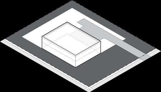
Loading in Front and Corner Established Yards not allowed

Pull-Off Loading Area
“Pull-Off” Loading Area
Location of Off-Street Loading Spaces
Off-Street Loading
(d) Design and Construction of Loading Areas
The design and construction of loading spaces shall be in compliance with the stricter of the regulations contained in this section , or the minimum specifications prescribed by the Board of Public Works. The following standards shall apply to the design of offstreet loading areas:
(1) Loading and Unloading Activity. Loading and unloading activity may not encroach upon or interfere with any public right-of-way, except where specifically designated by the Board of Public Works.
(2) Maneuvering. Each maneuvering area, aisle, and interior access drive utilized to access a loading space shall be designed and located to provide safe and efficient ingress/egress to each loading space. Trucks shall not need to back from or into a public street, or onto an adjoining lot (unless the subject lot and the adjoining lot are located within the same integrated center or industrial park and such maneuvering area is subject to a recorded easement allowing such maneuvering).
(3) Surface of Loading Areas. All off-street loading areas and the ingress/egress to and from such off-street loading areas located on such lot shall be hard surfaced with asphalt, concrete, or other material to provide a durable dust-free surface.
(4) Landscaping. Where any loading area is located within 50 feet of, and visible from, a side or rear lot line that abuts any lot in a S1, S2, U1, U2, U3, or UF district, the loading area shall be screened by a Type 3 buffer, designed per Section 21-09.01(n)
(5) The design of loading areas shall be subject to the approval of the Department of Public Works.
(e) Use of Loading Area
Space allocated for off-street loading spaces and associated maneuverability shall not be used to satisfy off-street parking space requirements.
Section 21-07.05: Private Streets & Alleys
(a) Intent
This section is intended to provide minimum design standards necessary to ensure safety, coordinated development, and efficient circulation when access is provided by private streets or alleys.
(b) Applicability
All private streets and private alleys, when specifically authorized for use by the City of South Bend through the applicable development review process, shall be developed to the following standards.
(c) Design and Construction of Private Streets and Alleys
(1) Pavement Width for Private Streets. Minimum pavement width for that portion of a private street available for through traffic (i.e., exclusive of parking spaces) shall be:
(A) In a S1, S2, U1, U2, U3, or UF district:
i. One-way Traffic - 12'
ii. Two-way Traffic - 20'
(B) In a NC, DT, OS, U, C, or I district:
i. One-way Traffic - 14'
ii. Two-way Traffic - 28'
(2) Pavement Width for Private Alleys. The minimum pavement width for that portion of a private alley available for through traffic (i.e., exclusive of parking spaces) shall be a minimum of 12 feet in any district.
(3) Depth and Materials. The minimum pavement depth and materials for a private street or private alley shall be as required by the City of South Bend for a public street or public alley.
(4) Curbs. Curb sections for a private street or private alley shall be as required by the City of South Bend for a public street or public alley.
(5) Emergency Vehicles. The geometric design of a private street or private alley shall provide for the through movement or turn-around of emergency vehicles. The Board of Public Works or Fire Department may require private street or alley widths or access beyond the minimums required in this Ordinance.
(6) Maintenance / Services. Prior to the issuance of an improvement location permit or obtaining secondary plat approval, the developer or subdivider shall file documentary assurances with the Board of Public Works that all lots served by a private street or private alley shall be provided with the following services: regular trash pick-up; leaf pick-up; snow removal; daily mail delivery service; roadway maintenance and repair, including, but not limited to, driving surface, roadway subgrade, subsurface drainage, roadside drainage, curbs, sidewalks, street lights, street name signs, traffic control signs, and traffic control signals; and, powers to enforce speed control and parking regulations. Such services shall be provided in accordance with the specifications approved by the Board of Public Works, which shall include the establishment of a maintenance fund or escrow account by the developer or subdivider, which may be supplemented by regular or special assessments against each lot owner provided such assessments are at reasonable and nondiscriminatory rate of charge. Such documentary assurances shall be incorporated into the applicable final plat that is recorded in the Office of the Recorder of St. Joseph County, Indiana, or otherwise provided for through legally binding perpetual agreements as approved by the Board of Public Works.
Article 21-08: Building Standards
Sections
Section 21-08.01: Building Standards 8-1
Section 21-08.02: Building Types 8-7
Section 21-08.03: Building Frontage Types ............. 8-17
Section 21-08.01: Building Standards
(a) Intent
This section includes regulations that reinforce the scale and design of buildings that are unique to South Bend and are intended to improve the physical quality of buildings that contribute to the overall character of the City, emphasizing the importance of how buildings relate to the public street.
(b) Applicability
Within the City of South Bend, all new developments and all additions to existing development shall comply with the standards of this section, except:
(1) Detached ancillary dwelling units; and
(2) Accessory structures.
(c) Building Design
(1) All primary buildings shall be designed to be permanently erected on a permanent foundation and connected to all required utilities.
(2) Primary facades shall be oriented to a front lot line. Building designs that orient main entrances so that they are not visible from the primary street are prohibited. Any entrance on a side facade shall be visible from the street or clearly identified using architectural features, awnings/canopies, or lighting. The Zoning Administrator may waive this requirement for buildings oriented to a common open space.
(3) Buildings shall provide windows and doors on facades facing primary and secondary streets that meet the transparency requirements of the applicable zoning district. Building designs that create blank wall conditions facing primary or secondary streets are prohibited.
(4) In a U3, UF, NC, or DT district, when fronting and within 50 feet of a public street, any parking structure or podium building having a ground-floor parking lot shall have at least 75 percent of the linear width of the ground floor front and corner facades be comprised of occupied liner spaces at least 15 feet deep. The measurement shall be made from building corner to building corner and exclude pedestrian and vehicular entries. The liner spaces may include permitted uses, such as retail areas, dwellings, leasing offices, or fitness centers.
(d) Building
Materials for Existing Buildings - Front and Corner Facades
Renovations and restorations of older buildings shall respect the original building design, including structure, use of materials, and details. The following requirements apply to all exterior renovations and major additions of residential buildings with 5 or more units and nonresidential buildings in all zoning districts.
(1) Exterior renovations, major additions, renovations of residential buildings with 4 or fewer units, and accessory buildings are encouraged to comply with the provisions of Section 21-08.01(e), however, at a minimum they shall utilize building materials that are compatible and harmonious with the materials used on the existing building.
(2) To the extent possible, new materials or signs shall not cover original materials and detailing.
(3) Natural materials (brick, slate, glass, stone, etc.) shall be retained and not covered with any other materials.
(e) Building
Materials for New Construction - Front and Corner Facades
The following regulations shall apply to all front and
corner facades of residential buildings with 5 or more units and non-residential buildings in all zoning districts.
(1) Building materials used on the front and corner facades shall extend a minimum depth of 16 inches along the side facade, measured from the face of the front or corner facade.
(2) Exterior insulation and finish system (E.I.F.S.) is not permitted on the ground floor except as trim. In a C or I district, however, E.I.F.S. may constitute a maximum of 66 percent of the ground floor facade.
(3) Standard, fluted, or split face concrete masonry units (CMUs) above the basement level are prohibited as face material. Glazed or heavily polished CMUs are allowed.
(4) Unfinished metal, plywood, and unfinished precast or poured-in-place concrete are prohibited.
(5) Commercial-grade/scale products are prohibited on any residential building facade.
(6) Windows and doors on a ground floor front or corner facade shall have clear, transparent glass that has a minimum Visible Light Transmittance (VLT) of 50 percent and a maximum Visible Light Reflectance (VLR) of 25 percent as indicated by the glass manufacturer.
(7) Roofs on residential buildings shall be clad in cedar wood shake, fiberglass shingles, asphalt shingles, slate shingles, clay tile, prefinished pre-stamped metal shingles, prefinished metal standing seam, or other recognized roofing material. Sheet or roll-type roofing is prohibited on sloped roofing.
(8) In a NC or DT district, the following additional regulations apply.
(A) Vinyl siding is prohibited.
(B) Security devices such as coiling shutters and accordion gates are prohibited on front or corner side facades, except where such devices are at least 50 percent transparent and located wholly behind a window or door, when viewed from the public right-of-way or open space.
(C) Vents, air conditioners, and other utility elements, except where such elements are
enclosed, camouflaged, screened, obscured, or otherwise not visible from the street, are prohibited as part of a front or corner facade.
(9) In a NC or DT district, all primary buildings shall comply with the following architectural regulations in order to create variation and interest in the built environment:
(A) A minimum of 66 percent of each front or corner facade shall be constructed of the following primary building materials:
i. High quality, durable, natural materials, such as brick or stone; wood lap siding; lapped, shingled, or panel fiber cement board siding; and glass.
ii. Other high quality synthetic materials such as synthetic equivalents of brick or stone, architectural precast concrete that looks like brick or stone; or traditional lime-based stucco may be approved by the Zoning Administrator.
(B) Each applicable facade shall include at least two architectural elements (e.g., quoins, pilasters, soldier courses, lintels, friezes, cornices, dentils, architraves, etc.).
(10) In a C district, a minimum of 66 percent of each front or corner facade of all primary buildings shall be constructed of the following building materials:
(A) High quality, durable, natural materials, such as brick or stone; wood lap siding; lapped, shingled, or panel fiber cement board siding; and glass.
(B) Other high quality synthetic materials such as synthetic equivalents of brick or stone, architectural precast concrete that looks like brick or stone; or traditional lime-based stucco may be approved by the Zoning Administrator.
(C) Exterior insulation and finish system (E.I.F.S.).
(f) Facade Articulation - NC or Dt District
In a NC or DT district, these regulations are intended to encourage walkable environments by creating visually interesting buildings with human scaled details and proportions. The following regulations apply to any building greater than 50 feet wide.
Bu I lDING StANDARDS
Building Standards
(1) A facade shall be organized using a consistent rhythm and pattern of windows, building articulation, or other architectural features. Facades shall be organized into building segments that consist of regularly repeated spatial elements making a vertical division in a structure, commonly defined by the number of window and door openings per floor or by the space between columns and/or piers.
(2) Vertical articulation is required to visually break up the massing of the front and corner facades into building segments no greater than 32 feet in width. Vertical articulation may be satisfied through the use of architectural features such as bays, columns, pilasters, mullions, regular repetition of window patterns, a break in the building plane, or recessed entries. On corner lots, of the primary facade segment along the
(3) Horizontal articulation cornice lines, entablatures, canopies, changes
Horizontal Course above Ground Floor
Storefronts set rhythm of each segment above
Base
recessed entries, or other architectural treatments) is required to help distinguish the ground floor or podium from upper stories.
(4) Variation in color shall not be used to meet the required articulation.
(5) A main entrance shall effectively address the adjacent public realm and be given prominence on the building facade. This may be satisfied through the use of architectural features such as entranceway roofs or recesses; a chamfered corner; sidelight windows, transom window, or other adjacent windows; additional mouldings with expression lines; or a bay of unique width.

A building segment consists of regularly repeated spatial elements making a vertical division in a structure, commonly defined by the number of window and door openings per floor or by the space between columns and/or piers.
Facade Articulation
Parapet
Pilaster
Lintel Cornice
Horizontal
(g) Building Components
Building components are smaller building features that are attached to the primary building mass. Building components provide architectural articulation and/or additional usable space. The following sections include definitions of typical building components and any additional regulations that may apply.
(1) Architectural Features. Includes sills, belt courses, eaves, cornices, roof overhangs, chimneys, or other ornamental elements attached to or laterally supported by a building.
(A) Architectural features may encroach a maximum of 3 feet into any minimum required setback but shall be located at least 18 inches from a lot line.
(B) Architectural features may extend up to 3 feet into a right-of-way with the permission of the Board of Public Works.
(2) Awning or Canopy. A wall-mounted, roof-like cover, often of fabric, metal, fiberglass, or glass providing protection from the weather or decorative embellishment over a window, door, sidewalk, walkway or the like.
(A) An awning or canopy may encroach a maximum of 8 feet into a minimum required front or corner setback.
(B) With the permission of the Board of Public Works, an awning or canopy may extend into a right-of-way to within 18 inches of a curb.
(C) An awning shall be securely attached to and supported by the building, A canopy shall be attached to the building but may also be supported by posts.
(D) An awning or canopy shall match the approximate width of the windows or doors to which the awning or canopy is attached or covering.
(E) The bottom edge of the awning or canopy shall have a minimum clear height over a sidewalk or walkway of 8 feet.
(F) An awning shall be made of a durable, weather resistant material, such as cloth, canvas,
canvas-like material, acrylic fabrics, nylon, or metal. Awnings shall not be made of vinyl.
(G) Open-ended awnings and operable awnings are encouraged. Rounded and hooped awnings are discouraged.
(H) Awnings shall not be internally or back lit.
(I) An awning or canopy used as a building sign is subject to the additional requirements of Section 21-10
(3) Balcony. A platform with a railing that may project or be recessed within a building facade located above the first story.
(A) Balconies shall be a minimum of 5 feet deep and 6 feet wide, excluding false or juliet balconies that are less than 16 inches deep.
(B) A balcony may encroach a maximum of 5 feet into a minimum required front, corner, or rear setback.
(C) With the permission of the Board of Public Works, a balcony may extend into a right-ofway.
(4) Bay Window. A bay window extends outward from a building to increase light, views, and articulation of a facade.
(A) A bay less than 10 feet in width may encroach a maximum of 3 feet into any minimum required setback but shall be located at least 18 inches from a lot line.
(5) Building Entrance. A point of ingress and egress for pedestrians into a building, upper story use, or first floor tenant space.
(6) Building Frontage Type. Building frontage types are located at the main building entrance and provide an interface or transition between the private realm (building interiors) and the public realm (sidewalks and civic spaces).
(A) See Section 21-08.03 for all frontage type regulations.
(B) Multiple frontage types may exist for buildings that have more than one main entrance.
(7) Deck. A roofless, ground-supported, and unenclosed platform, usually constructed of wood, of which any permanent horizontal area(s) of the platform is raised above grade level and is designed and intended for the recreational enjoyment of the occupant(s) and guest(s) of the primary structure or use.
(A) Any deck over 30 inches above grade shall comply with all minimum required setbacks for the applicable district.
(B) A deck less than 30 inches above grade, inclusive of any railing, may be located within any minimum required setback but shall not encroach more than 8 feet into the minimum front setback.
(8) Fire Escapes, Exterior. An emergency exit mounted outside of a building that provides a method of escape in the event of a fire or other emergency when interior stairwells are inaccessible.
(A) Fire escapes may be added to existing buildings when no other means of providing egress is possible or practical.
(B) To the extent possible, fire escapes shall not be located on a front or corner facade. Rear or side facades are preferred.
(C) Exterior fire escapes may encroach into any minimum required setback and may encroach into a right-of-way with permission of the Board of Public Works.
(D) Sizing and location of fire escapes shall be approved by the Fire Marshal.
(9) Forecourt. See Section 21-08.03(f) for all regulations relating to forecourts.
(10) Gallery. See Section 21-08.03(e) for all regulations relating to galleries.
(11) Garage. A fully-enclosed structure, whether attached to or detached from a primary building, used for the storage of vehicles.
(A) Garages shall comply with all minimum required building setbacks but may encroach into a required rear setback up to within 5 feet of the rear lot line.
(B) Except in a S1 district, if the garage door on an attached garage faces a primary or secondary street, the garage shall be set back at least 5 feet behind the front or corner building facade.
(C) If oriented with garage doors facing a street, a garage shall not be located less than 18 feet from the right-of-way, sufficient to accommodate the parking of an automobile without blocking the sidewalk or any public way.
(D) If oriented with garage doors facing an alley, a garage shall be located 5 feet from the lot line or have a setback of not less than 18 feet from the right-of-way, sufficient to accommodate the parking of an automobile without blocking any public way.
(E) In a S1, U1, or U2 district, the total capacity of a garage, garages, or carports, in combination, whether attached or detached, shall not exceed 4 vehicles. Garage Location

(12) Patio. A hard-surfaced space laid or poured directly on finished grade with at least one side open to the weather and essentially unobstructed to the sky, specifically designed and intended for the recreational enjoyment of the occupant(s) and guest(s) of the primary structure or use and not designed or intended for use by automotive vehicles.
(A) A patio less than 30 inches above grade may be located within any minimum required setback but shall not encroach more than 8 feet into the minimum required front setback.
(13) Porch. See Section 21-08.03(c) for all regulations relating to porches.
(14) Porte-Cochere. A porte-cochere is a roofed structure that is integrated with the design of the primary building and extends over a driveway, providing an articulated entryway and protection from the weather.
(A) A porte-cochere shall be open on at least two sides.
(B) A porte-cochere may be located within an established front, corner, side or rear yard but shall comply with all minimum required building setbacks.
(15) Ramps/Wheelchair Lifts. Includes accessibility ramps or wheelchair lifts that meet federal, state, and local accessibility standards.
(A) Accessibility features may encroach into any minimum required setback to the extent necessary to perform its proper function.
(16) Rear Extensions. A secondary extension from the rear wall of a primary building that extends into a required rear setback for a primary building.
(A) Rear extensions may encroach into a required rear setback for a primary structure, but they shall be limited to a maximum of one story and shall comply with the maximum allowed height limit for accessory buildings within the applicable zoning district.
(B) Rear extensions shall have a smaller footprint, a narrower width, and a depth not greater than the main building.
(C) Rear extensions shall comply with the maximum allowed building coverage within the applicable zoning district.
(D) Rear extensions may encroach into any established rear yard up until the rear setback for accessory buildings. Rear extensions shall meet the minimum required corner and side setbacks for primary buildings.
(17) Satellite Dishes. See Section 21-06.02(f)(22) for all regulations relating to satellite dishes.
(18) Storefront. See Section 21-08.03(g) for all regulations relating storefronts.
(19) Stoop. See Section 21-08.03(d) for all regulations relating to stoops.
(20) Terrace. See Section 21-08.03(h) for all regulations relating to terraces.
(21) Towers, Turrets, and Cupolas. A building component that is significantly taller than it is wide with the purpose of gaining views, providing light and ventilation to a building, adding a decorative element, or terminating an important axis including tower, turrets, cupolas, elevator or stair towers, or steeples.
(A) Towers, turrets, cupolas, and the like may exceed the maximum building height, up to 25 feet in height above the roof line.
(B) Towers, turrets, cupolas, and the like shall comply with all minimum required setbacks for a primary structure.
Building Types
Section 21-08.02: Building Types
(a) Intent
This section regulates different physical forms of buildings within each zoning district, creating variation in the urban environment within an appropriate scale. The following regulations apply in addition to the development standards for each zoning district. In the case of a conflict, the more restrictive regulation shall prevail.
(b) Applicability
All primary buildings in any Standard District shall comply with the requirements of this section in addition to the development standards of Section 21-03 Building types do not apply to development within a Special District, as regulated within Section 21-04
(1) An applicant shall select which allowed building type corresponds to the building proposed for construction or alteration, and shall comply with the standards for that building type as it relates to that new construction or alteration.
(2) The applicant shall select which allowed building frontage type will be used with the selected building type, per Section 21-08.03
(3) Each building type may house any use allowed in the zone in which it is located in accordance with Section 21-06 The names of the building types are not intended to limit or expand uses within a building type.
(4) Civic and Institutional uses are exempt from this section.
(c) Number of Buildings
Each lot shall comply with the maximum number, if any, of primary buildings allowed by the building type requirements of this section. The Zoning Administrator may waive this requirement if the submitted building permit application includes a site plan with potential lot lines that meet the intent and all the requirements of this Ordinance.
Carriage House
Detached House
Cottage Court
Duplex
Townhouse
Apartment House
Stacked Flats
Shop
Mid-Rise/Tower
Key Allowed
Table 21-08A: Building Types Allowed by Zoning District
21-08.02(d) Building Type: Carriage House
(1) Description
A Carriage House is an accessory structure typically located at the rear of a lot, designed as a small residential dwelling, home office space, or small business space located above a garage or at ground level. Carriage Houses provide affordable housing opportunities within walkable neighborhoods.

Illustrative Examples

(2) Zoning Districts
The Carriage House building type is permitted in the following districts:
(3) Building Type Standards
Lot Requirements
Only allowed on a lot that has a primary building.
Building Dimensions
Building Height See Zoning District
Building Width 36' max.
Total Finished Floor Area 800 sq. ft. max.
Separation between buildings 10' min.
Number of Dwelling Units
Units per Carriage House 1 max.
Carriage Houses per Lot 1 max.
Facade Design
Placement of windows and doors requires careful consideration for privacy of both owner and neighbors.
Allowed Frontage Types
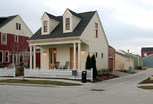
Building Types
21-08.02(e): Building Type: Detached House
(1) Description
A Detached House is a small to medium-sized, freestanding structure on a single lot. It is typically located within a residential neighborhood of primarily single unit houses in a walkable urban setting or in outlying areas of the City. A Detached House may be accessed from the alley or from a driveway off of the street. Garages may be attached or detached to the main house on the same lot.
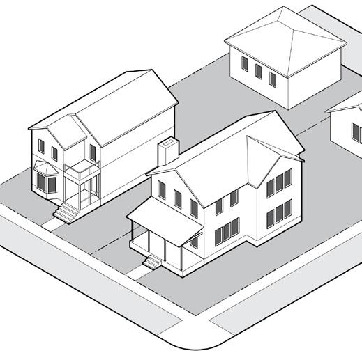
(2)
Zoning Districts
The Detached House building type is permitted in the following districts:
(3) Building Type Standards
Building Dimensions
Building Height 2.5 stories max.
Number of Dwelling Units
Units per Detached House 1 max.
Detached Houses per Lot 1 max.
Allowed Frontage Types
Porch Gallery
Stoop Illustrative Examples


Building Types
21-08.02(f)
Building Type: Cottage Court
(1) Description
A Cottage Court consists of a series of small, detached buildings arranged to define a shared court that is typically perpendicular to the street. This type is appropriately scaled to fit within primarily single unit or medium-density neighborhoods. The courtyard shall be either partially or wholly open to the street.

Illustrative Examples

(2) Zoning Districts Allowed
The Cottage Court building type is permitted in the following districts:
(3) Building Type Standards
Lot Requirements
Lot Width (along street) 50' min.
If cottage court is subdivided into multiple lots, each lot shall front onto the open space and meet the building coverage requirements of the applicable zoning district.
Building Dimensions
Building Height 1.5 story max.
Separation between buildings 5' min.
Number of Dwelling Unit s (includes ancillary dwellings)
Units per Cottage 2
Dwelling Units Per Lot U2
Common Space
Allowed Frontage Types

Building Types
21-08.02(g) Building Type: Duplex
(1) Description
A Duplex consists of two side-by-side or stacked dwelling units, both facing the street, within a single building mass. This type has the appearance of a medium to large detached home and is appropriately scaled to fit within primarily single unit neighborhoods or medium-density neighborhoods.
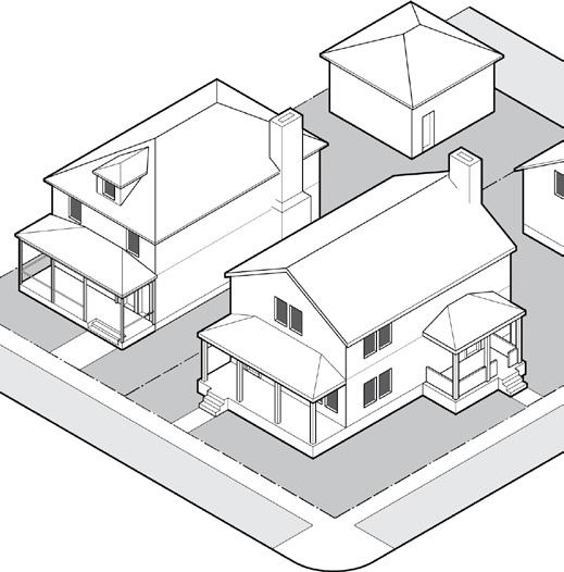
Illustrative Examples

(2) Zoning Districts Allowed
The Duplex building type is permitted in the following districts:
(3) Building Type Standards
Building Dimensions
Building Height 2.5 story max.
Building Width 48' max.
Number of Dwelling Units
Units per Duplex 2 max.
Duplex per Lot 1 max.
Allowed Frontage Types
Porch Gallery
Stoop

21-08.02(h) Building Type: Townhouse
(1) Description
A Townhouse is an attached structure that consists of 3–8 townhouses placed side-by-side on narrow lots that share a party wall. Typically located within medium-density neighborhoods or in a location that transitions from residential into a neighborhood center. Each unit has an individual entrance along a street or open space. Garages may be detached or attached, often tucked under the main living floor above.


(2) Zoning Districts Allowed
The Townhouse building type is permitted in the following districts:
(3) Building Type Standards
Building Dimensions
Building Height 3 story max.
Building Width (total of all attached Townhouses) U2 district 4 units or 72' max. All other districts 8 units or 168' max. Townhouse Width 15' min., 36' max.
Number of Dwelling Units
Allowed Frontage Types

Building Types
21-08.02(i)
Building Type: Apartment House
(1) Description
An Apartment House is a medium-sized structure that consists of 3 or 4 side-by-side and/or stacked dwelling units, typically with a shared entry. This type has the appearance of a large family home and is appropriately scaled to fit within primarily single unit neighborhoods or into medium-density neighborhoods.
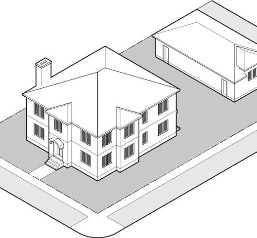

(2) Zoning Districts Allowed
The Apartment House building type is permitted in the following districts:
(3) Building Type Standards
Building Dimensions
Building Height 3 story max.
Building Width
U2 district 48’ max.
All other districts 60’ max.
Separation between buildings 10’ min.
Number of Dwelling Units
Units per Apartment House 3 min. / 4 max.
Apartment Houses per lot U2 district 1 max.
All other districts Unlimited
Allowed Frontage Types
Porch Gallery
Stoop
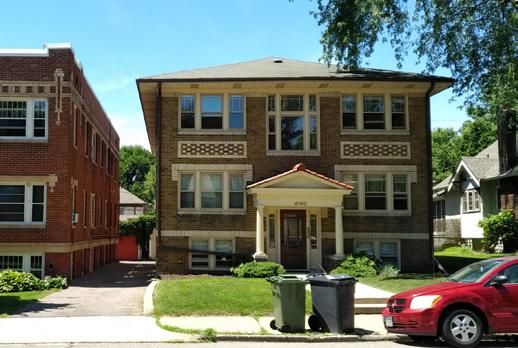
21-08.02(j) Building Type: Stacked Flats
(1) Description
Stacked Flats is a medium-to-large-sized structure that consists of 5 or more side-by-side and/or stacked dwelling units. Units typically share one or more common entries but may have an individual entry accessed off of a courtyard or series of courtyards. This type is appropriately scaled to fit within mediumdensity neighborhoods, neighborhood centers or downtown.


(2)
Zoning Districts Allowed
The Stacked Flats building type is permitted in the following districts:
(3) Building Type Standards
Building Dimensions
Building Height (stories) 2 min. / 5 max.
Building Width
S2, DT districts 200' max.
All other districts 120' max.
Separation between buildings 10' min.
Number of Dwelling Units
Units per Stacked Flats 5 min.
Allowed Frontage Types Porch Gallery Stoop Forecourt

Building Types
21-08.02(k) Building Type: Shop
(1) Description
A Shop is a structure intended to provide pedestrian oriented retail and services on the ground floor. It may be a single story or provide a vertical mix of uses with upper-floor residential or office uses. Upper floor units are typically accessed by a common entry, preferably located along the street. This type is the primary component of a neighborhood center and may be found downtown. It is a critical component to creating a walkable environment.
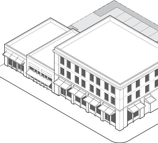

(2) Zoning Districts Allowed
A Shop building type is permitted in the following districts:
(3) Building Type Standards
Building Dimensions
Facade Height 16' min.
Building Height 6 stories max.
Building Width 150' max.
Number of Dwelling Units
Units per building Unlimited
Allowed Frontage Types

21-08.02(l) Building Type: Mid-Rise/Tower
(1) Description
A Mid-Rise/Tower is a structure with substantial height, built on a large lot that may incorporate structured parking. It is used to provide a vertical mix of uses with retail or service on the ground-floor and residential or office on the upper-floors; or may be a single-use building. Upper floors shall step back from ground floor building facade in order to provide adequate light and air at the sidewalk level. This type is a primary component of an urban downtown and high intensity neighborhood centers.

Illustrative Examples

(2) Zoning Districts Allowed
The Mid-Rise/Tower building type is permitted in the following districts: DT
(3) Building Type Standards
Building Dimensions
Building Height 6 stories min.
Building Footprint 400' x 400' max.
Number of Dwelling Units
Units per building Unlimited
Facade Setback (from facade of floors below)
Floors 6-8
Abutting DT district 0' min
Abutting any other district 10' min.
Floors 9+
Front/Corner
Allowed Frontage Types
of building footprint max.

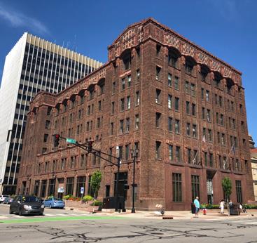
Building Frontage Types
Section 21-08.03: Building Frontage Types
(a) Intent
Building frontage types provide a transition and appropriate interface between the public realm (street and sidewalk) and the private realm (yard and building). The allowed frontage type standards supplement the standards for each building type.
(b) Applicability
Building frontage types shall be applied to all primary buildings located in a Standard District. If any of the building frontage types are included on a building, even if not required, it shall comply with the standards of this section.
(1) Table 21-08B identifies the frontage types allowed for each building type.
(2) Building frontage types may encroach into a minimum required setback as allowed by the applicable zoning district.
(3) Any encroachment of a frontage type into a public right-of-way shall be approved by the Board of Public Works.
(4) Civic and Institutional uses are exempt from this section.
Table 21-08B: Building Frontage Types Allowed
Porch
Stoop
Gallery
Forecourt
Storefront
Terrace Key Allowed
(1) Description
A porch is a raised, roofed platform attached to a building to form an articulated entryway and semiprivate social space. Porches may be projecting, engaged, or integral to a building facade.
(2) Frontage Standards
A porch shall have a roof.
If unenclosed and open on three sides, a porch may encroach into a required front or corner setback as allowed by the applicable zoning district.
Open porch bases shall be enclosed with latticework or similar material, or visually concealed with landscape.
21-08.03(c) Frontage Type: Porch 21-08.03(d) Frontage Type: Stoop
(1) Description
A stoop is a small raised platform that serves as an entryway to a building, typically for residential uses with small setbacks. A stoop may be roofed or open to the sky, although a covered or recessed stoop is preferred to provide shelter from the elements.
(2) Frontage Standards
A stoop shall be at least 18” above the sidewalk and shall directly connect to the sidewalk, walkway, or driveway.
A stoop shall have a railing or wall, a covering, or be at least 18” above the adjacent walkway or driveway.
If unenclosed and open on three sides, a stoop may encroach into a required front or corner setback as allowed by the applicable zoning district.

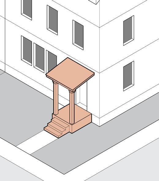
Bu I lDING StANDARDS
Building Frontage Types
21-08.03(e) Frontage Type: Gallery
(1) Description
A raised platform that provides additional living space for upper floor uses, with access solely from the interior of a building. A gallery may be roofed or uncovered and may be projecting or be integral to the building.
(2) Frontage Standards
Dimensions
Width, Clear 8' min.
Depth, Clear 6' min.
Ground Floor Height, Clear 8' min.
Height 1 story max. 1
1 A 2-story gallery may be approved by the Zoning Administrator on stacked flats, shops, or mid-rise/towers.
Standards
Galleries shall be supported from below by a porch, arcade, or other structure; or visually supported by brackets, corbels, or beams along its full depth.
In a NC or DT district with a retail ground floor, a gallery shall extend over the sidewalk with approval of the Board of Public Works.
21-08.03(f) Frontage Type: Forecourt
(1) Description
A forecourt is a space open to the sky formed by a recess in the central portion of the building facade. Porches, stoops, and galleries may encroach into the forecourt.
(2) Frontage Standards
Dimensions
Width, Clear 12' min.
Depth, Clear 12' min.
Height (max.) 2 x width of forecourt
Standards
A forecourt shall be enclosed by building walls on three sides and give careful consideration to solar orientation. A minimum 25% of forecourt shall be composed of landscape with remaining areas paved with hardscape material. Asphalt may not be used as a surface material.


21-08.03(g) Frontage Type: Storefront
(1) Description
A storefront is utilized for all retail uses featuring a primary entrance at grade and incorporating substantial windows at the sidewalk level for the display of goods, services, and signs.
(2) Frontage Standards
Dimensions
Depth of Recessed Entry 5' max.
Sill Height 3’ max.
Standards
Open-ended, operable awnings or canopies are encouraged for shade and weather protection.
Bi-fold glass windows and doors that allow the space to open to the sidewalk are encouraged.
Residential grade windows are not permitted.
21-08.03(h) Frontage Type: Terrace
(1) Description
A terrace accommodates a change in grade by using an elevated platform to provide circulation and access across the front of a building. Terrace frontages may be used to mimic historic loading docks of old industrial areas.
(2) Frontage Standards
Dimensions
Depth, Clear 8' min.
Finished Level above Sidewalk 4' max.
Standards
Frequent steps up to the terrace are required to maximize access and avoid blank walls along the sidewalk.
Low walls used as seating are encouraged.
Building Frontage Types
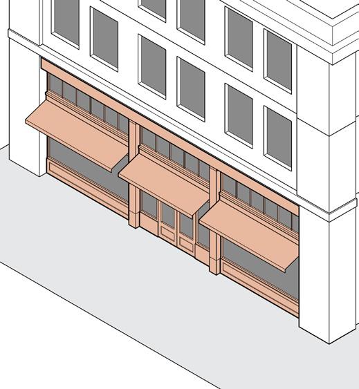

Article 21-09: Site Development Sections
Section 21-09.01: Landscape 9-1
Section 21-09.02: Fences & Walls 9-10
Section 21-09.03: Stormwater .......................... 9-12
Section 21-09.04: Outdoor Lighting 9-13
Section 21-09.05: Clear Sight Area 9-16
Section 21-09.06: Performance Standards 9-17
Section 21-09.01: Landscape
(a) Intent
Landscape is an essential element of the site design process and is an important feature in promoting public health, safety, comfort, convenience, and general welfare. Landscape regulations are intended to:
(1) mitigate incompatibilities between adjacent land uses and reduce the negative impacts of higher intensity land uses on less intense adjacent land uses;
(2) provide critical visual and noise buffering between higher intensity district and less intense districts;
(3) lessen the impact of development on the environment by reducing glare and heat buildup; and
(4) break up large expanses of pavement so as to reduce impervious surface area, storm water run-off, and the level of pollutants from non-point sources.
(b) Applicability
All new developments and all additions to existing development (building additions, parking area expansions, etc.) shall provide landscape as required by this section and within the applicable zoning district.
(c) Installation of Landscape
All landscape required by this section or regulated within the applied zoning district shall be installed prior to the issuance of a final certificate of occupancy for the use on the real estate. If seasons, weather conditions, or other conditions beyond the applicants' control create a situation which is not appropriate for the installation of landscape immediately prior to the issuance of a final certificate of occupancy, the Zoning Administrator may
(d)
authorize a temporary certificate of occupancy pending the installation of landscape required; landscape shall be installed not later than 3 months after the start of the next planting season. The start of planting seasons shall be March 15 and August 15 of each year.
Minimum Plant Material Sizes at Time of Planting
All plant materials specified within this Ordinance shall comply with the minimum sizes at time of planting as specified in the following table.
Table 21-09A: Minimum Size at Time of Planting
Deciduous Shade Tree 2 ½" caliper at 6" above ground
Deciduous Ornamental Tree 1 ½" caliper at 6" above ground
Evergreen Tree 1 6' high
Hedge Plants / Shrubs 24" high
1 Evergreen must be of a wide spread species that does not drop its lower branches (e.g., white pines).
(e) Maintenance of Landscape
All plant materials shall be maintained in a healthy, growing condition. The owner shall be responsible for the replacement of any required planting that is removed or dies after the date of planting. Such replacement shall occur within three months after the start of the next planting season. Failure to maintain required landscape areas shall constitute a violation of this Ordinance enforceable under the provisions of Section 21-13.02
(f) Live vegetation
All trees and shrubs required by this section shall be living vegetation.
(g) Tree Conservation
All proposed development shall conserve on-site established trees, defined as any healthy tree with a caliper of 6 inches or more, measured at 6 inches above the ground.
(1) Removal. An on-site established tree may be removed only if at least one of the following conditions are satisfied:
(A) The tree interferes with the construction of a structure or other site improvement, no feasible and prudent location alternative exists on-site for the proposed structure or other site improvement, and no possibility exists for incorporation of the tree into the proposed development.
(B) The tree is causing damage to an existing structure or site improvement and no feasible remedy exists other than removing the tree.
(C) The tree is diseased or injured beyond restoration, as determined by a licensed arborist.
(D) The tree is dead, is in danger of falling, is located so as to pose a threat to existing structures, interferes with existing utility infrastructure, is in conflict with required clear sight area, or is otherwise considered hazardous or unsafe.
(2) Replacement. In the event that an on-site established tree of a minimum of 6 inches diameter, measured at 6 inches above the ground, is removed under any circumstances, including the accidental killing of a tree during the course of construction activity, the following requirements apply:
(A) For each established tree that is removed, one replacement tree shall be installed on-site beyond that which is otherwise required by
this section. The replacement trees shall be installed in compliance with Section 21-09.01(c)
(B) If the site cannot accommodate the number of trees required as replacements, the Zoning Administrator may allow the replacement trees to be installed off-site within the city limits of the City of South Bend.
(C) A replacement tree may be planted in a public park or public right-of-way with the authorization of the City Forester.
(h) Berms
An earthen berm may be used, subject to the following:
(1) Berms are prohibited in a U1, U2, U3, UF, NC, or DT district.
(2) Each berm shall have a maximum height of 3 feet, or up to 6 feet in the I district. Berms shall be planted and covered with live vegetation.
(3) Each berm shall have a minimum crown width of 2 feet and a side slope not greater than 3 feet horizontal to 1 foot vertical (3:1).
(4) Berms shall not interfere with clear sight area or required drainage.
(i) Relation to Utilities
In those instances where overhead utilities are located within a required setback, required buffer, or tree lawns, plant material selections shall be limited to small growing trees which do not exceed 25 feet in height at maturity. Landscape plantings may be shifted to avoid underground utilities.
(j) Location of Landscape
To the extent possible, landscape required by this section shall be placed on the development site, with the exception of streetscape trees. When circumstances dictate that landscape can or should be placed in the public right-of-way to meet the requirements of this section, permission shall be obtained from the City Forester prior to the placement of landscape within the right-of-way. Landscape shall not interfere with clear sight area or utilities.
(k) Alternate Landscape Plan
The Zoning Administrator, upon request by an applicant, shall have the authority to approve an alternate landscape plan, subject to the provisions below, as long as the intent of this section is met. An alternate landscape plan may include the following:
(1) The redistribution or clustering of landscape materials.
(2) Any combination of shade trees, ornamental trees, evergreen trees, or hedge plants/shrubs, provided that the total amount of plant materials remains proportional to the base requirements of this section.
(3) The substitution of narrow spread evergreen trees for wide spread evergreen trees at a rate of 4 trees for each 1 required. If narrow spread evergreen trees are used, the required buffer width may be reduced by 5 feet.
21-09.01(l): Streetscape Trees
(1) Definition
Streetscape trees provide healthy, long-living trees along or adjacent to the public right-of-way in order to improve the comfort of public streets and sidewalks while creating a buffer between pedestrians and vehicular travel.
(2) Applicability
Streetscape trees shall be provided for all new development and additions to existing development (i.e., building additions, parking area expansions) as required within the applicable zoning district.
(3) Exemptions
The Zoning Administrator may waive a development from the required streetscape trees for the following scenarios:
(A) Streetscape trees of the minimum required number and size are already installed and maintained in a healthy, growing condition.
(B) The crown of a well-established tree planted on-site and adjacent to the outer edge of the lot reaches over the public right-of-way area and would cause overcrowding of the new street tree.
(C) The specific location of a curb cut, utility line, underground vault, transit stop/station, or other feature conflicts with the placement of a tree.
(4) General Requirements
All streetscape trees shall be installed in accordance with Chapter 19 Article 1 of the South Bend Municipal Code and planting standards of the Department of Venues, Parks, and Arts.
(A) A minimum of one streetscape tree shall be installed on the adjacent street, for each full 30 feet of street frontage. For example, a 50 foot lot width would require one tree, while a 60 foot lot width would require two trees.
(B) As indicated within the zoning district, streetscape trees may be permitted to be located within the established front yard of a lot instead of the street tree lawn.
(C) Streetscape trees shall consist of native, deciduous shade trees and selected from the recommend list of tree species for South Bend and approved by the City Forester.
(D) To the extent possible, streetscape trees shall be evenly spaced, with the exception of driveways or other interferences within the lot or right-of-way.
Driveway interrupts even spacing

Streetscape trees
Landscape
21-09.01(m): Building Foundation Landscape
(1) Definition
Building foundation landscape is installed along or in relation to the perimeter foundation of a building or structure to enhance the appearance from the street.
(2) Applicability
Building foundation landscape shall be provided for all new buildings and building additions with facades over 35 feet in width facing a street or civic space as required within the applicable zoning district and in accordance with the following regulations.
(3) Exemptions
Building foundation landscape is not required for the following scenarios:
(A) Residential buildings of up to 4 units;
(B) If a building is within 5 feet of an applicable lot line; and,
(C) Buildings located in a NC or DT district.
(D) The Zoning Administrator may waive the requirement for building foundation landscape if a building is located more than 50 feet from the street and the Zoning Administrator determines the building foundation landscape is not needed to meet the intent of this ordinance.
(4) General Requirements
(A) Building foundation landscape shall be provided at a rate of at least 1 hedge plant or shrub for every 5 feet of applicable facade. Any fractional result shall be rounded up to the next whole number. For example, if a minimum requirement is applied to a 62 foot long elevation, the resulting fraction of 12.4 requires 13 hedge plants.
(B) Building foundation landscape areas shall be a minimum of 3 feet in the smallest dimension.
(C) Building foundation landscape shall be located along or adjacent to each applicable building facade, except where a portion of the facade is devoted to pedestrian or vehicular ingress/egress, loading or drop-off zones, or outdoor seating areas. In these cases, foundation landscape shall be aggregated into one or more locations abutting such building elevation. Building Foundation Landscape Ingress/egress

Aggregated landscaping Outdoor seating
21-09.01(n): Landscape Buffer
(1) Definition
A landscape buffer provides screening or buffering between adjacent uses or zoning districts.
(2) Applicability
The following scenarios require the installation of a landscape buffer.
(A) A buffer is required between specified zoning districts as regulated within the applicable zoning district.
(B) A landscape buffer shall be provided where specific uses are introduced as part of any new development or change of use, as listed below.
Table 21-09B: Buffers Required by Use Uses Standards
Drive-Through Facility
21-06.01(k)(7)
Gas Station 21-06.01(k)(11)
Industrial, Heavy 21-06.01(g)(2)
Industrial, Light
Outdoor Storage
Parking Lots
21-06.01(g)(3)
21-06.02(f)(25)
21-06.01(l)(4)
Retail & Service, Heavy 21-06.01(k)(17)
Self-Storage Facility 21-06.01(k)(18)
Utilities, Major 21-06.01(m)(2)
Utilities, Minor 21-06.01(m)(3)
Vehicle Sales or Rental 21-06.01(k)(21)
Vehicle Service, Major 21-06.01(k)(22)
Warehouse/Distribution 21-06.01(g)(5)
(3) Exemptions
A buffer is not required for the following scenarios:
(A) Residential buildings of up to 4 units located in any zoning district.
(B) Except as otherwise required, when an alley separates applicable zoning districts, a buffer is not required along the lot line abutting the alley.
(4) General Requirements
(A) Buffers shall be located along the outer perimeter of the lot, parallel to and extending along 100 percent of the shared lot line, unless otherwise indicated in the use standards.
(B) Any fractional result shall be rounded up to the next whole number. For example, if a minimum requirement of 2 evergreen trees per 25’ of adjacent lot line is applied to a 40’ lot, the resulting fraction of 3.2 is rounded up to 4 required trees.
(C) Parking areas, loading, and driveways shall not be located in any buffer.
(D) Landscape buffers may include a combination of shrubs, trees, fences, and walls installed per the requirements Table 21-09C
(E) When two buffer types are required in the same general location, only the more intense buffer is required to be installed.
Landscape
Table 21-09C: Landscape Buffer Standards
Type 1
Type 1 Buffer
A min. depth of 5' and requires a continuous hedge row of shrubs planted 3' on center. The hedge may be replaced with a solid, masonry wall of 2-3' in height. The low wall may incorporate additional landscape.
Type 2

Type 2 Buffer
A min. depth of 5' with 20 shrubs for every 100' of length, spaced evenly or grouped together as desired. A continuous 6' high solid fence is required. A higher fence is permitted
Type Type
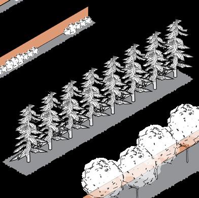
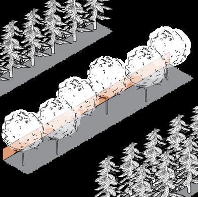
Type 3 Buffer
A min. depth of 15' and requires 8 evergreen trees for every 100' of length, spaced evenly in a single row at approximately 12.5' on center. If a 6' min. height fence is provided, evergreens may be replaced with shade trees provided at a rate of 6 shade trees for every 100' of length, spaced evenly or grouped together as desired.

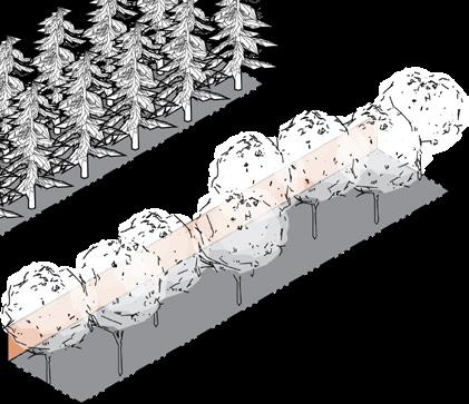
Type 4 Buffer
A min. depth of 25' and requires 14 evergreen trees for every 100' of length, spaced evenly in a staggered double row at approximately 12.5' on center. If a 6' min. height fence is provided, evergreens may be replaced with shade trees provided at a rate of 8 trees for every 100' of length, spaced evenly or grouped together as desired.
21-09.01(o): Parking Lot Landscape
(1) Definition
Parking lot landscape screens parking lots, enhances the aesthetics of a lot and the adjacent public realm, provides shade protection, and reduces the impervious surfaces on a lot.
(2) Parking Lot Screening.
All new surface, off-street parking lots and expanded surface off-street parking lots that contain 4 or more parking spaces, for any use, excluding driveways, shall provide parking screening subject to the following regulations:
(A) Where a parking lot is located along, within 50 feet of, and visible from a street or open space, other than an alley, the parking lot shall be screened by a Type 1 buffer per Section 21-09.01(n) The buffer shall be placed along the edge of the parking lot or access drive that faces the street, with breaks permitted for vehicular and pedestrian access.
(B) Where any parking lot is located along, within 50 feet of, and visible from a side or rear lot line that abuts any lot in a S1, U1, or U2 district, the parking shall be screened by a Type 1 buffer located at the edge of the parking area or a Type 2 buffer located along the abutting lot line, designed per Section 21-09.01(n) When an alley separates zoning districts, a buffer is not required along the lot line abutting the alley.
(C) When a more intense buffer type exists between a parking lot and the applicable lot line, the parking lot screening is not required.
(3) Parking Drive Landscape.
For the townhouse building type, individual driveways that are 18 feet long or more and lead to attached garages serving individual dwelling units shall provide a landscape strip at least 4 feet wide between driveways.
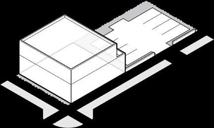


Landscape Attached Dwelling Unit with Garage Driveway
Off-Street Parking Lot Screening Options
Low masonry wall
Continuous hedge planted 3' o.c.
Combination of low wall and hedge
(4) Parking Lot Landscape Islands.
In addition to parking screening requirements, all new surface parking lots containing 30 or more parking spaces and all expanded surface parking lots which are increased by 30 or more parking spaces, whether such increase occurs at one time or in successive stages, shall be subject to the following regulations:
(A) All such off-street parking areas shall include at least 1 required landscape island for every 15 parking spaces (or fraction thereof).
(B) Each required landscape island shall measure a minimum 144 square feet in area.
(C) Each required landscape island shall contain a minimum of 1 deciduous shade tree or 1 deciduous ornamental tree.
(D) Parking islands should be located at the end of parking bays so as to define vehicular and pedestrian traffic patterns.
(E) Area devoted to landscape islands shall be in addition to any required streetscape, building foundation landscape, landscape buffer, building foundation landscape, or parking lot screening required by this section.
(F) Parking lots shall include areas used for Vehicle Sales or Rental uses.
(G) Parking lots do not include areas used for semi-truck loading, maneuvering, or parking.
(H) Zoning Administrator may approve a design where landscape islands are aggregated into one or more larger landscape islands.

Parking Lot Landscape Islands
Landscape island at end of parking bay
Drive lane
15spaces
Parking lot screening
Min. 144 square feet
Pedestrian Access Street Street
Section 21-09.02: Fences & Walls
(a) Applicability
The construction of a new fence or wall, or reconstruction of an existing fence or wall, shall comply with the standards of this section.
(b) Location
(1) Fences and walls may encroach into any required setback and be located in any established yard. No fence or wall shall encroach across a lot line or into a public right-of-way.
(2) All fences shall comply with the Clear Sight Area provisions of Section 21-09.05
(c) Height
The height of all fences and walls is measured from the average natural ground level within 2 feet of the base of the fence or wall. An additional 1 foot of height is allowed, above the maximum permitted height, for posts, columns, or light fixtures.
(1) Fences and walls shall not exceed the maximum height listed in Table 21-09D.
(2) On a lot without a primary building, the height of fences and walls shall not exceed 3 feet if less than or equal to 50 percent open or 4 feet if more than 50 percent open.
(3) In the NNZO, fences and walls shall be erected in compliance with the provisions of Section 2105.02(g)(1)
(4) An open fence enclosing a game court as defined by Section 21-06.02(f)(9) may be erected to a maximum of 12 feet in height, irrespective of the above standards.
yards require a lower fence height
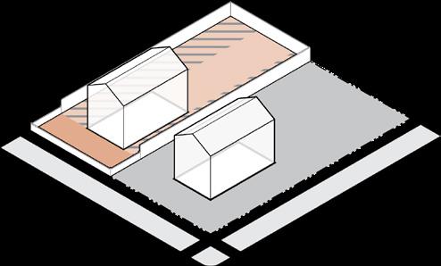
Interior Lot - Fence Height
in side/ rear yard

yards require a lower fence height
Corner Lot - Fence Height

Corner Lot - Fence at building facade line
Table 21-09D: Fences & Walls Maximum Height
District 1
Established Front & Corner Yard Established Side & Rear Yard
Less than or Equal to 50% Open More than 50% Open Any Fence Type
S1, S2, U1, U2, U3
UF, NC, DT, OS, U, C
1 In the NNZO, fences and walls shall also comply with the provisions of Section 21-05.02(g)(1)
(d) Finish
All fence posts and related supporting members of a fence shall be erected so that the finished sides of the fence face the adjacent lot or public right-of-way.
(e) Materials
(1) Fence and wall materials may include, but are not limited to, chain link, solid, stockade, architectural screen, lattice-work, shadow-box, vinyl, or masonry.
(2) In a NC or DT district, chain link fence materials are prohibited in an established front or corner yard or within 10 feet of a front or corner lot line.
(3) In the NNZO, fences and walls shall also comply with the provisions of Section 21-05.02(g)(1)
(4) Fences or walls constructed of barbed wire, electric, razor wire, or other similar types of security wire fences shall only be permitted for non-residential uses such as, but not limited to, utility sites such as water, sewer, electric and gas main facilities; heating, ventilating and airconditioning equipment; restricted public access areas such as airports, sewer and water treatment facilities; public safety facilities; and public and private communication facilities such as wireless, radio, and television communication towers. These materials shall not be located in any established front or corner yard. The Zoning Administrator shall have the authority to determine the extent and location of such fences.
Section 21-09.03: Stormwater
(a) Applicability
All projects shall meet the stormwater requirements in the latest version of the Design and Construction Standards and Prevailing Specifications for Public Works.
(b) Above Ground Retention
(1) Above ground retention shall not be located in a U1, U2, U3, UF, NC, or DT district, or within an Airport Approach Surface as determined by the Federal Aviation Administration.
Section 21-09.04: Outdoor Lighting
(a) Intent
The following regulations are intended to provide for the installation of outdoor light fixtures which:
(1) Provide adequate light for safety, utility, and security,
(2) Promote efficient lighting that conserves energy,
(3) Mitigate objectionable glare, offensive light sources, and the spillover of light beyond lot lines, and
(4) Reduce light pollution and improve night sky visibility.
(b) Applicability
The outdoor lighting regulations contained in this section, except as specifically stated otherwise, apply to all outdoor light fixtures.
(1) Nonconforming Lighting. Routine repair and maintenance of nonconforming lighting is permitted, provided such changes do not result in a higher lumen output. Routine repair and maintenance includes changing lamps or light bulbs, ballast, starter, photo control, housing, lenses, and other similar components. Nonconforming lighting may be altered to eliminate or reduce a nonconformity or to create conforming lighting.
(c) Exempt
The following outdoor light fixtures are exempt from the regulations of this section.
(1) Residential Buildings of up to 4 Units. All outdoor light fixtures used for the illumination of personal property, provided that such outdoor light fixtures shall meet the maximum allowable light levels permitted by Section 21-09.04(f).
(2) Public Lighting. All outdoor light fixtures required by government agencies or originating from public areas and ways, including but not limited to parks, rights-of-way, public art, or other public facilities, that are installed for the benefit of the public health, safety, and welfare.
(3) Construction and Emergency Lighting. All outdoor light fixtures provided for construction work or the abatement of an emergency situation necessitating said lighting, provided that the use of fixtures is discontinued during hours when construction activity or emergency abatement is not in progress and that such outdoor light fixtures are removed upon completion of the construction activity or the abatement of the emergency.
(4) Special Event Lighting. Outdoor light fixtures for civic and special events, such as festivals, fairs, carnivals, and sporting events, may be placed on a temporary basis subject to the following standards:
(A) The Zoning Administrator shall approve special event lighting.
(B) Special event lighting shall not be installed more than thirty days prior to the special event and shall be removed not more than fifteen days after the special event.
(C) Searchlights. Notwithstanding anything contained in this section, one portable, rotating searchlight may be used for a special event, provided that it shall not be permitted for more than three occurrences during a calendar year; shall not be used for a period of more than two consecutive days during a special event; and shall not be operated between the hours of 12:00 midnight and 8:00 a.m.
(5) Holiday Decorations. All outdoor light fixtures used for holiday decorations, up to 60 days per year.
(6) Low Intensity Lights. Low voltage (12 or fewer volts), low wattage ornamental landscape light fixtures and solar operated light fixtures having self-contained rechargeable batteries, where any single light fixture does not exceed 100 lumens.
(7) Internal Illumination of Signs. All outdoor light fixtures which are completely enclosed within a sign cabinet and which provide illumination only for a sign face, subject to Section 21-10.01(j)
(d) Prohibited Lights
(1) Unshielded lighting, except as otherwise provided in this section.
(2) Searchlights, beacons, and other high-intensity narrow-beam fixtures, except as provided for in Section 21-09.04(c)(4)
(3) Any lights that flash, move, revolve, rotate, scintillate, blink, flicker, vary in intensity or color, or use intermittent electrical pulsation. Includes strobe lights. This provision is not intended to prohibit artistic lights installed along the river or in a public open space.
(e) General Provisions
(1) Basis of Design. In general, all exterior light sources shall be directed downward and the illumination confined to necessary or useful areas.
(2) Power Supply. Outdoor light fixtures located on light poles shall be provided power by underground wiring.
(f) Maximum Light Levels at Lot Line
(1) The maximum light level at any point on a lot line abutting an S1, S2, U1, U2, or U3 lot shall not exceed 0.2 foot candles. All others shall not exceed 1.0 foot candles. Foot candles are measured with the lightreading sensor of a light meter held parallel to the ground and at ground level, facing up.
(2) The Zoning Administrator may determine that certain light fixtures are exempt from these requirements because they do not adversely affect an adjacent property owner or right-of-way, or because they are necessary for the functioning of the use.
(g) Shielding & Cutoff
(1) All outdoor light fixtures shall be placed and directed to prevent light trespass or glare onto adjacent rights-of-way or properties that may create a nuisance or may distract or interfere with the vision of drivers.
(2) All outdoor light fixtures shall be full cutoff or fully shielded to prevent light at or above horizontal 90 degrees (above nadir) and limited to a value not exceeding 10 percent of lamp lumens at or above 80 degrees.
(3) All outdoor light fixtures shall be fitted so that no portion of the light source or drop lens is visible below the fixture when viewed directly from the side.

(h) Fixture Mounting & Height
(1) Outdoor light fixtures shall be mounted parallel to the ground and shall utilize a rigid mounting arm with no built-in uptilt and no adjustment feature.
(2) Outdoor lighting used to illuminate a particular area (i.e., entryway, sidewalk, parking area, or loading area) shall, within those areas, be of uniform height, size, and design.
(3) Outdoor lighting used to illuminate areas for pedestrians shall not exceed 15 feet.
(4) Outdoor lighting used to illuminate areas for vehicular travel and parking shall not exceed 30 feet.
(i) Type of Bulb
(1) All outdoor light fixtures shall be energy efficient and produce at least 80 lumens per watt of energy consumed.
(2) Lights may not have a color temperature of more than 3,000 Kelvin.
Full Cutoff
(j) Special Regulations for Outdoor Lighting
(1) Accent Lighting
(A) Outdoor lighting used to accent architectural features, landscaping, or art may be directed upward, provided that light fixtures are located, aimed, or shielded to reflect the light off surfaces to emphasize form and texture and minimize light spill into the night sky. Upward aimed building facade lighting shall not exceed 900 lumens.
(B) Building facade lighting exceeding 900 lumens shall be fully shielded and aimed downward.
(C) Building facade lighting that is measurable at the ground level shall be included in the maximum allowable light levels permitted by Section 21-09.04(f)
(2) Security Lighting
(A) Building-mounted (wall pack) security light fixtures are only permitted for loading, storage, or service areas and/or rear entrances to buildings and not as substitutes for appropriate light fixtures for parking areas or pedestrian walkways.
(B) Building-mounted (wall pack) security light fixtures are not permitted to project above the roof line of a building.
(3) Sports Fields. Freestanding outdoor light fixtures may be installed for sport and athletic fields, provided they do not exceed 110 feet in height above grade and meet the maximum allowable light levels permitted by Section 21-09.04(f)
(4) Vehicular Canopies
(A) Lighting for any canopy area over fuel sales, drive through lanes, automated teller machines, or similar structures shall use recessed fixtures.
(B) Highly reflective material installed on the underside of the canopy is prohibited.
Section 21-09.05: Clear Sight Area
(a) Clear Sight Area Requirements
(1) Except in a NC or DT district, no building, structure, or improvement, including landscape, shall be erected, placed, planted, or maintained so as to interfere with a clear sight area located between the heights of 3 feet and 10 feet above the crown of a street, driveway, or alley. A clear sight area shall be established for all streets, whether public or private.
(2) The clear sight area is the triangular area formed by the street right-of-way line; another street right-
of-way line, alley right-of-way line, or driveway surface edge; and a line connecting points 10 feet from the intersection of said lines. In the case of a round or corner-cut right-of-way, the measurement shall be taken from the intersection of the right-ofway lines extended.
(3) The City Engineer or designee may require a larger clear sight area, as provided by Indiana Department of Transportation Design Manual standards, when necessary to provide for the safe movement of pedestrians and vehicles.

Section 21-09.06: Performance Standards
(a) Intent
All land development activity is subject to the following performance and design criteria.
(b) General Provisions
All uses in existence prior to the effective date of this Ordinance or established after the effective date of this Ordinance in any district shall comply with the performance standards of the applicable municipal, state, or federal regulations pertaining to: smoke, dust, and particulate matter; odor; noise; heat and glare; vibration; waste, hazardous materials, and other noxious matter; and electrical interference, and shall be subject to enforcement action by the applicable municipal, state, or federal agency responsible for monitoring and enforcing such regulations.
(c) Smoke, Dust, and Particulate Matter
Smoke, dust, and other types of air pollution that can be borne by the wind from the use shall be controlled through appropriate landscape, sheltering, paving, wetting, collecting, or other means.
(d) Odor
No use may emit odors of an intensity and character as to be detrimental to the public health, safety, and welfare. Odors lasting less than 15 minutes for every 24-hour period are exempt.
(e) Noise
No use may be conducted in a manner that generates a sound level that is in violation of Chapter 13, Article 7 of the South Bend Municipal Code.
(f) Heat and Glare
Any activity or the operation of any use that produces heat or glare shall be conducted so that no heat or glare from the activity or operation is detectable at any point off-site. Flickering or intense sources of light shall be fully shielded.
(g) v ibration
No use may produce continuous, frequent, or repetitive vibrations that are of an intensity and character as to be detrimental to the public health, safety, and welfare.
(h) Waste, Hazardous Materials, and Other Noxious Matter
The use, storage, handling, transport, discharge, and disposal of waste and hazardous materials shall comply with all applicable laws.
(i) Electromagnetic Interference
Electromagnetic interference from any use shall not adversely affect the operation of any equipment located off the lot where the interference originates.
This page intentionally left blank
Article 21-10: Signs
Sections
Section 21-10.01: General Provisions 10-1
Section 21-10.02: Exempt Signs 10-5
Section 21-10.03: Prohibited Signs ...................... 10-7
Section 21-10.04: Sign Measurement 10-8
Section 21-10.05: On-Premise Signs 10-11
Section 21-10.06: Use-Specific Signs 10-18
Section 21-10.07: Off-Premise Signs 10-19
Section 21-10.01: General Provisions
(a) Intent
Signs are an essential element in the promotion and identity of a use on a site that impacts public health, safety, comfort, general welfare, and the quality of life. This section is intended to:
(1) Encourage the effective use of signs as a means of communication;
(2) Encourage signs which, by their design, are integrated with and harmonious to the buildings and sites which they occupy;
(3) Eliminate excessive and confusing sign displays;
(4) Maintain and improve the appearance of the City as an attractive place in which to live and conduct business;
(5) Safeguard and enhance property values by minimizing the possible adverse effects of signs on nearby properties;
(6) Protect public and private investment in buildings and open spaces; and
(7) Eliminate potential hazards to motorists and pedestrians resulting from signs.
(b) Applicability
All new, reconstructed, altered, or relocated signs shall comply with the standards of this section.
(c) Permit Required
(1) All sign types described in this section, except those listed as exempt in Section 21-10.02, require a permit per Section 21-12.07(f) before they may be constructed, reconstructed, altered, or relocated, unless otherwise noted in the applicable section.
(2) Painting, cleaning, refacing, or other normal maintenance and repair of a sign does not require a sign permit, provided that no change is made to any structural component of the sign. For awning signs, removal of the frame for resurfacing shall be considered normal maintenance provided the existing frame is reutilized and the sign complies with all other regulations of this section.
(3) Any sign that encroaches into a public right-of-way requires approval from the Board of Public Works.
(d) Maintenance
(1) All signs shall be maintained in good repair (e.g., without peeling paint or broken sign faces) and in operable condition (e.g., if internally illuminated, all light bulbs or tubes shall be operational) at all times. The City may order the removal of any sign which becomes a public hazard due to lack of maintenance and repair.
(e) Nonconforming Signs
A nonconforming sign that was lawfully established and maintained in compliance with the provisions of all applicable laws in effect at the time of original installation, but that does not now comply with the provisions of this Ordinance, may be repaired or altered in accordance with Section 21-13.01(i)
(f) Removal of Freestanding Signs
Notwithstanding anything contained in Section 21-13.01 to the contrary, freestanding on-premise signs and sign structures, shall be subject to the following removal provisions:
(1) When the building on the premise is removed, any sign and sign structure located on the lot and accessory to such building shall also be removed at the same time.
(2) When the activity, business, or service conducted, manufactured, or sold on the premise ceases, the business identification sign shall be covered so as not to promote a business not in operation. A sign cabinet in which the sign face has been removed for more than 12 months shall be deemed to be abandoned and removed from the property.
(3) When a legally established nonconforming building, or any activity, business, commodity, or service on the premise, suffers a partial destruction in excess of the value specified in Section 21-13.01(i) of this Ordinance and such building, or activity, shall be removed and brought into compliance with the terms of this Ordinance, any sign or sign structure located on the lot shall also be brought into compliance with the terms of this Ordinance.
(g) Cutting of Trees or Shrubs
No person shall damage, destroy, or remove any required trees, shrubs, or other vegetation for the purpose of increasing or enhancing the visibility of any sign.
(h) Location
(1) Each permanent sign, except for off-premise signs and multi-tenant signs, shall be located on the same site as the subject of the sign.
(2) The minimum front or corner setback for any freestanding sign shall be:
(A) In a NC or DT district: 0 feet
(B) In all other districts: 5 feet from all streets, except limited access highways, which shall have a setback of 50 feet.
(3) The minimum side and rear setback shall be the same as required for any accessory building or structure.
(4) No sign, other than signs placed by agencies of government with appropriate jurisdiction, or a sign whose placement is authorized by such agencies, may be erected or placed on public property, including rights-of-way.
(5) No sign may be installed in a way that obstructs free and clear vision, clear sight area per Section 21-09.05, or free use of any public right-of-way, intersection, ingress or egress point, transit stop, parking space, drive aisle, driveway, building entrance, fire escape, or accessibility ramp.
(6) No sign may obstruct or substantially interfere with any window, door, fire escape, stairway, ladder, or opening intended to provide ingress or egress to any building.
(i) Accessory Structures
All signs are hereby declared to be accessory structures and shall meet the applicable standards of Section 21-06.02 unless otherwise provided. As an accessory structure, a sign may not occupy a lot without a primary building or use also being legally located on the lot, unless in compliance with the regulations of this ordinance for temporary signs, offpremise signs, or use-specific signs.
(j) Illumination
(1) External Illumination shall be shielded so that it illuminates only the sign surface and does not shine on, cause glare to, or otherwise impair the vision of the driver of any motor vehicle traveling on a public right-of-way.
(2) Colored light shall not be used at a location or in a manner so as to be confused with or construed as a traffic control device.
(3) Signs that are illuminated at night may not exceed a maximum luminance level of 750 nits, regardless of the method of illumination. All illuminated signs shall comply with the luminance level at least one-half hour before Apparent Sunset, as determined by the National Oceanic and Atmospheric Administration (NOAA). At Apparent Sunrise, as determined by NOAA, signs may resume luminance levels appropriate for daylight conditions.
(k) Changeable Copy Signs
(1) Changeable copy sign may be used as part of either a freestanding sign or as part of a building sign, but not both. Only one changeable copy sign is allowed per business.
(2) The changeable copy portion of an on-premise sign shall not exceed 40 percent of the sign surface area of any permitted sign type.
(3) A sign that does not change more than 2 times per 24 hour period shall not be considered a changeable copy sign.
(4) Electronic Message Centers (EMC). EMC shall also comply with the following regulations:
(A) All EMC signs shall have automatic dimming controls, either by photocell or via software settings, in order to bring EMC lighting level at night into compliance with this section;
(B) Except permitted off-premise signs, EMC signs located within 200 feet of a lot in the S1, S2, U1, U2, U3, or UF district shall not be illuminated between the hours of 11pm and 6am;
(C) In the DT district, EMC shall only be permitted by Special Exception;
(D) All messages shall be static and displayed for a minimum of 8 seconds;
(E) Any change in an electronic message shall be instantaneous without fading in, dropping in, spinning, rotating, or similar moving copy changes;
(F) Full motion video or film display via an electronic file imported into the EMC software or streamed in real time into the EMC is prohibited; and
(G) Any EMC sign that is malfunctioning shall be turned off until such time that it is functioning properly.
(l) Temporary Signs
Temporary signs are allowed in all districts and may be either a freestanding or building sign. Temporary signs shall comply with the following regulations.
(1) A temporary sign, if a freestanding sign, shall be located in compliance with all setback regulations for a permanent sign;
(2) A temporary sign, if a wall sign, shall be located in compliance with the regulations for a permanent wall sign;
(3) A temporary sign shall not be illuminated; and,
(4) All temporary signs shall meet the standards found in Table 21-10A
(5) All temporary signs that are 6 square feet or less are exempt from obtaining a location improvement permit. Any temporary sign greater than 6 square feet shall obtain all required approvals per Section 21-12.07(f)
Table 21-10A: Allowed Temporary Signs
Construction Sign - Located on a Site with an Active Building Permit (except for 1-4 dwelling unit residential)
Number of Signs 2 per street frontage
Total Sign Surface Area
Fence/Wall Wrap Sign
Construction Signs (all other)
Sign Height
Duration
Multiple Lot Development
Number of Signs
Total Sign Surface Area
Sign Height
Duration
Unlimited coverage with 64 square feet maximum copy area for every 200 feet of street frontage or portion thereof.
64 square feet max. total for all construction signs per street frontage
8' max.
May be installed only after the approval of a building permit, and shall be removed within 30 days of issuance of a certificate of occupancy or expiration of a building permit.
1 per perimeter street frontage
32 square feet max.
8' max.
May be installed after secondary plat approval is issued and shall be removed when 75% of lots in the subdivision have received a Certificate of Occupancy.
Single Lot Development - For Sale, Lease, or Rent Sign
Number of Signs
Total Sign Surface Area
1-4 dwelling unit residential
All other use
Sign Height
Duration
Temporary Signs for a Non-Residential Use
Number of Signs
Total Sign Surface Area
S1, S2, U1, U2, or U3 district
UF, NC, DT, OS, U, C, or I district
Sign Height
Duration
1 per street frontage
6 square feet max.
32 square feet max.
6' max.
May be installed at the time the lot is listed for sale or lease, and shall be removed upon final close of the sale or lease.
2 per street frontage
24 square feet max. total for all signs per street frontage
48 square feet max. for all signs per street frontage
6' max.
May be installed not more than 30 days.
Frequency No more than 4 times during a calendar year
Temporary Signs for a Residential Use
Number of Signs
Total Sign Surface Area
Sign Height
Duration
2 per street frontage
6 square feet max.
4' max.
May be installed not more than 30 days.
Frequency No more than 2 times during a calendar year
All temporary signs greater than 6 square feet shall obtain the required approvals per Section 21-12.07(f)
Section 21-10.02: Exempt Signs
(a) Exempt Signs
The following signs do not require a sign permit, but shall still follow applicable requirements:
(1) Address Sign. A sign that identifies the address of a lot, structure, or establishment, provided it does not exceed 2 square feet in area for a lot with only a residential use or 4 square feet in area for a lot with non-residential uses.
(2) Authorized Sign. Public signs and notices erected, authorized, or mandated by governmental authority under any law, statute, or ordinance. Includes the following signs:
(A) traffic, directional, or warning information;
(B) signs of public service companies indicating danger;
(C) signs erected by, or on the order of, a public officer in the performance of their public duty which aide service or safety;
(D) public hearing signs;
(E) historical markers;
(F) signs or exterior displays required to be maintained by government order or regulations, provided that the content and size thereof does not exceed that required by such order or ordinance.
(3) Architectural Features. Signs which are architecturally integral to the building and only indicate the name of the building, date of erection, monumental citations, commemorative tablets and the like, when carved into stone, concrete or similar material or made of bronze, aluminum, or other permanent type construction and made an integral part of the building.
(4) Campus Signs. Signs that are located interior to a campus or open space provided such signs are not legible from the street.
(5) Flags. Up to six flags having a maximum combined area not to exceed 120 square foot. The flag shall be attached to a flag poles which is permanently
anchored to the ground or attached to the principal building or accessory structure.
(6) Fuel Pump Sign A fuel pump sign that is attached to a fuel pump may not exceed two square feet in area per pump. Operational and payment instructions on the face of the pump are exempt from this limitation.
(7) Holiday Displays. Displays which contain no commercial message, are primarily decorative in nature, and are clearly incidental and commonly associated with any national or religious holiday, and which are erected not more than 30 days prior to the start of the holiday and removed no more than 15 days after the holiday.
(8) Incidental Signs. Non-illuminated signs not exceeding 3 square feet, provided there is no more than 2 per street frontage per lot. Incidental signs may include, but are not limited to, signs advertising a political candidate; garage sale; home improvement/remodeling; business hours of operation, and, seasonal/holiday signs.
(9) Menu Board. A menu board is a permanently mounted sign displaying the items for sale at a drive-through establishment.
(A) Menu boards shall only be permitted in conjunction with a permitted drive-through use.
(B) A maximum of two menu boards is permitted per drive-through lane.
(C) A menu board may not exceed 48 square feet in area or 8 feet in height above grade.
(10) Parking Lot Directional and Information Sign. Incidental parking signs that provide additional direction or information, such as signs marking entrances and exits, parking areas, circulation direction, restroom, and pick-up or delivery areas, may be on a building or freestanding provided they comply with the following:
(A) No more than 2 signs per driveway or 1 sign per critical turning point (e.g., to direct vehicular traffic to a drive-up, loading area, etc);
(B) S1, S2, U1, U2, U3, UF, and NC Districts – signs shall not exceed 4 square feet in surface area or 4 feet in height;
(C) DT, OS, U, and C District – signs shall not exceed 6 square feet in surface area or 4 feet in height;
(D) I District – signs shall not exceed 8 square feet in surface area and 6 feet in height;
(E) Freestanding parking lot directional and information signs located within the clear sight area shall be limited to 3 feet in height. and
(F) All signs shall be non-illuminated.
(11) Sidewalk Sign. A sidewalk sign includes twosided, portable signs that are placed outside of an establishment, constructed in the form of an “A” or similar tent-like shape, or attached to a post with a heavy base in the form of an inverted “T,” and intended to be viewed from the sidewalk at close range, are allowed provided they comply with the following:
(A) A maximum of one sidewalk sign is permitted per establishment per street frontage.
(B) Sidewalk signs shall not exceed 10 square feet in sign surface area per side and 4 feet in height above grade.
(C) A sidewalk sign may be placed outdoors on the premises or a public sidewalk during business hours only, and shall be stored indoors at all other times.
(D) The sign shall not interfere with ingress and egress points and shall maintain a minimum of 5 feet of sidewalk clearance at all times.
(E) A sidewalk sign may not be illuminated or contain any electronic components.
(F) A sidewalk sign may not be placed outdoors when high winds, heavy rain, or heavy snow conditions are present and may not interfere with any snow removal operations.
(12) Tombstones.
(13) Window Sign. One window sign per non-residential use provided it does not exceed 4 square feet and is non-illuminated.
(14) Works of Art. Three dimensional works of art (e.g., statuary, sculptures) and two dimensional works of art (e.g., murals) that are artistic in nature and which are not used for advertising or promotion of a business, product, service, or commercial activity. Two dimensional works of art shall not be located on the front facade of a building.
Section 21-10.03: Prohibited Signs
(a) Prohibited Signs
These signs, as well as any sign type not expressly allowed by this Ordinance, are prohibited:
(1) Signs which interfere with, obstruct the view of, imitate, copy, purport to be, or may be confused with any authorized official sign, traffic sign, traffic signal, or traffic control device.
(2) Signs on portable trailer frames; and, signs attached to or painted on a vehicle parked and visible from the public right-of-way, provided, however, a vehicle which is used in the normal day-to-day operation of a business use shall not be considered a portable sign if the vehicle is parked beside or behind the building in which the use is located, or if the sign on the vehicle contains less than 9 square feet in sign surface area.
(3) Signs or devices motivated by wind, thermal changes, or other environmental input, such as spinners, pinwheels, unsecured banner, pennant, streamers, balloons, air-inflated signs, or other wind-blown devices or displays that are designed to inform or attract attention, except for flags that conform to Section 21-10.02(a)(5)
(4) Signs attached to trees, street lights, or utility poles.
(5) Signs that bear or contain statements, words or pictures of an obscene, pornographic, immoral character, or which contain advertising matter which is untruthful or will offend public morals or decency.
(6) Any rotating beam, beacon, intermittent light, lights of changing colors or degrees of intensity, or flashing illumination in connection with any sign surface, except as part of an electronic message center sign.
Section 21-10.04: Sign Measurement
(a) Sign Surface Area
Sign surface area shall be measured as follows:
(1) Signs on a Background. The entire area of the framework or background of the sign is calculated as sign area, including any material or color forming the sign face or background used to differentiate the sign from the structure against which it is placed.
(2) Signs with a Base. The base of a monument sign does not count as sign area if it is less than 3 feet in height and is constructed of masonry or a material that matches the primary building facade material.
(3) Individually Mounted Letters or Features. The sign area is calculated as the total area of each rectangle that encompasses each word or graphic element. Sign area does not include any supporting framework or bracing, unless such framework is part of the message or sign face.
(4) Signs on an Awning. The area of awning sign is calculated by drawing the smallest possible rectangle that encompasses each word or graphic element on the awning.
(5) Signs with Poles or Brackets. For signs that include a pole, pole cover, or bracket, the portion of the structure that is not an integral part of the display area shall not be included in the overall calculation of sign area provided no pole or pole cover exceed 2 feet in width.
(6) Two or More Faces. If the sign has two or more faces, the area of all faces is included in determining the area of the sign. However, if two sign faces are placed back to back, or at an angle no greater than 15 degrees from one another so that both faces cannot be viewed from any point at the same time, the sign surface area shall be computed by the measurement of one of the sign faces. In addition, except for off-premise signs, such sign faces that are part of the same sign structure shall not be more than 42 inches apart.


Individually Mounted Letters & Signs on an Awning

with Poles or Brackets


with 2 or More Faces
(7) Three-Dimensional, Free-Form, or Sculptural (nonplaner). The sign area is calculated as 50 percent of the sum of the area of the four vertical sides of the smallest cube that will encompass the sign
(8) Landscape Wall or Fence Sign. The sign area of a sign face located on an ornamental, decorative fence, or masonry wall shall be limited to the area of the sign face only if the fence or wall has a length of at least 3 times the width of the sign or message element. If a fence or wall is less than 3 times the width of the sign or message element, the fence or wall shall be deemed to be part of the background of the display used to differentiate the sign from the backdrop, and the entire area of the fence or wall shall be considered part of the sign surface area.
(9) Signs at a Building Corner. In the case of a building sign located on the corner of a building and oriented toward the intersection of two or more streets, such building sign shall count half its sign area toward the maximum permitted sign surface area for each street frontage.
(b) Sign Height
Sign height is measured as the vertical distance from the street grade at the base of the sign or sign structure, to the highest point of the sign or sign structure.
(c) Vertical Clearance
For signs attached to a structure, vertical clearance is measured as the vertical distance from the grade level to the lowest point of the sign.
(d) Facade Area Calculations for Building Signs
When calculating the area of a facade upon which a building sign may be placed, the following regulations apply:
(1) The area of the facade shall be the actual surface area of the facade of the building or tenant space located above grade and beneath the top of the wall, not including the roof. Facade area shall include any two dimensional area of the building elevation from which the facade, or portion thereof, may be viewed.
(2) The calculation of facade area is determined independently for each facade.

Sign Area


Signs on a Landscape Wall or Fence: Wall is less than 3 times the width of the sign

Signs on a Landscape Wall or Fence: Wall is more than 3 times the width of the sign

Sign Area Calculation
Sign Surface Area

Area Facade Area Calculation
Total Facade
Section 21-10.05: On-Premise Signs
(a) Definition
An on-premise sign is a sign erected, maintained, or used for the purpose of the display of messages relating to the use of, products sold on, or the sale or lease of, the lot on which it is displayed.
(b) Residential Sign Standards
Residential dwelling uses shall be permitted one onpremise sign that provides only the name, address, address of the management thereof, or associated information; provided it complies with the following:
(1) Buildings with 4 or fewer dwellings in any district are permitted one building or freestanding sign per street frontage. The sign shall not exceed 2 square feet in surface area, 4 feet in height, or be illuminated;
Table 21-10B: Non-Residential Sign Standards
(2) Multi-unit buildings of 5 or more dwellings in S2, U3, and UF districts are permitted one building or freestanding sign per street frontage. The sign shall not exceed 32 square feet in surface area, 6 feet in height, or be internally illuminated;
(3) Multi-unit buildings in the NC, DT, or U district shall comply with the non-residential sign standards of this section.
(c) Non-Residential Sign Standards
The number, height, and total sign surface area per street frontage of all on-premise signs for any nonresidential use may not exceed the maximums allowed within the applicable zoning district, as shown in Table 21-10B The surface area allowed for building signs is the sum of the surface areas of all building signs on a facade.
1 If lot frontage is greater than 200 feet, signs may increase to 64 square feet in area and up to 8 feet in height.
2 Sign height may increase to 25 feet max. for a multi-tenant sign or 35 feet max. when oriented to a limited access highway.
3 For multi-tenant signs, the sign area may be increased to 140 square feet for sites with 500 feet of frontage or less. If street frontage is greater than 500 feet, the sign area may be increased to 300 square feet maximum.
4 If lot frontage is greater than 500 feet, then additional signs are allowed at a rate of one sign for every 500 feet of additional frontage, or portion thereof. Total sign area may be combined into one larger sign or divided between multiple signs with a minimum separation of 100' between signs.
21-10.05(d): On Premise Signs: Building Signs
(1) Building Sign Definition
A building sign is any sign attached to or supported by a building. Building signs include, but are not limited to awning or canopy signs, projecting signs, roof signs, suspended signs, wall signs, and window signs.
(2)
Number and Area of Signs
The number of building signs are unlimited per facade; however, the combined area of all building signs per street frontage shall comply with Table 21-10B and meet any of the following standards specific to the applicable sign type.
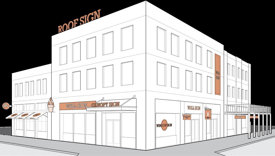
Sign Types
Building
(3) Awning or Canopy Sign
A sign or graphic printed on or in some fashion attached directly to the material of an awning or canopy.
(A) A maximum of one sign is permitted per awning or canopy surface. Only awnings and canopies on the ground story may contain signs.
(B) The sign surface area shall not exceed 50 percent of the awning or canopy surface on which it is displayed.
(C) Awnings or canopies shall meet all regulations of Section 21-08.01(g)(2)
(4) Projecting Signs
A two-sided or three-dimensional sign that is affixed to a wall and projects more than 18 inches beyond the exterior wall of a building.
(A) Projecting signs shall have a vertical clearance of at least 8 feet above a sidewalk or 15 feet above a driveway.
(B) Projecting signs shall not extend more than 6 feet from the building face except a projecting marquee sign may extend to within 18 inches of a curb face.
(C) Projecting signs shall not extend more than 4 feet above the building roof line on a flat roof or above the eave line for pitched roofs.
(D) A maximum of one projecting sign is permitted per establishment per frontage.
(E) Projecting signs shall have a minimum of 15 feet between other projecting signs.
(5) Roof Signs
A sign mounted on the roof or the uppermost architectural band of a building.
(A) Roof signs are only permitted in the NC or DT districts and shall only be installed on a building with a flat roof.
(B) A maximum of one roof sign is permitted per building.
(C) Roof signs shall not be more than 75 percent of the building width at the roof level or 15 feet in height.
(D) Roof signs shall not extend below the upper lintel of windows of the highest story of a building.

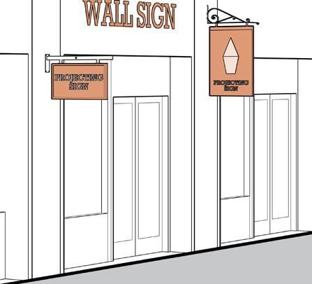
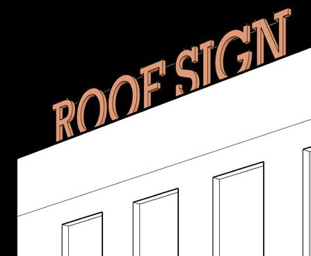
Awning Signs Roof Sign
Projecting Signs
(E) Roof signs may be internally illuminated. External illumination is prohibited.
(F) Roof signs shall consist of individual alphanumeric characters or graphic elements.
(6) Suspended Signs
A sign that is suspended, hung, or connected to the underside of a horizontal surface and intended to be viewed from the sidewalk at close range.
(A) A maximum of one suspended sign is permitted per ground floor establishment per frontage.
(B) Suspended signs shall have a maximum sign surface area of 6 square feet.
(C) Suspended signs shall have a vertical clearance of at least 8 feet above the finished grade below.
(7) Wall Signs
Any sign attached to, applied to, or mounted on the wall of a building or structure, with the face of the sign parallel to that of the wall.
(A) Wall signs shall not project more than 18 inches from the wall.
(B) Wall signs shall not be more than 80 percent of the building facade width.
(C) No wall sign may extend above the window sills of the second story, unless the establishment extends to the second story or above. No portion of a wall sign may extend above the roofline or parapet wall of a building with a flat roof or above the lower eave of a building with a pitched roof.
(8) Window Signs
A sign that is attached to, placed upon, printed on the interior or exterior of a window or door of a building, or displayed within the interior and clearly intended for public recognition outside the building.
(A) Window signs shall not exceed 25 percent of the area of the window or 12 square feet, whichever is less. In the case of multi-pane windows, the surface area of the window shall be the combined surface area of the individual panes.


Suspended Signs
Window Signs
Wall Sign
Signs
21-10.05(e): On Premise Signs: Freestanding Signs
(1) Freestanding Sign Definition
A freestanding sign is a sign that is attached to, erected on, or supported by some structure that is not itself an integral part of or attached to a building. Freestanding signs include, but are not limited to: pylon, pole, pole with cladding, monument, yard signs, and signs posted on a decorative fence or non-building wall.
(2) Number and Size of Signs
The number, surface area, and height of freestanding signs on a lot shall comply with Table 21-10B and meet any of the following standards specific to the applicable sign type.
(3) Separation of Signs
When a lot abuts more than one street or limited access highway, the minimum separation between freestanding signs on a lot, regardless of the orientation, shall be 100 feet. If a lot that has greater than 500 feet of street frontage is allowed more than one freestanding sign per street frontage, the minimum separation between those signs shall be 100 feet.

Freestanding Signs
(4) Monument Signs
A sign that is constructed in or on the ground surface with its sign display surface attached to a pedestal, base, or wall.
(A) The sign shall be attached to a pedestal that is integral to the sign structure, or integral with a perimeter wall or fence.
(B) The base shall be at least 75 percent of the width of the widest part of the sign face.
(5) Pole Signs
A sign that is supported by one or more poles that are anchored in the ground, and intended to be viewed at a distance.
(A) The lowest portion of the sign display shall have a vertical clearance of at least 7 feet above the grade below.
(B) Pole signs are permitted only on lots where the front building facade is located more than 25 feet away from the front lot line.
(6) Yard Signs
A two-sided sign that is mounted to or suspended by supporting posts or brackets, intended to be viewed at close range.
(A) A yard sign may be mounted onto a double set of posts or suspended from a single post in a L-shape configuration.
(B) The sign display shall have a vertical clearance of at least 12 inches above the grade below.
(7) Multi-Tenant Sign
A multi-tenant sign is a sign that advertises three or more establishments within a building or series of buildings in a development.
(A) Location. Multi-Tenant signs shall only be permitted in a C or I district.
(B) Sign Height and Area
(i) A multi-tenant sign shall not exceed 25 feet in height.
(ii) For projects with less than or equal to 500 feet of lot frontage, the sign shall not exceed 140 square feet.

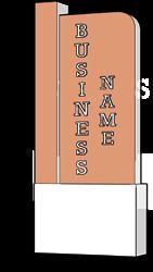


Monument Signs
Yard Signs
Pole Signs
(iii) For projects with greater than 500 feet of lot frontage, the sign area shall not exceed 300 square feet.
(iv) Any business that is displayed on a multitenant sign shall not be entitled to its own freestanding sign.
(C) Distance Between Multi-Tenant Signs. MultiTenant signs shall be permitted at a rate of one multi-tenant sign for every 500 feet of street frontage, provided that:
(i) the minimum separation between multi-tenant signs on a single development site, regardless of the street frontage to which the multi-tenant sign is oriented, shall be 100 feet; and
(ii) the minimum separation between multi-tenant signs oriented toward the same street frontage shall be 300 feet.
Multi-Tenant Sign
Section 21-10.06: Use-Specific Signs
(a) Definitions
A use-specific sign is a sign erected, maintained, or used for the display of messages relating to a specific use or group of uses, as allowed within Section 21-06 For the purposes of this ordinance, a use-specific sign is neither an on-premise or off-premise sign. Usespecific signs include freestanding canopy signs, multitenant signs, and place identification signs.
(b) Freestanding Canopy Sign
A freestanding canopy sign is a sign that is applied to, painted on, or mounted to a canopy structure that is not attached to a building. Freestanding canopies are typically associated with a gasoline station, car wash, and bank or A.T.M. drive-through.
(1) Sign Area. Freestanding canopy signs shall not exceed 25 percent of the surface area of the facade of the canopy.
(2) Illumination. Freestanding canopy signs in a NC or DT district shall not be illuminated.
(3) Number and Area. The number and sign surface area of use-specific signs do not count toward the on-premise maximum standards.
(4) Projection. Freestanding canopy signs shall have a maximum projection of 12 inches above the canopy.

Canopy Sign Sign Surface Area Facade Area
(c) Place Identification Sign
A place identification sign is a sign that only indicates the name of a recorded, platted residential subdivision, recognized neighborhood association, office or industrial park, education or medical campus, or other recognized place.
(1) Sign Type. Place identification signs shall be limited to freestanding monument signs as defined by Section 21-10.05(e)(4)
(2) Location. One place identification sign shall be permitted per quadrant of an intersection.
(3) Sign Height and Area. A place identification sign shall not exceed 32 square feet each or 8 feet in height.
(4) Sign Materials. All place identification signs shall be constructed of ornamental metal, masonry, or other permanent material.
(5) Illumination. Place Identification signs shall not be internally illuminated.
Freestanding
Signs
Section 21-10.07: Off-Premise Signs
(a) Definition
An off-premise sign is a sign erected, maintained, or used for the purpose of the display of messages relating to the activity, business, or products sold at a location other than the premises on which the sign is located.
(b) Districts Allowed
Off-premise signs shall only be permitted in a C or I district.
(c) Off-Premise Sign Types
Off-premise signs shall be limited to freestanding signs including advertising signs and indirect business identification signs
(d) Advertising Signs
An advertising sign is a freestanding pole sign displaying advertisements that are meant to be viewed at a distance, typically oriented to a limited access highway or major arterial street.
(1) Sign Surface Area for Advertising Signs
(A) Limited Access Highways and Arterial StreetsThe maximum sign surface area for advertising signs oriented toward a limited access highway shall be 672 square feet.
(B) All Other Streets - The maximum sign surface area for advertising signs oriented toward any street not classified as a limited access highway shall be 300 square feet.
(C) Temporary Extensions - Temporary extensions or embellishments integrally incorporated into the sign surface and having: a vertical height of no more than 4 feet above the top of the main portion of the sign; a maximum horizontal dimension of no more than 1 foot beyond the sides of the main portion of the sign; or, a maximum vertical dimension of no more than 1 foot below the bottom of the main portion of the sign, with a maximum combined area not to exceed 200 square feet in additional sign surface area may be added to a 672 square foot advertising sign.
(D) Concealment of Sign Supports - The backs of advertising signs shall be: concealed by another sign surface; screened by suitable architectural treatment; or, painted to blend with the surrounding (and maintained as such), so that the supports, tie rods, bracing or framework which supports the sign surface is screened from view.
(E) Empty Displays Prohibited - Empty sign surfaces, or signs without a display or message covering the entire sign surface, shall be prohibited. This regulation shall apply individually to each display surface.
(2) Distance Between Advertising Signs
(A) Linear Spacing - The minimum separation between advertising signs located along and oriented toward the same limited access highway shall be 1,000 feet. The minimum separation between advertising signs located along and oriented toward the same street shall be 750 feet, measured along the centerline of the limited access highway or street to which the sign is oriented, from the point in the centerline closest to the leading edge of the sign.
(B) Radial Spacing - An advertising sign shall not be located closer than 300 feet in any direction from any other advertising sign.
(3) Placement Limitations Along Limited Access Highways
(A) Location Restriction - No advertising sign shall be located within 500 feet of an interchange, at-grade intersection, or rest area on any limited access highway.
(B) Measurement - The method of measurement of the location restrictions along a limited access highway shall be along the centerline of the limited access highway or street, measured from the nearest point of the intersection of the centerline of the exit / entrance ramp or intersecting street and the right hand lane of
the main traveled way of the limited access highway closest to the off-premise sign.
(4) Maximum Height of Advertising Signs. The maximum height of an advertising sign shall not exceed 35 feet above grade.
(5) Minimum Setbacks of Advertising Signs
(A) Limited Access Highway - The minimum front or corner setback shall be 50 feet from the proposed right-of-way.
(B) All Other Streets - The minimum front or corner setback shall be the same as required for any primary building or structure.
(C) Side and Rear Setback - The minimum side setback or minimum rear setback for an advertising sign shall be the same as required for any primary building or structure.
(6) Separation from Certain Districts or Uses
(A) Linear Spacing - The minimum distance between an advertising sign and a S1, S2, U1, U2, U3, or UF district, Historic Preservation district or designated historic landmark, public park and open space, residential use, religious institution, school, or river shall be 200 feet, measured along the centerline of the right-ofway to which the advertising sign is oriented, from the point in the centerline closest to the leading edge of the advertising sign to the point in the centerline nearest the district boundary or lot line of a use specified herein.
(B) Radial Spacing - The minimum distance in any direction between an advertising sign and a S1, S2, U1, U2, U3, or UF District, Historic Preservation district or designated historic landmark, public park and open space, residential use, religious institution, school, or river shall be 100 feet, measured perpendicular from the nearest edge of the sign to the nearest district boundary or lot line of an applicable use.
(C) Jurisdictional Boundaries - Required separation distances for proposed advertising signs located within the corporate limits of the
City of South Bend shall also be maintained from advertising signs located in adjacent municipalities or jurisdictional areas.
(7) Construction of Off-Premise Signs. The supports, uprights, bracing, and framework of an advertising sign shall be of steel construction.
(e) Indirect Business Identification Signs
An indirect business identification sign is a freestanding sign that is associated with an activity, business, or building located within a shopping, entertainment, or business complex but with no direct street frontage.
(1) Use Limitation. Indirect business identification signs shall only be allowed when the business it is advertising is not listed or cannot be added to a multi-tenant sign.
(2) Location
(A) Indirect business identification signs shall be located within 500 feet of the main entrance to the associated establishment or building.
(B) Indirect business identification signs shall be located within a sign easement granted by the property owner that gives such party permanent access to view from the public right-of-way.
(3) Sign Type. Indirect business identification signs shall be a freestanding monument sign as defined by Section 21-10.05(e)(4)
(4) Sign Height and Area. The surface area and height of indirect business identification signs shall comply with Table 21-10B for on-premise signs and meet the standards specific to freestanding signs within the applicable zoning district. Indirect business identification signs do not count against the on-premise maximum sign area or number of signs for the lot on which it is located.
(5) Distance Between Indirect Business Identification Signs. The minimum separation between an indirect business identification sign and any other freestanding signs on a lot, regardless of the orientation, shall be 100 feet.
Article 21-11: Neighborhood & Subdivision Design
Section 21-11.01: General Provisions
(a) Short Title
This article shall be known and cited as the “City of South Bend Subdivision Control Ordinance” per IC 367-4-700.
(b) Intent
The intent of this section is to promote development patterns that support the creation of complete neighborhoods with a mix of housing, civic, retail, and service choices within a compact, walkable, and transit friendly environment. This section provides a framework for the subdivision of buildable land that meets the following goals.
(1) Provide clear standards for private development that influences the function and character of a neighborhood.
(2) Ensure orderly growth and development through the conservation, protection, and proper use of land through adequate provisions for circulation, utilities, and services.
(3) Ensure street connectivity and safety within walkable neighborhoods having numerous route options.
(4) Promote walkable urban projects.
(5) Provide access to open space.
(6) Promote the health, safety, and general welfare of the City.
Sections
Section 21-11.01: General Provisions 11-1
Section 21-11.02: Subdivision of Land 11-2
Section 21-11.03: Blocks ................................. 11-4
Section 21-11.04: Streets & Alleys 11-6
Subdivision of Land
Section 21-11.02: Subdivision of Land
(a) Applicability
The subdivision of land may occur in any and all districts established by this Ordinance. Whenever a subdivision occurs, the rules, regulations, and procedures of this section shall apply.
(1) No subdivision, resubdivision, or adjustment of lot lines of any lot, tract, or parcel of land shall occur except in strict accordance with the provisions of this section.
(2) No street, sanitary sewer, storm sewer, water main, or other facility shall be laid out, constructed, opened, or dedicated for public use or travel, or for the common use of occupants of abutting buildings, except in strict accordance with the provisions of this section.
(3) No lot under consideration for a proposed division, consolidation, or alteration shall be sold, nor shall a permit to erect, alter, or repair any building upon land be issued, until the proposed division, consolidation, or alteration has been approved and recorded, and until the associated improvements required by the City have either been constructed or guaranteed as provided in Section 21-12.06 However, if a major subdivision has received primary approval, permits for model homes may be issued, provided that no more than two permits are in existence at any one time, and that such homes are not occupied until the subdivision has been given secondary approval and has been recorded.
(b) General Regulations
(1) The subdivision shall conform to the applicable provisions of the zoning ordinance, including lot width and depth.
(2) In all subdivisions, consideration shall be given to preserve the natural environment, existing topography, and historic resources in a historic preservation district or designated as a historic landmark.
(3) The subdivision shall be coordinated with existing developments or neighborhoods, and may require the extension of existing streets.
(4) In review of subdivisions, the Plan Commission shall give consideration to the needs and requirements for open space uses and community facilities.
(5) Proposed subdivisions in flood hazard areas shall assure that the development is consistent with the need to minimize flood damages.
(6) Easements shall be provided for utilities where necessary. When located along a rear or side lot line, easements shall be centered on such line and be at least 5 feet wide on both sides of the lot line. Easements shall be continuous to the end of the block to connect with adjoining blocks in the shortest direct line.
(7) All property corners shall be indicated by monuments in compliance with 865 IAC 1-12-18.
(c) Lot Standards
(1) Side lines of all lots shall be at right angles or radials to street lines, when possible.
(2) Every lot shall abut on a public street.
(3) Double frontage lots shall not be permitted, except where the lot abuts a limited access highway.
(4) Flag lots shall not be permitted.
(d) Required Improvements
(1) All required improvements shall be designed and constructed in accordance with the latest standards adopted by the Board of Public Works.
(2) Proper and adequate provisions shall be made for drainage. The City Engineer shall determine the extent, location, and capacity of such facilities.
(3) Complete public sewer and water systems shall be provided as approved by the Board of Public Works.
(4) Streets, including curbs and gutters, shall be improved and surfaced per the latest standards adopted by the Board of Public Works.
Subdivision of Land
(5) Sidewalks shall be installed on both sides of any street per the latest standards adopted by the Board of Public Works.
(6) A complete street lighting system shall be provided per the latest standards adopted by the Board of Public Works.
(e) Open Space & Linkages
(1) On sites greater than 5 acres or providing 50 dwelling units, a minimum of 10 percent of the project area shall be designated as publicly accessible civic or open space. This number shall be calculated after street rights-of-way are subtracted from the project area. Civic or open spaces may be managed privately or publicly but shall be open to the public.
(2) If a subdivision abuts or is located within 500 feet of any portion of a public trail, a direct linkage from the subdivision to such public trail shall be provided.
Section 21-11.03: Blocks
(a) Applicability
This section applies to development sites that meet any of the following criteria:
(1) Creates a new block, reconfigures the dimension of a block, or creates 300 feet or more of new public or private street.
(2) Projects that result in modification to any lot or combination of lots by a single property owner or agent with an aggregate area of 3 acres or more within any 5-year period.
(b) b lock Standards
(1) Blocks shall be generally rectangular in shape but are expected to respond to natural features and the block pattern of surrounding development.
(2) Blocks shall be a minimum width so as to provide two rows of developable lots.
(3) A new block, or an existing block where a change in dimensions is proposed, shall be subdivided with streets to create blocks that meet the standards in Table 21-11A , measured according to the following criteria:
(A) A block is defined by streets or by civic spaces.
(B) Block length is measured along the right-ofway line of one block side.
(C) Block perimeter is the sum of its side block lengths.
(D) Where multiple zones apply to one block, the predominant zone along each block face will determine the maximum block length, and the least restrictive zone will determine the maximum block perimeter.
(E) In a standard district, block lengths in excess of 600 ft. shall provide a mid-block passage connecting two block sides with a dedicated right-of-way or reserved with a permanent access easement.

Measuring Length and Perimeter of Blocks
Table 21-11A: Block Perimeter
(4) Portions of development sites abutting areas of undeveloped land, areas unsuitable for development, nonconforming incomplete blocks, or physical obstacles may be granted a waiver from the block dimension requirements by the Plan Commission.
(5) Block perimeter may be increased with the approval of the Zoning Administrator to accommodate special buildings, civic spaces, or unique arrangements of these elements.
(c) b lock Connectivity
(1) New streets shall connect to and extend the existing block network where possible. This requirement does not apply to portions of the project boundary where connections cannot be made because of physical obstacles.
(2) Where adjoining areas are not developed, streets in a new subdivision shall be extended to the project boundary line to allow for the future extension of streets into adjoining areas. Such rights-of-way shall be provided at intervals no greater than the maximum block length for the zone.
Section 21-11.04: Streets & Alleys
(a) Applicability
This section shall apply to any development that includes the addition of public or private streets.
(b) Street Standards
(1) The arrangement, character, extent, width, grade, and location of all streets shall be correlated to existing and planned streets, existing topography, public convenience and safety, and in their appropriate relation to the proposed building types and uses of the land to be served by such streets.
(2) Proposed streets shall be adjusted to the contour of the land to produce usable lots and streets of reasonable gradient.
(3) Half-streets and half-alleys shall be prohibited. Whenever a half-street is adjacent to a tract to be subdivided, the other half (1/2) of the street shall be platted within such tract.
(4) The minimum right-of-way width of all streets shall be per the latest standards adopted by the Board of Public Works.
(5) Street jogs with centerline offsets of less than 150 feet shall be prohibited.
(6) Cul-de-sac and dead-end streets, designed to be so permanently, shall not be longer than 200 feet measured along its centerline from the centerline of the intersecting street to the radius point. All dead-end streets shall terminate per the latest standards adopted by the Board of Public Works.
(7) No new street shall have a name which duplicates or so nearly duplicates so as to be confused with any existing street in the incorporated and unincorporated areas of St. Joseph County, unless the new street is to be an extension or is at the same block number of an existing street. Loop streets and cul-de-sac which are an extension of or aligned with existing streets but will never be continued shall not duplicate the name of the existing street. Continuous streets which have major directional changes shall require a change in street name for each directional change.
(c) Alley Standards
(1) Alleys shall be provided at the discretion of the Plan Commission and the Board of Public Works.
(2) Alley intersections with sharp changes in alignment shall be avoided, but where necessary, corners shall be cut off sufficiently to permit safe vehicular movement.
(3) Dead-end alleys shall be prohibited except when provided with forty-foot outside turning radius at the dead end.
Article 21-12: Administration
Sections
Section 21-12.01: Common Council 12-1
Section 21-12.02: Plan Commission 12-2
Section 21-12.03: Board of Zoning Appeals ............. 12-4
Section 21-12.04: Historic Preservation Commission 12-5
Section 21-12.05: Staff Agencies 12-11
Section 21-12.06: Subdivision Review Procedures 12-12
Section 21-12.07: Development Review Procedures 12-16
Section 21-12.01: Common Council
(a) Duties and Powers
In order to effectuate the purpose of this Ordinance regarding the implementation of the Comprehensive Plan and this Ordinance, the Common Council shall, to the fullest extent permitted by applicable law, including without limitation IC 36-7-4 et. seq., have the powers and duties to:
(1) Approve, reject, or amend a comprehensive plan, or segment thereof, certified to it by the Plan Commission.
(2) Initiate amendments to the text of this Ordinance.
(3) Adopt, reject, or amend proposals to amend or partially repeal the text of this Ordinance.
(4) Initiate amendments to the text of the South Bend subdivision control ordinance.
(5) Adopt, reject, or amend proposals to amend or partially repeal the text of the South Bend subdivision control ordinance.
(6) Adopt or reject proposals to amend zone maps.
(7) Approve or disapprove all petitions for special exceptions and use variances after receiving such petitions from the Board of Zoning Appeals with a favorable recommendation, unfavorable recommendation, or no recommendation.
(8) Such additional powers and duties as may be set forth for the Common Council elsewhere in this Ordinance or Indiana State Law.
Section 21-12.02: Plan Commission
(a) Establishment
The advisory planning law is hereby adopted, and the Plan Commission is hereby established as the plan commission for the City of South Bend, Indiana, in accordance with IC 36-7-4-200 et seq.
(b) Membership, Qualifications, and Terms
The membership of the Plan Commission, the qualification of its members, and the terms of membership shall be in accordance with IC 36-7-4-200 et seq.
(c) Duties and Powers
The Plan Commission is hereby vested with the duties and powers imposed upon and granted to an advisory plan commission under the advisory planning law, including, without limitation, the powers and duties listed below. To effectuate the purposes of this Ordinance, the Plan Commission may, to the fullest extent permitted by applicable laws:
(1) Supervise and make rules for the administration of the affairs of the planning department;
(2) Prescribe uniform rules pertaining to investigations and hearings, and other matters authorized by Indiana Planning and Zoning Laws;
(3) Keep a complete record of all departmental proceedings;
(4) Record and file all bonds and contracts and assume responsibility for the custody and preservation of all papers and documents of the planning department;
(5) Prepare, publish, and distribute reports, ordinances, and other material related to the Plan Commission activities authorized by Indiana State Law or this Ordinance;
(6) Adopt a seal;
(7) Certify to all official acts;
(8) Supervise the fiscal affairs of the planning department;
(9) Delegate authority to its employees to perform ministerial acts in all cases except where final action of the Plan Commission is necessary;
(10) Designate a hearing examiner or a committee of the commission to conduct any public hearing required to be held by the Plan Commission;
(11) Appoint a plat committee to hold hearings on and approve plats and replats on behalf of the Plan Commission;
(12) Make recommendations to the Common Council concerning:
(A) The adoption of the Comprehensive Plan and amendments to the Comprehensive Plan;
(B) The adoption or text amendment of this Ordinance, a replacement zoning ordinance, or the South Bend subdivision control ordinance;
(C) Zoning map changes; and,
(D) Special exceptions, when heard as part of a combined public hearing per the procedures of Section 21-12.07(f)(4)
(13) Render decisions concerning and approve plats or replats of subdivisions;
(14) Assign street numbers to lots and structures or renumber lots and structures on streets or highways within the Plan Commission’s jurisdiction to conform with the numbers of structures on streets within the City of South Bend. The Plan Commission hereby delegates the assignment of street numbers to the City Engineer;
(15) Name or rename streets when performed in connection with a plat or replat (the naming or renaming of streets within the City of South Bend, when not performed in connection with a plat or replat, shall be within the jurisdiction of the Board of Public Works);
(16) Render decisions concerning variances, when heard as part of a combined public hearing per the procedures of Section 21-12.07(f)(3);
(17) Render decisions concerning development plans and amendments to development plans;
(18) Establish advisory committees of citizens interested in problems of planning and zoning which shall report to the Plan Commission and shall make inquires and reports only on the subject and problems specified in the resolution establishing the advisory committee of citizens by the Plan Commission;
(19) Establish an executive committee which may act in the name of the Plan Commission as set forth in IC 36-7-4-408;
(20) Negotiate for grants-in-aid and agree to terms and conditions attached to such grants-in-aid;
(21) Subject to final confirmation and approval by the Common Council, establish a schedule of reasonable fees to defray the administrative costs connected with:
(A) processing and hearing administrative appeals and petitions for zone map change, special exceptions, variances, and development plan approvals;
(B) issuing improvement location permits; and,
(C) other official actions taken under this Ordinance;
(22) Invoke any legal, equitable, or special remedy available under this Ordinance or applicable law for the enforcement of the provisions of this Ordinance or actions taken hereunder;
(23) Establish an alternate procedure for disposition of certain matters that would otherwise be heard by the Board of Zoning Appeals in accordance with IC 36-7-4-923 et seq.; and
(24) Exercise all powers conferred on it by State law, local ordinance, or rule in the manner so prescribed. This section shall not be construed as a limitation on such powers.
Section 21-12.03: Board of Zoning Appeals
(a) Establishment and Jurisdiction
The Board of Zoning Appeals for the City of South Bend, Indiana, is hereby established in accordance with IC 36-7-4-900 et seq. The Board of Zoning Appeals for the City of South Bend, Indiana, shall have exclusive authority over all matters set forth under IC 36-7-4-900 et seq., within the corporate limits of the City of South Bend, Indiana.
(b) Membership, Qualifications, and Terms
The membership of the Board of Zoning Appeals, the qualification of its members, and the terms of membership shall be in accordance with IC 36-7-4-902 et seq.
(c) Duties and Powers
The Board of Zoning Appeals shall have the duty and power to:
(1) Hear and determine appeals from and review any order, requirement, decision, or determination made by Staff, hearing officer, or administrative official under this Ordinance.
(2) Hear and determine appeals from and review any order, requirement, decision, or determination made by an administrative board or other body except the Plan Commission in relation to the enforcement of this Ordinance.
(3) Hear and determine appeals from and review any order, requirement, decision, or determination made by an administrative board or other body except the Plan Commission in relation to the enforcement of those provisions of this Ordinance requiring the procurement of an improvement location permit or a certificate of occupancy.
(4) Hear and make a favorable recommendation, unfavorable recommendation, or no recommendation to the Common Council on all special exceptions in accordance with the provisions of Section 21-12.07(f)(3)
(5) Hear and determine all variances from development standards of this ordinance in accordance with IC 36-7-4-918.5.
(6) Hear and determine all variances of use from the terms of this ordinance in accordance with IC 36-74-918.4.
(d) Other Powers
The Board of Zoning Appeals shall exercise all powers conferred on it by State law, local ordinance, or rule in the manner so prescribed. This section shall not be construed as a limitation on such powers.
Section 21-12.04: Historic Preservation Commission
(a) Established; m embership; Compensation, tenure of Office; Filling vacancies
(1) There is hereby established and perpetuated a Historic Preservation Commission with the membership and powers and duties as set forth in the Interlocal Agreement between St. Joseph County and the City of South Bend, dated December 12, 2017.
(2) Reserved . A nonpartisan Historic Preservation Commission of 9 members shall continue to be appointed, all of whom shall be interested and knowledgeable in historic preservation in the local area. The membership shall be appointed as follows:
(A) The Mayor and the Common Council of the City of South Bend and the St. Joseph County Council and Board of Commissioners of St. Joseph County shall each appoint 2 atlarge members, designating not more than 1 member from any major political party and giving consideration to persons residing in areas having historic significance; and
(B) The 8 members appointed above shall in turn appoint the ninth member, who shall be an architectural historian.
(3) Each member of the Historic Preservation Commission shall serve without compensation for terms of 3 years which terms shall continue to be staggered in accordance with the original provisions for appointment in effect in 1973 which was then as follows:
(A) The Mayor and the Common Council of the City of South Bend and the Council and the Board of Commissioners of St. Joseph County shall each make one appointment for a term of 1 year and one appointment for a term of 2 years; and
(B) The ninth member shall be appointed for a term of 3 years.
(4) If a vacancy occurs by resignation or otherwise, the unexpired term shall be filled within 30 days of such vacancy by the appropriate appointing body.
(5) Whenever a Commissioner fails to attend 4 consecutive, regularly scheduled meetings, the Historic Preservation Commission may determine the position to be vacant and certify to the appropriate appointing body that the position is vacant. Within a reasonable time after receiving such certification, the appropriate appointing body shall appoint another and different Commissioner for the remainder of the unexpired term.
(6) Each member of the Historic Preservation Commission will serve at the pleasure of his or her appointing body, and may be removed at any time for any reason or no reason.
(b) Procedures and Responsibilities
The Historic Preservation Commission shall have the following responsibilities within the corporate boundaries of the City of South Bend:
(1) Reserved.
(2) Reserved.
(3) The Commission shall hold at least 4 advertised public hearings to provide the public with an opportunity of becoming aware of Commission business and to make their views known.
(4) Survey, identify, plan for, and advise the Common Council and the Plan Commission concerning the establishment of Historic Preservation Districts. Survey, identify, plan for, and advise the Common Council concerning the designation of historic landmarks.
(A) The Historic Preservation Commission shall recommend the designation of historic landmarks and the establishment of Historic Preservation Districts on the basis of historical and cultural significance, educational value, and suitability for preservation.
(B) Historic landmarks shall be designated and Historic Preservation Districts shall be established by the Common Council through the passage of an ordinance. Said ordinance shall be initiated in the usual manner: By the Common Council; by a petition of the owners of 50 percent or more of the subject area; or by the Plan Commission.
(C) If any proposed ordinance is introduced to the Common Council for the purpose of creating a new Historic Preservation District, or repealing, altering, or modifying an established Historic Preservation District, then prior to referral to the Plan Commission, the proposed ordinance shall be referred by the Common Council to the Historic Preservation Commission which shall hold a public hearing within 90 days of the referral, unless such public hearing was conducted by the Historic Preservation Commission prior to introduction of the proposed ordinance which shall satisfy this requirement of a public hearing. The public hearing before the Historic Preservation Commission shall be for the purpose of hearing comments on the proposed ordinance and for the purpose of delivering either a favorable or unfavorable recommendation to the Common Council. Notice of such hearing shall be given to all owners of property in the affected Historic Preservation District. Failure of the Historic Preservation Commission to deliver a recommendation within 90 days following referral by the Common Council shall be considered a favorable recommendation.
(D) If any proposed ordinance is introduced to the Common Council for the purpose of creating a new historic landmark, or repealing, altering, or modifying an established historic landmark, then prior to the Common Council's public hearing, the proposed ordinance shall be referred by the Common Council to the Historic Preservation Commission which shall hold a public hearing within 90 days of the referral, unless such public hearing was conducted by the Historic Preservation Commission prior
to introduction of the proposed ordinance which shall satisfy this requirement of a public hearing. The public hearing before the Historic Preservation Commission shall be for the purpose of hearing comments on the proposed ordinance and for the purpose of delivering either a favorable or unfavorable recommendation to the Common Council. Notice of such hearing shall be given to all owners of the affected historic landmark. Failure of the Historic Preservation Commission to deliver a recommendation within 90 days following referral by the Common Council shall be considered a favorable recommendation.
(5) Upon the earlier of the reading of a proposal for a historic landmark before the Historic Preservation Commission or upon the filing of an ordinance before the Common Council for the purpose of creating a new historic landmark, the Commission may declare such proposed new historic landmark to be under interim protection.
(A) Not more than 2 working days after declaring a building, structure, or site to be under interim protection under this section, the Historic Preservation Commission shall provide the owner of the building, structure, or site with a written notice of declaration by personal delivery or certified mail. The Historic Preservation Commission shall also notify the Common Council and the St. Joseph County/South Bend Building Department. In the event the owner cannot be located after due diligence, the Historic Preservation Commission or the City Department of Code Enforcement which shall affix a notice of interim protection to the building, structure, or site. Written notice under this section shall:
i. Cite the authority of the Historic Preservation Commission to put the building, structure, or site under interim protection under this section;
ii. Explain the effect of putting the building, structure, or site under interim protection; and
Historic Preservation Commission
iii. Indicate that the interim protection is for a maximum period of 6 months.
(B) A building or structure put under interim protection under Section 21.12.04(b)(5)(A) remains under interim protection for a period of 6 months, or until an ordinance designating the landmark is approved or rejected by the Common Council, whichever occurs first.
(C) While a building, structure, or site is under interim protection under this section;
i. The building, structure, or site may not be demolished or moved; and
ii. The exterior appearance of the building, structure, or site may not be conspicuously changed by addition, reconstruction, or alteration.
(D) The Commission may approve a Certificate of Appropriateness at any time during the period of interim protection, provided the proposed change meets the criteria for considering effect of actions on historic buildings in Section 21-12.04(b)(6) of this section and any proposed preservation guidelines prepared by the Historic Preservation Commission for the affected building, structure, or site.
(6) Within Historic Preservation Districts, or as to historic landmarks, the Historic Preservation Commission shall have the following responsibilities:
(A) The Historic Preservation Commission shall issue a certificate of appropriateness before any one of the following actions is taken: the construction, reconstruction, alteration, demolition, or moving of any exterior feature of any building, structure, or use. Certificates of appropriateness shall be issued in accordance with the stipulations of this article, and the submission of a certificate of appropriateness shall be accompanied by fees as prescribed by the Historic Preservation Commission. A listing of such fees shall be kept on file in the
Office of the Historic Preservation Commission and the City Clerk's Office. Such listing shall be kept current and shall be available for public inspection during regular business hours of said offices.
(B) Nothing in this article shall be construed to prevent the ordinary maintenance and repair of any building, structure, or use which will not involve a change in any exterior features or to prevent the construction, reconstruction, alteration, demolition, or moving of any building, structure, or use which the Building Commissioner or other official having such power may certify as required by the public safety because of an unsafe or dangerous condition.
(C) Where the Historic Preservation Commission deems it necessary, the Commission may petition the Common Council for a temporary delay in the issuance of the required permit(s) for proposed construction, reconstruction, alteration, demolition, or moving of a designated historic landmark for the purpose of preparing a preservation plan for said landmark. Such petition shall be for a specified period of time. The Common Council shall grant the Commission's petition when it finds:
i. That such action will not cause the owner of the subject lot to suffer hardship; and
ii. That such delay will not be injurious to the public health, safety, or welfare; and
iii. That in keeping with the intent of this article, such action is necessary and appropriate.
(D) In no case may the delay granted by the Common Council exceed one year, but the Commission may petition the Common Council for a continuation of any such delay granted by the Common Council in accordance with the same procedures set forth above for the initial petition.
(E) An application for a building permit, demolition permit, sign permit, or moving permit shall also be deemed to be an application for a certificate of appropriateness. Within 5 working days of receipt of such application relative to a building, structure, or use in said district, the Building Commissioner shall forward the application to the Historic Preservation Commission for review and action pursuant to Section 21-12.04(b)(6)(F), below.
(F) Where no other permit is required, an application for a certificate of appropriateness shall be filed with the Historic Preservation Commission on the form prescribed by the Commission. Said applicant shall include the following information:
i. Name, address, and telephone number of the applicant
ii. Location of the subject building, structure or use;
iii. Structural drawings and specifications, floor plans, elevations, cross-sectional plans, renderings, diagrams, or other such plans;
iv. Samples of materials to be used, including colors;
v. Where the proposed change includes a sign, a scale drawing showing the location of the sign on the structure or lot, the type of lettering, and the method of illumination; and
vi. Other such information as the Historic Preservation Commission may require under the provisions of this article.
(G) The Historic Preservation Commission shall consider the application within 45 days following its receipt of the application for a certificate of appropriateness, and shall either:
i. Issue a certificate of appropriateness stating that the proposed construction, reconstruction, alteration, demolition, or moving is in conformance with the provisions of this article and authorize the
Building Commissioner to issue a building permit, demolition permit, sign permit, or moving permit if required; or
ii. Deny the application, stating in writing the reason(s) for such denial. Upon such denial, the applicant may appeal said denial to the Common Council which shall make a final determination of the application. Failure of the Historic Preservation Commission to take such action within 60 days after receipt of the application by the Commission shall constitute approval of the application.
(H) In making such determination, the Historic Preservation Commission shall consider the following:
i. Appropriateness of the proposed construction, reconstruction, alteration, demolition, or moving to the preservation of the historic landmark, specifically, and/or the Historic Preservation District, generally;
ii. The detriment to the public welfare if the proposed construction, reconstruction, alteration, demolition, or moving is permitted even though it is not deemed appropriate; and
iii. The potential hardship that the denial of a certificate of appropriateness would cause the applicant.
(I) Reserved.
(J) The Historic Preservation Commission may petition the Zoning Administrator (as defined in Section 21-02.02 of this Code) or his or her designee and the Department of Code Enforcement to cause the maintenance and/ or repair of any historic landmark or lot in Historic Preservation District(s). All appropriate legal remedies at the state and local levels shall be utilized by such officials when seeking compliance with standards established for preserving and protecting historic landmarks and Historic Preservation Districts as further addressed in sub-section (f) herein, which are in accordance with the intent of this article.
Historic Preservation Commission
(K) Within each of the Historic Preservation Districts established in accordance with the provisions of this article, the Historic Preservation Commission shall establish Neighborhood Development Committees to advise the Historic Preservation Commission in matters relative to the district which the Committee represents.
(7) Establish reasonable and just standards for the preservation of historic landmarks and Historic Preservation Districts, including architectural treatment, site development requirements, and provisions concerning construction, reconstruction, alteration, demolition, or removal of any building or structure, or parts thereof. Provided, however, that:
(A) The Historic Preservation Commission may adopt only those standards necessary to prevent such construction, reconstruction, alteration, demolition, or removal which is not in keeping with the purpose and intent of this article; and
(B) Such standards shall be applicable only to the exterior features of historic landmarks and of buildings or structures within Historic Preservation Districts.
(8) Develop historic preservation plans for historic landmarks and districts and, together with other public or private agencies or officials, assist in the administration and implementation of such plans.
(9) Promote public interest in historic preservation by initiating and carrying on a public relations and community education program.
(10) Advise and assist owners of historic landmarks in the preservation of those landmarks.
(11) Accept, in the name of the City of South Bend, through gift, grant, legacy, bequest, or endowment, monies and preservation easements in real property for the purpose of the preservation of historic landmarks and Historic Preservation Districts. Expenditures of such money, regardless of the source, shall be deposited in a special Historic Preservation Commission account, and receive
prior approval from the Common Council before expenditures may be made.
(12) The provisions of this article shall be enforced as provided by Article 13 of this chapter.
(13) The Historic Preservation Commission, as the local government certified by the Indiana State Historic Preservation Officer and the Secretary of the Interior of the United States, shall process National Register of Historic Places Inventory Nomination Forms in accordance with regulations established by the Historic Preservation Commission consistent with the Indiana Certified Local Government Regulations.
(14) The Historic Preservation Commission shall receive and accept preservation easements, determined by the Commission to be appropriate and acceptable, as follows:
(A) The preservation easements shall be created and conveyed in accordance with the provisions of IC 32-5-2.6-1 et seq. (“Act”);
(B) The Commission shall receive, accept, administer, monitor, and enforce the preservation easements in accordance with the provisions of the Act and rules and regulations adopted by the Commission;
(C) The Commission may charge any person granting a preservation easement to the Commission a filing and administration fee reasonably related to the Commission's costs of processing, recording, and periodically reviewing and monitoring the preservation easement;
(D) The Commission may enforce the terms and provisions of the documents creating any preservation easement and may collect from the person or persons against whom such enforcement is sought the Commission's costs of enforcement, including without limitation court costs and attorneys' fees, and the document creating any preservation easement accepted by the Commission shall provide for the payment of such enforcement costs;
(E) The Commission may accept a preservation easement only if all persons with an interest in the subject real property at the time that the easement is granted join in the grant and conveyance of the easement to the Commission; and
(F) As used in this section, “preservation easement” means a nonpossessory interest of the Historic Preservation Commission in real property imposing limitations or affirmative obligations for the purpose of preserving the historical, architectural, archeological, or cultural aspects of such real property.
(c) Annexed Landmarks
Where the Historic Preservation Commission has designated a historic landmark in Saint Joseph County, and the real estate on which the landmark is situated or comprised is subsequently annexed to and brought within the boundaries of the City of South Bend, such landmark shall upon annexation to the City of South Bend, become a historic landmark of the City of South Bend subject to regulation under this section. The Historic Preservation Commission shall notify the owner of such real estate in writing by certified mail of the City of South Bend's landmark designation.
Section 21-12.05: Staff Agencies
(a) Establishment
The Office of the Plan Commission of South Bend, Indiana, is hereby established as the planning department for the City of South Bend, Indiana.
(b) Administration of Planning and Zoning Authority
The Office of the Plan Commission is hereby delegated the authority to perform all ministerial acts of the Plan Commission not required by law to be performed by the Plan Commission or the Board of Zoning Appeals under this Ordinance and within the City of South Bend.
(c) Duties and Powers of the Zoning Administrator
The Zoning Administrator shall have the jurisdiction, authority, and duties described below:
(1) To enforce and administer this Ordinance, receive and review all applications required by this Ordinance for determination by the Board of Zoning Appeals, and issue improvement location permits.
(2) When requested by the Plan Commission or Board of Zoning Appeals, or when the interests of the City so require, make investigations in connection with matters referred to in this Ordinance and render written reports on the same.
(3) To keep the records of the planning department, including, without limitation, records of: applications; and, reports rendered. The Zoning Administrator shall maintain records of all final determinations, decisions, and recommendations of the Plan Commission.
(4) To maintain records including, without limitation, records of: all applications before the Board of Zoning Appeals; all final determinations, decisions and recommendations of the Board of Zoning Appeals; permits issued; certificates issues; inspections made; and, notice or orders issued.
(5) To transmit to the Plan Commission the recommendation of the planning department on all applications, petitions, or matters requiring official action by the Plan Commission.
(6) To transmit to the Board of Zoning Appeals technical advice on all applications, petitions, or matters requiring official action by the Board of Zoning Appeals.
(7) To transmit to the Board of Zoning Appeals the recommendation of the planning department on all applications, petitions, or matters requiring official action by the Board of Zoning Appeals.
(8) To maintain the Official Zone Maps and designate on the Official Zone Maps all map amendments granted under the terms of this Ordinance.
(9) To provide and maintain information for the public relative to all matters arising out of this Ordinance.
(10) To designate Staff to assist in the daily administration of the duties and responsibilities set forth in this Ordinance.
(11) To perform such other duties as the Plan Commission may direct in accordance with the provisions of this Ordinance.
(d) Duties and Powers of Staff
The Zoning Administrator, or his/her designee, is hereby charged with the administration of this Ordinance and, in particular, shall have the jurisdiction, authority, and duties described below:
(1) To conduct preliminary consultations with potential applicants regarding development proposals regulated by this Ordinance.
(2) To review all improvement location permit applications for compliance with the provisions of this Ordinance.
(3) To issue improvement location permits upon a determination that such permit application is in full compliance with all terms and provisions of this Ordinance, the subdivision control ordinance, and all other duly adopted applicable ordinances, rules, or regulations of the City of South Bend.
Section 21-12.06: Subdivision Review Procedures
(a) General Provisions
(1) Intent. Subdivision allows for the orderly division or consolidation of lots, the alteration of lot boundaries, and the dedication of land for public right-of-way, parks, and other public purposes. It shall be administered to ensure the orderly growth and development and the protection of proper use of land by adequate provisions for circulation, utilities, and services.
(2) Applicability. This section, together with Section 21-11 , may be cited as the “City of South Bend Subdivision Control Ordinance.” The subdivision control ordinance shall apply to all subdivisions of land, as defined herein, located within the jurisdiction of the Plan Commission. No land within said jurisdiction shall be subdivided until:
(A) A plat conforming to these regulations has been approved and certified by the Plan Commission;
(B) The approved final plat has been filed with the St. Joseph County Recorder’s office.
(3) Authority. The Plan Commission is established as the administrative agency for this section.
(4) Initiation. A registered land surveyor, on behalf of the property owner, shall initiate a subdivision.
(5) Classification
(A) Minor Subdivision – a division of land, over any period of time, into 2 or more lots or parcels, not requiring any new streets or alleys, or involving the extension of any municipal facilities, and not adversely affecting the development of the remainder of the parcel or any adjoining lot.
(B) Major Subdivision – a division of land either by metes and bounds description or by plat, into 2 or more lots or parcels for the purpose, whether immediate or future, of conveyance, transfer, improvement or sale, which involves the addition or extension of streets or municipal facilities.
(C) Administrative Lot Line Adjustment – the adjustment of lot lines of a recorded subdivision plat which does not reduce the area, frontage, width, depth, or building setback lines of each building site below the minimum zoning requirements and does not increase the original number of lots in any block of a recorded plat. An Administrative Lot Line Adjustment shall be considered a revised final plat subject to procedures as outlined in Section 21-12.06(c)
(6) Exceptions. The regulations of this chapter shall not apply to the following:
(A) The unwilling sale of land as a result of legal condemnation as defined and allowed in state law.
(B) An allocation of land in the settlement of an estate of a decedent or a court decree for the distribution of property; however, such division may result in a non-buildable lot.
(C) Platting of condominiums regulated by IC 32-25.
(7) Minimum standards. All subdivisions approved by the Commission shall comply with the standards established in Section 21-11
(b) Primary Plat Procedure
(1) Pre-submittal Review. A pre-submittal consultation is required with Plan Commission staff prior to submitting a primary plat for a Major Subdivision. A pre-submittal consultation for a Minor Subdivision is strongly encouraged. The staff will review the zoning classification of the site, regulatory ordinances and materials, procedures, and the proposed development of the lot.
(2) Filing. A subdivision application shall be submitted in accordance with the filing schedule. All filing requirements, including, but not limited to, an application, plat drawing, site data support drawing, and appropriate filing fees, shall be submitted by the registered land surveyor in the manner prescribed by the Plan Commission, and the Plan Commission staff shall determine whether a subdivision application is complete.
Subdivision Review Procedures
(3) Referral and review
(A) The staff, within 2 business days following the date of the filing of a complete application, shall provide a copy of the subdivision application to the appropriate agencies. The staff may also refer the subdivision application to any State agency or board which has regulations or rules which affect the use or design of the subdivision. The agencies shall review the subdivision application and submit a report to the staff.
(B) The staff shall review the subdivision application for technical conformity with the standards in Section 21-11, and the requirements, recommendations and comments of the reviewing agencies, and prepare a report with a recommendation for the Plan Commission’s consideration.
(4) Submission to Plan Commission
(A) Within 30 days after the filing of the subdivision application, the staff shall announce the date, time, and place of the meeting at which the Plan Commission shall consider the application.
(B) The staff of the Plan Commission shall be responsible for all public notices and legal advertisements.
(C) If the subdivision application complies with the subdivision ordinance, or has minor deficiencies which, in the staff’s opinion, can be immediately corrected, the staff shall place the subdivision application on the agenda of the first available meeting of the Plan Commission.
(D) If the subdivision application does not comply with the subdivision ordinance and has deficiencies which, in the staff’s opinion, cannot be immediately corrected, the staff shall notify the applicant. Once the subdivision application has been resubmitted and the staff determines that the subdivision meets the standards of sub-section (C) above, then the subdivision application will be placed on the first available meeting of the Plan Commission.
(5) Commission Consideration. After receiving a staff report and recommendation, the Plan Commission shall consider the subdivision application for primary approval.
(6) Approval
(A) If the Plan Commission finds that the subdivision application does not comply with all standards regarding primary approval, the Plan Commission shall deny primary approval and shall render a decision with written findings and its reasons for disapproval.
(B) If the Plan Commission finds that the subdivision application complies with the standards regarding primary approval, the Plan Commission shall give primary approval with or without modifications and conditions imposed and render a decision with written findings which shall include any modifications and conditions. The staff shall also affix the Commission’s seal and certificate of approval upon a copy of the subdivision plat. One copy shall be provided to the applicant and a second copy retained in the Plan Commission’s file.
(C) Within 5 days after the Plan Commission acting on the subdivision application, the staff shall provide all interested parties with a copy of the written findings and decision.
(7) Expiration
(A) For Minor Subdivisions, the applicant shall have 2 years from the date of the decision to satisfy any conditions or modifications set forth in the primary approval in order to be eligible to receive secondary approval.
(B) For Major Subdivisions, primary approval shall be effective indefinitely; provided, however, all subdivisions receiving secondary approval shall be developed in accordance with the most recent applicable subdivision codes, ordinances, and standards.
(c) Secondary (Final) Plat Procedure
(1) Filing
(A) For Minor Subdivisions, the submittal for primary review shall also serve as secondary plat approval application.
(B) For Major Subdivisions and Administrative Lot Line Adjustments, a separate application shall be filed for secondary approval.
(2) Referral and review. The staff, within 2 business days following the date of the filing of a complete application, shall provide a copy of the subdivision application to the appropriate agencies. The staff may also refer the subdivision application to any State agency or board which has regulations or rules which affect the use or design of the subdivision. The agencies shall review the subdivision application and submit a report to the staff.
(3) Determination of major change. A primary plat being considered for secondary plat approval shall be considered a major change from the primary plat approval if one or more of the following applies:
(A) Any interior minor collector or local street has been relocated in such a way as to adversely impact abutting property owners; or
(B) Any entrance street has been relocated in such a way as to adversely impact abutting property owners; or
(C) The drainage plan has been altered in such a way as to adversely impact abutting property owners; or
(D) Any stub street has been relocated in such a way as to adversely impact abutting property owners; or
(E) The number of lots shown on the approved primary plat has been increased; or
(F) The Zoning Administrator believes it advisable because of the collective effect of numerous small changes.
(4) Public Hearing. If a secondary plat submittal is determined to be a major change, a public hearing with the Plan Commission shall be required. Otherwise, unless requested by the City Engineer, Plan Commission staff, or applicant, a hearing of the Plan Commission is not required for secondary approval.
(5) Required Improvements. A report from the City Engineer shall be submitted to the Staff prior to secondary approval of a major subdivision. The report shall indicate that the requirements of Section 21-11.02(d) have been satisfactorily completed or that plans and specifications for improvements have been approved and performance guarantees for the improvements have been filed and approved. These guarantees shall:
i. Run to the City; and
ii. Provide satisfactory surety as required by the latest standards adopted by the Board. The surety shall be foreclosed if improvements and installations have not been completed within 12 months from the date of the Committee’s granting of the secondary approval of the subdivision; however, an extension of time may be granted by the Board at their public meeting, provided a request for such extension has been petitioned to the Board by the applicant or his successor in title prior to the time surety would lapse as defined above.
(6) Staff Consideration
(A) For Minor Subdivisions, if all modifications or conditions placed upon the primary plat have been complied with or corrected, the staff shall grant secondary plat approval.
(B) For Major Subdivisions and Administrative Lot Line Adjustments, upon receipt of the reports from the appropriate agencies, and after compliance with all requirements for secondary plat approval, the staff shall grant secondary plat approval.
Subdivision Review Procedures
(7) Approval
(A) If the staff or Plan Commission, as applicable, finds that the secondary plat does not comply with all standards regarding secondary approval, then the staff shall notify and release the original drawing to the applicant’s registered land surveyor with notice of the items to be satisfactorily and completely addressed.
(B) If the staff or Plan Commission, as applicable, finds that the secondary plat complies with the standards regarding secondary plat approval and all required improvements meet the requirements of this Ordinance, does not constitute a major change, and complies with all the conditions and modifications imposed upon the primary plat, the staff or Plan Commission, as applicable, shall grant secondary plat approval. The staff shall also
affix the Plan Commission’s seal and certificate of approval upon a copy of the final plat. One copy shall be provided to the applicant and a second copy retained in the Plan Commission’s file.
(8) Recording. Within 7 calendar days of secondary plat approval, the staff shall so notify the applicant in writing, record the final plat in the Office of the St. Joseph County Recorder, and make a final recorded plat available for the applicant to pick up from the City.
(9) Expiration. If modifications are requested during the review of the secondary plat application, the applicant shall have 2 years to complete the modifications in order to receive secondary plat approval, and if such modifications are not completed within 2 years, then the application shall be dismissed, and any further approvals will require the submission of a new application.
Section 21-12.07:
Development Review
Procedures
(a) Intent
The Development Review Procedures for the City of South Bend are intended to provide for the protection of the public health, safety, morals, and general welfare of the citizens of the City of South Bend by providing for the thorough, but timely, review of all permit applications and development petitions.
(b) Filing
(1) All applications shall be submitted to the appropriate review agency on the proper forms provided.
(2) Prior to formal submittal of an application, the applicant may request a pre-application conference with the appropriate review agency. The purpose of the pre-application conference, which does not require a formal application or fees, is to provide informal advice and assistance to the applicant. Any opinions or advice provided are not binding with respect to any official action that may be taken on the application. In the case of a major subdivision application, a pre-application conference is mandatory at least 10 days prior to filing.
(c) Fees
Upon submittal of an application, any applicable fees shall be paid as specified in this section.
(d) Determination of Completeness
(1) The application will be examined by the appropriate review agency. If the review agency determines an application does not include
all submittal requirements and is incomplete, the applicant will be notified within 5 business days. The review agency may withhold formal review of the application until all documents and requirements have been fulfilled.
(2) Once the review is under consideration by the appropriate review agency, additional information may be requested to determine compliance with this ordinance.
(e) Review and Agency
Reports
After an application is determined to be complete, the review agency shall provide a written report with any discrepancies or additional information requested. For 1 unit and 2 unit dwellings, the agency shall have 5 business days to review the application for compliance with this ordinance. For all other applications, the review agency shall have 14 business days to review the application for compliance with this ordinance.
Table 21-12A: Development Review Procedures
Zoning Text Amendment 21-12.07(f)(8)
Modification of Development Plan 21-12.07(f)(9)
Development Review Procedures
21-12.07(f): Common Procedures
(1) Improvement Location Permit
(A) Applicability. An improvement location permit is required prior to any development project which meets or exceeds the thresholds below.
(i) New construction, erection, or placement of a primary or accessory building, structure, improvement, or sign, unless otherwise noted in this ordinance. For 1 unit and 2 unit dwellings, a building permit issued by the Building Department shall constitute an improvement location permit under this ordinance.
(ii) Enlargement of any building, structure or improvement.
(iii) Alteration or change in use of a building, structure, or lot which would require review for compliance with this ordinance, including, but not limited to, interior renovations which alter the gross floor area of a use within an existing building.
(iv) Substantial facade alterations to the front or corner facades of a primary building, other than a 1 unit or 2 unit dwelling.
(v) New construction or reconstruction of a parking lot with 4 or more spaces.
(vi) Temporary structures, improvements, or signs, unless otherwise noted in this ordinance.
(B) Authority. The Zoning Administrator shall review and act on all applications for an improvement location permit.
(C) Initiation. The property owner, contractor, subcontractor, or authorized agent may initiate an improvement location permit.
(D) Criteria for Approval. Compliance with all sections of this ordinance.
(E) Procedure. Except for signs and temporary structures, applications submitted for, or considered part of, Commercial Plan Review with the Building Department shall constitute an application for an improvement location permit.
Improvement location permits for signs and temporary structures shall be filed directly with the office of the Zoning Administrator in the manner prescribed
(F) Expiration. An improvement location permit shall be valid for the longer of 1 year after the date of issuance; or the length of any required building permit, if such building permit is obtained within 1 year after the date of issuance of the improvement location permit.
(G) Appeals. An aggrieved party may appeal the issuance of an improvement location permit by the Zoning Administrator to the Board of Zoning Appeals in accordance with Section 21-12.03 Appeals shall be filed within 15 days after the issuance of the improvement location permit.
(2) Zone Map Change
(A) Applicability. A zone map change (a.k.a. rezoning) allows for amendment of the Official Zone Map in response to changed conditions for development or changes in City policy in accordance with IC 367-4-602 et seq.
(B) Authority. The Common Council, after receiving a recommendation from the Plan Commission, shall act on a request for a zone map change.
(C) Initiation. A petition for zone map change may be initiated by either:
(i) The Plan Commission,
(ii) Property owners who own at least 50 percent or more of the land involved, or
(iii) The Common Council.
(D) Criteria for Approval. The Plan Commission and Common Council shall pay reasonable regard to:
(i) The comprehensive plan;
(ii) Current conditions and the character of the current structures and uses in each district;
(iii) The most desirable use for which the land in each district is adapted;
(iv) The conservation of property values throughout the jurisdiction; and
(v) Responsible development and growth.
(E) Procedure
(i) A petition for zone map change shall be filed in the office of the Plan Commission, along with all the required documents as outlined in the application adopted by the Plan Commission. The staff shall prepare an Ordinance for zone map change and forward it, along with the petition, to the City Clerk. All fees required shall be paid at the time of filing.
(ii) Depending on the nature of the proposal, the Zoning Administer and Common Council shall have the authority to request the submission of other supplemental information, including, but not limited, to building elevations, sign plans, landscape plans, lighting plans, or traffic studies.
(iii) The office of the City Clerk shall then place any properly filed petition for a zone map change by title on the agenda for the next regularly scheduled meeting of the Common Council.
(iv) At first reading of the title of a proposed Ordinance for Zone Map Change at the Common Council meeting, the Common Council shall refer said ordinance to the Plan Commission for public hearing and recommendation.
(v) The staff of the Plan Commission shall be responsible for all public notices and legal advertisements.
(vi) The petitioner or authorized agent shall be required to appear before the Plan Commission and subsequent Common Council meetings to present its request.
(vii) After its public hearing, the Plan Commission shall certify the proposal with
a favorable recommendation, unfavorable recommendation, or no recommendation.
(viii) The certification of a proposal may include written commitments as set forth in Section 2112.07(f)(7) as addressed in IC 36-7-4-1015.
(ix) Upon the City Clerk receiving a written certification on a petition for zone map change from the Plan Commission pursuant to IC 36-74-605, the Office of the City Clerk shall list the Ordinance for Zone Map Change by bill number and commonly known address on the Common Council’s next meeting agenda.
(x) Within 90 days after receiving the written certification on a proposed zoning ordinance from the Plan Commission, the Common Council shall take final action thereon, pursuant to applicable law.
(F) Expiration. Once a zone map change is passed and all conditions are satisfied, the Official Zone Map shall be amended to reflect the change. A change to the Official Zone Map remains with the lot until such time as a new petition for Official Zone Map Change is approved.
(G) Appeals. Adoption of an Ordinance for Zone Map Change is a legislative act and is not subject to appeal.
(3) Special Exception Procedures
(A) Applicability. A use which is listed as a special exception is a use, that while generally appropriate, may contain locational impacts that may have a detrimental effect. Therefore, such land uses should be regulated in accordance with IC 36-7-4900 et seq.
(B) Authority. The Common Council, after receiving a recommendation from the Board of Zoning Appeals, shall act on request for a special exception.
(C) Initiation. A special exception shall be initiated by the property owner.
(D) Criteria for Approval. A special exception may be approved under this section only upon a determination in writing that:
(i) The proposed use will not be injurious to the public health, safety, comfort, community moral standards, convenience, or general welfare;
(ii) The property use will not injure or adversely affect the use of the adjacent area of property values therein;
(iii) The proposed use will be consistent with the character of the district in which it is located and the uses authorized therein; and
(iv) The proposed use is compatible with the recommendations of the City of South Bend Comprehensive Plan.
(E) Procedure
(i) A petition for special exception shall be filed in the office of the Zoning Administrator, along with all the required documents as outlined in the application adopted by the Board of Zoning Appeals. The staff shall prepare a Resolution for Special Exception and forward it, along with the petition, to the City Clerk. All fees required shall be paid at the time of filing.
(ii) Depending on the nature of the proposal, the Zoning Administrator, Board of Zoning Appeals, and Common Council shall have the authority to request the submission of other supplemental information, including, but not limited, to building elevations, sign plans, landscape plans, lighting plans, or traffic studies.
(iii) The office of the City Clerk shall then place any properly filed petition for a special exception by title on the agenda for the next regularly scheduled meeting of the Common Council.
(iv) At first reading of the title of the resolution at the Common Council meeting, the Common Council shall refer said ordinance to the Board of Zoning Appeals for public hearing and recommendation.
(v) The staff of the Board of Zoning Appeals shall be responsible for all public notices and legal advertisements.
(vi) The petitioner or authorized agent shall be required to appear before the Board of Zoning Appeals and subsequent Common Council meetings to present its request.
(vii) After its public hearing, the Board of Zoning Appeals shall certify the proposal with a favorable recommendation, unfavorable recommendation, or no recommendation.
(viii) The certification of a petition may include written commitments as set forth in Section 2112.07(f)(7) as addressed in IC 36-7-4-1015.
(ix) The Board of Zoning Appeals shall adopt written findings of fact in compliance with IC 36-7-4-900 et seq.
(x) Upon the City Clerk receiving a written certification on a petition for special exception from the Board of Zoning Appeals pursuant to IC 36-7-4-605, the Office of the City Clerk shall list the petition for special exception by resolution number and commonly known address on the Common Council’s next meeting agenda.
(xi) Within 60 days after receiving the written certification on a petition for special exception from the Board of Zoning Appeals, the Common Council shall take final action thereon, pursuant to applicable law.
(xii) An approved special exception may be subject to the site plan as presented to the Board of Zoning Appeals and Common Council. Any modification to the site plan, if applicable, shall be reviewed in accordance with Section 2112.07(f)(9)
(F) Expiration. A special exception shall be binding and remain with the lot with no expiration, unless expressly provided for in the approval.
(G) Appeals. Approval of a special exception are subject to judicial review in accordance with IC 367-4-1603, provided such review is filed no later than 30 days after the date of the decision.
(4) Use Variance Procedures
(A) Applicability. A use variance may be sought in the following conditions:
(i) When a desired use is consistent with the character of the area, but it is not permitted;
(ii) When a combination of uses on a lot is not allowed in any of the zoning districts, the property should be zoned into the district that permits the most of those proposed uses and a use variance sought for the balance of uses; or
(iii) In any of the above conditions, a use variance cannot be sought if a use could be permitted with a special exception.
(B) Authority. The Common Council, after receiving a recommendation from the Board of Zoning Appeals, shall act on a request for use variance.
(C) Initiation. A use variance shall be initiated by the property owner.
(D) Criteria for Approval. A use variance may be approved under this section only upon a determination in writing that:
(i) The approval will not be injurious to the public health, safety, morals, and general welfare of the community;
(ii) The use and value of the area adjacent to the lot included in the variance will not be affected in a substantially adverse manner;
(iii) The strict application of the terms of the zoning ordinance will constitute an unnecessary hardship if applied to the lot for which the variance is sought; and
(iv) The approval does not interfere substantially with the comprehensive plan.
(E) Procedure
(i) A petition for use variance shall be filed in the office of the Zoning Administrator, along with all the required documents as outlined in the application adopted by the Board of Zoning Appeals. The staff shall prepare a Resolution for Use Variance and forward it, along with the petition, to the City Clerk. All fees required shall be paid at the time of filing.
(ii) Depending on the nature of the proposal, the Zoning Administrator, Board of Zoning Appeals, and Common Council shall have the authority to request the submission of other supplemental information, including, but not limited, to building elevations, sign plans, landscape plans, lighting plans, or traffic studies.
(iii) The office of the City Clerk shall then place any properly filed petition for a use variance by title on the agenda for the next regularly scheduled meeting of the Common Council.
(iv) At first reading of the title of a proposed use variance at the Common Council meeting, the Common Council shall refer said resolution to Board of Zoning Appeals for public hearing and recommendation.
(v) The staff of the Board of Zoning Appeals shall be responsible for all public notices and legal advertisements.
(vi) The petitioner or authorized agent shall be required to appear before the Board of Zoning Appeals and subsequent Common Council meetings to present its request.
(vii) After the public hearing, the Board of Zoning Appeals shall certify the proposal with a favorable recommendation, unfavorable recommendation, or no recommendation.
(viii) The certification of a petition may include written commitments as set forth in Section 2112.07(f)(7) as addressed in IC 36-7-4-1015.
(ix) The Board of Zoning Appeals shall adopt written findings of fact in compliance with IC 36-7-4-900 et seq.
Development Review Procedures
(x) Upon the Office of the City Clerk receiving a written certification on a petition for use variance from the Board of Zoning Appeals pursuant to IC 36-7-4-605, the Office of the City Clerk shall list the Resolution for Use Variance by resolution number and commonly known address on the Common Council’s next meeting agenda.
(xi) Within 60 days after receiving the written certification on a petition for use variance from the Board of Zoning Appeals, the Common Council shall take final action thereon, pursuant to applicable law.
(F) Expiration. A use variance shall be binding and remain with the lot with no expiration, unless expressly provided for within the approval.
(G) Appeals. Approval of a use variance is subject to judicial review in accordance with IC 36-7-4-1603, provided such review is filed no later than 30 days after the date of the decision.
(5) Development Variance
(A) Applicability. A development variance allows for relief from the development standards of this ordinance when strict application will result in unnecessary hardship and when the approval will not be contrary to the public interest and is consistent with the spirit of this ordinance.
(B) Authority. The Board of Zoning Appeals shall act on request for a development variance.
(C) Initiation. A development variance shall be initiated by the property owner.
(D) Criteria for Approval. A development variance may be granted only upon written determination that:
(i) The approval will not be injurious to the public health, safety, morals, and general welfare of the community;
(ii) The use and value of the area adjacent to the lot included in the variance will not be affected in a substantially adverse manner;
(iii) The strict application of the terms of the zoning ordinance will result in practical difficulties in the use of the property;
(iv) The variance granted is the minimum necessary; and
(v) The variance granted does not correct a hardship caused by a former or current owner of the property.
(E) Procedure
(i) A petition for development variance shall be filed in the office of the Zoning Administrator, along with all required documents as outlined in the application adopted by the Board of Zoning Appeals. All fees required shall be paid at the time of filing.
(ii) Depending on the nature of the proposal, the Zoning Administer and Board of Zoning Appeals shall have the authority to request the submission of other supplemental information, including, but not limited, to building elevations, sign plans, landscape plans, lighting plans, or traffic studies.
(iii) The staff of the Board of Zoning Appeals shall be responsible for all public notices and legal advertisements.
(iv) The petitioner or authorized agent shall be required to appear before the Board of Zoning Appeals to present its request.
(v) After the public hearing, the Board of Zoning Appeals shall either approve the petition, approve the petition with conditions and/or commitments, deny the petition, or continue the petition to a definite future meeting date.
(vi) The certification of a petition may include written commitments as set forth in Section 2112.07(f)(7) as addressed in IC 36-7-4-1015.
(6)
(vii) If the Board of Zoning Appeals approves the petition for development variance subject to written commitments, the petitioner is responsible for ensuring the commitments are fully executed prior to commencement of the development.
(viii) The Board of Zoning Appeals shall adopt written findings of fact in compliance with IC 36-7-4-900 et seq.
(F) Expiration. An approved development variance shall become null after 1 year unless an application for permit, subdivision, or other governmental approval is filed. Failure to start construction or establishment of the use or development related to the approval within 1 year of such application shall cause the approved development variance to become null. Once the construction or establishment of the use or development begins, the granted development variance shall be binding and remain with the lot with no expiration.
(G) Appeals. Final decisions of the Board of Zoning Appeals are subject to judicial review in accordance with IC 36-7-4-1603, provided such review is filed no later than 30 days after the date of the decision.
Combined Public Hearing Procedure
(A) Applicability. In accordance with IC 36-7-4-403.5, the Plan Commission may conduct a combined hearing relative to developments that require more than one hearing under this section provided such request is in conjunction with a subdivision, rezoning, or both under the jurisdiction of the Plan Commission.
(B) Authority. The Plan Commission shall act on a development variance request or subdivision. The Common Council, after receiving a recommendation from the Plan Commission, shall act on petitions for zone map change, special exception, or use variance.
(C) Initiation. The property owner shall initiate the use of this procedure.
(D) Criteria for Approval. The criteria for approval shall be the same as established for the development procedure included in the request.
(E) Procedure
(i) A proposal for combined public hearing shall be filed in the office of the Plan Commission, along with all the required documents as outlined in the application adopted by the Plan Commission. The staff shall prepare an Ordinance for Zone Map Amendment, which includes the special exception or use variance if applicable, and forward it, along with the petition, to the City Clerk. All fees required shall be paid at the time of filing.
(ii) Depending on the nature of the proposal, the Zoning Administrator and Common Council shall have the authority to request the submission of other supplemental information, including, but not limited, to building elevations, sign plans, landscape plans, lighting plans, or traffic studies.
(iii) The office of the City Clerk shall then place all properly filed petitions for Zone Map Amendment by title on the agenda for the next regularly scheduled meeting of the Common Council.
(iv) At first reading of the title of a proposed zoning ordinance at the Common Council meeting, the Common Council shall refer said ordinance to the Plan Commission for public hearing and recommendation.
(v) The staff of the Plan Commission shall be responsible for all public notices and legal advertisements.
(vi) The petitioner or authorized agent shall be required to appear before the Plan Commission and subsequent Council meetings to present its request.
(vii) After the public hearing, the Plan Commission shall certify the proposal with a favorable recommendation, unfavorable recommendation, or no recommendation.
(viii) The certification of a proposal may include written commitments as set forth in Section 2112.07(f)(7) as addressed in IC 36-7-4-1015.
Development Review Procedures
(ix) Upon the Office of the City Clerk receiving a written certification on a petition for zone map amendment from the Plan Commission pursuant to IC 36-7-4-605, the Office of the City Clerk shall list the Ordinance for Zone Map Change by bill number and commonly known address on the Common Council’s next meeting agenda.
(x) Within 90 days after receiving the written certification on a proposed zoning ordinance from the Plan Commission, the Common Council shall take final action thereon, pursuant to applicable law.
(F) Expiration. Once a Zone Map Amendment is passed and all conditions are satisfied, the Official Zone Map should be amended to reflect the change. Zone Map Amendments do not expire.
(G) Appeals. Adoption of a zone map amendment is a legislative act and is not subject to appeal.
(7) Commitments
(A) Applicability. As a condition of adoption of a rezoning (zone map amendment) proposal, subdivision, special exception, or variance, the owner of a lot may be required or allowed to make a commitment to the Plan Commission, Board of Zoning Appeals, as applicable, concerning the use or development of that lot in accordance with IC 36-7-4-1015.
(B) Authority. The property owner shall act to adopt a commitment.
(C) Initiation. A commitment may be initiated by the property owner, Plan Commission, Board of Zoning Appeals, or Common Council.
(D) Procedure
(i) A commitment may be agreed upon or required at any point in the development approval process which includes a rezoning proposal, primary subdivision, special exception, or variance.
(ii) Such commitments may include: limitations upon certain uses; requirements for specific building or parking area setback or screening
requirements; requirements for specific site design features or project amenities; or requirements that development conform with site development plans, building elevations, sign plans, landscape plans or lighting plans which were submitted in connection with the proposal.
(iii) The staff of the Plan Commission or Board of Zoning Appeals shall be responsible for putting the commitment in writing.
(iv) The property owner shall be responsible for executing the document with a notarized signature and returning the commitment and all appropriate fees to the staff.
(v) Once the fully executed commitment is received, the staff shall record the commitment in the office of the St. Joseph Counter Recorder. After a commitment is recorded, it is binding on all subsequent owners or any other person who acquires an interest in the lot.
(vi) If a rezoning petition was approved with commitment, the official zone map shall not be amended until such commitments are fully executed and recorded. An improvement location permit shall not be issued for any development approved with commitments until such time as the commitment is fully executed and recorded.
(vii) In those instances where a property owner wishes that approved commitments be modified or terminated, such request shall be filed with the Plan Commission or Board of Zoning Appeals to which the commitment was made. The decisions shall be made at a public hearing after notice of the hearing has been provided under the rules of the Plan Commission or Board of Zoning Appeals.
(E) Expiration. Unless provisions for automatic termination under IC 36-7-4-1015 are contained in the terms of the commitment, or a commitment is terminated as noted above, the commitment shall be binding to the lot upon which the commitment was made.
(F) Appeals. A commitment is part of a legislative act and is not subject to appeal; however, a commitment may be enforced in accordance with IC 36-7-4-1015.
(8) Zoning Text Amendment
(A) Applicability. A zoning text amendment allows for amendment of the zoning ordinance in response to changed conditions for development or changes in City policy in accordance with IC 36-7-4-602 et seq.
(B) Authority. The Common Council, after receiving recommendation for the Plan Commission, shall act on request for a zoning text amendment.
(C) Initiation. A petition for zoning text amendment may be initiated by either the Plan Commission or the Common Council.
(D) Criteria for Approval. The Council shall act for the purposes of:
(i) Securing adequate light, air, convenience of access, and safety from fire, flood, and other danger;
(ii) Lessening or avoiding congestion in public ways;
(iii) Promoting the public health, safety, comfort, morals, convenience, and general welfare; and
(iv) Otherwise accomplishing the purpose of state law and the comprehensive plan for the City of South Bend.
(E) Procedure
(i) The staff of the Plan Commission shall prepare an ordinance for amending the text of the zoning ordinance and forward it to the City Clerk.
(ii) The office of the City Clerk shall then place any properly filed petition for zoning text amendments by title on the agenda for the next regularly scheduled meeting of the Common Council.
(iii) At first reading of the title of a proposed ordinance at the Common Council meeting, the Common Council shall refer said ordinance to the Plan Commission for public hearing and recommendation.
(iv) The staff of the Plan Commission shall be responsible for all legal advertisements.
(v) After the public hearing, the Plan Commission shall certify the proposal with a favorable recommendation, unfavorable recommendation, or no recommendation.
(vi) Upon the City Clerk receiving a written certification on a petition for zoning text amendment from the Plan Commission pursuant to IC 36-7-4-605, the City Clerk shall list the Ordinance for Zoning Text Amendment by bill number on the Common Council’s next meeting agenda.
(vii) Within 90 days after receiving the written certification on a proposed zoning ordinance from the Plan Commission, the Common Council shall take final action thereon, pursuant to applicable law. Any modifications to the ordinance shall follow the procedures outlined in IC 36-7-4-607.
(F) Expiration. Amendments to the text of the zoning ordinance shall not expire.
(G) Appeals. Adoption of a zoning text amendment is a legislative act and is not subject to appeal.
(9) Modification of Development Plan
(A) Applicability. A site development plan which has already been approved as part of a development procedure under this section, may be modified in accordance with the following provisions.
(B) Authority. The Zoning Administrator shall have the authority to approve minor modifications to site development plans. If it is determined to be a major modification, approval shall be granted by the body that originally approved the plan.
(C) Initiation. A proposal for modification of a development plan may be initiated by the property owner, or authorized agent.
(D) Criteria for Approval. The Zoning Administrator may determine a plan qualifies for a minor modification if the following conditions apply:
(i) There is no increase in height, area, bulk or intensity of land uses which exceeds that allowed within the district or that would adversely impact the purpose or intent of the overall development;
(ii) There is no reduction in setbacks or parking below what is required by this ordinance;
(iii) There is no designation of additional land uses not previously approved; and
(iv) There are no additional driveways or access points to the lot.
(E) Procedure
(i) A petition for Modification of a Site Development Plan shall be filed with the office of the Zoning Administrator.
(ii) The staff shall have the authority to distribute copies of the plans to other departments for review.
(iii) The staff shall have 15 business days in which to review the proposed modification.
(iv) If it is determined additional information is needed from the applicant, the information shall be requested within 15 business days. The staff shall have 15 additional days to review the information once received.
(v) Once it is determined the modifications meet the intent and purpose of the development, the staff shall certify the revised development plan and issue written findings of fact.
(vi) If it is determined that the modification does not qualify as a minor modification under this ordinance, the property owner may submit the proposed modification to either the Plan Commission or Board of Zoning Appeals, whichever body reviewed the initial proposal.
(F) Expiration. Development plans shall have no expiration date unless or until such time as the lot is rezoned.
(G) Appeals. The decision or determination by the Zoning Administrator regarding a development plan may be appealed to the Plan Commission by any person claiming to be adversely affected by the decision. Appeals shall be filed within 30 days of the determination.
This page intentionally left blank
Article 21-13:
Nonconformities & Enforcement
Section 21-13.01: Nonconformities
(a) Intent
Within the districts established by this Ordinance, there exist:
(1) nonconforming lots of record;
(2) nonconforming buildings or structures;
(3) nonconforming uses of land;
(4) nonconforming uses within nonconforming buildings or structures; and,
(5) nonconforming signs
which were legally established prior to the effective date of this Ordinance, but which would be prohibited, regulated, or restricted under the provisions of this Ordinance. It is the intent of this Ordinance to permit these legally established nonconforming lots of record, buildings, structures, uses, and signs to continue until they are removed, but not to encourage their survival. It is further the intent of this Ordinance that legally established nonconforming buildings, structures, uses, and signs shall not: (a) be enlarged upon, expanded, or extended except as otherwise expressly permitted herin; or, (b) be used as grounds for adding other buildings, structures, uses, or signs which are prohibited elsewhere in the same district.
Nonconforming lots of record, nonconforming buildings or structures, nonconforming uses of land, nonconforming uses within nonconforming buildings or structures, and nonconforming signs that are either illegal or not legally established on the effective date of this Ordinance shall not become legally established by virtue of the enactment of this Ordinance.
Nonconforming lots of record, nonconforming buildings or structures, nonconforming uses of land,
Sections
Section 21-13.01: Nonconformities 13-1
Section 21-13.02: Enforcement 13-7
nonconforming uses within nonconforming buildings or structures, and nonconforming signs which are in full compliance with the regulations of this Ordinance pertaining to the permitted uses and development standards of the district to which the real estate is zoned shall, after the effective date of this Ordinance, be considered validated as conforming lots of record, buildings, structures, uses, and signs for the purposes of interpreting and applying this Ordinance.
(b) Certificate of Legally Established Nonconforming Use of Land
In order to protect the lawful nonconforming status of a nonconforming lot, use, building, structure, or sign, a person who owns or operates said nonconforming lot, use, building, structure, or sign shall request a Certificate of Legally Established Nonconforming Use of Land. The applicant, prior to the issuance of the Certificate of Legally Established Nonconforming Use of Land, shall bear the burden of proof to demonstrate that the lot, use, building, structure, or sign was legally established per the requirements of this section. Submitted materials shall be provided in the manner prescribed by the Plan Commission.
(c) Legally Established Nonconforming Lots
(1) Legally Established Nonconforming Lots of Record. Any legally established lot recorded or any legally established platted lot recorded prior to the effective date of this Ordinance, having less than the required minimum, or that is larger than the maximum, lot area, lot width, or lot depth required by the applicable district regulations of this Ordinance, shall be deemed a legal nonconforming lot of record and may be used for any permitted use within the applicable district in which such lot is located provided that all other development standards are met.
(2) Legally Established Nonconforming Lot Frontage. Any legally established lot in which the frontage of such lot has been reduced below, or increased above, that which is required by the applicable district regulations of this Ordinance by the acquisition of right-of-way or access rights by a governmental entity shall be deemed a legal nonconforming lot of record and may be used for any permitted use within the applicable district in which such lot is located provided that all other development standards are met.
(3) Buildable Lots. A legal nonconforming lot of record may be used as a buildable lot if such legal nonconforming lot of record complies with one of the following:
(A) Any lot, in its entirety, of a subdivision that was recorded in the Recorder's Office prior to the adoption of this Ordinance; or
(B) A parcel described by a metes and bounds description, or as lots or any combination of parts of lots of an unrecorded subdivision; provided that it complies with all of the following:
i. Recorded evidence of ownership evidencing the parcel as being under single and separate ownership was recorded in the Recorder's Office prior to June 13, 1949;
ii. The current legal description describes the parcel as recorded in the Recorder's Office on or before June 13, 1949; and,
iii. The parcel has frontage along an improved, dedicated, and accepted public street.
(C) A parcel described by a metes and bounds description, or as lots or any combination of parts of lots of an unrecorded subdivision; provided that it complies with all of the following:
i. Recorded evidence of ownership evidencing the parcel as being under single and separate ownership was recorded in the Recorder's Office after June 13, 1949, but on or before December 11, 1961;
ii. The current legal description describes the parcel as recorded in the Recorder's Office after June 13, 1949, but on or before December 11, 1961;
iii. The total area of the parcel consists of at least 6,000 square feet; and,
iv. The parcel has frontage along an improved, dedicated, and accepted public street.
(D) A parcel described by a metes and bounds description, or as lots or any combination of parts of lots of an unrecorded subdivision; provided that it complies with all of the following:
i. Recorded evidence of ownership evidencing the parcel as being under single and separate ownership was recorded in the Recorder's Office on or before July 27, 1966;
ii. The current legal description describes the parcel as recorded in the Recorder's Office on or before July 27, 1966;
iii. The parcel meets or exceeds the minimum, and does not exceed the maximum, lot area, lot width, and lot depth requirements of the district in which the parcel is located; and,
iv. The parcel has frontage along an improved, dedicated, and accepted public street.
(E) A parcel of land described by a metes and bounds description, or as a lot or lots or any combination of parts of lots of an unrecorded or recorded subdivision that does not comply with any of the above sub-sections of this Article, and provided that prior to the adoption of this Ordinance both of the following were met:
i. Recorded evidence of ownership evidencing the property as being under single and separate ownership was recorded in the Recorder's Office; and
ii. A primary building exists or once existed on the lot.
(F) Any of the lots described in sub-sections (1) through (5), above, which is reduced in lot area as a result of action by a governmental unit or entity.
(4) Side Setback Provision for 32' and 33’ Wide Lots. A legally established lot of record as of January 1, 2020, in a S1, U1, U2, U3, or UF district that has a lot width of at least 32 feet but less than 34 feet only shall be required to have a minimum side setback of 4 feet for residential uses.
(d) Legally Established Nonconforming Buildings or Structures (Excluding Signs)
Where a legally established nonconforming building or structure exists on the effective date of this Ordinance that could not be built under the terms of this Ordinance by reason of restrictions on: gross floor area; building coverage; building height limitations; front, corner, side, and rear setbacks and yards; location on the lot; bulk; or other provisions of this Ordinance applicable to the building or structure, such building or structure may continue to exist so long as it remains otherwise lawful, subject to compliance with the following provisions:
(1) Except as otherwise expressly permitted herein, such legally established nonconforming building or structure may not be enlarged, expanded, or altered in a way which increases its nonconformity, provided such building or structure may be altered so as to decrease the extent of nonconformity;
(2) Should such legally established nonconforming building or structure, or legally established nonconforming portion of a building or structure, be damaged or destroyed by any means to the extent that restoration will exceed 50 percent of the cost of construction of the entire building or structure at the time the damage or destruction is reported, as determined pursuant to Section 21-13.01(n), said building or structure shall not be reconstructed except in conformity with the provisions of this Ordinance; and
(3) Should such legally established building or structure be moved for any reason for any distance whatsoever, such legally established building or structure shall thereafter conform to the provisions of this Ordinance.
(e) Legally Established Nonconforming Uses of Land
Where legally established nonconforming uses of land exist on the effective date of this Ordinance which would not be permitted by the provisions of this Ordinance, such uses may be continued so long as they remain otherwise lawful; provided that:
(1) Such legally established nonconforming uses shall not be enlarged, expanded, increased, or extended to occupy a greater area of land than was occupied on the effective date of this Ordinance;
(2) Such legally established nonconforming uses shall not be moved in whole or in part to any portion of the lot or parcel other than that occupied by such uses on the effective date of this Ordinance; and,
(3) No additional building or structure shall be erected in connection with such legally established nonconforming use of land.
(f) Discontinuation of Legally Established Nonconforming Uses of Land
(1) If any legally established nonconforming use of land, other than a 1 unit dwelling, is abandoned for any period of time, then any subsequent use of such land shall conform to the provisions of this Ordinance. For purposes hereof, “Abandoned” shall mean an intentional discontinuance of the use by the property owner with no intention of continuing the use within the 12-month period following the date of discontinuance.
(2) Any violation of this sub-section shall result in enforcement proceedings under Section 21-13.02 of this Ordinance.
(g) Legally Established Nonconforming Uses Within Legally Established Nonconforming Buildings or Structures
If any legally established nonconforming use is located within a legally established nonconforming building or structure and such legally established nonconforming building or structure becomes unsafe or unlawful by reason of physical condition and is razed, the legally established nonconforming use previously being conducted in such legally established nonconforming building or structure shall be extinguished and no longer permitted.
If any legally established nonconforming use is located within a legally established nonconforming building or structure and such legally established nonconforming building or structure is damaged or destroyed by any means to the extent that restoration will exceed 50 percent of the cost of construction of the entire building or structure at the time the damage or destruction is reported, as determined pursuant to Section 21-13.01(n), the legally established nonconforming use previously being conducted in such legally established nonconforming building or structure shall be extinguished and no longer permitted.
(h) Repairs and Maintenance of Legally Established Nonconforming Buildings or Structures (Excluding Signs)
(1) Ordinary Repairs. On any legally established nonconforming building or structure, or portion of a building or structure containing a legally established nonconforming use, work may be done on ordinary repairs or on the repair or replacement of non-bearing walls, fixtures, wiring, or plumbing, provided that the cubic feet content existing when the building or structure, or portion of a building or structure containing a legally established nonconforming use, became nonconforming shall not be increased. Nothing herein shall be deemed to prevent the strengthening, repairing, or restoring to safe condition of any building or structure, or part thereof, declared to be unsafe by any official charged with protecting the public safety, upon order of such official.
(2) Reconstruction Prohibited. If a legally established nonconforming building or structure or portions of a building or structure containing a legally established nonconforming use becomes unsafe or unlawful by reason of physical condition and is razed, such building or structure shall not thereafter be rebuilt or used except in conformity with the provisions of this Ordinance.
(3) Remodeling. The gross floor area and the maximum building height devoted to the legally established nonconforming use shall not be increased, except as such increase is required to comply with other applicable federal, state or local regulations (i.e., minor enlargements to accommodate ADA
accessibility guidelines or current building codes), and as permitted in (1) below; and,
(4) Parking Area, Outside Storage Area, or Outside Operations Area. A legally established nonconforming parking area, outside storage area, or outside operations area may be maintained, repaired, or upgraded by hardsurfacing provided that:
(A) There is no increase in the total area occupied by the parking area, outside storage area, or outside operations area;
(B) If, in the discretion of the Zoning Administrator, the hardsurfacing would serve to reduce a potential negative impact of the existing parking area, outside storage area, or outside operations area on surrounding properties (e.g., reduction in fugitive dust emissions, noise, erosion, etc.); and
(C) Such hardsurfacing shall require an improvement location permit and shall also be subject to full review under and compliance with the storm drainage requirements of the City of South Bend.
(i) Legally Established Nonconforming Signs
(1) Any legally established nonconforming sign within the City of South Bend may continue to exist, including the performance of normal and routine maintenance, so long as such sign remains otherwise lawful.
(2) Legally established nonconforming signs may receive normal and routine repair and maintenance subject to the following provisions:
(A) A legally established nonconforming sign may not be enlarged, expanded, or altered in a way which increases its nonconformity;
(B) A legally established nonconforming sign erected pursuant to the grant of a variance of either a previously enacted zoning regulation or this Ordinance for number of signs, height of sign, setback of sign, or sign surface area may be altered so as to decrease the extent of nonconformity authorized by such grant of variance;
(C) Except as provided for in sub-section (2)(B), above, the removal of a sign structure or a sign cabinet shall be deemed definitive evidence that such sign requires work beyond normal and routine repair and maintenance, and such sign shall not be repaired, maintained, or reconstructed except in conformity with the provisions of this Ordinance;
(D) If a legally established nonconforming sign is damaged or destroyed by any means to the extent that the repair or reconstruction of the sign exceeds 50 percent of the cost of construction of the entire sign, determined pursuant to Section 21-13.01(n), said legally established nonconforming sign shall not be reconstructed except in conformity with the provisions of this Ordinance;
(E) If the cost of normal and routine repair and maintenance of a legally established nonconforming sign exceeds 50 percent of the cost of construction of the entire sign, determined pursuant to Section 21-13.01(n), said legally established nonconforming sign shall not be repaired, maintained, or reconstructed except in conformity with the provisions of this Ordinance; and,
(F) Except as provided in sub-section (2)(B), above, should a legally established nonconforming sign be moved for any reason for any distance whatsoever, such legally established nonconforming sign shall thereafter conform to the provisions of this Ordinance.
(j) Reconstruction, Remodeling, or Enlargement of a Legally Established Nonconforming 1 Unit Dwelling or 2 Unit Dwelling
Notwithstanding any provision of this section to the contrary, any legally established nonconforming 1 unit dwelling or 2 unit dwelling may be:
(1) Reconstructed if damaged or destroyed by fire, natural disaster or for any other reasons; or,
(2) Remodeled or enlarged,
provided that such remodeling or additions comply with the development standards of the applicable
district related to maximum building coverage, minimum setbacks (except as set forth in (l) below), maximum setbacks, building height, and off-street parking.
(k) Reconstruction or Remodeling of a Legally Established Nonconforming Multi-Unit Dwelling
Notwithstanding any provision of this section to the contrary, any legally established nonconforming multiunit dwelling which contains 4 or fewer dwelling units may be:
(1) Reconstructed if damaged or destroyed by fire, natural disaster, or for any other reasons; or,
(2) Remodeled, provided that such remodeling:
(A) Does not increase the height, area, or bulk of the building (except as set forth in (l) below);
(B) Does not increase the number of dwelling units in the building; or,
(C) Does not increase the number of bedrooms in any dwelling unit in the building.
(l) Additions Along a Legally Established Nonconforming Rear Setback
Acknowledging that the inability to expand or enlarge a legally established nonconforming building or structure may create a hardship for rear building additions, and where the extent of such rear building addition is not so significant as to have any adverse impacts on adjacent properties, the minimum rear setback for any legally established nonconforming building having a rear setback which is less than that which is required, or the maximum rear setback that is greater than that which is required, shall be allowed to expand one time up to an amount of 20 percent of the total gross floor area of the building or structure so long as all of the following are satisfied:
(1) The expansion or enlargement does not result in the building or structure being nearer to any side lot line or front lot line;
(2) The new rear setback is not less than 80 percent of the permitted rear setback; and
(3) All other applicable development standards, except the rear setback to be expanded upon are in compliance with the requirements of the district.
The provisions of this sub-section shall not be applicable to any rear setback in which an additional setback is required due to adjacency to an S1, S2, U1, U2, U3, or UF district.
(m) Legally Established Planned Unit Development (PUD)
The Planned Unit Development (PUD) district is no longer included in the zoning districts applicable to this zoning ordinance. With the adoption of this ordinance, all projects previously designated PUD have been assigned to the zoning district that most closely meets the intent, uses, and development standards of the approved PUD. Any development standards approved as part of the PUD that do not meet the development standards of the district to which it was assigned shall be considered permissible as legal approvals in a manner consistent with the grant of a variance. Any use approved as part of the PUD but not permitted in the district to which it was assigned shall be considered permissible as a legal approval in a manner consistent with the grant of a special exception and shall be subject to the site development plan associated with the approved PUD.
(n) Determination of Cost of Construction
In determining the reported cost of construction of a building or structure (excluding signs) or the cost of construction of a sign, the Zoning Administrator may consider the following items:
(1) Building or Structure. Documentation prepared by and provided by the applicable insurance company responsible for adjusting the loss;
(2) Sign. Documentation prepared by and provided by an appraiser licensed by the State of Indiana to appraise the type of property involved; or,
(3) Other documentary evidence relevant to the reported cost of construction deemed appropriate by the Zoning Administrator.
(o) Existing Buildings – Zone Map Amendment, Special Exception, or Use Variance
In those instances where buildings exist on a lot or parcel that is subsequently rezoned to another zoning district (zone map amendment), granted a special exception, or approved for a use variance, those buildings shall be exempt from seeking variances from the required building placement and building form of the applicable zoning district. Such developments shall meet the access and parking, building components, building standards, site development, landscaping, and sign regulations of the applicable zoning district. All existing buildings at the time of the rezoning shall be deemed to be legal nonconforming buildings and shall comply with all other provisions of this Ordinance from that point forward.
Section 21-13.02: Enforcement
(a) Authority
The Building Department, the Department of Code Enforcement, the Plan Commission, and the Staff of each department are hereby designated to enforce the terms and provisions of this Ordinance in accordance with Indiana law.
(b) Alleged Violations
Whenever Staff receives a complaint or has reason to suspect that an alleged violation of the terms and provisions of this Ordinance are occurring, Staff shall investigate the complaint or suspicion and shall take whatever action is warranted in accordance with the provisions of this section.
(c) Responsibility for Violations
The owner, tenant, or occupant of any building or land or part thereof and any architect, builder, contractor, agent, or other person who commits, participates in, assists, directs, creates, or maintains any situation that is in violation of the terms and provisions of this Ordinance, may be held responsible for the violation, suffer the penalties, and be subject to the remedies herein provided.
(d) Inspection of Property - Right of Entry
Staff may enter upon any building, structure, or land or part thereof at any reasonable time for the purpose of inspecting all buildings, structures, or lands located within the corporate limits of the City of South Bend for the purpose of carrying out their duties in the enforcement of this Ordinance. Prior to entering upon any premises, Staff shall furnish sufficient identification and information to enable the owner, tenant, or occupant to determine the purpose of the inspection and that the person conducting the inspection is an authorized representative of the City of South Bend.
If entry is denied by the owner, tenant, or occupant of a premises, Staff may make application to any court of competent jurisdiction for the issuance of a search warrant. Such application shall identify the premises upon which entry is sought and the purpose for which entry is desired. The application shall state the facts giving rise to the belief that a condition which is in
violation of this Ordinance exists on the premises, or that such a violation in fact exists and shall be abated, and that the condition or violation is not a lawful nonconforming use to the best of the affiant's belief. Any warrant issued pursuant to such application shall order such owner, tenant, or occupant to permit entry to Staff for the purposes stated therein.
(e) Cease & Desist Order
Staff is empowered to issue a Cease & Desist Order requiring the suspension of land improvement of any kind when any of the following circumstances exist:
(1) A site improvement is occurring without an improvement location permit or any other permit required by this Ordinance having first been obtained; or,
(2) A site improvement is occurring in violation of:
(A) The terms, conditions, or provisions of this Ordinance;
(B) The terms and conditions of an improvement location permit;
(C) The terms and conditions of any other permit required as a prerequisite to the issuance of an improvement location permit;
(D) The terms, provisions, conditions, or commitments of a variance or special exception;
(E) The terms of commitments made or conditions imposed in connection with the approval of a development plan;
(F) Other approval grant authorized by this Ordinance; or,
(G) Other applicable federal, state, or local law or ordinance.
(3) The Cease & Desist Order shall be posted on the lot in a conspicuous place, or personally delivered to the owner, tenant, or occupant of any building or land or part thereof and any architect, builder, contractor, agent, or other person who commits, participates in, assists, directs, creates, or maintains any situation that is in violation of the terms and provisions of this Ordinance and state the conditions under which construction or other activity may be resumed. Staff shall meet with the recipient of a Cease & Desist Order upon request to explain the conditions under which construction or other activity may be resumed.
(4) In addition to any other remedies available pursuant to any other applicable law and this Ordinance, the South Bend Corporation Council, Zoning Administrator, or appropriate enforcement official may institute a lawsuit in a court of competent jurisdiction to enforce the provisions of a Cease & Desist Order, including, but not limited to, injunctive relief.
(f) Violations
Subject to the provisions of Section 21-13.01 , each of the following shall constitute a zoning violation which may be enforced by the Building Department, Department of Code Enforcement, and the Department of Community Investment in accordance with the provisions set forth in Section 21-13.02(g) below:
(1) The failure to obtain an improvement location permit when one is required by the terms and provisions of this Ordinance;
(2) The violation of a Cease & Desist Order issued pursuant to this section;
(3) The outdoor storage of junk, trash, or debris in any district the provisions of which do not specifically permit such a use;
(4) The parking or storage, in any district the provisions of which do not specifically permit such a use, of any:
(A) Motor vehicle used or designed for use in pulling, towing, hauling, transporting; or,
(B) Motor vehicle or separate trailer as a temporary or permanent base, platform, or support for
equipment, machinery, materials, or other goods (including but not limited to stake body trucks, dump trucks, trucks or tractors having dual real wheels or more than two axles, semitrailer tractors, semi-trailers, and trailers having dual real wheels or more than one axle or having an overall length of more than 12 feet.
However, this provision does not apply to motor vehicles which do not exceed three-quarter ton load classification in size and which are the primary source of transportation for an individual whose primary place of residence is the particular dwelling at which the commercial motor vehicle is parked on a regular basis.
(5) The conduct of any activity that is not specifically enumerated as a permitted primary or accessory use in that district, and which activity has not been legally established by a currently valid special exception or other approval grant;
(6) The location, erection, or maintenance of any sign not specifically permitted by this Ordinance;
(7) The outdoor storage or display of merchandise or goods in any district the provisions of which do not specifically permit such a use or in violation of the district development standards regulating such a use;
(8) Failure to comply with district development standards, including but not limited to landscaping, design and paving of parking areas, minimum loading space requirements, trash container enclosures, fencing, landscaping, or screening requirements;
(9) The failure to comply with:
(A) The terms, provisions, conditions, or commitments of a variance grant or special exception grant;
(B) The terms of commitments made in connection with a zoning map change or the approval of a development plan;
(C) The terms, provisions, or conditions of any other permit required as a prerequisite to the issuance of an improvement location permit; or,
(D) Other approval grant authorized by this Ordinance; and,
(E) Any other provisions of this Ordinance, or other applicable federal, state, or local law or ordinance.
The primary enforcement responsibility for Items (1) and (2) above shall be the vested with the Building Department; however, the Department of Code Enforcement or the Department of Community Investment may also initiate enforcement of these matters.
The primary enforcement responsibility for Items (3), (4), and (5) above shall be vested with the Department of Code Enforcement; however, the Department of Community Investment may also initiate enforcement of these matters.
The Zoning Administrator, as part of the Department of Community Investment, or his or her designee shall be responsible for enforcing against all other zoning violations set forth above; however, the Department of Code Enforcement and Building Department shall also be authorized to initiate enforcement at their discretion.
(g) Remedies or Penalties for Violation
Any owner, tenant, or occupant of any building or land or part thereof and any architect, builder, contractor, agent, or other person who commits, participates in, assists, directs, creates, or maintains any situation that is in violation of the terms and provisions of this Ordinance as defined in Section 21-13.02(f) above, may be issued a citation by Staff.
Subject to the provisions of (1) and (2), below, each day a zoning violation remains uncorrected is a distinct and separate zoning violation subject to an additional citation and fine in the amount prescribed in this Ordinance.
(1) Procedures for Initial Notice of Zoning Violation or Citation.
(A) Staff may issue a notice of zoning violation to a person (i.e., any owner, tenant, or occupant of any building or land or part thereof and any architect, builder, contractor, agent, or other person) who commits a zoning violation or allows a zoning violation to be committed
on real estate in which the person has a possessory interest. The notice of zoning violation may be served by: personal service; certified mail, return receipt requested; registered mail; or, by posting such notice in a conspicuous place on the lot where the violation occurs, and shall serve as notice that a zoning violation has been committed.
(B) No citation shall be issued unless notice as required by Section 21-13.02(g)(1)(A) has been provided at least 10 days before the citation is issued, in order to allow the person receiving notice an opportunity to correct the violation and to come into compliance with the terms and provisions of this Ordinance, provided, however, the service of a notice of zoning violation and the provision of time to correct the zoning violation is not required before issuing a citation for a violation of a Cease & Desist Order issued pursuant to Section 21-13.02(e) If upon re-inspection, the zoning violation remains unabated, a second notice of zoning violation may be served, or a citation accompanied by the fines as specified in Section 21-13.02(h), below, may be issued.
(2) Action After Second Notice or Citation. A person (i.e., any owner, tenant, or occupant of any building or land or part thereof and any architect, builder, contractor, agent, or other person) who is served with a second notice of zoning violation or receives a citation shall have 10 days from service of a second notice of zoning violation or receipt of citation to take one of the following actions:
(A) Such person may elect to file a petition for a permit, zoning map change, variance, special exception, or development plan approval to correct such violation, in which case the person shall indicate the intent to file such a petition on the served second notice or citation and return a copy to the Zoning Administrator or appropriate enforcement official. During the pendency of said petition, the issuance of additional notices or citations and additional monetary fines as prescribed in Section 2113.02(h), shall be stayed. A person who files the
petition within said time period shall pursue the petition in an expeditious and diligent manner. If the petition is denied, withdrawn, or dismissed and the zoning violation continues, then a lawsuit may be commenced by the South Bend Corporation Council, Zoning Administrator, or appropriate enforcement official as provided by applicable laws.
(B) Such person or any other interested party may elect to appeal the decision of the enforcement official pursuant to Section 21-12.03(c) as an Administrative Appeal before the Board of Zoning Appeals.
(3) Legal Action for Failure to Correct Violation.
If an owner, tenant, or occupant of any building or land or part thereof and any architect, builder, contractor, agent, or other person who is served with a second notice of zoning violation or receives a citation fails to either correct the violation or take such actions to come into compliance within 10 days as set forth in Section 21-13.02(g)(2), above, then the South Bend Corporation Council, Zoning Administrator, or appropriate enforcement official may institute legal action in a court of competent jurisdiction to enforce the terms and conditions of this Ordinance, including, but not limited to: enforcement of a Cease & Desist Order as provided in Section 21-13.02(e); assessment and collection of fines as provided in Section 21-13.02(h); or, the pursuit of injunctive and other equitable relief and remedies available under Indiana law.
(h) Fines
Monetary fines for zoning violations shall be assessed as follows:
(1) In a S1, S2, U1, U2, or U3 District.
(A) The monetary fine for the first citation for a zoning violation shall be not less than Fifty Dollars ($50.00). The following monetary fines shall apply for each subsequent citation:
(B) Second Citation - Minimum $100.00
(C) Third Citation - Minimum $200.00
(D) Each additional - Not to exceed a $300.00 increase in the previously assessed monetary
fine, to a maximum monetary fine for each citation not to exceed Two Thousand Five Hundred Dollars ($2,500.00).
(E) Each day that a zoning violation remains uncorrected shall constitute a violation which may result in the issuance of a subsequent citation.
(2) In a UF, NC, DT, OS, U, C, or I District.
(A) The monetary fine for the first citation for a zoning violation shall be not less than Fifty Dollars ($50.00). The following monetary fines shall apply for each subsequent citation:
(B) Second Citation Minimum - $100.00 per day that the zoning violation remains uncorrected.
(C) Third Citation Minimum - $200.00 per day that the zoning violation remains uncorrected.
(D) Additional Citations - Not to exceed a $300.00 increase in the previously assessed monetary fine for each day that the zoning violation remains uncorrected, to a maximum monetary fine for each zoning violation not to exceed Two Thousand Five Hundred Dollars ($2,500.00) per day that the zoning violation remains uncorrected.
(E) Each day that a zoning violation remains uncorrected shall constitute a violation which may result in the issuance of a subsequent citation.
(3) All fines prescribed by this section for zoning violations shall be paid as follows:
(A) If enforcement action was initiated by the Building Department, all fines thus received shall be deposited with the applicable fund for fines of the Building Department.
(B) If enforcement action was initiated by the Zoning Administrator or Department of Community Investment, all fines thus received shall be deposited with the applicable fund for fines of the Department of Community Investment.
(C) If enforcement action is initiated by the Department of Code Enforcement, all fines thus received shall be deposited in the same account as fines collected pursuant to Chapter 16, Article 8, Section 16-61 of the South Bend Municipal Code.
(D) The person making the payment shall receive a receipt stating the amount and purpose for which the fine has been paid, a duplicate of which shall be made a part of the records of the City of South Bend.
(4) If a person who receives a citation fails to:
(A) Pay the assessed fine within:
i. In a S1, S2, U1, U2, or U3 district - 14 days after the issuance of a citation; or
ii. In a UF, NC, DT, OS, U, C, or I district - 7 days after the issuance of a citation;
(B) File a petition as prescribed in Section 2113.02(g)(2)(A), above; or,
(C) File an appeal as prescribed in Section 2113.02(g)(2)(B), above,
The South Bend Corporation Council, Zoning Administrator, or appropriate enforcement official may file a lawsuit as provided by applicable law to enforce the terms and provisions of this Ordinance.
(5) Additional Remedies
(A) Seeking a penalty as authorized in this section does not preclude the designated enforcement entity from seeking alternative and additional relief from the Court in the same action, or from seeking injunctive relief or any other remedy in a separate action for the enforcement of this Ordinance available under applicable Indiana law.
(B) In the event that a violation of this Ordinance is determined to exist by a court of competent jurisdiction, the owner, tenant, or occupant of any building or land or part thereof and any architect, builder, contractor, agent, or other person who commits, participates in, assists, directs, creates, or maintains any situation that
is in violation of the terms and provisions of this Ordinance shall be liable to the City of South Bend for the City’s reasonable attorney fees in accordance with Indiana law.
This page intentionally left blank
Article 21-14: Floodplain
Sections
Section 21-14.01: Authority and Purpose 14-1
Section 21-14.02: Definitions 14-3
Section 21-14.03: General Provisions .................... 14-11
Section 21-14.04: Administration 14-13
Section 21-14.05: Flood Hazard Reduction 14-15
Section 21-14.06: Variance Procedures 14-21
Section 21-14.01: Authority and Purpose
(a) Statutory Authority
The Indiana Legislature has in IC 36-7-4 granted the power to local government units to control land use within their jurisdictions. Therefore, the Common Council does hereby adopt the following floodplain management regulations.
(b) Findings of Fact
(1) The flood hazard areas of the City of South Bend, Indiana are subject to periodic inundation which results in loss of life and property, health and safety hazards, disruption of commerce and governmental services, extraordinary public expenditures for flood protection and relief, and impairment of the tax base, all of which adversely affect the public health, safety, and general welfare.
(2) These flood losses are caused by the cumulative effect of obstructions in floodplains causing increases in flood heights and velocities, and by the occupancy in flood hazard areas by uses vulnerable to floods or hazardous to other lands which are inadequately elevated, inadequately flood-proofed, or otherwise unprotected from flood damages.
(c) Purpose of this Article
It is the purpose of this Article to promote the public health, safety, and general welfare and to minimize public and private losses due to flood conditions in specific areas by provisions designed to:
(1) Restrict or prohibit uses which are dangerous to health, safety, and property due to water or erosion hazards, which result in damaging increases in erosion or in flood heights or velocities;
(2) Require that uses vulnerable to floods, including facilities which serve such uses, be protected against flood damage at the time of initial construction;
(3) Control the alteration of natural floodplains, stream channels, and natural protective barriers which are involved in the accommodation of flood waters;
(4) Control filling, grading, dredging, and other development which may increase erosion or flood damage;
(5) Prevent or regulate the construction of flood barriers which will unnaturally divert floodwaters or which may increase flood hazards to other lands; and,
(6) Make federal flood insurance available for structures and their contents in the City of South Bend, Indiana by fulfilling the requirements of the National Flood Insurance Program.
(d) Objectives
The objectives of this Article are:
(1) To protect human life and health;
(2) To minimize expenditure of public money for costly flood control projects;
(3) To minimize the need for rescue and relief efforts associated with flooding and generally undertaken at the expense of the general public;
(4) To minimize prolonged business interruptions;
(5) To minimize damage to public facilities and utilities such as water and gas mains, electric, telephone, and sewer lines, streets, and bridges located in floodplains; and
(6) To help maintain a stable tax base by providing for the sound use and development of flood prone areas in such a manner as to minimize flood blight areas.
(e) Severability
If any section, clause, sentence, or phrase of this Article is held to be invalid or unconstitutional by any court of competent jurisdiction, then said holding shall in no way effect the validity of the remaining portions of this Article.
Section 21-14.02: Definitions
(a) Definitions
Unless specifically defined below, words or phrases used in this Article shall be interpreted so as to give them the meaning they have in common usage and to give this Article its most reasonable application. In addition to the definitions contained in Section 21-02.01 , the following definitions shall apply to the Floodplain Regulations of this Chapter.
(1) A zone means portions of the SFHA in which the principal source of flooding is runoff from rainfall, snowmelt, or a combination of both. In A zones, floodwaters may move slowly or rapidly, but waves are usually not a significant threat to buildings. These areas are labeled as Zone A, Zone AE, Zones A1-A30, Zone AO, Zone AH, Zone AR and Zone A99 on a FIRM. The definitions are presented below:
(A) Zone A Areas subject to inundation by the 1 percent annual chance flood event. Because detailed hydraulic analyses have not been performed, no base flood elevation or depths are shown.
(B) Zone AE and A1-A30. Areas subject to inundation by the 1 percent annual chance flood event determined by detailed methods. Base flood elevations are shown within these zones. (Zone AE is on new and revised maps in place of Zones A1-A30).
(C) Zone AO. Areas subject to inundation by 1 percent annual chance shallow flooding (usually sheet flow on sloping terrain) where average depths are between 1 and 3 feet. Average flood depths derived from detailed hydraulic analyses are shown within this zone.
(D) Zone AH Areas subject to inundation by 1 percent annual chance shallow flooding (usually areas of ponding) where average depths are between 1 and 3 feet. Average flood depths derived from detailed hydraulic analyses are shown within this zone.
(E) Zone AR. Areas that result from the decertification of a previously accredited flood protection system that is determined to be in the process of being restored to provide base flood protection.
(F) Zone A99. Areas subject to inundation by the 1 percent annual chance flood event, but which will ultimately be protected upon completion of an under-construction Federal flood protection system. These are areas of special flood hazard where enough progress has been made on the construction of a protection system, such as dikes, dams, and levees, to consider it complete for insurance rating purposes. Zone A99 may only be used when the flood protection system has reached specified statutory progress toward completion. No base flood elevations or depths are shown.
(2) Accessory structure (appurtenant structure) means a structure with a gross floor area 400 square feet or less that is located on the same lot as the primary structure and the use of which is incidental to the use of the primary structure. Accessory structures should constitute a minimal initial investment, may not be used for human habitation, and be designed to have minimal flood damage potential. Examples of accessory structures are detached garages, carports, storage sheds, pole barns, and hay sheds.
(3) Addition (to an existing structure) means any walled and roofed expansion to the perimeter of a structure in which the addition is connected by a common load-bearing wall other than a firewall. Any walled and roofed addition, which is connected by a firewall or is separated by independent perimeter load-bearing walls, is new construction.
(4) Appeal means a request for a review of the floodplain administrator’s interpretation of any provision of this Article.
(5) Area of shallow flooding means a designated AO or AH Zone on the community’s Flood Insurance Rate Map (FIRM) with base flood depths from 1 to 3 feet where a clearly defined channel does not exist, where the path of flooding is unpredictable and indeterminate, and where velocity flow may be evident. Such flooding is characterized by ponding or sheet flow.
(6) Base Flood means the flood having a 1 percent chance of being equaled or exceeded in any given year.
(7) Base Flood Elevation (BFE) means the elevation of the 1 percent annual chance flood.
(8) Basement means that portion of a structure having its floor sub-grade (below ground level) on all sides.
(9) Boundary River means the part of the Ohio River that forms the boundary between Kentucky and Indiana.
(10) Boundary River Floodway means the floodway of a boundary river.
(11) Building - see “Structure.”
(12) Community means a political entity that has the authority to adopt and enforce floodplain ordinances for the area under its jurisdiction.
(13) Community Rating System (CRS) means a program developed by the Federal Insurance Administration to provide incentives for those communities in the Regular Program that have gone beyond the minimum floodplain management requirements to develop extra measures to provide protection from flooding.
(14) Critical facility means a facility for which even a slight chance of flooding might be too great. Critical facilities include, but are not limited to, schools, nursing homes, hospitals, police, fire, and emergency response installations, installations which produce, use or store hazardous materials or hazardous waste.
(16) Development means any man made change to improved or unimproved real estate including but not limited to:
(A) construction, reconstruction, or placement of a structure or any addition to a structure;
(B) installing a manufactured home on a site, preparing a site for a manufactured home or installing a recreational vehicle on a site for more than 180 days;
(C) installing utilities, erection of walls and fences, construction of roads, or similar projects;
(D) construction of flood control structures such as levees, dikes, dams, channel improvements, etc.;
(E) mining, dredging, filling, grading, excavation, or drilling operations;
(F) construction and/or reconstruction of bridges or culverts;
(G) storage of materials; or
(H) any other activity that might change the direction, height, or velocity of flood or surface waters.
“Development” does not include activities such as the maintenance of existing structures and facilities such as painting, re-roofing; resurfacing roads; or gardening, plowing, and similar agricultural practices that do not involve filling, grading, excavation, or the construction of permanent structures.
(17) Elevated structure means a non-basement structure built to have the lowest floor elevated above the ground level by means of fill, solid foundation perimeter walls, filled stem wall foundations (also called chain walls), pilings, or columns (posts and piers).
(15) D Zone means unstudied areas where flood hazards are undetermined, but flooding is possible. Flood insurance is available in participating communities but is not required by regulation in this zone.
(18) Elevation Certificate is a certified statement that verifies a structure’s elevation information.
(19) Emergency Program means the first phase under which a community participates in the NFIP. It is intended to provide a first layer amount of insurance at subsidized rates on all insurable structures in that community before the effective date of the initial FIRM.
(20) Existing manufactured home park or subdivision means a manufactured home park or subdivision for which the construction of facilities for servicing the lots on which the manufactured homes are to be affixed (including, at a minimum, the installation of utilities, the construction of streets, and either final site grading or the pouring of concrete pads) is completed before the effective date of the community’s first floodplain ordinance.
(21) Expansion to an existing manufactured home park or subdivision means the preparation of additional sites by the construction of facilities for servicing the lots on which the manufactured homes are to be affixed (including the installation of utilities, the construction of streets, and either final site grading or the pouring of concrete pads).
(22) FEMA means the Federal Emergency Management Agency.
(23) Flood means a general and temporary condition of partial or complete inundation of normally dry land areas from the overflow, the unusual and rapid accumulation, or the runoff of surface waters from any source.
(24) Flood Boundary and Floodway Map (FBFM) means an official map on which the Federal Emergency Management Agency (FEMA) or Federal Insurance Administration (FIA) has delineated the areas of flood hazards and regulatory floodway.
(25) Flood Insurance Rate Map (FIRM) means an official map of a community, on which FEMA has delineated both the areas of special flood hazard and the risk premium zones applicable to the community.
(26) Flood Insurance Study (FIS) is the official hydraulic and hydrologic report provided by FEMA. The report contains flood profiles, as well as the FIRM, FBFM (where applicable), and the water surface elevation of the base flood.
(27) Flood Prone Area means any land area acknowledged by a community as being susceptible to inundation by water from any source. (See “Flood”)
(28) Flood Protection Grade (FPG) is the elevation of the regulatory flood plus two feet at any given location in the SFHA. (See “Freeboard”)
(29) Floodplain means the channel proper and the areas adjoining any wetland, lake, or watercourse which have been or hereafter may be covered by the regulatory flood. The floodplain includes both the floodway and the fringe districts.
(30) Floodplain management means the operation of an overall program of corrective and preventive measures for reducing flood damage and preserving and enhancing, where possible, natural resources in the floodplain, including but not limited to emergency preparedness plans, flood control works, floodplain management regulations, and open space plans.
(31) Floodplain management regulations means this Article and other zoning ordinances, subdivision regulations, building codes, health regulations, special purpose ordinances, and other applications of police power which control development in flood-prone areas. This term describes federal, state, or local regulations in any combination thereof, which provide standards for preventing and reducing flood loss and damage. Floodplain management regulations are also referred to as floodplain regulations, floodplain ordinance, flood damage prevention ordinance, and floodplain management requirements.
(32) Floodproofing (dry floodproofing) is a method of protecting a structure that ensures that the structure, together with attendant utilities and sanitary facilities, is watertight to the floodproofed design elevation with walls that are substantially impermeable to the passage of water. All structural components of these walls are capable of resisting hydrostatic and hydrodynamic flood forces, including the effects of buoyancy, and anticipated debris impact forces.
(33) Floodproofing certificate is a form used to certify compliance for non-residential structures as an alternative to elevating structures to or above the FPG. This certification shall be by a Registered Professional Engineer or Architect.
(34) Floodway is the channel of a river or stream and those portions of the floodplains adjoining the channel which are reasonably required to efficiently carry and discharge the peak flood flow of the regulatory flood of any river or stream.
(35) Freeboard means a factor of safety, usually expressed in feet above the BFE, which is applied for the purposes of floodplain management. It is used to compensate for the many unknown factors that could contribute to flood heights greater than those calculated for the base flood.
(36) Fringe is those portions of the floodplain lying outside the floodway.
(37) Hardship (as related to variances of this Article) means the exceptional hardship that would result from a failure to grant the requested variance. The Board of Zoning Appeals requires that the variance is exceptional, unusual, and peculiar to the lot involved. Mere economic or financial hardship alone is NOT exceptional. Inconvenience, aesthetic considerations, physical handicaps, personal preferences, or the disapproval of one’s neighbors likewise cannot, as a rule, qualify as an exceptional hardship. All of these problems can be resolved through other means without granting a variance, even if the alternative is more expensive, or requires the property owner to build elsewhere or put the lot to a different use than originally intended.
(38) Highest adjacent grade means the highest natural elevation of the ground surface, prior to the start of construction, next to the proposed walls of a structure.
(39) Historic structures means any structures individually listed on the National Register of Historic Places or the Indiana State Register of Historic Sites and Structures.
(40) Increased Cost of Compliance (ICC) means the cost to repair a substantially damaged structure that exceeds the minimal repair cost and that is required to bring a substantially damaged structure into compliance with the local flood damage prevention ordinance. Acceptable mitigation measures are elevation, relocation, demolition, or any combination thereof. All renewal and new business flood insurance policies with effective dates on or after June 1, 1997, will include ICC coverage.
(41) l etter of Final Determination (lFD) means a letter issued by FEMA during the mapping update process which establishes final elevations and provides the new flood map and flood study to the community. The LFD initiates the six-month adoption period. The community shall adopt or amend its floodplain management regulations during this six-month period unless the community has previously incorporated an automatic adoption clause.
(42) l etter of Map Change (lOMC) is a general term used to refer to the several types of revisions and amendments to FEMA maps that can be accomplished by letter. They include Letter of Map Amendment (LOMA), Letter of Map Revision (LOMR), and Letter of Map Revision based on Fill (LOMR-F). The definitions are set forth as follows:
(A) l etter of Map Amendment (lOMA) means an amendment to the currently effective FEMA map that establishes that a lot is not located in a SFHA through the submittal of propertyspecific elevation data. A LOMA is only issued by FEMA.
(B) l etter of Map Revision (lOMR) means an official revision to the currently effective FEMA map. It is issued by FEMA and changes flood zones, delineations, and elevations.
(C) Letter of Map Revision Based on Fill (LOMR-F) means an official revision by letter to an effective NFIP map. A LOMR-F provides FEMA’s determination concerning whether a structure or lot has been elevated on fill above the BFE and excluded from the SFHA.
(43) l owest adjacent grade means the lowest elevation, after completion of construction, of the ground, sidewalk, patio, deck support, or basement entryway immediately next to the structure.
(44) Lowest floor means the lowest elevation described among the following:
(A) The top of the lowest level of the structure.
(B) The top of the basement floor.
(C) The top of the garage floor, if the garage is the lowest level of the structure.
(D) The top of the first floor of a structure elevated on pilings or pillars.
(E) The top of the floor level of any enclosure, other than a basement, below an elevated structure where the walls of the enclosure provide any resistance to the flow of flood waters unless:
i. The walls are designed to automatically equalize the hydrostatic flood forces on the walls by allowing for the entry and exit of flood waters by providing a minimum of two openings (in addition to doorways and windows) in a minimum of two exterior walls; if a structure has more than one enclosed area, each shall have openings on exterior walls;
ii. The total net area of all openings shall be at least 1 square inch for every 1 square foot of enclosed area; the bottom of all such openings shall be no higher than 1 foot above the exterior grade or the interior grade immediately beneath each opening, whichever is higher; and,
iii. Such enclosed space shall be usable solely for the parking of vehicles and building access.
(45) Manufactured home means a structure, transportable in one or more sections, which is built on a permanent chassis and is designed for use with or without a permanent foundation when attached to the required utilities. The
term “manufactured home” does not include a “recreational vehicle.”
(46) Manufactured home park or subdivision means a lot (or contiguous lots) of land divided into two or more manufactured home lots for rent or sale.
(47) Market value means the building value, excluding the land (as agreed to between a willing buyer and seller), as established by what the local real estate market will bear. Market value can be established by independent certified appraisal, replacement cost depreciated by age of building (actual cash value), or adjusted assessed values.
(48) Mitigation means sustained actions taken to reduce or eliminate long-term risk to people and property from hazards and their effects. The purpose of mitigation is twofold: to protect people and structures, and to minimize the cost of disaster response and recovery.
(49) National Flood Insurance Program (NFIP) is the federal program that makes flood insurance available to owners of property in participating communities nationwide through the cooperative efforts of the Federal Government and the private insurance industry.
(50) National Geodetic Vertical Datum (NGVD) of 1929 as corrected in 1929 is a vertical control used as a reference for establishing varying elevations within the floodplain.
(51) New construction means any structure for which the “start of construction” commenced after the effective date of the community’s first floodplain ordinance.
(52) New manufactured home park or subdivision means a manufactured home park or subdivision for which the construction of facilities for servicing the lots on which the manufactured homes are to be affixed (including at a minimum, the installation of utilities, the construction of streets, and either final site grading or the pouring of concrete pads) is completed on or after the effective date of the community’s first floodplain ordinance.
(53) Non-boundary river floodway means the floodway of any river or stream other than a boundary river.
(54) North American Vertical Datum of 1988 (NAVD 88) as adopted in 1993 is a vertical control datum used as a reference for establishing varying elevations within the floodplain.
(55) Obstruction includes, but is not limited to, any dam, wall, wharf, embankment, levee, dike, pile, abutment, protection, excavation, canalization, bridge, conduit, culvert, building, wire, fence, rock, gravel, refuse, fill, structure, vegetation, or other material in, along, across or projecting into any watercourse which may alter, impede, retard or change the direction and/or velocity of the flow of water; or due to its location, its propensity to snare or collect debris carried by the flow of water, or its likelihood of being carried downstream.
(56) One-percent annual chance flood is the flood that has a 1 percent chance of being equaled or exceeded in any given year. Any flood zone that begins with the letter A is subject to the 1 percent annual chance flood. See “Regulatory Flood.”
(57) Physical Map Revision (PMR) is an official republication of a community’s FEMA map to effect changes to base (1 percent annual chance) flood elevations, floodplain boundary delineations, regulatory floodways, and planimetric features. These changes typically occur as a result of structural works or improvements, annexations resulting in additional flood hazard areas, or correction to base flood elevations or SFHAs.
(58) Public safety and nuisance means anything which is injurious to the safety or health of an entire community, neighborhood or any considerable number of persons, or unlawfully obstructs the free passage or use, in the customary manner, of any navigable lake, or river, bay, stream, canal, or basin.
(59) Recreational vehicle means a vehicle which is: (1) built on a single chassis; (2) 400 square feet or less when measured at the largest horizontal projections; (3) designed to be self propelled or permanently towable by a light duty truck; and (4) designed primarily not for use as a permanent dwelling, but as quarters for recreational camping, travel, or seasonal use.
(60) Regular program means the phase of the community’s participation in the NFIP where more comprehensive floodplain management requirements are imposed and higher amounts of insurance are available based upon risk zones and elevations determined in a FIS.
(61) Regulatory flood means the flood having a 1 percent chance of being equaled or exceeded in any given year, as calculated by a method and procedure that is acceptable to and approved by the Indiana Department of Natural Resources and the Federal Emergency Management Agency. The regulatory flood elevation at any location is as defined in Section 21-14.03(b) of this Article. The “Regulatory Flood” is also known by the term “Base Flood,” “One-Percent Annual Chance Flood,” and “100-Year Flood.”
(62) Repetitive loss means flood-related damages sustained by a structure on two separate occasions during a 10-year period for which the cost of repairs at the time of each such flood event, on the average, equaled or exceeded 25 percent of the market value of the structure before the damage occurred.
(63) Section 1316 is that section of the National Flood Insurance Act of 1968, as amended, which states that no new flood insurance coverage shall be provided for any lot that the Administrator finds has been declared by a duly constituted state or local zoning authority or other authorized public body to be in violation of state or local laws, regulations, or ordinances that intended to discourage or otherwise restrict land development or occupancy in flood-prone areas.
(64) Special Flood Hazard Area (SFHA) means those lands within the jurisdiction of the City of South bend, Indiana subject to inundation by the regulatory flood. The SFHAs of the City of South Bend are generally identified as such on the St. Joseph County, Indiana and Incorporated Areas Flood Insurance Rate Map dated January 6, 2011 as well as any future updates, amendments, or revisions, prepared by the Federal Emergency Management Agency with the most recent date. (These areas are shown on a FIRM as Zone A, AE, A1- A30, AH, AR, A99, or AO.)
Definitions
(65) Start of construction includes substantial improvement, and means the date the building permit was issued, provided the actual start of construction, repair, reconstruction, or improvement was within 180 days of the permit date. The actual start means either the first placement of permanent construction of a structure on a site, such as the pouring of a slab or footings, the installation of piles, the construction of columns, or any work beyond the stage of excavation; or the placement of a manufactured home on a foundation. Permanent construction does not include land preparation, such as clearing, grading and filling; nor does it include the installation of streets and/or walkways; nor does it include excavation for a basement, footings, piers, foundations, or the erection of temporary forms; nor does it include the installation on the lot of accessory buildings, such as garages or sheds not occupied as dwelling units or not part of the main structure. For a substantial improvement, the actual start of construction means the first alteration of any wall, ceiling, floor, or other structural part of a building, whether or not that alteration affects the external dimensions of the building.
(66) Structure means a structure that is principally above ground and is enclosed by walls and a roof. The term includes a gas or liquid storage tank, a manufactured home, or a prefabricated building. The term also includes recreational vehicles to be installed on a site for more than 180 days.
(67) Substantial damage means damage of any origin sustained by a structure whereby the cost of restoring the structure to its before-damaged condition would equal or exceed 50 percent of the market value of the structure before the damage occurred.
(68) Substantial improvement means any reconstruction, rehabilitation, addition, or other improvement of a structure, the cost of which equals or exceeds 50 percent of the market value of the structure before the “start of construction” of the improvement. This term includes structures that have incurred “repetitive loss” or “substantial damage” regardless of the actual
repair work performed. The term does not include improvements of structures to correct existing violations of state or local health, sanitary, or safety code requirements.
(69) Suspension means the removal of a participating community from the NFIP because the community has not enacted and/or enforced the proper floodplain management regulations required for participation in the NFIP.
(70) Variance is a grant of relief from the requirements of this Article, which permits construction in a manner otherwise prohibited by this Article where specific enforcement would result in unnecessary hardship.
(71) Violation means the failure of a structure or other development to be fully compliant with this Article. A structure or other development without the elevation, other certification, or other evidence of compliance required in this Article is presumed to be in violation until such time as that documentation is provided.
(72) Watercourse means a lake, river, creek, stream, wash, channel or other topographic feature on or over which waters flow at least periodically. Watercourse includes specifically designated areas in which substantial flood damage may occur.
(73) X zone means the area where the flood hazard is less than that in the SFHA. Shaded X zones shown on recent FIRMs (B zones on older FIRMs) designate areas subject to inundation by the flood with a 0.2 percent chance of being equaled or exceeded (the 500-year flood). Unshaded X zones (C zones on older FIRMs) designate areas where the annual exceedance probability of flooding is less than 0.2 percent.
(74) Zone means a geographical area shown on a FHBM or FIRM that reflects the severity or type of flooding in the area.
(75) Zone A (see definition for A zone).
(76) Zone B, C, and X means areas identified in the community as areas of moderate or minimal hazard from the principal source of flood in the area. However, buildings in these zones could be flooded by severe, concentrated rainfall coupled with inadequate local drainage systems. Flood insurance is available in participating communities but is not required by regulation in these zones. (Zone X is used on new and revised maps in place of Zones B and C.)
General Provisions
Section 21-14.03: General Provisions
(a) l ands to Which This Floodplain Regulations Article Applies
This Article shall apply to all SFHAs and known flood prone areas within the jurisdiction of the City of South Bend, Indiana.
(b) Basis for Establishing Regulatory Flood Data
This Article’s protection standard is the regulatory flood. The best available regulatory flood data is set forth as follows:
(1) The regulatory flood elevation, floodway, and fringe limits for the studied SFHAs within the jurisdiction of the City of South Bend, Indiana shall be as delineated on the 1 percent annual chance flood profiles in the Flood Insurance Study of St. Joseph County, Indiana and Incorporated Areas dated January 6, 2011 and the corresponding Flood Insurance Rate Map dated January 6, 2011 as well as any future updates, amendments, or revisions, prepared by the Federal Emergency Management Agency with the most recent date.
(2) The regulatory flood elevation, floodway, and fringe limits for each of the SFHAs within the jurisdiction of the City of South Bend, Indiana, delineated as an “A Zone” on the St. Joseph County, Indiana and Incorporated Areas Flood Insurance Rate Map dated January 6, 2011 as well as any future updates, amendments, or revisions, prepared by the Federal Emergency Management Agency with the most recent date, shall be according to the best data available as provided by the Indiana Department of Natural Resources; provided the upstream drainage area from the subject site is greater than 1 square mile. Whenever a party disagrees with the best available data, the party needs to replace existing data with better data that meets current engineering standards. To be considered, this data shall be submitted to the Indiana Department of Natural Resources for review and subsequently approved.
(3) In the absence of a published FEMA map, or absence of identification on a FEMA map, the regulatory flood elevation, floodway, and fringe
limits of any watercourse in the community’s known flood prone areas shall be according to the best data available as provided by the Indiana Department of Natural Resources; provided the upstream drainage area from the subject site is greater than 1 square mile.
(4) Upon issuance of a Letter of Final Determination (LFD), any more restrictive data in the new (not yet effective) mapping/study shall be utilized for permitting and construction (development) purposes, replacing all previously effective less restrictive flood hazard data provided by FEMA.
(c) Establishment of Floodplain Development Permit.
A Floodplain Development Permit shall be required in conformance with the provisions of this Article prior to the commencement of any development activities in areas of special flood hazard.
(d) Compliance
No structure shall hereafter be located, extended, converted or structurally altered within the SFHA without full compliance with the terms of this Article and other applicable regulations. No land or stream within the SFHA shall hereafter be altered without full compliance with the terms of this Article and other applicable regulations.
(e) Abrogation and Greater Restrictions.
This Article is not intended to repeal, abrogate, or impair any existing easements, covenants, or deed restrictions. However, where this Article and another conflict or overlap, whichever imposes the more stringent restrictions shall prevail.
(f) Discrepancy between Mapped Floodplain and Actual Ground Elevations
(1) In cases where there is a discrepancy between the mapped floodplain (SFHA) on the FIRM and the actual ground elevations, the elevation provided on the profiles shall govern.
(2) If the elevation of the site in question is below the base flood elevation, that site shall be included in the SFHA and regulated accordingly.
(3) If the elevation (natural grade) of the site in question is above the base flood elevation and not located within the floodway, that site shall be considered outside the SFHA and the floodplain regulations will not be applied. The property owner shall be advised to apply for a LOMA.
(g) Interpretation
In the interpretation and application of this Article all provisions shall be:
(1) Considered as minimum requirements;
(2) Liberally construed in favor of the governing body; and,
(3) Deemed neither to limit nor repeal any other powers granted under state statutes.
(h) Warning and Disclaimer of l iability
The degree of flood protection required by this Article is considered reasonable for regulatory purposes and is based on available information derived from engineering and scientific methods of study. Larger floods can and will occur on rare occasions. Therefore, this Article does not create any liability on the part of the City of South Bend, Indiana, the Indiana Department of Natural Resources, or the State of Indiana, for any flood damage that results from reliance on this Article or any administrative decision made lawfully thereunder.
(i) Penalties for Violation
Failure to obtain a Floodplain Development Permit in the SFHA or failure to comply with the requirements of a Floodplain Development Permit or conditions of a variance shall be deemed to be a violation of this Article. All violations shall be considered a common nuisance and be treated as such in accordance with the provisions of the Zoning Ordinance of the City of South Bend, Indiana. All violations shall be punishable by a fine per Section 21-13.02(h)
(1) A separate offense shall be deemed to occur for each day the violation continues to exist.
(2) The City of South Bend Zoning Administrator shall inform the owner that any such violation is considered a willful act to increase flood damages and therefore may cause coverage by a Standard Flood Insurance Policy to be suspended.
(3) Nothing herein shall prevent the City of South Bend, Indiana from taking such other lawful action to prevent or remedy any violations. All costs connected therewith shall accrue to the person or persons responsible.
Section 21-14.04: Administration
(a) Designation of Administrator
The Common Council hereby appoints the Building Commissioner to administer and implement the provisions of this Article and is herein referred to as the Floodplain Administrator.
(b) Permit Procedures
Application for a Floodplain Development Permit shall be made to the Floodplain Administrator on forms furnished by him or her prior to any development activities, and may include, but not be limited to, the following: plans in duplicate drawn to scale showing the nature, location, dimensions, and elevations of the area in question; existing or proposed structures, earthen fill, storage of materials or equipment, drainage facilities, and the location of the foregoing. Specifically the following information is required:
(1) Application Stage
(A) A description of the proposed development;
(B) Location of the proposed development sufficient to accurately locate property and structure(s) in relation to existing roads and streams;
(C) A legal description of the property site;
(D) A site development plan showing existing and proposed development locations and existing and proposed land grades;
(E) Elevation of the top of the lowest floor (including basement) of all proposed buildings. Elevation should be in NAVD 88 or NGVD;
(F) Elevation (in NAVD 88 or NGVD) to which any non-residential structure will be floodproofed; and
(G) Description of the extent to which any watercourse will be altered or relocated as a result of proposed development. A hydrologic and hydraulic engineering study is required and any watercourse changes submitted to DNR for approval and then to FEMA as a Letter of Map Revision. (See Section 21-14.04(c)(6) for additional information.)
(2) Construction Stage. Upon establishment of the floodproofed elevation of a floodproofed structure, it shall be the duty of the applicant to submit to the Floodplain Administrator a floodproofing certificate. Certification shall be prepared by or under the direct supervision of a registered professional engineer and certified by same (the Floodplain Administrator shall review the floodproofing certification submitted). The applicant shall correct any deficiencies detected by such review before any further work is allowed to proceed. Failure to submit the floodproofing certification or failure to make correction required shall be cause to issue a stop-work order for the project.
(3) Finished Construction. Upon completion of construction, an elevation certification (FEMA Elevation Certificate Form 81-31 or any future updates) which depicts the “as-built” lowest floor elevation is required to be submitted to the Floodplain Administrator. If the project includes a floodproofing measure, floodproofing certification (FEMA Floodproofing Certificate Form 81-65 or any future updates) is required to be submitted by the applicant to the Floodplain Administrator.
(c) Duties and Responsibilities of the Floodplain Administrator
The Floodplain Administrator and/or designated staff is hereby authorized and directed to enforce the provisions of this Article. The administrator is further authorized to render interpretations of this Article, which are consistent with its spirit and purpose. Duties and responsibilities of the Floodplain Administrator shall include, but not be limited to:
(1) Review all floodplain development permits to assure that the permit requirements of this Article have been satisfied;
(2) Inspect and inventory damaged structures in the SFHA and complete substantial damage determinations;
(3) Ensure that construction authorization has been granted by the Indiana Department of Natural Resources for all development projects subject to Section 21-14.05(e) and Section 21-14.05(g)(1) of this Article, and maintain a record of such authorization (either copy of actual permit or floodplain analysis/ regulatory assessment);
(4) Ensure that all necessary federal or state permits have been received prior to issuance of the local floodplain development permit. Copies of such permits/authorizations are to be maintained on file with the floodplain development permit;
(5) Maintain and track permit records involving additions and improvements to residences located in the floodway;
(6) Notify adjacent communities and the State Floodplain Coordinator prior to any alteration or relocation of a watercourse, and submit copies of such notifications to FEMA;
(7) Maintain for public inspection and furnish upon request local permit documents, damaged structure inventories, substantial damage determinations, regulatory flood data, SFHA maps, Letters of Map Change (LOMC), copies of DNR permits, letters of authorization, and floodplain analysis and regulatory assessments (letters of recommendation), federal permit documents, and “as-built” elevation and floodproofing data for all buildings constructed subject to this Article;
(8) Utilize and enforce all Letters of Map Change (LOMC) or Physical Map Revisions (PMR) issued by FEMA for the currently effective SFHA maps of the community;
(9) Assure that maintenance is provided within the altered or relocated portion of said watercourse so that the flood-carrying capacity is not diminished;
(10) Review certified plans and specifications for compliance;
(11) Verify and record the actual elevation of the lowest floor (including basement) of all new or substantially improved structures, in accordance with Section 21-14.04(b);
(12) Verify and record the actual elevation to which any new or substantially improved structures have been floodproofed, in accordance with Section 2114.05(b)(3);
(13) Stop Work Orders
(A) Upon notice from the Floodplain Administrator, work on any building, structure or premises that is being done contrary to the provisions of this Article shall immediately cease.
(B) Such notice shall be in writing and shall be given to the owner of the property, or to his agent, or to the person doing the work, and shall state the conditions under which work may be resumed.
(14) Revocation of Permits
(A) The Floodplain Administrator may revoke a permit or approval, issued under the provisions of the Article, in cases where there has been any false statement or misrepresentation as to the material fact in the application or plans on which the permit or approval was based.
(B) The Floodplain Administrator may revoke a permit upon determination by the floodplain administrator that the construction, erection, alteration, repair, moving, demolition, installation, or replacement of the structure for which the permit was issued is in violation of, or not in conformity with, the provisions of this Article.
for Flood Hazard Reduction
Section 21-14.05: Provisions for Flood Hazard Reduction
(a) General Standards
In all SFHAs and known flood prone areas the following provisions are required:
(1) New construction and substantial improvements shall be anchored to prevent flotation, collapse, or lateral movement of the structure;
(2) Manufactured homes shall be anchored to prevent flotation, collapse, or lateral movement. Methods of anchoring may include, but are not limited to, use of over-the-top or frame ties to ground anchors. This standard shall be in addition to and consistent with applicable state requirements for resisting wind forces;
(3) New construction and substantial improvements shall be constructed with materials and utility equipment resistant to flood damage below the FPG;
(4) New construction and substantial improvements shall be constructed by methods and practices that minimize flood damage;
(5) Electrical, heating, ventilation, plumbing, air conditioning equipment, utility meters, and other service facilities shall be located at/above the FPG or designed so as to prevent water from entering or accumulating within the components below the FPG. Water and sewer pipes, electrical and telephone lines, submersible pumps, and other waterproofed service facilities may be located below the FPG;
(6) New and replacement water supply systems shall be designed to minimize or eliminate infiltration of flood waters into the system;
(7) New and replacement sanitary sewage systems shall be designed to minimize or eliminate infiltration of flood waters into the system;
(8) On-site waste disposal systems shall be located and constructed to avoid impairment to them or contamination from them during flooding;
(9) Any alteration, repair, reconstruction, or improvements to a structure that is in compliance with the provisions of this Article shall meet the requirements of “new construction” as contained in this Article;
(10) Whenever any portion of the SFHA is authorized for use, the volume of space which will be occupied by the authorized fill or structure below the BFE shall be compensated for and balanced by an equivalent volume of excavation taken below the BFE. The excavation volume shall be at least equal to the volume of storage lost (replacement ratio of 1 to 1) due to the fill or structure.
(A) The excavation shall take place in the floodplain and in the same lot in which the authorized fill or structure is located;
(B) Under certain circumstances, the excavation may be allowed to take place outside of but adjacent to the floodplain provided that the excavated volume will be below the regulatory flood elevation, will be in the same lot in which the authorized fill or structure is located, will be accessible to the regulatory flood water, will not be subject to ponding when not inundated by flood water, and that it shall not be refilled;
(C) The excavation shall provide for true storage of floodwater but shall not be subject to ponding when not inundated by flood water;
(D) The fill or structure shall not obstruct a drainage way leading to the floodplain;
(E) The grading around the excavation shall be such that the excavated area is accessible to the regulatory flood water;
(F) The fill or structure shall be of a material deemed stable enough to remain firm and in place during periods of flooding and shall include provisions to protect adjacent property owners against any increased runoff or drainage resulting from its placement; and,
(G) Plans depicting the areas to be excavated and filled shall be submitted prior to the actual start of construction or any site work; once site work is complete, but before the actual start of construction, the applicant shall provide to the Floodplain Administrator a certified survey of the excavation and fill sites demonstrating the fill and excavation comply with this article.
(b) Specific Standards
In all SFHAs, the following provisions are required:
(1) In addition to the requirements of Section 2114.05(a), all structures to be located in the SFHA shall be protected from flood damage below the FPG. This building protection requirement applies to the following situations:
(A) Construction or placement of any new structure having a gross floor area greater than 400 square feet;
(B) Addition or improvement made to any existing structure where the cost of the addition or improvement equals or exceeds 50 percent of the value of the existing structure (excluding the value of the land);
(C) Reconstruction or repairs made to a damaged structure where the costs of restoring the structure to its before damaged condition equals or exceeds 50 percent of the market value of the structure (excluding the value of the land) before damage occurred;
(D) Installing a travel trailer or recreational vehicle on a site for more than 180 days;
(E) Installing a manufactured home on a new site or a new manufactured home on an existing site. This Article does not apply to returning the existing manufactured home to the same site it lawfully occupied before it was removed to avoid flood damage;
(F) Reconstruction or repairs made to a repetitive loss structure; and
Provisions for Flood Hazard Reduction
(G) Addition or improvement made to any existing structure with a previous addition or improvement constructed since the community’s first floodplain ordinance.
(2) Residential Structures. New construction or substantial improvement of any residential structure (or manufactured home) shall have the lowest floor; including basement, at or above the FPG (two feet above the base flood elevation). Should solid foundation perimeter walls be used to elevate a structure, openings sufficient to facilitate the unimpeded movements of floodwaters shall be provided in accordance with the standards of Section 21-14.05(b)(4)
(3) Non-Residential Structures. New construction or substantial improvement of any commercial, industrial, or non-residential structure (or manufactured home) shall either have the lowest floor, including basement, elevated to or above the FPG (two feet above the base flood elevation) or be floodproofed to or above the FPG. Should solid foundation perimeter walls be used to elevate a structure, openings sufficient to facilitate the unimpeded movements of floodwaters shall be provided in accordance with the standards of Section 21-14.05(b)(4) Structures located in all “A Zones” may be floodproofed in lieu of being elevated if done in accordance with the following:
(A) A Registered Professional Engineer or Architect shall certify that the structure has been designed so that below the FPG, the structure and attendant utility facilities are watertight and capable of resisting the effects of the regulatory flood. The structure design shall take into account flood velocities, duration, rate of rise, hydrostatic pressures, and impacts from debris or ice. Such certification shall be provided to the floodplain administrator as set forth in Section 21-14.04(c)(12)
(B) Floodproofing measures shall be operable without human intervention and without an outside source of electricity.
FlOODPl AIN
(4) Elevated Structures. New construction or substantial improvements of elevated structures shall have the lowest floor at or above the FPG.
Elevated structures with fully enclosed areas formed by foundation and other exterior walls below the flood protection grade shall be designed to preclude finished living space and designed to allow for the entry and exit of floodwaters to automatically equalize hydrostatic flood forces on exterior walls. Designs shall either meet the following minimum criteria:
(A) Provide a minimum of two openings located in a minimum of two exterior walls (having a total net area of not less than 1 square inch for every 1 square foot of enclosed area).
(B) The bottom of all openings shall be no more than 1 foot above the exterior grade or the interior grade immediately beneath each opening, whichever is higher.
(C) Openings may be equipped with screens, louvers, valves, or other coverings or devices provided they permit the automatic flow of floodwaters in both directions.
(D) Access to the enclosed area shall be the minimum necessary to allow for parking for vehicles (garage door) or limited storage of maintenance equipment used in connection with the premises (standard exterior door) or entry to the living area (stairway or elevator).
(E) The interior portion of such enclosed area shall not be partitioned or finished into separate rooms.
(F) The interior grade of such enclosed area shall be at an elevation at or higher than the exterior grade.
(G) Property owners shall be required to execute and record with the structure’s deed a nonconversion agreement declaring that the area below the lowest floor (where the interior height of the enclosure exceeds 6 feet) shall not be improved, finished or otherwise converted; the community will have the right to
inspect the enclosed area. The non-conversion agreement shall be recorded in the office of the St. Joseph County Recorder.
(5) Structures Constructed on Fill. A residential or nonresidential structure may be constructed on a permanent land fill in accordance with the following:
(A) The fill shall be placed in layers no greater than 1 foot deep before compacting to 95 percent of the maximum density obtainable with either the Standard or Modified Proctor Test method. The results of the test showing compliance shall be retained in the permit file.
(B) The fill shall extend 10 feet beyond the foundation of the structure before sloping below the FPG.
(C) The fill shall be protected against erosion and scour during flooding by vegetative cover, riprap, or bulkheading. If vegetative cover is used, the slopes shall be no steeper than 3 horizontal to 1 vertical.
(D) The fill shall not adversely affect the flow of surface drainage from or onto neighboring properties.
(E) The top of the lowest floor including basements shall be at or above the FPG.
(F) Fill shall be composed of clean granular or earthen material.
(6) Standards for Manufactured Homes and Recreational Vehicles. Manufactured homes and recreational vehicles to be installed or substantially improved on a site for more than 180 days shall meet one of the following requirements:
(A) These requirements apply to all manufactured homes to be placed on a site outside a manufactured home park or subdivision; in a new manufactured home park or subdivision; in an expansion to an existing manufactured home park or subdivision; or in an existing manufactured home park or subdivision on which a manufactured home has incurred “substantial damage” as a result of a flood:
i. The manufactured home shall be elevated on a permanent foundation such that the lowest floor shall be at or above the FPG and securely anchored to an adequately anchored foundation system to resist flotation, collapse, and lateral movement.
ii. Fully enclosed areas formed by foundation and other exterior walls below the FPG shall be designed to preclude finished living space and designed to allow for the entry and exit of floodwaters to automatically equalize hydrostatic flood forces on exterior walls as required for elevated structures in Section 21-14.05(b)(4)
iii. Flexible skirting and rigid skirting not attached to the frame or foundation of a manufactured home are not required to have openings.
(B) These requirements apply to all manufactured homes to be placed on a site in an existing manufactured home park or subdivision that has not been substantially damaged by a flood:
i. The manufactured home shall be elevated so that the lowest floor of the manufactured home chassis is supported by reinforced piers or other foundation elevations that are no less than 36 inches in height above grade and be securely anchored to an adequately anchored foundation system to resist flotation, collapse, and lateral movement.
ii. Fully enclosed areas formed by foundation and other exterior walls below the FPG shall be designed to preclude finished living space and designed to allow for the entry and exit of floodwaters to automatically equalize hydrostatic flood forces on exterior walls as required for elevated structures in Section 21-14.05(b)(4)
iii. Flexible skirting and rigid skirting not attached to the frame or foundation of a manufactured home are not required to have openings.
Provisions for Flood Hazard Reduction
(C) Recreational vehicles placed on a site shall either:
i. Be on site for less than 180 days;
ii. Be fully licensed and ready for highway use (defined as being on its wheels or jacking system, is attached to the site only by quick disconnect type utilities and security devices, and has no permanently attached additions); or
iii. Meet the requirements for “manufactured homes” as stated earlier in this section.
(7)
Accessory Structures.
Relief to the elevation or dry floodproofing standards may be granted for accessory structures. Such structures shall meet the following standards:
(A) Shall not be used for human habitation.
(B) Shall be constructed of flood resistant materials.
(C) Shall be constructed and placed on the lot to offer the minimum resistance to the flow of floodwaters.
(D) Shall be firmly anchored to prevent flotation.
(E) Service facilities such as electrical and heating equipment shall be elevated or floodproofed to or above the FPG.
(F) Shall be designed to allow for the entry and exit of floodwaters to automatically equalize hydrostatic flood forces on exterior walls as required for elevated structures in Section 2114.05(b)(4)
(8) Above Ground Gas or Liquid Storage Tanks. All above ground gas or liquid storage tanks shall be anchored to prevent flotation or lateral movement.
(c) Standards for Subdivision Proposals
(1) All subdivision proposals shall be consistent with the need to minimize flood damage;
(2) All subdivision proposals shall have public utilities and facilities such as sewer, gas, electrical, and water systems located and constructed to minimize flood damage;
FlOODPl AIN
Provisions for Flood Hazard Reduction
(3) All subdivision proposals shall have adequate drainage provided to reduce exposure to flood hazards;
(4) Base flood elevation data shall be provided for subdivision proposals and other proposed development (including manufactured home parks and subdivisions), which is greater than the lesser of 50 lots or 5 acres;
(5) All subdivision proposals shall minimize development in the SFHA and/or limit density of development permitted in the SFHA; and
(6) All subdivision proposals shall ensure safe access into/out of SFHA for pedestrians and vehicles (especially emergency responders).
(d)
Critical Facility
Construction of new critical facilities shall be, to the extent possible, located outside the limits of the SFHA. Construction of new critical facilities shall be permissible within the SFHA if no feasible alternative site is available. Critical facilities constructed within the SFHA shall have the lowest floor elevated to or above the FPG at the site. Floodproofing and sealing measures shall be taken to ensure that toxic substances will not be displaced by or released into floodwaters. Access routes elevated to or above the FPG shall be provided to all critical facilities to the extent possible.
(e) Standards for Identified Floodways
(1) Located within SFHAs, established in Section 21-14.03(b) of this Article, are areas designated as floodways. The floodway is an extremely hazardous area due to the velocity of floodwaters, which carry debris, potential projectiles, and has erosion potential. If the site is in an identified floodway, the Floodplain Administrator shall require the applicant to forward the application, along with all pertinent plans and specifications, to the Indiana Department of Natural Resources and apply for a permit for construction in a floodway. Under the provisions of IC 14-28-1, a permit for construction in a floodway from the Indiana Department of Natural Resources is required prior to the issuance of a local building permit for any excavation, deposit, construction, or obstruction activity located in the floodway. This includes land preparation activities such as filling,
grading, clearing, and paving etc. undertaken before the actual start of construction of the structure. However, it does exclude non-substantial additions/improvements to existing (lawful) residences in a non-boundary river floodway. (IC 14-28-1-26 allows construction of non-substantial additions/improvements to residences in a nonboundary river floodway without obtaining a permit for construction in the floodway from the Indiana Department of Natural Resources. Please note that if fill is needed to elevate an addition above the existing grade, prior approval for the fill is required from the Indiana Department of Natural Resources.
(2) No action shall be taken by the Floodplain Administrator until a permit (when applicable) has been issued by the Indiana Department of Natural Resources granting approval for construction in the floodway. Once a permit for construction in a floodway or letter of authorization has been issued by the Indiana Department of Natural Resources, the Floodplain Administrator may issue the local Floodplain Development Permit, provided the provisions contained in Section 2114.05 of this Article have been met. The Floodplain Development Permit cannot be less restrictive than the permit for construction in a floodway issued by the Indiana Department of Natural Resources. However, a community’s more restrictive regulations (if any) shall take precedence.
(3) No development shall be allowed, which acting alone or in combination with existing or future development, that will adversely affect the efficiency of, or unduly restrict the capacity of the floodway. This adverse effect is defined as an increase in the elevation of the regulatory flood of at least fifteen-hundredths (0.15) of a foot as determined by comparing the regulatory flood elevation under the project condition to that under the natural or pre-floodway condition as proven with hydraulic analyses.
(4) For all projects involving channel modifications or fill (including levees) the City of South Bend, Indiana shall submit the data and request that the Federal Emergency Management Agency revise the regulatory flood data per mapping standard regulations found at 44 CFR § 65.12.
(f) Standards for Identified Fringe
If the site is located in an identified fringe, then the Floodplain Administrator may issue the local Floodplain Development Permit provided the provisions contained in Section 21-14.05 of this Article have been met. The key provision is that the top of the lowest floor of any new or substantially improved structure shall be at or above the FPG.
(g) Standards for SFHAs without Established Base Flood Elevation and/or Floodways/Fringes
(1) Drainage area upstream of the site is greater than 1 square mile:
(A) If the site is in an identified floodplain where the limits of the floodway and fringe have not yet been determined, and the drainage area upstream of the site is greater than 1 square mile, the Floodplain Administrator shall require the applicant to forward the application, along with all pertinent plans and specifications, to the Indiana Department of Natural Resources for review and comment.
(B) No action shall be taken by the Floodplain Administrator until either a permit for construction in a floodway or a floodplain analysis/regulatory assessment citing the 100 year flood elevation and the recommended Flood Protection Grade has been received from the Indiana Department of Natural Resources.
(C) Once the Floodplain Administrator has received the proper permit for construction in a floodway (including letters of authorization) or floodplain analysis/regulatory assessment approving the proposed development, a Floodplain Development Permit may be issued provided the conditions of the Floodplain Development Permit are not less restrictive than the conditions received from the Indiana
Department of Natural Resources and the provisions contained in Section 21-14.05 of this Article have been met.
(2) Drainage area upstream of the site is less than 1 square mile:
(A) If the site is in an identified floodplain where the limits of the floodway and fringe have not yet been determined and the drainage area upstream of the site is less than 1 square mile, the Floodplain Administrator shall require the applicant to provide an engineering analysis showing the limits of the floodplain and 1 percent annual chance flood elevation for the site.
(B) Upon receipt, the Floodplain Administrator may issue the local Floodplain Development Permit, provided the provisions contained in Section 21-14.05 of this Article have been met.
(3) The total cumulative effect of the proposed development, when combined with all other existing and anticipated development, shall not increase the regulatory flood more than 0.14 of 1 foot and shall not increase flood damages or potential flood damages.
(h) Standards for Flood Prone Areas
All development in known flood prone areas not identified on FEMA maps, or where no FEMA published map is available, shall meet general standards as required per Section 21-14.05
Variance Procedures
Section 21-14.06: Variance Procedures
(a) Designation of Variance and Appeals Board
The Board of Zoning Appeals (BZA) shall hear and decide appeals and requests for variances from requirements of this Article.
(b) Duties of Variance and Appeals Board
The Board of Zoning Appeals shall hear and decide appeals when it is alleged an error in any requirement, decision, or determination is made by the Floodplain Administrator in the enforcement or administration of this Article. Any person aggrieved by the decision of the Board of Zoning Appeals may appeal such decision to the St. Joseph County Circuit or Superior Court.
(c) Variance Procedures
In passing upon such applications, the Board of Zoning Appeals shall consider all technical evaluations, all relevant factors, all standards specified in other sections of this Article, and:
(1) The danger of life and property due to flooding or erosion damage;
(2) The susceptibility of the proposed facility and its contents to flood damage and the effect of such damage on the individual owner;
(3) The importance of the services provided by the proposed facility to the community;
(4) The necessity of the facility to a waterfront location, where applicable;
(5) The availability of alternative locations for the proposed use which are not subject to flooding or erosion damage;
(6) The compatibility of the proposed use with existing and anticipated development;
(7) The relationship of the proposed use to the comprehensive plan and floodplain management program for that area;
(8) The safety of access to the lot in times of flood for ordinary and emergency vehicles;
(9) The expected height, velocity, duration, rate of rise, and sediment of transport of the floodwaters at the site; and,
(10) The costs of providing governmental services during and after flood conditions, including maintenance and repair of public utilities and facilities such as sewer, gas, electrical, and water systems, and streets and bridges.
(d) Conditions for Variances
(1) Variances shall only be issued when there is:
(A) A showing of good and sufficient cause;
(B) A determination that failure to grant the variance would result in exceptional hardship; and,
(C) A determination that the granting of a variance will not result in increased flood heights, additional threats to public safety, extraordinary public expense, create nuisances, cause fraud or victimization of the public, or conflict with existing laws or ordinances.
(2) No variance for a residential use within a floodway subject to Section 21-14.05(e) or Section 21-14.05(g) (1) of this Article may be granted.
(3) Any variance granted in a floodway subject to Section 21-14.05(e) or Section 21-14.05(g)(1) of this Article will require a permit from the Indiana Department of Natural Resources.
(4) Variances to the Provisions for Flood Hazard Reduction of Section 21-14.05(b) of this Article may be granted only when a new structure is to be located on a lot of one-half acre or less in size, contiguous to and surrounded by lots with existing structures constructed below the flood protection grade.
(5) Variances shall only be issued upon a determination that the variance is the minimum necessary, considering the flood hazard, to afford relief.
(6) Variances may be granted for the reconstruction or restoration of any structure individually listed on the National Register of Historic Places or the Indiana State Register of Historic Sites and Structures.
(7) Any applicant to whom a variance is granted shall be given written notice specifying the difference between the Flood Protection Grade and the elevation to which the lowest floor is to be built and stating that the cost of the flood insurance will be commensurate with the increased risk resulting from the reduced lowest floor elevation [see Section 21-14.06(e)].
(8) The Floodplain Administrator shall maintain the records of appeal actions and report any variances to the Federal Emergency Management Agency or the Indiana Department of Natural Resources upon request [see Section 21-14.06(e)].
(e) Variance Notification
Any applicant to whom a variance is granted that allows the lowest floor of a structure to be built below the flood protection grade shall be given written notice over the signature of a community official that:
(1) The issuance of a variance to construct a structure below flood protection grade will result in increased premium rates for flood insurance up to amounts as high as $25 for $100 of insurance coverage; and;
(2) Such construction below the flood protection grade increases risks to life and property. A copy of the notice shall be recorded by the owner in the office of the St. Joseph County Recorder and shall be recorded in a manner so that it appears in the chain of title of the affected parcel of land.
The Floodplain Administrator shall maintain a record of all variance actions, including justification for their issuance.
(f) Historic Structure
Variances may be issued for the repair or rehabilitation of historic structures upon a determination that the proposed repair or rehabilitation will not preclude the structure’s continued designation as a historic structure and the variance is the minimum to preserve the historic character and design of the structure.
(g) Special Conditions
Upon the consideration of the factors listed in Section 21-14.06, and the purposes of this Article, the Board of Zoning Appeals may attach such conditions to the granting of variances as it deems necessary to further the purposes of this Article.