PORT FO LIO & GIS WORK SAMPLE
PERIOD
AUTHOR PHONE EMAIL

2020-2024 Selected Zhuopei Jin +1 (737)781 3665 zhuopeijin @utexas.edu
M.S.Community And Regional Planning
M.S.Urban Design
TABLE OF CONTENT

My Explorations...
THE GATEWAY:MILLBRAE MASTER PLAN AND NETWORK DESIGN URBAN DESIGN
ECOTONE REGION: THE INTERLOCK OF USES
THE ANCHOR BRIDGE
GET RID OF WALLS
RESEARCH
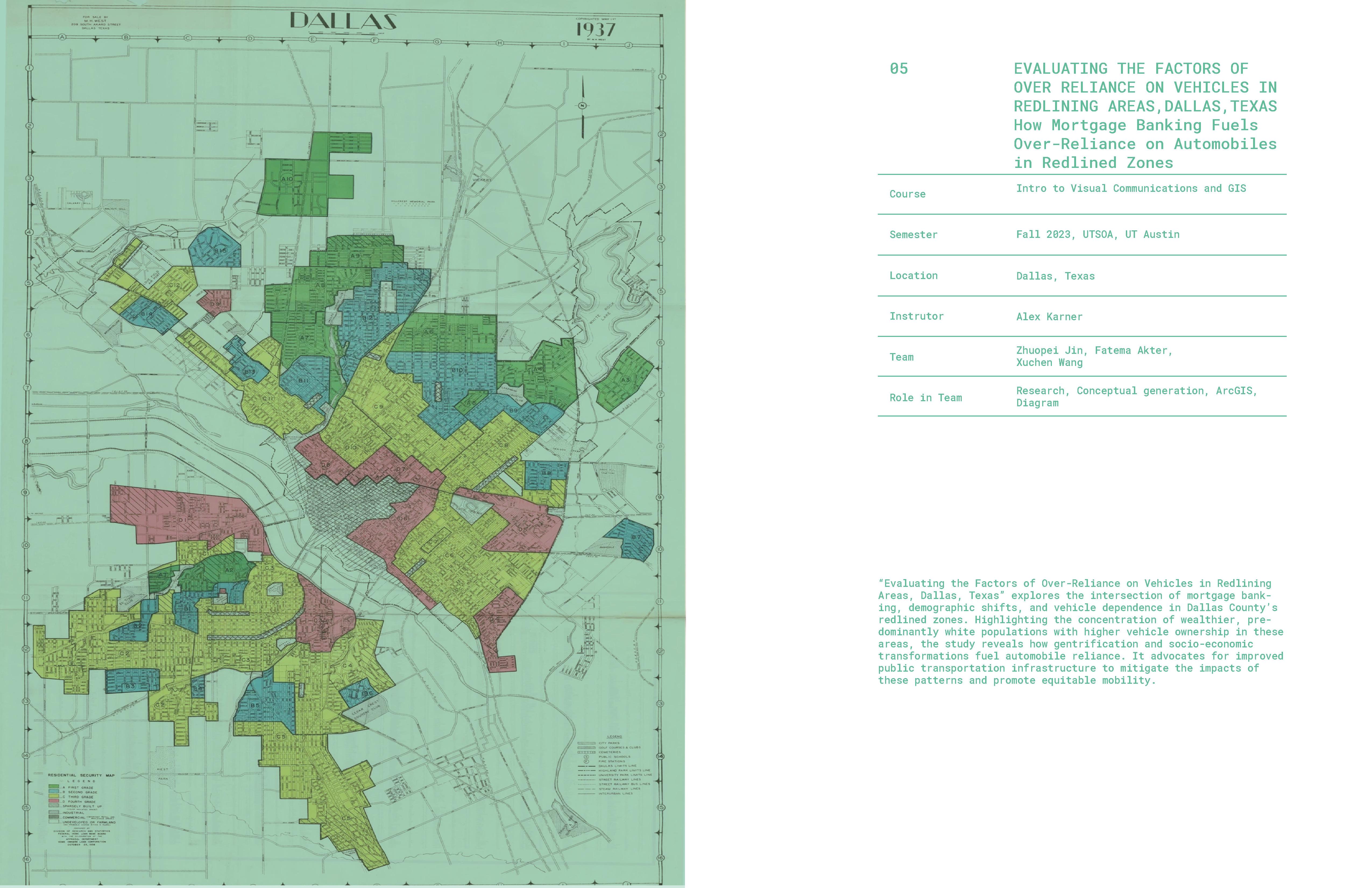
EVALUATING THE FACTORS OF OVER RELIANCE ON VEHICLES IN REDLINING AREAS,DALLAS,TEXAS
DISPARITIES IN AIR POLLUTION EXPOSURE AMONG DIFFERENT RACIAL, EDUCATIONAL, AND ECONOMIC GROUPS IN TEXAS
01 02 03 04 05 06
URBAN DESIGN
Studio 01
Semester Location Instrutor Team Role in Team
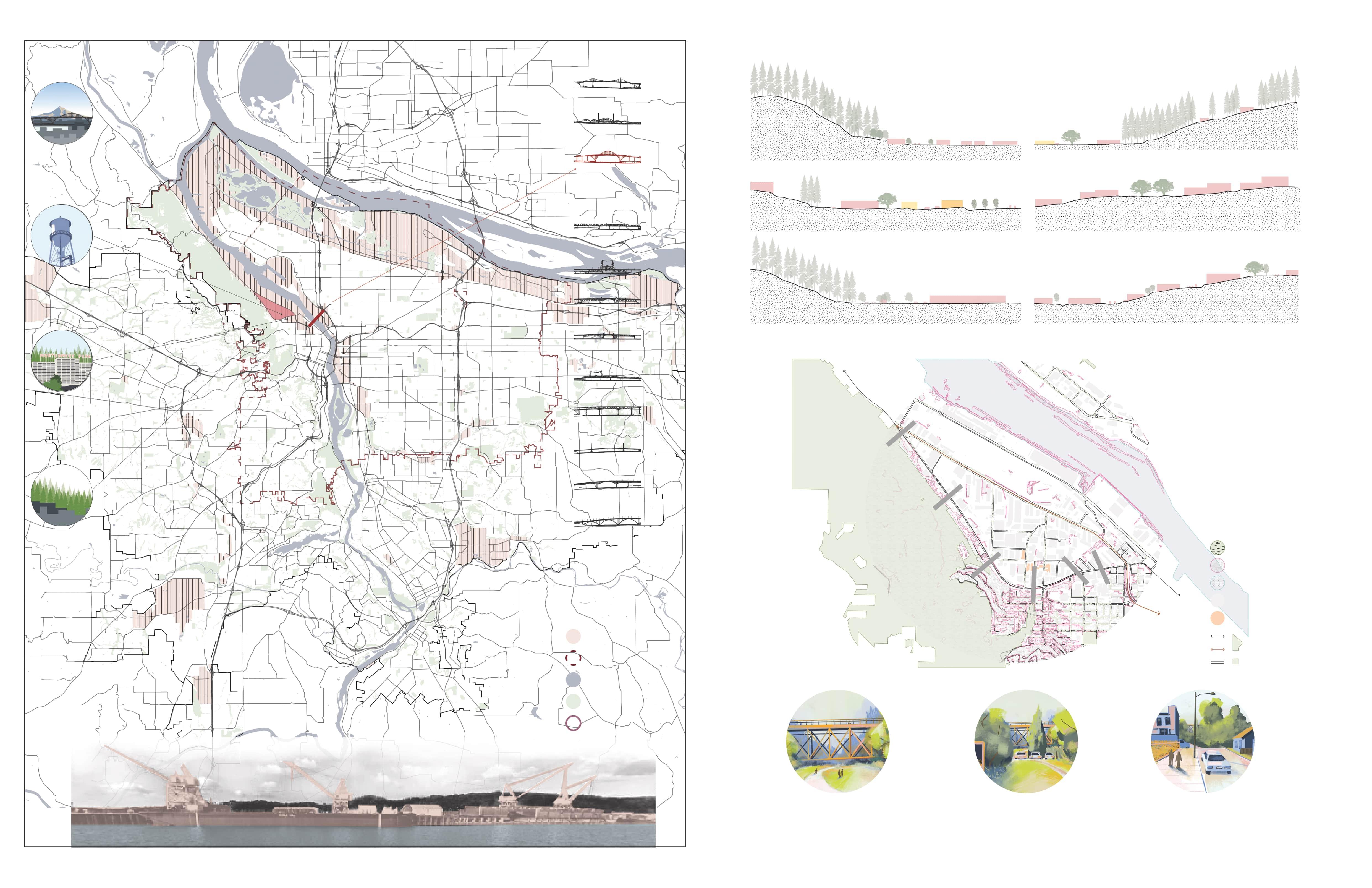
THE GATEWAY: Millbrae Master Plan and Network Design
Urban Design Studio with Gehl StudioCity Making in Silicon Valley
Spring 2023, UTSOA, UT Austin
San Francisco, California
Laura Johnson, Ghigo, Dean Almy
Zhuopei Jin, Faith Charles, Aishwarya Parab
Research, Conceptual Design, Modeling, Rendering, Diagram
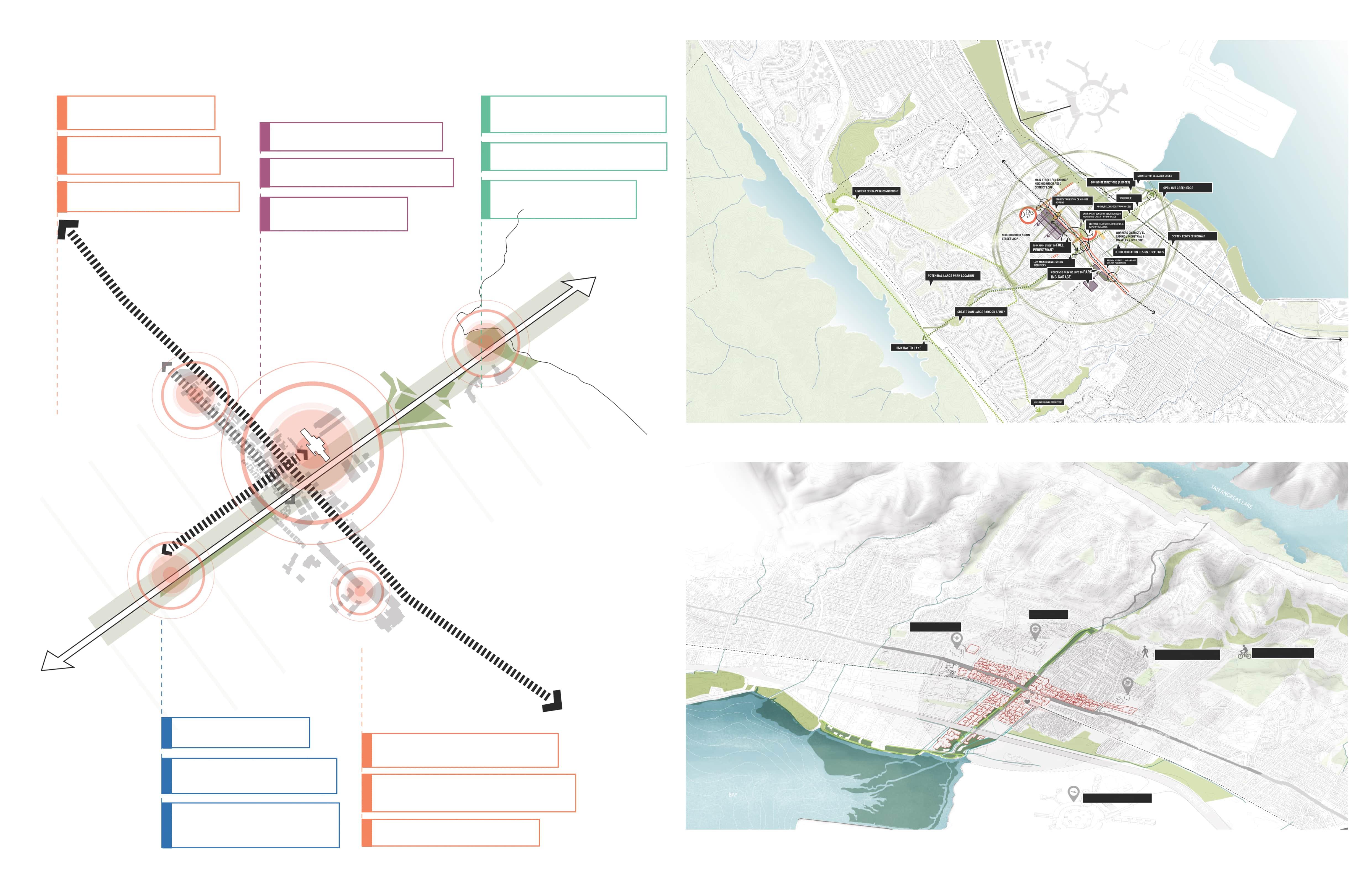
In response to Millbrae’s compromised urban fabric—marked by segregated land uses, ecological disconnection, and a car-dominated landscape—our design project proposes a transformative approach. By implementing a road diet on Millbrae Ave, introducing dedicated lanes for buses and bikes, and enhancing pedestrian safety, we aim to reconnect the community. Integrating green corridors to bridge ecological gaps and redefining land uses, our project envisions a revitalized, human-centric Millbrae. This initiative promises to forge a sustainable, cohesive, and vibrant urban gateway in the Bay Area.
Challenges for Millbrae’s Transformation
COMPROMISED MOBILITY AND CONNECTIVITY
Dominance of cars
More vehicle crossings than pedestrian crossings
Absence of specific lanes for various modes of transit
ENVIRONMENTAL DEGRADATION AND ECOLOGICAL DISCONNECTION
Loud noise due to flights
Ecological fragments from San Andreas Lake to the Bay Inefficient land use in bay areas.
Existing Character in Millbrae
LAND USE SEGREGATION
East Millbrae exhibits land use segregation with industry, housing, workplaces, and offices being separate, alongside inefficient land use in coastal areas.
DISRUPTED URBAN CHARACTER AND SEGREGATED LAND USE
Several breaks in urban character
Land use segregation (industry, housing, workplaces, and offices are segregated)
Inefficient land use in coastal areas
LACK OF SAFETY AND ACCESSIBILITY
Dangerous spaces for pedestrians and cyclists
Too wide avenues to cross
High crash rates along Millbrae Ave
Unsafe shared bike lanes
ABSENCE OF MULTIMODAL TRANSIT
An able-bodied person requires the full 32-second crossing window to traverse Millbrae Avenue, where no specific lanes are designated for alternate modes of transit.
INEFFICIENT LAND USE IN BAY AREAS
Ecological fragmentation from San Andreas Lake to the Bay, and inefficient land use in bay areas
“Millbrae
Connectivity Global Visions
as the Gateway”
Serving as the globall aviation hub and gateway of bay area for domestic and international travelers.
NO PUBLIC TRANSIT LANE
Without a specific bus lane, buses share lanes with other forms of transit.
Driving Economy Regional
Serving as an economic and recreational hub for the travelers and local bay residents of the region though transit systems.
Ecological Threads City
Connectings ecological fragmentst from San Andreas Lake to the Bay. Creating a network of green public spaces and blue infrastructure links.
Linking Fragmented Neighborhoods Local
Accomodating motimodal transit and improving safety by reimagining the existing transit infrastructure to serve the local community and becoming a hotspot for new business and highlight the local identity
HIGH CRASH RATES ALONG MILLBRAE
The Transportation Injury Mapping System (TIMS) from UC Berkeley indicates that crashes are concentrated along Millbrae Ave
The extremely narrow pedestrian paths and lack of protection from fast-moving traffic make biking on Millbrae undesirable.
DANGEROUS SPACES FOR PEDESTRIANS
2
3 6 5 4
1
Masterplan Concept Culmination
Millbrae: A gateway global connectivity, regional economy, and local identity through multimodal transit, ecological corridors, and vibrant commercial hubs for travelers and residents alike
Promote public art and create unique wayfinding markers
Create community anchors for different neighbourhood serving uses
Tansit oriented residential, and Mixed-use developments along ECR
Gateway of bay area for domestic and international travelers
Road dieting and Specific transit lanes for buses and bikes
Safe pedestrian experience with improved crossing
Create green corridors that connect parks, open spaces, and natural habitats
Establish educational programs focus on environmental sustainability
Promote infill development to optimize landuse potential and reduce demand on open space
Master Plan Design Strategies
ECOLOGY HUB TRANSIT HUB
LOCAL COMMERCIAL (MAIN STREET)
Link bay to Lake, integrate multimodal transit, enhance green networks, bolster local economy, and enrich community spaces for sustainable.
Connected Network
NEIGHBORHOOD HUB
WORKFORCE HUB (EL CAMINO)
Create walkability and bikefriendliness to link residents
Support mixed housing types and affordability to foster inclusivity with amenities
Multipurpose community centers and open spaces to host local markets, cultural events, and social gatherings
Offer training and development centers for workforce advancement
Develop zones that attract technology firms, research institutions, and innovative businesses
Provide housing near employment centers for workers
5-minute bike zones and 15-minute walkable areas, connecting essential services and community hubs.
1 2 3 4 5 5-minute bike 15-minute Walk San Francisco Airport Millbrae Library High School
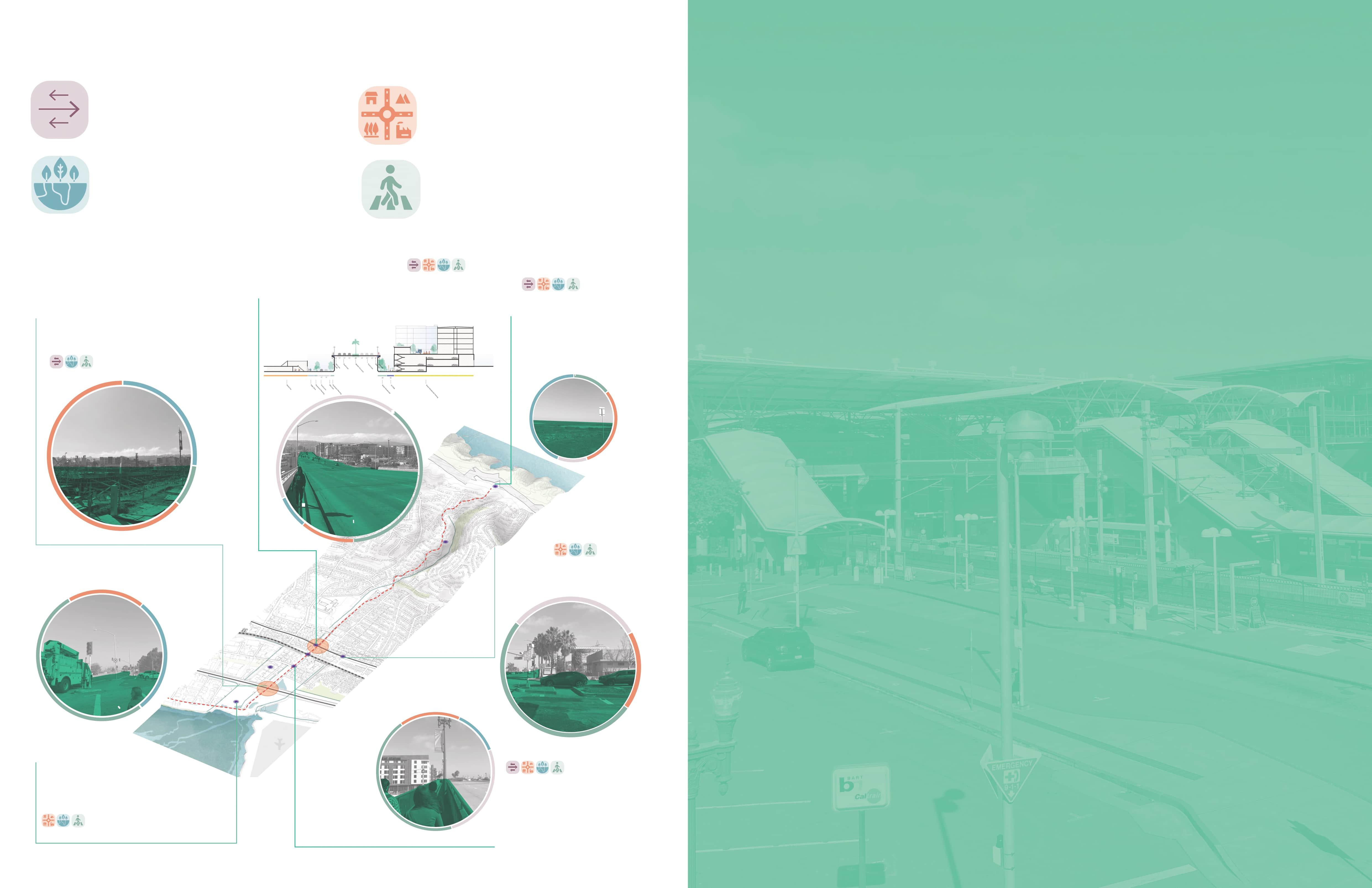
Human-Centric Neighboorhood Hub: Integrating Nature, Recreation, and Social Spaces
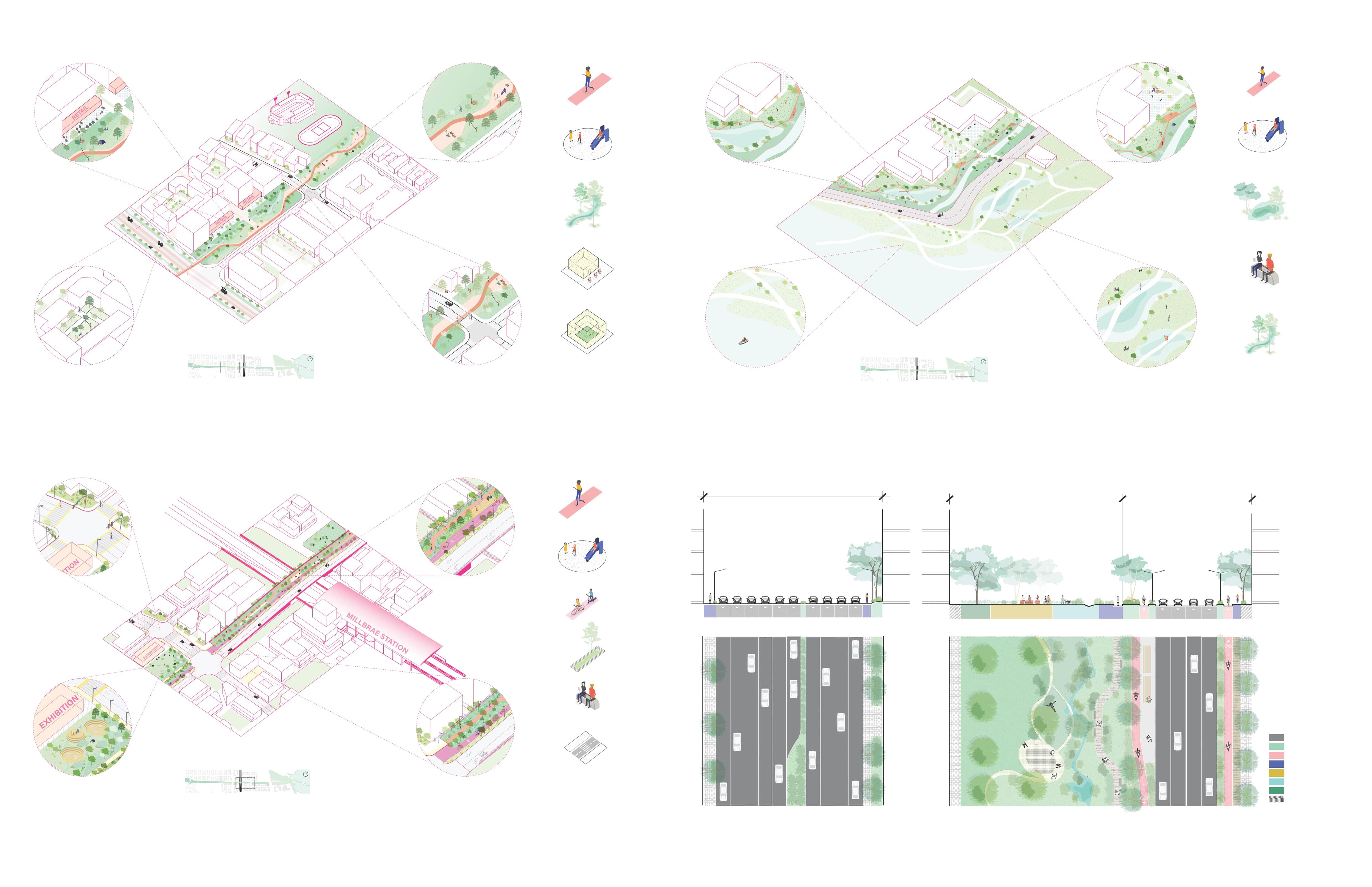
Fostering cohesion and engagement through green corridors connecting natural spaces with versatile community centers for markets, events, and social gatherings.
Multimodal Mobility & Road Diet: A Human-Centric Transit Hub Approach
Revamping transit through road dieting and multimodal options around Millbrae station, enhancing safety, accessibility, and connectivity for a seamless journey in the heart of Millbrae.
Human-Centric Ecology Hub: Connecting People with Nature
Integrating human experiences with ecological stewardship, creating green corridors and community spaces along the bay area that promote wildlife conservation, recreational activities, and social cohesion.
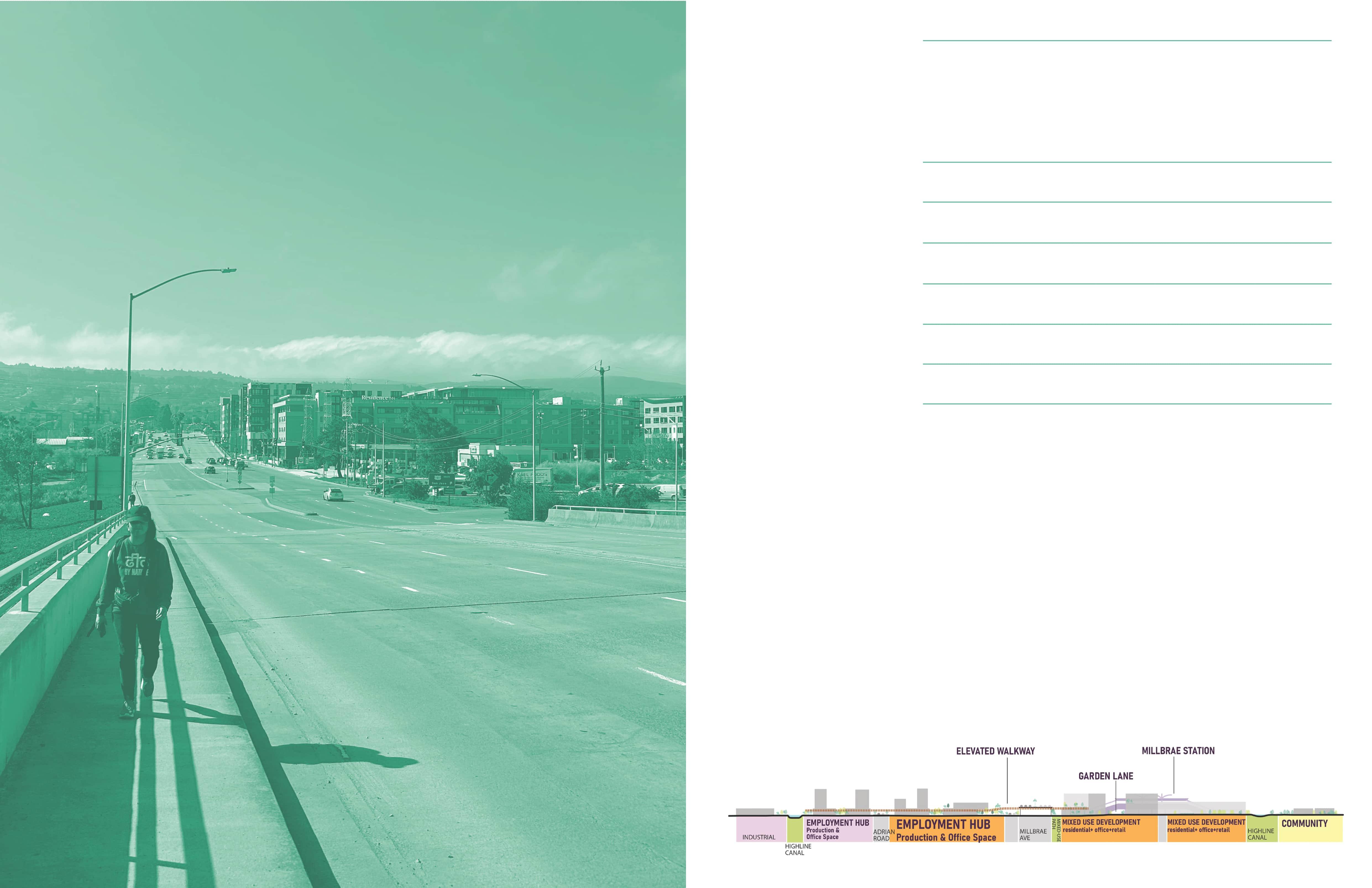
District Relationship to Corridor as Connector
Transforming Millbrae Ave from 8 to 4 lanes, adding bus and bike lanes, road dieting enhances pedestrian safety and connectivity, revitalizing it as a community connector.
N CAFE PEDESTRIAN LANE PLAYGROUND CREEK CAFE SEMI-PRIVATE SPACE N PEDESTRIAN LANE PLAYGROUND BIKE AND SCOOTER LANE PLANTING AREA SEATING CROSS 20’ 40’ 30’ 20’ 10’ 6’ 5’ 11’ 11’ 11’ 85-95’ 120-150’ 11’ 5’ 6’ 8’ 8’ 8’ MINIMUM DISTANCE FROM BUILDING LANDSCAPE BUFFER (LARGE TREES) CREEK FLOOD BANK PROGRAM & RECREATION ACTIVITIES PEDESTRIAN WALKING PATH BIKE LANE BIOSWALE TRAVEL LANE EXISTED PROPOSED 11’ 11’ 11’ 11’ 11’ 11’ 11’ 125-135’ 11’ 11’ 11’ 8’ 10’ N PEDESTRIAN LANE PLAYGROUND SEATING POND CREEK
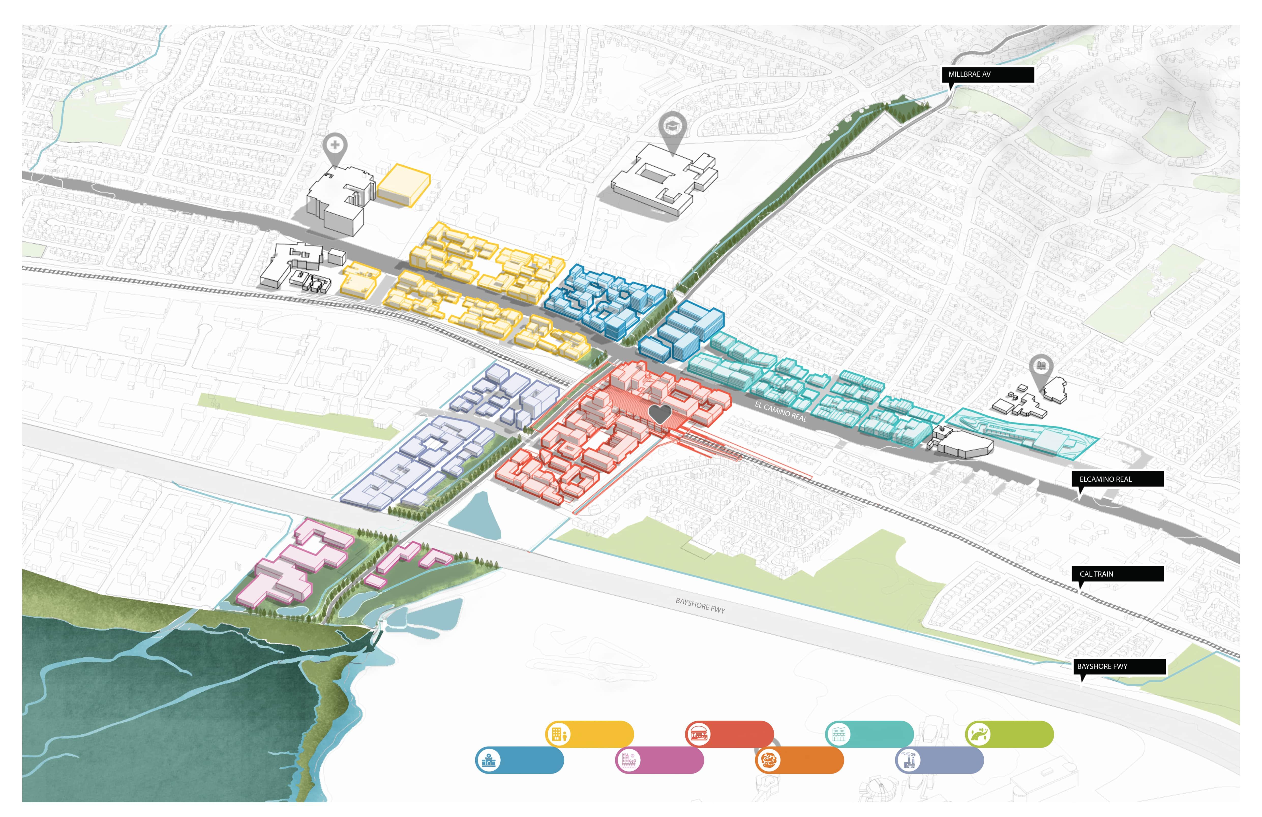
“Millbrae as the Gateway”
MILLBRAE STATION MEDICAL CENTER BAYSIDE COMMUNITY INDUSTRIAL COMMERIAL STREET CORRIDOR
EL CAMINO REAL
Studio
ECOTONE REGION: The Interlock of Uses
Urban Design Advanced Studio
Fall 2022, UTSOA, UT Austin
Portland, Oregon
Dean Almy, Maggie Hansen
Zhuopei Jin, Andrea Michelle Cruz Mejia, Anthony Watley, Leah Gundrum
Research, Conceptual Design, Modeling, Rendering, Diagram
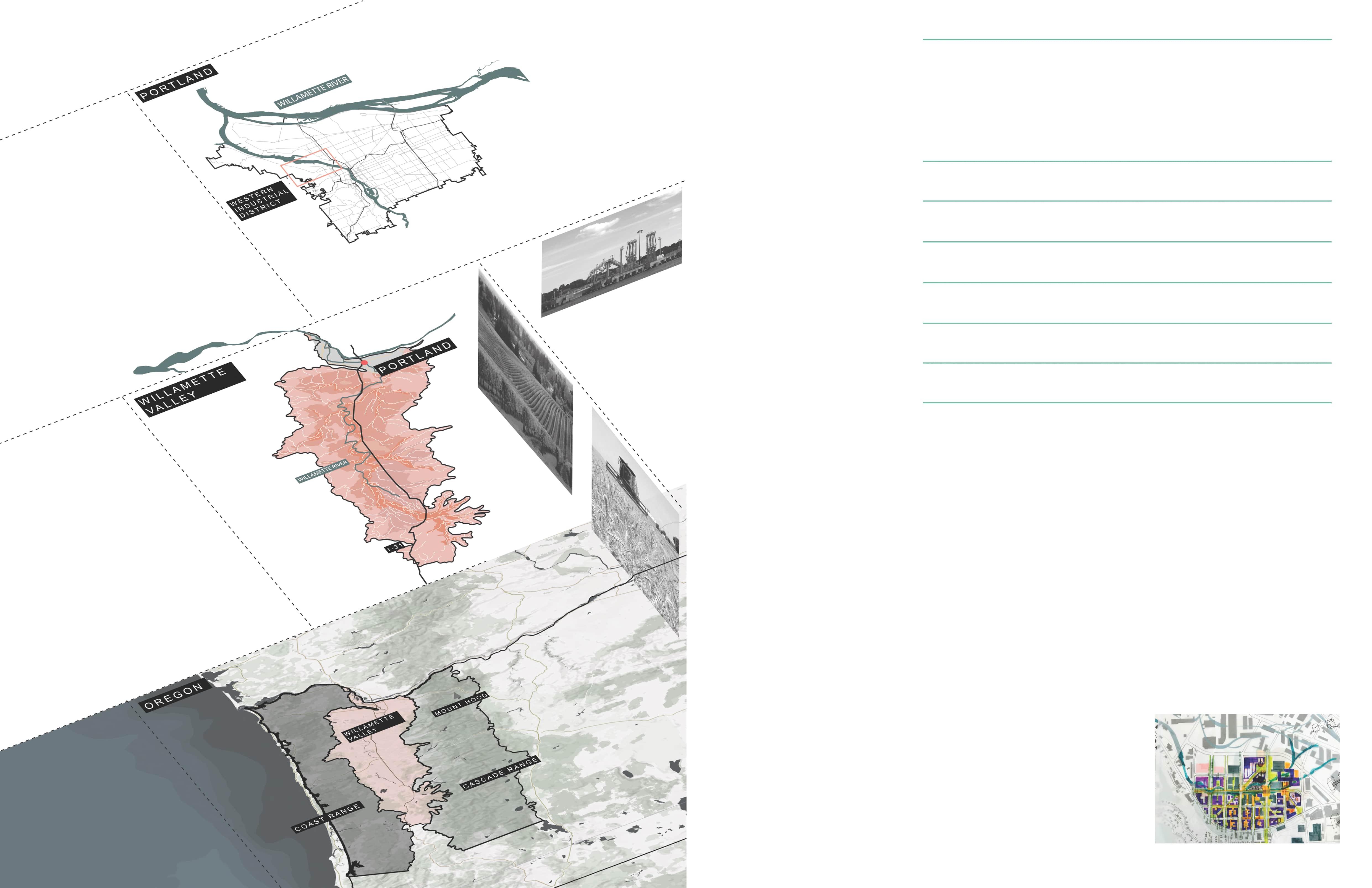
Nestled between the Willamette river and dense ecological zone of Forest Park As, Guild’s Lake Industrial Sanctuary is one of the last remaining urban industrial districts in the United States and a major backbone of Portland’s economy.
The design aims to integrate the site within the natural ecological systems of Forest Park and the Willamette River and with the urban fabric of the surrounding neighborhoods in a way that addressed the needs of a city. The strategy of intervention is to emphasize and enhance the multiple cultural identities and programs that meet at the sites edges and allows them to synthesize into an urban and ecological ecotone of systems that softens edges and creates a hybridized space.
Semester Location Instrutor Team Role in Team 02
The industrial edge has resulted in the Willamette river being named a superfund site, a factor that led the design to investigate a proposal that enhances the forces of the forest and the multifamily housing that are arising from the south and southwest. Public spaced dedicated to views of Portland icons that give the city its identity and provide residents with a sense of belonging.
industry 1854 1910 1946 1967 SITE CONTEXT | Portland Icon SUPERFUND SITE SECTION | Habitat Fragment& Hard Edge Mount Hood Water Tower Fremont Bridge Montgomery Park Building Forest Park Industry Portland Boundary Park/Open Space Urban Growth Water Section F-F Section E-E Section D-D Section C-C Section A-A Section B-B
Forest Park/Open Space 25% slopes Water Building Footprint Cultural Buildings Truck Street Street Curb A B C E F A B C E F D D
Existing Forest Park Penetration
South:
Forest Park Forest Park Forest Park Forest Park Industry Industry Industry Industry Industry Industry Residential Residential Industry Cultural Building
Forest Park North: Housing
Urban resilience, diversity, and livability are the three mains values that drive our proposal. The design creates urban resilience through the decrease of fragmentation by connecting to the forest and attributing it to areas dedicated to housing.
Forest park’s edge along the northern part of NW St. Helen RD is considered by Portland a hard edge. NW St Helen Rd is an existing hard edge between the current residential area and the industrial sanctuary.
The designe conceptualizes an ecotone to allow various systems to coexist harmoniously and address the lack of diverse use on the site. To create these ecotones, intermediates are introduced to facilitate the transition between existing elements and address any shortcomings.
The gradient is from forest to meadow, in relation to the gradient from housing to industry. Housing typology is exist in the forest blocks, the adaptive reuse of industrial buildings at the transition along the central spine, and the cultural center, housing, and workshops introduced in the meadow blocks.
Urban
CONCEPT |
resilience, Diversity, and Livability
Forest Meadow Forest Meadow
esidential Wetland Amenities River Industrial PublicTrans t Forest River Res dent al ndustrial Existing Hard Edges
Diverse Use of the Site
to Meadow Transition (Drew by Leah Gunfrum)
Wetland
R
PROPOSED ECOTONE
Forest
Created a Soft Transition for Ecotone
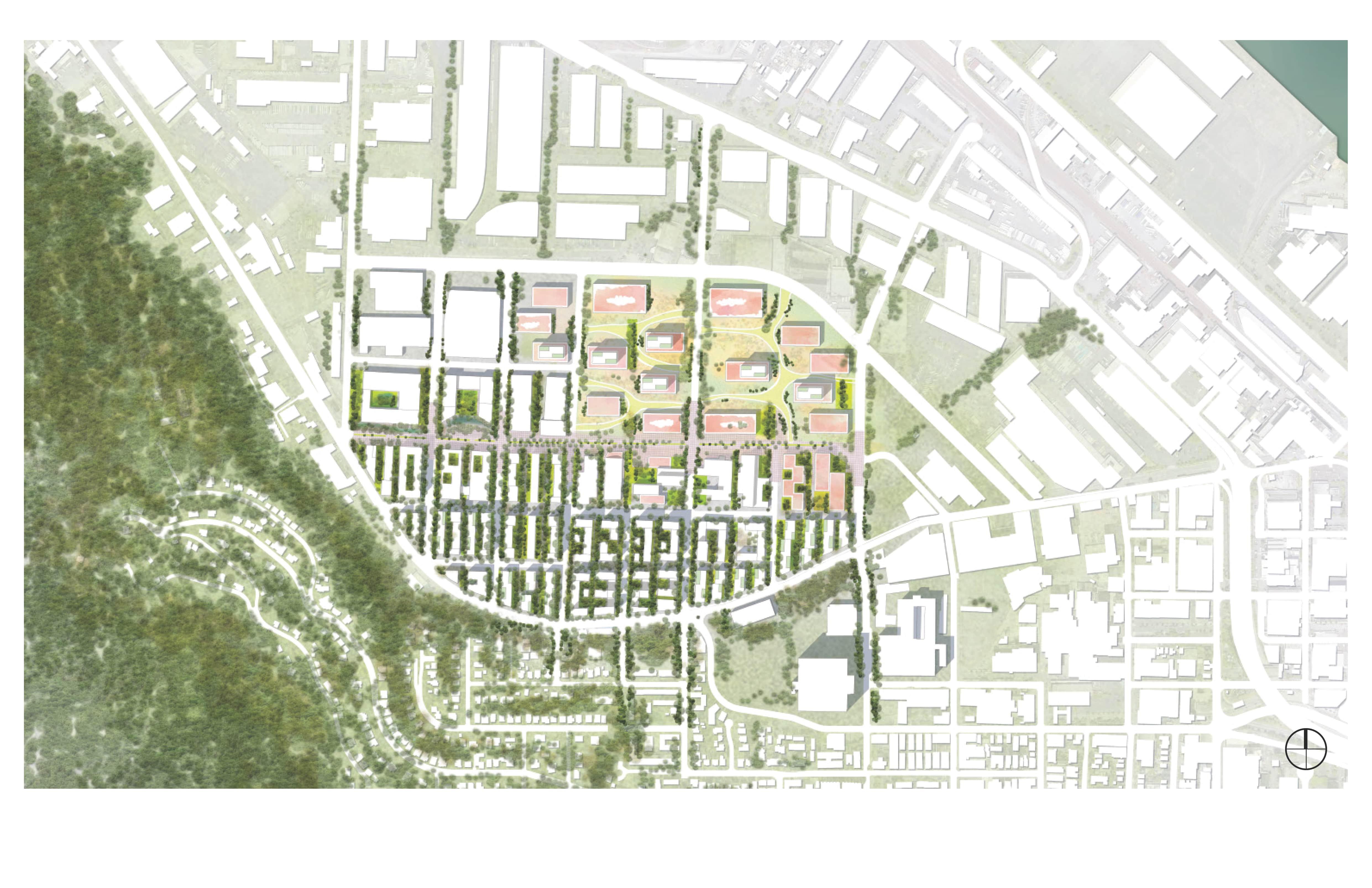
The strategy of intervention aims to integrate what is already present on the site with new elements to create an urban-ecological ecotone of interconnected systems that blur boundaries and create hybrid spaces. The existing semi-permeable edge of the forest park is utilized by extending the southern canopy to create forest blocks for multi-family housing. Diverse programming is introduced in the northeast, creating a new meadow system. A smooth transition between forest housing blocks and cultural meadow blocks is created through a central spine, which acts as a buffer. The forest blocks offer a sheltered environment for residents while the central spine provides strategic views of the surrounding landmarks.
SITE DESIGN
N
Forest Housing Block
Forest Housing Block emphasizes close proximity to nature and the integration of natural elements into the built environment. This type of housing can be particularly appealing to those who value a connection to the natural world and seek a more environmentally conscious way of living.
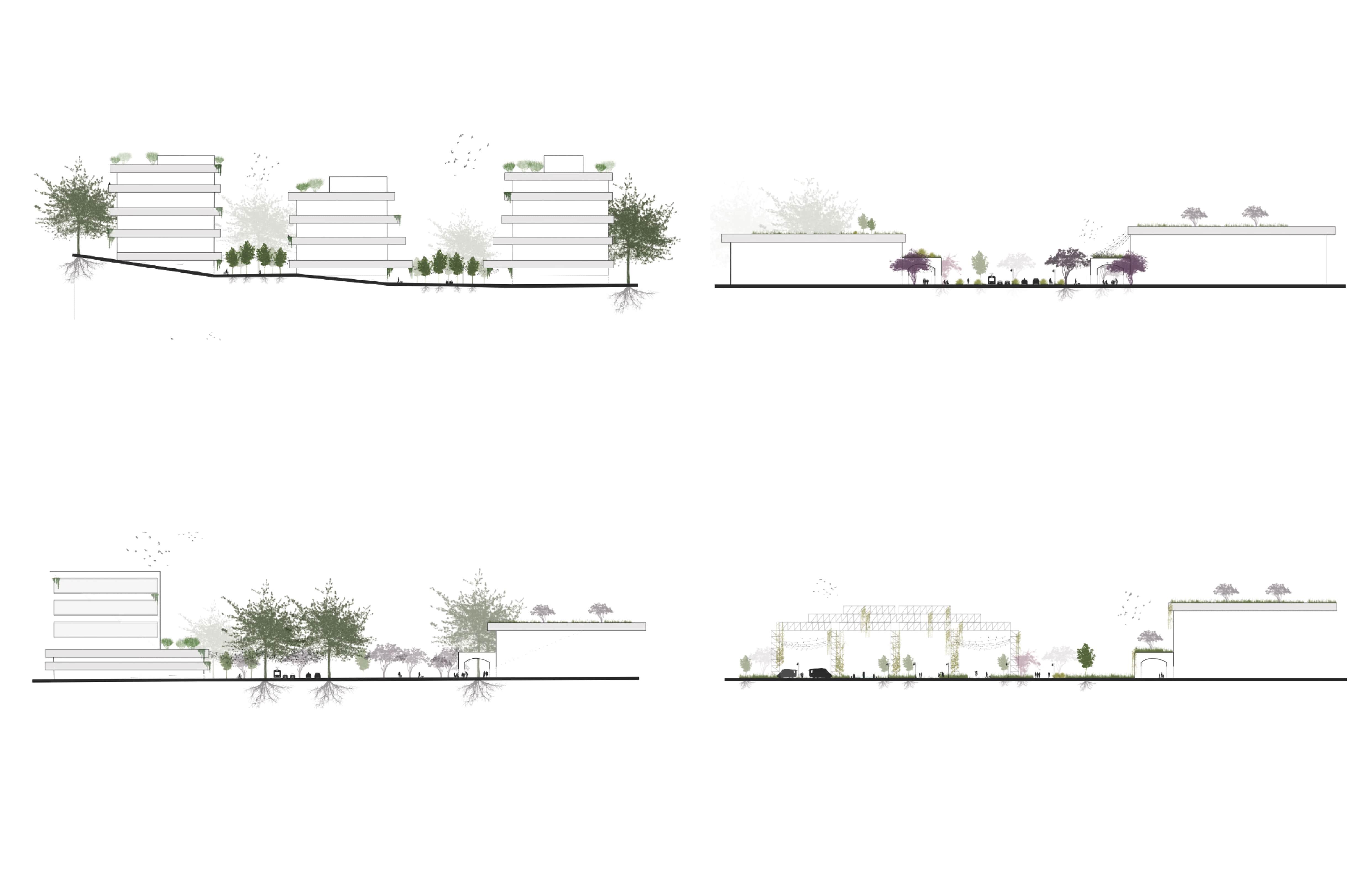
Forest Western Plaza
The Forest Western Plaza provides a unique and enjoyable public space that provides both aesthetic and functional benefits to those who use it. The incorporation of a forest-like environment into an urban setting can also help to improve air quality, reduce noise pollution, and provide habitat for wildlife.
Meadow Eastern Plaza
The space incorporates green spaces, such as lawns, roof gardens, and trees. The meadow suggests that the plaza has a natural, park-like feel and provides a space for people to engage in outdoor activities and even public transportation. A meadow plaza can serve as a gathering place for community events and activities. The aim of Meadow Eastern Plaza is to create a well-designed and functional public space that provides aesthetic, recreational, and social benefits to those who use it.
Meadow Mixed Use Block
A meadow mixed use block includes a combination of residential homes, shops, offices, parks, or other amenities, all located within close proximity to each other. The idea behind a meadow mixed use block is to create a convenient, livable community that integrates natural and built environments in a way that enhances the overall quality of life for those who live and work there.
SECTION
HOUSING
RETAIL COFFEE
Created a More Diverse Use of the Site
A soft transition is created for ecotone between forest housing blocks and cultural meadow blocks, seen here as a central spine. The forest blocks conceal the surrounding context, grounding residents in a space shielded from the challenges resulting from the industrial sanctuary, while the central spine to meadow transition offers a strategic opening of the canopy to provide safe celebrated views of the icons seen on site
CULTURAL CENTRAL SPINE
THE
RETAIL RETAIL
ZONE PEDESTRIAN ZONE BIKE LANE TRANSIT LANE STREET CAR LANE LANDSCAPE FURNITURE ZONE LANDSCAPE FURNITURE ZONE
PEDESTRIAN
Company
The ANCHOR BRIDGE

TIANHUA urban design and planning Co.LTD project
APR 2021 - JUL 2021
Shanghai, China
Yi Zhao
Zhuopei Jin, Jingchen Liu, Liqun Zhu
Research, Conceptual Design, Modeling, Rendering, All the Drawings in portfolio
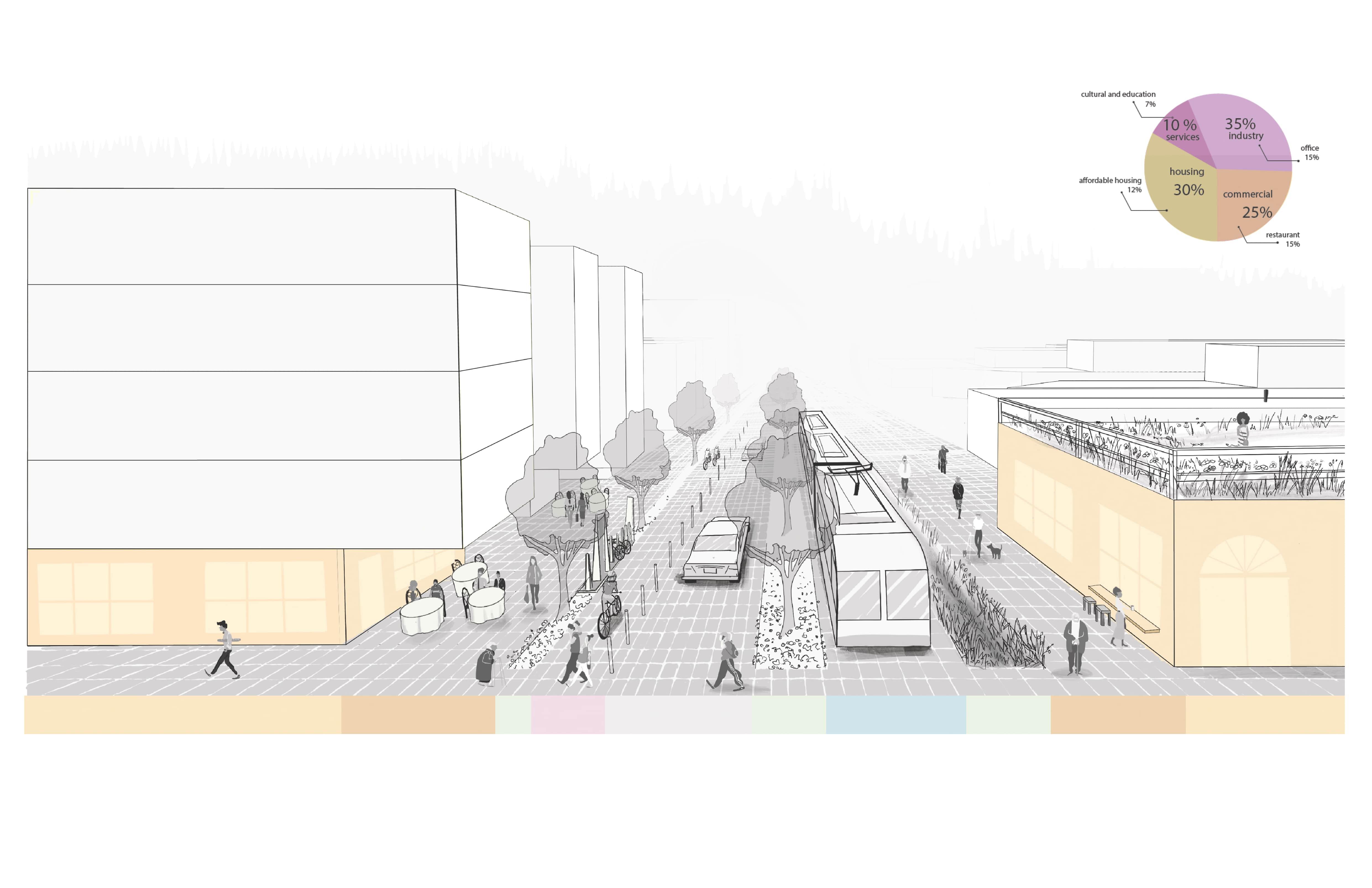
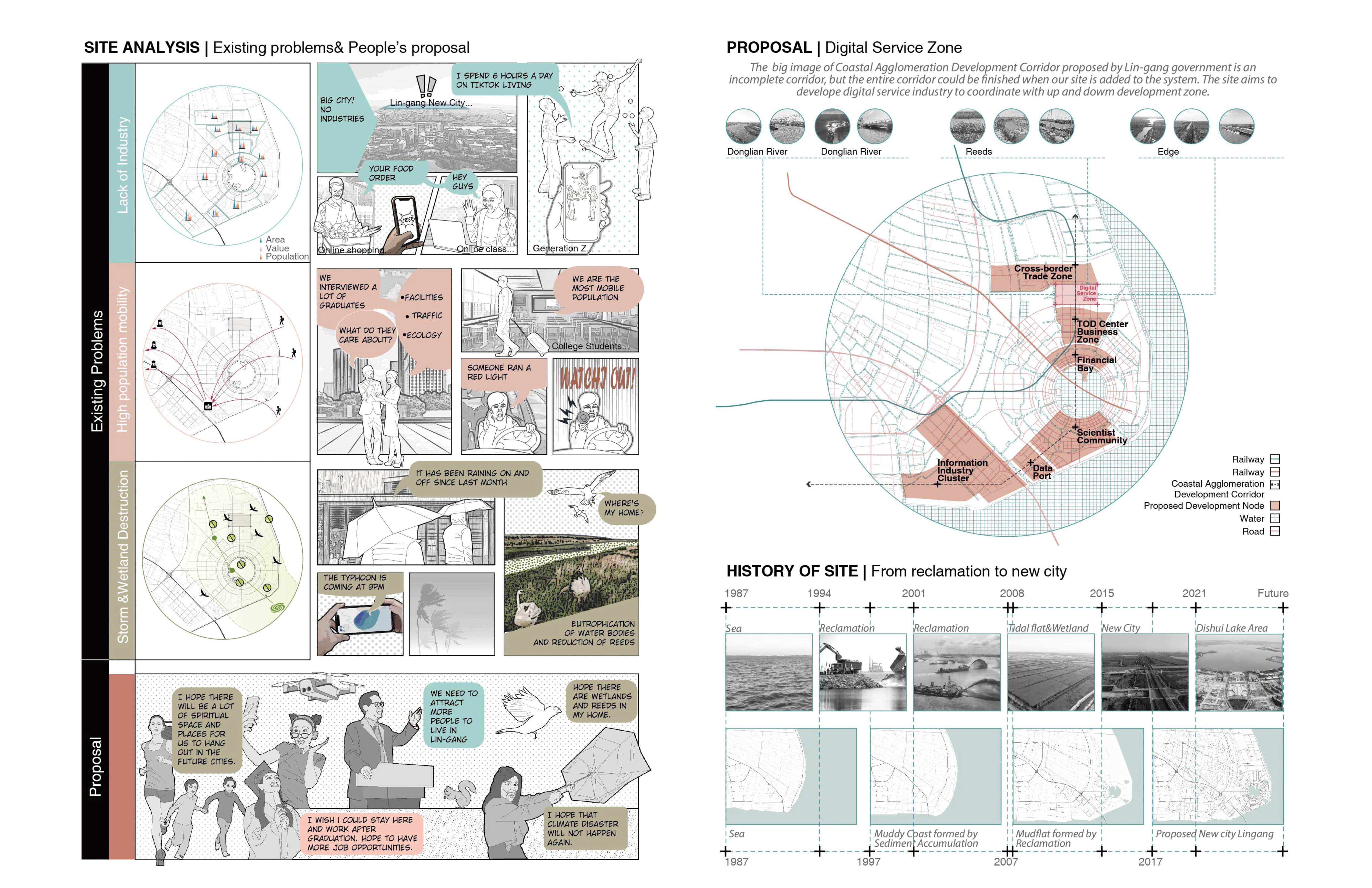
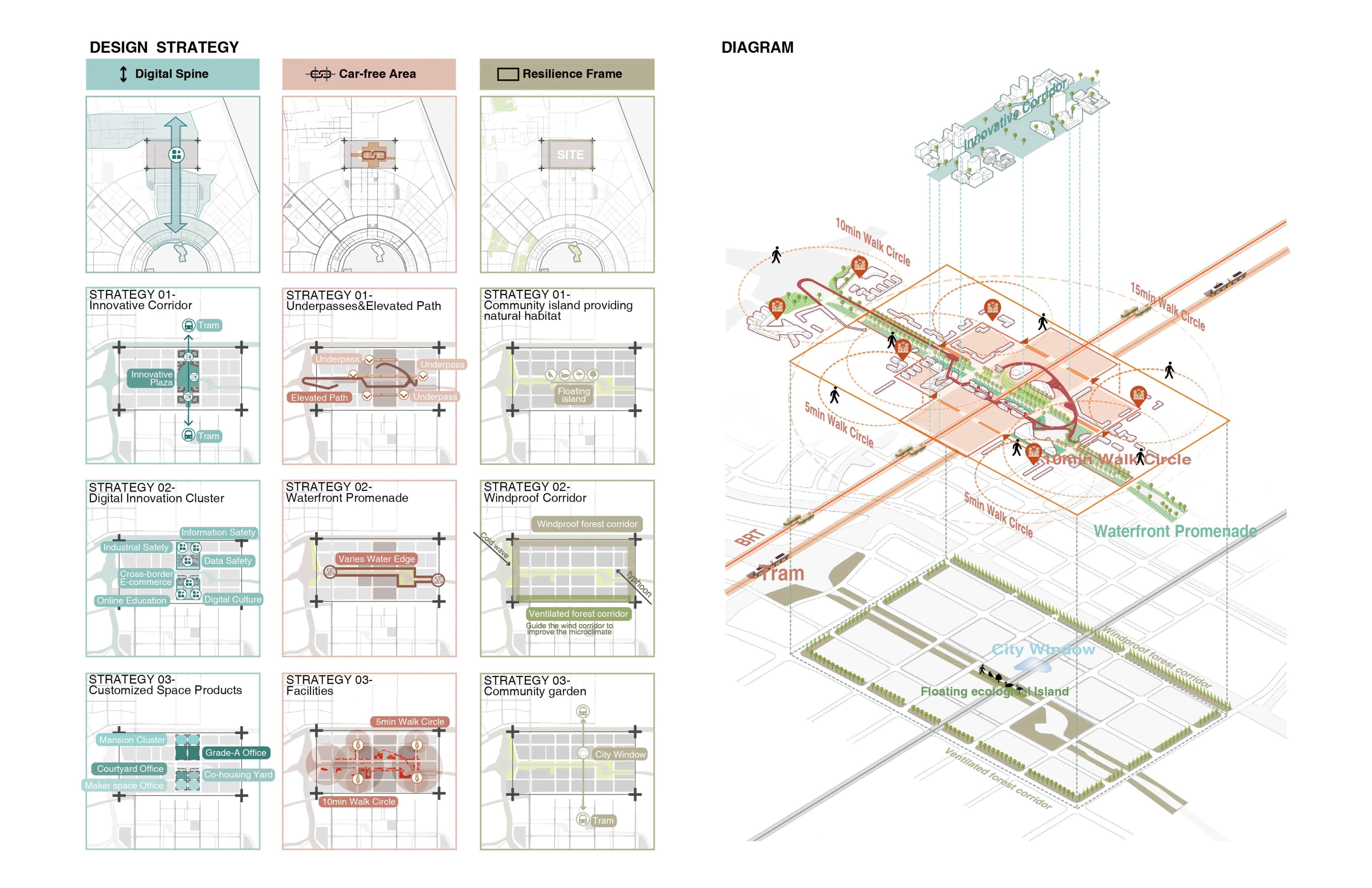
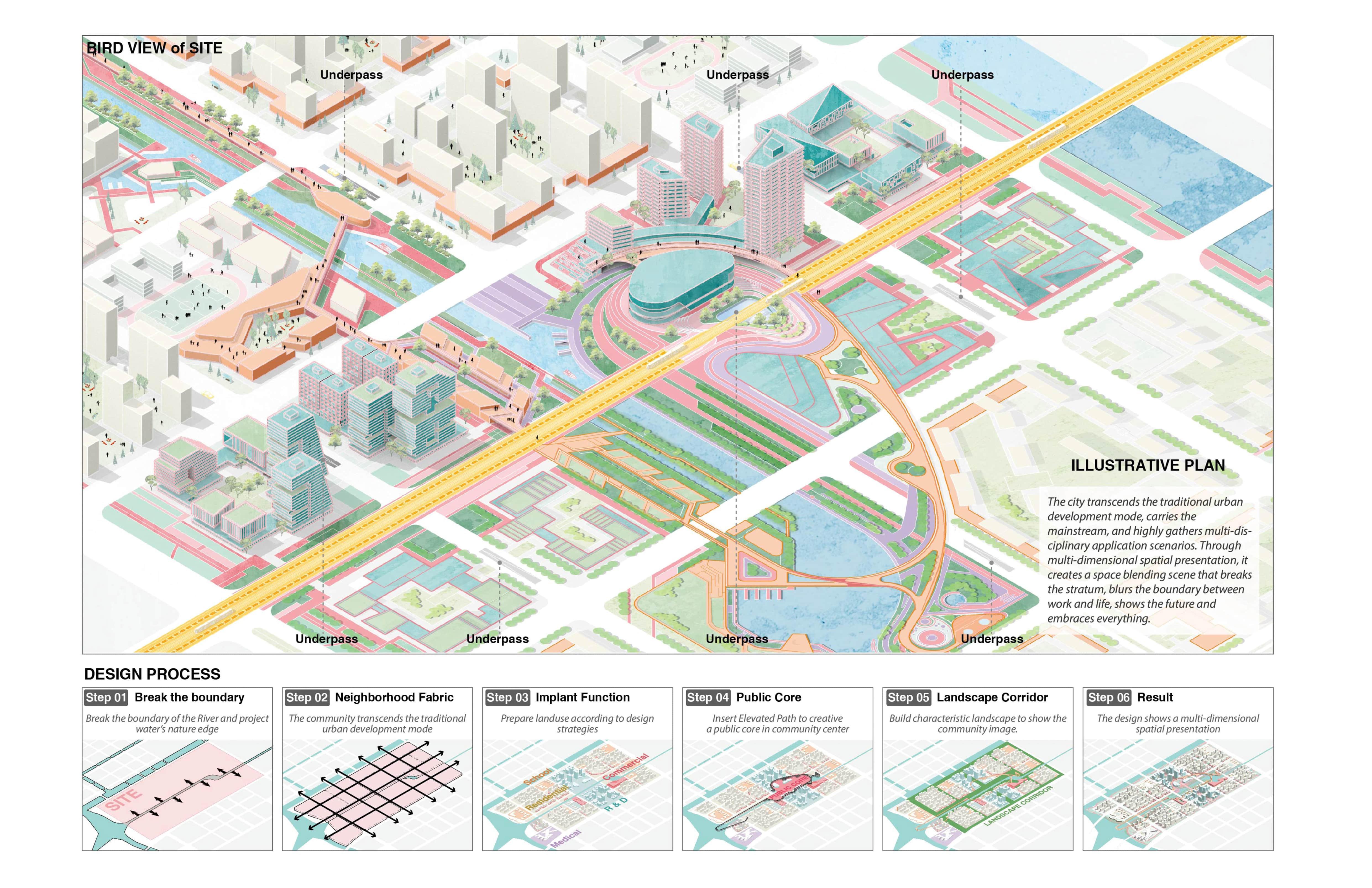
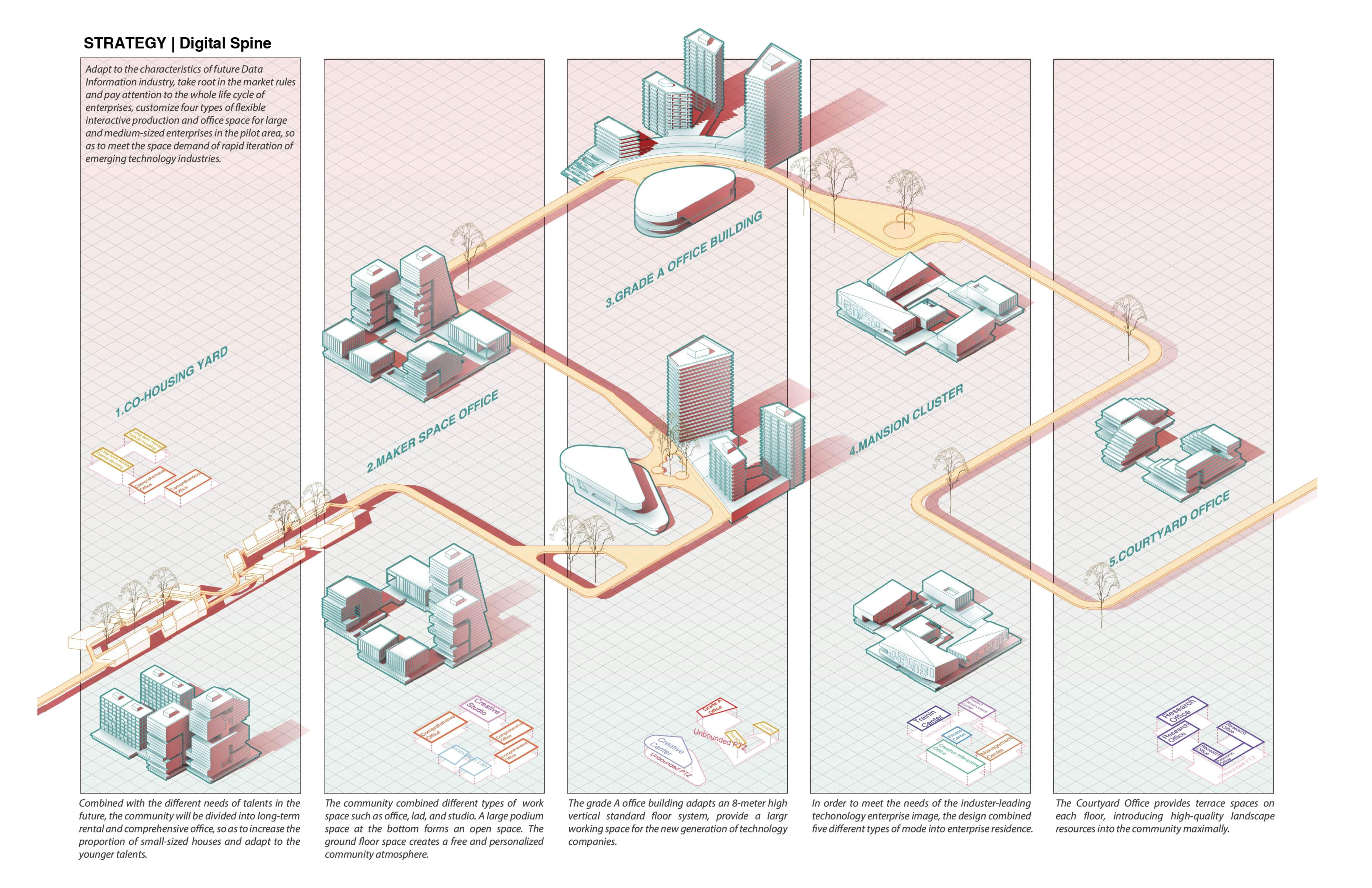
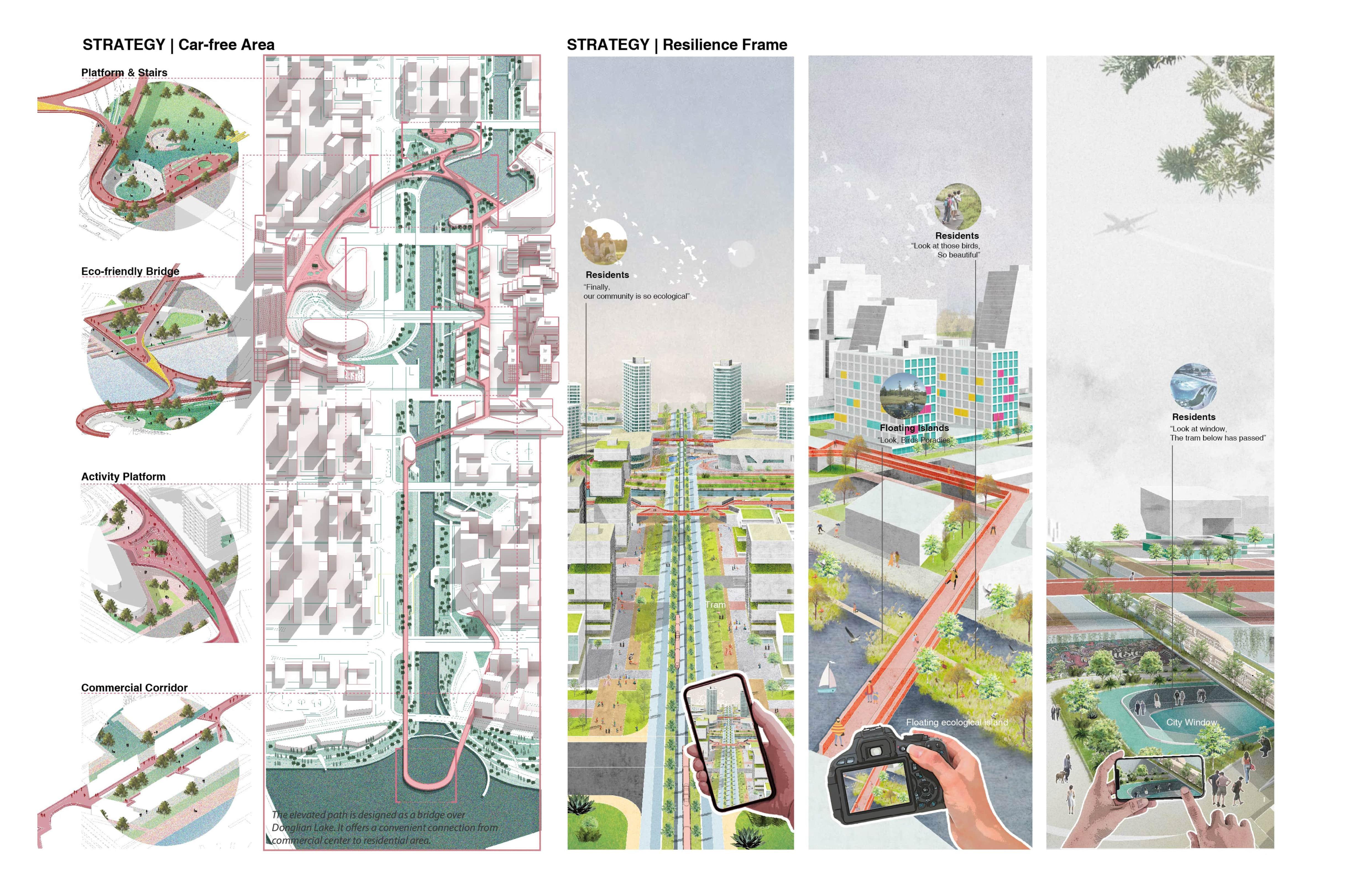
Lin-gang No.105 community will establish a new civic and industry node for the Shanghai Dishui Lake Core Area. The design puts forward a acomprehensive network composed of industry, public facilitties and landscape systems. To adapt to the development characteristics of digital economy and innovative industries in the future, the strategy of “Digital Spine” aims at cultivating industrial ecosystem for the 105 community. I believe that another characteristic of of future cities is sustainability, resilience and urbanization. Therefore, I put forward a blue-green base to cope with the climate changes in the port area and fullfill people’s requirements to get close to nature.
Semester Location Instrutor Team Role in Team 03
RESEARCH
Researchers have expended considerable efforts to document the economic and mobility outcomes among zero-car households. Researchers have found that individuals without cars travel fewer miles and experience reduced job access even in the most transitrich neighborhoods.
Study Area
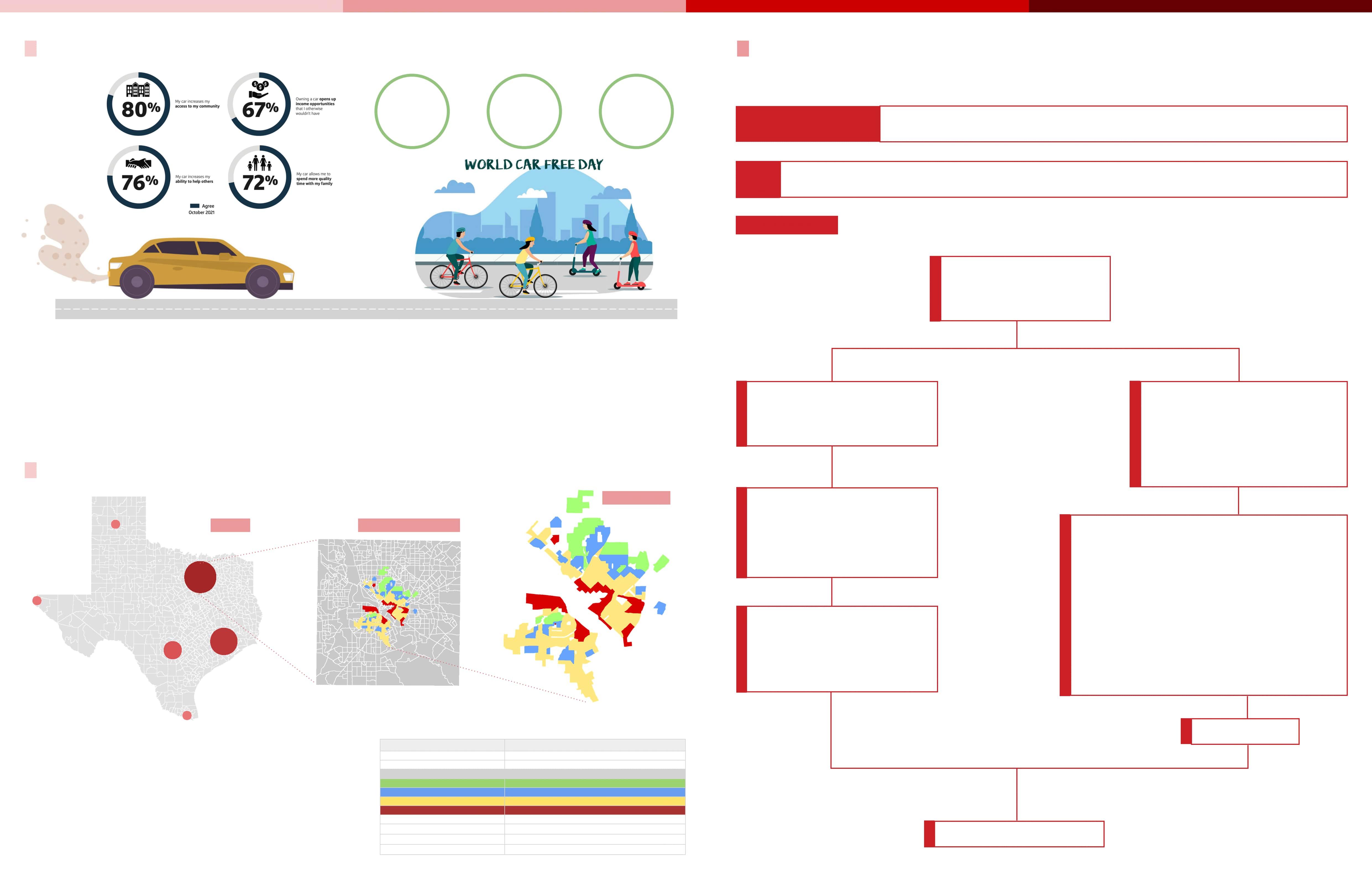
Redlining means “the denial of loans, mortgages, and other services based on a neighborhood’s demographic makeup” (Macon, 2017, par. 2).
Unfortunately, these maps have not changed much throughout Dallas’ history and there are still issues with loans to low-income people in Dallas.
“Car-free
21% of residents who are not owning a car become represent a chosen freedom instead of mobility burden.
Research Problem
How House loan lending practices in redline areas fuel the over-reliance on automobiles?
ACS Demographic data 2021, Tiger census tracts shapefile with redline score, LODES data
Methodology
-Check linear relationship with vehicles availability to variables to check whether vehicles or no vehicles data have linearity using Scatter Plot Charts Data
Add join and Spatial join between Demographics to HOLC shapefile
Texas ACS (2017-2021)
Demographic data at census tract level
Used vlookup (Excel) to combine Redline scored data of 2020 and LEHD (LODES) data of 2021 to demographic data
Select the tracts where demographic features are represented
Create and compare maps between whole Dallas county and Dallas redline areas
Analyze and Findings
Used Jupyter Notebook to -Perform multiple linear regression to check significance level
Tables & Maps
Research Background Research Question , Data & Methodology
Friday” media campaigns Offering free transit passes Building transitoriented developments
166 100 84 20 21 24 TEXAS DALLAS COUNTY
Count of Readline scored areas in Texas Cities 20 Amarillo, TX 24 Beaumont-Port Arthur, TX 166 Dallas-Fort Worth-Arlington, TX 36 A 56 B 61 C 13 D 21 El Paso, TX 100 Houston-The Woodlands-Sugar La 84 San Antonio-New Braunfels, TX 16 Waco, TX
REDLINING
Linear Regression(Comparing Vehicles vs No vehicles)
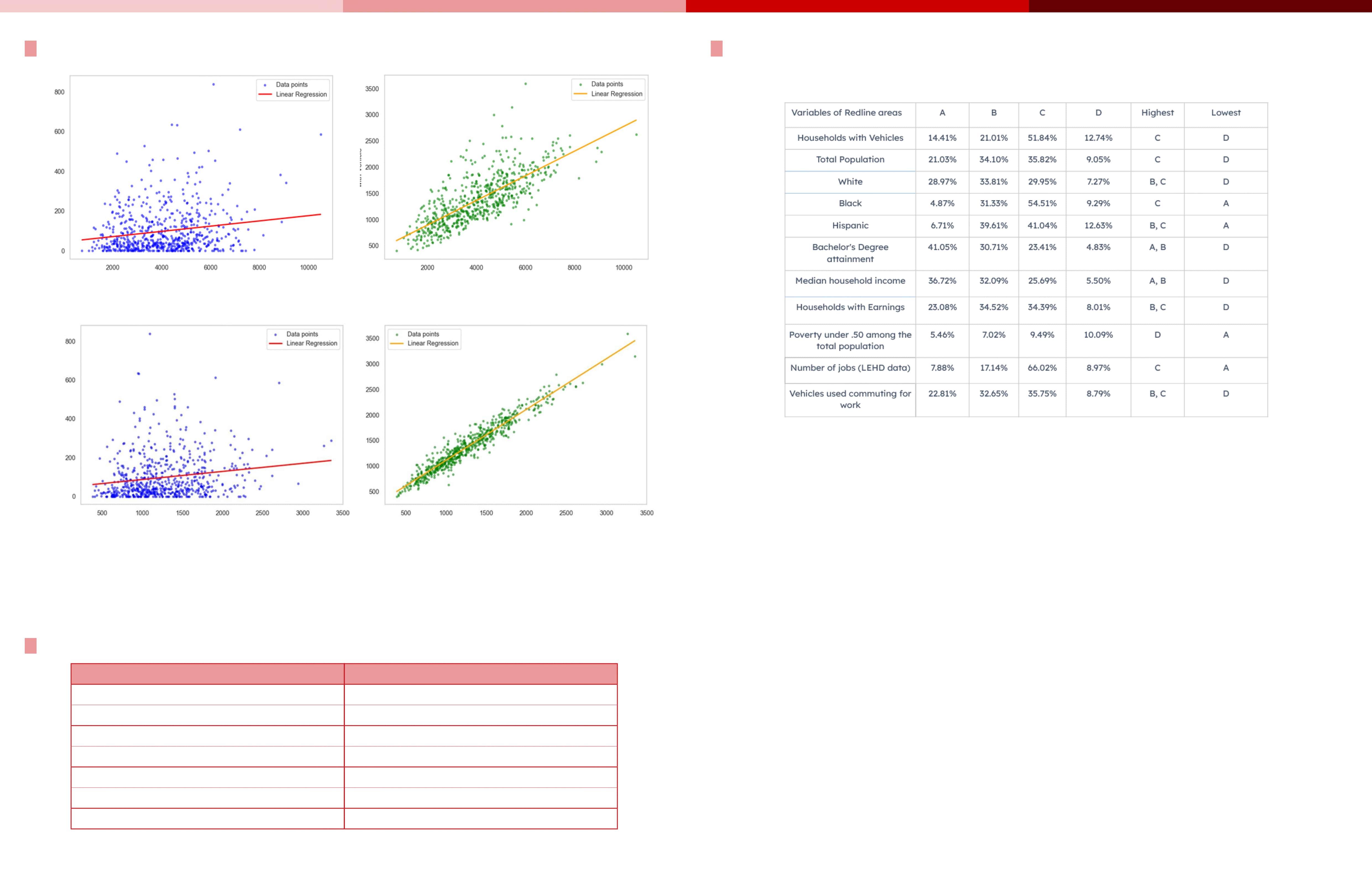
Linear regression was employed to determine the significance of vehicle availability data compared to the absence of vehicles. The investigation sought to identify which vehicle data exhibited a stronger linear relationship with total population and Households with Earnings . Figures 01 indicate that households with vehicle availability data demonstrate a notably high linear relationship with total population than the households with no vehicles availability.
Multiple Linear Regression to check the significant variables of Vehicles availability data
Vehicles dependency demographic Data
Table 02: Demographic data of vehicles dependency in HOLC areas
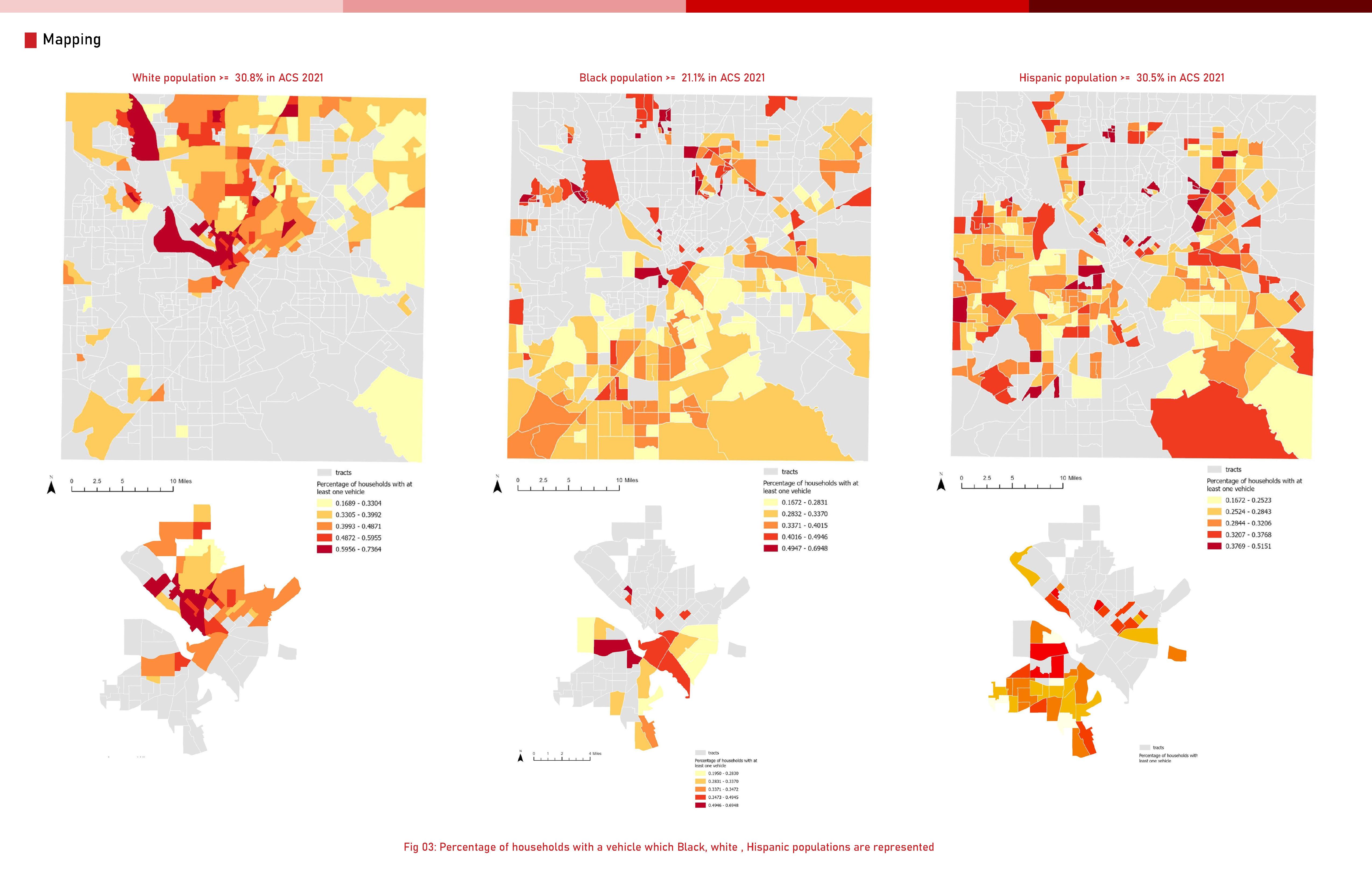
The tables suggests that, D area is still lacking behind in terms of development while B and C areas are getting more concentration.As the demographic data varies with the number of vehicles in these areas. It depicts that, areas where there are more white, hispanic and low black people with higher bachelor’s degree and job opportunity, the usage of vehicles are higher in those areas.
From the linear regression of vehicles availability with population data shows that most of the redline areas having Households with vehicles availability data have more linearity than the households with no vehicles availability data.So, we chose to work with the vehicles availability data to find out the vehicles dependency in redline areas.
Multiple linear regression shows that ,if household income, Share of white, hispanic population & job opportunity and educated population increases ,the vehicles availability increases. On the other, if the poverty and share of black increases vehicles availability decreases.
Pivot table analysis shows, the significant variables we found from the regression is heavily prominent in B and C categorized redline areas in Dallas.
Table 01
Multiple linear regression to check significant variables in Dallas County
Vehicles Availability No Vehicles Availability Total Population Total Population No Vehicles Availability Households with Earnings Households with Earnings No Vehicles Availability vs. Households with Earnings Vehicles Availability
Significant Variables of Vehicles availability data Significance Median Household Income Positively significant White Positively significant Black Negatively significant Hispanic Positively significant Bachelor’s degree attainment Positively significant Employment Positively significant Ratio of Income to Poverty level (Under 50) Negatively significant
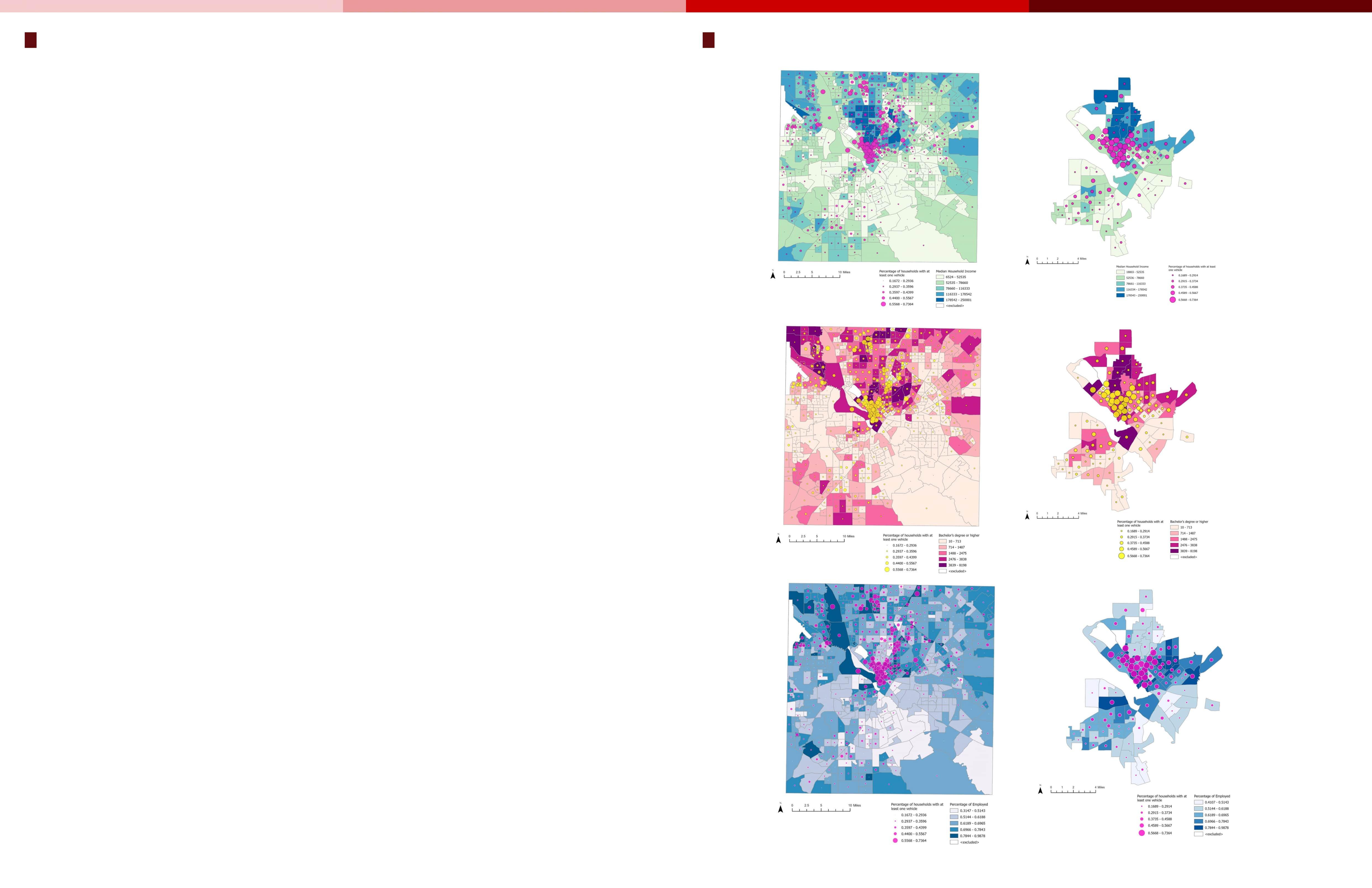
Findings:
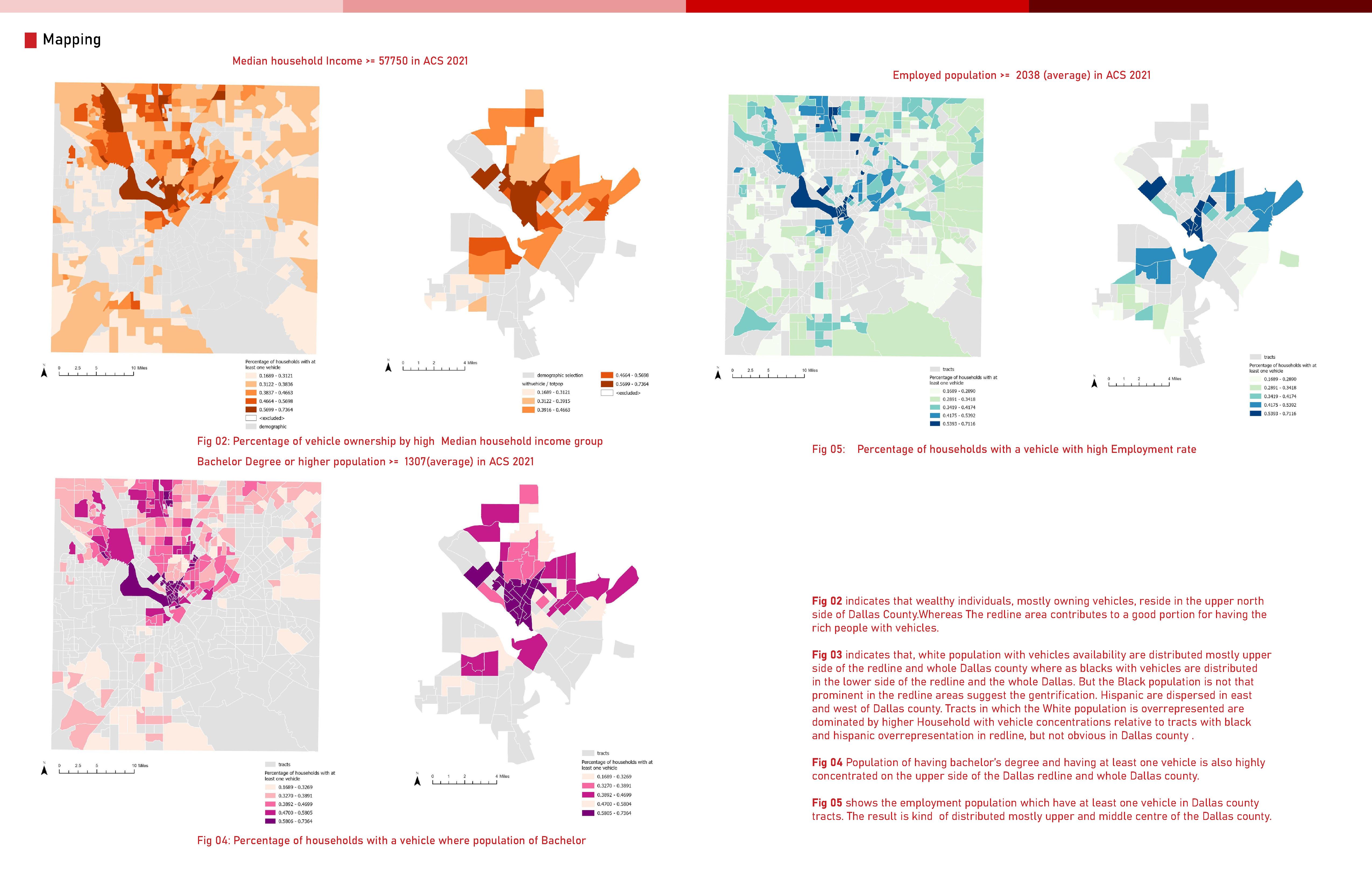
As the demographic data and vehicles availability data suggests that, redlined areas are facing gentrification where white and higher educated people are moving in; job opportunities are available in mostly B, C category.
People from every HOLC category is dependent on vehicles to commute in their day to day life as people are getting Home loans and more opportunities are creating in those areas and people choose to buy houses in redline areas and more educated people are moving in these areas.
As people getting easy home loans, they choose to live where more job opportunities are creating, it increases their economic condition and they choose to depend on vehicles rather than using public transport even for short distances.
Only D areas are still behind from development and the number of minority is higher in these areas. People are dependent on public transport in these areas rather than on vehicles in comparison to others.
The dallas redline areas contribute to a high percentage to the reasons of vehicles dependency in the Dallas county. It suggests that, Dallas county experiencing the vehicles availability increment due to the overall increment of people moving in these areas.
Recommendation:
We can suggest that the government should be more precise about improving public transit accessibility by developing transportation infrastructure so that even if Housing loan system emphasizes gentrification, it should not be significant for the increment of vehicles in the redline areas and also should not be negatively impact the overall automobile dependency in Dallas county which is an important concern nowadays.
Findings and Conclusion Append
Course
Semester
Disparities in Air Pollution Exposure Among Different Racial, Educational, and Economic Groups in Texas
Data Environment Equity
Fall 2023, UTSOA, UT Austin
Texas Sergio Castellanos
Zhuopei Jin, Daniel Sung, Alyce Keys
Research, Conceptual generation, Coding, Diagram
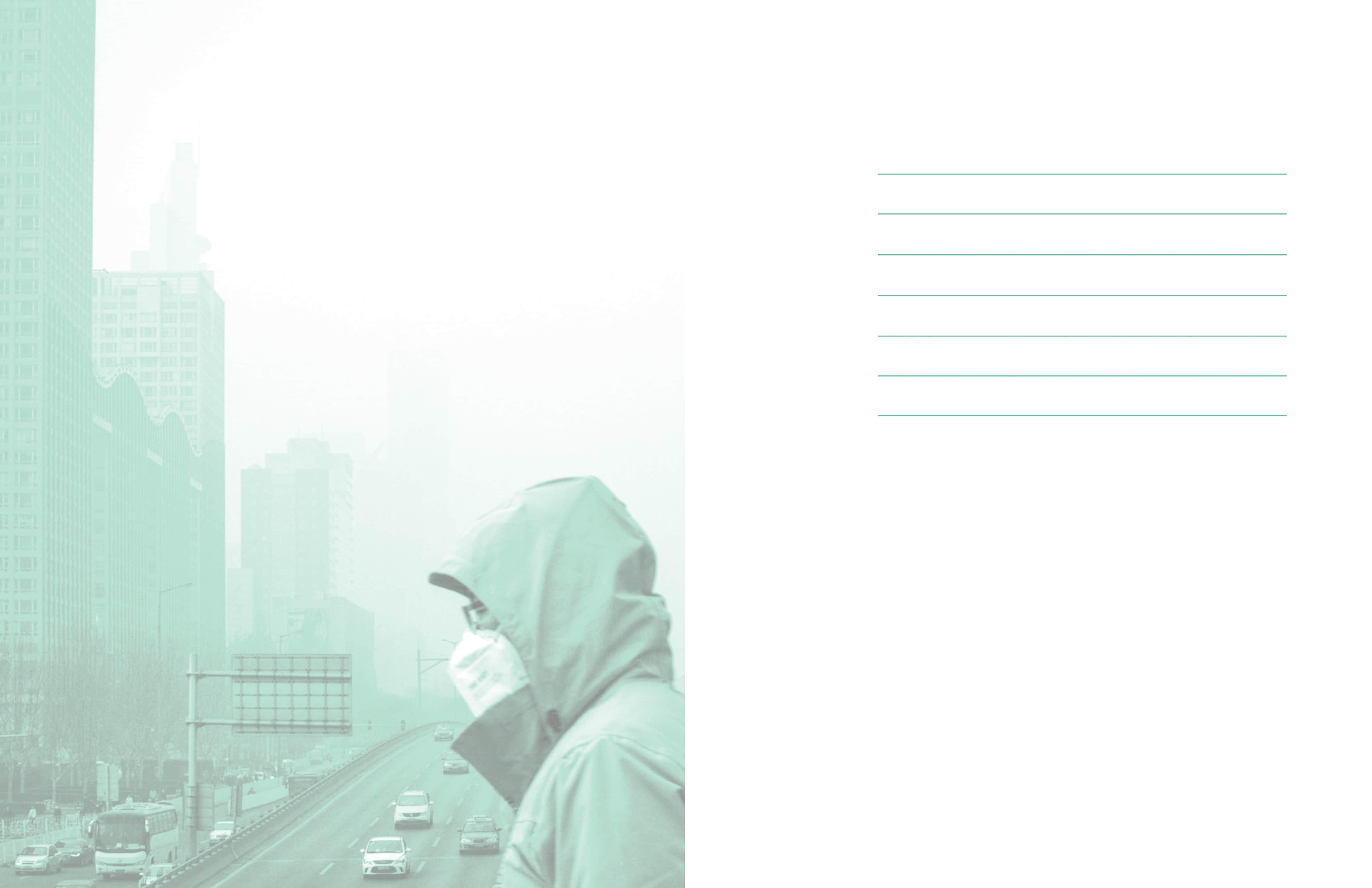
“Evaluating the Factors of Over-Reliance on Vehicles in Redlining Areas, Dallas, Texas” explores the intersection of mortgage banking, demographic shifts, and vehicle dependence in Dallas County’s redlined zones. Highlighting the concentration of wealthier, predominantly white populations with higher vehicle ownership in these areas, the study reveals how gentrification and socio-economic transformations fuel automobile reliance. It advocates for improved public transportation infrastructure to mitigate the impacts of these patterns and promote equitable mobility.
Team Role in Team 06
Location Instrutor