I have always had an underlying interest in art and design however Landscape Architecture has allowed me to express this in a more adventurous and diverse form. The ability of Landscape Architecture to incorporate a range of components makes it unique, particularly with the inclusion of natural elements. This characteristic separates landscape design from other art forms as we create designs which mature and evolve, promoting a harmonious human-nature balance. Multi-beneficial and multi-functional landscapes are my focus, to ensure a productive space to develop the landscape’s longevity as it contributes to the landscape value. My aspirations reflected in my entries to several competitions detail my conceptual ideas to promote an improved human-nature relationship. I believe this is effective in achieving sustainability to mitigate environmental issues such as climate change and biodiversity loss. I was able to experiment and apply a wide range of my research, such as on environmental pollution or urban rewilding, into a conceptual design.
I have an abstract approach to design, demonstrated in my conceptual drawings and visualisation renders. This details how I have translated thought and inspiration into a landscape design. However, I use this to develop an interest in landscape functions. More recently, I have experimented with more analytical and research-based approaches within my “Necrosphere” project. It has aided in my understanding of my design methodology, allowing me to develop and demonstrate new sets of skills. I aim to continue as a designer informed by literature and natural functions to improve my abilities and design process.
Contents Temple Wilds
- Urban design using human-wildlife conflict
Necrosphere
- Embracing death and new life within a landscape
Forest of Dean
- Landscape Characterisation and Capacity Study
Beyond the View
- Bringing perspective to the Hidden Ecosystem
Dissertation
- Rewilding in Landscape Architecture
Inter-urban Woodland
- A green vision of the residential streetscape
First Rays of Spring
- Multifunctional Renewable Energy Design
- A representation of Coral Reefs through planting
Design Summary
Temple Wilds reflects the fragmented characteristics incorporating both human and natural elements. It creates the foundation for allowing natural succession for urban nature to evolve and develop, maximising urban biodiversity potential. The use of the Abiotic Nature to create site structures and forms will illustrate the fragmented nature overgrowing into industrial representation features. It defines the human and nature corridor through the site, contributing to connectivity. The architecture will be complementing this theme, to define datum point on the site. The concept of pioneering vegetation withholds the opportunity for proposed habitats to change becoming suitable to the local microclimate. Allowing for natural encroachment is particularly significant with growing urban pressures and unstable climatic changes. This approach ensures wildlife suitability developing into habitat maturity to maximise benefit to current and future urban fauna. The 4D evolution of the natural cityscape embraces changes and allows for long-term sustainability, visualising the daily, seasonal and annual changes of the landscape.
Immersive
Circulation Strategy - Highlighting the primary and secondary paths to understand key areas of connectivity.
Flooding Strategy - Landscape embraces the flooding and the changing river tides. This aims to revitalise the proposed habitats as it naturally evolves to be more suitable and enhance urban ecology. This also maintains key access and circulation through the site.
Temple Wilds
Wayfinding Strategy - preservation of key views, defined by the landscape features to visually interact with the external context.
Seasonal Intensity StrategyEnsure potential for human activity throughout the year and understand the seasonal changes of the site.
Microclimate Strategy - The massing has impact on the habitats and planting proposed, creating a range of habitats with increased habitat interaction.
The new proposed bridge interacting with the green corridor and the proposed building roof.
Boardwalk over the mudflats interacting with the woodland and drainage basin.
The boardwalk over retention ponds interacting with the green corridor and river, weaving through wet woodland trees
Industrial Swale
Design Summary
In order to tackle current environmental issues such as climate change and biodiversity loss, we must first confront our issues of humans governing natural forces, resulting in human-nature conflicts. I intend to create a different perception of nature through embracing natural forces such as flooding, where humans adapt to nature. This is applied to Castlemeads, a neglected nature reserve with a strong
Decay and dead matter, known as necromass, has become my inspiration; I investigated the development of new life generated from life-death interaction. This is a feature of nature constantly overlooked for its unappealing aesthetic and yet it is essential to nature’s process to ensure a healthy environment. This element and its concept has been applied to regenerated Castlemeads into an adaptable and educational landscape that provides a new, interactive experience for people through perspective play and embracing the changing landscape. Before implementing this
YunHui Luk
Snail Woodlice Millipedes Beetles
Slug Fly SpringtailWorm
Furnitecture Axonometric Render
Diagram of the Decaying Process
Furnitecture Drawing Development
Challenges Emerging Issues Mitigation Strategy
Rising Sea Levels
Extreme Weather
Habitat Erosion
- Coastal squeeze leading to habitat fragmentation
- Erosion of low-lying habitats
- Habitats encroaching inland
- Changing of species in the local habitats
- Contribute to habitat erosion
- Habitats less adapted to extreme and changing climates
- Develop local biodiversity and genetic diversity
Human Risk
- Embrace and adapt to local changing conditions for habitat suitability, providing sufficient space
- Enhance ecotonal potential on site as a transitional landscape
- Increasing pressure on local living conditions with unstable climate
- Improve Access to Greenspace
- Develop ecosystem services
- Increasing mental health issues
- Increasing pollution and disease risk.
- Over-exploitation of natural resources
- Human-wildlife conflict
- Develop opportunity for recreational/edible landscapes
- Optimise carbon sequestration and pollution remediation
- Plan to identify and mitigate human-wildlife conflict such as ensuring sufficient wildlife resources.
Include:
• Agricultural Land Classification •
•
•
•
Existing environmental conditions have eliminated much of the distinct potential for development. This is often due to environmental conditions resulting in the location becoming economically unviable. It is also important for the future development prospects, ensuring the settlement’s longevity.
•
•
Include:
•
The existing social constraints include the existing settlements and the 1km buffer of larger settlements to mitigate the risk of settlement adjoining. This development should define an individual identity, complementing existing settlements and preserving key historic features.
Include:
Track and Trace Layers
•
•
The Forest of Dean has a range of protected areas of ecological and visual importance which takes up an extensive area of the district. In addition to the existing protected sites, existing greenspaces are protected from development for environmental and recreation value.
Landscape
This planning development vision aims to produce sustainable rural development for 4835 new dwellings with a low-density housing approach, suggested to maintain local and district-wide characteristics in the local Core Strategy, this development plan will support 10,637 residents. The existing landscape has significant cultural features and landscape character this development aims to protect and enhance to create distinctiveness. All placemaking will contribute to improving the Quality of Life, defining the local amenities and choices within a neighbourhood, and creating a new neighbourhood identity with landscape characteristics significant in the National Character Assessment, 106. The development follows TCPA Garden City guidance and the shared space concept to achieve sustainable development with socio-economic longevity which limits negotiation for an enhanced ecological network in the townscape planning.
Landscape Features the NCA and LCA identified:
• Floodplains
• Brooke
• Ditches/Moats
• Hedgerows
• Mature Standing Oak Trees
• Small corpses/shelter belts of wooded areas
Housing and Land Budget Allocation
Calculate the land required to meet the housing criteria of 4835 homes, considering the necessary facilities and services. This will use the Forest of Dean Core Strategy (2012) as guidance for current socio-economic issues within the district.
Site Overview
Create an outline of the study area and understand the current site context in relation to the district history and direct socio-economic influences impacting local needs.
Policy and Guidance
Highlighting the relevant policies and guidances currently impacting the direction of future development.
Site Baseline Data
Assessing the current context of the study area that will influence the opportunities and constraints for local development. This includes the social and environmental factors of the landscape.
Site Short-listing and Sieve Mapping
Using data to short-list suitable sites within the Forest of Dean for a new mono-centric development. This will use the Quality of Life Assessment for further analysis to select the most appropriate site for development with maximum benefit to the surrounding area.
Strategy and Vision
Define the opportunities for the selected site. To create a vision diagram on the site outlining the key development strategies.
Methodology Diagram
Environmental Sieve Mapping
Social Sieve Mapping
Warnock and Brown Matrix
This strategy aims to support facilities with convenient transportation options, utilising existing and historic infrastructure to maximise transportation diversity and support socio-economic development.
Sustainable Transport Strategy
Public transport options should be incentivised to mitigate local carbon emissions and relieve traffic on local roads. The strategy develops from the existing bus route and train line with proposed bus stops and train stations to connect to local/national transport hubs.
This strategy encourages sustainable transport, connecting facilities and local green space. Different types of cycle trails and horse riding exist within the forest, used as a cultural and tourist attraction.
Rural characteristics restrict wider accessibility this is supported in the 20-minute neighbourhood plan and TCPA Garden City standard.
The disused railway developed into a greenway for pedestrians and cyclists, adjacent to the open meadow and the proposed employment land.
Proposed Greenway Neighbourhood Centre
The neighbourhood centre adjacent to the secondary road, drainage ditches and residential alnd including terraced and semi-detatched houses.
Visualisation of the road integrated into the public realm and is used by residents in a shared space setting. Vehicles are encouraged to maintain low speed to reduce vehicle-pedestrian accidents. Seen in research in New Zealand, developing a principle for shared space increases vehicular interaction with landscape features suggested at every 75m to maintain the ideal speed of below 10 miles/hours.
Forest of Dean
Visualisation of the Country Park SANG. Open wet meadows are common features in this landscape typology, highlighted to provide ecological value for priority species. Promoting aquatic habitats is cited to mitigate flooding risk while promoting biodiversity and connectivity.
A-A, Section and conceptual plan of the Low Density Housing to demonstrate the Shared Space concept.
Refer to Housing Strategy for section line. 1:500 scale
Design Summary
North Place’s location next to Cheltenham’s town centre provides significant social and economic opportunities, and yet, it sits as car park. It remains an eyesore to the historic Regency town of Cheltenham. This design for North Place can catapult Cheltenham into a green future using biophilic design. It will benefit the local people, developing a sense of place. The design promotes social inclusion and diversity while providing environmental sustainability, connecting the site to the existing town. The proposal of the site being a transportation hub links to its historic use as a coach station, promoting sustainable transport in Cheltenham. It becomes a key location for buses and cyclists as well as for pedestrians through wayfinding strategies. The vision is to create an experience in the public realm through landscape interactivity and perspective design. This was inspired by the Hidden Ecosystem, what is unseen, unknown and unappreciated. With the design, there is the creation of ranging microclimates allowing for additional biodiversity, while also reflecting the concept of the Hidden Ecosystem. It also brings diversity in experience especially dependent on the season and daytime as well as the route taken through the site to maintain interest in the landscape through the year.
Beyond the View
Summer - close tree canopy experience
Arch with Wisteria
Adds more shelter and colour to the site.
Autumn - experience seasonal change Winter - more light in the darkest season
Community Garden
All year food production, for community wellbeing and contributes to community identity.
Community Compost
Used as part of the wider circular economy within the local community
Gravel
Locally sourced. Adds to the soundscape of the site.
Plant Covered Building
Used to represent a miniaturised hill to bring the background hill into the view.
Pergola
Treated timber with shelters for the library. Is apart of the forest carpet within the miniaturisation scene with the buildings.
Glass Walkable and provides light through the use of trespass lighting.
Library Education space on site.
View of the outdoor library with Pergola
Sketch of Archway Avenue
Rewilding in Landscape Architecture
Assessing the potential for more wildlife to be introduced into the urban ecosystem in the UK 2022 - 2023
(Locally Published)
Dissertation
Urban rewilding represents the concept of human-modified ecosystems to be embraced in the local city setting. It promotes expansion and co-evolution, developing as a general environmental restoration definition. Yet the core of rewilding is to support all native species and ecological processes (Pettorelli, et al., 2019).
Today, rewilding is gaining momentum as people have begun to understand natural value. Recently, there was a requirement for an increase in 10% net biodiversity gain in England’s Environmental Act (Landscape Institute, 2022). And yet, in the past 20 years, green spaces near new developments in England and Wales has shrunk by 40% (Findlay, 2022). This demonstrates the failure to balance contrasting needs of the urban and natural realm. Rewilding and the design process creates potential for positive interactions, to change the current relationship between human-wildlife from dominance to coexistence by merging cultural and recreational values.
The aims of this dissertation are to assess the opportunities and constraints of rewilding potential in UK cities using case study methodology. This will aid in the understanding of landscape architecture’s role in rewilding by presenting the possibilities of environmental design or rewilding integration for a more cohesive urban ecosystem, adding emphasis on landscape planning and design.
Early Stages
YunHui Luk
Increased plant cover provides shade and filters pollutants
Gaps allow cars to overtake
Connection between urban space and wildlife area
Reduction in noise pollution and light pollution
Designed for safety for everyone including animals
Design Vision
This street design framework acts as a corridor between woodland habitats. Roads connect people but are barriers for all wildlife, creating a fragmented ecosystem. If applied, this design turns the residential setting, an ecological desert, into a flourishing landscape. It increases in habitat interaction and biodiversity while maintaining the key functions of road infrastructure. Integrating more green spaces into an immersive area will improve mental health and wellbeing.
This is a vision of only one feature of the cityscape and is a part of how I see the future of green cities.
Inter-Urban Woodland
Initial Section Sketch
Rendered Axonometric
Initial Plan Sketch
Perforated Pipes
Motion-Sensitive Lights
Permeable Paving
Design Intention
An issue facing renewable infrastructure is its monofunctional nature and its inconsistency in energy production. The addition of additive functions is limited due to its weather reliance, yet necessary. This design resolves these issues, creating a renewable sculpture. It generates solar energy, while providing shade in an open park. It has the additional function of water collection due to its surface spread, feeding it to a blue roof shelter. This extended biodiversity, while allowing for renewable production. This competition, with the goal to rethink renewable energy, was an opportunity to use my research on renewable infrastructure and apply as a design.
Layers of the Solar Panels
Cross Section - Demonstrates how the features interacts with the surrounding context
Rainy Visualisation
Visualisation
Design Intent
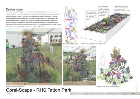
In this group competition submission, the design intention behind this planting plan was to create a microcosm of a wild coral reef, through the interconnection of vibrant succulents and brightly coloured broad-leaved plants. The aim is to bring an exotic underwater landscape into the UK as a sensorial experience that features diverse textures and colours. The design plays into the sensory theme as it encapsulates a coral reef. The design uses specifically positioned pale and colourless plants which are used to represent coral bleaching, this not only raises awareness that our coral reefs are rapidly deteriorating but also evokes negative senses and emotions. In contrast, the presence of wildlife planting attracts a diverse range of pollinators reflecting the liveliness of the corals.
Contrast between the pale planting and the dominating vibrancy portrays the bleaching reality of our coral reefs.
A topographical range conveyed through different planting height. This demonstrates the landforms of coral landscape.
The juxtaposing textures created aim to represent coral reefs through biomimicry, evoking a range of sense.
Sketch vision of the floral instillation
Photo of the Floral Instillation
Initial sketch of long border submission
Long Border Masterplan
Luk Landscape Architecture Portfolio
Contact Details: To find out more about me, visit my blogs:
yunhuiluk@gmail.com
linkedin.com/in/yunhui-luk-4800b2209
Art Blog - https://lukyunhui.wixsite.com/ designblog Conservation Blog - https://nandc-by-yunhuiluk.blogspot.com/