
Bear running down road near Alligator River National Wildlife Refuge. Photo: Houston Bumgarner

Dr. Ron Sutherland - Chief Scientist Alex Vanko - GIS Specialist Nikki Robinson - North Carolina Project Manager
Prioritizing Wildlife Road Crossings in North Carolina To Reconnect Wildlife Habitat and Improve Road Safety September 2022
Part B: Coastal Plain Part A: Blue Ridge Mountains Section 3: Top 20 Priority Wildlife Road Crossing Sites Table of Contents 9-21 Methods Summary Executive Summary Section 1 About This Report Section 2 4-53 Res ea r ch Re s ults and M it iga t ion S t rateg ies to I mp rov e Wildlif e Connect ivi ty an d Hu ma n Safe ty al ong I - 40 in t he Pi geon R iv er Gorge Part C: Sandhills Part D: Piedmont Section 4 Data AcknowledgementsSourcesCited 22-356-836-4546-5556-60 Appendices 61-646566
A wildlife crossing over a highway. Photo: Dron285

Recently increased funding sources for new wildlife crossing infrastructure necessitate a guide to the highest-priority locations in North Carolina with the greatest need for these structures. This report presents the results of Wildlands Network’s statewide analysis to
3
Executive Summary
3) Support land conservation strategies to protect quality wildlife habitat, ensuring effective connectivity and wildlife crossings’ long-term success.
identify the top 20 highest-priority wildlife crossing sites in North Carolina. We also present our extended list of 179 priority sites that we considered in developing the top 20 list.
1) Support competitive grant applications for federal wildlife crossing funding; and
2) Direct those efforts to the places in North Carolina with the most urgent need for increased wildlife connectivity and driver safety.
Roads pose a serious challenge to wildlife in North Carolina, with animals getting killed and injured on highways in large numbers each year. Our state’s extensive road network also disrupts the habitat connectivity that species need to move and survive. At the same time, collisions between larger wildlife and vehicles are a constant human safety risk to travelers on North Carolina’s roadways. Wildlife road crossings (which are structures designed to allow animals to pass safely over or under highways) are a proven method for solving both problems by allowing safe passage for wildlife and reducing wildlife-vehicle collisions.
Section 1 – About This Report
Wildlife-vehicle collisions and roadkill are common occurrences across North Carolina’s extensive network of roads and highways. These incidents pose a growing threat to both travelers’ safety and wildlife survival. Fortunately, there is a solution that addresses both problems at once: wildlife road crossings. A wildlife road crossing is any structure that allows wildlife to pass over or under a roadway without crossing the flow of traffic, reconnecting severed habitat and reducing wildlife-vehicle collisions. Crossings range from small drainage culverts to large bridges built specifically for animals to cross a road, and they are often associated with fencing or other structures to guide wildlife to the crossings and keep them out of the roadway. By allowing safe passage for wildlife, these crossing structures increase wildlife habitat connectivity and significantly reduce dangerous wildlife-vehicle collisions. Awareness of the value of wildlife crossings is on the rise. With growing public support and new sources of state and federal infrastructure funding (including the Infrastructure Investment and Jobs Act of 2021, which provides $350 million over five years for wildlife crossing infrastructure), now is the time for action on wildlife crossings in North Carolina.
Whatquestion.followsis
Wildlands Network’s report of the 20 highest priority locations across North Carolina most in need of new wildlife road crossings (or enhancement of existing structures). This list is the result of geospatial analysis combined with review by 42 North Carolina wildlife experts. Our geospatial model identified priority road segments for crossing action based on daily traffic, road characteristics, wildlife-vehicle collisions, proximity to protected lands or wetlands, rare species habitat, and connectivity models for black bear, timber rattlesnake, and box turtle. We combined this priority model with special attention to wildlife-vehicle collision hotspots and important wildlife connectivity corridors to create a list of 179 priority crossing sites across North Carolina. With the help of our panel of wildlife experts, we then
4
selected the top 20 wildlife crossing priority sites shown in this report.
Adult female deer moves across a roadway. Photo: Taya

Construction or enhancement of wildlife crossing structures can be costly, and the money required will come largely from competitive grant programs. This means North Carolina needs to be strategic about investing in crossing projects that will have the greatest impact on wildlife and travelers’ safety. So, the question of the moment is: where do we need wildlife road crossings in North Carolina? This report is our answer to that
This wildlife crossing priority list is the first of its kind in North Carolina, but that does not mean our work is complete. We acknowledge there may be other worthy wildlife crossing priorities in the state, and we hope that further review will reveal new priorities in the future. Many hotspots may be removed from the list as new wildlife crossing improvements are completed. A few of these priority sites may have already had improvements
In addition, the top 20 and full list of crossing priority sites can be used to guide land conservation efforts. Not only are these sites identified as high-value, high-risk sites for wildlife, but installing expensive wildlife crossings is much easier to justify if the land on either side of the crossing is permanently protected and well-connected to larger blocks of wildlife habitat. This is where land trusts, state and local conservation agencies can step in to help improve wildlife connectivity in North Carolina.
We have also included our full list of 179 identified road crossing priorities (see list and map in Section 4) These sites are all important for supporting wildlife connectivity on a statewide scale, and this list should be consulted regularly as the North Carolina Department of Transportation (NCDOT) implements new and ongoing infrastructure improvements. NCDOT regularly tracks numerous highway projects at once, so we hope that they can include this large list of priority wildlife crossing sites during project planning across North Carolina.
5
Construction at Harmon Den. Photo: Nikki Robinson
that we not aware of, such as bridge widening or culvert replacement, that are beneficial to wildlife. In addition, there are some sensitive priority sites that were not included in this public report. For example, known road mortality hotspots for the rare bog turtle are not shown here due to the threat of collectors poaching the turtles. Crossing projects for bog turtles and similar species will have to be pursued behind the scenes.
We present this report to serve as a guide for targeting action on wildlife crossings to the sites in most need of urgent attention. It is also intended to support applications to federal and state infrastructure funds supporting wildlife crossing implementation. With smart investment and continued support, we can make the roads of North Carolina a safer place for its people and its wildlife.

models are shown below: 6 R oad P riority Charac teris tic s Criteria Thres hold – Small Sp ec ies Tr a ffi c vo l ume A nnua l a vg d a il y tr a ffi c = 2,000 vehi cl es o r mo r e Ro a d wi d t h 8 met er s o r mo r e Typ e o f med i a n Incl ud es j er s ey b a rr i er , g ua r d r a il , o t her p o s i t i ve b a rr i er , o r r a i s ed med i a n wi t h s l o p ed edg e, cur b , a nd p a i nt ed p a vement R a r e/end emi c/end a ng er ed s p eci es ho t s p o t s Int er s ect r o a d s eg ment (a ni ma l o nl y) Pr o t ect ed a r ea s a d j a cent t o r o a d >50% o f l a nd wi t hi n 0.3 mil e r a d i us p r o t ect ed N ea r b y wet l a nd s L a nd i n 300m b uffer i s a t l ea s t 70/50/30% wet l a nd (fo r co a s t a l p l a i n, p i ed mo nt , o r Bl ue R i dg e r es p ect i vel y) Ti mb er r a tt l es na ke co nnect i vi t y mo d el To p 10% curr ent fl o w fr o m C i r cui t s ca p e mo d el Bo x t urt l e co nnect i vi t y mo d el To p 10% centr a li t y fr o m C o nnect i vi t y A na l ys i s Too l ki t mo d el R oad P riority Charac teris tic s Criteria Thres hold – Larg e Sp ec ies Tr a ffi c vo l ume A nnua l a vg . d a il y tr a ffi c = 10,000 vehi cl es o r mo r e Sp eed li mi t 60 mp h o r hi g her Typ e o f med i a n Incl ud es j er s ey b a rr i er , g ua r d r a il , o t her p o s i t i ve b a rr i er Wil d li fe vehi cl e co lli s i o n ho t s p o t s A t l ea s t 2 5 co lli s i o ns /yea r wi t hi n 0 25 mil e r a d i us R a r e/end emi c/end a ng er ed s p eci es ho t s p o t s Int er s ect r o a d s eg ment (a ni ma l o nl y) Pr o t ect ed a r ea s a d j a cent t o r o a d >50% o f l a nd wi t hi n 0.3 mil e r a d i us p r o t ect ed Bl a ck b ea r co nnect i vi t y mo d el To p 10% curr ent fl o w fr o m C i r cui t s ca p e mo d el
Blue Ridge Mountains. Photo: Clayton

7 R oad P riority Charac teris tic s Criteria Thres hold All Sp ec ies Tr a ffi c vo l ume (s ma ll s p eci es ) A nnua l a vg . d a il y tr a ffi c = 2,000 vehi cl es o r mo r e Tr a ffi c vo l ume (l a r g e s p eci es ) A nnua l a vg . d a il y tr a ffi c = 10,000 vehi cl es o r mo r e Ro a d wi d t h 8 met er s o r mo r e Sp eed li mi t 60 mp h o r hi g her Typ e o f med i a n Incl ud es j er s ey b a rr i er , g ua r d r a il , o t her p o s i t i ve b a rr i er , o r r a i s ed med i a n wi t h s l o p ed edg e, cur b , a nd p a i nt ed p a vement Wil d li fe vehi cl e co lli s i o n ho t s p o t s A t l ea s t 2 5 co lli s i o ns /yea r wi t hi n 0 25 mil e r a d i us R a r e/end emi c/end a ng er ed s p eci es ho t s p o t s Int er s ect r o a d s eg ment (a ni ma l o nl y) Pr o t ect ed a r ea s a d j a cent t o r o a d >50% o f l a nd wi t hi n 0.3 mil e r a d i us p r o t ect ed N ea r b y wet l a nd s L a nd i n 300m b uffer i s a t l ea s t 70/50/30% wet l a nd (fo r co a s t a l p l a i n, p i ed mo nt , o r Bl ue R i dg e r es p ect i vel y) Bl a ck b ea r co nnect i vi t y mo d el To p 10% curr ent fl o w fr o m C i r cui t s ca p e mo d el Ti mb er r a tt l es na ke co nnect i vi t y mo d el To p 10% curr ent fl o w fr o m C i r cui t s ca p e mo d el Bo x t urt l e co nnect i vi t y mo d el To p 10% centr a li t y fr o m C o nnect i vi t y A na l ys i s Too l ki t mo d el
We created our full list of wildlife crossing priority sites for this report by combining the results of our 2017 models with new priorities based on updated wildlife-vehicle collision data and important wildlife connectivity corridors. We started by extracting the highest-priority segments from each of the three geospatial models (score of 6+ for small species, 5+ for large species, or 8+ for all species). Then we added points where major roads cross major wildlife corridors as identified by previous Wildlands Network connectivity mapping efforts. This included habitat cores and connectivity corridors from our Eastern Wildway map (see Appendix A) and priority corridors from a connectivity map in western North Carolina that we created for Blue Ridge Forever (see Appendix B). Finally, we used updated data from NCDOT to create a
new wildlife-vehicle collision density map and added crossing priority points wherever there were at least five deer-vehicle collisions per mile per year. This threshold came from research that found at five collisions per mile year, the cost of those collisions exceeds the cost of implementing a wildlife crossing structure, making a crossing a cost-effective solution (Donaldson 2005, Huijser et al. 2009). The combined result of the geospatial model, corridor points, and deer-vehicle collisions points was a list of 155 wildlife crossing priority sites.
Creating the Draft Crossing Priority List
Our geospatial road crossing priority model was very useful for filtering out high-priority roads using a comprehensive set of criteria representing wildlife value, risk, and traveler safety. For this report, we sought to narrow down the results of the models to a manageable number of priorities and to include feedback from North Carolina wildlife experts.
SelectionResea r ch
North Carolina. The stratification resulted in six sites each in the Blue Ridge Mountains and the Coastal Plain and four sites each in the Piedmont and Sandhills (since these regions are smaller). Within each region, we examined the top expert-voted sites and vetted each location in person to select the final sites.
8
In September 2021, we shared a webmap showing our 155 wildlife crossing priority sites with 169 wildlife experts across North Carolina, including a range of wildlife biologists and conservationists across academic, government, and non-profit institutions. We asked them to pick their top 10 highest-priority crossing sites and compiled the results into a tally of votes for each site. In all, 42 experts shared their feedback with us (see Appendix C). In general, the top-voted sites did not line up with the highest wildlife-vehicle collision hotspots, nor did they match too closely with our 2017 geospatial

Expert Review
Top 20 Priority Site Re s ults and M it iga t ion S t rateg
priority model. The expert-chosen sites tended to favor intersections of roads with large and well-known protected areas or, in a few cases, mortality hotspots for select priority species including elk (US 19 and I-40 west of Asheville) and red wolf (US 64 and NC 94 near Alligator River National Wildlife Refuge). Expert respondents also provided 24 new suggested crossing priority sites that were not on our original list. We added these suggestions to our priority map for a total of 179 wildlife crossing priority sites.
i e s t o I mp rov e Wildlif e Connect i v i ty an d Hu ma n S a f e ty al o n g I - 40 in t he Pi geon R iv er G o rg e
To focus action on the sites in most urgent need of wildlife crossing improvements, we narrowed our list of 179 sites down to the top 20 highest-priority sites. We stratified our top 20 list by region to avoid biasing our efforts to one part of the state, especially because our expert respondents were not evenly distributed across
9
Part A: Blue Ridge Mountains
Section 3: Top 20 Priority Wildlife Road Crossing Sites

Photo: Southwings
Site 1 I-40 through the Pigeon River Gorge

research in the Pigeon River Gorge using roadkill surveys, roadside wildlife cameras, crossing structure wildlife cameras, and elk GPS collars (Hillard et al. 2022). This research identified a key set of priority opportunities for improving wildlife crossing infrastructure in the Gorge. The cameras indicated that only a few of the existing structures appear to provide safe passage for wildlife.
Numerous existing bridges and culverts plus one complete land bridge (where all of I-40 goes through a tunnel) and one partial land bridge (where only I-40 northbound goes through a tunnel)
Existing Infrastructure
NCDOT Projects
5. White Oak Road and Jonathan Creek (construction year 2022)
Great Smoky Mountains National Park, Pisgah National Forest, Cherokee National Forest, multiple land trust properties and conservation easements
Reptiles: timber rattlesnake, box turtle Salamanders: 31 species within the national park
Protected Areas
I-40 through the Pigeon River Gorge
4. White Oak Road (construction year 2023)
1.recommendations.HarmonDenbridge
Cow elk and calf using box culvert under I-40. Photo: Wildlands Network/NPCA

Key Species

2. White Oak Road and Fines Creek (construction year 2024)
3. Pigeon River (construction year 2024)
Road Ecology Research
over Cold Spring Creek Road (completed)
A 28-mile stretch of Interstate 40 snakes through the steep, rocky Pigeon River Gorge alongside the Pigeon River, creating a major barrier for wildlife between Great Smoky Mountains National Park to the south and Pisgah and Cherokee National Forests to the north. The highway cuts right through what would otherwise be a massive core forest habitat block featuring some of the highest biodiversity in North America, hindering wildlife movement and blocking a crucial northern migration route.

Wildlands Network in partnership with the National Parks Conservation Association conducted three years of
Large mammals: dense black bear population, white-tailed deer, and reintroduced elk Mesocarnivores: bobcats, coyotes, skunks, raccoons, opossums, weasels, and otters
NCDOT is fast-tracking a set of five aging I-40 bridges for emergency replacement, and Wildlands Network/NPCA provided wildlife-friendly enhancement
11 4 LanesRoad 23,500 VehiclesPerDay Map of I-40
Site 2 US 19 at the Blue Ridge Parkway
Photo: Wildlands Network
Protected Areas
US 19 is a busy highway that emerges from Maggie Valley and intersects the Blue Ridge Parkway.
Blue Ridge Parkway bridge over US 19 may be suitable for some wildlife such coyotes
Blue Ridge Parkway
Road Ecology Research
Existing Infrastructure
Modernize roadway (Right-of-way [ROW] year 2029)
Elk, black bear, and white-tailed deer
NCDOT Projects
Map of US 19
Blue Ridge Parkway interchange with US 19. Photo: NPCA


Key Species
Reintroduced elk cross the highway on a regular basis and have caused numerous vehicle collisions. This is a key spot for improving elk connectivity throughout the region, especially since the Blue Ridge Parkway acts as a wildlife corridor connecting two large blocks of National Forest land to the south and north.


US 19 at the Blue Ridge Parkway
Wildlands Network elk GPS collaring research (along with other elk GPS research projects by the National Park Service and North Carolina Wildlife Resources Commission) revealed heavy elk use in the US 19/Maggie Valley corridor. The elk cross the highway at multiple locations, including near the Blue Ridge Parkway and in the urbanized corridor of Maggie Valley.
13 2 LanesRoad 5,600 VehiclesPerDay 15 ExpertVotes
Site 3 I-40 East of Canton
Photo: Wildlands Network
2. US 19/23: Upgrade roadway from Chestnut Mountain Road to Wiggins Road (ROW year 2029)
15 4 LanesRoad 49,500 VehiclesPerDay 11 ExpertVotes 6 GISHighestModelScore
Wildlife-Vehicle Collisions
Black bear. Photo: Larry Knupp

One or more small residential roads, and some small creek culverts, pass under I-40. US 19 parallels the interstate, so potential crossing structures may have to take the second highway into consideration.

I-40 East of Canton
Busy Interstate 40 crosses an important wildlife corridor at the Buncombe/Haywood county line. This corridor (identified by Wildlands Network’s connectivity map for Blue Ridge Forever) connects protected land including Pisgah National Forest to the south and conservation easements in Sandy Mush to the north, but it intersects with Interstate 40 and US 19.
Key Species
Black bear, elk, white-tailed deer, and many Appalachian species
NCDOT Projects
Protected Areas
Road Ecology Research
1. I-40: Add additional lanes from Wiggins Road to Monte Vista Road (ROW year 2029)
North Hominy Creek triple culvert used by deer. Photo: Wildlands Network
Extensive protected lands to the south and north, but mostly private land close to I-40 and US 19. Southern Appalachian Highlands Conservancy recently purchased a tract at Chestnut Mountain on the south side. The risk of ongoing development is high, especially on the Buncombe County side where there is already a major new development under construction.
Existing Infrastructure
Map of I-40

Wildlands Network has initiated wildlife camera surveys in this area and in the new Chestnut Mountain preserve. Results are not yet available.
Contains WVC hotspots with up to six collisions per kilometer per year.
Site 4 I-40 at Kitsuma Peak
Photo: Wildlands Network

Key Species
Likely some stream culverts under the roadway, but given the steep grade and visibility barriers, these are difficult to observe from above.

Black bear, many Appalachian species

Wildlife-Vehicle Collisions
improvements, rehabilitate pavement, and reconstruct median barrier (construction year 2022).
Trail and fencing along I-40. Photo: Wildlands Network

Protected Areas
I-40 mile marker 67 to 73: Construct safety and drainage
17 6 LanesRoad 31,500 VehiclesPerDay
Low WVC rates, possibly due to low traffic speed and jersey barrier walls. However, the steep road grade and frequent fog warnings contribute to dangerous road conditions.
Existing Infrastructure
NCDOT Projects
Black bear approaching the highway. Photo: Wildlands Network/NPCA
Pisgah National Forest protects land on both sides of the highway, but development is spreading into the area from Old Fort and Black Mountain.

I-40 at Kitsuma Peak
Busy Interstate 40 climbs into the mountains along a steep, winding grade, cutting through a swath of national forest land that wraps around the east side of Asheville between Old Fort and Black Mountain. The interstate forms a barrier to south-north wildlife movement through the national forest and blocks the connection between that forest and the Hickory Nut Gorge protected areas around Lake Lure to the south and to the South Mountains/Box Creek Wilderness Area to the southeast.
Map of I-40
Site 5 I-26 at Appalachianthe Trail
Photo: NPCA
Key Species
Interstate 26 cuts across the Appalachian Trail at the North Carolina/Tennessee state line. Wildlands Network identified this area as part of an important wildlife corridor in our model for Blue Ridge Forever. The crossing of the Appalachian Trail provides an opportunity for improving a national pedestrian corridor as well as an important pathway for wildlife.
There was a brief study of the I-26 culverts a few miles south of this location that did not yield promising results. The National Parks Conservation Association is initiating a new road ecology project on I-26 in 2022.


Existing Infrastructure
Low WVC rates here (possibly impacted by data collection at the state border), but there is a WVC hotspot about two miles south along I-26 (six collisions per kilometer per year).
Road Ecology Research
Narrow band of protected areas on each side of the border corresponding with the Appalachian Trail corridor
US 23 crosses under I-26 at this location. There may be a culvert or underpass for Little Creek nearby. Some culverts were installed on I-26 a few miles further south when it was first constructed.
I-26 at the Appalachian Trail
19
Wildlife-Vehicle Collisions
Map of I-26
Black bear, many Appalachian species
Protected Areas
Site 6 US 441 through Great Smoky Mountains National Park
Photo: Wildlands Network
Wildlife-Vehicle Collisions
Key Species
NCDOT Projects None
2 LanesRoad 3,700 VehiclesPerDay 9 ExpertVotes 6 GISHighestModelScore
Likely some creek culverts under the roadway
Map of US 441
Two juvenile black bears. Photo: Wildlands Network/NPCA

Elk, black bear, white-tailed deer, and the full range of the park’s biodiversity including 30 salamander species
Typical traffic stops in GSMNP. Photo: Wildlands Network

NCDOT does not appear to be recording WVCs along this highway, so we have no information about collision rates.

Protected Areas
Great Smoky Mountains National Park covers both sides of the highway.
Existing Infrastructure
US 441 through Great Smoky Mountains National Park
This highway carries tourist traffic through the middle of Great Smoky Mountains National Park (GSMNP), one of the highest-biodiversity areas in the U.S. This creates a barrier that cuts through the core wilderness of the park, a barrier that likely impacts the flow of small species in particular such as salamanders, rattlesnakes, and box turtles as well as rare plants whose seeds are dispersed only by small animals or which spread vegetatively along the ground.
21
Photo: Houston Bumgarner

23
Part B: Coastal Plain

Site 7 US 64 through Dare and Tyrrell Counties
Photo: Wildlands Network

Protected Areas
1. US 64 from Columbia to Alligator River Bridge: modernize roadway (ROW year 2028)
Red wolf, black bear, river otter; numerous snake, turtle, alligator, and amphibian species

25 2 LanesRoad Map
Several red wolves have been killed on this stretch of highway, including three wolves in 2021 alone, plus three clusters of historic red wolf mortality going back to 1987. NCDOT data shows a long stretch of WVC hotspots through the National Wildlife Refuge (ranging from four to seven WVCs per kilometer per year). Extreme mortality for snakes, turtles, and frogs has been documented on this stretch.
US 64 carries beach traffic through the north end of Alligator River National Wildlife Refuge and Alligator River Game Land in Dare and Tyrrell Counties. The highway cuts through a core natural area causing an extremely high volume of wildlife mortality and interrupting dispersal for diverse herpetofauna, river otters, black bears, and the critically-endangered red wolf. There are two wildlife mortality hotspots here, one within the refuge in Dare County, and another within the Game Land in Tyrrell County. Both received high rankings and we combined the sites for convenience.
NCDOT Projects
Red wolves in Alligator River National Wildlife Refuge.

Photo: Wildlands Network
64
Key Species
Wildlife-Vehicle Collisions
Existing Infrastructure
Alligator River National Wildlife Refuge, Alligator River Game Land
The tables and maps in Section 4 reflect two separate shapefiles.
No crossing structures. The road is just above the surrounding canals and wetland which will make underpasses difficult. Further west, where US 64 was elevated and expanded to four lanes, three wildlife crossing underpasses and exclusion fencing along the highway were installed.
Road Ecology Research
2. The US 64 bridge over Alligator River is scheduled to

NCDOT sponsored substantial road ecology research when the state was planning on expanding the remaining stretch of US 64 to the Outer Banks. Several research reports are available, including a system of 33 proposed wildlife crossing sites. Implementation of the crossings stalled when the highway expansion project lost priority status.
US 64 through Dare and Tyrrell Counties of US
Site 8 NC 94 at Pocosin Lakes National Wildlife Refuge
Photo: Ron Sutherland
This rural highway with moderate traffic passes by the east side of the massive Pocosin Lakes National Wildlife Refuge, posing a serious road mortality risk for critically-endangered red wolves, black bears, and other wildlife. The highway cuts the Albemarle Peninsula in half from south to north, interrupting the flow of red wolves and other species east-to-west. The site shown here occurs where there is protected area on both sides of the road, but it may be more important to address terrestrial connectivity across NC 94 further north, especially given the threat of sea level rise in this region.
Key Species

Existing Infrastructure
NC 94 at Pocosin Lakes National Wildlife Refuge
Red wolf mortality tracking revealed a wolf mortality spot at this location.
There are WVC hotspots along NC 94 approximately three to four miles to the north. Red wolf collisions have occurred at this location and throughout the next 11 miles of NC 94.
Wildlife-Vehicle Collisions
Pocosin Lakes National Wildlife Refuge on both sides of the highway; private land (Alligator River Game Land & the Buckridge Coastal Preserve) on both sides farther north.


Road Ecology Research
Maybe some creek culverts, but likely small and low due to the low roadway and thus unsuitable for most wildlife
NCDOT Projects None
27 2 LanesRoad 500 VehiclesPerDay
Map of NC 94
Red wolf, black bear, bobcat, herpetofauna
Protected Areas

Site 9 US 70 CroatanthroughNational Forest
Photo: Wildlands Network
1. US 70 from I-40 to Morehead City: install broadband fiber alongside highway (construction year 2021)

None
Protected Areas
3. Construct multi-lane Havelock Bypass through USFS land (construction year 2019).
Black bear, bobcat; numerous herpetofauna including timber rattlesnake, pygmy rattlesnake, and possibly even eastern diamondback rattlesnake
Map of US 70
NCDOT Projects
Key Species
Existing Infrastructure
Croatan National Forest surrounds the highway at this location

Low recorded collision rate at this location
US 70 through Croatan National Forest
Wildlife-Vehicle Collisions

29 4 LanesRoad
US 70 divides Croatan National Forest in two, fragmenting a public forest that is already threatened by rapid development. The highway interferes with internal connectivity within the national forest, which is, in turn, crucial for connectivity across the larger coastal plain area for many species.
2. Construct interchange on US 70/Slocumb Rd. at Cherry Point Military Base (slated for completion in 2024.)

Photo: Jeff Hall
Site 10 US 17 at West Camp Lejeune
Bobcat. Photo: Wildlands Network

31 4 LanesRoad 24,500 VehiclesPerDay 10 ExpertVotes 4 GISHighestModelScore
Numerous rare species including some of the only eastern diamondback rattlesnakes left in North Carolina (a highly road-sensitive species), tiger salamanders, Carolina gopher frogs, ornate chorus frogs, and more; black bear, bobcat
Wildlife-Vehicle Collisions
This coastal highway splits the western side of Camp Lejeune Marine Corps Base, dividing extensive, high-quality longleaf pine forest habitat. US 17 inhibits wildlife from dispersing south-north into the large core forests of the military reserve and interferes with connectivity between the base and the massive Holly Shelter/Angola Bay Game Land complex to the south.


1. US 17: install shoulder rumble strips (construction year 2023)
Existing Infrastructure
US 17 at West Camp Lejeune
Key Species
NCDOT Projects
Protected Areas
Low at this location, but there are WVC hotspots on US 17 to the north and south (up to seven WVCs per kilometer per year)
Camp Lejeune, which is a de facto protected area despite extensive military use, covers both sides of the highway; Holly Shelter Game Land to the south
Three underpasses with dirt roads along this stretch of highway, presumably for military use only and relatively low traffic. If so, may only need fencing to make these underpasses effective wildlife crossing structures.
2. US 17 to Old Folkstone Rd: widen to multiple lanes (ROW year 2025)
Map of US 17
Photo: Ron Sutherland
Site 11 NC 211 at Green Swamp Preserve


Photo: Wildlands Network
Site 12 US 74 at Columbus Game Land
Existing Infrastructure
An underpass near this location crosses underneath US 74 and NC 214 (wildlife suitability unknown)
1. US 74 pavement rehabilitation (construction year 2025)

US 74 at Columbus Game Land
35 4 LanesRoad 14,000 VehiclesPerDay 7 ExpertVotes 8 GISHighestModelScore
Map of US 74
This coastal highway runs east to west through Columbus Game Land, cutting off north-south connectivity between the broader Green Swamp Preserve/Lake Waccamaw State Park complex to the south and the Cape Fear River/Bladen Lakes State Forest complex to the north. NC 214 runs parallel to US 74 very close to this site, increasing the barriers to wildlife. This site was chosen for the natural habitat within the Columbus Game Land on either side of the highway, but additional crossing opportunities should be considered along US 74, especially to the east.
3. US 74: improve conflict intersection at Chauncey Town Road and Old Lake Road (construction year 2022)
Columbus County Game Land on both sides of highway, Lake Waccamaw State Park directly to the south

Moderate WVC hotspot at this location (three to seven collisions per kilometer per year)
Black bear, bobcat, timber rattlesnake
Wildlife-Vehicle Collisions
Protected Areas
2. US 74 at Chauncey Town Rd: convert at-grade intersection to interchange (construction year 2022)
Wild turkey. Photo: Wildlands Network

Key Species
NCDOT Projects
Photo: Wildlands Network

37
Part C: Sandhills

Photo: Wildlands Network
Site 13 US 1 Sandhillsat Game Land

US 1 bisects a 60,000-acre complex of the Sandhills Game Land longleaf pine forest. The highway acts as a strong barrier to internal wildlife connectivity across the game land, particularly for upland longleaf pine species that are more likely to cross at road grade than use riparian underpasses. This is one of a few highways that fragment what would otherwise be an extensive network of longleaf pine forest including Fort Bragg to the east.
Wildlife-Vehicle Collisions
Widening project under construction a few miles away from this site in Marston, NC.
Long leaft pine savannah forest. Photo: Ron Sutherland

pine snakes. Other herpetofauna researchers have also documented roadkill.
Rare herpetofauna including northern pine snake, eastern coachwhip, southern hognose snake, eastern tiger salamander, and gopher frog
Key Species
Continuous stretch of weak WVC hotspots at this location (one to two collisions per kilometer per year). This area has many documented road mortalities of rare snakes.
Existing Infrastructure
Road Ecology Research
NCDOT Projects
US 1 splits 60,000 acre game land. Photo: Wildlands Network
Wildlands Network Chief Scientist Dr. Ron Sutherland surveyed roadkill here during a past project and documented mortality of several rare snakes including
US 1 at Sandhills Game Land

Blocks A and B of the Sandhills Game Land on either side of the highway; Fort Bragg and Camp Mackall not far to the east

39 5 LanesRoad 8,600 VehiclesPerDay 10 ExpertVotes 4 GISHighestModelScore
Map of US 1
Protected Areas
None. US 1 was widened here relatively recently with no accommodations for upland wildlife passage.
Photo: Wildlands Network
Site 14 US 15/501 at Sandhills Game Land

Weak hotspot at this location (two WVCs per kilometer per mile), but higher hotspot two miles to the south (seven WVCs per kilometer per mile)
Gopher frog. Photo: Ron Sutherland

Key Species
US 501 cuts through the Sandhills Game Land, interfering with connectivity for wildlife across the longleaf pine forests of the Game Land, Camp Mackall, and Fort Bragg to the east. The site is also adjacent to extensive grasslands at the Luzon military drop zone.


Bridge to the north across Drowning Creek likely allows riparian species movement, but no infrastructure for upland species
Protected Areas
NCDOT Projects
None
41 2 LanesRoad 5,600 VehiclesPerDay 8 ExpertVotes 4 GISHighestModelScore
Just to the north of this site, US 501 crosses Drowning Creek, a large stream that flows into the Lumber River and is likely an important riparian wildlife corridor.
Map of US 15/501 Highway crosses over significant wildlife corridor at Drowning Creek. Photo: Wildlands Network
Sandhills Game Land on either side of the highway, military land at the Luzon drop zone. Significant development pressure exists on private lands along the highway.
Existing Infrastructure
US 15/501 at Sandhills Game Land
Rare herpetofauna including northern pine snake, eastern coachwhip, southern hognose snake, scarlet kingsnake, gopher frog, and eastern tiger salamander
Wildlife-Vehicle Collisions
Site 15 US 1 Drowningat Creek
Photo: Wildlands Network

NCDOT Projects
Map of US 1

The long, open US 1 bridge over Drowning Creek appears relatively suitable for riparian wildlife, but this site may need improvements for upland species and/or fencing to direct wildlife to the bridge underpass and keep them off the road.

Wildlife-Vehicle Collisions
Existing Infrastructure
Key Species
Riparian species including river otter, timber rattlesnake, mud snake, eastern kingsnake; black bear, bobcat

Moderate hotspot (five WVCs per kilometer per year)
Protected Areas
US 1 at Drowning Creek
US 1 crosses a major riparian corridor at Drowning Creek on the edge of the Sandhills Game Land. Drowning Creek and its tributaries help provide riparian connectivity between major blocks of protected land in the Sandhills and, via the Lumber River, to the Coastal Plain of North and South Carolina.
Long but not very elevated bridge over the creek. Photo: Wildlands Network
Sandhills Game Land on either side of the highway, Fort Bragg, Camp Mackall. Extensive public and private protected areas away from the road including land with safe harbor agreements and conservation easements held by Sandhills Area Land Trust.

43 4 LanesRoad 9,100 VehiclesPerDay
Recently increased to four lanes, and the bridge was replaced. No upcoming projects.
Site 16 NC 211 at McCain Tract
Photo: Wildlands Network
Photo: Wildlands Network
Key Species
Protected Areas
NC 211 skirts the edge of an extensive longleaf pine forest and cuts through the middle of the state-owned McCain tract near Fort Bragg. The highway and associated development threaten to cut off Fort Bragg from the adjacent core longleaf areas of the Sandhills Game Land and Camp Mackall.
Existing Infrastructure
Rare herpetofauna including northern pine snake, eastern coachwhip, southern hognose snake, Carolina gopher frog, and eastern tiger salamander. Large mammal species.
NC 211 is scheduled to be widened between Aberdeen and Raeford sometime in 2024.
NC 211 at McCain Tract
45 2 LanesRoad 10,500 VehiclesPerDay 6 ExpertVotes 3 GISHighestModelScore
Busy highway through rare herps and other wildlife habitat.
Map of NC 211

Weak hotspot at this location, but less than a mile south is a strong hotspot on the same road (12 WVCs per kilometer per year).
NC 211 divides longleaf forests at Fort Bragg with Sandhills Game Land.

Wildlife-Vehicle Collisions
The McCain tract is owned by the state but its level of protection is unknown. Fort Bragg to the east, Sandhills Game Land to the west. High development pressure exists within private lands around the McCain tract and the west side of Fort Bragg, making it urgent to secure terrestrial corridor routes now.
Photo: Ron Sutherland
NCDOT Projects
NCDOT is actively considering constructing a low-lying herpetofauna crossing at this location during upcoming widening of NC 211. They should also consider a larger crossing to create safe passage for large mammals like white-tailed deer and bobcat and reduce WVCs.

Photo: Chansak Joe A.

47
Part D: Piedmont

Photo: Ron Sutherland
Site 17 I-85 at Eno River State Park

Map of I-85

Just to the west of this location, US 70 and Rhodes Creek cross under an I-85 bridge. Further west, Stony Creek passes under I-85 through a large culvert, and then passes under I-70.
49 4 LanesRoad
Wildlife-Vehicle Collisions

Within a mile, there are strong hotspots ranging from nine to 18 WVCs per kilometer per year
This very busy interstate highway cuts between Eno River State Park and Duke Forest across one of the most important remaining wildlife corridors in the rapidly-urbanizing Triangle region. I-85 and parallel US 70 form a near-impenetrable barrier across this corridor that otherwise links Jordan Lake to the south and Falls Lake to the north, both of which have extensive protected forestlands. This area is plagued with wildlife-vehicle collisions caused by white-tailed deer.
I-85 at Eno River State Park
Pavement rehabilitation on I-85 from the Orange County line to US 15/501 (construction year 2025)
Protected Areas
White-tailed deer, bobcat, coyote, box turtle, various snake species

Existing Infrastructure
Eno River State Park abuts the highway to the north; Duke Forest is within a half mile to the south. Brumley Nature Preserve, owned and protected by Triangle Land Conservancy, is south of the highway about three miles to the west of this location. Considerable need for land protection in the face of heavy development pressure.
NCDOT Projects
Key Species

Photo: Wildlands Network
Site 18 NC 24 at Uwharrie National Forest
Existing Infrastructure
Two small creeks cross under US 24 near this location, likely through small culverts
Low hotspot at this location (four WVCs per kilometer per year), but strong hotspot at the site five miles to the west (14 WVCs per kilometer per year)
NCDOT Projects
NC 24 to Troy bypass to widen to multiple lanes (ROW in progress, construction year 2024)
NC 24 at Uwharrie National Forest
51
Black bear, timber rattlesnake, bobcat, box turtle, rare wetland species
Wildlife-Vehicle Collisions
This rural highway runs through the bottom third of Uwharrie National Forest, cutting off the southern side of the forest from the more extensive tracts of public land to the north. At a larger scale, US 24 is a barrier to connectivity between the Uwharries and the Sandhills. There are at least two key opportunities here for wildlife road crossing installation. In addition to this location, which is near a key wetland (Roberdo Bog), another one of our priority sites five miles west includes a crossing of the Uwharrie Trail, which provides an opportunity to address wildlife and pedestrian connectivity at the same time.

Key Species
Protected Areas
Uwharrie National Forest on both sides of the highway

Site 19 I-73 south of Candor
Photo: Wildlands Network
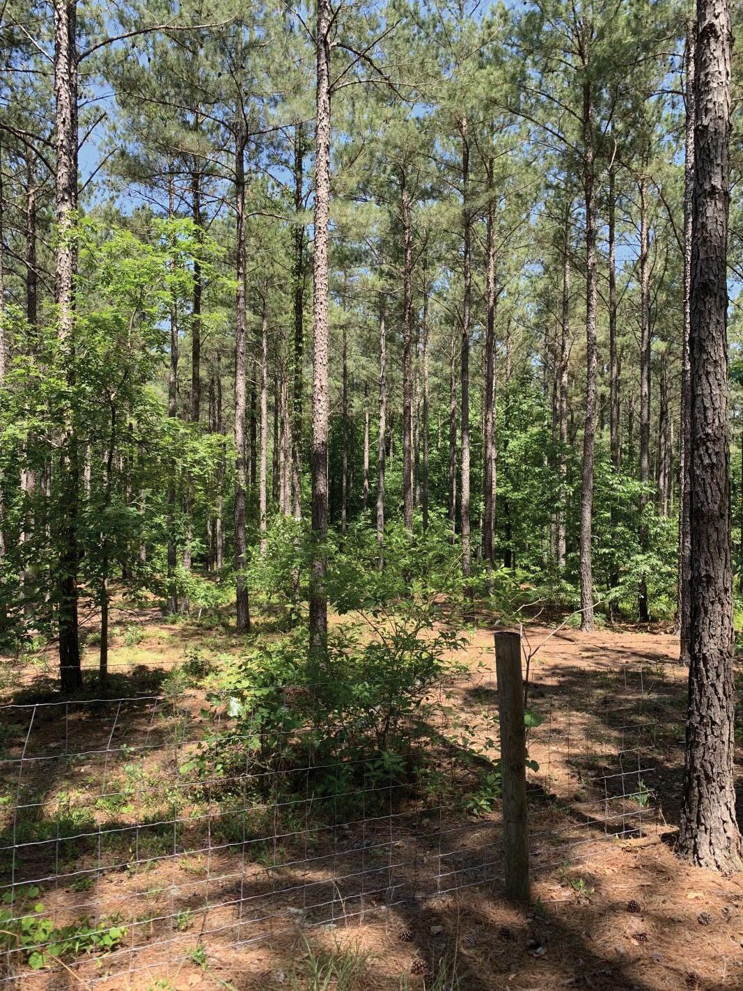
Existing Infrastructure
53 4 LanesRoad
None
Wildlife-Vehicle Collisions
An existing standard DOT right of way fence that is inadequate for keeping deer and other wildlife away from highways. Photo: Wildlands Network
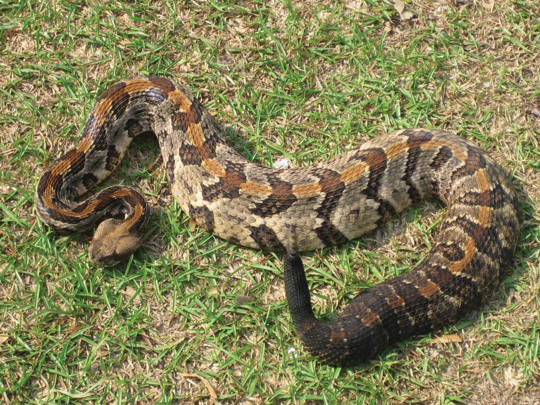
Key Species
NCDOT Projects
Interstate maintenance on I-73 from NC 211 to NC 24/27 (construction year 2023)
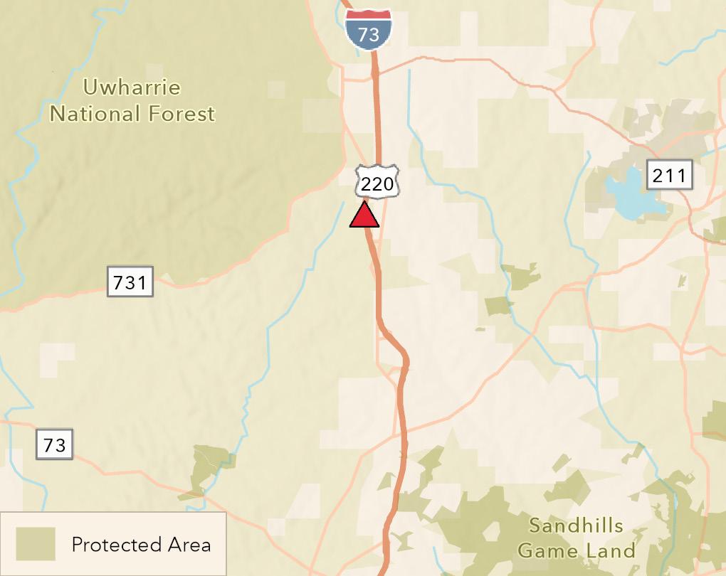
Rare herpetofauna including timber rattlesnake, eastern kingsnake, and scarlet kingsnake; black bear, bobcat

I-73 south of Candor
Protected Areas
Map of I-73
Interstate 73 runs north-south between the Sandhills Game Land to the east and Uwharrie National Forest to the west, disrupting any potential wildlife corridor route between these two large natural areas. At this site, there is a wide gap of about six to eight miles between any protected lands, so extensive land conservation work is needed to secure a route for wildlife between the Sandhills and the Uwharries.
Weak hotspot at this location (five WVCs per kilometer per year)
Uwharrie National Forest, Sandhills Game Land, some Safe Harbor private properties to the east
Site 20 NC 54 at New Hope Creek
Photo: Samuel
US Army Corps land associated with Jordan Lake protects both sides of the highway here. This is a registered natural heritage area due to its bottomland hardwood forest.
Wildlife-Vehicle Collisions
Bobcat, turkey, box turtle, river otter, white-tailed deer
1. Rehabilitation of multiple structures from US 15/501 to east of NC 147 (construction year 2025)
NC 54 at New Hope Creek NC
Protected Areas
55 2 LanesRoad 14,000 VehiclesPerDay 5 ExpertVotes 4 GISHighestModelScore Map of
54
2. Upgrade roadway corridor and construct interchange improvements at NC 54 and I-40 (ROW year 2029)
There is a small bridge where New Hope Creek flows under NC 54 that is heavily used by deer and other species and a small box culvert further to the west.
under the bridge despite its small size. Wildlands staff regularly observe small animal roadkill here (including several otters) but no deer roadkill has been seen.
Wildlands Network monitored wildlife use of the New Hope Creek bridge on NC 54 (and the much wider 15/501 bridge over the same creek further north) for over two years. We found a surprising number of white-tailed deer, raccoons, coyotes, and more species crossing


NCDOT Projects
NC 54 runs from Durham to Chapel Hill across New Hope Creek and the bottomland hardwood forest surrounding the creek. This creates a barrier across the New Hope Creek wildlife corridor, one of the most important remaining corridors in the Triangle region that connects Jordan Lake to the south with the Duke Forest, Eno River State Park, and Falls Lake to the north.

Key Species
Road Ecology Research
No WVCs recorded. Many anecdotal observations of small mammal and herpetofauna roadkill.
Existing Infrastructure
56 Section 4: Data All Priority Wildlife Crossing Sites Ranked by Expert Votes Name E x p ert Votes P rimary Reas on for I nclus ion Long itud e Latitud e I 40 t hr o ug h Pi g eo n R i ver G o r g e 2 1 Id ent i fi ed b y Wil d l a nd s N et w o r k's w il d li fe cr o ss i ng p r i o r i t i z a t i o n mo d el 83 03478 2 35 74735 4 US 64 through Dare and Tyrrell Counties 2 0 Id ent i fi ed b y Wil d l a nd s N et w o r k's w il d li fe cr o ss i ng p r i o r i t i z a t i o n mo d el 75 85828 5 35 86422 1 U S 19 a t Bl ue R i dg e Pa r kw a y 1 5 Wi t hi n a n E a s t er n Wil d w a y co rr i d o r 83 15743 6 35 49477 3 N C 94 a t Po co s i n L a kes N WR 1 1 Id ent i fi ed b y Wil d l a nd s N et w o r k's w il d li fe cr o ss i ng p r i o r i t i z a t i o n mo d el 76 19479 0 35 71670 8 I 40 E a s t o f C a nt o n 1 1 Wi t hi n a Bl ue R i dg e Fo r ever p r i o r i t y w il d li fe co rr i d o r 82 78466 4 35 53992 1 U S 1 a t Sa nd hill s G a me L a nd s 1 0 Id ent i fi ed b y Wil d l a nd s N et w o r k's w il d li fe cr o ss i ng p r i o r i t i z a t i o n mo d el 79 56525 5 35 00856 9 I 40 a t K i t s uma Pea k 1 0 Wi t hi n a Bl ue R i dg e Fo r ever p r i o r i t y w il d li fe co rr i d o r 82 23776 3 35 62474 6 U S 70 t hr o ug h C r o a t a n N F 1 0 Id ent i fi ed b y Wil d l a nd s N et w o r k's w il d li fe cr o ss i ng p r i o r i t i z a t i o n mo d el 76 88263 7 34 84359 8 U S 17 a t C a mp L ej eune w es t s i d e 1 0 Id ent i fi ed b y Wil d l a nd s N et w o r k's w il d li fe cr o ss i ng p r i o r i t i z a t i o n mo d el 77 48196 4 34 62888 7 I 26 a t A pp a l a chi a n Tr a i l 9 Wi t hi n a Bl ue R i dg e Fo r ever p r i o r i t y w il d li fe co rr i d o r 82 56109 7 35 95408 4 N C 211 a t G r een Sw a mp 9 Id ent i fi ed b y Wil d l a nd s N et w o r k's w il d li fe cr o ss i ng p r i o r i t i z a t i o n mo d el 78 30079 2 34 09605 1 U S 441 t hr o ug h G r ea t Smo ky M o unt a i ns N P 9 Wi t hi n a n E a s t er n Wil d w a y co rr i d o r 83 35377 4 35 58381 4 U S 15 /501 a t Sa nd hill s G a me L a nd s 8 Id ent i fi ed b y Wil d l a nd s N et w o r k's w il d li fe cr o ss i ng p r i o r i t i z a t i o n mo d el 79 44352 4 35 02128 6 I 85 a t E no R i ver St a t e Pa r k 8 Wil d li fe vehi cl e co lli s i o n ho t s p o t 78 99768 6 36 03857 4 U S 74 a t C o l umb us G a me L a nd 7 Id ent i fi ed b y Wil d l a nd s N et w o r k's w il d li fe cr o ss i ng p r i o r i t i z a t i o n mo d el 78 46042 2 34 32234 9 U S 1 a t Dr o w ni ng C r eek 6 Id ent i fi ed b y Wil d l a nd s N et w o r k's w il d li fe cr o ss i ng p r i o r i t i z a t i o n mo d el 79 49324 1 35 06209 9 N C 211 a t M cC a i n Tr a ct 6 Id ent i fi ed b y Wil d l a nd s N et w o r k's w il d li fe cr o ss i ng p r i o r i t i z a t i o n mo d el 79 34749 3 35 05587 1 N C 24 a t U w ha rr i e N a t i o na l Fo r es t 5 Id ent i fi ed b y Wil d l a nd s N et w o r k's w il d li fe cr o ss i ng p r i o r i t i z a t i o n mo d el 79 96989 1 35 31887 5 I 73 s o ut h o f C a nd o r 5 Id ent i fi ed b y Wil d l a nd s N et w o r k's w il d li fe cr o ss i ng p r i o r i t i z a t i o n mo d el 79 73448 8 35 23954 0 N C 54 a t N ew Ho p e C r eek 5 Id ent i fi ed b y Wil d l a nd s N et w o r k's w il d li fe cr o ss i ng p r i o r i t i z a t i o n mo d el 78 97124 6 35 91695 4 Top 20 Priority Wildlife Crossing Sites Ranked by Expert Votes

57 Nam e Ex pe rt Vote s Pri m ary Re as on f or In cl u s i on Lon gi tu de Lati tu de I 40 th rou gh P ige on Rive r Gorge 2 1 I den tifie d by Wildlan ds Ne twork' s wildlife crossin g prioritization m ode l 83 03478 2 35 74735 4 US 64 through Dare and Tyrrell Counties 2 0 I den tifie d by Wildlan ds Ne twork' s wildlife crossin g prioritization m ode l 75 85828 5 35 86422 1 US 64 at Alligator Rive r GL 1 7 With in an Easte rn Wildway corridor 76 13803 2 35 92619 7 US 1 9 at Blue Ridge P arkway 1 5 With in an Easte rn Wildway corridor 83 15743 6 35 49477 3 NC 94 at P ocosin Lake s NWR 1 1 I den tifie d by Wildlan ds Ne twork' s wildlife crossin g prioritization m ode l 76 19479 0 35 71670 8 I 40 East of Can ton 1 1 With in a Blue Ridge F ore ve r priority wildlife corridor 82 78466 4 35 53992 1 US 1 at S an dh ills Gam e Lan d 1 0 I den tifie d by Wildlan ds Ne twork' s wildlife crossin g prioritization m ode l 79 56525 5 35 00856 9 I 40 at Kitsu m a P e ak 1 0 With in a Blue Ridge F ore ve r priority wildlife corridor 82 23776 3 35 62474 6 US 70 th rou gh Croatan NF 1 0 I den tifie d by Wildlan ds Ne twork' s wildlife crossin g prioritization m ode l 76 88263 7 34 84359 8 US 17 at Cam p Le jeu n e we st side 1 0 I den tifie d by Wildlan ds Ne twork' s wildlife crossin g prioritization m ode l 77 48196 4 34 62888 7 I 26 at Appalach ian T rail 9 With in a Blue Ridge F ore ve r priority wildlife corridor 82 56109 7 35 95408 4 NC 211 at Green S wam p 9 I den tifie d by Wildlan ds Ne twork' s wildlife crossin g prioritization m ode l 78 30079 2 34 09605 1 US 441 th rou gh Gre at S m oky Mou n tain s NP 9 With in an Easte rn Wildway corridor 83 35377 4 35 58381 4 US 15 /5 0 1 at S an dh ills Gam e Lan d 8 I den tifie d by Wildlan ds Ne twork' s wildlife crossin g prioritization m ode l 79 44352 4 35 02128 6 I 85 at En o Rive r S tate P ark 8 Wildlife veh icle collision h otspot 78 99768 6 36 03857 4 US 19 e ast of Ch e roke e 8 With in a Blue Ridge F ore ve r priority wildlife corridor 83 23491 2 35 46506 3 US 74 at Colu m bu s Gam e Lan d 7 I den tifie d by Wildlan ds Ne twork' s wildlife crossin g prioritization m ode l 78 46042 2 34 32234 9 NC 53 be twe e n Holly S h e lte r an d An gola Bay GL 7 I den tifie d by Wildlan ds Ne twork' s wildlife crossin g prioritization m ode l 77 76638 1 34 63211 9 I 26 at Blue Ridge P arkway 7 With in a Blue Ridge F ore ve r priority wildlife corridor 82 56496 1 35 49635 7 NC 24 on Cam p Le jeun e 7 I den tifie d by Wildlan ds Ne twork' s wildlife crossin g prioritization m ode l 77 29202 0 34 71030 1 US 64 at Appalach ian T rail 7 With in an Easte rn Wildway corridor 83 54622 2 35 12096 5 US 1 at Drown in g Cree k 6 I den tifie d by Wildlan ds Ne twork' s wildlife crossin g prioritization m ode l 79 49324 1 35 06209 9 NC 211 at McCain T ract 6 I den tifie d by Wildlan ds Ne twork' s wildlife crossin g prioritization m ode l 79 34749 3 35 05587 1 US 129 at Joyce Kilm e r 6 With in an Easte rn Wildway corridor 83 90274 4 35 42423 5 US 276 th rou gh P isgah Nation al F ore st 6 With in an Easte rn Wildway corridor 82 78628 9 35 31393 9 US 264 on e dge of Alligator Rive r NWR 5 I den tifie d by Wildlan ds Ne twork' s wildlife crossin g prioritization m ode l 75 76921 4 35 77201 2 NC 24 at Uwh arrie Nation al F ore st 5 I den tifie d by Wildlan ds Ne twork' s wildlife crossin g prioritization m ode l 79 96989 1 35 31887 5 NC 133 at Orton Cre e k 5 I den tifie d by Wildlan ds Ne twork' s wildlife crossin g prioritization m ode l 78 03369 3 34 00553 2 US 17 e ast of Gree n S wam p 5 I den tifie d by Wildlan ds Ne twork' s wildlife crossin g prioritization m ode l 78 13515 0 34 08503 9 I 73 sou th of Can dor 5 I den tifie d by Wildlan ds Ne twork' s wildlife crossin g prioritization m ode l 79 73448 8 35 23954 0 NC 54 at Ne w Hope Cree k 5 I den tifie d by Wildlan ds Ne twork' s wildlife crossin g prioritization m ode l 78 97124 6 35 91695 4 NC 143 at Appalach ian T rail 5 I den tifie d by Wildlan ds Ne twork' s wildlife crossin g prioritization m ode l 83 71794 5 35 35833 7 I 40 at Se ve n Mile Cree k 5 With in an Easte rn Wildway corridor 79 13882 2 36 06329 2 US 19 at Appalach ian T rail 5 With in a Blue Ridge F ore ve r priority wildlife corridor 83 59179 1 35 33165 3 I 40 at Ne w Hope Cre e k 5 With in an Easte rn Wildway corridor 78 96927 6 35 90490 8 NC 24 at Uwh arrie T rail 5 With in an Easte rn Wildway corridor 80 04270 2 35 31156 1 US 17 at Hofm an n F ore st 4 I den tifie d by Wildlan ds Ne twork' s wildlife crossin g prioritization m ode l 77 30150 5 34 83536 0 US 264 at Lon g Sh oal Rive r 4 I den tifie d by Wildlan ds Ne twork' s wildlife crossin g prioritization m ode l 75 89304 3 35 64628 2 US 421 ne ar NE Cape Fe ar Rive r 4 I den tifie d by Wildlan ds Ne twork' s wildlife crossin g prioritization m ode l 78 01489 4 34 35647 0 US 64 at S ou th Mou n tain s 4 With in a Blue Ridge F ore ve r priority wildlife corridor 81 85265 9 35 56028 2 US 221 ne ar Grave yard Mou n tain 4 I den tifie d by Wildlan ds Ne twork' s wildlife crossin g prioritization m ode l 82 04086 7 35 76413 1 US 17 at P asqu otan k Rive r 4 I den tifie d by Wildlan ds Ne twork' s wildlife crossin g prioritization m ode l 76 34118 4 36 42988 7 I 48 5 at S te ven s Cre e k Natu re P re se rve 4 Wildlife veh icle collision h otspot 80 63960 4 35 14060 0 I 40 at Old F ie ld Cree k 4 With in an Easte rn Wildway corridor 79 06907 8 35 97550 6 US 23 at Balsam Mt P re se rve 4 With in an Easte rn Wildway corridor 83 11282 4 35 41620 6 US 64 we st of High lan ds 4 With in an Easte rn Wildway corridor 83 25423 2 35 07811 1 US 64 at Nan tah ala Nation al F ore st 4 With in an Easte rn Wildway corridor 83 60687 3 35 07412 4 US 117 at NE Cape F e ar Rive r 4 With in an Easte rn Wildway corridor 77 89741 3 34 36531 9 US 158 at North Rive r GL 4 With in an Easte rn Wildway corridor 76 04430 0 36 39066 2 NC 109 at Uwh arrie Nation al F ore st Mid 4 With in an Easte rn Wildway corridor 80 01850 7 35 43349 2 NC 109 in Uwh arrie Nation al F ore st S ou th 4 With in an Easte rn Wildway corridor 79 98330 5 35 39836 4 US 1 at Neu se Rive r 4 With in an Easte rn Wildway corridor 78 55454 6 35 90919 8 US 221 at Box Cre e k Wilde rn e ss 4 With in a Blue Ridge F ore ve r priority wildlife corridor 81 96598 7 35 53695 5 US 21 e ast of S ton e Moun tain 4 With in a Blue Ridge F ore ve r priority wildlife corridor 80 99381 8 36 40747 4 All Priority Wildlife Crossing Sites continued
58 Name Expert Votes Primary Reason for Inclusion Longitude Latitude NC 130 at Gum Swamp 3 Iden tified by Wildlands Network's wildlife crossing prioritization model-78 57661 6 34 12455 5 NC 41 at Bay Tree Lake State Park3 Iden tified by Wildlands Network's wildlife crossing prioritization model-78 43507 7 34 67656 4 I-26 at Che stnut Moun tain 3 Iden tified by Wildlands Network's wildlife crossing prioritization model-82 26664 4 35 24781 0 I-26 at Gre en River Game Land 3 Iden tified by Wildlands Network's wildlife crossing prioritization model-82 37331 2 35 27433 0 US 64 through Hickory Nut Gorge3 Within a Blue Ridge Forever priority wildlife corridor 82 28088 3 35 44940 0 US 17 east side Dismal Swamp 3 Iden tified by Wildlands Network's wildlife crossing prioritization model-76 36816 9 36 53525 7 NC 24 at Overh ills 3 Iden tified by Wildlands Network's wildlife crossing prioritization model-79 02033 2 35 23634 4 US 13 at Chowan Swamp Game Land3 Iden tified by Wildlands Network's wildlife crossing prioritization model-76 92337 1 36 41032 2 US 158 at Great Dismal Swamp 3 Iden tified by Wildlands Network's wildlife crossing prioritization model-76 50145 2 36 43622 3 NC 16 at Moun tain Island Lake 3 Within an Eastern Wildway corridor 80 99167 2 35 36681 2 US 23 at Nee dmore Game Land 3 Within a Blue Ridge Forever priority wildlife corridor 83 38429 3 35 08348 9 US 19 at Sn owbird Moun tains 3 Within a Blue Ridge Forever priority wildlife corridor 83 71363 4 35 23647 6 US 17 south of Hamstead 3 Within an Eastern Wildway corridor 77 74260 7 34 33879 0 US 17 near Tren t River 3 Within an Eastern Wildway corridor 77 17717 0 35 07284 7 US 258 at Roanoke River Wetlands3 Within an Eastern Wildway corridor 77 36955 7 36 22048 5 NC 109 at Uwharrie National Forest North3 Within an Eastern Wildway corridor 80 04676 9 35 47858 7 US 74 at Lumber River 3 Within an Eastern Wildway corridor 78 95939 6 34 44241 4 US 52 at Pee Dee NWR 3 Within an Eastern Wildway corridor 80 09765 7 35 06617 5 I-95 at Swift Creek 3 Within an Eastern Wildway corridor 77 81850 5 36 06902 7 US 64 at Johns River Game Land 3 Within a Blue Ridge Forever priority wildlife corridor 81 67516 9 35 79481 8 US 17 at Winn abow 3 Wildlife-veh icle collision hotspot 78 09366 0 34 14897 2 NC 133 at Daws Creek Road 3 Wildlife-veh icle collision hotspot 77 98181 7 34 13015 8 NC 54 at Willow Cree k 3 Wildlife-veh icle collision hotspot 79 08976 3 35 90914 8 US 74 at White Marsh 2 Iden tified by Wildlands Network's wildlife crossing prioritization model-78 67023 6 34 34960 9 I-44 0 at Walnu t Cree k 2 Iden tified by Wildlands Network's wildlife crossing prioritization model-78 57910 7 35 75583 4 NC 12 at Cedar Island NWR 2 Iden tified by Wildlands Network's wildlife crossing prioritization model-76 32626 5 34 94483 7 US 25 at Green River 2 Within a Blue Ridge Forever priority wildlife corridor 82 45130 6 35 20285 3 US 158 at Caswe ll Game Land 2 Within an Eastern Wildway corridor 79 29152 8 36 39968 4 US 64 at Tater Knob 2 Within a Blue Ridge Forever priority wildlife corridor 82 35856 6 35 48906 4 US 64 near Sapphire 2 Within a Blue Ridge Forever priority wildlife corridor 83 00350 9 35 11842 1 US 23 near Double Top Mountain2 Within a Blue Ridge Forever priority wildlife corridor 83 38259 8 35 02517 3 US 64 at Hiawassee River 2 Within a Blue Ridge Forever priority wildlife corridor 83 93023 3 35 05671 0 US 52 at P ilot Mountain 2 Within an Eastern Wildway corridor 80 46081 2 36 34482 7 I-95 at Black River 2 Within an Eastern Wildway corridor 78 64913 3 35 22046 0 I-95 at Big Marsh Swamp 2 Within an Eastern Wildway corridor 78 98903 0 34 80448 7 I-95 at Lumber River 2 Within an Eastern Wildway corridor 79 02980 9 34 63228 1 US 701 at Bladen Lakes State Forest2 Within an Eastern Wildway corridor 78 47503 4 34 70213 0 US 74 at Little Gre en Swamp 2 Within an Eastern Wildway corridor 78 17598 2 34 29838 5 US 1 at S he aron Harris 2 Within an Eastern Wildway corridor 78 97995 1 35 64509 0 I-95 at Fishing Creek 2 Within an Eastern Wildway corridor 77 78642 3 36 14295 3 US 70 at Neu se River 2 Within an Eastern Wildway corridor 77 61840 4 35 26095 8 NC 242 at Su ggs Mill Pond 2 Within an Eastern Wildway corridor 78 58569 1 34 79411 1 US 64 north of Highlands 2 Within a Blue Ridge Forever priority wildlife corridor 83 19002 7 35 07883 2 US 321 at Pisgah National Forest 2 Within a Blue Ridge Forever priority wildlife corridor 81 61148 6 36 06458 6 US 64 at Bu ffalo Creek 2 Within an Eastern Wildway corridor 78 41060 2 35 81260 0 NC 280 SW of Mills River 2 Wildlife-veh icle collision hotspot 82 59295 9 35 36604 5 US 264 at S un ny Side Road 2 Wildlife-veh icle collision hotspot 77 29336 0 35 62556 6 I-14 0 at Blue Clay Road 2 Wildlife -veh icle collision hotspot 77 90016 0 34 31013 4 US 17 at Randolphville Road 2 Wildlife-veh icle collision hotspot 78 18743 6 34 04346 9 US 70 at Burke tt Road 2 Wildlife-veh icle collision hotspot 77 46183 8 35 22095 5 NC 211 at Beulah Hill Road 2 Wildlife-veh icle collision hotspot 79 47717 7 35 20511 0 I-85 at West Mallard Cree k Ch Road2 Wildlife-veh icle collision hotspot 80 74357 4 35 33416 5 Wiildlife mortality 2 Suggested by expert 81 14987 7 36 42569 2 US 158 at Pasquotank River 1 Iden tified by Wildlands Network's wildlife crossing prioritization model-76 18729 3 36 31004 1 US 1 at Lynn Branch 1 Iden tified by Wildlands Network's wildlife crossing prioritization model-78 76690 5 35 75140 8
59 Name Expert Votes Primary Reason for Inclusion Longitude Latitude US 64 at Sh iloh Farm Road 1 Iden tified by Wildlands Network's wildlife crossing prioritization model-77 49660 1 35 86979 4 US 220 at Virginia Line 1 Iden tified by Wildlands Network's wildlife crossing prioritization model-79 91399 1 36 53166 1 US 74 near Mill Spring 1 Iden tified by Wildlands Network's wildlife crossing prioritization model-82 13339 8 35 27502 0 US 74 at Green River 1 Iden tified by Wildlands Network's wildlife crossing prioritization model-82 03623 1 35 28600 6 US 421 ne ar F lint Knob 1 Within a Blue Ridge Forever priority wildlife corridor 81 42047 4 36 19422 9 321 / 421 ne ar Snake Den Mountain1 Within a Blue Ridge Forever priority wildlife corridor 81 72863 1 36 23355 8 US 25 at Appalachian Trail 1 Iden tified by Wildlands Network's wildlife crossing prioritization model-82 79034 6 35 91050 3 I-40 along Angola Bay Game Lands1 Iden tified by Wildlands Network's wildlife crossing prioritization model-77 94549 1 34 71888 4 I-84 0 at Horsepen Cree k 1 Iden tified by Wildlands Network' s wildlife crossing prioritization model-79 86021 5 36 13865 3 US 64 at Panther Moun tain 1 Within a Blue Ridge Forever priority wildlife corridor 82 86319 4 35 13774 5 I-40 at Lake Crabtree 1 Within an Eastern Wildway corridor 78 78622 7 35 84286 6 I-40 at Beaverdam Creek 1 Within an Eastern Wildway corridor 78 35771 6 35 22994 9 US 17 near Bear Grass 1 Within an Eastern Wildway corridor 77 07485 1 35 69982 0 US 64 at Little River 1 Within an Eastern Wildway corridor 78 35608 1 35 83052 0 I-95 at Conten tne a Cree k 1 With in an Eastern Wildway corridor 78 05404 1 35 69144 8 NC 89 at Hanging Rock State Park1 Within an Eastern Wildway corridor 80 20219 7 36 40328 2 US 19 /64 at Notte lly River 1 Within a Blue Ridge Forever priority wildlife corridor 84 07356 5 35 05088 3 US 64 east of Brasstown 1 Wildlife-veh icle collision hotspot 83 87219 0 35 03735 5 Lee s Chapel Road east of N Church St1 Wildlife-veh icle collision hotspot 79 78165 5 36 13784 3 US 64 at Raleigh St 1 Wildlife-veh icle collision hotspot 77 75811 4 35 94320 7 US 64 at Howard Ave 1 Wildlife-veh icle collision hotspot 77 63713 4 35 89956 8 US 264 at Mozingo Road 1 Wildlife-veh icle collision hotspot 77 48458 2 35 60792 6 US 264 at Old Pactolus Road 1 Wildlife-veh icle collision hotspot 77 26873 2 35 62545 4 US 264 at Asbury Ch Road 1 Wildlife-veh icle collision hotspot 76 98649 3 35 53849 3 Hu ll Road at Hillcrest Road 1 Wildlife-veh icle collision hotspot 77 63463 6 35 29103 8 US 70 at NC 43 1 Wildlife-veh icle collision hotspot 77 13054 0 35 12590 1 NC 33 at Grimes Farm Road 1 Wildlife-veh icle collision hotspot 77 15075 9 35 53757 0 US 258 at Je ssie WI lliams Road1 Wildlife-veh icle collision hotspot 77 60325 6 34 93511 2 NC 41 at I-40 1 Wildlife-veh icle collision hotspot 77 95228 0 34 75307 7 NC 87 at Coley Road 1 Wildlife-veh icle collision hotspot 78 53694 8 34 58428 6 US 17 at Sh allote 1 Wildlife-veh icle collision hotspot 78 35477 9 33 98881 4 NC 130 at Civietown Road 1 Wildlife-veh icle collision hotspot 78 32820 4 33 96633 0 NC 130 at Cypre ss Branch Creek1 Wildlife-veh icle collision hotspot 78 67946 7 34 24307 5 US 264 at NC 30 1 Wildlife-veh icle collision hotspot 77 20933 8 35 62638 6 NC 33 at Hardee Creek 1 Wildlife-veh icle collision hotspot 77 32257 5 35 59509 9 NC 11 at Jolly Road 1 Wildlife-veh icle collision hotspot 77 42877 0 35 49195 4 US 258 at Sandy Foun dation Road1 Wildlife-veh icle collision hotspot 77 63704 3 35 15388 8 NC 11 at Quinn Saw Mill Road1 Wildlife-veh icle collision hotspot 77 72740 3 35 09213 7 I-54 0 at Leesville Road 1 Wildlife-veh icle collision hotspot 78 72835 6 35 91116 1 Creedm oor Road at I540 1 Wildlife-veh icle collision hotspot 78 68184 8 35 91526 2 US 1 at Cranes Cree k Rd 1 Wildlife-veh icle collision hotspot 79 26185 8 35 28738 7 NC 24 /27 at Scaly Bark Branch1 Wildlife-veh icle collision hotspot 80 24385 2 35 32477 3 NC 73 at Gold Hill Road 1 Wildlife-veh icle collision hotspot 80 55048 2 35 41597 5 I-85 at Finch Farm Road 1 Wildlife-veh icle collision hotspot 80 03592 7 35 86546 2 I-48 5 at Providen ce Road 1 Wildlife-veh icle collision hotspot 80 76997 0 35 06010 5 I-48 5 at E John St 1 Wildlife-veh icle collision hotspot 80 70920 7 35 10253 7 I-48 5 at US 74 1 Wildlife-veh icle collision hotspot 80 68872 7 35 11019 6 Wildlife mortality 1 Suggested by expert 82 95138 8 35 08996 1 Wildlife mortality 1 Suggested by expert 82 67017 4 35 45607 8 I-40 bear crossing site 1 Su ggested by Ken drick Wee ks 82 35184 3 35 60299 3 Wildlife mortality 1 Suggested by expert 82 21976 9 35 72253 4 Wildlife mortality 1 Suggested by expert 82 15935 7 35 79899 2 US 221 near Linville Falls 1 Su ggested by Josh Ke lly, Moun tain True 81 94132 3 35 94861 4 US 19 at Appalachian Trail 1 Su ggested by Josh Ke lly, Moun tain True 82 01128 8 36 17722 7 NC 105 at Watauga County Line1 Su ggested by Sue Cameron , USF WS Ashe ville 81 81792 2 36 13314 9 NC 105 at Seven Devils 1 Su ggested by Sue Cameron , USF WS Ashe ville 81 79536 5 36 14684 3
0
60 Name Expert Votes Primary Reason for Inclusion Longitude Latitude
NC 226 south of I-40 1
I-85 near Salisbury 1
Su ggested by Ed Corey, NC State Parks 78 61721 3 34 24489 5
77
Su ggested by N athan She pard, N C Natural Heritage 77 31639 2 34 57600 2 Roosevelt Blvd at NC Aquarium1
Su ggested by N athan She pard, N C Natural Heritage 79 39548 9 34 84999 5
Data Availability
Su ggested by Fred Boyce , N C Aquarium at Pine Knoll Sh ores-76 82492 2 34 69838 5 Nine F oot Road at Croatan N F1
81
US 421 east of Boone 1 Su ggested by Chris Ke lly, N CWRC 57600 8 36 23258 0
80
Su ggested by N athan She pard, N C Natural Heritage 78 39013 9 34 24690 5
NC 50 at Greater Sandy Run1
US 17 near Stump Soun d1
Su ggested by Hervey McIver, TNC 77 53518 4 34 50824 4
0
Su ggested by N athan She pard, N C Natural Heritage 79 13120 6 35 04975 4 Hallsboro Road S at White Marsh1
Su ggested by Hervey McIver, TNC 36575 0 35 73828 0
NC 211 at Green Swamp1
Point shapefiles for the 179 priority sites and top 20 high priority sites can be found here.
Plank Road in Fort Bragg1
Su ggested by Hervey McIver, TNC 61441 2 34 63590 2
NC 172 in Camp Leje un e1
US 401 at Tunstall Bay 1
81
81
Su ggested by N athan She pard, N C Natural Heritage 76 91395 2 34 79779 6 NC 33 at Goose Creek G L1
Su ggested by Chris Ke lly, N CWRC 89378 7 35 64341
Su ggested by N athan She pard, N C Natural Heritage 76 59951 1 35 25438 7
NC 226 near Golden 1 Su ggested by Sue Cameron , USF WS Ashe ville 82894 2 35 55188
Appendix A – The Eastern Wildway in North Carolina

On behalf of the Blue Ridge Forever Coalition of land trusts, Wildlands Network created a connectivity value index for all of western North Carolina by stacking up a large set of connectivity models we ran for various species, including bears, timber rattlesnakes, and box turtles.
Appendix B – Blue Ridge Forever Connectivity Map Created by Wildlands Network

Josh Kelly, Mountain True
Jeff Hunter, National Parks Conservation Association
Andy Wood, Habitat Gardens, LLC
Joe Yarkovich, National Park Service
Fred Boyce, North Carolina Aquariums
Bryan Stuart, North Carolina Museum of Natural Sciences
Mike Martin, North Carolina Wildlife Resources Commission
Nathan Shephard, North Carolina Natural Heritage, North Carolina Department of Natural and Cultural Resources
Jerry Reynolds, North Carolina Museum of Natural Sciences
Hugh Irwin, The Wilderness Society
Appendix C – North Carolina Wildlife Expert Respondents
Christine Kelly, North Carolina Wildlife Resources Commission
Jeff Marcus, The Nature Conservancy
Ben Prater, Defenders of Wildlife
Jeff Hall, North Carolina Wildlife Resources Commission
Sara Childs, Duke University
Rua Mordecai, South Atlantic Landscape Conservation Cooperative
Andrea Shipley, North Carolina Wildlife Resources Commission
Sue Cameron, U.S. Fish and Wildlife Service
Meredith Wojcik, North Carolina Natural Heritage, North Carolina Department of Natural and Cultural Resources
Steve Goodman, National Parks Conservation Association
John Sealy, UNC Greensboro
Misty Buchanan, North Carolina Natural Heritage, North Carolina Department of Natural and Cultural Resources
Ryan Nordsven, U.S. Fish and Wildlife Service
Jeff Beane, North Carolina Museum of Natural Sciences
Hervey McIver, The Nature Conservancy
Kevin Smith, Davidson College
David Allen, North Carolina Wildlife Resources Commission
Nicki Cagle, Duke University
Joseph Madison, U.S. Fish and Wildlife Service
Roland Kays, North Carolina Museum of Natural Sciences
Kendrick Weeks, North Carolina Wildlife Resources Commission
Ed Corey, North Carolina State Parks
Aaron McCall, The Nature Conservancy
Susan Miller, U.S. Forest Service, Uwharrie National Forest
Dan Smith, University of Central Florida
Hanni Muerdter, Southern Appalachian Highlands Conservancy
Graham Reynolds, UNC Asheville
Travis Wilson, North Carolina Wildlife Resources Commission
Andrew Jacobson, Catawba College
Ron Sutherland, Wildlands Network
Tara Anderson, U.S. Forest Service, Pisgah National Forest
Liz Rutledge, North Carolina Wildlife Federation
Jack Elvin
Jeff NationalHall Parks Conservation Association
Thanks to the North Carolina wildlife experts (listed in Appendix C) who contributed to this report by voting on the top priority wildlife road crossing sites, suggesting additional sites, and generally sharing their feedback and Thanksadvice.
Acknowledgments
to the North Carolina Department of Transportation for the use of their data on wildlife-vehicle collisions and upcoming roadway maintenance and development projects. And finally, thanks to the following people and organizations for providing some of the photos in this report:
Houston Bumgarner
USSouthwingsForestService
Sources Cited
Huijser, M. P., J. W. Duffield, A. P. Clevenger, R. J. Ament, and P. T. McGowen. 2009. Cost–benefit analyses of mitigation measures aimed at reducing collisions with large ungulates in the United States and Canada; a decision support tool. Ecology and Society 14(2): 15. Online link
Ernest, M. and R. Sutherland. 2017. Prioritizing Wildlife Road Crossings in North Carolina. Wildlands Network. Online link
Donaldson, B.M. 2005. The use of highway underpasses by large mammals in Virginia and factors influencing their effectiveness. Virginia Transportation Research Council, Report Number: VTRC 06-R2. Online link
Hillard, L., Goodman, S., Sutherland, R., and J. Hunter. 2022. Research results and mitigation strategies to improve wildlife connectivity and human safety along I-40 in the Pigeon River Gorge. Wildlands Network and National Parks Conservation Association. Online link
wildlandsnetwork.org info@wildlandsnetwork.org
Photo: Ron Sutherland
