
NOAA predicts above-normal 2025 Atlantic hurricane season
Forecasters within NOAA’s National Weather Service predict above-normal hurricane activity in the Atlantic basin this year.
NOAA’s outlook for the 2025 Atlantic hurricane season, which goes from June 1 to November 30, predicts a 30% chance of a near-normal season, a 60% chance of an above-normal season, and a 10% chance of a below-normal season.
The agency is forecasting a range of 13 to 19 total named storms (winds of 39 mph or higher). Of those, 6-10 are forecast to become hurricanes (winds of 74 mph or higher), including 3-5 major hurricanes (category 3, 4 or 5; with winds of 111 mph or higher). NOAA has a 70% confidence in these ranges.
“NOAA and the National Weather Service are using the most advanced weather models and cutting-edge hurricane tracking systems to provide Americans with real-time storm forecasts and warnings,” said Commerce Secretary Howard Lutnick.
“With these models and forecasting tools, we have never been more prepared

for hurricane season.”
“As we witnessed last year with significant inland flooding from hurricanes Helene and Debby, the impacts of hurricanes can reach far beyond coastal communities,” said Acting NOAA Administrator Laura Grimm. “NOAA is critical for the delivery of early and accurate forecasts and warnings, and provides the scientific expertise needed to save lives and property.”
Factors influencing NOAA’s predictions
The season is expected to be above normal due to a confluence of factors, including continued ENSO-neutral conditions, warmer than average
ocean temperatures, forecasts for weak wind shear, and the potential for higher activity from the West African monsoon, a primary starting point for Atlantic hurricanes. All of these elements tend to favor tropical storm formation.
The high activity era continues in the Atlantic Basin, featuring high-heat content in the ocean and reduced trade winds. The higher-heat content provides more energy to fuel storm development, while weaker winds allow the storms to develop without disruption.
This hurricane season also features the potential for a northward shift of the West African monsoon, producing tropical

waves that seed some of the strongest and most long-lived Atlantic storms.
“In my 30 years at the National Weather Service, we’ve never had more advanced models and warning systems in place to monitor the weather,” said NOAA’s National Weather Service Director Ken Graham. “This outlook is a call to action: be prepared. Take proactive steps now to make a plan and gather supplies to ensure you’re ready before a storm threatens.”


Improved hurricane analysis and forecasts in store for 2025 NOAA will improve its forecast communications, decision support and storm recovery efforts this season. These include:
• NOAA’s model, the Hurricane Analysis and Forecast System, will undergo an upgrade that is expected to result in another 5% improvement of tracking and intensity forecasts that will help forecasters provide more accurate watches and warnings.
• NOAA’s National Hurricane Center (NHC) and Central Pacific Hurricane Center will be able to issue tropical cyclone advisory products up to 72 hours before the arrival of storm surge or tropical-storm-force winds on land, giving communities more time to prepare.
• NOAA’s Climate Prediction Center’s Global Tropical Hazards Outlook, which provides


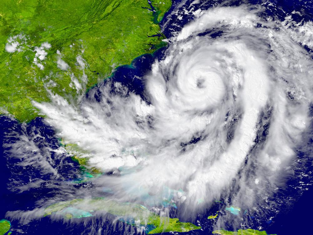
COURTESY NOAA
Image of Hurricane Milton from NOAA’s GOES-16 satellite on Oct. 8, 2024.
Disaster Preparedness Guide


Get


The time to put an emergency kit together is before a disaster, reminds ReadyNC.gov.

An emergency kit is a container of items your family may need in or after an emergency. Most of the items can be found in your house. It is important to put them in one place. Be sure every family member knows where the kit is kept. You need to put enough water, food and supplies in your kit for three to seven day for each person and pet. You may be on your own for hours or even days after a disaster. Being ready for an emergency helps you and your family to survive. It also allows police, fire fighters and emergency medical workers to help those who need it most.
What to put in your emergency preparedness kit:
• Water – 1 gallon per person per day for 3 to 7 days
• Food – non-perishable and canned food supply for 3 to 7 days
• Battery-powered or hand crank radio and National oceanic and Atmospheric Administration (NOAA) Weather Radio with extra batteries
• Cell phone with charger
• First aid kit and first aid book
• Flashlight and extra batteries
• Manual can opener for food
• Wrench or pliers to turn off water
• Blanket or sleeping bag – 1 per person
• Prescription medications and glasses
• Seasonal change of clothing, including sturdy shoes
• Toothbrush, toothpaste, soap, feminine supplies
• Extra house and car keys
• Important documents
– insurance policies, copy of driver’s license, Social Security card, bank account records
• Fire extinguisher
• Cash and change
• Books, games or cards
• Face coverings / masks
• Hand sanitizer
• Sanitizing wipes
You and your family members may have special needs. You need to plan for those needs when making your emergency supply kit.
For baby:
• Formula
• Bottles
• Diapers
• Baby wipes
• Pacifier
• Soap/baby powder
• Clothing
• Blankets
• Canned food and juices
For adults:
• Contact lenses and supplies
• Extra eye glasses
• Dentures
For people with functional needs:
• Container for hearing aid/cochlear implant processor (to keep dry)
• Extra batteries for hearing aid/choclear implant
• Communication card explaining best way to communicate with you
You should have basic first aid supplies on hand to help you if you have an injured family member or friend after an emergency. It is important to know how to treat minor injuries. Taking a first aid class is helpful too. Simply having a first aid kit can help you stop bleeding, avoid infection and assist in sanitization.
• Two pairs of latex or other germ-free gloves (if you are allergic to latex)
• Germ-free bandages to stop bleeding
• Cleansing agent/soap and antibiotic towels
• Antibiotic cream
• Burn cream
• Adhesive bandages in a variety of sizes
• Eye wash solution to flush the eyes
• Thermometer
• Prescription medications you take every day such as insulin, heart medicine and asthma inhalers. You should periodically rotate medicines to account for expiration dates.
• Prescribed medical supplies such as glucose and blood pressure monitoring equipment and supplies
• Scissors
• Tweezers
• Tube of petroleum jelly or other lubricant Non-prescription drugs:
• Aspirin or non-aspirin pain reliever
• Anti-diarrhea medication
• Antacid
• Syrup of Ipecac (use to induce vomiting if advised by the Poison Control Center)
• Laxative
• Potassium Iodide (for those who live near nuclear plants; use only as ordered by the State Health Director) You need to have an emergency supplies kit for your pet. Keep this kit with the family kit. Make sure every person knows where the kit is kept. The items below should go in your pet’s kit.
• Canned or dry pet food
• Water for 3 to 7 days
• Food dishes
• Muzzle, collar and leash
• Immunization records
• Identification tag (should contain pet name and phone number)
• Current photos of your pets in case they become lost
• Medicine your pet requires
• Pet beds and toys
• Pet carrier
• Proper fitting muzzle

WEDNESDAY, MAY 28, 2025
Disaster Preparedness Guide
Ice and water: Stock up before the storm
By Danielle Puleo danielle.puleo@ thecoastlandtimes.com
When a hurricane or tropical storm is in the forecast, one of the most crucial (and sometimes overlooked) items to add to your checklist is clean drinking water and ice. Not only does it help keep perishables cold, but it becomes a vital resource if the power goes out or water supply is compromised. We spoke with Brim Silver, co-owner and co-manager of Ice House OBX in Manteo, about how they prepare and how locals can make the most of their services before a storm.
“We keep the machine in constant service,” Brim explains. “Before any impending storm, Ice House OBX makes sure to fully tend the machine so it’s
running at full capacity.”
This is no small task.
With water constantly flowing and ice being produced around the clock, Brim’s husband, Beau, personally maintains machine and filtration systems, ensuring the freshest, cleanest ice and water available on the Outer Banks. One major advantage? The Ice House OBX team lives just minutes away, so they’re able to monitor, maintain and respond quickly.
“Our job is to make sure the community always has access to ice and clean water—especially when it matters most.”
When it comes to preparing for a storm, Brim has a few key pieces of advice for residents and visitors alike:
• Get a large cooler — as big as you can reasonably carry — and fill it with ice

before the storm • Don’t forget to fill water containers with fresh water from the machine.
Having several gallons on hand could be critical if water
to avoid last-minute rushes.
• “If the power goes out,” Brim says, “you’ll be incredibly grateful you have
and water
Registry available in Dare for those with special medical needs
In times of emergency, Dare County is able to provide assistance to residents with special medical needs, which can include both physical or mental health disabilities. Individuals with special medical needs could require care and assistance in order to meet basic needs during an emergency situation and should plan carefully for disasters or other kinds of emergencies.
Examples of persons who may have special medical needs can include but are not limited to: someone who uses a wheelchair, requires oxygen or has a
caregiver.
If you or someone you know has special medical needs and could require assistance with emergency planning and/or evacuating in case of a hurricane or other weather event, complete the Special Medical Needs Voluntary Registration form virtually at darenc.com/ specialneeds. The forms can also be printed from this site, completed and mailed to Dare County Department of Health & Human Services, Attn: Adult Services, P.O. Box 669, Manteo, NC 27954. “This registry allows
responders to know where individuals are in our community who may require special help during an emergency,” said Beth Bradley, adult services supervisor with Dare County Department of Health & Human Services. “It is a valuable tool to help those in need and we want the residents of Dare County to be aware of the availability of this registry so that they can inform their friends and neighbors who may require assistance in a crisis.”
If you do not have access to the form online, forms can be picked up at Department of


ready.”
Even in the thick of an emergency, you’re not on your own. Ice House OBX provides a service number, 252-216-7733, can be reached via email icehouseobx@gmail.com, and keeps their Facebook page updated with availability and storm-related service updates.
When prepping for hurricane season or a major coastal storm, clean water and ice should be non-negotiables. Thanks to locally-run services like Ice House OBX—which combine thoughtful maintenance with community care—you’ve got a reliable source for both, day or night. Make it part of your plan. Because a cooler full of ice today can mean a lot more comfort, safety and peace of mind tomorrow.
Health & Human Services, Social Services Division office locations, or mailed to your address upon request. Registering with the Department of Health & Human Services for Special Medical Needs will enable emergency responders to quickly locate participants as well as anticipate and plan for what type of assistance may be necessary.
“The 2025 hurricane season began June 1 and ends November 30,” commented Greta Sharp, preparedness coordinator with the Dare County Department of Health & Human
Services. “This is a great time of year for Dare County residents to review their special medical needs status, preparedness plans, and stock up on any emergency supplies they may need. Our department also maintains helpful information year round on our website at darenc. com/StormReady that can provide guidance on various public health related concerns that arise before, during, and after a storm.”
For more information on special medical needs registration, contact Bradley at 252-4755500 or BradleyB@darenc.gov.


Disaster Preparedness Guide
Prepare your pets for disasters
fresh.
immediate area.
Your pets are an important member of your family, so they need to be included in your family’s emergency plan. To prepare for the unexpected, follow these tips from Ready.gov with your pets in mind:
• Make a plan.
• Build an emergency kit.
• Stay informed.
Make a plan
If you have a plan in place for you and your pets, you will likely encounter less difficulty, stress and worry when you need to make a decision during an emergency. If local officials ask you to evacuate, that means your pet should evacuate too. If you leave your pets
behind, they may end up lost, injured or worse. Things to include in your plan:
• Have an evacuation plan for your pet. Many public shelters and hotels do not allow pets inside. Know a safe place where you can take your pets before disasters and emergencies happen.
• Develop a buddy system. Plan with neighbors, friends or relatives to make sure that someone is available to care for or evacuate your pets if you are unable to do so.
• Have your pet microchipped. Make sure to keep your address and phone number up-to-date and include contact information for an emergency contact outside of your

• Contact your local emergency management office, animal shelter or animal control office to get additional advice and information if you’re unsure how to care for your pet in case of an emergency.
Build a kit for your pet
Just as you do with your family’s emergency supply kit, think first about the basics for survival, such as food and water. Have two kits, one larger kit if you are sheltering in place and one lightweight version for if you need to evacuate. Review your kits regularly to ensure that their contents, especially foods and medicines, are
Here are some items you may want to include in an emergency kit for your pet:
• Food. Keep several days’ supply of food in an airtight, waterproof container.
• Water. Store a water bowl and several days’ supply of water.
• Medicine. Keep an extra supply of the medicine your pet takes on a regular basis in a waterproof container.
• First aid kit. Talk to your veterinarian about what is most appropriate for your pet’s emergency medical needs.
• Collar with ID tag and a harness or leash. Include a backup leash, collar and ID tag. Have copies of your pet’s registration information and other relevant documents in a waterproof container and available electronically.

Prepare pets for travel


• Traveling bag, crate or sturdy carrier, ideally one for each pet.


• Grooming items. Pet shampoo, conditioner and other items, in case your pet needs some cleaning up.
• Sanitation needs. Include pet litter and litter box (if appropriate), newspapers, paper towels, plastic trash bags and household chlorine bleach to provide for your pet’s sanitation needs.
• A picture of you and your pet together. If you become separated from your pet during an emergency, a picture of you and your pet together will help you document ownership and allow others to assist you in identifying your pet.
• Familiar items. Put favorite toys, treats or bedding in your kit. Familiar items can help reduce stress for your pet.
When evacuating your home, it’s important to bring your pets. Because you may need to put your cat or dog into a pet carrier, it’s important that they’re comfortable with the experience. Follow these tips to reduce their stress:
• Leave the carrier out in places your pet frequently visits
• Leave the carrier open
• Feed them treats near the carrier – you can even try putting a few treats inside the carrier
• Add a favorite blanket or small bed inside the carrier so it smells familiar
• Make note of where your pets hide, so you can easily find them in case you have to leave your house quickly.
Tips for large animals
In addition to the tips above:
• Ensure all animals have some form of identification.
• Evacuate animals earlier, whenever possible. Map out primary and secondary routes in advance.
• Make available vehicles and trailers needed for transporting and supporting each type of animal. Also make available experienced handlers and drivers.
• Ensure destinations have food, water, veterinary care and handling equipment.
• If evacuation is not possible, animal owners must decide whether to move large animals to a barn or turn them loose outside.
Stay informed Being prepared and staying informed of current conditions. Here are some ways you can stay informed:
• Pay attention to wireless emergency alerts for local alerts and warnings sent by state and local public safety officials.
• Listen to local officials when told to evacuate or shelter in place.
• Download the FEMA app and get weather alerts from the National Weather Service, for up to five different locations anywhere in the United States.
• Always bring pets indoors at the first sign or warning of a storm or disaster.
Important contacts
• Dare County Emergency Management
– 252-475-5655
• Dare Central Communications (Non-Emergency) – 252-473-3444
• Tyrrell County Emergency Management – 252796-4516 (office)
• Hyde County Emergency Management – 252542-0105 or 252-352-8381
• Currituck Emergency Management – 252-232-2115
• N.C. Emergency Management - State EOC – 800-858-0368 Road/Ferry conditions
• North Carolina: – 511

• Virginia – 511
N.C. Ferry Service –Sign up for text and/ or email notification on schedule changes at ncdot.gov/fins
Utility companies
• Dominion Energy –866-366-4357 (outage, service)
• Cape Hatteras Electric Cooperative – 252-9955616 (office), 866-5119862 (outage)
• Tideland Electric –800-637-1079 (office), 800-882-1001 (outage)
• Dare County Water Department – 252-475-5990
• Kill Devil Hills Water Dept. 252-480-4080
• Nags Head Water Dept. 252-449-2004
• Manteo Water Dept. 252-473-4106
• Spectrum – 833-267-6094
• BrightSpeed – 833-692-7773
Additional contacts

• Outer Banks SPCA (Dare County Animal Shelter) – 252475-5620. After hours: 252-216-8860
• U.S. Coast Guard (Sector N.C.) – 910-343-3880
• N.C. Highway Patrol –Need Assistance: dial *47 (*HP) on a cellular phone. • Cape Hatteras National Seashore – 252-473-2111

Disaster Preparedness Guide

Elevator safety before the storm
By Danielle Puleo danielle.puleo@ thecoastlandtimes.com
How to protect your lift and your home
If your Outer Banks home has an elevator, it’s not just a convenience — it’s an investment worth protecting. When hurricanes or major storms are in the forecast, taking a few proactive steps can help you avoid costly water or electrical damage. We spoke with Joey Austin, president and operations manager of Atlantic Elevators, about what homeowners should know before the weather turns.
The most important move? Make sure your elevator is on
the second or highest floor of your home. “If flooding occurs, you want to keep that elevator car out of the water,” says Austin. Leaving it on the ground floor greatly increases the risk of damage. Even in past storms where elevator pits were completely flooded, units that were parked above water were often still operable. If your elevator has easy access to a controller or machine room, Austin recommends turning the elevator and backup battery off. “This helps protect the unit from electrical surges during or after the storm,” he says. While the
battery might die in the process, it’s far better than risking costly electrical damage.
“Don’t wait until the last minute,” says Austin. Two to three days before the storm is the best time to secure your elevator. If you’re evacuating and don’t have time to shut things down properly, you can still take some simple precautions: leave the elevator on the second floor and open the door. That way, even if someone unknowingly tries to call the elevator from another floor, it won’t move—and no one’s safety will be at risk.
There are two primary types of home elevators: traction
and hydraulic. Most OBX elevators are traction-style, where the motor sits at the top of the hoist way. This location helps minimize flood-related damage.
Hydraulic elevators, on the other hand, are more vulnerable. If you have a hydraulic model, be sure to shut off the valve in the machine room to prevent the elevator from “creeping” down into floodwaters in the event of a power outage.
Once the skies clear, don’t rush to turn the elevator back on. First, check the ground floor and elevator pit for any signs of water intrusion.
Austin says he’s seen situations where homeowners turned the elevator back on too soon, only for it to descend directly into standing water. When in doubt, call Atlantic Elevators before restarting your system—they’re happy to walk you through it and/or come out and take a look. Atlantic Elevators is open Monday through Friday, 8 a.m. to 5 p.m., with technicians on-call on weekends during summer months. If you need help securing or inspecting your elevator, contact Atlantic Elevators by calling 252473-1083 or emailing service@ atlanticelevators.com.


Disaster Preparedness Guide
Hurricane history in Dare since 1985
1985 – Gloria
• Sept 16 – Oct 2
• Max Wind Speed: 144 mph
• Landfall: Hatteras
– 9/26/85
• Category 2 at Landfall with a 6-8 ft. storm surge and 104 mph winds
1985 – Kate
• Nov 15 – Nov 23
• Max Wind Speed: 123 mph
• Landfall in Florida
• Affected NC 11/22/85
• Tropical storm when arrived in NC with 52 mph winds
1991 – Bob
• Aug 16 – Aug 29
• Max Wind Speed: 115 mph
• Never made landfall in NC
• Reached Category 3 off of NC coast
• Hit North Carolina 8/19/91
1993 – Emily
• Aug 22 –Sept 6
• Max Wind Speed: 115 mph
• Never made landfall in NC
• Reached Category 3 off of coast
• Affected NC 8/31/93
• Evacuation – all of Dare County
• Estimated $12 million in damages
1996 – Bertha
• July 5 – July 17
• Max Wind Speed: 115 mph
• Landfall: Topsail Beach 7/13/96
• Category 2 at landfall with 104 mph winds and a 5 ft. storm surge
• Evacuation – all of Dare County
1996 – Fran
• Aug 23 – Sept 10
• Max wind Speed: 121 mph
• Landfall: Cape Fear
• Category 3 at landfall with 115 mph winds and an 8-12 ft. storm surge
• No evacuations in Dare County
1998 – Bonnie
• Aug 19 – Aug 31
• Max Wind Speed: 115 mph
• Landfall: Cape Fear
• Category 3 at landfall 6-8 ft. storm surge
• Evacuation – all of Dare County
1998 – Earl
• Aug 31 – Sept 8
• Max Wind Speed: 98 mph
• Tropical storm when reached NC
1999 – Dennis
• Aug 24 – Sept 8
• Max Wind Speed: 104 mph
• Landfall: Dare County 9/14/99
• Tropical Storm at landfall 69 mph winds
• Evacuation – all of Dare County
• Estimated $10 million in damages
1999 – Floyd
• Sept 7 – Sept 19
• Max Wind Speed: 155 mph
• Landfall: Topsail Island 9/16/99
• Category 2 at landfall with 109 mph winds
• Evacuation – all of Dare County
2003 – Isabel
• Sept 7 – Sept 29
• Max Wind Speed: 160
mph
• Landfall: Drum Inlet 9/18/03
• Category 2 at landfall with 104 mph winds and 6-10 ft. storm surge
• Created breech in island between Frisco and Hatteras Village
• Evacuation – all of Dare County
• Estimated $167 million in damages
2004 – Alex
• Aug 3
• Category 2 at the time of landfall
• Caused sound side flooding
• Most damage in the form of flooding damage to cars and homes
• Estimated $2.4 million in damages
2005 – Ophelia
• Sept 13 – Sept 16
• Max Wind Speed: 85 mph
• Passed NC Coast as a Tropical Storm
• Evacuation – Hatteras Island only
• Estimated $19,500 in damages
2010 – Earl
• Aug 25- Sept 5
• Max Wind Speed: 145 mph
• Passed 100 miles off of the NC Coast
• Evacuation – all of Hatteras Island and Ocean front of all towns
• Estimated $500,000 in damages
2011 – Irene
• Aug 20 – Aug 28
• Max Wind Speed: 120 mph
• Landfall just south of the Outer Banks
• Evacuation all of Dare County

• Significant flooding
• Estimated Damages: $53,975,960
2012 – Sandy
• Oct 25 – Oct 31
• Max Wind Speed: 70 mph
• Significant road damage to NC 12 in Kitty Hawk and Rodanthe
• 7-8 inches of rainfall
• Emergency ferry activation due to NC 12 road damage
• Estimated Damages: $13+ million
2014 – Arthur
• July 3 – July 4
• Max Wind Speed: 101 mph
• Category 2 at landfall
• Earliest hurricane on record
• Landfall between Cape Lookout and Beaufort
• Mandatory evacuation issued for Hatteras Island
2016 – Hermine
• Aug 28 - Sept 3
• Max Wind Speed: 73 mph
• Category 1 with tropical sustained winds
• Extensive flooding in villages on Hatteras Island
• Storm surge of 4 feet about normal tide
• Estimated storm damages: $5.4 million
2016 – Matthew
• Oct 7 - Oct 9
• Max Wind Speed: 94 mph
• Category 1 with landfall in South Carolina
• Highest Dare County wind reported at 94 mph
• NWS reported rainfall 12+ inches in Kill Devil Hills
• Estimated statewide damages: $1.5 billion
2017 – Maria
• Sept 25 - Sept 27
• Max Wind Speed: 75 mph
• Category 1 • State of Emergency Declared
• Mandatory evacuation of visitors on Hatteras Island
• No estimate of


damages available
2018 – Tropical Storm Chris
• July 7 – July 10
• Stayed three days off NC’s southeast coast
• Persistent north-northeast wind: 25 mph
• NE swell brought rough surf
• Soundside flooding and dangerous surf
• No estimate of damages available
2018 – Florence
• Sept. 12 – Sept. 18
• Landfall near Wrightsville Beach at 7.15 a.m., Sept.14
• Category 1
• State of Emergency declared
• Mandatory evacuation issued for all of Dare County
• NC 12 closed from Oregon Inlet bridge to Hatteras village
• Estimated damages: $502,500.
2018 – Michael
• Oct 10 – Oct 12
• Landfall at Mexico Beach, Fla., Oct 10
• Category 4 with top wind at 155 miles per hour.
• Leaving the Gulf Coast, Michael sliced through Alabama, Georgia, South Carolina, North Carolina and left for the Atlantic Ocean through Virginia.
Tropical storm in Dare County
• Winds: 74 mph Kitty Hawk
• 2 to 4 ft. flood waters above ground level soundside surge
• Damages: $7.3 million
2019 – Dorian
• Sept. 6
• Landfall on Cape Hatteras as Category 1
• 101 miles per hour winds recorded at Cape Hatteras
2020 – Isaias
• Aug. 3
• Category 1 at landfall near Ocean Isle Beach
• 72 mph winds recorded in Avon
• 1-3 feet of storm surge in isolated locations of Dare County
• Produced a lethal EF3 tornado in nearby Bertie County
2024 – Debby
• Aug. 3-8
• Landfall: (1) Steinhatchee, Fla. Category 1. Winds 80 mph
• (2) Bulls Bay, S.C. tropical storm tracking to west of eastern N.C.
• Spawned 10 tornadoes. Three fatalities. $2.5 billion damages.
• Dare County experienced heavy rainfall, flooded highways, streets.
• Cautioned to avoid swimming in coastal waters from Wright Memorial Bridge to S.C. state line.
2024 – Ernesto
• Aug. 16-18
• Landfall. Bermuda, 650 miles east of Rodanthe. Category 1.
• Winds 85 mph.
• Brought dangerous surf and coastal flooding to Rodanthe, Buxton.
• Rodanthe – Corbina Drive house debris stretched for 11 miles along coast.
• Buxton beach oceanfront houses underwashed. Septic systems compromised.
2024 – Helene
• Sept. 26-28
• Landfall: Big Bend area near Perry, Fla. Sept. 26 as Category 4
• Post tropical cyclone, Sept. 27. Tornado watch issued for Dare County and 14 other eastern counties. Schools closed early.
• 4-7 feet of storm surge impacted Hatteras Island villages
• Over $14.8 million in damages across Dare County
• In two days, 12 to 20 inches of rain fell in western N.C. Winds 40 to 60 mph.
• Fatalities: 251 lives lost. Estimated $78.7 billion in damages.
• Recovery continues.
Tips on staying safe while visiting the beach
• Swim near a lifeguard. The chances of drowning at a beach with lifeguards are 1 in 19 million.

• Never swim alone. Always swim with a buddy so that if one swimmer has a problem, the other can provide assistance and call for help.
• Know how to swim before venturing into the ocean. Swimming in a pool is not the same as swimming at a surf beach with crashing waves, winds, and dangerous currents.


• Know before you go. Check the local surf forecast before going to the beach. • If in doubt, don’t go out!


WEDNESDAY, MAY 28, 2025
Disaster Preparedness Guide
How are tropical cyclones named?
Since 1953, Atlantic tropical storms had been named from lists originated by the National Hurricane Center. They are now maintained and updated through a strict procedure by an international committee of the World Meteorological Organization.
Six lists of names are used in rotation and re-cycled every six years, i.e., the 2023 list will be used again in 2029. The only time that there is a change in the list is if a storm is so deadly or costly that the future use of its name for a different storm would be inappropriate for reasons of sensitivity. If that occurs, then at an annual meeting by the WMO committee (called primarily to discuss many other issues) the offending name is stricken from the list and another name is selected to replace it. Several names have been retired since the lists were created.
If a storm forms during the off-season, it will take the next name in the list based on the current calendar date. For example, if a tropical cyclone formed on December 28, it would take the name from the previous season’s list of names. If a storm formed in February, it would be named from the subsequent season’s list of names. In the event that more than 21 named tropical cyclones occur in the Atlantic basin in a season, any additional storms will take names from an alternate list of names approved by the WMO.
Reason to name hurricanes
Experience shows that the use of short, distinctive names in written as well as spoken communications is quicker and less subject to error than the
older, more cumbersome latitude-longitude identification methods. These advantages are especially important in exchanging detailed storm information between hundreds of widely scattered stations, coastal bases and ships at sea.
The use of easily remembered names greatly reduces confusion when two or more tropical storms occur at the same time. For example, one hurricane can be moving slowly westward in the Gulf of America, while at exactly the same time another hurricane can be moving rapidly northward along the Atlantic coast. In the past, confusion and false rumors have arisen when storm advisories broadcast from radio stations were mistaken for warnings concerning an entirely different storm located hundreds of miles away.
History of hurricane names
For several hundred years, many hurricanes in the West Indies were named after the particular saint’s day on which the hurricane occurred.
Ivan R. Tannehill describes in his book “Hurricanes” the major tropical storms of recorded history and mentions many hurricanes named after saints. For example, there was “Hurricane Santa Ana” which struck Puerto Rico with exceptional violence on July 26, 1825, and “San Felipe” (the first) and “San Felipe” (the second) which hit Puerto Rico on September 13 in both 1876 and 1928.
Tannehill also tells of Clement Wragge, an Australian meteorologist who began giving women’s names to tropical storms before the end of the 19th century.

An early example of the use of a woman’s name for a storm was in the novel “Storm” by George R. Stewart, published by Random House in 1941, and since filmed by Walt Disney. During World War II this practice became widespread in weather map discussions among forecasters, especially Army and Navy meteorologists who plotted the movements of storms over the wide expanses of the Pacific Ocean.
In 1953, the United States abandoned a confusing two-year old plan to name storms by a phonetic alphabet (Able, Baker, Charlie) when a new, international phonetic alphabet was introduced. That year, the United States began using female names for storms.
The practice of naming hurricanes solely after women came to an end in 1978 when men’s and women’s names were included in the Eastern North Pacific storm lists. In 1979, male and female names were included in lists for the Atlantic and Gulf of America.
Dare County – Love the Beach, Respect the Ocean
In an effort to provide beachgoers with information on how to enjoy the Outer Banks’ beautiful barrier island beaches safely, Dare County Emergency Management created the “Love the Beach, Respect the Ocean” campaign. This effort has led to numerous safety videos and graphics to inform the public of potential hazards at the beaches.

Dare County also offers a text message service, where you can sign up for text alerts on beach conditions for the Outer Banks beaches by texting “OBXBeachConditions” to 77295. For additional information on Love the Beach, Respect the Ocean, go to lovethebeachrespecttheocean.com.


The alphabetical list of 2025 Atlantic hurricane names as chosen by the World Meteorological Organization.
Disaster Preparedness Guide

NCSU researchers predict 12 to 15 named storms this hurricane season
The 2025 Atlantic hurricane season will see 12 to 15 named storms forming in the Atlantic basin, according to researchers at North Carolina State University. The Atlantic basin includes the entire Atlantic Ocean, the Gulf of Mexico and the Caribbean Sea.
The number of named storms predicted is in line with recent averages, according to Lian Xie, professor of marine, earth and atmospheric sciences at NC State. The long-term (1951 to 2023) average of named storms is
11, and the more recent average (1994 to 2024) is 15 named storms.
Of the predicted 12 to 15 named storms, six to eight may grow strong enough to become hurricanes (the historical average is six), with the possibility of two to three storms becoming major hurricanes, noted a news release from NCSU.
The Gulf of Mexico’s forecast is also in line with recent averages. Of the 12 to 15 named storms predicted across the entire Atlantic
basin, Xie’s data indicate the likelihood of one to three named storms forming in the region, with one to two of them becoming hurricanes, and the potential for one to become a major hurricane.
Historic averages for the Gulf are three named storms and two hurricanes.
Xie’s methodology evaluates more than 100 years of historical data on Atlantic Ocean hurricane positions and intensity, as well as other variables, including weather patterns and sea-surface
temperatures, to predict how many storms will form in each ocean basin.
The forecast was made through a collaboration between NC State’s departments of marine, earth and atmospheric sciences and computer science. NC State adjunct assistant professor of marine, earth and atmospheric sciences Xia Sun is the lead scientist of this year’s forecast team.
The Atlantic hurricane season runs from June 1 through Nov. 30.
advance notice of potential tropical cyclone risks, has been extended from two weeks to three weeks, to provide additional time for preparation and response.
Enhanced communication products for this season
• NHC will offer Spanish language text products to include the Tropical Weather Outlook, Public Advisories, the Tropical Cyclone Discussion, the Tropical Cyclone Update and Key Messages.
• NHC will again issue an experimental version of the forecast cone graphic that includes a depiction of inland tropical storm and hurricane watches and warnings in effect for the continental U.S. New for this year, the graphic will highlight areas where a hurricane watch and tropical storm warning are simultaneously in effect.
• NHC will provide a rip current risk map when at least one active tropical system is present. The map uses data provided by local National Weather Service forecast offices. Swells from distant hurricanes cause dangerous surf and rip current conditions along the coastline.
Innovative tools for this year
• NOAA National Environmental Satellite, Data, and Information Services (NESDIS), in collaboration with NOAA’s Office of Marine and Aviation Operations and NOAA Research, is deploying a new, experimental electronically scanning radar system called ROARS on NOAA’s P-3 hurricane hunter research aircraft. The system will scan beneath the plane to collect data on the ocean waves and the wind structure of the hurricane.
• NOAA Weather Prediction Center’s experimental Probabilistic Precipitation Portal provides user-friendly access to see the forecast for rain and flash flooding up to three days in advance. In 2024, Hurricane Helene caused more than 30 inches of extreme inland rainfall that was devastating and deadly to communities in North Carolina. NOAA’s outlook is for overall seasonal activity and is not a landfall forecast. NOAA also issued seasonal hurricane outlooks for the eastern Pacific and central Pacific hurricane basins. NOAA’s Climate Prediction Center will update the 2025 Atlantic seasonal outlook in early August, prior to the historical peak of the season.


COURTESY NORTH CAROLINA STATE UNIVERSITY