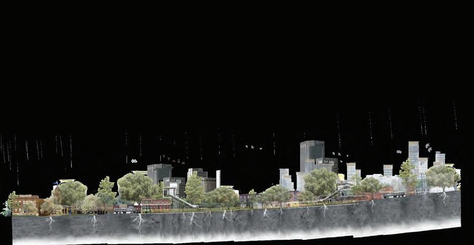
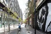
New Ground is a mark of collective departure and arrival for an exhibition once anchored by the Hearth, in Wilkinson.
Students stepping onto new ground as they move from study into practice.
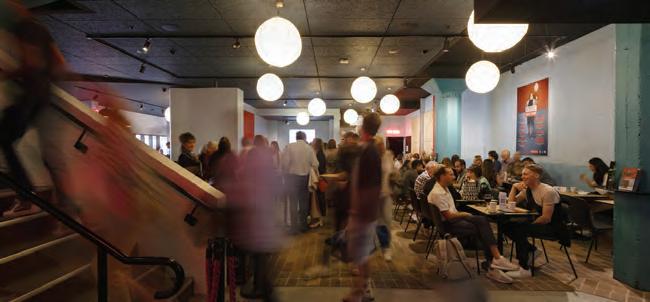
ADP establishing new ground with the exhibition at Carriageworks.
These projects chart fresh territories, staking out possibilities for how we might design, inhabit, and share in the future of contemporary urban and digital practice.
New Ground
ADP Graduate Show 2025
Opening night 4 December 2025, 6pm Carriageworks
Exhibition dates 4–6 December 2025
We acknowledge the tradition of custodianship and law of Country on which the University of Sydney is located.
We pay our respect to those who have cared, and continue to care, for Country.
Dean’s Welcome
Donald McNeill
Foreword
Master
Master
Master of
Introduction: Deena Ridenour Program Director and Catherine
Gilbert Program Director
Student
Lectures and Events
Tin Sheds Gallery
Donald McNeill Head of School and Dean
In 2025, the School of Architecture, Design and Planning welcomed students from across Australia and around the world. The collective learning across these geographies comes together in the ADP Graduate Show 2025. This catalogue represents a remarkable creative efort and the culmination of countless hours of work.
A major focus for the School’s architecture programs this year was the prominence of staf and student work in the Venice Biennale. In October last year, we received the exciting news that our Associate Dean Indigenous Strateg and Services, Dr Michael Mossman, had been appointed as one of a three-person Creative Director team to design and curate the Australian Pavilion at the Venice Biennale. Along with colleagues Elle Davidson and Bradley Kerr, this achievement marked an outstanding milestone for the School in 2025. The Sydney School of Architecture, Design and Planning sits on Gadigal land, where Aboriginal people have taught, learnt and nurtured since time immemorial. Within these pages you will fnd many designs that work with Country, refecting the depth of engagement by both staf and students.
This catalogue captures how our students and educators spent much of their time in 2025. It includes comparative studies of planning systems from Hong Kong to Melbourne and Lane Cove; iridescent acrylic pendants from lighting design; strategies for translating exhibitions between Dublin and Sydney; creative urban form and masterplanning responses to challenges such as the rapidly transforming St Marys district; architectures of subversion, guerrilla tactics and resistance movements from our Master of Architecture students; and zines exploring Sydney’s new Metro and its efects on the urban corridor between Sydenham and Bankstown.
In 2025, we also continued our close collaboration with Rothwell Co-Chairs Atelier Bow-Wow, who spent time in Bourke, Wilcannia, Brewarrina and Cobar with a group of students exploring urban–rural conditions. The Tin Sheds Gallery hosted a full program of events and exhibitions, culminating in WaterTalks, which presented the Hunter River, known as CoquunMyan by the Awabakal, Worimi and Wonnarua Traditional Custodians, and examined the impacts of colonialism and industrialisation on water.
I would like to thank the many educators who guided students through the design process. Behind the carefully crafted models and posters in the exhibition and catalogue lie of-cuts, sweat, crits, laughter, and countless iterations and revisions. This is the creative process we hold central to our work in ADP.
As always, our Engagement team, who brought together both the exhibition and catalogue, deserve enormous praise for their professionalism and dedication in making this collective efort shine. This year we have moved to the impressive backdrop of Eveleigh’s Carriageworks, a new ground that presents a very diferent exhibition context to our usual home in the Wilkinson Building. In the coming months, we will undertake a signifcant refurbishment of key spaces in the Wilkinson, reopening in 2026 with enhanced facilities and renewed character.
I wish our graduating students every success and look forward to welcoming you back to the University throughout your careers.
It is wonderful to see all the fantastic work from the graduates of the Master of Urban Design, Master of Urban and Regional Planning, and Master of Urbanism programs this year.
New Ground is an apt theme for this year’s Grad Show, which we might interpret as a call to think more carefully about the ground upon which all of the built environment professions undertake their work. This includes acknowledging that Aboriginal Country is the context of all contexts for our work. In this space, Elle Davidson (Balanggarra) has been leading Urbanism through an important discussion on Indigenising our curricula, which has clearly infuenced the students’ work this year.
Ground might also refer to the various environments we work with, in, and around. From dealing with climate change through urban design to making our cities more efcient through new transport planning, rethinking how built and biological environments might coexist and integrate with one another is increasingly important in our lecture theatres, classrooms, and studios.
If we push this new ground metaphor a little further, we might also consider that the built environment professions may have run aground, or that some professions have been grounded. To run aground is to lose one’s way, to become disoriented, and ultimately to be shipwrecked. To be grounded is to be restricted, prevented, or prohibited from undertaking an activity, and we have certainly seen encroachments into the professional capacities of planners and urban designers in recent years. This year, our students have been asking tough questions about the past, present, and future of the built environment professions. They have been refecting on the roles they will play in the future of their cities and how they will keep both their professions and their cities afoat.
With this in mind, we might also think about ground in more abstract terms, as a future direction or destination toward which we are heading. This new ground is what is on display in the students’ work every year. In some cases, it is new conceptual ground articulated through ideas about how to better understand, regulate, design, and renew our cities. In others, it is more speculative and future-oriented, revealing in their studio work the types of cities they would like to see in the future. This future-focused thinking and practice is the kind of work I hope our students will advocate for and pursue as they enter the built environment workforce after their studies.
On behalf of the Urbanism Discipline, we hope our graduates will go out into the world, question it, and ultimately make it a better place.
MASTER OF URBAN DESIGN MASTER OF URBANISM
MASTER OF URBAN AND REGIONAL PLANNING
Introduction
Deena Ridenour Master of Urban Design Program Director
Catherine Gilbert Master of Urbanism and Master of Urban and Regional Planning Program Director
Congratulations to all the graduates of the Master of Urban Design, Master of Urban and Regional Planning, and Master of Urbanism programs for your outstanding achievements in 2025.
This year’s theme, New Ground, is both a celebration and a challenge—a call to redefne the worldviews and practices that have shaped our disciplines. You are the future innovators, advocates, and change-makers who will shape the cities of tomorrow.
The work showcased here refects not only mastery of core knowledge and professional skills but also the creativity, analytical rigour, and thought leadership needed to confront some of the most pressing issues of our time—from decarbonising cities and adapting to a changing climate, to renewing urban environments in ways that foster equity, health, and justice. These projects embody optimism and innovation, demonstrating how urban designers and planners can lead transformative change in Sydney and the world beyond.
The exemplary work presented in this catalogue has been selected from a rich body of coursework—designs, plans, strategies, reports, and presentations—produced through both individual efort and collaborative teamwork in disciplinary and multidisciplinary contexts. For many, this represents the culmination of an intense and rewarding learning journey.
None of this would have been possible without the dedication of our teaching teams—lecturers, unit coordinators, and tutors—who have guided and inspired students throughout their studies. We extend our gratitude to the practitioners—Adjuncts, panellists, jurors, and guest lecturers—who have generously shared their expertise and insights. We also acknowledge the invaluable contributions of Elle Davidson (Balanggarra) and Dr Michael Mossman (Kuku Yalanji) in reframing curricula across our School and deepening appreciation of Country and Indigenous perspectives. Finally, we thank our professional staf for their unwavering support.
On behalf of the Urbanism Discipline, we wish all our graduates every success as you take your knowledge, creativity, and passion into the world—defning New Ground for urban practice and shaping more sustainable, inclusive, and just cities.
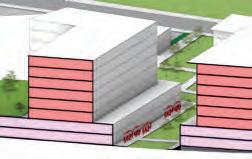
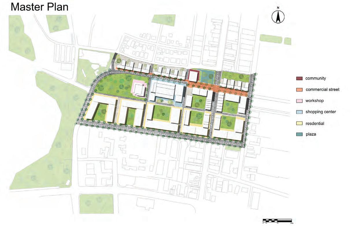
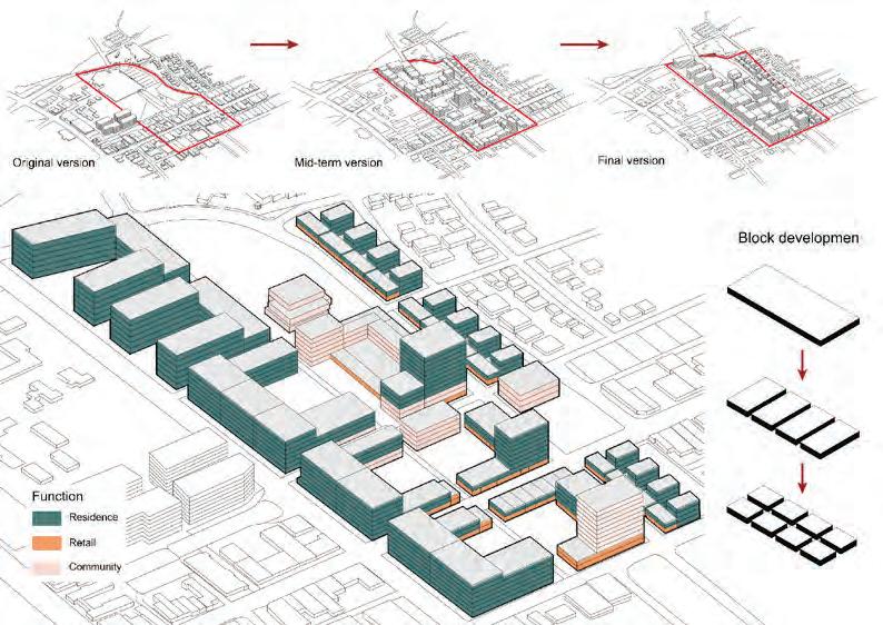
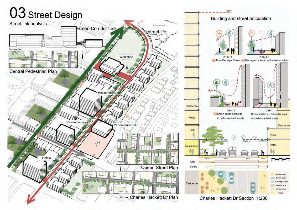
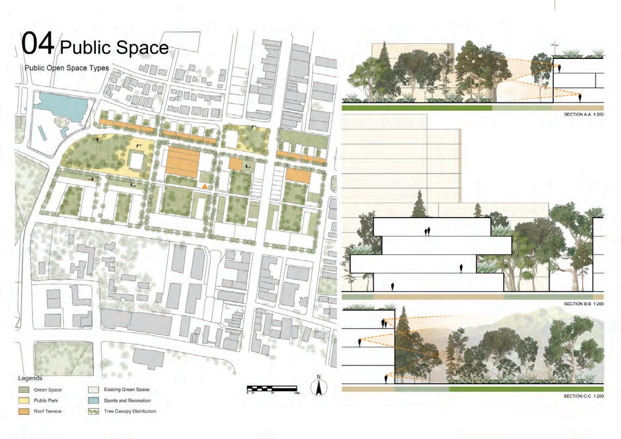
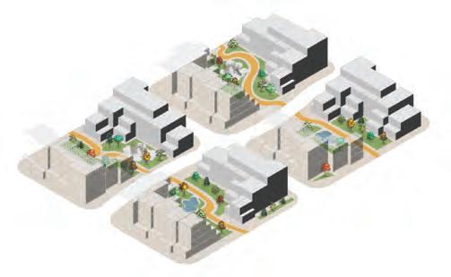
Emergent Urbanity – St Marys Town Centre
St Marys is set to evolve from a car-dependent suburb into a vibrant, well-connected urban centre ofering diverse opportunities for living, working, and recreation. This studio investigates how urban form and public space can shape this transformation, creating an authentic, walkable, and socially connected environment. Inspired by Kim Dovey’s idea of “spaces of public encounter,” the work explores how design can foster the ‘common’—shared experiences and connections that lay the foundation for community life.
Located along Queen Street and centred on a major transport interchange, St Marys has strong structural potential yet faces challenges of low density, limited mixed-use activity, and car-dominated landscapes. The arrival of the Metro, linking St Marys to the Western Sydney Aerotropolis, positions it for major growth under the Western District Plan and the TransportOriented Development Program.
Through critical engagement with government master plans, the studio proposes alternative visions for two key areas: the Station Precinct, integrating surplus Metro land with fne-grain retail, and the Town Park Precinct, reimagining open spaces and retail connections. Combining research, spatial analysis, and design experimentation, the work envisions St Marys as a thriving Western Parkland City destination built on accessibility, intensity, and everyday urban life.
URBAN DESIGN STUDIO : URBAN PROJECTS COORDINATOR
Deena Ridenour
TUTORS
Brendan Randles
Deena Ridenour
Ian Woodcock
STUDIO CRITICS AND CONTRIBUTORS
Martin Abbott, ADP
Craig Alchin, Six Degrees Urban
Ken Baird, City of Sydney
Greg Burgon, Architectus
Michelle Cramer, FrazerNash Consultancy
Jonathan Knapp, SJB
Jan McCredie, City of Parramatta Council
Marco Marin, City of Parramatta Council
Aditya Malshe, City of Penrith Council
Richard Nugent, CM+
Deepti Prasad, ADP
Tanya Vincent, Transport for NSW
Vera Xia, ADP
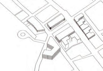
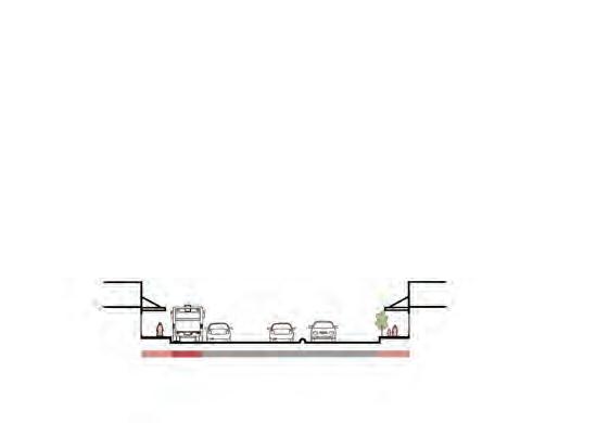
Figure 1: City of Penrith Council
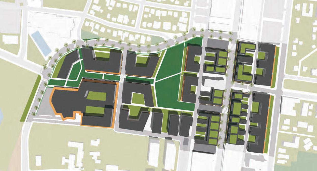
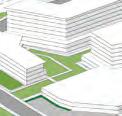
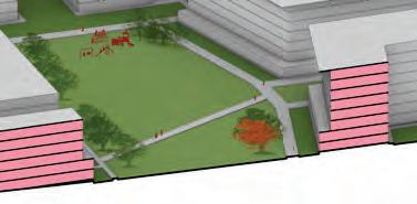
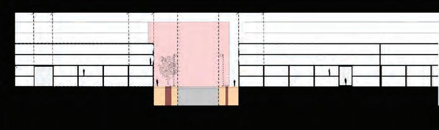
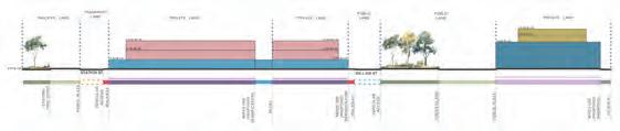
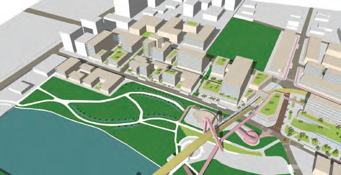
St Marys sits at the junction of the T1 rail line and the future M2 Metro, linking Western Sydney Airport with the wider region. The Town Park Precinct, approximately one kilometre from the upcoming metro station, builds its own identity around local amenity, accessibility and community life. Designed for 4,100 residents and 1,500 jobs, it envisions a vibrant, mixed-use centre.
The former St Marys Shopping Complex is adaptively reused as a lively mixed-use hub. New east–west connections transform a once car-dependent area into a walkable, bike-friendly environment. Flood-sensitive design incorporating bioswales, diverse frontages, permeable passages and a multi-layered Central Park anchors a resilient, connected and people-focused precinct.
Jonathan Gassoub, Danielle Tang, Gianluca Dragone, Abhay Singh Saini, St Marys Town Park Precinct
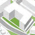
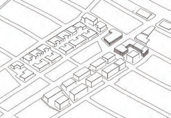
Built Form - Overview
Our master plan for St Marys envisions an “Emergent Urbanity”: a connected, mixed and resilient town centre shaped by Country, landscape and community life. Anchored by Queen Street and the existing transport network, the proposal establishes a clear urban structure of compact blocks, blue-green corridors and two defning streets that frame everyday urban life.
An internal pedestrian street serves as the heart of community activity, a car-free spine lined with cafés, local retail and fexible spaces for markets and events, fostering constant social engagement and street vitality. In contrast, a transit-oriented street near the bus interchange accommodates ofces and mixed-use program, ofering a dynamic interface between work and leisure.
Together, these streets weave ecological systems, active mobility and cultural expression into a cohesive public-realm network. The design promotes walkability, adaptive density and climate-responsive landscapes, transforming St Marys into a sustainable, inclusive and distinctly local centre that thrives on daily interaction and shared identity.
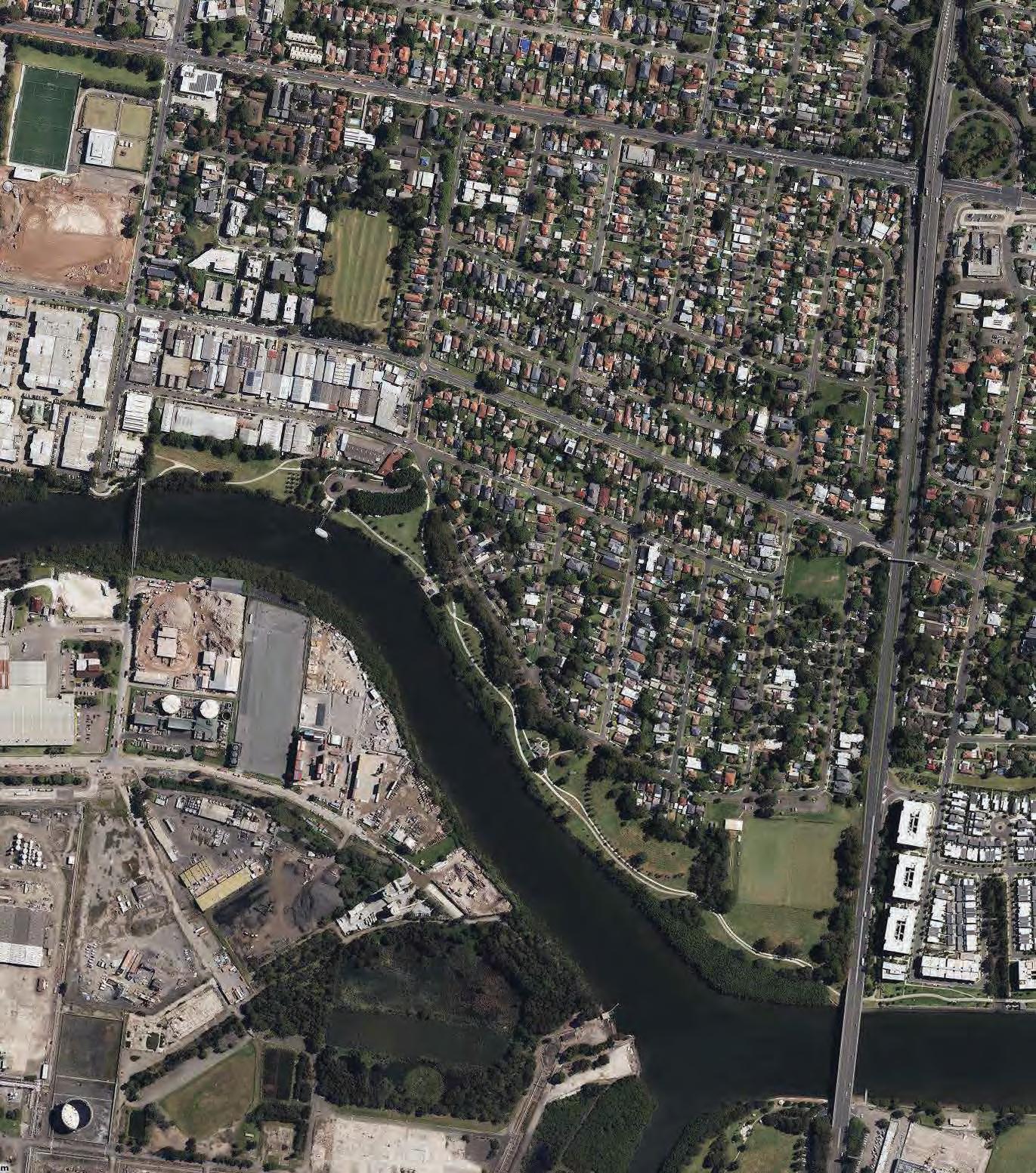
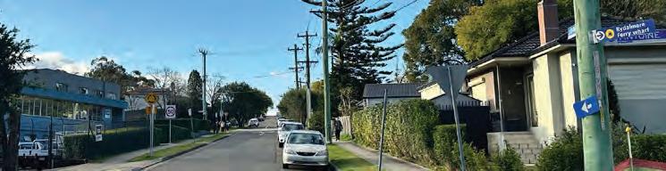
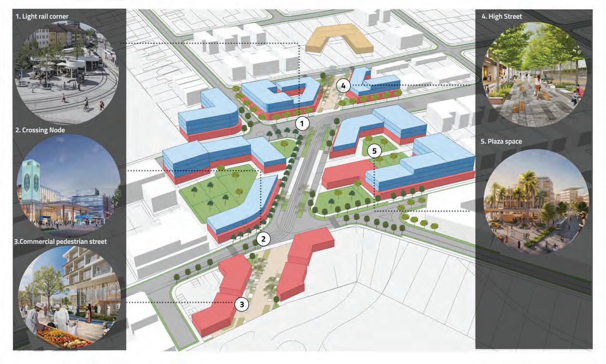
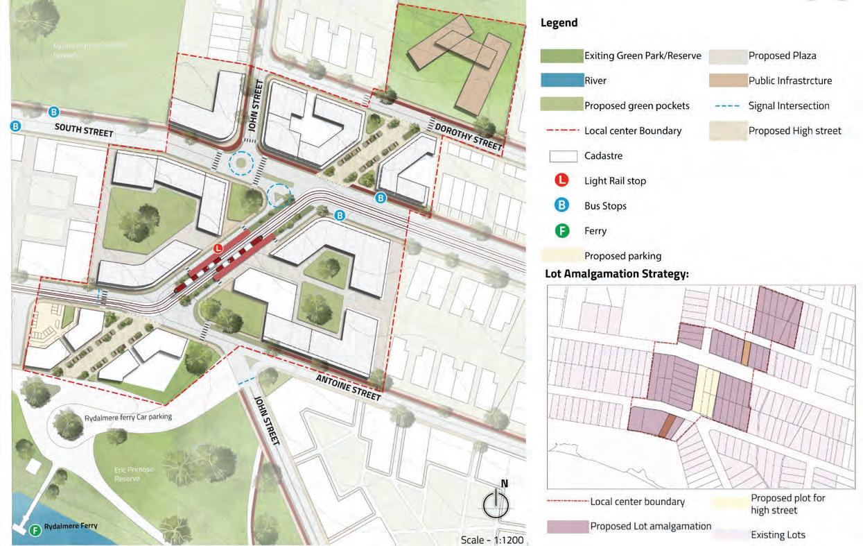
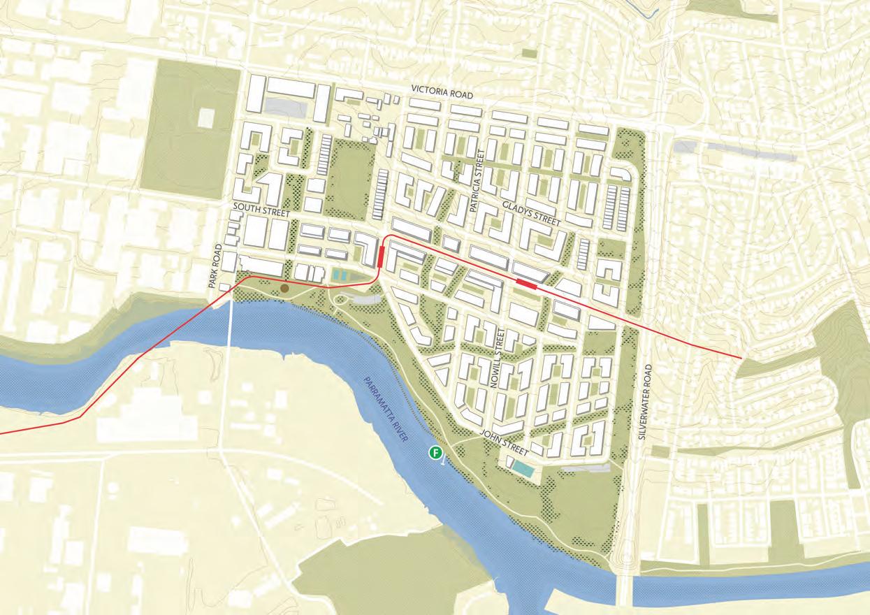
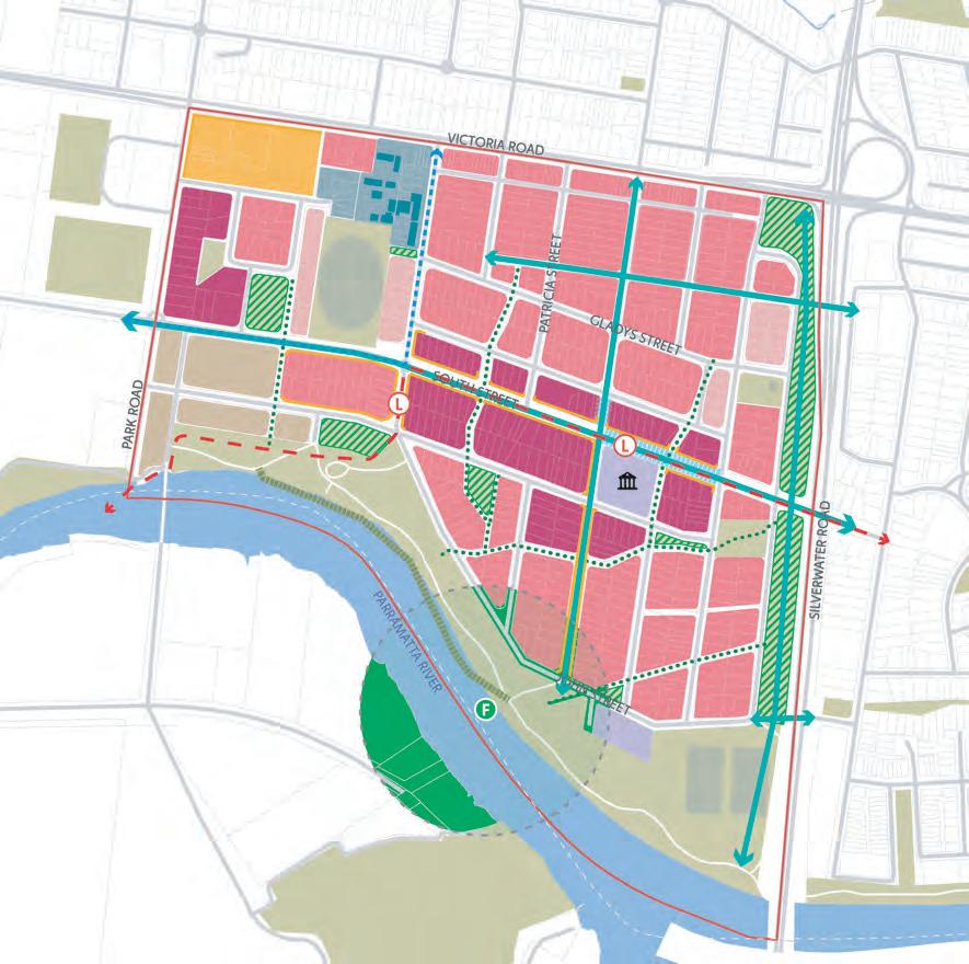
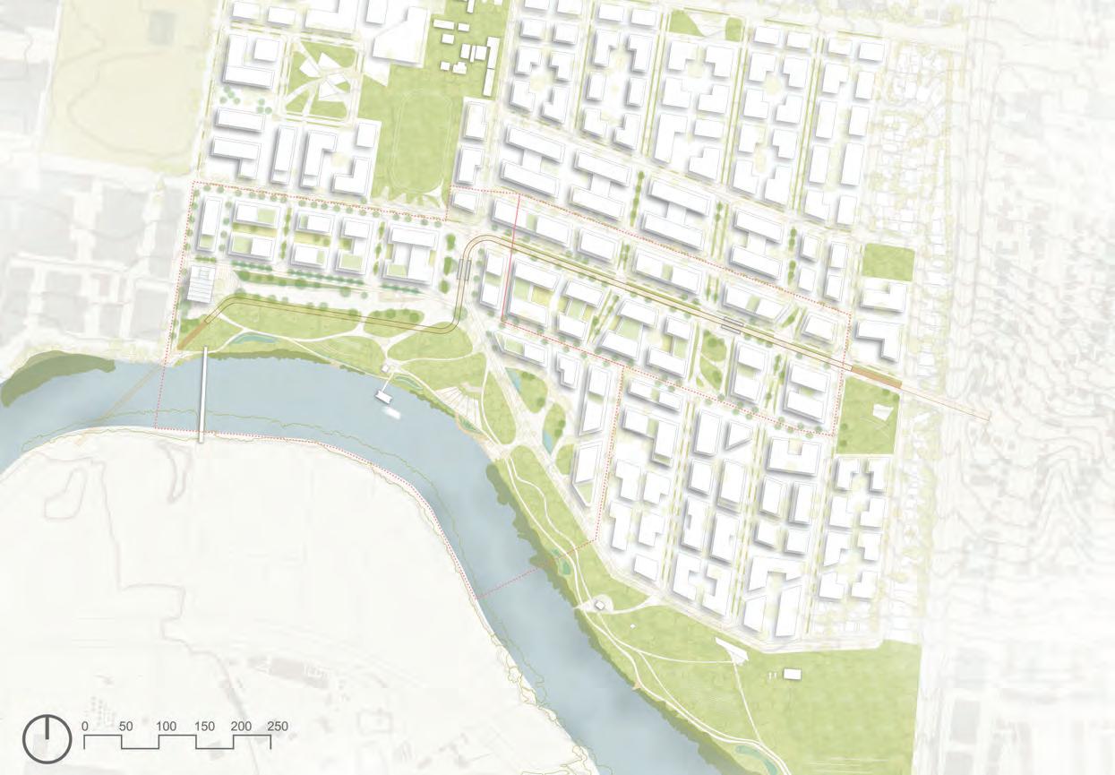
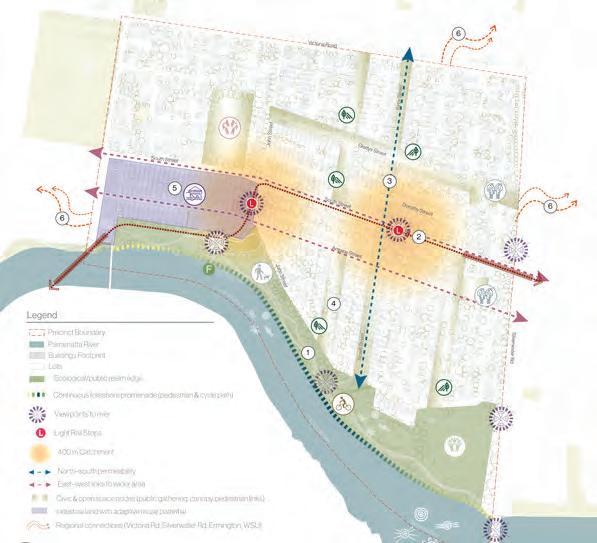
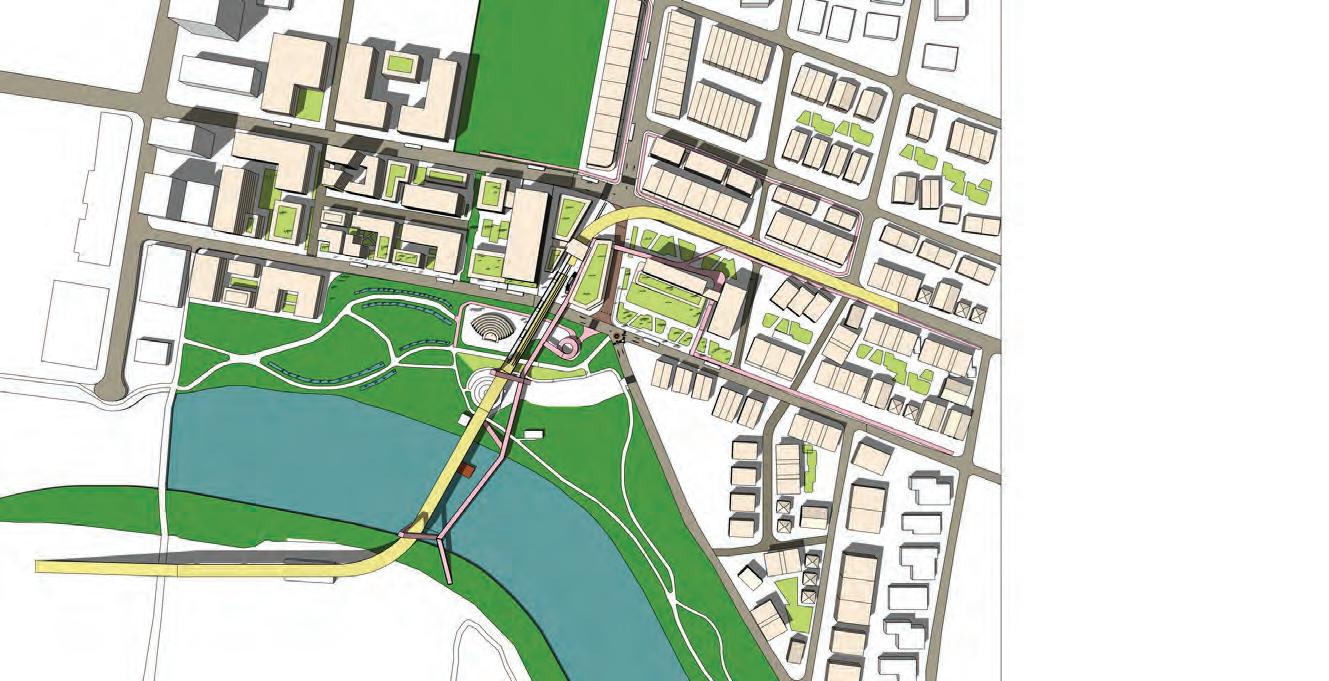
Communing with the Parramatta River: A Transformative Vision for Rydalmere
The Parramatta River has been a lifeline for the Dharug Nation and Burramattagal people for thousands of years. It holds deep cultural signifcance and also carries the weight of colonial trauma. The City of Rydalmere sits on the northern shore of this ancient waterway, central to the cultural life of the Dharug Nation and Burramattagal people, known as the “people of the eel place”. For millennia, the river sustained First Nations communities through its fertile landscapes and gathering places, and it retains profound cultural meaning today. Yet this enduring value now intersects with growing pressures for urban development, driven by major infrastructure investment and population growth.
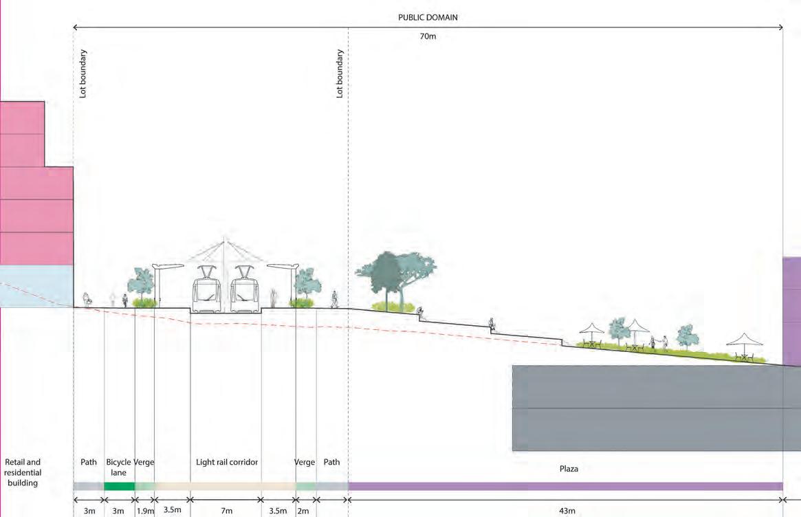
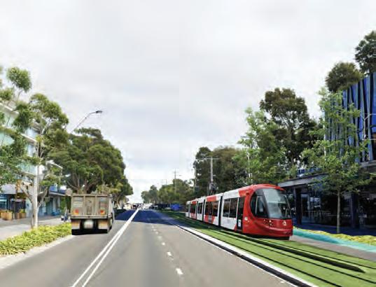
Parramatta is Sydney’s Central River City, and the City of Parramatta Council envisions transforming the river into a continuous parkland that celebrates shared values, improves accessibility and restores ecological health. This vision coincides with Parramatta Light Rail Stage 2, which will link the city centre to Sydney Olympic Park, passing through Rydalmere. The light rail acts as a catalyst for urban change, creating opportunities for increased housing in a well-connected, high-amenity location.
This studio explores how urban design can respond to these pressures, transitioning from low-density suburban housing to more compact forms while protecting natural systems and river health. Students will develop strategies for communal, sustainable living that respect cultural heritage and ecological resilience, ensuring the Parramatta River remains a thriving heart of the city.
The proposal defnes the site as a transit-anchored neighbourhood structured by a dual-centre urban framework comprising a primary hub and a secondary node, stitched together by an east–west green spine aligned with the upcoming Parramatta Light Rail. This corridor connects fragmented blocks into a legible network that links transit stops, residential zones, the ferry wharf foreshore and Silverwater Road. Mixed-use development clusters around transit hubs, while water-sensitive urban design corridors introduce ecological diversity and inclusive social spaces. Guided by Connecting with Country principles, the plan strengthens the riverfront identity and fosters resilient, culturally grounded urban transformation.
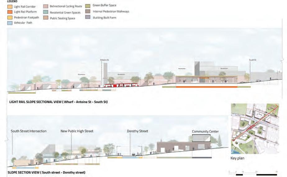
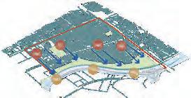
KEY MOVES
Key Moves
New Corridor Master Plan
ACTIVE AND PERMEABLE NETWORK
--Locate the new Light Rail Stop and Corridor
Establish an active integrated corridor with existing Ferry
Create more sitethrough links
Reestablish continuous bicycle network
DIVERSIFY THE MAIN LOCAL CENTRE
PUBLIC DOMAIN ENHANCEMENT
-Create a new plaza next to the Light Rail
Retain and upgrade the existing foreshore
Extend continuous pedestrian footpath
RIVERFRONT AND VIBRANT FRONTAGES
-Establish a new Community Centre
Establish a new functional retail centre
Locate mixed use surrounding as transition to residential
-Establish active frontages facing the junction
Nurture key spine towards the river
Locate front facades facing the river and foreshore Key Moves
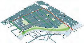
Precinct - Master Plan 8
Precinct - Master Plan
ACTIVE AND PERMEABLE NETWORK
-Locate the new Light Rail Stop and Corridor
Establish South Street as active corridor
Create more site-through links
RESPONSIVE BUILT FORM
-Densify buildings within Light Rail Stop radius
Locate lower rise buildings on north side to allow sun access to park s is o buildings on the east as noise barrier to arterial road
CONNECTING GREEN-BLUE CORRIDOR
-Retain the existing green corridor and open spaces
Establish a new si i r open space along the corridor
Reestablish private tree canopy corridor
SECOND-TIER NEW LOCAL CENTRE
-Establish a new secondary local centre on east junction
Locate mixed use with active frontages facing the junction
Include new employement hubs
Rydalmere
Rydalmere
Sudhanshu S.
Chiploonkar, Dharani Rajakumar,
Yichen Wang, Han Zhang, Rydalmere Reimagined: From Industrial Edge to Urban Ecosystem
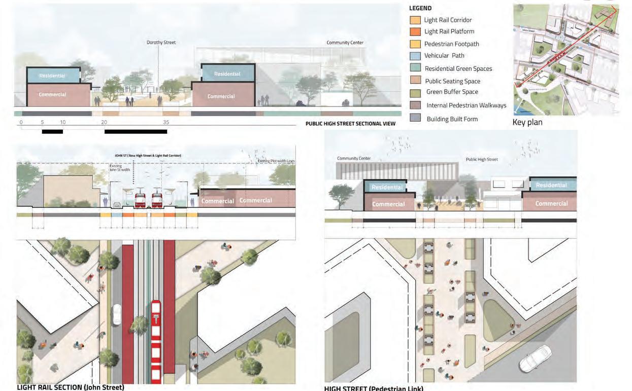
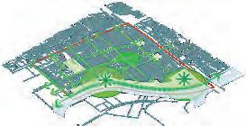
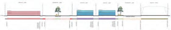
Situated along the proposed NSW Light Rail corridor, the Rydalmere Riverfront Precinct reimagines the interface between transit, community and landscape. Through an iterative studio process, the project orchestrates transitoriented density, ecological restoration and youth-focused public infrastructure. Layered interventions, from ferry-to-rail transitions and green spines to civic anchors and terraced riverfronts, construct a cohesive urban ecosystem. The design employs parametric analysis, landscape integration and adaptive building typologies to mediate between the site’s industrial legacy and its emerging urban life. This intervention transforms the corridor into a sustainable urban spine, one that choreographs mobility, culture and environmental resilience into a unifed precinct identity. Contextual height transitions of two to fve storeys and permeable built forms foster humanscale density and cultural vitality, merging advanced urban infrastructure with deep ecological stewardship to create an enduring, connected and community-centric urban fabric.
Breakwater Studio reimagines Rydalmere as a climate-resilient neighbourhood centre that places the Parramatta River at the heart of its design. The master plan integrates diverse development around the future light rail with enhanced riparian habitats and cultural landscapes. An interconnected blue-green grid features a network of proposed green spaces, swales and a mangrove boardwalk that encourages active movement. Key interventions include a civic centre and library, an activated waterfront with community gardens and a swimming pool, north–south ecological corridors along existing creek lines connecting South Street to the river, and the adaptive reuse of the light industrial zone into a creative hub.
Lewis Bee, Elsa Darmalingum, Christopher Papaioannou, Lucia Scanlan-Bloor, Rydalmere Rivulets
Rojas Figueroa, Shriya Ninad Sawant, Jack Elcombe, Nainesh Thakur, Rydalmere
Opportunities Map: What are the potentialities to be developed in the
The Master Plan repositions the precinct as an extension of the Parramatta River Corridor, integrating landscape, built form and mobility to support Dharug Country principles and ecological restoration. Through a Green-Blue Mixed-Use Corridor and a Movement-Activity Local Centre, the proposal establishes sustainable connections between the riverfront, light rail and surrounding neighbourhoods. Public benefts include expanded open spaces and connected links, new housing, improved ecological systems and adaptive reuse opportunities, creating a future-ready precinct that celebrates Country, reinforces community identity and contributes to Parramatta’s vision of a liveable river city.
Alonso
New Urban Corridors and Street Hierarchy
Refocus the River and embed Country
Establish a network of connected and protected open spaces
Industrial Legacy as Urban Framework
Streets as River Corridors
precinct?
Design Principles: Looking for the best approach to the River
Green-Blue Mixed-Use Corridor (Left) & Movement-Activity Local Centre (Right)
Recognise limits and connect through resilience
Planning and designing strategically for High-Speed Rail in Australia
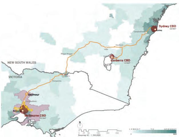
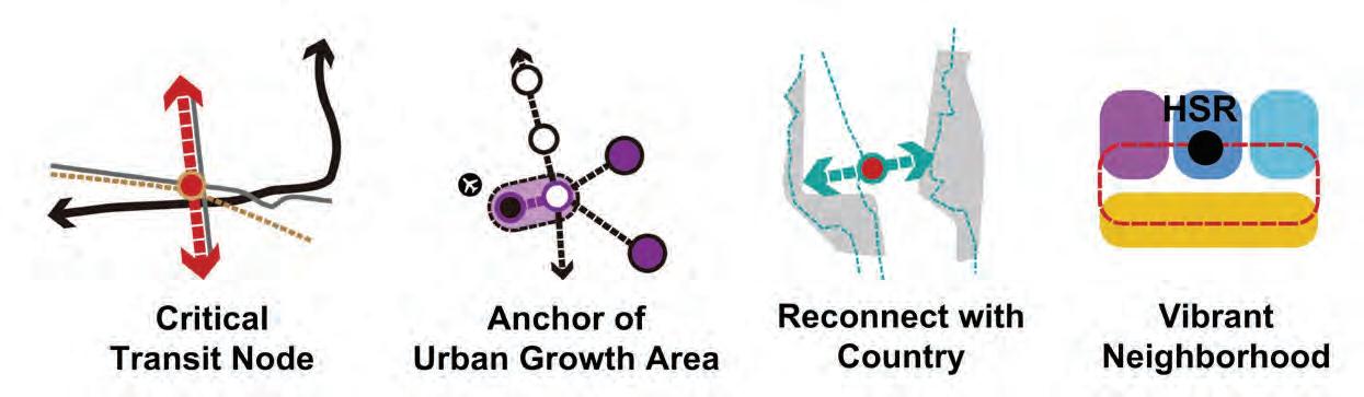
The Integrated Urbanism Studio is the capstone unit of the Master of Urbanism degree. It addresses real-world urban challenges and the need for urbanists to develop strategic solutions that persuade the public, stakeholders, politicians and investors of their value. In 2025, students were challenged to plan and design strategically for High-Speed Rail (HSR) in Australia, focusing on the corridor between Sydney and Melbourne.
Since the 1980s, proposals to upgrade this rail link, connecting Australia’s two most populous cities, have been discussed but never realised. The corridor now ranks as the ffth-busiest air route in the world, contributing signifcantly to carbon emissions. A HSR connection presents a generational opportunity to reshape economic, cultural and physical landscapes, particularly around new station precincts. Improved rail access between capital and regional cities could stimulate growth, support population redistribution, and transform living, working and travel patterns.
Multidisciplinary teams from the Urban and Regional Planning, Urban Design, and Heritage Conservation streams developed strategic plans for the corridor, each focusing on one of seventeen potential station locations identifed in earlier studies. They explored how HSR could deliver environmental care and stewardship, economic vitality, heritage conservation, cultural development and sustainable growth through integrated land use and transport planning.
These proposals revealed the transformative potential of HSR across diverse contexts, from metropolitan CBDs and suburban centres to regional towns and new settlements, with proposed stations including Strathfeld, Liverpool, Canberra, Wagga Wagga, Albury-Wodonga and Shepparton.
INTEGRATED URBANISM STUDIO COORDINATORS
Alice Vialard
Ian Woodcock
TUTORS
Alice Vialard
Ian Woodcock
Deena Ridenour
Jesse McNicoll
STUDIO CRITICS AND CONTRIBUTORS
James Whitten, Monash University
Iain Lawrie, University of Melbourne
Garry Glazebrook, Fastrack Australia
Ross Lowery, Fastrack Australia
Michael Kahn, Design Inc Sydney/ADP
Halvard Dalheim, ADP
Syd Herron, HSR/Aviation and Airport Consultant
Joe Langley, High Speed Rail Authority
Pete David, High Speed Rail Authority
Diana Gri ths, Studio GL
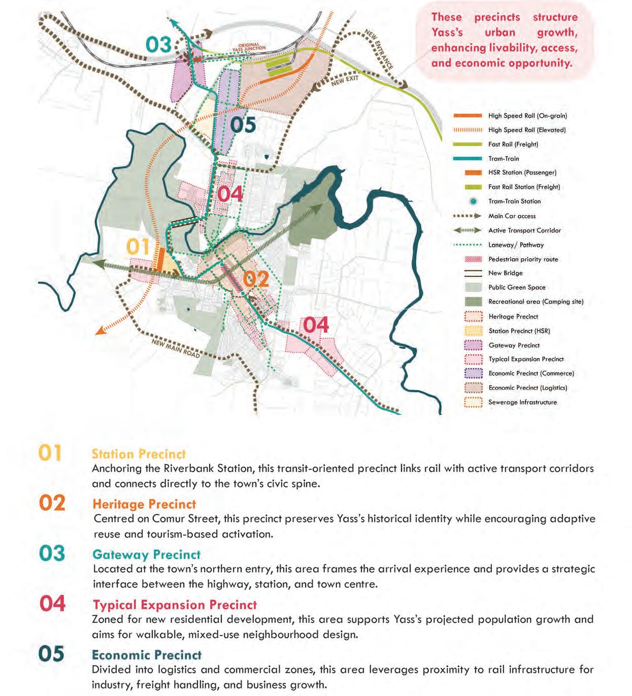
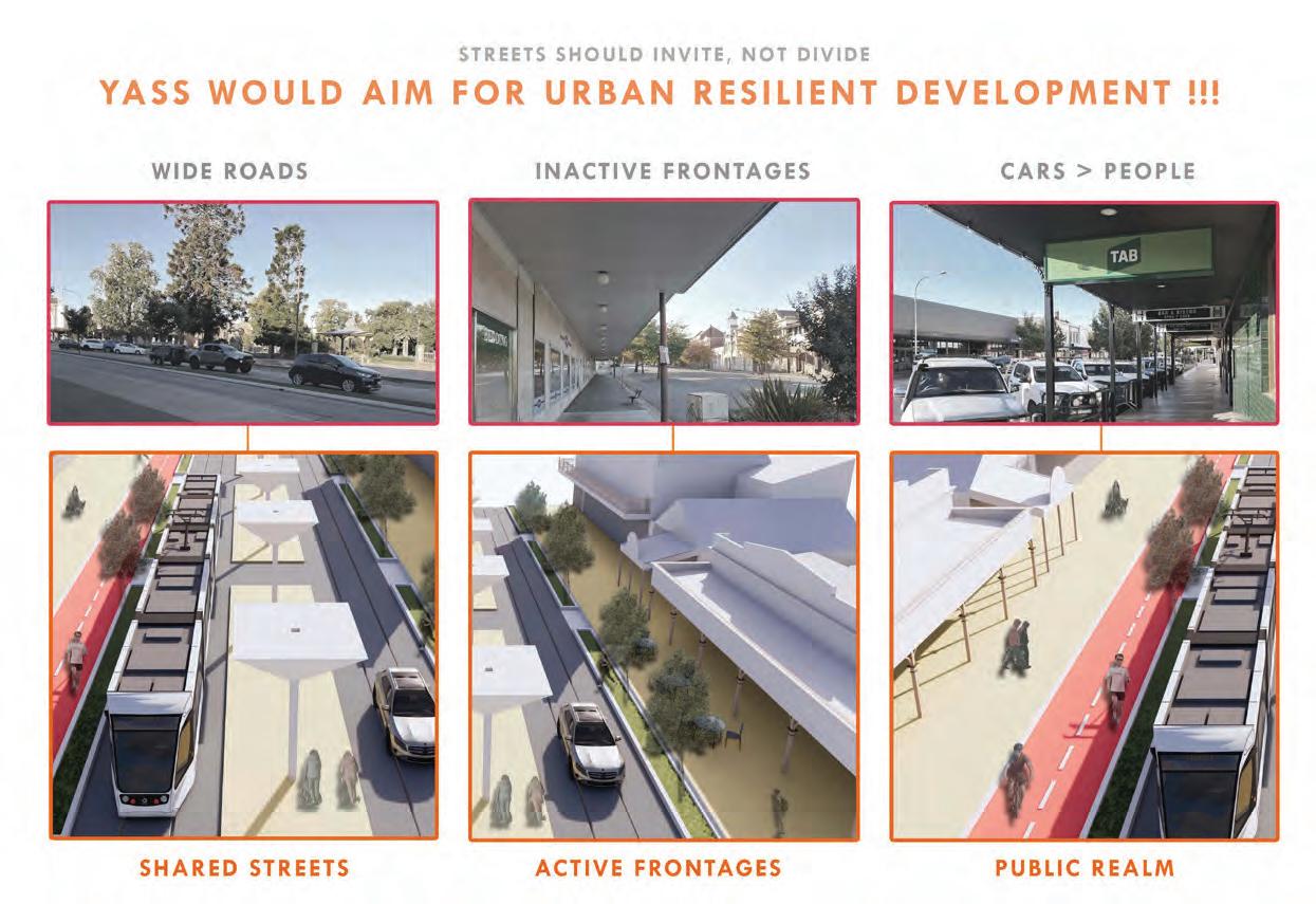
Yass sits at a pivotal geographic intersection, where high-speed rail can bypass the Blue Mountains and unlock access to previously disconnected regions. Its strategic position enables it to act as a gateway catchment, linking Canberra and the Central West to Australia’s east coast HSR spine.
As a result, Yass becomes the natural interchange where intercity meets inter-regional, connecting major cities with inland growth centres. This integration allows previously isolated towns to tap into regional labour markets, services, and economic activity.
Estimated travel times highlight the corridor’s effciency:
Yass–Sydney
1 hour (via Goulburn and Canberra)
Yass–Melbourne
3 hours
Sydney–Melbourne
Under 4 hours at speeds of 250–300 km/h
30
HSR CORRIDOR
REGIONAL CORRIDOR
REGIONAL COACHES
This rapid connectivity positions Yass not just as a through-stop, but as the key catchment node driving regional integration, decentralisation, and accessibility across the corridor.
Figure 1. Excerpt from Jeremy Huey Leong, Ashley Lin, Thuy An Nguyen, Eunice Wong, and Yuyang Tong’s ‘Yass!’ project
Kanghyun Kim, Danielle Li, Xiaoning Zhu, Xuechen Zhai, Malavika Muralidharan, The High-Speed Rail Corridor: Transport Hubs opening gates to regional centres
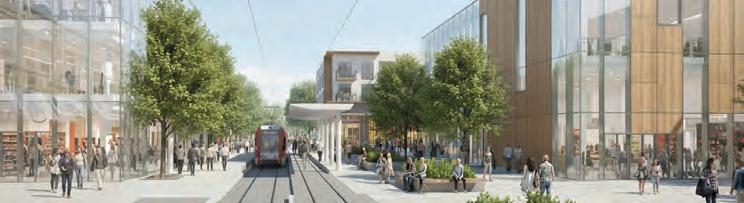
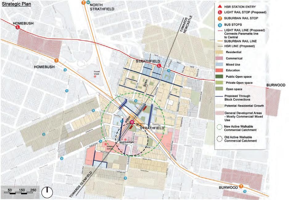
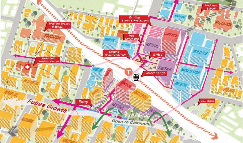
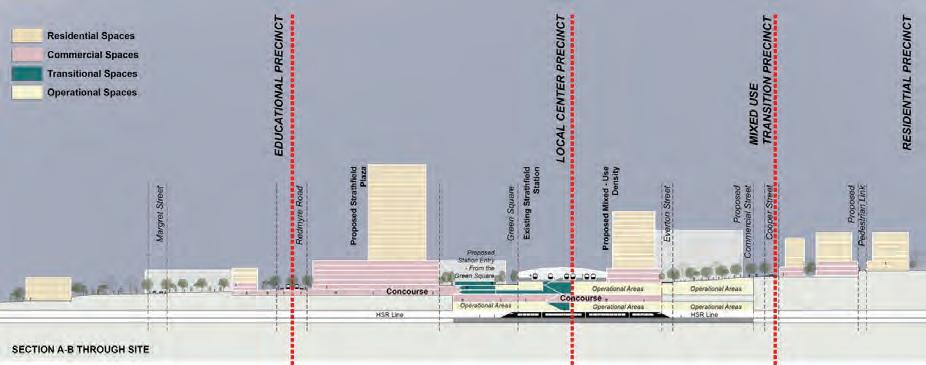
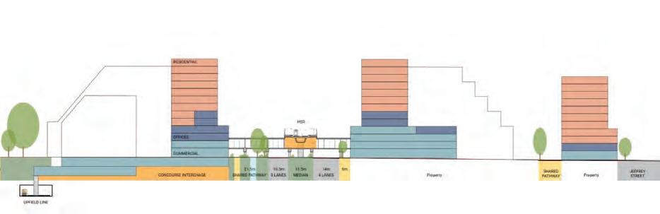
What if Strathfeld was Australia’s integrated High-Speed Rail urban centre? This project explores a design where underground infrastructure drives above-ground transformation. Centred on the idea of “the station as a city,” the proposal unites four distinct yet connected precincts—education, local centre, mixed-use and residential—through a network of pedestrian corridors, green links and vibrant public plazas. Each precinct responds to Strathfeld’s existing urban character while enabling new density, permeability and economic diversity. By embedding highdensity living, active frontages and multimodal connectivity around the future high-speed rail hub, the plan transforms Strathfeld from a commuter interchange into a dynamic destination that bridges regional mobility with local identity and demonstrates how infrastructure can drive meaningful urban transformation.
Abhay Singh Saini, Audrey See, Anjali Mangale, Sahaj Kaur Bajwa, Shivanya Kannan, Living on the Fringe: Fast Tracks, Balanced Future
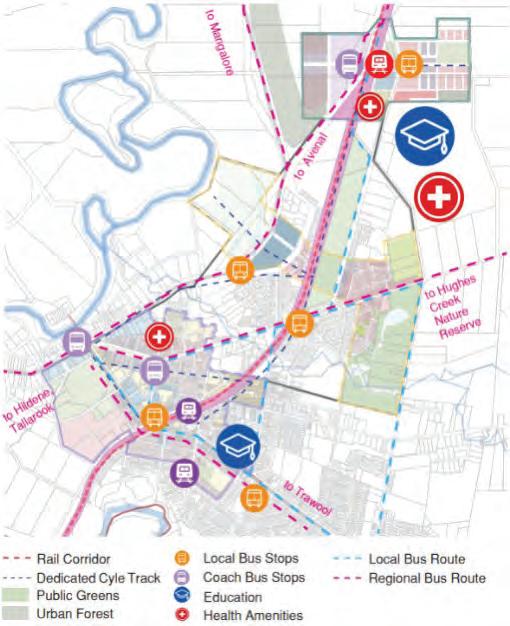
Seymour’s Urban Transformation Plan is a phased strategic framework that guides the town’s growth in response to the future Sydney–Melbourne High-Speed Rail (HSR) corridor. Envisioned as a fringe city, it reinforces Seymour’s peri-urban identity by blending rural character with resilient, ecologically responsive and culturally grounded urban design that builds on the town’s heritage and its connection to the Goulburn River. The plan positions Seymour as a well-connected regional centre linking metropolitan Melbourne and regional Victoria. Structured around three phases—the Old Town Precinct, the Bridge Precinct and the HSR Precinct—it aims to support a population of approximately 40,000 by 2041.
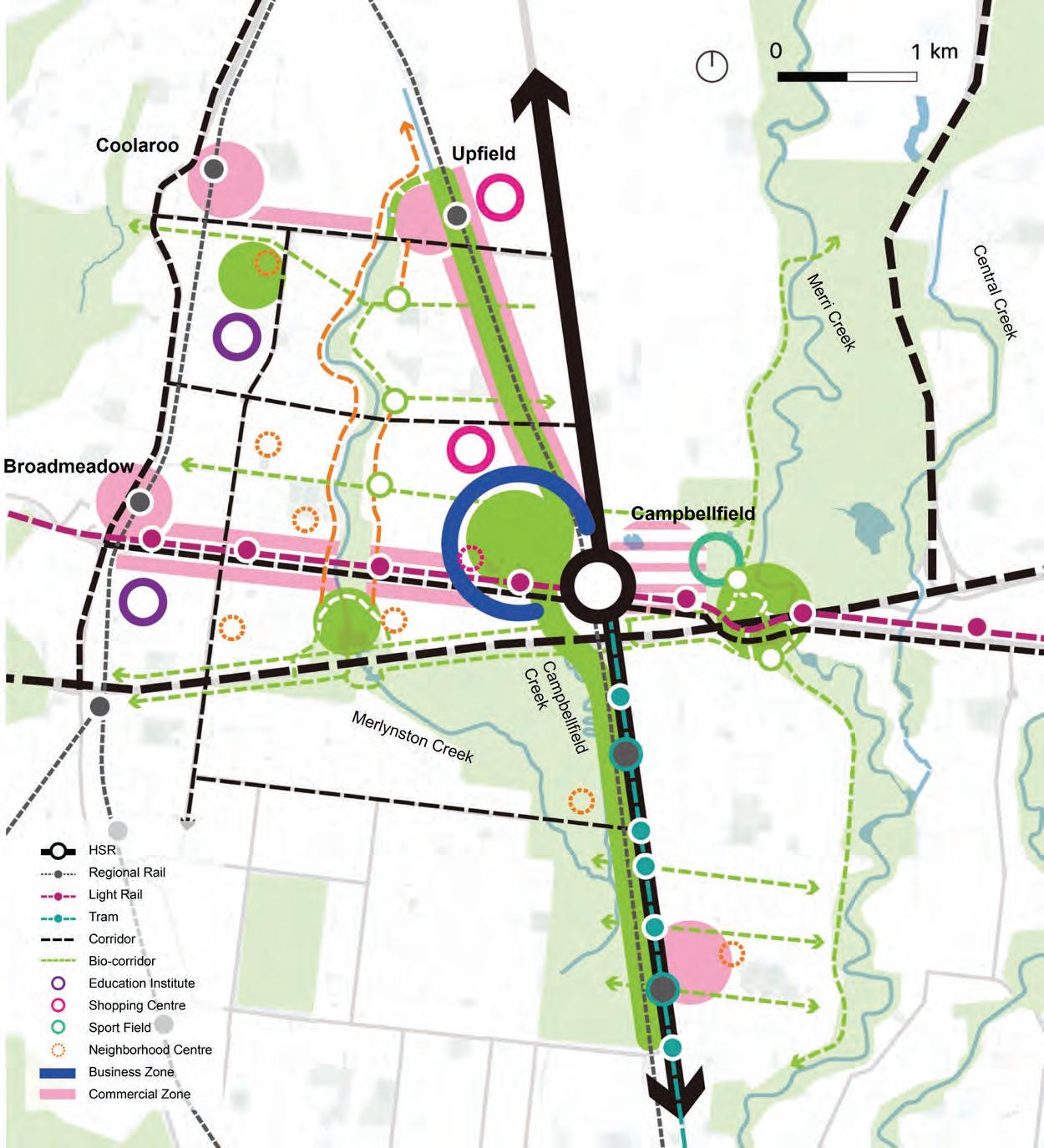
This project explores how a future High-Speed Rail station at Campbellfeld could catalyse development by leveraging multi-modal transport integration to establish a highly accessible, mixed-use gateway for Greater Melbourne and regional Victoria. The precinct will connect regional rail services, tram routes and a future light rail link to Melbourne Airport, positioning Campbellfeld as a strategic destination for both living and working. Beyond mobility, the proposal uses transport infrastructure to strengthen and reconnect fragmented ecological systems. Guided by existing site conditions, the green network framework enhances public realm quality across multiple suburbs, supporting residential and employment uses while enabling more resilient and sustainable urban growth.
Yuxin
Huey Leong, Ashley Lin, Thuy An Nguyen, Eunice Wong, Yuyang Tong, Yass! The Interchange Nexus: Strategic Plan 2056
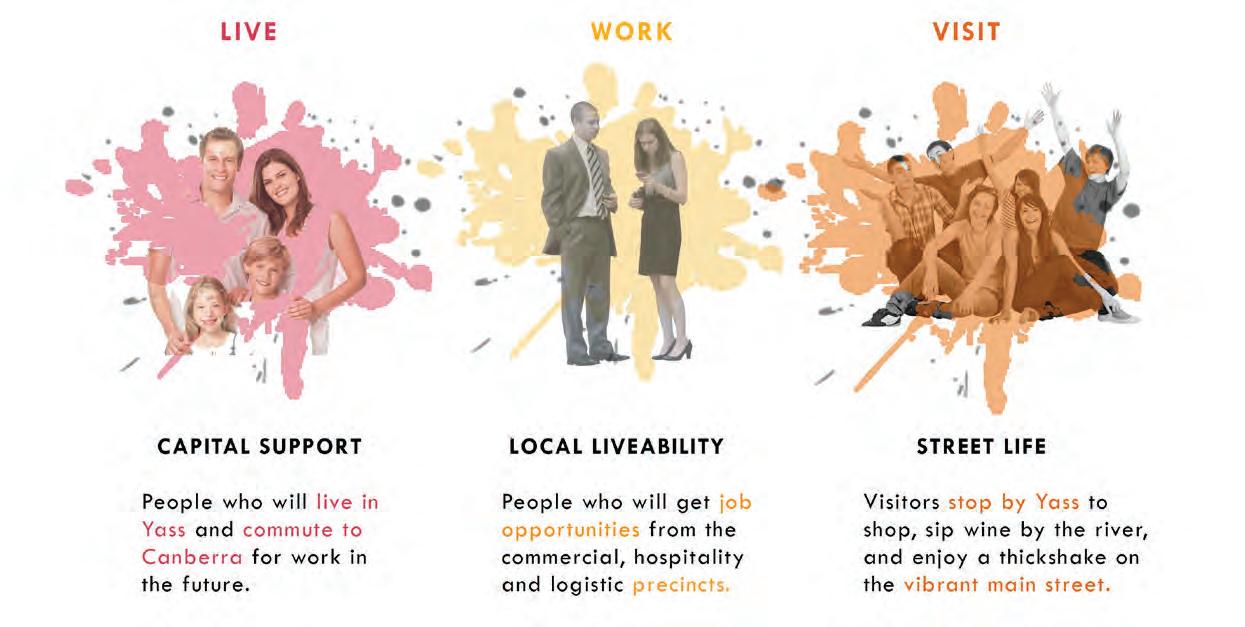
This strategic plan positions Yass as the central Interchange Nexus along Australia’s frst High-Speed Rail (HSR) corridor, connecting Sydney, Canberra, Melbourne and the Central West region. With its strategic location, Yass will enable strong connectivity between major cities and regional centres. The integration of the HSR and tram–train systems will enhance accessibility, foster regional development and support the decentralisation of populations from major cities. This 30-year implementation framework aims to balance long-distance travel with regional connectivity while addressing the challenge of new station placement to preserve the unique urban character of underdeveloped towns. Yass will evolve from a pass-through town into Australia’s most critical interchange—an economic catalyst for freight, a regional gateway supporting Canberra’s growth as the nation’s capital, and a civic spine enhancing rural access and resilience.
Jeremy
Urban Form and Design
This core unit in the Master of Urban Design and Urbanism introduces key concepts, tools, and techniques for understanding urban morpholog, the study of how cities take shape and evolve over time. It establishes a foundation in Indigenous concepts of Country and theories of place, identity, and positionality, encouraging participants to refect on their own experiences of place while critically engaging with the legacies of colonial-settler urbanism in Sydney.
Through lectures, discussions, and applied exercises, the unit explores how geography, infrastructure, policy, and culture intersect to shape urban form. A major group project invites participants to trace the evolution of an urban corridor, whether a waterway, railway, or road, to reveal the layers of history, planning, and lived experience that defne contemporary Sydney. By combining spatial analysis with cultural and historical understanding, the unit builds essential skills for observing, interpreting, and designing within complex urban environments. It positions urban design as both a technical and cultural practice, grounded in respect for Country and attentive to the diverse forces that continue to shape Australia’s cities.
URBAN FORM AND DESIGN COORDINATORS
Ian Woodcock
Martin Abbott
TUTORS
Martin Abbott
Denver Alcantara
Tomas Va Der Meer
Tamara Obradovic
Sherly Robert
Jialing Xie
Nan Ye
GUEST LECTURERS
Beau De Belle, ADP
Michael Kahn, DesignInc
Sydney
Dallas Rogers, ADP
STUDIO CRITICS
Boyd Barber, Sydney Metro
Catherine Gilbert, ADP
Fariz Hazmi, Hatch Global
Michael Kahn, Design Inc
Sydney
Carolina Pantoja-Mardones, ADP
Deena Ridenour, ADP
Irene Sarah, DesignInc
Sydney
Vera Xia, ADP
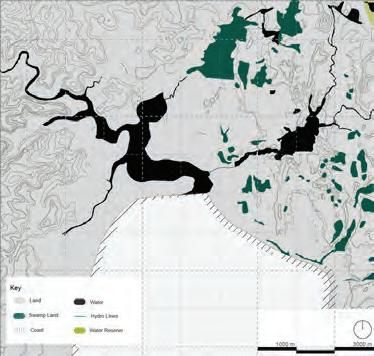
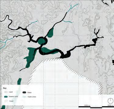
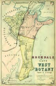
Lost Flora - Pre-colonial vs Present vegetation
Before pre-clearing, the Botany Road area was covered by a continuous mosaic of estuarine wetlands, coastal dunes, and inland forests. Today, most of this vegetation has disappeared due to urbanisation, with only small remnants of wetland, saltmarsh, and dune vegetation remaining along Botany Wetlands and Botany Bay.
Including reedlands, wetlands were lost through reclamation and canalisation, dunes were replaced by port, residential, and industrial development, and the inland Sydney Turpentine–Ironbark forest has been almost entirely cleared by urban expansion.
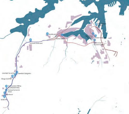
Country, Contours, and Connection - Aboriginal map 1770
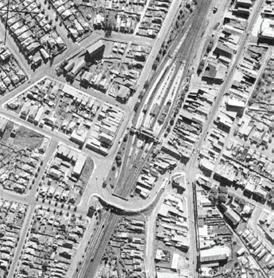
Industrial Nodes Along the Goods Line Corridor (c. 19 10’s)
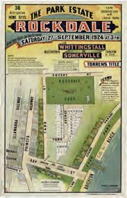
Subdivision Overlays (c. 1880’s): A. Central–Darling Harbor, B. Glebe–Lilyfield, C. Hawthorne–Lewisham West
Urban Design Foundations Studio
This studio unit is core to all Graduate programs in Urbanism (MURP, MUD, MUrbanism) and the Master of Transport. Students are introduced to foundational concepts in urban design through lectures, readings and weekly feldwork trips to diferent parts of Sydney.
The design studio allows multi-disciplinary groups to select a site from 26 station precincts and 15 wharf precincts to explore the challenges and opportunities for making more liveable, equitable and inclusive cities. Students are encouraged to explore a variety of diferent future scenarios for more sustainable transport, public spaces and signifcant local increases in population.
URBAN DESIGN FOUNDATIONS STUDIO COORDINATOR
Ian Woodcock
TUTORS
Denver Alcantara
Boyd Barber
Isabel Gabaldon
Oscar James
Liz Lester
Sherly Robert
Akshai Sabu
Tomas Van Der Meer
Jialing Xie
Nan Ye
GUEST LECTURER
Somwrita Sarkar, ADP
STUDIO CRITICS
Martin Abbott, ADP
Lekhana Chidanandaswamy, ADP
Fariz Hazmi, Hatch Global Michael Kahn, DesignInc
Sydney
Sephira Luo, ADP
Tamara Obradovic
Carolina Pantoja-Mardones, ADP
Peter Qian, NSW Department of Planning
Sherly Robert, Hector Abrahams Architects
Irene Sarah, DesignInc
Sydney
Ha Thai, ADP
Amy Tseng, Hatch Global Tomas Van Der Meer, City of Parramatta
Vera Xia, ADP
Nan Ye, ADP/UNSW
Overview of projects and proposed changes
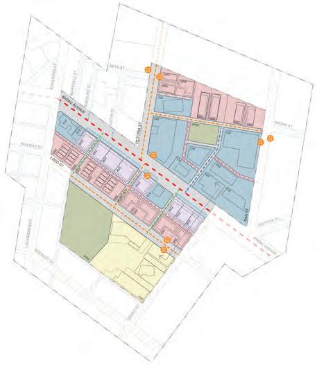
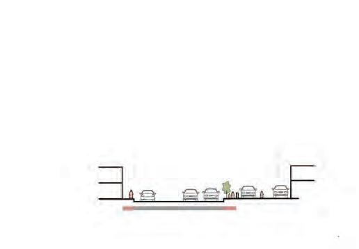
In sum, the proposed urban design framework, interventions and projects: enables a measured and siteresponsive doubling of the population within a 400m catchment of Rydalmere wharf responds to key weaknesses and threats across the site (flood risk, estbalished residential character) recognises and elevates existing strengths (riverfront, wetlands, open spaces) facilitates increased X-minute urbanism live, work, visit opportunities and integrates Rydalmere with surrounding hubs and precincts
Three-dimensional and mixed-use Bridge
• Discontinuous connection between the north and south banks
• Lack of people activities on the site
• Two stations and one wharf have low utilization rate
RAILWAY GREEN CORRIDOR
Reuse negative space and enhance accessibility
• Activate community vitality
• Prevents the space on both sides of the railway track from being divided.
• Provide more leisure and cultural facilities
Project 1: Active Transport Connectivity Cycling and micromobility network
Project 3: Improving economic vitality and social functions
Removing disused rail line to create direct connection to Hercules St
Wander People
GEORGINA N
Hercules St activation Green Verges Parklets
Wander People
Intensification
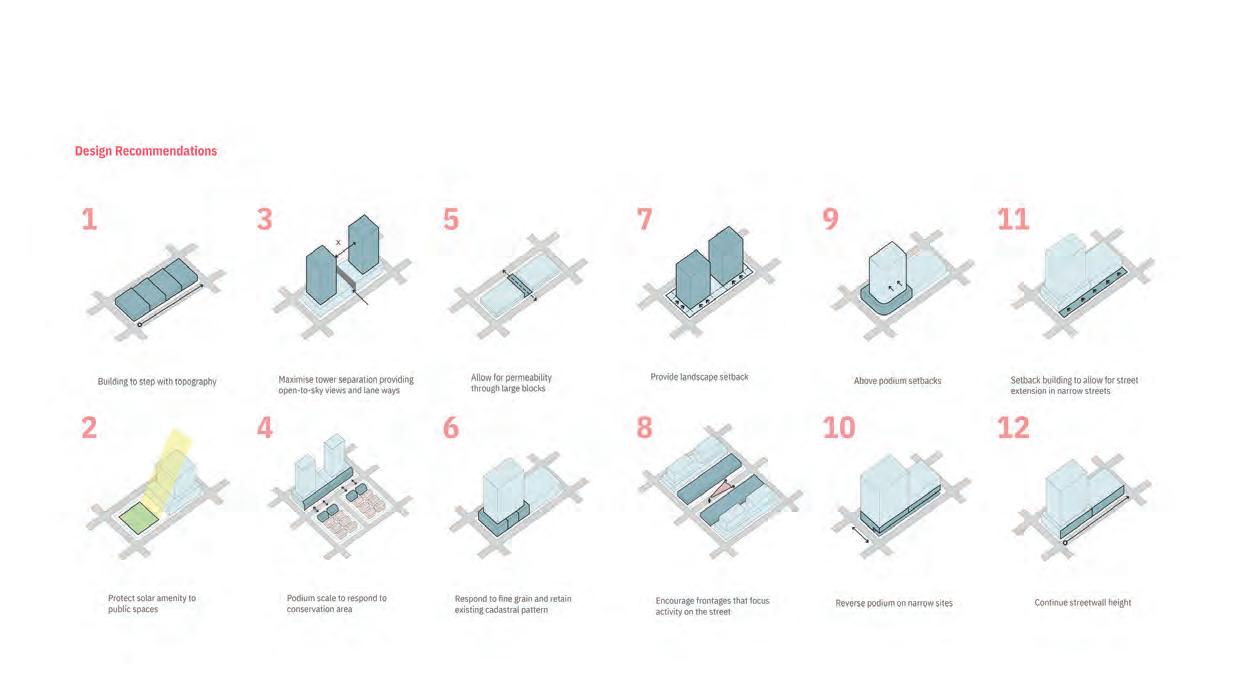
Design Recommendations
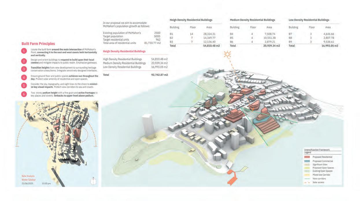
Paul Baker, Bethany Ngai, Anuya Barde, Alonso Rojas, Jack Elcombe, McMahons Point
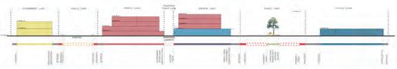
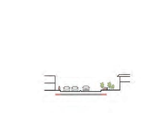
New Open Space
The open space strategy was developed to address key gaps identified in Ashfield: a lack of quality public areas, limited greenery, and few cultural or social gathering spaces. As population density increases, the need for well-designed, accessible open spaces becomes essential.
The proposal introduces three plazas and one park along the green spine, each with a distinct character and purpose. Together, they create a continuous network that supports daily life, connects culture and community, and strengthens Ashfield’s multicultural and economic identity.
Charlotte St.
Charlotte St.
A’Beckett Ave.
Hercules St.
Liverpool Rd.
Charlotte St.
Property and the Built Environment
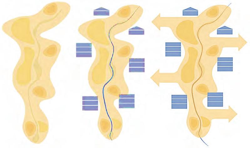
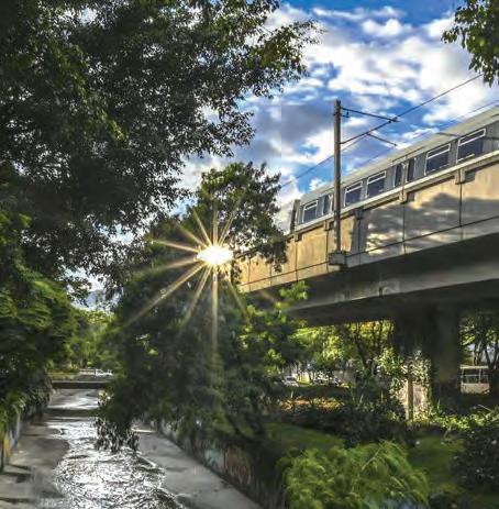
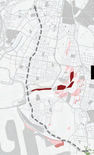
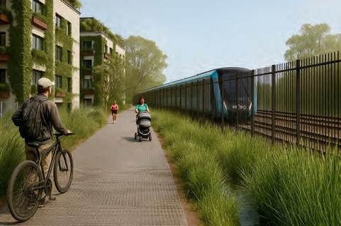
The Property and the Built Environment unit ofers a critical understanding of contemporary development processes in relation to its efects on cities, communities, and citizens; its role in the economy; and the many stakeholders involved. This year, students collaborated on zines that reimagine propertied relations in the Sydenham–Bankstown Renewal Corridor. Sydney’s new Metro line will transform this urban corridor when it opens in 2026. What does the Metro mean for past, present, and future communities living between Sydenham and Bankstown? How can we maintain and grow the social fabric of these communities? The assignment invited projects that interrogate the normative assumptions and tools shaping Sydney’s built environment. Each group adopted a stakeholder perspective and developed a proposal within one of two streams: property development or a socially minded initiative.
Zines merge visual and written content to engage audiences beyond traditional media, emerging in diverse printed and digital formats. Often subversive, zines challenge convention, and sometimes radically oppose it. In the classroom, the open format fosters creative and critical thinking, challenging students as zine-making is rarely straightforward.
The selected zines present proposals that sharply engage with contemporary property development in Sydney. They foreground bold ideas for afordable housing, community care, the climate and environment, and Indigenous relations. Taken together, they open dialogue among emerging urban professionals and Sydneysiders about how their city’s future could be otherwise.
Our proposal for Marrickville introduces policy changes to increase density while preserving the suburb’s eclectic and communal character. Community First ofers a socially minded refnement inspired by the Department of Planning’s Transport-Oriented Development proposal, which risks eroding Marrickville’s identity, heritage and diversity through unbalanced growth. Addressing the lack of supporting infrastructure, it advocates inclusive heritage renewal through adaptive reuse, community-led design panels, afordable cultural tenancies and character protection. Informed by research and governance context, it promotes sustainable growth that strengthens Marrickville’s cultural fabric, local economy and sense of belonging across the Inner West.
Cilla Louis
Jasmine Small
Jack Feilen
Sam Je s
Holly Bence
AFFORDABLE HOUSING ALONG THE METRO CORRIDOR
Our zine, Staying Local, explores how the Metro’s arrival can be used to deliver afordable housing and protect long-term residents from displacement in Sydney’s southwest. We have positioned ourselves as a non-proft Community Housing Provider (CHP) that has partnered with the Canterbury-Bankstown Council and Sydney Metro/TAHE. The Sydenham to Bankstown Metro upgrade promises major improvements in connectivity, accessibility and service frequency. Our project explores how the corridor’s publicly-owned rail edges and bufer zones can be a foundation for afordable and inclusive housing while ensuring the benefts of transport investment are shared by those who already call the corridor home.
How can the Metro’s arrival be used to deliver permanently affordable housing and protect long-term residents from displacement in Sydney’s southwest?
Cilla louis
Jasmine Small Jack Feilen Sam Jeffs Holly Bence
Yu Ching Chau
Yuanchao Hong
Steven Kwok
MID - R ISE MID - R ISE
BIG W E L COME BIG W E L COME
PILOT SITE
HURLSTONE PARK RENEWAL
Hurlstone Park: Mid-Rise, Big Welcome explores how transit-oriented and afordable housing strategies can rejuvenate one of Sydney’s quietest suburbs without erasing its heritage. Centred on Crinan Street beside the future Metro station, the project envisions a mid-rise, mixed-use community combining everyday shops, afordable homes and green public spaces. Through maps, policy analysis and design proposals, the zine demonstrates how sensitive urban renewal can connect fragmented centres, foster inclusivity and create a “car-lite” heart for Hurlstone Park. It celebrates sustainable growth, balancing density, community and character to model an equitable and replicable approach to Sydney’s suburban transformation.
Billy Tang
Zhen Lu
Hongyu Ge
Qianyu Chen
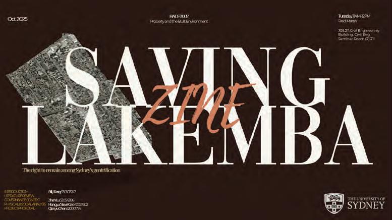
Situated within the Sydenham–Bankstown Metro Corridor, Saving Lakemba explores what it means to live, belong and evolve within a city that is constantly changing. Centred on the notion of the “right to the city”, it acts as a microcosm of the contemporary “progressively west” urban landscape that so often displaces and erases lived traditions in one of Sydney’s most culturally diverse suburbs. It proposes a ‘missing middle’ housing typolog that promotes modular, community-led housing initiatives responding to the identity of the communities that inhabit it. Rather than building over, we can build with those who already call Lakemba home.
Theone Angelopoulos
Pip Austin
Lili Beattie
Monique Gaul
Density Done Diferently begins with a simple provocation: displacement does not need to be an inevitable outcome of density. The Good Developer challenges the assumption that private markets alone can deliver socially useful density. Using Marrickville as our test case, we demonstrate how a publicly held ground-lease system, transparent feasibility and mixed tenures can support medium-rise housing while keeping long-term residents in place. Policy analysis, demographic evidence and a functional fnancial model combine to show that afordability is achievable when land is not sold to the highest bidder. The argument is simple: development can generate proft without hollowing out the communities it depends on.
COOL
Anna Browne
Ruolin Cui
Huaijin Dai
Rushan Yang
HEALTH + HEAT CORRIDORS
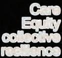
Cool Commons: Health + Heat Corridors reimagines Sydney’s western suburbs as networks of shared cooling infrastructure rooted in care, equity and collective resilience. Centred in Campsie and Bankstown, the project transforms overheated streets into “cool corridors” of shade trees, misting points and pocket parks co-designed by residents, schools and businesses. Guided by theories of the commons and supported by local and state policy, it connects environmental justice with public health and governance reform. Through community-led initiatives such as the Heat Equity Partnership and Adopt-a-Tree Challenge, Cool Commons demonstrates how everyday urban spaces can become inclusive, climate-resilient commons for all.
Reclaiming the Streets for
The Good Developer Proposal for the Marrickville Metro Station Precinct
Jacinta He
Alia Levi
Min-Han Hsieh
Yehyun Cho
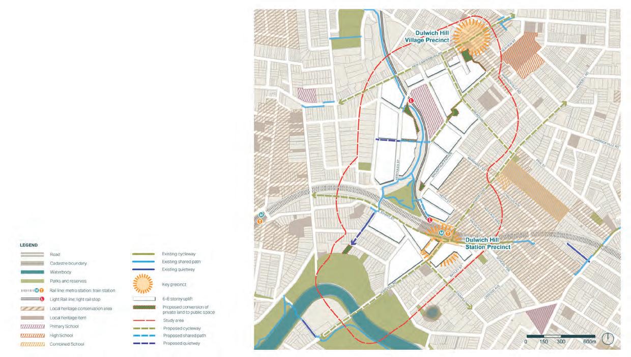
HIGH-DENSITY IN DULWICH HILL
Situated near the beginning of the Sydenham to Bankstown Urban Renewal Corridor, Dulwich Hill is undergoing rapid transformation driven by the Transport-Oriented Development (TOD) policy. However, the TOD’s social and ecological consequences often amplify existing suburban challenges. In Dulwich Hill, environmental degradation is of particular concern, as diminishing habitats and a poorly designed built environment have contributed to a suburb lacking biodiversity and community connection. Our project reimagines high-density development within the TOD framework, weaving nature into the urban fabric through a regenerative lens and envisioning humans as participants with, and as, nature, co-evolving as they seek to dismantle their separation.
Freya Power
Neam Alnejadah
Mannav Badal
Vasilisa Ragulina
Wiley park iley pa
Threads of Wiley: Weaving Culture, Living, & Enterprise
Threads of Wiley is an urban-focused proposal for the suburb of Wiley Park in the City of Canterbury-Bankstown. Its core objective is to address the lack of amenities for the area’s signifcant migrant and refugee community. The project centres on creating a multilingual and multicultural dwelling that integrates business opportunities and training for tenants, supporting social and economic acclimatisation. Adopting a retroft and renewal approach to an existing block, the design is structured around three interlocking layers: living (multigenerational duplexes), civic (a social anchor with job support), and green (shared courtyards). This strateg fosters social cohesion and local economic opportunity by building on the suburb’s diverse character.
How can high-density be developed with a human-environmental partnership?
Urban Report
The Urban Report is a major research project completed over one semester, designed to simulate the process of working within an urban research consultancy. Each report responds to a specifc research brief and is presented as a written and illustrated document of 5,000–10,000 words. Through this project, participants develop advanced skills in research, analysis, and communication within a professional urbanism context.
Depending on the brief, the report may take diferent forms: a practically focused study such as the preparation of an urban design or development proposal; a theoretically driven exploration that reviews key concepts and frameworks; or an investigation that bridges theory and practice, testing ideas through contemporary urban issues.
At its core, the Urban Report is an opportunity to deepen understanding of urban systems, design processes, and governance frameworks. It encourages independent inquiry, critical thinking, and evidence-based argumentation, while fostering the ability to communicate complex urban ideas clearly and persuasively. Ultimately, the project strengthens professional capabilities in research and reporting—key foundations for contributing meaningfully to the evolving practice of urbanism.
URBAN REPORT
COORDINATORS
Yoshimi Hasegawa
Nancy Marshall
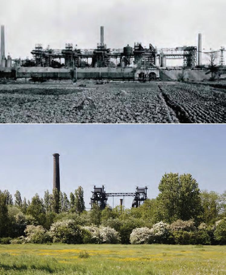
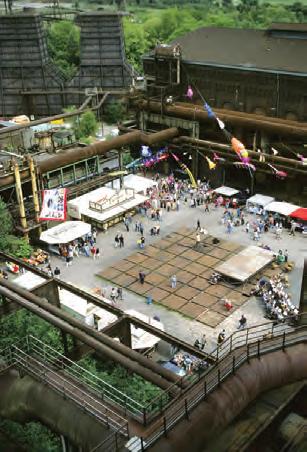
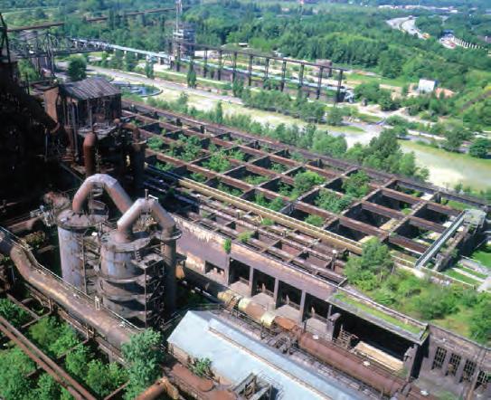
Figure 1 and 2. Landschaftspark at Duisburg
In the context of the current climate crisis, it is well established that anthropogenic activity has pushed natural systems out of balance. As a result, 90 per cent of present-day natural disasters can be directly attributed to climate change. Extreme weather, food and water scarcity, rising sea levels, forest fres and ocean acidifcation are afecting species across the planet.
Over the years, cities have developed primarily to serve human populations, causing detrimental impacts on other natural systems. Although cities cover just 3 per cent of the planet’s land surface, they consume two-thirds of the total energ demand and are responsible for 70 per cent of carbon dioxide emissions. Climate mitigation and resilience eforts therefore need to target their largest source of disruption—our cities.
If the anthropocentric nature of cities is disrupting natural and regulatory ecosystems, then carving out spaces within urban environments that cater specifcally to fauna and fora could help re-establish these systems, strengthen the green–blue grid and potentially create self-sustaining ecosystems within cities. David Foreman frst coined the term re-wilding in 1992 through his vision of creating a network of protected green spaces across North America to support native species populations. While the term is now widely used across projects of varying scale and character, re-wilding involves the ecological restoration of functional and resilient ecosystems through the recovery of native fauna and fora in balanced numbers.
This report explores how re-wilding interventions, particularly in post-industrial or disused urban spaces, afect biodiversity values and reshape spatial quality through ecological, social and emotive dimensions. To fully comprehend the benefts and impacts of re-wilding, several projects of varying scales were studied, alongside diferent metrics and frameworks for assessing climate change mitigation and adaptation. Using inferences from these studies, a framework was developed across six themes to holistically evaluate the outcomes of re-wilding projects. This was then applied to the post-industrial landscape of Landschaftspark Duisburg-Nord in Germany and refned based on the fndings of this assessment.
From the study of re-wilding projects and the evaluation of Landschaftspark Duisburg-Nord, it is evident that a single project can produce far-reaching outcomes and that community and government engagement is pivotal to its success. By efectively assessing and accounting for all benefts, stronger advocacy can be made for the wider implementation of re-wilding projects.
Landschaftspark Duisburg-Nord demonstrates how complex ecological processes can adapt to, and create resilience within, unconventional environmental conditions. It makes a strong case for the implementation of re-wilding, over conservation or basic remediation, at post-industrial sites, and highlights the potential for using nature-based solutions to reinstate complex systems. Projects such as Landschaftspark have become instrumental benchmarks for more recent transformations, including the High Line in New York, the restoration of the Utrecht Canal in the Netherlands and the Cheonggecheon River in Seoul. While these projects still lean towards conservation rather than allowing nature to evolve freely, further experimentation in the spirit of Landschaftspark would deepen understanding. With so many uncertainties, experimentation remains the most efective way to determine what is feasible on a given site. The greater the number of implemented projects, the richer the data and insights that can inform future re-wilding eforts.
Reinstating nature does not imply the exclusion of people from natural environments. A carefully crafted balance can be achieved between core natural spaces, left largely untouched, and recreational spaces where people can enjoy the benefts of nature. The way Landschaftspark integrates human activity with natural growth allows for cultural and recreational use while promoting eco-tourism—a means to generate revenue and safeguard the site’s future.
The success of this project lies in its balance between the natural and the manmade, between human spaces and wilderness, and between intervention and the freedom of natural processes. The resulting transformation is a testament to the potential of re-wilding to unlock ecological, social and cultural value—even on land once contaminated and forgotten.
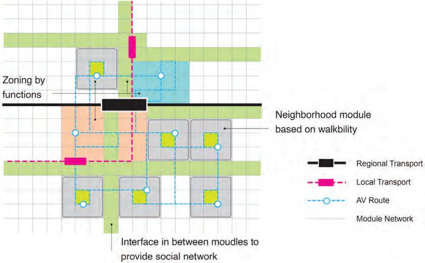
Modern cities have long struggled with trafc congestion and car dependency. Streets built primarily for vehicles have reduced space for people, weakened walkability and diminished urban liveability. Reclaiming Urban Space explores how the arrival of autonomous vehicles (AVs) could provide an opportunity to redesign the city around people rather than cars. Instead of allowing technolog to dominate public space, the project asks how AVs can help create safer, more connected and more human-centred urban environments.
The research begins by tracing how the car shaped cities throughout the twentieth century. After World War II, many countries rebuilt rapidly through car-focused planning. While cars brought convenience and mobility, they also led to urban sprawl, pollution and the erosion of public life. Today, as technolog advances at an unprecedented pace, cities are searching for new models that balance mobility with sustainability and quality of life. AVs represent both a challenge and an opportunity: they could either repeat the same mistakes or become tools for reclaiming urban space for people.
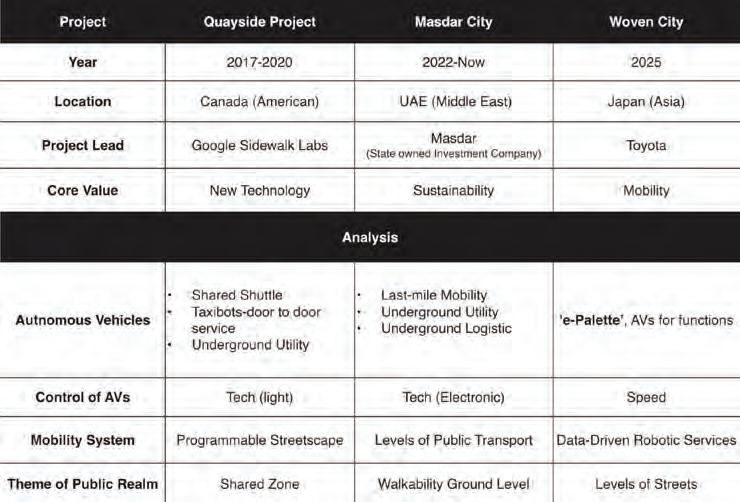
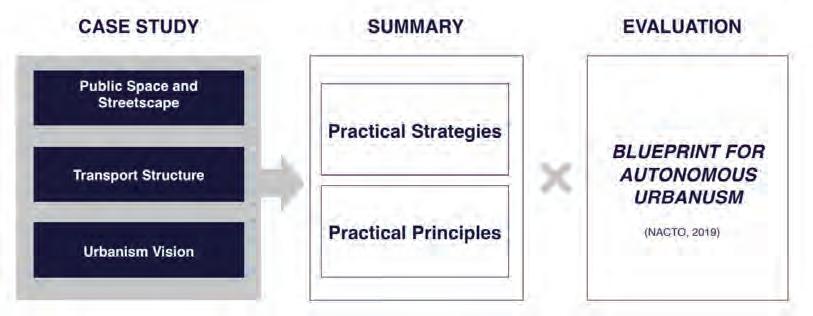
Using NACTO’s Blueprint for Autonomous Urbanism as a theoretical foundation, this project evaluates how AVs might be integrated into existing urban systems while enhancing public life. The research adopts a multilayered methodolog combining literature review, policy analysis and global case studies, including Sidewalk Labs’ Quayside (Toronto), Masdar City (Abu Dhabi) and Toyota’s Woven City (Japan). Together, these precedents illustrate global experimentation in balancing technological innovation with social and spatial equity. Each reveals a distinct dimension of the AV transition: Quayside’s dynamic modular streetscape, Masdar City’s low-carbon mobility ecosystem and Woven City’s human-centred “living lab” that integrates autonomous mobility, data and community life.
Through comparative analysis, the research identifes recurring themes that shape the autonomous urban future: the relationship between mobility and spatial hierarchy, the evolution of the street as a social stage and the growing importance of digital governance. It argues that AVs, when positioned as public infrastructure rather than private products, can fll critical gaps in public transport, particularly the “last-mile” connection, while freeing surface space for pedestrians, green networks and community uses.
The project proposes an urban framework structured around three pillars: public transport systems, streetscape transformation and digital infrastructure. Public transport remains the backbone of the city, with AVs operating as shared, adaptive extensions that enhance accessibility without undermining collective mobility. Streets become multifunctional public spaces, hybrid corridors that prioritise walking, cycling and social interaction. Meanwhile, robust digital networks and transparent data governance are recognised as essential civic infrastructure, shaping how autonomous systems operate and how equitably they serve the public realm.
Ultimately, Reclaiming Urban Space calls for a human-centred approach to autonomous urbanism. It challenges the notion that technological progress must come at the expense of community and place. Instead, it envisions a future where AI-driven mobility enhances rather than replaces public life, creating a city where autonomous vehicles move seamlessly alongside pedestrians and digital systems strengthen civic trust. Through this lens, the project reframes automation as an instrument for reclaiming urban space, advancing sustainability and fostering social connection in the age of intelligent mobility.
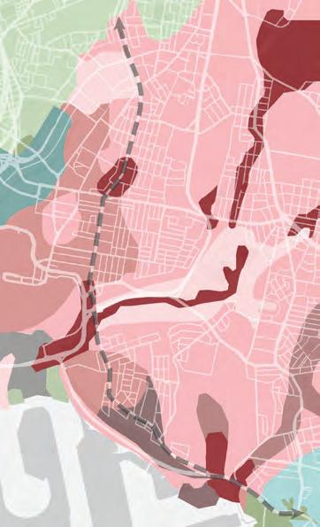
Comparative review of planning systems and lessons for NSW
This unit explores contemporary land use and environmental planning systems in Australia, with a focus on statutory planning and development assessment in NSW. It examines key legal and institutional frameworks, familiarises students with state and local planning instruments, and introduces planning processes. The unit also prepares students for professional practice by developing their understanding of public participation in planning and the ethical responsibilities of planners in decision-making.
For their second assessment, students were asked to compare the local plan for a NSW local government, and the wider planning system it sits within, with that of another jurisdiction in Australia or overseas. They examined government roles in planning and the legal foundations for planning, as well as the applicable policy instruments, and development control approaches. Students were asked to examine each plan and its wider planning system in relation to a topic of their choosing. Selected topics included vertical integration; how accessible the planning system is to the public/non-experts; and how it addresses contemporary challenges including fooding, urban heat, biodiversity protection, housing afordability and heritage. Students concluded with insights and recommendations for the NSW planning system. The following extracts showcase their thematic analyses.
PLANNING PRINCIPLES, SYSTEMS AND PRACTICE
COORDINATOR
Catherine Gilbert
TUTORS
Amit Bhattarai
Prudence Hudson
Jacqueline Tyrrell
STUDIO CRITICS AND CONTRIBUTORS
Giovanni Cirillo, Planning Lab
Elle Davidson, Zion Engagement and Planning/ ADP
Stacey Miers, Shelter NSW
Yolande Stone, Department of Planning, Housing and Infrastructure
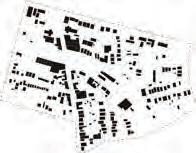
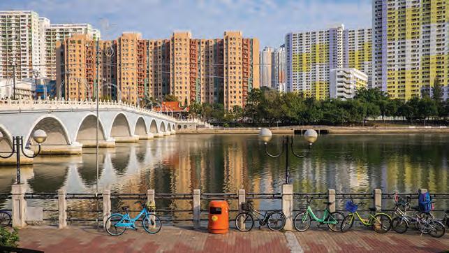
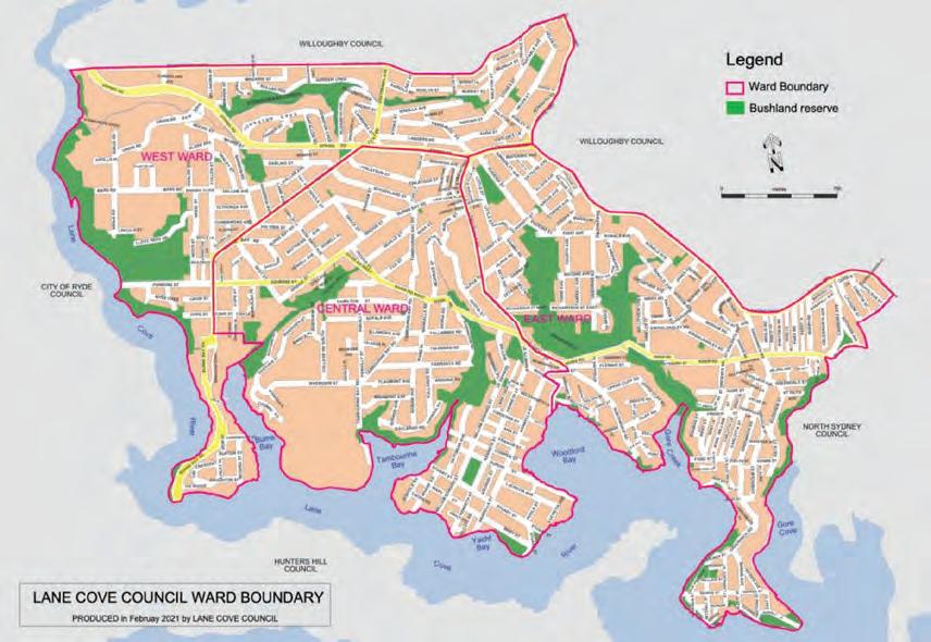
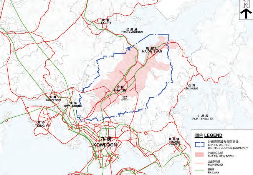
Figure 1. Sha Tin, Hong Kong, Source: Hong Kong Tourism Board
Bethany Ngai, Emilie Trevallion, Comparative review of planning systems and approaches in Lane Cove, NSW and Sha Tin, Hong Kong
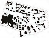
This assignment compares the local planning systems of Lane Cove, New South Wales (NSW), and Sha Tin, Hong Kong, examining how diferent governance structures shape local planning outcomes. Lane Cove is an established suburb on Sydney’s Lower North Shore operating within a multi-level planning framework under the Environmental Planning and Assessment Act 1979. Its planning system emphasises community participation, ecological sustainability and alignment between state and local plans. In contrast, Sha Tin is a planned suburban district developed under Hong Kong’s Town Planning Ordinance (TPO). It forms part of a centralised and efciency-driven planning model where authority is concentrated in the Town Planning Board. Both areas face pressures from urban growth and environmental conservation, yet their approaches difer markedly in fexibility, integration and public engagement. The comparison highlights how governance scale and statutory design infuence sustainable and participatory planning outcomes.
The theme of vertical integration evaluates how efectively planning systems connect strategic objectives at higher levels with local implementation. A well-integrated system maintains a “line of sight” between policy intent and development outcomes.
In New South Wales, vertical integration is reinforced through a structured hierarchy of legislation and plans. National environmental laws, such as the Environment Protection and Biodiversity Conservation Act 1999, set overarching conservation goals that cascade through state-level instruments like the Environmental Planning and Assessment Act (EP&A Act), State Environmental Planning Policies (SEPPs) and regional strategies such as the Greater Sydney Region Plan. At the local level, these priorities are expressed in statutory tools such as the Lane Cove Local Environmental Plan (LEP 2009) and Development Control Plan (DCP 2010). This creates a consistent and transparent framework in which local decisions align with broader state and national objectives. However, the system can be rigid, as state-level SEPPs override local planning discretion, limiting responsiveness to local conditions.
By contrast, Hong Kong’s planning system under the Town Planning Ordinance (TPO) is highly centralised. The Town Planning Board (TPB) controls both strategic and statutory planning, preparing Outline Zoning Plans (OZPs) that legally defne land uses across districts. This produces strong top-down coherence and statutory certainty, particularly in environmental zoning such as “Green Belt” and “Country Park” areas. However, this model limits fexibility and local participation: district councils act only in an advisory capacity, and social goals such as afordability or community inclusion are largely absent from zoning instruments.
Overall, Lane Cove’s planning framework demonstrates greater inclusiveness and accountability, integrating social, environmental and economic goals through multi-level coordination. Sha Tin’s model delivers efciency and clarity but lacks adaptability and cross-sectoral collaboration. The comparison underscores the balance between coherence and fexibility needed for efective vertical integration.
Figure 1. Lane Cove, NSW, Source: Lane Cove Council (2021)
From our comparative review, we recommend that NSW simplify its planning layers to improve coordination between SEPPs, regional plans and local instruments, which will ensure faster and clearer decision-making. We also propose that NSW adopt elements of Hong Kong’s Country Parks Ordinance, which promotes environmental awareness through public access and education, ultimately fostering stronger community stewardship.
Figure 2. Sha Tin, Hong Kong, Source: Planning Department (2022)
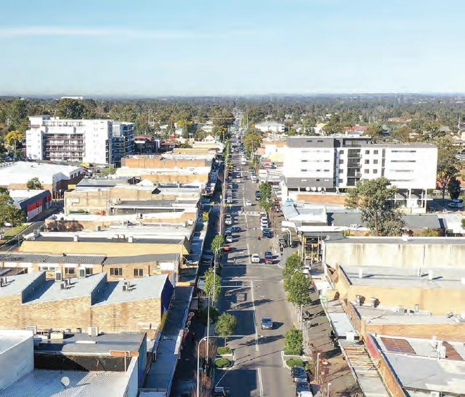
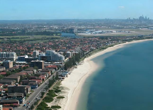
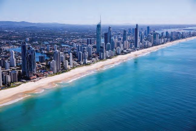
This assignment provides a comparative analysis of the planning systems and local plans of Bayside Council (New South Wales) and the City of Gold Coast (Queensland). Bayside Council is located within the Greater Sydney metropolitan area and extends around the northern side of Botany Bay. The City of Gold Coast lies in South East Queensland and is the state’s south-easternmost Local Government Area (LGA), bordering New South Wales.
While the case studies difer signifcantly in size and urban form, both LGAs have experienced substantial growth in recent years, with populations increasing by around 20 per cent over the last decade. Both are coastal, high-growth LGAs that share similar environmental challenges but operate under diferent statebased planning frameworks. This report compares governance structures, planning legislation, local planning instruments, development control mechanisms, community consultation practices and, in particular, the accessibility of planning information in both jurisdictions.
Comparing Accessibility
Accessibility in planning relates to how easily members of the public can understand planning instruments, identify development controls applying to their land and participate in decision-making.
In both states, a principal planning act establishes the basis of the system: the Environmental Planning and Assessment Act 1979 in NSW and the Planning Act 2016 in Queensland. The NSW system creates a fragmented regulatory environment in which planning controls are distributed across State Environmental Planning Policies (SEPPs), the Local Environmental Plan (LEP), the Bayside Development Control Plan (DCP) and a series of technical specifcations. The City of Gold Coast adopts a diferent approach, as its local planning scheme, the City Plan, operates as a comprehensive framework. All zoning, overlays, development codes, relevant state interests and regional objectives are consolidated within this single scheme. The integrated nature of the City Plan makes it easier to navigate than the fragmented framework in NSW, where users must consult multiple documents across diferent levels of government.
The City Plan includes an interactive map showing planning information such as zoning and applicable overlays. When selecting a site, the system generates a property-specifc report listing all relevant mapping content. By contrast, Bayside Council provides only a digital map with limited information, which is noninteractive and potentially unintuitive for frst-time users. Furthermore, DCP controls are excluded from this map and must instead be accessed through multiple static PDF fles.
The accessibility of planning information is also afected by language and presentation. Both LGAs supplement regulations with illustrative images to clarify rules and standards. The City Plan includes more diagrams and photographs, with zoning and overlay codes supported by illustrations. Queensland planning documents generally use simpler, more accessible language and colourful graphics, making them easier to understand for members of the public unfamiliar with planning terminolog. However, statutory acts in both states remain written in formal legal language.
The process and impact of making submissions on development applications or plan amendments are similar in both LGAs. Exceeding statutory minimums, the City of Gold Coast and Bayside Council both ofer userfriendly online engagement portals, GC Have Your Say and Have Your Say Bayside, which list projects currently open for public consultation. These platforms enable submissions on statutory plan amendments, strategies and public realm projects.
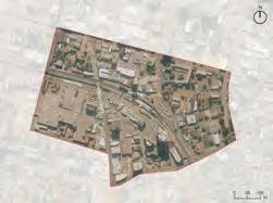
Figure 1. Aerial view of Bayside Council from Visit Sydney Australia
Recommendations for Bayside and NSW
To address the fragmentation of planning frameworks, a central planning portal should be developed to integrate relevant development controls in one place. This portal should be interactive, use plain language and include an option to generate automatic site-specifc reports. Additionally, Have Your Say Bayside should be expanded with explanatory materials and visual guides to support community participation. These actions would retain NSW’s existing legal structure while improving accessibility, reducing confusion and enhancing transparency. Further recommendations from the full report include explicitly integrating climate change mitigation and adaptation into Bayside’s and NSW’s planning objectives, as well as introducing medium-density complying development categories to help ease pressure on Sydney’s housing market.
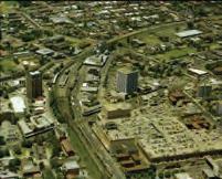
Figure 2. Aerial view of the City of Gold Coast from Global Work & Travel
Catherine Zhou, Jane Huang,
A Comparative Review of the Planning Systems and Approaches in Northern Beaches (Sydney) and Wyndham City (Melbourne) LGAs
This report compares the planning systems and approaches adopted by two case study Local Government Areas (LGAs): Northern Beaches Council (NSW) and Wyndham City Council (VIC). It examines governance layers, overarching legislation, local instruments, development control mechanisms and consultation approaches.
Both LGAs are located within Australia’s largest metropolitan regions and operate within difering yet complex multi-scalar planning frameworks that link local, regional, state and Commonwealth-level systems. Each faces signifcant environmental challenges associated with coastal wetlands, biodiversity and bushfre risks while undergoing rapid urban growth. These shared characteristics make them particularly suitable for comparative analysis, especially in understanding how planning systems address ecological resilience.
Comparison
Both Northern Beaches and Wyndham City are characterised by extensive networks of wetlands, estuaries and coastal foreshores that play critical ecological roles in supporting biodiversity and community connection. Each council faces the challenge of establishing long-term ecological protection and addressing climate change threats while accommodating growth and urban development pressures. Although both councils’ plans acknowledge the principles of ecologically sustainable development and public participation, neither consistently embeds Indigenous knowledge or formal co-management arrangements within statutory instruments.
The Northern Beaches multi-scalar planning framework, comprising State Environmental Planning Policies (SEPPs), Local Environmental Plans (LEPs) and Development Control Plans (DCPs), creates a complex system for managing coastal and wetland areas. Land use zoning provides immediate protection through Waterway and Conservation zones, which heavily restrict permissible uses and forms of development. These measures prevent medium to high-density residential and other intensive land uses from being proposed on environmentally sensitive or high-risk sites.
The LEP also includes provisions mandating Development Applications (DAs) to address environmental concerns and hazards around coastal and wetland areas, supported by visual mapping tools such as the Foreshore Building Line Map and Coastal Risk Planning Map. The Pittwater 21 DCP complements the LEP by providing detailed hazard and design controls. Section B3 specifcally outlines requirements for development near coastal and estuarine lands, including assessments for sea level rise. However, while these provisions provide a framework for environmental risk assessment, their reliance on objectives rather than measurable standards introduces limitations in enforcement and consistency.
Wyndham City Council demonstrates a proactive approach to managing its coastal areas and wetlands through the Wyndham Coastal and Marine Management Plan 2020–2025 (WC&MMP). The plan’s strengths include its integration with other legislation, strong community engagement, improved public amenities and accessibility, and a focus on place-based precinct planning. Although the WC&MMP itself lacks statutory weight, these environmental controls are supported by the Wyndham Planning Scheme, which is built upon the Victoria Planning Provisions (VPP) framework. This structure ensures state-wide consistency while allowing local adaptation.
Figure 1. Northern Beaches Council Area Aerial View
Relevant VPP clauses such as Clause 12.02-2S (Coastal Areas) and Clause 12.01-1S (Protection of Biodiversity) guide councils to avoid development in vulnerable coastal areas, protect signifcant wetlands and native vegetation, and integrate climate change adaptation into land use decisions. Environmental Signifcance Overlays (ESOs) and Vegetation Protection Overlays (VPOs) are used to protect sensitive environments, including parts of the Western Treatment Plant wetlands. However, there is no overarching plan with site-specifc goals for the protection of this signifcant ecological area.
While both councils identify climate resilience as a strategic objective, implementation mechanisms are uneven. Sea level rise projections and erosion risks are acknowledged but not always translated into enforceable controls or development restrictions. Furthermore, the heavy reliance on performance-based criteria can lead to variable interpretation and weaker enforcement.
Conclusion
The NSW planning system could draw on Victoria’s consolidated planning scheme model to integrate state and local policies within a single statutory instrument, thereby strengthening enforceability and providing comprehensive wetland mapping. This could include expanding overlay schedules and establishing dedicated conservation zones.
To strengthen public engagement during the early stages of Development Application (DA) submissions, it is recommended that all NSW LGAs adopt multiple notifcation channels, beyond the current reliance on online exhibition, for planning scheme amendments and development applications.
PUBLIC PROGRAM
Lectures and events
10 DECEMBER
New Attitudes: Indefnite Plans
Bangkok Tokyo Architecture
11 DECEMBER
New Attitudes: C34 BAST
14 FEBRUARY
Financialising Intelligence: AI, Economics, and Reactionary Politics
Orit Halpern
19–21 FEBRUARY
Australasian Housing Research Conference: Housing at a Crossroad: Wealth, Inequality and Housing Futures
14 MARCH
Design for Disaster: Tackling Heat and Fire
Ashley Dunn, Stewart Monti, Shamila Haddad, Dagmar Reinhardt
14 MARCH
Design for Disaster: Tackling Water and Flood
John de Manincor, Stewart Monti, Lucy Marshall, Deena Ridenour
12 MARCH
Book talk: Assembly by Design
Olga Touloumi
13 MARCH
Beyond the Workplace Zoo: Humanising the Ofce
Nigel Oseland
21 MARCH
Histories of Architecture and Built Environments group Home Game Research Review
26 MARCH
Interaction Design Networking Meetup
1 APRIL
Countering spatial injustice in the U.S.: The promise of “zoning for equity”
Rolf Pendall
2 APRIL
Book talk: After Spaceship Earth
Eva Díaz
3 APRIL
Raising the Bar: Housing Essentials for Equitable Cities
Catherine Gilbert
9 APRIL
Digital Decarbonisation Plans in Taiwan, Japan and Australia SungYueh Perng
9 APRIL
Book talk: Is Architecture Art?
John Macarthur
9 APRIL
New Attitudes: The Way Things Go
Theo De Meyer
10 APRIL
New Attitudes: Refections on Life
Stefanie Everaert
10 APRIL
Questioning the great Australian Dream?
Anthony Burke, Nicole Gurran, Gavin Wilson, Catherine O’Donnell, David Burdon
17 APRIL
Design at Dusk
Heather Horst, Tram Tran
30 APRIL
Broken Links: The Value Housing Chain
Fatou K. Dieye
1 MAY
RENEW: Collaborative and Sustainable Practices for Multi-unit Housing Renovation Symposium
1 MAY
Friends of Figma: Designing for All: Inclusive Practice for Better Experiences
Dominic Kirkwood, Pawel Wodkowski
3 MAY
Australian Architecture Conference: Architecture in Action
3 MAY
Australian Architecture Conference: Designing the Elizabeth Line - Shaping London’s Future Transit
Neil McClements
3 MAY
Australian Architecture Conference: Australasian Student Architecture Congress
14 MAY
Book talk: Spatial Theories for the Americas
Fernando Luiz Lara
29 MAY
Money Talks
Taylor Hardwick, Marcus Carter, Tianyi Zhangshao
29 MAY
Design at Dusk
Carlos Tirado Cortes, Muhammed Yildirim, Jared Berghold
12 JUNE
Retroftting Suburbia for Urgent Challenges
Ellen Dunham-Jones
1 AUGUST
EMBARK Careers Festival and Networking Meetup
1 AUGUST
Urban Rural Commons: Japan Documented on Cards
5 AUGUST
Reclaiming Memory: The Sexto Panteón and the Forgotten
Architect Itala Fulvia Villa
Léa Namer
11 AUGUST
Scholarships and Prizes Night
13 AUGUST
Soft Architecture: Afro-Indian Spatial Strategies under Hard Migrations
Amina Kaskar
27 AUGUST
Architectural Encounters in Asia
Pacifc
Amanda Achmadi, Paul Walker, Soon-Tzu Speechley
28 AUGUST
Design at Dusk
Leigh-Anne Hepburn, Adeola Bamgboje-Ayodele, Yaron Meron, Phillip Gough, Carlos Tirado Cortes, Marius Hogenmueller
1 SEPTEMBER
Paradigm Shift in Evidence-Based Policy Development for Education Buildings: Mitigation, Adaptation and School Environments
Conducive to Learning
Dejan Mumovic
2 SEPTEMBER
Lloyd Rees and the Architects
Simon Weir, Ross Wilson
9 SEPTEMBER
Renewing the Sculpture Garden
Will Fung, Johnny Ellice-Flint, Robert Champion, Phillip Arnold
14 SEPTEMBER
Festival of Urbanism: Regenerative Creative-led Urban Development: Danks Street South Precinct Visit
Heidi Axelsen, Hugo Moline
15 SEPTEMBER
Festival of Urbanism: Thriving Cultural Ecologies: Making Spaces and Systems for Creative Practice
Kate Goodwin, Mat Levinson, Heidi Axelsen, Hugo Moline, Michelle Tabet, Rebecca Conroy
15 SEPTEMBER
Festival of Urbanism: Regenerative Country, Community, Culture
Peter Cooley, Koolyn Gordon, Daryl Wells, Jess Herder
15 SEPTEMBER
Festival of Urbanism: Regenerative Spaces? Public Art and Engagement in Urban Placemaking
Tina Havelock Stevens, Michael Dagostino, Nicole Gurran, Enya Moore
16 SEPTEMBER
Festival of Urbanism: Roads to Regenerative Urbanism
Jennifer Kent, Sara Stace, Eamon Waterford, Kevin J. Krizek
16 SEPTEMBER
Festival of Urbanism: Regenerating Civics: Urban AI, Social Media and Post-Truth
Luke Hespanhol, Rose Jackson, Marcus Foth, Christine El-Khoury, Justine Humphry
17 SEPTEMBER
Festival of Urbanism: Urban Rewilding: Nature-based Solutions for Resilience and Regeneration
Dan Penny, Jo Gillespie, Genevieve Wright, Robert Allen, Emily Fern Strautins
17 SEPTEMBER
Festival of Urbanism: Urban Regeneration or Regenerative Urbanism?
Alexandra O’Mara, Alistair Sisson, Louise Crabtree Hayes, Caroline Pidcock, Emily Rowland
17 SEPTEMBER
Festival of Urbanism: Debate: That Housing “Abundance” is the Solution
Nicole Gurran, Tina Perinoto, Patrick Fensham, Jess Scully, Steven Rowley, Ben Hendriks, Mehnaaz Hossain
18 SEPTEMBER
Festival of Urbanism: Many Hands, Many Actors, Many Ideas: Unpacking Parramatta’s Urban Design
Deena Ridenour, Kelly Van Der Zanden, Philip Graus, Phillip Vivian, Callantha Brigham, Gigi Lombardi
18 SEPTEMBER
Festival of Urbanism: Regeneration for the Next Generation
Natalie Lawrie, Colin Finn, Aaron Petersen, Akshaisankar Sabu, Lucy Band
19 SEPTEMBER
Festival of Urbanism: Reclaiming Tomorrow: Artists’ Visions for a Regenerative Future
Kate Goodwin, Anne Loxley, Jonathan Jones, Cat Jones, Liza Lim
19 SEPTEMBER
Festival of Urbanism: Connections across time and place: City Art Walk
Barbara Flynn, Jonathan Jones
23 SEPTEMBER
Parlour Sydney Student Salon Honey Amartuvshin, Simone Carmody, Ruby Mathews
24 SEPTEMBER
Green Pathways: Building a career in sustainable architecture, design and planning
Joanne Andrade, Yen Dao, Emily Chung, Natalia Saavedra Toro
24 SEPTEMBER
In the Daylight of Our Existence Architectural History and the Promise of Queer Theory
S.E Eisterer
25 SEPTEMBER
Design at Dusk
Karen Gallagher, Thom Loveday, Michelle Thomson
2 OCTOBER
Festival of Urbanism: Live Performance, Placemaking and the Arts; Creative Industries and Precincts for Regenerative Urbanism
Greta Werner, Emily Collins, George Tulloch, Ruth Callaghan, Chris Gibson
7 OCTOBER
Book launch: The Appian Way
Ross Anderson
14 OCTOBER
Competition Days: National Gallery of Victoria
Angelo Candelapes
28 OCTOBER
Façade Futures: Academia–Industry Collaboration for Planetary Solutions
29 OCTOBER
Book talk: Pistols in St Paul’s: Science, Music and Architecture in the Twentieth Century
Tin Sheds Gallery is a contemporary exhibition space located within the Sydney School of Architecture, Design and Planning at the University of Sydney that has been a site for radical experimentation for over 50 years. It provides a public platform for projects that inspire the imagination and ignite critical dialogue—addressing the diverse forces that shape the built environment locally and internationally.
The Tin Sheds ofcially opened in 1969 as an autonomous art space on City Road within the university grounds, facilitated by artists, academics and students. It spurred a pivotal historical movement in Australian art, nurturing cross-disciplinary experimentation and politically orientated practices for several decades. In 1989 it ofcially joined the School delivering art workshop classes. In 2004, it relocated to a purpose-built gallery onsite and became operationally integrated with the School.
The gallery’s mission is to foster and advance debate about the role of architecture, art, design and urbanism in contemporary society through the production of innovative exhibitions, publications and related activities.
ADVISORY GROUP
2025 PROGRAM
Deborah Barnstone
Guillermo Fernández-Abascal
Kate Goodwin
Yaron Meron
Eva Rodriguez Riestra
Emrah Baki Ulas
GALLERY MANAGER
Iakovos Amperidis
INSTALLERS
Sarah Anstee
Julien Bowman
Mac Mans eld
Image credit: RoXY, Juha van ‘t Zelfde, 2022
Image credit: Ngubadimarri Big Love for Dharug Ngurra, Bernadette Hardy, 2024
Image credit: Art Workshops 1981” from Tin Sheds Gallery [Series 1016] at the University of Sydney Archives
Image credit: The Forgotten Town (2024) Katie Taylor
Image credit: ‘Pica Erased: working image’ 2025
Tea, Time & Tim Tams
Pressure: Architecture, Process and the Print Studio
PICA Erased
Collapse by Design
EXHIBITION BY CURATOR
IMAGE CREDIT
ACKNOWLEDGEMENTS
Denis Beaubois
Mark Themann
Jessica Maurer
Create NSW, Snow and Kynan Tan, Tim Sherratt, University of Sydney
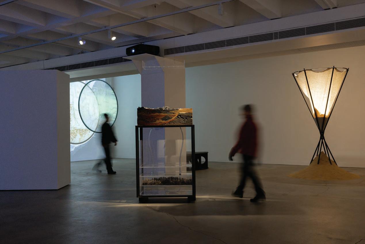
Indivisible is a body of work by artist Denis Beaubois that explores the idea of the nation. Central to the exhibition is an examination of parliamentary language since Federation and how it has been used to describe (or prescribe) the qualities of the Australian people over time.
The works incorporate data mining, video installation, sound, sculpture, and Schlieren imaging to refect on the language that upholds nationhood. Indivisible asks us to consider selective histories, mythologies, and how assumptions of national character have changed.
EXHIBITION BY WITH
IMAGE CREDIT
ACKNOWLEDGEMENTS
Stand Van Zaken (BE)
Theo De Meyer (BE)
Stefanie Everaert (BE)
GFA2 (ES/AU)
Desplans (FR/SE)
BAST (FR)
Erika Nakagawa + erikalab (JP)
Mike Hewson (NZ/AU)
Sam Chermaye O ce (DE/USA)
Ine Meganck (BE)
Hamish McIntosh
City of Sydney, Brickworks, TKD Architects, GHD, Candalepas Associates, Second Edition, Supercontext, Carey Lyon, Eckersley O’Callaghan
A Good Idea is a collaborative exhibition by Stand Van Zaken that brings together drawings by architects from around the world, which serve as instructions for locally crafted artifacts. These peculiar objects, born of global imagination and local interpretation, are explicit in their construction yet indeterminate in their use, loosely exploring themes of domesticity and the oftenoverlooked rituals of everyday life.
Together, the sketches and objects temporarily camp in the gallery space, creating an austere yet joyous interior—a rich scenography crafted with care and mindful of waste. Here, architecture celebrates collaboration, directness, ingenuity, and the beauty of bringing ideas to life.
CURATOR PARTICIPANTS
IMAGE CREDIT
Sharmila Wood
Urbonas Studio (USA)
Sao Sreymao (KH)
Khvay Samnang (KH)
Zarina Muhammad (SG)
Tomoko Hayashi (JP)
Mei Swan Lim (AU)
Imani Jacqueline Brown (USA)
Daniel Jan Martin (AU)
underFOOT Collective (AU)
Maja Baska
Actions for Water unites artists, architects, and cartographers to examine swamps, wetlands, and subterranean waters as vital ecologies of renewal. While frameworks like the Ramsar Convention aim to protect these environments, their ongoing degradation highlights the urgent need for intervention. Reimagined as interconnected ancestral, ecological, and scientifc networks, these waterscapes are envisioned as spaces of radical sensuality, otherworldliness, and speculative possibility.
Celebrated for their biodiversity and cultural signifcance, the works invite audiences to refect on what lies beneath. The exhibition explores environmental urbanism and regenerative futures rooted in care, creativity, and resilience.
EXHIBITION BY
Irene Perez Lopez
Maria Cano Dominguez
Shellie Smith
Professor Glenn Albrecht
Mia Tulumovic
Ananya Khujneri
Therese Keogh
Nicole Cha ey
CREDIT
ACKNOWLEDGEMENTS
Maja Baska
Choi Cai, Jye White, Callum Twomey, Adviteeja Khujneri, University of Newcastle
WaterTalks presents the Hunter River, known as Coquun-Myan by the Awabakal, Worimi and Wonnarua Traditional Custodians, as a living entity, shedding light on the profound and pervasive impacts of colonialism and industrialisation on water and its social and ecological systems, rendered visible in the Anthropocene.
The river’s hydrosocial narratives are depicted through artifacts, projections, and interactive elements that immerse the viewer in colonial and post-colonial water practices. Belonging, ownership, extractivism, dispossession and the biodiversity and climate crisis shape the river and its memories, entangled by deep time and spirit.
IMAGE
We thank our Sponsors for their generous support.
PLATINUM SPONSOR
GOLD SPONSORS
SILVER SPONSORS
BRONZE SPONSORS
Bates Smart is looking for current students and recent graduates to join our citymaking team.
Transformative thinking for the future city.
Pictured
Indi Sydney | Gadigal Country
Ngurra: The National Aboriginal and Torres Strait Islander Cultural Precinct Canberra, Australia
Responsiveness is embedded in our design process.
We actively respond to the needs, challenges, and contexts of all projects.
We present di erent ideas and concepts. Ones our clients’ didn’t even think were a possibility.
Creativity for us, goes beyond project outcomes but applies to our creative thinking across the whole design process.
We enjoy what we do and how we do it.
Western Sydney Startup Hub
Gonski Meers Foyer - Belvoir Street Theatre
Alexandria Park Community School
Published on the occasion of New Ground, the University of Sydney School of Architecture, Design and Planning ADP Graduate Show 2025, presented at Carriageworks.