

INSTRUMENT www. SuperiorInstrument .com Superior iS Your Jobsite technology solution! Southington • Norwich East Hartford • Bridgeport • Danbury Your SucceSS iS our BuSineSS! SALES • SERVICE • SUPPORT • TRAINING


With the iDig system you can manage distances, depths and desired slopes. The combination of advanced technologies is unique in the world: no cables, radio communication, simplified installation and solar charging. The user interface has been designed with excavator operators and can be appreciated by all. The bargraph and LED display guides you in the same field of vision as your bucket and makes the iDig an ideal daily tool for you.
Do you have several excavators? iDig has a removable solution that attaches in seconds from one machine to another. The iDig can save as many excavator and bucket profiles as you want. In the morning you attach on the sensors, the control box and the LED bargraph, then select the right excavator. Less than an hour is the average time you need to install the system. Once done, you do not have to do it again. The iDig keeps in memory the exact dimensions of your excavators. Installing the iDig is really simple: attach the 3 sensors, the control box and the LED bar in the cab and start working. No need for a technician, you do it yourself by following the on screen instructions.

Get the depth, slope and distance to the nearest centimeter without getting out of your cab. For all field applications that you will be confronted with your excavator, iDig Grade Control System will be your ideal partner: excavations, foundations, trenches, slopes, embankments, parking lots and swimming pools. Dig to the nearest centimeter with the correct percentage of slope and save time on your sites.


Level Best is now the leading brand of laser grading equipment and systems in the construction, excavation and site preparation industries, and is specified wherever grading accuracy, speed, high production and reliability are essential.
Level Best laser grading boxes are the first choice of contractors and crews who need grade accuracy, smooth operation, machine durability, and simplicity of operation. Throughout North America Level Best products are the recognized leader in product design and technical support in high precision laser grading attachments. Level Best means fine grade made easy!
Level Best laser grading systems let you create a finish grade accurate to within 1/10th of an inch. There is no laser grading equipment more accurate than Level Best.
Operators love how smoothly Level Best operates in tough environments to create such highly precise grades. The key is the unique Level Best hydraulic valve system that adjusts six times per second on the fly. Operation is so smooth that you never know it’s working so hard.
Level Best grading boxes and laser systems are made to the highest standards of material and craftsmanship. You can expect Level Best units to log thousands of high production hours.
Learning how to use Level Best systems is fast and easy, especially for operators who have worked with other kinds of grading systems. Training operators to step up to the demands of finish grading has never been easier. Outstanding fine grading results have never been easier to achieve.


Using a self-leveling grading laser is the most accurate way of grading the foundation of any construction site. Our selection of Topcon and Spectra digital laser levels includes the most advanced technology and user-friendly features that allow for a single person to perform all necessary functions. We have longrange grading lasers perfectly compatible with our laser grading equipment for conquering the biggest, toughest jobs. These digital laser levels eliminate the need for multiple setups and are designed with greater visibility and tracking.
With the newest software and durable construction, these are the most versatile and durable grading lasers available. They provide the versatility, durability, and functionality you need to accurately grade even the largest foundations.

The Spectra Precision® LL100N Laser Level is a complete one man leveling crew in a case. Automatic, self-leveling ensures fast, accurate setups. Easy, one-button operation requires minimal training. The LL100N Laser Level is capable of handling a wide variety of elevation control applications. Versatility is added with single-axis manual slope capability for setting out driveways, ramps, and residential drainage lines. It is rugged enough for the toughest jobsite and designed to survive a 3 foot drop onto concrete.


The Spectra Precision® LL300N Laser Level features a rugged design with a metal sunshade that provides superior drop and weather protection (IP66). Built to withstand severe drops of up to 3 ft directly onto concrete means less downtime and cost due to damage caused by accidental drop or tipover. The LL300N’s fully automatic self-leveling capability provides fast, accurate setup. Rechargeable NiMH battery pack or alkaline batteries keeps the unit working with no downtime due to power loss.
The RL-H5A is a next generation self-leveling construction laser with great distance and high accuracy.
• Long-range operation (800 m)
• Smart long-range receiver

The Spectra Precision® LL500 Laser Level is a one-person leveling system designed for longer range measurements across your entire site. Accurate, stable and reliable, featuring a 1,600 ft working diameter increases productivity by reducing the need for multiple setups on a large jobsite. The LL500 is self-leveling with built-in “out-of-level” shutoff that maintains accuracy over the entire work area and minimizes errors. Visible “spotting” beam determines receiver mounting placement makes it faster to find the on-grade position.
• Simple, intuitive manual slope capability
• ±10 Arc second horizontal accuracy
• Extralong battery life (100 hours)
• Tough IP66 weatherproof rating
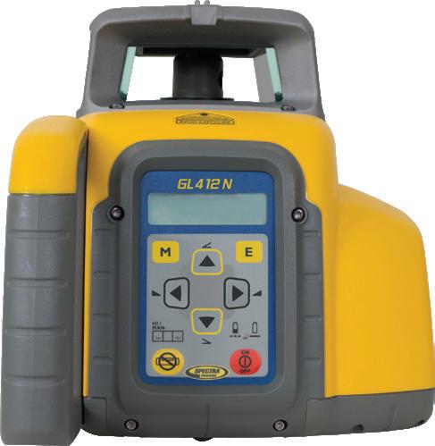
The GL412N is a single grade laser that also offers long-range operation in addition to its grade capability of -10 to +15 percent. An RC402N fullfunction remote control offers an easy to use menudriven interface. The radio remote operates at a range up to 330 ft and provides the ability to make grade changes and start automatic alignments remotely, which can significantly reduce setup time. Dual slope also available - GL422N.

The GL612N Grade Laser provides single grade capability of 25% in addition to being fully selfleveled in vertical for building axis alignment or setting 90 degree. Simple, robust and easy to use with a menu-driven interface that is replicated on the radio remote control makes the GL612N the first choice for any contractor requiring versatile grade capability. Dual slope also available - GL622N.

The Spectra Precision UL633N is Universal and can do multiple applications. It is a flat, rotating laser, single and dual grade laser, vertical alignment and 90-degrees set out laser – that’s what makes it Universal. Small contractors can do more work on their own and larger contractors do not have to worry about sending the wrong laser or multiple lasers to the jobsite.


The Topcon RL-SV1S is designed for single slope applications. This cost-effective, easy-to-use laser has a solid set of features. The RL-SV1S is a cost effective solution covering single slope job site needs.
• Long-range operation - 800 m (diameter)
• Single slope laser
• Full function radio remote (RC-50 included)
• Tough IP66 construction rating
• Extra-long battery life (up to 120 hours)

The Topcon RL-HV2S is a multi-task laser, meaning you can use it for construction and interior jobs where you need a laser for horizontal, single slope, dual slope or vertical applications. This laser has many features and is very user friendly.
• Long range operation (800 m)
• Horizontal, multi-slope and vertical applications
• Extra long battery life (120 hours)
• Tough IP66 construction rating
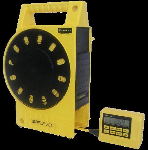
The ZIPLEVEL PRO-2000 & PRO-2000B High Precision Altimeters are designed to save significant time and money on the job site. Unlike a conventional rotating laser or builder’s level, ZIPLEVEL allows true one person operation with paper thin precision over unlimited ranges without line of sight, distance error, factory calibration or math. They are extremely fast and easy to use, have numerous powerful built in functions including a PC interface, and are built jobsite rugged.

Benefitting from the latest technology developed by Spectra Precision®, the DG813 delivers unprecedented performance when laying pipes. In addition, the DG813 comes with a smart Spot Finder SF803 which increases even further productivity. The laser can align automatically to the center of the Spot Finder, ideal for first day setup, and can also calculate the grade – great for checking previous work on a second day setup.
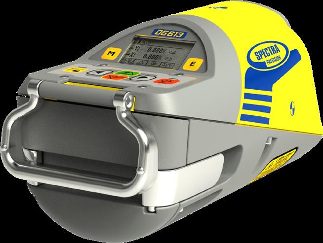

Designed to fit around tighter inverts, the Spectra Precision DG613 and DG613G deliver the most productive pipe laying experience in the market. They are extremely rugged and thrive in demanding underground conditions. Benefitting from the latest technology developed by Spectra Precision, the beams move quickly and accurately for alignment and grade. Simple to use, with the new menu driven user interface, the DG613(G) help you improve efficiency and provide unprecedented performance and reliability. Working in the trenches just got easier with the new range of pipe lasers from Spectra Precision.

For any major construction project, measuring the grade and length of pipe needed is a crucial part of the process - and often one of the most difficult to do correctly. Whether you’re laying sewer lines or underground cable, a pipe laser is crucial for getting reliably accurate data for long-distance pipe and cable laying, saving you the cost of human error and creating more project efficiency. Superior Instrument is Connecticut’s only complete sales and in-house service source for construction lasers, machine control and surveying instruments as well as pipe-grade lasers.


• Shorter length
• Grade range -12% to +40%
• Self-leveling over entire grade range & full cross axis compensation
• Ultra-fast beam movement
• Operating range up to 500 ft with radio / IR remote control
• Large intuitive graphical display on laser & remote control
• IP68 protection (dust and waterproof)
Flexible and convenient, the TP-L6 pipe laser’s smaller size, long-life battery and mobile app make the unit one of the most flexible on the market. This pipe laser is easier to use, fits into tighter spaces, and increases convenience and safety for workers.
• Compact design adds flexibility
• Red/Green laser
• Self-leveling
• Bluetooth connection
• -15% to 40% grade setting range
• 60-hour battery
• Optional plumb beam
• Additional Android mobile app remote control and display

With the GX-2012, you have multiple tools in one instrument. Having 3 operating modes, the GX2012 can be used for confined space, safety monitoring in it’s Normal Operating mode; for leak investigation in Leak Check mode; and for underground leak checking in Bar Hole mode.

The GX-3R is the worlds smallest 4 gas monitor weighing only 3.52 ounces and can comfortably be clipped within a worker’s breathing zone . It simultaneously monitors and displays LEL combustibles, O2, CO, and H2S. The GX-3R represents the latest evolution of gas detection technology utilizing a new generation of micro sensors.


The GX-3R Pro is the smallest 5-gas monitor weighing only 4.58 ounces. In addition to monitoring standard confined space gases, LEL, O2, CO, & H2S, the GX-3R Pro has a 5th channel for adding infrared or toxic gas sensors. It comes equipped with Bluetooth wireless communication, man-down alarm, alkaline or rechargeable power supply, and a 3 year warranty. The Lithium-ion battery pack lasts 25 hours and will fully charge in 3 hours.
Schonstedt Maggie

The Maggie combines the best features of two flagship Schonstedt products: the sensitivity and precision of the GA-52Cx, and the single-handed operation of the GA-92XT.

Schonstedt REX
Rex is recommended for locating all types of underground utilities: water and sewer, electric, telecom, and gas. Its thin and sleek profile combines with a retractable receiver to make Rex the most user-friendly and portable pipe & cable locator on the market.
Schonstedt GA-52CX

The GA-52Cx Locator detects the magnetic field of iron and steel objects, with unmatched sensitivity. Designed for one-hand operations, the On/Off-Sensitivity and Volume controls are located on the underside of the cover.

Schonstedt u-Locate
Damaging buried utilities can be costly and dangerous. u-LOCATE allows you to quickly and accurately locate underground utilities, helping prevent costly damages, utility strikes, and service outages.
Schonstedt GA-72CD
The GA-72Cd Locator detects the magnetic field of iron and steel objects. It provides audio detection signals that peak in frequency when the locator’s tip is held directly over the target. The GA72Cd has the option of nulling or peaking.

Schonstedt Spot
Magnetic Locators, including Spot, detect the magnetic field of iron and steel objects. With engineering and accuracy equal to the GA-52Cx, in a sleek, ultralight-weight package with improved ergonomics, Spot is IP54 rated and comes with a 7-year warranty!

Schonstedt GA-92XTD
With one hand, you can detect the magnetic fields of all ferromagnetic objects, property markers, manholes, septic tanks, well casings, valve boxes, cast iron pipes, steel drums, and unexploded ordnances up to 16 ft below the surface.
Chrisnik Hounddog

The ChrisNik HoundDog Magnetic Locator is built with new hi-tech Fence Ignoring Technology (FIT). The HoundDog can sniff out those hard to find survey markers under fences and around metal buildings.

The Autel EVO II Pro V3 RTK drone is an advanced, proven aerial platform used for high accuracy image collection in various commercial applications. The aircraft can record the original satellite observation data, camera exposure parameters and more. The positioning system supports an RTK base station and NTRIP RTK network, which help to achieve accurate and stable data acquisition in complex operation environments.

DJI’s Mavic Series of drones range from the high-end Mavic 3 with a 28x super zooming HD camera and 46 minutes of flight time to the lower end Mini 2 that only weighs half a pound, fits in the palm of your hand and can fly for 31 minutes.

The Carlson Aerial Platform (CAP) 50 is an American made UAS platform offering up to 6lbs payload capacity for advanced users in the surveying, construction, engineering, mining, quarry, land development, and related industries. Available with LiDAR, photographic, or depth sounder payloads, the CAP50 provides versatile options for numerous applications.


The DJI Phantom Series is DJI’s original and flagship drone line-up. The V2.0 version of the Phantom 4 Pro moves to DJI’s OcuSync transmission technology for up to a 4.3 mile transmission range. The P4 Pro features a 1-inch 20MP camera sensor with a mechanical shutter and is capable of shooting up to 4K video.
The Matrice series is the drone of choice for mapping, inspection, and surveying. This enterprise level drone series from DJI allows for a wide array of options and configurations in regards to gimbals, cameras, durability, flight characteristics, and precision. Upward gimbals, two or more downward gimbals, compatible with cameras of all kinds, and many more customization options make the Matrice drones a top choice for industrial applications of all kinds.


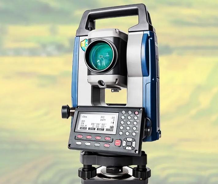
Spectra DET-2
The Spectra Precision® DET-2 Construction Theodolite is a rugged, cost-effective theodolite designed to give accurate angle measurements (2” angle accuracy) in general construction applications.
Features:
• 2” angular accuracy
• Vertical axis compensation
• Dual LCD with extra-large characters
• Back-lit LCD and telescope reticle
• Simple six-button keypad
• Large suite of programmable settings
• Optical plummet allows quick setup over a control point

David White LT8-300P
Rugged and Dependability makes this David White LT8-300P five-minute instrument the first choice for almost every horizontal and vertical sighting application in construction. The level transit is lined up over a reference point by using an optical plummet, assuring you of precise positioning every time.
SitePro DT8-05LS
The DT8-05LS has a laser beam built into aperture for easy and accurate alignment. Simple, push button functions gives the user precise LCD digital readouts.
Features:
• Incremental encoding detection system with dual digital displays
• Automatic power shut-off
• Optical plummet for centering of point
• Coaxial tangent and clamp screws provide ease of use in sighting and alignment
• Built-in battery pack can be attached and detached by a single action
• Water-resistant, sealed construction

David White LT8-300LP
Rugged and Dependability makes this David White LT8-300LP five-minute instrument the first choice for almost every horizontal and vertical sighting application in construction. The level transit is lined up over a reference point by using a laser plummet, assuring you of precise positioning every time.
SitePro TL20X
The TL20X transit level is ideal for fast set-up, simple to use for leveling and vertical applications.
Features:
• Clamps and tangents bring your instrument quickly on target
• 15 minute horizontal circle
• 3-screw leveling base with 5/8-11 thread for tripod
• Built-in sunshade with rubber eyepiece

David White LT8-300LTU
The 360º telescope rotation allows you to see directly below the instrument for pipe laying applications. Ruggedness and dependability make these five minute instruments the first choice for practically every horizontal and vertical sighting application in construction.

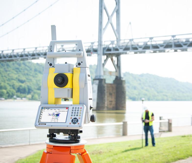
The iX Series robotic total stations are a trimmed down, high-performance solution. You get the efficiency of a single-operator robotic system, the power of long range reflector-less measurements and performance as a hybrid positioning solution.
The iM-50 Series is the perfect entry-level site layout and survey tool offering reliability and flexibility without sacrificing cost or functionality.
The sleek design is built tough, with a water and dustproof IP66 rating, integrated Bluetooth® capability and an internal antenna, enabling you to deliver measurements cable-free to your data controller, streamlining your equipment weight and workflow.

The Carlson CRx series robotic total stations are quick to set up, and are packed with easyto-use functions that simplify your surveying workflows and provide powerful tools to make you more efficient and accurate. With 5” touch screen, a more powerful processor, automatic data back-up, and the advanced positioning technology of STReAM360, Carlson’s super-reliable CRx robotic total stations provide the most efficent way to survey.
The Nikon N and K total stations offer an advanced EDM in an innovative package. Each includes a new charger featuring a USB-C on-the-go connection letting you recharge via a power bank or car plug. The Total Station File Transfer app and Bluetooth connection let you easily transfer data between the field and office, so your data makes it to the office before you do. Both include bright Nikon optics and rugged reliability, making each of these powerful total stations the right choice for a full range of projects.

The LN-150 takes you from paper plans and tape measures into digital layout and construction verification workflows. This tool is easy to learn and easy to use, letting you automate and execute layout and construction verification processes for increased productivity, accuracy, and bottom-line savings.
The layout navigator automatically locks onto the prism for real-time positioning on the go.

The Spectra Geospatial FOCUS 50 is a high-performance robotic total station you can customize to fit your needs. Available in three models, with your choice of angular accuracy – 1”, 2”, 3”or 5”. The FOCUS 50 features the smoothness of MagDrive™, the stability of SurePoint™ and the productivity of Autolock™. It is designed to be easy to learn, and pairs perfectly with the suite of Spectra Geospatial Field Software options, including Origin, Layout Pro, and Survey Pro.

Spectra Ranger 7
The Ranger 7 continues the legacy of the Ranger data collector by focusing on what is important. With its rugged and sunlight readable 7-inch touch screen, full keypad, and Windows 10 Pro operating system, is built to hit the mark for surveyors requiring an easy-to-use, rugged, cost-effective data collector.

The Carlson RTK5 adds an advanced GNSS solution to the RT5, allowing new levels of freedom and accuracy in a compact, light, versatile package. It comes with a custom-built pole and cradle, a survey-grade antenna, a small portable helix antenna for handheld GNSS use, and provides an all-in-one solution for land surveyors, engineers, GIS professionals, and anyone else in need of advanced GNSS positioning with an RTK rover.

Spectra Ranger 5
The Ranger 5 is an Android-based survey field data collector built to handle a full range of projects. Its five-inch screen and full keyboard enable surveyors to work efficiently, even while wearing gloves. Its lightweight but rugged construction and outstanding battery life make it reliable and easy to use, even in tough field conditions.

The Carlson RT5 Rugged Tablet features the integration of a brilliant 8” capacitive touch screen and high performance yet energy-efficient Intel processor within a slim, lightweight, and durable package. With built-in Wi-Fi as well as optional data capture modules, this robust tablet offers seamless information capture and transmission for improved workflow, providingv reliable operation in harsh, mission critical environments.


Spectra ST100
With a fully featured Windows® 10 platform, exceptional processing power, long battery life, 512 GB solid state drive and 16 GB SDRAM memory, you can work quickly and efficiently, without stopping for a recharge. And when the day is done, send your work to the office via 4G LTE , Wi-fi or Bluetooth® connection.

The Carlson RT4 is designed for surveying, stake out, construction layout and GIS mapping and is bundled with Carlson SurvPC – the Windowsbased data collection program – with the option of running with the Esri® OEM program for use in the field. Or use in the office with any Carlson office software. Along with the 8GB of RAM and 128GB of storage, you can collect and analyze your data quicker than ever before.
With an integrated high-resolution camera, inclinometers, a compass, a L1 GNSS receiver, and weather-proof housing, the Scan2K can be deployed in many environments and orientations. Whether on a tripod, vehicle, or moving platform, the outstanding performance of the Scan2K makes it the most versatile terrestrial laser scanner on the market.

Utilizing an Intel® RealSense stereo camera on Carlson’s RT5 or RTk5 rugged tablets, Scan3D adds a new tool to the truck for surveyors, engineers, construction professionals, accident reconstruction specialists, and anyone else needing instant, mobile 3D scanning of rooms, spaces, equipment, and much more. Relying solely on local processing, no cloud processing or internet connection is required to scan.

Carlson Point Cloud is a modular program that provides this powerful ability to go from field scan to finished plat, all with seamless integration to Carlson Survey, Carlson Civil and Carlson Mining. Carlson Point Cloud delivers a whole new level of powerful automation for large data sets. It gives laser scanner users the ability to process millions of data points with Carlson Software ease-of-use.


Aerial surveying is rapidly becoming a vital part of any surveyor’s toolkit. Thousands of people use drone site flyovers every day to help boost efficiency and lower costs. With Carlson Photo Capture processing, you can use flyover data to:
• Quickly generate interactive 3D maps of sites
• Capture highly accurate 3D site data from any camera
• Share site maps with customers -anywhere, anytime
• Save man-hours in the field

Carlson Construction is an integrated cut/fill takeoff and 3D surface modeling software solution designed for site and road construction. It offers powerful inspection and 3D viewing tools for elevating 2D designs to 3D model files. Previously only in Takeoff and Civil, Material Quantities Reports are now available in Construction. This gives estimators the volume, area, length and/ or count for items such as asphalt, gravel, curb, or any “subgrade” or “select fill” they define.


Bridge the gap between drones and CAD. Designed for use by surveyors, civil engineers, and contractors, Precision 3D Topo allows users to import survey data, points, polylines, surfaces, point clouds, both traditional LIDAR and aerial drone survey data, and more from a wide variety of programs and entities to create usable 3D surfaces.

The Carlson Civil Suite is the civil engineering design software that puts you in the passing lane! What might take days with other civil engineering software takes just hours, or even minutes, with the powerful and intuitive Carlson Civil. Work with Carlson Civil on AutoCAD (versions 2010 to current) or with the built-in IntelliCAD 8.1. You’ll get true 3D, easy-to-use 3D, plus, with the updated 3D Flyover, any surface edits made in CAD are automatically updated in the 3D view.
Spectra Geospatial Origin field software is the new, modern software professional surveyors need to handle a full range of projects quickly and efficiently. Intuitive and reliable, Origin offers an extensive range of features, including one-tap easy-to-use feature coding, powerful COGO computing, map layer manager, and map-centric workflows for measuring and stakeout. Spectra Geospatial Origin supports the Windows and Android operating systems. Connect Origin to GNSS receivers or robotic or mechanical instruments, or maximize the advantages of both GNSS and conventional in an integrated survey. Rely on it to meet your needs today and future-proof your business with the leading-edge design and technology you’ll want tomorrow.

Since 1988, Superior Instrument has been providing Surveyors and Contractors with the best products and service in the industry. In 2008, we marked a milestone in our history with the completion of our Superior GPS Network Foundation!
Today, Superior Instrument is still leading the way again by providing our customers with new industry leading technologies.
Our new Superior GNSS Network is built with the latest technology to take full advantage of the latest constellations for an ALL IN VIEW solution. GPS manufacturers have been hard at work incorporating the latest constellations in their receivers and you expect the same of your Network. The advantage is clear: more satellites + more signals + more SV baselines in the solution = MORE PRODUCTIVE USE OF YOUR INVESTMENT! VRS • SINGLE BASELINE | DGPS • GPS • GLONASS • GALILEO • BEIDOU
• Single controlling provider
• Experienced, knowledgeable staff responsible for maintenance, calibration and reporting of the system status
• All brands of network compatible GPS receivers are welcome to join the Superior GNSS Network
• Single source for tech support
• Local company with long standing reputation of support
• Friendly, familiar staff interested in your success
• Discounts for multiple rovers, special discounts for our GPS customers
• Compatible with most brands and models of GPS equipment
• RTK Drone Compatible
Network GPS Systems Benefits:
• Eliminates the need for a site-specific base station
• Reduces your equipment inventory
• Eliminates chance of theft or damage of existing base
• Lower equipment and equipment maintenance costs
• Single, fixed point of reference
• Reduces your setup time, day after day
• Split your 2 receiver RTK system into 2 network rovers
• Better utilization of existing equipment
• Eliminates the labor cost watching the base
• Offers a unified coordinate system
• Greater mobility and
• Faster deployment


The Spectra Geospatial®SP85 is a next generation GNSS receiver that combines decades of GNSS RTK technology with revolutionary new GNSS processing. Featuring the new 600-channel “7G” chipset combined with the patented Z-Blade™ technology, the SP85 system is optimized for tracking and processing signals from all GNSS constellations in challenging environments.
The SP60 is a new generation GNSS receiver offering a high level of flexibility to cover any demand from GIS all the way up to sophisticated RTK and Trimble RTX™ capable solutions. Combining the unique all-signals tracking and processing Z-Blade GNSS-centric technology and L-band capability for satellite-delivered Trimble RTX correction services, the SP60 receiver provides the most reliable measurements and the highest possible accuracy under any conditions anywhere in the world.


The SP20 handheld GNSS receiver combines innovative, camera-enabled data collection workflow with a high level of performance in an ergonomic, scalable solution (from meter to cm accuracy).
Rugged and lightweight, the SP20 is easy-touse and highly accurate. It is the optimal tool not only for cadastral, construction, or topo surveys, but also for a range of GIS projects, including data collection, inspection and maintenance.
The BRx7 is Carlson’s all-new multi-GNSS, multifrequency smart antenna. The BRx7 provides robust performance and high precision in a compact, rugged package with tilt compensation ability. With multiple wireless communication ports and an open GNSS interface, the BRx7 can be used in a variety of operating modes.
Use the BRx7 as a precise network rover to work with your GNSS VRS network, or set up your BRx7 as an easy-to-use base-rover package with industry-leading performance via the internal long range and spread-spectrum radio or cellular communication via Carlson’s Listen-Listen, a unique cloud- based low latency service that eliminates baseline length restrictions of UHF radios. With only an Internet connection, you can enjoy a simple, easy-to-use base-rover solution that can also support a single base with multiple simultaneous rover connections.
The BRx7 provides state-of-the-art RTK performance when receiving corrections from a static base station or network RTK correction system. With multiple connectivity options, the BRx7 allows for RTK corrections to be received over radio, cell modem, Wi-Fi, Bluetooth, or serial connection. The BRx7 delivers centimeter-level accuracy with virtually instantaneous initialization times and cutting edge robustness in challenging environments.
The BRx7 also features proprietary SureFix® technology to provide high fidelity information about the quality of the RTK solution, allowing enhanced and improved RTK accuracy, availability, and precision.
The built-in web user interface (WebUI) can be used to monitor and control the receiver status and operation, as well as to upgrade the BRx7 with new firmware and activations. The BRx7 is immune from magnetic interference, and is both Athena™ -enabled and Atlas®-capable (subscription required).
a In-House Repair Center, Huge Parts Inventory
a Factory Trained Technicians
a Factory Service Tooling for Calibration to Factory Specs
a Superior Zero Down-Time Program - Reduced Rental Cost for Replacement Instrument While Yours is in for Repair
a One-on-One Personalized Training


Superior Instrument is Connecticut’s only complete sales and in-house service source for construction lasers, machine control and surveying instruments. Unparalleled local support is what we strive for. An investment in technology, without adequate support, is a bad investment. Invest with Superior Instrument and our over 30 years in business. We’ll be here when you need us!
Whether you are looking to buy, rent or lease equipment or need an in-house, full service repair facility... Superior Instrument is ready to handle the demands of today’s high tech construction and surveying industry. Superior Instrument offers the best selection of top brand instrumentation available and you can always expect to be serviced by experienced, factory trained staff dedicated to providing you with knowledgeable, professional expertise.


