


Moscopan Mill Popayán, Colombia
Golden Repair Toronto, Canada
Canopea, Botanical City Cali, Colombia 2018
Kingdom Downtown Master Plan Hail, Saudi Arabia 2018
111 Moatfield Drive, Toronto 2024
Description
When considering the relationship between the OAA Headquarters building and the surrounding landscape, it is apparent that there are several shattered systems that need repair. Beyond repair alone, regeneration and renewal need to be considered as well. As a continuation of the OAA’s Renew+Refresh initiative, this proposal seeks to extend the original vision into the landscape. The Japanese have a concept, translated as “Golden Repair” (kintsugi), that treats the breakage of a piece of pottery as part of the history of the object, rather than something that needs to be hidden, resulting in something more beautiful than before. In the same way, this proposal seeks to not only repair the broken relationship between the building and the land, but to enhance, regenerate and renew.
Duties
3D modeling, elevations and rendered images.
Area: 4360 m2
Stage: Private Competition
Client: OAA
Studio: Tekleab Schewai, MSLA
Design: Tekleab Schewai, MSLA
Team: Tekleab Schewai, MSLA Studio, Andres Solano


Under the proposed condition the minor flows from Parcel-A will be intercepted by existing four catchbasins, collected in manhole (MH-1) and conveveyed by the existing stormsewers to manhole(MH-2) which will be replaced by the Oil-Grit Seperator (OGS). Meanwhile in Parcel-B the flow will be intercepted by the proposed Bioswel and Pool Drainage system and the existing two catchbasin.


1.2.1 Stormwater Management Criteria

The SWM criteria for the site includes: Quantity control: Control post-development to predevelopment flow rates for 2-100 years events. Quality control: Provide enhanced and innovative method of treatment

1.2.2 Existing vs proposed conditions
The existing stormwater runoff collection in parcel-A will remain unaltered due to the low discharge caused by the implementation of permeable pavers and reducing the parking area. The drainage from the building rooftop will only be altered partially as we are planning to the use of the second floor terrace discharge to the cistern. While in parcel-B there will be a major change as we will be collecting the runoff discharge coming from the drive-way through the use of flush curb and the bioswel and directing it to the stone circle drainage dry pool. Another change is the use of the permeable pavers in the drive-way near the main entrance of the building. The catch basin located at the south-east corner of the site will be unaltered. The second manhole(MH-2) will be replace by the stormceptor to provide enhanced water quality treatment of all runoffs through the long term average removal of 80% of Toatal Suspended Solids on an annual loading basis.
1.2.3 Stormwater Management Plan
1.2.3.1 Quantity Control


The primary interventions proposed for the site is to represent the Golden Repair concept by means of a continuous gold banding that runs throughout the site. The banding begins at the main entrance and continues along the ground before travelling up the building columns, stretching along the ceiling, before plunging back to the land to terminate at the geothermal system. This banding is meant to stitch together, or to mend, the distance between the building, the land, and the soil, and to serve as a permanent reminder of the importance of these relationships.


The proposed site stormwater mangement will remain same as the existing one since we tried to reduce the discharge through the use of permeable pavers, green area and drainage dry pool in order to retain all runoff from rainfall events up to 5mm on--site through infiltration, evapotranspiration and rainwater reuse. See design calculation in Appendix-A
1.2.3.2 Quality Control
The quality treatment for the site is provided by EF04 oil-grit seperator(OGS) which removes 80% Total Suspended Solids (TSS).


The planting palette proposed has been compiled with native plants originally found in the Don River ecosystem. The predominant plant mix will be meadow species, which have also been proposed to be extended into the boulevard to further connect the site to the Don River across Moatfield Drive. To make further connections to the history of the Don, there are two intersecting swathes of purple and yellow perennials proposed in the bioswale area. In this scheme, the purple flowers represent the original watercourse alignment of the Don River, and the yellow flowers are meant to show the repair to the straight, contrived, concrete channels of the 20th century. The golden colour, in particular, is meant to show the repair to the straight concrete channels and to connect conceptually to the “golden repair” motif.


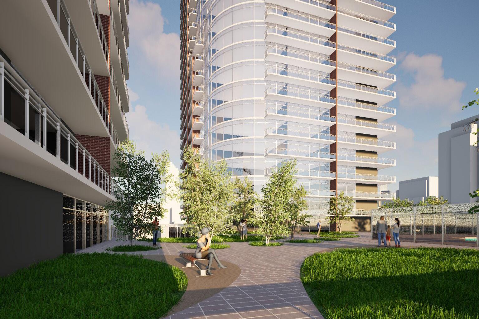


Above the platform, the residential aspect of the building consists of two distinct towers. The subsidized apartment block, standing at 10 stories, gives lower priced housing alternatives in the downtown core. Adjacent to it, a 45-story condominium tower is intelligently stepped on to keep away from overshadowing neighboring homes, ensuring good enough sunlight access and minimizing visible impact. This stepped massing method no longer best addresses shadowing worries but also contributes to an extra harmonious integration of tall buildings into the urban material.


Cali, Colombia 2018
Description
The Cali River originates in the Alto del Buey, in the Farrallones de Cali outcrops, as part of the ecological region of Bosques Montanos of the Valle del Cauca, and it discharges 50 km ahead into the Cauca River, located in the dry tropical forest ecoregion of the Valle del Cauca. The river latterly formed the ecological corridor between two different ecoregions, turning it into one of the most biodiverse places of the planet.
3D modeling of the entire project and post-production of graphic pieces such as: render plan, aerial view, sections and detailed axonometries.
Area: 67 ha
Stage: Public Competition
Client: SCA
Studio: Bermúdez Arquitectos
Design: Diego Bermudez
Team: Santiago Izquierdo, Juan David Herrera, Cristina Garcia, Carlos Santamaria, Andres Solano


The canopy is the uppermost stratum of the forest. Here, 40% of the species reside. It is fundamental to rethink the river and its flanking territories as a new botanical city, capable of restoring the lost biodiversity, and to function as an ecological connection that not only links the Cauca River with the Fallarones, but actually constitutes an articulating corridor between the two mayor ecoregions of the Valle del Cauca.


Canopea allows for its visitors to rediscover the retrieved biodiversity in a passage that would, in its final stage, connect the Botanical garden of Cali with the new Valle del Cauca Botanical Reserve, reaching up to an area of influence of over 1500 ha. Let´s reimagine Calí as an urban hybrid: a Biodiverse Natural Reserve.

Hail, Saudi Arabia 2018
Description
Ha’il will become a global precedent for urban integration with mountain landscape. Ha’il’s new urban fabric becomes a “base-camp” downtown on the foot of the mountains which is in close proximity to the city. A visitor center which will anchor the edge of the mountain, transforming the development into a gate with a commercial boulevard connecting the two. Ha’il is destined to become the destination for adventure exploration through its passion for extreme sports such as rally, mountain biking, cliff climbing, ATV’s, sky diving and paragliding.
Deuties
3D modeling and post-production of graphic pieces such as: site plan, rendered plan, conceptual schemes, public space schemes and perpective sections.

Area: 126 ha
Stage: Master Plan
Client: Tekuma Frenchman
Studio: Estudio Altiplano
Design: Pedro Aparicio, Santiago Buendía, Andrés Hernandez, Josephine Philipsen
Team: Fabio Chica, Andres Solano.

The site will be anchored with a unique stadium carved out of the cliffs for performance and sports events; an entrepreneurship hub and finally a world class Digital Petroglyph Park that will be visible from an observation deck that can be reached by cable car. Together with a nationally recognized biosphere reserve, Ha’il will be a model district for a active healthy lifestyle and family entertainment.


Monterrey, Colombia 2020
Description
Located in the foothills of the southwest Casanare plains, the town of Monterrey has a privileged location due to its easy access from the 4 important capitals of the region (Bogotá, Tunja, Villavicencio and Yopal), becoming a the high-potential place for tourism and investment. Monterrey is located in the Túa river valley formed by the hills of Monserrate and the Palmicha, where a terraced geography with high filtration and a warm humid climate predominate. The project under development is located on the Los Querubines farm, which despite its proximity to the municipal capital of Monterrey preserves a natural and quiet environment typical of a rural setting.
Duties
Analysis and site plans and diagrams, design of landscape and urban strategies for future development. CAD drawings of the entire master plan and typical houses.

Area: 272 ha
Stage: Master Plan
Client: Socar Ing
Studio: Sosin Sas
Design: Andres Solano
Team: Andres Solano, María


The First stage is destined to the development of rural housing, commerce and complementary activities. Seeking to consolidate, restore and allow its long-term growth, our proposal incorporates ecological routes within the existing forest bodies, which will accompany the recreational activities destined to the delight of all its inhabitants. As a general strategy, our project tries to create a mix of uses working in a harmonious way where the communal areas and forest areas are the articulating agent that allows pertinent levels of privacy to be preserved in each use.
