Maritime Museum of San Diego Board of Directors 2024
Kenneth Stipanov, Chair
Greg Murphy, Vice Chair
Kenneth Andersen
Bill Bartsch
Brian Bilbray
Greg Cox
William Dysart
Dr. Iris Engstrand
Michael Garmon
Gary Gould
Deward Houck
Erich Lathers
John Laun
Al Love
Manish Parikh
Douglas Sharp
Pamela Werner
Thomas P. Workman
Ex Officio
Raymond E. Ashley, President/CEO
Sharon Cloward, Port Tenants
Association Representative
Margaret Clark, Docent Chair
Bob Klug, Ships’ Maintenance Crew Representative
MAINS’L HAUL EDITORIAL BOARD
Raymond E. Ashley, Ph.D. President/CEO
Jim Cassidy, Ph.D.
U.S. Navy Civilian (Retired)
Stephen Colston, Ph.D. San Diego State University, Emeritus
Iris H.W. Engstrand, Ph.D. University of San Diego, Emerita
Kale B. Fajardo, Ph.D. University of Minnesota
Mark G. Hanna, Ph.D. University of California, San Diego
Carla Rahn Phillips, Ph.D. University of Minnesota, Emerita
Alex Roland, Ph.D.
Duke University, Emeritus
Timothy Runyan, Ph.D. East Carolina University
Paula De Vos, Ph.D.
San Diego State University
MAINS’L HAUL is published by the Maritime Museum of San Diego, wind and weather permitting, aboard the ferryboat Berkeley. MAINSAIL HAUL An order in tacking ship bidding, “Swing the main yards.”
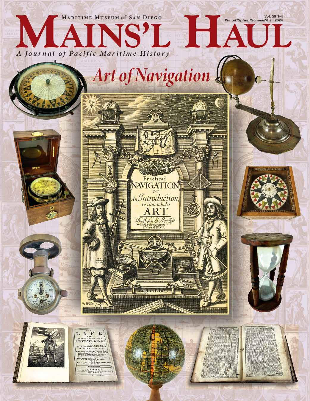
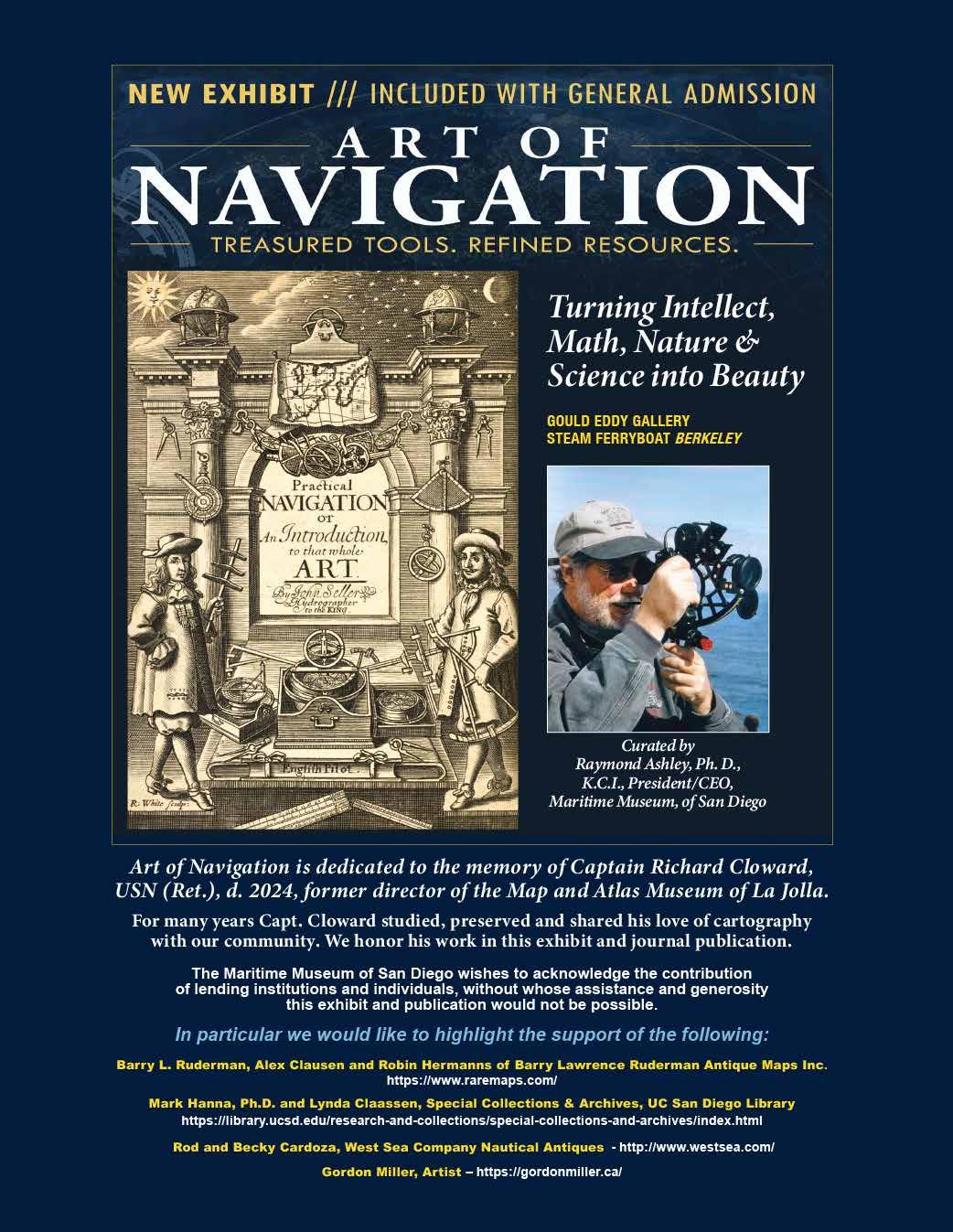
The Art of Navigation
Ashley, Ph.D., K.C.I. From the Helm
Oceanic Crossings: Mathematics, Instruments and Navigation: New Ways of Defining Space and Measuring Time
Projecting the Globe and Maritime Rivalries
The Eighteenth Century: Revolution in Nartrative Wayfinding and Projection
The Spanish Perspective
The Seventeenthg Century: Elegant Baroque design and Increasing Precision
Enlightened Voyages and Scientific Navigation
Trade Routes and Wayfinding
The Enduring Art of Navigation
Email: editor@sdmaritime.org, or write to Mains’l Haul, Maritime Museum of San Diego, 1492 N. Harbor Dr., San Diego, CA 92101-3309 Phone: 619-234-9153
Our mission is to engage members and the public in the study of maritime history, while promoting scholarly research. Articles are indexed for researchers worldwide at sdmaritime.orgMains’l Haul, and in America: History & Life and Historical Abstracts. ISSN# 1540-3386.
Editor Kevin Sheehan, Ph.D. Contributing Editor Paula De Vos, Ph.D.
Editorial Assistant Nancy Matthews
Art Director Tony Enyedy
Printer: Neyenesch Printers Inc.
ISBN 0-944580-47-5
Gordon Miller An Artist's Perspective
Mains’l Haul is produced with financial support from the Bob and Laura Kyle Endowed Chair in Maritime History
The Art of Navigation FROM THE HELM
When the great voyages of European exploration began in the midfifteenth century at the dawn of the Scientific Revolution, oceanic navigation was one of the rare disciplines (along with military and mining engineering), in which mathematics and instruments found tangible and useful application. Even among many of the foremost scientists of that time, mathematics and instruments were thought to be impediments or distortions of the pure reliance on human observation that the ancient Greek philosopher Aristotle had argued as the basis
by Raymond Ashley, Ph.D., KCI. President and CEO Maritime Museum of San Diego
for scientific investigation. Instruments, therefore, were at first perceived as expressions of esoteric art rather than science. The compass for instance, a recently adopted instrument for determining direction, was the first instrument in history that measured a quality of nature (magnetism) that humans were not only unable to sense, but was a quality not even understood within the known attributes of the
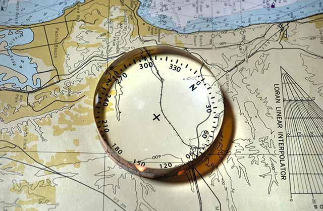
Magnification Prism Collection of Dr. Raymond Ashley Photographer: Doc White
natural world when the use of it for wayfinding became essential. Mariners regularly risked their lives and merchants their ships, in other words, on something that responded to an unknown and mysterious force.
In consequence, navigation derived its beginnings not as a science, but as an obscure art wherein masters practiced their secretive methods by the use of an arsenal of exotic instruments augmented by increasingly rational and baroque representations of geography at odds with conventional experiential understandings of space and direction. Far at sea and beyond sight of land, this mysterious and arcane craft not only conveyed the power of life and death for a ship’s crew, but also determined the direction and magnitude of the oceanic empires that reversed centuries of European decline.
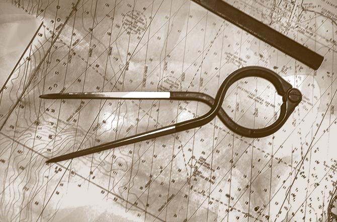
Navigational Dividers
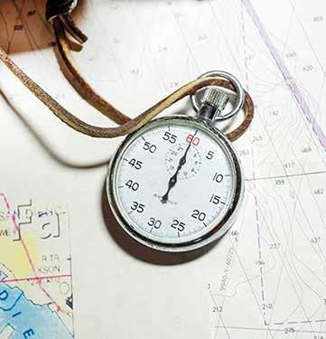
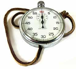
Collection of Dr. Raymond Ashley Photographer: Doc White Stopwatch
Collection of Dr. Raymond Ashley Photographer: Doc White
As a powerful and mysterious art, navigation and the territorial claims of trade and empire it conveyed drew authority and mastery from the same aesthetic as all artistic expression. Consequently, the instruments,
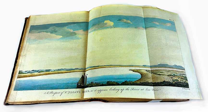
reference texts, and nautical charts that were its tools and products were therefore also objects of exquisite beauty. Charts were embellished with elaborate cartouches, fine portraits of famous explorers, detailed renderings of ships, native watercraft, as yet unknown lands, and even monsters that roamed the deep. In the days before photography, detailed landscapes and elevations of islands, coastlines, and harbor entrances provided vital navigational information but also drew upon conventions of contemporary landscape art. Among the first popular genres of non-fiction made available by the invention of the printing press to mass audiences, voyage accounts provided
stirring narratives, as well as graphic renderings of strange places, animals, and peoples that held readers enthralled. The ships themselves were certainly practical and powerful conveyances of cargo, people, information, and military might, but also of national prestige. Ships were designed to be just as beautiful as they were useful, since they were at the same time projections of power, identity, authority, and possession. In an age when baroque embellishment was a statement of wealth and power, ships were among the most baroquely embellished objects created.
The Maritime Museum of San Diego’s exhibition
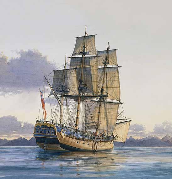
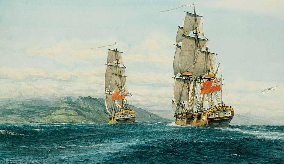
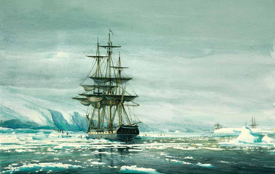
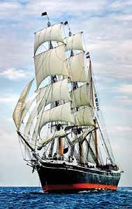
Art of Navigation draws upon some of the finest and most beautiful examples extant of period instruments, charts, and voyage accounts, illuminated by the work of documentary maritime artist Gordon Miller, embellished by exquisite models of the storied ships that conducted the enterprise from the Museum’s own collections, and even majestic full-scale operational versions such as the galleon San Salvador, man-ofSurprise, schooner Californian, and the museum flagship Star of India, veteran of twenty-one navigations around the earth.
Art of Navigation , you can step into a moment of history when science was subordinate to art in the conveyance of authority and sail the fascinating course by which art first and finally morphed into science.
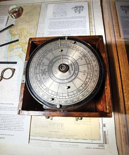
Fields Reversible Dial
Collection of Dr. Raymond Ashley Photographer: Doc White
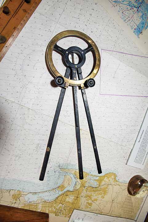
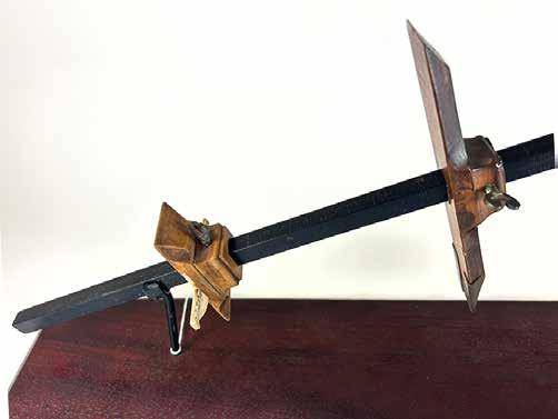
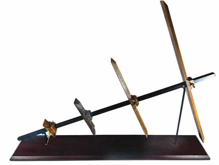
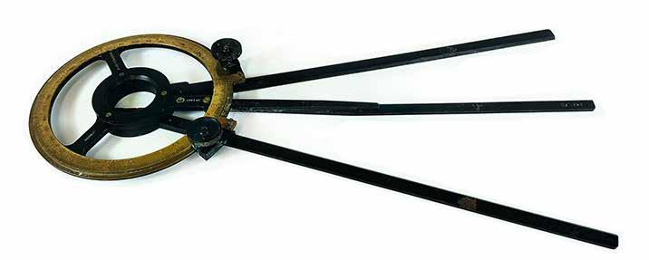
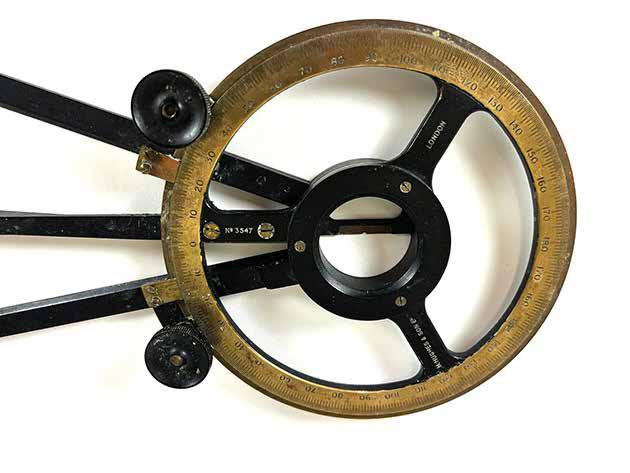
Three-Arm Protractor
Collection of Dr. Raymond Ashley Photographer: Doc White
Gordon Miller An Artist’s Perspective
Of the paintings reproduced here in our gallery, the Vancouver-based artist Gordon Miller reflects:
“These paintings arose from my research into the maritime history of British Columbia, and the men who first ventured into these waters. Their ships were the product of centuries of evolution and refinement, and their navigators were beneficiaries of years of accumulated experience and knowledge. Lured by the riches and mystique of Asia, they had explored most of the world’s oceans and coastlines and helped define the size and grandeur of the planet. The ventures that began with the Norse voyages in the first millennium ended in the eighteenth century with the arrival of the first sailors off these misty, magical shores of North America.
Much of the time creating these paintings was spent researching the histories and specifications of the ships. We have only vague ideas of the earliest vessels; there are no known documents or detailed descriptions of them. Not until well into the seventeenth century were ships being built from plans. To accurately portray any vessel, I begin by studying their plans, have often created my own when none existed, and occasionally build small models to help visualize them.
It has not been my intention to create maritime “Art”, but to illustrate as faithfully and accurately as possible the ships and events described in the paintings.”
Discovery of San Diego Artist Gordon Miller
Maritime Museum of San Diego Collection
This original painting was kindly donated to the Maritime Museum of San Diego by the artist in 2024.
The Early European Voyages
For centuries Europeans carried on a vigorous maritime trade without venturing out of sight of land. This changed late in the first millennium when Vikings of the Common Era made exploratory voyages across the North Atlantic. Almost the entire west coast of Africa had been explored by Europeans to the Cape of Good Hope before Columbus headed west into the southern Atlantic, looking for a westward route to Asia. What caused this momentous change that would result in a reconfiguring of global connections via the oceans? We may point to the development of navigational techniques empowered by the incorporation of initially novel technologies, resulting in an increasingly precise vision of the shape and size of distant coastlines, the dimensions of oceans, seas and other waterways, and the nature of peoples, animals and plants that dwelt there. Maritime Museum
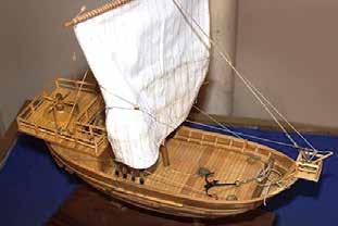
This model of a late-medieval sailing vessel is based on the well-preserved wreck of a vessel known as a cog dated to 1380, found in 1962 in Bremen, and now displayed at the German Maritime Museum in Bremerhaven. On 8 October 1962, wooden fragments of a ship were found in the Weser River during dredging operations. They turned out to be remnants of a cog that seems to have sunk during a storm after drifting away from a shipyard before completion. Until then, cogs had mostly been known from images found in medieval documents and seals. The Bremen cog remains today the best-preserved medieval northern European vessel.
Modelmaker: Joe Bompensiero Maritime Museum of San Diego Collection
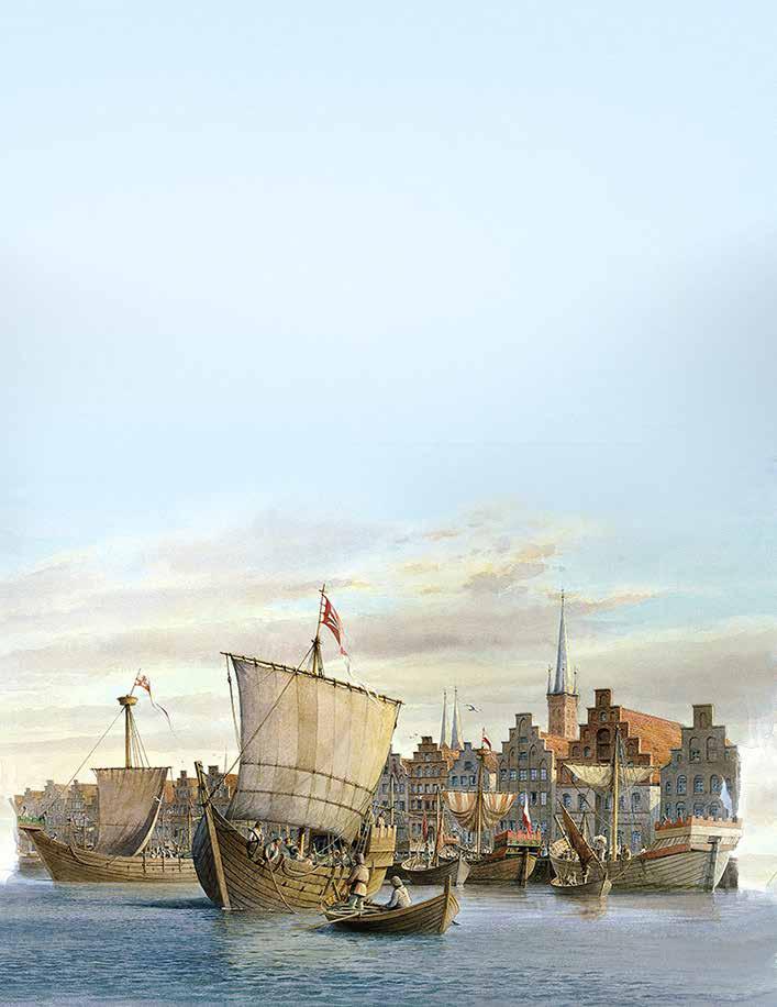
Hanseatic cogs, Lübeck – circa 1350
Artist: Gordon Miller
Bremen Cog, ca 1380
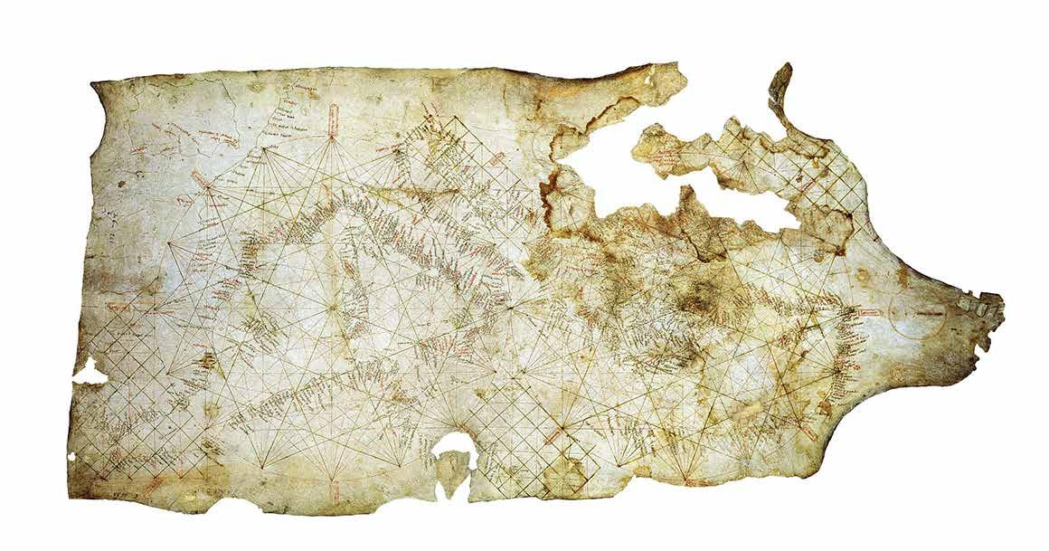
Found in the Italian city of Pisa, this chart shows the Mediterranean Sea, the Black Sea and a part of the Atlantic coast. It extends from the north of present-day Morocco to the present-day Netherlands. The Mediterranean is represented with the greatest detail. The Carta Pisana is the oldest surviving portolan – a type of chart that focuses primarily on what would have been most important to navigators: coastal features and ports, while leaving inland areas blank. On the map, North is located at the upper edge, in contrast to other maps of the same period such as the Hereford Mappa Mundi (ca. 1300), where East is at the top. The development of portolan charts designed specifically for navigation is closely linked to the increased use of the nautical compass by mariners .
The Nautical Chart
Maps have been a common means of depicting geographical space and location in many civilizations for thousands of years. Until the Early Modern era, however, maps almost always evoked experiential elements of the geography they depicted – rivers, mountains, cities, monumental structures, etc. were often given prominence and spatial assignment according to individual relative importance rather than enfolded within an absolute scale that applied uniformly to all.
It is probably no coincidence that shortly after the mariner’s compass rendered direction into a universal abstraction, nautical charts emerged that could dependably deliver a ship to a precise landfall at great distance beyond the horizon without recourse to sighting land or features ashore as reference points – so long as a consistent course by the compass was steered.
European mariners began to use the compass by the mid-thirteenth century. By 1275 the first true nautical chart, the Carta Pisana, rendered the Mediterranean into a rational depiction of space with all elements to a uniform scale, as though looking down on it from far above the surface of the earth – a perspective that no human being had ever seen.
Carta Pisana Reproduction courtesy of the Bibliothèque nationale de France.
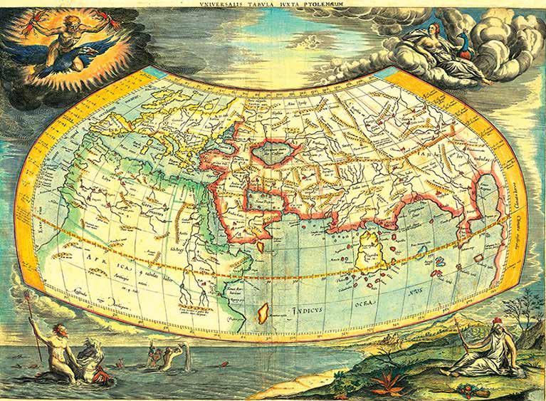
This world map by the Flemish cartographer Gerard Mercator was based on the writings of the ancient geographer Claudius Ptolemy. The engraved decorative border includes a frieze of allegorical figures representing the four elements: Fire (Zeus), Air (Hera), Water (Poseidon), and Earth (Gaia). While Mercator is perhaps best known for his modern maps and the map projection which bears his name, one of his life goals was to produce his own version of Ptolemy’s Geographia . As a second installment of his Atlas sive Cosmographia , Mercator published an authentic version of Ptolemy, deliberately devoid of the distracting interpretations and
Scholars placed more emphasis on first-hand observation, as well as began to question certain medieval authorities in light of the rediscovery of ancient texts. For mapmaking and geography, the most important of these ancient volumes would be Ptolemy’s Geographia, first printed with maps in 1477.
misinterpretations by earlier editors intent on improving the Egyptian geographer’s seminal work. Mercator’s goal was an accurate portrait of Ptolemy’s second-century view of the world. To understand the present, the mapmaker believed one must appreciate the past. The atlas, first published in 157 8, included Ptolemy’s twentyseven maps, carefully restored, handsomely engraved, and supplemented by an index of place names and an enlarged boundary map of the Nile Delta. A total of eight editions were published between 1578 and 1730
Universalis Tabula Iuxta Ptolemaeum. Published in Leiden, ca 1690.
Courtesy of the Barry Lawrence Ruderman Antique Maps Collection
This is a fine reproduction of a late-medieval world map attributed to the German printer Hanns Rust. It was printed in 1924 by Ludwig Rosenthal, one of the most famous antiquarians of his time. Hanns Rust’s world map was a separately published map, published circa 1480. The map is oriented with east at the top, and shows the then four principal rivers of the world (Ganges, Phison, Indus and Nile) flowing from Paradise at the top of the map. Jerusalem is at the center. Europe, Asia and Africa are named for Noah’s three sons – Ham, Shem, and Japheth – with the map ringed by twelve classical windheads.
Similar to other woodblock maps of this period, this map employs circular symbols showing castles and buildings. Lodged in the border, which is actually a world ocean that rings the continents, are islands (including Engenland, or England), rocks, and ships. This ring represents the edge of the known world and is populated with monsters and strange scenes. Below the map is a smaller depiction of the world (lower right) which represents the tripartite division of town, country, and sea. In the lower left is a model of the four elements (air, water, fire and earth). It was meant for general consumption, as it is written in colloquial German – the first European map to be printed in a vernacular language. This map was printed just at the dawn of a period of growing European map consciousness, that reflects an increase in the knowledge and use of maps in everyday situations by a broader portion of the population. The rise in map consciousness developed between roughly 1450 and 1750 for a variety of reasons. First, the cultural movement of the Renaissance encouraged interest in the wider world, as seen in the demand for
elaborately printed geographic tomes full of descriptions and, increasingly, maps. Scholars began to place more emphasis on first-hand observation, as well as to question certain medieval authorities in light of the rediscovery of ancient texts. For mapmaking and geography, the most important of these ancient volumes would be Ptolemy’s Geographia, first printed with maps in 1477.
The rediscovery of Ptolemy's work points to another development, the printing press. Although manuscript maps continued to be popular as elite commodities, mass-produced maps could reach a wider audience for the first time, as this map attests. These developments spurred a departure from the dependence on scholasticism of the late-Medieval period, as well as marked a realization that the world as early modern Europeans knew it no longer fit into the mold recorded by medieval scholars and religious experts.
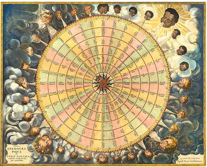
from Earth with the naked eye. The other thirty points on the sidereal rose were determined by the rising and setting positions of fifteen bright stars.
This map illustrates the classical thirty-twopoint compass rose, as used in medieval times by mariners at sea.
Arab navigators in the Red Sea and the Indian Ocean, who depended on celestial navigation, were using a thirty-two-point sidereal compass rose before the end of the tenth century. A sidereal compass rose uses the position of stars to indicate compass points. In the northern hemisphere, the steady Pole Star (Polaris) was used for the north-south axis; the less-steady Southern Cross had to do for the southern hemisphere, as the southern pole star, Sigma Octantis, is too dim to be easily seen
The western half of the rose would be the same stars in their setting position. The true position of these stars is only approximate to their theoretical equidistant rhumbs on the sidereal compass. Stars with the same declination formed a “linear constellation” to provide direction as the night progressed.
A similar sidereal compass was used by Polynesian and Micronesian navigators in the Pacific Ocean, although different stars were used in a number of cases, clustering around the East-West axis.
The thirty-two-point compass used for navigation in the Mediterranean by the fourteenth century had increments of 11 1/4° between points. Only the eight principal winds (N, NE, E, SE, S, SW, W, NW) were given special names. The eight half-winds combined the names of the two principal winds, e.g. Greco-Tramontana for NNE,
Jan Jansson. Tabula Anemographica seu Pyxis Nautica ventorum nomina sex linguis repraesentans. Published in Amsterdam, 1650.
On loan from the Barry Lawrence Ruderman Antique Maps Collection
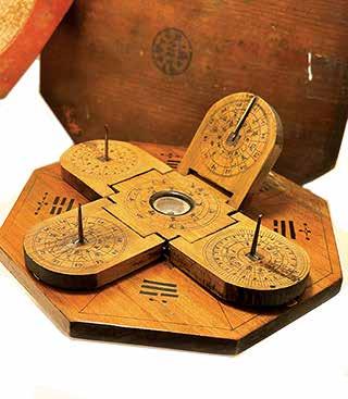
Chinese Luopan Compass
Mid-to-late nineteenth century Maritime Museum of San Diego Collection
Greco-Levante for ENE, and so on. Quarterwinds were more cumbersomely phrased, with the closest principal wind named first and the next-closest principal wind second, e.g. “Quarto di Tramontana verso Greco” (literally: “one quarter wind from North towards Northeast,” i.e. North by East), and “Quarto di Greco verso Tramontana” (“one quarter wind from NE towards N”, i.e. Northeast by North). Boxing the compass (naming all 32 winds) was a skill familiar to all medieval mariners.
The compass was invented in China during the Han dynasty between the 200 BCE and 100 CE where it was called the “South-Governor”( ) or “South Pointing Fish”( ). The magnetic compass was not, at first, used for navigation, but for geomancy and fortune-telling by the Chinese.
The earliest Chinese magnetic compasses were employed to order and harmonize buildings by the geomantic principles of feng shui , as well as for fortune telling.
This portable compass has four hinged sundials with folding brass gnomons. Their shadows would have been observed to note changes in seasons and determine propitious dates and times for various endeavors.
Chinese Compass mid-nineteenth century Courtesy of the collection of Rod and Becky Cardoza, West Sea Antiques
Projecting the Globe and Maritime Rivalries
At the beginning of the sixteenth century, European maritime expansion was still in its infancy. What lay west across the Atlantic was only vaguely understood. The extent of this "New World," not to mention the vast ocean that lay beyond it, would come to be revealed to Europeans in subsequent decades. Cartographers traced the contours of islands and continents – some more an expression of aspiration and imagination than observation. Mapmakers populated lands and seas with images of peoples and creatures unfamiliar, exotic, enticing and foreboding. Hand in hand with the peeling back of horizons through voyages of encounter came imperial aspirations seeking monopoly and profit. Routes were pioneered, carefully recorded, jealously safeguarded and increasingly threatened by the encroachment of rival powers. The maps of this momentous century reveal this story with artistry, precision and imagination.
Heinrich Bunting. Die eigentliche und warhafftige gestalt der Erden und des Meers. Published in Leipzig, 1585
Courtesy of the Barry Lawrence Ruderman Antique Maps Collection
decorative example of Heinrich Bunting’s unusual map of the world, including depictions of Europe, Africa, much of Asia, the tip of the Americas, and the Indian Ocean. It provides evidence of the rapid developments in European geographical perceptions in the sixteenth century, largely due to voyages to the Americas and beyond.
Bunting’s woodcut maps are often unique representations with few predecessors or descendants; for this reason they hold a special place within the history of world maps or biblical maps. This style of representation stems in part from Bunting’s purpose: as a theologian, not a geographer, he sought to use the maps as illustrations of the movements of biblical actors.
This world map was included in Bunting’s Itinerarium Sacrae Scripturae , one of the bestselling books of the sixteenth century. Although the precise number and content of the maps in the volumes shifted over time, this map was included from the very first edition, published in Magdeburg in 1581. This interesting map focuses on the oikumene , or the ancient known world, showing Europe, Asia, and Africa in outline with the locations of the principal cities.
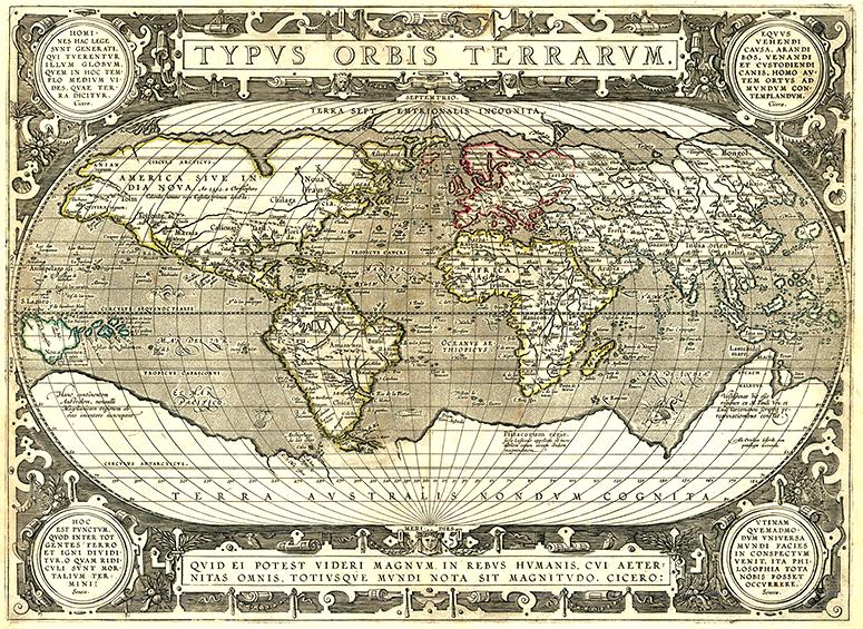
Abraham Ortelius’s map of the world is, without doubt, one of the most recognized and influential world maps of the late sixteenth and early seventeen centuries. It had a profound influence on contemporary cartography.
Ortelius’s map of the world was issued utilizing three different copper plates between
1570 and 1612. This final state utilized the still-surviving third copper plate and was issued separately after 1617, several decades after Ortelius’s death.
O rtelius’s ability to locate and draw upon both Spanish and Portuguese sources is apparent throughout the map, and is quite remarkable, given the manner in which each nation guarded its cartographic information. Both nations kept their geographic knowledge locked in a single institution, with all cartographic knowledge maintained on a single master map. Copies of the master map were closely monitored, and pilots could be punished for not returning their charts; however, no vault is impenetrable and geographic secrets leaked out, including to Ortelius in Antwerp .
Abraham Ortelius, Typus Orbis Terrarum. Published in Antwerp, 1617-1641 Courtesy of the Barry Lawrence Ruderman Antique Maps Collection
merchants across the Pacific. Many of these galleons were constructed in the Philippines using tropical hardwoods. Because of the lucrative nature of the trans-Pacific trade, the galleons themselves reached immense size for their day. The largest were capable of carrying as many as 1,000 passengers. The return voyage, in which the ship was known as the “Acapulco Galleon,” brought to Asia as much as onethird of the silver and gold extracted from the New World.
Modelmaker: Dr. William Brown
Maritime Museum of San Diego Collection
Photographer: Ted Walton
Antonio de Herrera y Tordesillas. Descripción de las Yndias Occidentales.
Published in Madrid, 1726
Courtesy of the Barry Lawrence Ruderman Antique Maps Collection
This is the 1726 edition of Antonio de Herrera y Tordesillas’ general map of America, the Pacific Ocean and the Eastern part of Asia, from his Descripción de las Indias Ocidentales, first published as part of his important Historia general in Madrid in 1601.
Herrera’s general map is derived from the manuscript map of Juan López de Velasco (ca. 1580), housed at the John Carter Brown Library, Providence, Rhode Island. Originally suppressed as part of Spain’s secretive approach to geographic knowledge, Velasco’s manuscript map was latter printed with official approval in Herrera’s landmark work as part of an opening of publication protocols under Spain’s King Philip III.
The map illustrates the Line of Demarcation and the antemeridian between the Spanish and Portuguese colonial claims (running through Brazil in South America and through China and the Malay Peninsula in Asia respectively). The islands of Maritime Southeast Asia are shifted tens of degrees to the east of their actual location, placing them (not surprisingly) under Spanish control. These include the Moluccas, so important for their spices and under Portuguese control, as well as the Philippines, which were claimed and occupied by Spain.
Manila Galleon, late 1500s
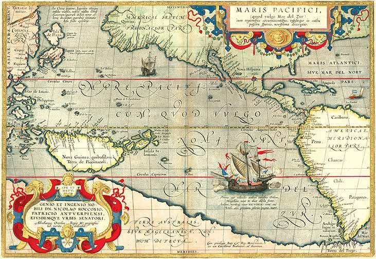
This is an English edition of Ortelius’s “Maris Pacifici” which was the first stand-alone map of the Pacific ever printed. It was featured in the Theatrum Orbis Terrarum, the first modern atlas. The text on the verso of this edition of the map is in English. Ortelius’s Pacific, while vast, shows a muchsmaller body of water than the Pacific turned out to be. However, methods for measuring longitude were still uncertain in the late-sixteenth century, and Ortelius, dependent on information brought back by navigators, was working from a limited amount of information.
In 1570, Ortelius published the first modern atlas, Theatrum Orbis Terrarum , or “Theater of the World.” In this, he produced a set of uniform maps with supporting text gathered in book form. Previously, there were other bound map collections, specifically the Italian Lafreri atlases, but these were sets of maps – not necessarily uniform in size and style – selected and bound together on demand.
Ortelius’s atlas outperformed competing atlases from other cartographic luminaries like the Mercator family. Between 1570 and 1612, 31 editions of the
atlas were published in seven languages. At the time of its publication, it was the most expensive book ever produced.
Perhaps the most arresting detail of the map is the massive ship off the coast of Chile. This is Magellan’s Victoria , the ship that completed the world’s first circumnavigation. A text box below the ship triumphantly proclaims:
“I was the first to sail around the world by means of sails, and carried you, Magellan, leader, first through the straits. I sailed around the world, therefore I am justly called Victoria [Victory], my sails were my wings, my prize was glory, my fight was with the sea.”
Beyond this decoration, there are two large strapwork cartouches at the top right and lower left. The detailing is a style characteristic of Ortelius’s work. In the upper right is the title, which translates to, “A very new description of the peaceful sea, commonly called South Sea with the regions lying around it, and its islands, scattered everywhere.” The bottom left cartouche carries the date of the first edition of 1589, and a dedication to Nicolaus Roccoxius, a wealthy politician of Antwerp.
Abraham Ortelius, Maris Pacifici quod vulgo Mar del Zud. Published in Antwerp, 1606
Courtesy of the Barry Lawrence Ruderman Antique Maps Collection
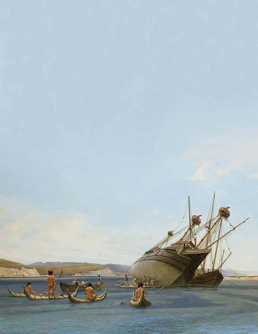
The
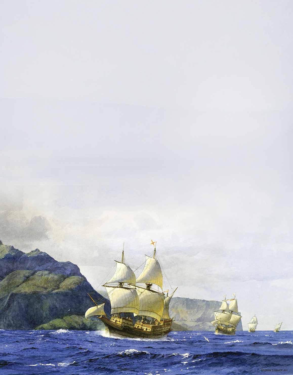
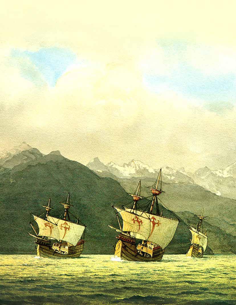
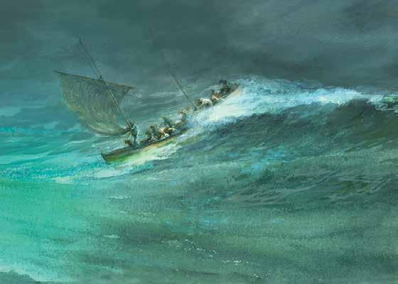
Below: Sailing from Callao in search of the Solomon Islands, 1567
Artist: Gordon Miller
Below:
Left:
Manila Galleon Westbound in the Trades, late 1500s
Artist: Gordon Miller
Álvaro de Mendaña reaches the Marquesas, 1595
Artist: Gordon Miller
The galleon Golden Hind –originally named the Pelican – was launched in 1577. In December of that year, under the command of Francis Drake, she set out on a voyage to explore the Pacific and harass the Spaniards. Having captured the Spanish galleon Nuestra Señora de la Concepción with her valuable cargo, Drake proceeded along the west coast of the Americas, finally reaching a region he named New Albion, just north of modern San Francisco. From there, having careened the Golden Hind and carried out much needed repairs, the English sailed westward across the Pacific. Drake and his crew would eventually circumnavigate the globe, before arriving in Plymouth in September of 1580. Upon her return, Golden Hind was moored at Deptford,
Careening of the Golden Hind, 1579
where she would remain for much of the next century on public display – quite likely the world’s first museum ship. Today a replica of the Golden Hind is likewise on display in London.
Modelmaker: Dr. William Brown Maritime Museum of San Diego Collection
This model represents the careening or cleaning of the underside of the hull of the Golden Hind. In this vignette,
Drake’s crew scrapes and burns marine growth off the lower part of her hull in preparation for her voyage across the Pacific. This took place near Drake’s Bay, on the Pacific coast just to the north of modern-day San Francisco.
Modelmaker: Dr. William Brown Maritime Museum of San Diego Collection
A Fair and Good Bay: Careening of Golden Hind, 1579
Artist: Gordon Miller
Photographer: Ted Walton
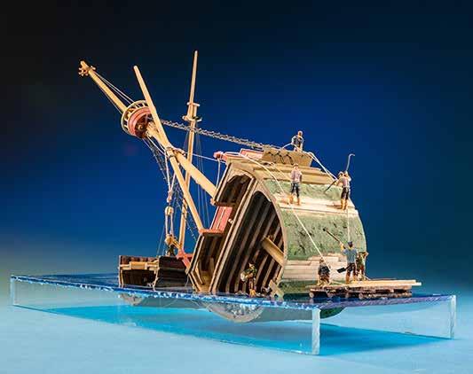
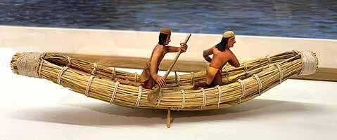
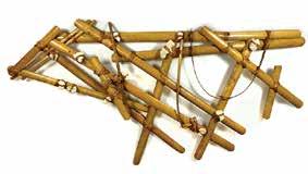
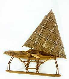
California Native American reed boat, sixteenth century
Modelmaker: John Sauvajot Maritime Museum of San Diego Collection
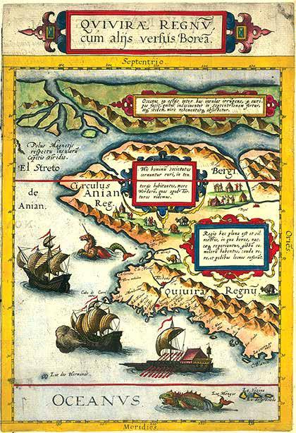
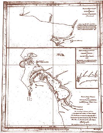
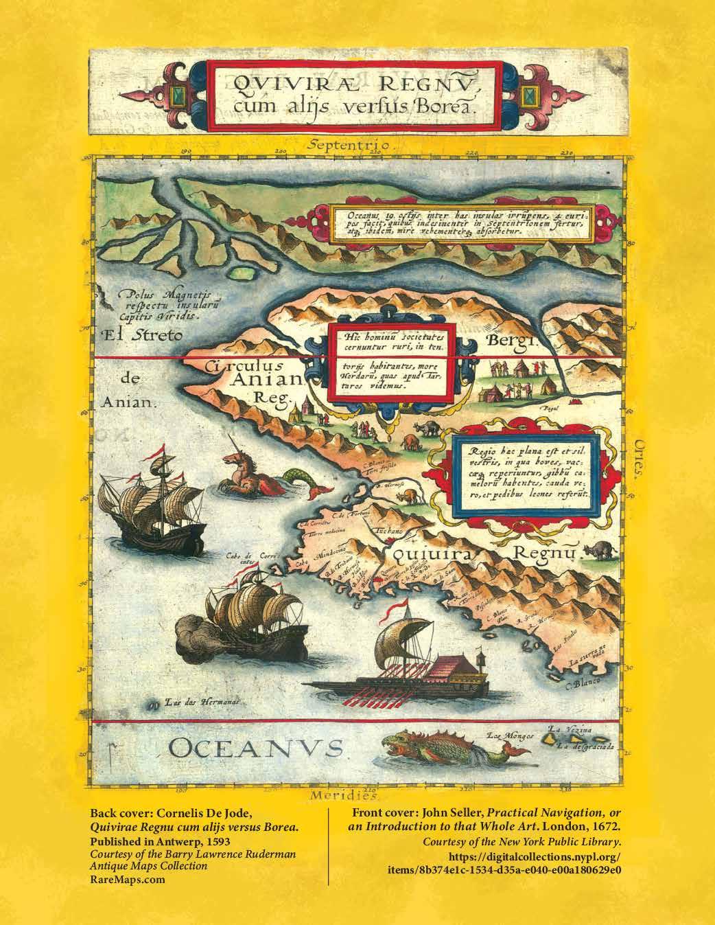
This map is one of the most remarkable examples of sixteenth-century conjectural cartography to appear in print.
The map extends from the mythical arctic regions of the Northwest Passage and Arctic in the north to Southern California and the Channel Islands, with the island west of C. Blanco almost certainly being Catalina Island or San Clemente Island off the coast of San Diego. Cape Mendocino is shown (inclusive of the small island off its modern coastline), emphasizing the western-most part of the California coastline, with another prominent region marked Anian Reg[io], which corresponds geographically to the area around Cape Nome, Alaska, and the Bering Sea.
Cartographically, De Jode’s map is derived from Plancius’s world map of 1592. De Jode’s map is one of the earliest regional maps to focus on this stretch of largely unexplored coastline. The map is from the second edition of De Jode’s very rare Speculum Orbis Terrae and was issued in only one known edition.
The map extends from the mythical Northwest Passage (El Streto de Anian) to the northern part of Baja California. Mountains line the coasts of the landmasses. Cities are marked with small
Cornelis De Jode, Quivirae Regnu cum alijs versus Borea. Published in Antwerp, 1593.
Courtesy of the Barry Lawrence Ruderman Antique Maps Collection
clusters of buildings and are here colored red. Embellished text boxes expand on the images of settlements, people, and goats. They explain the typical animals of the area, the similarity of the indigenous people's tents to those of the Tartars, and the geography of the northern polar region.
The decorative elements are stunning, particularly the large ships. The three vessels are remarkably detailed, with one firing a broadside and another in full sail. The third, the southernmost, is patterned on a ship from Southeast Asia. Also in the water are two large sea monsters, one a mermaid unicorn, the other a fearsome fish.
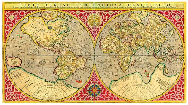
This map is based on Gerard Mercator’s celebrated 1569 world map. This is the only collectible world map with direct input from Gerard Mercator, arguably the greatest geographer of his era. Rumold Mercator recast his father’s famous projection as a double hemisphere, with the Americas on the left and Africa, Europe and Asia on the right. A huge landmass extends from
the southern tip of the Americas to the islands of New Guinea and Java Mayor. Mercator applied names taken from the writings of the Venetian traveler Marco Polo to describe parts of this vast Terra Australis . Maps of this type were extremely influential in encouraging European exploratory voyages to the region in the late sixteenth and early seventeenth centuries .
Maritime Museum of San Diego Collection
Courtesy of the Barry Lawrence Ruderman Antique Maps Collection
Rumold Mercator. Orbis Terrae Compendiosa Descriptio Quam ex Magna Universali Mercatoris... Published in Amsterdam, 1613
Courtesy of the Barry Lawrence Ruderman Antique Maps Collection
Golden Hind, 1577
Photographer: Ted Walton
Mathematics, Instruments and Navigation: New Ways of Defining Space and Measuring Time
t the dawn of the sixteenth century, mathematics and instruments were believed to have few practical applications for understanding or manipulating the physical world. In the 3rd century BCE, Aristotle, for instance, wrote that instruments distorted “pure” observation by the human senses and would produce flawed results contrary to the purposes of science.
The mathematical techniques and instruments used in mining, military engineering and, most of all navigation, were the few areas of human endeavor that such things were believed effective in producing desired outcomes. Even in these cases, experts were thought to be practitioners of a mysterious art, their authority derived from an arsenal of exotic instruments, mathematical tables, and cyphers normal people did not know how to use. Navigation developed its own special language derived from astronomy, making it even more inaccessible, and treatises on navigation emphasized the magisterial quality of the discipline as art steeped in mysticism.
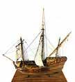
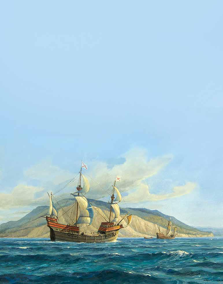
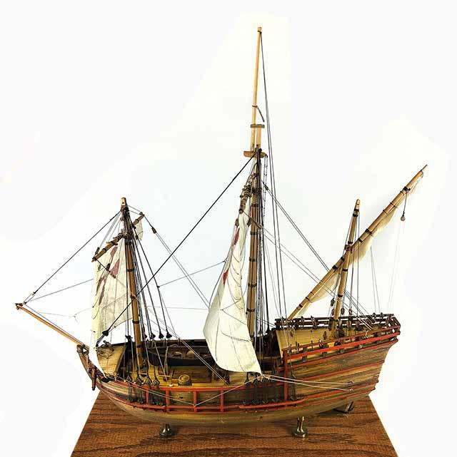
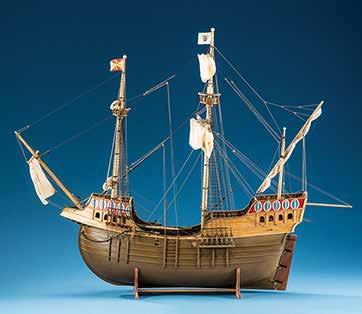
Santa María was the largest of the three small ships used by Christopher Columbus in his first expedition across the Atlantic Ocean in 1492, with the backing of the Spanish monarchs. Juan de la Cosa was her master and owner. She was built in Pontevedra, Galicia, in Northern Spain, and designed as a medium-sized commercial nau or carrack, about 58 ft. long on deck. On December 24, 1492, she ran aground off present-day site of Cap-Haitien, Haiti. Columbus ordered the wreck’s timbers to be used to build a fort which he named La Navidad.
Santa María, 1492
Modelmaker: Dr. Charles Stern Maritime Museum of San Diego Collection
But as navigation increasingly became a tool of seaborne empire, European maritime states attempted through the creation of national institutions at first to restrict and control navigational information for their exclusive benefit, and later to stimulate technical improvements in the practice to further the benefits of international oceanic trade. The 16th-century Casa de la Contratación in Spain and the Casa da Índia in Portugal represented the first phase in the efforts of states to control the production of nautical charts and instruments and to license pilots. In the seventeenth century, the National Observatories in London and Paris were the first permanently funded scientific institutions created to solve and manage technical challenges, such as solving the longitude problem.
As nation-states embraced a new technical/mathematical emphasis in science, such institutions became elements of state identity and authority, reflected increasingly in the production of charts and mathematical tables. As the markers of expertise in navigation evolved from conspicuous use of arcane instruments to the mastery of complex mathematical equations, the products of navigation – charts, instruments, and ships themselves – reflected the increasing state sponsorship of such endeavors.
The elaborate cartouches gave way to increasingly precise and detailed depictions of coastlines, soundings, and the simple grid of the chart became increasingly a spare expression of its accuracy. The process of navigation shifted from graphic manipulation on the chart to intellectual reduction of observations through complex mathematical computations. Ships themselves accordingly lost much of their embellishment as they grew to be ever more powerful and far-reaching expressions of military power and trade.
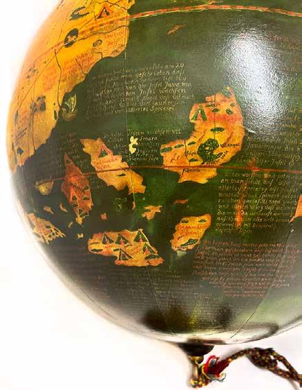
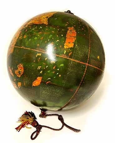
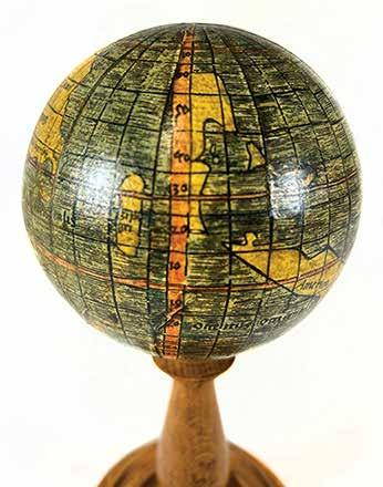
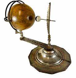
The Erdapfel
(Earth-apple) is the oldest surviving terrestrial globe. It was produced by the German cosmographer Martin Behaim between 1490 and 1492. The globe shows an enlarged Eurasian continent and an empty ocean between Europe and Asia. The mythical Saint Brendan’s Island is included. Cipangu (the Japanese archipelago) is oversized and well south of its true position; Martellus’s map is followed in developing an enormous phantom peninsula east of the Golden Chersonese (the Malay Peninsula). The globe essentially reproduces the theoretical geography of the world known to European intelligentsia just prior to the voyage of Christopher Columbus. The globe’s surface is covered with images and captions taken from sources familiar to Columbus: the writings of Marco Polo, Isidore of Seville and the ancient geographer Ptolemy.
Martin Behaim Erdapfel facsimile reproduction of 1490-1492 original Maritime Museum of San Diego Collection
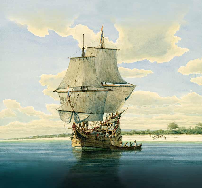
São Gabriel, 1497
The São Gabriel was a carrack captained by Vasco da Gama on the first Portuguese voyage to India round the Cape of Good Hope. Da Gama set sail in 1497 in the company of three other vessels. His small fleet reached Calicut on India’s Malabar Coast in May of 1498. The voyage opened the way for the Portuguese to establish and monopolize the trade between Europe and India for the better part of a century.
The Portuguese national poem, Os Lusíadas, written by Luís Vaz de Camões in 1572, renders an account of this voyage into Homeric form and is widely regarded as one of the greatest epic poems in literary history.
Modelmaker: Dr. William Brown
Maritime Museum of San Diego Collection Photographer: Ted Walton
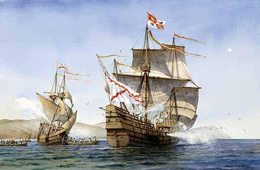
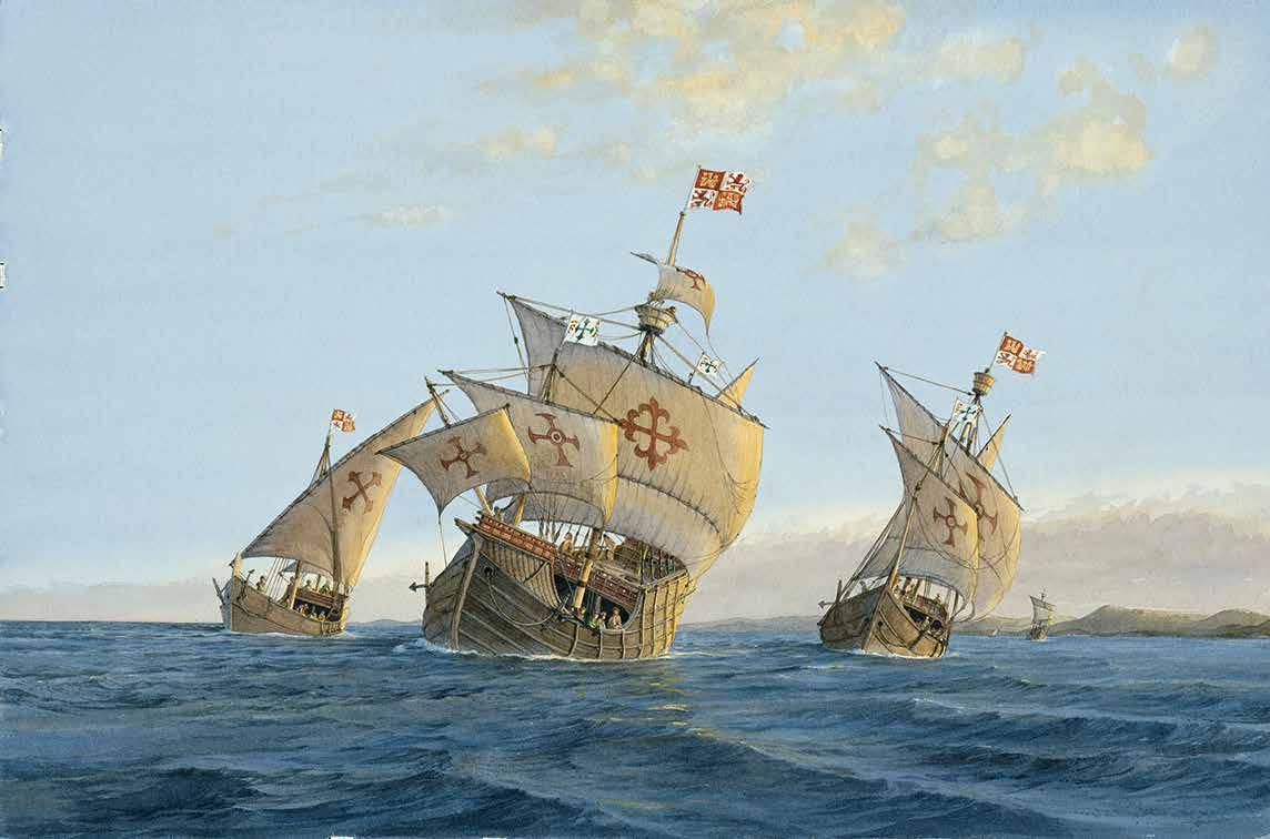
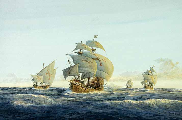
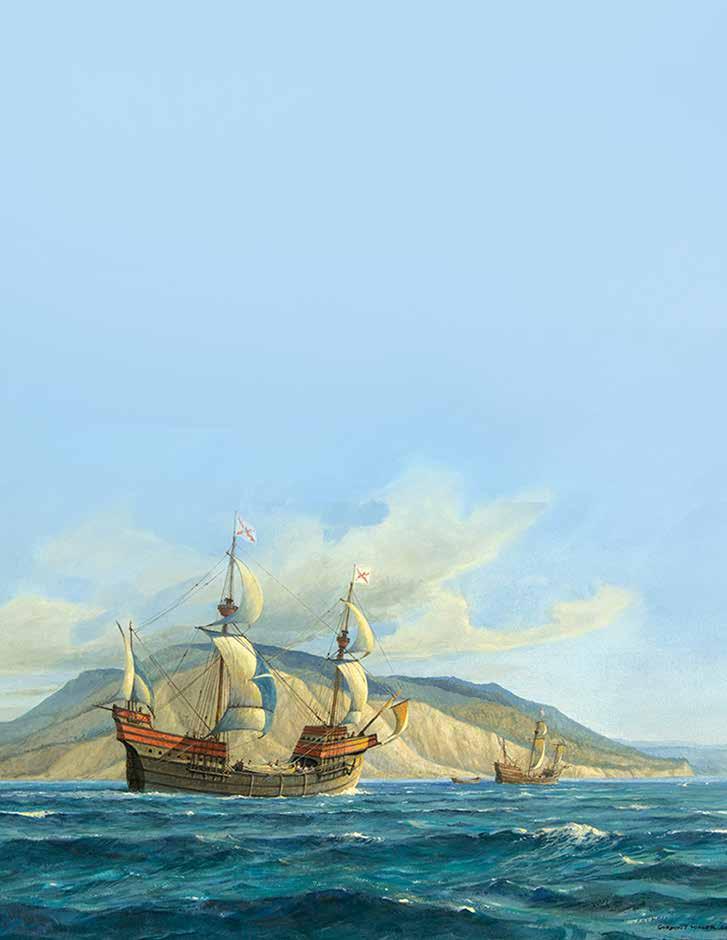
Pinta, Niña, and Santa María depart from Spain, 1492
Artist: Gordon Miller
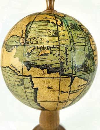
Waldseemüller Globe
The first map or globe to show the two continents of North and South America was produced one year after the death of Columbus. Waldseemüller printed an unknown number of gores, each of which could have been cut and formed into a small globe. Of these only four original gores have survived. All the original globes have been lost. Waldseemüller is the first cartographer to use the designation “America” on any map, in honor of the explorer Amerigo Vespucci. A strait divides the continents of North and South America, and a narrow ocean separates the Americas from Asia. Scholars continue to discuss the cartographer’s sources and motive for including what would become known as the Pacific, six years before it was seen by Europeans.
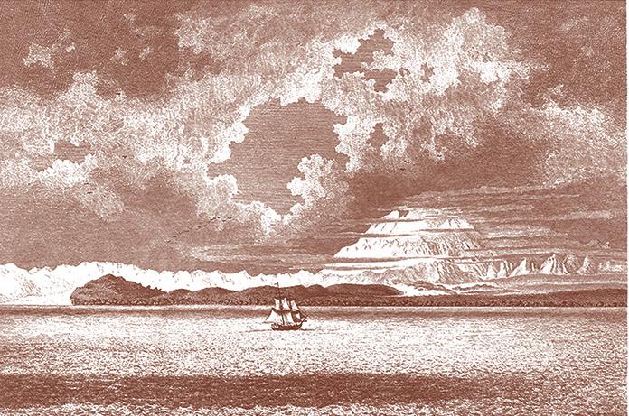
Vasco da Gama approaching the Cape of Good Hope, 1497
Artist: Gordon Miller
Facsimile reproduction of 1507 original Maritime Museum of San Diego Collection
Magellan Commemorative Globe
The now-lost original of this globe was produced shortly after the 1522 return of the Victoria to Spain with the last survivors of Ferdinand Magellan’s expedition. The globe shows the track taken by Magellan’s fleet across the Pacific.
Facsimile reproduction of 1522 original Maritime Museum of San Diego Collection
Magellan in the Strait of Magellan, 1520
Artist: Gordon Miller
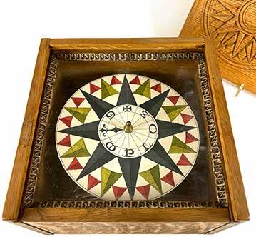
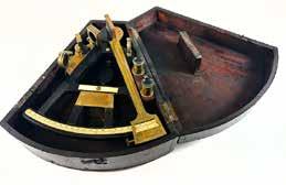
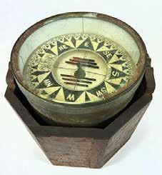
Dry-Card Compass
Hand-crafted replica sixteenth-century compass in wooden box with sliding lid. The lid bears a carving of a compass rose. The compass dial is hand-painted with a red, green, and black compass rose. The brass center ornament is engraved with symbols designating direction.
Dry compasses begin appearing around 1269 in medieval Europe and 1300 in the medieval Islamic world. They were replaced in the early 20th century by the liquid-filled magnetic compass. The adaptation of the compass to nautical use seems to have directly influenced the evolution of cartography, and in particular the development of portolan charts, of which the Carta Pisana (see page 7) is one of the earliest surviving examples. Maritime Museum of San Diego Collection
Replica of sixteenth-century original
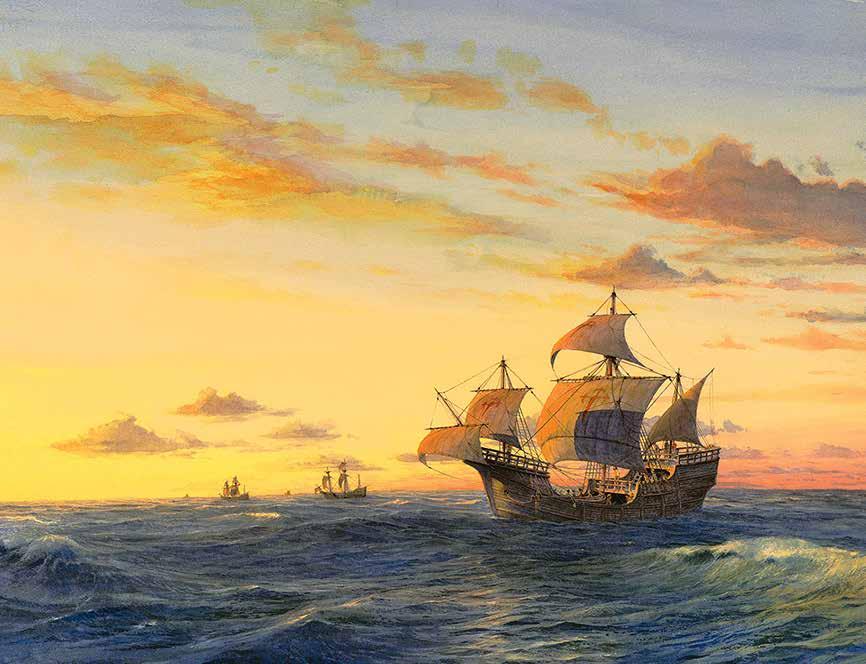
Atlantic Sunset: Magellan and Victoria, 1519-1520
Artist: Gordon Miller
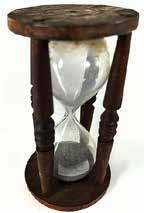
Log Glass Mid-1850s
The log glass was used in conjunction with a log and line to time the period during which the log line was allowed to unroll from the log reel and so estimate the ship’s speed from the amount of line paid out. Though these devices are often referred to as sandglasses, the powder within the glass was actually composed of crushed eggshells.
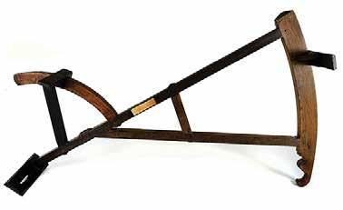
T heSounding Lead and Line
Courtesy of Raymond Ashley
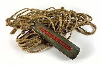
Chip Log and Reel
Replica of nineteenth-century original
chip log, also called common log, ship log, or just log, was a navigation tool mariners used to estimate the speed of a vessel through water. It consisted of a wooden board attached to a line (the log-line). The log-line had a number of knots at uniform intervals. The word "knot", meaning nautical mile per hour, derives from this measurement method. The log-line is wound on a reel so the user can easily pay it out. A navigator who needed to know the speed of the vessel had a sailor drop the log over the ship’s stern. The log acted as a drogue, remaining roughly in place while the vessel moved away. The sailor let the log-line run out for a fixed time while counting the knots that passed over. The length of log-line passing (the number of knots) determined the reading. The reading was acquired by turning a log glass in which fine eggshell fragments drained from one glass bulb into another. Prior to the introduction of the chip log, pilots and navigators measured a ship’s speed by counting the time it took for a floating wood chip or piece of debris to pass between two points along the length of the ship, counted in heartbeats.
Maritime Museum of San Diego Collection
leadline was the earliest navigational instrument, its design having changed little in thousands of years. It consisted of a lead weight attached to a length of rope. The depth of water could be ascertained simply by dropping the weight and feeling the line go slack as it hit the bottom. The depth was noted either by counting the knots in the line as they disapeared into the water, or counting the full arm spans of line (about six feet, equivalent to a fathom) the leadman took back in. The entire process of measurig the depth and contours of the sea bottom was called sounding. There was usually a cavity in the bottom of the lead that could be filled with tallow, so that a sample of the bottom was brought up with each sounding. This was useful in determing trough position and for knowing what type of bottom the ship would drop its anchor in, and thus how well the anchor might hold.
Knowing depth of water was essential in keeping the ship from running aground, from taking the ground during low tide and, if the bottom contours were known, for determining the ship's position.
Benjamin King Backstaff / Davis Backstaff
Newport, Rhode Island, 1764
The backstaff was invented in 1594 by the English navigator Captain John Davis. His instrument was named the backstaff because it was used with the observer’s back to the sun thereby avoiding eye damage caused by looking at the sun directly. It remained in common use even after 1731 when the octant (an early form of the modern sextant) was invented independently by John Hadley of England and Thomas Godfrey of Philadelphia.
Maritime Museum of San Diego Collection
Sebastian Münster. Die Neuwen Inseln / So hinder Hispanien gegen Orient / ven dem landt indie ligen
Published in Basel, 1554
Courtesy of the Barry Lawrence Ruderman Antique Maps Collection
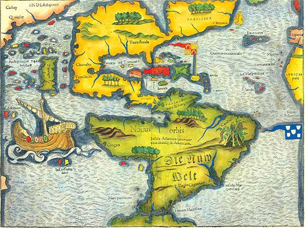
Münster’s depiction of America is the earliest map to show all of North and South America in a true continental form. His Cosmographia was the first influential German description of the world. The present map in its various states was the best known and most widely circulated map of the Americas until Abraham Ortelius’s map of 1570.
Sebastian Münster (1488-1552) was a cosmographer and professor of Hebrew who taught at Tübingen, Heidelberg, and Basel. He settled in the latter in 1529 and died there, of plague, in 1552. Münster made himself the
center of a large network of scholars from whom he obtained geographic descriptions, maps, and directions.
He is best known for his Cosmographia universalis , first published in 1544 and released in at least 35 editions by 1628. It was the first Germanlanguage description of the world and contained 471 woodcuts and 26 maps over six volumes. Many of the maps were taken from the Geographia and modified over time. The Cosmographia was widely used in the sixteenth and seventeenth centuries. The text, woodcuts, and maps all influenced geographical thought for generations.
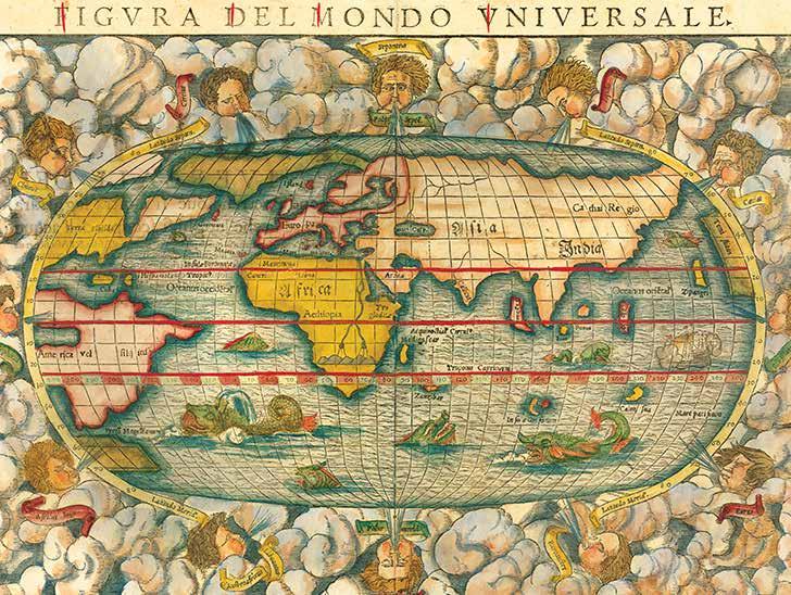
Sebastian Münster. Figura del Mondo Universale
Published in Basle, 1552. Courtesy of the Barry Lawrence Ruderman Antique Maps Collection
This is a second edition of Münster’s map of the world, one of the most recognized and influential world maps of the sixteenth century. Today, it is one of the earliest obtainable world maps. This example is from the second woodblock, which featured in editions of Cosmographia from 1550 with significant revisions from the first edition.
The map is richly embellished with a dozen wind-heads blowing their gales from a cloud border. The blowing cherubs do not intrude into the oval of the projection, as they did in the first iteration. The other easily noticeable change is the inclusion of the letters "DK" in the clouds in the lower left corner. These are the initials of the engraver, David Kandel.
Sea monsters frolic in the Southern Ocean, where no large continent is hypothesized to hide. Instead, a small unlabeled landmass lies south of the Straits of Magellan, which were discovered less than two decades before this map was produced. Each ocean is labeled with a text block, made by inserting metal type into the woodblock, and this map contains one of the earliest namings of the Pacific Ocean (Mare Pacificum).
Münster’s map is a fascinating mixture of information
derived from the most up-to-date sources he could access. He maintained a large network of sources, written and printed, and informants who fed him information about the shape of the world. This map reveals several of his sources.
For example, close knowledge of Magellan’s historic circumnavigation is evident. Münster most likely had access to the maps and manuscripts written by Antonio Pigafetta, partially published in Paris in 1525, as well as Maximilianus Transylvanius's published account based on Christopher Haro’s interviews of survivors, published in 1523 in Cologne.
Access to other maps and geographies is also evident, including Martin Waldseemüller’s 1507 map of the world. A facsimile of Waldseemüller’s globe is illustrated on page 23. As a trained geographer, Münster clearly had studied Marco Polo, as evidenced by his placement of Japan (Zipangri) at roughly 20 degrees north latitude. He also was familiar with Ptolemy’s ideas. For example, Münster follows the traditional Ptolemaic geography in Africa by depicting twin lakes on the same latitude near mountains. Ptolemy thought this configuration to be the source of the Nile River.
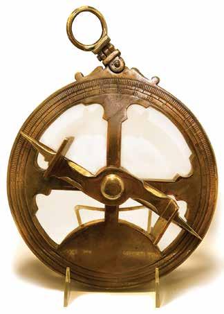
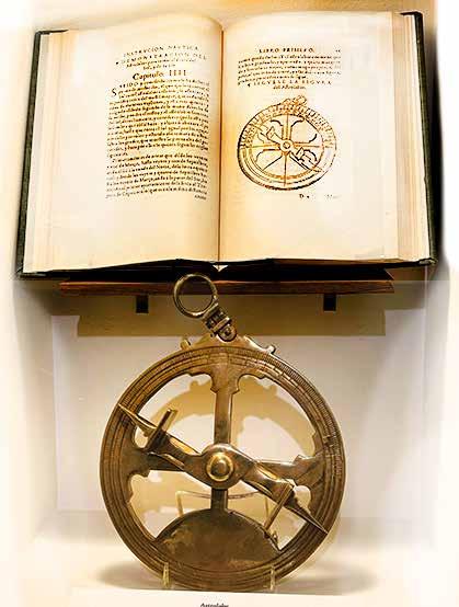
Astrolabe
Facsimile of mid-sixteenth-century original Maritime Museum of San Diego Collection
This astrolabe is of a design that would have been used habitually by mariners on voyages in the Pacific during the sixteenth century. Astrolabes were able to measure the altitude above the horizon of a celestial body, day or night. They could help to identify stars or planets, to determine local latitude given local time (and vice versa), and to survey, or to triangulate. They were used in classical antiquity, the Islamic Golden Age, the European Middle Ages, and the Age of Discovery for all these purposes.
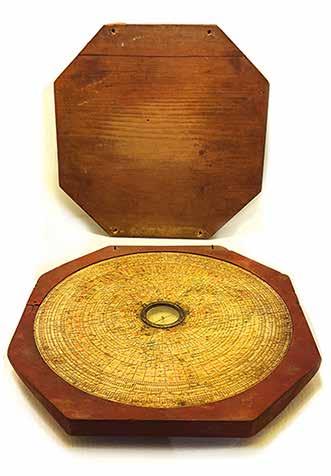
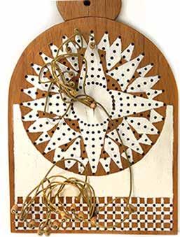
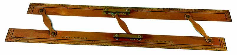
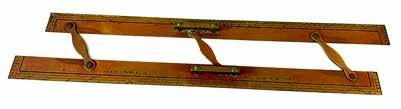
Traverse Board
Reproduction of sixteenthcentury original Maritime Museum of San Diego Collection
The traverse board is a tool formerly used in dead-reckoning navigation to easily record the speeds and directions sailed during a watch. Even crew members who could not read or write could use the traverse board. The top part is for recording direction sailed. It has a representation of the compass rose with its 32 compass points, just as on the face of the ship’s compass. Eight concentric rings are inscribed on the compass rose. Each ring has one peg hole at each point of the compass. Eight pegs are attached to the center of the compass rose with strings.
The bottom part is for recording speed. It has four rows of holes. Each column represents a certain speed, measured in knots.
Each half-hour during the watch, a crew member inserted a peg in the top part of the board to represent the heading sailed during that half-hour, as shown on the ship’s compass. The innermost ring of peg-holes is used for the first half-hour, and each succeeding measurement was made in the next ring out, until all eight rings were used.
Each hour during the watch, a crew member inserted a peg in the bottom portion of the board to represent the speed sailed during the hour. The speed would have been measured using a knot log. If the speed for the first hour of the watch was 10 1/2 knots, the crew member would count over 10 holes in the first row and place one peg, then place another peg in the column marked “1/2”. In the second hour of the watch, the crew member would use the second row of pegs, and so on until all four rows were used.
At the end of the watch, the navigator collected the information about the speeds and directions sailed during the watch into the logbook, cleared the pegs from the board, and used the information to figure the vessel’s dead reckoning track. Meanwhile, the helm of the new watch would begin recording the new sailing headings and speeds on the traverse board.
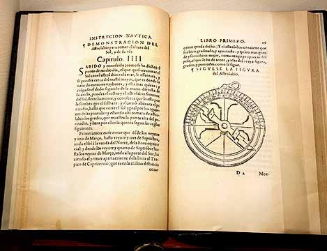
Diego García del Palacio. Instrucción náutica para navegar
Published in Mexico, 1587
Maritime Museum of San Diego Collection
Facsimile of the 1587 edition of García del Palacio’s foundational work on the art of navigation. Palacio’s writings on sixteenth-century shipbuilding were studied in detail by historians, nautical archaeologists, and naval architects, and the findings were incorporated
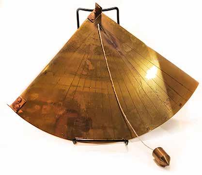
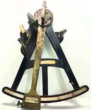
Mariner’s Quadrant
Replica of sixteenth-century original Maritime Museum of San Diego Collection
The mariner’s quadrant was a simple nautical instrument designed to measure altitude. An object would be observed by viewing it through the two circular sights. A reading would then be taken according to the line weighted with a plumb bob. This would give the altitude in degrees above the horizon. This altitude could then be used to determine latitude.
As with the astrolabe, the heaving deck of a moving ship proved a problematic platform for making observations indexed to plumb weights, which gave instruments using the horizon some advantages. Quadrants and astrolabes, however, could be used to observe stars and planets all through the night whereas instruments which required sight of the horizon could not be used past evening twilight or before dawn.
into the design and construction of the Maritime Museum of San Diego’s replica of Juan Rodríguez Cabrillo’s galleon San Salvador.
Nocturnal
Replica of sixteenth-century original Maritime Museum of San Diego Collection
Beginning use early in the sixteenth century, the nocturnal transforms the North Star and its “guards” (the closest two stars of the Big Dipper) into a rough celestial clock. Having preset the instrument for the date, the observer looks through the center hole directly at the North Star and moves the nocturnal’s arm into alignment with the guard stars to determine time. Knowing the time allowed a navigator to apply proper corrections to the measured altitude of Polaris for determining latitude, and to calculate the state of tide for established locations. The star Polaris lies very near the earth’s north polar axis, but not exactly, requiring a correction to be made to the observation depending on time
The Seventeenth Century Elegant Baroque design and increasing precision
Joris van Spilbergen, Straits of Le Maire, Nova Guinea, South Pacific. Published in Amsterdam, 1619.
Courtesy
of the
Barry Lawrence Ruderman Antique Maps Collection
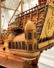
The seventeenth century witnessed a flourishing in the art and science of European cartography. Maps became ever more precise, as mapmakers gained more access to the observations of Spanish, Portuguese, Dutch, English and French mariners. In concert with this drive towards increasing accuracy, the artistic trajectory of the Baroque manifested itself in marginal embellishment. This artistry is further evident in the naval architecture of the period, with elaborate decorative design worked into the construction of vessels. Just as maps reflected both national achievement and imperial aspiration, so also ships came to express the accomplishments and status of peoples and their rulers. Extravagant embellishment combined with political, scientific, economic and spiritual aspirations lay at the heart of Baroque artistry.
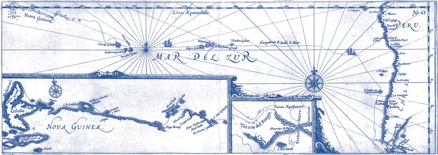
Spilbergen’s rendering of Willem Schouten and Jacob Le Maire’s map / sea chart of a portion of his circumnavigation of the world, showing the route of his voyage including the rounding of Cape Horn, then across the Pacific to New Guinea, was published in Amsterdam in 1619.
The chart shows Le Maire’s route from around Cape Horn, the first expedition to locate an alternative route around the tip of South America, which would come to be known for a time as Le Maire’s Strait and later Cape Horn. After sailing north to the island of Juan Fernandes, the expedition island hopped its way to New Guinea, the first Europeans to visit a number of the islands along the way.
The inset map shows details of the expedition’s transit south of the Straits of Magellan via the Fretum Le Maire, and the route of the expedition along the coast of New Guinea Islands to the west.
Van Spilbergen’s mapping of the voyage of Schouten & Le Maire’s route would be the first to be published, appearing in Spilbergen’s account of his circumnavigation between 1614 and 1617. Because Spilbergen’s account of his expedition (which included details he learned from Le Maire while the pair spent time together on the return voyage to Europe) was published first, it holds primacy for the first printed map to depict the discoveries.
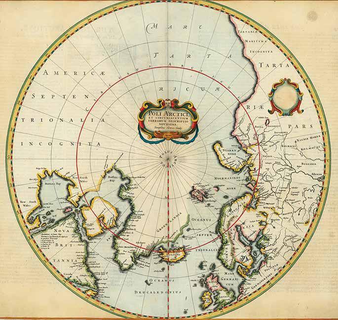
This map shows the geography of the globe from 50°N latitude. The seas between Tartary, in Asia, and Baffin Bay, in North America, are left open. However, all of the toponyms in northern Asia, Europe, and North America are named for explorers who hoped to chart just this area.
Two cartouches grace the map’s surface. One, near the North Pole, includes the title and maker. The other, in Tartary, was empty in earlier versions of the map and later included the publishing information of Frederick de Wit.
Henricus Hondius, Poli Arctici, et Circumiacentium Terrarum Descriptio Novissima. Published in Amsterdam, 1636.
Courtesy of the Barry Lawrence Ruderman Antique Maps Collection
The most alluring part of this map is the series of vignettes that surround the circular chart. All four corners show scenes of whaling and sealing. Men in masted ships send out smaller boats to pursue the animals. They harpoon the creatures, tow them ashore, and there process the meat and render the fat. These are meant to celebrate the burgeoning Dutch whaling industry at work on the eastern coast of Labrador; this is the first map to feature Dutch toponyms in that area.
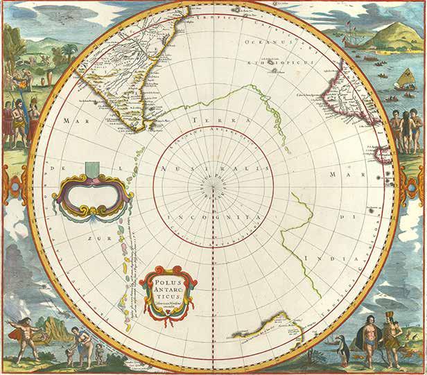
The map shows all but two of the known Dutch discoveries up to 1627, including those of Pieter Nuyts, Frederick de Houtman, Dirk Hartog, and Jan Fransz Leeuwin south of the 20th parallel south. Omitted are the voyages of Jansz and Roossengin in 1605-06 and Cartensz and van Colster in 1623. Saint Helena, the Disappointment Islands, and Le Maire’s discovery of the Tongan archipelago, all above the 20th parallel, are shown outside the circular perimeter. The supposed coastline of the unknown southern continent appears as a splintered line, nearly touching Tierra del Fuego. Vignettes filling the four corners purportedly depict various native scenes spanning the region.
Henricus Hondius, Polus Antarcticus. Published in Amsterdam, 1636.
Courtesy of the Barry Lawrence Ruderman Antique Maps Collection
Duyfken at Cape Keerweer, 1606
Artist: Gordon Miller
Jacob Le Maire in Eendracht off Cape Horn, 1616
Artist: Gordon Miller
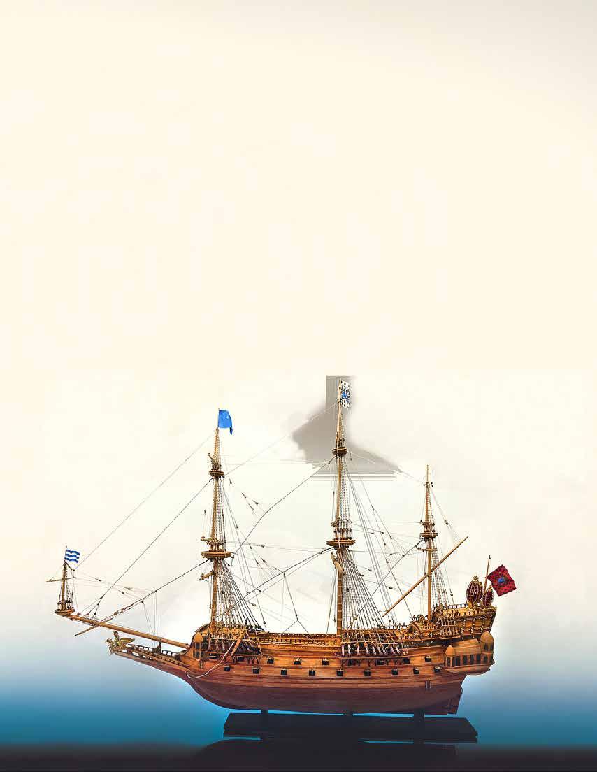
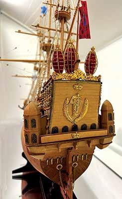
Ship-of-the-line La Couronne was built in 1636 by the French as part of the effort by King Louis XIII’s chief minister, Cardinal Richelieu, to ensure French naval dominance. She was one of the most imposing vessels of her time, designed to compete with even larger ships of other European navies, particularly those of the British. This vessel’s elaborately embellished quarter galleries fore and aft, as well as stern and figurehead, were intended to exemplify the height of French naval architecture and the aesthetics of the French Baroque. Variations of this type of ostentatious design are found in many other contemporary naval vessels, each of which sought to express national pride and confidence.
Modelmaker: Joe Bompensiero Maritime Museum of San Diego Collection
La Couronne, 1636
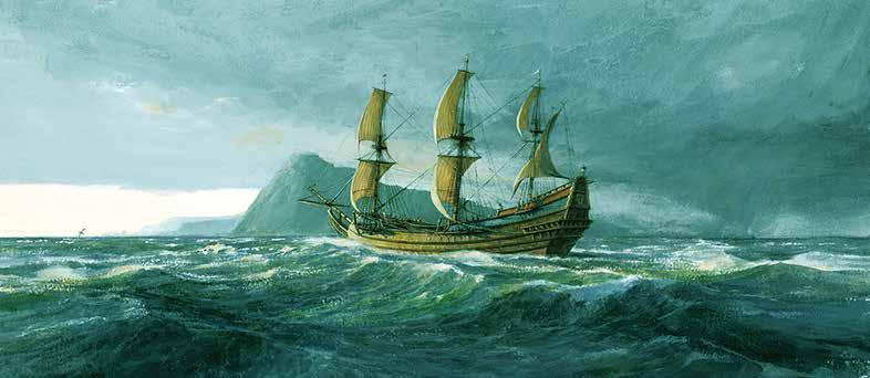
The Roaring Forties: Batavia in the Southern Ocean, 1629 Artist: Gordon Miller
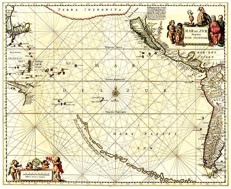
Jansson’s map was the first chart of the Pacific to show California as an island and the earliest sea chart of the Pacific to appear in a Dutch Atlas.
A long chain of islands appears in the South Pacific, which are likely a vestige of Terra Australis. These were noted by Jansson to have been discovered by Hernando Gallego in 1576. The first mention of this explorer appears in a Hondius map of the Antarctic. A Spanish navigator, Juan Fernandez, in search of Terra Australis in that year did claim to have discovered a mountainous island that some early scholars believed could be New Zealand.
California is shown as an island, based upon the Briggs model, but lacking the second Punta de la Concepción suggesting reliance upon Dutch cartographer Pieter Goos or his sources. Jansson includes a lengthy note about the island and previous mapping. The large Terra Incognita in the Northwest nearly connects Asia with the Island of California, separated only by the Fretum Anian .
Many places in California are named, from Cabo San Lucas to Cabo Mendocino. Some islands of the West Pacific start to take shape, with a part of Papua outlined. Many other islands, real and imaginary, are also shown.
Jan Jansson, Mar Del Zur Hispanis Mare Pacificum. Published in Amsterdam, 1650.
Courtesy of the Barry Lawrence Ruderman Antique Maps Collection
Dutch warships in the midseventeenth century were relatively small, but the Dutch Republic’s navy was one of the most powerful in the world. The Dutch were known for shipbuilding and had the largest number of ships in the world during the 17th century, also known as the “Dutch Golden Age.” However, the shallow waters around the Netherlands meant that Dutch ships were always smaller than those of other countries, which was a problem during the First Anglo-Dutch War (1652–1654). In response, the Dutch implemented a successful fleet-building program, including orders for sixty ships in 1653 and another sixty ten years later. This model represents classic Dutch shipbuilding techniques and the elaborate ornamentation found on even relatively small warships just prior to the First Anglo-Dutch War.
Modelmaker:
C. Washington
Katarina, 1649
John
Maritime Museum of San Diego Collection
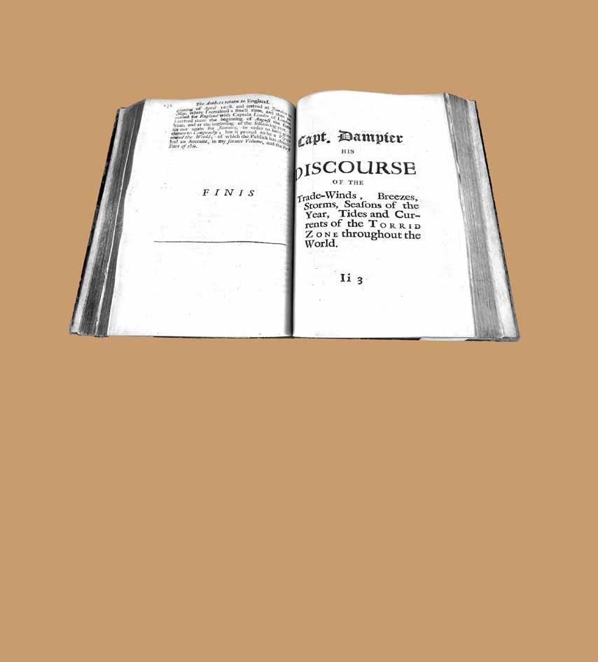
William Dampier. A New Voyage Around the World... Illustrated with particular maps and draughts. London: Printed for James Knapton, 1697.
Courtesy of Special Collections & Archives, UC San Diego
A New Age in Literature
The literary and technical works described in this edition of Mains'l Haul have a direct relationship with the nautical instruments, cartography and illustrations also featured in this issue. Many of the voyages narrated and described in these books resulted in the invention or improvement of the tools of navigation or in the acquisition of essential information related to the hydrography of the Pacific. This useful knowledge and inspiring narrative were then passed on to later generations of navigators.
Beyond this, the voyage narratives featured here became the first exotic adventure travel story accounts
that middle-class people could own and lend to each other. Their publication and wide dissemination stimulated the creation of a seemingly boundless popular market for adventure stories as well as an appetite for literature related to the narratives of oceanic voyages, stories of exploration, and tales of heroic deeds, all of which were set within the context of the ever-expanding imperial domain.
Even today, bookstores – both brick and mortar and online – as well as online streaming services have an enormous inventory in the category of “action and adventure.” This entire genre of publication and film descends directly to the books presented here. Maritime Museum of San Diego
William Dampier was the best known of the famous group of English buccaneers who raided Spanish ports in the South Sea from 1680 to 1720. His first voyage, under Captain Swan in the Cygnet, took him from Virginia to Spanish colonial possessions in the Americas and then across the Pacific to the East Indies. He traveled extensively along the coasts of Asia on several voyages which lasted from 1683 to 1691. It was on one of these voyages that the first landing was made by the English on the Australian mainland at the entrance to King Sound on the northwest coast. Dampier’s is essentially a nautical travel narrative, and also an exercise in self-promotion, combining adventure stories with natural history as well as detailed descriptions of oceanic winds and currents.
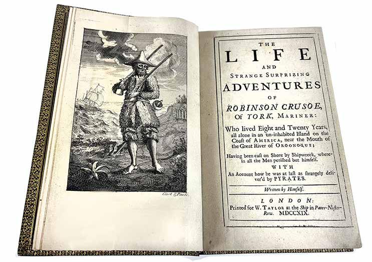
An event on Dampier’s voyages would have a profound influence on the writings of one of the most influential British novelists of the eighteenth century. In Daniel Defoe’s The life and strange surprizing adventures of Robinson Crusoe..., the character of Robinson Crusoe was inspired by the adventures of the Scottish sailor Alexander Selkirk, who was abandoned on the Pacific island of Juan Fernández during William Dampier’s second expedition.
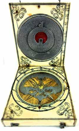
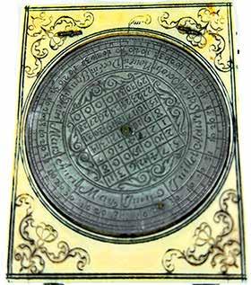
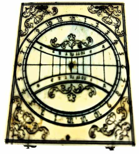
Bloud-type ivory Diptych Dial made in Dieppe in the late seventeenth century. A diptych dial is a type of sundial that gets its name from its two hinged leaves. The upper outer face has a circular equinoctial dial and central polar dial. The upper inner face has a latitude scale and pewter lunar volvelle. The lower inner face has a horizontal dial, printed paper compass rose, and pewter elliptical hour scale. The base has an inset pewter disc engraved with a perpetual calendar square and calendar scale .
Diptych
Dieppe, ca 1680 Maritime Museum of San Diego Collection
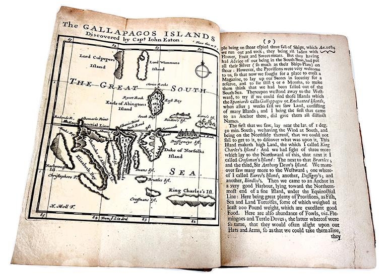
This work provides a fascinating insight into the history of piracy. William Hacke, the editor of this compilation of voyage narratives, had himself been a buccaneer before settling down to the somewhat more respectable work of publishing the journals of his former comrades. One of his former associates, Ambrose Cowley, was well known for his harassing ventures against the Spaniards in the West Indies. In his voyaging into the Pacific, he sailed further south than any of his predecessors, and he named some of the Galápagos Islands.
Bartholomew Sharp, the elected leader of the buccaneers, plundered and looted along the west coast of South America and weakened Spanish domination in those seas by capturing some significant charts in 1680, from which Hacke later made several highly important manuscript atlases.
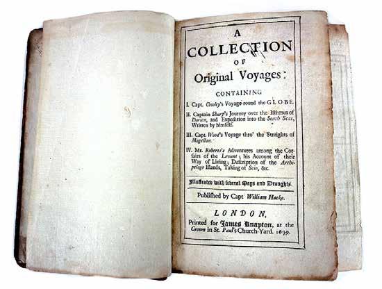
William Hacke. A collection of original voyages... London: Printed for James Knapton, 1699
Courtesy of Special Collections & Archives, UC San Diego Library
Cross-staff made by Abraham Tade. The sides bear graduated scales for altitude and zenith distances. On one of the vanes written in ink is the name “D de Waay”, believed to be that of an owner.
The navigator, holding the staff to one eye, would move the crosspiece until its lower end coincided with the horizon and its upper end with a celestial body. The desired elevation could then be read from the intersection of the crosspiece with the staff, on which
Abraham Tade Cross-Staff Danish, 1699 Maritime Museum of San Diego Collection
The twelve globe gores depict the world centered on the Atlantic Ocean. North America is stretched east-to-west in the north, a typical depiction for the time. A Northwest Passage is suggested, as open water flows around the Arctic waters into the Pacific. There is also an open river flowing into the interior of the continent, suggesting an interior passage as well. California is separated from the continent as an island, again a common depiction for the time.
The myth of California as an island was most likely the result of the travel account of Sebastián Vizcaíno, who had been sent north along the shore of California in 1602. A Carmelite friar, Fray Antonio de la Ascensión, accompanied him. Ascensión described the land as an island and around 1620 sketched maps to that effect. Normally, this information would have been reviewed and locked in the Spanish repository, the Casa de la Contratación. However, the manuscript maps were intercepted in the Atlantic by the Dutch, who took them to Amsterdam where they began to circulate. Ascensión also published descriptions of the insular geography in Juan Torquemada’s Monarquía
Indiana of 1613 (with the island details curtailed somewhat), and in his own Relación breve of ca. 1620.
The first known maps to show California as an island were on the title pages of Antonio de Herrera’s Descripción de las Indias Occidentales (1622) and Jacob le Maire’s Spieghel Der Australische Navigatie (1622). Two early examples of larger maps are those by Abraham Goos (1624) and another by Henry Briggs, which was included in Samuel Purchas’s Hakluytus Posthumus or Purchas his Pilgrimes (1625). In addition to Briggs and Goos, prominent practitioners like Jan Jansson and Nicolas Sanson adopted the new island and the practice became commonplace. John Speed’s map (1626-7), based on Briggs’s work, is well known for being one of the first to depict an insular California.
The island of California became a fixture on midto-late seventeenth-century maps. The island suggested possible links to the Northwest Passage, with rivers in the North American interior supposedly connecting to the sea between California and the mainland. Not everyone was convinced, however. Father Eusebio Kino, after extensive travels in what is now California,
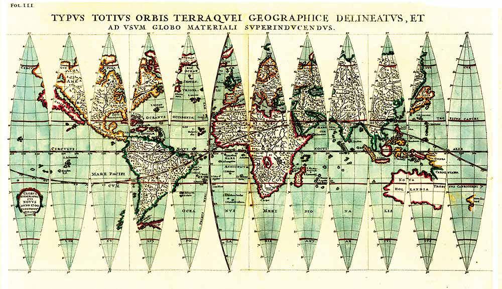
Heinrich Scherer. Typus Totius Orbis Terraquei Geographice Delineatus, Et Ad Usum Globo Materiali Superinducendus. Published in Munich, 1702 Courtesy of the Barry Lawrence Ruderman Antique Maps Collection
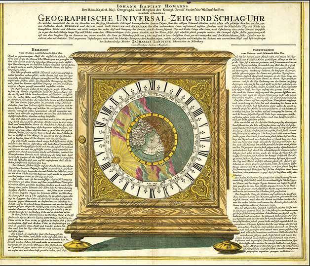
Johann Baptiste Homann. Geographische UniversalZeig Und Schlag Uhr (Homann’s Geographical Cabinet with celestial images and California depicted as an island).
Published in Nuremberg, 1705.
Arizona, and northern Mexico, concluded that the island was actually a peninsula and published a map refuting its status as an island (Paris, 1705).
This is an advertisement for Zacharias Landteck’s universal geographic clock that tells the time around the world and shows the progression of the sun across the northern hemisphere.
The clock is a marvel of engineering, as the text explains. The standing table clock has a face that includes twenty-four hours, rather than the usual twelve. It also contains a concentric rotating ring with the months of the year and the signs of the zodiac. At its center is a map of the northern hemisphere that can be covered by a rotating shaded glass disc. Together, the clock’s rings would let a user see their own time, but also to calculate the local time, sunrise, and sunset of any meridian around the world.
T he map shows California as an island. It includes a large landmass crossing the North Pacific; this Compagnie Land was supposedly sighted in the mid-seventeenth century and was later exaggerated by mapmakers into a continentsized behemoth. A possible Northwest Passage is suggested, as the precise coastlines near the North Pole are unfinished.
B ased in Nuremberg, Homann was at the center of local and regional trade. While never
intended for travel, the clock, and this broadside, do engage with the ongoing discussion about differences in time over long distances, an observation that played into one of the most pressing scientific issues of the day: how to calculate longitude accurately.
While solutions to the longitude question were complex and multiple, clocks did prove an important part of that answer. If a clock could be made to tell time consistently while traveling – i.e. to not lose time due to jostling, the elements, or the mechanism – then a user could compare the clock’s time to the local time and thus calculate their longitude relative to their point of departure.
John Harrison would develop just such a clock – several of them, in fact – over the decades of the mid-eighteenth century. The clocks were tested on a series of voyages, including those of James Cook and other Pacific explorers, in the last decades of the eighteenth century. Eventually, every ship carried a clock based on Harrison’s design that could keep time at sea.
Courtesy of the Barry Lawrence Ruderman Antique Maps Collection
Defoe continues to hold a position as one of the great writers in the English language. He was also one of the most prolific. He published over 250 works in his lifetime, including many political pamphlets. Robinson Crusoe, the hero of this story, is one of his best-known characters. Defoe’s fictional romance of a marooned sailor fending for himself on a lonely island was loosely based on a true story.
T he character of Robinson Crusoe was inspired by the adventures of the Scottish sailor Alexander Selkirk. Selkirk lived alone for over four years on the Pacific island of Juan Fernández, having been marooned there in the course of William Dampier’s
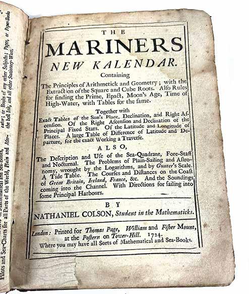
Nathaniel Colson. The mariners new kalendar: Containing the principles of arithmetick and geometry; ... Together with exact tables of the sun’s place, declination, and right ascension. ... Also, the description and use of the sea-quadrant, fore-staff and nocturnal. ... With directions for sailing into some principal harbours .
London: printed for Thomas Page, William and Fisher Mount, 1724.
Courtesy of Special Collections & Archives, UC San Diego Library
Daniel Defoe. The life and strange surprizing adventures of Robinson Crusoe, of York. Mariner: who lived eight and twenty years, all alone in an un-inhabited island on the coast of America, near the mouth of the Great River of Oroonoque; having been cast on shore by shipwreck, wherein all the men perished but himself. With an account how he was at last as strangely deliver’d by pyrates; Written by himself.
London: Printed for W. Taylor, 1719.
Courtesy of Special Collections & Archives, UC San Diego Library
second expedition. He was rescued during Dampier’s third expedition and returned home. Defoe moved his hero to the Caribbean and gave him a companion – man Friday – a variation on Rousseau’s concept of the “noble savage.”
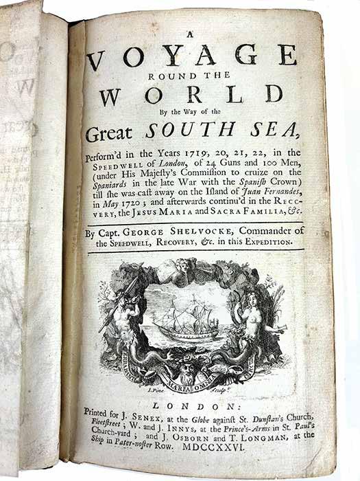
George Shelvocke. A voyage round the world by way of the Great South Sea...By Capt. George Shelvocke, Commander. London: Printed for J. Senex; W. and J. Innys, J. Osborn and T. Longman, 1726. Courtesy of Special Collections & Archives, UC San Diego Library
The story and its themes have been extensively studied by theologians, historians, anthropologists, sociologists and students of literature, and is described by some commentators as a spiritual autobiography. It has also been critiqued for its racism, sexism and implied messages about the validity of European dominance over indigenous peoples.
Nathaniel Colston's (below) extremely popular guide for mariners included both the theory and practice of the art of navigation. Among its contents are declination tables as well as instructions on the use of instruments such as the quadrant and nocturnal. It also contains instructions for specific courses along the coasts of Britain, Ireland and France, as well as soundings in the English Channel and instructions on how to approach and find anchor in well-known harbors.
Captains Shelvocke and Clipperton led a privately financed privateering expedition to attack Spanish shipping. Shelvocke gave his superior officer the slip in a storm and proceeded to Brazil and thence to the west coast of South America, where in two months he sacked Payta, Peru, and captured several small prizes. His vessel, the Speedwell , was wrecked at Juan Fernández. The survivors built another ship from the wreckage and sailed to Baja California. After crossing the Pacific via Guam and reaching Macau, Shelvocke returned to England. He was accused of piracy and embezzlement but acquitted. He wrote this account to vindicate his conduct.
S helvocke’s A voyage round the world... would captivate not only his contemporaries but also exert a profound influence on later generations of readers. His account was used extensively by Commodore George Anson during his later circumnavigation and assault on the Spanish seaborne empire in the Pacific. An incident in the narrative describing the passage around Cape Horn, in which a sailor kills an albatross, is said to have inspired Samuel Taylor Coleridge’s Rime of the Ancient Mariner . We also know that Coleridge, William Wordsworth and Wordsworth’s sister, Dorothy, avidly read and discussed Shelvocke. With Coleridge and Wordsworth considered the founders of English Romanticism, with its exaltation of nature and the past, it is more than likely that Shelvocke’s vivid prose also had some influence on the birth of this artistic and intellectual movement.
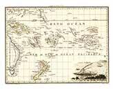
Usually known as Gulliver’s Travels , this work is Jonathan Swift’s famous caricature of eighteenth-century life and of the morals of courts, parties, and leaders. It is the renowned Anglo-Irish satirist’s only work related to the South Seas. It was also his most popular publication. The four voyages of Gulliver were set in the then as-yet unexplored regions of the Pacific Ocean. Lilliput, the land of little people,
The four voyages of Gulliver were set in the then as-yet unexplored regions of the Pacific Ocean. Lilliput, the land of little people, was northwest of Van Diemen’s Land (Tasmania), near where Terra Australis was located on contemporary maps.
Jonathan Swift. Travels into several remote nations of the world: In four parts; By Lemuel Gulliver [pseud.], first a surgeon, and then a captain of several ships . London: Printed for Benj. Motte, 1726.
Courtesy of Special Collections & Archives, UC San Diego Library
was northwest of Van Diemen’s Land (Tasmania), near where Terra Australis was located on contemporary maps. Brobdingnag, the land of the giants, was a peninsula north of New Albion (California), near Alaska. The four islands of Part III were east of Japan, and the isle of the Houyhnhnms, the noble horses, was south of New Holland (Australia). The maps found in this edition depict all these imaginary lands.
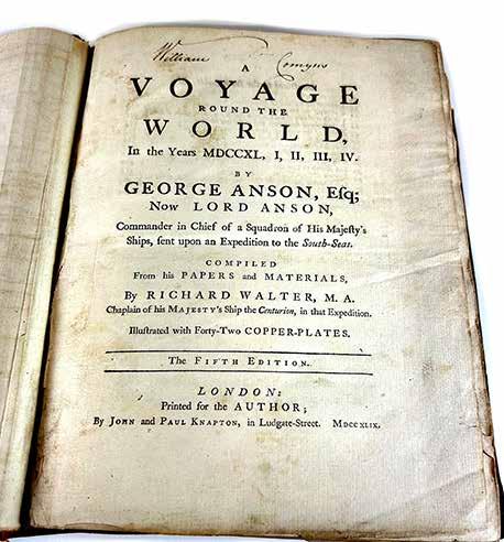
Richard Walter.
A voyage round the world II, III, IV. By George Anson, esq.; commander in chief of a squadron of His Majesty’s ships, sent upon an expedition to the South-Seas; Compiled from papers and other materials of the Right Honourable George lord Anson, and published under his direction, by Richard Walter ... London: Printed for the author, by John and Paul Knapton, 1748.
Courtesy of Special Collections & Archives, UC San Diego Library
This is the official account of Anson’s voyage. Britain sent eight vessels under the command of George Anson to harass the Spaniards on the western coast of South America. In June 1743, Anson captured the Manila Galleon laden with an immense treasure in silver. This compilation has long occupied a distinguished position as a masterpiece of descriptive travel. Anson’s voyage appears to have
been the most popular book of maritime adventure in the eighteenth century. It contains vivid accounts of the voyage, conflict with the Spaniards, as well as details on sailing conditions and distant ports visited. In preparation for his voyage, Commodore George Anson drew extensively on a narrative published in 1726 by the buccaneer George Shelvocke: A voyage round the world by way of the Great South Sea .
In turn, Anson’s voyage and its narrative accounts became essential sources of information for later voyages in the Pacific, including the circumnavigations of HMS Dolphin under Commodore John
Byron (1764-1766) and Captain Samuel Wallace (1766-1768), and those of James Cook. Each of these expeditions drew upon Anson’s experiences and attempted to find solutions to the prevailing technical problems of scurvy and the determination of longitude.
W alter’s account of Anson’s voyage also makes several references to John Campbell, then a midshipman on that expedition but later a distinguished captain, navigator, and inventor of the sextant – examples of which are on display in this exhibit. Campbell was actually the British Admiralty’s first pick to command Endeavour for the expedition to observe the transit of Venus. Campbell declined, and they then selected James Cook on his recommendation as a substitute.
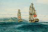
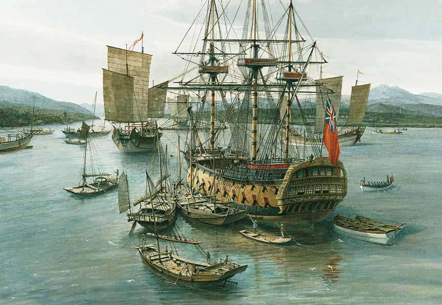
HMS Centurion in Whampoa Anchorage, China, 1743. Artist: Gordon Miller
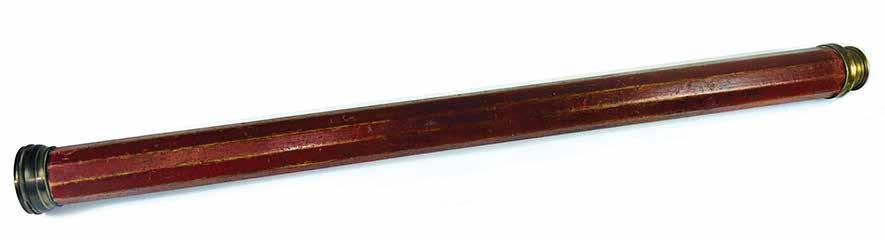
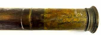
Decahedral Long Glass
Ca. 1740
This hand-held telescope would have been used at sea by deck officers to verify the identity of distant vessels and make close observations of sea conditions and coastal landforms.
Jacques-Nicolas Bellin (1703-1772) was among the most important mapmakers of the eighteenth century. In 1721, at the age of eighteen, he was appointed Hydrographer to the French Navy. In August 1741, he became the first Ingénieur de la Marine of the Dépôt des cartes et plans de la Marine (the French Hydrographic Office) and was named Official Hydrographer of the French King. During Bellin's term as Official Hydrographer, the Dépôt was the one of the most active centers for the production of sea charts and maps in Europe.
His output included a folio-format sea atlas of France, the Neptune François . He also produced a number of sea atlases of the world, including the Atlas Maritime and the Hydrographie Française. These gained fame and distinction all over Europe and were republished throughout the eighteenth and even in the nineteenth century.
This particular map shows the prevailing winds in the Pacific Ocean and was based in part on the observations of the English navigator William Dampier. California is shown as an island. Nouvelle Holland is
Jacques Nicolas Bellin. Representation du Cours ordinaire des Vents de Traverse qui regnent les Cotes dans la grande Mer Du Sud. Published in Paris, 1747.
Courtesy of the Barry Lawrence Ruderman Antique Maps Collection
Maritime Museum of San Diego Collection
Enlightened Voyages and Scientific Navigation
A Most Important Discovery:
Samuel Wallis reaches Tahiti in HMS Dolphin , 1767
Artist: Gordon Miller
HMS Dolphin in Matavai Bay, Tahiti, 1767
Artist: Gordon Miller
From the middle decades of the eighteenth century, European maritime powers became increasingly focused on visiting the South Seas. Overt military rivalry was replaced by a quest for new lands to occupy and colonize. For trade to flourish, sea routes needed to be more precisely determined, and the location of distant islands and their peoples known with greater precision. Hence, the rise of so-called scientific voyages that employed evermore sophisticated techniques and instruments for defining space and determining location with exactitude.
Edge of the Ice: James Cook with Resolution and Adventure in the Southern Ocean, 1773
Artist: Gordon Miller
James Cook approaching the Hawaiian Islands, 1778
Artist: Gordon Miller
The Endeavour , a name synonymous with the British exploration of the Pacific, began her life as a humble collier – the Earl of Pembroke – launched in 1764. In 1768 the British Royal Navy purchased her with the express purpose of refitting her for a voyage of scientific discovery to the South Sea. The former collier’s commodious hull provided her with ample room for the storage of supplies. Her relatively shallow draft was
Artist: Gordon Miller
also considered advantageous for the reconnaissance of uncharted shores. Commanded by Lieutenant James Cook, Endeavour reached the east coast of the Australian continent in April 1770.
Modelmaker: Dr. William Brown Maritime Museum of San Diego Collection
Photographer: Ted Walton
HM Bark Endeavour, 1764
Right: Captain Bligh in the Longboat, 1788
This is the first printed view of Mount St. Elias, the second tallest mountain in North America, from an original drawing by Thomas Heddington. The image shows Mount St. Elias, with George Vancouver’s ship, the Discovery , in the foreground. The view appeared in the official account of Vancouver’s expedition, A Voyage of Discovery to the North Pacific Ocean and Round
George Vancouver. Icy Bay and Mount St. Elias. Published in London, 1798.
Courtesy of the Barry Lawrence Ruderman Antique Maps Collection
the World, 1791-1795 . Published in 1798 to wide public acclaim, Vancouver’s narrative greatly increased the European public’s knowledge about the Pacific Coast. There were no commissioned artists on Vancouver’s expedition. Thomas Heddington (1776-1860), a midshipman, was one of the crew members
who made drawings of the new territory.
George Vancouver (1757–1798), a naval officer and explorer, grew up in King’s Lynn, England, the youngest of six children. After entering the Royal Navy in 1771, he served in both the second and third great exploratory voyages of James Cook. During Cook’s second voyage, a three-year quest to find a legendary southern continent, Vancouver received instruction from the astronomer William Wales. During Cook’s third voyage, to the Pacific Northwest, Vancouver was part of the first-known group of Europeans to land on the coast of present-day British Columbia.
In 1790, Vancouver was chosen to captain the Discovery and charged with a mission to discover and chart the vast areas
George Vancouver. Views of Headlands and Islands on the Coasts of Northwest and South America. Published in London, 1798.
Courtesy of the Barry Lawrence Ruderman Antique Maps Collection
of the Pacific that were still unknown, in part to locate a Northwest Passage between the Atlantic and Pacific Oceans. This four-year voyage of discovery circumnavigated the globe and eliminated the possibility of an inland Northwest Passage. During many months of surveying, Vancouver produced detailed regional maps of the Northwest Coast, as far north as Alaska. He also established several hundred placenames for physical features in the areas surveyed.
The meticulously rendered sketches of coastal headlands, bays and ports were intended both as an aid to navigation and also as a means of depicting these distant shores for a curious public. Upon returning to England in 1795, Vancouver’s voyage received little recognition, and he faced personal and political attacks from colleagues and crew members alleging abuse of power. With his health failing, Vancouver spent his remaining years in retirement, revising his journal for publication. His Voyage of Discovery to the North Pacific Ocean, and Round the World was first published in 1798, which was also the year of his death. It contained
a multi-volume account of his voyage as well as an atlas of his maps. His exploration and mapmaking activities greatly increased knowledge of the North American coast.
George Vancouver, who had served on Captain Cook’s second and third voyages, was made commander of an expedition aimed at asserting British claims in the Pacific Northwest, and to conduct reconnaissance for a possible passage from the Pacific to the Atlantic. This voyage became one of the most important ever made in the pursuit of geographical knowledge. Vancouver surveyed the coast of California, and visited San Francisco, San Diego and other Spanish settlements in Alta California, providing detailed reports for British authorities.
Above: George Vancouver. A voyage of discovery to the North Pacific Ocean: and round the world; in which the coast of north-west America has been carefully examined and accurately surveyed... London: Printed for G. G. and J. Robinson, and J. Edwards, 1798.
Courtesy of Special Collections & Archives, UC San Diego Library
Quadrants, Sextants and Octants
The first optical instruments that allowed the observer to measure altitude of a celestial body by superimposing its image on the horizon were called “quadrants.” Because the optical principle is “double reflecting,” an arc of 45 degrees can actually measure 90 degrees (1/4 of a circle) of angle, suitable for measuring the altitude of anything in the sky. Quadrants are also distinguished by their ebony wood frames and inlaid ivory arcs. With the introduction of tables for lunar distance it became possible to determine time precisely (and therefore longitude) by measuring the angle between the moon and specific stars. Sometimes the angles exceed 90 degrees so the sextant was developed to make such measurements out to 120 degrees.
Because the sextant, like the quadrant, used mirrors to double reflect the image of the body, it only required 60 degrees of arc (onesixth of a circle) to measure 120 degrees. This capability also came in handy to determine position by two horizontal angles measured between charted and visible features on the shore. The lunar distance method required a high order of accuracy and because metal is more stable than wood, sextants were always made out of metal, usually brass. Once the name “sextant” came into common use, people then started calling the ebony-framed instruments (formerly quadrants) octants for consistency.
Maritime Museum of San Diego Collection
The Spanish Perspective
Sanson’s map of California and the Southwest is the first regional map of America to show California as an island. Prior to this map, all maps with California shown as an island were either world maps, Western Hemisphere, North America, Pacific Ocean or some substantially larger geographical region. The region illustrated was still largely unknown to Europeans. The Rio Grande is shown flowing into the Sea of Cortez, an error which would not be corrected until the publication of a later map by Nicolosi. A number of New Mexican villages are shown, including Taos and Santa Fe, along with several bands of Apache Indians. The Moqui, Zuni and Navajo names also appear.
This is the earliest map to show the so-called Second Sanson Model of insular California with two bays featured in the northern-most portion of the island. The nomenclature used is a combination of Blaeu and Sanson and includes Cibola, Reg Coromedo and Lago de Oro, along with a reference to Pto. de Francisco Draco. California includes many early place names, such as San Diego, San Francisco, Canal de S. Barbara, Point Concepcion, Cape Mendocino, Point Reyes and a curiously located “Punta de Monte Rey,” well north of its correct location. The peninsula above California is a curious and unexplained addition. Quivira is also shown, but located in eastern New Mexico, far from its normal location on the Northwest Coast.
Nicolas Sanson. Audience de Guadalajara, Nouveau Mexique, Californie, &c. Published in Utrecht, 1683. Courtesy of the Barry Lawrence Ruderman Antique Maps Collection
Port and Shipyard of San Blas, 1775
Artist: Gordon Miller
San Carlos approaching Golden Gate, 1775
Artist: Gordon Miller
The San Carlos, described in historical sources as a packet boat, was constructed on the west coast of New Spain as part of a small fleet of vessels destined to play a vital role in the Spanish colonization of Upper California. Beset by bad luck and adverse sailing conditions, her first voyage from La Paz to San Diego took 111 days She reached port with her crew and passengers decimated by sickness. Despite these initial setbacks, the San Carlos would go on to explore California’s coast and holds the distinction of being the first ship to enter San Francisco Bay and survey its reaches in August of 1775. Dr. William Brown based this model of the San Carlos on research conducted by Ray Acker and the interpretation of marine artist Gordon Miller. He faithfully reproduced Acker’s plans based on Spanish archival sources. Of note in this model is a tiller to steer the vessel rather than a wheel, and the mizzen mast made fast to the mainmast, giving her the configuration of a snow.
Modelmaker: Dr. William Brown Maritime Museum of San Diego Collection
Photographer: Ted Walton
This manuscript diary by Juan Pantoja y Arriaga, second pilot and captain of the ship Aránzazu , begins with the departure of Pantoja's ship from San Blas on June 22, 1786. Pantoja was tasked with the reconnaissance of the east coast of Baja California to determine where supplies might be delivered for the maintenance of Spanish troops and missions. The manuscript also includes two folding maps of the gulf coast of Baja California. The diary contains daily entries through July 11, recording the position of the Aránzazu , sailing directions, and other observations. About half of the text contains Pantoja’s observations of the region around Loreto. The first of the maps shows a portion of the Baja California gulf coast, from north of Loreto to a point Pantoja calls “Punta de San Jose,” just south of the southern tip of Isla Catalana. The coastline is rendered in detail, with the town of Loreto marked in red (including a small symbol noting the mission), and with Estero de Napolo, and other points noted. The second map is a more detailed rendering of the coastline from Puerto Escondido south to Punta de Ligui.
San Carlos, 1767
Photographer: Ted Walton
Juan Pantoja y Arriaga. Extracto del diario que ha hecho... 1786
Above, below and top right: Juan Pantoja y Arriaga. Extracto del diario que ha hecho...1786.
Courtesy of Special Collections & Archives, UC San Diego Library
Juan Pantoja y Arriaga. Plan of Port Sn. Diego on the west coast of California: lat. 32̊ 39 N. long. 12̊ 4’ W. fr. Sn. Blas. London: A. Dalrymple, 1789.
Courtesy of Special Collections & Archives, UC San Diego Library
Alexander Dalrymple, Hydrographer to the British East India Company, was the publisher of the first two printings of Pantoja’s map of San Diego. The Pantoja map was drawn in 1782, a landmark year in the history of San Diego. In that year the first
surveys were made of San Diego Bay and the first accurate map of this region was produced for the Spanish government. This would remain the most significant map drawn of the area until the American maps of the 1850s.
Trade Routes and Wayfinding
As sailing routes across the length and breadth of the Pacific transitioned from those pioneered by indigenous navigators, to those of European explorers, and finally those of commercial wind-powered vessels, the need to find location at sea remained a constant. Maps and charts - once exquisitely crafted and jealously guarded - became more utilitarian, and instrumentsonce embellished with rare materials - were now more ubiquitous. Knowledge became more systematized and the principles of navigation and haven-finding were learned both in the classroom and at sea.
Bowditch, a distinguished mathematician and astronomer, had worked on correcting and revising John H. Moore’s The New Practical Navigator. Bowditch’s outstanding contribution to the first American edition of Moore’s work was a chapter on a “New method of working a lunar observation.” Bowditch extensively revised and improved Moore’s earlier publication. Written for a general rather than academic audience, Bowditch’s first edition was acclaimed by the maritime world and its use was extended to the English merchant marine and even to the English and French navies. The work was
Morethan a thousand years before European mariners began to use the compass, indigenous island peoples of the Pacific had learned to navigate precisely across immense distances of open water without the charts, instruments, mathematical calculations, written directions, graphic depictions, or metal tools and implements developed by European mariners. They relied instead entirely on their senses and an enormous capacity for learning and memorizing the complex relationships between stars and planets, winds, wave patterns, behavior of sea life, and atmospheric phenomena. To master this immense intellectual challenge required many years of training and apprenticeship, augmented by teaching aids. In like fashion to the
Nathaniel Bowditch. The new American practical navigator; being an epitome of navigation... 1st edition. Newburyport: Edmund M. Blunt, 1802. Courtesy of Special Collections & Archives, UC San Diego Library
indispensable to the maritime and commercial expansion of the nineteenth century and is frequently described as the greatest book in the entire history of navigation.
Lunar Tellurian, also featured in this exhibit publication, this construction is not a “chart” to be taken into a canoe for plotting or reference, but a teaching aid used to indicate how oceanic wave trains are reflected, refracted, and diffracted around and between islands, providing the means to determine direction as well as the course and distance to islands that might be hundreds of miles away. Maritime Museum of San Diego Collection
Micronesian Stick Chart and Pacific Island Outrigger Canoe Maritime Museum of San Diego Collection
Conrad Malte-Brun, Oceanique Oriente .
Published in Paris, 1812
Courtesy of the Barry Lawrence Ruderman Antique Maps Collection
Adecorative
antique engraved map of the Eastern Pacific, from the Carolines, Eastern Australia, and Tasmania to the Marquesas, including all of New Zealand. The captions and names of geographical features are in French and reflect the intense interest of that nation’s navigators with the South Sea. Malte-Brun’s maps were extremely well researched, utilizing the most up-to-date information – the product of the so-called “enlightened voyages” of the eighteenth century. This
map includes a decorative cartouche with depictions of Polynesian sailing vessels, further reflecting the contemporary European fascination with the cultures and societies of the peoples of Oceania.
Journal of a Third Voyage for the Discovery of a North-West passage from the Atlantic to the Pacific: Performed in the years 1824-1825, in his majesty’s ships Hecla and Fury under the orders of Captain William Edward Parry, R.N., F.R.S., and commander of the expedition. London: John Murray, 1826. Courtesy of the Barry Lawrence Ruderman Antique Maps Collection
William Parry had sailed to the Arctic under Sir John Ross on his voyage of 1818. Parry sailed on another arctic expedition in May, 1821. His vessels were locked in ice twice during this voyage. Despite this he was able to continue exploring and recording his findings. Among his descriptions are a treatise on the life of the indigenous inhabitants and a narrative of scientific discoveries.
The brig USS Porpoise was launched in 1836. In the summer of 1837 under the command of Lieutenant Charles Wilkes, she surveyed parts of the southern coastline of the United States. In August 1838 she joined the United States Exploring Expedition Squadron and traveled to the South Pacific before returning to New York, having circumnavigated the globe. After conducting anti-slavery operations off the coast of West Africa, Porpoise was assigned to the North Pacific Exploring and Surveying Expedition. In September 1854 Porpoise lost contact with other vessels in the expedition and is assumed to have foundered in a typhoon.
Modelmaker: Dr. William Brown Maritime Museum of San Diego Collection Photographer: Ted Walton
USS Porpoise , 1836
Photographer: Ted Walton
A Memorable Day: Vincennes, Peacock, Porpoise reach the coast of Antartica, 1840 Artist: Gordon Miller
This lunar tellurian was made by A.H. Andrews & Co. around the middle of the nineteenth century. The tellurian was an interactive teaching tool, designed to demonstrate the relationship between the Sun, the Earth and the Moon. As the moon revolves around the Earth, revealing various phases, the Earth in turn revolves around the central axis representing the Sun as the center of the solar system. The two bands around the Earth represent day and night, with twilight in between.
Automated clockwork mechanisms modeling the relative motions of bodies of the solar system date as far back as the Greek Antikythera mechanism (ca. 205-285 BCE). By the early seventeenth century such devices came to be known as planetariums or orreries (named after early patron Charles Boyle, Fourth Earl of Orrery). By the eighteenth century, ownership of one these elaborate mechanisms, often modeling the complex relative motions of all the known bodies of the Solar System, became a marker of status, wealth, and intellectual prowess.
Teachers' manuals were also published to assist in the classroom use of the tellurian.
Navigation slate from the Euterpe written in white chalk within etched columns, set in a wooden frame with a hinged door. The position indicated is 77 degrees east, 44 degrees south, in the Southern Ocean. The adjacent logbook is original to Euterpe and contains daily observations of sea conditions, wind, distance travelled, latitude and longitude for the 1885 voyage.
Lunar Tellurian
Euterpe Navigation Slate and Logbook, 1885
Maritime Museum of San Diego Collection
Courtesy of the collection of Rod and Becky Cardoza, West Sea Antiques
Amarine
This Thomas Adams chronometer came on board the Star of India to San Diego in 1927.
Chronometer
chronometer is a precision timepiece that is carried on a ship and employed in the determination of the ship’s position by celestial navigation. It is used to determine longitude by comparing Greenwich Mean Time (GMT) and the time at the current location found from observations of celestial bodies. When first developed in the 18th century, it was a major technical achievement, as accurate knowledge of the time over a long sea voyage was vital for effective navigation.
The purpose of a chronometer is to measure accurately the time of a known fixed location. This is particularly important for navigation. As the Earth rotates at a regular predictable rate, the time difference between the chronometer and the ship’s local time can
be used to calculate the longitude of the ship relative to the Prime Meridian (defined as 0°, or another starting point) if accurately enough known, using spherical trigonometry. Practical celestial navigation usually requires a marine chronometer to measure time, a sextant to measure the angles, an almanac giving schedules of the coordinates of celestial objects, a set of sight reduction tables to help perform the height and azimuth computations, and a chart of the region.
Chronometer
Waltham chronometer, early 20th century Maritime Museum of San Diego Collection
Maritime Museum of San Diego Collection
Ca. 1880
Taffrail log
Maritime Museum of San Diego Collection
Ataffrail log is a mechanical speed logging device, used like a car odometer. The taffrail log was towed from the stern or taffrail of the ship by a long line. Taffrail logs were developed in the eighteenth century and became a practical device
in the nineteenth century. The brass veined “fish” would spin when thrown over the stern and towed. The number of turns would be recorded and when retrieved could be read by the mariner to estimate speed and distance travelled.
Kelvin & Hughes Parallel Rule
Maritime Museum of San Diego Collection
Parallel rules are a drafting instrument used by navigators to draw lines on charts. The tool consists of two straight edges joined by two arms which allow them to move closer or further away while always remaining parallel to each other. Early charts are distinguished by a crosshatched web of
bearing lines called loxodromes, emanating from several compass roses. Once the use of parallel rule came into common practice in the eighteenth century, it became more practical to “walk” the course and bearing lines from the compass roses. Charts became graphically cleaner and simpler.
Thermopylae and Empress of India, 1892
Artist: Gordon Miller
Dry-Card Compass
Late nineteenth century
This dry-card compass by Sir William Thompson (Lord Kelvin) was used on the Star of India during her service with the Alaska Packers Association. It came to San Diego on board the Star of India in 1927.
Maritime Museum of San Diego Collection
Dry-Card Compass
This dry-card compass by T. Helmsley & Son dates from the first half of the nineteenth century. It came to San Diego on board the Star of India in 1927.
Maritime Museum of San Diego Collection
The Enduring Art of Navigation
T he course plotted for the Star of India’s 2023 sail off the coast of San Diego. The Star of India remains the world’s oldest active merchant vessel, sailing every two years using only the power of the wind harnessed by her sails and expertly guided by a trained crew, largely composed of volunteers.
of
Today wayfinding with the use of GPS and other relatively modern innovations has seemingly rendered obsolete the instruments and methods that guided mariners for centuries. As part of its mission, the Maritime Museum of San Diego continues to preserve not only the material culture produced by mariners – charts and instruments – but also the techniques applied in their use. The museum, with its vibrant sail-training program, embraces these time-tested skills as part of its mission to preserve a living memory of our common seafaring heritage.
Star of India course, November 2023
Star
India at sea off the coast of San Diego. Photographer Bob Grieser.
Nbetween two points on a chart. Many charts do not have a scale of miles, instead relying on latitude to determine distance where 1 degree of latitude = 1 nautical mile.
Ninstruments to achieve a number of goals – estimating distance travelled,
Navigational Dividers
mid-twentieth century
Maritime Museum of San Diego Collection
Stopwatch
Log book of the Euterpe ( Star of India ), voyage of 1885. The Star of India preserves both the memory and practice of traditional tall-ship navigation.
fixing a precise position at sea, and plotting a course. While Art of Navigation features many historic instruments and charts, this exhibit and its attendant publication also reminds us that the techniques used for centuries by navigators remain valid even today. Dividers permit the sailor to measure distance on a paper chart; the pelorus assists in taking bearings that can then be used to plot position; the parallel rule helps in drawing straight lines to chart a course; the sextant translates the positions of celestial bodies to location north and south on the surface of the globe; and the stopwatch combined with the taffrail log estimates speed and distance travelled, all while taking into account variations in sea conditions such as the influence of currents and changes in wind direction and velocity. These methods may well not be as accurate as simply reading the screen of a hand-held GPS device, but they do afford navigators schooled in their use a deep and abiding connection with the elements that envelope the vessels on which they sail.
Parallel Rule/Collection of Dr. Raymond Ashley
Collection of Dr. Raymond Ashley
The pelorus is used to take bearings of objects on shore or of other ships from a position more convenient or practical than from the ship’s steering compass. The bearings taken with the sighting vanes are relative to the ship’s centerline or course, so then must be converted to true or magnetic directional bearings to plot a position.
An azimuth ring is used to determine the influence of the ship’s own magnetic field on that of the compass, known as compass deviation. Ships are often made of iron or steel, but even wooden ships may have enough iron in them to influence a compass. Because the true bearing of the Sun can be calculated for any position, day, and time, the shadow cast by the gnomon in the center of the azimuth ring will be the
reciprocal of the sun’s true bearing. This may then be compared with the expected variation between true and magnetic north to determine the amount of error (deviation) of the ship’s compass due to immediate magnetic influences. The deviation may vary with course, so the process of sailing in a circle, adjusting the ring for the changing course and noting the difference between the expected and observed azimuth shadow, is called “swinging” a compass. If the deviation is excessive, some or all of it might be corrected by placement of iron objects or small magnets near the compass or within the compass binnacle.
This device can be used either as a pelorus or as an azimuth ring as need requires.
The bearings of any three objects both within sight and positioned on a chart will give a ship’s plotted position. The two “horizontal” angles separating the three objects might be measured with a compass, a pelorus, or a
Collection of Dr. Raymond Ashley
The Pelorus or Azimuth Ring
Collection of Dr. Raymond Ashley
sextant held horizontally. Using a three-arm protractor, the three arms are set in accordance with the measured angles and then the device maneuvered on a chart until each of the three arms lies directly on the charted position of one of the observed objects. The point where the arms converge is the ship’s position.
Since 1998, this modern Plath sextant has been used at sea to navigate Maritime Museum of San Diego vessels Star of India, Californian, and San Salvador. On the recent November 2023 sailing of the Star of India, it was used to verify position and plot the course shown in the chart reproduced on page 68.
Sextant Collection of Dr. Raymond Ashley
Today the Star of India, powered only by the wind and guided by traditional instruments, still sails regularly off the coast of San Diego. She remains a living reminder of the relationship between intellect, math, nature and science.