FERC Project No. 14787 Black Canyon Hydro, LLC
November 2022
License Application
E: Environmental Report Seminoe Pumped Storage Project
Final
Exhibit
This page intentionally left blank.
1.0 Introduction 1
1.1 Purpose of Action and Need for Power 2
1.1.1 Purpose of Action............................................................................................2 1.1.2 Need for Pumped Storage Hydropower ..........................................................2 1.1.3 Consequences of Denial of License Application .............................................3
1.2 Statutory and Regulatory Requirements.....................................................................3
1.2.1 Federal Power Act 5
1.2.1.1 Section 4(e) Conditions 5 1.2.1.2 Section 10(j) Recommendations 6 1.2.1.3 Section 18 Fishway Prescription 6 1.2.2 Lease of Power Privilege 6 1.2.3 Federal Land Policy and Management Act 7 1.2.4 Clean Water Act 7 1.2.4.1 Section 401 7 1.2.4.2 Section 404....................................................................................8 1.2.5 Endangered Species Act.................................................................................8 1.2.6 National Historic Preservation Act...................................................................9 1.3 Consultation 9
2.0 Proposed Action and Alternatives 11
Final License Application – Exhibit E
Project January 2023 | i
Seminoe Pumped Storage
Contents
2.1 Applicant’s Proposal 11 2.1.1 Proposed Project Facilities............................................................................11 2.1.1.1 Upper Dam and Reservoir...........................................................15 2.1.1.2 Lower Reservoir and Seminoe Dam............................................18 2.1.1.3 Hydraulic Conveyance Between Reservoirs................................20 2.1.1.4 Powerhouse and Transformer Caverns.......................................23 2.1.1.5 Pump-Turbines ............................................................................26 2.1.1.6 Generator-Motors.........................................................................28 2.1.1.7 Configuration and Ratings ...........................................................29 2.1.1.8 Switchyard ...................................................................................29 2.1.1.9 Transmission Lines......................................................................29 2.1.1.10 Summary of Project Features......................................................31 2.1.2 Summary of Proposed PM&E Measures.......................................................35 2.1.3 No Action Alternative.....................................................................................47 2.2 Alternatives Considered but Eliminated from Detailed Analysis ...............................47 2.2.1 Regional Generation Supply Development and Generation Supply Alternatives 47 2.2.2 Fossil-Based Generation 48 2.2.3 Nuclear Power 49 2.2.4 Renewable Resources 49 2.2.5 Other Pumped Storage 50 2.2.6 Other Energy Storage Technologies 51 2.2.7 Conclusion 52 2.3 Project Siting Alternatives 52 2.3.1 Topography, Water, Services, and Site Access Factors 53
2.3.2 Environmental Factors ..................................................................................54 2.3.3 Transmission Considerations........................................................................57
3.0 Environmental Analysis......................................................................................................63
3.1 General Description of the River Basin.....................................................................63
3.1.1 Tributary Rivers and Streams 63 3.1.2 Topography 63 3.1.3 Major Land and Water Uses 67 3.1.3.1 Major Land Uses and Ownership 67 Major Water Uses 71 3.1.4 Major Dams and Diversions 71 3.1.5 Climate 72
3.2 Environmental Effects Analysis 73
3.2.1 Cumulative Effects (18 CFR §5.18(b)(2))......................................................73 3.2.1.1 Geographic Scope 74 3.2.1.2 Temporal Scope 76 3.2.1.3 Reasonably Foreseeable Future Actions 76 3.2.1.4 Resource Effects 86
3.3 Geologic and Soil Resources....................................................................................86
3.3.1 Affected Geologic and Soil Environment 86 3.3.1.1 Regional Physiography, Setting, and Geologic History 86 3.3.1.2 Project Vicinity Geology 91 3.3.1.3 Surficial Geology..........................................................................92 3.3.1.4 Groundwater................................................................................99 3.3.1.5 Soils.............................................................................................99 3.3.1.6 Shoreline and Stream Banks.....................................................100 3.3.1.7 Mineral and Geothermal Resources..........................................101 3.3.1.8 Abandoned and Active Mines....................................................102 3.3.1.9 Proximity to Hazardous Waste Facilities....................................103 3.3.1.10 Quaternary Faulting and Seismicity...........................................103 3.3.1.11 Volcanic Activity.........................................................................105 3.3.1.12 Underground Features...............................................................105 3.3.2 Direct and Indirect Environmental Effects - Geologic and Soil Resources...................................................................................................106 3.3.2.1 Expansive Soils..........................................................................106 3.3.2.2 Mass Soil Movement 106 3.3.2.3 Water Erosion and Windblown Dust 106 3.3.2.4 Construction Spoil 107 3.3.2.5 Geology and Seismicity 107 3.3.2.6 Aboveground Project Features 111 3.3.3 Cumulative Environmental Effects Related to Geologic and Soil Resources 112 3.3.4 Agency Consultation and Applicant Recommendations 114 3.3.4.1 Agency Consultation 114 3.3.4.2 Applicant Recommendations 114
3.4 Water Resources 115 3.4.1 Affected Water Resources Environment .....................................................115 3.4.1.1 Water Resources Overview.......................................................115 3.4.1.2 Aquatic Resources Delineation Study........................................117
Final License Application – Exhibit E
Project January 2023 | ii
Seminoe Pumped Storage
3.4.1.3 Surface Waterbodies and Wetlands ..........................................120 3.4.1.4 Water Quantity...........................................................................125 3.4.1.5 Water Quality.............................................................................130 3.4.1.6 Groundwater..............................................................................154 3.4.2 Direct and Indirect Environmental Effects on Water Resources .................155 3.4.2.1 Potential Effects on Seminoe Reservoir ....................................155 3.4.2.2 Potential Effects on North Platte River Downstream .................157 3.4.2.3 Potential Impacts on Other Aquatic Habitat, Surface Waterbodies, and Wetlands 161 3.4.2.4 Groundwater 165 3.4.3 Cumulative Environmental Effects Related to Water Resources 166 3.4.4 Agency Consultation and Applicant Recommendations 168 3.4.4.1 Agency Consultation 168 3.4.4.2 Applicant Recommendations 168
3.5 Fish and Aquatic Resources 168
3.5.1 Affected Fish and Aquatic Environment ......................................................169 3.5.1.1 Fisheries Community.................................................................169 3.5.1.2 Species of Greatest Conservation Need....................................174 3.5.1.3 Fisheries Management ..............................................................178 3.5.1.4 Resident Fish Survey Study Fish Data ......................................182 3.5.1.5 Desktop Fish Entrainment Study ...............................................189 3.5.1.6 Aquatic Environment in the Project Vicinity ...............................195 3.5.1.7 Amphibians................................................................................199 3.5.1.8 Macroinvertebrates....................................................................200 3.5.1.9 Invasive Species........................................................................201 3.5.1.10 Rare, Threatened, and Endangered Aquatic Species ...............202 3.5.2 Direct and Indirect Environmental Effects – Fish and Aquatic Resources...................................................................................................202
3.5.2.1 Construction-related effects 202 3.5.2.2 Operations-related effects 204 3.5.3 Cumulative Environmental Effects Related to Fish and Aquatic Resources 206 3.5.4 Agency Consultation and Applicant Recommendations 207 3.5.4.1 Agency Consultation 207 3.5.4.2 Applicant Recommendations 207 3.6 Botanical Resources 208
3.6.1 Affected Botanical Environment..................................................................208 3.6.1.1 Land Cover Types and Habitats ................................................209 3.6.1.2 Botanical Resources..................................................................209 3.6.1.3 Inter-Mountain Basins Big Sagebrush Steppe...........................210 3.6.1.4 Rocky Mountain Foothill Limber Pine-Juniper Woodland ..........211 3.6.1.5 Developed, Open Space............................................................211 3.6.1.6 Wyoming Basins Dwarf Sagebrush Shrubland and Steppe.......211 3.6.1.7 Inter-Mountain Basins Mixed Salt Desert Scrub ........................211 3.6.1.8 Inter-Mountain Basins Big Sagebrush Shrubland......................211 3.6.1.9 Inter-Mountain Basins Shale Badland........................................212 3.6.1.10 Inter-Mountain Basins Curl-leaf Mountain Mahogany Woodland and Shrubland ..........................................................212 3.6.1.11 Inter-Mountain Basins Greasewood Flat 212
Final
– Exhibit E
January 2023 | iii
License Application
Seminoe Pumped Storage Project
3.6.1.12 Open Water (Fresh)...................................................................212 3.6.1.13 Western Great Plains Open Freshwater Depression Wetland......................................................................................212 3.6.1.14 Pasture/Hay...............................................................................212 3.6.1.15 Inter-Mountain Basins Cliff and Canyon ....................................212 3.6.1.16 Western Great Plains Riparian Woodland and Shrubland.........212 3.6.1.17 Southern Rocky Mountain Dry-Mesic Montane Mixed Conifer Forest and Woodland....................................................213 3.6.1.18 Western Great Plains Floodplain 213 3.6.1.19 Noxious Weeds and Invasive Species 213 3.6.1.20 Rare, Threatened, and Endangered Plant Species 214 3.6.1.21 Limber Pine 216 3.6.1.22 Persistent Sepal Yellowcress 217 3.6.2 Direct and Indirect Environmental Effects – Botanical Resources 217 3.6.2.1 Project Effects on Terrestrial Habitats 217 3.6.2.2 Project Effects on Noxious Weeds and Invasive Species 218 3.6.2.3 Project Effects on Rare, Threatened, and Endangered Plants 219
3.6.3 Cumulative Environmental Effects Related to Botanical Resources 221 3.6.4 Agency Consultation and Applicant Recommendations 223 3.6.4.1 Agency Consultation 223 3.6.4.2 Applicant Recommendations 224
3.7 Wildlife Resources 225 3.7.1 Affected Environment..................................................................................225 3.7.1.1 2021 Habitat Assessment and Rare, Threatened, and Endangered Species Evaluation Study......................................226 3.7.1.2 Habitat........................................................................................227 3.7.1.3 Terrestrial Wildlife......................................................................229 3.7.1.4 Avifauna 232 3.7.1.5 Designated Wildlife Areas 243 3.7.1.6 Rare, Threatened, and Endangered Wildlife Species 247 3.7.1.7 Platte River Recovery Implementation Program (PRRIP) Species 253 3.7.1.8 Greater Sage-grouse Lek and Habitat Study 256 3.7.1.9 BLM Seasonal Discretionary Activities Timing Restrictions 267 3.7.2 Direct and Indirect Environmental Effects - Wildlife Resources 268 3.7.2.1 Terrestrial Wildlife and Habitat 268 3.7.2.2 Common Wildlife Species 270 3.7.2.3 Rare, Threatened, and Endangered Wildlife Species 272 3.7.2.4 Platte River Recovery Implementation Program (PRRIP) Species 276
3.7.3 Cumulative Environmental Effects Related to Wildlife Resources 276 3.7.4 Agency Consultation and Applicant Recommendations 279 3.7.4.1 Agency Consultation 279 3.7.4.2 Applicant Recommendations 279
3.8 Recreation 281
3.8.1 Affected Recreation Environment................................................................281 3.8.1.1 Recreation in the Footprint of Potential Disturbance .................281 3.8.1.2 Recreation in the Immediate Project Vicinity 281
Final
– Exhibit E
January 2023 | iv
License Application
Seminoe Pumped Storage Project
3.8.1.3 Existing Shoreline Buffer Zones.................................................289 3.8.1.4 Other Recreation Uses and Recreation Needs..........................289 3.8.1.5 Specially Designated Recreation Areas.....................................293 3.8.1.6 Nationally and Regionally Significant Recreation Areas............294 3.8.2 Direct and Indirect Environmental Effects – Recreation..............................295 3.8.3 Cumulative Environmental Effects Related to Recreation...........................298 3.8.4 Agency Consultation and Applicant Recommendations..............................301 3.8.4.1 Agency Consultation..................................................................301 3.8.4.2 Applicant Recommendations 301
3.9 Land Use.................................................................................................................301
3.9.1 Affected Land Use Environment 302 3.9.1.1 Vegetation and Wildlife Habitat 308 3.9.1.2 Floodplains and Wetlands 309 3.9.1.3 Grazing 309 3.9.1.4 Agricultural Lands......................................................................310 3.9.2 Direct and Indirect Environmental Effects – Land Use................................312 3.9.3 Cumulative Environmental Effects Related to Land Use.............................313 3.9.4 Agency Consultation and Applicant Recommendations..............................314 3.9.4.1 Agency Consultation..................................................................314 3.9.4.2 Applicant Recommendations.....................................................314
3.10 Cultural Resources..................................................................................................314
3.10.1 Affected Environment 314 3.10.1.1 Regulatory Context and BLM Authorities and Standards 314 3.10.1.2 Cultural Resources Area of Potential Effects 315 3.10.1.3 Cultural History Overview 315 3.10.1.4 Preliminary Results of the Cultural Resources Study 338 3.10.2 Direct and Indirect Environmental Effects on Cultural Resources 346 3.10.3 Cumulative Environmental Effects Related to Cultural Resources 347 3.10.4 Agency Consultation and Applicant Recommendations 347 3.10.4.1 Agency Consultation 347 3.10.4.2 Applicant Recommendations 348
3.11 Paleontological Resources 348 3.11.1 Affected Environment..................................................................................349 3.11.1.1 Regulatory Context and BLM Authorities and Standards 349 3.11.1.2 Geology 350 3.11.1.3 Results of the Paleontological Survey 352 3.11.2 Environmental Effects on Paleontological Resources 353 3.11.3 Cumulative Environmental Effects Related to Paleontological Resources 357 3.11.4 Agency Consultation and Applicant Recommendations 358 3.11.4.1 Agency Consultation 358 3.11.4.2 Applicant Recommendations 358
3.12 Aesthetic Resources 358 3.12.1 Affected Aesthetic Environment ..................................................................359 3.12.2 Direct and Indirect Environmental Effects – Aesthetic Resources ..............361 3.12.2.1 Key Observation Points (KOPs).................................................361 3.12.2.2 KOP 1: Seminoe Dam and Reservoir Viewpoint........................361 3.12.2.3 KOP 2: Seminoe State Park, North Red Hills............................361
Final License Application – Exhibit E
Project January 2023 | v
Seminoe Pumped Storage
3.12.2.4 KOP 3: Seminoe Reservoir Viewpoint.......................................362 3.12.2.5 KOP 4: Seminoe Tailrace ..........................................................362 3.12.2.6 KOP 5: Bennett Mountains WSA...............................................362 3.12.2.7 Construction and Operational Impacts.......................................365 3.12.2.8 KOP 1: Seminoe Dam and Reservoir Viewpoint........................365 3.12.2.9 KOP 2: Seminoe State Park, North Red Hills ............................365 3.12.2.10 KOP 3: Seminoe Reservoir Viewpoint.......................................366 3.12.2.11 KOP 4: Seminoe Tailrace ..........................................................367 3.12.2.12 KOP 5: Bennett Mountains WSA 367 3.12.3 Cumulative Environmental Effects Related to Aesthetic Resources 368 3.12.4 Agency Consultation and Applicant Recommendations 369 3.12.4.1 Agency Consultation 369 3.12.4.2 Applicant Recommendations 369
3.13 Socioeconomic Resources 370
3.13.1 Affected Socioeconomic Environment.........................................................370 3.13.1.1 Population and Demographics...................................................370 3.13.1.2 Housing and Income..................................................................372 3.13.1.3 Workforce, Industry, and Education...........................................372 3.13.1.4 Employment...............................................................................372 3.13.1.5 Industries ...................................................................................373 3.13.1.6 Education...................................................................................374 3.13.1.7 Public Services ..........................................................................374 3.13.2 Direct and Indirect Environmental Effects – Socioeconomic.......................374 3.13.3 Cumulative Environmental Effects Related to Socioeconomic Resources...................................................................................................376 3.13.4 Agency Consultation and Applicant Recommendations..............................377 3.13.4.1 Agency Consultation..................................................................377 3.13.4.2 Applicant Recommendations.....................................................377
3.14 Environmental Justice.............................................................................................378 3.14.1 Affected Environmental Justice Environment 378 3.14.1.1 Minority Populations 381 3.14.1.2 Low-Income Populations 381 3.14.1.3 Non-English-Speaking Groups 382 3.14.1.4 Sensitive Receptors 382 3.14.2 Direct and Indirect Environmental Effects – Environmental Justice 382 3.14.3 Cumulative Environmental Effects Related to Environmental Justice.........382 3.14.4 Agency Consultation and Applicant Recommendations..............................382 3.14.4.1 Agency Consultation..................................................................382 3.14.4.2 Applicant Recommendations.....................................................383
3.15 Air............................................................................................................................387 3.15.1 Affected Air Environment 387 3.15.2 Direct and Indirect Environmental Effects – Air 387 3.15.2.1 Construction-related Effects 387 3.15.2.2 Operations-related Effects 387 3.15.3 Cumulative Environmental Effects Related to Air Quality 388 3.15.4 Agency Consultation and Applicant Recommendations 389 3.15.4.1 Agency Consultation 389 3.15.4.2 Applicant Recommendations 389
Final License Application – Exhibit E
Project January 2023 | vi
Seminoe Pumped Storage
3.16 Noise.......................................................................................................................389
3.16.1 Affected Noise Environment 389 3.16.2 Direct and Indirect Environmental Effects - Noise 392 3.16.2.1 Construction 392 3.16.2.2 Operation 393 3.16.3 Cumulative Environmental Effects Related to Noise 393 3.16.4 Agency Consultation and Applicant Recommendations 395 3.16.4.1 Agency Consultation 395 3.16.4.2 Applicant Recommendations 395
4.0 Developmental Analysis 396
4.1 Power and Developmental Benefits of the Project 396 4.2 Comparison of Alternatives 398 4.2.1 No-action Alternative...................................................................................398 4.2.2 Black Canyon’s Proposal 398 4.3 Cost of Environmental Measures............................................................................399
5.0 Conclusions and Recommendations 415
5.1 Comprehensive Development and Recommended Alternative 415 5.1.1 Measures Proposed by the Applicant..........................................................415 5.1.2 Agency- and Stakeholder-Proposed Measures...........................................415 5.2 Unavoidable Adverse Effects..................................................................................415 5.3 Consistency with Comprehensive Plans.................................................................415
5.3.1 Federal Comprehensive Plans 416 5.3.1.1 Bureau of Land Management. 1991. Wyoming Wilderness Study Report: Statewide Overview. Department of the Interior, Cheyenne, Wyoming. September 1991. 416 5.3.1.2 National Park Service. 1993. The Nationwide Rivers Inventory. Department of the Interior, Washington, D.C. 1993. 416 5.3.1.3 U.S. Fish and Wildlife Service. 2013. Greater Sage-grouse (Centrocercus urophasianus) Conservation Objectives: Final Report. Denver, Colorado. February 2013........................416 5.3.1.4 U.S. Fish and Wildlife Service. 1989. Fisheries USA: The Recreational Fisheries Policy of the U.S. Fish and Wildlife Service. Washington, D.C. December 1989. .............................417 5.3.1.5 U.S. Fish and Wildlife Service. Canadian Wildlife Service. 1986. North American Waterfowl Management Plan. Department of the Interior. Environment Canada. May 1986...........................................................................................417
5.3.1.6 U.S. Fish and Wildlife Service. 1986. Whooping Crane Recovery Plan. Department of the Interior, Albuquerque, New Mexico. December 23, 1986..............................................418 5.3.2 State of Wyoming Comprehensive Plans....................................................418 5.3.2.1 Wyoming Department of Commerce, State Parks, and Historic Sites. 1990. Wyoming State Comprehensive Outdoor Recreation Plan (SCORP). Cheyenne, Wyoming........418
Final
– Exhibit E
Project January 2023 | vii
License Application
Seminoe Pumped Storage
5.3.3 Additional Management Plans.....................................................................419
5.3.3.1
Bureau of Land Management. 2008. Record of Decision and Approved Rawlins Resource Management Plan for Public Lands Administered by the Bureau of Land Management Rawlins Field Office Rawlins, Wyoming. U.S. Department of Interior BLM Rawlins Field Office. December 2008. ........................................................................419
5.3.3.2 Carbon County. 2021. Carbon County Natural Resource Management Plan. Y2 Consultants, LLC & Falen Law Offices. April 2021. 419
5.3.3.3 Bureau of Land Management. 2015. Approved Resource Management Plan Amendment for Greater Sage-grouse, Casper, Kemmerer, Newcastle, Pinedale, Rawlins, and Rock Springs Field Offices. U.S. Department of the Interior Bureau of Land Management Wyoming State Office. September 2015. 420
5.3.3.4 Bureau of Land Management. 2019. Wyoming Greater Sage-grouse Approved Resource Management Plan Amendment and Record of Decision (ARMPA). U.S. Department of the Interior Bureau of Land Management. March 2019. 421
5.3.3.5 Platte River Recovery Implementation Program 421 6.0 Literature Cited 423
– Exhibit E
January 2023 | viii
Final License Application
Seminoe Pumped Storage Project
Tables
Table 1.2-1. Major Regulatory and Statutory Requirements for the Seminoe Pumped Storage Project 4
Table 1.2-2. ESA-Listed Species Identified by the USFWS IPaC System That May Occur in the Project Area 8
Table 1.3-1. Key Project Dates and Milestones 10
Table 2.1-1. Water Level Variation in Seminoe Reservoir due to a Complete Project Pumping or Generating Event ...............................................................................19
Table 2.1-2. Maximum Seminoe Reservoir Elevation Intra-Day Fluctuation due to Pumped Storage Operations 19
Table 2.1-3. Pumping and Generating Times, at Full Capacity 23
Table 2.1-4. Summary of Project Features 31
Table 2.1-5. PM&E Measures Proposed by Black Canyon ........................................................36
Table 3.1-1. Land Ownership in the Footprint of Potential Disturbance 68
Table 3.1-2. Water Use in 2015 in Wyoming and Carbon County 71
Table 3.1-3. Dams and Diversions on the North Platte River 72
Table 3.1-4. Average Temperature and Precipitation for Carbon County (1991–2020) .............72
Table 3.2-1. Geographic Scope by Resource for Cumulative Effects Associated with the Seminoe Pumped Storage Project 74
Table 3.2-2. Reasonably Foreseeable Future Actions 77
Table 3.3-1. Descriptions of Surficial Deposits in the Vicinity of the Project 95
Table 3.3-2. Seminoe Mountains Section Fault Parameters ....................................................104
Table 3.4-1. Streams Identified within the Aquatic Resources Delineation Study Area............118
Table 3.4-2. Acreage Summary of Aquatic Resources Identified within the Aquatic Resources Delineation Study Area 120
Table 3.4-3. Inflow to Seminoe Reservoir Data 127
Table 3.4-4. North Platte River Water Rights – Proximate to Project .......................................128
Table 3.4-5. Narrative Water Quality Standards for Class 1, 2AB, 2B, and 2C Waters............131
Table 3.4-6. Minimum DO Criteria for Class 1, 2AB, 2B and 2C Waters (milligrams per liter [mg/L]) 132
Table 3.4-7. Physiochemical Results at WDEQ/WQD Stations on the North Platte River between Seminoe Reservoir and Casper, Wyoming 139
Table 3.4-8. In-situ Water Quality Data Collected for the Resident Fish Survey Study............143
Table 3.4-9. Particle size distribution of samples......................................................................144
Table 3.4-10. Summary of Sediment Sampling Results 147
Table 3.4-11. CFD Model Scenarios 149
Table 3.4-12. Historical Kortes Reservoir Flows Recorded Above 11,500 cfs..........................160
Table 3.4-13. Ephemeral, Intermittent, and Perennial Streams Crossed by the Project Transmission Line................................................................................................162
Table 3.5-1. Relative Abundance of Fish Species Observed in Seminoe Reservoir 170
– Exhibit E
Final License Application
January 2023 | ix
Seminoe Pumped Storage Project
Table 3.5-2. Fish Species of Greatest Conservation Need Present in the Platte River Basin....................................................................................................................176
Table 3.5-3. WGFD Seminoe Reservoir Fish Stocking Program 2010-2021 178
Table 3.5-4. Seminoe Reservoir WGFD Fisheries Data for 2021 Sampling 181
Table 3.5-5. WGFD Seminoe Reservoir Gillnet Sampling – Spring 2021 181
Table 3.5-6. WGFD Seminoe Reservoir Gillnet Sampling – Fall 2021 .....................................182
Table 3.5-7. Seminoe Reservoir 2021 Resident Fish Survey Catch Data 184
Table 3.5-8. 2016 Total Effort, Catch and CPUE by Season and Gear Types 185
Table 3.5-9. Average Burst Swim Speeds and Fish Sizes for Target Species and Life Stages Evaluated 191
Table 3.5-10. Estimated Minimum Lengths (inches) of Target and Representative Species Excluded by the Proposed Fish Exclusion Device at the Seminoe Pumped Storage Project......................................................................................192
Table 3.5-11. Estimated Seasonal and Annual Entrainment Rates of Target Species by Fish Size Class from 34 Hydroelectric Developments (EPRI 1997) 194
Table 3.5-12. Seasonal and Mean Annual Entrainment Rates for Target Species at the Proposed Maximum Pumping Capacity (12,000 cfs) 195
Table 3.5-13. Resident Fish Survey Study Sample Area Habitat Details .................................197
Table 3.6-1. Vegetation Communities Identified in the Botanical Study Area...........................210
Table 3.6-2. Noxious Weed Plant Species Recorded in the Botanical Study Area 213
Table 3.6-3. BLM Sensitive Plant Species in the Botanical Study Area 215
Table 3.6-4. Vegetation Communities Permanently Impacted by Proposed Upper Reservoir 218
Table 3.6-5. Temporary and Permanent Disturbance within Limber Pine Habitats..................221
Table 3.7-1. Mammalian, Reptilian, and Amphibian Species Observed or Likely to Occur in the Vicinity of the Wildlife Study Area 229
Table 3.7-2. Bird Species Observed or Likely to Occur in the Vicinity of the Wildlife Study Area 233
Table 3.7-3. Summary of Raptor Nests Observed During 2021 and 2022 Raptor Nest Surveys................................................................................................................239
Table 3.7-4. Designated Wildlife Areas.....................................................................................243
Table 3.7-5. List of All Special Status Species Considered for Analysis, Likelihood to Occur in the Wildlife Study Area, Habitat Associations, and Summary of Modeling Methods 249
Table 3.7-6. Monitored Lek Locations 261
Table 3.7-7. Greater Sage-grouse Leks Within the Study Area1 ..............................................261
Table 3.7-8. Results of 2021 and 2022 Greater Sage-grouse Lek Monitoring .........................266
Table 3.7-9. Current BLM Seasonal Timing Restrictions Applicable to the Footprint of Potential Disturbance 268
Table 3.8-1. Summary of Recreation Facilities Assessed During the Recreation Resources Study 287
Table 3.9-1. Land Use in the Footprint of Potential Disturbance ..............................................302
Table 3.9-2. Verified Land Cover Types Within the Botanical Study Area1 ..............................308
Final
– Exhibit E
January 2023 | x
License Application
Seminoe Pumped Storage Project
Table 3.9-3. Grazing Allotments in the Footprint of Potential Disturbance ...............................311
Table 3.10-1. Previous Cultural Resource Surveys within One Mile of the APE 330
Table 3.10-2. Previously Recorded Cultural Resource Sites within One Mile of APE 335
Table 3.10-3. Sites Recorded Within the Geotechnical Investigation APE 341
Table 3.10-4. Isolated Resources Recorded Within the Geotechnical Investigation APE........341
Table 3.10-5. Sites Recorded Within the Cultural Resource Study APE 342
Table 3.10-6. Isolated Resources Within the Cultural Resource Study APE 344
Table 3.11-1. Geologic Units within the Project Area 350
Table 3.11-2. Previously Recorded Fossil Localities in the Vicinity of the Project in the Records of the DMNS..........................................................................................352
Table 3.12-1. Visual Resource Management (VRM) Class Objectives 359
Table 3.13-1. City of Rawlins, Carbon County, and State of Wyoming Population Data (2010 & 2020) 371
Table 3.13-2. Employment by Industry in Carbon County, 2019 373
Table 3.14-1. Minority Populations by Race and Ethnicity and Low-Income Populations within 5 miles of the Footprint of Potential Disturbance.......................................379
Table 3.14-2. Languages Spoken at Home in the Vicinity of the Project 385
Table 4.3-1. Cost of Environmental Mitigation and Enhancement Measures Considered in Assessing the Environmental Effects of Continuing to Operate the Seminoe Pumped Storage Project 400
Figures
Figure 2.1-1. General Site Plan ..................................................................................................13
Figure 2.3-1. Pumped Storage Site Selection Factors 53
Figure 2.3-2. Proposed Seminoe Pumped Storage Project Footprint of Potential Disturbance and Bennett Mountains Wilderness Study Area. 55
Figure 2.3-3. Proposed Re-routing of Existing Transmission Lines in the Vicinity of the Proposed Project’s Upper Reservoir. 61
Figure 3.1-1. North Platte River Basin ........................................................................................65
Figure 3.1-2. Topography of the Project Vicinity 66
Figure 3.1-3. Land Ownership in the Project Vicinity 69
Figure 3.3-1. Major Mountain Ranges and Basins in the State of Wyoming with Geological Cross-Section 88
Figure 3.3-2. Generalized Geology, Faults, and Structural Features in Carbon County, Wyoming................................................................................................................90
Figure 3.3-3. Geology of the Project Vicinity 93
Figure 3.3-4. Structural Features and Bedrock Units of the Project Vicinity 94
Figure 3.3-5. Surficial Deposits in the Project Vicinity 97
Figure 3.3-6. Landslides, Expansive Soils, and Windblown Soil Deposits of the Project Vicinity .................................................................................................................109
Figure 3.4-1. Kortes Reservoir Average Daily Flows by Month, 1951-2022. 125
Final
Application – Exhibit E
January 2023 | xi
License
Seminoe Pumped Storage Project
Figure 3.4-2. Water Quality Sampling Locations ......................................................................137
Figure 3.4-3. Seminoe Reservoir CE-QUAL-W2 Model Grid 152
Figure 3.5-1. Seminoe Resident Fish Survey Area Overview 183
Figure 3.5-2. PSD for Walleye in Seminoe Reservoir Study Area 186
Figure 3.5-3. PSD for Brown Trout in Seminoe Reservoir Study Area .....................................187
Figure 3.5-4. PSD for Rainbow Trout in Seminoe Reservoir Study Area 188
Figure 3.5-5. PSD for Cutthroat Trout in Seminoe Reservoir Study Area 189
Figure 3.7-1. Raptor Nest Survey Area, Inaccessible Areas, and Historic Nest Locations 237
Figure 3.7-2. Raptor Nests Observed During 2021 Raptor Nest Surveys ................................241
Figure 3.7-3. Designated Wildlife Areas in the Project Vicinity 245
Figure 3.7-4. Winter Range Crucial Habitat for Big Game in the Project Vicinity 246
Figure 3.7-5. Greater Sage-grouse Report Study Area and Habitat Management Categories 259
Figure 3.7-6. 2021 Greater Sage-grouse Lek Monitoring Locations.........................................263
Figure 3.8-1. Recreation Areas Inventoried for the Recreation Resources Study 285
Figure 3.8-2. Seminoe Reservoir Ice Fishing Areas 291
Figure 3.9-1. Land Use in the Project Vicinity 305
Figure 3.12-1. Viewshed Analysis and KOPs ...........................................................................363
Figure 3.14-1. Environmental Justice Communities within 5 miles of the Footprint of Potential Disturbance 380
Figure 3.16-1. Potential Noise Receptors in the Project Vicinity 391
– Exhibit E
January 2023 | xii
Final License Application
Seminoe Pumped Storage Project
Appendices
Appendix A Consultation Record
Appendix B Aquatic Resources Delineation Study Report
Appendix C Desktop Fish Entrainment Study Report
Appendix D Resident Fish Survey Study Report
Appendix E Special-Status Plants and Noxious Weeds Study Report
Appendix F Greater Sage-grouse Lek and Habitat Study Report
Appendix G Habitat Assessment and Rare, Threatened, and Endangered Species Evaluation Study Report
Appendix H Recreation Resources Study Report
Appendix I Cultural Resources Study Report - Privileged
Appendix J Paleontological Resources Study Report - Privileged
Appendix K Visual and Aesthetic Resources Study Report
Appendix L Black Canyon DLA Comment Response Matrix
Appendix M Limnology of the Upper North Platte Reservoir System, Wyoming
Appendix N Modeling Assessment of Water Temperatures in Seminoe Reservoir Under Pumped Storage Operations
– Exhibit E
Final License Application
January 2023 | xiii
Seminoe Pumped Storage Project
This page intentionally left blank.
Seminoe Pumped Storage Project
–
E
January 2023 | xiv
Final License Application
Exhibit
List of Acronyms
AC alternating current
ACHP Advisory Council on Historic Preservation
AIS Aquatic Invasive Species
APE Area of Potential Effects
APLIC Avian Power Line Interaction Committee
ARMPA Approved Resource Management Plan Amendment
ARPA Archaeological Resources Protection Act
AU animal unit
AUM animal unit month
Black Canyon Black Canyon Hydro, LLC
BLM U.S. Bureau of Land Management
BMPs Best Management Practices
BP Before Present
CAID Casper-Alcova Irrigation District
CCCT Combined-Cycle Combustion Turbines
CEQ Council on Environmental Quality
CFD Computational Fluid Dynamics
CFR Code of Federal Regulations
CPUE catch per unit effort
CWA Clean Water Act
DDCT Density Disturbance Calculation Tool
DMNS Denver Museum of Nature and Science
DLA Draft License Application
DO dissolved oxygen
EJ Environmental Justice
EO Executive Order
– Exhibit E
January 2023 | xv
Final License Application
Seminoe Pumped Storage Project
EPRI Electric Power Research Institute
ESA Endangered Species Act
FEMA Federal Emergency Management Agency
FERC Federal Energy Regulatory Commission
FGDC Federal Geographic Data Committee
FL fork length
FLA Final License Application
FMCR Fisheries Management team from the Casper Region
FPA Federal Power Act
FR Federal Register
GHMA General Habitat Management Area
GIS Geographic Information System
GPS Global Positioning System
HDR HDR Engineering, Inc.
HSI habitat suitability index
HPMP Historic Properties Management Plan
HSSPCP Hazardous Substances Spill Prevention and Cleanup Plan
HUC Hydrologic Unit Code
ICS interference check standard
IPaC Information, Planning, and Conservation (USFWS)
ISD Industrial Siting Division
KOP Key Observation Point
LOPP Lease of Power Privilege
MTFWP Montana Fish and Wildlife and Parks
MTNHP Montana Natural Heritage Program
N number
NEPA National Environmental Policy Act
– Exhibit E
January 2023 | xvi
Final License Application
Seminoe Pumped Storage Project
Seminoe Pumped Storage Project
NHD National Hydrography Dataset
NHPA National Historic Preservation Act
NOI Notice of Intent
NPDES National Pollutant Discharge Elimination System
NPS National Park Service
NRCS Natural Resources Conservation Service
NRHP National Register of Historic Places
NRMP Natural Resource Management Plan
NTUs nephelometric turbidity units
NWI National Wetlands Inventory
O&M Operations and maintenance
OHV off-highway vehicle
OHWM Ordinary High-Water Mark
OREC Wyoming Outdoor Recreation Office
PAD Pre-Application Document
PBDB Paleobiology Database
PBO programmatic biological opinion
PFYC Potential Fossil Yield Classification
PHMA Priority Habitat Management Area
PM&E protection, mitigation, and enhancement
POR period of record
Project Seminoe Pumped Storage Project
PRPA
PRRIP
Paleontological Resources Preservation Subtitle of the Omnibus Public Lands Act of 2009
Platte River Recovery Implementation Program
PSD Proportional Size Distribution
RAM Ranching, Agriculture, and Mining Reclamation U.S. Bureau of Reclamation
–
E
Final License Application
Exhibit
January 2023 | xvii
RFO Rawlins Field Office
RMP Resource Management Plan
RMPPA Resources Management Plan Planning Area
RPW relatively permanent water
RTE rare, threatened, and endangered
SCCT Simple-Cycle Combustion Turbines
SCORP Statewide Comprehensive Outdoor Recreation Plan
SD stock density
SGCN Species of Greatest Conservation Need
SGEO Sage-grouse Executive Order 2019-3 (SGEO
SL standard length
SPCR Wyoming Department of State Parks and Cultural Resources
SWPPP Stormwater Pollution Prevention Plan
TL total length
TLP Traditional Licensing Process
UCM University of Colorado Museum
UPRR Union Pacific Railroad
U.S. United States
U.S.C. U.S. Code
USACE U.S. Army Corps of Engineers
USDA U.S. Department of Agriculture
USDOI U.S. Department of the Interior
USEPA U.S. Environmental Protection Agency
USFS U.S. Forest Service
USFWS U.S. Fish and Wildlife Service
USGS U.S. Geological Survey
UW University of Wyoming
– Exhibit E
January 2023 | xviii
Final License Application
Seminoe Pumped Storage Project
VRM Visual Resource Management
VRP Voluntary Remediation Program
W.S. Wyoming Statute
WAPA Western Area Power Administration
WDEQ Wyoming Department of Environmental Quality
WGFD Wyoming Fish and Game Department
WHMA Wildlife Habitat Management Area
WOUS Waters of the United States
WPCI Wyoming Pipeline Corridor Initiative
WQC Water Quality Certification
WQD Water Quality Division
WRCC Western Regional Climate Center
WSA Wilderness Study Area
WSGS Wyoming State Geological Survey
WSHPO Wyoming State Historic Preservation Office
WY Wyoming
WYNDD Wyoming Natural Diversity Database
Wyoming State Parks Division of State Parks, Historic Sites, and Trails: Wyoming Department of State Parks and Cultural Resources
YOY young of year
– Exhibit E
January 2023 | xix
Final License Application
Seminoe Pumped Storage Project
Units of Measurement
°C degrees Celsius
°F degrees Fahrenheit
µS/cm microsiemens per centimeter ac-ft acre-feet amsl above mean sea level cal yr calibrated years cfs cubic feet per second fps feet per second ft foot/feet ka kilo annum, or thousand years km kilometer kV kilovolt mg/kg milligrams per kilogram mg/L milligrams per liter mgd million gallons per day mm millimeter MW megawatt MWh megawatt-hour
– Exhibit E
January 2023 | xx
Final License Application
Seminoe Pumped Storage Project
1.0 Introduction
This Environmental Report provides an analysis of the environment in the vicinity of the proposed Seminoe Pumped Storage Project (Project; FERC No. 14787) as well a preliminary analysis of the effects of the Project on that environment. Black Canyon Hydro, LLC (Black Canyon) is proposing the licensing, construction, and operation of the Project, which will be located in Carbon County, Wyoming, approximately 35 miles northeast of the City of Rawlins. The Project will entail the construction of a new 972 megawatt (MW) pumped storage facility, including an underground powerhouse, associated transmission line, and a new upper reservoir above the existing Seminoe Reservoir, which will be utilized as a lower reservoir for the Project. Seminoe Reservoir is managed by the U.S. Bureau of Reclamation (Reclamation). Black Canyon has initiated a licensing process for the Project with the Federal Energy Regulatory Commission (FERC), the federal agency with jurisdiction over non-federal hydropower projects in the United States (U.S.). Black Canyon filed an application for a Preliminary Permit for the Project with FERC on June 16, 2016. FERC issued a Preliminary Permit to Black Canyon on September 23, 2016, and extended the term of the Preliminary Permit by order dated August 8, 2019. Black Canyon filed with FERC a Pre-Application Document (PAD), a Notice of Intent (NOI) to File a License Application, and a Request to Use the Traditional Licensing Process (TLP) on April 20, 2020. On June 3, 2020, FERC granted Black Canyon authorization to use the TLP to license the Project. Black Canyon held a Joint Agency Public Meeting and Site Visit with interested stakeholders on July 21, 2020. The consultation record is attached as Appendix A
During this process, Black Canyon engaged stakeholders and implemented a suite of resource studies that will inform FERC’s environmental and developmental analyses and decision regarding license issuance. In coordination with the interested stakeholders and resource agencies, the following studies were performed in support of FERC’s review of the license application for the Project:
• Aquatic Resources Delineation Study
• Desktop Fish Entrainment and Impingement Study
• Resident Fish Survey Study
• Special-Status Plants and Noxious Weeds Study
• Greater Sage-grouse Lek and Habitat Study
• Habitat Assessment and Rare, Threatened, and Endangered Species Evaluation Study
• Recreation Resources Study
• Cultural Resources Study, filed as Privileged
• Paleontological Resources Study, filed as Privileged
• Visual and Aesthetic Resources Study
The reports of these studies are attached as Appendices B through K, respectively. Appendix L contains the comment/response matrix documenting all comments received on the Draft License Application (DLA) and Black Canyon’s responses Appendix M
– Exhibit E
January 2023 | 1
Final License Application
Seminoe Pumped Storage Project
Seminoe Pumped Storage Project
contains the Limnology of the Upper North Platte Reservoir System; and Appendix N contains the Modeling Assessment of Water Temperatures in Seminoe Reservoir Under Pumped Storage Operations (referred to herein as the Water Temperature Assessment)
Exhibit E is based on publicly available information and information obtained through the above listed studies to characterize the affected environment of the following resource areas: geologic and soil resources; water resources; fish and aquatic resources; terrestrial resources; rare, threatened, and endangered (RTE) resources; recreation resources; land use; cultural and paleontological resources; aesthetic resources; and socioeconomic resources. Potential environmental effects as well as proposed protection, mitigation, and enhancement (PM&E) measures are also presented for each resource area.
1.1 Purpose of Action and Need for Power
1.1.1
Purpose of Action
The purpose of the proposed action is to construct a 972 MW pumped storage facility, adding generating capacity and energy storage to the existing electricity grid. This proposed action will require FERC’s granting of an original license for the construction and operation of hydroelectric and related facilities in compliance with the Federal Power Act (FPA) and other applicable laws (Section 1.2, Statutory and Regulatory Requirements). This license will allow Black Canyon to construct and operate the proposed Project.
In deciding whether to issue an original license for the Project, FERC must determine that the Project will be best adapted to a comprehensive plan for improving or developing a waterway. In addition to the power and developmental purposes for which licenses are issued (e.g., flood control, irrigation, and water supply), FERC must give equal consideration to the purposes of energy conservation; the protection, mitigation, or damage to and enhancement of fish and wildlife (including related spawning grounds and habitat); the protection of recreational opportunities; and the preservation of other aspects of environmental quality.
1.1.2
Need for Pumped Storage Hydropower
Pumped storage hydropower is a commercially proven, grid-scale, energy storage technology. It is needed, in conjunction with large scale renewable energy generation, for grid-reliability and grid stabilization because much of that generation is variable and nondispatchable. The Project will use off-peak or excess available energy to pump water from the lower reservoir to the upper reservoir. The Project will have a nominal 972 MW capacity and storage capacity of 9.7 hours, dependent on grid conditions and market demand. Annual electrical energy production is estimated to be 2,916 gigawatt hours. In addition to providing a dispatchable supply of peaking power, the Project will provide other electric system ancillary services, such as operating reserves, inertia, reactive power, black start capabilities, and voltage and frequency support, that are important for a stable transmission grid in the region.
– Exhibit E
January 2023 | 2
Final License Application
Seminoe Pumped Storage Project
1.1.3 Consequences of Denial of License Application
If the no action alternative is selected, other generating alternatives will need to be developed to meet the increasing demand for reliable peaking power generations, predominately gas- or oil-fired combustion turbines. There are dynamic benefits (voltage regulation, black start capability, and load following) which can be provided by the proposed pumped storage facility that are not available when using conventional combustion rubines and would be foregone. This may result in earlier retirement of existing powerplants, rather than the extended life that is possible with a pumped storage facility in place.
Denial of this application could also result in less effective utilization of transmission buildout planned for the area from technical and economic standpoints. The proposed Project and its point of interconnection are located at an emerging strategic crossroads of transmission development that is intended to facilitate the movement and delivery of lowcarbon energy resources throughout the region. License denial and consequent nonconstruction of the Project would eliminate the potential for a major management tool for numerous regional entities responsible for the procurement and delivery of power.
Carbon County would lose property tax revenues in the amount of hundreds of millions of dollars over the life of the Project, along with thousands of employment job-years in construction and operation and associated indirect income and spending.
If the proposed Project were not constructed, the Project site would likely remain undeveloped, with the upper reservoir area continuing to be used for hunting and grazing activity.
1.2 Statutory and Regulatory Requirements
FERC’s action to issue a new license for a major unconstructed project is a major federal action that will trigger a National Environmental Policy Act (NEPA) process. It is anticipated that FERC will engage both Reclamation and U.S. Bureau of Land Management (BLM) as well as other stakeholders in this process. This section briefly describes the applicable statutory and regulatory requirements in addition to NEPA that must be addressed as part of the licensing process. An original license for the Project is subject to numerous requirements under the FPA and other statutes. Major regulatory and statutory requirements are summarized in Table 1.2-1
– Exhibit E
January 2023 | 3
Final License Application
Seminoe Pumped Storage Project
Table 1.2-1. Major Regulatory and Statutory Requirements for the Seminoe Pumped Storage Project
Requirement Agency Status
Section 4(e) of the FPA
U.S. Bureau of Land Management (BLM)
Section 10(j) of the FPA Wyoming Game and Fish Department (WGFD), U.S. Fish and Wildlife Service (USFWS)
Federal Power Act Section 18 Fishway Prescription
Lease of Power Privilege pursuant to Reclamation Act of 1902
Right-of-Way Grant Authorization pursuant to Federal Land Policy and Management Act, and Record of Decision
Clean Water Act (CWA) –Section 401 Water Quality Certification
USFWS
Reclamation
Black Canyon will continue to consult with the BLM throughout the licensing process.
Black Canyon will continue to consult with the WGFD and USFWS throughout the licensing process.
Black Canyon will continue to consult with USFWS throughout the FERC licensing process.
Black Canyon will continue to consult with Reclamation throughout the licensing process.
BLM
Black Canyon will continue to consult with the BLM throughout the licensing process.
Wyoming Department of Environmental Quality (WDEQ)
Endangered Species Act (ESA) USFWS
National Historic Preservation Act (NHPA)
CWA Section 404 Dredge and Fill Permit
Wyoming Industrial Siting Council Permit
National Pollutant Discharge Elimination System (NPDES), Large Construction Permit, and Stormwater Pollution Prevention Plan (SWPPP)
Wyoming State Historic Preservation Office (WSHPO)
Black Canyon will continue to consult with the WDEQ throughout the licensing process.
FERC has designated Black Canyon as FERC’s non-federal representative for carrying out informal Section 7 consultation.
FERC has designated Black Canyon as FERC’s non-federal representative for carrying out informal Section 106 consultation.
U.S. Army Corps of Engineers (USACE)
WDEQ
WDEQ
Black Canyon will continue to monitor statutes and regulations, and proposed Project activities to determine 404 status.
Black Canyon will obtain permits necessary for construction.
Black Canyon will obtain permits necessary for construction.
– Exhibit E
Final License Application
January 2023 | 4
Seminoe Pumped Storage Project
Requirement Agency Status
Agreement to relocate segment of existing transmission line
Western Area Power Administration (WAPA)
Black Canyon will consult with WAPA to obtain agreement
Black Canyon understands that WAPA will coordinate with Reclamation prior to a line outage due to impacts on operations of Reclamation’s hydropower facilities.
SW-3 Reservoir Permit and Water Use Permit
Wyoming State Engineer’s Office
Conditional Use Permit Carbon County Department of Planning and Development
Black Canyon will obtain permits necessary for construction.
Black Canyon will obtain permits necessary for construction.
The following regulatory and statutory requirements are not applicable to the proposed Project: (i) the Coastal Zone Management Act is not applicable because the Project is located outside of the coastal zone; (ii) The Wild and Scenic Rivers Act is also not applicable because no portion of the Project’s Footprint of Potential Disturbance1 will be located on or adjacent to an area designated as part of the national Wild and Scenic Rivers system; and (iii) The Magnuson-Stevens Fishery Conservation and Management Act is not applicable to the proposed Project because there is no Essential Fish Habitat in the vicinity of the Project.
1.2.1
Federal Power Act
1.2.1.1 Section 4(e) Conditions
Section 4(e) of the FPA provides that any license issued by the FERC for a project within a federal reservation shall be subject to and contain such conditions as the Secretary of the responsible federal land management agency deems necessary for the adequate protection and use of the reservation.
Black Canyon will continue to consult with Reclamation and BLM throughout the licensing process.
1Black Canyon initially drew a Conceptual Project Boundary for the Pre-Application Document in 2020. It was revised and expanded in 2021 as Project design advanced to encompass all lands potentially disturbed by Project construction, as well as those lands required for Project operation and maintenance. This Footprint of Potential Disturbance was the subject of resource studies during 2021, which are presented in the Draft License Application (DLA), and during 2022, which are presented in this Final License Application Only those lands required for Project operation and maintenance are included in the Project’s proposed FERC Project Boundary, presented in Exhibit G of this FLA
– Exhibit E
January 2023 | 5
Final License Application
1.2.1.2 Section 10(j) Recommendations
Under Section 10(j) of the FPA, each hydroelectric license issued by FERC must include conditions based on recommendations provided by federal and state fish and wildlife agencies for the PM&E measures for fish and wildlife resources affected by the project. FERC is required to include these conditions unless it determines that they are inconsistent with the purposes and requirements of the FPA or other applicable law. Before rejecting or modifying an agency recommendation, FERC is required to attempt to resolve any such inconsistency with the agency, giving due weight to the recommendations, expertise, and statutory responsibilities of such agency.
Black Canyon will continue to consult with the WGFD and USFWS throughout the licensing process.
1.2.1.3 Section 18 Fishway Prescription
Section 18 of the FPA provides that any license issued by FERC shall be subject to and contain any “fishways” for the safe and timely upstream and downstream passage of fish that may be prescribed by the Secretary of the Interior or the Secretary of Commerce, as appropriate The USFWS issues prescriptions for freshwater species, while the National Marine Fisheries Service issues prescriptions for marine and anadromous species)
Black Canyon will continue to consult with USFWS throughout the licensing process regarding the applicability of Section 18 of the FPA to the Project.
1.2.2 Lease of Power Privilege
Because the Project is located both inside and outside of the boundaries of Reclamationmanaged lands and facilities that include Seminoe Dam and Reservoir, and because Congress reserved authority for hydropower development at Seminoe Dam and Reservoir to Reclamation, the Project is subject to the dual jurisdiction of FERC and Reclamation. Specifically, the Project will require a lease of power privilege (LOPP) from Reclamation for that portion of the Project located within the boundaries of Seminoe Dam and Reservoir and require FERC to issue a license over that portion of the Project located outside the boundaries of Seminoe Dam and Reservoir. Proceedings for dual jurisdictional projects are governed by the November 6, 1992, memorandum of understanding between FERC and Reclamation (58 FR 3269 (Jan. 8, 1993)). The Memorandum of Understanding provides that for non-federal hydropower facilities involving Reclamation projects which are in whole or in part subject to FERC jurisdiction, FERC shall be the lead agency for the purposes of compliance with NEPA and other applicable regulatory statutes.
On July 29, 2019, Black Canyon submitted a letter to the Director of Reclamation’s Great Plains Region office requesting initiation of the formal Lease of Power Privilege process for the Project. Per the LOPP process, Reclamation gauged interest among its Kendrick Project water stakeholders and its Power Marketing Agency (i.e., WAPA) in additional hydropower development at Seminoe Reservoir, as these entities would have priority over
Final License Application – Exhibit E
January 2023 | 6
Seminoe Pumped Storage Project
Seminoe Pumped Storage Project
Black Canyon. No interest was indicated. Therefore, Reclamation initiated the competitive solicitation process for a preliminary Lease of Power Privilege.
On April 27, 2020, Reclamation published in the Federal Register a notice of intent to accept proposals for pumped storage hydroelectric power on Seminoe Reservoir (85 FR 23373). Black Canyon submitted the Seminoe Pumped Storage Project Lease of Power Privilege Proposal to Reclamation on September 22, 2020 (Black Canyon 2020a). To Black Canyon’s knowledge, no other proposals were received. On November 13, 2020, Reclamation notified Black Canyon that it was selected as the preliminary lessee for the proposed LOPP development project. The Preliminary Lease was executed on February 23, 2021.
Consultation and coordination between Black Canyon and Reclamation are documented in the consultation record (Appendix A). Black Canyon will continue to work and consult with Reclamation to facilitate information sharing, coordination, and alignment of all agency and regulatory processes.
1.2.3 Federal Land Policy and Management Act
The BLM will determine whether to grant a permit for use of BLM-managed lands for the Project. Rights-of-way and other land uses are recognized as major uses of public lands and are authorized pursuant to Sections 302 and 501 of the Federal Land Policy and Management Act. BLM will evaluate the Project to determine if it is in conformance with the Goals and Objectives of the Rawlins Record of Decision and Approved Resource Management Plan (RMP) (BLM 2008b), as amended. The BLM outlines goals and objectives for each resource area of interest in the RMP, as well as management actions intended to meet the goals for each resource.
The BLM is also guided by the 2015 Approved Resource Management Plan Amendment for Greater Sage-grouse (ARMPA) (BLM 2015). Black Canyon will coordinate with BLM to ensure compliance with the RMP and the ARMPA or request an RMP waiver or amendment as necessary. Black Canyon will consult with the BLM throughout the licensing process.
1.2.4 Clean Water Act
1.2.4.1 Section 401
Under Section 401 of the Clean Water Act (CWA), a license applicant for an activity that may result in a discharge into navigable waters must obtain certification from the appropriate state water quality agency verifying compliance with the CWA. The requirement can also be waived.
Black Canyon will consult with the Wyoming Department of Environmental Quality (WDEQ) regarding the CWA Section 401 Water Quality Certification (WQC) for the Project.
– Exhibit E
January 2023 | 7
Final License Application
1.2.4.2 Section 404
Section 404 of the CWA establishes a program to regulate the discharge of dredged or fill material into waters of the United States, including wetlands. Section 404 requires a permit before dredged or fill material may be discharged into waters of the United States, unless the activity is exempt from Section 404 regulation.
Black Canyon will consult with the USACE regarding the applicability of Section 404 of the CWA to the Project
1.2.5 Endangered Species Act
Section 7 of the Endangered Species Act (ESA) requires federal agencies to ensure that their actions are not likely to jeopardize the continued existence of endangered or threatened species or result in the destruction or adverse modification of the critical habitat of such species.
By FERC letter order dated June 3, 2020, Black Canyon has been designated as the FERC’s non-federal representative for carrying out informal consultation, pursuant to Section 7 of the ESA. Black Canyon will consult with the USFWS throughout the licensing process.
Black Canyon prepared a list of ESA-listed species potentially occurring within the Project Area2 using the USFWS Information, Planning, and Conservation (IPaC) website in January 2022. The USFWS IPaC System identifies several threatened, endangered, and candidate species that may occur in the Project area (Table 1.2-2). No designated critical habitat for any ESA-listed species occurs within the Footprint of Potential Disturbance This consultation is included in Appendix A Additional detail on ESA-listed species is provided in Section 3.7 Wildlife Resources.
Table 1.2-2. ESA-Listed Species
by the USFWS IPaC System That May Occur in the Project Area
Project Area is defined as the Footprint of Potential Disturbance plus a 5-mile buffer.
– Exhibit E
January 2023 | 8
Final License Application
Seminoe Pumped Storage Project
Identified
Common Name Scientific Name ESA Status Piping Plover Charadrius melodus Threatened Whooping Crane Grus americana Endangered Pallid Sturgeon Scaphirhynchus albus Endangered Monarch Butterfly Danaus plexippus Candidate Blowout Penstemon Penstemon haydenii Endangered Ute Ladies’-tresses Spiranthes diluvialis Threatened Western Prairie Fringed Orchid Platanthera praeclara Threatened Black-footed Ferret Mustela nigripes Experimental Population, Non-Essential
2
1.2.6 National Historic Preservation Act
Section 106 of the NHPA requires FERC to consider the effect of licensing a hydropower project on historic properties, and to allow the Advisory Council on Historic Preservation (ACHP) a reasonable opportunity to comment on the proposed action. "Historic properties" are defined as any district, site, building, structure, or object that is included in or eligible for inclusion in the National Register of Historic Places (NRHP).
By FERC letter order dated June 3, 2020, Black Canyon has been designated as FERC’s non-federal representative for carrying out informal consultation pursuant to Section 106 of the NHPA. Black Canyon will consult with the Wyoming State Historic Preservation Office (WSHPO) throughout the licensing process.
1.3 Consultation
FERC's regulations (18 Code of Federal Regulations [CFR] Section 4.38) require that applicants consult with appropriate resource agencies, tribes, and other entities before filing an application for an original license. Black Canyon is committed to a thorough consultation process and has met with interested resource agencies and stakeholders throughout the TLP. Black Canyon has coordinated with or notified Reclamation, BLM, WGFD, WSHPO, USFWS, potentially affected tribes, and Carbon County, among other stakeholders, regarding the plans for the resource studies described in Section 1.0.
Prior to filing of the NOI and PAD, Black Canyon requested from stakeholders on the Project distribution list any existing, relevant, and reasonably available information describing the existing environment within the vicinity of the Project. Black Canyon received information from WDOT, BLM, WGFD, and USFWS. The PAD and NOI were filed on April 20, 2020. FERC issued a notice of commencement and approval of TLP use on June 3, 2020. Under this notice, FERC designated Black Canyon non-federal representative status for carrying out informal consultation pursuant to Section 7 of the Endangered Species Act, and Section 106 of the National Historic Preservation Act. Comments were received on the NOI and PAD from several parties, including BLM and WGFD.
By letters dated May 22, 2020, sent via email, FERC invited the Northern Arapaho Tribe and Eastern Shoshone Tribe of the Wind Reservation to participate in the licensing process. FERC did not receive a response from the Northern Arapaho Tribe and, therefore, followed up by email on June 15, 2020, August 14, 2020, and September 3, 2020, with no responses. Additionally, FERC did not receive a response from the Eastern Shoshone Tribe of the Wind River and therefore followed up on August 14, 2020, and September 3, 2020. Black Canyon will continue to notify potentially interested tribes of progress and milestones in the licensing process and Section 106 consultation process.
Black Canyon held a joint public-agency meeting followed by a site visit on July 21, 2020. Attendees of the joint public-agency meeting included WGFD, WDEQ, FERC, Reclamation, and Wyoming State Parks, Comments were received on the NOI and PAD from several agencies including BLM and WGFD and individuals.
License Application – Exhibit E
January 2023 | 9
Final
Seminoe Pumped Storage Project
Black Canyon distributed draft study plans to potentially interested parties in March 2021. Reclamation, BLM, and WGFD provided comments. Black Canyon’s response to comments received on the draft study plans are included in Appendix A.
Black Canyon consulted with BLM and WGFD regarding potential impacts on the Greater Sage-grouse and other sensitive resources throughout 2021 and 2022 during the environmental review for Black Canyon’s geotechnical study and execution of the Greater Sage-grouse Lek and Habitat Study Black Canyon has consulted with BLM and WSHPO in reviewing the geotechnical study and defining the Area of Potential Effects (APE)
The Project consultation log is found in Appendix A. Additionally, Black Canyon developed a website to aid in consultation, available at https://www.seminoepumpedstorage.com/. Table 1.3-1 provides a summary of key Project dates and milestones to date.
Table 1.3-1. Key Project Dates and Milestones
Milestone
Participant Date
File application for Preliminary Permit
Black Canyon
June 16, 2016 Issue Preliminary Permit FERC September 23, 2016
FERC extends term of Preliminary Permit FERC August 8, 2019
File NOI/PAD, Request for TLP, and Newspaper Notice Black Canyon April 20, 2020
Stakeholders provide comments on Request for TLP Stakeholders May 20, 2020
FERC Issues Notice of Commencement and Approves Use of TLP FERC June 3, 2020
Provide Stakeholders with Notification of Joint Meeting Location and Timing Black Canyon July 4, 2020
Hold Joint Meeting and Site Visit Black Canyon July 21, 2020
Comments on PAD / Study Requests Stakeholders September 19, 2020
Conduct Studies
Black Canyon March through October 2021
Distribute DLA to Stakeholders Black Canyon June 6, 2022
Comments on DLA (90 days after DLA is distributed) Stakeholders September 6, 2022
File Final License Application (FLA) Black Canyon January 2023
– Exhibit E
January 2023 | 10
Final License Application
Seminoe Pumped Storage Project
2.0 Proposed Action and Alternatives
2.1
Applicant’s Proposal
2.1.1 Proposed Project Facilities
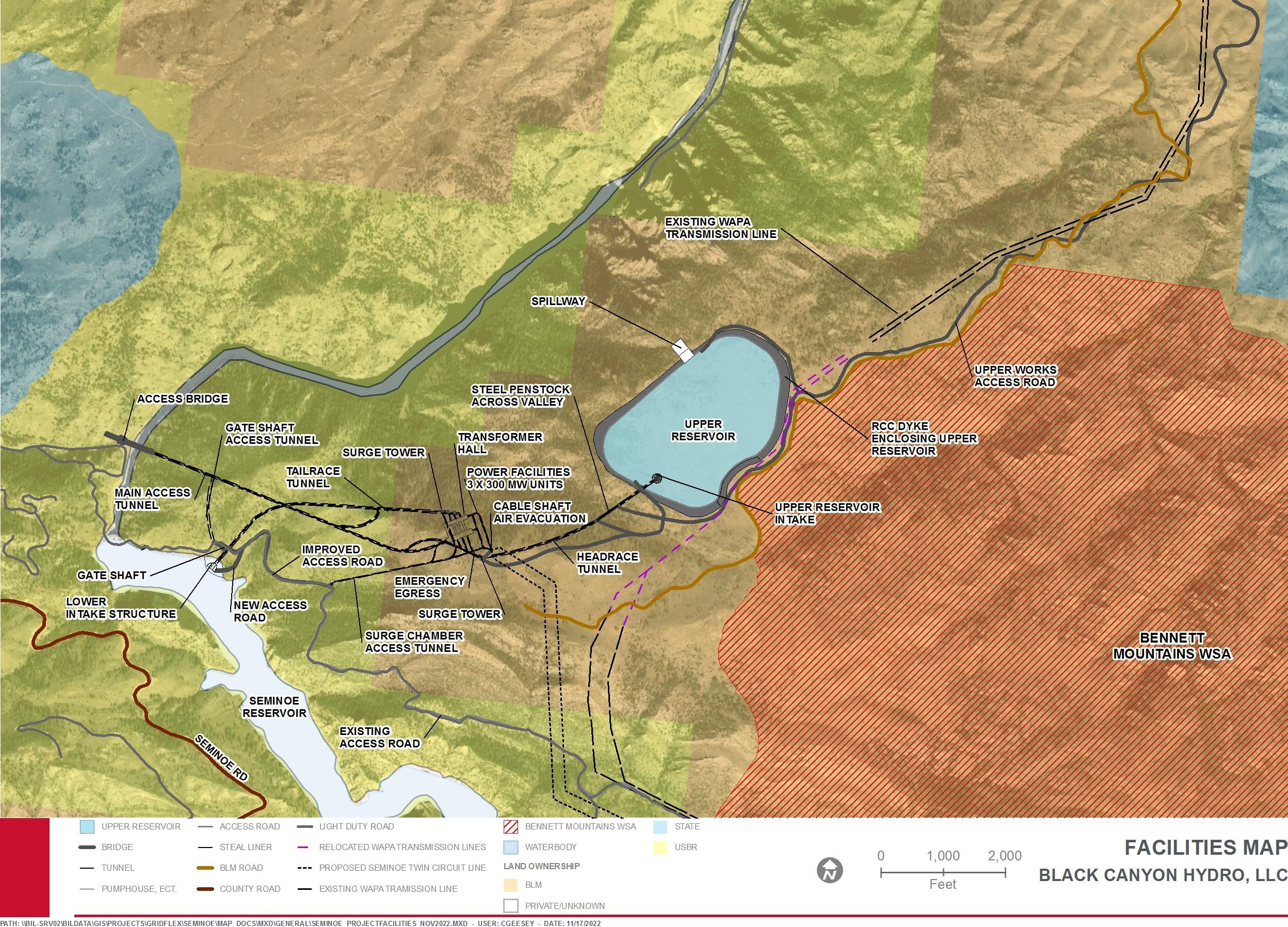
The proposed Project facilities will create an “open loop” hydraulic arrangement The facilities will include a new upper reservoir constructed to the west of the Bennett Mountain Wilderness Study Area (WSA); an upper intake structure; isolating gates in a separate gate shaft; a near-horizontal headrace tunnel including a steel conduit over a gulley; a vertical shaft and surge facility; a horizontal, low-level, high-pressure tunnel connected to a manifold and penstocks; underground power facilities containing three pump turbines and three variable-speed generator-motors; GSU transformers; gas-insulated switchgear; draft tube extensions and manifold; a tailrace surge shaft; tailrace; gates and gate shaft; and a lower intake within the existing Seminoe Reservoir. Access tunnels will provide access and egress from the underground works, and a vertical cable shaft will contain high-voltage transmission cables from the gas-insulated switchgear to the (surface) overhead transmission lines to the Aeolus interconnection. Figure 2.1-1 shows the general arrangement of the main Project components discussed herein.
– Exhibit E
January 2023 | 11
Final License Application
Seminoe Pumped Storage Project
This page intentionally left blank.
Seminoe Pumped Storage Project
–
E
January 2023 | 12
Final License Application
Exhibit
Figure 2.1-1. General Site Plan
Final License Application – Exhibit E Seminoe Pumped Storage Project January 2023 | 13
This page intentionally left blank.
License Application – Exhibit E
Project January 2023 | 14
Final
Seminoe Pumped Storage
2.1.1.1 Upper Dam and Reservoir
The new upper reservoir, to be constructed to the west of the Bennett Mountain WSA, will be located within an area of rolling terrain and occasional small rock outcrops at a minimum existing ground elevation of 7,280 feet.
The upper reservoir will be formed by constructing a roller-compacted concrete (RCC), water-retaining perimeter structure using aggregate processed from excavated material from within the reservoir area. The crest of the RCC water-retaining structure will be at elevation 7,455 feet and the crest width will be 20 feet.
The storage between the normal maximum operating pool of elevation 7,445 feet and the normal minimum operating pool level of elevation 7,350 feet will be approximately 10,800 ac-ft. The normal maximum operating pool level allows for a freeboard of 10 feet to the dam crest, which will be enhanced by a 3-foot-high wave wall. The over-pumping emergency spillway crest elevation is 7,446 feet, one foot above the normal maximum operating pool elevation. Incidental wave overtopping spillage at the over-pumping emergency spillway is anticipated to be infrequent and nominal, which will be attenuated by the spillway stilling basin at the toe of the dam and subsequent downstream protection.
The adopted cross section of the RCC water-retaining structure will be typical for such structures and will include a vertical upstream face and a stepped downstream face averaging 0.8 H to 1 V. Aggregate materials for RCC construction will be primarily processed from the headrace tunneling, from excavations within the reservoir footprint, and from dam foundation excavation activities. Sand, cement, pozzolans, and admixtures will be imported from local and regional commercial sources. The upstream face will incorporate grout-enriched, vibrated RCC to ensure impermeability. The crest will incorporate a road delineated by raised curbs, the 3-foot-high parapet and wave wall on the upstream side, and a steel vehicle barrier on the downstream side.
Preparing the foundation of the RCC structure is necessary for dam construction. Vegetation, overburden, waste material, and weathered rock will be removed to expose firm, un-weathered bedrock. Where required, dental and leveling concrete may be placed.
If geologic features (such as joints, lineaments, etc.) are encountered during foundation preparation, each will be excavated, cleaned, filled with concrete, and (if needed) treated with remedial grouting before any required consolidation grouting is performed. It is currently assumed that an average of 10 feet of excavation will be required over the whole dam (structure) foundation to reach acceptable bedrock quality, although this will be verified during site investigations.
Vehicles will access the crest of the RCC water-retaining structure near the intake and gate shaft and also close to the over-pumping emergency spillway, in both cases by 20foot-wide ramps. These ramps will be formed by extending the RCC placement downstream of the downstream stepped face of the structure.
Vehicles will access the interior of the reservoir by a similar, 20-foot-wide, RCC ramp forming an extension upstream of the water-retaining structure near the intake.
Final License Application – Exhibit E
January 2023 | 15
Seminoe Pumped Storage Project
Seminoe Pumped Storage Project
The floor of the reservoir will be covered by an impermeable geomembrane attached to, and sealed to, the upstream face of the RCC water-retaining structure. This membrane will consist of a layer of geotextile, supported by geomembrane and a geospacer all founded on a crushed granular bedding. The excavated rock surface forming the floor of the reservoir will be shaped to avoid incidence of high stresses in the geomembrane, and as appropriate, concrete infill will be placed on the floor for shaping. The geomembrane will be anchored to the rock floor at regular intervals. Appropriate underdrainage will be incorporated, discharging in galleries at the low spots of the perimeter where the RCC water-retaining structure is highest.
The proposed site of the upper reservoir is currently traversed by two existing Western Area Power Administration (WAPA) transmission lines, the Miracle Mile-Snowy Range 1 115 kV (MM-SNG-1) and Miracle Mile-Snowy Range 2 230 kV (MM-SNG-2). These WAPA transmission lines extend from the Project site to the Aeolus Substation. The Project will utilize this existing alignment to the maximum extent possible to establish the corridor for the Seminoe interconnection transmission lines, as described below. Prior to the implementation of construction at the upper reservoir site or even before a contractor has been mobilized the section of these existing WAPA lines extending over the footprint of the new upper reservoir will be relocated to accommodate the new upper reservoir.
To prevent any access by individuals or animals to the RCC structure, the reservoir will be surrounded by a 10-foot-high chain and rail security fence, approximately 25 feet from the toe of the RCC. Lockable gates will be installed where the access road to the RCC structure passes through the fence. Cameras mounted at intervals on the downstream RCC slope will monitor any attempts to climb or damage the fence.
Over-Pumping Emergency Spillway
The upper reservoir will have no natural water inflow (except rain and snow), but an overpumping emergency spillway will be included, sized for the simultaneous over-pumping discharge condition of the three units at maximum water elevation (i.e., if the motors fail to trip at the maximum water level). The over-pumping emergency spillway will be a 200-footlong, ungated, ogee crest formed by conventional concrete on the top of the RCC section, with a weir crest elevation of 7,446 feet, one foot above the maximum normal water level of 7,445 feet.
Discharges over the over-pumping emergency spillway will be minimized or eliminated by redundant data sensors linked to the pumping controls. A Level Control System will be used for normal plant operation and a completely independent Level Protection System will be a fail-safe backup system to the Level Control System. Multiple types of instrumentation equipment will be used for both systems to avoid faults specific to one manufacturer. Redundancy, alternative cable routes and types, and battery back-up packs at the upper reservoir will also be incorporated to mitigate the consequences of equipment failure or power supply interruptions. The independent Level Protection System will consist of, at a minimum, three sets of two electrical sensing devices, which will be set at least three inches higher than the normal shutdown level of the pump cycle. Each set will be connected to one of the units. If either of the pairs of sensors is activated, a hard-wired
Final License Application – Exhibit E
January 2023 | 16
shutdown of the pump cycle will occur. At least two other sensors located remotely from each other will be included to back up the electrical switches and will be set at least 3 inches higher than the unit electrical sensors. Each of these extra sensors will trip all three pumps. Two additional electrical switches will be located within the over-pumping emergency spillway – but separately from each other - to trip all pumps if any significant water volumes flow over the spillway crest. Actuation of either switch in the over-pumping emergency spillway will trip all the pump cycles and initiate an alarm. In summary the independent emergency Level Protection System will include at least eight discrete water level sensors physically separated from each other, plus two spillway sensors.
A literature review has been made of the reliability of water level sensors. A study by Idaho National Engineering Laboratory in 1995 indicated an average failure rate of water level sensors of between 2.2 to 6 E-7 per hour, while other selected references indicated a worst case of 2.1 E-6 per hour. The IEEE Standard of 2007 indicates a failure rate of 2.88813E7 per hour of a pressure sensor based on a rate of 0.00253 per year. From the available data and using a conservative value of failure rate of 2.0E-6, the proposed system of sensors would exhibit a combined failure rate of 1.6E-23 per hour which implies that water could be inadvertently discharged over the emergency spillway once every 7.13E+18 years.
Including the spillway sensors in the calculation (i.e., assuming that the spillway sensors fail to register the initial discharge from over pumping, and thus allow continuous over pumping), implies a failure rate of 5.606E-31 per hour (or uncontrolled release once every 1.78E+30 years).
These failure rates will be investigated and confirmed in a Potential Failure Modes Analysis (PFMA) during detailed design but can be categorized as very low probability. To further enhance the safety – and reduce the possibility of spillway discharge – cameras will be installed to allow plant operators to visually monitor the water level in the upper reservoir 24 hours per day – particularly at the spillway crest. Redundant cameras will monitor a fixed staff gauge in a stilling well located in an Instrumentation Building cantilevered over the water. Additional cameras will provide a view of the reservoir.
If units were to continue pumping in excess of the maximum water level (elevation 7,445 feet), the excess water would be discharged through the engineered spillway in a controlled manner. Given the volume and size of the lower reservoir, there is a potential for a significant water transfer well in excess of the volume of the upper reservoir. This excess would be limited by the pumping capacity flow rate. If all three units were to continue pumping when the normal maximum water elevation had been reached, the consequent pumping flow would be approximately 8,298 cubic feet per second (cfs). This pumping flow is much greater than the peak flow of 93 cfs resulting from a probable maximum precipitation event at the upper reservoir (which would be the criteria for spillway design if there were a limitation on the available water for pumping). The over pumping flow which could pass over the spillway is not, however, in excess of the spillway capacity of the Kortes dam ungated spillway.
License Application – Exhibit E
January 2023 | 17
Final
Seminoe Pumped Storage Project
Seminoe Pumped Storage Project
The ogee crest will direct the spilling water down a stepped spillway located on the face of the RCC dam into a stilling basin. A significant amount of energy from the discharging water will be dissipated on the stepped spillway with the balance being dissipated in a Reclamation Type I basin at elevation 7,378 feet. The stilling basin will discharge into a natural gulley downslope of the northwest corner of the reservoir site and thence into the Kortes Reservoir. Riprap erosion protection is envisioned for 50 feet downstream of the stilling basin to protect the upper part of the gulley and mitigate erosion below the overpumping emergency spillway. During the detailed design site investigations, an examination of the gulley will be performed to determine if any further riprap or protection of the gulley is needed, such as further riprap or grouting of existing rocks in the gulley. The provision of a catch basin close to the top water level of Kortes Reservoir will be considered as a mitigation to reduce the sediment entering Kortes Reservoir.
WAPA Transmission Line Rerouting
Two existing WAPA transmission lines, the Miracle Mile-Snowy Range 1 115 kV and Miracle Mile-Snowy Range 2 230 kV, traverse the footprint of the proposed new upper reservoir. These are the same lines that extend past the Aeolus Substation, establishing the proposed corridor for the Seminoe interconnection transmission line to follow, as described below. As part of this Project construction – or before – the existing WAPA lines above the proposed footprint of the upper reservoir would be rerouted to avoid traversing the footprint of the upper reservoir.
WAPA has been consulted and is considering two alternatives – one northwest of the reservoir, and one southeast of the reservoir along the existing track. In either case, WAPA is amenable to co-locating the two lines on to one series of poles, and thus will accept a right of way of 150 feet.
2.1.1.2 Lower Reservoir and Seminoe Dam
The lower reservoir for the pumped storage Project will be the existing Seminoe Reservoir on the North Platte River. Seminoe Reservoir, with a total capacity of 1,017,280 ac-ft, is formed by a concrete-arch dam structure containing 210,000 cubic yards of concrete and rising 295 feet above the rock foundation.
Reclamation operates Seminoe Reservoir such that the normal minimum water level is elevation 6,290 feet, but a lower minimum water level of elevation 6,239 feet (the Active Conservation Level) is possible during extreme drought events or to facilitate repair work on the dam. During a full pumping or generating event of the Project, the variation in the water level of Seminoe Reservoir at its normal operating headwater elevation of 6,357 feet, will be less than 6.4 inches. This may occur daily during Project operations. The variation of the water level in Seminoe Reservoir due to a full Project pumping or generating event is shown for various Seminoe Reservoir water levels below in Table 2.1-1
Final License Application – Exhibit E
January 2023 | 18
Table 2.1-1. Water Level Variation in Seminoe Reservoir due to a Complete Project Pumping or Generating Event
Seminoe Reservoir Water Level (elevation in feet)
Variation (inches)
Under existing conditions, Seminoe Reservoir does not experience daily fluctuations but seasonal surface water elevation changes. Under high wind conditions, increased wave action may create dynamic intra-day shoreline conditions and erosive forces along Seminoe Reservoir’s operating range. Project related effects have the potential to be greatest when Seminoe Reservoir is at the lowest operating level (6,290 feet), a condition that has occurred three percent of the time historically (Table 2.1-2).
Under low operating levels of elevations at 6,290 feet, Project operations are predicated to have a daily surface water fluctuation of 20.88 inches and a surface area change of 238 acres, representing a four percent change in surface area (Table 2.1-2). Under normal operating headwater elevation of 6,357 feet, Project operations are predicated to have a daily surface water fluctuation of 6.4 inches and a surface area change of 176 acres, representing a change of less than one percent in surface area (Table 2.1-2). Any change in Seminoe Reservoir elevation due to Project operations will be within the historic range of Seminoe Reservoir water levels. Project effects on Seminoe Reservoir level and surface area will occur within a band where wave action has historically altered water levels
Table 2.1-2. Maximum Seminoe Reservoir Elevation Intra-Day Fluctuation due to Pumped Storage Operations
– Exhibit E
January 2023 | 19
Final License Application
Seminoe Pumped Storage Project
Water Level
6,290 20.8 6,300 17.0 6,310 14.2 6,320 11.8 6,330 9.8 6,340 8.3 6,350 7.0 6,357 6.4
Percent Exceedance based on Historical Seminoe Reservoir Water Level Seminoe Reservoir Water Level (Elevation
ft) Water Level Variation (inches) Seminoe Reservoir Surface Area (acres) Surface Area Variation (acres) 97 6,290 20.88 6,085 238 91 6,300 17.04 7,500 192 80 6,310 14.16 9,065 181 69 6,320 11.76 10,820 192
in
Percent Exceedance based on Historical Seminoe Reservoir Water Level
Seminoe Reservoir Water Level (Elevation in ft)
Water Level Variation (inches)
Seminoe
2.1.1.3
Seminoe Dam, which is a Federal facility operated by Reclamation, is a part of the Kendrick Project, which was authorized pursuant to Section 4 of the Act of June 25, 1910 (36 Stat. 836), and Subsection B of the Act of December 5, 1924 (43 Stat. 702). Seminoe Dam and Powerplant is a multiple-purpose structure that provides benefits of irrigation, power, and flood control. Its construction was completed in August 1939. The power plant at the downstream base of the dam with a rated head of 166 feet generates electric power as the water is released for irrigation and other purposes.
As noted in the prior sections, the crest of Seminoe Dam is at elevation 6,361 feet, with a normal headwater elevation of 6,357 feet. Water is normally released from the reservoir through penstocks to the Seminoe Power Plant, which includes three units, each composed of a 13,500 KW generator driven by a 20,800-horsepower turbine. Water can also be released through a low-level outlet works or over a controlled spillway and outlet tunnel with a capacity of 48,500 cfs at a water level of elevation 6,357 feet.
Seminoe Dam exhibits some deterioration from alkali-aggregate reaction and is experiencing ongoing alkali-silica reaction (ASR) that has affected the durability and integrity of concrete in the dam. Studies of this phenomena at Seminoe have been underway since the 1950s and various cores extracted from the dam have indicated deterioration in the top 35 feet of the dam structure, with most of the damage within the top 10 feet. Reclamation continues to study the dam structure but has not yet decided upon a mitigation strategy.
A solution to the ASR deterioration may require a medium-term drawdown of water while repairs are implemented. Despite this potential variation in the dam’s operation, the operation of the pumped storage facilities will likely be unaffected by ASR-related construction, except in extreme drought years.
Hydraulic Conveyance Between Reservoirs
The hydraulic conveyance system between the upper and lower reservoirs and through the power generating facilities will be predominately comprised of underground tunnels. The sole exception will be an approximately 615-foot-long section of the upper waterway across a gulley close to the upper reservoir, which will be formed by a steel conduit supported on concrete piers.
Final License Application – Exhibit E
Project January 2023 | 20
Seminoe Pumped Storage
Reservoir Surface Area (acres) Surface Area Variation (acres) 55 6,330 9.84 12,890 150 36 6,340 8.28 15,200 179 11 6,350 6.96 17,930 148 0.5 6,357 6.36 20,045 176
Near the southwestern edge of the upper reservoir will be an intake in the form of a covered bell-mouth set at a weir elevation of 7,295 feet. The setting will avoid deleterious vortexes and air entrainment, and will prevent frazil ice, but does allow if necessary for a considerable drawdown below the normal minimum water level of elevation 7,350 feet. An excavated channel from the intake to the northeast corner of the reservoir will be included to facilitate this extra drawdown. The diameter of the bell mouth entrance will be 75 feet. The upper reservoir floor elevation around the intake will be at elevation 7,290 feet. A 400foot-wide channel will connect the intake to the lowest part of the reservoir. There will be no gates on the intake and the coarse screens will be such as to prevent the entry of major debris. Additionally, a floating trash boom will be anchored around the intake to prevent floating debris from being drawn into the intake. Debris caught on the screen will be dislodged during pumping. Security cameras will be installed to monitor the intake for debris. If any debris accumulates, it will be removed in a timely manner.
Ice accumulation is possible in the upper reservoir during the winter but is dependent on operating cycles. The intake facility is located at an elevation to minimize the chance of ice being drawn in. Provisions to deal with frazil ice will be addressed during the detailed design phase of the Project.
The intake will discharge into a short, concrete-lined, vertical shaft with an internal diameter of 36 feet. At the base of this shaft will be a 90-degree bend and a near-horizontal, concrete-lined tunnel below the RCC water-retaining structure.
Immediately downstream of the foundations of the RCC water-retaining structure will be a headrace gate shaft with an excavated diameter of approximately 46 feet. The waterway will be divided into two sluiceways through the gate structure in which two identical wheeled operating gates, 13 feet wide by 36 feet high, will be mounted in gate guides. Upstream of the wheeled gates (i.e., the reservoir side) will be slots in which bulkheads can be placed for maintenance of the wheeled gates or during maintenance of the headrace tunnel.
The excavated gate shaft will daylight downstream of the RCC water-retaining structure and so will be extended using structural concrete to the crest level of the RCC waterretaining structure. The area between the gate shaft and the RCC water-retaining structure will form part of the road access to the crest of the dam structure.
From the headrace gate shaft to the vertical shaft, the tunnel will be horseshoe shaped, fully lined in concrete, and 32 feet wide finished by 32 feet high finished. The tunnel will slope downstream at approximately 1: 100 (0.0025) and the routing will require a steel penstock section over the gulley close to the upper reservoir. The gulley enables access to create construction portals on the upstream and downstream side of the gulley area. The gulley will be crossed by an approximately 24-foot-diameter steel penstock supported on concrete columns at approximately 50-foot centers. At the downstream end of the steel section, close to the portal, an access hatch will be included for inspection of the headrace tunnel and penstock.
Final License Application – Exhibit E
January 2023 | 21
Seminoe Pumped Storage Project
The hydraulic conduits have been sized to maintain maximum flow velocities of approximately 15 feet per second (fps) for concrete-lined tunnels and approximately 24 fps for steel-lined penstocks. The large-diameter, low-pressure steel pipe in the headrace tunnel is estimated to permit a slightly higher flow velocity of 28 fps.
At the downstream end of the headrace tunnel, a vertical, concrete-lined shaft will be constructed with an internal finished diameter of 30 feet. For surge mitigation and for ease of construction, the vertical shaft will be extended upwards to the surface. The initial portion of this surge shaft will be 15 feet in diameter; at an approximate elevation of 7,190 feet, the diameter will increase to 30 feet. The 15-foot and 30-foot portions of the surge shaft will be concrete lined. Near the existing ground surface, the top 50 feet of the surge shaft will be steel lined, with a steel pressure cover at ground level to form a pressure chamber. Two small compressors may be located on the surface next to the pressure chamber (one for redundancy) to maintain sufficient air pressure within the surge shaft to address potential surge conditions. Alternatively, the compressors may be located within the transmission take-off building at the top of the cable shaft with compressed air piping conducted from there to the surge shaft through buried ducts.
At the bottom of the vertical shaft, the hydraulic conduit will include a 90-degree bend into a fully concrete-lined, high-pressure tunnel that is 30 feet in diameter. This tunnel will extend to a concrete-lined manifold and three penstock tunnels. The concrete penstock tunnels will be 17 feet in diameter and steel lined within 165 feet of the power facilities. The amount of steel lining for the penstocks will be re-evaluated based on the completion of additional data gathering on the rock quality at the power facilities.
The penstocks connect the hydraulic conduit to the pump-turbines located in the underground machine hall. Downstream of the pump-turbines, the draft tube extension tunnels will be steel lined to the draft tube gate valves located below the transformer gallery. Downstream of the gate valve, the draft tube will be 17.5 feet in diameter, concrete lined, and will intersect the concrete-lined manifold extending to the downstream surge shaft. The downstream surge shaft is proposed to be 30 feet in diameter and concrete lined. It will extend to a level of elevation 6,360 feet to accommodate all surge events without loss of water. The top of the shaft will be a cavern, sized adequately for shaft construction.
From the downstream surge shaft, the tailrace will be circular and concrete lined with a diameter of 31 feet.
The access tunnel to the surge shaft will be 15 feet wide by 16 feet high and will be lined with shotcrete.
At the downstream end of the tailrace, a gate shaft with an excavated diameter of approximately 46 feet will be constructed. This gate shaft will be configured identically to the upper reservoir gate shaft and house a waterway divided into two sluiceways in which two identical wheeled operating gates, 13 feet wide by 36 feet high, will be mounted in gate guides. Downstream (reservoir side) of the wheeled gates will be slots in which bulkheads can be placed for maintenance of the wheeled gates or for maintenance of the
Final License Application – Exhibit E
January 2023 | 22
Seminoe Pumped Storage Project
2.1.1.4
Seminoe Pumped Storage Project
headrace tunnel. Access to the gate shaft will be from the existing road at the lower intake and the road will be accessed via a tunnel from the main access tunnel.
The lower reservoir intake will be a precast structure at the outlet of the tailrace tunnel. The planned construction methodology envisages that the lower reservoir intake will be pre-cast and floated into place and sunk on to a pre-excavated rock ledge. The lower reservoir intake will be horizontal at an invert level of elevation 6,230 feet. It will include bar racks that are cleanable and removeable. The slots into which the bar racks fit will be engineered for bulkheads that allow the water intake structure to be drained for maintenance. A gantry crane will be located at the deck level of elevation 6,360 feet to facilitate cleaning and the handling of both the bar racks and bulkheads.
The power and control cabling for the lower reservoir intake cranes and gates will be routed through the main access tunnel (MAT) and the lower reservoir intake and gate shaft access tunnel.
The elevation of the lower reservoir intake and the size of the bar racks are based on Reclamation data of historical water levels and assume a bar rack velocity during pumping of 2 fps, at 1 foot in front of the racks, is applicable. Further studies may result in reevaluation of the intake velocity criteria and a redesign of the lower intake. Computational fluid dynamic modelling may also be performed to finalize the shape and geometry.
Pumping and generating times are given below in Table 2.1-3
Table 2.1-3. Pumping and Generating Times, at Full Capacity Operation
Total pumping time from maximum Seminoe elevation (6,357 ft) 15.1 hours
Total pumping time from minimum Seminoe elevation (6,290 ft) 19.0 hours
Generating time maximum capacity 9.7 hours
Maximum energy stored 10,600 MWh
Computational fluid dynamic analysis has been used to check water velocities in the reservoir in front of the intake during generation at low Seminoe levels, and a small hot spot has been discovered where velocities may be slightly higher than 2 fps At this location a 100-foot by 100-foot clean rock blanket may be placed to mitigate any sediment pick up.
Powerhouse and Transformer Caverns
General
The proposed underground power facilities are typical of a pumped storage plant of this size and capacity. The underground power facilities will consist of two caverns the machine hall and the transformer gallery connected by three busbar galleries and a connecting access tunnel.
Final License Application – Exhibit E
January 2023 | 23
Machine Hall
The machine hall will contain the three pump-turbines, three generator-motors, and unit spherical shut-off valves upstream of the pump-turbines. The machine hall will also contain the powerhouse bridge crane and a substantial number of systems supporting the operation of the units and the general functioning of the plant (balance of plant systems). A control room, workshops, and stores will also be in the machine hall and the various floors will be serviced by two elevators and at least two isolated stairwells. Hatches in the floors associated with each unit will provide for moving heavy equipment and parts between the floors and the main floor level which will incorporate an erection bay.
The MAT will connect to the machine hall at the southwest end to facilitate direct entry to the assembly bay. At the other end of the machine hall and at the far end of the transformer gallery, emergency egress tunnels will be located and routed to connect with the downstream surge shaft access tunnel at a higher level.
Transformer Gallery
The transformer gallery will contain a three-phase, GSU transformer for each unit and other plant rooms, as well as – on a lower floor – draft tube bonneted gate valves on the draft tube extensions. Provision for storing a spare, three-phase, GSU transformer has not been included, but could be incorporated later in the design process. In the crown of the transformer gallery will be gas-insulated switchgear arrangement described later.
Access to the transformer gallery will be via a connecting gallery from the assembly bay in the machine hall. Rails will be set in the floor of the connecting gallery and the transformer hall for the movement of the GSU transformers.
Busbar Galleries
There will be three busbar galleries approximately 170 feet long between the machine hall and the transformer gallery containing the low-voltage (LV) bus, reversing switches, breakers, etc., as well as the electrical equipment for the variable-speed generator-motors.
Ventilation and Fire Safety
The internal floors and sections of the machine hall and the transformer gallery will be divided by fireproof walls into fire zones and redundant sealed stairwells so that emergency egress routes are available into the emergency egress tunnel and the MAT.
Ventilation ducts and fans will be installed to ensure that both normal ventilation and smoke venting are routed to the emergency evacuation routes. In general, normal air circulation and smoke and air evacuation during a fire will be directed up the cable shaft, so that fresh air is always entering the underground complex via the MAT and the emergency egress route.
The MAT will function as the main conduit for ventilation air to enter the cavern complex so that under conditions of emergency egress, fresh air will always be entering and smoke cannot engulf personnel exiting.
Final License Application – Exhibit E
January 2023 | 24
Seminoe Pumped Storage Project
Seminoe Pumped Storage Project
The surge shaft access tunnel will be connected to the rest of the underground cavern complex directly by a 20-foot-diameter shaft and a 10-foot by 10-foot emergency egress tunnel from the end of the power cavern opposite of the MAT. This connecting tunnel and shaft will be an alternative emergency egress from the cavern complex in the event of fire or other emergency.
The vertical cable shaft will also have steel stairs as an alternative emergency egress.
Power Facilities Access
The access to the underground facilities will be through the MAT. This will be a vehicular tunnel, sized for the largest item to be transported during construction (which is expected to be the three-phase, GSU transformer). For the purposes of design development, the tunnel is shown as 32 feet wide by 32 feet high and unlined but with a concrete floor slab.
The portal for the MAT will be approximately 1,350 feet downstream of the existing Seminoe Dam, with a road grade at elevation 6,250 feet on the east abutment. This is approximately 92 feet above the normal maximum reservoir level (elevation 6,158 feet) of the Kortes Reservoir – although when spilling Kortes level can reach elevation 6,165.70 feet. This configuration will provide sufficient separation at the point where the access tunnel crosses the tailrace tunnel. The location is a sufficient distance downstream from Seminoe Dam and its access road to ensure Reclamation operations are not affected and also offers maximum flexibility for Reclamation in any design development to mitigate the impact of any potential future structural improvements relating to the ASR deterioration of Seminoe Dam.
It is preferable that the access tunnel portal be at the lowest elevation possible commensurate with Reclamation plans so that the bridge configuration is not overly complex in design or construction requirements
The proposed access tunnel will be aligned near horizontally to the bridge crossing of Seminoe Dam tailrace but the tunnel portal elevation and location may be adjusted after further discussion with Reclamation to ensure that the final configuration is best suited to Reclamation operations and potential ASR mitigation plans for Seminoe Dam.
A bridge will be constructed across the Seminoe tailrace, from the existing road on the left side of the tailrace to the portal The bridge will support a 40-foot-wide road and will be designed for the largest delivered load during construction of the Project, which is expected to be the GSU transformers
Two additional secondary access tunnels will be constructed: i) an access tunnel for the construction of, and maintenance of, the lower reservoir intake and, ii) a downstream surge shaft access tunnel. The surge shaft access tunnel will be connected to the rest of the underground cavern complex directly by a 20-foot-diameter shaft and a 10-foot by 10-foot emergency egress tunnel from the end of the power cavern remote from the MAT. This connecting tunnel and shaft will form a second (emergency) egress from the cavern complex in the event of fire or other emergency. Fans or other arrangements will be included to ensure that, like the MAT, air is always drawn in through the emergency egress,
License Application – Exhibit E
January 2023 | 25
Final
2.1.1.5
Seminoe Pumped Storage Project
facilitating safe escape The following sections outline further emergency egress stairs routes in the cable shaft.
For construction, several connecting tunnels will be created by, and for the convenience of, the construction contractor depending on the method of excavation of the underground works These tunnels will be incorporated into the overall ventilation scheme of the Project and may be used to create safety refuges, with emergency air, supplies, and communication
Evacuation of Power to the Surface
Power will be evacuated from the transformer gallery through a horizontal tunnel with an approximate length of 765 feet to a vertical cable shaft The GSU transformers will be connected to the outgoing circuits via 500 kV, gas-insulated switchgear configured as a breaker and a half arrangement and located in the crown of the transformer gallery Within the cable shaft will be an elevator, separate fireproof compartments for each of the two sets of three cables, and a set of steel stairs The cable tunnel and shaft will be incorporated into the ventilation system as the conduit to draw air out of the underground complex, with fans at the top of the shaft and within the horizontal cable tunnel at the transformer gallery level The proposed size of the cable tunnel is 18 feet wide and 20 feet high and is not expected to require a concrete lining or floor The tunnel will have a full shotcrete lining Similarly, the cable shaft is only lined with shotcrete
Pump-Turbines
Turbine Inlet Valve
Each of the three pump-turbines will be provided with a spherical inlet valve at the entrance to the unit’s spiral case Valve sizing is expected to be between 8 to 10 feet, with the final diameter determined by the supplier of the pump-turbine, in accordance with the spiral case intake diameter The spherical valve will be operated by a high-pressure, doubleacting servomotor, served from a hydraulic power unit and a valve counterweight for emergency closure Pressurized oil may be provided by the governor hydraulic power unit, or separately by a dedicated valve hydraulic power unit
Functions of the spherical valve include the following:
• Isolating an individual pump-turbine from the penstock (in conjunction with the draft tube gate) so its spiral case can be emptied for maintenance work without draining the penstock;
• Normal shut-off for reducing pressure in the spiral case to minimize leakage through the closed wicket gates when the unit is shut down or is being started as a pump; and
• Secondary independent means of emergency shut-off of flow in the event the wicket gates are unable to close
Pump-Turbines
The three, identical, proposed pump-turbines will operate at a synchronous speed of 300 rotations per minute (rpm) and are nominally rated at 324 MW.
License Application – Exhibit E
January 2023 | 26
Final
Each pump-turbine will be a vertical-shaft, single-runner, reversible, reaction-type with movable wicket gates, fixed stay vanes, steel-plate spiral cases, and elbow-type suction draft tubes
The movable wicket gates are for regulation of power output and for control of speed during starting, synchronizing, and shutting down in the turbine mode The moveable wicket gates also serve for control of starting and stopping during pump operation and are regulated to obtain the maximum pump efficiency under varying head conditions
The initial operation of the first pump-turbine will be in pumping mode and water must be available to provide head against which the pump will start. Therefore, the construction sequence of the RCC water-retaining structure will be organized so that the RCC placement on the east side up to a level of approximately elevation 7,305 feet will be completed first, together with the reservoir lining In this way, snow melt and rain can be collected during the construction period so that up to 96 ac-ft is available to be pumped into the headrace tunnel at the appropriate time
Pump-Turbine Components
The embedded pump-turbine components consist of the draft tube liner, discharge ring, stay ring, spiral case, and pit liner. Access to the water passages is provided by watertight man doors on the spiral casing and the draft tube liner
Pump-turbine rotating parts consist of the runner (impeller) and the pump-turbine shaft The runner is bolted directly to the lower end of the flanged shaft, with connection to the generator shaft at the upper end The assembly is typically supported by the combined thrust and guide bearing located immediately below (or above) the generator-motor, a generator guide bearing, and by a turbine guide bearing close to the headcover, just above the shaft seal
The distributor assembly includes the headcover and bottom ring, the wicket gates, and their operating mechanism consisting of levers, links, and an operating ring with connection to the distributor servomotors
The pump-turbine headcover also supports the shaft seal and miscellaneous piping for air, water, pressure equalizing, tailwater depression, and bearing oil systems
A water depression system will be provided for start-up in pumping mode This system consists of a compressor and sufficiently large pressure accumulators with the relevant piping, sensors, and control When applied, the system will depress the water in the runner chamber down the draft tube cone to ensure the runner spins completely in air during startup The spiral casing remains filled with water and partially pressurized, with the wicket gates completely closed and the runner band drain valve open. Separate water lines will be provided to the upper and lower runner seals for cooling while the runner spins in air
Each pump-turbine will be provided with an electro-hydraulic digital governing system with speed and acceleration sensing, speed regulation, stabilizing, and diagnostic functions All control and diagnostic functions are accomplished through a digital processor The
Final License Application – Exhibit E
January 2023 | 27
Seminoe Pumped Storage Project
processor provides a control signal to an electro-hydraulic transducer that controls positioning of the main oil-distributing valve directing pressure oil to the gate servomotors to position the wicket gates The governing system is also designed and equipped to provide the control features required for pumping, including optimization of wicket gate opening during pumping Each governing system includes electrical speed sensing, an actuator, restoring connection, an oil pump set, sump tank, high-pressure tank, oil piping to the pump-turbine servomotors, and all controls, instruments, and accessories necessary for a complete governing system.
2.1.1.6 Generator-Motors
The generator-motors will be sized to match the ratings of the pump-turbines for pumping and generating. The generator-motors will be double-fed induction machines (DFIM) that are capable of variable-speed operation The machine rating is 360 megavolt ampere (MVA) at 0.90 power factor. Synchronous speed will be 300 rpm to match that of the pumpturbine Nominal voltage will be 18 kV, although the final voltage selection will be made by the suppliers within 10 percent of this rated voltage.
The pump-turbines are sized for a maximum pump-input power of approximately 309 MW, allowing for a motor rating of 330 MVA at 0.95 power factor, to respect a potential 999 MVA interconnect agreement (also considering all other loads and losses) Depending on the chosen vendor for a variable-speed unit, the speed is typically adjustable within +/- 5 to 10 percent of the synchronous speed for increased operating range and to optimize efficiency given the head range
The resulting equipment selection provides a machine represented by a pumping ‘K-factor’ between 606 and 725 at maximum and minimum total dynamic head, respectively where K = nq*H^0.5.
Unlike conventional synchronous machines, the rotor has an alternating current (AC) winding to which variable frequency power is applied The stator is identical in function to a comparable synchronous machine, although there is a tendency for the core height to be increased
The generator-motor will be indirect cooled via air-to-water surface air coolers to maintain ambient temperature in the generator housing at not greater than 40 degrees Celsius (°C) Cooling water will be taken from the penstock or draft tube of the unit and returned to a different point The same cooling water circuits will be used to provide cooling for other components in the power station as well.
The generator-motors will be high-impedance grounded, limiting the ground fault current to not more than 20 amperes (amps). Between this feature and the main circuits being comprised of isolated phase bus, high current faults are eliminated except in the generator itself or other components that are not of isolated phase construction, mostly transformers and reactors
A DFIM unit does not require a separate starting bus and static frequency converter because the generator-motor can be started as a motor using the variable-speed drive.
Final License Application – Exhibit E
January 2023 | 28
Seminoe Pumped Storage Project
Black-start capability can be provided by supply of a low voltage AC circuit to the AC excitation system from station service to temporarily build up the voltage on the unit when the AC supply to the excitation transformer is not available
2.1.1.7 Configuration and Ratings
A single-line diagram is provided in Exhibit A, Section 2.8, and also in Exhibit F, Sheet 21, identifying the configuration of equipment needed to support the DFIM machines
2.1.1.8 Switchyard
General
GSU transformers for each unit will be provided rated at 360 MVA, with 18 kV, deltaconnected, LV windings, and 500 kV, grounded wye, high-voltage windings located in the transformer gallery of the underground complex. Appropriate basic insulation level and surge-arrester ratings will be selected based on technical standards for these ratings
Transformers will be 3-phase construction, oil-filled, water-cooled type oil directed water forced or oil forced water forced, but use natural, ester oil-type FR-3 or equal with 600°C flashpoint instead of the 300°C flashpoint of mineral type insulating oil GSUs will be provided with oil-capture basins that guide oil to closed tanks so that any potential fire hazard is transferred away from the transformer. A low-volume, nitrogen-injected fire protection system similar to a Victaulic Vortex system is envisioned to be provided with each GSU. Each transformer will be contained in a vault with a 4-hour fire rating.
Switchgear
The underground facilities will incorporate a 500 kV, gas-insulated switchgear arrangement in the crown of the transformer gallery above the GSU transformers
The underground, 500 kV, gas-insulated switchgear will be configured as a breaker and a half arrangement. SF6 is currently used for such applications, but alternate gases are under development for active components and are expected to be available by the year 2024. Wherever possible, gas-insulated buses or lines will use compressed air instead of SF6 to reduce the carbon potential This could be accomplished by selection of an 800 kV, gas-insulated bus to account for the lower dielectric strength of compressed air.
To avoid issues with transformer energization and de-energization, point-on-wave circuit breakers will be provided for all 500 kV breakers Transmission line feeders will be supplied with high-speed ground switches Surge arresters are provided at both ends of the underground transmission line feeders and at the terminals of each GSU
2.1.1.9 Transmission Lines General
Power input and evacuation will be by two, 500 kV circuits from the underground gasinsulated switchgear through the low-level cable tunnel, up the cable shaft to a take-off structure at the surface, and thence via two separate, 500 kV, overhead primary
– Exhibit E
January 2023 | 29
Final License Application
Seminoe Pumped Storage Project
Seminoe Pumped Storage Project
transmission lines extending to the 500 kV interconnection at Aeolus Substation, approximately 30 miles to the southeast of the Project (Sheets 32-40 of Exhibit F).
The proposed design for transmission lines from the transformer hall to the surface provides for the use of either solid dielectric cables (separated in the tunnels and shafts) or a gas-insulated bus with no combustible materials Either option provides acceptable fireproofing The 28-foot-diameter vertical shaft, which will also function as the air and smoke evacuation conduit, will include an elevator for maintenance access to the cables or bus in the shaft as well as access to the outdoor cable terminations and disconnect switches The vertical shaft will include steel grating platforms every 30 feet Steel stairs will also be included for emergency egress from all landings. Stairs and platforms will use gratings to maximize airflow capability of the system.
To interconnect the Project to the existing electrical grid, approximately 30 miles of BLM and private lands will be traversed by an overhead transmission system. The power delivery will be split into two self-supporting or separate circuits, at the request of the interconnecting utility. 500 kV is the preferred transmission voltage. It should be noted that negotiations for transmission right-of-way with private landowners are ongoing, and the final routing of the Project transmission line in particular areas will depend on the results of those negotiations.
The proposed 500 kV transmission line corridor from the Seminoe gas-insulated switchgear to the Aeolus Substation follows the existing WAPA transmission line and is located based on construction, maintenance, and engineering requirements; land use; and potential impact to landowners in the area.
The initial routing of the transmission lines from the take-off structure will be on the south side of the existing WAPA 230 kV and 115 kV lines. At the bottom of the initial slope, the 500 kV lines from the Project will cross the WAPA lines and will be to the north of these lines for the remainder of the transmission route The 500 kV lines will be on steel lattice towers approximately 100 feet tall and spaced evenly across a 450-foot-wide right-of-way.
At certain locations, to avoid stringing lines directly above buildings, a slight line diversion will be proposed away from the WAPA lines (See Exhibit G).
The 500 kV Aeolus Substation at the terminus of the primary 500 kV lines will require the addition of two feeders, assumed as one full new bay of breaker and a half This will require the addition of civil works to expand the 500 kV substation, including the ground mat and fencing New dead-end towers will be required to terminate the incoming transmission lines from the Project.
Transmission line protection of the 500 kV transmission circuits will be determined in later design phases and likely consist of transfer trip, carrier blocking, and/or line differential arrangements. It will incorporate high-speed differential protection of the underground circuits that will block reclosing of both ends of the line and close a high-speed ground switch. No automatic reclose of these circuits should occur until they have been proven to be unaffected and functional.
License Application – Exhibit E
January 2023 | 30
Final
Towers, Foundations and Conductors
Drilled pier foundations will be utilized as the primary foundation solution along the transmission line If upon detailed design, drilled piers are deemed unsuitable due to access, subsurface strata, or topography, micro pile foundations are an alternative due to the nature and ease of installation in difficult terrain.
Aluminum conductor, steel-reinforced cable will be used on this Project Aluminum conductor, steel-reinforced cable is the most common and economical conductor used in high-voltage transmission projects. During detailed design, alternative conductors may be evaluated, especially in environmentally sensitive areas or for particularly long spans where a customized, low-sag conductor may be a more suitable and less invasive option.
The use of optical ground wire is also anticipated. This cable serves as an overhead lightning protection wire, as well as a means of communication between Project facilities and the interconnecting grid facilities Optical ground wire requires a splice box to be placed on structures at fixed intervals, controlled by the maximum reel length available.
Opposite of the optical ground wire will be a steel or alumoweld overhead ground wire, which is simply for lightning protection of the phases not covered by the optical ground wire.
2.1.1.10 Summary of Project Features
Table 2.1-4 summarizes the Project features.
Table 2.1-4. Summary of Project Features Project Feature
– Exhibit E
January 2023 | 31
Final License Application
Seminoe Pumped Storage Project
Feature Data
Plant
of Units 3 Operating Speed Nominal 300 rpm
Rated Capacity in generating mode (@M-G Terminals) 972 MW
rated Capacity in generating mode (@M-G Terminals) 324 MW
firm power (max output at minimum net head, @M-G Terminals) ~265 MW
Plant Discharge in generating mode ~12,500 cfs
Turbine unit Flow ~4,200 cfs
maximum motor input power (@M-G Terminals) ~314 MW
Hydroelectric
Number
Total
Unit
Unit
Maximum
Maximum
Unit
Project Feature
Feature Data
Maximum pump flow ~3,500 cfs
Maximum pump flow at TWL in upper reservoir 2,766 cfs
Generator Rating 360 MVA, 0.90 power factor
Motor Rating 330 MVA, 0.95 power factor
Low Pressure Headrace Waterway
Tunnel Internal Width/Height, D shape, concrete lined 32 ft by 32 ft
Tunnel Length 2,756 ft
Steel gulley crossing diameter 24 ft
Steel Pipe Length ~615 ft
Shaft
Internal Diameter, concrete lined 30 ft
Length 1,225 ft
High Pressure Tunnel
Internal Diameter – concrete lined 30 ft
Length 123 ft
Penstock
Internal Diameter - concrete and steel lined 17 ft
Length 330 ft, 247 ft, and 165 ft
Draft Tube extension
Internal Diameter - concrete and steel lined 17.5 ft
Length 140 ft, 103 ft, and 85 ft
– Exhibit E
January 2023 | 32
Final License Application
Seminoe Pumped Storage Project
License Application – Exhibit E Seminoe Pumped Storage Project January 2023 | 33
Final
Feature
Downstream Surge Chamber Internal Diameter 36 ft Length 232 ft Tailrace Tunnel Internal Diameter 31 ft Length 4,070 ft Powerhouse Cavern Height 142 ft Length 460 ft Width 80 ft Transformer Cavern Height 113 ft Length 413 ft Width 71 ft ISO Phase Bus galleries (3) Height 43.5 ft Length 170 ft Width 31 ft Upper Reservoir Water-retaining structure type RCC Storage Total Reservoir Capacity (below spillway crest) 13,300 ac-ft Inactive storage 2,500 ac-ft Active Storage 10,800 ac-ft Operating Levels
Project Feature
Data
Project Feature
Feature Data
Maximum Normal Water Level 7,445 ft
Minimum Normal Water Level 7,350 ft
Water Surface Area
Surface Area at Normal Maximum Water Level 114 acres
Surface Area at Normal Minimum Water Level 111 acres
Dam Structural Dimensions
Maximum Structural Height 180 ft
Minimum Structural Height 65 ft
Top Width 20 ft
Length 8,498 ft
Crest Elevation 7,455 ft
Over-pumping emergency spillway
Ungated Ogee Weir
Length 200 ft
Crest Elevation 7,446 ft
Capacity (max pumping flow at normal max level) ~8,298 cfs
Retaining structure Seminoe Dam
Operating Levels
Maximum Normal Water Level 6,357 ft
Minimum Normal Water Level (typical) 6,290 ft
Minimum Normal Water Level (active conservation level) 6,239 ft
Storage 1,016,717 ac-ft
Water Surface Area at Normal Maximum Water Level 20,291 acres
Transmission Line No. of Circuits 2
Application – Exhibit E
January 2023 | 34
Final License
Seminoe Pumped Storage Project
Lower Reservoir1
2.1.2
Project Feature
Feature Data
Structure Type Single Circuit Lattice Tower
Voltage 500 kV
Length ~30 Miles
1 The Project’s lower reservoir is Reclamation’s existing Seminoe Reservoir and is not a proposed Project facility for purposes of the FERC license. See Section 1.2 of this Exhibit for more information on the relationship of the Project to Reclamation’s Seminoe Dam and Reservoir.
Summary of Proposed PM&E Measures
Black Canyon describes proposed PM&E measures in Section 3.3 through 3.16 of this Exhibit Other environmental measures may be proposed based on continued consultation with resource agencies, to protect and enhance resources and mitigate potential Project effects, as those effects are better understood through continued design, analysis, and consultation. PM&E measures as proposed at this time are summarized in Table 2.1-5.
In addition to these PM&E measures, Black Canyon expects that an amendment to the BLM Rawlins Field Office Resource Management Plan (RMP) will be required to facilitate construction of the Project. The following elements may be addressed in the RMP amendment:
• Visual Resources Management – currently some areas in the Project vicinity are classified as VRM-2 viewshed; a VRM-3 or VRM-4 classification will be required for the Project;
• Stipulated seasonal restrictions related to wildlife and habitat, to allow for construction activities, including restrictions for raptor nests, big game crucial winter range, sage grouse, and other resources.
The RMP amendment may also address other RMP components, such as a wind avoidance area and limber pine habitat. Black Canyon anticipates that the BLM will coordinate its environmental review of the RMP amendment with the FERC licensing process.
– Exhibit E
January 2023 | 35
Final License Application
Seminoe Pumped Storage Project
Final License Application – Exhibit E
Seminoe Pumped Storage Project
Table 2.1-5. PM&E Measures Proposed by Black Canyon
Number
Enhancement/Mitigation Measures
1. Erosion and Sediment Control Plan: Black Canyon proposes to develop and implement an Erosion and Sediment Control Plan to address erosion associated with Project construction. The Erosion and Sediment Control Plan will include:
• The use of Best Management Practices (BMPs) recommended by the State of Wyoming, to specify erosion control measures to help minimize potential adverse impacts.
• NPDES permitting for construction activities, as required by Wyoming State law and the Federal CWA
• Specific actions to be implemented during Project construction and operation to minimize the potential for generating windblown dust from Project activities and to control fugitive dust.
• Actions to address earthworks in soils that are highly erodible.
2.
Exhibit E Section and Resource Area
Section 3.3 Geologic and Soil Resources
Section 3.4 Water Resources
Section 3.5 Fish and Aquatic Resources
Section 3.15 Air
Stormwater Pollution
Prevention Plan (SWPPP): Prior to the commencement of construction, Black Canyon proposes to prepare and implement a SWPPP. The SWPPP is anticipated to prevent erosion, scouring, and general water quality degradation during Project construction. The SWPPP will include:
• Description of potential storm water discharges from support activities related to Project construction such as equipment staging areas, material storage areas, and access roads.
• Description of existing vegetation across the portion of the site to be disturbed.
• Discussion of other potential pollutions sources (e.g., vehicle fueling, equipment maintenance).
• The drainage or water body that may receive a storm discharge from Project construction activities.
• Site maps that detail where BMPs will be installed in each major stage of construction, including placement and timing.
• Discussion of BMPs, including those related to erosion prevention, sediment control, temporary and permanent stabilization measures, construction site dewatering, good
Section 3.3 Geologic and Soil Resources
Section 3.4 Water Resources
January 2023 | 36
Final License Application – Exhibit E
Seminoe Pumped Storage Project
Number Enhancement/Mitigation Measures
housekeeping, bulk storage of petroleum products, concrete waste, employee training, maintenance schedule, and inspection schedule.
3. Hazardous Substances Spill Prevention and Cleanup Plan: Black Canyon proposes to develop and implement a Hazardous Substances Spill Prevention and Cleanup Plan to address potential issues resulting from spills of hazardous substances or fuels during construction, operation, or maintenance. The Hazardous Substances Spill Prevention and Cleanup Plan will:
• Specify materials handling procedures and storage requirements.
• Identify spill notification and cleanup procedures for areas in which spills may occur.
• Identify inventory, storage, and handling methods for hazardous materials
• Develop employee training procedures to help minimize accidental pollutant releases which could contaminate surface or groundwater or stormwater runoff.
4. Pre- and Post-Construction Stream Flow Monitoring: Black Canyon proposes to conduct preconstruction and post-construction monitoring of water flow in Number One Gulch, Number Two Gulch, and Dry Lake Creek. In the event that reduced streamflows are identified post-construction, Black Canyon will work with the BLM and other agencies (as applicable) to identify mitigation measures.
Exhibit E Section and Resource Area
5. Transmission Line Design: During final design, Black Canyon will complete designs of transmission facilities (including locations of transmission towers and access roads) in a manner that minimizes surface disturbing activity in identified 100-year floodplains, areas within 500 feet of perennial waters and wetland/riparian areas, and areas within 100 feet from the inner gorge of ephemeral channels, as specified in the BLM Rawlins Field Office RMP. If transmission structures cannot be located outside the buffers, Black Canyon will consult with BLM on steps to identify reasonable mitigation measures to minimize adverse impacts to water features.
6. Fish Exclusion Measures: Black Canyon proposes to install and maintain fish exclusion bar racks at the lower reservoir inlet/outlet to reduce fish entrainment.
Section 3.3 Geologic and Soil Resources
Section 3.4 Water Resources
Section 3.5 Fish and Aquatic Resources
Section 3.6 Botanical Resources
Section 3.6 Botanical Resources
Section 3.6 Botanical Resources
Section 3.7 Wildlife Resources
Section 3.5 Fish and Aquatic Resources
January 2023 | 37
Final License Application – Exhibit E
Seminoe Pumped Storage Project
Number Enhancement/Mitigation Measures
7. AIS Plan: Black Canyon will develop and implement an AIS Construction Monitoring and Decontamination Plan (AIS Plan) specific to Seminoe Reservoir. The AIS Plan will:
• Include measures for monitoring and decontaminating construction equipment used in areas below the ordinary high-water line of water bodies.
• Be developed in consultation with BLM and WGFD following license issuance and during development of final construction plans.
Exhibit E Section and Resource Area
Section 3.5 Fish and Aquatic Resources
8. Habitat Restoration, Reclamation, and Enhancement Plan: Black Canyon will develop and implement a Habitat Revegetation, Restoration, and Enhancement Plan to identify measures that could be reasonably implemented for management, avoidance, and mitigation of potential habitat and associated vegetation losses during construction and operation of the Project. The Habitat Revegetation, Restoration, and Enhancement Plan will:
• Identify specific measures to be taken to restore vegetation disturbed by Project-related construction activities.
• Describe revegetation efforts to prevent soil erosion and the spread of weeds, maintain or restore existing native plant communities and wildlife habitat, and integrate site features with the surrounding environment.
• Specify native seed mixes which will include milkweed (Asclepias spp.) species, as appropriate.
• Identify restoration measures for Project impacts to RTE plant species.
• Develop measures specific to protection of Limber Pine.
• Address seasonal timing restrictions for vegetation management in areas containing plants used by monarch butterflies to minimize the potential for interference with monarch breeding or sources of nectar used as a food source along the migration route.
Section 3.6 Botanical Resources
Section 3.7 Wildlife Resources
January 2023 | 38
Final License Application – Exhibit E
Seminoe Pumped Storage Project
Exhibit
Number Enhancement/Mitigation Measures
9. Biological Resources Protection Training Program: Black Canyon proposes to develop a biological resources protection training program. The program is intended to help inform construction workers and other Project staff of the sensitive biological (botanical and wildlife) resources in the area.
10. Pre-Construction Surveys: Prior to construction, Black Canyon will complete botanical and wildlife surveys and habitat assessments. These surveys will be conducted by trained botanists and biologists in areas that will be disturbed by the Project. Specific pre-construction surveys include:
• At least three consecutive years of surveys for Ute ladies’-tresses;
• Areas where milkweed is likely to occur (i.e., wetlands, roadsides, drainages, mesic areas) for suitable monarch butterfly habitat;
• Conduct winter roost site surveys for bald eagles within suitable habitat;
• Conduct year-of-construction raptor nest surveys throughout the Project Footprint of Potential Disturbance and a 1-mile buffer, wherever access is obtained. Raptor nest surveys were conducted in 2021 and the results of those surveys will be used to inform the year-ofconstruction surveys.
Based on the findings of the surveys, Black Canyon with consult with applicable regulating agencies to identify reasonable avoidance or mitigation measures to reduce adverse impacts.
11. Noxious Weed Management Plan: Black Canyon proposes to develop and implement a Noxious Weed Management Plan for construction of the Project. This plan will include measures to reduce the spread or introduction of noxious weed and invasive plant species The Noxious Weed Management Plan will incorporate restrictions and guidelines for application of pesticides including herbicides, including avoidance of known sensitive plant species. Black Canyon will coordinate with BLM regarding herbicide use on BLM lands. Measures that will be included in the plan include:
• Prevent introduction and establishment by cleaning vehicles and equipment prior to movement to a new location in order to minimize the potential for transporting seeds.
E Section and Resource Area
Section 3.6 Botanical Resources
Section 3.7 Wildlife Resources
Section 3.6 Botanical Resources
Section 3.7 Wildlife Resources
Section 3.6 Botanical Resources
January 2023 | 39
Final License Application – Exhibit E
Seminoe Pumped Storage Project
Number Enhancement/Mitigation Measures
• Work with land managers to develop and implement a plan to assess, treat, and monitor noxious weeds and invasive plants at the Project and in the adjacent landscape where they are present.
• Work with the local weed and pest district to implement and fund long-term plans for successful restoration of disturbed sites.
12. RTE Plant Management Plan: Black Canyon proposes to develop a RTE Plant Management Plan for Project operation in consultation with applicable agencies. The RTE Plant Management Plan will specify the following for applicable RTE species:
• The local occurrences and habitats;
• Disturbance buffers and use restrictions;
• Survey and monitoring requirements (if present);
• Specific mitigation activities;
• Report and consultation requirements.
13. Fire Prevention and Protection Plan: Black Canyon proposes to develop and implement a Fire Prevention and Protection Plan for the Project. The Fire Prevention and Protection Plan will:
• Identify potential fire hazards and prevention measures.
• Describe fire prevention during operations and maintenance.
• Discuss fire protection systems and proper housekeeping for fire prevention.
• Identify applicable fire safety requirements including training programs and equipment maintenance schedules.
14. Upper Reservoir Wildlife Exclusion: Black Canyon proposes to fence and monitor the upper reservoir to prevent cattle, wild ungulates, and other medium- to large-sized animals from accessing this area. Based on the current Project design, upper reservoir wildlife exclusion measures may include:
• Installing an 8-foot-tall game fence around the base of the upper reservoir and spillway
Exhibit E Section and Resource Area
Section 3.6 Botanical Resources
Section 3.7 Wildlife Resources
Section 3.7 Wildlife Resources
January 2023 | 40
Final License Application – Exhibit E
Seminoe Pumped Storage Project
Number Enhancement/Mitigation Measures
• A gate, or set of gates, will be installed to have continued safe access and egress to the upper reservoir while maintaining a minimum height of at least 8 feet.
• There will be a one-way exit gate, built during construction, to facilitate a safe exit in the event that wildlife were to enter the fenced-off area.
• Black Canyon will provide regular maintenance and monitoring to ensure the fencing has not failed.
Exhibit E Section and Resource Area
15. Raptor-Safe Transmission Line Structures: Black Canyon proposes to design raptor-safe transmission line structures (i.e., the transmission line design will comply with Avian Power Line Interaction Committee (APLIC) guidelines: Suggested Practices for Avian Protection on Power Lines, The State of the Art in 2006 [APLIC 2006] and Reducing Avian Collisions with Power Lines: The State of the Art in 2012 [APLIC 2012]) to protect avian species from collision or electrocution as a result of landing or perching on transmission lines. This design may include:
• Installing visibility enhancement devices to reduce the risk of collision on new or existing lines (e.g., marker balls, bird diverters).
• Regular maintenance of the transmission line and retrofitting the lines as applicable, which may include covering jumper wires, reframing, or replacing a structure.
• Installing perch guards between closely-spaced conductors above arms and conductors to keep raptors from contacting energized parts.
• Providing safe alternative locations for perching and nesting.
16. Greater Sage-grouse Management: Black Canyon proposes to design a transmission line that minimizes adverse impacts to Greater Sage-grouse, including complying with applicable APLIC guidelines in “Best Management Practices for Electric Utilities in Sage-grouse Habitat” (APLIC 2015). Once a final Project design is developed, Black Canyon will submit that Project design through the WGFD DDCT as part of the permitting process. The results of the DDCT can guide consultation with WGFD to reduce and mitigate Greater Sage-grouse impacts. The proposed Greater Sage-grouse Management may include:
• Installing anti-perch and/or anti-nesting devices to reduce use by predatory birds.
January 2023 | 41
Section 3.7 Wildlife Resources
Section 3.7 Wildlife Resources
Number Enhancement/Mitigation Measures
• Identifying methods to reduce collision risk for Greater Sage-grouse and migratory birds.
• Limiting construction disturbance and access during breeding season.
• Minimizing spacing between existing and proposed transmission lines.
Final License Application – Exhibit E
Seminoe Pumped Storage Project
Exhibit
E Section and Resource Area
17. Post-Construction Surveys: Post to construction, Black Canyon will complete a Greater Sagegrouse lek survey to comply with the Sage-grouse Executive Order 2019-3 (SGEO). These surveys will be conducted by trained scientists in areas that will be disturbed by the Project.
Section 3.7 Wildlife Resources
18. Wildlife Seasonal Restrictions: Black Canyon proposes to work closely with BLM to plan for Project construction windows that provide for both wildlife protection and feasible Project construction timelines. This would include developing manageable timing and scheduling restrictions that can accommodate the construction schedule.
Section 3.7 Wildlife Resources
19. Traffic Management Plan: Black Canyon will develop and implement a Traffic Management Plan prior to construction The plan will include:
• Traffic volume (how many trucks/equipment per day during construction and operation).
• Which roads are to be used and for which activities. Stress and impacts to wildlife (and recreational users) may vary widely depending on which roads are being used.
• Construction traffic will pass over the Seminoe Range and the Miracle Mile.
• Plans for winter road maintenance if a year-long schedule is to be kept.
• Gravel roads that would need to be upgraded or surfaced.
• Whether recreational traffic would be diverted onto the Morgan Creek Wildlife Habitat Management Area.
• The difference between pre-construction traffic counts on affected roads.
• The use of the newly proposed access road to the upper reservoir.
• Describe the purpose, frequency, timing, and duration (i.e., construction or operation phases) of use of the proposed bridge over the North Platte River, located 1,000 feet downstream of Seminoe Reservoir to access to the Main Access Tunnel Portal.
Section 3.7 Wildlife Resources
Section 3.8 Recreation
January 2023 | 42
Number Enhancement/Mitigation Measures
• Measures to mitigate impacts to wildlife, including Project speed limits to reduce wildlifevehicle collisions and methods of enforcement.
• Manage traffic by implementing a speed limit to reduce wildlife injury due to collisions.
Final License Application – Exhibit E
Seminoe Pumped Storage Project
Exhibit E Section and Resource Area
20. Biological Construction Monitors: Black Canyon proposes to have biological construction monitors on site during construction to monitor sensitive biological resources, including conducting avian nesting surveys of areas near active construction during nesting season (April 1 to August 31).
Section 3.6 Botanical Resources
Section 3.7 Wildlife Resources
21. Raptor Protection Plan: Prior to the onset of ground disturbance at the start of formal construction activities, Black Canyon proposes to prepare and implement a Raptor Protection Plan. The Raptor Protection Plan will include:
• Appropriate seasonal and spatial buffers of active raptor nests and bald eagle roost sites.
• Raptor-safe guidelines for all new electrical construction.
• Employee training to ensure plan compliance.
22. Outdoor Lighting Plan: Black Canyon proposes to develop a Project outdoor lighting plan to incorporate lighting design features that help minimize disturbance to wildlife species during construction and operation of the Project. The outdoor lighting plan will include:
• Designing outdoor lighting to incorporate design and operational features to help to reduce impacts on foraging bats and migrating and nocturnal birds.
• Using localized and portable lighting during construction where and when the work is occurring.
• Provisions to power lighting equipment by generators that will have switches to cut power when lighting is not required during construction.
• The use of minimal exterior lighting that will consist of safety lighting. For all safety lighting, Black Canyon proposes to minimize lighting to the extent possible and use dark-sky compliant lighting fixtures.
Section 3.7 Wildlife Resources
Section 3.7 Wildlife Resources
Section 3.12 Aesthetics Resources
January 2023 | 43
Final License Application – Exhibit E
Seminoe Pumped Storage Project
Number Enhancement/Mitigation Measures
• Provisions that all lighting will use full cutoff luminaires and be properly shielded and mounted, except as required to meet minimum safety and security requirements (e.g., emergency lighting triggered by alarms).
• The use of lighting that is amber in color, using either low-pressure sodium lamps or yellow LED lighting, which reduces skyglow and wildlife impacts from exterior lighting.
Exhibit E Section and Resource Area
Section 3.8 Recreation
• Prohibit fishing and other recreation in and around the upper reservoir.
• Fence the upper reservoir for site security, public safety, and wildlife protection.
24. Historic Properties Management Plan (HPMP): Black Canyon proposes to develop an HPMP and to conduct cultural resource monitoring during ground disturbing construction activities. The HPMP will:
• Identify the nature and significance of historic properties that may be affected by Project maintenance and operation.
• Identify goals for the preservation of historic properties.
• Establish guidelines for routine maintenance and operation.
• Establish procedures for consulting with SHPOs, THPOs, Indian tribes, historic preservation experts, and the public concerning effects to historic properties.
25. Paleontological Monitoring: Black Canyon proposes to develop and implement a plan to monitor construction and if necessary, mitigate adverse impacts to significant paleontological resources (as defined in BLM IM-2009-11) during construction. This may include:
• Identifying when and what factors may place paleontological resources at risk to damage, destruction, or unauthorized collecting.
• Identifying monitoring strategies to observe, document, and recognize changes or impacts to paleontological resources during Project construction.
Section 3.10 Cultural Resources
Section 3.11 Paleontological Resources
January 2023 | 44
23. Public Access: Black Canyon proposes to manage lands over which it has control in the Footprint of Potential Disturbance for appropriate public access. Black Canyon proposes to:
Final License Application – Exhibit
E
Seminoe Pumped Storage Project
Number Enhancement/Mitigation Measures
• Measures to identify, record, and evaluate significant paleontological and cultural discoveries during Project construction, as applicable.
26. Visual Resources: Black Canyon proposes to:
• Use BLM environmental colors (Standard Environmental Colors, Color Chart CC-001) for surface coatings of fences, gates, and other above-ground facility features.
• Design the upper reservoir, bridge, and lower intake structure so that materials repeat and/or blend in with the existing form, line, color, and texture of the landscape to the extent feasible.
Exhibit E Section and Resource Area
Section 3.12 Aesthetic Resources
27. Air Pollution Control Plan: Black Canyon proposes to develop an Air Pollution Control Plan to minimize emissions and control construction dust through the use of BMPs. Elements of such a plan include the following provisions for controlling fugitive dust from the construction site:
• Establish stabilized truck exit areas for washing the wheels of all trucks that enter paved roadways from the construction site and dirt roads leading from the construction site.
• Establish tracking pads at construction exits to prevent dirt from being tracked onto roadways.
• Apply water or dust reducing agents to any truck routes within the construction site as needed (during dry and windy periods) or, in cases where such routes would remain in place for an extended duration, cover the routes with gravel to avoid re-suspension of dust.
• Apply water or dust reducing agents to all exposed surfaces as needed during dry weather. Exposed surfaces include, but are not limited to soil piles, graded areas, unpaved parking areas, staging areas, and access roads.
• Cover or maintain at least 2 feet of free board space on haul trucks transporting soil, sand, or other loose material on the site. Cover any haul trucks that would be traveling along freeways or major roadways.
• Use wet power vacuum street sweepers to remove any visible track out mud or dirt onto adjacent paved public roads.
Section 3.15 Air
January 2023 | 45
Final License Application – Exhibit E
Seminoe Pumped Storage Project
Number Enhancement/Mitigation Measures
• Pave all roadways, driveways, sidewalks, and parking lots as soon as possible. In addition, lay building pads as soon as possible after grading unless seeding or soil binders are used.
• Incorporate dust control measures (e.g., dust collectors and covers limiting pathways for dust) into the temporary concrete batch plant, if used at the construction site.
o To control vehicle emissions from diesel-powered equipment working at the construction site the plan could also include:
▪ Minimize idling time by either shutting equipment off when not in use or reducing idling time to 5 minutes. Provide clear signage regarding this requirement for workers at the entrances to the site.
▪ Establish protocols for equipment inspection and maintenance programs to ensure work and fuel efficiencies.
▪ Maintain all construction equipment in proper working condition according to manufacturer’s specifications. Ensure that equipment is running in proper condition before it is operated.
28 Noise: To minimize the effects of noise related to construction and operation of the Project, Black Canyon will utilize several strategies to manage noise associated with construction, including sequencing of the use of noise-producing machinery and siting laydown areas and other construction activities to take advantage of natural buffering of noise from vegetation and topography between noise generation and receptors.
Exhibit E Section and Resource Area
Section 3.16 Noise
January 2023 | 46
2.1.3 No Action Alternative
Under the no action alternative, an original license is not granted for the proposed Project. The Project would not be constructed or operated, and the proposed economical supply of peaking power generated by the Project in balance with renewable generation sources on the grid, and other electric system ancillary services, such as operating reserves and voltage and frequency support, would not be available to the grid. Under the no action alternative, the environmental resource effects and enhancements discussed in this application arising from the Project would not occur.
2.2 Alternatives Considered but Eliminated from Detailed Analysis
There are several other types of electric generation resources that can supply dispatchable power, ancillary services and, in the case of energy storage technologies, use renewable resources more effectively by storing and shaping their delivery. As will be explained below, none of these alternatives could fit the need as well as the proposed Project.
2.2.1 Regional Generation Supply Development and Generation Supply Alternatives
The future energy supply in Wyoming and greater regional market will be increasingly supplied by wind and solar resources, which are non-dispatchable, intermittent, and variable in nature but have become the lowest cost sources of energy.3 Large-scale energy storage must be developed to provide resiliency and reliability to an electric grid increasingly powered by intermittent renewable energies. Wyoming currently does not have a requirement or goal to generate a certain amount of the state’s electricity from renewable energy (U.S. Energy Information Administration 2021). However, PacifiCorp (the utility with which the Project would interconnect and the dominant utility serving Wyoming and major load centers in Utah) has chosen a path to de-carbonization that entails closing coal-fired generating plants and adding significant amounts of renewable energy, as detailed in their 2021 Integrated Resource Plan (IRP) (PacifiCorp 2021).
Beginning in 2017, PacifiCorp more than doubled wind energy production and constructed a key segment of the Energy Gateway transmission projects, including four new wind projects in Wyoming: Cedar Springs 1, Cedar Springs 2, Ekola Flats, and TB Flats; totaling 1,150 MW of new generating capability.
PacifiCorp is investing in re-powering nearly all its existing wind fleet located in Wyoming, Washington, and Oregon, which involves installing new, larger, state-of-the-art nacelles
3 New solar development in PacifiCorp’s preferred portfolio is paired with new storage resources (i.e., batteries) (PacifiCorp 2021). Therefore, projected portfolio plans for wind generation, rather than solar, are discussed in this section.
Final License Application – Exhibit E
January 2023 | 47
Seminoe Pumped Storage Project
2.2.2
and blades, increasing the output and useful life of about 1,000 MW of existing generating capability from the same wind source.
Due to Wyoming’s high average wind speeds, PacifiCorp has already procured more than 1,900 MW of new wind generation capacity, which will be delivered to load centers through the approved Energy Gateway transmission projects. More specifically, the Gateway South line, originating at the Aeolus Substation, will be the primary means of delivering the wind energy to the northern Utah load center. Additionally, in its 2021 cluster window, PacifiCorp received interconnection applications into or near Aeolus Substation totaling nearly 1,400 MW.
PacifiCorp’s IRP compared the costs of wind energy resources over the wide range of its multi-state service territory. The cost of wind energy from an area designated as “Medicine Bow”, the location of the Aeolus Substation into which the Project would connect, is shown as being lower in cost than wind from any other region. An additional 3,628 MW of new wind energy capacity is planned by 2040 (PacifiCorp 2021). Given this portfolio preference, the lower cost of Wyoming wind, and the number of specific wind projects in development, it is likely that a significant amount of new wind capacity will be built in the vicinity of the proposed Project.
From a transmission perspective, accommodating this additional wind capacity will be challenging, even with planned new transmission lines, such as Gateway South. This challenge is exacerbated in that wind-only transmission utilization will be inefficient. The proposed Project will increase utilization of existing and new transmission capacity in the region by shifting peak wind generation to times when transmission capacity is available which otherwise would have been curtailed due to limited transmission capacity. It will also increase grid reliability and load access for the intermittent and non-dispatchable wind resource to serve load more effectively.
PacifiCorp is anticipating nearly 3,250 MW of new, low-cost, clean energy resources by 2024 (PacifiCorp 2021). The Project is well positioned to support this increased generation growth in Wyoming and Utah.
Fossil-Based Generation
Coal-fired steam generation provides large-scale baseload energy, serving a different function in an energy supply portfolio than pumped storage. As a major source of greenhouse gas emissions, coal-fired generation in the market region for the Project is being phased out and there are no plans for new coal-fired capacity additions. Therefore, coal is not a viable alternative to the Project.
Gas-fired power plants include simple-cycle combustion turbines (SCCT), combined-cycle combustion turbines (CCCT), and internal combustion reciprocating engines. Gas-fired generation has provided most of the peaking and intermediate capacity in the western market since the 1990s. CCCT plants are used for intermediate-to-baseload service. SCCTs, including frame turbines and aeroderivatives, are used for peaking power and have a lower capital cost than pumped storage. They, along with CCCT plants, are
Final License Application – Exhibit E
January 2023 | 48
Seminoe Pumped Storage Project
significant sources of greenhouse gas emissions and their inclusion in regional resource plans is being scaled back dramatically. Furthermore, while they can be used to follow variations in solar and wind output, they do not provide the energy storage function that will be critical for integrating large amounts of renewable resources. Therefore gas-fired generation is not a viable alternative to the Project.
2.2.3 Nuclear Power
Nuclear fission power plants have provided baseload energy in many regions of the U.S. since the 1970s and several plants operate in California, Arizona, and Washington. Due to policy changes, safety concerns, or economic factors, the two nuclear plants in California are being or have been retired.
Nuclear power plants are a carbon-free source of generation. With the existing technology available, they are large, have a long development timeline, and require significant capital investments. Disposal of nuclear waste is also a significant concern. Wyoming is the largest domestic producer of uranium used for conventional nuclear fission power plants; however, the state does not have any existing fission plants. One small, modular nuclear reactor is currently proposed in Wyoming. The 345 MW Natrium power plant is based on new technology using molten salts as a heat source. Cost estimates for pilot plants such as the Natrium power plant are high and they will need to be operated at a close to baseload capacity factor to keep the cost of energy at a competitive level.
Nuclear generation is a baseload resource and does not provide the flexible energy storage services that will be required to integrate large amounts of renewable energy. When combined with cost, ongoing concerns about waste disposal, and the experimental nature of new nuclear technology options, nuclear power is not a viable generation alternative to the Project.
2.2.4 Renewable Resources
Solar energy, particularly photovoltaic solar (PV solar), is an emerging form of electric energy supply and is increasing in many parts of the western U.S. It is one of the lowest cost energy sources available and does not generate greenhouse gas emissions. Solar output is relatively predictable, with the exception being cloud cover that can interrupt normal generation patterns causing a mid-day output peak and no generation during the night. The result is the well-established “duck curve,” with a steep ramp up needed for generating capacity that aligns with increasing load in the early evening. Since PV solar is not a firm or dispatchable generation alternative, it is not a viable alternative to the Project. PV solar is a major driver of the need for energy storage resources like the proposed Project.
Wind energy is another leading source of carbon-free energy seeing widespread deployment. Where the wind resource is of high quality, the cost of wind energy is very low. Wind energy viability is particularly high in Wyoming, possessing high average annual wind speeds of 6.5 meters per second or higher at 80 meters above ground surface in over half of the state by area (Tetra Tech 2021). Wyoming is likely to export wind energy
Final License Application – Exhibit E
January 2023 | 49
Seminoe Pumped Storage Project
production to other states. Like PV solar, wind energy is not dispatchable, and it has a lower ability to predictably match demand. Therefore, use of wind energy, particularly in Wyoming, is a major driver of the need for energy storage resources like the proposed Project.
Wyoming’s geothermal resources are used for direct heating applications, mainly in Yellowstone National Park and Hot Springs State Park, and do not have adequate resources for commercial electricity generation (State of Wyoming Geological Survey 2015). However, the economics of geothermal power require that it operates as a baseload facility. Geothermal resources are site specific and require significant lead times and development risk. More generally, the cost of geothermal generation is depressing its inclusion in most resource plans. Additionally, geothermal generation is baseload in nature and not able to provide the energy storage services needed for integrating other renewable resources. Therefore, geothermal is not a viable generation alternative to the Project.
Conventional hydroelectric power has provided relatively firm, carbon-free energy in parts of the western U.S., specifically the Pacific Northwest, California, and Colorado, for many decades. Wyoming currently has 21 dams that generate power, most of which are owned and operated by the federal government. Across a wider region, there is potential for new, small hydropower additions to non-powered dams, but there are no plans for major hydropower projects akin to those developed in other parts of the west in earlier generations. Due to the limited potential of future large hydropower developments, openloop pumped storage developments serve as opportunities to better utilize existing hydropower developments in Wyoming.
The lack of viable development opportunities for new major hydroelectric power sources in the western region, along with the other reasons given here, mean that conventional hydroelectric power is not a viable generation alternative to the Project.
2.2.5 Other Pumped Storage
The viability of pumped storage projects requires a relatively rare combination of factors to be present, including suitable topography and geology, land availability, a source of fill water, an acceptable level of environmental impact, correct sizing for the market, and interconnection options. No major pumped storage projects have been constructed in the U.S. since 1995, and relatively few proposed pumped storage projects advance to development and receiving a FERC license. There are only three pumped storage projects in the Western Electricity Coordinating Council region that recently have received a FERC license: Eagle Mountain in California, Swan Lake North in Oregon, and Gordon Butte in Montana. Construction has not commenced at any of these projects.
Within the State of Wyoming, there are currently three preliminary permits pending or recently granted for other proposed pumped storage projects (P-15244, P-15247, P-15253). Two involve closed-loop concepts and one is an off-stream (open-loop) concept similar in concept to the Project. Each of these projects have a proposed generation capacity of 500 MW. Recently, a Notice of Decision Not to Proceed was filed for a 400 MW, closed-loop concept in Wyoming (P-14853) due to land ownership and access issues.
Final License Application – Exhibit E
January 2023 | 50
Seminoe Pumped Storage Project
2.2.6
Seminoe Pumped Storage Project
Pumped storage projects at the preliminary permit stage are considered speculative and, as of the time of this writing, none of these concepts have advanced beyond this phase.
Based on both their early stage of development and smaller project sizes, it is Black Canyon’s estimation that no pumped storage projects are currently proposed in Wyoming with an equivalent or superior level of viability as that represented by the Project.
Other Energy Storage Technologies
Battery Energy Storage Systems (BESS) are increasing, primarily in the form of lithiumion batteries paired with PV solar. The cost of batteries has fallen significantly over the past several years, and costs are forecasted to continue to decline. Stand-alone battery projects are being constructed at the scale of hundreds of MW, and projects of 1 gigawatt have been proposed. These systems generally have storage durations of 2 to 4 hours.
Like pumped storage projects, BESS represent dispatchable capacity that helps to integrate carbon-free renewable resources and will thus see significant deployment across the market. Compared with pumped storage, BESS have the advantage of shorter development times, modularity, and flexibility of location. However, BESS have disadvantages compared to as the Project:
• Higher cost at longer durations of storage (duration will be increasingly important as renewable energy penetration increases);
• Significantly shorter useful life (10 to 20 years, depending on cycling);
• Degradation of storage capacity and efficiency through use (resulting in a higher fixed operations and maintenance [O&M] cost for augmentation);
• Environmental impacts from mining of battery materials and the lack of methods for recycling spent battery cells;
• Future supply risks associated with competition for materials (lithium and other materials) and policy considerations (e.g., reliance on raw materials and manufacturing in China). Evidence of this risk is seen in recent industry studies showing a slowdown in battery price decline due to rising commodity prices and reduced production; and
• An inability to supply inertia to the grid
Exhibit D includes an analysis of (Estimated Annual Value of Project Power) using lithiumion as a benchmark for comparison to illustrate how and why the Project represents a lower long-term long-duration cost of storage than utility-scale batteries when viewed through the energy or megawatt hours (MWh) lens.
New battery technologies, hydrogen-based systems, and mechanical systems (rail energy storage and systems that lift and lower concrete blocks) are at the demonstration or research and development stage and do not represent commercially available alternatives to the Project.
Compressed air energy storage (CAES) is the only other long-duration energy storage technology with an established track record, but this technology requires very specific and rare geology. The CAES technology available today requires the combustion of natural
Final License Application – Exhibit E
January 2023 | 51
Seminoe Pumped Storage Project
gas, a source of greenhouse gases. A CAES project in Utah is being developed for the only known “Gulf Coast” style domal-quality salt formation in the western U.S. There are no known active proposals for CAES projects in Wyoming.
2.2.7 Conclusion
BESS are the most likely alternative to the Project in terms of addressing utility and market needs for a distributed storage solution in the emerging low-carbon market. However, the advantages of pumped storage, where it can be built, make the Project an exceptional opportunity for meeting the needs of Wyoming and the greater regional energy market.
There are currently no proposed projects that could provide the same benefit to optimizing regional diversity of renewable energy siting and existing and new transmission in the region. Therefore, no other pumped storage project in Wyoming is a viable generation alternative to the Project.
2.3
Project Siting Alternatives
Pumped storage project siting is unusual among utility resource technologies because the technical and economic viability of a given project is highly dependent on an uncommon combination of factors. The most significant of these factors are depicted in Figure 2.3-1.
Site locations in the vicinity of the Kortes and Seminoe Reservoirs were explored based upon Carbon County’s attributes of water supply, favorable geology and topography, access to construction power, short distance to an existing high-voltage transmission interconnection, and local infrastructure to support a multi-year construction duration. As detailed project in this section, when screening for these factors, the area adjacent to Seminoe Reservoir became the focus for the Project and the proposed Project emerged as the preferred alternative
– Exhibit E
Final License Application
January 2023 | 52
Figure 2.3-1. Pumped Storage Site Selection Factors
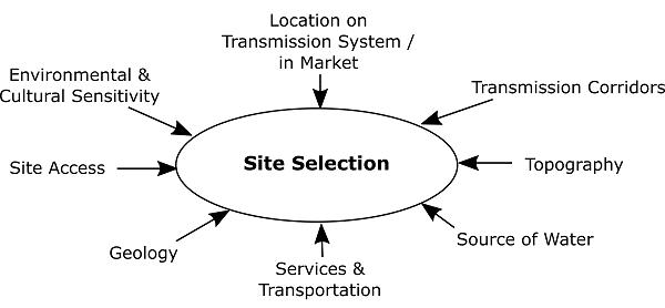
2.3.1 Topography, Water, Services, and Site Access Factors
The single greatest driver of pumped storage cost is the combination of available head (i.e., vertical drop) and horizontal hydraulic conveyance length in conjunction with suitable geology and reservoir topography. Head can range from the low hundreds of feet to over 3,000 feet. This makes the most efficient use of water and land while minimizing the sizing of tunnels, rotating equipment, the powerhouse, and other structures. The horizontal length of the hydraulic conveyances (typically tunnels) to create the head available by the topography must typically be less than 10 to 12 times the total head for an economic project. The geologic characteristics must be able to support economic tunneling methods and reduced underground risk. Lastly, the topography that will define the upper reservoir configuration must be able to economically design and construct the dam to provide enough water volume to support nearly 9.7 hours of storage at the desired capacity for generation and pumping.
Access to Seminoe Reservoir provides a lower reservoir of significant volume such that upper reservoir operation is unlikely to cause disruption to Reclamation operations. In previously considered configurations in the 2011 Preliminary Permit Application, the 2013 Reclamation Phase I report, and the 2014 Successive Preliminary Permit Application, utilizing Kortes Reservoir was an option; however, due to its relatively small storage volume (4,765 acre-feet, less than the selected alternative’s storage volume [13,427 acrefeet]) against Seminoe Reservoir’s storage volume (>1,000,000 acre-feet), Kortes Reservoir was ruled out due to the fluctuations in elevation and downstream impacts that a pumped storage facility could impose. The 2013 Reclamation Phase I report acknowledged the challenges of utilizing Kortes Reservoir as the lower reservoir for pumpgeneration, and the necessity of stream augmentation was included in alternatives that utilized Kortes as the lower reservoir to meet downstream flow requirements. Reclamation’s Phase II report stated that long-term operational impacts to Seminoe Reservoir would be minimal, that the pumped storage facility would not change the timing or frequency of releases, and therefore, would not affect overall water supply or
– Exhibit E
Final License Application
January 2023 | 53
Seminoe Pumped Storage Project
Seminoe Pumped Storage Project
downstream flows. The feasibility study found that the proposed volume of water pumped into the new reservoir would be very small relative to the volume of water in the existing Seminoe Reservoir and would, therefore, be unlikely to change reservoir elevations such that there would be adverse effects to Seminoe Reservoir resources (Reclamation 2013).
Additional favorable factors present in the region adjacent to Seminoe Reservoir, northeast of Rawlins and south of Casper include:
• Rawlins is the largest town in Carbon County, affording nearby services to support Project development, construction, and operation.
• Casper is the largest city in Wyoming, affording services to support Project development, construction, and operation.
• Good aggregate material on the Project site that will be excavated can likely be utilized in the construction of the RCC upper reservoir dam.
• Good highway access is available to the Project site, including Interstate 80 and Interstate 25.
2.3.2 Environmental Factors
Environmental screening factors are key to site selection. These include biological and cultural factors, along with general land use policy.
Figure 2.3-2 shows the location of the proposed Project configuration overlaid with the location of the Bennett Mountains WSA. The Bennett Mountains WSA does not currently have a wilderness designation In Reclamation’s Phase I and II Report alternatives, portions of the proposed upper reservoirs had overlapped with this area. The concept study prepared to support the 2019 Preliminary Permit Application and PAD considered the Bennett Mountains WSA, and relocated the upper reservoir presented in Reclamation’s Phase II Report such that no Project feature would extend into the Bennett Mountains WSA. This aspect was maintained in the feasibility study and the selected Project configuration.
Under all action alternatives, construction and operation of the Project has the potential to temporarily or permanently impact habitat, wildlife, and botanical species, including aquatic habitats and species.
As described in Exhibit E Section 3.0 Environmental Analysis of this FLA, a combination of avoidance, minimization, mitigation, and enhancement measures (PM&Es measures) support selection of pumped storage development in this location
–
E
Final License Application
Exhibit
January 2023 | 54
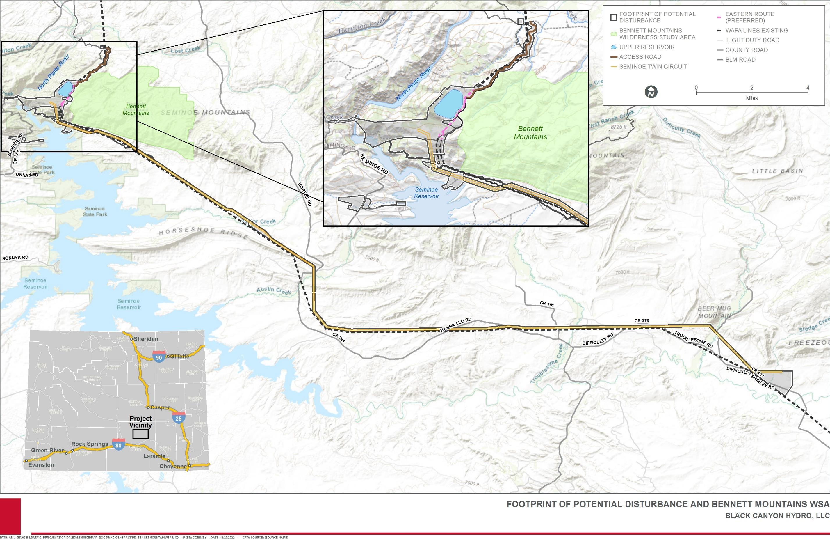
– Exhibit E
January 2023 | 55
Final License Application
Seminoe Pumped Storage Project
Figure 2.3-2. Proposed Seminoe Pumped Storage Project Footprint of Potential Disturbance and Bennett Mountains Wilderness Study Area.
This page intentionally left blank.
License Application – Exhibit E
Project January 2023 | 56
Final
Seminoe Pumped Storage
2.3.3 Transmission Considerations
Location on the transmission system and within the market are important considerations for pumped storage development in general and the Project in particular. The State of Wyoming itself has no requirement or goal to generate a certain percentage of its electricity from renewables. It is also a relatively small market compared to neighboring states like Utah and others in the Pacific Northwest region. In fact, Wyoming as a state is the largest net exporter of energy as a percentage of its energy consumption, exporting 15 times the energy it consumes. As such, existing, in-progress, and proposed transmission line projects aim to improve the ability of the State of Wyoming to deliver energy to out-of-state markets. Reliability and economic use of transmission will benefit significantly from energy storage, and pumped storage can be an exceptional value in energy storage, as previously discussed in Section 1.1
Within the State of Wyoming, southern Wyoming represents an important crossroads of existing, planned, and proposed transmission. This allowed for consideration of a number of alternative points of interconnection and associated Project transmission line routes
The 2011 Preliminary Permit Application, FERC No. P-14087, showed the pumped storage project connected to both the Kortes and Seminoe Reservoirs and interconnected with the existing Western Area Power Administration (WAPA) Miracle Mile-Snowy Range line at an interconnection point adjacent to Seminoe. From the interconnection point, energy from the proposed Project would transfer energy through the WAPA Miracle Mile-Snowy Range line to one of the following proposed transmission facilities: the Gateway West line via the Aeolus Substation, the Zephyr line, TransWest Express, or the Overland. The 2014 Successive Preliminary Permit Application did not propose alternatives to this original concept.
The 2013 Reclamation Phase II Report considered an interconnection at Miracle Mile Switchyard with a 230 kilovolt (kV) line and an interconnection to Aeolus Substation with 230 kV and 500 kV transmission options. Interconnection at the Miracle Mile Switchyard was considered, as this option would be the shortest transmission route, requiring only 7 miles of a single, 230 kV line. However, this interconnection would result in overloads to the existing system at 250 MW of pumping load and, therefore this interconnection point was determined to be inadequate to consider further. Interconnection at the Aeolus Substation would require more land acquisition, requiring over 30 miles of double-circuit, 230 kV line or single-circuit, 500 kV line. Both the 230 kV line and single-circuit 500 kV line options were determined to be feasible, although the 500 kV line was determined to be considerably more expensive at the time of the Phase II Report
The 2016 Preliminary Permit Application for the Project (FERC No. P-14787) refined the interconnection options and narrowed the transmission alternatives to either the Aeolus Substation or the planned northern terminal for the TransWest Express DC line near Sinclair, Wyoming, and ruled out the other alternatives presented in the 2011 and 2014 Preliminary Permit Applications. The 2019 Successive Preliminary Permit Application was supported by a transmission screening study performed by Power Engineers, Inc. The screening study reviewed the viability of interconnecting 500, 600, and 1,000 MW Project
Final License Application – Exhibit E
January 2023 | 57
Seminoe Pumped Storage Project
configuration alternatives presented in the concept study (HDR 2019) at Aeolus Substation and the planned TransWest Express Terminal. These two interconnection alternatives were presented in the Project’s PAD (Gridflex 2020). Black Canyon chose not to pursue the TransWest Express interconnection alternative due to the commercial indeterminacy of that transmission project, as well as the cost of pursuing both points of interconnection.
Preferred Interconnection Alternative
The feasibility study examined a variety of transmission alternatives, all considering Aeolus Substation as the interconnection point. Six alternatives for transmission lines from the Project location to Aeolus Substation were examined: 2 x 230 kV (2 single-circuit), 3 x 230 kV (1 single-circuit, 1 double-circuit), 2 x 345 kV (2 single-circuit), 2 x 345 kV (1 doublecircuit), 2 x 500 kV (2 single-circuit), and 2 x 500 kV (1 double-circuit). A 1 x 500 kV alternative was not examined due to feedback from the transmission provider that reliability rules would limit the capacity on that line to well below the plant-rated capacity. The 2 x 230 kV options were found to be infeasible due to energy losses in the cable, which would necessitate a larger generator to make up for the energy losses. The 345 kV options had the issue that there is no 345 kV bus at Aeolus Substation, which would necessitate a complete 345 kV switchyard to be added, significantly increasing the cost of these alternatives. The 2 x 500 kV transmission line options with interconnection at Aeolus Substation were determined to be the most technically and economically viable point of interconnection for the Project. Further engineering studies will refine the specifications of power equipment and choice of transmission line (single-circuit vs. double-circuit). The proposed transmission route can be found in Sheets 32-40 of Exhibit F.
The location of the proposed Project upper reservoir intersects with two existing WAPA transmission lines: the Miracle Mile-Snowy Range 1 115 kV line (MM-SNG-1) and the Miracle Mile-Snowy Range 2 230 kV line (MM-SNG-2), (the “WAPA transmission lines”). These lines extend past the Aeolus Substation, establishing a likely corridor for the Project’s proposed interconnection transmission line to follow. As part of Project construction, approximately 1 mile of the existing WAPA transmission lines in the area of the proposed upper reservoir will be re-routed. Two re-route concepts were investigated in 2022: (1) re-routing the WAPA transmission lines to the west of the proposed upper reservoir (Western Route); and (2) re-routing the WAPA transmission lines along the eastern edge of the proposed upper reservoir, between the reservoir wall and the Bennett Mountain access road (which forms the border of the Bennett Mountains Wilderness Study Area (WSA)) (Eastern Route). Each re-route option is less than 1 mile long. Figure 2.3-3 shows the location of the existing alignment and two WAPA transmission line re-routing alternatives.
Both WAPA transmission line re-location alternatives combine two existing transmission circuits onto a single steel monopole structure with the use of a 3-pole transmission structure at the beginning and end of each re-route. This will result in minimal impact to existing structures and the surrounding environment. The Project proposes to use Meyer pre-engineered steel poles where possible at the request of WAPA.
The Western Route includes spans of approximately 900 feet and 1,600 feet over challenging terrain, resulting in limited access to transmission towers, advanced
Final License Application – Exhibit E
January 2023 | 58
Seminoe Pumped Storage Project
construction measures, and increased environmental and resource impacts. These spans would require special construction techniques include the use of helicopters for structure spotting and conductor stringing.
Based on current designs of the WAPA transmission line re-route alternatives, which designs are subject to change prior to construction, the Western Route, when compared to the Eastern Route, would result in an additional five steel monopole tower structures; 116,308 pounds of custom steel; 48 cubic yards of concrete volume; 22,129 pounds of steel rebar; 26,795 feet of conductor; 9,191 feet of optical ground wire (OPGW); and 294 feet of steel shield wire. The additional materials, weights, distances, construction activities, and required access roads would result in additional environmental and resource impacts when compared to the Eastern Route. The Eastern Route is the preferred route because it is more accessible, is located on more suitable topography, has lower estimates in the aforementioned measures, and therefore would be easier to construct and maintain over the Project lifecycle.
– Exhibit E
January 2023 | 59
Final License Application
Seminoe Pumped Storage Project
This page intentionally left blank.
Seminoe Pumped Storage Project
– Exhibit E
January 2023 | 60
Final License Application
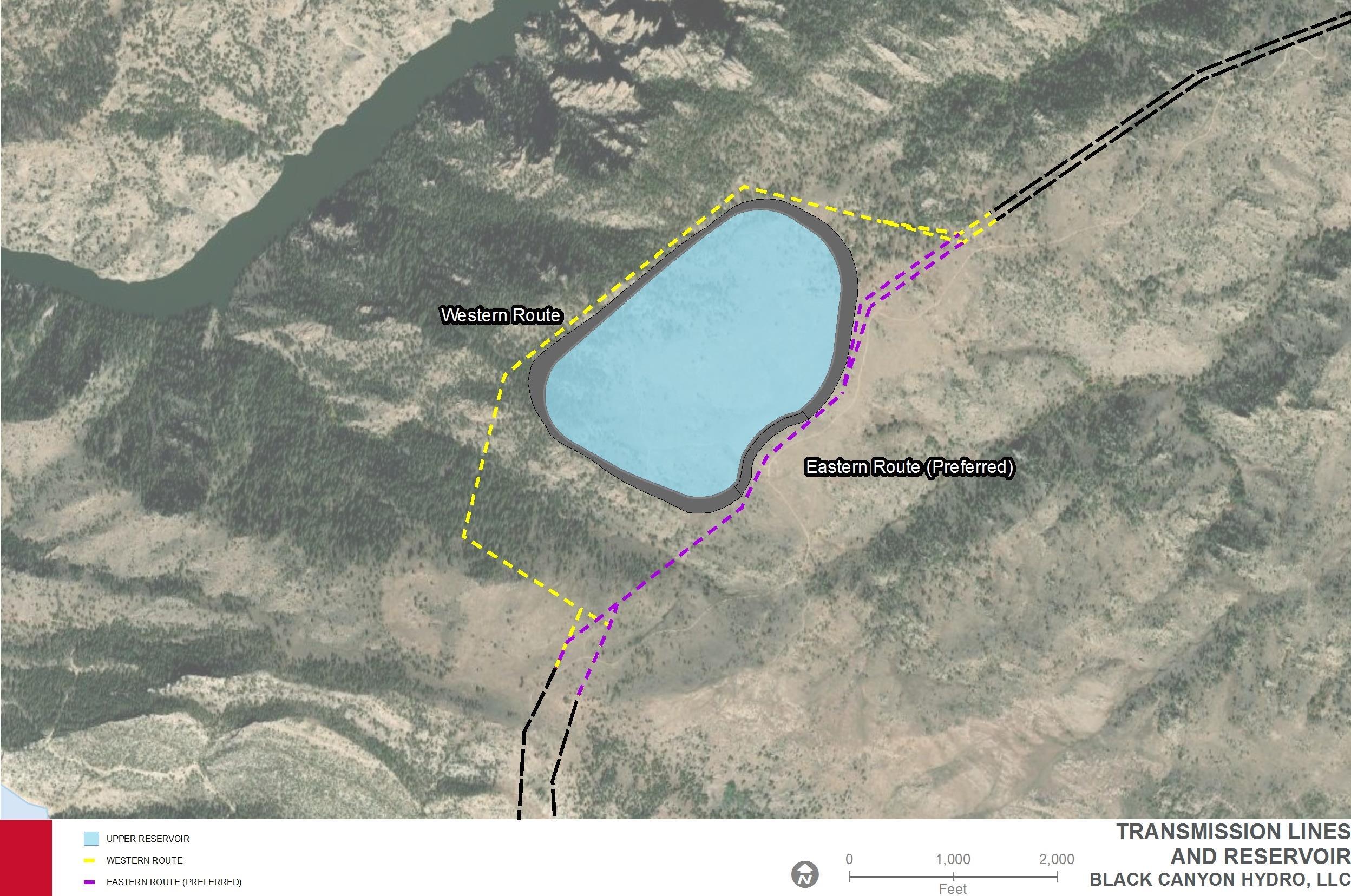
Final License Application – Exhibit E Seminoe
Storage Project January 2023 | 61
Pumped
Figure 2.3-3. Proposed Re-routing of Existing Transmission Lines in the Vicinity of the Proposed Project’s Upper Reservoir.
This page intentionally left blank.
License Application – Exhibit E
Project January 2023 | 62
Final
Seminoe Pumped Storage
3.0 Environmental Analysis
3.1 General Description of the River Basin
The Project is located in the North Platte River Basin (Figure 3.1-1), which is a subbasin of the Platte River Basin. The Platte River Basin also includes the South Platte River Basin and the Central Platte River Basin (Wyoming Water Development Commission 2016). The Platte River Basin is located in a semiarid to subhumid climate and much of the river flow originates as spring snowmelt in the Rocky Mountains (U.S. Geological Survey [USGS] 1983). The North Platte River Basin drains approximately 21,907 square miles in southeast Wyoming and extends into northern Colorado and central Nebraska (Wyoming Water Development Commission 2016; Reclamation 2019a). The South Platte River Basin drains an additional approximately 2,000 square miles in Wyoming (Wyoming Water Development Commission 2016). Together, the North, South, and Platte rivers drain approximately 86,000 square miles (USGS 1983).
The North Platte River is 716 miles long with headwaters in north-central Colorado at the junction of Grizzly Creek and Little Grizzly Creek. The North Platte River flows through southeast Wyoming into east-central Nebraska where it becomes the Platte River at the confluence with the South Platte River. The Platte River then joins the Missouri River south of Omaha, Nebraska.
3.1.1 Tributary Rivers and Streams
Major tributaries that flow into the North Platte River in Wyoming include the Sweetwater River, Laramie River, and Medicine Bow River (Figure 3.1-1). The Sweetwater River and Laramie River confluences with the North Platte River are downstream of the Project location, and the Medicine Bow River confluence is upstream of the Project location. The minor tributaries that have a confluence downstream of the Project include Morgan, Lost, and Hamilton Creeks.
3.1.2
Topography
The Project is located in the Seminoe Mountains in central Wyoming along the southeastern margin of the Wyoming Province. The Seminoe Mountains consist of an uplifted Laramide thrust wedge cored by Precambrian metamorphic and plutonic rocks. The Seminoe Mountains are within the Wyoming Basin which encompasses approximately 40,000 square miles of southern Wyoming and northern Colorado.
Carbon County is topographically dominated by the Medicine Bow Mountains and Sierra Madre in the southern part of the county; however, the remaining areas of the county also have substantial local relief because of smaller mountains such as the Ferris, Seminoe, and Shirley Mountains, as well as numerous ridges and scarps. The county includes part or all of several topographic and structural basins, including all of the Saratoga Valley, the Kindt, Hanna, and Shirley Basins as well as parts of the Laramie and Great Divide Basins (Bartos et al. 2006).
Elevations in the Footprint of Potential Disturbance range from 6,135 feet to 7,502 feet Topography in the Project vicinity is shown on Figure 3.1-2
Final License Application – Exhibit E
Storage Project January 2023 | 63
Seminoe Pumped
This page intentionally left blank.
Seminoe Pumped Storage Project
– Exhibit E
January 2023 | 64
Final License Application
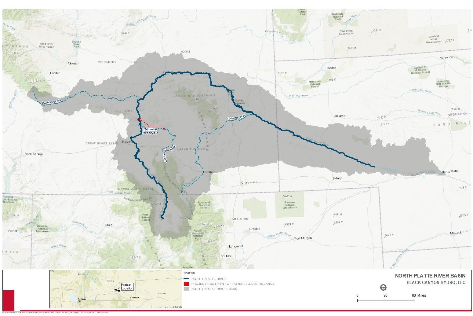
Final License Application – Exhibit E
Storage Project January 2023 | 65
Seminoe Pumped
Figure 3.1-1. North Platte River Basin
Figure 3.1-2. Topography of the Project Vicinity
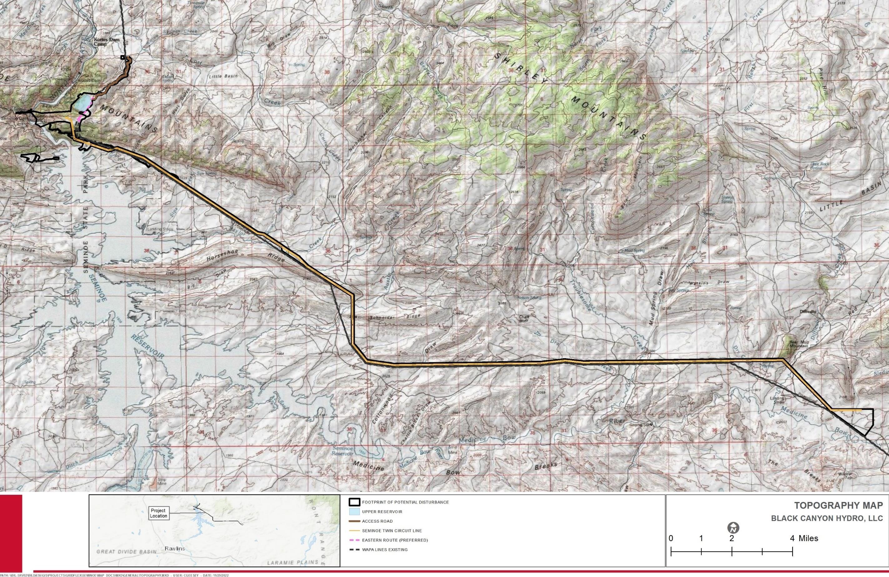
Final License Application – Exhibit E Seminoe Pumped Storage Project January 2023 | 66
3.1.3 Major Land and Water Uses
The Project will be located entirely in Carbon County, Wyoming, in a remote region within the Seminoe Mountains (Hein 2014). In the Pathfinder-Seminoe subbasin, flow of the North Platte River is regulated by Seminoe, Kortes, and Pathfinder reservoirs. The subbasin includes those areas, other than the Sweetwater and Medicine Bow rivers, which drain into the North Platte River between Pathfinder Dam and the head of Seminoe Reservoir (BLM 2008b).
3.1.3.1 Major Land Uses and Ownership
Land use in the Platte River Basin primarily consists of agriculture, oil and gas development, mining, and recreation (Ostlind 2014) Within the Footprint of Potential Disturbance, most of the land cover is woodland, desert scrub, or shrubland (USGS 2016). There is little developed land in the Footprint of Potential Disturbance (USGS 2016).
The Project Footprint of Potential Disturbance encompasses all lands potentially needed for Project construction, operation, and maintenance. The total acreage within the Project Footprint of Potential Disturbance, which includes permanent and temporary disturbance areas, is 3,040 acres4
Within the Footprint of Potential Disturbance is the FERC Project Boundary which includes only those lands required for Project operation and maintenance, such as all Project facilities and access roads. The FERC Project Boundary encompasses 1,522 acres of land and is presented in Exhibit G of this FLA.
The Footprint of Potential Disturbance is further broken down to identify Temporary Disturbance Areas. These lands are those that are outside of the FERC Project Boundary, but are anticipated to be impacted by Project construction based on current design There are a total of 623 acres identified as Temporary Disturbance Areas. This includes areas disturbed during construction such as lay down areas and temporary access roads, but after which will be decommissioned, rehabilitated, and revegetated. While other lands included in the Footprint of Potential Disturbance may be incorporated into Project design at a later date, only those included in the FERC Project Boundary and Temporary Disturbance areas are currently projected to be affected by Project construction, operation, and maintenance activities.
Land in the Project vicinity includes the Seminoe State Park on Federal land administered by State Parks, Federal land administered by the BLM and Reclamation, and private land (Figure 3.1-3). Seminoe State Park, located southwest of the Project vicinity on the shores of Seminoe Reservoir, provides year-round camping, boating, and hiking opportunities (Hein 2014). The BLM administers over two million acres of public land in Carbon County, which is available for livestock grazing, mineral production, recreation, and wildlife habitat
4 Note that throughout Exhibit E, the term ‘study area’ is used. The study area for each respective study described herein may differ slightly from the Footprint of Potential Disturbance. For example, a buffer area may be applied. Refer to the respective resource reports, referenced throughout Exhibit E, for details on each study area
Final License Application – Exhibit E
January 2023 | 67
Seminoe Pumped Storage Project
(City of Rawlins undated). Major economic uses of land in Carbon County include commercial wind power, raising cattle and sheep, mining, and natural gas production (Van Pelt 2014).
Table 3.1-1 provides a summary of land ownership within the Footprint of Potential Disturbance
Table 3.1-1. Land Ownership in the Footprint of Potential Disturbance
– Exhibit E
January 2023 | 68
Final License Application
Seminoe Pumped Storage Project
Acreage within the Footprint of Potential Disturbance BLM 1,518 Reclamation 259 State 4 Private 1,232 Other 27 Total 3,040
Landowner/Administrator
Figure 3.1-3. Land Ownership in the Project Vicinity
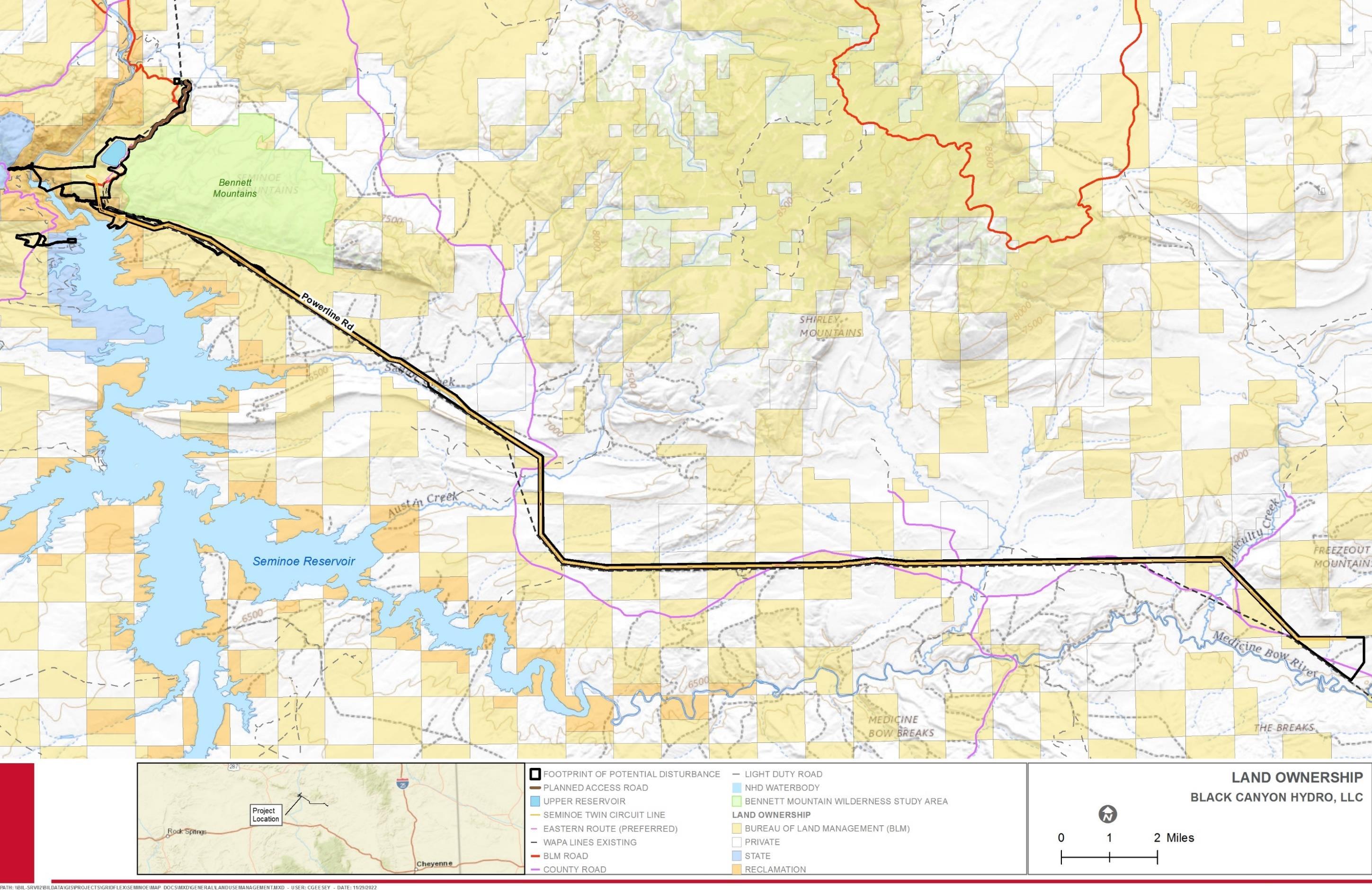
License Application – Exhibit E
Project January 2023 | 69
Final
Seminoe Pumped Storage
This page intentionally left blank.
License Application – Exhibit E
Project January 2023 | 70
Final
Seminoe Pumped Storage
Major Water Uses
Water use and rights in the Platte River Basin are complex and have been subject to contest between the states of Wyoming, Colorado, and Nebraska for over a century, and are the subject of a 1945 Decree by the U.S. Supreme Court (N. Platte Decree) and the subsequent 2001 stipulated settlement between the states (2001 Stipulation) The waters of the North Platte River Basin are heavily regulated and monitored (Wyoming State Engineer’s Office, 2021; Wyoming Water Development Commission 2016) In addition, Wyoming, Nebraska, Colorado, and the U.S. Department of Interior finalized the Platte River Recovery Implementation Program (PRRIP) in 2007, which prohibits further surface water depletions beyond 1997 levels to maintain water demands for endangered species downstream.
The Upper North Platte River Basin provides most of the water used in other Platte River subbasins for agriculture, municipal, and industrial uses (Wyoming Water Development Commission 2016) Seminoe Dam was constructed in 1938 as a part of the federally funded Kendrick Project, with a goal of expanding irrigation and hydropower in central Wyoming (Hein 2014).
On average, Wyoming uses approximately 8,000 million gallons per day (mgd) of freshwater (Table 3.1-2). As shown in Table 3.1-2, the largest beneficial use of water for the state of Wyoming, and in Carbon County, is irrigation, followed by uses such as public (municipal) supply and other industrial or power uses (USGS 2015).
Table 3.1-2. Water Use in 2015 in Wyoming and Carbon County
3.1.4
Source: USGS 2015
Major Dams and Diversions
There are nine major dams on the North Platte River. Seminoe Dam is the farthest upstream dam on the North Platte River and has among the largest total reservoir storage capacity of all reservoirs on the North Platte River in Wyoming (Reclamation undated). Table 3.1-3 lists dams operated by Reclamation on the North Platte River (listed from upstream to downstream) in Wyoming. The Kingsley Dam (Lake McConaughy) and Keystone Diversion Dam are located on the North Platte River just upstream of the confluence with the South Platte River. After the confluence, the Platte River flows east through Nebraska (Franc Logic 2018). The Kingsley and Keystone Diversion Dams are both owned and operated by The Central Nebraska Public Power and Irrigation District and licensed by FERC (FERC 1998, Franc Logic 2018).
Final License Application – Exhibit E
Project January 2023 | 71
Seminoe Pumped Storage
Water Use Category Water Use
Wyoming Carbon County Thermoelectric 52Public Supply 101 2.85 Irrigation 7,788 896 Industrial (total self-supplied withdrawal) 8 0.75
(mgd)
Table 3.1-3.
3.1.5 Climate
The climate in Carbon County is characteristic of desert and mid-latitude highland semiarid steppe (Trewartha and Horn 1980, Martner 1986). Steppe climate areas generally experience large seasonal temperature variations with cold winters and warm summers with low precipitation, but annual precipitation also varies from year to year.
Average temperatures range from approximately 84 degrees Fahrenheit (F) in July to approximately 13F in January. Average annual precipitation for the POR (1948 - 2011) is 12.66 inches and the average annual snowfall is 21.3 inches. Further results for average temperature (°F) and precipitation (inches) in Carbon County between 1991-2020 are displayed in Table 3.1-4.
Table 3.1-4.
Final License Application – Exhibit E Seminoe Pumped Storage Project January 2023 | 72
Reclamation
Dams and Diversions on the North Platte River Dam Total Reservoir Capacity (Acre-Feet) Operator Seminoe 1,017,273
Kortes 4,739 Reclamation Pathfinder 1,070,000 Reclamation Alcova 184,405 Reclamation Gray Reef 5,332 Reclamation Glendo 492,022 Reclamation Guernsey 45,612 Reclamation Kingsley (Lake McConaughy) 1,790,000 Central Nebraska Public Power and Irrigation District Keystone Diversion 65,974 Central Nebraska Public Power and Irrigation District Source: Reclamation undated, FERC 1998, Franc Logic 2018
Month Average Temperature (°F) Average Precipitation (inches) January 20.9 1.2 February 23.0 1.2 March 31.9 1.4 April 39.0 1.8 May 48.3 2.1 June 58.2 1.2 July 65.7 1.1 August 63.7 1.0
Average Temperature and Precipitation for Carbon County (1991–2020)
Month
Average Temperature (°F) Average Precipitation (inches)
September 54.8 1.4
October 42.3 1.5
November 30.5 1.3
December 21.3 1.4
Source: High Plains Regional Climate Center 2022
3.2 Environmental Effects Analysis
The Council on Environmental Quality (CEQ) has promulgated regulations under NEPA defining types of environmental effects. The CEQ revised the NEPA regulations in April 2022. The presently operative regulations found at 40 CFR §1508.1(g) define “effects” as follows:
“Effects or impacts means changes to the human environment from the proposed action or alternatives that are reasonably foreseeable and include the following:
(1) Direct effects, which are caused by the action and occur at the same time and place.
(2) Indirect effects, which are caused by the action and are later in time or farther removed in distance, but are still reasonably foreseeable
(3) Cumulative effects, which are effects on the environment that result from the incremental effects of the action when added to the effects of other past, present, and reasonably foreseeable actions regardless of what agency (federal or nonfederal) or person undertakes such other actions. Cumulative effects can result from individually minor but collectively significant actions taking place over a period of time.”
This FLA employs these definitions in the following discussion. In subsections 3.3 through 3.16, direct, indirect, and cumulative effects are briefly discussed for each resource potentially affected by the proposed Project.
3.2.1 Cumulative Effects (18 CFR §5.18(b)(2))
According to the Council on Environmental Quality’s regulations for implementing the National Environmental Policy Act (NEPA) (40 CFR §1508.7), a cumulative effect is the effect on the environment that results from the incremental effect of the action when added to other past, present, and reasonably foreseeable future actions, regardless of the agency or party undertaking such other actions 5 Cumulative effects can result from individually
5
On April 20, 2022, CEQ issued a final rule, National Environmental Policy Act Implementing Regulations Revisions (Final Rule, 87 FR 23453), which restores the previous regulatory definition of “cumulative effects” that was in effect before being modified in 2020. This recent final rule became effective as of May 20, 2022.
License Application – Exhibit E
January 2023 | 73
Final
Seminoe Pumped Storage Project
minor but collectively significant actions taking place over time, including hydropower and other land and water development activities.
The environment that would be affected by the Project reflects the natural processes, human influences, and other innumerable activities occurring over thousands of years. CEQ, in a memorandum regarding analysis of past actions issued on June 24, 2005, stated: “agencies can conduct an adequate cumulative effects analysis by focusing on the current aggregate effects of past actions without delving into the historical details of individual past actions.” (CEQ 2005). In this analysis, the impacts of past projects are considered to have become part of the affected environment, which is described and evaluated in Sections 3.3 to 3.16; however, ongoing effects of past actions that are relevant to the analysis were also considered.
Resources that that are subject to our cumulative analysis review include: geology and soils, water resources, fish and aquatic resources, botanical resources, wildlife resources, recreation, land use, cultural resources, paleontological resources, aesthetic resources, socioeconomic resources, environmental justice, air quality, and noise. No environmental justice communities were identified within 5 miles from the Footprint of Potential Disturbance that would be affected by the Project. Therefore, the Project would not contribute to cumulative effects on environmental justice.
3.2.1.1 Geographic Scope
For a cumulative effect to occur, another project must impact the same resource(s) as the Project. The geographic scope of the analysis defines the physical limits or boundaries of the proposed action’s effects on environmental resources. Within each geographic scope, other projects’ effects, when combined with those of the Project, could result in a cumulative effect. Projects located outside of the geographic scope for an individual resource were not evaluated because their potential to contribute to a cumulative effect diminishes with increasing distance from the Project.
Because the proposed action may affect each resource differently, the geographic scope for each resource area varies as shown in Table 3.2-1.
Table 3.2-1. Geographic Scope by Resource for Cumulative Effects Associated with the Seminoe Pumped Storage Project
Resource Geographic Scope
Geology and Soils Construction workspaces
Water Resources HUC-8 Watersheds
Justification
Effects on soils and surficial geology would be highly localized and are not expected to extend beyond the area of direct disturbance associated with the Project.
Watersheds are natural, well-defined boundaries for surface water flow, and commonly contribute to the recharge of groundwater resources. Impacts on water resources could extend throughout a HUC-8 watershed.
Final License Application – Exhibit E
January 2023 | 74
Seminoe Pumped Storage Project
Resource Geographic Scope Justification
Fish and Aquatic Resources
Botanical Resources
HUC-8 Watersheds
Consideration of effects within a HUC-8 watershed sufficiently accounts for effects on fish and aquatic resources that would be directly affected by construction activities and for indirect impacts such as changes in habitat availability and displacement of transient species.
HUC-8 Watersheds
Consideration of effects within a HUC-8 watershed sufficiently accounts for impacts on vegetation (including special status species) that would be directly affected by construction activities and for indirect impacts such as changes in habitat availability and displacement of transient species.
Wildlife Resources HUC-8 Watersheds
Consideration of effects within a HUC-8watershed sufficiently accounts for effects on wildlife (including special status species) that would be directly affected by construction activities and for indirect effects such as changes in habitat availability and displacement of transient species.
Recreation Within 2 miles of the Footprint of Potential Disturbance
Land Use Within 1 mile of Footprint of Potential Disturbance
Cultural Resources
Proposed APE
Effects on public recreational areas would be restricted to the construction workspaces and the adjacent landscape up to 2 miles
Effects on general land uses, including public recreational areas, would be restricted to the construction workspaces and the adjacent landscape up to 1 mile.
The proposed APE for direct effects (physical) includes areas subject to ground disturbance, while indirect effects (visual or audible) include project elements that are visible from historic properties in which the setting contributes to their NRHP eligibility.
Paleontological Resources
Aesthetic Resources
Socioeconomic Resources
Within 200 feet of Footprint of Potential Disturbance
Within 0.5 mile of Footprint of Potential Disturbance
Carbon County, WY
Areas subject to ground disturbance and in associated proximity to these disturbance areas.
Allows for consideration of viewshed-level effects visual resources.
The area where workers are expected to reside during construction and operation of the Project, with associated effects on employment, housing, public services, transportation, traffic, property values, economy, and taxes.
License Application – Exhibit E
January 2023 | 75
Final
Seminoe Pumped Storage Project
Resource Geographic Scope Justification
Environmental Justice
Within 5 miles of the Footprint of Potential Disturbance
Air Quality –Construction Within 0.25 mile of all active construction
Consistent with FERC guidance on Environmental Justice analyses.
Air emissions during construction would be limited to vehicle and construction equipment emissions and dust and would be localized to the Project’s active construction work areas and areas adjacent to these active work areas. Longterm operational effects on air quality would be negligible and are not included in the cumulative effects analysis.
Noise Within 1 mile of construction of the upper reservoir, underground powerhouse, power tunnel, tailrace tunnel, new intake in the existing Seminoe Reservoir, powerhouse access tunnel, high-voltage transmission tunnel, and switchyard
Within 0.25 mile of construction of transmission lines
3.2.1.2 Temporal Scope
Noise from construction of the reservoir and powerhouse facilities could affect receptors up to 1 mile away
Areas in the immediate proximity of transmission lines would have the potential to be affected by construction noise.
The temporal scope of the cumulative analysis includes a discussion of the past, present, and reasonably foreseeable future actions, and their effects on the affected resources. Based on the term of an Original License, the temporal scope will include actions that may occur 30–50 years into the future. The historical discussion will, by necessity, be limited to the amount of available information for each of the resources.
3.2.1.3 Reasonably Foreseeable Future Actions
“Present” projects are those currently ongoing (either being constructed or are in operation) and affecting the environment in such a manner that could contribute to a cumulative impact. The cumulative impacts of past and present actions on resources in the Footprint of Potential Disturbance are represented by the description of the existing affected environment for each resource.
“Reasonably foreseeable” projects are proposed projects or developments that have applied for a permit from a local, state, or federal authority or planned projects, which have been publicly announced. Other foreseeable future actions may be identified by agencies
License Application – Exhibit E
January 2023 | 76
Final
Seminoe Pumped Storage Project
Seminoe Pumped Storage Project
or based on known trends, such as population changes Reasonably foreseeable future actions within the geographic scope of the Project are listed in Table 3.2-2 and described below.
Thirteen reasonably foreseeable future actions were analyzed for cumulative effects as described in Table 3.2-2
Table 3.2-2. Reasonably Foreseeable Future Actions
Project or Action
Wyoming Pipeline Corridor Initiative (WPCI) Project
Location
Statewide including Carbon County
Approximate Distance from the Footprint of Potential Disturbance
~ 5 miles
Description
The WPCI aims to establish corridors on public lands dedicated for future use of pipelines associated with carbon capture, utilization, and storage (CCUS), enhanced oil recovery (EOR) and delivery of associated petroleum products (Wyoming Energy Authority, undated).
Potential Resources Cumulatively Affected
Water Resources
Fish and Aquatic Resources
Botanical Resources Wildlife Resources Recreation Land Use Cultural Resources Socioeconomic Resources Environmental Justice Noise (Construction)
Two Rivers Wind Energy Project
Carbon and Albany Counties, WY (near Medicine Bow)
~ 5 miles
A 280-MW wind project proposed on private land consisting of one substation, electrical collection systems and access roads, a 230-kV transmission line, and wind turbine generators (BluEarth Renewables, 2022a)
Water Resources
Fish and Aquatic Resources
Botanical Resources Wildlife Resources Socioeconomic Resources Environmental Justice Noise (Construction)
– Exhibit E
January 2023 | 77
Final License Application
Project or Action Location
Lucky Star I Wind Project
Approximate Distance from the Footprint of Potential Disturbance
Carbon and Albany Carbon Counties, WY (near Medicine Bow and Rock River)
Shirley Basin In-Situ Uranium Recovery Project
Chokecherry and Sierra Madre Wind Energy Project
Carbon County, WY
Carbon County, WY
Description
~ 15 miles A 500-MW wind project proposed on private land consisting of two substations, electrical collector systems and roads, a 230-kV transmission line to the point of interconnection, and wind turbine generators (BluEarth Renewables, 2022b)
~35 miles This project would reopen the former conventional uranium mill site as a uranium recovery facility (UrEnergy, 2022).
~ 32 miles A 3,000-MW wind energy project proposing 600 wind turbines that is 50 percent sited on private land and 50 percent sited on federal land (Power Company of Wyoming, 2022).
Potential Resources Cumulatively Affected
Water Resources
Fish and Aquatic Resources
Botanical Resources
Wildlife Resources Socioeconomic Resources
Socioeconomic Resources
Socioeconomic Resources
– Exhibit E
January 2023 | 78
Final License Application
Seminoe Pumped Storage Project
Project or Action Location
TransWest Express Transmission Line Project
Carbon and Sweetwater Counties, WY
Approximate Distance from the Footprint of Potential Disturbance
~ 30 miles
Description
A 600-kV, direct current transmission line designed to facilitate renewable energy delivery from Wyoming to the southwestern United States while providing a regional upgrade to the western U.S. power grid. The project would interconnect with the existing transmission grid near Sinclair, Wyoming, and the Marketplace Hub in Boulder City, Nevada (BLM 2020a)
Potential Resources Cumulatively Affected
Socioeconomic Resources
Gateway West Transmission Line Project
Carbon, Sweetwater, Natrona, and Converse Counties, WY
Overlaps with Footprint of Potential Disturbance at Aeolus substation
Approximately 1,000 miles of new highvoltage transmission lines between the Windstar substation near Glenrock, Wyoming, and the Hemingway substation near Melba, Idaho. The project would include approximately 200 miles of 230-kV lines in Wyoming and approximately 800 miles of 500-kV lines in Wyoming and Idaho (BLM 2020a).
Geology and Soils
Water Resources
Fish and Aquatic Resources Botanical Resources Wildlife Resources Recreation Land Use Cultural Resources Paleontological Resources
Aesthetic Resources
Socioeconomic Resources Environmental Justice Air Quality Noise (Construction)
Application – Exhibit E
January 2023 | 79
Final License
Seminoe Pumped Storage Project
Project or Action Location
Gateway South Transmission Line Project
Statewide including Carbon County
Approximate Distance from the Footprint of Potential Disturbance
Overlaps with Footprint of Potential Disturbance at Aeolus substation
Description
The project, currently under construction, consists of a 500-kV transmission line, approximately 400 miles long, beginning at the planned Aeolus substation near Medicine Bow, Wyoming and terminating at the Clover substation near Mona, Utah. The line would be constructed within a 250-foot-wide ROW to accommodate the construction and operation of the transmission line (BLM, 2020a)
Potential Resources Cumulatively Affected
Geology and Soils
Water Resources
Fish and Aquatic Resources
Botanical Resources Wildlife Resources Recreation Land Use Cultural Resources Paleontological Resources Aesthetic Resources Socioeconomic Resources Environmental Justice Air Quality Noise (Construction)
Rock Creek Wind Energy Center Carbon and Albany Counties, WY (Near Arlington)
~25 miles A 590-MW wind energy project proposing a maximum of 129 turbines over approximately 47,520 acres with anticipated construction in 2023 (Invenergy, 2022).
Water Resources
Fish and Aquatic Resources Botanical Resources Wildlife Resources Socioeconomic Resources
License Application – Exhibit E
January 2023 | 80
Final
Seminoe Pumped Storage Project
Project or Action Location
Rawlins Resource Management Plan (RMP) Amendment for Oil and Gas Leasing
Albany and Carbon Counties, WY
Approximate Distance from the Footprint of Potential Disturbance
Unknown
Description
The Rawlins Field Office has issued a Notice of Intent (NOI) to prepare an Environmental Assessment for an amendment to the Rawlins RMP. The amendment would remove an estimated 12,425 acres from future oil and gas leasing. These acres are located on federal mineral estate adjacent to the water resources for the municipalities of Rawlins, Saratoga, and Laramie, Wyoming (BLM, 2020a)
Potential Resources Cumulatively Affected
Socioeconomic Resources
Continental Divide –Creston (CD-C) Natural Gas Project
Carbon and Sweetwater Counties, WY
~ 55 miles
This project proposes 8,950 additional natural gas wells drilled from 5,450 well pads, including 100 to 500 coal bed natural gas wells and associated facilities and infrastructure (BLM, 2020a)
Socioeconomic Resources
Desolation Flats Natural Gas Development Project and
Endurance/Barricade Gas Infrastructure Project
Carbon and Sweetwater Counties, WY
~80 miles
The project consists of 385 natural gas wells and associated facilities and infrastructure. The ROD approving the project was published in 2004 and construction is anticipated to continue through 2024 (BLM, 2020a)
Socioeconomic Resources
License Application – Exhibit E
January 2023 | 81
Final
Seminoe Pumped Storage Project
Project or Action Location
Atlantic Rim Natural Gas Development Project
Carbon County, WY
Approximate Distance from the Footprint of Potential Disturbance
Seminoe Pumped Storage Project
Description
~ 60 miles The project consists of 2,000 gas wells and associated facilities and infrastructure. The ROD approving the project was published in 2007 and construction is anticipated to continue through 2027 (BLM, 2020a)
Potential Resources Cumulatively Affected
Socioeconomic Resources
– Exhibit E
Final License Application
January 2023 | 82
The Wyoming Pipeline Corridor Initiative (WPCI) was proposed in 2012 as part of Governor Mead’s energy strategy. It aims to establish corridors on public lands dedicated for future use of pipelines associated with CCUS, EOR, and delivery of associated petroleum products. Approximately 2,000 miles of pipeline corridors throughout central and western regions of Wyoming have been identified for the WPCI and consist of 25 segments covering BLM, private, and state land. Three segments (Segment 2, 6, and 7) are located within Carbon County. Segment 2 is a 200-foot lateral corridor that is approximately 125 miles long and generally follows the I-80 corridor between Rawlins and Rock Springs. Segment 6 is approximately 80 miles long and Segment 7 is approximately 59 miles long (State of Wyoming, 2019). The WPCI would also be compatible with other uses, like broadband infrastructure, which could be acceptable at the outer boundaries of the approved corridors. The current WPCI effort will only apply to BLM administered lands. In January 2021, a record of decision (ROD) was granted by BLM (Wyoming Energy Authority, undated).
The Two Rivers Wind Project is a 280-MW wind project proposed on private land near Medicine Bow, Wyoming. The project will include one substation, electrical collection systems and access roads, and a 230-kV transmission line to the point of interconnection. Additionally, the project construction would include road improvements, road construction, and geotechnical investigations and would be followed by construction of foundations, the electrical collection systems, and the installation of wind turbine generators (BluEarth Renewables, 2022a). The project is anticipated to achieve commercial operation in 2024 (BluEarth Renewables, 2022a) and is therefore a reasonably foreseeable future action.
The Lucky Star I Wind Project is a 500-MW wind project proposed on private land near Medicine Bow and Rock River, Wyoming. The project will include two substations, electrical collector systems and roads, and a 230-kV transmission line to the point of interconnection. Additionally, project construction would include road improvements, road construction, and geotechnical investigations and would be followed by construction of foundations, the electric collection systems, and installation of wind turbine generators (BluEarth Renewables, 2022b). In 2019, Carbon County denied the project’s permit application. BLM staff reviewed comments/responses received regarding the Plan of Development and it is anticipated that the County application for the project will be resubmitted in 2023 (Carbon County Planning & Zoning Commission, 2022).
The Shirley Basin Project is a former conventional uranium mill site located approximately 35 miles south of Casper, Wyoming. Historically, the mine produced more than seventyone million pounds of uranium, primarily from the 1960s through the 1990s. The former mill was decommissioned in 1992 The project would re-open the mine as a uranium recovery facility. The project proposes to open three relatively shallow mining units and potentially build a complete processing plant with drying facilities. All major permits for the project, including the BLM Plan of Operations, Land Quality Division Permit to Mine and associated aquifer exemption, and Uranium Recovery Program License have been received. Additional minor permits are ongoing to ensure the project is construction ready (Ur-Energy, 2022).
The Chokecherry and Sierra Madre Wind Energy Project is a 3,000 MW-wind energy project proposing 600 wind turbines and is 50 percent sited on private land and 50 percent
Final License Application – Exhibit E
January 2023 | 83
Seminoe Pumped Storage Project
sited on federal land. A ROD approving the wind project was signed in October 2012 which identified the project area suitable to accommodate a 3,000 MW wind farm consisting of up to 1,000 wind turbines. The EIS was approved and a site-specific NEPA analysis for Phase I of the Project was completed (BLM, 2020a). Project construction commenced in September 2016 focusing on building the infrastructure across the site that is critical for constructing, operating, and maintaining the wind project. Through 2021, over 135 miles of roads and 178 turbine pads have been constructed (Power Company of Wyoming, 2022). The project has an estimated life of 30 years (BLM, 2020a)
The TransWest Express Transmission Line Project is a high voltage direct current (DC) transmission system extending from south-central Wyoming to southern Nevada. The project will consist of approximately 728 miles of 600-kV DC transmission line and two terminals, each containing a converter station that converts alternating current (AC) to DC or vice-versa. The northern AC/DC converter station will be located near Sinclair, Wyoming (BLM, 2016a). All federal, state, and county permits were issued by January 2020. It is estimated that transmission line construction will occur from 2023 to 2026. Construction commencement will be determined after the BLM Notice to Proceed is issued (TransWest Express, 2022).
The Gateway West Transmission Line Project proposes to build and operate approximately 1,000 miles of new high-voltage transmission lines in Wyoming and Idaho. It is comprised of two major line segments, one of which (Segment D) will stretch approximately 488 miles starting at the Windstar substation near Glenrock, Wyoming, proceeding south to Medicine Bow and then spanning across southern Wyoming to the Populus substation near Downey, Idaho. This segment will include seven expanded or new substations and consists of three sub-segments. The first subsegment (D.1) is a single circuit 230-kV line that runs approximately 75 miles between the existing Windstar substation in eastern Wyoming and the existing Aeolus substation near Medicine Bow, Wyoming. The Aeolus substation will also be used by the Project. This segment is planned to be placed in service in November 2024. The second subsegment (D.2) is a single circuit 500-kV line running approximately 140 miles from the Aeolus substation to a new annex substation (Anticline) near the existing Jim Bridger substation in western Wyoming. Segment D.2 was placed in service in November 2020 (PacifiCorp, 2022a). The final subsegment (D.3) is outside of the geographic scope for the cumulative analysis.
The Gateway South Transmission Line Project (Segment F) is a high voltage (500 kV) transmission line extending approximately 400 miles from the Aeolus substation in southeastern Wyoming near Medicine Bow to the Clover substation near Mona, Utah. The project will include a new 500-kv bay/equipment at the existing Aeolus substation, 546 structures, 159 miles of new access routes, 141.5 miles of ROW in Wyoming as part of Segment I. The Aeolus substation will also be used by the Project. The project is anticipated to be in service for customers in 2024 (PacificCorp, 2022b)
The Rock Creek Wind Energy Center is a 590-MW wind energy project proposing a maximum of 129 turbines over approximately 47,520 acres with anticipated construction in 2023 and operations in 2024 (approximately 5,890 acres and 10 wind turbines in Carbon County). The project is located near Arlington, Wyoming just north of I-80 and east of County Road 13. The project will consist of at least two new substations, one operations
Final License Application – Exhibit E
January 2023 | 84
Seminoe Pumped Storage Project
and maintenance building, project roads, and above and underground collector system, and other related ancillary facilities. Two generation tie-lines will be included, one to Foote Creek Substation and one to Aeolus Substation (Invenergy, 2022). This project has received an approved conditional use permit from Carbon County (Carbon County Planning & Zoning Commission, 2022).
The BLM Rawlins Field Office proposed an RMP amendment for an area in Carbon and Albany Counties that encompasses approximately 12,425.34 acres of public land. The analysis of closing this area to oil and gas leasing was not conducted when the Rawlins Field Office RMP was finalized in 2008; therefore, the amendment was needed to consider management of BLM-administered lands within these municipal water sources. The acreage was determined based on the location of the water sources in relation to BLM surface and sub-surface mineral estate and the extent of the watersheds draining to these sources (BLM 2014a). The Rawlins Field Office issued an NOI for an Environmental Assessment for the Rawlins RMP Amendment for Oil and Gas Leasing (BLM, 2020a). This effort has been on hold due to lack of staff and priority workloads (Carbon County Planning & Zoning Commission, 2022). However, as this effort is currently in the NEPA process it is considered a reasonably foreseeable future action.
The CD-C Project, proposed by BP America Production Company, would conduct infill drilling to develop natural gas and condensate resources within two previously developed project areas described as the Continental Divide/Wamsutter II and Creston Blue Gap project areas The project proposes to drill approximately 8,950 new natural gas wells that would operate in addition to the 2,850 existing natural gas wells. The total number of wells drilled will depend on factors such geologic characteristics, engineering technology, economic factors, commodity prices, availability of commodity markets, and lease stipulations and restrictions. The gas resource is primarily conventional natural gas; however, the project also includes development of coalbed natural gas (CBNG). All proposed wells are anticipated to be drilled during a 10-to-15-year period after approval. The average life of a well is expected to be 30 to 40 years for both conventional and CBNG wells (BLM, 2016b). The ROD approving the project was issued in September 2016 with construction to take place through 2032 (BLM, 2020a)
The Desolation Flats Natural Gas Development Project and Endurance/Barricade Gas Infrastructure Project consists of approximately 385 natural gas wells as 361 well locations, with a forecasted success rate of 65 percent (250 producing wells). The project will include the development of wells, access roads, pipelines, and other ancillary facilities located on public lands. Project construction started in 2004 and will continue through 2024 (BLM, 2020a). The life-of-project is anticipated to be 30 to 50 years (BLM 2004a)
The Atlantic Rim Natural Gas Development Project is a project between multiple companies that proposes to develop up to 2,000 natural gas wells within a 270,000-acre project area. Development would occur over the next 30 to 50 years with about 13,600 acres of new disturbance, with a maximum of 7,600 acres disturbed at any one time. In March 2007, the BLM issued its final decision approving the project, electing the preferred alternative to allow natural gas development within the analysis area (BLM, 2021). The project has been under construction since 2007 and will continue through 2027 (BLM, 2020a).
Final License Application – Exhibit E
January 2023 | 85
Seminoe Pumped Storage Project
3.2.1.4
Resource Effects
The cumulative effects analysis considered the potential effects of other actions as described in relevant public documents. The scope of the cumulative effects analysis depends in part on the availability of information about other projects. For this assessment, other projects were identified from information publicly available from Carbon County, FERC, and BLM; Black Canyon’s knowledge of other planned, pending, and ongoing projects; communications with federal, state, and local agencies; and comments received on the DLA. Cumulative effects analyses used an approximation of project footprints as interpreted from publicly available project descriptions, maps, and aerial photography. When determining the significance of a cumulative effect, the analysis considered the duration of the impact; the geographic, biological, and/or social context in which the impact would occur; and the magnitude and intensity of the impact.
The potential for cumulative effects associated with the Seminoe Pumped Storage Project would be greatest during the construction phase. Where Black Canyon determined that a potential for cumulative effects exists, the impacts have been quantified to the extent possible. However, in many cases, the potential effects can only be described qualitatively. This is particularly the case for projects in the planning state, which may be contingent on economic conditions, availability of financing, and/or the issuance of permits.
The following sections address the potential cumulative effects on specific environmental resources from the Project and the other projects identified within the applicable geographic scope (Table 3.2-1).
3.3
Geologic and Soil Resources
3.3.1 Affected Geologic and Soil Environment
The Affected Environment for geology and soils includes the Footprint of Potential Disturbance.
3.3.1.1
Regional Physiography, Setting, and Geologic History
The physiography of the state of Wyoming includes alluvial valleys, volcanic plateaus, forested mountains, mountain ranges, high plains, glaciated peaks, and lava fields. There are seven distinct physiographic ecoregions, including the Snake River Plain, Middle Rockies, Wyoming Basin, Wasatch and Uinta Mountains, Southern Rockies, High Plains, and Northwestern Great Plains (Chapman et al. 2004). A geological cross-section of named basins and mountain ranges of Wyoming are shown on Figure 3.3-1.
Most of the eastern half of the state is situated within the Northwestern Great Plains ecoregion, which primarily includes the Powder River Basin. The Middle Rockies ecoregion encompasses the northwestern portion of Wyoming and includes Yellowstone and Grand Teton National Parks and also includes a small portion of northeastern Wyoming. The Project vicinity in south-central Wyoming is situated in the Wyoming Basin Level III Ecoregion This ecoregion is a broad arid intermontane basin interrupted by hills and low mountains (Chapman et al. 2004).
Final License Application – Exhibit E
January 2023 | 86
Seminoe Pumped Storage Project
Seminoe Pumped Storage Project
The Seminoe Mountains are within the Wyoming Basin which encompasses approximately 40,000 square miles of southern Wyoming and northern Colorado (Carpenter and Cooper 1951). The major geomorphic elements expressed in this region reveal a topography that has resulted from Laramide forces and continued uplift with accompanying basin-andrange-type, block-faulting through the Pliocene, followed by latest faulting, erosion, and local deposition in the Quaternary.
The North Platte River kept pace with the rising land-surface, cutting downward in response to each mountain building event. See Figure 3.1-1 in Section 3.1 for a figure illustrating the North Platte River Basin. The modern drainage pattern in the Project vicinity generally takes on a dendritic form (except in sharply defined strike valleys). The most notable of the positive landforms in this region of south-central Wyoming include: the Laramie Mountains, Ferris Mountains, Seminoe Mountains, Shirley Mountains, Granite Mountains, Green Mountains, Rattlesnake Hills, Pedro Mountains, Freezeout Mountains, Sierra Madre Mountains, Medicine Bow Mountains, the Casper Arch, and the Rawlins Uplift. Some large scale negative topographic features include: the Great Divide Basin, Hanna Basin, Shirley Basin, Laramie Basin, and the south-east portion of the Wind River Basin (Bennett and Aalto 1982).
– Exhibit E
January 2023 | 87
Final License Application
Final License Application – Exhibit E
Seminoe Pumped Storage Project
Source: Chapman et al. 2004.
Figure 3.3-1. Major Mountain Ranges and Basins in the State of Wyoming with Geological Cross-Section

January 2023 | 88
Carbon County is dominated by six geologic structural basins (Hanna, Great Divide, Washakie, Kindt, Laramie, and Shirley basins) and by five major uplift features (Rawlins Uplift, Sweetwater Arch (including the Ferris and Seminoe Mountains), Shirley-Freezeout Mountains, Medicine Bow Mountains, and Sierra Madre) Carbon County is topographically dominated by the Medicine Bow Mountains and Sierra Madre in the southern part of the county; however, the remaining areas of the county also have substantial local relief because of smaller mountains such as the Ferris, Seminoe, and Shirley Mountains, as well as numerous ridges and scarps. The county includes part or all of several topographic and structural basins, including all of the Saratoga Valley, the Kindt, Hanna, and Shirley Basins as well as parts of the Laramie and Great Divide Basins (Bartos et al. 2006) (Figure 3.3-2).
Key mountain-building events that affected the region include the Sevier Orogeny and the Laramide Orogeny. The Sevier Orogeny occurred during the Jurassic to Eocene (140-50 million years) when the oceanic plate to the west subducted under North America near present-day California, resulting in compressive stresses (due to collision), crustal thickening, and mountain building. These tectonic forces resulted in north-south trending mountain ranges in Wyoming (e.g., the Thrust Belt). Dominant structures that formed as a result of the Sevier Orogeny include west-dipping, east-vergent thrust faults that displace sedimentary rocks above the crystalline basement rocks (i.e., they do not displace basement rocks) (Black Canyon 2020b).
The Laramide orogeny occurred from approximately 70 to 35 million years ago, originating from the same horizontal compression that defined the previous Sevier Orogeny (i.e., subduction of the oceanic plate underneath the continental crust in the west). Structures resulting from this orogeny differ from the structures produced during the Sevier Orogeny as the Laramide faults displace crystalline basement rocks as well as the overlying sedimentary rocks (Wyoming State Geological Survey [WSGS] 2020).
Rocks ranging from Precambrian (2.7 billion years) to Quaternary age are present within the Project vicinity, except for the Ordovician, Silurian, and Devonian representatives. The oldest lithologies consist of crystalline basement rock which intruded sediments up to 25,000 feet thick associated with the Beltian Geosyncline over several separate geologic events (Bennett and Aalto 1982).
Between early-Oligocene and middle-Pliocene, tremendous amounts of tuffaceous material were extruded from western provinces (notably the present-day Yellowstone National Park region), resulting in surface layers at least several hundred feet thick throughout Carbon County. Much of this deposited material was removed due to latePliocene uplift, which, coupled with quiescence of volcanism, allowed for rapid excavation during the Pleistocene so that now, in many cases, high-level remnants are the only reminders of what had once been an almost continuous blanket of volcanic fall-out debris. The closest intrusive rocks of Tertiary age are approximately 40 miles northwest of Seminoe Dam in the Rattlesnake Range (Bennett and Aalto 1982).
Final License Application – Exhibit E
January 2023 | 89
Seminoe Pumped Storage Project
Source: Bartos et al. 2006
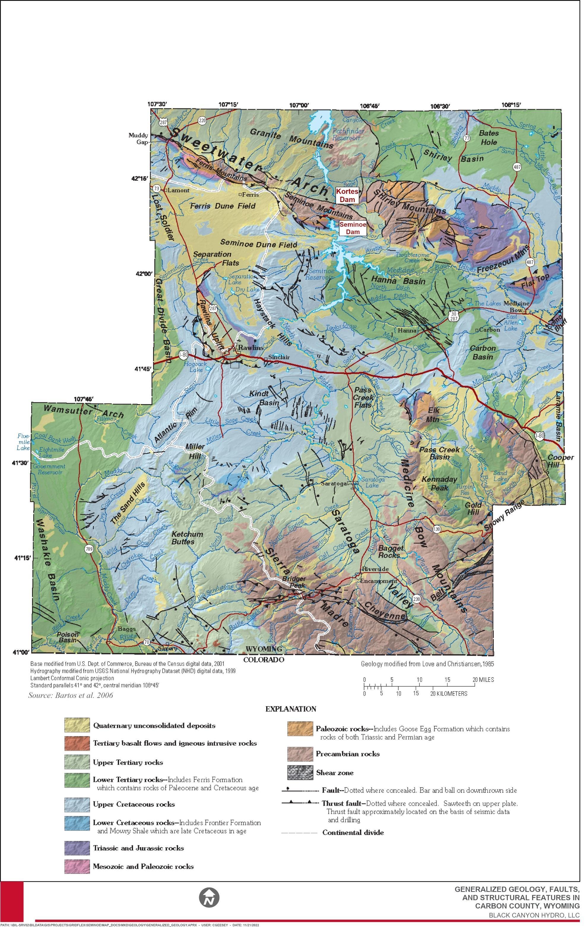
Final License Application – Exhibit E Seminoe Pumped Storage Project January 2023 | 90
Figure 3.3-2 Generalized Geology, Faults, and Structural Features in Carbon County, Wyoming
3.3.1.2 Project Vicinity Geology
The overall mapped geology of the proposed Project is provided on Figure 3.3-3 Bedrock units are based on WSGS (2020) lithologic descriptions and nomenclature
The Project is located in the Seminoe Mountains in central Wyoming along the southeastern margin of the Wyoming Basin. The Seminoe Mountains consist of an uplifted Laramide thrust wedge cored by Precambrian metamorphic and plutonic rocks. The Precambrian core consists of Archean metasedimentary and metavolcanic rocks greater than 2.7 Ga6 exposed in a broad, vertically plunging fold. The rocks are of lower amphibolite grade and were intruded and folded by syntectonic granodiorite (more than 2.6 Ga) (Hausel 1994). The Project is located on the southern flank of the Sweetwater Arch within the Seminoe Mountains, an east-west trending anticline that extends eastward for approximately 75 miles from the southern end of the Wind River Range. The core of the uplift, the Granite Mountains, has eroded to Precambrian basement rocks and subsequently has dropped 2,000 feet in elevation by normal faulting due to crustal extension. The southern boundary of the Sweetwater Arch is marked by the Ferris, Seminoe, and Shirley Mountains (Carpenter and Cooper 1951, Bartos et al. 2006). The Sweetwater Arch, along with the Laramie Range, Medicine Bow, and Sierra Madre mountains, is composed of Precambrian, Paleozoic, Mesozoic, and early Tertiary rocks. The Seminoe Mountains were uplifted during the Laramide tectonic event uplift is bounded on the southwest by a low-angle reverse fault on the north by the Kortes reverse fault, which is a Precambrian shear zone that was reactivated during the Laramide deformation and again in the late Cenozoic (Blackstone and Hausel 1992). These rock layers were compressed into anticlines and uplifted along low-angle thrust faults and highangle reverse faults. The South Granite Mountains fault system bounds the northern extent of the Seminoe Mountains the fault is an undifferentiated Quaternary fault less than 1.6 million years old. It is a normal fault with a slip rate of 0.2 millimeters per year (WSGS 2020). The total fault length is approximately 85 miles.
The area of the proposed upper reservoir7 is situated in Precambrian (late Archean) rocks of the Seminoe Mountain core located on a flat-topped granite mountain bounded on the west by a steep drop-off to Kortes Reservoir, to the north by a moderately steep drop-off paralleling two gulches, to the east by a steep drop, and to the south by a steep drop-off to Seminoe Reservoir along dip-slope sedimentary bedding (Bennett and Aalto 1982). Approximately 550 million years ago, following uplift of the Precambrian rocks in and around the Project vicinity, the Cambrian Flathead Sandstone was deposited in a shallow sea. In the northernmost Project vicinity, this sedimentary unit occurs as a blue-gray and yellow, mottled, hard, dense limestone interbedded with soft green micaceous shale, with dull-red quartzite sandstone at the base (WSGS 2020). Other rocks in the immediate area of the proposed upper reservoir include the Mississippian through Pennsylvanian age Madison, Amsden, and Tensleep formations, with ages from 360 to 310 million years. The
6 One-billion years (i.e., giga annum)
7 Exhibit A of this license application describes the location of proposed Project facilities in detail.
Final License Application – Exhibit E
January 2023 | 91
Seminoe Pumped Storage Project
formations are distinct, forming steep ridges of light-colored rocks throughout the areas these rock units formed in shallow oceans and vast sand dune fields (WSGS undated). The Tensleep Formation in this area is characterized by white to gray sandstone with thin limestone and dolomite beds. The Amsden Formation contains red and green shales and dolomite, with a red base. When uplift occurred during the Laramide orogeny (70 to 35 million years), the Cambrian to Cretaceous sedimentary formations in the Project vicinity, which were horizontal at the time of deposition, were uplifted due to faulting associated with this orogeny (Figure 3.3-3 and Figure 3.3-4).
Cambrian through Pennsylvanian sedimentary rocks including sandstones, siltstones, and limestones are found exclusively from Seminoe Reservoir to approximately halfway to the outlet works location in the vicinity of Dry Lake Creek. These include undifferentiated Cambrian rocks as well as the Madison, Amsden, and Tensleep formations (a total sedimentary sequence thickness of approximately 1,300 feet, of which the Madison and Tensleep formations comprise the majority). From this area to several miles beyond the proposed upper reservoir area are crystalline basement rocks of Precambrian age, namely granite with occasional gabbroic dikes (actual composition may range to near diorite in places) (Bennett and Aalto 1982).
The proposed transmission line corridor begins in late Archean-age granite (Wg) and extends across deposits of Quaternary gravels (Qt), alluvium and colluvium (Qa), the Mesaverde Formation (Kmv) (light-colored massive to thinly-bedded sandstone), the Medicine Bow Formation (Kmb) (brown/gray sandstone and shale with thin coal and carbonaceous shale beds), the Hanna Formation (Th) (brown/gray sandstone, shale, conglomerate, coal), the Wind River Formation (Twdr) (variegated red and white claystone and siltstone), Cloverly Formation (Kcv) (rusty sandstone at top, underlain by brightly variegated bentonitic claystone; chert-pebble conglomerate locally at base), the Niobrara Formation (Ks) (light-colored limestone and gray to yellow speckled limy shale [age about 83 Ma]), and Steele Shale (Ks) (gray soft marine shale containing numerous bentonite beds and thin lenticular sandstone) (WSGS 2020) (Figure 3.3-4). The youngest geologic features in the area are the sand dunes located at the southern end of Seminoe State Park – the common wind direction is west to east. Many smaller dunes in the Project vicinity are stabilized by vegetation, but they show an elongate east-northeast shape that indicates the common wind direction (WSGS 2020).
3.3.1.3 Surficial Geology
Quaternary unconsolidated deposits that contain hydrogeologic units in Carbon County include alluvium and colluvium sediment, landslide deposits, dune sand (eolian), lacustrine sediments, glacial deposits, and terrace gravels Quaternary unconsolidated deposits in Carbon County generally are less than 70 feet thick and occur only in about 16 percent of the land area of the county. Alluvium and colluvium can be found in major drainages of Carbon County, such as the North Platte River, and this sediment also is found in minor drainages. These surficial deposits consist of silt, sand, and gravel, with coarser materials and cobbles occurring near the mountains (Bartos et al. 2006).
Final License Application – Exhibit E
January 2023 | 92
Seminoe Pumped Storage Project
Figure 3.3-3 Geology of the Project Vicinity
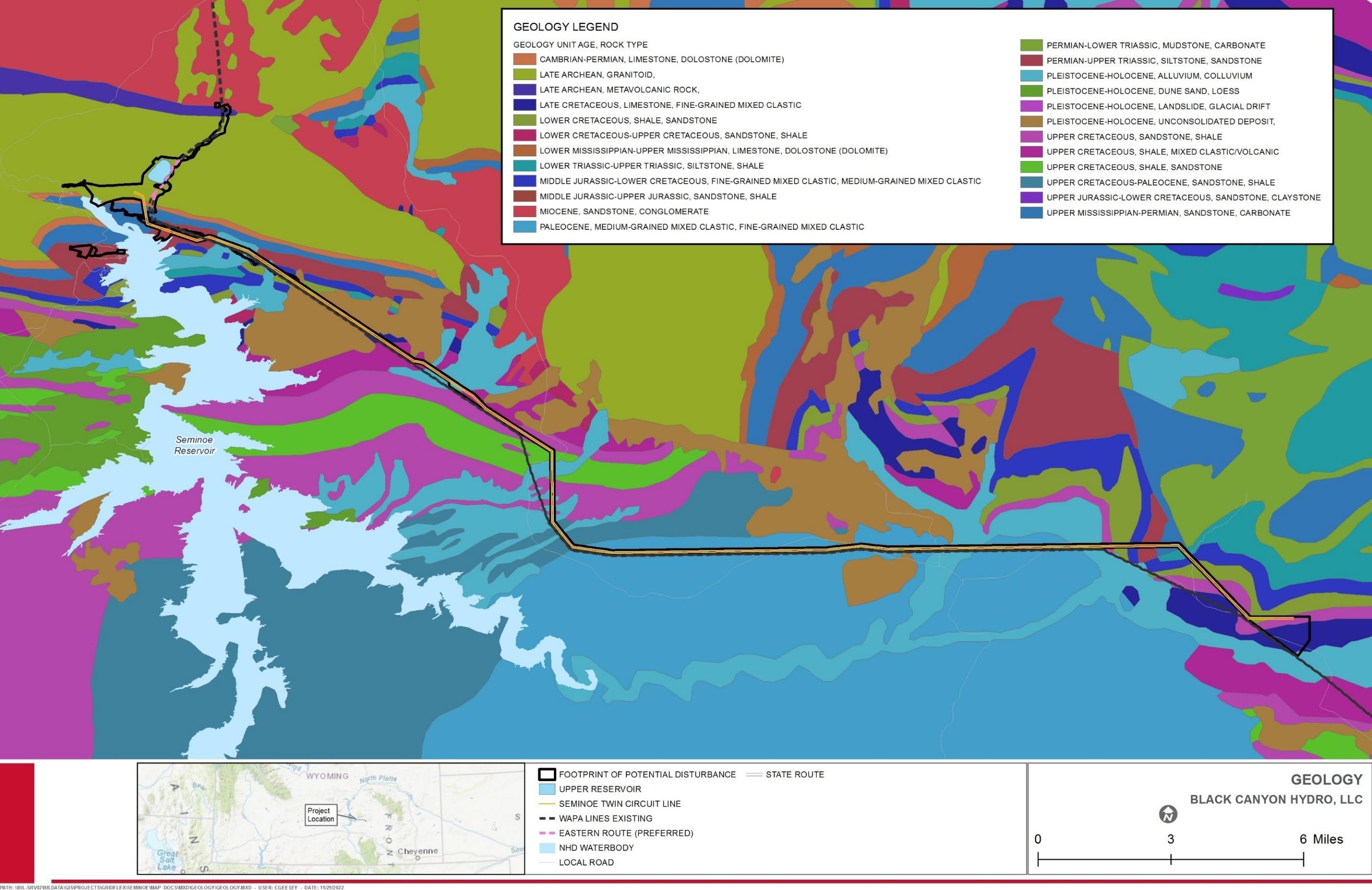
Final License Application – Exhibit E
Storage Project January 2023 | 93
Seminoe Pumped

Final License Application – Exhibit E
Storage Project January 2023 | 94
Seminoe Pumped
Figure 3.3-4. Structural Features and Bedrock Units of the Project Vicinity
The Greater Platte River basins, including the North Platte, contain abundant surficial deposits that were sensitive to, or are reflective of, the climate under which they formed: deposits from multiple glaciations in the mountain headwaters of the North and South Platte rivers and from continental ice sheets in eastern Nebraska; fluvial terraces along the rivers and streams; areas of eolian sand and other dune fields; thick sequences of wind-blown silt (loess); and sediment deposited in numerous lakes and wetlands (USGS undated).
Thin surficial deposits including alluvium, colluvium, and in-situ decomposed parent rock (particularly in the igneous rocks) commonly occur in drainages and depressions, as well as on some side slopes within the Project vicinity (Bennett and Aalto 1982). A list of all prominent surficial units mapped throughout the Project vicinity are described in Table 3.3-1 and are shown on Figure 3.3-5 (WSGS 2020).
Table 3.3-1. Descriptions of Surficial Deposits in the Vicinity of the Project Unit Surficial Deposits Abbreviations (1:100,000 scale)
a Alluvium - stream and river deposits.
b Bench - a strip of relatively level earth or rock, raised and capped with gravel.
c Colluvium - loose and incoherent deposits, usually at the foot of a cliff or on the surface of a slope and there chiefly by gravity.
d Dissected.
e Eolian deposits - windblown deposits, includes sand, silt, and clay.
f Alluvial fan deposits - a fan shaped deposit made by a stream or a debris flow where they have run out onto a level plain.
l Landslide - earth and rock which became loosened from a hillside and slides, flows, or falls down the slope.
R Bedrock.
r Residuum - a residual deposit remaining in place after the decomposition of rocks.
s Slopewash - soil and rock material that has been moved down a slope by gravity assisted by running water.
t Terrace deposits - relict alluvial deposits on relatively flat, horizontal, or gently inclined surfaces which are bounded by a steeper ascending slope on one side and by a steeper descending slope on the opposite side.
u Grus - an accumulation of angular, coarse- grained fragments resulting from the granular disintegration of crystalline rocks.
Source: WSGS 2020.
Final License Application – Exhibit E
January 2023 | 95
Seminoe Pumped Storage Project
This page intentionally left blank.
Seminoe Pumped Storage Project
–
E
January 2023 | 96
Final License Application
Exhibit
Figure 3.3-5 Surficial Deposits in the Project Vicinity
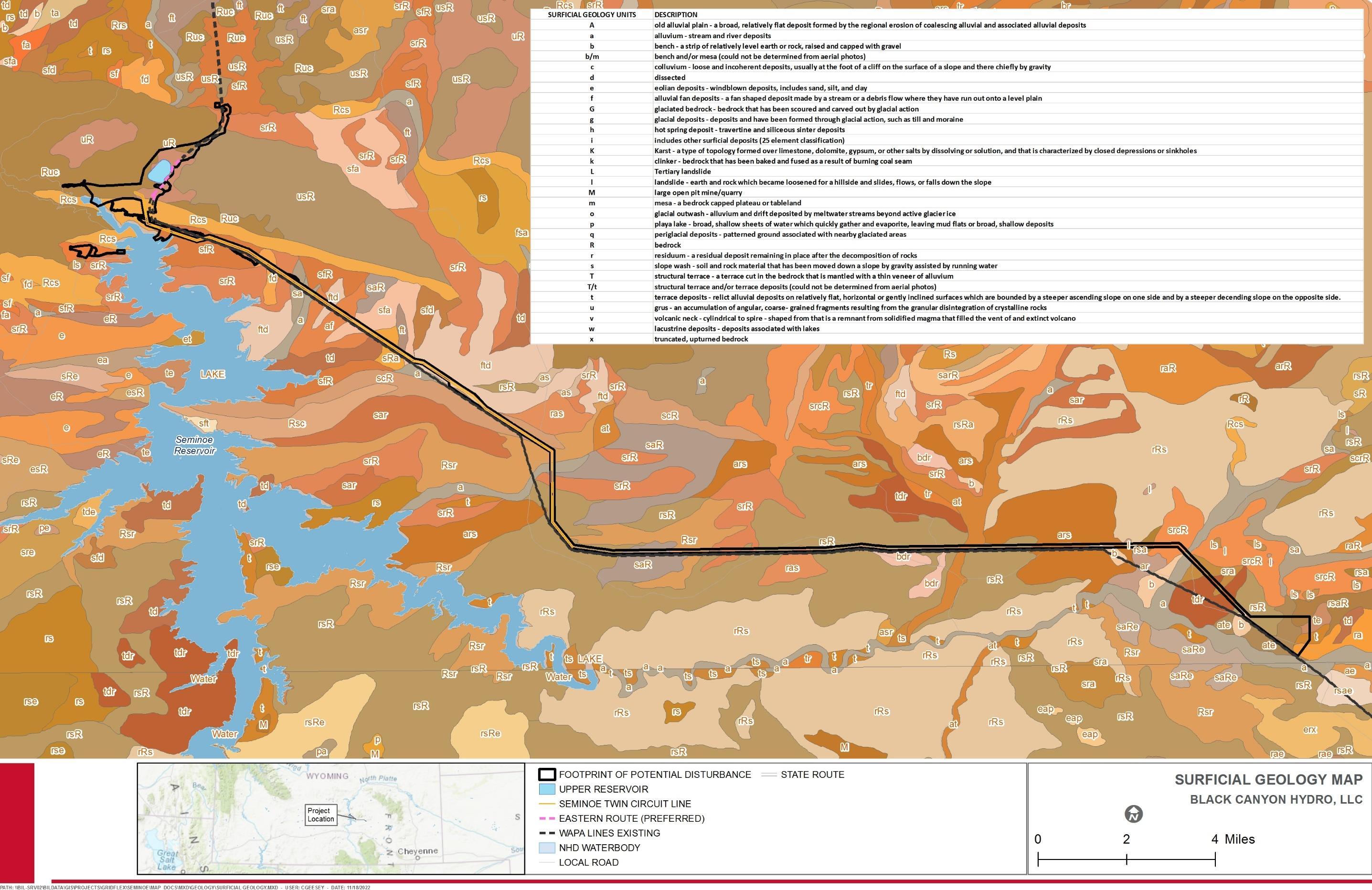
Final License Application – Exhibit E
Storage Project January 2023 | 97
Seminoe Pumped
This page intentionally left blank.
License Application – Exhibit E
Project January 2023 | 98
Final
Seminoe Pumped Storage
3.3.1.4 Groundwater
Estimates of water used in Carbon County indicate that groundwater accounts for approximately two percent of the overall water used. In many parts of the county, it is the only supply of water available. Aquifers in hydrogeologic units of lower Tertiary age are the most widely tapped for groundwater pumping. Rocks that contain these aquifers occur at or near land surface in much of the county (Figure 3.3-2). Aquifers in unconsolidated deposits of Quaternary age can be important water supplies locally but are not widespread (Bartos et al. 2006).
Groundwater in Carbon County occurs under both water-table (unconfined) and artesian (confined) conditions. Under water-table conditions, permeable material extends from the land surface to the saturated zone, allowing vertical movement of water. Aquifers in Quaternary unconsolidated deposits consisting of alluvium, dune sand (eolian), lacustrine, and gravel deposits generally are unconfined (Bartos et al. 2006).
Groundwater is a significant water supply for municipal and domestic users within the Platte River Basin. Both surface water and groundwater are used for irrigation purposes in the Platte River Basin (Taucher et al. 2013).
Feasibility drilling as part of the North Platte River Hydroelectric Study (Seminoe Site) (Bennett and Aalto 1982) in the area of the proposed upper reservoir did not encounter groundwater in boreholes drilled for that study. In wet years, Dry Lake (located within the footprint of the proposed upper reservoir) is known to fill with water but dries up by July according to local ranchers. Surface water seeps vertically downward to become the main supply for the springs found in nearby gullies (Bennett and Aalto 1982) Several springs are located in the vicinity of the proposed transmission line (e.g., Red Springs, Sips Spring, and others). A detailed discussion of groundwater resources in the Project vicinity is described in Section 3.4, Water Resources.
3.3.1.5 Soils
The U.S. Department of Agriculture (USDA) Natural Resources Conservation Service (NRCS) Soil Survey of Carbon County has not been completed; therefore, there are no existing NRCS soil data for the Project (USDA 2022).
Overall, soils in Wyoming show a close relationship to geologic parent materials and vegetation communities under which they form. Landscape stability and age relationships are also important in understanding soil occurrence throughout the state (Munn and Arneson 1998).
According to the Soils Map of Wyoming (Munn and Arneson 1998), which depicts processbased soil categories in Wyoming and provides generalized descriptions of soils within the state, in foothills and lower mountains, steep south-facing slopes are commonly occupied by Entisols (Torriorthents) and Inceptisols (Ustochrepts). Hillslopes under sagebrush and grasses are frequently Mollisols, most commonly without argillic (clay accumulation) horizons. Where grassland is intermingled with forest, the grassland sites are often on either warmer aspects or finer textured (less rocky) soils. On stabilized sand dunes, the soils are Entisols (Torripsamments). On playas with clayey textures and clay dunes
Final License Application – Exhibit E
Project January 2023 | 99
Seminoe Pumped Storage
3.3.1.6
frequently associated with them, soils are commonly salt-affected Aridisols (Calcigypsids or Gypsisalids). Soils along ephemeral channels are usually Entisols (Torrifluvents) on surfaces younger than approximately 6,000 years old, with wet Mollisols (Haplaquolls) occurring along streams with permanent high-water tables (Munn and Arneson 1998).
The Project vicinity is located in Soil Map Unit Zone 9: Laramie and Wind River Basins, Intermountain Basins, Frigid, aridic. Munn and Arneson (1998) define this zone as:
The Laramie and Wind River Basins are rimmed with upturned Cretaceous and older sedimentary rock. Soils developed on these parent materials are typically an association of Natrargids and Torriorthents. The interiors of the basins are filled with alluvial sediments of Tertiary and Pleistocene age. Soils on older alluvial surfaces (700,000 years and older) are usually dominated by calcium accumulations (Petrocalcids and Haplocalcids) while younger, low-relief surfaces are occupied by Haplargids (Pleistocene surfaces) or Haplocambids (Holocene surfaces). A complex of Natrargids and Haplargids occupies broad uplands developed in Tertiary-age parent materials. Riparian areas often contain Haplaquolls, and steep scarps are typically occupied by Torriorthents.
Soils in the Great Divide Basin formed in residuum or alluvium derived dominantly from shales or sandstones. Layers of both these types are often found together in alternating bands of varying thickness. Soils in the Ferris and Seminoe Mountains have a granitic base overlaid with fractured and pushed-aside uplifts of sandstone and limestone. The dark red hills bordering Seminoe Reservoir represent the Chugwater Formation. Textures range from clays to loams to sands and from very shallow to deep. Clay and silt-dominated soils are often saline or alkaline, while sandy and loamy soils have had enough precipitation to leach salts sufficiently to allow them to function (effective rooting depth) as moderate to deep soils. Soils in the North Platte River Basin are generally sands and sandy clay-loams, with gravel and rocks becoming more numerous closer to the mountains and along higher gradient streams (BLM 2003).
Shoreline and Stream Banks Reservoirs
The proposed upper reservoir will be constructed to the west of the Bennett Mountains Wilderness Study Area (WSA) in an unwooded area that has a minimum existing ground elevation of approximately 7,280 feet. The area of the proposed upper reservoir is situated in Precambrian (late Archean) rocks of the Seminoe Mountain core located on a flat-topped granite mountain. Vegetation in the area of the proposed upper reservoir includes mostly herbaceous vegetation with scattered shrubs.
The shoreline of the lower reservoir within the Project vicinity is dominated by steep bedrock cliffs with occasional large boulder and bedrock shard complexes which extend deep into the lower reservoir. Shoreline slopes in this area of the lower reservoir generally range from vertical to near vertical. Other portions of Seminoe Reservoir in the Project vicinity are also dominated by steep shores with occasional vertical cliffs intermixed with areas of moderate to gentle slopes along the shoreline Farther east from the Project vicinity within Seminoe Reservoir, many portions of the shoreline are dominated by sand,
Final License Application – Exhibit E
January 2023 | 100
Seminoe Pumped Storage Project
and a few areas of boulders and large bedrock shards are located sporadically along the shoreline and extend into the water.
North Platte River
To facilitate access to the main access tunnel entrance for the Project, a bridge will be constructed north of Seminoe Dam across the North Platte River section close to Seminoe Dam. Substrate in this area is dominated by boulder with some scattered areas of cobble/rubble. The stream banks in this area are relatively steep, generally unvegetated, and dominated by boulders.
3.3.1.7 Mineral and Geothermal Resources
Wyoming is a national leader of energy production from coal, uranium, natural gas, and crude oil. Wyoming also has potential for the development of alternative forms of energy including geothermal. Wyoming’s geologic setting along with ideal conditions of heat, pressure, and time has led to the creation of large reservoirs of oil and natural gas within the strata of the state’s basins. Vast reserves of coal also underlie the state, and Wyoming has the largest uranium reserves in the U.S. (WSGS 2022a).
Wyoming has the world’s largest deposit of trona, a sodium carbonate compound that is processed into soda ash or baking soda This mineral is Wyoming’s top export and is mined from the Green River Formation over 100 miles west of the Project (Wyoming Mining Association, 2022) Wyoming also produces more bentonite than any other state Bentonite is mined from surface deposits in the northern parts of the state No trona or bentonite is produced in the vicinity of the Project (Wyoming Mining Association, 2022).
Oil and Natural Gas
Coal, oil, and natural gas all exist within Wyoming and the Project vicinity (BLM 2008a). Wyoming’s first oil well was drilled in 1884 and its first refinery was built in Casper in 1895 (WSGS 2022d) Gas production began as early as 1974 and production has fluctuated over time. Most gas exploration has occurred in the eastern Greater Green River Basin, including the Great Divide Basin, and wells are targeted for stratigraphic traps in rocks of the Upper Cretaceous. There has also been drilling in the rocks of the Precambrian in the area. Exploration for gas reserves in coalbeds has occurred to the west of the Project vicinity and in the Hanna Basin, just to the east of the Project vicinity (BLM 2008a).
Coal
Wyoming is one of the top coal-producing states in the U.S. (Webster and McNamee 2019). Most coal occurs in rock sequences deposited during the Cretaceous Period and Paleocene and Eocene Epochs when the climate was warm and humid and suitable for vegetation growth in brackish/freshwater swamps (WSGS 2020). Commercial mining of coal in Wyoming began in the mid-1860s. At one time (pre-1920) coal was the most valuable mineral resource, but it now ranks behind petroleum and natural gas There are significant oil shale reserves in the southwest of the state. In the area immediately surrounding the Project vicinity, there are six coalfields containing coal resources of subbituminous to bituminous rank (Hanna Basin, Carbon Basin, Great Divide Basin, Rock
Final License Application – Exhibit E
January 2023 | 101
Seminoe Pumped Storage Project
3.3.1.8
Creek, Kindt Basin, and Little Snake River) (BLM 2008a). Approximately 27 million tons of federal coal have been recovered using strip mining and another 16 million tons have been extracted using underground mining methods in the Project vicinity (BLM 2008a).
Uranium
Wyoming is estimated to contain approximately one third of the total uranium reserves in the U.S. (Webster and McNamee 2019). Sedimentary uranium deposits have been discovered in most of the major basins in the vicinity of the Project, including the Shirley Basin to the east and the Great Divide Basin to the west. Commercial development of sedimentary uranium and magnetite deposits in the area has occurred over the last 50 years (Webster and McNamee 2019).
Geothermal
According to the WSGS (2022b), tourism is the primary use of geothermal energy in Wyoming. Geothermal features draw hundreds of thousands of tourists to Wyoming each year, allowing them to enjoy thermal springs in the state, primarily in Yellowstone National Park and Hot Springs State Park in Thermopolis. Direct use of geothermal energy is also harnessed as a means to heat buildings, water, and roadways in some areas of the state.
Although there is currently limited potential for economic geothermal resource development in Wyoming, there are adequate resources for small scale energy production and geothermal heat pump implementation. As new technologies emerge and geothermal resources are discovered, the viability of geothermal energy in Wyoming may increase in the future (WSGS 2015).
The Project vicinity has a relatively low favorability of deep enhanced geothermal systems, and no areas within the immediate vicinity of the Project have been identified as having hydrothermal sites (National Renewable Energy Laboratory undated).
Abandoned and Active Mines
Many mines (past or present), prospects, or mining occurrences are scattered around the Project vicinity (WSGS 2022c). Wyoming has 318,661 records of mining claims on public land managed by the BLM and 3,187 records of mines listed by the USGS. Of these claims, approximately 11 percent are active while approximately 89 percent are now closed; Sweetwater, Fremont, and Converse are the most active counties for mining claims in Wyoming (The Diggings™ 2022).
The Seminoe Mountains mining district in the Project vicinity is restricted to a belt of Archean metamorphic rocks cropping out along the western flank of the Seminoe Mountains. According to Hausel (1994), the Seminoe Mountains mining district is known for its iron ore and gold deposits, but also hosts some copper, silver, serpentine, asbestos, jasper, jade, and leopard rock. According to Hausel’s work in the area (Hausel 1994), some previously unknown zones of anomalous lead and zinc associated with shear zones were detected, and some pyrope garnet and chromian diopside were recovered from a nearby placer. Historic ore production from the Seminoe Mountains mining district has been minor (Hausel 1994).
Final License Application – Exhibit E
January 2023 | 102
Seminoe Pumped Storage Project
Review of the USGS Mineral Resources Online Spatial Data website (https://mrdata.usgs.gov/) found no record of mines, past or present producers, within the proposed Footprint of Potential Disturbance However, several pits, prospects, and mines are located in the Project vicinity, primarily between the Ferris Mountains Wilderness Study Area and the Bennet Mountain Wilderness Study Area. The Mines and Mineral Map of Wyoming (WSGS 2022c), indicates that the East Seminoe Dam jade float, within the Seminoe Mountains mining district, is located to the south of the proposed transmission line route. According to WSGS (2022c), the East Seminoe Dam jade float is a surface mine with host rocks dominated by unconsolidated sand, gravel, and cobbles. Similar to the USGS Mineral Resources Online Spatial Data, the Mines and Mineral Map of Wyoming also indicates that several pits, prospects, and mines are located in the Project vicinity.
3.3.1.9 Proximity to Hazardous Waste Facilities
The WDEQ Voluntary Remediation Program (VRP) works with businesses, landowners, and communities to repair contaminated land and return it to productive use. The WDEQ VRP staff assists volunteers through the process of characterizing contaminated sites and developing remedy agreements to establish cleanup requirements (WDEQ undated-a).
According to the WDEQ VRP Sites online spatial data website (https://gis.deq.wyo.gov/ Html5Viewer/index.html?viewer=VRP_WEB_MAP.VRP_WEB_MAP), no VRP sites are identified in the vicinity of the proposed upper reservoir area, Seminoe Reservoir, or along the proposed transmission line corridor.
3.3.1.10
Quaternary Faulting and Seismicity
The South Granite Mountains fault system bounds the northern extent of the Seminoe Mountains (Figure 3.3-2). According to Machette (1999), the South Granite Mountains fault system is a west-northwest trending, north-dipping, fault system located along the north margin of a low chain of anomalous west-northwest-trending mountain ranges within the Wyoming Basin province of central Wyoming. Two episodes of movement have been associated with the fault system. The first episode was near the end of the Eocene when the Granite Mountains (to the north) were uplifted at least 3 kilometers (km) (1.2 miles), and during the Pliocene to Quaternary when the fault system was reactivated in the opposite sense (down-to-the north), resulting in subsidence of the previously uplifted Precambrian-cored Sweetwater Arch. There have been detailed paleo-seismic investigations at two locations along the central portion of the fault system. The study results revealed clear evidence for Quaternary deformation on the three central faults (sections) of the system, but Quaternary deformation has not been indicated for the distal sections (Machette 1999). Pleistocene to Holocene displacement was documented in the Green Mountain and Ferris Mountains areas, and minor Quaternary displacement was documented in the Muddy Gap area. However, all five sections are considered to be potentially Quaternary in age because of the prevalence of lineaments, springs, alignment of vegetation, and fault scarps. From west to east, the five fault sections of the South Granite Mountains fault system include: 1) Crooks Mountain; 2) Green Mountains; 3) Muddy Gap; 4) Ferris Mountains; and 5) Seminoe Mountains (Machette 1999).
Final License Application – Exhibit E
January 2023 | 103
Seminoe Pumped Storage Project
The Seminoe Mountains section of the South Granite Mountains fault system extends west-northwest roughly 35 km (22 miles) along the north margin of the Seminoe Mountains from Sand Creek Canyon on the west to Corral Creek (or Saylor Creek) on the east. The eastern end of the Seminoe Mountains section is also the eastern end of the Seminoe Mountains structural block (Machette 1999).
The characteristics of the Seminoe Mountains section of the South Granite Mountains fault system are summarized in Table 3.3-2 below.
Table 3.3-2 Seminoe Mountains Section Fault Parameters Parameter
Description
Fault Type Normal
Length km (mi)2 35 (22)
Average Strike N68°W
Dip N Most Recent Event (ka1) <130
Recurrence Interval N/A
Average Displacement per Event N/A Slip Rate (mm/yr)3 <0.23
Source: Machette 1999 Notes:
1 One thousand years (i.e., kilo annum [ka])
2 Total fault length of approximately 133 km (83 miles)
3 Low slip rate is inferred from lack of deformation of deposits that could be as old 130 ka.
As part of an Assessment of Potential for Surface Faulting for Seminoe and Kortes Dams (Geomatrix Consultants 1988), three faults that had previously been identified in the area of Seminoe Dam and the proposed upper reservoir and hydraulic conveyance structures were examined to evaluate any possible evidence for late Quaternary displacement (Black Seam Fault, Red Seam Fault, and Reservoir Fault). Based on the results of the study, the three faults near Seminoe Dam were judged to have a very low potential for future surface faulting. The study indicated that topographic surfaces covered by Quaternary deposits are located across the projections of the three faults on the east and west sides of Seminoe Reservoir, and these surfaces are not displaced. The study concluded that there has been no late Quaternary displacement of these faults, and thus the potential for future surface faulting is very low (Geomatrix Consultants 1988).
As mentioned above, the proposed transmission line corridor does not cross any prominent structural features. However, it is located near a concealed fault near Troublesome Creek east of Shirley Mountain Road (Figure 3.3-4).
The Basic Seismological Characterization for Carbon County, Wyoming (Case et al. 2002), reports that the first earthquake that was felt and reported in Carbon County occurred just southwest of Rawlins on March 28, 1896, which was an intensity IV (Mercalli scale) earthquake that shook for about two seconds. On March 10, 1917, another intensity IV
Final
Application – Exhibit E
January 2023 | 104
License
Seminoe Pumped Storage Project
earthquake was recorded approximately one mile northeast of Rawlins. The earthquake was felt as a distinct shock that caused wooden buildings to noticeably vibrate. Most of the earthquakes recorded in Carbon County occurred in the 1970s.
Several earthquakes occurred in Carbon County in the 1990s. On April 13, 1991, and April 19, 1991, magnitude (Richter scale) 3.2 and magnitude 2.9 earthquakes, respectively, occurred near the center of Seminoe Reservoir. The April 13 event was centered approximately 22 miles northeast of Sinclair, and the April 19 event was centered approximately 24 miles northeast of Sinclair. On December 18, 1991, a magnitude 3.1 earthquake occurred southwest of Seminoe Reservoir, approximately 15 miles northeast of Sinclair. Another earthquake reported in the area occurred on August 23, 1993. This magnitude 3.0 earthquake occurred near the center of Seminoe Reservoir, approximately 18 miles northwest of Hanna (Case et al. 2002). More recently, a magnitude 3.0 earthquake was recorded in northern Carbon County on February 1, 2000. No one reported feeling this event, which was centered approximately 27 miles north-northwest of Hanna (Case et al. 2002). Since 2000, nine earthquakes of magnitude 2.5 or greater have been recorded in Carbon County. The largest of these, a magnitude 3.5 earthquake, was recorded on August 13, 2004, on the west side of Pathfinder Reservoir, in Seminoe Dam area (Beck Consulting, AMEC Foster Wheeler, and Carbon County Emergency Management 2015).
3.3.1.11 Volcanic Activity
The nearest volcanic field to the Project vicinity is the Leucite Hills volcanic field north of the towns of Rock Springs and Superior in southwestern Wyoming. This volcanic field consists of a group of ultrapotassic mafic volcanoes formed from lamproites, some of the rarest rock types on the surface of the earth. The Leucite Hills volcanic field is one of the largest lamproite fields in the world. It consists of 22 known lamproite flows, dikes, necks, plugs, cinder cones, and pumice cones. Radiometric dating indicates volcanic activity commenced approximately 3.1 million years ago and continued until approximately 1.1 to 0.9 million years ago. Although none of the volcanoes in the field are currently active, the range of ages and the amount of time between each eruption indicate future eruptions could occur to the southeast (Hausel 2006).
Based on historical data from the National Oceanic and Atmospheric Administration National Centers for Environmental Information, Natural Hazards Viewer (https://www. ncei.noaa.gov/maps/hazards/?layers=2&extent=-180,70,180,-70), the Project vicinity has not experienced a significant earthquake or volcanic eruption.
3.3.1.12 Underground Features
Karst is the result of the dissolution of carbonate rocks such as limestone, dolomite, and gypsum. Dissolution is the result of infiltration of mild, naturally occurring carbonic acid solutions into rock fractures. Karst features are characterized by caves, sinkholes/cenotes, disappearing streams, springs, and other dissolution features.
Rock units that overlie the Madison Limestone were deposited on a well-developed karst topography. It is a shallow to moderately deep marine deposit that ranges from 0 to about
Final License Application – Exhibit E
January 2023 | 105
Seminoe Pumped Storage Project
500 feet thick (Bartos et al. 2006). As previously mentioned, several springs occur in the Project vicinity. Subterranean dissolution features may also be encountered along the power tunnel alignment as it passes through Madison Limestone
3.3.2 Direct and Indirect Environmental Effects - Geologic and Soil Resources
This section presents information available at this time about potential direct and indirect effects of the proposed Project on geologic and soil resources. This FLA presents some of the effects on geologic and soil resources as they are understood at this time.
The following sections review geologic hazards that are potentially present in the vicinity of the Project (WSGS 2020), considerations associated with the Project vicinity identified by Reclamation (2013, 2014) and Bennett and Aalto (1982), and potential effects of pumped storage operation on shoreline erosion at Seminoe Reservoir
3.3.2.1
Expansive Soils
Small areas of expansive soils exist throughout the vicinity of the Project (Figure 3.3-6). Expansive soils shrink and swell in response to changes in ground moisture. Examples of expansive soils include bentonite, smectite, montmorillonite, and vermiculite. Expansive soils may cause unstable conditions for certain types of infrastructure including roads, highways, and utility lines (Wittke et al. 2019), leading to increased maintenance. No expansive soils are identified in the proposed upper reservoir area; however, the proposed transmission line corridor traverses through small areas of regionally (low and moderate hazard) susceptible expansive soils. Additionally, the eastern terminus of the proposed transmission corridor is located in regionally (moderate hazard) susceptible expansive soils.
3.3.2.2
Mass Soil Movement
There are no mapped landslides in the immediate Project vicinity (Figure 3.3-6). However, a large area of previous mass movement occurs to the northwest of the Project in the vicinity of Bradley Peak. This landslide is mapped as “multiple block slide, multiple slump, multiple flow” by Wittke et al. (2019). Landslides mostly occur on steep ridges and movement typically depends on soil type, slope gradient, and moisture content (Black Canyon 2020b).
Proposed Project facilities located beneath steep terrain could be subjected to landslides or debris flows. Steep slopes with sufficient quantities of colluvium and/or loose or weathered rock are susceptible to landslides and debris flows given sufficient initiation. This initiation could come from a seismic event, addition of water, concentration of hillslope runoff by a road or drainage structure onto a slope, or from a period of heavy or frequent precipitation
3.3.2.3 Water Erosion and Windblown Dust
Erosion hazards not related to expansive soils and mass soil movement processes described above may result from water erosion and windblown dust.
Final License Application – Exhibit E
January 2023 | 106
Seminoe Pumped Storage Project
The Project vicinity does not receive much rainfall, which generally minimizes erosion from water sources. The average annual precipitation for the period of record (POR) (19482011) is 12.66 inches and the average annual snowfall is 21.3 inches (Western Regional Climate Center [WRCC] 2022). However, over long periods, these natural processes may potentially result in erosion. Hazards related to water include erosion of soils at the proposed upper reservoir, the switchyard, the transmission line, and Project access roads. Loosening of rock and soil in the hills above Seminoe Reservoir has the potential to create conditions of gradual or catastrophic movement of rock and soil. Surface and near-surface flow can erode soils and weaken rock (such as during freeze-thaw cycles).
Windblown deposits are more prominent in the western portion of the Project vicinity than in the eastern portion (Figure 3.3-6). These deposits are primarily made up of sand, silt, and clay that have been transported by the wind and deposited (Wittke et al. 2019). Sometimes, windblown soils can affect infrastructure in the immediate area by covering up roadways or encroaching on homes.
As discussed in Section 2.1.1.2, Project operations are predicated to have a daily surface water fluctuation of 6.4 inches under normal operating headwater elevation of 6,357 feet. Any change in Seminoe Reservoir elevation due to Project operations will be within the historic range of Seminoe Reservoir water levels and, therefore, any impacts to shoreline erosion would occur along the perimeter of Seminoe Reservoir where it has operated historically. Project effects on Seminoe Reservoir level and surface area will occur within a band where wave action has historically altered water levels and shoreline erosive forces.
3.3.2.4 Construction Spoil
Black Canyon proposes to design the Project to make the best possible use of nearby construction materials and to limit the amount of material (e.g., soil and rock) that must be imported (borrow) or exported (waste). An earthwork balance is not only vital to control construction costs but also to limit environmental impacts that would otherwise arise from off-site borrow or waste areas.
3.3.2.5
Geology and Seismicity
As part of the Reclamation Pumped Storage Evaluation Special Study Final Phase 2 Report for the Yellowtail, Seminoe, and Trinity Sites (Reclamation 2013), Reclamation determined that no fatal flaws related to geology/seismology were identified during the study phases at the proposed Seminoe, Yellowtail, and Trinity sites and that of the three sites, the Seminoe site has the fewest geologic challenges. According to Reclamation (2013), the proposed upper reservoir is located in an area of low to moderate seismic risk. As previously described, Quaternary movement has occurred on three sections of the South Granite Mountain fault system located to the northwest of the proposed upper reservoir
Final License Application – Exhibit E
January 2023 | 107
Seminoe Pumped Storage Project
This page intentionally left blank.
Seminoe Pumped Storage Project
– Exhibit E
January 2023 | 108
Final License Application
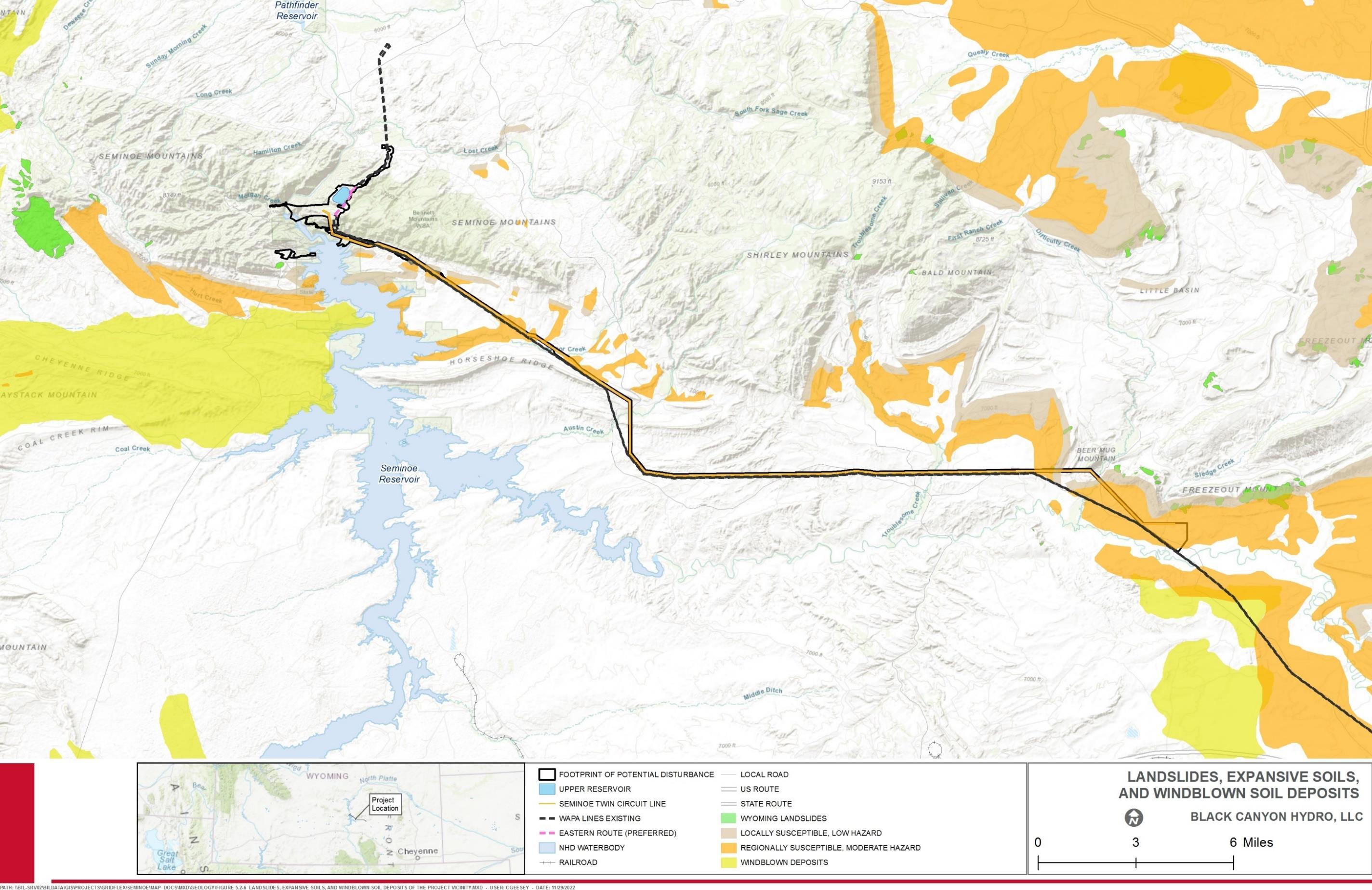
License Application – Exhibit E
January 2023 | 109
Final
Seminoe Pumped Storage Project
Figure 3.3-6. Landslides, Expansive Soils, and Windblown Soil Deposits of the Project Vicinity
This page intentionally left blank.
License Application – Exhibit E
Project January 2023 | 110
Final
Seminoe Pumped Storage
3.3.2.6 Aboveground Project Features
For purposes of this discussion, aboveground Project features include the proposed upper reservoir, upper reservoir embankment, lower reservoir, switchyard, proposed access roads, bridge across the North Platte River below Seminoe Dam, and transmission line. The proposed upper reservoir will be constructed in granite (slopes cut in the granite should be stable [Bennett and Aalto 1982]) that has been intruded by younger granite and gabbro dikes; the existing rock is moderately to intensely jointed.
During construction, soil disturbances associated with clearing, access road and bridge construction, construction of the upper reservoir, and other activities can cause erosion and sedimentation and increase windblown dust. Construction of the Project may, therefore, affect the rates of erosion and sedimentation, resulting in degraded water quality. Because of the inherent nature of overhead transmission systems (lines suspended above the ground surface), the construction of most of the proposed transmission line is anticipated to produce relatively little effect on erosion and sedimentation. Construction of access roads, however, is expected to increase the potential for erosion and sedimentation. Some access roads might involve stream crossings and could include culverts, bridges, or low-water crossings. Open streams may also be channeled through culverts over the course of construction. Construction of these roads and stream crossings could cause or contribute to erosion. These impacts are potentially significant but would be mitigable to a less-than-significant level with the implementation of an Erosion and Sediment Control Plan that incorporates BMPs designed to minimize the potential for erosion, and sedimentation and windblown dust, and to control fugitive dust emissions. The Erosion and Sediment Control Plan will specify requisite erosion control measures to ensure that excess sediment does not enter Number 1 Gulch and Number 2 Gulch.
Water levels in Seminoe Reservoir are highly dependent upon the runoff each year. Typically, the lowest surface elevation occurs in April, immediately preceding the runoff period. Reservoir levels typically rise rapidly during the runoff and peak around the end of June. Elevations can drop rapidly in July and August depending on irrigation demand and slowly decrease from September through April as slightly more water is released than flows in. Since 2007, minimum surface elevation has varied from a low of 6,289 feet in 2008, to a high of 6,346 feet in 2012. Maximum water elevation has varied from a low of 6,321 feet in 2007 to a high of 6,356 feet in 2010. Average within-year fluctuation since 2007 is 21 feet (SD = 14.5) (WGFD 2021a).
Pumped storage electrical generation operations will involve the cycling of water between Seminoe Reservoir and a new upper reservoir, generating power with release of water from the upper reservoir to Seminoe Reservoir, and returning water to the upper reservoir for storage. Black Canyon analyzed the potential effect of Project operations on water level fluctuations in Seminoe Reservoir with an assumption that the Project will have the flexibility to operate whenever Seminoe Reservoir is within Reclamation’s normal operating range (surface water elevation ranging from 6,290 feet to 6,357 feet).
Final License Application – Exhibit E
January 2023 | 111
Seminoe Pumped Storage Project
3.3.3
Results of this assessment indicate that during a full pumping or generating event of the Project, the variation in the water level of Seminoe Reservoir at its normal maximum operating surface elevation of 6,357 feet, will be approximately 6.4 inches. The current typical daily fluctuation of Seminoe Reservoir is for most of the year (e.g., in June and July Seminoe Reservoir experiences daily fluctuations up to 0.3 foot, almost 4 inches). Therefore, operation of the Project will involve water level fluctuations generally within the range of levels currently experienced within Seminoe Reservoir at its normal maximum operating surface elevation
Operation of the Project is not anticipated to affect erosion processes or bank stability within Seminoe Reservoir in the vicinity of the Project. Large areas of bedrock outcrops, large boulders, and cobble line the shorelines of Seminoe Reservoir in areas, especially near the proposed intake structure, and serve to protect these areas from erosion. As a result, Project operations are not expected to have adverse impacts on geological or soil resources within Seminoe Reservoir.
Underground Project Features
Underground features include the powerhouse; a power tunnel between the upper reservoir and the powerhouse; a tailrace tunnel between the powerhouse and a new intake in the existing Seminoe Reservoir; powerhouse access tunnel; and a high-voltage transmission tunnel. Extending away from their respective portals and for many hundreds of feet, the tailrace and powerhouse access tunnels will likely encounter steeply dipping sedimentary rocks of Pennsylvanian, Mississippian, and Cambrian age. The last 2,000 feet or so of tunnel toward the proposed powerhouse will likely be in Precambrian granite. The powerhouse and tailrace tunnels will be built entirely in granite (WSGS 2020, Bennett and Aalto 1982). Locating the powerhouse in granite precludes the possibility of slippage along bedding planes, which may be a problem for the structure if it was located in sedimentary units (Bennett and Aalto 1982).
Based on estimates, and information obtained from previous drilling investigations in the area of the powerhouse and access tunnels, the rock that will likely be encountered in the area will be moderately to intensely fractured. As such, support systems may be warranted (Bennett and Aalto 1982).
Cumulative Environmental Effects Related to Geologic and Soil Resources
As noted in Table 3.2-1, the geographic scope for geology and soils is construction workspaces since impacts on soils and surficial geology would be highly localized. The geographic scope includes the aboveground limits of the Project and extends belowground to the depth of proposed construction for the proposed Project facilities. As detailed in Table 3.2-2, there are two projects that occur within the geographic scope for geologic and soil resources: 1) Gateway West Transmission Line Project, and 2) Gateway South Transmission Line Project. These projects tie into the existing Aeolus Substation, which represents less than 7 percent (approximately 462 acres) of the Project’s Footprint of
Final License Application – Exhibit E
January 2023 | 112
Seminoe Pumped Storage Project
Potential Disturbance and the only physical proximity between the Project and others within the geographic scope for potential effects on geologic and soil resources.
Issues Identified for Analysis
Potential cumulative effects on geological hazards include landslide susceptibility resulting from the loss of vegetation or ground-disturbing activities related to the construction phase of multiple projects in a localized area.
Cumulative effects on soil resources could result from either: 1) new alterations to the natural environmental and land surface that could increase the rate of soil erosion by water or wind; or 2) the permanent conversion of vegetated rangeland soils to other uses that could collectively result in limited loss of productivity of soils within the geographic scope for analysis. The implementation of appropriate mitigation measures would minimize shortterm impacts, such as new disturbance of surface soils and other new alterations to the natural environment from construction of the Project and other past, present, and future projects. Mitigation measures would allow for the local soil resources to be stabilized or returned to a state close to their preconstruction state.
Results
As discussed in Section 3.3.1.10, there are three faults identified in the area of Seminoe Dam and the proposed upper reservoir and hydraulic conveyance structures (Black Seam Fault, Red Seam Fault, and Reservoir Fault). These faults were studied as part of an Assessment of Potential for Surface Faulting for Seminoe and Kortes Dams (Geomatrix Consultants 1988), which concluded that there has been no late Quaternary displacement of these faults, and, thus, the potential for future surface faulting is very low. Furthermore, neither the Gateway West Transmission Line Project or the Gateway South Transmission Line Project cross any of these fault lines. Therefore, there are not foreseeable future actions that have the potential to affect geologic stability or sensitive geologic formations. Cumulative effects of past and present actions are not expected to affect faults or flooding.
Aeolus Substation, located at the eastern terminus of the proposed Project transmission lines, is the only area of overlap between the Project and other reasonably foreseeable projects. Aeolus substation is sited in regionally (moderate hazard) susceptible expansive soils (Figure 3.3-6). This area, which contains soils susceptible to wind or water erosion, may represent some potential for cumulative effects on geologic and soil resources, since the Project overlaps with the two aforementioned reasonably foreseeable future actions. However, soils in the vicinity of the Aeolus substation are disturbed and largely unvegetated as part of baseline conditions, because it is already constructed and in use as a regional transmission hub. The remaining portion of the geographic scope of the Project would experience the least cumulative effects since most of the soils are not susceptible to erosion or other hazards (Figure 3.3-6).
Past and present surface disturbance of soils occurs from existing and reasonably foreseeable grazing that occurs on many of the BLM-managed lands near the Project and in Wyoming. Project construction will remove certain lands from grazing rotations. Soil
Final License Application – Exhibit E
January 2023 | 113
Seminoe Pumped Storage Project
disturbance in grazed areas is typically localized to trailing routes, mineral and supplemental feeding areas, and riparian areas (BLM 2020b), rather than lands projected to be affected by Project construction. Soil disturbance due to grazing is managed through BLM rangeland health standards and guidelines.
Cumulative effects on soil resources could occur if Project activities overlap concurrently or at different timeframes, or if previously restored areas are subsequently re-disturbed. Because the Project includes PM&E measures specific to Geologic and Soil Resources that will be consistent with BLM standards and practices, most Project-related impacts on soils would be temporary and short term. Although construction of other projects may overlap the Footprint of Potential Disturbance at Aeolus Substation, construction of the Gateway West Transmission Line Project and Gateway South Transmission Line Project is projected to be complete prior to construction of the Seminoe Pumped Storage Project. All three projects will incorporate mitigation measures to reduce erosion, sedimentation, windblown dust, and revegetation (BLM 2013, 2022b) As a result, the Project, when combined with other actions, is not expected to have substantial cumulative effects on geologic or soil resources.
3.3.4 Agency Consultation and Applicant Recommendations
3.3.4.1 Agency Consultation
The NOI and PAD for the proposed Project were filed with the FERC on April 20, 2020. Comments were received from several agencies including BLM and WGFD, and individual stakeholders. Black Canyon held a virtual joint public-agency meeting on July 21, 2020, and has continued consultation with stakeholders since that time. Black Canyon distributed its proposed resource study plans for the Project on August 3, 2020, and March 23, 2021. Black Canyon distributed the DLA on June 6, 2022. Responses to stakeholder comments and Black Canyon’s Record of Consultation are provided in Appendix A. BLM and USEPA provided comments on geologic and soils resources in their comments on the DLA. Responses to comments on the DLA are provided in Appendix L.
3.3.4.2
Applicant Recommendations
As described in Table 2.1-5, the following PM&Es are applicable to geologic and soil resources:
• Erosion and Sediment Control Plan: Black Canyon proposes to develop and implement an Erosion and Sediment Control Plan to address erosion associated with Project construction.
• Stormwater Pollution Prevention Plan (SWPPP): Prior to the commencement of construction, Black Canyon proposes to prepare and implement a SWPPP. The SWPPP is anticipated to prevent erosion, scouring, and general water quality degradation during Project construction.
• Hazardous Substances Spill Prevention and Cleanup Plan: Black Canyon proposes to develop and implement a Hazardous Substances Spill Prevention and
Final License Application – Exhibit E
January 2023 | 114
Seminoe Pumped Storage Project
Cleanup Plan to address potential issues resulting from spills of hazardous substances or fuels during construction, operation, or maintenance
3.4 Water Resources
This section provides a summary of existing information on surface hydrology, water quality, and water quantity and usage that may be affected by the proposed Project and associated facilities. Black Canyon currently anticipates relying on surface water from existing water rights within the North Platte River Basin as its water source for the Project components which will include the initial fill, long-term make-up water, and depending on State Engineer requirements, may also include a source for long-term refilling of the upper reservoir; thus, the discussions below focus on surface water sources, as opposed to groundwater sources, for existing environment and potential impacts.
3.4.1 Affected Water Resources Environment
The proposed Project is located in Carbon County, Wyoming, at and near the existing Seminoe Reservoir, approximately 35 miles northeast of Rawlins, Wyoming, on the North Platte River. The Project will entail the construction of a new upper reservoir above the existing Reclamation Seminoe Reservoir, which will be utilized as the lower reservoir for the Project. As currently designed, Reclamation’s operation of Seminoe Reservoir is not anticipated to be affected by the Project. While the Project anticipates using Seminoe Reservoir as its lower reservoir, there appears to be excess capacity within the reservoir that can be used upon approval by Reclamation. Storage credits with Reclamation will, therefore, be sought through capacity storage contract(s) for the Project’s water to be stored in Reclamation facilities including Seminoe Reservoir without affecting operations in Seminoe Reservoir.
Pumped storage electrical generation operations will involve the cycling of water between Seminoe Reservoir and the new upper reservoir, generating power with releases of water from the upper reservoir to Seminoe Reservoir and returning water to the upper reservoir for storage. The Project proposes to be established in an “open loop” pumped storage hydraulic arrangement where the working volume will be re-used for power generation. The Project anticipates applying to the Wyoming State Engineer for a storage water right associated with the upper reservoir. In the event the water cycling for hydropower generation requires an additional water right, the Project will seek to permit any usage as a non-consumptive beneficial use for industrial power generation.
3.4.1.1 Water Resources Overview
The Project is situated in the Wyoming Basin Level III Ecoregion of Wyoming. This ecoregion is a broad arid intermontane basin interrupted by hills and low mountains (Chapman et al. 2004). The Seminoe Mountains are within the Wyoming Basin, which encompasses approximately 40,000 square miles of southern Wyoming and northern Colorado (Carpenter and Cooper 1951). The modern drainage pattern takes on a dendritic form (except in sharply defined strike valleys) (Bennett and Aalto 1982).
Final License Application – Exhibit E
January 2023 | 115
Seminoe Pumped Storage Project
8
Carbon County's watersheds are diverse and dynamic and consist of a variety of vegetation and topography, including uplands, floodplains, wetlands, channels, springs, lakes, and reservoirs. These watersheds continue to evolve under the influence of climate, floods, landslides, erosion, and human land use. The water resources of Carbon County are an integral function of the County’s economy and the health of County residents and communities. Carbon County, and many surrounding areas in Wyoming, are headwater watersheds. Many of the waters within the County are important to municipalities, irrigation, wildlife, and other uses both within the County and outside of the County (Carbon County 2021).
Carbon County watersheds drain in several directions (see Figure 3.3-2). The North Platte River is the largest stream in Carbon County, carrying more water and having a larger watershed than any other stream in the county. The Medicine Bow River, a tributary of the North Platte River, forms the second largest stream by discharge and by watershed size (Bartos et al. 2006)
According to the USGS (2020), the proposed Project is located in two watersheds, the Pathfinder-Seminoe Reservoirs watershed (Hydrologic Unit Code [HUC] 10180003) and Medicine Bow (HUC 10180004). The Project is primarily located in the Pathfinder-Seminoe Reservoirs watershed, which encompasses approximately 1,030 square miles and lies entirely within the state of Wyoming The Pathfinder-Seminoe Reservoirs watershed discharges into the North Platte River at Seminoe Reservoir. A smaller portion of the Project on the southeastern side along the proposed transmission line is located in the Medicine Bow watershed which encompasses approximately 1,441 square miles and also is located within the state of Wyoming. The Medicine Bow watershed also discharges into the North Platte River (Black Canyon 2020b).
The Project is located in the North Platte River Basin, which is a subbasin of the Platte River Basin, composed of the North and South Platte River Basins (Wyoming Water Development Commission 2016). The North Platte River Basin drains approximately 21,907 square miles in southeast Wyoming and also extends into northern Colorado and central Nebraska (Wyoming Water Development Commission 2016, Reclamation 2019a)
The Medicine Bow and Sierra Madre Ranges surround the Upper North Platte River in Wyoming with the river originating in the North Park area surrounding Walden, Colorado. The North Platte flows in a large horseshoe bend for nearly 350 miles, circling the Laramie Range then flowing through the southeast Wyoming Plains before exiting Wyoming near Torrington (WDEQ 2022a). The mountainous regions of the Platte River are the source of the major rivers and streams that provide water resources for the basin, with streams in the interior being ephemeral to perennial and having a mixture of spring and montane snowmelt origins. Abrupt topographical relief and numerous types of exposed granitic and sedimentary bedrock are typical throughout the Platte River Superbasin8. Land use in the Platte River Superbasin includes livestock grazing, mineral extraction, dry rangeland, and irrigated pasture and crops (WDEQ 2022a). Within the North Platte River Basin, the
The
Final License Application – Exhibit E
January 2023 | 116
Seminoe Pumped Storage Project
Platte River Superbasin includes the Niobrara, North Platte, and South Platte Basins (WDEQ 2022a).
3.4.1.2
proposed upper reservoir for the Project will be located in the Pathfinder-Seminoe Subbasin (HUC 10180003) and the existing Seminoe Reservoir (lower reservoir) is located in both the Pathfinder-Seminoe Subbasin and the Medicine Bow Subbasin (HUC 10180004) (Black Canyon 2020b).
In the Pathfinder-Seminoe Subbasin, North Platte River flow is regulated by Seminoe, Kortes, and Pathfinder reservoirs. The subbasin includes those areas, other than the Sweetwater and Medicine Bow Rivers, which drain into the North Platte River or its reservoirs between Pathfinder Dam and the head of Seminoe Reservoir (BLM 2008a).
The headwaters of the Medicine Bow Subbasin are on the north slope of the Snowy Range. Water quality characteristics change drastically as the streams flow from the metamorphic geology of the mountains through the easily erodible, fine-grained sedimentary geology of the subbasin. This subbasin drains into Seminoe Reservoir (BLM 2008a).
Aquatic Resources Delineation Study
In accordance with the Aquatic Resources Delineation Study Plan, Black Canyon performed an Aquatic Resources Delineation Study to assess the nature and degree of the Project’s potential impacts on areas potentially subject to the jurisdiction of the U.S. Army Corps of Engineers (USACE) under Section 404 of the CWA 9 The USACE regulates discharges of fill material into Waters of the United States (WOUS) under authority of Section 404 of the CWA. The objective of the study was to prepare a baseline map of potential WOUS in the immediate Project vicinity The methods and results of the study are presented in detail in the Aquatic Resources Delineation Study (HDR Engineering, Inc. [HDR] 2022a) (Appendix B). The results of this study form the baseline and over-arching characterization of surface waterbodies and wetlands within the Project vicinity The study methods are summarized in this section, with the relevant results discussed in the subsections below.
The Aquatic Resources Delineation study area consisted of all lands and waters with potential to be affected by Project construction and operation that were assessed in 2021 and 2022. These lands included the proposed upper reservoir, access roads, transmission line corridor, and currently anticipated laydown yards and related disturbance areas. After the original study was conducted in 2021, additional lands were identified that will be included in the Footprint of Potential Disturbance for the Project. Aquatic resources on these lands were assessed during 2022 (HDR 2022a)
A desktop assessment was performed to collect information related to aquatic resources in the vicinity of the survey area prior to performing the field investigation. Wetland scientists performed the aquatic resources delineation on June 16 to 18 and August 24 to 26, 2021. The additional lands that were identified that will be included in the Footprint of Potential Disturbance for the Project were assessed on August 3, 2022 The delineations were conducted in accordance with the 1987 Corps of Engineers Wetlands Delineation
9 33 United States Code (U.S.C.) §1341.
Final License Application – Exhibit E
January 2023 | 117
Seminoe Pumped Storage Project
Manual (Environmental Laboratory 1987), the Regional Supplement to the Corps of Engineers Wetland Delineation Manual: Arid West Region (Version 2.0; USACE 2008a), A Field Guide to the Identification of the Ordinary High Water Mark (OHWM) in the Arid West Region of the Western United States (USACE 2008b), and the Updated Datasheet for the Identification of the Ordinary High Water Mark (OHWM) in the Arid West Region of the Western United States (USACE 2010)
The field crews demarcated points and boundaries of all evaluated areas using Global Positioning System (GPS) equipment, including impoundments and stock ponds within the study area that exhibited the required parameters for a wetland feature (i.e., hydrophytic vegetation, hydric soils, and wetland hydrology). The crews assigned each feature a wetland cover type classification based on the USFWS classification system for wetlands and deep-water habitats of the U.S. (Federal Geographic Data Committee [FGDC] 2013) and collected representative photographs.
The OHWM defines the boundaries of aquatic features for a variety of federal, state, and local regulatory purposes. OHWM features were identified using Regulatory Guidance Letter 05-05 (USACE 2005) and were determined in general accordance with the Field Guide to the Identification of the Ordinary High Water Mark (OHWM) in the Arid West Region of the Western United States (USACE 2008b) and the Updated Datasheet for the Identification of the Ordinary High Water Mark (OHWM) in the Arid West Region of the Western United States (USACE 2010). GPS data was collected either on the centerline for narrow streams or along each bank for wider streams. Each linear channel feature was classified as either ephemeral, intermittent, or perennial based on its origin and hydrologic regime (HDR 2022a).
Based on the results of the Aquatic Resources Delineation Study (Appendix B), several aquatic resources were identified in the survey area, including 13 freshwater emergent wetlands, 13 ephemeral streams, 2 intermittent streams, 5 perennial streams, and 1 openwater habitat feature (i.e., Seminoe Reservoir). Table 3.4-1 lists the streams identified during the study that are within the study area. Table 3.4-1.
– Exhibit E
January 2023 | 118
Final License Application
Seminoe Pumped Storage Project
Streams Identified
Aquatic Resources Delineation Study Area Resource ID1, 3 Type Area (acres)2 S-1A Ephemeral 0.002 S-2A Ephemeral 0.17 S-3 C Perennial 0.464 S-4D Ephemeral 0.023 S-5A D Perennial 0.159 S-5B D Perennial 0.019
within the
Resource ID1, 3 Type Area (acres)2
S-5C D Perennial 0.03 S-5D D Perennial 0.006 S-6A D Intermittent 0.061 S-6B D Intermittent 0.201 S-6C D Intermittent 0.009 S-6D D Intermittent 0.009 S-6E D Intermittent 0.053 S-7 D Perennial 0.631 S-8D Ephemeral 0.023 S-9 D Ephemeral 0.271 S-10 D Ephemeral 0.052 S-11 D Ephemeral 0.042 S-12 D Perennial 0.284 S-13 D Ephemeral 0.041 S-14 D Intermittent 0.03 S-15 D Ephemeral 0.016 S-16 D Ephemeral 0.067 S-17 D Ephemeral 0.068 S-18 D Ephemeral 0.053 S-19 D Perennial 0.097 S-20 D Ephemeral 0.036 Total 2.949
1 See Appendix F of the Aquatic Resources Delineation Study report for corresponding OHWM stream datasheets
2 As measured/calculated in ArcMapTM version 10.7.1 within the study area
3 Location relative to Project features: A = Upper Reservoir Access Road; B = Upper Reservoir; C = Areas south of the upper reservoir and west of the transmission lines; D = Transmission Line Corridor
– Exhibit E
January 2023 | 119
Final License Application
Seminoe Pumped Storage Project
Table 3.4-2 summarizes the areas of aquatic resources identified in the study area by feature class (HDR 2022a).
Table 3.4-2. Acreage Summary of Aquatic Resources Identified within the Aquatic Resources Delineation Study Area
Feature Class
Acres
Freshwater Emergent Wetland 9.05
Ephemeral Channel 0.86
Intermittent Channel 0.36
Perennial Channel 1.72
Open Water Habitat 27.66
Total 39.65
Source: HDR 2022a
3.4.1.3 Surface Waterbodies and Wetlands
As previously mentioned, the Project will be located in the North Platte River Basin, a subbasin of the Platte River Basin, which is composed of the North and South Platte River Basins (Wyoming Water Development Commission 2016). Within the North Platte River Basin, the proposed upper reservoir for the Project will be located in the PathfinderSeminoe Subbasin and the existing Seminoe Reservoir (lower reservoir) is located in both the Pathfinder-Seminoe Subbasin and the Medicine Bow Subbasin (Black Canyon 2020b).
Stream types in Carbon County include perennial, ephemeral, and intermittent. Major perennial streams in Carbon County either have headwaters in the Sierra Madre or Medicine Bow Mountains in the southern part of the county or flow into the county from mountainous areas in northern Colorado. Many of the smaller streams in the county that have headwaters in lowland areas are ephemeral, and flow only as a result of local snowmelt and rainfall runoff. Streamflows in intermittent streams vary depending on reach characteristics. Snowmelt runoff, ground-water inflows, and/or springs maintain streamflows throughout most years in some perennial reaches, whereas ephemeral reaches exist where streamflows are less than the losses to seepage, evaporation, and/or diversions (Bartos et al. 2006)
Surface drainage in the Platte River Basin is controlled by topography and is essentially equivalent to physiography. Perennial streams receive a large percentage of their source waters from overland flow associated with snowmelt and rainfall that originate in semihumid and humid mountainous headwater regions and persistent baseflow. Most ephemeral flow occurs in response to springtime snowmelt and to intense, short duration rainfall events characteristic of transient convective thunderstorms. Streamflows are also affected by vegetation, temperature, manmade diversions, and complex interconnections with groundwater (Taucher et al. 2013)
The USGS National Hydrography Dataset (NHD) (USGS 2019) identifies 62 water features within the proposed Footprint of Potential Disturbance. Many of these features were also
Final License Application – Exhibit E
January 2023 | 120
Seminoe Pumped Storage Project
identified in the USFWS National Wetlands Inventory (NWI) database (USFWS 2019). The NHD and NWI mapped surface water features within the proposed Footprint of Potential Disturbance were assessed during the June and August 2021 and the August 3, 2022, aquatic resources delineation completed by Black Canyon (HDR 2022a) (included as Appendix B) to determine if their current characteristics and locations matched the datasets. As summarized above, the aquatic resources identified in the survey area were 13 freshwater emergent wetlands, 13 ephemeral streams, 2 intermittent streams, 5 perennial streams, and 1 open-water habitat feature (i.e., Seminoe Reservoir) (HDR 2022a). The extent of these features within the Footprint of Potential Disturbance are shown in the mapbook included in the study report at Appendix B, and each feature class is described in more detail below. The aquatic resources identified in the Footprint of Potential Disturbance are summarized in the study report in Appendix B
Perennial Channels
The North Platte River is one of the dominant perennial surface-water features in Carbon County as well as in the Project vicinity. The North Platte River flows into the southeast corner of Carbon County from its headwaters in the mountains of northern Colorado. The river flows out the northern edge of the county through Pathfinder Reservoir. It continues through Natrona, Converse, Platte, and Goshen Counties before flowing into Nebraska. The North Platte River is eventually joined by the South Platte River near the City of North Platte, Nebraska. At the confluence, the two rivers combine to form the Platte River, a major tributary to the Missouri River. The river is an important surface-water resource for the region today, providing water for irrigation, industry, municipal, and hydroelectric uses (Bartos et al. 2006).
The largest use of water from the North Platte River is for irrigation. Irrigation along the North Platte probably began with crude ditches used to irrigate irregular patches of land on the flood plain. By the late 1800s, extensive development of the North Platte had taken place, and by 1901, summer flows in the Upper North Platte River and its tributaries had been over-appropriated. To help mitigate this over-appropriation, Reclamation projects were constructed over the next several decades. The two most notable of these Reclamation projects affecting Carbon County are the North Platte and Kendrick Reclamation Projects. Seminoe Dam was constructed in the north-central part of the county between 1936 and 1939 as part of the Kendrick Reclamation Project. Water stored in Seminoe Reservoir is used to help irrigate about 24,000 acres west of Casper, Wyoming Although development of water resources from the North Platte River and its tributaries has helped to make the region productive economically, it also has changed streamflow characteristics causing a deterioration of riverine habitat (Bartos et al. 2006)
The North Platte River within the proposed Footprint of Potential Disturbance downstream of Seminoe Dam is characterized as a relatively permanent water (RPW), with an average OHWM width of 81 feet. According to the FGDC (2013), this section of the North Platte River is classified as riverine, upper perennial, unconsolidated bottom (R3UB). During the Aquatic Resources Delineation Study (HDR 2022a), observed substrate in this area was dominated by small boulders with areas of cobble/rubble. The stream banks in this area are relatively steep, generally unvegetated, and dominated by boulders and cobble.
Final License Application – Exhibit E
January 2023 | 121
Seminoe Pumped Storage Project
Additional perennial streams in the Project vicinity include Austin Creek, Difficulty Creek, Saylor Creek, and Troublesome Creek Each of these perennial streams have relatively abrupt boundaries between the stream channel and adjacent upland areas due to channel downcutting (i.e., erosion). In some locations, adjacent agricultural activities have degraded riparian vegetation, compromising soil structure along the banks of the streams and increasing bank erosion. In locations along these streams, the historical floodplains have become hydrologically disconnected from the streams. The beds of the perennial channels in the Project vicinity primarily comprise coarse material (e.g., cobble, gravel, and sand), with low proportions of fines (silt and clay). Most perennial stream channels within the Project vicinity are moderately to weakly entrenched and generally lack flanking of riparian scrub-shrub species. The active channels typically include immediate herbaceous hydrophytic vegetation, quickly transitioning to upland vegetation moving up the steep banks. Riparian vegetation included willow species (Salix spp.), Nebraska sedge (Carex nebrascensis), baltic rush (Juncus arcticus), creeping foxtail (Alopecurus arundinaceus), greasewood (Sarcobatus vermiculatus), Wyoming big sagebrush (Artemisia tridentata spp. wyomingensis), rabbitbrush (Chrysothamnus viscidiflorus), Great Basin wildrye (Leymus cinereus), smooth brome (Bromus inermis), prairie junegrass (Koeleria macrantha), Canada thistle (Cirsium arvense), Maximilian sunflower (Helianthus maximiliani), and wild licorice (Glycyrrhiza lepidota) (HDR 2022a).
Intermittent Channels
Streams S-6A, S-6B, S-6C, S-6D, S-6E, and S-14 (Appendix B) are intermittent channels that vary from low to moderate gradients with the average width of the OHWM varying from 2 to 6 feet. During the 2021 field surveys (HDR 2022a), these streams had relatively slow-moving or stagnant water due to the dry season and extreme drought conditions at the time of the delineation. Intermittent streams with no flow contained isolated pools of surface water and/or saturated or inundated emergent wetlands. Documented stream beds mainly consisted of cobble-gravel, mud, and sand, while associated riparian vegetation included upland scrub, dense upland grasses, and/or emergent wetlands.
Ephemeral Channels
All ephemeral streams are associated with the upper reservoir access road or transmission line portion of the Aquatic Resources Delineation Study area. Ephemeral channels (Appendix B) vary from low to moderate gradients with the average width of the OHWM varying from 2 to 12 feet. In general, ephemeral streams within the Project vicinity can be placed into two broad categories: those that include a low-flow channel, active floodplain, and low terrace; and those with a single channel, without differentiation of stream geomorphic features. In general, those that included the stream geomorphic features included more herbaceous vegetation along the stream banks, while those lacking stream geomorphic features mostly only included upland shrub species, such as big sagebrush. Some or all of the following plant species were identified along the ephemeral channel banks: big sagebrush, greasewood, rabbitbrush, tansyleaf tansyaster (Machaeranthera tanacetifolia), western ragweed (Ambrosia psilostachya), dandelion (Taraxacum oficianale), yellow falsify (Tragopogon dubius), Great Basin wildrye (Leymus cinereus), western wheatgrass (Pascopyrum smithii), prairie junegrass (Koeleria macrantha), needle
Final License Application – Exhibit E
January 2023 | 122
Seminoe Pumped Storage Project
and thread (Hesperostipa comata), and Indian rice grass (Achnatherum hymenoides). The substrate of ephemeral channels within the Aquatic Resources Delineation Study area primarily consisted of silt/sand, except some that included scattered cobble and even bedrock at higher elevations (HDR 2022a)
Freshwater Emergent Wetlands
Emergent wetlands are areas characterized by erect, rooted, herbaceous hydrophytes, excluding mosses and lichens (FGDC 2013). Emergent wetlands include areas commonly referred to as marshes and wet meadows. Surface water inundation may be relatively brief to permanent, but water depth is sufficiently shallow (usually less than 3 feet) so that rooted plants are emergent in at least part of the wetland.
Thirteen emergent wetlands totaling approximately 9.05 acres were delineated within the study area as part of the Aquatic Resources Delineation Study (Appendix B) (HDR 2022a). Some of these wetlands abutted channels within the study area and some were associated springs and seeps, and others occurred as slope and depressional wetlands. All emergent wetlands identified within the study area were dominated by emergent vegetation, primarily Nebraska sedge and baltic rush. Other dominant species included common spikerush (Eleocharis palustris), dwarf spikerush (Eleocharis parvula), white willow (Salix alba), foxtail barley (Hordeum jubatum), bluejoint (Calamagrostis canadensis), common threesquare (Schoenoplectus pungens), seaside arrowgrass (Triglochin maritima), creeping foxtail, yard knotweed (Polygonum aviculare), and rough cocklebur (Xanthium strumarium) (HDR 2022a)
Seminoe Reservoir
Seminoe Reservoir is currently owned, operated, and maintained by Reclamation and is primarily used for power generation, recreation, municipal use, flood control, and downstream irrigation (Black Canyon 2020b). Seminoe Reservoir is the first and most upstream reservoir on the North Platte River and, therefore, anything upstream from the reservoir is not regulated by a reservoir system for flood mitigation as areas downstream from the reservoir are (Carbon County 2021).
Seminoe Dam and its powerplant are located on the north end of Seminoe Reservoir. At the maximum normal operation pool elevation of 6,357 feet, the storage capacity of Seminoe Reservoir is 1,016,717 acre-feet (ac-ft). The elevation of the gated spillway is 6,307.0 feet (Reclamation 2020a). Water released at the dam is used for irrigation, hydropower, flood control, or stored in downstream federal reservoirs for later use. Seminoe Dam and Seminoe Reservoir along with the Alcova Dam and powerplant, Casper Canal and laterals, and other drainage distributions make up the Kendrick Project (Reclamation 2020b). The Kendrick Project was a cooperative agreement between Reclamation and the State of Wyoming to construct a series of dams and reservoirs to be used to supply irrigation waters to farmers in eastern Wyoming and western Nebraska in the early 1900s. These structures are operated to work together to control river waters. The Casper Alcova Irrigation District (CAID) was formed concurrently and helps to provide
Final License Application – Exhibit E
January 2023 | 123
Seminoe Pumped Storage Project
irrigation water by operating and maintaining conveyances serving lands downstream from the headgate, which diverts directly from Alcova Reservoir (State of Wyoming [WY] 2020).
Seminoe Reservoir is 24 miles long from Seminoe Dam to the North Platte River inflow bay and averages 0.8 mile wide. Seminoe Reservoir is bifurcated with the Medicine Bow River forming a second major arm that is 12 miles from the Medicine Bow River inflow to the main body of the reservoir. Seminoe Reservoir has a maximum depth of 206 feet, a mean depth of 50 feet, and an approximate shoreline length of 210 miles. Flows up to approximately 4,000 cfs are released from the reservoir through the Seminoe Powerplant for electrical generation. Flows in excess of 3,000 cfs and up to 48,000 cfs are released through a controlled spillway tunnel (WGFD 2021a).
Water levels in Seminoe Reservoir are highly dependent upon the runoff in a given year. Typically, the lowest surface elevation occurs in April, immediately preceding the runoff period. Reservoir levels typically rise rapidly during the runoff and peak around the end of June. Elevations can drop rapidly in July and August depending on irrigation demand and slowly decrease from September through April as slightly more water is released than flows in. Since 2007, minimum surface elevation has varied from a low of 6,289 feet in 2008, to a high of 6,346 feet in 2012. Maximum water elevation has varied from a low of 6,321 feet in 2007 to a high of 6,356 feet in 2010. Average within-year fluctuation since 2007 is 21 feet (SD = 14.5) (WGFD 2021a).
Light penetration in the North Platte and Medicine Bow arms of Seminoe Reservoir is greatly reduced by the turbidity of the runoff in early summer. The water clears by midsummer, but a turbid underflow apparently passes through Seminoe Reservoir, causing reduced light availability in Kortes Reservoir and the Miracle Mile in the late summer and fall (Reclamation 1981).
More recent Seminoe Reservoir water surface elevation data obtained as part of the Resident Fisheries Survey Study (HDR 2022b) indicated that Seminoe Reservoir water surface elevations were continuously decreasing during the 2021 sampling events. During 2021, Seminoe Reservoir was being drawn down for a late 2021 test of Seminoe Dam During the 2021 sampling of Seminoe Reservoir, water surface elevations decreased from 6,323.1 to 6,309.0 feet over the course of sampling with the largest single day decrease of 0.35 foot occurring on June 20, 2021. Although the daily elevation decrease was relatively minor, the seasonal decrease from the beginning to the end of the 2021 Resident Fish Survey Study decreased approximately 14.1 feet (HDR 2022b)
According to the FGDC (2013), large areas of Seminoe Reservoir are classified as L1UBHh (lacustrine, limnetic, unconsolidated bottom, permanently flooded, diked/impounded). Seminoe Reservoir comprises approximately 27.66 acres of the study area on the northeastern side of Seminoe Reservoir (HDR 2022a).
North Platte River Downstream
Downstream of Seminoe Dam and the Project’s Footprint of Potential Disturbance, the North Platte River flows directly into Kortes Reservoir, an 83-acre reservoir that is also operated by Reclamation as part of the Kendrick Project. Kortes Dam is situated in the
Final License Application – Exhibit E
January 2023 | 124
Seminoe Pumped Storage Project
1,000-foot gorge of the Black Canyon on the North Platte River. Kortes Reservoir is confined to the narrow canyon and provides storage for 4,700 acre-feet of water (Reclamation undated). Because of frequent surges of water from Seminoe Reservoir, Kortes Reservoir does not offer boat ramps or other recreational amenities (Reclamation 2017). The stretch of the North Platte River immediately downstream of Kortes Dam and upstream of Pathfinder Reservoir is known as Miracle Mile, which is well known for its fishing and recreational value, as described in Section 3.8.1.
Utilizing Reclamation Hydromet data (Reclamation 2019b), the average monthly and seasonal stream flows for Kortes Reservoir, and maximum stream flow events from the past sixty years have been modeled to understand the impacts of any potential overpumping event on the Kortes Reservoir and Miracle Mile. Kortes Reservoir has seen an average daily flow of 1,277 cfs each year between 1951 and 2022. The highest maximum daily average flow typically occurs in June with an average of 2,188 cfs (Figure 3.4-1).
Kortes Reservoir - Historical (1951-2022)
Daily Average Flow per Month Annual Average Daily Flow: 1,277 cfs
Flow (cfs)
2000
1500
1000
500
2500 Jan Feb Mar Apr May Jun Jul Aug Sept Oct Nov
2,188 1,665 1,167 849 851 938 1,047 0
1,096 1,087 1,187 1,541 1,704
Months
Average Daily Average
Source: Reclamation 2022b. Figure 3.4-1. Kortes Reservoir Average Daily Flows by Month, 1951-2022.
The highest daily average flows through Kortes Reservoir occur during the late spring and early summer months. The historic high flows have been linked to spring snowmelt runoff events during years with above-average snowpack and precipitation events. These events commonly occur over a period of several days with sustained high flows being recorded over the course of several consecutive days, averaging around a week in duration. June 1983 recorded the highest recorded average daily flow at 16,225 cfs (Reclamation 2019b)
3.4.1.4
Water Quantity
This section describes the surface water quantities (flow and water rights) within and adjacent to the Footprint of Potential Disturbance. The North Platte River flows through
Final License Application – Exhibit E
January 2023 | 125
Seminoe Pumped Storage Project
Seminoe Reservoir and is highly regulated for power generation and instream flow protection. Surface water supplies in the North Platte River basin are considered to be fully appropriated. Any new water supplies for a new water need that are above de minimis amounts are typically only available through the transfer of existing water rights, transbasin diversion, or the development of non-hydrologically connected groundwater (Wyoming Water Development Commission 2016).
Flows
The limnology of Seminoe Reservoir is determined by the interactions of the North Platte and Medicine Bow Rivers. Low flows in these two tributaries result in more riverine conditions in Seminoe Reservoir, including increased salinity, increased flushing rate, decreased sediment load, and decreased nutrient input. High river flows result in more lacustrine conditions, with the opposite attributes of those listed above (Reclamation 1981).
Being the first impoundment on the system, Seminoe Reservoir receives the uncontrolled spring runoff from the North Platte and Medicine Bow Rivers. Over 75 percent of the total annual flow of the North Platte enters Seminoe Reservoir during the period from April through July, with peak flows usually occurring in June. The Medicine Bow River inflows peak in May or June, with over 70 percent of the annual total arriving in Seminoe Reservoir in the period from April through June. Seminoe Reservoir impounds this spring flood and Seminoe Dam releases it at a relatively even monthly rate for power generation. The result of this operating pattern is that Seminoe Reservoir fills rapidly during spring runoff, usually reaching its maximum storage in July, and then is drawn down gradually to late winter minimum storage levels (Reclamation 1981).
Daily average inflows into Seminoe Reservoir area were estimated from the USGS gage (Station No. 06630000) located upstream of Seminoe Dam near Sinclair, Wyoming, with a drainage area of 4,175 square miles and the USGS gage (Station No. 06635000) located to the east of Seminoe Dam at Medicine Bow near Hanna, Wyoming, with a drainage area of 2,338 square miles. The two gages have an overlapping POR for 81 water years, from October 1, 1939, to September 30, 2020
Flow data from both gages were combined in calculating the mean, maximum, minimum, and exceedances. The total drainage area of both gages is 6,513 square miles and the drainage accounts for about 90.3 percent of the total drainage area of the Project.
Monthly average flows range from 341 cfs to 5,042 cfs (Table 3.4-3). The highest flow recorded during the POR was 19,300 cfs and the lowest flow was 50 cfs. Inflow data for the North Platte River is provided as Table 3.4-3. Annual and monthly flow duration curves are provided in Exhibit B of this license application
Final License Application – Exhibit E
January 2023 | 126
Seminoe Pumped Storage Project
Table
3.4-3.
Period
Inflow to Seminoe Reservoir Data
Minimum (cfs) 90% Exceedance (cfs)
Average (cfs) 10% Exceedance (cfs) Maximum (cfs)
January 138 235 363 501 752
February 188 258 410 549 5,470
March 163 345 723 1,226 5,550
April 395 737 1,736 3,136 9,170
May 306 1,326 3,749 7,020 16,980
June 130 1,107 5,042 9,462 19,300
July 75 353 1,593 3,532 13,930
August 50 188 535 1,019 3,071
September 52 127 341 590 4,175
October 97 225 464 794 1,848
November 125 291 484 732 1,148 December 142 263 394 544 827 Annual 50 250 1,320 3,627 19,300
Sources: USGS 2021a, 2021b.
Existing Water Rights
Water resources in Carbon County have been important to historic cultural development such as agriculture, municipal use, and recreation including hunting and fishing. Irrigation development in Carbon County started in the 1850s and the earliest water right filings are recorded in the 1860s. The first surface water laws were enacted in 1875, and in 1894, the Carey Act was passed to encourage settlement and irrigation development across western states. Over time, irrigation throughout the area expanded across the lowlands and the development of reservoir storage rights began in the early 1900s (Carbon County 2021).
While there are many water rights sourced from the North Platte River, there are only a handful of water rights associated with Seminoe Reservoir and only one water right actually pertaining to storage within Seminoe. As part of the Kendrick Project, the vast majority of water stored in Seminoe Reservoir is permitted under a reservoir water right, Permit No. P4552.0R, held by Reclamation for the secondary benefit of irrigation by the Casper-Alcova Irrigation District.
There are a number of other water rights sourced from the North Platte River that are held by Reclamation and other third parties. Table 3.4-4, below, is a list of those water rights gathered through a desktop study of the proximate area around the Project and downstream along the North Platte River to the City of Casper. The vast majority of these water rights, in both volume and flow, are held by Reclamation or by third parties in conjunction with Reclamation.
Final License Application – Exhibit E
Project January 2023 | 127
Seminoe Pumped Storage
Table
3.4-4. North Platte River Water Rights – Proximate to Project
Permit # Facility
Beneficial Use Storage (acft) / Flow (cfs) Owner
P11148.0 Twin Bridge Reservoir Livestock, Recreation, Wildlife 567.7 ac-ft Private Party
P13387.0 Grey Reef Ranch Death Valley Reservoir
P13393.0 Grey Reef Ranch Duck Pond Reservoir
Wildlife 2.76 ac-ft Private Party
Wildlife 4.59 ac-ft Private Party
P13806.0 Conwell Ditch Irrigation 4.98 cfs Private Party
P15498.0 Private Storage Wildlife 7.42 ac-ft Private Party
P15622.0 Lusby Ditch Irrigation 0.80 cfs Private Party
P15728.0 Royce Ditch Irrigation 3.450 cfs Private Party
P17308.0 Kamon Pipe Line No.1 Domestic 0.10 cfs Private Party P17309.0 Kamon Pipe Line No.2 Domestic 0.10 cfs Private Party
P18488.0 Casper Canal Industrial, Irrigation, Domestic 337.69 cfs
Reclamation, CAID, Private Party
P18681.0 Penstocks, Seminoe Dam Other 1990.00 cfs Reclamation
P18682.0 Casper CanalStorage (Alcova) Irrigation, Domestic 184,295.0 acft Reclamation, CAID, Private Party
P18683.0 Casper CanalStorage (Seminoe) Irrigation, Domestic 1,360,000.0 ac-ft Reclamation, CAID, Private Party
P19060.0 Miller Pipeline No. 2 Irrigation 0.35 cfs Private Party
P19338.0 Jerich Ditch Irrigation 1.27 cfs Private Party
P21174.0 Alcova Power Plant Hydropower 3800 cfs Reclamation
P21233.0 Pump Pine Line and Pump Ditch Irrigation 38.5 ac-ft Private Party
P21376.0 Webert Ditch Irrigation 0.32 cfs Private Party
P22187.0 Fremont Canyon Power Plant Industrial 2320 cfs Reclamation
P22293.0 Kortes Power Plant Hydropower 2850 cfs Reclamation
– Exhibit E
Final License Application
January 2023 | 128
Seminoe Pumped Storage Project
Permit # Facility
Beneficial Use Storage (acft) / Flow (cfs) Owner
P2370.0 Birminghan Ditch Irrigation 0.57 cfs Private Party
P2370.1 Birminghan Ditch Irrigation 0.57 cfs Private Party
P2371.0 Birminghan Ditch Irrigation .079 cfs Private Party
P25726.0 Poison spider Water Co. Pipeline Disposal 0.134 cfs Private Party
P27590.0 Pump - Domestic Domestic 0.056 cfs Private Party
P32338.0 Lawrence Diversion Domestic 0.056 cfs Private Party
P32926.0 Eckroth Pipeline Domestic 0.056 cfs Private Party
P34079.0 Parker #2 Pipeline Domestic 0.056 cfs Private Party
P4462.0 Irrigation (Private) Irrigation 0.24 cfs Private Party P4552.0 Seminoe Storage Hydropower, Irrigation 1,360,000.0 ac-ft Reclamation
P4630.0 Alcova Storage Hydropower, Irrigation 184,295.0 acft Reclamation
P5580.0 Kortes Storage Hydropower, Irrigation 4,640.0 ac-ft Reclamation
P5876.0 Pump Line Ditch Irrigation 0.01 cfs Private Party P609.0 Pathfinder Storage Hydropower, Irrigation 1,380,000.0 ac-ft Reclamation
P6489.0 Grey Reef Storage Hydropower, Irrigation 1,798.0 ac-ft Reclamation
Black Canyon recognizes that there are many additional water rights sourced from the North Platte River further downstream but not proximate to the Project. These water rights include those located hundreds of miles away from the Project in Nebraska. Use of water on the North Platte River is, therefore, restricted as an interstate river and governed by the North Platte Decree and subsequent 2001 Stipulation.
The Project’s initial fill and ongoing operations are being permitted to be in compliance with the North Platte Decree and the 2001 Stipulation. The Project is proposing a one-time diversion from Seminoe Reservoir for the initial fill, which will require a commensurate offset of consumptive irrigation that is taken out of use for one year. Subsequently, the initial fill water will be cycled between the upper reservoir and Seminoe Reservoir, utilizing the excess capacity storage in Seminoe Reservoir. The Project’s release of water from the upper reservoir into Seminoe Reservoir for power generation is a beneficial use that is non-consumptive in nature. The Project anticipates some evaporative losses that will be offset through the annual securing of make-up water, thus creating a net zero effect to the North Platte River. As such, little to no effect is anticipated to existing water rights sourced from the North Platte River system.
Final License Application – Exhibit E
January 2023 | 129
Seminoe Pumped Storage Project
Initial Fill and Make-up Water
Because the North Platte River drainage is fully appropriated, securing a water supply for the Project requires temporary or permanent agreements from existing water right holders. Black Canyon is currently in discussions over various permitting paths for water usage with the State Engineer and Reclamation. As a further consideration, the water uses in the North Platte drainage are subject to the terms of the North Platte Decree and the 2001 Stipulation. In addition, the PRRIP and compliance with the ESA constrain the development of any new water projects in the North Platte Basin that exceed 20 ac-ft per year in water depletions (Wyoming Water Development Commission 2016).
The State Engineer has broad discretion in how to permit water usage at the Project, but has indicated the following permits and agreements will likely be necessary:
(i) A new water storage right associated with the upper reservoir;
(ii) An excess capacity storage contract with Reclamation to hold water in Seminoe Reservoir;
(iii) A water service contract with Reclamation to purchase the initial water fill;
(iv) A temporary water authorization allowing the purchased water to be diverted for use at the Project;
(v) A contractual arrangement with the Casper Alcova Irrigation District for their consent to water being diverted from Seminoe for the initial fill;
(vi) A memorandum of operation or understanding regarding how spilled water at Seminoe that is accounted for as Project water can be captured downstream and exchanged
Black Canyon is consulting on water permitting with the State Engineer and has undertaken actions to secure the above agreements and permits. A new water storage right for the upper reservoir will be sought after FERC licensing is complete and construction of the upper reservoir begins. Black Canyon has initiated a basis of negotiations with Reclamation in order to secure the excess capacity storage contract(s) and water service contract. A temporary water authorization will be sought from the State Engineer, pursuant to Wyo. Stats. Ann. §41-3-110. In addition, Black Canyon is in negotiations with the Casper Alcova Irrigation District to secure the contractual arrangement to allow for the initial fill and, potentially, long-term, make-up water for the Project. The Project may, if necessary, seek to engage with other water right holders and/or parties as becomes necessary to secure water supply and usage. As the State Engineer is still making final determination on permitting, the agreements for the water supply and plans for its availability may be further developed and finalized as the licensing process advances.
3.4.1.5 Water Quality
Federally Approved Water Quality Standards
Wyoming’s surface water quality standards include designated uses, water quality criteria, and antidegradation provisions to protect and restore Wyoming’s surface waters. The standards are developed to be consistent with the Wyoming Environmental Quality Act
Final License Application – Exhibit E
January 2023 | 130
Seminoe Pumped Storage Project
and the Federal CWA. Wyoming’s Surface Water Quality Standards are included in Chapter 1 of the Water Quality Rules and Regulations and were updated in April 2018 (Wyoming Department of Environmental Quality [WDEQ] undated-b). The North Platte River is considered a Class 1 water from the headwaters of Pathfinder Reservoir upstream to Kortes Dam and from Natrona County Road 309 bridge (near the confluence with Poison Spider Creek) upstream to Alcova Dam (WDEQ/Water Quality Division [WQD] 2007a).
The remainder of the segment, including all reservoirs, is considered Class 2AB (WDEQ/WQD 2007a). Water quality standards for temperature, dissolved oxygen (DO), pH, turbidity, suspended solids, and taste, odor, and color are presented in Table 3.4-5. Table 3.4-6 details the minimum DO criteria for Class 1, 2AB, 2B, and 2C waters.
Table 3.4-5. Narrative Water Quality Standards for Class 1, 2AB, 2B, and 2C Waters
Parameter Standard
For Class 1, 2, and 3 waters, pollution attributable to the activities of man shall not change ambient water temperatures to levels which result in harmful acute or chronic effects to aquatic life, or which would not fully support existing and designated uses.
Temperature
Dissolved Oxygen
When ambient temperatures are above 60°F (15.6°C) in all Class 1, 2AB, and 2B waters which are cold water fisheries, pollution attributable to the activities of man shall not result in an increase of more than 2ºF(1.1ºC) in existing temperatures.
When ambient temperatures are above 60ºF(15.6ºC) in all Class 1, 2AB, 2B, and 2C waters which are warm water fisheries, pollution attributable to the activities of man shall not result in an increase of more than 4ºF(2.2ºC) in existing temperatures.
In all Class 2A, 2D, and 3 waters, pollution attributable to the activities of man shall not deplete DO amounts to a level which will result in harmful acute or chronic effects to aquatic life, or which would not fully support existing and designated uses.
In all Class 1, 2AB, 2B, and 2C waters, pollution attributable to the activities of man shall not result in a DO content of less than that presented in Table 3.4-6 below.
For all Wyoming surface waters, pollution attributable to the activities of man shall not be present in amounts which will cause the pH to be less than 6.5 or greater than 9.0 standard units.
pH
For all Class 1, 2, and 3 waters, pollution attributable to the activities of man shall not change the pH to levels which result in harmful acute or chronic effects to aquatic life, directly or in conjunction with other chemical constituents, or which would not fully support existing and designated uses.
Final License Application – Exhibit E Seminoe
Project January 2023 | 131
Pumped Storage
Parameter Standard
In all cold water fisheries and/or drinking water supplies (Classes 1, 2AB, 2A, and 2B), the discharge of substances attributable to or influenced by the activities of man shall not be 1-20 present in quantities which would result in a turbidity increase of more than ten (10) nephelometric turbidity units (NTUs).
Turbidity
In all warm water or nongame fisheries (Classes 1, 2AB, 2B, and 2C), the discharge of substances attributable to or influenced by the activities of man shall not be present in quantities which would result in a turbidity increase of more than 15 NTUs.
Suspended Solids
In all Wyoming surface waters, floating and suspended solids attributable to or influenced by the activities of man shall not be present in quantities which could result in significant aesthetic degradation, significant degradation of habitat for aquatic life, or adversely affect public water supplies, agricultural or industrial water use, plant life or wildlife.
Taste, Odor, Color
No Class 1, 2, or 3 waters shall contain substances attributable to or influenced by the activities of man that produce taste, odor, and color or that would: (a) Of themselves or in combination, impart an unpalatable or off-flavor in fish flesh; (b) Visibly alter the natural color of the water or impart color to skin, clothing, vessels, or structures; (c) Produce detectable odor; or (d) Directly or through interaction among themselves, or with chemicals used in existing water treatment processes, result in concentrations that will impart undesirable taste or odor to public water supplies.
Source: WDEQ/WQD 2007a
Final License Application – Exhibit E
Storage Project January 2023 | 132
Seminoe Pumped
30
N/A
6.5 7
9.5
N/A
7
5.0
8.0
4.0
Table 3.4-6. Minimum DO Criteria for Class 1, 2AB, 2B and 2C Waters (milligrams per liter [mg/L]) Cold Water Criteria Early Life Stages(1)(2) Other Life Stages
Day Mean
(3)
Day Mean
(6.5)
(3)
Day Mean Minimum(4) N/A(3)
1 Day Minimum(4)
(5.0)
Notes: 1 These are water column concentrations recommended to achieve the required inter-gravel DO concentrations shown in parentheses. For species that have early life stages exposed directly to the water column, the figures in parentheses apply. 2 Includes all embryonic and larval stages and all juvenile forms to 30 days following hatching. 3 N/A (Not Applicable). 4 All minima should be considered as instantaneous concentrations to be achieved at all times.
Source: WDEQ/WQD 2007a Previous Water Quality Data Collection
U.S. Environmental Protection Agency
Seminoe Reservoir was surveyed three times in 1975 by U.S. Environmental Protection Agency’s (USEPA) National Eutrophication Survey. The final report issued in 1977 concluded that the reservoir was eutrophic in the North Platte and Medicine Bow arms, moderately eutrophic in the upper basin, and mesotrophic at two sample stations nearest Seminoe Dam. The limiting nutrient was determined to be phosphorus in May and October, and nitrogen in August. It was believed that light might also be a limiting factor during times of high turbidity. A year of monthly tributary sampling indicated that the North Platte River contributed 60.7 percent of the annual phosphorus loading and 62.8 percent of the annual nitrogen loading, while the Medicine Bow River contributed 23.0 percent of the annual phosphorus input and 17.8 percent of the annual nitrogen input (USEPA 1977 as cited in Reclamation 1981).
U.S. Bureau of Reclamation
The baseline limnology of Seminoe, Kortes, Pathfinder, and Alcova Reservoirs on the North Platte River was studied by Reclamation limnologists during 1976-1979. The study period included two years of severe drought followed by two years of higher-than-average runoff in the North Platte basin (Reclamation 1981). Limnology of the Upper North Platte reservoir system is typical in many ways of the High Plains Region of the Western U.S.; i.e., the reservoir waters are dimictic and alkaline, with salinity averaging 369 mg/L and calcium carbonate hardness averaging 184 mg/L. Study results showed that blue-green algae blooms are common in late summer and that this annual bloom depends on a shift from phosphorus-limiting conditions in early summer to more nitrogen-limiting conditions by late summer. The study also indicated that nutrient dynamics, and hence primary production in the system, are heavily influenced by the interaction of three main factors: system operating criteria, annual runoff variations in the three major tributaries, and the presence of deep outlets in all four dams (Reclamation 1981).
All the reservoirs in the study were characterized as alkaline, hard, and somewhat saline bodies of water. Measured hydrogen ion concentrations (pH) were always greater than 7.0, mean calcium carbonate hardness was approximately 184 mg/L, mean total dissolved solids approximately 318 mg/L, mean salinity (sum of anions and cations) approximately 369 mg/L, and conductivity readings during the study ranged from 240 to 577 microsiemens per centimeter (μS/cm) (Reclamation 1981).
All four reservoirs are dimictic, with isothermal conditions in both spring and fall and ice covers in the winter. Study results showed that maximum observed summer water temperatures ranged from about 17 to 20C at the surface, and 14 to 18C at the bottom
Light penetration in the North Platte and Medicine Bow arms of Seminoe Reservoir is greatly reduced by the turbidity of the runoff in early summer. The water clears by midsummer, but a turbid underflow apparently passes through Seminoe Reservoir,
Final License Application – Exhibit E
Project January 2023 | 133
Seminoe Pumped Storage
causing reduced light availability in Kortes Reservoir and the Miracle Mile in the late summer and fall. Study results showed that bottom DO concentrations in the deep-water study stations in the reservoirs reach their minimum by late August; however, the brevity of summer thermal stratification seems to prevent the development of any serious anaerobic, reducing conditions. Minimum observed bottom DO concentrations were reported as 0.2 mg/L in Seminoe Reservoir (Reclamation 1981).
Heavy metals (i.e., iron, manganese, zinc, copper, and lead) did not appear to constitute a biologic hazard in the system, although the study reported total concentrations of iron often, and manganese sometimes, exceeded USEPA quality criteria for domestic water supplies. The percent organic content and the concentration of heavy metals in the bottom sediments of the reservoirs are strongly positively correlated with the percentage of claysized fines (Reclamation 1981).
The study indicated that the high production of epilithic algae and benthic organisms in the Miracle Mile of the North Platte River seems directly attributable to the deep discharges from Seminoe and Kortes Dams, which supply nutrients and ensure a relatively constant physical environment. This instream production, in turn, appears to provide a food base for trout moving into the Miracle Mile from the North Platte arm of Pathfinder Reservoir (Reclamation 1981).
Existing Water Quality Data
Wyoming Department of Environmental Quality/Water Quality Division
There is limited water quality data available in the immediate Project vicinity. The Monitoring and Assessment Program of the WDEQ/WQD conducted stream assessments on the North Platte River from 1996 through 2005, where chemical, physical, and biological information were collected. The objectives of these assessments were to: 1) document baseline conditions and 2) evaluate water quality conditions to determine whether designated uses were supported on their dates of sampling. The WDEQ/WQD completed one-time assessments at 26 stations on the North Platte River. The primary objective of this study was to evaluate the water quality conditions of the North Platte River with respect to Wyoming water quality standards to determine whether designated uses of the North Platte River were supported (WDEQ/WQD 2007b).
Segment 2 of this study was the river reach from Seminoe Reservoir to Casper, Wyoming. In this reach of the North Platte River, there were six sample locations (WB175, WB181, WB179, WB176, WB177, and WB1178). Sampling location WB175 is the first location downstream of Seminoe Reservoir and, therefore, the closest sampling location to the proposed Project. All the sample locations in Segment 2 are depicted in Figure 3.4-2. Segment 2 receives inflows from Segment 1 and streams within Seminoe-Pathfinder (HUC 10180003), Medicine Bow (HUC 10180004), Little Medicine Bow (HUC 10180005), Sweetwater (HUC 10180006), and Middle North Platte-Casper (HUC 10180007) subbasins (WDEQ/WQD 2007b). This segment drains a watershed comprised largely of sedimentary formations and marine shales common to the Wyoming Basin and Northwestern Great Plains with some granitics and metamorphic materials in the mountains (USGS 1985). The North Platte River is considered a Class 1 water from the
Final License Application – Exhibit E
January 2023 | 134
Seminoe Pumped Storage Project
headwaters of Pathfinder Reservoir upstream to Kortes Dam and from Natrona County Road 309 bridge (near the confluence with Poison Spider Creek) upstream to Alcova Dam (WDEQ/WQD 2007b). The remainder of the segment, including all reservoirs, is considered Class 2AB (WDEQ/WQD 2007a).
Water temperatures in this segment of the North Platte River were below the WDEQ/WQD (2007b) maximum criteria of 20°C for a cold-water fishery on the dates sampling occurred. Throughout the segment, DO concentrations were above the acceptable one-day minimum criterion of 8 mg/L that is considered protective of early aquatic life stages in Class 1 and 2AB waters (WDEQ/WQD 2007a). Turbulent reservoir releases combined with dense beds of aquatic vegetation resulted in supersaturated DO concentrations >10 mg/L at some sites. Temperature and DO concentrations at these sites may vary depending on upstream reservoir conditions. All of the pH values throughout the segment, except for station WB175, were within the state standards of 6.0-9.0 (WDEQ/WQD 2007b). The pH at WB175 was >9.0, which was probably the result of elevated photosynthetic rates from the thick stands of aquatic macrophytes on the channel bed (WDEQ/WQD 2007b).
Recent guidance by the USEPA (2000) recommends maximum total phosphorous and nitrate-nitrogen concentrations of 0.022 mg/L and 0.025 mg/L, respectively, to protect aquatic life uses for streams in the Wyoming Basin ecoregion. Concentrations of these nutrients at most stations were below detection (<0.1 mg/L). This information is not particularly informative since the detection limit was greater than the recommended concentration. However, the presence of thick aquatic macrophyte stands in the North Platte River below the reservoirs suggests nutrient enrichment may be occurring at lower concentrations. This is expected since hypolimnetic reservoir releases can contain nutrients that when oxidized, become bioavailable. For example, station WB181 (Figure 3.4-2) exhibited a nitrate-nitrogen concentration of 0.1 mg/L that exceeded the recommended maximum concentration for the Wyoming Basin. The source of this nutrient was likely hypolimnetic water releases from Pathfinder Dam, immediately upstream of the sampling location (WDEQ/WQD 2007b).
Final License Application – Exhibit E
January 2023 | 135
Seminoe Pumped Storage Project
This page intentionally left blank.
Seminoe Pumped Storage Project
– Exhibit E
January 2023 | 136
Final License Application
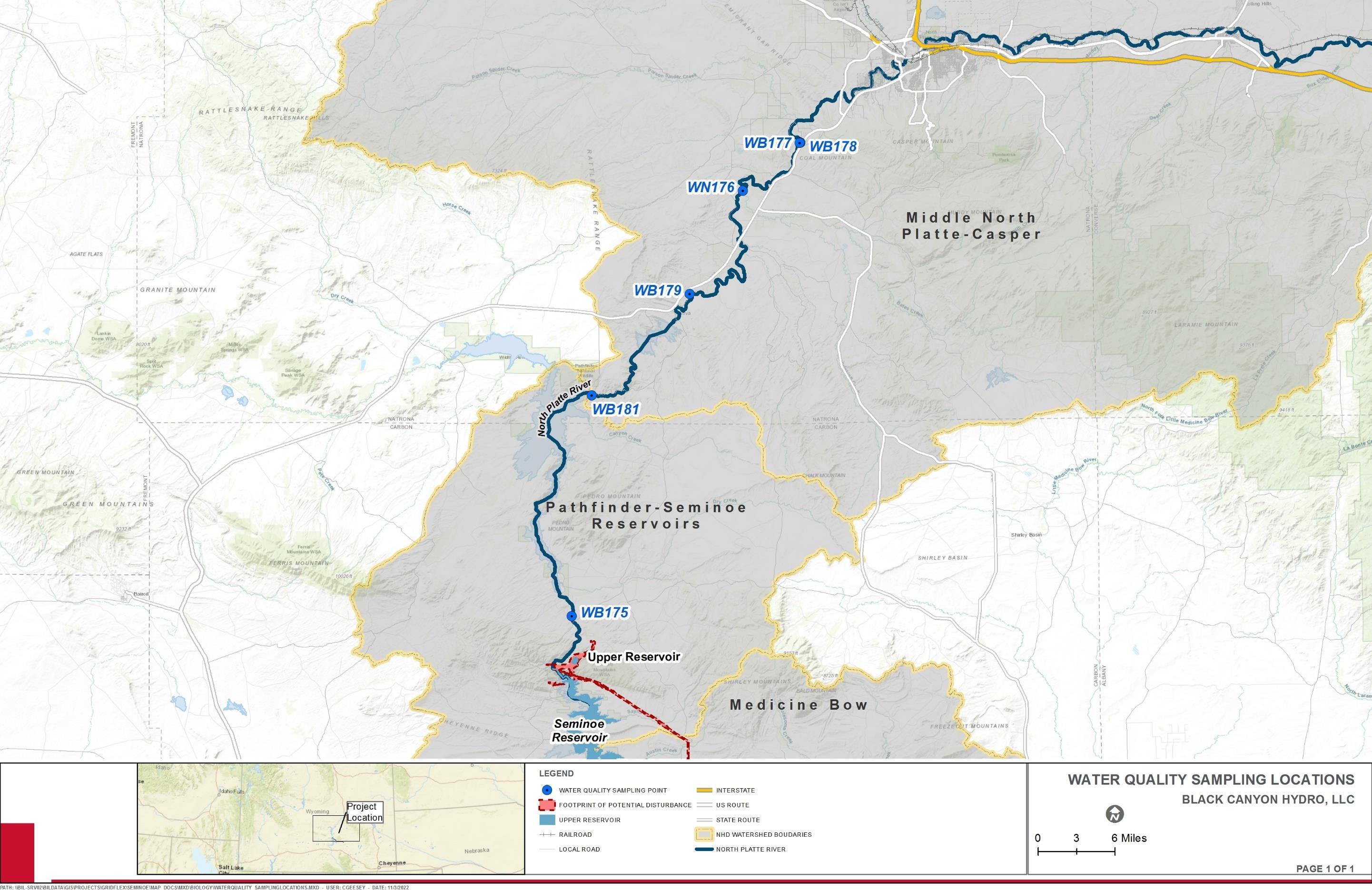
Final License Application – Exhibit E Seminoe Pumped Storage Project January 2023 | 137
Figure 3.4-2. Water Quality Sampling Locations
This page intentionally left blank.
License Application – Exhibit E
Storage Project January 2023 | 138
Final
Seminoe Pumped
In general, conductivity, sulfate, alkalinity, and hardness increased with distance downstream due to the influence of dissolved solids conveyed in streams that drain the carbonate sedimentary materials in the Wyoming Basin and to the effects of evapoconcentration in the reservoirs. All measured chloride concentrations were below the 230 mg/L criterion protective of aquatic life uses (WDEQ/WQD 2007a).
Metals were listed as a possible source of impairment in the North Platte River below Alcova Dam in the State of Wyoming’s 1996 303(d) list and, therefore, total selenium, total copper, total cadmium, total lead, and/or total mercury were collected at stations WB176, WB177, WB178, and WB179. Concentrations of all metals at all sampled sites were below reporting detectable limits, except for total selenium at station WB176 (WDEQ/WQD 2007b). The total selenium concentration of 6 micrograms per liter (ug/L) at station WB176 exceeded the instream chronic criterion of 5 ug/L, which is considered protective of aquatic life uses (WDEQ/WQD 2007a). Sources of the selenium were likely irrigation return flows to the North Platte River from the Kendrick Project vicinity (WDEQ/WQD 2007b).
Table 3.4-7 details the sampling parameters for each of the sampling location in Segment 2 of the study area.
Table 3.4-7. Physiochemical Results at WDEQ/WQD Stations on the North Platte River between Seminoe Reservoir and Casper, Wyoming
Description
WB175 WB181 WB179 WB176 WB177 WB178
Date 9/18/02 9/24/02 10/22/02 10/22/02 10/22/02 10/22/02 Time 14:17 9:20 17:10 9:05 14:27 14:40 Temperature (°C) 16.4 15.5 9.9 7.2 6.1 7.5 pH 9.1 8.5 8.8 8.7 8.6 8.5 Conductivity (µS/cm) 495 492 500 555 534 540
Dissolved Oxygen (mg/L) 10.5 8.3 10.9 8.5 10.0 9.9
Turbidity (NTU) 7.1 20.1 5.1 3.7 4.1 3.2
Total Suspended Solids (mg/L) 5 8 4 <2 <2 3
Alkalinity (mg/L as CaCO3) 120 150 140 140 140 150 Sulfate (mg/L) 124 117 123 144 152 141 Chloride (mg/L) 10 9 10 11 12 16 Nitrate (mg/L as N) <0.1 0.1 <0.1 <0.1 <0.1 <0.1
Total Phosphorus (mg/L) <0.1 <0.1 <0.1 <0.1 <0.1 <0.1
Total Hardness (mg/L as CaCO3) 192 196 204 216 224 232
Total Selenium (ug/L) NM NM <5 6 <5 <5
Total Copper (ug/L) NM NM <10 <10 <10 <10
Total Cadmium (ug/L) NM NM <1 <1 <1 <1
Total Lead (ug/L) NM NM <5 <5 <5 <5
Total Mercury (ug/L) NM NM <1 NM NM NM
Final License Application – Exhibit E
January 2023 | 139
Seminoe Pumped Storage Project
Description
WB175 WB181 WB179 WB176 WB177 WB178
Color None Gray None None None None
Sheen None None None None None None
Odor None None None None None None
Discharge (cfs) 546 75 501 ~501 ~501 ~501
NM = Not Measured.
Source: WDEQ/WQD 2007b
Water quality data is recorded at the USGS gage (Station No. 06635000) on the Medicine Bow River above Seminoe Reservoir near Hanna, Wyoming. Over the last ten years, the lowest recorded water temperature was -0.7°C and the highest recorded water temperature was 23.4°C. Specific conductance ranged from 398 µS/cm to 2,180 µS/cm. DO levels ranged from a low of 6.7 mg/L to a high of 12.7 mg/L. Over the ten-year period, there were 17 instances where DO was recorded below the daily minimum of 8.0 mg/L. During the same period, pH levels ranged from a low of 7.0 to a high of 8.7, indicating that all recorded measurements were within the state standards for pH.
More recently in 2016, the WDEQ/WQD conducted probabilistic surveys of perennial streams and rivers in the greater Platte River Basin The probabilistic surveys in the Platte River Superbasin included all non-headwater, perennial streams that were not located in USFS wilderness areas. This equated to a target population of approximately 4,995 miles of perennial streams and rivers or over 68 percent of the 7,394 total miles of perennial streams and rivers in the Platte River Superbasin Results from this survey provided an objective representation of the biological condition, drinking water suitability and human health condition of Platte River Superbasin perennial streams and rivers. The study also identified the most common stressors and their relative impact to biological condition in the Platte River Superbasin (WDEQ 2022a)
All data collections for the surveys occurred during typical baseflow or near baseflow conditions. Dissolved aluminum, arsenic, cadmium, iron, manganese, and zinc; total hardness, nitrogen, phosphorus, selenium, arsenic, zinc, cadmium, chloride, sulfate and suspended solids; Escherichia coli bacteria: nitrate+nitrite-N: and a suite of pesticides and herbicides were analyzed from grab samples collected at the base of a riffle at each study site. Measurements of water temperature, dissolved oxygen, pH and specific conductance occurred in the field. Benthic macroinvertebrates were the primary indicator of biological condition used during the surveys (WDEQ 2022a).
Of the 20 stressors evaluated as part of the surveys, Nitrate+Nitrite-N (31 percent of stream miles), channel instability (26 percent of stream miles), total suspended solids (18 percent), total phosphorus 18 percent), and riparian disturbance (17 percent) were the five most extensive stressors that influence biological condition in the Platte River Superbasin Nutrients (nitrate+nitrite-N and total phosphorus) were most prevalent in the Laramie, middle North Platte and the lower North Platte and South Platte, whereas physical stressors were more prevalent in the Laramie, Medicine Bow, and Upper North Platte (WDEQ 2022a)
Final License Application – Exhibit E
Project January 2023 | 140
Seminoe Pumped Storage
The most extensive stressor in the Platte River Superbasin is nitrate+nitrite-N, affecting approximately 31 percent of perennial streams. Channel instability, TSS, total phosphorus and riparian disturbance are also top stressors, with 17 to 26 percent of perennial streams in the most-disturbed condition. The prevalence of most disturbed nitrate conditions in the Platte River Superbasin is, in large part, a reflection of the very high relative extent of mostdisturbed nitrate+nitrite-N conditions in the Lower North Platte and South Platte (WDEQ 2022a).
Based on relative extent and relative risk, riparian disturbance, channel instability, and total phosphorus were the most important factors that influenced biological condition of Platte River Superbasin streams. According to WDEQ (2022a), streams were three to four times more likely to be in a most-disturbed biological condition when these stressors are present as when they are not present. Total selenium was not an extensive stressor in the Platte River Superbasin, but where present in most-disturbed conditions, posed a relatively high relative risk to biological condition Based on the study results, nutrients (nitrate+nitrite-N and total phosphorus) emerged as top stressors in the Platte River Superbasin. These parameters affected 18 percent and 31 percent of perennial streams in the Platte River Superbasin, respectively (WDEQ 2022a).
Cyanobacterial
Blooms in Seminoe Reservoir
The WDEQ, the Wyoming Department of Health (WDH), and the Wyoming Livestock Board (WLB) have experienced an increased number of inquiries regarding harmful cyanobacterial blooms (HCBs) in Wyoming waters in recent years HCBs are dense concentrations of cyanobacteria that can have serious health consequences for humans, pets, and livestock through contact, ingestion, and/or inhalation of cyanotoxins or other cyanobacteria-related irritants. Cyanobacteria are commonly referred to as blue-green algae since they appear and function similar to algae, yet they are taxonomically distinct from true algae. HCBs are therefore also referred to as harmful algal blooms or HABs (WDEQ 2022b). Under normal conditions, cyanobacteria are present in the water column or attached to surfaces at low levels. When blooms occur, cyanobacteria can become visibly abundant and form dense brown, green, or blue-green colonies.
The type of cyanotoxins present in a waterbody depends on the species/genera of cyanobacteria, though some species/genera are capable of producing multiple types of toxins. Moreover, toxigenic cyanobacteria, or those with genes that allow for cyanotoxin production, may only produce cyanotoxins under certain environmental conditions. Many factors, including excess nutrients, sunlight, wind, water flow, and temperature, contribute to the formation of HCBs. Although blooms can occur at any time, they are more likely to occur in late summer and early fall when reservoir temperatures warm, water levels stabilize, nutrients are assimilated, and primary productivity increases. Blooms may occur in some reservoirs following turn-over when nutrients are released from the bottom of a reservoir as cooler water is brought toward the surface. Shallow reservoirs, those with long residence times, or those with elevated concentrations of nutrients have an increased likelihood of blooms (WDEQ 2022b).
In 2020, the WDH issued a recreational use advisory for Seminoe Reservoir due to an HCB. On July 9, 2020, satellite imagery from the Cyanobacteria Assessment Network
Final License Application – Exhibit E
January 2023 | 141
Seminoe Pumped Storage Project
(CyAN) identified elevated densities of cyanobacteria covering a large portion of Seminoe Reservoir. As a result, the WDEQ visited the reservoir on July 15, 2020, and collected water samples at the Boat Club Picnic Area. Cyanobacteria densities exceeded the 20,000 cells/mL recreational use threshold identified in Wyoming’s HCB Action Plan (Wyoming State Parks & Cultural Resources 2020). More recently, an HCB recreational use advisory was also issued on September 28, 2022, for Sunshine Beach within Seminoe Reservoir (Wyoming State Parks & Cultural Resources 2022).
In response to increasing HCBs in Wyoming waters, the WDEQ, WDH, WLB, resource management agencies, and other stakeholders developed an HCB program to inform collaborators and the public when HCBs are present in Wyoming surface waters so they can make informed decisions to protect public and animal health. An HCB Action Plan for Publicly Accessible Waterbodies in Wyoming was developed that provides the WDEQ, WDH, WLB, resource management agencies, and other cooperators with procedural guidelines should a HCB be suspected in surface waters in the state of Wyoming (WDEQ 2022b)
Black Canyon Water Quality and Sediment Data Collection
Seminoe Reservoir Water Quality Data
Concurrent with the fish sampling as part of the 2021 Resident Fish Survey Study (HDR 2022b), in-situ water quality data was collected at each sampling site or episode. A Hydrolab® with an associated MS5 Multiparameter Mini Sonde was used to record water quality measurements, including pH, dissolved oxygen (DO), temperature, and specific conductivity. Water quality parameters were collected at the depth of the fish sampling: water quality data associated with sinking bottom gillnet sets were collected at the depth of the net sets, while water quality data collected with mid-column floating gillnets were collected at the depth of the net set. Water quality data associated with boat electrofishing was collected within one meter of the water surface. Water quality data collected during each survey event and location is summarized in Table 3.4-8 Figures illustrating gillnet sampling and electrofishing locations within Seminoe Reservoir are provided in the Resident Fish Survey Study Report included as Appendix D of Exhibit E of the Final License Application. Water temperatures within Seminoe Reservoir ranged from approximately 54 to 72F and reflect typical seasonal values for lakes in this region. DO concentrations were consistently measured in the 5 to 6 mg/L range and are believed to be anomalous. During the fall fish sampling, areas of significant cyanobacteria blooms (consistent with those observed by Reclamation in the 1970s [Reclamation 1981]) were present in portions of Seminoe Reservoir; pH values ranged from 7.17 to 8.71 and likely reflect the high buffering capacity of the watershed (HDR 2022b). During the 2021 Resident Fish Survey Study (HDR 2022b), Seminoe Reservoir was undergoing a significant drawdown for maintenance to the existing Seminoe Dam and drawing water from the deepest portions of the reservoir. This likely influenced the DO data values reported in Table 3.4-8. During fish collection events in the late summer/early fall, the development of blue-green algae (Aphanizomenon flos-aquae) blooms (Reclamation
Application – Exhibit E
January 2023 | 142
Final License
Seminoe Pumped Storage Project
198110) were observed and were concentrated in the backwater coves and fingers of all study areas in Seminoe Reservoir (HDR 2022b)
Table 3.4-8 In-situ Water Quality Data Collected for the Resident Fish Survey Study
Water Temperature (°F) DO (mg/L) DO (percent saturation) pH Specific Conductivity (µS/cm)
Area 1 – Spring
54.2 – 71.7 6.05 – 7.12 72.2 - 89.9 7.17 - 8.70 342.8 – 364.0
Area 1 – Fall
65.8 – 67.3 5.63 – 6.30 72.3 – 82.3 8.07 – 8.42 398.5 – 402.4
Area 2 – Spring
55.2 – 69.7 6.32 – 7.03 71.6 – 91.7 7.90 - 8.43 344.0 – 363.5
Area 2 – Fall
64.8 – 67.6 5.84 – 6.40 75.0 – 83.8 8.16 – 8.47 397.4 – 401.4
Area 3 – Spring
54.8 – 69.6 6.5 – 8.08 74.1 – 93.1 7.54 – 8.40 340.6 – 355.3
Area 3 – Fall
64.7 – 66.2 5.88 – 6.88 75.3 – 88.1 8.16 – 8.51 398.1 – 407.7
Area 4 – Spring
59.8 – 70.5 6.04 - 6.93 73.3 – 90.7 8.11 – 8.42 324.5 – 367.2
Area 4 – Fall
65.4 – 68.0 5.92 – 6.33 75.7 – 83.3 8.40 - 8.47 401.4 - 406.0
Area 5 – Spring
56.0 – 68.1 6.11 - 7.05 72.7 – 93.1 8.01 – 8.40 323.1 – 344.3
Area 5 – Fall
65.1 – 71.2 5.93 - 8.14 75.7 - 110.7 8.34 - 8.71 402.3 - 411.3
Source: HDR 2022b
Note: Figure 3.5-1 in Section 3.5 Fish and Aquatic Resources depicts sampling areas 1 through 5 within Seminoe Reservoir.
Sediment Data Collection
In 2021, Black Canyon obtained 10 sediment samples from the area of the proposed intake structure in Seminoe Reservoir and had the samples tested for heavy metals at a qualified
10 A copy of the 1981 report from Reclamation titled Limnology of the Upper North Platte Reservoir System, Wyoming can be obtained from: http://www.nativefishlab.net/library/textpdf/20516.pdf
Final License Application – Exhibit E
January 2023 | 143
Seminoe Pumped Storage Project
3.4-9.
laboratory (Eurofins TestAmerica [Eurofins] 2021). Standard analytical protocols were followed in the analysis of the samples and no problems were encountered or anomalies observed. In addition, all laboratory quality control samples were within established control limits, with any exceptions noted below. Each sample was analyzed to achieve the lowest possible reporting limit within the constraints of the method.
Samples were analyzed for metals on September 29, 2021. The Method 6010D interference check standard solution (ICS) exhibited a result for Barium above the reporting limit. The laboratory confirmed that this element was a trace impurity in the interference check standard solution. These results are not indicative of a matrix interference. The percent recoveries and/or relative percent difference of the matrix spike and matrix spike duplicate performed on sample SR-21-01A were outside control limits for Iron and Manganese Method 6010D because the sample concentration was greater than four times the spike amount. Because the corresponding Laboratory Control Sample and the Method Blank sample were within control limits, no corrective action was taken. No additional analytical or quality issues were noted (Eurofins 2021). Table 3.4-10 provides a summary of sediment sampling results for the area near the proposed intake structure in Seminoe Reservoir.
All but two of the samples were classified as fine sediments, either silts and/or clays. The other two sample locations (SR-21-03 and SR-21-08) are clayey sand and clayey sand and gravel. All samples except for SR-21-01 and SR-21-07 had fine sediment above a layer of sand or sand and gravel. These layers were mixed in the samples. The particle size distribution of the samples is in Table 3.4-9.
Final License Application – Exhibit E
January 2023 | 144
Seminoe Pumped Storage Project
Item Sample
Particle size Distribution Summary Gravel Sand Sand Coarse Sand Medium Sand Fine Silt Clay Gravel Sand Fines % % % % % % % % % % 1 SR-21-01 0 2.7 0 0.9 1.8 38.9 58.5
2
0
0
3
47.5
4
0
5
4.8
Table
Particle size distribution of samples.
Name
0 2.7 97.4
SR-21-02
20.1
1.8 18.3 36.3 43.6 0 20.1 79.9
SR-21-03
27.6 4.6 9.9 13.1 5.3 19.6 47.5 27.6 24.9
SR-21-05
19 0 1.2 17.8 32.8 48.2 0 19 81
SR-21-06
27.6 1.8 4.8 21 48.1 19.5 4.8 27.6 67.6 6 SR-21-07 0 11.2 0 1.1 10.1 30.7 58.1 0 11.2 88.8 7 SR-21-08 12.4 17 1.6 1.3 14.1 33.9 36.7 12.4 17 70.6 8 SR-21-09 5.9 49.2 1.5 3.1 44.6 10.5 34.4 5.9 49.2 44.9 9 SR-21-10 0 16.2 0 1.6 14.6 17.9 65.9 0 16.2 83.8 10 SR-21-11 14.6 14.5 0.3 1.6 12.6 5.5 65.4 14.6 14.5 70.9 Designated Use Attainment Wyoming's Integrated 305(b) Assessment and 303(d) Report describes the status of surface water in Wyoming in relation to state water quality standards. The report contains
a 303(d) list of Wyoming's impaired surface waters requiring the development of a Total Maximum Daily Load and fulfills requirements of the Federal CWA.
Wyoming’s Final 2016/2018 Integrated 305(b) and 303(d) Report stated that WDEQ/WQD removed the North Platte River from the 303(d) List and placed it into Category 2 because the North Platte was meeting the selenium criteria protective of its cold water fish and aquatic life other than fish designated uses (WDEQ 2018). Waters in the vicinity of the proposed Project were not assessed according to Wyoming’s 2020 Integrated 305(b) and 303(d) Report (WDEQ 2019).
– Exhibit E
January 2023 | 145
Final License Application
Seminoe Pumped Storage Project
This page intentionally left blank.
Seminoe Pumped Storage Project
– Exhibit E
January 2023 | 146
Final License Application
Table 3.4-10 Summary of Sediment Sampling Results
Constituent SR-21-01A (9/25/2021) SR-21-02A (9/26/2021) SR-21-03A (9/25/2021) SR-21-05A (9/25/2021) SR-21-06A (9/26/2021) SR-21-07A (9/27/2021) SR-21-08A (9/26/2021) SR-21-09A (9/25/2021) SR-21-10A (9/26/2021) SR-21-11A (9/25/2021)
Metals (Method 6010D) (milligrams per kilogram [mg/kg])
Arsenic 10 6.7 6.0 8.2 6.0 6.4 4.5 7.3 9.1 8.0
Barium 270 ^6+ 140 ^6+ 110 ^6+ 180 ^6+ 100 ^6+ 160 ^6+ 130 ^6+ 170 ^6+ 200 ^6+ 170 ^6+
Cadmium 1.3 U 0.83 U 0.82 U 0.97 U 0.68 U 1.0 U 0.93 U 0.84 U 1.1 U 0.97 U
Chromium 30 20 20 24 26 23 19 23 25 20
Copper 26 19 21 20 35 19 16 19 23 18
Iron 28,000 16,000 24,000 21,000 30,000 20,000 16,000 20,000 23,000 18,000
Lead 25 15 13 18 12 17 13 18 20 16
Manganese 2,400 770 650 1,000 780 650 480 620 1,300 1,200
Selenium 4.8 3.0 U 2.9 U 3.5 U 2.5 U 3.6 U 3.3 U 3.0 U 3.9 U 3.5 U Silver 2.7 U 1.7 U 1.6 U 1.9 U 1.4 U 2.0 U 1.9 U 1.7 U 2.2 U 1.9 U Zinc 98 61 59 72 58 67 53 71 81 65
Mercury (Method 7471B) (mg/kg)
Mercury 0.073 U 0.048 0.039 U 0.047 0.036 0.050 U 0.040 U 0.043 0.053 0.049 U
General Chemistry (%)
Percent Moisture 73.2 54.0 51.5 59.7 45.7 61.8 55.6 53.2 62.8 60.3
Percent Solids 26.8 46.0 48.5 40.3 54.3 38.2 44.4 46.8 37.2 39.7
Notes:
Metals and Mercury results and standards reported in mg/kg. mg/kg - milligram per kilogram
General chemistry results reported in percentage (%) ^6+ indicates that the laboratory interference check standard (ICSA and/or ICSAB) is outside of acceptance limits, high biased. U indicates that the lab result was below the laboratory reporting limits
Final License Application – Exhibit E Seminoe
Storage Project January 2023 | 147
Pumped
This page intentionally left blank.
License Application – Exhibit E
Storage Project January 2023 | 148
Final
Seminoe Pumped
Black Canyon Water Quality Models
Sediment and Metal Transport Model
As described in the Preliminary Supporting Design Report (Exhibit F), a hydraulic analysis was preformed to determine the flow conditions in the immediate vicinity of the lower inlet/outlet structure. Maximum velocities during generation and pumping were estimated using a Computational Fluid Dynamics (CFD) model to address the departure conditions and the potential for sediment mobilization. The CFD model of the lower inlet/outlet structure and tailrace tunnel was constructed using the FLOW-3D HYDRO (version 1.0) computer program developed by Flow Science, Inc. FLOW-3D is a commercially available CFD modelling package that uses structured, rectangular gridding based upon the Fractional Area Volume Obstacle Representation method and the Volume-of-Fluid technique These techniques provide accurate 3D closed-conduit and free-surface modelling capabilities when the model is properly developed and boundary conditions are accurately applied.
The CFD model analyzed four hypothetical scenarios which included user-specified volumetric flow rates applied at the modeled portion of the tailrace tunnel and userspecified pressure boundary attached to Seminoe Reservoir. The total flow rates used in the CFD model was 12,500 cfs and 11,955 cfs under generating and pumping modes, respectively. The water surface elevations used in the model were set to the maximum (6,357 feet) and normal minimum (6,290 feet) operating levels. Details for each scenario are provided in Table 3.4-11. Table 3.4-11.
Results of the CFD model during pumping (Scenario No. 2 and 3) suggest that flows entering the intake structure from the reservoir do not exhibit excessive turbulence. There were no significant circulatory patterns observed near the intake and the near-bottom velocities were approximately 0.0 feet per second (fps) which suggests that the operation of the intake in pumping mode will not draw in significant amounts of sediment from the reservoir bottom, nor damage the reservoir shoreline.
Final License Application – Exhibit E
January 2023 | 149
Seminoe Pumped Storage Project
CFD Model Scenarios Scenario Number Seminoe Reservoir Level (feet) Total Flow Rate (cfs) Scenario Description 1 6,290 12,500 Normal Minimum Operating Level during Generation 2 6,290 11,955 Normal Minimum Operating Level during Pumping 3 6,357 11,955 Maximum Operating Level during Pumping 4 6,357 12,500 Maximum Operating Level during Generation
Results of the CFD model during generation (Scenario No. 1 and 4) suggest large-scale circulatory patterns are possible within Seminoe Reservoir. The near-bottom velocities are estimated to be less than 2 fps with a small area (estimated to be 50 feet by 50 feet) where velocities may reach 2 fps when Seminoe Reservoir is at the minimum operating level. As described in Exhibit A, Black Canyon anticipates that the installation of a clean rockfill blanket (approximately 100 feet by 100 feet) may be warranted in this area to prevent sediment resuspension. Final Project design development may further reduce near-bottom velocities
Water Temperature Model
Black Canyon developed a CE-QUAL-W2 (W2) model for Seminoe Reservoir to further investigate potential Project effects on thermal stratification in Seminoe Reservoir and temperature changes of Seminoe Reservoir Dam outflow into Kortes Reservoir. The W2 model is a two-dimensional, longitudinal/vertical, hydrodynamic and water quality model. The model is best suited for the Project given the relatively long and narrow characteristics of Seminoe Reservoir, which exhibits longitudinal and vertical gradients. The W2 model is the reservoir model of choice throughout the U.S. and other countries and serves as the two-dimensional, longitudinal/vertical hydrodynamic model of choice for Reclamation (USACE undated-a). The W2 model provides information about water flow and velocity, water temperature, and temperature stratification under existing conditions and with proposed pumped storage operations. Project generating and pumping times used in the model were estimates based on current proposed Project operations at the time of model development (10 hours for generating and 12.5 hours for pumping operations). The Seminoe Water Temperature Assessment has been developed from this model information and is attached as Appendix N.
Seminoe Reservoir water column temperature data were collected as part of a limnology study of the Upper North Platte reservoir system performed by the Reclamation from 1976 to 1979. Temperature data from 1978 (included in the Reclamation dataset) was used to calibrate Seminoe Reservoir model under existing conditions. The model grid was developed based on bathymetry collected during sedimentation surveys of Seminoe Reservoir by Reclamation in 1950 and 1951. The model also took into account reservoir tributary flows, water temperature associated with such flows, reservoir outflow, and meteorological data.
Modeling of the Upper Reservoir
Under normal operations, water in the upper reservoir would only sit for 1.5 hours before cycling back to Seminoe Reservoir. Due to the short period of time that water remains in the upper reservoir, it is unlikely that meteorological effects (e.g., temperature, dewpoint temperature, wind speed, wind direction, cloud coverage, solar radiation) could change the water temperature in the upper reservoir. A hypothetical critical scenario was modeled under summer conditions with no water being released from the upper reservoir for three weeks, representing an opportunity for the water in the upper reservoir to warm before being released to Seminoe Reservoir. This hypothetical scenario may represent a total station outage with a full upper reservoir. This would be a critical scenario as the upper
Final License Application – Exhibit E
January 2023 | 150
Seminoe Pumped Storage Project
Seminoe Pumped Storage Project
reservoir would typically be drained during a station outage for required tunnel inspections. Results from the critical scenario upper reservoir model were similar to the previous scenario modeled for the upper reservoir, that is, negligible water temperature changes (inlet to outlet). Although the upper reservoir surface layers warmed slightly more during the three weeks of no operations, these higher temperatures never reached the near bottom location of the outlet in Seminoe Reservoir.
The upper reservoir model runs indicated that there would be a negligible increase between the Project inlet and outlet temperature. Therefore, temperature changes in flows into and out of the upper reservoir were not included in Seminoe Reservoir modeling analysis to assess Seminoe Reservoir temperature changes with and without pumped storage operations.
Thermal Stratification in Seminoe Reservoir
Seminoe Reservoir model was configured to include the inlet/outlet structure to predict water temperature and water temperature stratification effects under pumped storage operations. The inlet/outlet structure is located at an elevation of 6,256 feet (centerline of structure) (Segment 41) (Figure 3.4-3). Segment 42 includes Seminoe Dam, with penstocks centerline located at an elevation of 6,292 feet. A hypothetical daily schedule for the Project operating within a high solar supply grid was set to generate power (water released from the upper reservoir to Seminoe Reservoir) for 10 hours per day at maximum capacity (12,500 cfs) and to pump water (water pumped from Seminoe Reservoir to the upper reservoir) for 12.5 hours per day (10,000 cfs), for 7 days per week, 52 weeks per year. The model was run for all three simulation years (1976 to 1978). As noted above, the negligible temperature change flows from the upper reservoir were not used in Seminoe Reservoir model analysis under pumped storage operations. The modelcomputed temperature from the water withdrawn from Seminoe Reservoir was specified as the temperature of the water released into Seminoe Reservoir via the inlet/outlet structure. The model simulation was performed seven times for Seminoe Reservoir to achieve “steady” conditions under Project operations. This was equivalent to executing Seminoe Reservoir model for 21 years.
Results from Seminoe Reservoir model under pumped storage operations was assessed for two parameters: 1) vertical temperature stratification changes near the inlet/outlet structure, and 2) water temperature changes in the water released by Seminoe Dam penstocks into Kortes Reservoir. As documented in the literature (Reclamation 1981) and reproduced by Seminoe Reservoir model under existing conditions, Seminoe Reservoir reflects a typical dimictic cycle (i.e., summer and winter stratification conditions) separated by isothermal conditions (i.e., overturn) in fall and spring. From September to April the main body of Seminoe Reservoir is naturally well mixed (i.e., not thermally stratified) and from May to August a natural thermal stratification occurs. Under existing conditions, maximum temperature stratification in Seminoe Reservoir occurs during the summer months (June, July, August).
Final License Application – Exhibit E
January 2023 | 151
Figure 3.4-3. Seminoe Reservoir CE-QUAL-W2 Model Grid

– Exhibit E
January 2023 | 152
Final License Application
Seminoe Pumped Storage Project
Three mechanisms were identified that may change water column temperature stratification under Project operations: 1) Seminoe Reservoir water surface elevation changes due to daily generation and pumping operations; 2) water being withdrawn from Seminoe Reservoir during pumping operations; and 3) water being released to Seminoe Reservoir during power generation. Daily water surface elevation changes due to Project operations vary from less than 7 inches under high reservoir elevation conditions to approximately 20 inches under extremely low reservoir elevation conditions. Because Seminoe Reservoir’s normal maximum temperature stratification under existing conditions occurs in the summer when the reservoir elevation is high, any elevation changes due to Project operations are minimal and do not impact the naturally occurring thermal stratification. In the winter, when reservoir elevations are low, the elevation changes due to Project operations are larger, however, the water column is thermally well mixed (i.e., destratified) and, therefore, changes from Project operations are negligible, if at all. Consequently, elevation changes due to Project operations are not expected to impact naturally occurring thermal stratification or destratification.
The second possible mechanism for changing water temperature stratification is that water is withdrawn from Seminoe Reservoir by the inlet/outlet structure during pumping operations. Model sensitivity runs indicate that when water is withdrawn, the withdrawal action pulls water from model layers (elevations) at and above the location of the inlet/outlet structure. When temperature stratification is naturally present during the summer, withdrawing water from layers at and above the inlet/outlet structure pulls in slightly warmer waters instead of only the deeper, cooler waters near the inlet/outlet structure. When warmer water is then released back from the upper reservoir into the colder water at the inlet/outlet structure elevation in Seminoe Reservoir, it is more buoyant and rises closer to the surface which can change the water column temperature stratification. Although it is difficult to specifically isolate the effects of this process in water column temperature changes, sensitivity runs indicate that such effects are relatively minor in comparison to the effects of water release operations (power generation).
The third possible mechanism for changing water temperature stratification is water being released to Seminoe Reservoir by the inlet/outlet structure during power generation. Water release operations produce an exit velocity and corresponding momentum that temporally mix the temperature over a portion of the water column. Seminoe Reservoir model with Project operations suggests that this mechanism is the most significant. Water released from the upper reservoir to Seminoe Reservoir for 10 hours per day at 12,500 cfs produces a temporal temperature destratification in a portion of the water column immediately in front of the inlet/outlet structure and surrounding areas.
Seminoe Reservoir Dam Outflow
Results from Seminoe Reservoir model were analyzed to assess potential temperature changes in the water released by Seminoe Dam penstocks into Kortes Reservoir. Seminoe Reservoir model indicates that Project operations would result in a slight increase in the temperature of the water released by Seminoe Dam penstocks into Kortes Reservoir. The mechanism identified for Project operations increasing the penstock water temperature is
Final License Application – Exhibit E
January 2023 | 153
Seminoe Pumped Storage Project
a redistribution of the already existing water column heat due to the additional mixing during power generation; slightly warmer water is then routed through the penstocks.
The greatest temperature increase corresponds to the modeled year 1977. Based on meteorological conditions, the year 1977 represents an unusual year with extreme lowflow conditions. Under existing conditions, 1977 reflects unusually high thermally stratified conditions due to extreme low river flows and, therefore, it is more sensitive to impacts from Project operations. It also reflects the coldest penstock temperature from all three simulation years and, therefore, despite the temperature increase due to Project operations, the penstock water temperature is still significantly below the other two simulation years. It is important to note that Project operations do not add a thermal (heat) load to Seminoe Reservoir but rather slightly redistribute the naturally occurring water heat content.
3.4.1.6 Groundwater
Estimates of water used in Carbon County indicate that groundwater only accounts for approximately 2 percent of the overall water used; however, in many parts of the county it is the only supply of water available. Groundwater in the county occurs under both watertable (unconfined) and artesian (confined) conditions (Bartos et al. 2006). Recharge to aquifers in Carbon County occurs by infiltration of precipitation on outcrop areas, infiltration of snowmelt runoff from the mountains, and leakage of streamflow. Groundwater discharge in Carbon County occurs mainly as seepage to streams, discharge to springs and seeps, pumpage from wells, evapotranspiration, and underflow along streams and in aquifers that extend out of the area (Bartos et al. 2006).
The hydrogeologic units in the Platte River Basin consist of saturated strata and fractured crystalline rocks that store and convey groundwater. These rock units range in geologic age from Quaternary to Precambrian and are variably permeable. Virtually all the geologic units in the Platte River Basin, including confining units, are capable of yielding at least small quantities of groundwater to wells. Estimated average annual recharge in the Platte River Basin ranges from less than 1 inch per year in interior areas of the drainage subbasins to 28 inches per year in the surrounding mountains (Taucher et al. 2013).
The Groundwater Atlas of Wyoming (Stafford et al. 2017) was developed to enable research and comparison of groundwater wells, groundwater quality, aquifers, and recharge across the state. According to the Groundwater Atlas of Wyoming, several groundwater wells are located in the Project vicinity, some associated with the North Red Hills Campground and others on BLM land (Stafford et al. 2017)
Feasibility drilling as part of the North Platte River Hydroelectric Study (Seminoe Site) (Bennett and Aalto 1982) in the area of the proposed upper reservoir (i.e., drill hole DD-7) did not encounter any groundwater11. In wet years, Dry Lake (located within the proposed
11
Drill hole DD-7, located in the center of Dry Lake, went through 38.7 feet of material described as granitic saprolite and had a total drill hole depth of 199.9 feet (Bennett and Aalto 1982)
Final License Application – Exhibit E
January 2023 | 154
Seminoe Pumped Storage Project
3.4.2
upper reservoir) is known to fill with water but dries up by July according to local ranchers. Much of the water probably seeps vertically downward to become the partial supply for the springs found in local gullies (Bennett and Aalto 1982) The North Platte River Hydroelectric Study (Bennett and Aalto 1982), also noted that groundwater would not likely be a factor that could cause problems with surface structures (e.g., proposed upper reservoir and embankment).
Several springs are located in the vicinity of the proposed transmission line (e.g., Red Springs, Sips Spring, and others) as shown on Seminoe Dam and Seminoe Dam Northeast USGS 7.5-foot topographical maps in the USGS Topographic Maps on Google Earth.
Direct and Indirect Environmental Effects on Water Resources
This section presents information available at this time about potential direct and indirect effects of the proposed Project on surface water and groundwater resources, including water quantity and quality.
3.4.2.1
Potential Effects on Seminoe Reservoir Water Quantity
Initially filling the Project will require approximately 13,300 ac-ft of water, equal to the sum of active storage (10,800 ac-ft) and inactive storage for the upper reservoir (2,500 ac-ft), and the volume of the conveyance system, and estimated net losses due to evaporation and leakage over the filling period. The amount needed for initial fill will be offset by snow and rainfall collected in the upper reservoir during construction and prior to commencement of commercial operation. The proposed water supply options described above in Section 3.4.1.4 will provide for the initial fill of the upper reservoir and for the make-up water to replace the evaporation losses from the upper reservoir over the life of the Project.
As no additional appropriations are anticipated, existing surface water resources will be protected, and the Project use will be consistent with other water rights for the North Platte River. Because the North Platte River drainage is fully appropriated, securing a water supply for the Project requires temporary or permanent agreements to acquire water supplies from existing water rights holders. The initial fill schedule will be confirmed as Project design progresses and will conform to existing water rights. System recharge to replace evaporation and other losses will be conducted during periods when excess water is available to conform to existing water rights.
There will be no adverse effect on Seminoe Reservoir water quantity and the water rights holders who store water there. Black Canyon will obtain water volumes necessary for Project initial-fill and make-up for losses over the life of the Project by agreement with existing water rights holders. Evaporative losses, any seepage from the upper reservoir, and any leakage from system conveyance will be accounted for in water agreements between Black Canyon and one or more water rights holders.
Final License Application – Exhibit E
January 2023 | 155
Seminoe Pumped Storage Project
Seminoe Pumped Storage Project
Long-term operational impacts on surface water resources are anticipated to be minimal. The Project as proposed will not change the timing or frequency of releases from Seminoe Reservoir and will therefore not affect overall water supply or downstream flows; current operations of Seminoe Reservoir by the Reclamation will not be affected by the Project’s pumped storage operations.
Water Quality
Pumped storage operations will involve the cycling of water between Seminoe Reservoir and a new upper reservoir. Electricity will be generated when up to 10,800 ac-ft is released from the upper reservoir to Seminoe Reservoir The water will then be pumped back to the upper reservoir. The full pump-generating cycle may occur as frequently as daily. Black Canyon analyzed the potential effect of Project operations on water level fluctuations in Seminoe Reservoir with an assumption that the Project will be capable of operating within Reclamation’s current normal operating range (elevations 6,357 feet to 6,290 feet). Results of this analysis are presented in Exhibit B of this FLA.
Based on 2021 sediment sampling, the sediments near the intake are primarily fines consisting of silt and clays (Table 3.4-9). With anticipated near-bottom velocities being 0 fps during pumping operations and up to 2 fps during generation in small, localized areas directly below the intake structure, the Project has the potential to resuspend sediment into the overlying water column of Seminoe Reservoir which may include concentrations of heavy metals as presented in Table 3.4-10. To prevent sediment mobilization and metal transport, Black Canyon proposes to install a clean rockfill blanket (approximately 100 feet by 100 feet) below the intake in the area where near-bottom velocities are anticipated to be the highest. This will prevent sediments, including clays and silts, from being resuspended during Project operations. More information related to the Project design, including the rockfill blanket, is included in Exhibit A.
Sediment disruption during construction, including during the installation of the rockfill blanket, will be addressed in the Erosion and Sediment Control Plan which will detail proposed BMPs to contain and minimize sediment and metal mobilization and transport. When finalizing the Project design, Black Canyon will continue to engage in consultation with resource agencies regarding the potential for sediment mobilization as a result of Project construction and operations. Project operations may minimally disrupt thermal stratification for a relatively short period of time (June to August) as discussed in Section 3.4.1.5. However, significant temperature increases are not anticipated due to Project operations. Furthermore, Black Canyon recognizes the existing and prior history of algal blooms in Seminoe Reservoir as described in Section 3.4.1.5 but is not aware of a mechanism by which the Project would affect or exacerbate these existing conditions.
Significant hydraulic modification has already occurred in Seminoe Reservoir. However, increased turbidity from in-water work for the tunnels and intake may result in a temporary construction-related impact to fish and aquatic resources in Seminoe Reservoir. These effects will be minimized by implementation of BMPs and Black Canyon’s compliance with conditions of relevant permits prior to and during Project construction.
License Application – Exhibit E
Final
January 2023 | 156
3.4.2.2
Potential Effects on North Platte River Downstream
Black Canyon received comments regarding the potential for impacts on the North Platte River downstream of the Project. As discussed above, it is unlikely Project operations during pumping will resuspend significant amounts of sediment due to near-bottom velocities of close to 0 fps. Based on the results of CFD modelling, during generation a small portion (approximately 50 feet by 50 feet) of the bottom may experience near-bottom velocities up to 3 fps which has the potential to mobilize sediments. Black Canyon will use established BMPs, as outlined in the Erosion and Sediment Control Plan, to prevent and mitigate the transport of sediments and metals downstream on the North Platte River If sediments were to be transported downstream, they are expected to settle out of the water column within Kortes Reservoir and would not be deposited within the Miracle Mile.
As discussed in Section 3.4.1.5, Black Canyon conducted temperature modeling to evaluate the potential for the Project to affect water temperatures in Seminoe Reservoir or downstream From September to April the main body of Seminoe Reservoir is naturally well mixed (i.e., not thermally stratified) and from May to August a natural thermal stratification occurs. Under existing conditions, maximum temperature stratification in Seminoe Reservoir occurs during the summer months (June, July, August). Black Canyon’s modeling indicates that under pumped storage operations in the winter, during both pumping and generation, there will be minimal difference in the temperature stratification under existing conditions and with Project operations. In the summer, during pumping operations, there are minor differences in the temperature stratification under existing conditions and with Project operations. This indicates that the Project, when pumping, does not impact thermal stratification in Seminoe Reservoir, regardless of the natural stratification occurring throughout the year. However, in the summer during power generation, temperature becomes fully mixed (i.e., destratified) for a portion of the water column, resulting in increased absolute water temperatures under unusual low-water conditions, and a temporal shift in natural seasonal water temperatures overall.
Black Canyon’s modeling found that the greatest modelled temperature increase occurred in August of 1977, an extreme low-water year, with an average monthly temperature range of 10.7C to 11.7C under existing conditions and 12.4C to 15.1C under Project operations. However, 15.1C is substantially lower than the maximum average temperature range during August 1976 and 1978, more typical water years, under existing conditions (without Project operations). With Project operations, modeling indicates that water released by Seminoe Dam penstocks into Kortes Reservoir during summer conditions in extreme low-water years (represented by 1977) will be within the average temperature ranges during typical water years under existing conditions. As a result, Project is not expected to detrimentally affect water temperatures downstream of Seminoe Reservoir
Depending on the hydrologic conditions of a given year, modelling results indicate that natural seasonal temperature increases are expected to occur approximately 4 weeks earlier in a typical year as a result of Project operations. Under existing conditions, peak water temperatures generally occur in September. With Project operations, similar peak
Final License Application – Exhibit E
January 2023 | 157
Seminoe Pumped Storage Project
water temperatures are observed in August, with slightly reduced temperatures in September. Generally, the shift in temperature starts in late May/early June and extends through late August/early September. Modeling indicates that this period would largely occur after the spring (early April through late-May) spawning season for Rainbow Trout and prior to the initiation of fall spawning periods for Brown Trout (mid-October through December) and fall run Rainbow Trout (Scott and Crossman, 1973; Roberge et al, 2002); each of these are important species present in Seminoe Reservoir and the Miracle Mile. Based on these model results, effects on aquatic biota within Kortes Reservoir, and subsequently the downstream “Miracle Mile,” does not appear likely to be of a magnitude or duration to cause a measurable change in the aquatic system of the North Platte River downstream of Seminoe Reservoir.
Measures to Reduce Risk of Over Pumping
As noted in Section 2.1 of Exhibit A, in the event of an over-pumping scenario (i.e., if sensor equipment fails and excess water is pumped to the upper reservoir, causing the water level of the upper reservoir to rise above the maximum crest elevation), water would be released from the upper reservoir via an emergency spillway into a stilling basin, which would then overflow water into an unnamed drainage about 0.5 mile north of Dry Lake Creek that would then flow down a slope of approximately 2,700 feet into Kortes Reservoir. Over pumping and resulting spill is extremely unlikely because of the numerous design features incorporated into the Project, including pump shut-off/upper reservoir volume controls.
Discharges over the over-pumping emergency spillway will be minimized or eliminated by redundant data sensors linked to the pumping controls. A Level Control System will be used for normal plant operation and, but a completely independent Level Protection System will form be a fail-safe backup system to the Level Control System. Multiple types of instrumentation equipment will be used for both systems to avoid faults specific to one manufacturer. Redundancy, alternative cable routes and types, and battery back-up packs at the upper reservoir will also be incorporated to mitigate the consequences of equipment failure or power supply interruptions. The independent Level Protection System will consist of, at a minimum, three sets of two electrical sensing devices type switches, which will be set at least three inches higher than the normal shutdown level of the pump cycle. Each set will be connected to one of the units. If either of the pairs of sensors switch is activated, a hard-wired shutdown of the pump cycle will occur. At least two other sensors located remotely Two mechanical float type switches located away from each other will be included to back up the electrical switches and will be set at least 3 inches higher than the unit electrical sensors switches. Each of these mechanical float type switches extra sensors will trip all three pumps. Two additional electrical switches will be located within the overpumping emergency spillway – but separately from each other - to trip all pumps if any significant water volumes flows over the spillway crest. Actuation of either switch in the over-pumping emergency spillway will trip all the pump cycles and provide initiate an alarm. In summary the independent emergency Level Protection System will include at least eight discrete water level sensors physically separated from each other, plus two spillway sensors.
Final License Application – Exhibit E
January 2023 | 158
Seminoe Pumped Storage Project
A literature review has been made of the reliability of water level sensors. A study by Idaho National Engineering Laboratory in 1995 indicated an average failure rate of water level sensors of between 2.2 to 6 E-7 per hour, while other selected references indicated a worst case of 2.1 E-6 per hour. The IEEE Standard of 2007 indicates a failure rate of 2.88813E7 per hour of a pressure sensor based on a rate of 0.00253 per year. From the available data and using a conservative value of failure rate of 2.0E-6, the proposed system of sensors would exhibit a combined failure rate of 1.6E-23 per hour which implies that water could be inadvertently discharged over the emergency spillway once every 7.13E+18 years.
Including the spillway sensors in the calculation (i.e., assuming that the spillway sensors fail to register the initial discharge from over pumping, and thus allow continuous over pumping), implies a failure rate of 5.606E-31 per hour (or uncontrolled release once every 1.78E+30 years).
In the event that all sensors fail to initiate a trip, the inflow to Kortes Reservoir would not exceed the Project pumping capacity, expected to be approximately 8,298 cfs. As a comparison, the capacity of the ungated Kortes spillway is 50,000 cfs. Therefore, any effect on the downstream Miracle Mile stretch of the North Platte River would be delayed if Kortes was below its top water level at the time of over pumping. If the over pumping did cause a spill from Kortes Reservoir, the flow would be lower than historical maximum flows, as described in the next section.
Irrespective, Black Canyon has analyzed the consequences of a scenario in which all three of the Project’s pumping units were operating and all sensors failed, during which a flow of up to 8,298 cfs could be discharged into Kortes Reservoir until the issue is resolved. As described below, the consequences of a release from the proposed upper reservoir to the over-pumping emergency spillway would be primarily sediment transport.
Because the slope between the over-pumping emergency spillway and Kortes Reservoir is very steep, large flows due to inadvertent over pumping would be anticipated to result in severe erosion of the unnamed drainage.
The stilling basin would discharge into a natural gulley downslope of the northwest corner of the upper reservoir site and thence into Kortes Reservoir. Riprap erosion protection for 200 feet downstream of the stilling basin would protect the upper part of the gulley and discourage erosion below the over-pumping emergency spillway.
The most direct gulley route to Kortes Reservoir from the over-pumping emergency spillway is 2,700 feet (slope distance). As noted, it is intended that significant vulnerable areas will be anchored and protected by riprap or gabions. To calculate potential debris transport, it has been assumed that such protection would be implemented over one-third of the gulley length or for 900 feet, leaving 1,800 feet unprotected. Assuming that the maximum width of the flow is 100 feet, which for over pumping of 8,298 cfs would result in a flow depth of approximately five feet, it is reasonable that an average of three feet of the bed material might be mobilized. Therefore, a total of approximately 20,000 cubic yards of
Final License Application – Exhibit E
January 2023 | 159
Seminoe Pumped Storage Project
material (1,800 feet by 100 feet by 3 feet) could be displaced and possibly enter Kortes Reservoir under this extremely unlikely scenario
Historical Data on Flows from Kortes Reservoir
In the past 40 years, there have been three naturally occurring events that resulted in daily mean flows of 13,000 to 16,000 cfs lasting for periods of 3 to 7 days (Reclamation 2019b) The following analysis compares these historic flows to the potential overflow event of the proposed upper reservoir and concludes that an emergency over-pumping event would result in a lower flow rate than these naturally occurring events.
In the unlikely event of the over-pumping scenario, an estimated 8,298 cfs would be combined with the Kortes Reservoir average monthly high daily flow of 2,187 cfs (June), totaling an anticipated flow of approximately 10,390 cfs entering the Miracle Mile. To be conservative, Black Canyon analyzed a scenario where 11,500 cfs would flow into the emergency spillway. Historically, as shown in Table 3.4-12, the Miracle Mile has experienced flows above 11,500 cfs in the years 1983, 1984 and in 2010 (Reclamation 2019b)
Table 3.4-12 Historical Kortes Reservoir Flows Recorded Above 11,500 cfs
Kortes Reservoir – Historic High Flow Events
Date Flow in cfs 6/25/1983 13,800 6/26/1983 14,350 6/27/1983 15,425 6/28/1983 15,525 6/29/1983 16,060 6/30/1983 16,225 7/1/1983 14,500 5/26/1984 11,930 5/27/1984 12,219 5/28/1984 11,757 5/29/1984 12,261 6/7/1984 13,059 6/8/1984 13,017 6/9/1984 12,366 6/13/2010 13,720 6/14/2010 14,600 6/15/2010 14,220 6/16/2010 12,340
Source: Reclamation 2019b
– Exhibit E
January 2023 | 160
Final License Application
Seminoe Pumped Storage Project
The most recent high flow event occurred during June 2010. During the event from June 7 to June 19, 2010, the highest daily mean total discharge leaving Kortes Reservoir into the Miracle Mile was 14,600 cfs, recorded on June 15, 2010. During this period the highest daily mean total discharge exceeded 10,500 cfs for 6 days in a row, between June 11 and June 16 (Reclamation 2019b)
Based on the historic flows, both Kortes Reservoir and the Miracle Mile have successfully managed sustained flows more than 11,500 cfs during three different periods (1983, 1984, and 2010). The Miracle Mile has experienced 18 days between 1945 and 2019 of daily mean total discharge values greater than 11,500 cfs (Reclamation 2019b). No major failures were reported, and infrastructure was able to manage the high flows in each of the three high flow events Therefore, Black Canyon does not anticipate significant adverse effects to the operation of Kortes Dam and Reservoir or the North Platte River downstream of the Project due to inadvertent discharge of 10,500 cfs from the upper reservoir.
Emergency Action Plan
Black Canyon will develop, prior to Project operation, an Emergency Action Plan as part of the Dam Safety requirements of the FERC license. As appropriate, this plan would include remediation requirements to address impacts in the highly unlikely event of over pumping. Black Canyon has consulted with Reclamation and will address/has addressed any concerns or recommendations raised by Reclamation.
3.4.2.3 Potential Impacts on Other Aquatic Habitat, Surface Waterbodies, and Wetlands
The potential effects of construction and operation upon surface water quality will be minimized by implementation of BMPs and Black Canyon’s compliance with relevant permits prior to Project construction. During final design, Black Canyon will design the transmission facilities to avoid surface-disturbing activity in identified 100-year floodplains, within 500 feet of perennial waters and wetland/riparian areas, and 100 feet from the inner gorge of ephemeral channels, as specified in the BLM Rawlins Field Office RMP. If transmission structures cannot be located outside the buffers, Black Canyon will coordinate with BLM on steps to mitigate impacts to water features.
Most of the streams within the study area for the Aquatic Resources Delineation Study are ephemeral stream channels (HDR 2022a). According to USACE (undated-b), an ephemeral stream has flowing water only during, and for a short duration after, precipitation events in a typical year. Most of the identified ephemeral streams within the Footprint of Potential Disturbance are episodic stream channels that appear to convey flows only during and immediately after precipitation events. Many of the ephemeral channels in the Footprint of Potential Disturbance are typical of arid fluvial systems, including sparsely vegetated washes with sand or sand and gravel beds with varying densities of scattered stones of variable sizes. Historic agricultural activities within portions of the Project vicinity have disturbed natural hydrology through some ephemeral washes.
Because of the inherent nature of overhead transmission systems (lines suspended above the ground surface), the construction of most of the proposed transmission line is
Final License Application – Exhibit E
January 2023 | 161
Seminoe Pumped Storage Project
anticipated to produce little effect on erosion and sedimentation. Transmission structures will be sited to avoid streams and floodplain areas to the extent practical, thus minimizing the potential for affecting watercourses.
The transmission line will span about 24 streams or stream segments according to the Aquatic Resources Delineation Study along the proposed transmission line alignment (HDR 2022a; USGS 2019). It is anticipated that transmission line structures will be placed outside of streams. New temporary or permanent access roads may be constructed to provide access to the proposed transmission line. Some of those roads might involve stream crossings and could include culverts, bridges, or low-water crossings. Open streams may also be channeled through culverts over the course of construction. Construction of these roads and stream crossings could cause or contribute to erosion. These impacts will be ameliorated with the implementation of an Erosion and Sediment Control Plan that incorporates BMPs designed to minimize the potential for erosion and sedimentation to stream and wetland areas.
The proposed transmission line for the Project will be sited adjacent to an existing transmission line, thus minimizing effects on undisturbed habitats. Table 3.4-13 below lists surface waterbodies that will be crossed by the proposed transmission line for the Project. During final design, Black Canyon will design the transmission facilities to avoid surface disturbing activity in identified 100-year floodplains, within 500 feet of perennial waters and wetland/riparian areas and 100 feet from the inner gorge of ephemeral channels, as specified in the BLM Rawlins Field Office RMP. If transmission structures cannot be located outside the buffers, Black Canyon will coordinate with BLM on steps to mitigate impacts to water features.
Table 3.4-13. Ephemeral, Intermittent, and Perennial Streams Crossed by the Project Transmission Line
Final License Application – Exhibit E
January 2023 | 162
Seminoe Pumped Storage Project
Resource ID Type1 Hydrologic Regime2 FGDC Code3 Average OHWM4 Width (feet)5 Length (feet)5 Area (acres)5 S-4 NRPW E R6 2 498 0.023 S-8 NRPW E R6 2 506 0.023 S-9 NRPW E R6 12 977 0.271 S-10 NRPW E R6 5 448 0.052 S-11 NRPW E R6 2 926 0.042 S-13 NRPW E R6 6 297 0.041 S-15 NRPW E R6 5 140 0.016 S-16 NRPW E R6 5 580 0.067 S-17 NRPW E R6 6 493 0.068 S-18 NRPW E R6 5 463 0.053
Resource ID Type1 Hydrologic Regime2 FGDC Code3
Average OHWM4 Width (feet)5
Length (feet)5 Area (acres)5
S-20 NRPW E R6 3 522 0.036
S-6A RPW I R4UB3 4 669 0.061
S-6B RPW I R4UB3 3 3,160 0.201
S-6C RPW I R4UB3 2 200 0.009
S-6D RPW I R4UB3 4 95 0.009
S-6E RPW I R4UB3 2 1,161 0.053
S-14 RPW I R4UB3 6 221 0.03
S-5A RPW P R2UB1 4 1,730 0.159
S-5B RPW P R2UB1 4 201 0.019 S-5C RPW P R2UB1 4 330 0.03
S-5D RPW P R2UB1 4 62 0.006
S-7 RPW P R2UB1 18 1,496 0.663
S-12 RPW P R2UB2 14 879 0.284
S-19 RPW P R2UB1 7 649 0.097
Totals 16,703 2.313
Source: HDR 2022a 1 NRPW = non-relatively permanent water; RPW = relatively permanent water 2 E = ephemeral; I = intermittent; P = perennial 3 FGDC 2013
4 Ordinary High-Water Mark
5 As measured/calculated in ArcMap™ version 10.7.1 within the study area
To facilitate access to the main access tunnel entrance for the Project, a bridge will be constructed across the North Platte River downstream of Seminoe Dam. Existing roadways will be used to access the bridge and main access tunnel. The bridge structure is anticipated to be comprised of precast beams and a cast-concrete deck and will consist of six spans supported on sets of three columns with capping beams at each end of the bridge. The approach slab will be supported by an embankment confined by concrete and reinforced-earth walls. BMPs and relevant permitting, including USACE in-water permitting as appropriate, will minimize effects of this structure on aquatic and wetland habitats.
As previously described, 13 emergent wetlands within the Aquatic Resources Delineation study area were identified through secondary data source review and field investigations conducted by Black Canyon on June 16 to 18, 2021, August 24 to 26, 2021, and on August 3, 2022 (HDR 2022a). The wetlands totaled approximately 9.1 acres. Some of these wetlands abut channels within the study area, some were associated with springs and seeps, and others occurred as slope and depressional wetlands.
Final License Application – Exhibit E
January 2023 | 163
Seminoe Pumped Storage Project
12
Potential impacts to wetlands will be avoided and minimized to the maximum extent practicable. Any impacts to wetlands occur during construction of roads or other activities will be minimized Temporary impacts are anticipated to be mitigated by returning disturbed areas to preconstruction elevations, stabilizing soils with erosion control measures, and revegetating disturbed areas with appropriate species for long-term soil stability and decreased erosion potential. Construction of the proposed upper reservoir will permanently impact approximately 1.5 acres of palustrine emergent wetland (W-2)12 This wetland is an isolated depressional wetland, and cattle activity and grazing are prevalent in the area (HDR 2022a). As described above, in wet years, this area is known to fill with water but dries up by late spring or early summer Some of the water may seep downward to become the partial supply for the springs discharging to local gullies. Construction of the upper reservoir will, therefore, result in the reservoir capturing and retaining a limited amount of rainfall that would have otherwise reached these springs. If this area does act as a recharge area for the springs, then placing an impermeable membrane on the proposed upper reservoir floor could effectively seal off the flow/partial flow of water to the springs and dry them up. These springs are the primary source of any water flowing down gulches in the area (Number One Gulch and Number Two Gulch) and Dry Lake Creek (Bennett and Aalto 1982). Black Canyon proposes to conduct pre-construction and postconstruction monitoring of water flow in Number One Gulch, Number Two Gulch, and Dry Lake Creek. In the event that reduced streamflows are identified post-construction, Black Canyon will work with the BLM to identify mitigation measures.
The proposed upper reservoir will occupy about 114 acres at normal maximum operating pool, about 0.02 percent of Pathfinder-Seminoe Reservoirs watershed (HUC 10180003), which is about 1,030 square miles (USGS 2020). Therefore, impact to springs, runoff, and stream flow within the watershed will be negligible.
Precipitation on the upper reservoir water surface will represent the only natural upper reservoir recharge. The upper reservoir will be lined so that the reservoir will not leak; therefore, any losses would be attributable to evaporation. Since the upper reservoir will be enclosed on all sides by an embankment, surface water runoff will not enter or be intercepted by the upper reservoir. The presence of the upper reservoir will preclude captured water from flowing downstream into the North Platte River watershed. Interception of rainfall by the upper reservoir is expected to be minimal on a watershed level.
Construction could increase turbidity in area streams and in Seminoe Reservoir through two primary pathways: 1) increased surface erosion; and 2) in-water construction activities. Construction activities could contribute to known turbidity issues in Seminoe Reservoir. However, these short-term construction impacts on surface water resources are anticipated to be minimal as a result of implementation of Black Canyon’s Erosion and Sediment Control Plan Construction of the proposed upper reservoir will necessitate the
The wetland is an isolated feature, not adjacent to nor draining to a relatively permanent water or traditional navigable water. Therefore, W-2 is a potential non-jurisdictional aquatic resource (HDR 2022a).
Final License Application – Exhibit E
January 2023 | 164
Seminoe Pumped Storage Project
removal of existing vegetation covering approximately 114 acres, exposing soils to increased erosion. Increased sediment loading in this area could discharge to the swale feature identified as Dry Lake Creek on the USGS topographic map These effects will be minimized through the implementation of BMPs and Black Canyon’s compliance with relevant permits.
Construction of the proposed Project will require the use of a variety of motorized heavy equipment including, but not limited to, 4x4 pickups, fuel trucks, cranes, dozers, concrete trucks, backhoes, conductor pullers, shield tensioners, and drill rigs. Much of this equipment will require job-site replenishment of petroleum products and other hazardous materials, including oils, grease, coolants, lubricants, and other fluids. The accidental spill of these products, or similar construction-related materials, could lead to the discharge of contaminants onto the soil or into existing surface waters located within the Footprint of Potential Disturbance. Conveyance of contaminants could take place directly at the time of the spill or could be retained in place (such as soil contaminants) until a runoff event delivered them to a watercourse later or could infiltrate into the soil and/or groundwater below. A chemical spill affecting a water body, stream channel, wetland area, or groundwater is a potentially significant impact; however, any potential impact is anticipated to be minimized through the implementation of a Hazardous Substances Spill Prevention and Cleanup Plan. In addition, in order to minimize potential construction impacts on the aquatic environment within the Footprint of Potential Disturbance, Black Canyon proposes to develop and implement an Erosion and Sediment Control Plan that incorporates BMPs designed to minimize the potential for erosion and sedimentation to stream and wetland areas.
The Project is not expected to impact water quality within or adjacent to the Project, including to ephemeral, intermittent, or perennial streams. Any potential impacts to surface waters due to ground disturbance during construction will be managed through the Project’s Erosion and Sediment Control Plan.
3.4.2.4 Groundwater
The upper reservoir will be constructed with a liner system to prevent leakage into groundwater. Black Canyon proposes to design this liner system to prevent upper reservoir water losses or groundwater impacts, and to prevent groundwater from entering the upper reservoir. The tunnel system between the reservoirs (depending on depth, location, pipe runs, and the design of other subsurface facilities) could impact groundwater flow by causing it to move around those impediments.
Due to the semi-arid classification for the Project vicinity and the short duration of construction assumed prior to placement of an impermeable liner in the upper reservoir during construction, the potential for a discernible effect during construction on the shallow aquifers that may exist in the area of the upper reservoir is minimal. Black Canyon proposes to design the liner system to prevent leakage from the upper reservoir. Therefore, no significant effects to groundwater quality are expected from construction of the upper reservoir.
Final License Application – Exhibit E
January 2023 | 165
Seminoe Pumped Storage Project
Review of the Groundwater Atlas of Wyoming (Stafford et al. 2017), revealed no active wells in the vicinity of the upper reservoir; however, several groundwater wells are located in the vicinity of Seminoe Reservoir, some associated with the North Red Hills Campground and others on BLM and Wyoming State Park lands within the Project vicinity Static water levels reported in these other wells ranged from 15 to 158 feet (Stafford et al. 2017).
Extensive tunneling will be required to construct the underground powerhouse, power tunnel between the upper reservoir and the powerhouse, tailrace tunnel between the powerhouse and a new intake in Seminoe Reservoir, powerhouse access tunnel, and the high-voltage transmission tunnel. Excavation activities associated with that tunneling could encounter or destabilize artesian groundwater systems. In addition, the placement of a possible underdrain system for leak detection and water evacuation in the upper reservoir, could destabilize localized artesian groundwater.
3.4.3 Cumulative Environmental Effects Related to Water Resources
As noted in Table 3.2-1, the geographic scope for water resources is the HUC-8 watersheds in the Project vicinity since watersheds are natural, well-defined boundaries for surface water flow, and commonly contribute to the recharge of groundwater resources. The HUC-8 watersheds that comprise the geographic scope are the Pathfinder-Seminoe Reservoirs watershed (HUC 10180003) and the Medicine Bow watershed (HUC 10180004). The geographic scope encompasses surface waters, groundwater, and wetlands As detailed in Table 3.2-2, there are six projects that occur within the geographic scope for water resources: 1) WPCI Project, 2) Two Rivers Wind Energy Project, 3) Lucky Star 1 Wind Project, 4) Gateway West Transmission Line Project, 5) Gateway South Transmission Line Project, and 6) Rock Creek Wind Energy Center.
Issues Identified for Analysis
Reasonably foreseeable future actions with the potential to affect water resources include actions that impact soils and subsequently water such as removing surface vegetation, disturbing soils, and creating the potential for soil erosion and subsequent sedimentation impacts to surrounding waterbodies. Cumulative effects on water resources can include impacts on groundwater, surface waters, and wetlands.
• Black Canyon currently anticipates relying on surface water from existing water rights within the North Platte River Basin as its water source for the Project. Therefore, cumulative effects on groundwater resources from the Project were not assessed further.
• Surface water quality is an important feature of watershed health that, when maintained, provides long-term, beneficial effects on the environment.
• Modification of wetlands and riparian areas can result in cumulative effects on the functional capacity of these vegetation communities to maintain water quality.
Final License Application – Exhibit E
January 2023 | 166
Seminoe Pumped Storage Project
Results
Reasonably foreseeable projects within the watersheds primarily include transmission line projects and wind energy projects. Due to the inherent nature of overhead transmission systems and wind turbines, they are anticipated to produce relatively little effect on erosion and sedimentation and, therefore, water quality in the watersheds. However, construction of access roads is expected to increase the potential for erosion and sedimentation associated with the Project and those listed in Table 3.2-2. Some access roads might involve stream crossings and could include culverts, bridges, or low-water crossings. Open streams may also be channeled through culverts over the course of construction. Construction of these roads and stream crossings could cause or contribute to erosion.
Each of the projects either have or would be required to obtain water use and discharge permits, implement erosion and sediment controls, and adhere to various spill plans as mandated by federal and state agencies. Impacts to water quality as the result of accidental releases of hazardous materials into water resources would depend on the proximity to or potential to be transported to a waterway or vulnerable aquifer. The current BLM RMPs include specific stipulations for site-specific projects to prevent cumulative long-term impacts to water resources. For these reasons, impacts from the Project, in combination with other actions, would likely be minor and highly localized and would not result in a significant cumulative effect on water resources in the watershed.
Ground-disturbing activities associated with past and present activities in the geographic scope, which could currently be affecting water resources, include transmission line facilities, pipelines, residential developments, and wind-energy facilities. Past and present development has contributed to some level of ground disturbance which, over time, is expected to be compliant with federal and state requirements. Where past and present developments are not meeting federal and state requirements, water resources could be cumulatively affected by increased sediment loading in the intermittent and perennial systems located near the Project.
Ground disturbance from the construction of the Project, and other projects within the geographic scope, has the potential for localized short-term cumulative effects on water resources. Short-term impacts could include degradation of the quality of waters from sedimentation as a result of destabilization of fragile soils and modification of upland, riparian, and wetland vegetation. These impacts, such as increased turbidity, would individually result in temporary impacts because they would return to baseline levels over a period of days or weeks following construction. Long-term impacts could include reduced riparian cover and sedimentation that remains in the river system. However, implementation of design features of the Project and selective mitigation measures, including reclamation of disturbed areas, would minimize cumulative effects on water resources. Cumulative effects on surface waters, if any, would dissipate the farther from they occur from the Project. Because the Project only overlaps with other projects in the vicinity of Aeolus substation, an already-constructed and disturbed area, the potential for newly-initiated cumulative effects related to ground disturbance is considered minor.
Final License Application – Exhibit E
January 2023 | 167
Seminoe Pumped Storage Project
Cumulative effects on water quantity would depend on the period in which proposed projects were developed as well as the project-specific details on water use. The Wyoming State Engineer’s Office is tasked with permitting and managing state waters, including a policy that requires new water uses to occur without injury to senior water users (BLM, 2020b) Both initial fill and make-up water for the Project would be required from Seminoe Reservoir. Because such withdrawals would occur through water rights permits and currently authorized uses, this activity would not impair water supplies or water rights. The other projects within the geographic scope will not require large volumes of water from Seminoe Reservoir for construction or operation, thus there are no cumulative effects anticipated from filling and maintaining the Project’s upper reservoir.
3.4.4 Agency Consultation and Applicant Recommendations
3.4.4.1 Agency Consultation
The NOI and PAD for the proposed Project were filed with the FERC on April 20, 2020. Comments were received from several agencies, including BLM and WGFD, and individuals. Black Canyon held a virtual joint public-agency meeting on July 21, 2020, and has continued consultation with stakeholders since that time. Black Canyon distributed its proposed resource study plans for the Project on August 3, 2020, and March 23, 2021. Black Canyon distributed the DLA on June 6, 2022. Responses to stakeholder comments
and Black Canyon’s Record of Consultation are provided as Appendix A. USEPA, Reclamation, BLM, WGFD, and WDEQ provided comments on water quality in their comments on the DLA. Responses to comments on the DLA are provided in Appendix L.
3.4.4.2
Applicant Recommendations
As described in Table 2.1-5, the following PM&Es are applicable to water resources:
• Erosion and Sediment Control Plan: Black Canyon proposes to develop and implement an Erosion and Sediment Control Plan to address erosion associated with Project construction.
• Stormwater Pollution Prevention Plan (SWPPP): Prior to the commencement of construction, Black Canyon proposes to prepare and implement a SWPPP. The SWPPP is anticipated to prevent erosion, scouring, and general water quality degradation during Project construction.
• Hazardous Substances Spill Prevention and Cleanup Plan: Black Canyon proposes to develop and implement a Hazardous Substances Spill Prevention and Cleanup Plan to address potential issues resulting from spills of hazardous substances or fuels during construction, operation, or maintenance.
3.5
Fish and Aquatic Resources
The subsections below describe fish and aquatic resources in the vicinity of the Project and consider the effects on these resources of constructing and operating the Project as proposed by the Applicant. Descriptions of the affected environment, the environmental effects, and the proposed PM&E measures were developed based on research including
Final License Application – Exhibit E
January 2023 | 168
Seminoe Pumped Storage Project
fish stocking data, biological surveys, and creel survey information provided by the WGFD; electronic searches of literature and database information; and available data presented in the Applicant’s PAD (Black Canyon 2020b) and reports from the following studies completed by Black Canyon:
• Resident Fish Survey Study Report (HDR 2022a);
• Fish Impingement and Entrainment Study Report (HDR 2022b);
• Aquatic Resources Delineation Report (HDR 2022f); and
• 2021 Habitat Assessment and Rare, Threatened, and Endangered Species Evaluation Study (HDR 2022c).
3.5.1 Affected Fish and Aquatic Environment
The proposed Project is located on Seminoe Reservoir, approximately 35 miles northeast of Rawlins, in Carbon County, Wyoming, on the North Platte River. The proposed Footprint of Potential Disturbance lies within the North Platte River Basin, which is described in Section 3.1. The North Branch of the Platte River is described as a semiarid to subhumid climate and much of the river flow originates as spring snowmelt in the Rocky Mountains (USGS 1983).
As described in Section 3.4, the limnology of Seminoe Reservoir is determined by the flow regimes of the North Platte and Medicine Bow Rivers, the two primary tributaries to the reservoir Low flows in these two tributaries result in conditions resembling riverine conditions in Seminoe Reservoir, including elevated salinity, increased flushing rate, decreased sediment load, and decreased nutrient input. High river flows result in more lacustrine conditions, with the opposite attributes of those listed above (Reclamation 1981).
As discussed in Section 3.4.1.5, blue-green algae blooms may occur when driven by a shift from phosphorus-limiting conditions in early summer to more nitrogen-limiting conditions by late summer (Reclamation 1981; HDR 2022b). These algae blooms can affect aquatic populations by affecting water quality or by shading the water column, resulting in a loss of beneficial algae which can make up a large portion of the diets of many aquatic species.
As previously described in this FLA, the Project will utilize the existing Seminoe Reservoir as the lower reservoir. The known affected fish and aquatic environments of Seminoe Reservoir are described in detail below.
3.5.1.1 Fisheries Community
According to historical data, the Platte River Basin once contained the most diverse fish communities in the state, home to six game species and 27 nongame species (WGFD 2010). Numerous anthropogenic actions, such as water diversions and channelization for agriculture, habitat fragmentation through farm construction, pollution, and non-native species introductions have resulted in the reduction of fish populations and/or extirpation of some species. By the 1880s, all accessible waterbodies in Albany, Carbon, and Laramie
Final License Application – Exhibit E
January 2023 | 169
Seminoe Pumped Storage Project
counties were stocked with Rainbow (Oncorhynchus mykiss) and Brook (Salvelinus fontinalis) Trout, and approximately 7,000 Common Carp (Cyprinus carpio) were also introduced in the state (WGFD 2010). Game species, such as Greenback Cutthroat Trout (Oncorhynchus clarkii stomias), Sauger (Sander canadensis), Shovelnose Sturgeon (Scaphirhynchus platorynchus), and Channel Catfish (Ictalurus punctatus), and nongame species such as Goldeye (Hiodon alosoides) and Sturgeon Chub (Macrhybopsis gelida) have likely been extirpated from the Platte River for 50 to 100 years or more. The Plains Minnow (Hybognathus placitus) also became rare by the 1970s and was likely extirpated from the Platte River Basin by 1995 (WGFD 2010).
The WGFD has performed fisheries surveys on Seminoe Reservoir for decades. Table 3.5-1 below provides a species list, species classification (i.e., game or nongame), and qualitative relative abundances for species identified by the WGFD in its ongoing biannual gillnetting and seining surveys.
Table 3.5-1. Relative Abundance of Fish Species Observed in Seminoe Reservoir
Common Name Scientific Name Classification
Qualitative Relative Abundance
Brook Trout Salvelinus fontinalis Game Rare
Bigmouth Shiner Notropis dorsalis Nongame Rare
Brown Trout Salmo trutta Game Common
Common Carp Cyprinus carpio Nongame Common
Emerald Shiner Notropis atherinoides Nongame Abundant
Fathead Minnow Pimephales promelas Nongame Common
Iowa Darter Etheostoma exile Nongame Common
Johnny Darter Etheostoma nigrum Nongame Common
Lake Trout Salvelinus namaycush Game Rare
Lake Chub Couesius plumbeus Nongame Rare
Longnose Dace Rhinichthys cataractae Nongame Rare
Longnose Sucker Catostomus Nongame Abundant
Rainbow Trout Oncorhynchus mykiss Game Abundant
Sand Shiner Notropis stramineus Nongame Rare
Snake River
Cutthroat Trout Oncorhynchus clarkii behnkei Game Common
Brook Stickleback Culaea inconstans Nongame Rare
Walleye Sander vitreus Game Abundant White Sucker Catostomus commersonii Nongame Abundant
Source: WGFD 2020b
Final License Application – Exhibit E
January 2023 | 170
Seminoe Pumped Storage Project
13
Native Fish
This section discusses those native fish species that may occur within the Platte River Basin. Only some of these species have been recently observed or collected in Seminoe Reservoir by the WGFD in biannual surveys or by Black Canyon during the 2021 Resident Fish Survey Study (HDR 2022b). No obligate migrant fish species (catadromous or anadromous) have been identified in Seminoe Reservoir or streams within the Resident Fish Survey study area13; however, some fish species may exhibit localized spawning migrations or movements related to seasonal habitat fluctuations. Life history information of select fish species or families that may occur in Seminoe Reservoir or associated tributaries is provided below.
Black Bullhead
Black Bullhead (Ameiurus melas) is a native game species of catfish (family Ictaluridae) that is found in turbid, mud-bottomed lakes, ponds, pools, and backwaters of streams (Montana Natural Heritage Program [MTNHP] and Montana Fish and Wildlife and Parks [MTFWP] 2020). It is tolerant of high-water temperature and low DO concentrations. Black Bullhead are omnivorous, feeding on aquatic insects, crustaceans, mollusks, fish, and vegetation. Adult Black Bullheads are nocturnal. They become reproductively mature in their second or third year and spawn from May to early July in shallow water, often associated with aquatic vegetation.
Stonecat
The Stonecat (Noturus flavus, family Ictaluridae) is the only other native game species, aside from Black Bullhead, that remains in the Platte River Basin (WGFD 2017c). They are found in swift-water areas of streams near structure such as rocks and logs and in lakes over sand and gravel bottom where there is wave action (MTNHP and MTFWP 2020). They feed primarily on aquatic insects and small fish, as well as the early life stages of other fish species. They spawn from June (peak) to August in moderate currents. Young are guarded by parents.
Shiners
Red (Cyprinella lutrensis) and Sand (Notropis stramineus) shiners (family Leuciscidae) are native nongame fish species found in the Platte River Basin (WGFD 2017c). Red Shiners usually inhabit pool areas of rivers, slow streams, and lakes (MTNHP and MTFWP 2020) They are omnivorous and feed on aquatic and terrestrial invertebrates, algae, and the early life stages (eggs and larvae) of other fishes. They spawn over an extended period from spring to fall, with a peak from early to mid-summer (Nico et al. 2020). Spawning may occur over riffles, on or near submerged objects, over vegetation, or associated with
The Resident Fish Survey study area is defined in the Resident Fish Survey Study Report (HDR 2022b) as all waters within Seminoe Reservoir downstream of the intersection of ID Ridge and Horseshoe Ridge at approximately 42°05’15.25” N by 106°52’40.78” W.
Final License Application – Exhibit E
January 2023 | 171
Seminoe Pumped Storage Project
sunfish nests. Sand Shiners are associated with large and small streams with clear water, rapid currents, and sand or gravel bottoms, as well as the shallows of lakes (MTNHP and MTFWP 2020). Food resources of the Sand Shiner mainly consist of small aquatic insects and crustaceans. Sand Shiners become reproductively mature at one year old and spawn from May to August, with a late July to August peak. Shiners are an important forage resource for larger predators, such as Catfish, Bass, and Walleye.
Suckers
There are a number of native suckers (family Catostomidae) present in the Platte River Basin, including Longnose Sucker (Catostomus catostomus), Mountain Sucker (Catostomus platyrhynchus), Quillback (Carpiodes cyprinus), River Carpsucker (Carpiodes carpio), Shorthead Redhorse (Moxostoma macrolepidotum), and White Sucker (Catostomus commersonii) (WGFD 2017c). Longnose and Mountain suckers are found in cold, clear streams, and Longnose Sucker are also found in lakes (MTNHP and MTFWP 2020). Longnose Suckers reach reproductive maturity in four to five years and spawn from April to early July when water temperatures reach 54 to 59°F (MTNHP and MTFWP 2020). Mountain Suckers are reproductively mature at two to four years of age and spawn from June to July when water temperatures exceed 50°F. Quillback are found in low gradient streams and reservoirs (ODNR 2012), while River Carpsuckers are found in reservoirs and the pools of river backwaters (MTNHP and MTFWP 2020). Quillback spawn between early April and late May, depositing eggs randomly over sand or muddy bottoms in quiet water (ODNR 2012). River Carpsucker becomes mature at two to three years of age and spawns from May to July over vegetation along shorelines of reservoirs and in quiet areas of streams (MTNHP and MTFWP 2020). Shorthead Redhorse prefer large rivers with sand, gravel, or rocky bottoms with swift currents. Shorthead Redhorse spawn in April and May (ODNR 2012). White Suckers are habitat generalists and reach high abundances in reservoirs. White Suckers reach maturity in their third or fourth year and spawn from April to June (MTNHP and MTFWP 2020). This species usually moves upstream for spawning. All the suckers are benthic foragers, feeding on aquatic invertebrates and algae (ODNR 2012, MTNHP and MTFWP 2020).
Non-native and Introduced Fish Species
This section discusses the non-native or introduced species that may occur within the Platte River Basin. Only some of these species have been recently observed or collected in Seminoe Reservoir as identified by the WGFD in biannual surveys or by Black Canyon during the 2021 Resident Fish Survey Study (HDR 2022b).
Salmonids
Several trout species (family Salmonidae) were introduced to the Platte River Basin in the late 1800s and in the 1900s (WGFD 2010), and Seminoe Reservoir has been managed as a trout fishery since that time. The species introduced include Rainbow, Brook, Brown (Salmo trutta), Golden (Oncorhynchus aguabonita), and Lake (Salvelinus namaycush) Trouts and hybrids (e.g., Splake [Salvelinus namaycush x S. fontinalis], Tiger [Salmo trutta x Salvelinus fontinalis]), several subspecies of cutthroats, Kokanee salmon
Final License Application – Exhibit E
January 2023 | 172
Seminoe Pumped Storage Project
(Oncorhynchus nerka), and Grayling (Thymallus sp.) (WGFD 2017c). Most salmonids are associated with cool, clean streams, rivers, lakes, and reservoirs, and feed on aquatic insects and/or small fish (except for Kokanee Salmon, which feed on plankton) (MTNHP and MTFWP 2020).
Rainbow Trout typically become reproductively mature at two to three years of age and spawn when water temperatures exceed 42 to 44°F (Behnke 2010, MTNHP and MTFWP 2020). They move into tributary streams from lakes and/or upstream or into tributaries of large rivers for spawning. Rainbow Trout spawn from April to July, depending on water temperature. Brook Trout reach maturity in two years and spawn from September to October. Brown Trout become mature at three years of age, although this can be variable. They may move upstream into tributaries to spawn from October to December. Kokanee Salmon reach maturity in four years and spawn from November to December. They often move into tributary streams to spawn and die soon after (MTNHP and MTFWP 2020).
Walleye
Walleye were originally introduced by the WGFD to several downstream reservoirs but were soon identified in Seminoe Reservoir in the 1960s (Marwitz and Hubert 1997). Walleye have become a popular targeted sport fish in Seminoe Reservoir since its introduction and are an important species of management interest. Walleye are primarily found in large lakes and reservoirs and to a lesser extent in rivers (MTNHP and MTFWP 2020). They feed heavily on small fish and caused impacts through predation to the managed trout fishery after establishing in Seminoe Reservoir (Marwitz and Hubert 1997). Walleye reach reproductive maturity in two to four years and move upstream or to suitable rocky areas in lakes or rivers for spawning (MTNHP and MTFWP 2020). Spawning takes place in April to early May when water temperatures reach 40 to 50°F.
Sunfishes
Several sunfishes (family Centrarchidae) have been introduced in the Platte River Basin to enhance the sport fishery, including Largemouth (Micropterus salmoides) and Smallmouth (M. dolomieu) basses, common sunfishes (Lepomis spp.), and crappies (Pomoxis spp.) (WGFD 2017c). All centrarchids are found in lakes and reservoirs and feed on aquatic insects and small fish (MTNHP and MTFWP 2020).
The males of most species of centrarchids build nests and guard the eggs after spawning (Rohde et al. 2009). Largemouth Bass reach reproductive maturity in three to five years and spawn from May to July when water temperatures are between 62 to 65°F (MTNHP and MTFWP 2020). They spawn in emergent vegetation in quiet areas. Smallmouth Bass are mature in four years and spawn from May to June. Sunfish (e.g., Bluegill), reach maturity in two years and spawn from May to July when water temperature exceeds 68°F, while Black Crappie become reproductively mature in two to three years and spawn from May to June when water temperatures reach 58 to 64°F.
License Application – Exhibit E
January 2023 | 173
Final
Seminoe Pumped Storage Project
3.5.1.2
Shiners
Two shiners, the Emerald Shiner (Notropis atherinoides) and Golden Shiner (Notemigonus crysoleucas) (family Leuciscidae), are nonnative nongame species that provide forage for larger introduced predators, such as Walleye (WGFD 2010). Emerald Shiners are a pelagic species found in larger streams and impoundments with aquatic vegetation (MTNHP and MTFWP 2020). They feed on zooplankton and small aquatic insects. Emerald Shiners reach reproductive maturity at two years and spawn from July to August.
Golden Shiners are associated with ponds, lakes, and slow-moving streams with aquatic vegetation (MTNHP and MTFWP 2020). They feed on zooplankton, aquatic insects, and vegetation, and larger individuals may consume snails and small fish. Golden Shiners reach maturity at two years of age and spawn from May to August.
Gizzard Shad
Gizzard Shad (Dorosoma cepedianum) (family Clupeidae) are a nonnative nongame species that are typically introduced to bodies of water to provide supplemental foraging for predators such as bass or Walleye to lessen impacts to stocked trout (Marwitz and Hubert 1997; WGFD 2010). Gizzard Shad are sensitive to low temperatures, and cool winter seasons often function as a population control mechanism due to die-offs (Williamson and Nelson 1985). Typically, Gizzard Shad are abundant in large, sluggish rivers, impoundments, lakes, swamps, and floodwater pools, and feed on zooplankton. They spawn in May, broadcasting eggs over submerged objects such as rocks or logs near the shore (ODNR 2012).
Common Carp
Common Carp (family Cyprinidae) are a nonnative nongame species and are one of the most introduced in the world. They are tolerant of most habitat conditions although they prefer large eutrophic lakes with soft vegetated bottoms (Barus et al. 2001). They can cause significant environmental damage to lakes and rivers based on their feeding behavior and rapid reproduction (Lackman et. al. 2019). They typically spawn in late spring in response to higher water temperatures from seasonal rainfall events. A single female can produce as many as 300,000 eggs per spawn and can produce as many as one million eggs in a lifetime. Carp are omnivorous and will feed on crustaceans, aquatic worms, small fish, and submerged aquatic vegetation including algae. They are targeted by bow fishers and anglers on occasion in Seminoe Reservoir
Species of Greatest Conservation Need
WGFD designates Species of Greatest Conservation Need (SGCN) to “identify species whose conservation status warrants increased management attention, funding, as well as consideration in conservation, land use, and development planning in Wyoming” (WGFD 2017c). Two native game fish species and 13 nongame fish species are classified as SGCN; however, both of the game species (Sauger and Shovelnose Sturgeon) and three nongame species (Goldeye, Plains Minnow, and Sturgeon Chub) have been extirpated from the Platte River Basin (WGFD 2017c) (Table 3.5-2)
Final License Application – Exhibit E Seminoe
Storage Project January 2023 | 174
Pumped
Seminoe Pumped Storage Project
This section discusses those SGCN that may occur within the Platte River Basin. Species lists have been developed using the State of Wyoming’s Natural Resource and Energy Explorer tool. No recent observations of these species are known to have occurred in Seminoe Reservoir based on fisheries surveys by the WGFD in biannual surveys or by Black Canyon during the 2021 Resident Fish Survey Study (HDR 2022b).
–
E
Final License Application
Exhibit
January 2023 | 175
License Application
Seminoe Pumped Storage Project
Table 3.5-2. Fish Species of Greatest Conservation Need Present in the Platte River Basin
Common Name Scientific Name Habitat
Bigmouth Shiner Notropis dorsalis
Low gradient streams with perennial flow; sand substrate; open water free of cover or vegetation.
Population
Status Habitat Limiting Factor
Stable. Severe – extensive fragmentation.
Brassy Minnow Hybognathus hankinsoni
Common Shiner Luxilus cornutus
Clear water and weedy ponds and streams; slow runs or pools with mud bottoms.
Habitat generalist; cool, clear streams with gravel substrates, little vegetation, and flowing water.
Vulnerable - declining populations and decreasing distribution.
Vulnerable - limited, and possibly declining distribution.
Vulnerable - increases in habitat loss likely.
Moderate - increasing losses likely.
Flathead Chub Platygobio gracilis
Main channels of sandy, turbid streams with small substrates, deep water, and woody debris.
Hornyhead Chub Nocomis biguttatus
Clear streams with riffle habitat and gravel substrates; minimal aquatic vegetation; thalweg depths greater than 1.5 feet.
Iowa Darter Etheostoma exile Cool, slow-moving vegetated waters with little to no turbidity and sand or gravel substrates.
Northern Plains Killifish Fundulus zebrinus Generalists; shallow streams with sand or gravel substrates.
Some populations vulnerable where in low abundance and altered habitats; other populations stable and secure.
Impoundments have reduced population size and distribution; reduced turbidity, altered temperature regimes, and flow regulation.
Imperiled due to restricted distribution; found only in Laramie and North Laramie Rivers.
Vulnerable due to decreasing abundance and distribution, especially over the last decade.
Severe - limited habitat in Wyoming.
Severe - increasing turbidity, pollution, and drainage of wetlands. Also impacted by nonnative species introductions.
Stable - Distribution and abundance appears stable over the last decade.
Severe - limited availability of shallow, sandy habitat.
Final
– Exhibit E
January 2023 | 176
Final License Application – Exhibit
Seminoe Pumped Storage Project
Common Name Scientific Name Habitat Population Status Habitat Limiting Factor
Orangethroat Darter
Plains Topminnow
Etheostoma spectabile Clear to moderately turbid water with gravel substrates; slow riffles or pools free of silt.
Fundulus sciadicus
Shallow, slow water in clear streams with heavy vegetation and sand or gravel substrate. Also found in vegetation-filled sloughs and backwaters.
Greatly restricted distribution. Severe - limited habitat range in Wyoming.
Vulnerable - limited and possibly declining distribution in native range.
Severe - limited availability of shallow, backwater habitats.
Suckermouth Minnow
Phenacobius mirabilis
Source: WGFD 2020b
Riffles of warm streams with gravel or sand substrates. Avoid intermittent streams and cool streams.
Imperiled - greatly restricted distribution.
Severe - limited habitat in Wyoming.
E
January 2023 | 177
3.5.1.3 Fisheries Management
WGFD has conducted extensive fisheries management efforts spanning many decades through initial and annual fish stocking efforts, biannual fishery and creel surveys conducted at Seminoe Reservoir. Fisheries management in the Platte River Basin during the late 1900’s focused primarily on the stocking of game species and mainstream reservoir species (WGFD 2010). As stated previously, a number of game species have been introduced to the Platte River Basin, including various trouts, Bass, Sunfish, Crappie, and Walleye (HDR 2020).
WGFD Fish Stocking
Seminoe Reservoir’s game fishery is dominated by stocked Rainbow Trout and introduced, but self-sustaining, Walleye (Reclamation 1981). Although heavily reliant on stocking support, the fish population of Seminoe Reservoir appears to be healthy, with a mix of naturally reproducing (Walleye and Brown Trout) as well as stocked fish (Rainbow Trout, Cutthroat Trout) and other resident and introduced fish species Stocked fish are generally released near the North Red Hills or South Red Hills Boat launches at Seminoe State Park. Table 3.5-3 provides fish stocking data from 2010-2021 provided by WGFD14. The stocking report indicates that approximately 65,000 to 196,000 trout were stocked annually into Seminoe Reservoir from 2010-2021 (Table 3.5-3). Many of the trout stocked were varieties of Rainbow Trout including the Fire Hole Rainbow Trout and the Fall Rainbow Trout. Several varieties of Cutthroat Trout were also stocked in 2011, 2019, and 2021.
Table 3.5-3. WGFD Seminoe Reservoir Fish Stocking Program 2010-2021
– Exhibit E
January 2023 | 178
Final License Application
Seminoe Pumped Storage Project
Species
No. Stocked 2021 BRC/FRB 65,390 2020 FRB 170,820 2019 CRC/FRB 196,732 2018 FRB 171,455 2017 FRB 84,646 2016 FRB 164,184 2015 FRB 150,533 2014 FRB/FHR 118,442 2013 FRB 144,158 2012 FRB 177,447 2011 FRB/SRC 154,187
Date Stocked
1
14 Additional historical stocking data preceding this period is available upon request from the WGFD.
Date Stocked Species1
No. Stocked 2010 FRB 151,939
Total – 12 Years -- 1,749,933 (Average = 145,828 fish/year)
1. Species/Strain identification: BRC = Bear River Cutthroat, FRB = Fall Rainbow, CRC = Colorado River Cutthroat, FHR = Fire Hole Rainbow, SRC = Snake River Cutthroat.
Source: HDR 2022b
Seminoe Reservoir is well known for trout and Walleye fishing (Wyoming [WY] Parks 2022a). In 2021, high survival of the 100,000 Rainbow Trout stocked the previous year by the WGFD continued to improve Seminoe Reservoir fishery (WGFD 2022c). Recent fish sampling by the WGFD showed mostly two and three-year-old Rainbow Trout that averaged over 14.3 inches and weighed 1.3 pounds, with a few fish upwards of 20 inches (WGFD 2022c). Anglers fishing on Seminoe Reservoir also catch wild Brown Trout, particularly in the North Platte River Arm. Generally, fewer Brown Trout are captured during trout netting, however the largest measured 26.6 inches and weighed 10.8 pounds (WGFD 2022c). Seminoe Reservoir is also well-known for supporting a healthy Walleye fishery. After rising steadily from 2011 to 2015, the Walleye population has remained relatively consistent over the past four years. Fall sampling conducted by WGFD showed that this leveling-off of the population is likely driven by good recruitment in past years and a nearly equal reduction in the number of fish over 15 inches (WGFD 2022c). The largest Walleye collected during sampling by the WGFD was 31.0 inches and weighed 8.7 pounds (WGFD 2022c). Additionally, state record Walleye have been captured from Seminoe Reservoir in years past (WY Parks 2022a).
Fisheries Management Casper Region (FMCR) Creel Surveys
A 2015 spot creel survey was conducted at Seminoe Reservoir by the Fisheries Management Team from the Casper Region (FMCR) and local WGFD wardens from March through December. In addition to this survey, a one-month programmed creel survey was conducted during July to assess the Walleye angling pressure and harvest. During the studies, a total of 448 individual anglers were interviewed with 284 of those interviews obtained by FMCR during the 10 programmed creel days in July (WGFD 2016).
FMCR interviewed 103 anglers between March 21 and June 29 (63 shore, 40 boat) with 86 percent of those anglers targeting Rainbow Trout. Anglers targeting Rainbow Trout reported a mean catch rate of 0.36 fish per hour
Anglers reported catching 122 Rainbow Trout, 58 percent of which were harvested. The average length of harvested Rainbow Trout was 17.0 in. (number [N] =71, stock density [SD] =1.3). According to WGFD (2016, undated), while Rainbow Trout anglers were meeting catch rate objectives in 2015, poor survival of Rainbow Trout stocked in 2013 and 2014 had a significant negative impact on 2015 angling. It appears that the 2015 WGFD management objective is too low for this water. The objective value was from the management objectives committee recommendations based on an average for Wyoming waters under similar management. Seminoe Reservoir has a better return per pound stocked than most other large waters with predators. However, WGFD (2016), noted that
Final License Application – Exhibit E
January 2023 | 179
Seminoe Pumped Storage Project
dips in indicator species (such as in 2015) suggested stocking and survival should be further analyzed.
During the WGFD 2015 surveys, Walleye anglers were more successful compared to anglers targeting Rainbow Trout at Seminoe Reservoir. A total of 245 anglers reported fishing for Walleye, of which 99 had catch rates exceeding 0.5 fish per hour. The mean individual Walleye catch rate was 0.60 fish per hour (N=245, SD=0.88). The assessment values for Walleye anglers in 2007 was not statistically different from 2015. The mean individual catch rate for Walleye anglers in 2007 was 0.89 fish per hour (n = 135, SD = 1.13) (WGFD 2016).
During the 2015 survey, it was reported that 609 Walleye were caught, of which 53 percent were harvested. The average length of harvested Walleye in 2015 was 14.4 inches, which is identical to the length of harvested Walleye in 2007. Otolith data indicates that it takes an average of four years for fish to pass through the length range where most harvest is focused. Slow growth coupled with harvest is most likely the reason why large year classes generally do not reach lengths greater than 16 inches in large numbers (WGFD 2016, unpublished). Additional information regarding the 2015 creel survey data is provided in Appendix D
WGFD Fish Sampling
WGFD has a lengthy history of conducting fishery surveys in Seminoe Reservoir to support the fisheries management program (WGFD 2021b). These fish surveys generally occur biannually with the first occurring in late spring/early summer (generally the first week of June) and the latter occurring in late summer/early fall (generally mid-September).
WGFD’s most recent surveys occurred on June 1 and September 20, 2021, closely coinciding with Black Canyon’s 2021 late spring/early summer and late summer/early fall Fish Survey (June 17-23 and August 24-30) (HDR 2022b). The 2021 WGFD fishery survey was conducted at 28 individual sites within Seminoe Reservoir, with 16 of them occurring in the same areas as the Black Canyon fishery surveys (Areas 1-5 are illustrated in 3.5-1). Many of the WGFD sampling locations were in the same vicinity as the Black Canyon sampling locations, with seven of the WGFD sample locations directly overlapping the Black Canyon sample locations (HDR 2022b) Gillnetting was the sole collection method used by the WGFD during their surveys. Sinking gillnets and floating gillnets were both used for their sampling (HDR 2022b).
During 2021, water levels at Seminoe Reservoir declined over 21 feet compared to the recent past, providing opportunities for anglers to experience newly exposed shoreline, new fishing spots, and an increased density of fish (WGFD 2021c). Data provided by the WGFD and presented in Table 3.5-4 show a total collection of 257 fish consisting of six species were collected in 2021 during surveys. Walleye and Rainbow Trout dominated the WGFD fish collection. No rare, threatened, or endangered (RTE) or species of special concern were identified.
As stated previously, Walleye are an important species of management interest in Seminoe Reservoir. The overall size of the Walleye population in Seminoe Reservoir has
Final License Application – Exhibit E
January 2023 | 180
Seminoe Pumped Storage Project
continued to be relatively stable since 2014 (WGFD 2021c). Sampling conducted in the fall of 2021 revealed a Walleye population that, for the third consecutive year, is increasingly comprised of younger fish (under 16.5 inches) and a decreased catch of memorable-size fish (i.e., 25 – 30 inches [Murphy and Willis 1996]). Increased numbers of younger fish from successful spawning events are approximately equal to the reductions in the number of older and larger fish (WGFD 2021c). This type of strong recruitment of juvenile Walleye year-after-year has been uncommon in Seminoe Reservoir historically, where good spawning and survival typically occur once every two to four years; this is likely the result of annual stability of the high-water levels since 2016. A steady influx of small fish each year results in a lower average length of Walleye in Seminoe Reservoir, however, numbers of moderate to large-size Walleye are expected to rebound in upcoming years once the current population of small fish recruit to a size where they can diversify their diets.
Table 3.5-4, Table 3.5-5, and Table 3.5-6 provide the WGFD 2021 data by season and by coinciding area with the Black Canyon sampling locations.
Table 3.5-4. Seminoe Reservoir WGFD Fisheries Data for 2021 Sampling
Common Scientific Total Relative Abundance (%)
White Sucker Catostomus commersonii 16 6.2
Longnose Sucker Catostomus 7 2.7
Common Carp Cyprinus carpio 1 0.4
Walleye Sander vitreus 113 44.0
Rainbow Trout Oncorhynchus mykiss 106 41.2 Brown Trout Salmo trutta 14 5.4
Total Captured 257 100
Total Species 6
Source: HDR 2022b
Table 3.5-5. WGFD Seminoe Reservoir Gillnet Sampling – Spring 2021
– Exhibit E
January 2023 | 181
Final License Application
Seminoe Pumped Storage Project
Species 2021 Spring Seminoe Reservoir Gillnet Sampling Catch Total Relative Abundance (%) Common Area 1 Area 2 Area 3 Area 4 Area 5
1 1 2 1 3
1 3 3 2 1 10 6 4
-- 1 3 27 6 37 23.6
4 10 34 28 23 99 63.1
Longnose Sucker
White Sucker
Walleye
Rainbow Trout
3.5.1.4
Species
2021 Spring Seminoe Reservoir Gillnet Sampling Catch
Common Area 1 Area 2 Area 3 Area 4 Area 5
Total Relative Abundance (%)
Brown Trout 4 3 1 1 9 5.7
Total Captured 5 18 43 59 32 157 100
Total Species 2 4 3 5 3 5 --
Source: HDR 2022b
Table 3.5-6. WGFD Seminoe Reservoir Gillnet Sampling – Fall 2021
Species
2021 Fall Seminoe Reservoir Gillnet Sampling Catch
Common Area 1 Area 2 Area 3 Area 4 Area 5
Total Relative Abundance (%)
Longnose Sucker 2 1 1 1 5 5.0 White Sucker 2 1 1 2 6 6.0
Common Carp 1 1 1.0 Walleye 28 10 19 19 76 76.0 Rainbow Trout 1 6 7 7.0 Brown Trout 4 1 5 5.0
Total Captured -- 37 12 23 28 100 100
Total Species -- 5 3 5 4 5 --
Source: HDR 2022b
Resident Fish Survey Study Fish Data
During the 2021 field season, Black Canyon performed two Resident Fish Survey Study events (late spring/early summer and late summer/early fall). The study methods and results are described in detail in the 2022 Resident Fish Survey Study Report (HDR 2022b) as Appendix D to this FLA. The fish survey study events incorporated both active and passive sampling techniques in Seminoe Reservoir to identify communities, temporal and special distribution, and density of fish within the reservoir. Sampling areas are identified in Figure 3.5-1
Final License Application – Exhibit E
Project January 2023 | 182
Seminoe Pumped Storage

– Exhibit E
Final License Application
January 2023 | 183
Seminoe Pumped Storage Project
Figure 3.5-1. Seminoe Resident Fish Survey Area Overview
A total of 2,637 fish representing 11 species were collected from the study area during the 2021 seasonal surveys. Table 3.5-7 provides a species list, an overall total and total for each sampled area, and the overall relative abundance of the fish species collected. Table 3.5-7 also provides the number of individual fish by sampled areas and combines the results of both seasonal events and all gear types. Based on the results of the Resident Fish Survey Study (HDR 2022b), fish density was highest in Area 2 with 10 species; the highest abundance occurred in Area 5, largely due to the presence of Emerald Shiners and minnow species which comprised over 45 percent of the total catch in that area.
Table 3.5-7. Seminoe Reservoir 2021 Resident Fish Survey Catch Data
Species
Seminoe Reservoir Sampled Area Total Relative Abundance (%) Common Area 1 Area 2 Area 3 Area 4 Area 5
Sucker1 (Catostomidae) 108 120 58 114 62 462 17.5
Longnose Sucker - 5 3 4 6 18 0.7 White Sucker 108 115 55 110 56 444 16.8 Carps and Minnow (Cyprinidae) 40 151 322 130 1,046 1,689 64.1
Lake Chub - - - - 1 1 0.0 Common Carp 7 16 24 18 14 79 3.0 Minnow spp - 95 254 - - 349 13.2 Emerald Shiner 33 40 44 112 1,031 1,260 47.8 Perch (Percidae) 25 91 14 35 26 191 7.2
Jonny Darter - 9 2 3 3 17 0.6 Walleye 25 82 12 32 23 174 6.6 Trout (Salmonidae) 97 61 19 53 65 295 11.2 Cutthroat Trout 7 8 - 1 5 21 0.8 Rainbow Trout 74 39 13 35 38 199 7.5 Brown Trout 16 14 6 17 22 75 2.8
Total Captured 270 423 413 332 1,199 2,637 100
Total Species 7 10 9 9 8 11
1 Bold text indicates cumulative family totals.
Walleye and Rainbow Trout were the most abundant species collected during the WGFD 2021 sampling as described above; however, White Sucker and the minnow species were the most abundant of the Black Canyon sampling due to the difference in sampling gear
– Exhibit E
January 2023 | 184
Final License Application
Seminoe Pumped Storage Project
used. Cyprinids were the most abundant and diverse group (Table 3.5-7) comprising over 64 percent of the total combined catch and consisting of at least 4 taxa. White Sucker, Walleye, and Rainbow Trout dominated most catches with Common Carp, Brown Trout, and Longnose Sucker comprising the remaining catch. The larger individuals of game species and suckers were dominant in the lower areas of the reservoirs (i.e., Areas 1 and 2) while smaller individuals of all species and minnow species were dominant in the upper sections of the reservoir (Areas 4 and 5) (HDR 2022b).
Active fish sampling consisted of 21.1 hours of boat electrofishing (actual time “on”) and 15 seine events as shown below in Table 3.5-8. Boat electrofishing was the most effective sample gear, which produced a total catch of 1,994 fish (75.6 percent) with a catch per unit effort (CPUE) of 94.65 fish per hour. While most sampling occurred during daylight hours, specific areas were targeted for night electrofishing (HDR 2022b).
Passive fish sample methods involved the deployment of gillnets for a total of 196.7 hours which included day and night sets as well as bottom (deep nets) and suspended (floating) net sets. Gillnets are beneficial in sampling deep littoral and pelagic water habitat and were used in each of the five sampled areas, resulting in a CPUE of 0.9 fish per hour (HDR 2022b).
Table 3.5-8 2016 Total Effort, Catch and CPUE by Season and Gear Types Method Late
Source: HDR 2022b
Proportional Size Distribution (PSD) is a measure of species size structure (Murphy and Willis 1996). The metric is a ratio (expressed as a percentage) between the number of quality-sized individuals or larger individuals and stock sized individuals. PSD measures for Walleye and the three trout species (Brown Trout, Rainbow Trout, and Cutthroat Trout) were determined according to the length categories (based on total length) described in Gablehouse (1984). The following figures provide graphical representation of the PSDs of Walleye, Brown Trout (lentic), Rainbow Trout, and Cutthroat Trout for Seminoe Reservoir. PSD values that range from 40 to 60 indicate a structurally balanced population. Values <40 indicate an abundance of small fish and values > 60 indicate and abundance of large fish. Descriptions of these PSD metrics in relation to Seminoe Reservoir are provided below, by species.
Final License Application – Exhibit E
January 2023 | 185
Seminoe Pumped Storage Project
Late
Total Hours/ Events
Fish CPUE Hours/ Events Number of Fish CPUE Hours/ Events Number of Fish CPUE
Spring/Early Summer
Summer/Early Fall
Number of
Boat Electrofishing 8.9 (2.9)2 499 55.9 11.2 (3.3)2 1,495 133.4 21.1 (6.2)2 1994 94.7 Seining 8.0 8 11 7.0 455 651 15 463 20.11 Gillnet 106.8 (46.1)2 106 1.0 89.8 (24.4)2 74 0.8 196.7 (70.5)2 180 0.9 1 = Indicates per pass. 2 = Indicates Nighttime fishing or net sets.
Walleye
For Walleye, minimum length categories are sub-stock (0 millimeters [mm]), stock (250 mm), quality (380 mm), preferred (510 mm), memorable (630 mm), and trophy (760 mm). Figure 3.5-2 provides the PSD for Walleye resulting in a value of 54.6 indicating that the population of Walleye are well balanced in Seminoe Reservoir and includes a variety of catchable fish in the stock size class or larger.
Figure 3.5-2. PSD for Walleye in Seminoe Reservoir Study Area

Brown Trout
For Brown Trout, minimum length categories are sub-stock (0 mm), stock (200 mm), quality (300 mm), preferred (400 mm), memorable (500 mm), and trophy (600 mm). Figure 3.5-3. provides the PSD for Brown Trout resulting in a value of 100 percent and shows that the population of Brown Trout contain many large fish and few younger age classes. Brown Trout are not stocked as part of the WGFD Seminoe Reservoir stocking program (HDR 2022b). Brown Trout generally utilize riverine and tributary features for spawning and return to Seminoe Reservoir for the remainder of their life cycle. Spawning in the tributaries of Seminoe Reservoir where young-of-year (YOY) fish likely reside could explain what appears to be skewed data for Brown Trout in Seminoe Reservoir, as these early life stages are not present in the areas that were sampled
– Exhibit E
January 2023 | 186
Final License Application
Seminoe Pumped Storage Project
Figure 3.5-3. PSD for Brown Trout in Seminoe Reservoir Study Area

Rainbow Trout
For Rainbow Trout, minimum length categories are sub-stock (0 mm), stock (250 mm), quality (400 mm), preferred (500 mm), memorable (650 mm), and trophy (800 mm). Figure 3.5-4 provides the PSD for Rainbow Trout resulting in a value of 99.5 percent and shows that the population of Rainbow Trout consists of an abundance of large fish and an absence of smaller fish. Rainbow Trout are currently the most common species stocked in Seminoe Reservoir as part of the WGFD stocking program. Based on the stocking data provided by WGFD, maximum stocking length is approximately 250 mm with an average of 145,000+/- Rainbow Trout stocked in Seminoe Reservoir, annually. Based on these stocking numbers, Rainbow Trout would be equal to or greater than stock size unless natural reproduction is occurring in the tributaries to or within Seminoe Reservoir.
– Exhibit E
January 2023 | 187
Final License Application
Seminoe Pumped Storage Project
Figure 3.5-4. PSD for Rainbow Trout in Seminoe Reservoir Study Area

Cutthroat Trout
For Cutthroat Trout, minimum length categories are sub-stock (0 mm), stock (200 mm), quality (350 mm), preferred (450 mm), memorable (600 mm), and trophy (750 mm). Figure 3.5-5 provides the PSD for Cutthroat Trout resulting in a value of 99 percent and shows that the population of Cutthroat Trout contain almost exclusively large fish. Cutthroat Trout are currently a species stocked in Seminoe Reservoir as part of the WGFD stocking program, although stocking numbers of Cutthroat Trout are significantly less than for Rainbow Trout and only occurred in three of the last twelve stocking years. Based on these stocking numbers and the relative size stocked by WGFD, it is expected that Cutthroat Trout would be equal to or greater than stock size unless some natural reproduction is occurring in the tributaries to or within Seminoe Reservoir.
– Exhibit E
January 2023 | 188
Final License Application
Seminoe Pumped Storage Project
Figure 3.5-5. PSD for Cutthroat Trout in Seminoe Reservoir Study Area
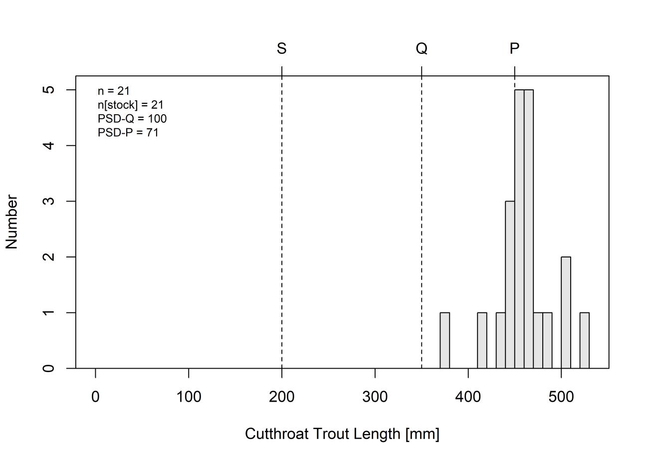
3.5.1.5 Desktop Fish Entrainment Study
Black Canyon conducted a Desktop Fish Entrainment Study in support of preparing an original license application for the Project. Recent site-specific fish community data collected during the summer and fall 2021 (HDR 2022b), as well as recent fish data collected by the WGFD were used to perform a desktop analysis of fish that may be potentially entrained at the proposed intake structure in Seminoe Reservoir. The study methods and results are described in detail in the Desktop Fish Entrainment Study Report (HDR 2022b) as Appendix C to this FLA
The potential for fish to become entrained or impinged at a hydroelectric facility is dependent on a variety of factors such as fish life history, size and swimming ability, water quality, operating regimes, inflow, and inlet/outlet and turbine configurations and locations (e.g., shoreline, deep water) (Cada et al. 1997). The risk of impingement is dependent on the presence of debris or fish screening structures at the inlet/outlet structure. Impingement occurs when a fish is held against or entrapped on the exterior inlet/outlet structure screen (i.e., bar racks, fish exclusion devices) due to forces created by the approach velocities. Entrainment occurs when the fish passes through the bar rack or fish exclusion device and is drawn into the hydraulic conveyance or powerhouse structures.
– Exhibit E
January 2023 | 189
Final License Application
Seminoe Pumped Storage Project
The potential for fish entrainment is variable throughout a given year depending on life stage and Project-specific operations. Early life stage and smaller-sized fish may be more abundant during certain portions of the year, thus increasing their susceptibility to entrainment. In addition, diurnal and seasonal movements of both small and large fish may bring them near inlet/outlet structures. Physical and operational characteristics of a given project, including bar rack spacing, approach velocities, inlet/outlet depth, waterbody stratification, and proximity of inlet/outlet structures to feeding and rearing habitats also affect the potential for a fish to become entrained. These factors were used to model entrainment and impingement potential at the Seminoe Project using methods wellestablished in the hydroelectric industry
A targeted species list was developed based on 2021 field data from the Resident Fish Survey Study (HDR 2022b) and available historical fish community studies (WGFD 2010). The list also includes consideration of fish community composition and abundance of the North Platte River and Seminoe Reservoir and any other species of interest related to state and/or federal protections (e.g., Bigmouth Shiner and Iowa Darter), or angler significance. Selected species were evaluated for potential of entrainment and impingement based on swim speed, behavior, habitat preferences, life stages, and other life history characteristics. Risk assessment of impingement and entrainment potential also considered seasonal or temperature-dependent behavioral changes in fish species.
Burst swim speeds for target or representative species were compared to the estimated inlet/outlet velocities to evaluate whether fish may be susceptible to approach velocities at the Project. Burst swim speed is the swim speed used to escape predation, maneuver through high flows, or in this case, escape approach velocities and avoid entrainment. Burst swim speed data were compiled from the literature Bell (1991); however, if speciesspecific data were unavailable, burst swim speed or darting speed was calculated as 2x critical swim speed (Bell, 1991).
Impingement and entrainment characterizations at the Project consider velocities under maximum turbine pumping capacity of 12,000 cfs, corresponding to a maximum approach velocity of 2.0 feet per second (fps). The burst speeds shown in Table 3.5-9 indicate that all target species and life stages evaluated, except for eggs and larvae, would be able to avoid entrainment at the Project given that estimated swim burst speeds are greater than maximum approach velocities at the inlet/outlet structure. Involuntary entrainment risk is low with exception of those life stages with limited swimming abilities. The likelihood of those life stages occurring in the vicinity of the inlet/outlet structure are described later in this section.
Final License Application – Exhibit E
January 2023 | 190
Seminoe Pumped Storage Project
Table 3.5-9. Average Burst Swim Speeds and Fish Sizes for Target Species and Life Stages Evaluated
Common Name Scientific Name Age Length1 Burst Swim Speed (fps)2 Reference
Brook Trout Salvelinus fontinalis Adult 6 4.9 Katopodis and Gervais 2016
Brook Stickleback Culaea inconstans Adult 4 3 Bell 1991
Brown Trout Salmo trutta Adult 13 12.5 Bell 1991
Common Carp Cyprinus carpio Adult 21 14 Bell 1991
Emerald Shiner
Notropis atherinoides Adult 1.6 5.3 Katopodis and Gervais 2016
Fathead Minnow Pimephales promelas Adult 2 2.2 Katopodis and Gervais 2016
Iowa Darter/ Johnny Darter Etheostoma spp. Adult 1.4 2.6 Katopodis and Gervais 2016
Lake Trout Salvelinus namaycush Adult 18-35 10.5 Dunlop et al. 2010
Lake Chub4 Couesius plumbeus Adult 3.5 4.4 Katopodis and Gervais 2016
Longnose Dace Rhinichthys cataractae Adult 2.6 4.8 Katopodis and Gervais 2016
Longnose Sucker/ White Sucker Catostomus spp. Adult 4 10 Bell 1991
Rainbow Trout Oncorhynchus mykiss
Juvenile/ Adult 5.9-11.8 8.9 Blank et al. 2020
Sand Shiner Notropis stramineus Adult 1.7 4.4 Katopodis and Gervais 2016
Snake River Cutthroat Trout3 Oncorhynchus clarkii Juvenile/ Adult 5.9-11.8 11.6 Blank et al. 2020
Walleye Sander vitreus Juvenile 3.15 (FL) 2.5 Peake et al. 2000
– Exhibit E
January 2023 | 191
Final License Application
Seminoe Pumped Storage Project
Seminoe Pumped Storage Project
Common Name Scientific Name Age Length1 Burst Swim Speed (fps)2 Reference
Juvenile 6.30 (FL) 6 Peake et al. 2000 Adult 13.7822.44 (FL) 5.5-8.6 Peake et al. 2000
Notes:
1 Lengths are Total Length (TL) unless otherwise noted (SL: standard length; FL: fork length)
2 Burst swim speeds were calculated as 2x critical speed (Bell 1991), unless burst speed was provided in the literature.
3 Oncorhynchus clarkii lewisi used for this subspecies.
4 Humpback Chub was used as a surrogate for Lake Chub.
For the impingement assessment, proportional estimates of body width to length (scaling factor) were compiled by Smith (1985) for all the target and representative species in this study (HDR 2022b). The scaling factor multiplied by the maximum recorded length for the species (Smith 1985), or maximum recorded length from field data collected during the Resident Fish Survey Study, resulted in a corresponding width which was then compared to the spacing of the bar racks currently proposed at the Project (0.75-inch spacing) (Table 3.5-10).
Table 3.5-10 Estimated Minimum Lengths (inches) of Target and Representative Species Excluded by the Proposed Fish Exclusion Device at the Seminoe Pumped Storage Project Common
– Exhibit E
January 2023 | 192
Final License Application
Body Width Scaling Factor1 Maximum Reported Length (inch)2 Corresponding Body Width (inch) Minimum Length (in) Excluded by
Bar Racks (0.75
Brook Trout 0.122 22 2.7 6.1 Brook Stickleback 0.138 2.7 0.4 Not Excluded Brown Trout 0.118 24 2.8 6.4 Common Carp 0.162 33 5.3 4.6 Emerald Shiner 0.108 4.0 0.4 Not
Fathead Minnow 0.156 3.5 0.5
Iowa Darter/
Darter
2.0
Lake Trout 0.104 50 5.2
Lake
Longnose
Name
Proposed
inch)
Excluded
Not Excluded
Johnny
0.118
0.2 Not Excluded
7.2
Chub 0.125 3.5 0.4 Not Excluded
Dace 0.139 3.3 0.5 Not Excluded Longnose Sucker/ White Sucker 0.126 15 1.9 6.0
Common Name
Body Width Scaling Factor1
Maximum Reported Length (inch)2
Corresponding Body Width (inch)
Minimum Length (in) Excluded by Proposed Bar Racks (0.75 inch)
Rainbow Trout 0.114 21 2.4 6.6
Sand Shiner4 0.126 3.5 0.4 Not Excluded
Snake River Cutthroat Trout3 0.099 20 2.0 7.6
Walleye 0.125 24 3.0 6.0
White Sucker 0.146 22 3.2 5.1
Notes:
1 Scaling factor (Smith 1985) expresses body width as a proportion of length based on proportional measurements.
2 Maximum lengths reported by Smith (1985) or as collected in the 2021 Resident Fish Survey Study.
3 Cutthroat Trout not represented in Smith (1985); a scaling factor of Coho Salmon was used.
4 Sand Shiner used as Bigmouth Shiner Surrogate.
Several smaller species including Brook Stickleback, Iowa and Johnny darters, Fathead Minnow, Lake Chub, Longnose Dace, and Sand and Emerald shiners would pass through the proposed fish exclusion bar racks at the Project (Table 3.5-11). Young life stages, juveniles, and smaller adults of some target species could physically pass through the fish exclusion bar racks, but larger individuals would be excluded. A few Walleye and White Sucker individuals collected in the Resident Fish Survey Study were below the minimum size excluded by the proposed fish exclusion bar racks, comprising twenty and one percent of the catch, respectively, in the area where the inlet/outlet structure is proposed. All adult trout species would be excluded from the proposed 0.75-inch fish exclusion bar racks. The fish that would be excluded by the fish exclusion bar racks would be susceptible to impingement, however, all these species have burst speeds (Table 3.5-9) much greater than the estimated through-rack velocities; therefore, these fish would likely avoid impingement at the inlet
In addition, most freshwater fish species have demersal and/or adhesive eggs and larvae that remain close to areas with protective cover, further reducing their risk of entrainment. Ichthyoplankton mortality from turbine passage at hydropower projects is generally expected to be low and has been estimated to be between two and five percent (Cada 1991). Most of the lotic spawning species near the Project (i.e., trout species), move upstream and spawn in the larger tributaries located approximately 20 miles upstream from the proposed Project vicinity (Raleigh et al. 1984; Bernstein and Montgomery 2008, Black Canyon 2020b). The current design assumes the inlet/outlet structure opening will be located near the center of the channel, just upstream of the existing Seminoe Dam, and will be at located at a depth of at least 200 feet at Seminoe Reservoir normal maximum high-water elevation (which provides a minimum submergence of 30 feet at Seminoe Reservoir lower water elevation). As such, the likelihood of eggs and other non-motile life stages being spawned near or drifting downstream in proximity of the proposed inlet/outlet structure in Seminoe Reservoir, where they could be entrained, is low
Final License Application – Exhibit E
Project January 2023 | 193
Seminoe Pumped Storage
The estimated mean monthly and mean annual entrainment rates by target species based on the Electric Power Research Institute (EPRI) (1997) database and the currently proposed Project design maximum pumping capacity are presented in Table 3.5-11 Table 3.5-12 provides the estimated seasonal and mean annual entrainment rates for the target species at the maximum pumping capacity of 12,000 cubic feet per second (cfs). The estimates include all fish size classes (i.e., life stages) combined for each of the target species. White Sucker has the greatest potential entrainment rate (32 percent of total) of the target species based on the EPRI database, followed by Emerald Shiner (18 percent of total), Fathead Minnow (10 percent of total), Walleye (9 percent of total), and Brook Stickleback (8 percent of total). Trout species such as Rainbow and Snake River Cutthroat Trout, species often sought by anglers, have low estimated entrainment rates of the target species, each having roughly less than one percent of the total entrainment rate.
Table 3.5-11 Estimated Seasonal and Annual Entrainment Rates of Target Species by Fish Size Class from 34 Hydroelectric Developments (EPRI 1997)
Fish Size (Total Length)
Mean Monthly Entrainment Rate (fish/hr) by Season Average Annual Entrainment Rate (fish/hr) Winter Spring Summer Fall
0-2" 0.05 0.09 0.45 0.04 0.16 2.1-4" 0.09 0.21 0.30 0.10 0.18 4.1-6" 0.15 0.06 0.04 0.05 0.07 6.1-8" 0.26 0.05 0.01 0.23 0.14 8.1-10" 0.09 0.03 0.01 0.17 0.08 10.1-15" 0.02 0.05 0.02 0.03 0.03 15.1-20" 0.01 0.01 0.00 0.01 0.01 20.1-25" 0.00 0.00 0.00 0.00 0.00 25.1-30" 0.00 0.00 0.00 0.00 0.00 >30" 0.00 0.00 0.00 0.00 0.00
Total 0.68 0.51 0.84 0.62 0.66
Note: Values in bold represent average fish per hour entrainment from 34 sites selected from the EPRI database and were adjusted for maximum pumping capacity (cfs) at the Project.
Final License Application – Exhibit E
January 2023 | 194
Seminoe Pumped Storage Project
Table 3.5-12. Seasonal and Mean Annual Entrainment Rates for Target Species at the Proposed Maximum Pumping Capacity (12,000 cfs)
Target Species
Mean Monthly Entrainment Rate (fish/hr) by Season* Mean Annual Entrainment Rate (fish/hr)* Winter Spring Summer Fall
Bigmouth Shiner 0.71 1.16 0.46 0.21 0.64
Brook Trout 8.06 2.46 0.38 2.36 3.32
Brook Stickleback 3.74 9.99 2.62 1.42 4.44
Brown Trout 0.55 0.81 0.08 1.13 0.64
Common Carp 0.38 0.29 0.70 0.24 0.40
Emerald Shiner 3.27 10.67 10.88 15.25 10.01
Fathead Minnow 0.45 10.06 7.10 4.48 5.52
Iowa Darter 0.00 0.48 0.08 0.93 0.37
Johnny Darter 1.64 2.03 1.44 0.62 1.43
Lake Chub 0.00 0.04 0.00 0.00 0.01
Lake Trout 8.06 2.46 0.38 2.36 3.32
Longnose Dace 0.12 1.61 1.63 0.76 0.10
Longnose Sucker 0.18 0.91 0.81 0.59 0.62
Rainbow Trout 0.75 0.23 0.05 0.40 0.35 Sand Shiner 0.71 1.16 0.46 0.21 0.64
Snake River Cutthroat Trout 0.75 0.23 0.05 0.40 0.35
Walleye 1.80 1.96 14.23 2.84 5.21
White Sucker 20.33 10.46 21.89 19.19 17.97 Sum 51.47 57.03 63.22 53.40 55.35
* These rates were calculated based on the maximum pumping capacity based on the current proposed design. However, it is feasible that the Project would be operated below the maximum load, utilizing just one or two turbine units for certain periods of each day. As such, these entrainment rates could be viewed as conservative (i.e., overestimates) of the potential entrainment risk at the proposed Project
3.5.1.6
Aquatic Environment in the Project Vicinity
As previously mentioned, the Project will be located in the North Platte River Basin, which is a subbasin of the Platte River Basin, composed of the North and South Platte River Basins (Wyoming Water Development Commission 2016). Within the North Platte River Basin, the proposed upper reservoir for the Project will be located in the PathfinderSeminoe Subbasin (HUC 10180003) and existing Seminoe Reservoir (lower reservoir) is
Final License Application – Exhibit E
January 2023 | 195
Seminoe Pumped Storage Project
located in both Pathfinder-Seminoe Subbasin and Medicine Bow Subbasin (HUC 10180004) (Black Canyon 2020b).
Seminoe Reservoir
Most of the aquatic habitat existing within the Project vicinity is within Seminoe Reservoir. Seminoe Reservoir is a dimictic lake with a relatively weak and brief summer thermal stratification, isothermal conditions in spring and fall, and ice cover in the winter (Reclamation 1981). However, stratification lasts a relatively short period of time (June to August) due to the continual withdrawal of cooler hypolimnetic waters through the dam’s low-level outlets (Black Canyon Hydro 2020, Reclamation 1981). The lake is further characterized as alkaline, hard, and somewhat saline (Reclamation 1981). Characteristics of Seminoe Reservoir, such as surface area, volume, and maximum and minimum surface elevations are provided in Section 3.4.1.3 above and Exhibit B of this license application.
The North Platte River is the primary water source of Seminoe Reservoir, followed by Medicine Bow River (USEPA 1977). Other smaller tributaries include Cottonwood Creek, Sips Creek, Hurt Creek, Saylor Creek, Austin Creek, and Troublesome Creek (Black Canyon 2020b), as well as Obrien Creek and many draws, ditches, and swales.
The amount of aquatic habitat in Seminoe Reservoir depends on the reservoir surface water elevation and habitat quality characteristics, such as habitat complexity and water quality. A higher surface water elevation provides a greater amount of aquatic habitat, both in total volume and in the littoral zone. The minimum to maximum operating pool elevation can fluctuate up to 67 feet (Stantec 2022).
Based on fish seining investigations primarily conducted to detect changes in relative abundance of common littoral zone fishes in Wyoming reservoirs, Bailey (2005) described Seminoe Reservoir as having very little, if any, aquatic vegetation, with most reservoir substrates dominated by sand and gravel that provide limited habitat complexity. Based on recent observations of exposed aquatic habitat within Seminoe Reservoir during the Resident Fish Survey Study (HDR 2022b), Bailey’s description is still accurate for large areas within Seminoe Reservoir
As previously described, Black Canyon performed a Resident Fish Survey Study that encompassed approximately the downstream one-third of Seminoe Reservoir. This area was further divided into five sub-areas for ease of sampling and data processing. A detailed description of the aquatic habitat associated with each subsection is provided below. Much of the aquatic habitat consists of gradual to steep drop-offs from the shoreline and the shallow sections of Seminoe Reservoir within the study area are dominated by sandy substrate. General information regarding each subsection surface area, shoreline length and approximate center location is provided in Table 3.5-13 and additional descriptive text of each sample area is provided below. Sampling areas are identified above in Figure 3.5-1
– Exhibit E
Final License Application
January 2023 | 196
Seminoe Pumped Storage Project
Table 3.5-13. Resident Fish Survey Study Sample Area Habitat Details
Sample Area Sample Area Nickname
Approximate Center Coordinates
Approximate Surface Area (acres)
Approximate Shoreline Length (miles)
1 The Canyon 42.150438,106.899217 157 5.3
2 State Campgrounds/ Sunshine Beach 42.134163,106.883694 878 12.4
3 Sand Draw 42.118771,106.860005 907 7.1
4 Mini Tetons 42.098204,106.840693 1,110 9.6
5 Sand Mountain 42.09483,106.857945 912 8.2
Totals 3,964 42.6
Source: HDR 2022b
Area 1 – The Canyon
During the 2021 Resident Fish Survey, observed water depths in Area 1 ranged from 0 feet at the shoreline to approximately 125 feet along the thalweg (HDR 2022b), with maximum water depths near Seminoe Dam extending to over 175 feet (Fishermap.Org, 2022). The shoreline of Area 1 is dominated by steep bedrock cliffs with occasional large boulder and bedrock shard complexes which extend deep into the canyon waters making up the dominant visible substrate within the littoral zone. Areas of sand substrate and submerged aquatic vegetation are visually absent in Area 1 except for a few small sand beaches occurring in areas with lower slope. These areas generally consist of a short, gradual slope of sand or fine substrate leading to a significant drop-off a short distance from shore. Shoreline slopes generally ranged from vertical to near vertical and occurred along approximately 90 percent of the shoreline within the Canyon. No tributaries were observed entering this area (HDR 2022b).
Area 2 – “State Campgrounds/Sunshine Beach”
The shoreline of Area 2 is dominated by steep shores with occasional vertical cliffs on the western shore and areas of moderate to gentle slopes on the western shore. The eastern shore is steeper than the eastern shore in most areas with sandstone, red sandstone, and bedrock cliffs and occasional large boulder and bedrock shard complexes; some extending into the littoral zone Some areas on both the eastern and western shores contain long stepped sand beaches between the boulder and bedrock outcrops Observed depths in Area 2 ranged from 0 at the shoreline to approximately 100 feet in the thalweg (HDR 2022b). Areas of sand substrate are much more dominant on the eastern shore than the western shore. Submerged aquatic vegetation was visually absent from this area. Three unnamed tributaries were observed entering Seminoe Reservoir from the western shore and Red Spring Draw enters on the eastern shore of Area 2 northwest of Hurt Gulch. These tributaries are assumed to be categorized as ephemeral tributaries.
Final License Application – Exhibit E
Project January 2023 | 197
Seminoe Pumped Storage
Area 3- “Sand Draw”
Most of the observed substrate in Area 3 is dominated by sand, with a few areas of boulders and large bedrock shards sporadically located along the shoreline that extend into the littoral zone (HDR 2022b) A small, relatively unvegetated island is located within Seminoe Reservoir in the northwestern portion of Area 3 south of Hurt Gulch. Observed substrate extends into the littoral zone from the island and is dominated by areas of exposed bedrock and scattered areas of boulder and rubble substrate. The western shore is also dominated by sand substrate however, the shoreline slopes are more gradual, with only minimal boulder outcrops extending into the littoral zone (HDR 2022b). This area includes the inlets from Cottonwood Creek and Hurt Gulch on the eastern shore. Observed depths in Area 3 during the Resident Fish Survey ranged from 0 feet at the shoreline to approximately 85 feet, however mapped depths can reach to approximately 160 feet within the thalweg of Area 3 (Fishermap.Org, 2022).
Area 4 – “Mini Tetons”
Most of the shoreline and littoral habitat in this area are gently sloping with sand, gravel, or cobble substrates, the littoral zone surrounding the “Mini Tetons” (two large boulder/bedrock shard outcrops protruding from the reservoir in the mid-eastern portion of this area) and portions of the southern shore (especially the western end) along Horseshoe Ridge consist of bedrock, bedrock shards, and large boulders with a much steeper slope (HDR 2022b). Substrates at the inlet of Saylor Creek consisted of a mix of deep sand and silt. Sips Creek also drains into Area 4 on its eastern shore just north of Saylor Creek (HDR 2022b). Observed depths in Area 4 during the Resident Fish Survey ranged from 0 to approximately 90 feet, however mapped depths can be as great as approximately 140 feet in the thalweg (Fishermap.Org, 2022)
Area 5 – “Sand Mountain”
Much of Area 5 is dominated by sand substrate, ranging from gradual to steep slopes and included the shoreline of “Sand Mountain”15 and the inlet of Hurt Creek on the western shore (HDR 2022b) Sand Mountain is a popular informal recreation area where boaters pull up to the sandy beach to swim and sunbathe. Sand Mountain is steep on the shoreward side and is popularly used for dirt biking and dune climbing. The rest of the western shoreline is also dominated by sand substrate; however, the shoreline slopes are more gradual with only minimal outcrops extending into the littoral zone. Miller Cove on the western shore also contains steep bedrock cliffs extending into the littoral zone. Observed depths in Area 5 during the Resident Fish Survey ranged from 0 feet at the shoreline to approximately 115 feet but can have depths of up to approximately 140 feet (Fishermap.Org, 2022).
15 “Sand Mountain” is located at the eastern end of ID Ridge and the area adjacent to Seminoe Reservoir in this area contains young geologic features dominated by sand dunes.
Final License Application – Exhibit E
January 2023 | 198
Seminoe Pumped Storage Project
Non-Seminoe Reservoir Aquatic Features
As described above in Section 3.4, Black Canyon performed an Aquatic Resources Delineation to assess the nature and degree of the Project’s potential impacts on areas potentially subject to the jurisdiction of USACE under Section 404 of the CWA. Based on the results of the study, several aquatic resources were identified in the Project vicinity, including 13 freshwater emergent wetlands, 11 ephemeral streams, three intermittent streams, and five perennial streams, most of which occur along the proposed transmission line corridor and access roads Most of these features are located at a high elevation often in steep terrain and have few, if any, associated fish or aquatic biota. Most of these aquatic resources are considered low-quality due to the lack of persistent year-round stream flow, relatively high-water temperatures, and limited riparian vegetation (HDR 2022f). Limited information is available describing the fisheries and aquatic resources of these tributary features
The complete methods and results of the Section 404 Preliminary Jurisdictional Determination Study are presented in the Aquatic Resources Delineation Report (HDR 2022f) (included as Appendix B).
3.5.1.7 Amphibians
Amphibian species in Seminoe Reservoir and within the Project vicinity are not welldocumented Many of the aquatic habitats (e.g., ephemeral and intermittent streams) may or may not contain aquatic life, which is largely dependent on the frequency and duration that surface water is present.
Though not often observed, at least six species of amphibians are native to the region.
Amphibian habitat preferences are primarily influenced by food and reproductive requirements. Species that may be found in the Project vicinity may include Northern Leopard Frog (Lithobates pipiens), tiger salamanders (Ambystoma mavortium), boreal chorus frogs (Pseudacris maculata), and Plains spadefoot (Spea bombifrons) in the Shirley Basin (Orabona et al. 2016, BLM 2008b). The Boreal Toad (Anaxyrus boreas), Columbia Spotted Frog (Rana luteiventris), and Great Basin Spadefoot (Spea intermontane) are unlikely to occur in the Project vicinity.
The Columbia Spotted Frog, Great Basin Spadefoot, and Northern Leopard Frog are listed as Wyoming BLM Sensitive Species and WGFD SGCN Tier II species. The Boreal Toad is also listed as a Wyoming BLM Sensitive Species but is a WGFD SGCN Tier I species None of these species were observed during the 2021 Habitat Assessment and Rare, Threatened, and Endangered Species Evaluation Study (HDR 2022c) (Appendix G) Based on range and habitat data analyzed as part of the 2021 Habitat Assessment and Rare, Threatened, and Endangered Species Evaluation Study (HDR 2022c), the Boreal Toad, Columbia Spotted Frog, and Great Basin Spadefoot do not occur in the Project vicinity. However, because the Northern Leopard Frog is a widespread species, relatively common in Wyoming, and occurs in a broad range of aquatic environments, it is likely present in the Project vicinity (HDR 2022c)
Final License Application – Exhibit E
January 2023 | 199
Seminoe Pumped Storage Project
3.5.1.8
Macroinvertebrates
Limited information exists regarding the aquatic macroinvertebrates that may exist in the Platte River Basin or Seminoe Reservoir and streams within the Footprint of Potential Disturbance. The only macroinvertebrate study of Seminoe Reservoir took place in 1976. Numerous locations were sampled within Seminoe Reservoir and of these samples, two types of benthic invertebrates were identified: chironomids (nonbiting midges) and oligochaetes (Reclamation 1976). Both organisms play an important role in the exchange of substances between the bottom sediments and the adjacent waters (Reclamation 1981).
Chironomids dwell in lake sediments and may feed on detritus or plant and animal matter. Chironomids have a strong ecological role serving as a food resource for fish such as suckers, which then act as prey for predators such as Walleye. Oligochaetes are aquatic earthworms that burrow in bottom sediments and fill a similar ecological role as chironomids (Reclamation 1976).
In the Casper region, two species of fairy shrimp have been found and collected during amphibian surveys. Many invertebrates, including freshwater shrimp, live in seasonal wetlands (puddles, stock tanks, playas) alongside amphibians. Freshwater shrimp eggs may remain dry for several months or up to a year, then hatch after heavy rainfall. These shrimp are important prey for a variety of organisms, including amphibians and birds, and may not survive in wetlands with fish. Though freshwater shrimp may be eaten by adult amphibians, they may feed on amphibian eggs and larvae (WGFD 2013). Freshwater shrimp in Wyoming include several species of fairy shrimp and tadpole shrimp. Fairy shrimp look similar to saltwater shrimp but are much smaller. They are usually under an inch long and light beige in coloration, though some may appear to be bright green or orange. Tadpole shrimp have been found in other areas of Wyoming and may live in the Casper region as well. They look similar to tadpoles when swimming in the water, but when in hand, tadpole shrimp appear similar to miniature horseshoe crabs (WGFD 2013).
Similar to benthic macroinvertebrates, little information is known regarding crayfish in Wyoming (WGFD 2017c). Therefore, all native crayfishes are considered SGCN except for the virile crayfish (Orconectes virilis). Two crayfish surveys have been performed across the state: one between 1985 and 1987, and one from 2007 to 2009. In addition to the virile crayfish, three other species were identified: calico crayfish (Orconectes immunis), ringed crayfish (O. neglectus neglectus), and devil crayfish (Cambarus diogenes). Only the ringed crayfish was identified during both survey periods. The calico crayfish was the most widespread species in the Platte River Basin but appears to have been displaced in many places by the virile crayfish (WGFD 2017c).
In addition to crayfish identified from the two historical crayfish surveys, the Resident Fish Survey Study field teams observed a strong crayfish population within Seminoe Reservoir, specifically in Areas 1 and 2 (Figure 3.5-1). Crayfish were observed during the night electrofishing surveys as were visually observed scaling the rock walls and embankments in large numbers. Crayfish are assumed to be an important food resource to the fishery community of Seminoe Reservoir. During the Resident Fish Survey Study, Walleye were observed regurgitating their stomach contents, as a result of the effects from electrofishing
Final License Application – Exhibit E
Project January 2023 | 200
Seminoe Pumped Storage
or accumulated stress, and those contents were almost entirely the remains of crayfish (HDR 2022b).
3.5.1.9 Invasive Species
Several types of aquatic invasive species (AIS) are present in Wyoming, including fish, pathogens, plants, and mollusks (WGFD 2017c). The most notable AIS in Wyoming is currently the New Zealand Mudsnail (Potamopyrgus antipodarum) and whirling disease (WGFD 2010), both of which affect salmonids. The New Zealand Mudsnail was recently discovered in the Casper Region (WGFD 2019c). These AIS can impact native species through competition, disease, changes in food resources, and direct mortality. For example, the New Zealand Mudsnail can form dense colonies where it spatially outcompetes native insect communities, which are a primary food resource for young trout and other native species (National Park Service [NPS] 2017). It also consumes large amounts of algae, which reduces a food resource available for native fish and aquatic invertebrates. Whirling disease is caused by a microscopic parasite (Myxobolus cerebralis) originating from Europe that can infect trout and salmon (NPS 2020a). The parasite feeds on the fish’s cartilage and cause skeletal deformities, a blackened tail, and a whirling swimming behavior and can eventually lead to mortality.
In the Platte River Basin several AIS are present including curly pondweed (Potamogeton crispus) observed downstream of Seminoe Dam, rusty crayfish (Orconectes rusticus) observed in Wagon Hound Creek, a tributary to the North Platte River downstream of Casper, Asian clam (Corbicula fluminea) observed in the North Platte River and the Guernsey Reservoir near Guernsey, and Brook Stickleback (Culaea inconstans) observed on the North Platte River upstream and within Seminoe Reservoir (WGFD 2022c)
Curly pondweed was introduced to the U.S. in the 1800s and quickly spread. It is currently found in the Miracle Mile section of the North Platte River, downstream of Seminoe Reservoir. The rusty crayfish are native to the southern U.S. (NPS 2017) and introduced to Wagonhound Creek (a tributary of the North Platte River) through the use of bait buckets. Rusty crayfish can outcompete native crayfishes and destroy native plant communities. Rusty crayfish have not spread due to repeated chemical treatments (WGFD 2017c, 2019).
Asian clams were discovered in the Columbia River in 1938 and are now widespread throughout the U.S. (WGFD 2017c). Asian clams cause damage with biofouling at power generation and water supply facilities. Asian clams are found in the Laramie River upstream of the town of Laramie and in the North Platte River downstream of Guernsey Reservoir.
The Brook Stickleback was introduced through bait introductions or accidentally through aquaculture and are widespread through the Platte River Basin, including the PathfinderSeminoe Reservoir drainage (WGFD 2017c). Other invasive species, such as zebra mussels (Dressena polymorpha), quagga mussels (D. bugensis) and Silver Carp (Hypophthalmichthys molitrix) are present in neighboring states and present high risk to introduction in Wyoming (WGFD 2017c).
Final License Application – Exhibit E
January 2023 | 201
Seminoe Pumped Storage Project
To address the concern for the expansion of AIS, the WGFD preforms watercraft inspections at several key locations entering the Platte River Basin and at major waterbodies. Twenty-one (21) waterbodies are monitored on an annual basis to identify the presence of any newly introduced invasive species and help prevent the spread of species to new waters. Watercraft inspections are conducted at Seminoe Reservoir on a rotating basis along with several other waterbodies (WGFD 2019). In 2019, 6,585 inspections were made and of those, 112 were considered high risk and 32 required decontaminations before launching. AIS monitoring by the WGFD is also ongoing in the Casper area and includes plankton net tow sampling, water quality sampling, and substrate sampling (HDR 2020).
During the 2021 Resident Fish Survey Study (HDR 2022b), no invasive aquatic species were collected; although several introduced, nonnative, or stocked fish (e.g., Common Carp, Brown Trout and Rainbow Trout) were repeatedly captured.
3.5.1.10 Rare, Threatened, and Endangered Aquatic Species
A list of species protected under the Endangered Species Act (ESA) potentially occurring within the Project Area was prepared using the USFWS IPaC website (USFWS 2021). One ESA Endangered fish species, the Pallid Sturgeon (Scaphirhynchus albus), was reported from the IPaC report as having the potential to occur within the Project Area. No designated critical habitat for any ESA-listed aquatic species occurs in the Footprint of Potential Disturbance. The unofficial IPaC report is included in Appendix G
During 2021 Resident Fish Survey Study (HDR 2022b), no rare, threatened, or endangered aquatic species were identified, observed, or collected. However, WGFD has designated SGCN to species whose conservation status warrants increased management attention, funding, as well as consideration in conservation, land use, and development planning in Wyoming (WGFD 2017c). Furthermore, the aquatic species that are placed in this category (Sauger, Goldeneye, and Plains Minnow) are currently extirpated from the Platte River Basin (WGFD 2010).
The Project’s upper reservoir and portions of the proposed transmission line occur on BLM-manage public lands The BLM maintains a list of special status species for Wyoming (BLM 2010) Included in this list as occurring in Carbon County, Wyoming, is the Colorado River Cutthroat Trout. The Colorado River Cutthroat Trout is one of the strains of trout stocked by the WGFD and was last stocked in Seminoe Reservoir in 2019 (WGFD 2021b)
3.5.2 Direct and Indirect Environmental Effects – Fish and Aquatic Resources
This section presents information available currently about potential direct and indirect effects of the proposed Project on fish and aquatic resources.
3.5.2.1
Construction-related effects
Potential short term direct effects on fish and aquatic resources largely stem from the inwater and ground disturbing activities associated with Project-related construction. Short-
Final License Application – Exhibit E
January 2023 | 202
Seminoe Pumped Storage Project
term direct effects have the potential to produce fish injury and mortality from propeller or boat strikes due to construction activities resulting in an increase in boat and barge traffic in the lower portions of Seminoe Reservoir (Areas 1 and 2 as shown on Figure 3.5-1 and described in Section 3.5.1.5 above). This type of effect is likely low due to the heavy volume of existing seasonal boat traffic currently experienced in Seminoe Reservoir in relation to the fish utilizing these habitats in and around the construction and laydown areas. Boat and barge navigation speeds during construction activities will be much lower than the recreational and angling boats and crafts currently utilizing the downstream portions of Seminoe Reservoir.
Sound vibrations from potential drilling, blasting and increased boat and barge traffic related to Project construction have the potential to deter habitat use and alter fish habitat and movement patterns near the construction sites and access areas. These effects will be temporary and will be limited in occurrence to preparation and construction activities. Based on the results of the Resident Fish Survey, the construction and laydown areas (Areas 1 and 2) were dominated by larger predatory fish (i.e., Walleye and trout) sporadically distributed along the shoreline and in shallow areas near steep drop-offs. Large omnivorous scavengers (suckers) dominated the deep-water catches in the location of the proposed intake. These fish are expected to largely avoid areas of heavy boat traffic and loud or consistent in-water noise from construction activities and would likely relocate to areas with less activity.
Potential impacts to crayfish and aquatic macroinvertebrates may also occur in areas at or near where ground disturbing activities may occur. These organisms are less mobile and may either relocate to less impacted areas or suffer mortality from being crushed or buried. Best management practices will be implemented to minimize the effects of construction activities on fish and aquatic species within the affected littoral and riparian zones, and the pelagic bottom of Seminoe Reservoir where construction occurs.
In-water construction of the inlet/outlet structure and appurtenant facilities may cause a short-term indirect effect on the fish and aquatic resources utilizing the downstream portion of Seminoe Reservoir (i.e., the Canyon) resulting from the disturbance of the sediment on the reservoir bottom (increased turbidity). Short-term effects include suspension of the sediment causing increased turbidity and decreasing light penetration into the water column. Increased turbidity can cause fish and aquatic species that are visual predators (i.e., Walleye) to have reduced visibility and thus decrease their ability to predate as effectively. This effect is assumed to be short-lived and to only occur during the construction of the inlet/outlet structure, construction and use of boat ramps, and any adjacent shoreline construction. Fish are presumed to temporarily relocate to adjacent habitats where the turbidity is conducive to visual feeding.
Pallid Sturgeon have been observed in the Lower Platte River from the Elkhorn River confluence in Nebraska to the Missouri River (PRRIP undated-e). Based on the distance from the Lower Platte River to the proposed Project on the North Platte River and at least four impassable barriers and two diversion dams, no direct effects to the Pallid Sturgeon are expected to result from the Proposed Project as this species is not expected to be present in Seminoe Reservoir
Final License Application – Exhibit E
January 2023 | 203
Seminoe Pumped Storage Project
3.5.2.2
Most of the unstocked populations of the Colorado River Cutthroat Trout are restricted to relatively small (< 6 kilometers) and/or unproductive headwaters (above 8,000 feet). They require cool, clear water and well vegetated streambanks for cover and bank stability (BLM 2010). Unstocked populations of the Colorado River Cutthroat Trout are not expected to occur in Seminoe Reservoir or the downstream reach of the North Platte River and therefore, no effects to this species are expected to occur from the Proposed Project.
Operations-related effects
Long-term direct effects include the potential fish injury and mortality due to Project operations, and potential revisions to Seminoe Reservoir aquatic habitats due to Project operations
Potential Fish Injury and Mortality
As stated previously, the potential for fish to become entrained or impinged at hydroelectric facilities is dependent on a variety of factors such as fish life history, size and swimming ability, water quality, operating regimes, inflow, and inlet/outlet and turbine configurations and locations (e.g., shoreline, deep water) (Cada et al. 1997). Furthermore, the risk of impingement is dependent on the presence of debris or fish screening structures at the inlet/outlet structure. Habitat and entrainment analyses suggest that the areas in proximity to the inlet-outlet structure provides limited suitable habitat for the species in Seminoe Reservoir, and none that is rare or unusual as compared to the remaining portions of the reservoir that could be used alternatively. Furthermore, many of the species in Seminoe Reservoir, such as trout species, exhibit localized migrations for spawning in tributaries, away from the inlet/outlet location.
The number of fish estimated to be entrained at the Project is attributed to the relative abundance of specific species, life history characteristics, physical and operational characteristics of the Project, reservoir stratification, and proximity of the structures to feeding and rearing habitat. Based on the habitat in the vicinity of the intake structure, it is unlikely that this is the preferred spawning, rearing or feeding habitat for walleye in Seminoe Reservoir. Observations during the Resident Fish Survey study show that the lentic portion of the lower reservoir (i.e., the intake vicinity) contains relatively ubiquitous and generic habitats and homogenous substrates. Although some walleye and other fish may be potentially entrained at the Project, the burst swimming speeds for juvenile and adult walleye (as well as juvenile and adult species targeted by the Fish Entrainment study report are greater than the calculated maximum intake velocities at the Project. The calculated velocities at the Project intake are low and are expected to decrease and decay substantially within a very short distance from the face of the bar rack. Fish burst speeds coupled with the limited spawning, feeding and rearing habitat preferred by walleye and other resident fish located in the vicinity of the Project intakes would significantly reduce the number of walleye and other fish from becoming entrained by the Project. Peak velocities at the intakes are generally short lived and tend to decrease as the lower reservoir elevations decrease and are confined to the face of the bar racks or screens (Bear Swamp Power Company 2018).
Final License Application – Exhibit E
January 2023 | 204
Seminoe Pumped Storage Project
Seminoe Pumped Storage Project
Based on these considerations, and the low estimated approach velocity of the inlet structure and proposed fish exclusion bar rack design, overall entrainment and impingement risk to aquatic species in Seminoe Reservoir is low and these effects are not likely to significantly impact reservoir populations
Total dissolved gas supersaturation downstream of some hydroelectric dams can cause localized gas bubble trauma or mortality in fish and other aquatic species, primarily as a result of air mixing with water during spillway use or as it is injected into turbines during operations to prevent cavitation. There is no evidence that gas supersaturation adversely affects hatching success of salmonid embryos (AFGD undated). Gas bubble disease can result in low-level fish mortality, however adult and juvenile fish exposed to high total dissolved gases will seek greater depth or cooler waters where the saturation level is lower (AFGD undated). Because pumped storage operations do not involve spillway use and no air injection will be required as part of Project operations, gas supersaturation is not anticipated to occur.
As described above, the Project will create an “open loop” hydraulic arrangement between the existing Seminoe Reservoir and the proposed upper reservoir. The Project will not change the operations, area, or volume of Seminoe Reservoir; thus no injury or mortality to fishery resources from supersaturation within and downstream of Seminoe Reservoir are expected from construction and operation of the Project.
Potential Effects on Seminoe Reservoir Aquatic Habitats
As discussed in Section 2.1.1.2, Project operations are predicated to have a daily surface water fluctuation of 6.4 inches under normal operating headwater elevation of 6,357 feet. Any change in Seminoe Reservoir elevation due to Project operations will be within the historic range of Seminoe Reservoir water levels and, therefore, any impacts to aquatic habitats would occur in areas where Seminoe Reservoir has operated historically. Much of Seminoe Reservoir aquatic habitat consists of gradual to steep drop-offs from the shoreline and shallow sections of Seminoe Reservoir dominated by sandy substrate. Project operations will result in gradual changes in reservoir elevation over the course of pumping and generation events. At Seminoe Reservoir low operating elevation of 6,290 feet, a full 9.7 hour generation event will produce less than a 2 inch per hour increase in reservoir elevation. A full pumping event will occur over an average of 17.05-hour period at a rate of less than 2 inch per hour change in elevation. Project effects on Seminoe Reservoir water level and surface area will occur within a band where wave action has historically altered water levels and impacted aquatic habitat conditions on an intra-day and even intra-hour scale.
Final License Application – Exhibit E
January 2023 | 205
3.5.3 Cumulative Environmental Effects Related to Fish and Aquatic Resources
As noted in Table 3.2-1, the geographic scope for fish and aquatic resources is the HUC-8 watersheds in the Project vicinity since impacts within a HUC-8 watershed sufficiently accounts for impacts on fish and aquatic resources that would be directly affected by construction activities and for indirect impacts such as changes in habitat availability and displacement of transient species. The HUC-8 watersheds that comprise the geographic scope are the Pathfinder-Seminoe Reservoirs watershed (HUC 10180003) and the Medicine Bow watershed (HUC 10180004). As detailed in Table 3.2-2, there are six projects that occur within the geographic scope for fish and aquatic resources: 1) WPCI Project, 2) Two Rivers Wind Energy Project, 3) Lucky Star 1 Wind Project, 4) Gateway West Transmission Line Project, 5) Gateway South Transmission Line Project, and 6) Rock Creek Wind Energy Center.
Given that water quality and aquatic habitats are highly interrelated, this section is supported by the assessment of cumulative impacts on water resources (Section 3.4.3).
Issues Identified for Analysis
Habitat quality is the primary limiting factor of any fish or aquatic species population and can be tied directly to recruitment and fecundity, as well as short-and long-term survivability. Large scale development projects and the introduction of nonnative species are big casual factors.
Modification of habitat components can result in cumulative impacts on populations at the local level and/or across a species’ known range. Special status species are highly prone to adverse impacts from project related disturbance resulting in habitat alteration.
Modification of aquatic habitats supporting fish, amphibians, and other aquatic organisms can result from cumulative impacts including ground disturbance, water draw down, and direct take from recreation.
Results
Construction of the Project and other projects in the geographic scope could have temporary cumulative impacts on surface water quality, as well as on fish and other organisms that inhabit affected waters. Past and present development has contributed to some level of ground disturbance that, over time, is expected to be reclaimed in compliance with federal and state requirements. However, long-term impacts could result in the removal or modification of riparian and wetland habitats and destabilization of soils in the watersheds feeding areas where fragile soils are highly prone to erosion.
Ground disturbance from implementation of the Project and other reasonably foreseeable future actions is expected to result in localized short-term cumulative effects on fish and aquatic resources, namely though sediment loading, increased turbidity, and modification of habitats in the watershed. Short-term impacts could include destabilization of sensitive or otherwise fragile soils and modification of upland, riparian, and wetland habitats potentially supporting amphibians and other aquatic or semi-aquatic species. Impacts on
Final License Application – Exhibit E
January 2023 | 206
Seminoe Pumped Storage Project
3.5.4
soils and vegetation could result in short-term elevated sediment loading in surface waters, increased water temperature, and decreased habitat availability, degrading the quality and availability of those habitats. However, implementation of design features of the Project and selective mitigation measures, including reclamation of disturbed areas, would be required for authorization and construction on BLM-administered land Following reclamation of Project disturbance, adverse impacts on aquatic habitats would be mostly or completely mitigated, resulting in normalized levels of sediment loading and water turbidity and revegetation of disturbed habitats.
Most Project-related impacts to fish and aquatic resources would be direct or indirect and not cumulative. Potential cumulative effects would be temporary and isolated to the specific Project construction workspaces; therefore, making it unlikely that there would be cumulative impacts to a fish species within it’s known range within the watersheds. Since the two overlapping, reasonably foreseeable future actions (Gateway West Transmission Line Project and Gateway South Transmission Line Project) are expected to be done with construction-related activities by the start of Project construction, cumulative impacts on fish and aquatic resources are unlikely.
Agency Consultation and Applicant Recommendations
3.5.4.1 Agency Consultation
The NOI and PAD for the proposed Project were filed with the FERC on April 20, 2020. Comments were received from several agencies including BLM and WGFD, and individuals. Black Canyon held a virtual joint agency-public meeting on July 21, 2020, and has continued consultation with stakeholders since that time. Black Canyon distributed its proposed resource study plans for the Project on August 3, 2020, and March 23, 2021. Black Canyon distributed the DLA on June 6, 2022. Responses to stakeholder comments and Black Canyon’s Record of Consultation are provided as Appendix A. WDEQ, USEPA, BLM, USFWS, WGFD, and FERC provided comments on fish and aquatic resources in their comments on the DLA. Responses to comments on the DLA are provided in Appendix L.
3.5.4.2
Applicant Recommendations
As described in Table 2.1-5, the following PM&Es are applicable to fish and aquatic resources:
• Erosion and Sediment Control Plan: Black Canyon proposes to develop and implement an Erosion and Sediment Control Plan to address erosion associated with Project construction.
• Hazardous Substances Spill Prevention and Cleanup Plan: Black Canyon proposes to develop and implement a Hazardous Substances Spill Prevention and Cleanup Plan to address potential issues resulting from spills of hazardous substances or fuels during construction, operation, or maintenance.
• Fish Exclusion Measures: Black Canyon proposes to install and maintain fish exclusion bar racks at the lower reservoir inlet/outlet to reduce fish entrainment.
Final License Application – Exhibit E
January 2023 | 207
Seminoe Pumped Storage Project
• AIS Plan: Black Canyon will develop and implement an AIS Construction Monitoring and Decontamination Plan (AIS Plan) specific to Seminoe Reservoir.
3.6 Botanical Resources
The subsections below describe botanical resources in the Project vicinity and consider the effects of constructing and operating the Project as proposed by Black Canyon on these resources. Descriptions of the affected environment, environmental effects, and proposed PM&E measures were developed based on available data presented in the Applicant’s PAD and the:
• Aquatic Resources Delineation Report (HDR 2022a);
• Habitat Assessment and Rare, Threatened, and Endangered Species Evaluation Study Report (HDR 2022c); and
• Special-Status Plants and Noxious Weeds Study Report (HDR 2022d).
Field surveys were conducted in May through August 2021 and June 2022 to document vegetation types in the Habitat Assessment and Rare, Threatened, and Endangered Species Evaluation Study area (HDR 2022c) as well as special-status plant species, and noxious weeds in the Special-Status Plants and Noxious Weeds Study area (HDR 2022d). These two study areas can be considered the same and will be referred to as the botanical study area16 . The results of these two studies form the baseline characterization of botanical resources in the botanical study area, with the relevant results discussed in the subsections below
3.6.1
Affected Botanical Environment
The botanical study area occurs in the Foothill Shrublands and Low Mountains and the Rolling Sagebrush Steppe Level IV Ecoregions of Wyoming (Chapman et al. 2004). Elevation within the study area ranges from approximately 6,200 feet above mean sea level (amsl) near Seminoe Dam to approximately 7,300 feet amsl at the proposed upper reservoir; much of the elevation along the transmission line corridor is between 6,500 and 6,700 feet amsl.
Average temperatures range from approximately between 84°F in July to approximately 13°F in January. Average annual precipitation for the POR (1948 - 2011) is 12.66 inches and the average annual snowfall is 21.3 inches The botanical study area is dominated by Inter-Mountain Basins Big Sagebrush Steppe, Rocky Mountain Foothill Limber PineJuniper Woodland, Wyoming Basins Dwarf Sagebrush Shrubland and Steppe, InterMountain Basins Mixed Salt Desert Scrub, as well as Developed, Open Space. These habitats comprise 93 percent of the botanical study area (HDR 2022c).
16 The botanical study area includes all lands that may be affected by Project construction and operation Refer to the Special-Status Plants and Noxious Weeds Study (Appendix E) and the Habitat Assessment and Rare, Threatened, and Endangered Species Evaluation Study (Appendix G) for maps of the respective study areas
Final License Application – Exhibit E
January 2023 | 208
Seminoe Pumped Storage Project
3.6.1.1 Land Cover Types and Habitats
The botanical study area primarily consists of three habitats: 1) types of sagebrush scrub differentiated by dominant species, 2) types of mixed coniferous woodland, and 3) developed open space land.
These three habitats, along with less common habitats and other land covers, are described in greater detail below.
3.6.1.2 Botanical Resources
Field surveys identified 19 different habitats and land covers in the botanical study area conforming to the USGS GAP/LANDFIRE National Terrestrial Ecosystems dataset (USGS 2011). These are identified in Table 3.6-1 with a short description included below. The full descriptions of these habitats and land covers can be found in the Habitat Assessment and Rare, Threatened, and Endangered Species Evaluation Study Report (HDR 2022c). A map depicting the location of these habitats and land covers is included in Appendix G
Most of the upland habitats in the botanical study area have an herbaceous community with a 5 percent amount of cover, as well as a 10 percent cover of perennial grasses. The most-encountered perennial grasses included blue grama (Bouteloua gracilis), basin wildrye (Elymus cinereus), squirreltail (Elymus elymoides), and slender wheatgrass (Elymus trachycaulus). The most-encountered shrub species include little sagebrush (Artemisia arbuscula), silver sagebrush (Artemisia cana), Wyoming big sagebrush (Artemisia tridentata ssp. wyomingensis), shadscale saltbush (Atriplex confertifolia), yellow rabbitbrush (Chrysothamnus viscidiflorus), and broom snakeweed (Gutierrezia sarothrae) (HDR 2022d)
The botanical study area includes a palustrine emergent wetland habitat type and 5 types of riverine habitat which include, riverine lower perennial unconsolidated bottom cobblegravel [R2UB1], riverine lower perennial unconsolidated bottom sand [R2UB2], riverine upper perennial unconsolidated bottom [R3UB], riverine intermittent unconsolidated bottom sand [R4UB2], riverine intermittent unconsolidated bottom mud [R4UB3], and riverine ephemeral [R6] (HDR 2022a) as classified by the Federal Geographic Data Committee (2013). Natural wetland habitats occurred in localized depressions and along stream channels, primarily dominated by Nebraska sedge (Carex nebrascensis) and Baltic rush (Juncus arcticus). Some wetlands were an immediate result of anthropogenic activities, such as impoundments within stream/swale features and irrigation for hay production. Large wetlands were identified because of excess irrigation. The ephemeral riparian systems occurred throughout most of the botanical study area and were dominated by upland species. The intermittent and perennial riparian systems were more discreetly located in features included in the National Hydrography Dataset (USGS 2019) such as Austin Creek and typically included several hydrophytic species in the active channels such as Nebraska sedge, Baltic rush, common horsetail (Equisetum arvense), northern bog orchid (Platanthera aquilonis), wild licorice (Glycyrrhiza lepidota), and aspen (Populus tremuloides). Most of the associated historical floodplain along perennial streams is being used for hay production with use of supplemental irrigation taken from the associated perennial streams (HDR 2022a).
Final License Application – Exhibit E
January 2023 | 209
Seminoe Pumped Storage Project
Table
3.6-1. Vegetation Communities Identified in the Botanical Study Area
Habitat Type
Acreage Percentage
Inter-Mountain Basins Big Sagebrush Steppe 1,657.31 52
Rocky Mountain Foothill Limber Pine – Juniper Woodland 639.61 20
Inter-Mountain Basins Mixed Salt Desert Scrub 443.40 14
Wyoming Basins Dwarf Sagebrush Shrubland and Steppe 234.92 7
Inter-Mountain Basins Greasewood Flat 59.71 2
Inter-Mountain Basins Mat Saltbush Shrubland 49.24 2
Inter-Mountain Basins Cliff and Canyon 31.98 1
Western Great Plains Riparian Woodland and Shrubland 29.68 1
Open Water (Fresh) 24.86 1
Western Great Plains Saline Depression Wetland 10.71 <1
Western Great Plains Cliff and Outcrop 4.85 <1
Developed, Open Space 3.65 <1
Western Great Plains Open Freshwater Depression Wetland 2.77 <1
Inter-Mountain Basins Shale Badland 2.62 <1
Northwestern Great Plains Mixedgrass Prairie 2.55 <1
Rocky Mountain Lodgepole Pine Forest 2.54 <1
Inter-Mountain Basins Big Sagebrush Shrubland 1.03 <1
Southern Rocky Mountain Dry-Mesic Montane Mixed Conifer Forest and Woodland 0.94 <1
Inter-Mountain Basins Curl-leaf Mountain Mahogany Woodland and Shrubland 0.80 <1
Total 3,203.18
Sources: USGS 2011, HDR 2022c
3.6.1.3
Inter-Mountain Basins Big Sagebrush Steppe
This landcover type is dominated by perennial grasses and forbs (>25% cover) with big basin sagebrush (Artemisia tridentata ssp. tridentata), big sagebrush (A. t. xericensis), Wyoming big sagebrush, three-tip sagebrush (A. t. tripartita), and/or antelope bitterbrush (Purshia tridentata) dominating or co-dominating the open to moderately dense (10–40%) shrub layer. Shadscale saltbush (Atriplex confertifolia), yellow rabbitbrush (Chrysothamnus viscidiflorus), rubber rabbitbrush (Ericameria nauseosa), horsebrush (Tetradymia spp.), or prairie sagewort (Artemisia frigida) may be common especially in disturbed areas. Associated graminoids include Indian rice grass (Achnatherum hymenoides), plains reedgrass (Calamagrostis montanensis), thickspike wheatgrass (Elymus lanceolatus ssp. lanceolatus), Idaho fescue (Festuca idahoensis), rough fescue (F. campestris), prairie junegrass (Koeleria macrantha), Sandberg bluegrass (Poa secunda), and bluebunch wheatgrass (Pseudoroegneria spicata). Common forbs are spiny phlox (Phlox hoodii), sandwort (Arenaria spp.), and milkvetch (Astragalus spp.) (HDR
Final License Application – Exhibit E
Pumped Storage Project January 2023 | 210
Seminoe
2022c). This landcover type accounts for over 50 percent of the vegetation within the botanical study area and occurs along the transmission line east of Seminoe Reservoir (HDR 2022c).
3.6.1.4 Rocky Mountain Foothill Limber Pine-Juniper Woodland
This landcover type is characterized by an open tree canopy or patchy woodland that is dominated by either limber pine, ponderosa pine (Pinus ponderosa), Utah juniper (Juniperus osteosperma), or Rocky Mountain juniper (J. scopulorum). Twoneedle pinyon (Pinus edulis) is not present in this community. A sparse to moderately dense short-shrub layer, if present, may include a variety of shrubs, such as black sagebrush (Artemisia nova), big sagebrush, curl-leaf mountain mahogany (Cercocarpus ledifolius), alderleaf mountain mahogany (C. montanus), red osier dogwood (Cornus sericea), rubber rabbitbrush, antelope bitterbrush, skunkbush sumac (Rhus trilobata), or Wood’s rose (Rosa woodsii). Herbaceous layers are generally sparse, but range to moderately dense and are typically dominated by perennial graminoids such as blue grama (Bouteloua gracilis), spike fescue (Leucopoa kingii), needle and thread (Hesperostipa comata), prairie junegrass, littleseed ricegrass (Piptatheropsis micrantha), Sandberg bluegrass, or bluebunch wheatgrass. This community was primarily found within and near the proposed upper reservoir (HDR 2022c).
3.6.1.5
Developed, Open Space
The Developed, Open Space areas within the Footprint of Potential Disturbance consist of dirt roads and residential areas (HDR 2022c).
3.6.1.6
Wyoming Basins Dwarf Sagebrush Shrubland and Steppe
This habitat is comprised of short sagebrush species and other shrub-steppe species that are short in nature, generally less than 30 centimeters tall, such as black sagebrush (Artemisia nova) and little sagebrush (Artemisia arbuscula) with variable cover of perennial grasses and herb. This habitat occurs throughout the botanical study area.
3.6.1.7
Inter-Mountain Basins Mixed Salt Desert Scrub
This habitat is comprised of several saltbush species such as shadscale, four-wing saltbush (Atriplex canescens), and cattle saltbush (Atriplex polycarpa). Other shrubs such as sagebrush species, rubber rabbitbrush, and winterfat (Krascheninnikovia lanata) can also occur as well as perennial grasses and herbs. This habitat occurs near Shirley Mountain Loop Road along the proposed transmission line.
3.6.1.8
Inter-Mountain Basins Big Sagebrush Shrubland
This habitat is dominated by various subspecies of big sagebrush (Artemisia tridentata) which often form as near monocultures but can have other shrub species in disturbed forms. Cover of perennial grasses and herbs is usually less than 25 percent. This habitat occurs throughout the botanical study area in low draw areas as well as the two-track road leading to the proposed upper reservoir.
Final License Application – Exhibit E
January 2023 | 211
Seminoe Pumped Storage Project
3.6.1.9
Inter-Mountain Basins Shale Badland
This habitat is primarily barren but can contain sparse cover of short shrubs covering no more than 10 percent of the habitat. Shrub species tend to be mat saltbush (Atriplex corrugata), Gardner’s saltbush (Atriplex gardneri), and birdfoot sagebrush (Artemisia pedatifida). This habitat occurs in isolated patches near Hanna Leo Draw Road.
3.6.1.10
Inter-Mountain Basins Curl-leaf Mountain Mahogany Woodland and Shrubland
This habitat is dominated by curl-leaf mountain mahogany (Cercocarpus ledifolius) with several other shrub species present such as currants (Ribes spp.), antelope bitterbrush (Purshia tridenata), and snowberry (Symphoricarpos spp.) along with perennial grasses and herbaceous vegetation. This habitat occurs in one area north of Austin Creek.
3.6.1.11
Inter-Mountain Basins Greasewood Flat
This habitat is generally dominated by greasewood (Sarcobatus vermiculatus) and can also have cover of saltbush species in the shrub layer. The herb layer is typically dominated by graminoids such as saltgrass (Distichlis spicata). This habitat occurs in isolated parts of the eastern portion of the botanical study area.
3.6.1.12
Open Water (Fresh)
This habitat occurs in areas of Seminoe Reservoir.
3.6.1.13
Western Great Plains Open Freshwater Depression Wetland
This habitat is comprised of depressional features and can also border lakes and is typically dominated by freshwater wetland species such as Nebraska sedge, cattails (Typha spp.), spikerush (Eleocharis spp.), and rush species (Juncus spp.). This habitat occurs in central and eastern portions of the botanical study area.
3.6.1.14
Pasture/Hay
This land cover is dominated by non-native species that are typically cultivated for livestock use such as red clover (Trifolium pratense), bluegrass species (Poa spp.) and timothy species (Phleum spp.). This land cover occurs along Difficulty Creek.
3.6.1.15
Inter-Mountain Basins Cliff and Canyon
This land cover is mostly barren and comprised of steep rock faces and outcrops. Some vegetation can occur but is generally scattered and of low total cover and comprised of species that dominant surrounding habitat types. This habitat is only found at the margin of Seminoe Reservoir and has low cover of conifer species found in the adjacent rocky mountain foothill limber pine-juniper woodland.
3.6.1.16
Western Great Plains Riparian Woodland and Shrubland
This habitat contains eastern cottonwood (Populus deltoides), willow species (Salix spp.), silver sagebrush (Artemisia cana), and perennial grasses in various mixtures. These areas
Final License Application – Exhibit E
Project January 2023 | 212
Seminoe Pumped Storage
3.6.1.17
are often subject to high disturbance from grazing and/or agriculture. This habitat is found throughout the botanical study area.
Southern Rocky Mountain Dry-Mesic Montane Mixed Conifer Forest and Woodland
This habitat is dominated by Douglas-fir (Pseudotsuga menziesii) and white fir (Abies concolor) but can also contain high cover of ponderosa pine (Pinus ponderosa). There are also often shrub species such as snowberry species, creeping barberry (Berberis repens), and kinnikinnick (Arctostaphylos uva-ursi). This habitat occurs between the proposed upper reservoir and Seminoe Reservoir.
3.6.1.18
Western Great Plains Floodplain
This habitat occurs as floodplains of medium to large rivers in the western Great Plains and is typically dominated by eastern cottonwood and willow species with a high cover of grass species comprising the understory such as switch grass (Panicum virgatum) and big bluestem (Andropogon gerardii). This habitat occurs along the shoreline of Seminoe Reservoir.
3.6.1.19
Noxious Weeds and Invasive Species
Noxious weeds in Wyoming do not have categories within the noxious weed designation. However, some species are designated by a specific county and only apply to that county, whereas those designated by the state apply in all of Wyoming. Under the Wyoming Weed & Pest Control Act ([W.S. 11-5-105 (a)(xi) and W.S. 11-5-102 (a)(xii)), 30 species of plants are designated as noxious weeds by the State of Wyoming (Wyoming Weed and Pest Council 2020). Carbon County has declared 5 plant species to be noxious or invasive (Carbon County Weed and Pest 2020).
Twelve state and county-listed noxious weeds were found during the special-status plants and noxious weed study, of which four are Carbon County listed noxious weeds and the remaining eight are state-listed noxious weeds (HDR 2022d). These species are identified below in Table 3.6-2
Table 3.6-2.
Final License Application – Exhibit E
January 2023 | 213
Seminoe Pumped Storage Project
Common Name Scientific Name Native to Wyoming State or Carbon County List Cheatgrass Bromus tectorum No Carbon County Hoary cress Cardaria draba No State of Wyoming Plumeless thistle Carduus acanthoides No State of Wyoming Diffuse knapweed Centaurea diffusa No State of Wyoming Russian knapweed Centaurea repens No State of Wyoming Canada thistle Cirsium arvense No State of Wyoming Bull thistle Cirsium vulgare No State of Wyoming
Noxious Weed Plant Species Recorded in the Botanical Study Area
Common Name Scientific Name Native to Wyoming State or Carbon County List
Russian olive Elaeagnus angustifolia No State of Wyoming
Halogeton Halogeton glomeratus No Carbon County
Perennial pepperweed Lepidium latifolium No State of Wyoming
Wyeth lupine
Lupinus wyethii Yes Carbon County
Plains pricklypear Opuntia polyacantha Yes Carbon County
Sources: Carbon County Weed and Pest 2020; HDR 2022d; Wyoming Weed and Pest Council 2020
Of these 12 species, cheatgrass was the most prevalent, occurring throughout the botanical study area, especially in disturbed areas along roads and in livestock grazing plots. The two-track road to the proposed upper reservoir had the highest concentration of noxious weed species found during surveys including Wyeth lupine, Canada thistle, hoary cress, Russian knapweed, bull thistle, and diffuse knapweed. Plains pricklypear, a Carbon County noxious weed is prevalent throughout the study area. It was observed mostly along the transmission line corridor and throughout the eastern portion of the study area. The remaining noxious weed species were primarily found along Hanna Leo Draw Road (halogeton and perennial pepperweed) and in the vicinity of Difficulty Creek (another occurrence of hoary cress, plumeless thistle, and Russian olive). Wyeth lupine is native to Wyoming, and although designated as a noxious weed under the Wyoming Weed & Pest Control Act, it is not ecologically the same as the other non-native noxious weeds. The location of these populations is included in Appendix E
3.6.1.20 Rare, Threatened, and Endangered Plant Species
A list of ESA-listed plant species potentially occurring in the botanical study area was prepared using the USFWS IPaC website (USFWS 2022a). This list returned records and/or potential habitat for three ESA-listed plant species: blowout penstemon (Penstemon haydenii), Ute ladies’-tresses (Spiranthes diluvialis), and western prairie fringed orchid (Platanthera praeclara). No critical habitat for any ESA-listed species occurs in the botanical study area (USFWS 2022a). Based on the results of the Special-Status Plants and Noxious Weeds Study, only Ute ladies’-tresses, an ESA-threatened species, was determined to have potential to occur based on suitable habitat (HDR 2022d).
A habitat assessment for Ute ladies’-tresses was conducted in May 2021, and further refined in August 2021 concurrent with the Aquatic Resources Inventory Study (HDR 2022a) and following the 1992 Interim Survey Requirements for Ute Ladies’-tresses Orchid (Spiranthes diluvialis) – Revised 2017 (USFWS 2017). The Ute ladies’-tresses habitat assessment for the 2022 updated study area was conducted August 3 and August 4, 2022, in concurrence with the wetland delineation effort for Aquatic Resources Inventory Study (HDR 2022a). This aspect of the botanical study required a unique survey area from the standard botanical study area. The Ute ladies’-tresses habitat assessment determined that 23.54 acres of habitat occurs in the Ute ladies’-tresses habitat survey area, 21.44 acres of
Final License Application – Exhibit E
Project January 2023 | 214
Seminoe Pumped Storage
which occurs on private property with the remaining 2.34 acres on land managed by the BLM. This habitat almost exclusively occurs along perennially flowing stream banks and most of the habitat is disturbed to some extent from livestock grazing and trampling as well as hay production. In 2021, one individual of ladies’-tresses (Spiranthes sp.) was observed but it was desiccated and not in condition to enable identification to species. In 2022, the individual was examined again, and determined not to be Ute ladies’-tresses.
Maps of potential Ute ladies’-tresses habitat within the botanical study area are included in Appendix E. Most of the suitable habitat occurs in irrigated hay pastures that were inundated during the August 2022 surveys.
The BLM maintains a list of sensitive plant species for Wyoming (BLM 2010), and four species were determined to have potential to occur in the botanical study area. These four species are Cedar rim thistle (Cirsium aridum), limber pine (Pinus flexilis), persistent sepal yellowcress (Rorippa calycina), and Rocky Mountain twinpod (Physaria saximontana ssp. saximontana). The results of the study found occurrences of limber pine and persistent sepal yellowcress in the botanical study area that are described below and are depicted in Appendix E. The study also determined that Cedar rim thistle and Rocky Mountain twinpod would not have potential to occur in the botanical study area based on a lack of suitable habitat (HDR 2022d). Please see Table 3.6-3 below for details.
Table 3.6-3. BLM Sensitive Plant Species in the Botanical Study Area
Species Distribution and Habitat Requirements
Cedar rim thistle (Cirsium aridum)
This species occurs on barren chalky hills, gravelly slopes, and fine-textured shaley draws and fans, often on mid to upper slopes. Soils are derived from whitishgray sandstone, chalk, tuffaceous colluvium, or clay substrates, often associated with the Split Rock and White River formations recorded in the upper Green River and Granite Mountains (Carbon and Sublette Counties). Flowers bloom late June through August.
Suitable Habitat in the Botanical Study Area
No
Limber pine (Pinus flexilis)
This species occurs in montane forests. Wyoming populations are on a variety of wind-exposed settings on ridges, outcrops, breaks and slopes, from topographic breaks in basins, to foothills, and to timberline. It has the largest elevational range of any conifer in the Rocky Mountains.
Yes
Persistent sepal yellowcress (Rorippa calycina)
This species is found primarily along moist sandy to muddy banks of streams, stock ponds, and man-made reservoirs near the high-water line. It occurs mostly on semi-disturbed or recently flooded openings in small inlets or bays. Occasional populations can also be found in openings in grassy stream banks, and on the banks of small playa lakes. Total vegetative cover at all
Yes
Final License Application – Exhibit E
January 2023 | 215
Seminoe Pumped Storage Project
3.6.1.21
Species Distribution and Habitat Requirements
sites averages 5-10 percent (but can reach 25 percent in some areas). Regional endemic of the Wyoming Basins Ecoregion and historic records on the Yellowstone River in south-central Montana and western North Dakota. Flowers late May to August but can be extended into mid-October.
Suitable Habitat in the Botanical Study Area
Rocky Mountain twinpod (Physaria saximontana var saximontana)
This species occurs on ridges and slopes on sandy, gravelly, and rocky soils of limestone, red sandstone, or clay. The vegetation is mainly sparsely vegetated cushion plant communities in sagebrush grasslands and open limber pine and Utah juniper woodlands. State endemic found in the southern Bighorn and Wind River Basins, and foothills of the Absaroka, Owl Creek and Wind River Ranges (Fremont, Hot Springs, and Park Counties). Specimens from Carbon and Natrona Counties are under review. Flowers bloom May through late June.
Sources: WYNDD 2022, HDR 2022d
Limber Pine
No
Limber pine is a primary constituent of Rocky Mountain Foothill Limber Pine-Juniper Woodland which is mapped in the Habitat Assessment and Rare, Threatened, and Endangered Species Evaluation Study Report (HDR 2022c). This habitat occupies approximately 622 acres in the botanical study area. The exact number of individual limber pine occurring within the Rocky Mountain Foothill Limber Pine-Juniper Woodland found within the upper reservoir area was not determined. Limber pine is a dominant species and therefore, according to the 2021 study plan, was mapped as a community. Limber pine in this vegetation community accounted for at least 30 percent of the tree cover in the area of the proposed upper reservoir and was observed as mature and saplings.
Fifty-six occurrences of limber pine were identified in the 2022 study area. These are considered isolated occurrences of limber pines and not part of a vegetation community due to the sporadic distribution and low percent cover observed. Several of these occurrences are documented within a shrub community of rabbitbrush, gooseberry, sagebrush, and bitterbrush. The 56 occurrences are located throughout the study area, with most occurring along the western portion, especially along the two-track road leading to the edge of Seminoe Reservoir. Occurrences range from an individual limber pine to up to 24 trees. In total, approximately 342 limber pine individuals were documented in these isolated occurrences. A map series depicting the limber pine occurrences as well the distribution of Rocky Mountain Foothill Limber Pine-Juniper Woodland in the study area is provided in Appendix E
Final License Application – Exhibit E
January 2023 | 216
Seminoe Pumped Storage Project
3.6.1.22 Persistent Sepal Yellowcress
Fourteen populations of persistent sepal yellow cress, comprising 695 individuals, were found along the shorelines of Seminoe Reservoir. These occurrences are depicted in Appendix E All occurrences were in an elevation range of 6,349 feet to 6,357 feet amsl, within 300 feet of the water’s edge on the days the surveys were conducted
3.6.2 Direct and Indirect Environmental Effects – Botanical Resources
This section presents information available at this time about potential direct and indirect effects of the proposed Project on botanical resources.
3.6.2.1 Project Effects on Terrestrial Habitats
Project construction activities are expected to have effects on botanical resources ranging from permanent conversion from a habitat to a non-vegetated land cover, to temporary impacts resulting from staging areas and disturbance buffers around permanent Project components. It is expected that construction of the upper reservoir will be the Project activity that creates the greatest amount of permanent displacement of habitat.
Once the Project is constructed, Project operations and maintenance (O&M) activities will likely continue to affect vegetation resources, but at a lower level of intensity than during construction. These activities will likely include periodic vegetation management along the proposed transmission corridor and access roads, as well as periodic access for maintenance and repair of the existing facilities in the surrounding vegetation.
Permanent vegetation impacts associated with the Project are not likely to have long-term effects on plant communities in the vicinity of the Project. All the communities potentially impacted by construction of the proposed Project are well-represented in the Seminoe Mountains, the general vicinity of the North Platte River, and throughout the proposed transmission line right-of-way. Additionally, Black Canyon intends to mitigate for displacement and disturbance of vegetation through development of a Habitat Restoration, Reclamation and Enhancement Plan. Black Canyon will work with the BLM during final design to site the location of temporary disturbance areas to limit impacts on old growth trees and limber pine to the extent possible. However, the construction of the 114-acre proposed upper reservoir would result in the permanent loss of 139.7 acres of habitat. The vegetation communities that will be lost as habitat are listed in Table 3.6-4
– Exhibit E
January 2023 | 217
Final License Application
Seminoe Pumped Storage Project
3.6.2.2
Table 3.6-4. Vegetation Communities Permanently Impacted by Proposed Upper Reservoir
Vegetation Community
Acres
Inter-Mountain Basins Big Sagebrush Steppe 84.3
Northwestern Great Plains Mixedgrass Prairie 1.8
Rocky Mountain Foothill Limber Pine-Juniper Woodland 35.6
Western Great Plains Saline Depression Wetland 0.5
Wyoming Basins Dwarf Sagebrush Shrubland and Steppe 17.5
Total 139.7
Project Effects on Noxious Weeds and Invasive Species
Non-native invasive plant species can impact human and other environmental resources. Areas where vegetation and soils have been disturbed are more susceptible to invasion by invasive weeds than undisturbed environments. Aggressive invasive weeds crowd out native vegetation and alter the natural environment and habitat for wildlife species, as well as affecting agricultural water-use efficiency and recreational land values. They can adversely affect native plant species, plant communities, and wildlife habitat through competition.
Noxious weeds and invasive species were documented during the 2021 and 2022 field seasons. During the field studies, the occurrence and distribution of eight State of Wyoming noxious weeds and four Carbon County noxious weeds were observed in the botanical study area. Wyeth lupine, Canada thistle, hoary cress, Russian knapweed, bull thistle, and diffuse knapweed were all primarily found along the two-track road leading to the proposed upper reservoir. Halogeton, perennial pepperweed, hoary cress, plumeless thistle, and Russian olive were all found along Hanna Leo Draw Road and/or in the vicinity of Difficulty Creek. The remaining species, cheatgrass and plains pricklypear, are not restricted in their distribution in the botanical study area.
The invasive plant species found in the botanical study area are known to occur throughout the western U.S. and are spread by various land uses. The combination of past and present land use activities in the Project vicinity has contributed to and likely will continue to facilitate the creation of disturbed and weedy habitats. It is well known that many types of land uses contribute to the invasion and spread of non-native invasive species including all ground-disturbing activities as well as any activities that promote the dispersal of weed seed. Roads, agriculture, farming/ranching, recreation, and residential and commercial developments all can contribute to the spread of invasive botanical species.
Black Canyon intends to minimize and control the spread of invasive botanical species that could result from construction and operation of the Project through development of a Noxious Weed Management Plan. Given adequate and appropriate weed management and site restoration activities, the Project should have minimal effects on plant communities and could provide a net benefit by reducing weed infestations in the botanical study area and vicinity. Thus, the Project is not expected to have significant impacts to the landscape from the spread of noxious weed species.
Final License Application – Exhibit E
Project January 2023 | 218
Seminoe Pumped Storage
3.6.2.3 Project Effects on Rare, Threatened, and Endangered Plants
Black Canyon consulted with the USFWS and BLM to identify RTE plant species in the Project vicinity. Black Canyon also conducted specific studies and incidental field observations to identify these resources in conjunction with other field activities conducted in 2021 in support of the Project licensing. The field surveys identified 23.54 acres of suitable habitat for Ute ladies’-tresses, an ESA-threatened species but no individual of Ute ladies’-tresses was found in the botanical study area. Two BLM sensitive plant species, limber pine and persistent sepal yellowcress, were also identified during field surveys in the botanical study area.
Habitat for Ute ladies’-tresses was primarily found along the margins of perennially flowing streams in the botanical study area, generally in areas not expected to be affected by Project construction (e.g., because Project transmission will span these areas) A total of 23.54 acres were identified as potential suitable habitat for Ute ladies’-tresses within the botanical study area. As described in the Special-Status Plants and Noxious Weeds Study Report, the data collected for the Aquatic Resources Inventory was used to determine suitable habitat for this species. Information was gathered during the aquatic resources delineation, as it directly correlates to Ute ladies’-tresses habitat. Most of the identified Ute ladies’-tresses suitable habitat has experienced some level of disturbance, including livestock grazing and trampling as well as hay production in wet meadow areas. Most of the suitable habitat occurs in irrigated hay pastures that were inundated during the August 2022 surveys. Of the 23.54 acres of Ute ladies’-tresses suitable habitat, 21.44 acres occur on private property, with the remaining 2.34 acres occurring on BLM-managed lands. In 2021, one potential Ute ladies’-tresses individual was observed in the study area but was extremely desiccated, and a positive identification was not possible. In 2022 the specimen was relocated and determined to not be Ute ladies’-tresses. Because marginal to suitable habitat for this species does occur in the study area, protocol surveys for Ute ladies’tresses will be required prior to Project construction. Per USFWS protocol for this species, preconstruction surveys will be conducted for three consecutive years during the known Ute ladies’-tresses flowering period between late July and the end of August, in areas where impacts cannot be avoided. Survey methodology and locations will be determined in consultation with USFWS. These surveys will be conducted by trained botanists in areas that will be disturbed by the Project. If the final configuration of the Project impacts mapped habitat for Ute ladies’-tresses, then the results of the protocol focused survey for Ute ladies’-tresses that would be conducted prior to construction would determine if and how many individual plants would be affected by the Project. Impacts to Ute ladies’-tresses habitat could take the form of direct impacts through construction of the Project, and indirect impacts through degradation of habitat by construction of the Project near Ute ladies’-tresses habitat. Because no Ute ladies’-tresses are currently known to occur in the botanical study area, it is not likely that the Project would jeopardize the continued existence of this species.
Persistent sepal yellowcress was found along the western and northeastern shorelines of Seminoe Reservoir. Along the western edge of the Reservoir there are nine occurrences that were documented during the 2022 survey efforts that could be temporarily and permanently affected by construction of a temporary laydown yard and/or marine works
Final License Application – Exhibit E
Project January 2023 | 219
Seminoe Pumped Storage
areas, and the construction and use of these temporary Project components could impact persistent sepal yellowcress through direct impacts on individuals and indirect impacts through disruption of habitat that could contain a seed bank for this species. Because this species was found within 300 feet of the shoreline of Seminoe Reservoir, and at least 14 occurrences of this species occur in the immediate vicinity of different proposed components of the Project (Intermountain Region Herbarium Network 2022), the entire Seminoe Reservoir shoreline should be considered suitable habitat for persistent sepal yellowcress
Potential threats to these occurrences include herbivory from ungulates such as bighorn sheep (Ovis canadensis), which were observed grazing in one of the occurrences along the eastern edge of the reservoir, drought and associated low reservoir water levels, encroachment of invasive and noxious plant species, and recreation in Seminoe Reservoir.
Potential Project effects on persistent sepal yellowcress could include fluctuations in water levels associated with Project pumping and generating operations, encroachment of noxious weeds into suitable habitat, as well as potential trampling and mortality of individuals during construction of the marine works areas. Impacts on persistent sepal yellowcress are considered negligible as occurrences documented during the 2021 and 2022 surveys are mostly outside of the construction footprint for most facilities.
As discussed in Section 2.1.1.2, Project operations are predicated to have a daily surface water fluctuation of 6.4 inches under normal operating headwater elevation of 6,357 feet. Any change in Seminoe Reservoir elevation due to Project operations will be within the historic range of Seminoe Reservoir water levels and, therefore, any impacts to shoreline habitats would occur withing areas where Seminoe Reservoir has operated historically. Project effects on Seminoe Reservoir water level and surface area will occur within a band where wave action has historically altered water levels and impacted shoreline habitat conditions on an intra-day and even intra-hour scale. Specifically, persistent sepal yellowcress populations were observed within 300 feet of the water’s edge Because persistent sepal yellowcress typically occupies shoreline habitat with sparse vegetation, daily fluctuations of approximately 6.4 inches are unlikely to adversely impact this species.
Limber pine was found throughout the botanical study area and occurring as a primary constituent of the Limber Pine-Juniper Woodland community around the proposed upper reservoir area, and as isolated occurrences. Some areas of Rocky Mountain Foothill Limber Pine-Juniper Woodland are expected to be directly impacted by the Project through the construction of the proposed upper reservoir and proposed access roads as well as along the transmission line According to GIS projections, 109.05 acres of Limber Pine habitat will be permanently disturbed because of construction activities planned for the Project (Table 3.6-5). Of the 109.05 acres of permanently disturbed habitat, 84.83 acres will be from surface level events. Similarly, 102.63 acres of temporary construction disturbance areas will be impacted from construction activities Important to note, these areas are likely to be disturbed during construction but will be revegetated after construction activities are complete
It is possible that the isolated limber pine occurrences along the access roads and transmission line corridor could be entirely avoided by the Project. If the final configuration
Final License Application – Exhibit E
January 2023 | 220
Seminoe Pumped Storage Project
3.6.3
of the Project does require impacting isolated limber pine tree occurrences, this impact could come in the form of indirect impacts such as tree trimming and tree limb removal, a direct impact of full tree removal, or a combination of these depending on site conditions and Project requirements. Black Canyon will work with the BLM during final design to site the location of temporary disturbance areas to limit impacts to on old growth trees and BLM sensitive species, including limber pine, to the extent possible. Because limber pine is a primary constituent of Rocky Mountain Limber Pine-Juniper Woodland which is mapped by the GAP/Landfire habitat map outside of the botanical study area (USGS 2011), and over 2,000 occurrences of this species have been documented in the past 50 years (Intermountain Region Herbarium Network 2022), it is not expected that impacts to this species in the botanical study area would jeopardize the continued existence of this species.
Black Canyon intends to minimize impacts to Ute ladies’-tresses habitat, persistent sepal yellowcress, and limber pine to the maximum extent practicable. Additionally, Black Canyon intends to mitigate for displacement and disturbance of vegetation through development of a Habitat Restoration, Reclamation and Enhancement Plan. This plan could incorporate mitigation for the loss of Ute ladies’-tresses habitat and individuals, Rocky Mountain Foothill Limber Pine-Juniper Woodland and limber pine individuals, as well as persistent sepal yellowcress individuals. Thus, the Project is not expected to have significant impacts to rare, threatened, and endangered plants. Table 3.6-5.
Cumulative Environmental Effects Related to Botanical Resources
As noted in Table 3.2-1, the geographic scope for botanical resources is the HUC-8 watersheds in the Project vicinity since impacts within a HUC-8 watershed sufficiently accounts for impacts on vegetation (including special status species) that would be directly affected by construction activities and for indirect impacts such as changes in habitat availability and displacement of transient species. The HUC-8 watersheds that comprise the geographic scope are the Pathfinder-Seminoe Reservoirs watershed (HUC 10180003)
Final License Application – Exhibit E
January 2023 | 221
Seminoe Pumped Storage Project
Permanent Disturbance Areas1 Feature Acres Underground 24.21 Surface 84.83 Total Permanent Disturbance 109.05 Temporary Construction Disturbance Area2 Surface 102.63 Total Impacted Area 211.68 1 Surface and underground impacts. Areas that are permanently disturbed and within the FERC Project Boundary 2 Temporary during construction and will be revegetated after construction.
Temporary and Permanent Disturbance within Limber Pine Habitats
and the Medicine Bow watershed (HUC 10180004). As detailed in Table 3.2-2, there are six projects that occur within the geographic scope for botanical resources: 1) WPCI Project, 2) Two Rivers Wind Energy Project, 3) Lucky Star 1 Wind Project, 4) Gateway West Transmission Line Project, 5) Gateway South Transmission Line Project, and 6) Rock Creek Wind Energy Center.
Issues Identified for Analysis
Reasonably foreseeable future actions with potential to impact vegetation include actions that would remove vegetation through surface-disturbing activities. It should also be noted that most BLM-managed lands in Wyoming have been and continue to be used for grazing. Grazing impacts depend on vegetation type and how that grazing allotment has been managed. On BLM-managed lands, managers are required to monitor rangeland health and manage that grazing to meet established rangeland health standards and guidelines (BLM 2020b). Black Canyon would comply with BMPs and reclamation guidelines to minimize impacts to rare and unique vegetation types, important, and special-status plant species.
The susceptibility of an area to colonization by invasive species increases with vegetation removal and soil disturbance, both of which would occur with Project construction. Cumulative effects on botanical resources are possible as a result of increased potential for spread of noxious weeds. However, weed populations in the Project vicinity are driven by regional-scale invasions and land use patterns rather than infrastructure projects specifically. The Project’s contributions to noxious weed distributions would be limited by BMPs and the implementation of a Noxious Weed Management Plan consistent with BLM noxious weed management guidelines.
Removal of vegetation would occur with Project construction of access roads, transmission towers, the upper reservoir, and other permanent Project structures. It is not expected that implementation of the Project will results in loss of native upland vegetation communities.
Permanent loss of vegetation occurs with construction of features such as roads and buildings (or similar large man-made structures). Temporary removal or crushing of vegetation does not results in a total loss of vegetation; however, revegetation of these areas often results in vegetation communities the differed from those that occurred predisturbance. Vegetation communities adjacent to disturbed areas also may differ in structure and compositions form those that occurred pre-disturbance, as soil disturbance and the transportation of seeds of non-native or invasive species by humans and/or livestock may have increased the likelihood of these areas being invaded by non-native species.
Results
The removal of vegetation, disturbance of soils, and transportation of seeds by humans and/or livestock may increase the likelihood of noxious weed invasion and spread in the area. Past actions that required the removal of vegetation and disturbance of soil likely resulted in the introduction of some noxious weeds. Present actions that require the removal of vegetation and disturbance of soils may also contribute to the introduction and
Final License Application – Exhibit E
January 2023 | 222
Seminoe Pumped Storage Project
3.6.4 3.6.4.1
spread of noxious weeds; however, actions on public lands are required to implement practices to prevent, treat, and monitor noxious weed invasions, and therefore their impacts are likely to be minimal.
Implementation of the Project would require the removal of vegetation and the disturbance of soils, which would increase the susceptibility of the Project to noxious weed invasion. Black Canyon plans to prepare and implement a Noxious Weed Management Plan for the Project. Implementation of this plan would minimize the spread and introduction of noxious weeds, though some degree of weed invasion and spread is still likely due to large areas of ground disturbance and increased vehicle use. Continuing maintenance of past, present, and future projects is assumed to involve some degree of noxious weed surveying, treatment, and monitoring, which would further reduce the potential for noxious weed invasion due to these actions and minimize any potential cumulative effects from future projects.
Past actions likely involved the removal of vegetation and the alteration of vegetation community composition and structure. Improper grazing practices and other soil-disturbing activities, as well as transport of weed seeds via human and livestock movement, have resulted in invasion of the area by noxious and invasive weeds. Present actions are also likely to result in change to vegetation communities by these same mechanisms, though it is assumed selective mitigation measures or other conditions of approval would be required for actions on public lands to minimize losses of native or desirable vegetation.
Construction of Project features such as access roads, transmission towers, the upper reservoir and associated components would require permanent removal of vegetation. Similarly, other transmission line project in the geographic scope would need to clear tall vegetation in the wire and border zones for safe operation, which would alter the structure and composition of certain vegetation communities. Revegetation of disturbed areas is part of the Project mitigation measures to restore disturbed areas as close as possible to pre-disturbance conditions and minimize impact. Reasonably foreseeable future actions that require the construction of permanent project features or introduce non-native plant species would be likely to result in incremental changes to vegetation community structure. While the construction of the Project is expected to incrementally contribute to cumulative effects on botanical resources, the Habitat Restoration, Reclamation, and Enhancement Plan will ensure that those impacts are minimized.
Agency Consultation and Applicant Recommendations
Agency Consultation
The NOI and PAD for the proposed Project were filed with the FERC on April 20, 2020. Comments were received from several agencies including BLM and WGFD, and individuals. Pertinent comments related to botanical resources consisted of a request by the BLM to survey for limber pine in addition to the special status species identified in the PAD; include access routes such as Bennett Mountain Road in the noxious weed study
Final License Application – Exhibit E
January 2023 | 223
Seminoe Pumped Storage Project
3.6.4.2
area; and a request to use the Assessment, Inventory, and Monitoring (AIM) protocol for determining ecological site descriptions (ESD) instead of ground-truthing the GAP/Landfire vegetation layer. Black Canyon held a virtual joint public-agency meeting on July 21, 2020 and has continued consultation with stakeholders since that time. Black Canyon distributed its proposed resource study plans for the Project on August 3, 2020, and March 23, 2021. Black Canyon distributed the DLA on June 6, 2022. Responses to stakeholder comments and Black Canyon’s Record of Consultation are provided as Appendix A. BLM, USFWS, WGFD, FERC, and USEPA provided comments on botanical resources in their comments on the DLA. Responses to comments on the DLA are provided in Appendix L.
Applicant Recommendations
As described in Table 2.1-5, the following PM&Es are applicable to botanical resources:
• Hazardous Substances Spill Prevention and Cleanup Plan: Black Canyon proposes to develop and implement a Hazardous Substances Spill Prevention and Cleanup Plan to address potential issues resulting from spills of hazardous substances or fuels during construction, operation, or maintenance.
• Pre- and Post-Construction Stream Flow Monitoring: Black Canyon proposes to conduct pre-construction and post-construction monitoring of water flow in Number One Gulch, Number Two Gulch, and Dry Lake Creek. In the event that reduced streamflows are identified post-construction, Black Canyon will work with the BLM and other agencies (as applicable) to identify mitigation measures.
• Transmission Line Design: During final design, Black Canyon will complete designs of transmission facilities (including locations of transmission towers and access roads) in a manner that minimizes surface disturbing activity in identified 100-year floodplains, areas within 500 feet of perennial waters and wetland/riparian areas and areas within 100 feet from the inner gorge of ephemeral channels, as specified in the BLM Rawlins Field Office RMP. If transmission structures cannot be located outside the buffers, Black Canyon will consult with BLM on steps to identify reasonable mitigation measures to minimize adverse impacts to water features.
• Habitat Restoration, Reclamation, and Enhancement Plan: Black Canyon will develop and implement a Habitat Revegetation, Restoration, and Management Enhancement Plan to identify measures that could be reasonably implemented for management, avoidance, and mitigation of potential habitat and associated vegetation losses during construction and operation of the Project.
• Biological Resources Protection Training Program: Black Canyon proposes to develop a biological resources protection training program. The program is intended to help inform construction workers and other Project staff of the sensitive biological (botanical and wildlife) resources in the area.
• Pre-Construction Surveys: Prior to construction, Black Canyon will complete botanical and wildlife surveys and habitat assessments. These surveys will be conducted by trained botanists and biologists in area that will be disturbed by the Project.
• Noxious Weed Management Plan: Black Canyon proposes to develop and implement a Noxious Weed Management Plan for construction of the Project. This plan will include measures to reduce the spread or introduction of noxious weed and
Final License Application – Exhibit E
January 2023 | 224
Seminoe Pumped Storage Project
invasive plant species. The Noxious Weed Management Plan will incorporate restrictions and guidelines for application of pesticides including herbicides, including avoidance of known sensitive plant species. Black Canyon will coordinate with BLM regarding herbicide use on BLM lands.
• RTE Plant Management Plan: Black Canyon proposes to develop a RTE Plant Management Plan for Project operation in consultation with applicable agencies.
• Biological Construction Monitors: Black Canyon proposes to have biological construction monitors on site during construction to monitor sensitive biological resources, including conducting avian nesting surveys of areas near active construction during nesting season (April 1 to August 31).
3.7 Wildlife Resources
The subsections below describe wildlife resources in the vicinity of the Project and considers the effects on these resources of constructing and operating the Project as proposed by the Applicant. Descriptions of the affected environment, the environmental effects, and the proposed PM&E measures were developed based on available data presented in the Applicant’s PAD (Black Canyon 2020b) and the:
• 2022 Habitat Assessment and Rare, Threatened, and Endangered Species Evaluation Study (HDR 2022c); and
• Greater Sage-grouse Lek and Habitat Study (HDR 2022e).
3.7.1
Affected Environment
The proposed Footprint of Potential Disturbance is inhabited by a variety of wildlife species and provides a range of habitats occurring within two distinct ecological zones. The Seminoe Mountains, where the proposed upper reservoir and powerplant would be located, is characterized by foothill shrublands and low mountains. The Seminoe Mountain range, like the nearby Shirley and Ferris Mountain ranges, is an isolated, dry range with rugged topography (Chapman et al. 2004). The Seminoe Mountains are bisected by the North Platte River, which creates a deeply incised canyon with 750-meter-high (2,460 foot) walls. Seminoe Reservoir and the Kortes Reservoir are created by two like-named hydroelectric dams that take advantage of the natural constriction points on the river. Recent wildfires have affected the current landcover conditions in portions of the Project vicinity.
The portion of the Footprint of Potential Disturbance within the transmission line corridor is characterized by rolling sagebrush steppe. It is part of a vast region of rolling plains, with hills, mesas, terraces, and ridges. The dominant vegetation is sagebrush steppe that gives way to more mixed-grass prairie toward the east. Much of this portion of the Footprint of Potential Disturbance is bordered by Seminoe, Shirley, and Freezeout mountains to the north and the Medicine Bow River to the south. Land use consists of cattle and sheep ranching or oil, gas, and coal extraction (Chapman et al. 2004).
A detailed description of vegetation communities and land cover types found in the Project vicinity is included in Section 3.6, Botanical Resources. The habitat types and terrestrial species that occur, or are likely to occur, within the Project vicinity are discussed in the
Final License Application – Exhibit E
January 2023 | 225
Seminoe Pumped Storage Project
subsections below. For the purposes of wildlife resources, the wildlife study area is defined as the Footprint of Potential Disturbance17 and a surrounding buffer of one mile (HDR 2022c).
3.7.1.1 2021 Habitat Assessment and Rare, Threatened, and Endangered Species Evaluation Study
Black Canyon conducted a Habitat Assessment and Rare, Threatened, and Endangered Species Evaluation Study (HDR 2022c) within the wildlife study area, including background literature reviews, desktop analyses, and field investigations. The results of this study form the baseline and over-arching characterization of terrestrial habitat and wildlife within the wildlife study area; as such, the study methods are summarized in this section with the relevant results discussed in the subsections below. The study methods and results are described in detail in the 2021 Habitat Assessment and Rare, Threatened, and Endangered Species Evaluation Study (HDR 2022c) as Appendix G to this FLA
Vegetation Mapping
Based on USGS Gap Analysis Program (GAP)/LANDFIRE National Terrestrial Ecosystems dataset (USGS 2011), there are 19 landcover types mapped within the wildlife study area. In preparation for field efforts, the GAP landcover dataset was uploaded as polygons in ArcGIS Collector, a geographical information system (GIS) application that was used on a tablet in the field (HDR 2022c).
Landcover mapping was conducted concurrently with the special-status plants and noxious weeds surveys (HDR 2022d) conducted between June 28 through July 2, 2021. The dominant species observed in the field was noted within each landcover type. Habitat conditions in the wildlife study area, such as level of disturbance, relative dominance of non-native species, and availability of wildlife habitat were noted in the field. Additionally, field biologists recorded incidental observations of wildlife within and adjacent to the wildlife study area (HDR 2022c).
If the landcover did not match the mapped GAP landcover type, a GPS point was taken, and biologists reassigned the landcover type. Four representative photographs were also taken in each cardinal direction at each GPS point (HDR 2022c).
Wildlife Habitat Assessment
A field-based wildlife habitat assessment was conducted from June 7–11, 2021, in conjunction with raptor nest surveys (described below in Section 3.7.1.4). During the assessment, biologists documented and mapped unique or high-quality wildlife habitat.
17 At the time the study was initiated in 2021, the Conceptual Project Boundary and a 1-mile buffer was utilized for the wildlife study area. As stated in Section 1.2, the Conceptual Project Boundary was revised and expanded in 2021 as Project design advanced to encompass all lands potentially disturbed by Project construction, as well as those lands required for Project operation and maintenance, now being referred to as the Footprint of Potential Disturbance
Final License Application – Exhibit E
January 2023 | 226
Seminoe Pumped Storage Project
Observations of rare, threatened, endangered, and other special status species were documented, and their spatial location was recorded as necessary (HDR 2022c).
Field observations and numerous geospatial datasets were used to conduct a desktopbased wildlife habitat assessment. Wildlife habitat modeling was conducted for all BLM Sensitive, state-listed, ESA-listed, and big game species with a potential to occur in the wildlife study area. The USFWS IPaC database was used to develop a list of species currently listed as threatened or endangered under the ESA that may occur in the Project Area (USFWS 2022a; Appendix G). This list also included a candidate species for listing, the monarch butterfly (Danaus plexippus). The current BLM Wyoming Sensitive Species List (BLM 2010) was used to identify BLM Sensitive Species. Species lists were developed using the State of Wyoming’s Natural Resource and Energy Explorer tool. The WGFD list of Tier I and Tier II Species of Greatest Conservation Need (SGCN) species (WGFD 2019a) was also included in the study. Big game species were also included based on comments from WGFD (HDR 2022c).
The first step of the desktop-based wildlife habitat assessment was to identify which species on the above lists may occur within the wildlife study area. This initial assessment relied on publicly available peer-reviewed literature and spatial datasets from the USGS and Wyoming Natural Diversity Database (WYNDD). Biologists determined that GAP landcover data would be sufficient for use in modeling wildlife habitat throughout the wildlife study area and habitat suitability index values (HSI) were assigned to each GAP landcover type on a scale from 0 to 3 (an HSI of 0 indicated Unsuitable/Non-Habitat and an HSI of 3 indicated High-quality Habitat) (HDR 2022c).
As warranted for each individual species, based on a qualitative assessment of all available data identified, researchers considered and used from one to several publicly available geospatial datasets to model relative habitat quality for each species separately. The methodology used to develop each species habitat model varied by species based on the habitat requirements, life history, and available spatial data (HDR 2022c).
When multiple datasets were used as model inputs, a multi-criterion habitat evaluation procedure was conducted to model potentially suitable habitat in the wildlife study area. Publicly available literature describing habitat requirements were used to identify the key characteristics of suitable habitat for each species assessed. These characteristics were then identified within one or more of the publicly available spatial datasets. Multiple spatial datasets (or model inputs) were summed using the Weighted Sum tool in the Spatial Analyst/Overlay toolbox in ArcGIS 10.7.1. Each model input was equally weighted because the relative importance of each species was assumed to be equivalent (HDR 2022c).
3.7.1.2 Habitat
The wildlife study area is primarily dominated by Inter-Mountain Basins Big Sagebrush Steppe and Rocky Mountain Foothill Limber Pine-Juniper Woodland (HDR 2022c). These land covers are described in Section 3.6.1. Anthropogenic disturbances in the form of past and present uses of the area (e.g., abandoned mines, roadways, utilities, fences) are commonly located within and adjacent to the wildlife study area
Final License Application – Exhibit E
January 2023 | 227
Seminoe Pumped Storage Project
The North Platte River basin generally contains sandy soils and sandy clay-loams, with gravel and rocks becoming more numerous closer to the mountains and along higher gradient streams. Mountain terrain is moderate to steep, and slopes become less steep on the adjacent foothill and plains, with a total elevation change of approximately 1,700 feet between the Seminoe Mountains and Seminoe Reservoir. Principal human uses in this watershed are livestock grazing, hay production, and recreation. Livestock use is with cattle, employing both cow/calf and yearling operations. Seasons of use are primarily winter and spring at lower elevations and summer and fall at higher elevations (BLM 2003).
Vegetation is predominantly either sagebrush-perennial grass or saline-influenced vegetation communities in the Project region. Wyoming big sagebrush (Artemisia tridentata subsp. wyomingensis) is the most common species amongst the 9 species or subspecies of sagebrush shrubs commonly occurring together or in site-specific habitats. Nuttall’s saltbush (Atriplex nuttallii) and black greasewood (Sarcobatus vermiculatus) are the distinctive species of saline-influenced communities. Mountain shrubs, which include bitterbrush (Purshia tridentata), snowberry (Symphoricarpos occidentalis), serviceberry species (Amelanchier spp.), and mountain mahogany (Cercocarpus ledifolius), occur in 10-inch or higher precipitation zones and are usually intermixed themselves or with sagebrush and aspen (Populus) (BLM 2003).
Aspen woodland is usually found above 7,000 feet in small pockets on north and eastfacing slopes where snow accumulates or there is some other source of additional moisture. Conifer woodlands occur above 7,500 feet, with limber pine (Pinus flexilis) and juniper (Juniperus scopulorum) on drier sites and lodgepole pine (Pinus contorta), subalpine fir (Abies lasiocarpa), and spruce (Picea spp) on wetter sites. Herbaceous and shrub-dominated riparian communities are the most common in the Project region, with tree-dominated habitat such as cottonwoods (Populus spp) being the least common in occurrence (BLM 2003).
Wildlife is abundant and diverse within the Project vicinity. Pronghorn antelope (Antilocapra americana), mule deer (Odocoileus hemionus) and Rocky Mountain elk (Cervus canadensis nelsoni) are common big game species, with small populations of bighorn sheep (Ovis canadensis) in the Ferris and Seminoe Mountains. Greater Sagegrouse (Centrocercus urophasianus) and mountain plover (Charadrius montanus) are important species of interest. Raptors include golden eagle (Aquila chrysaetos) and bald eagle (Haliaeetus leucocephalus); ferruginous hawk (Buteo regalis), red-tailed hawk (B. jamaicensis), Swainson’s hawk (B. swainsoni), burrowing owl (Athene cunicularia); and other hawks, harriers, and owls. Other commonly observed wildlife are coyotes (Canis latrans), badger (Taxidea taxus), beaver (Castor canadensis), muskrat (Ondatra zibethicus), white-tailed prairie dogs (Cynomys leucurus), ground squirrels (Urocitellus elegans), waterfowl, and songbirds (BLM 2003).
Based on the results of the 2021 Habitat Assessment and Rare, Threatened, and Endangered Species Evaluation Study (HDR 2022c), a total of 19 land cover and vegetation types occur in the wildlife study area. A full description of these land covers and vegetation types, as well as maps depicting the locations of these areas within the wildlife study area, are included in Section 3.6, Botanical Resources. The three dominant vegetation types occurring in the wildlife study area (described below), in decreasing order
Final License Application – Exhibit E
January 2023 | 228
Seminoe Pumped Storage Project
3.7.1.3
of dominance include: 1) Inter-Mountain Basins Big Sagebrush Steppe; 2) Rocky Mountain Foothill Limber Pine-Juniper Woodland; and 3) Inter-Mountain Basins Mixed Salt Desert Scrub (HDR 2022c). The landcover composition of these three dominant land cover and vegetation types in the wildlife study area, as described by the Landcover Descriptions for the Southwest Regional Gap Analysis Project (Lowry et al. 2005), are provided in Section 3.6.1
Terrestrial Wildlife
The vegetative community types associated with the Project provides suitable habitat for a variety of wildlife species. Although dominated by forested and sagebrush habitats, the occurrence of wetland, as well as riverine systems, increases the diversity of wildlife habitats available for indigenous and transient mammal species.
A total of nine mammal species were observed within the wildlife study area during the 2022 Habitat Assessment and Rare, Threatened, and Endangered Species Evaluation Study, as well as during the field activities in support of the other relicensing studies. The expansive amount of undeveloped land in Carbon County provides vast amounts of habitat for a wide variety of wildlife including big game species such as elk, mule deer, and pronghorn antelope, as well as a variety of small mammal species and amphibians. Carbon County has diverse rangeland and forest habitats that host a variety of wildlife species important to the recreational industry of the region. Hunting is a cornerstone to the local custom and culture of the county, and the hunting and tourism/guiding industry contributes to Carbon County’s economy. Carbon County has a long history of hunting big game, small game, upland birds, predatory species, and migratory game birds. Wildlife viewing is also a popular activity for both visitors and residents of Carbon County. In 2015, hunters spent $19.9 million and spent 92,000 days hunting (Carbon County 2021) Table 3.7-1 presents a list of mammalian, reptilian, and amphibian species that were observed in the vicinity of the Project during the 2021 Habitat Assessment and Rare, Threatened, and Endangered Species Evaluation Study, and other study activities, in addition to those species likely to occur within the Projects vicinity.
Table 3.7-1. Mammalian, Reptilian, and Amphibian Species Observed or Likely to Occur in the Vicinity of the Wildlife Study Area Common Name
Final
– Exhibit E
January 2023 | 229
License Application
Seminoe Pumped Storage Project
Scientific Name
Black-tailed
Rabbit* Lepus californicus American Badger Taxidea taxus Masked Shrew Sorex cinereus House Mouse Mus musculus Sagebrush Vole Lemmiscus curtatus Fringed Myotis Myotis thysanodes Long-Eared Myotis Myotis evotis Pallid Bat Antrozous pallidus
Mammals
Jack
Common Name
Townsend's Big Eared Bat
Western Small-footed Myotis
Scientific Name
Corynorhinus townsendii
Myotis ciliolabrum
Pronghorn Antelope* Antilocapra americana
Northern River Otter Lontra canadensis
American Pika Ochotona princeps
Mule Deer* Odocoileus hemionus
Least Chipmunk
Tamias minimus
Olive-backed Pocket Mouse Perognathus fasciatus
North American Deermouse Peromyscus maniculatus
North American Porcupine
Erethizon dorsatum
Bighorn Sheep* Ovis canadensis
Big Brown Bat Eptesicus fuscuspika
Snowshoe hare Lepus americanus
Red Squirrel* Tamiasciurus hudsonicus
Thirteen-lined Ground Squirrel Ictidomys tridecemlineatus
Swift fox Vulpes velox
Red fox* Vulpes
Wyoming Ground Squirrel Urocitellus elegans
Raccoon Procyon lotor
Coyote* Canis latrans
Long-tailed Weasel
Mustela frenata
Marten Martes americana
Bobcat
Lynx rufus
Striped Skunk Mephitis
Elk* Cervus canadensis
Beaver Castor canadensis
American Mink
Mustela vision
Muskrat Ondatra zibethicus
Mountain Lion Puma concolor
White-tailed Deer
Odocoileus virginianus
White-tailed Prairie Dog* Cynomys leucurus
Yellow-bellied Marmot Marmota flaviventris
Reptiles
Many-lined Skink
Plestiodon skiltonianus
License Application – Exhibit E
Project January 2023 | 230
Final
Seminoe Pumped Storage
Common Name
Northern Sagebrush Lizard
Scientific Name
Sceloporus graciosus
Greater Short-horned Lizard Phrynosoma hernandesi
Red-lipped Prairie Lizard Sceloporus undulatus
Eastern Short-horned Lizard Phrynosoma douglasii
Northern Earless Lizard Holbrookia maculate maculata
Western Smooth Green Snake Opheodrys vernalis
Wandering Gartersnake
Gophersnake
Thamnophis elegans vagrans
Pituophis catenifer
Bull Snake Pituophis catenifer sayi
Prairie Rattlesnake Crotalus virdis Amphibians
Boreal Toad Anaxyrus boreas
Columbia Spotted Frog Rana luteiventris
Great Basin Spadefoot Spea intermontana
Northern Leopard Frog Lithobates pipiens
Sources: American Society of Mammalogists 2022, HDR 2022c, BLM 2008b, WGFD 2020a, Orabona et al. 2016
Asterisk (*) indicates the species was observed in the vicinity of the Project as part of the 2021 Habitat Assessment and Rare, Threatened, and Endangered Species Evaluation Study.
The WGFD maintains approximately 450,000 acres of land under deed, lease, or by agreement and continually strives to acquire new access areas. These areas include access to nearly 225 miles of streams, over 21,000 lake surface areas, and more than 148 miles of road rights-of-way. Management of these lands demonstrates the State's commitment to its precious wildlife heritage and those people who seek to enjoy wildlife and wild lands (WGFD 2022c). Additional information describing designated wildlife areas in the vicinity of the Project is provided below in Section 3.7.1.5.
Species occurring in the vicinity of the Footprint of Potential Disturbance or that are important for their commercial or recreational value include big game species such as elk, mule deer, bighorn sheep, and pronghorn. Elk are found throughout most of Carbon County. Most of the elk habitat within the County is listed as spring/summer/fall habitat predominately in the mountain ranges along the southeast corner of the County. Mule deer are found throughout all of Carbon County and most of the County is designated as mule deer habitat. Bighorn sheep are known within Carbon County and approximately 25,000 acres of the County is designated as crucial winter/yearlong habitat near Seminoe State Park and along the edge of the Sierra Madre Range near Encampment (Carbon County 2021). Several bighorn sheep were observed within the Project vicinity in the summer of 2021 while driving along Seminoe Road in the vicinity of the North Red Hills Area near Seminoe State Park. Additionally, bighorn sheep were also observed along the hills/cliffs bordering Seminoe Reservoir in the vicinity of Seminoe Dam while conducting fisheries
Final License Application – Exhibit E
Storage Project January 2023 | 231
Seminoe Pumped
studies for the Project in the summer of 2021. Pronghorn are common throughout Carbon County and use most of the County year-long at some level except for the developed areas and the upper elevations. Most of Carbon County, outside of the mountain ranges, is designated as pronghorn habitat. Designated winter/yearlong range occupies about 35 percent of Carbon County, while spring/summer/fall range occupies approximately 26 percent of the County (Carbon County 2021). In 2020, the Governor of Wyoming signed Executive Order (EO) 2020-1 which protects mule deer and antelope migration corridors in Wyoming. These corridors do not fall within the Footprint of Potential Disturbance; however, they are located approximately 10 miles southwest (Black Canyon 2020b). Several pronghorn were observed within the Project vicinity in the summer of 2021 while driving along Seminoe Road near Seminoe Reservoir and were commonly observed while conducting the Habitat Assessment and Rare, Threatened, and Endangered Species Evaluation Study (HDR 2022c). Mapping of WGFD crucial ranges for bighorn sheep, elk, pronghorn antelope, and mule deer are provided in Section 3.7.1.5. Portions of the wildlife study area are located in crucial habitat for mule deer, bighorn sheep, and pronghorn antelope.
Carbon County hosts a wide variety of small game, furbearers, and other wildlife species that are important to the recreational industry of the region, including upland game birds, furbearers, migratory birds such as waterfowl, and other non-game wildlife (Carbon County 2021) Some of these species occur in the Project vicinity year-round and others migrate in and out depending on the season.
3.7.1.4 Avifauna
Lakes, reservoirs, streams, and wetland areas of Carbon County provide habitat for a wide variety of birds including shorebirds, wading birds, and waterfowl species. The BLM identified Seminoe Reservoir as providing important habitat for waterfowl and shorebirds, as well as many other bird species. Additionally, small pits, reservoirs, and playa lakebeds provide important habitat when adequate water is available. Development of water sources in normally dry desert regions has created habitat and increased production of waterfowl and other bird species in the Project vicinity (BLM 2004b). Seminoe Reservoir and the North Platte River are within the Central Flyway. Waterfowl and shorebirds use these aquatic areas to feed, nest, and for protection. Waterfowl species include various duck species and geese (Black Canyon 2020b).
Raptors (birds of prey) found in the Project vicinity include eagles, falcons, hawks, harriers, and owls. Several raptor nests have been documented near the proposed Project, as described in detail below.
Thirty-one bird species were recorded in the wildlife study area or immediate Project vicinity during the 2021 Habitat Assessment and Rare, Threatened, and Endangered Species Evaluation Study (HDR 2022c), as well as during the field activities in support of the other relicensing studies. Among these were raptors (described below), as well as numerous migratory, breeding, and year-round resident passerine bird species including brewer's sparrow (Spizella breweri), sage thrasher (Oreoscoptes montanus), sagebrush sparrow (Artemisiospiza nevadensis), loggerhead shrike (Lanius ludovicianus), killdeer (Charadrius vociferus), horned lark (Eremophila alpestris), red-winged blackbird (Agelaius
Final License Application – Exhibit E
January 2023 | 232
Seminoe Pumped Storage Project
phoeniceus), mourning dove (Zenaida macroura), lark sparrow (Chondestes grammacus), and others. Greater Sage-grouse (Centrocercus urophasianus) are known to occur in the Project vicinity; this species is discussed in detail below.
Table 3.7-2 provides a list of bird species observed in the wildlife study area or immediate vicinity during the 2021 Habitat Assessment and Rare, Threatened, and Endangered Species Evaluation Study, and other study activities, in addition to those species likely to occur within the Project vicinity
Table 3.7-2. Bird Species Observed or Likely to Occur in the Vicinity of the Wildlife Study Area
Common Name
Scientific Name
American Crow Corvus brachyrhynchos
American Kestrel* Falco sparverius
American Robin* Turdus migratorius
American White Pelican* Pelecanus erythrorhynchos
Bald Eagle* Haliaeetus leucocephalus
Bank Swallow* Riparia
Black-billed Magpie* Pica hudsonia
Brewer’s Blackbird* Euphagus cyanocephalus
Brewer's Sparrow* Spizella breweri
Broad-tailed Hummingbird Selasphorus platycercus
Burrowing Owl Athene cunicularia
Canada Goose Branta canadensis
Canvasback Aythya valisineria
Chimney Swift Chaetura pelagica
Clark’s Nutcracker* Nucifraga columbiana
Cliff Swallow Petrochelidon pyrrhonota
Common Loon Gavia immer
Common Merganser
Mergus merganser
Common Nighthawk* Chordeiles minor
Common Raven Corvus corax
Cooper's Hawk
Accipiter cooperii
Double-crested Cormorant* Phalacrocorax auritus
Downy Woodpecker Picoides pubescens
Ferruginous Hawk* Buteo regalis
Golden Eagle* Aquila chrysaetos
Great Blue Heron Ardea herodias
– Exhibit E
January 2023 | 233
Final License Application
Seminoe Pumped Storage Project
Common Name
Greater Sage-grouse*
Great-Horned Owl
Scientific Name
Centrocercus urophasianus
Bubo virginianus
Green-tailed Towhee* Pipilo chlorurus
Herring Gull Larus argentatus
Horned Lark* Eremophila alpestris
House Finch Haemorhous mexicanus
Juniper Titmouse Baeolophus ridgwayi
Killdeer* Charadrius vociferus
Lark Sparrow* Chondestes grammacus
Loggerhead Shrike* Lanius ludovicianus
Long-billed Curlew Numenius americanus
Long-eared Owl Asio otus
Mallard Anas platyrhynchos
Mountain Bluebird* Sialia currucoides
Mountain Plover Charadrius montanus
Mourning Dove* Zenaida macroura
Northern Flicker* Colaptes auratus
Northern Goshawk Accipiter gentilis
Northern Harrier Circus hudsonius
Northern Saw-whet Owl Aegolius acadicus
Osprey Pandion haliaetus
Peregrine Falcon Falco peregrinus
Prairie Falcon* Falco mexicanus
Red-Tailed Hawk* Buteo jamaicensis
Red-winged Blackbird* Agelaius phoeniceus
Ring-billed Gull Larus delawarensis
Rock Pigeon Columba livia
Rock Wren* Salpinctes obsoletus
Ruffed Grouse Bonasa umbellus
Sage Thrasher*
Oreoscoptes montanus
Sagebrush Sparrow* Artemisiospiza nevadensis
Sharp-shinned Hawk
Accipiter striatus
Sharp-tailed grouse Tympanuchus phasianellus
Spotted Sandpiper Actitis macularius
License Application – Exhibit E
January 2023 | 234
Final
Seminoe Pumped Storage Project
Common Name Scientific Name
Swainson's Hawk
Buteo swainsoni
Tree Swallow* Tachycineta bicolor
Turkey Vulture* Cathartes aura
Western Burrowing Owl Athene cunicularia hypugaea
Western Meadowlark* Sturnella neglecta
Western Wood-Pewee Contopus sordidulus
Wood Duck Aix sponsa
Sources: BLM 2008a, Black Canyon 2020b, eBird undated, Orabona et al. 2016
Raptor Nest Survey
Black Canyon conducted a ground-based raptor nest survey within accessible portions of the wildlife study area from June 7–11, 2021. It mapped potential raptor nesting substrate, including cliffs, rock outcrops, trees, and prairie dog colonies. The nest surveys focused on suitable nesting substrate. Biologists conducted the survey by foot and vehicle, using binoculars and spotting scopes as visual aids. When nests were observed, biologists attempted to record the status, condition, species present, number of adults, number of young/eggs, and any other pertinent notes to facilitate inclusion in the BLM raptor nest database. The BLM provided known, historic raptor nest locations prior to conducting field work. As permitted by land access, each known nest site in the study area was visited to determine nest condition and status (Figure 3.7-1). Biologists recorded field data in a geospatial application on a field tablet and took photographs of each nest site. Incidental observations (i.e., not associated with a nest) of raptors and other wildlife were recorded during the surveys. The study methods and results are described in detail in Black Canyon’s 2021 Habitat Assessment and Rare, Threatened, and Endangered Species Evaluation Study (HDR 2022c) included as Appendix G to this FLA.
An additional raptor nest survey was conducted in April 2022 in support of geotechnical investigations in the vicinity of the proposed upper reservoir. The 2022 raptor nest survey area overlapped a portion of the study area as shown in Figure 3.7-1. The survey methods were identical to those conducted in 2021, except that an unmanned aerial vehicle was used to survey a portion of the study area where ground-based access was either unsafe or inefficient.
Restrictions on private land access limited the extent and coverage of the surveys. Binoculars and spotting scopes were used to the extent possible to survey areas where land access was not granted. Inaccessible portions of the study area are noted in Figure 3.7-1
Final License Application – Exhibit E
Project January 2023 | 235
Seminoe Pumped Storage
This page intentionally left blank.
Seminoe Pumped Storage Project
– Exhibit E
January 2023 | 236
Final License Application
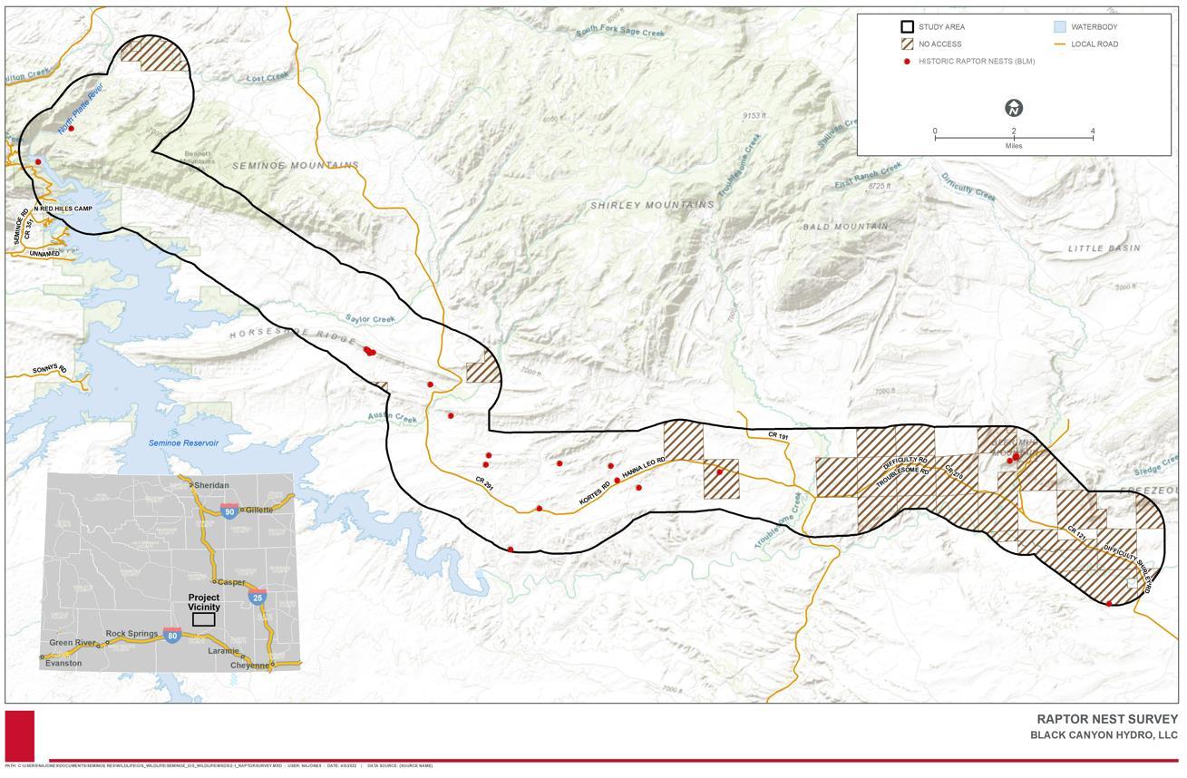
Final License Application – Exhibit E Seminoe
Storage Project January 2023 | 237
Pumped
Figure 3.7-1. Raptor Nest Survey Area, Inaccessible Areas, and Historic Nest Locations
This page intentionally left blank.
License Application – Exhibit E
Project January 2023 | 238
Final
Seminoe Pumped Storage
Raptor Nest Survey Results
A total of 38 raptor nest structures were identified within the study area during the 2021 and 2022 raptor nest surveys. Of these, six nests were confirmed to be active (i.e., occupied by nesting birds) at the time of the survey, the status of four nests could not be determined, and the remaining 28 were inactive (i.e., unoccupied, no birds present) at the time of the survey. Species composition is listed in Table 3.7-3 and nest locations, species, and status are displayed in Figure 3.7-2. Nests observed and reported here include one active common raven nest, which although not a raptor, nests on structures like that of medium-sized raptors and often uses historic raptor nests. The BLM provided historic nest locations (i.e., nests first observed between 1979 and 2014) to aid in the raptor nest survey. Of the 17 historic nest locations located in the study area, only five could be relocated and all five were inactive at the time of the survey. The remaining 12 historic nests could not be found (HDR 2022c)
Table 3.7-3. Summary of Raptor Nests Observed During 2021 and 2022 Raptor Nest Surveys
Species (Scientific Name)
Active Inactive Unknown
Bald eagle (Haliaeetus leucocephalus) 1 0 0
Common raven (Corvus corax) 1 0 0
Ferruginous hawk (Buto regalis) 0 1 0
Golden eagle (Aquila chrysaetos) 0 1 1
Red-tailed hawk (Buteo jamaicensis) 2 3 0
Sharp-shinned hawk (Accipiter striatus) 1 0 0
Unknown raptor 1 23 3
Source: HDR 2022c.
Researchers incidentally (i.e., not associated with a nest; perched, flying, foraging) observed bald eagles (Haliaeetus leucocephalus), golden eagles, red-tailed hawks, ferruginous hawks, prairie falcons, and American kestrels (Falco sparverius) in the study area during the 2021 wildlife field surveys (HDR 2022c)
License Application – Exhibit E
January 2023 | 239
Final
Seminoe Pumped Storage Project
This page intentionally left blank.
Seminoe Pumped Storage Project
– Exhibit E
January 2023 | 240
Final License Application
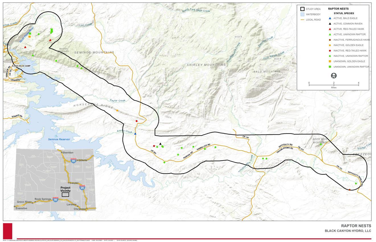
Final License Application – Exhibit E
Storage Project January 2023 | 241
Seminoe Pumped
Figure 3.7-2. Raptor Nests Observed During 2021 Raptor Nest Surveys
This page intentionally left blank.
License Application – Exhibit E
Storage Project January 2023 | 242
Final
Seminoe Pumped
3.7.1.5
Designated Wildlife Areas
There are multiple designated wildlife areas that are in the vicinity of the Project. These areas are managed or overseen by the BLM and WGFD. These areas are briefly described in Table 3.7-4 and shown in Figure 3.7-3 and Figure 3.7-4. As previously mentioned, portions of the wildlife study area are located in winter range crucial habitat for bighorn sheep, mule deer, and pronghorn antelope (Figure 3.7-4).
Table 3.7-4. Designated Wildlife Areas
Designated Area
Description
Bennett Mountains Wilderness Study Area
Morgan Creek Wildlife Habitat Management Area
BLM
The Bennett Mountains Wilderness Study Area encompasses 6,003 acres north and northeast of the Footprint of Potential Disturbance. Habitat in this area is characterized by rocky ledges and mountain plateaus and vegetation includes grasses and sagebrush along with pockets of pine, aspen, and willows (Black Canyon 2020b).
WGFD
The Morgan Creek Wildlife Habitat Management Area (WHMA) is located approximately 30 miles north of Sinclair (on the northwest side of the Footprint of Potential Disturbance) and primarily exists for the establishment of a bighorn sheep herd. The Seminoe and South Ferris Mountain ranges have been the sites for several successful bighorn sheep transplants and there is now a bighorn sheep hunting season in this region. Besides elk and bighorn sheep, more than 100 mule deer live in the area. Yellow-bellied marmots (Marmota flaviventris), coyotes (Canis latrans), red foxes (Vulpes vulpes), and other small mammals utilize the Morgan Creek WHMA for all or parts of the year. Pronghorn antelope occupy the surrounding foothills, though are uncommon within the WHMA boundaries (WGFD 2019b)
Crucial Aquatic Areas
The 2017 WGFD Statewide Action Plan states that one of the goals of the plan was to target habitat conservation efforts for SGCN and to guide development and other habitat alterations away from important habitat (WGFD 2017a). It identifies Seminoe Reservoir as a Crucial Aquatic Area (WGFD 2015)
Habitat/Crucial Winter Range
Crucial
The WGFD has identified areas based on their biological or ecological values. In order to maintain viable populations of certain species, these areas need to be protected or managed (WGFD 2015). During November 15-April 30th these areas must be avoided. The Mule Deer Crucial Winter Range crosses the Footprint of Potential Disturbance in several locations. The Bighorn Sheep Crucial Winter Range has been identified in the Footprint of Potential Disturbance near the Morgan Creek WHMA. Pronghorn Crucial Winter Range has been identified mostly along the proposed transmission line corridor (See Figure 3.7-4).
Final License Application – Exhibit E
Storage Project January 2023 | 243
Seminoe Pumped
Designated Area Description
Shirley
Basin/Medicine Bow Management Area- Black-Footed Ferret
The Shirley Basin/Medicine Bow Management Area 10J boundary covers the western half of Carbon County, between Casper and Elk Mountain, Wyoming. The 10J boundary is an area designated to help with the re-introduction of the Black-Footed Ferret (Mustela nigripes). The main Black-footed Ferret study area is located approximately 45 miles northwest of the Project (WGFD 2018).
Migration Corridors
Executive Order (EO) 2020-1 Wyoming Mule Deer and Antelope Migration Corridor Protection designates migration corridors within the state for mule deer and antelope. These corridors do not fall within the Footprint of Potential Disturbance; however, they are located approximately 10 miles southwest.
Enhancement Habitat Priority Areas
Enhancement Habitat Priority Areas are identified as those with the potential to address wildlife habitat issues and to improve, enhance, or restore wildlife habitats. One Enhancement Habitat Priority Area is located in the northwestern portion of the proposed Project, the Ferris-Seminoe Mountains (see Figure 3.7-3) (WGFD 2015).
Crucial Habitat Priority Areas Crucial Habitat Priority Areas are areas that need to be protected or managed to maintain healthy populations based on significant biological or ecological values (WGFD 2020a). The Footprint of Potential Disturbance falls within the Terrestrial Crucial Habitat Priority Areas for three species: Greater Sage-grouse core, big game transition, and big game crucial range. The Footprint of Potential Disturbance intersects crucial ranges for bighorn sheep, antelope, and mule deer (WGFD 2015)
Sage-grouse Core Area
EO 2019-3 Greater Sage-grouse Core Area Protection in the state of Wyoming delineates priority habitat areas for the Greater Sagegrouse. The Footprint of Potential Disturbance falls within a Greater Sage-grouse core area. There are no identified Greater Sage-grouse leks within the Footprint of Potential Disturbance (WGFD 2017b), however several leks are known in the Project vicinity and a few leks are very close to the Footprint of Potential Disturbance.
Source: Black Canyon 2020b
Note: Additional information describing BLM seasonal discretionary timing restrictions is provided in Section 3.7.1.8.
License Application – Exhibit E
January 2023 | 244
Final
Seminoe Pumped Storage Project
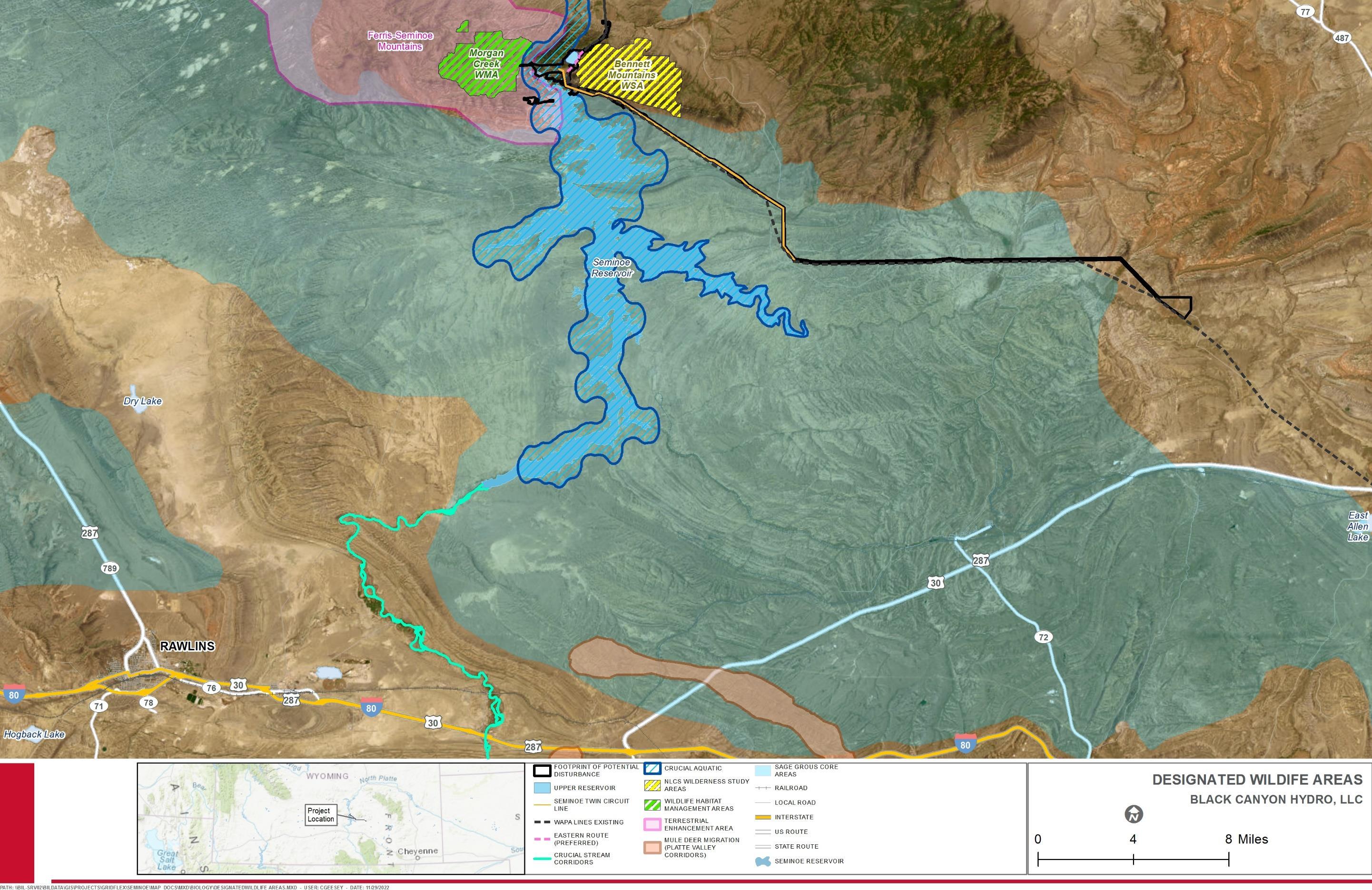
Final License Application – Exhibit E Seminoe Pumped Storage Project January 2023 | 245
Figure 3.7-3. Designated Wildlife Areas in the Project Vicinity
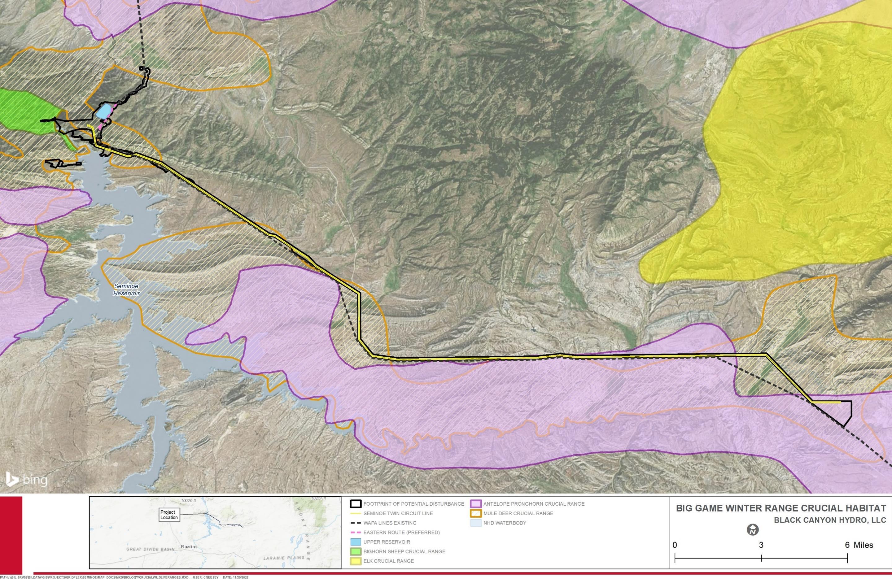
Final License Application – Exhibit E Seminoe
Storage Project January 2023 | 246
Pumped
Figure 3.7-4. Winter Range Crucial Habitat for Big Game in the Project Vicinity
3.7.1.6 Rare, Threatened, and Endangered Wildlife Species
A list of ESA-listed species potentially occurring within the Project Area was prepared using the USFWS IPaC website (USFWS 2021). No ESA-listed mammal species were reported from the IPaC report. However, the IPaC report indicated that that the ESAthreatened piping plover (Charadrius melodus) and the whooping crane (Grus americana) have the potential to be affected by the Project18 These two species, which are included in the PRRIP, are discussed in Section 3.7.1.7. One ESA Candidate terrestrial wildlife species, the monarch butterfly (Danaus plexippus), was also reported from the IPaC report; however, Candidate species are not afforded protection by the ESA or other statutes. No designated critical habitat for any ESA-listed species occurs in the Footprint of Potential Disturbance. The unofficial IPaC report is included in Appendix G.
Although not listed on the IPaC report, the black-footed ferret (Mustela nigripes) is also potentially present in the study area and is listed as ESA-endangered. The implementation of the 10J rule designated Wyoming’s black-footed ferret populations as experimental, non-essential populations, basically treating them as proposed for ESA-listing. As such, these populations are not afforded protection by ESA or other statutes.
Both golden and bald eagles were confirmed present within the wildlife study area during the 2021 Habitat Assessment and Rare, Threatened, and Endangered Species Evaluation Study (HDR 2022c). Bald eagles were observed foraging and nesting in the wildlife study area during the 2021 wildlife field surveys. Additionally, bald eagles were also frequently observed along the margins of Seminoe Reservoir while conducting fisheries studies for the Project in the summer of 2021. As previously mentioned, golden eagle nesting has historically occurred in the Project vicinity. BLM records list four known nests in the wildlife study area, and during the 2021 raptor nest surveys, an additional nest presumed to be a golden eagle nest was found high on a cliff above Kortes Reservoir. No active golden eagle nests were observed in the wildlife study area in 2021, but two nests were observed to be in good condition (HDR 2022c).
In addition to addressing the needs of ESA-listed species, the WYNDD was reviewed for state-listed threatened and endangered terrestrial wildlife species known to occur or with the potential to occur in the Project Area (University of Wyoming undated). Based on this review, state-listed threatened or endangered terrestrial wildlife species are not known to occur within the Footprint of Potential Disturbance
The BLM maintains a list of sensitive terrestrial wildlife species for Wyoming (BLM 2010). The review of the WYNDD for the Project Area included records of BLM sensitive terrestrial wildlife species known to occur in the Project Area (University of Wyoming undated).
Per the 2021 Habitat Assessment and Rare, Threatened, and Endangered Species Evaluation Study (HDR 2022c), species were compiled from the above reviews, analyzed for their potential to occur, and then grouped into a table if the species was determined to have the potential to occur in the wildlife study area (Table 3.7-5). Wyoming big game species with the potential to occur in the Project vicinity are also included in this table. 18 The Project area is located outside of the known ranges for the piping plover and whooping crane (HDR 2022c).
Final License Application – Exhibit E
January 2023 | 247
Seminoe Pumped Storage Project
This page intentionally left blank.
Seminoe Pumped Storage Project
– Exhibit E
January 2023 | 248
Final License Application
Table 3.7-5. List of All Special Status Species Considered for Analysis, Likelihood to Occur in the Wildlife Study Area, Habitat Associations, and Summary of Modeling Methods
Common Name Scientific Name Status Study Area Located within Known Range of Species
Insects
Amphibians/Reptiles
Likelihood of Occurrence in Study Area Brief Range/Habitat Description Summary of Habitat Modeling Methods
Unlikely Rare in study area but can occur in association with milkweed which are found in mesic habitats.
Boreal Toad Anaxyrus boreas SGCN Tier I/BLM Sensitive No Does Not Occur Study area located outside current range, but within historic range. Habitat includes subalpine ponds and streams from 6,500-11,500 ft above mean sea level
Columbia Spotted Frog Rana luteiventris SGCN Tier II/BLM Sensitive No Does Not Occur Range in Wyoming includes forests and mountains of the western, northwest, and north-central portions of the state.
Great Basin Spadefoot Spea intermontana SGCN Tier II/BLM Sensitive Yes Unlikely Xeric adapted amphibian. Found throughout most landcover types within up to 5 km of permanent or ephemeral water sources. Breeding depends on waterbodies.
Midget Faded Rattlesnake
1) Ranking of GAP Landcover Types (see Appendix G) 2) NWI wetlands except lake
NA
NA
1) Ranking of GAP Landcover Types (see Appendix G)
2) NWI wetlands (except lake and riverine)
3) Perennial water features
Crotalus oreganus concolor SGCN Tier I/BLM Sensitive No Does Not Occur Range limited to southwest Wyoming near Rock Springs; species not found in study area. NA
Northern Leopard Frog Lithobates pipiens SGCN Tier II/BLM Sensitive Yes Confirmed (Data) Near permanent water in any upland type, particularly marshy wetlands.
High Quality: 1) NWI wetlands except lake and riverine, 2) GAP species model.
Moderate Quality: 1) 100 m buffer of all wetlands except riverine, 2) 100 m buffer of all perennial rivers.
Nesting: Deciduous trees - digitized from aerial imagery
Foraging: Platte and Medicine Bow Rivers, Seminoe Reservoir from Wyoming perennial water features dataset; major gravel roads from WYDOT dataset
Ranking of GAP Landcover Types (see Appendix G)
Final License Application – Exhibit E
Project January 2023 | 249
Seminoe Pumped Storage
Monarch Butterfly Danaus plexippus ESA Candidate Yes
Fish
Pallid Sturgeon Scaphirhynchus albus ESA Endangered No Does not occur Platte River Species; see Section 3.7.1.7 NA
Birds
Baird's Sparrow Ammodramus bairdii SGCN Tier II/BLM Sensitive No Unlikely Study area located within migratory route, occurrence is unlikely and intermittent. NA
Bald Eagle Haliaeetus leucocephalus SGCN Tier II/BLM Sensitive Yes Confirmed (Field) Aquatic and riparian wetland systems; nest in deciduous trees; forage near open water and rivers, or for carrion along roads.
Brewer's Sparrow Spizella breweri SGCN Tier II/BLM Sensitive Yes Confirmed (Field) Sagebrush obligate; also nests in shrubland openings of forests and riparian saltbush shrublands.
Burrowing Owl Athene cunicularia SGCN Tier I/BLM Sensitive Yes Confirmed (Data) Nests almost exclusively in prairie dog colonies and other burrows.
Used white-tailed prairie dog habitat model.
Columbian Sharptailed Grouse Tympanuchus phasianellus columbianus SGCN Tier II/BLM Sensitive No Does Not Occur Study area located in historic but not current range. NA
Seminoe Pumped Storage Project
Common Name Scientific Name Status Study Area Located within Known Range of Species
Likelihood of Occurrence in Study Area
Brief Range/Habitat Description
Summary of Habitat Modeling Methods
Common Loon Gavia immer SGCN Tier I Yes Confirmed (Field) Occasional visitor during migration; known to stopover on Seminoe Reservoir Perennial water feature (Seminoe Reservoir) from WY GAP Project
Ferruginous Hawk Buteo regalis SGCN Tier II/BLM Sensitive Yes Confirmed (Field) Open and mountainous shrub/scrub and woodlands Ranking of GAP Landcover Types (see Appendix G)
Golden Eagle Aquila chrysaetos SGCN Tier II Yes Confirmed (Field) Open and mountainous shrub/scrub and cliffs/canyons
1) Nest density model (Dunk et al. 2019);
2) Ranking of GAP Landcover Types (see Appendix G)
3) Terrain Roughness Index (TRI)
Greater Sage-grouse Centrocercus urophasianus SGCN Tier II/BLM Sensitive Yes Confirmed (Field) See Greater Sage-grouse Lek and Habitat Study Report NA
Interior Least Tern Sternula antillarum athalassos
ESA Endangered No Does not occur
Platte River Species; see Section 3.7.1.7 NA
Loggerhead Shrike Lanius ludovicianus SGCN Tier II/BLM Sensitive Yes Confirmed (Field) Open shrub/scrub and meadows, woodlands, edge habitat Ranking of GAP Landcover Types (see Appendix G)
Long-billed Curlew Numenius americanus SGCN Tier II/BLM Sensitive Yes Likely Short and mixed-grass prairie, flat to rolling terrain; avoid trees, tall grasses, shrubs, and dense vegetation; near water.
Mountain Plover Charadrius montanus SGCN Tier I/BLM Sensitive Yes Likely Grassland and desert shrub, flat/rolling terrain, at least 50% bare ground.
Northern Goshawk Accipiter gentilis SGCN Tier I/BLM Sensitive Yes Unlikely Mature, old-growth forests with dense canopy.
Peregrine Falcon Falco peregrinus SGCN Tier II/BLM Sensitive Yes Confirmed (Data) Cliffs near waterbodies, river and lake bluffs
Ranking of GAP Landcover Types (see Appendix G)
1) Ranking of GAP Landcover Types (see Appendix G)
2) Terrain Roughness Index (TRI; inverted to select flat terrain)
3) WYNDD Species Distribution Model
1) Ranking of GAP Landcover Types (see Appendix G)
2) WYNDD Species Distribution Model
1) Terrain Roughness Index (TRI)
2) Ranking of GAP Landcover Types (see Appendix G)
3) WYNDD Species Distribution Model
Piping Plover Charadrius melodus ESA Threatened No Does Not Occur Platte River Species; see Section 3.7.1.7 NA
Sage Thrasher Oreoscoptes montanus SGCN Tier II/BLM Sensitive Yes Confirmed (Field) Sagebrush obligate; desert shrublands, grasslands, and juniper woodlands
Sagebrush Sparrow Artemisiospiza nevadensis SGCN Tier II/BLM Sensitive Yes Confirmed (Field) Sagebrush obligate; desert tall shrublands, steppe, and grasslands.
Ranking of GAP Landcover Types (see Appendix G)
Ranking of GAP Landcover Types (see Appendix G)
Trumpeter Swan Cygnus buccinators SGCN Tier II/BLM Sensitive No Does Not Occur Study area located in historic but not current range. NA
White-faced Ibis Plegadis chihi SGCN Tier II/BLM Sensitive Yes Unlikely Marshes, ponds, mudflats, swamps; emergent vegetation.
1) Ranking of GAP Landcover Types (see Appendix G)
2) WYNDD Species Distribution Model
Whooping Crane Grus americana ESA Endangered No Does Not Occur Platte River Species; see Section 3.7.1.7 NA
Yellow-billed Cuckoo Coccyzus americanus SGCN Tier II/BLM Sensitive No Does Not Occur Study area located outside known range and suitable habitat does not exist in the study area. NA
Final License Application – Exhibit E
January 2023 | 250
Common
Mammals
Status Study Area Located within Known Range of Species
Likelihood of Occurrence in Study Area
Brief Range/Habitat Description
Bighorn Sheep Ovis canadensis SGCN Tier II Yes Confirmed (Field) Steep, rocky terrain of desert, alpine, and forested areas.
Black-footed Ferret Mustela nigripes ESA Experimental Population, NonEssential/SGCN Tier I
Yes
Potentially Prairie dog colonies. Study area located in Shirley Basin-Medicine Bow Management Area 10J boundary.
WYNDD Species Distribution Model
Black-tailed Prairie Dog Cynomys ludovicianus SGCN Tier II/BLM Sensitive No Does Not Occur Species occurs in the plains of eastern Wyoming, not found in study area. NA
Elk Cervus canadensis Big Game Yes Confirmed (Field) Alpine and subalpine grasslands, woodlands, and meadows
Fringed Myotis Myotis thysanodes SGCN Tier II/BLM Sensitive Yes Confirmed (Data) Roosts in caves, mines, buildings, bridges, rock crevices, ponderosa pines and other trees in forests with low canopy closure in proximity to water; forages in woodlands near wetlands and riparian areas.
WYNDD Species Distribution Model
Idaho Pocket Gopher Thomomys idahoensis SGCN Tier II/BLM Sensitive No Does Not Occur Range limited to southeast Wyoming; species not found in study area. NA
Long-eared Myotis Myotis evotis SGCN Tier III/BLM Sensitive Yes Confirmed (Data) Roosts in caves, mines, buildings, bridges, rock crevices, forests of all types; forages in wooded riparian, ponds and lakes and rivers near forests.
Mule Deer Odocoileus hemionus Big Game Yes Confirmed (Field) Habitat generalist, prefers meadows, woodlands, and forests
Northern River Otter Lontra canadensis SGCN Tier II Yes Unlikely Rivers, streams, marshes, etc with vegetated and stable shorelines and structural complexity.
Pallid Bat Antrozous pallidus SGCN Tier II Yes Confirmed (Data) Cliffs and rock outcrops in desert grasslands, shrublands and rarely in forests.
Ranking of GAP Landcover Types (see Appendix G)
WGFD Seasonal and Crucial Range Mapping
1) Ranking of GAP Landcover Types (see Appendix G) 2) WYNDD Species Distribution Model
1) Ranking of GAP Landcover Types (see Appendix G) 2) Terrain Roughness Index (TRI)
Preble's Meadow Jumping Mouse Zapus hudsonius preblei SGCN Tier II/BLM Sensitive No Does Not Occur Range limited to southeast Wyoming; species not found in study area. NA
Pronghorn Antelope Antilocapra americana Big Game Yes Confirmed (Field) Open, rolling terrain; sagebrush, steppe, and deserts WGFD Seasonal and Crucial Range Mapping
Pygmy Rabbit Brachylagus idahoensis SGCN Tier II/BLM Sensitive Yes Unlikely Sagebrush obligate; tall dense sagebrush with deep soils. WYNDD Species Distribution Model
Spotted Bat Euderma maculatum SGCN Tier III/BLM Sensitive No Does Not Occur Range limited to southwest and north-central Wyoming; species not found in study area. NA
Swift Fox Vulpes velox SGCN Tier II/BLM Sensitive Yes Confirmed (Data) Shortgrass and mid-grass prairies with shrubs; flat and rolling terrain.
Ranking of GAP Landcover Types (see Appendix G)
Final License Application – Exhibit E
January 2023 | 251
Seminoe Pumped Storage Project
Name Scientific Name
Summary of Habitat Modeling Methods
WGFD Wyoming Black-footed Ferret Management Plan Mapping
WGFD Seasonal and Crucial Range Mapping
Common Name Scientific Name Status Study Area Located within Known Range of Species
Townsend's Big Eared Bat
Western Small-footed
Myotis
Likelihood of Occurrence in Study Area
Brief Range/Habitat Description
Corynorhinus townsendii SGCN Tier II/BLM Sensitive Yes Likely Roosts in caves and abandoned mines; forages at forest edges and riparian corridors, less often in shrublands and montane forests.
Myotis ciliolabrum SGCN Tier II Yes Confirmed (Data) Roosts in cliffs, canyons, rock-outcrops or badlands; forages in forested riparian areas, shrublands, and grasslands.
White-tailed Deer Odocoileus virginianus Big Game Yes Confirmed (Data) Habitat generalist, prefers riparian zones and agricultural fields
White-tailed Prairie Dog Cynomys leucurus SGCN Tier II Yes Confirmed (Field) Shrub-steppe, shortgrass prairie, meadow, mountain valleys, and low-relief transitional areas with mixed stands of shrubs and grasses.
Wyoming Pocket Gopher Thomomys clusius SGCN Tier I/BLM Sensitive Yes Unlikely Study area at edge of known range, dependent on Gardner's saltbush which is found in shrublands, greasewood flats, and badland landcover types in study area.
Seminoe Pumped Storage Project
Summary of Habitat Modeling Methods
WYNDD Species Distribution Model
WYNDD Species Distribution Model
WGFD Seasonal and Crucial Range Mapping
1) Ranking of GAP Landcover Types (see Appendix G)
2) WYNDD Species Distribution Model
3) USGS GAP Species Analysis Model
4) Terrain Roughness Index (TRI; inverted to select flat terrain)
Ranking of GAP Landcover Types (see Appendix G)
Species list compiled from USFWS 2021, BLM 2010, and WGFD 2019a; range and habitat descriptions compiled from literature cited in Section 3.2 of the 2021 Habitat Assessment and Rare, Threatened, and Endangered Species Evaluation Study Report (see Appendix G)
Likelihood of Occurrence: confirmed (field) = observed during 2021 wildlife field surveys; confirmed (data) = observations recorded by BLM, WGFD, WYNDD, or another third-party.
ESA = Endangered Species Act; WGFD = Wyoming Game & Fish Department; WYNDD = Wyoming Natural Diversity Database; USGS = U.S. Geological Survey; SGCN = WGFD Species of Greatest Conservation Need; BLM = Bureau of Land Management; NWI = National Wetlands Inventory Source: HDR 2022c.
Final License Application – Exhibit E
January 2023 | 252
3.7.1.7
Platte River Recovery Implementation Program (PRRIP) Species
The Platte River Recovery Implementation Program (PRRIP) was formed in 1997 by Colorado, Wyoming, Nebraska, and the U.S. Department of the Interior (USDOI), with the goal of developing a shared approach to improved management of the Platte River (PRRIP undated-a). The PRRIP is described in detail in Section 5.3.3.5 The goals of the PRRIP include enhancing, restoring, and protecting habitat lands for four target species: the interior least tern, pallid sturgeon, piping plover, and whooping crane (PRRIP undated-b). These target species are described below
Interior Least Tern
The interior least tern (Sternula antillarum athalassos) was ESA-listed as endangered on June 27, 1985, primarily due to the loss of nesting habitat as a result of dramatic alterations (channelization and impoundment) of important river systems. However, a recently completed five-year review resulted in a February 12, 2021, delisting of the interior least tern due to recovery. The USFWS is now in the process of putting in place a post-delisting monitoring plan to encourage and guide voluntary efforts to track species recovery. As described above, the interior least tern is a Platte River target conservation species and the PRRIP manages for the interior least tern along the central Platte River in a manner consistent with ongoing piping plover management on habitat used by both species (PRRIP undated-d).
Least terns are long-distance migrants that breed in North America and winter in Central and South America. The interior least tern historically nested along the Colorado (in Texas), Red, Rio Grande, Arkansas, Missouri, Ohio, and Mississippi River systems. It currently nests in the Mississippi and Rio Grande River basins from Montana south to Texas and from eastern New Mexico and Colorado to Indiana and Louisiana (PRRIP undated-d).
Least terns are viewed as opportunistic feeders, exploiting any fish within a certain size range. Foraging habitat for least terns includes side channels, sloughs, tributaries, shallowwater habitats adjacent to sand islands and the main channel (USFWS 2006). Least terns forage on small fish they capture by diving into shallow riverine habitats and freshwater ponds. Along the central Platte River, these birds usually feed within the river which is generally a short distance from their nesting colony. Throughout its range, least terns breed and nest on barren to sparsely vegetated riverine sandbars, sand and gravel pits, lake and reservoir shorelines, rooftops, ash pits, and salt flats from mid-May to early August. Along the central Platte River, least terns generally nest on managed off-channel nesting habitat created by sand and gravel mining operations or through excavation activities of the PRRIP (PRRIP undated-d).
A recovery plan for the interior least tern was issued on September 19, 1990 (USFWS 1990). The greatest threat to recovery of the interior least tern is the loss of nesting habitat attributable to channelization and impoundments of rivers where the species occurs, although disturbance of nesting areas by recreationists can reduce reproductive success.
Final License Application – Exhibit E
Project January 2023 | 253
Seminoe Pumped Storage
Pallid Sturgeon
Pallid sturgeon (Scaphirhynchus albus) was listed as endangered under the ESA on September 6, 1990 (55 FR 36641-36647) (USFWS 2014). The pallid sturgeon is one of the largest freshwater fish species in North America. The pallid sturgeon's historical range spanned the entire Missouri River and into the Mississippi River. Pallid sturgeon prefer moderate to swift river currents, turbid waterways, and water depths between three and 25 feet. The species is more commonly found where sandy substrates are plentiful, but also lives in predominately rocky waterways. Though pallid sturgeon prefer more turbulent and deeper rivers than the Platte River, several pallid sturgeon, including some from hatcheries, have been captured from the Platte River. The lower reaches of the Platte River, a more than 30-mile stretch from the Elkhorn River to its confluence with the Missouri River, is believed to have suitable spawning habitat for pallid sturgeon, although no conclusive evidence has been found that successful spawning is occurring in this region (PRRIP undated-e).
Pallid sturgeon are generally bottom feeders, skimming the sandy reaches of the various rivers and streams in their habitat. Lacking teeth, pallid sturgeon use their extendable mouths to suck up small fish, mollusks, and other food sources from river bottoms. Though little is known about the precise eating habits of the species, they are thought to be opportunistic feeders (PRRIP undated-e).
Pallid sturgeon have a long lifespan, living in excess of 50 years and perhaps as long as 100 years. As is true for many long-lived species, pallid sturgeon reach reproductive maturity relatively late. Males reach sexual maturity between the ages of five and seven years, while females are believed to become capable of reproduction when they are at least 15 years old. Reproduction does not take place every year; the average interval between spawning is three years, although other studies suggest an interval as long as 10 years. Spawning usually takes place May to July (PRRIP undated-e).
The USFWS (2014) identified the following limiting factors affecting the species: 1) activities which affect in-river connectivity and the natural form, function, and hydrologic processes of rivers; 2) illegal harvest; 3) impaired water quality and quantity; 4) entrainment; and 5) life history attributes of the species (i.e., delayed sexual maturity, females not spawning every year, and larval drift requirements). The degree to which these factors affect the species varied among river reaches. There is currently no critical habitat designated for the pallid sturgeon (USFWS undated).
Piping Plover
Piping plovers (Charadrius melodus) were listed under the provisions of the ESA on January 10, 1986. Piping plovers breed in North America and Canada and winter along the Atlantic and Gulf coast and in the Bahamas and West Indies. Three breeding populations of piping plovers are recognized; however, this discussion focuses on the threatened Northern Great Plains population. This population breeds in alkaline wetlands and along lake shorelines of the northern Great Plains and on the Missouri River and its tributaries in North Dakota, South Dakota, and Nebraska (PRRIP undated-f).
Final License Application – Exhibit E Seminoe Pumped Storage Project January 2023 | 254
Critical habitat was designated for the Northern Great Plains population of the piping plover on September 11, 2002 (USFWS 2001 as cited in USFWS 2015). Nineteen critical habitat units originally contained approximately 183,422 acres of prairie alkaline wetlands, inland and reservoir lakes, and portions of four rivers totaling approximately 1,207.5 river miles in Montana, Nebraska, South Dakota, North Dakota, and Minnesota. The affected areas include: the portion of the Missouri River adjacent to Nebraska counties; Loup; Niobrara, Elkhorn, and Platte Rivers (USFWS 2015). In response to a lawsuit brought by a consortium of water users in Nebraska (the Nebraska Habitat Conservation Coalition), an October 13, 2005, court ruling vacated the Nebraska portion of the piping plover critical habitat designation and remanded that portion to the USFWS for redesignation (USFWS 2006).
Piping plovers feed along the water's edge on small insects, spiders, crustaceans, and mollusks. Along the central Platte River, piping plovers usually feed along the shoreline of off-channel nesting habitats or on low sandbars within the river which is generally only a short distance from their nesting site. Throughout its range, this species nests from April to early August. Nests are generally located on barren to sparsely vegetated sand and gravel found on riverine sandbars, sand and gravel mines, lake and reservoir shorelines, and sand, gravel or pebbly mud found at alkali wetlands. Along the central Platte River, piping plovers generally nest on managed off-channel nesting habitat created by sand and gravel mining operations or through other PRRIP excavation activities. Piping plovers generally only produce a single brood of fledglings; however, re-nesting after fledging a brood has been observed (PRRIP undated-f).
The USFWS (2015) identified changes in the quality and quantity of riverine habitat due primarily to damming and water withdrawals as a primary threat to the species in the northern Great Plains. The USFWS (2015) also noted that habitat destruction and degradation has reduced suitable habitat. Human disturbance, predation, and invasive plants were also noted as further reducing breeding and wintering habitat quality and affecting survival.
Whooping Crane
In the United States, the whooping crane (Grus americana) was listed as threatened with extinction in 1967 (32 FR 4001) and endangered in 1970 (35 FR 16047) (both listings were grandfathered into the ESA). The USFWS has designated the Cheyenne Bottoms State Waterfowl Management Area and Quivira National Wildlife Refuge, Kansas; the Platte River bottoms between Lexington and Denman, Nebraska; and Salt Plains National Wildlife Refuge, Oklahoma, as critical migration habitat to the conservation of the species (Canadian Wildlife Service and USFWS 2005). These areas have geographic importance and are observed to have the highest frequency of crane use of any areas in the species’ migrational path (USFWS 2006).
Whooping cranes occur only in North America. According to the Canadian Wildlife Service and USFWS (2005), whooping crane currently exist in the wild at three locations and in captivity at nine sites. The February 2006 total wild population was estimated at 338 and includes: 215 individuals in the only self-sustaining Aransas-Wood Buffalo National Park Population that nests in Wood Buffalo National Park and adjacent areas in Canada, and
Final License Application – Exhibit E
January 2023 | 255
Seminoe Pumped Storage Project
winters in coastal marshes in Texas; 59 captive-raised individuals released to establish a non-migratory Florida Population in central Florida; and 64 individuals introduced between 2001 and 2005 that migrate between Wisconsin and Florida in an eastern migratory population. The last remaining wild bird in the reintroduced Rocky Mountain Population died in the spring, 2002. The captive population contained 135 birds in February 2006. The total population of wild and captive whooping cranes in February 2006, was 473 (Canadian Wildlife Service and USFWS 2005).
Whooping cranes are omnivorous feeders that forage on many items including mollusks, crustaceans, minnows, reptiles, amphibians, invertebrates, small mammals, small birds, berries, live oak, agricultural grains, and plant tubers located in wetlands, grasslands, and agricultural fields (PRRIP undated-g). On breeding grounds whooping cranes feed primarily on mollusks and crustaceans, insects, minnows, frogs, and snakes (USFWS 2006).
Remaining whooping cranes continue to breed in ancestral breeding areas and use ancestral migration routes and wintering grounds. Whooping cranes use a variety of habitats during migration. A common feature of the vast majority of sites used by whooping cranes during migration is the proximity to wetlands that provide undisturbed habitat for roosting (USFWS 2006). In general whooping cranes breed in large marshes and extensive mosaics of wetlands mixed with upland patches and small ridges (Travsky and Beauvais 2004). The Atlas of Birds, Mammals, Amphibians, and Reptiles in Wyoming (Orabona et al. 2016) describes habitat as wet-moist meadow grasslands, sedge meadows, irrigated native and introduced meadows, small grains, and marshes. The Canadian Wildlife Service and USFWS (2005) summarize habitat as including coastal marshes and estuaries, inland marshes, lakes, ponds, wet meadows and rivers, and agricultural fields. The wildlife study area is outside the known range of whooping crane, thus whooping crane are not anticipated to occur in the Project vicinity (HDR 2022c)
A revised recovery plan was published in 2007 (USFWS 2006). Currently, expanding human populations throughout the range of the whooping cranes continue to threaten survival and recovery of the birds. Factors affecting whooping crane survival and recovery include the potential for catastrophic loss of birds or habitat due to severe climatic events, infectious disease, and environmental contamination; chronic habitat loss due to development and human encroachment; and loss and degradation of wetland and other suitable migrational habitats (USFWS 2006).
3.7.1.8 Greater Sage-grouse Lek and Habitat Study
The Greater Sage-grouse is a BLM Sensitive Species and WGFD Tier II SGCN species. The Greater Sage-grouse was petitioned for listing under the ESA in 2002 and became a candidate for listing in 2010 (75 Federal Register [FR] 13910). However, following a status review in 2015, the USFWS determined that the species was not at risk of extinction and withdrew Greater Sage-grouse from the candidate list (80 Federal Register [FR] 47510). To preclude listing under the ESA, some states established relatively rigorous conservation measures, such as the State of Wyoming’s Core Area Protection EOs. Current management of the Greater Sage-grouse in Wyoming is based largely on Governor Gordon’s EO 2019-3. In November 2021, BLM announced a new planning
Final License Application – Exhibit E
Project January 2023 | 256
Seminoe Pumped Storage
initiative to address management of Greater Sage-grouse and sagebrush habitat on BLM lands (86 FR 66331). This effort may affect future management of the species in the Project vicinity (HDR 2022e).
The historic range of the Greater Sage-grouse covered most of the shrublands and prairies of the intermountain west, including 16 states and 3 Canadian provinces. Today the species has been extirpated from 5 states and 1 province, while their distribution has contracted within their current range. Populations across the west have declined, although accurate estimates are difficult to obtain due to variability in lek attendance. The major driver of population decline and range contraction is habitat alteration, including loss and fragmentation of sagebrush (Artemisia spp.) due to wildfire, cultivation, energy development, invasive species, and pinyon-juniper encroachment (Schroeder et al. 2020).
Greater Sage-grouse are closely associated with sagebrush landcover. Although there is variability in vegetative composition and topography, sagebrush is an underlying factor in all stages of the Greater Sage-grouse life cycle. Nests are located in areas with thick and diverse vegetative cover generally dominated by big sagebrush and, in some regions, are located near riparian habitat. Leks are located near nesting habitat on sparsely vegetated broad ridgetops, dry lake beds, disturbed areas, or grassy swales. Overwintering habitat is similar to nesting; tall sagebrush ensure access in deep snow (Schroeder et al. 2020).
Males strut on leks during early morning from mid-March through mid-May. Females establish nests around this same time and initiate incubation about three weeks following copulation. Young are born about one month later and can leave the nest almost immediately. Broods remain intact near the nest site for 10 to 12 weeks, at which time juveniles disperse towards winter habitat (Schroeder et al. 2020).
Greater Sage-grouse habitat in Wyoming was delineated by the USGS for the BLM in the 2015 Approved Resource Management Plan Amendment (ARMPA) for Greater Sagegrouse (BLM 2015). The ARMPA included habitat management categories to help apply management guidelines designed to protect and/or manage for Greater Sage-grouse habitat. These habitat management categories are referred to as Priority Habitat Management Area (PHMA) and General Habitat Management Area (GHMA). In 2017, the Wyoming state director of BLM signed the updated Wyoming Sage-grouse ARMPA which changed the PHMA boundaries, bringing them into consistency with the Wyoming Core Areas (version 4) from the current Governor’s EO 2015-4. The BLM (2015) management categories are defined as follows:
• PHMA BLM-administered lands identified as having the highest value to maintaining sustainable Greater Sage-grouse populations. Areas of PHMA largely coincide with areas identified as Priority Areas for Conservation in the USFWS’s Conservation Objectives Team report (USFWS 2013). These areas include breeding, late broodrearing, winter concentration areas, and migration or connectivity corridors.
• GHMA BLM-administered lands where some special management will apply to sustain Greater Sage-grouse populations. Areas of occupied seasonal or year-round habitat outside of PHMAs.
Final License Application – Exhibit E
January 2023 | 257
Seminoe Pumped Storage Project
Construction, operation, and maintenance of the Project may have the potential to affect Greater Sage-grouse. Black Canyon has, therefore, performed a Greater Sage-grouse study to assess the direct and indirect effects the Project may have on Greater Sagegrouse habitat. The study area, and areas classified as PHMA, Core Population Area, and non-habitat, are depicted in Figure 3.7-5
Black Canyon conducted a fine-scale, outcome-based baseline assessment of Greater Sage-grouse habitat and lek status for the Project. The study included habitat suitability analysis, lek monitoring, density disturbance calculation through the WGFD Density Disturbance Calculation Tool (DDCT) as part of the permitting process per EO 2019-3 guidelines19, and a lek proximity analysis. The study methods and results are described in detail in Black Canyon’s Greater Sage-grouse Lek and Habitat Study (HDR 2022e) included as Appendix F to this FLA
Black Canyon monitored four Greater Sage-grouse lek locations on April 20–22, April 27–28, and May 5–6, 2021 and monitored seven Greater Sage-grouse lek locations on April 18, 19 and 21, April 26–28, and May 3, 5, and 6, 2022, during the 2022 season (Table 3.7-6 and Figure 3.7-6). Field biologists followed the WGFD Handbook of Biological Techniques Sage-grouse Lek Count Protocol and conducted counts at each lek at 7- to 10-day intervals over a 3- to 4-week period after the peak of mating activity (early April), a minimum of three times annually. Lek counts were conducted from the ground, between one-half hour before sunrise and one hour after, when wind speeds were less than 16 kilometers per hour (10 miles per hour) and no precipitation was falling. If no birds were observed, biologists searched the lekking areas on foot for Greater Sage-grouse sign. A proximity analysis for the seven Greater Sage-grouse leks near the Project (Table 3.7-7) was completed using GIS to model the line of sight from the nearest Greater Sage-grouse lek towards the Project (HDR 2022e).
19Per the study plan, Black Canyon is coordinating with WGFD regarding the DDCT results and submittal, which will be completed during 2022.
Final License Application – Exhibit E
January 2023 | 258
Seminoe Pumped Storage Project
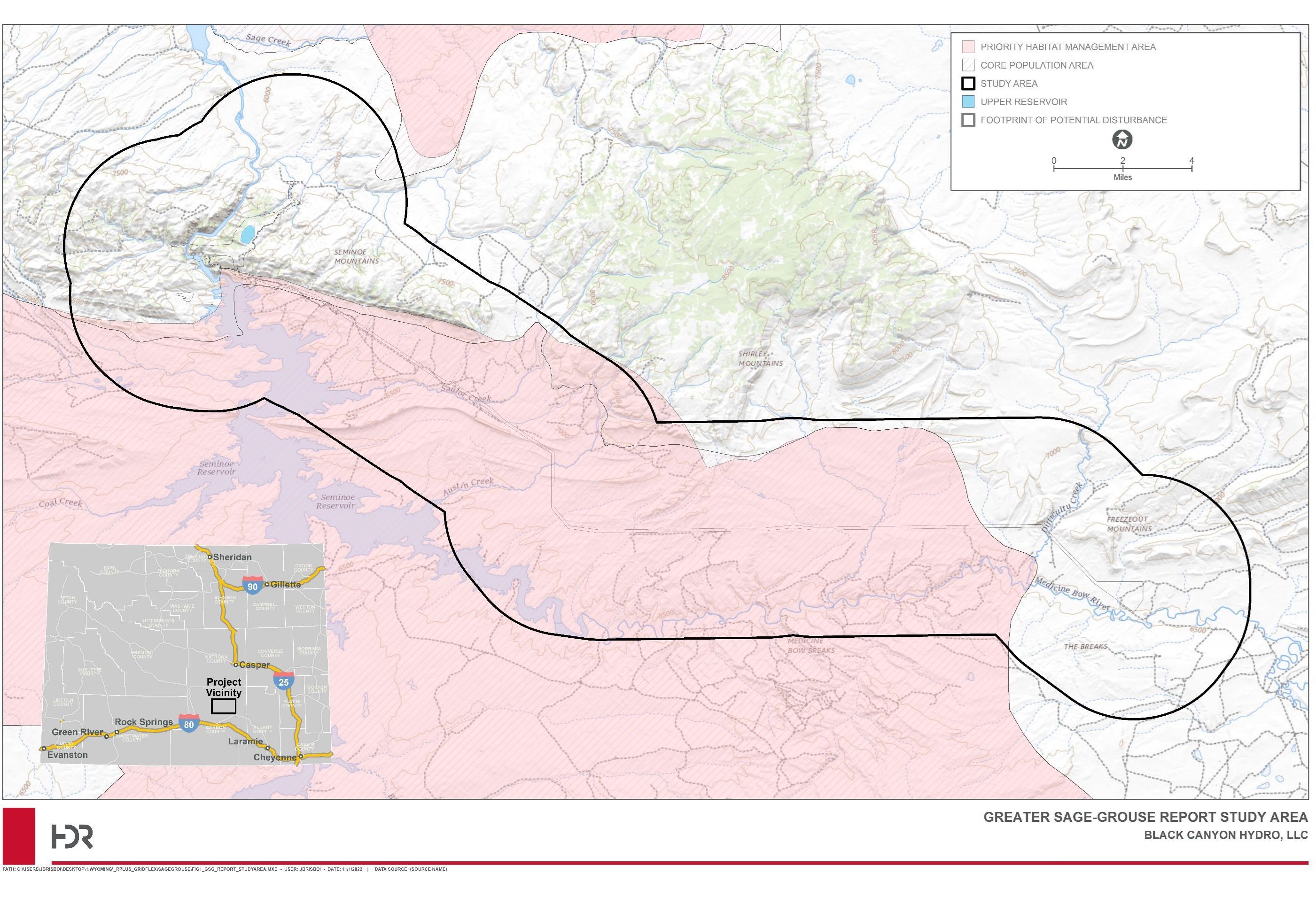
Final License Application – Exhibit E
Storage Project January 2023 | 259
Seminoe Pumped
Figure 3.7-5. Greater Sage-grouse Report Study Area and Habitat Management Categories
This page intentionally left blank.
Final License Application – Exhibit E
Storage Project January 2023 | 260
Seminoe Pumped
Table 3.7-6. Monitored Lek Locations
Lek Name Last Survey Prior to 2021 Status during Last Survey
Lek Monitored by: NAD83 UTM Zone 13N Easting
NAD83 UTM Zone 13N Northing 2021 2022
F-2583261 2020 Inactive HDR HDR 356937 4663426
F-2583302 2020 Active HDR HDR 350297 4663492 F-2583362 2020 Active WGFD HDR 357823 4660868
F-2584252 2020 Active HDR HDR 348700 4663639
F-2481083 2020 Active WGFD HDR 371197 4657346 F-2483144 2020 Active WGFD HDR 357701 4656293 F-2483084 2018 Unknown HDR HDR 351919 4657942
Source: HDR 2022b
Table 3.7-7. Greater Sage-grouse Leks Within the Study Area1
Lek Name
Township/Range/Section Site Class2
F-2583261* 25N/83W/26 Occupied F-2583302* 25N/83W/30 Occupied F-2583362 25N/83W/36 Occupied F-2584252* 25N/84W/25 Occupied F-2481083 24N/81W/8 Occupied F-2483144 24N/83W/14 Occupied F-2483084* 24N/83W/8 Occupied F-2481064 24N/82W/6 Unoccupied F-2483220 24N/83W/22 Unoccupied
Source: HDR 2022e.
Notes:
1
Of the seven occupied leks listed in Table 3.7-7, all but four (denoted with an asterisk) are currently being monitored by WGFD or another entity (HDR 2022e).
2 Occupied – A lek that has been active during at least one strutting season within the prior 10 years.
Unoccupied – Two classifications of unoccupied leks are “destroyed” and “abandoned.” Unoccupied leks are not protected during surface-disturbing activities.
Destroyed - A formerly active lek site and surrounding sagebrush habitat that has been destroyed and is no longer suitable for Greater Sage-grouse breeding. Not monitored unless the site has been reclaimed to suitable Greater Sage-grouse habitat.
Abandoned - A lek in otherwise suitable habitat that has not been active during a period of 10 consecutive years. To be designated abandoned, a lek must be “inactive” in at least four nonconsecutive strutting seasons spanning the 10 years. The lek should be surveyed at least once every 10 years to determine whether it has been reoccupied by Greater Sage-grouse (Christiansen 2012).
Final License Application – Exhibit E
Project January 2023 | 261
Seminoe Pumped Storage
This page intentionally left blank.
Seminoe Pumped Storage Project
– Exhibit E
January 2023 | 262
Final License Application
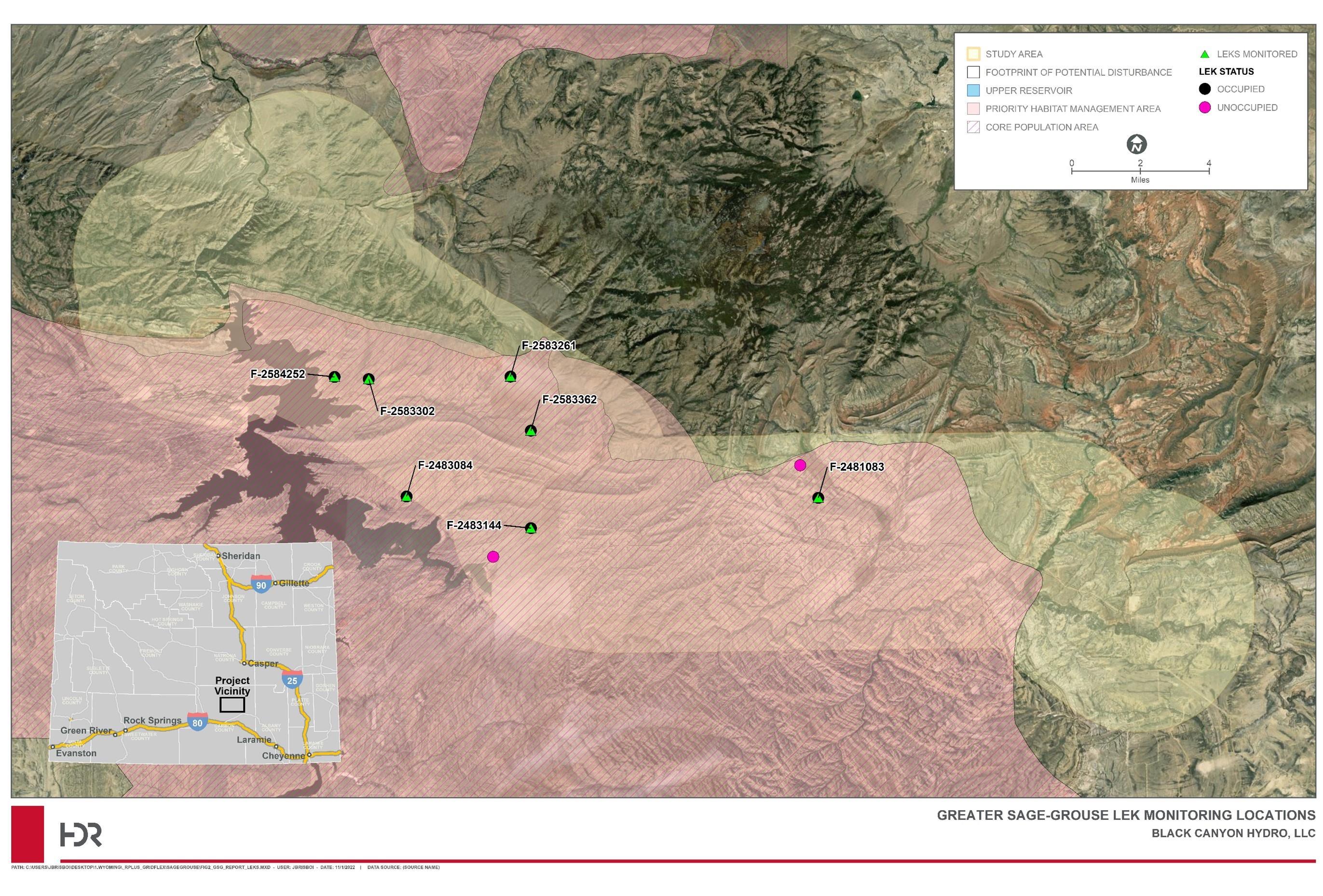
Final License Application – Exhibit E Seminoe Pumped Storage Project January 2023 | 263
Figure 3.7-6. 2021 Greater Sage-grouse Lek Monitoring Locations
This page intentionally left blank.
Final License Application – Exhibit E
Storage Project January 2023 | 264
Seminoe Pumped
Greater Sage-grouse Lek and Habitat Study Results
Desktop Habitat Assessment
The WGFD has designated approximately 54 percent of the study area as a Core Population Area for the Greater Sage-grouse (Figure 3.7-5). Additionally, the BLM has designated PHMAs, which are largely consistent with the WGFD Core Population Areas and are managed to avoid and minimize further disturbance. Approximately 58 percent of the study area is considered a PHMA. The remainder of the study area is designated as a GHMA (Figure 3.7-5).
The USGS SAGEMAP program (USGS 2002) maps approximately 59 percent of the study area as sagebrush/Greater Sage-grouse habitat. Approximately 70 percent of the study area was mapped as having at least 75 percent sagebrush cover and about 87 percent of the study area is mapped has having at least 50 percent sagebrush cover (Hanser 2020).
The Wyoming Natural Diversity Database also mapped probability of Greater Sage-grouse occurrence across the state by relating known occurrence data with environmental data (Keinath et al. 2010). This model predicts that Greater Sage-grouse have a high probability of occurrence within approximately 44 percent of the study area, a medium probability of occurrence in approximately 41 percent of the study area, and a low probability of occurrence in approximately 15 percent of the study area (HDR 2022e)
Greater Sage-grouse Lek Monitoring
Greater Sage-grouse were observed at five leks at least once during monitoring in 2021 and 2022 (Table 3.7-8).
• Male Greater Sage-grouse were observed strutting at the F-2583302 lek during all three lek counts in 2021, and 12 females were observed at that lek during the first count. Males were observed strutting at the F-2583302 lek during all three lek counts in 2022 but no females were present.
• Males were observed strutting at the F-2483084 lek during all three lek counts in 2021, and three females were observed during the first count and two were observed during the second count. Males were observed strutting at the F-2483084 lek during the three lek counts in 2022, and two females were observed during the second count, and one was observed during the third count.
• Males and females were observed strutting at the F-2481083 lek during the lek count in 2021. Males were observed during all three lek counts in 2022, and three females were observed during the first count and two were observed during the second count. Greater Sage-grouse observed at this lek were noted to be northwest of their usual location during the third count in 2022 due to cattle and cattle dogs in the area.
• Males were observed at the F-2483144 lek during the two lek counts in 2021, with two females observed during the second count. Males were observed strutting at the F2483144 lek during all three lek counts in 2022, and one female was observed at each of the counts.
Final License Application – Exhibit E Seminoe Pumped Storage Project January 2023 | 265
• Males were observed strutting at the F-2583362 lek during the count in 2021. Males were observed strutting at the F-2583362 lek during all three counts in 2022 and no females were observed.
No Greater Sage-grouse were observed at leks F-2583261 and F-2584252 in 2021 or 2022. Old scat was observed near the F-2584252 lek; no sign was found near the F2583261 lek (HDR 2022e). The complete results of the 2021 and 2022 Greater Sagegrouse lek monitoring conducted for the Project are presented below in Table 3.7-8
Table 3.7-8. Results of 2021 and 2022 Greater Sage-grouse Lek Monitoring Lek Name 1st Count Birds Present 2nd Count Birds Present 3rd Count Birds Present
F-2583261 4/22/2021 No 4/28/2021 No 5/6/2021 No 4/21/2022 No 4/28/2022 No 5/6/2022 No
F-2583302 4/20/2021 Yes; 17 males/ 12 females
4/27/2021 Yes; 15 males 5/5/2021 Yes; 5 males 4/18/2022 Yes; 28 males 4/26/2022 Yes; 29 males 5/3/2022 Yes; 28 males
F-2583362 3/30/2021* Yes; 8 males N/A N/A 4/21/2022 Yes; 10 males 4/28/2022 Yes; 7 males 5/6/2022 Yes; 11 males
F-2584252 4/20/2021 No 4/27/2021 No 5/5/2021 No 4/18/2022 No 4/26/2022 No 5/3/2022 No
F-2481083 4/6/2021* Yes; 14 males/ 2 females
N/A N/A 4/21/2022 Yes; 14 males/ 3 females
4/28/2022 Yes; 16 males/ 2 females
F-2483144 3/30/2021* Yes; 10 males 4/6/2021* Yes; 30 males/ 2 females
5/6/2022 Yes; 13 males
N/A
License
– Exhibit E
January 2023 | 266
Final
Application
Seminoe Pumped Storage Project
F-2483084
4/21/2022 Yes; 48 males/ 1 female
4/21/2021 Yes; 16 males/ 3 females
4/28/2022 Yes; 47 males/ 1 female
4/28/2021 Yes; 20 males/ 2 females
4/19/2022 Yes; 35 males 4/27/2022 Yes; 32 males/ 2 females
*Date monitored by WGFD; all other dates monitored by HDR.
Lek Proximity Analysis
5/6/2022 Yes; 43 males/ 1 female
5/6/2021 Yes; 17 males
5/5/2022 Yes; 27 males/ 1 female
A proximity analysis for seven Greater Sage-grouse leks closest to the Project (F-2584252, F-2583302, F-2583261, F-2583362, F-2483084, F-2483144, and F-2481083) was conducted with GIS to model the line of sight from the leks towards the Project. The proximity analysis modeled the line of sight from the ground at each lek and incorporated surrounding ground conditions within the study area. Based on the proximity analysis, primary facilities that may be visible from the seven occupied leks include portions of the access road along the existing transmission line and the proposed transmission lines (HDR 2022e).
3.7.1.9 BLM Seasonal Discretionary Activities Timing Restrictions
The BLM has several timing restrictions for the protection of wildlife that would apply to the Footprint of Potential Disturbance (Table 3.7-9). Black Canyon expects that an amendment to the BLM Rawlins Field Office Resource Management Plan (RMP) will be required to facilitate construction of the Project. The following elements may be addressed in the RMP amendment:
• Visual Resources Management – currently some areas in the Project vicinity are classified as VRM-2 viewshed; a VRM-3 or VRM-4 classification will be required for the Project;
• Stipulated seasonal restrictions related to wildlife and habitat, to allow for construction activities, including restrictions for raptor nests, big game crucial winter range, sage grouse, and other resources. The RMP amendment may also address other RMP components, such as a wind avoidance area and limber pine habitat. Black Canyon anticipates that the BLM will coordinate its environmental review of the RMP amendment with the FERC licensing process.
Final License Application – Exhibit E
January 2023 | 267
Seminoe Pumped Storage
Project
Lek Name 1st Count Birds Present 2nd Count Birds Present 3rd Count Birds Present
Table 3.7-9. Current BLM Seasonal Timing Restrictions Applicable to the Footprint of Potential Disturbance
Resource
Raptor nest sites1 (golden eagle, barn owl, red-tailed hawk, greathorned owl, other raptors)
Raptor nest sites1 (osprey, merlin, sharp-shinned hawk, kestrel, prairie falcon, northern harrier, Swainson’s hawk)
Restriction
February 1-July 15
April 1-July 31
Raptor nest sites1 (cooper’s hawk) April 1-August 31
Raptor nest sites1 (short-eared owl, long-eared owl, ferruginous hawk, peregrine falcon, screech owl)
March 1-July 31
Raptor nest sites1 (burrowing owl) April 15-September 15
Raptor nest sites1 (goshawk) April 1-August 31
Active raptor nests Year round (within 825 feet [ferruginous hawks, 1,200 feet])
Pronghorn, elk, moose, bighorn sheep, and mule deer crucial winter ranges
Greater Sage-grouse leks, breeding and nesting habitat
(1) Within ¼ mile of occupied Greater Sage-grouse leks - prohibit surface disturbance/occupancy year-round; avoid human activity 6:00 p.m.-9:00 a.m.
(2) Within 2-mile radius for Greater Sage-grouse identified nesting/early brood rearing habitat avoid surface disturbing activities
Migratory Bird Nesting Season (pre-construction surveys required)
Source: BLM 2008a Notes: 1 1-mile buffer for golden eagle and ferruginous hawk; ¾ – mile all others
3.7.2
3.7.2.1
November 15 - April 30
(1) March 1-May 20 (2) March 15-July 15
April 1 – August 31
Direct and Indirect Environmental Effects - Wildlife Resources
This section presents information available at this time about potential direct and indirect effects of the proposed Project on wildlife resources, including habitat. As described below, Black Canyon recognizes the need for preconstruction surveys of SGCN species and intends to conduct these surveys in coordination with WGFD on methods and timing of these studies prior to their initiation.
Terrestrial Wildlife and Habitat
Project construction activities are expected to have effects on terrestrial resources ranging from permanent conversion of habitats to non-vegetated land cover, to temporary effects resulting from staging areas and disturbance buffers around permanent Project components. It is expected that construction of the upper reservoir will create some amount of permanent displacement of habitat.
Final License Application – Exhibit E
Project January 2023 | 268
Seminoe Pumped Storage
Wildlife that occur in temporarily disturbed habitats or use them seasonally will potentially be impacted until construction is complete and disturbed areas have been effectively revegetated. Impacts to wetland and riparian habitat are anticipated to be avoided through placement of Project features and temporary disturbance areas outside of these habitats to the greatest extent practicable.
In addition to temporary and permanent habitat displacement, construction activities can affect wildlife and their habitats in several ways. Displaced individuals can suffer direct or indirect mortality or decreased breeding success. Direct mortality can occur by destruction of occupied burrows, nests, roost sites, and dens during vegetation clearing, excavation, and grading, or by collision with vehicles on roads to and from the Project. Indirect mortality occurs when displaced individuals are killed elsewhere by predators, vehicles, competitors, lack of resources, or exposure. Inconspicuous burrowing and nocturnal species and species with limited mobility are particularly susceptible to displacement and mortality (e.g., amphibians, snakes, small mammals).
Noise from excavation, blasting, staging of materials and equipment, vehicles, and workers can disturb nearby wildlife during sensitive periods in their life histories (e.g., nesting and brood-rearing; calving; winter). Estimates for type, number, duration, and location of heavy equipment are unknown at this time. It is anticipated that construction activities that generate noise will occur between the hours of 7 a.m. and 6 p.m., Monday through Friday, but will be in accordance with the proposed contractor’s schedule. It is common for a project of this magnitude to be constructed under a two-shift or three-shift schedule, generally excluding any significant construction over the weekends. Most of the noisegenerating Project construction will occur at the upper reservoir site. Construction equipment will include large excavators, scrapers, cranes, loaders, dump trucks, and miscellaneous material delivery by over-the-road semi-tractor trailers. There will also be explosive blasting for rock excavation for the new upper reservoir and powerhouse. It is also likely that a portable concrete batch plant will be erected on site to produce concrete for the Project.
Increased numbers of vehicles and humans can also disrupt wildlife movement, nesting, and foraging behavior. Construction can increase dust locally and displace and disrupt habitat features such as nest and roost trees for birds and bats. Any of these effects can cause nest failure or abandonment during building, egg-laying, or incubation, decrease availability of maternal denning and roost sites for species such as bats, and disrupt fawning and calving areas for ungulates.
Soil disturbance for construction of Project components and vehicle travel may generate fugitive dust that could degrade habitat quality and disturb wildlife. The Erosion and Sediment Control Plan will address practices to be established during Project construction and operation to minimize the potential for generating windblown dust from Project activities and to control fugitive dust
New transmission lines may pose an electrocution risk to perching birds and a collision risk to birds in flight. Project transmission will comply with applicable Avian Power Line Interaction Committee (APLIC) standards for minimizing electrocution and collision risks to birds. Electrocution occurs when a bird is large enough to span the distance between
Final License Application – Exhibit E
January 2023 | 269
Seminoe Pumped Storage Project
an energized component and a ground or between two uninsulated conductors; however, the separation between wires on lines of higher capacity than 69 kilovolts (kV) is generally sufficient to eliminate the risk of electrocution, even for larger birds such as eagles. The Project’s proposed 500-kV transmission lines will exceed the minimum separation for eagles of 60 inches between components (APLIC 2006).
New access roads could disrupt and disturb habitat and movement corridors, expose small wildlife to increased risk from predators (e.g., coyotes, foxes, and avian predators), and cause vehicle-related injuries and mortalities.
Permanent surface features of the proposed Project (e.g., the upper reservoir, transmission lines, upgraded and new access roads) will cause some degree of habitat fragmentation for a variety of wildlife species, mostly terrestrial species with limited home ranges. Ultimately, however, the footprint of the Project is limited, and functionally identical habitats to those in the Footprint of Potential Disturbance are abundant and well-distributed in the region, including large areas in the immediate vicinity. Given adequate implementation of appropriate PM&E measures, the Project is anticipated to have only minor, temporary effects on local general wildlife populations and their associated habitats. Effects on specific categories of wildlife are described below. PM&E measures proposed by Black Canyon are detailed in Section 3.7.4.
3.7.2.2 Common Wildlife Species
Ungulates
Construction of the upper reservoir has the potential to disturb ungulates, cause a loss of ungulate habitat, and will entail construction-related disturbances within designated statewide mule deer crucial winter-yearlong range. Construction activities are scheduled to be completed within five years of commencement and disturbed areas will be revegetated as soon as feasible following construction.
Project-related construction activities such as excavation, road construction and development, heavy equipment use, and associated noise have the potential to deter use and alter wildlife movement patterns. Subsequent operations activities, transmission and fence maintenance, surface features themselves, and associated road use could potentially disturb wintering ungulates during critical periods.
Based on WGFD habitat designations, the following big game use patterns could be temporarily disrupted by construction activities:
• Mule deer year-round habitat use in the Project vicinity.
• Pronghorn year-round habitat use in the Project vicinity
• Bighorn sheep crucial winter range in the vicinity of the Morgan Creek WHMA within the Footprint of Potential Disturbance.
• Elk year-round habitat use in the Project vicinity
Black Canyon will fence the upper reservoir to prevent cattle, wild ungulates, and other medium- to large-sized animals from accessing this area. Project design for the upper reservoir (see Exhibit A) consists of a rim dike structure, approximately 175 feet tall, that
Final License Application – Exhibit E
January 2023 | 270
Seminoe Pumped Storage Project
will be inaccessible to terrestrial wildlife except via a gated access road and associated ramp The ramp is incorporated into existing design and extends into the reservoir and Black Canyon believes this ramp will provide exit opportunities for wildlife.
Construction activities can be timed to minimize disturbance during critical periods, and Black Canyon anticipates working closely with the BLM and WGFD to plan and provide data for Project construction windows that both provide for wildlife protection and allow for feasible Project construction timelines. Revegetation and restoration efforts will restore temporarily affected ungulate habitat. Given adequate and appropriate protection and mitigation measures, the Project is anticipated to have only limited, short-term effects on local ungulate populations and movement patterns.
Amphibians, Reptiles, and Small Mammals
The proposed Project is not anticipated to significantly displace wetland or riparian habitat for amphibians or reptiles; therefore, no short- or long-term effects are anticipated on local amphibian and reptile populations. The proposed upper reservoir would not mimic natural aquatic habitat because the fenced reservoir will be built of concrete approximately 175 feet above ground level and water levels within it would fluctuate rapidly and often. Therefore, it is unlikely that amphibians, reptiles, or small mammals would be attracted to this feature. Incidental direct and indirect impacts to xeric terrestrial amphibians, reptiles, and small mammals, such as collisions of slow-moving individuals with vehicles or equipment, could occur during Project construction and operations. PM&E measures proposed by Black Canyon below are expected to limit these impacts.
Bats
Bats are prone to many of the same threats as avian species (described below), including collision-related injuries and mortalities. Black Canyon’s proposals to minimize outdoor lighting are expected to reduce the potential for detrimental Project effects on bats. Additionally, construction of the upper reservoir could have a positive effect on a variety of bat species. For example, pallid bats are typically recorded at moderately sized reservoirs that allow for approach and departure (Bachen et al. 2020).
Birds
Impacts due to Project construction and operations could include abandonment of the area and local nests due to habitat conversion or disturbance. Disturbance may displace birds into less suitable habitat and, thus, reduce survival rates and reproduction. Waterfowl that travel through the proposed Project may have collision risks from the new transmission line and fence around the upper reservoir. Avian tolerance levels to disturbance can be species-specific and individual-specific. For example, red-tailed hawks could experience a reduction in terrestrial foraging habitat and noise disturbance during construction. The impact to bird species from disturbance or displacement from construction activities is likely to be short term. However, construction noise or activity during the nesting season could contribute to nest abandonment and failure for some species.
Soil disturbance for construction of Project components and vehicle travel can generate fugitive dust that can disturb nearby nesting birds and degrade habitat quality. Vehicle
Final License Application – Exhibit E
January 2023 | 271
Seminoe Pumped Storage Project
3.7.2.3
travel is unlikely to directly affect nesting or migrating birds, but dust may be an issue from approximately June through August. The Erosion and Sediment Control Plan will address practices to be established during Project construction and operation to minimize the potential for generating windblown dust from Project activities and to control fugitive dust These measures will reduce fugitive dust emissions that could disturb nesting birds and affect habitat and forage quality.
Transmission lines can cause mortality of raptors, waterfowl, and migratory birds through direct collision or electrocution. Collision tends to affect birds that are migrating through the area and are unfamiliar with the location of wires. Electrocution tends to affect larger birds such as raptors, which, upon landing or taking flight, ground the live wires and connect the circuit. Electrocution or collision could cause injury or mortality to birds; for instance, red-tailed hawks are the most-reported hawk mortalities from collisions with powerlines (Manville 2002). Mortality as a result of collision with transmission structures or lines will be greatest where the movements of migrating birds are the most concentrated.
Two potential areas of concern will be where the proposed transmission line crosses Troublesome and Difficulty Creeks. These crossings could represent a risk to waterfowl because of the presence of wetlands/riparian habitat and agricultural fields abutting these areas. These areas were highlighted because of their potential use by waterfowl, but other types of birds could also be affected by collision with the proposed transmission line structures, conductors, or static wires. Black Canyon will design transmission structures and wires in accordance with applicable APLIC guidelines to minimize the threat to avian species. Black Canyon proposes to conduct pre-construction surveys to document any raptors and nests that occur in the Project vicinity. Also, appropriate temporal and spatial buffers will be implemented in consultation with relevant state and federal agencies.
Rare, Threatened, and Endangered Wildlife Species Insects
Based on Black Canyon’s botanical and wildlife habitat surveys of the wildlife study area and the analysis in Appendix G, there is a very low potential for milkweed to occur in the footprint of the upper reservoir and therefore be removed. It is highly unlikely that any monarch butterfly individuals would be inundated. No monarch butterflies were observed during the wildlife habitat surveys, and the vegetation surveys did not identify milkweed However, both showy milkweed and pallid milkweed could occur in the study area Therefore, prior to construction, Black Canyon will conduct a survey and habitat assessment in areas where milkweed is most likely to occur (i.e., wetlands, roadsides, drainages, mesic areas) for suitable monarch butterfly habitat. If suitable habitat is identified in an area of proposed disturbance, Black Canyon will discuss avoidance or mitigation measures with the FWS. In addition, as described in Section 3.6.4, as appropriate, milkweed species will be included in the native seed mixes specified in the Habitat Restoration, Reclamation, and Enhancement Plan to improve habitat for the monarch butterfly Black Canyon will also incorporate the following measures to benefit pollinators, including the monarch butterfly:
Final License Application – Exhibit E
January 2023 | 272
Seminoe Pumped Storage Project
• During operation of the Project, Black Canyon will adjust timing of vegetation management in areas containing plants used by monarchs to not interfere with monarch breeding or sources of nectar used as a food source along the migration route This will be included in the Habitat Restoration, Reclamation, and Enhancement Plan
• Black Canyon will work to eliminate or reduce the use of insecticides, which can result in direct mortality to monarchs. The use of pesticides including herbicides will be described in Black Canyon’s Noxious Weed Management Plan.
Birds
Federal and state-listed birds for which there is suitable habitat within the Project vicinity are identified above in Table 3.7-5. As previously mentioned, bald eagle and golden eagle presence in the wildlife study area have been directly observed (HDR 2022c). Based on the results of the raptor nest surveys (HDR 2022c), one active bald eagle nest was observed in the wildlife study area in 2021. Construction noise or activity during the nesting season could contribute to nest abandonment and failure. Both breeding and wintering bald and golden eagles could be susceptible to injury or mortality from transmission line collision. Golden eagles exhibit lower tolerance to disturbance compared to bald eagles (USFWS 2007). The potential impacts on the golden eagle are the removal of foraging habitat in the upper reservoir, potential impact on nesting, and potentially forcing intra- and interspecific competition for territories and prey.
Construction of the proposed Project may displace federal and state-listed birds. If construction activity starts after birds have begun nesting, nests may be abandoned or destroyed. Excavation, road improvements, and other vegetation-clearing activities can be timed to minimize disturbance to nesting birds. Protection and mitigation measures for birds are detailed in Section 3.7.4.
Greater Sage-grouse
Greater Sage-grouse were observed at five lek locations at least once during the lek monitoring in 2021 and 2022. No recorded leks are located near the upper reservoir area. Occupied leks are primarily adjacent to the proposed transmission line.
Greater Sage-grouse may be temporarily disturbed due to noise and increased human presence, noise during construction activities, and an increase of vehicle travel on access roads. However, these disturbances will not occur during lekking, nesting, or broodrearing, due to WGFD and BLM surface use restrictions. Some construction activities can be timed to minimize impacts, but loss of habitat from Project construction and operation may displace Greater Sage-grouse. The presence of additional transmission lines will increase perching opportunities for avian predators which may in turn result in increased predation on Greater Sage-grouse.
Based on the proximity analysis, primary facilities that may be visible from the seven occupied leks closest to the Project include portions of the access road along the existing transmission line and the proposed transmission lines. As mentioned above, the proposed transmission lines will parallel two existing transmission lines as well as either existing
Final License Application – Exhibit E
January 2023 | 273
Seminoe Pumped Storage Project
county roads or two-track ranch roads. Therefore, the proposed transmission lines are qualitatively expected to only minimally alter the lek viewsheds in the study area (HDR 2022e). In addition, Black Canyon proposes to engineer the height and number of tall structures at the upper reservoir during design to reduce potential impacts.
The Project is located partially within a Greater Sage-grouse Core Population Area and, therefore, Black Canyon will submit its Project footprint for WGFD review through the DDCT process. The estimate of the total debits resulting from direct and indirect impacts of the Project will be calculated for the Project following final design. If determined necessary, Black Canyon will develop a mitigation plan in coordination with the WGFD (HDR 2022e).
Mammals
The swift fox is a Wyoming BLM Sensitive Species and a WGFD SGCN Tier II species. Although swift foxes were not observed during the 2021 wildlife field surveys, the WYNDD (2021) includes observations in the vicinity of Difficulty Creek and Medicine Bow, on the eastern edge of the wildlife study area (HDR 2022c). Direct mortality can occur by destruction of occupied burrows or dens during vegetation clearing, excavation, and grading, or by collision with vehicles on roads to and from the Project
The white-tailed prairie dog is a Wyoming BLM Sensitive Species and a WGFD SGCN Tier II species. White-tailed prairie dogs were observed during the 2021 wildlife field surveys, and they are relatively common within suitable habitat of the wildlife study area (HDR 2022c). Excavation could injure individuals in burrows. There is abundant habitat for white-tailed prairie dog elsewhere in the Project vicinity. Given adequate protection and mitigation measures, no Project-related effects are anticipated on white-tailed prairie dog populations in the Project vicinity.
The northern river otter is a WGFD SGCN Tier II species. No river otters were observed during the 2021 wildlife field surveys. The WYNDD (2021) does have a record of an otter sighting from the 1980s in an inlet on the west side of Seminoe Reservoir; however, no observations have been recorded within the study area (HDR 2022c) Considering there is minimal aquatic habitat present in the wildlife study area that will be impacted as a result of the Project, no Project-related effects are anticipated on river otter populations in the Project vicinity
The pygmy rabbit is a Wyoming BLM Sensitive Species and a WGFD SGCN Tier II species. Pygmy rabbits were not observed in the wildlife study area during the 2021 wildlife field surveys and there are no records of observations in the vicinity of the wildlife study area (WYNDD 2021). Range mapping by WYNDD and WGFD do not include the wildlife study area and most of Carbon County is extralimital for the species. While it is unlikely that pygmy rabbits occur in the wildlife study area, there is suitable habitat present (HDR 2022c). Direct mortality can occur by destruction of occupied burrows during vegetation clearing, excavation, and grading, or by collision with vehicles on roads to and from the Project.
Final License Application – Exhibit E
January 2023 | 274
Seminoe Pumped Storage Project
The Wyoming pocket gopher is a Wyoming BLM Sensitive Species and a WGFD SGCN Tier I species. Wyoming pocket gophers were not observed during the 2021 wildlife field surveys. The WYNDD (2021) does not include any observations of the species in or near the wildlife study area. The nearest recorded observation is southwest of the wildlife study area, near Haystack Mountain (HDR 2022c). Excavation could injure individuals in burrows. Given adequate PM&E measures, no Project-related effects are anticipated on Wyoming pocket gopher populations in the Project vicinity.
There are five special-status species of bats with the potential to occur in the wildlife study area (HDR 2022c). Most of the bat species listed in Table 3.7-5 are either WGFD protected or sensitive species and/or BLM sensitive species. Bats are prone to many of the same threats as avian species, including collision-related injuries and mortalities. Black Canyon’s proposals to minimize outdoor lighting are expected to limit Project effects on bats and reduce disruption of nocturnal activities.
Amphibians
The Great Basin spadefoot is a BLM Sensitive Species and a WGFD SGCN Tier II species. The Great Basin spadefoot was not observed during the 2021 wildlife field surveys. The WYNDD (2021) includes recorded observations from the western Seminoe Mountains and eastern Ferris Mountains located outside the wildlife study area. The WYNDD species distribution model (WYNDD 2010) does not include the wildlife study area, but WYNDD’s range map for this species includes the north slope of the Seminoe Mountains within the wildlife study area (WYNDD 2021). The GAP species analysis program maps potential distribution of the species throughout the entire wildlife study area (USGS 2017). Based on this information, Great Basin spadefoot are likely very rare in the wildlife study area, but they could occur throughout most landcover types. Breeding habitat is more restricted to areas with reliable water sources (HDR 2022c) Incidental direct and indirect impacts to Great Basin spadefoot, such as collisions of slow-moving individuals with vehicles or equipment, could occur during Project construction and operations.
The northern leopard frog is listed as a Wyoming BLM Sensitive Species and WGFD SGCN Tier II species. No northern leopard frogs were observed during the 2021 wildlife field surveys. The WYNDD (2021) lists two observations of northern leopard frog in the study area at Seminoe Reservoir and along the North Platte River from before 1980. More recent observations have been recorded in the general area, outside of the wildlife study area. Because this species is widespread, relatively common, and occurs in a broad range of aquatic environments, it is expected to occur in the wildlife study area. Northern leopard frog habitat is not expected to be directly affected by the proposed Project because of the abundance of their available habitat in Wyoming. Incidental direct and indirect impacts to northern leopard frog, such as collisions of slow-moving individuals with vehicles or equipment, may occur during Project construction and operations.
Final License Application – Exhibit E
January 2023 | 275
Seminoe Pumped Storage Project
3.7.2.4 Platte River Recovery Implementation Program (PRRIP) Species
Effects within the Footprint of Potential Disturbance
None of the four PRRIP target species (interior least tern, pallid sturgeon, piping plover, or whooping crane) are known to occur in the vicinity of the Project and these species would not be affected by construction or operation of the Project
Environmental Effects from the Project on Water Quantity Available to PRRIP Target Species in the Platte River Basin
Black Canyon anticipates relying on surface water from existing water rights within the North Platte River Basin as its water source for initial fill and make-up water for the Project. System recharge to replace evaporation and other losses will be conducted during periods when excess water is available to conform to existing water rights. Water supply agreements with existing water right holders and the final water supply plans for the Project will be developed and finalized as the licensing process advances. The Project as proposed will not change the quantity, timing, or frequency of releases from Seminoe Reservoir and will therefore not affect overall water supply or downstream flows; current operations of Seminoe Reservoir by Reclamation will not be affected by the Project’s pumped storage operations. Based on these factors, water use from the North Platte River system during Project construction and operation activities is not anticipated to affect the PRRIP target species or any of the designated critical habitat that may be associated with a PRRIP target species along the Platte River downstream of the proposed Project.
3.7.3 Cumulative Environmental Effects Related to Wildlife Resources
As noted in Table 3.2-1, the geographic scope for wildlife resources is the HUC-8 watersheds in the Project vicinity since impacts within a HUC-8 watershed sufficiently accounts for impacts on wildlife (including special status species) that would be directly affected by construction activities and for indirect impacts such as changes in habitat availability and displacement of transient species. The HUC-8 watersheds that comprise the geographic scope are the Pathfinder-Seminoe Reservoirs watershed (HUC 10180003) and the Medicine Bow watershed (HUC 10180004). As detailed in Table 3.2-2, there are six projects that occur within the geographic scope for wildlife resources: 1) WPCI Project, 2) Two Rivers Wind Energy Project, 3) Lucky Star 1 Wind Project, 4) Gateway West Transmission Line Project, 5) Gateway South Transmission Line Project, and 6) Rock Creek Wind Energy Center.
Issues Identified for Analysis
Reasonably foreseeable future actions with potential to affect vegetation and subsequent wildlife habitat include those that would remove habitat through surface-disturbing activities. Project activities such as clearing, grading, and installation of impervious surfaces could alter wildlife habitat, fragment habitat, displace wildlife, and result in other potential effects, such as increased population stress. The quality and quantity of available winter range is the foremost a limiting factor for big game populations in Wyoming, and considered in management guidelines and construction timing restrictions by the BLM. Habitat quality is necessary for maintaining long-term survival of big game species by
Final License Application – Exhibit E
January 2023 | 276
Seminoe Pumped Storage Project
providing adequate forage and cover. Availability of crucial and severe winter range is essential for population survival during extreme or persistent climatic conditions and is used during seasonal shortages in forage. Development that occurs in limited habitats or winter ranges places pressure on local wildlife populations and may affect habitat quality and function
Overlapping construction and stabilization periods for projects within the geographic scope could result in temporal effects that could prolong displacement of wildlife from important habitats, displacement of wildlife from a larger geographic area, and extend the potential recovery time of wildlife from project direct and indirect effects.
Land administered by the BLM in the Project vicinity is managed for multiple-resource use. Past, present, and future actions in the geographic scope include livestock grazing, recreational use (e.g., biking, hiking, camping, hunting, fishing, boating, ice fishing), transmission lines, pipelines, and wind energy development. Past and present actions have contributed to incremental loss, alteration, and fragmentation of foraging, nesting, and breeding habitat and cover for wildlife species. Despite these incremental modifications of natural landscapes, however, wildlife habitat functionality is often maintained or enhanced on BLM-administered lands and private lands in the geographic scope through habitat restoration and improvement projects that promote ecosystem health, management of invasive species, and government incentive programs.
Results
Based on available information, Project construction will not overlap the only two projects that overlap the Footprint of Potential Disturbance (Gateway West and Gateway South transmission lines), as both are expected to have completed construction and stabilization work prior to the initiation of Project construction. These projects connect to the existing Aeolus Substation, as does the Project; because this area is highly developed and subject to ongoing use it does not provide high-quality habitat for big game or other wildlife species. The Gateway West and Gateway South projects are otherwise geographically removed from the Project vicinity. The construction timing of other reasonably foreseeable future actions within the geographic scope is not clearly defined so there is the potential for construction overlap in time; however, these projects share no geographic proximity to the Project.
The Project’s transmission facilities are generally co-located in the same corridor as multiple existing transmission lines. While concentrating development and disturbance is typically preferred so as to minimize habitat fragmentation, it may also involve a degree of cumulative effects. The presence of multiple transmission lines could become a barrier to movement for some species or individual or increase the intensity of indirect effects. Continuation of past and present actions into the future, in addition to other reasonably foreseeable future actions, may contribute to the incremental modification of wildlife habitats in the geographic scope.
Final License Application – Exhibit E
January 2023 | 277
Seminoe Pumped Storage Project
Reptiles
Cumulative effects on reptiles and their habitat could include the loss, alteration, and fragmentation to foraging and breeding habitat and cover, which would reduce habitat quality and function and could affect reptile abundance, distribution, and mortality rates. Reptile sensitivity to and recovery from cumulative disturbance is likely to be a function of species-specific characteristics and behavior and the type of action of each development in relation to the habitat.
The Project would contribute to incremental modifications of potentially suitable reptile habitat and the cumulative disturbance from all reasonably foreseeable future actions could place additional stress on habitats that are currently limiting for reptile populations in the geographic scope. However, the effects of the Project are anticipated to be minimal since the majority of reptile habitat would remain undisturbed by the Project and other actions in the geographic scope. The only areas of overlap between the Project and other actions is Aeolus substation, a developed site representing poor habitat for reptiles.
Big Game
Elk, mule deer, pronghorn, and bighorn sheep have habitat within the geographic scope for wildlife resources. Potential cumulative impacts from past, present, and reasonably foreseeable future actions could be a function of the type of action and scale, density, and arrangement of each development in designated habitat. Reasonably foreseeable future actions that sever migration corridors, particularly via roads or fences, could affect distribution of pronghorn big game on winter ranges. Large-scale or high-density projects/actions (e.g., oil and gas development) that disrupt big game over multiple breeding seasons would have greater cumulative impacts than low-density development. If Project activities were to temporally overlap then it could prolong big-game avoidance of crucial habitat and displacement from critical/serve habitat and increase physiological stress in populations in proximity to projects, impacts on populations would be minimized or avoided through implementation of seasonal restrictions and Project-specific PM&E measures. Similarly, Project mitigation actions such as habitat and vegetation management could have a beneficial effect of big-game populations.
Greater Sage-grouse
The majority of total available potential habitat for this species would not be affected by the Project or other cumulative actions. However, the Project is anticipated to incrementally contribute to cumulative impacts in Greater Sage-grouse habitats. If Greater Sage-grouse are observed during pre-construction surveys for the Project, selective mitigation measures would be implemented to avoid or reduce potential effects. However, cumulative impacts on vegetation structure providing contiguous sagebrush communities in Greater Sage-grouse habitat could occur.
It is not anticipated that the Project would overlap temporally or spatially with other reasonably foreseeable future actions, therefore, reducing cumulative effects on Greater Sage-grouse displacement from geographically limited contiguous sagebrush habitats or displacement form a larger geographic scope.
Final License Application – Exhibit E
January 2023 | 278
Seminoe Pumped Storage Project
Migratory Birds
Potential impacts to migratory birds include short-term and long-term habitat loss; nest or young abandonment as a result of construction activities or an increase in human presence; mortality of birds from vehicle collisions or destruction of nests, eggs, and young; fragmentation of habitat; and an increase in invasive or noxious weeds that reduces habitat quality. Bird collision mortality is largely caused by window strikes, but energy facilities such as transmission and distribution lines and wind turbines are a large proportion of annual collision mortality as well. Past and present actions in the geographic scope have contributed to incremental loss, alteration, and fragmentation of foraging, nesting, and breeding habitat and cover for migratory bird species. Continuation of past and present actions into the future, including reasonably foreseeable future actions, is anticipated to contribute to the incremental modification of migratory bird habitat and disturbance. Many of the reasonably foreseeable future actions, including the Project, proposed overhead structures (transmission lines, wind energy developments) which would create a collision hazard, particularly at all major river crossings, agricultural areas, and wetlands. Due to the wide range of migratory birds, the Project may also cumulatively compound with offsite effects such as noise, structure avoidance, and vegetation changes.
3.7.4 Agency Consultation and Applicant Recommendations
3.7.4.1 Agency Consultation
The NOI and PAD for the proposed Project were filed with the FERC on April 20, 2020. Comments were received from several agencies including BLM and WGFD, and individuals. Black Canyon held a virtual joint public-agency meeting on July 21, 2020, and has continued consultation with stakeholders since that time. Black Canyon distributed its proposed resource study plans for the Project on August 3, 2020, and March 23, 2021. Black Canyon distributed the DLA on June 6, 2022. Responses to stakeholder comments, and Black Canyon’s Record of Consultation are provided as Appendix A. USEPA, BLM, USFWS, WGFD, and FERC provided comments on wildlife resources in their comments on the DLA. Responses to comments on the DLA are provided in Appendix L.
Black Canyon consulted with WGFD regarding the protocol and monitoring locations for the Greater Sage-grouse Lek and Habitat Study (see report provided in Appendix F). WGFD has provided input on assessment of potential Project effects, design considerations, and BMPs and other potentially appropriate PM&E measures. Black Canyon will continue to consult with WGFD, BLM, and others throughout the licensing process.
3.7.4.2 Applicant Recommendations
As described in Table 2.1-5, the following PM&Es are applicable to wildlife resources:
• Transmission Line Design: During final design, Black Canyon will complete the design of transmission facilities (including locations of transmission towers and access roads) in a manner that minimizes surface disturbing activity in identified 100-year floodplains, areas within 500 feet of perennial waters and wetland/riparian areas and
Final License Application – Exhibit E
January 2023 | 279
Seminoe Pumped Storage Project
areas within 100 feet from the inner gorge of ephemeral channels, as specified in the BLM Rawlins Field Office RMP. If transmission structures cannot be located outside the buffers, Black Canyon will consult with BLM on steps to identify reasonable mitigation measures to minimize adverse impacts to water features.
• Habitat Restoration, Reclamation, and Enhancement Plan: Black Canyon will develop and implement a Habitat Revegetation, Restoration, and Enhancement Plan to identify measures that could be reasonably implemented for management, avoidance, and mitigation of potential habitat and associated vegetation losses during construction and operation of the Project.
• Biological Resources Protection Training Program: Black Canyon proposes to develop a biological resources protection training program. The program is intended to help inform construction workers and other Project staff of the sensitive biological (botanical and wildlife) resources in the area.
• Pre-Construction Surveys: Prior to construction, Black Canyon will complete botanical and wildlife surveys and habitat assessments. These surveys will be conducted by trained botanists and biologists in area that will be disturbed by the Project.
• Fire Prevention and Protection Plan: Black Canyon proposes to develop and implement a Fire Prevention and Protection Plan for the Project.
• Upper Reservoir Wildlife Exclusion: Black Canyon proposes to fence and monitor the upper reservoir to prevent cattle, wild ungulates, and other medium- to large-sized animals from accessing this area.
• Raptor-Safe Transmission Line Structures: Black Canyon proposes to design raptor-safe transmission line structures (i.e., the transmission line design will comply with Avian Power Line Interaction Committee (APLIC) guidelines: Suggested Practices for Avian Protection on Power Lines, The State of the Art in 2006 [APLIC 2006] and Reducing Avian Collisions with Power Lines: The State of the Art in 2012 [APLIC 2012]) to protect avian species from collision or electrocution as a result of landing or perching on transmission lines.
• Sage Grouse Management: Black Canyon proposes to design a transmission line that minimizes adverse impacts to Greater Sage-grouse, including complying with applicable APLIC guidelines in “Best Management Practices for Electric Utilities in Sage-grouse Habitat” (APLIC 2015). Once a final Project design is developed, Black Canyon will submit that Project design through the WGFD DDCT to reduce and mitigate Greater Sage-grouse impacts.
• Post-Construction Surveys: Post construction, Black Canyon will complete a Greater Sage-grouse lek survey to comply with the SGEO. These surveys will be conducted by trained scientists in areas that will be disturbed by the Project.
• Wildlife Seasonal Restrictions: Black Canyon proposes to work closely with BLM to plan for Project construction windows that provide for both wildlife protection and feasible Project construction timelines. This would include developing manageable timing and scheduling restrictions that can accommodate the construction schedule
• Traffic Management Plan: Black Canyon will develop and implement a Traffic Management Plan prior to construction.
• Biological Construction Monitors: Black Canyon proposes to have biological construction monitors on site during construction to monitor sensitive biological
Final License Application – Exhibit E
January 2023 | 280
Seminoe Pumped Storage Project
resources, including conducting avian nesting surveys of areas near active construction during nesting season (April 1 to August 31).
• Raptor Protection Plan: Prior to the onset of ground disturbance at the start of formal construction activities, Black Canyon proposes to prepare and implement a Raptor Protection Plan.
• Outdoor Lighting Plan: Black Canyon proposes to develop a Project outdoor lighting plan to incorporate lighting design features that help minimize disturbance to wildlife species during construction and operation of the Project.
3.8 Recreation
3.8.1
Affected Recreation Environment
Recreation resources in the vicinity of the proposed Project include recreation sites and dispersed public lands, wildlife resources, visual resources, waterways, and lakes, each of which provides different recreational opportunities (BLM 2008a). The BLM Rawlins Resource Management Plan Planning Area (RMPPA) offers a variety of recreational opportunities, primarily for dispersed use requiring undeveloped open space (BLM 2008a)
3.8.1.1 Recreation in the Footprint of Potential Disturbance
There are no existing recreation facilities within the footprint of the Project’s proposed upper reservoir. However, there is a parking area that has a boat ramp below Seminoe Dam that is owned and operated by Reclamation Black Canyon will minimize use of areas that need to be reserved for public access in the future. Furthermore, Black Canyon will maintain public access and parking in the parking area below Seminoe Dam.
Construction staging areas may be located on undeveloped lands not currently used for formal recreation within Seminoe State Park, administered by the Division of State Parks, Historic Sites, and Trails: Wyoming Department of State Parks and Cultural Resources (Wyoming State Parks). Potential impacts to Seminoe State Park are discussed in Section 3.8.2.
3.8.1.2 Recreation in the Immediate Project Vicinity
The Project’s upper reservoir and the access road to the upper reservoir are located adjacent to the Bennett Mountains WSA. This access road provides public access on the west side of the Bennett Mountains WSA (BLM 2019) The Bennett Mountains WSA encompasses approximately 6,000 acres of mountain plateaus, rocky ledges, and tributary draws offering a primitive and unconfined backcountry recreation experience (BLM undated-a). Bennett Mountain Road is a two-track road that allows motorized vehicles. The recreation opportunities in this area include off-road vehicle use, hunting, sightseeing, and hiking. Some trails in the Bennett Mountains WSA can be accessed from Bennett Mountain Road. The BLM notes that there is no public access by vehicle to the WSA (BLM undated-a). Black Canyon has not found any documentation of Bennett Mountain Road being considered a recreational trail, however, it is serving as a recreational access route as well as an administrative road for BLM, rancher grazing access road, and an access road for WAPA along its transmission line system In 2018, a Carbon County advisory
Final License Application – Exhibit E
January 2023 | 281
Seminoe Pumped Storage Project
committee proposed designating Bennett Mountains WSA lands as a Special Management Area with use and development restrictions (Carbon County Board of Commissioners 2018).
The Project’s lower reservoir will be Reclamation’s existing Seminoe Reservoir. Boating and recreational fishing, including ice fishing, are common uses of Seminoe Reservoir. Walleye, Brown Trout, Rainbow Trout, and Cutthroat Trout are all available in Seminoe Reservoir, with Rainbow Trout and Cutthroat Trout stocked annually (Reclamation 2015). Other recreational uses in the Project vicinity are wildlife viewing, hunting, hiking, backpacking, Off-highway vehicle (OHV) use, bicycling, photography, camping, and orienteering (BLM 2008a).
The “Miracle Mile” is located on the North Platte River between the Kortes Dam and Pathfinder Reservoir (WGFD 2019d) and is one of the most popular recreation destinations in the vicinity of the Project. Anglers and other recreationists access the approximately 5.5mile-long reach of the river at numerous locations. The access areas are used year-round and support a variety of outdoor recreational opportunities, including notably fishing, hunting, camping, and floating. An airstrip, used by recreational pilots, is located near Miracle Mile as shown on Figure 3.8-1.
Seminoe State Park is open year-round and offers camping, boating, swimming, fishing, hiking, wildlife viewing, bird watching, and all-terrain vehicle touring (WY Parks 2020). Morgan Creek WHMA is located approximately 2 miles west of the proposed Footprint of Potential Disturbance, near Seminoe Dam, and is managed by the WGFD. The 4,597-acre public access area is open from May 1st to October 31st annually and offers a variety of hunting and hiking opportunities in the rugged Seminoe Mountains (WGFD 2019b).
Developed recreation areas that were inventoried for the Recreation Resources Study, were located within approximately 2 miles of the Footprint of Potential Disturbance, as shown in Figure 3.8-1 The study was conducted in compliance with the study plan (Appendix A of the Study Report). No variances from the study plan were required. Based on comments Black Canyon received from BLM, Seminoe Dam, Reservoir Overlook, and Miracle Mile access locations have been added to the recreation facilities inventoried.
Recreation Resources Study
Black Canyon performed a Recreation Resources Study in 2021 and 2022 that included a recreation facility inventory and condition assessment of existing recreation facilities in an approximate 2-mile radius of the proposed Project location. The study report is presented in Appendix H Black Canyon also performed outreach to recreation owners and managers in the Project vicinity to obtain available information on recreation use and opportunities.
The following facilities were assessed during the Recreation Resources Study:
• Kortes Reservoir Facilities
• Seminoe State Park North Red Hills Area
• Seminoe State Park South Red Hills Area
• Seminoe State Park Sunshine Beach
Final License Application – Exhibit E
January 2023 | 282
Seminoe Pumped Storage Project
Seminoe Pumped Storage Project
• Seminoe State Park Sand Mountain Day Use Area
• Seminoe Reservoir Main Overlook
• Miracle Mile Public Access
Information regarding the type of facility, facility owner and operator, type of recreation provided, structures, signage, sanitation, vehicular access and parking, and accessibility was collected during the study. Photographs were taken of the recreation facilities and are provided in Appendix H A summary of each recreation facility visited during the study is provided in Table 3.8-1
In general, the facilities were in good condition and several amenities are available to visitors. These facilities include campsites, restrooms, boat launches, fishing areas, picnic areas, walking and OHV trails, and informational signage. Recreational opportunities at the facilities assessed include camping, fishing, boating, OHV riding, and picnicking (HDR 2022g).
– Exhibit E
January 2023 | 283
Final License Application
This page intentionally left blank.
Seminoe Pumped Storage Project
– Exhibit E
January 2023 | 284
Final License Application

Final License Application – Exhibit E Seminoe Pumped Storage Project January 2023 | 285
Figure 3.8-1. Recreation Areas Inventoried for the Recreation Resources Study
This page intentionally left blank.
Final License Application – Exhibit E Seminoe Pumped Storage Project January 2023 | 286
Table 3.8-1. Summary of Recreation Facilities Assessed During the Recreation Resources Study
Recreation Facility Owner/Operator Description
Kortes Reservoir Facilities
Seminoe Dam and Reservoir Overlook
Reclamation
Reclamation
The site is primarily used for shore angling along the North Platte River near the tailrace of Seminoe Dam. The site is a popular fishing area upstream of the Miracle Mile. The facilities are unstaffed and open year-round.
The site is used for sightseeing and offers views of Seminoe Dam and tailrace, Seminoe forebay, lower reservoir reaches, and mountains to the south and east. A smaller second overlook offers views of Seminoe State Park and expansive views of Seminoe Reservoir. Facilities are unstaffed and are open yearround with no fees.
Amenities Condition
Unpaved road access with signage, parking for ten cars, two picnic tables, one fire pit/ring, one interpretive display, and one ADA-accessible vault restroom.
Unpaved road access, parking area for 16 vehicles (one ADA space), two seating benches, informational signage, and scenic overlooks.
The facility was in good condition except signage and displays were noted as weathered and fading.
The site was in good condition, the seating bench at the second overlook needs maintenance as erosion is occurring in front of the bench.
Seminoe State Park
– North Red Hills
Area
Seminoe State Park
– South Red Hills
Area
Wyoming State Parks
Developed facilities at the site include a concrete boat ramp, campground, playground, and restrooms. The site is also used for angling. The site is open from May 1 to September 30. Reservations are required for overnight camping and fees for overnight camping range from $10 to $18 and fees for parking or day use range from $7 to $12.
Unpaved road access with signage, parking for seven vehicles (including three ADA spaces), campground with 16 recreational vehicle (RV) sites, 15 tent sites, and one group site (all camp sites have a fire pit/ring and picnic table), boat launch, playground with a basketball court, three restrooms, potable water, an information kiosk and signage, a RV dump site, trash receptacles, short loop trail, and ten ADA-accessible vault restroom stalls.
All aspects of the facility were in good condition.
Seminoe State Park
– Sunshine Beach
Wyoming State Parks
Developed facilities at the site include a boat launch, campground, playground, and restrooms. The site is used for angling as well. The facility is unstaffed and open from May 1 to September 30. Reservations are required for overnight camping and fees for overnight camping range from $10 to $18 and fees for parking or day use range from $7 to $12.
Unpaved road access with signage, parking for several vehicles plus three ADA spaces, campground with 20 tent sites (all camp sites have a fire pit/ring and picnic table), a picnic shelter, six additional day-use picnic tables, two additional fire pits/rings, a playground, an information kiosk, a hard surface boat launch, and eight total restroom stalls (all ADA-accessible).
All aspects of the facility were in good condition.
Seminoe State Park
– Sand Mountain Day Use Area
Wyoming State Parks
Wyoming State Parks
Sunshine Beach contains a developed campground and is also used for angling. The facility is unstaffed and open from May 1 to September 30. Reservations are required for overnight camping and fees for overnight camping range from $10 to $18 and fees for parking or day use range from $7 to $12.
The facility contains a developed picnic area and access and parking for the Seminoe Sand Dunes for OHV riding. The Sand Mountain Day Use Area is unstaffed and open year-round and day use fees range from $7 to $12.
Unpaved road access with signage, parking for at least 26 vehicles (two ADA spaces), campground with 29 tent sites and two group sites (all camp sites have a fire pit/ring and picnic table), four fishing trails, an informational kiosk, three restrooms, trash receptacles, eight total restroom stalls (all ADAaccessible)
Paved road access, parking for ten vehicles (one ADA space), one covered picnic table, three grills, one firepit/ring, and one vault restroom (ADAaccessible). There are several OHV trails available from the facility, but the trails were generally unmarked due to constantly changing conditions from windblown sand.
All aspects of the facility were in good condition.
The facility was in good condition, except the road where potholes and a lack of signage were noted
Reclamation
The site is a popular fishing area, extending about 5.5 miles from the Kortes Dam to Pathfinder Reservoir
Source: Recreation Resources Study Report (Appendix H, HDR 2022g)
Numerous dispersed camping sites, five picnic shelters and 57 picnic tables, benches, fire rings and grills, nine vault restrooms, and an ADA-compliant fishing dock. There are several formal and many informal boat launch points. Trails in the area include one ADA-compliant trail with a ramp for viewing the North Platte River.
The facilities were generally in good condition, although ungraveled access roads had some areas of washboarding and rough terrain.
Final License Application – Exhibit E Seminoe Pumped Storage Project January 2023 | 287
Miracle Mile Public Access areas
This page intentionally left blank.
Final License Application – Exhibit E
Storage Project January 2023 | 288
Seminoe Pumped
3.8.1.3
Existing Shoreline Buffer Zones
As the proposed Project is currently unconstructed, the upper reservoir does not currently exist.
The Project will be operated in a way that minimally affects the levels of Seminoe Reservoir and, therefore, is anticipated to have indiscernible impacts on recreational uses of the shoreline. Proposed Project operations are discussed in Exhibit B of this license application. Potential effects to water resources of Seminoe Reservoir are discussed in Section 3.4, Water Resources
3.8.1.4 Other Recreation Uses and Recreation Needs Hunting and Fishing in the Project Vicinity
Terrestrial recreation use in the Project vicinity is generally focused on big-game hunting.20 In addition to recreational hunting, commercial hunting is available where Special Recreation Permits have been authorized by the BLM for Big Game Hunting and Trophy Game Hunting. These commercial permits provide an income for licensed outfitters who guide clients in this area between December and February for mostly deer, elk, big horn sheep, and mountain lion (BLM 2022a). No hunting is permitted within Seminoe State Park (Wyoming State Parks 2022b)
Non-consumptive recreation use in the area includes angling, bird watching, and photography. Bighorn sheep photography is especially popular in the area as there are favorable public access points for photographing wildlife.
While WGFD has designated 11 walk-in hunting areas in Carbon County, none are in the Project vicinity (WGFD 2021d). These are areas of private or inaccessible land on which WGFD has leased rights for public access to hunt or fish.
The Miracle Mile is a popular fishing destination due to its remote setting, grand scenery, and large-sized Trout (Travel Wyoming 2014). Seminoe Reservoir is stocked annually with Cutthroat Trout, while the Miracle Mile is stocked annually with Rainbow Trout (Reclamation 2021). Available species for anglers in Seminoe Reservoir also include Walleye and Brown Trout. State record Walleye have been caught in Seminoe Reservoir in years past (WY Parks 2020). Ice fishing is also popular on Seminoe Reservoir, with good numbers of small Walleye (approximately 13 inches) and plenty of mid-size Rainbow Trout (approximately 16 inches) (WGFD 2021d).
Winter Recreation in the Project Vicinity
Seminoe Reservoir is used for ice fishing (WGFD 2021e) and Seminoe State Park is open year-round, accommodating campers during the winter (Wyoming Parks 2022a) However, Seminoe State Park does not explicitly offer winter activities (Wyoming State Parks 2020),
20 Personal communication with A. Mahoney, WGFD, December 15, 2021.
Final License Application – Exhibit E
January 2023 | 289
Seminoe Pumped Storage Project
but winter recreation opportunities are available within Carbon County (Carbon County undated-a),
Winter recreation, including Nordic skiing, snowshoeing, dog sledding, and snowmobiling is available in southern Carbon County (Carbon County undated-a). Designated snowmobiling areas include the Snowy Range, Sierra Madres, and Shirley Mountain (Carbon County undated-b). Over 500 miles of groomed and ungroomed trails are available in Carbon County, mainly in the central-southern portion of the County. Nordic skiing, alpine skiing, snowboarding, snowshoeing, and dog sledding are mostly concentrated in the Medicine Bow National Forest administered by the U.S. Forest Service (USFS), south of the Project vicinity (Carbon County undated-c; USFS undated). There are also opportunities for backcountry skiing and snowboarding as well as developed ski areas such as Snowy Ridge Ski Area.
Ice Fishing
To further understand winter recreation use in the Project vicinity, Black Canyon, conducted phone interviews with state and local stakeholders familiar with ice fishing on Seminoe Reservoir. Between September 19 and October 7, 2022, HDR made 21 phone inquiries and one email inquiry, resulting in six phone interviews. Interviews were conducted with representatives from Wyoming Game and Fish, Seminoe State Park, Seminoe Boat Club, and Rocky Mountain Discount Sports. Stakeholders were asked questions related to ice formation, temporal and spatial information, and the popularity of the Reservoir. Additional information was collected related to nearby facilities, fish species, and ice fishing reports and studies.
The interviews indicated that when people ice fish is largely dependent on weather conditions. Assuming weather conditions are favorable (minimal wind and snow), weekends are busier than weekdays and holiday periods are slightly busier than nonholidays. Similarly, there are no clear trends on the most popular times of day for ice fishing at Seminoe Reservoir. Stakeholders have observed people fishing during all hours of the day and night, noting that there are usually more daytime anglers than nighttime anglers. Locals will do day trips, while others will do multi-day fishing excursions and fish at different hours. On average, anglers will spend 6 to 8 hours per day ice fishing.
Stakeholders identified four access points: 1) Seminoe State Park – North Red Hills, 2) Seminoe State Park – South Red Hills, 3) Seminoe Boat Club, and 4) WGFD Boat Launch at Medicine Bow Arm (Figure 3.8-2). The two Seminoe State Park access points receive the most visitors followed by the Seminoe Boat Club access point near Coal Creek Bay. Most stakeholders agreed that where people fish on the Reservoir is directly tied to the access locations, with most anglers staying within a few hundred feet of the shoreline, but the entire lake does receive some use.
The number of people ice fishing on Seminoe Reservoir is dependent on weather conditions. Stakeholder responses ranged in the average number of people ice fishing from 20 to 50 people during busy times and under 10 people during non-busy times.
Final License Application – Exhibit E
January 2023 | 290
Seminoe Pumped Storage Project

E
January 2023 | 291
Final License Application – Exhibit
Seminoe Pumped Storage Project
Figure 3.8-2. Seminoe Reservoir Ice Fishing Areas
Overall, Seminoe Reservoir is relatively remote and does not see as much foot traffic as other similar reservoirs in the area. Other popular ice fishing reservoirs in Wyoming include Boysen Reservoir, Pathfinder Reservoir, Glendo Reservoir, Keyhole Reservoir, and Alcova Reservoir. Many of these reservoirs host ice fishing tournaments, unlike Seminoe Reservoir. Anglers may prefer to ice fish on Seminoe Reservoir since it can have better ice formation and be safer, there is an on-duty ranger, there is less crowding, and it is close for locals. For non-locals, it is a remote location and is not near any other facilities (hotels, restaurants, stores). Winter camping facilities are available at Seminoe State Park which is where most non-local ice anglers stay when fishing the Reservoir. In addition to locals, the Reservoir draws anglers from Laramie, Cheyenne, and Casper. About 30 percent of the ice anglers are estimated to have traveled 4 to 5 hours from Colorado.
Seminoe Boat Club
The private Seminoe Boat Club (Club) is located adjacent to the Sand Mountain Day Use Area. Seminoe Boat Club, Incorporated (SBC) is the owner and operator of the Club facilities (SBC 2021). SBC is a non-profit organization that promotes seasonal recreation at Seminoe Reservoir. The SBC provides lot and non-lot memberships at the Club, in which there are 89 leased lots, one general store and café, and one overnight camping area, as well as a parking area for boat trailers.
The store and café provide apparel, supplies, gas, wood, propane exchange, ice, and more and also serve breakfast and lunch (SBC 2021). The store and café as well as the parking area are open from May through September. The Club is not accessible in winter because there is no snow removal maintenance of the turn off road to the Club off County Road 351. The store lessee also operates the overnight campground, in which full hook-ups and campsites are available. The store manager also collects boat ramp fees for non-club member access. The campground and boat launch are open to non-members for a fee.
Needs Identified in Wyoming’s Statewide Comprehensive Outdoor Recreation Plan (SCORP)
The 2019 Wyoming SCORP is intended to serve as a guide for local, state, and federal agencies in the development and provision of future outdoor recreation opportunities (SPCR 2019). Surveys of both recreation providers and users were conducted to gather information about outdoor recreation opportunities, facilities, programs, uses, needs, and desires (SPCR 2019). In addition, since the 2014 SCORP, the state created the Wyoming Outdoor Recreation Office (OREC); its mission is “to enhance and expand the outdoor recreation industry and improve outdoor recreation infrastructure/access within the beautiful state of Wyoming.”
The survey of recreation providers was an e-mail survey of public recreation organizations throughout the state, including various municipalities ranging in size from small to large. The top three issues identified by Wyoming recreation providers pertain to maintenance of existing facilities, personnel needs, and restoration of existing facilities (SPCR 2019).
Final License Application – Exhibit E
January 2023 | 292
Seminoe Pumped Storage Project
Overall, concern about public access and the preservation of public lands was the most commonly identified issue by Wyoming recreation users, while the second most common concern was about the maintenance of both facilities and natural settings.
Using the results from the recreation provider and recreation user surveys, the 2019-2023 Wyoming SCORP identified three major issues related to outdoor recreation in Wyoming: 1. Land Use Management, 2. Facilities, and 3. Funding and Cost.
Based on these results, the 2019 SCORP provided a list of relevant recommendations to meet the needs of the user and ensure that the current recreational needs of the population are met. The SCORP also identified a list of priority projects to receive funding, which was developed using information from the user survey, provider survey, prior Wyoming SCORPs, and new facility trends.
3.8.1.5 Specially Designated Recreation Areas
Nationwide Rivers Inventory
No portion of the proposed Project will be located on or in the vicinity of rivers included within the Nationwide Rivers Inventory (National Park Service [NPS] 2021).
America’s Scenic Byways
No portion of the proposed Project will be located in any of America’s Byways designated by the U.S. Secretary of Transportation (U.S. Department of Transportation undated). The Seminoe-Alcova Backcountry Byway is located in the immediate vicinity of the Footprint of Potential Disturbance (Figure 3.8-1) Attractions along the 64-mile route include Alcova and Pathfinder Reservoirs, Seminoe Reservoir, Seminoe and Pedro Mountains, and Seminoe State Park (BLM undated-b). There is also a Seminoe Dam and Reservoir Overlook located along the byway.
It is possible that construction staging areas may be located off the Seminoe-Alcova Backcountry Byway. Potential impacts to the Seminoe-Alcova Backcountry Byway are discussed in Section 3.8.2.
National Trails System and Wilderness Areas
No portion of the proposed Project will be located within or adjacent to the National Trails System or within any designated Wilderness Area (NPS 2020b; Wilderness Connect undated).
Wild and Scenic Rivers
No portion of the proposed Project will be located on an area designated as part of the National Wild and Scenic Rivers system (National Wild and Scenic River System undated).
Final License Application – Exhibit E
January 2023 | 293
Seminoe Pumped Storage Project
3.8.1.6 Nationally and Regionally Significant Recreation Areas
Seminoe State Park
Potential construction staging areas in the Footprint of Potential Disturbance will be located on federal lands of Seminoe State Park which are administered by Wyoming State Parks. The Park is located across Seminoe Reservoir from the proposed Project underground powerhouse and lower reservoir intake structure. The Park is open year-round and offers camping, boating, swimming, fishing, hiking, wildlife viewing, bird watching, and ATV touring (WY 2020). Several developed recreation facilities within Seminoe State Park were assessed in the Recreation Resources Study (HDR 2022g)
Morgan Creek Wildlife Management Area
Morgan Creek Wildlife Management Area is located approximately 2 miles west of the proposed Footprint of Potential Disturbance, near Seminoe Dam, and is managed by the WGFD. The 4,597-acre public access area is open from May 1st to October 31st annually and offers a variety of hunting and hiking opportunities in the rugged Seminoe Mountains (WGFD 2019b).
Bennett Mountains Wilderness Study Area
The Bennett Mountains WSA is introduced above in Section 3.8.1.1. Additional information on the Bennett Mountains WSA was obtained through correspondence with the BLM.21 The Bennett Mountains WSA is approximately 6,000 acres and is closed to all motorized vehicle use. The WSA is a destination for scenic vistas, quiet landscapes, and numerous recreational opportunities, such as hiking and exploration, photography, horseback riding, dispersed camping, antler collecting, hunting, bird watching, and rock climbing. Most recreation in the Bennett Mountains WSA occurs in the summer months.22 Motorized vehicles and other motorized equipment are prohibited in the WSA. However, visitors may access by 4-wheel drive from unimproved roads and two-tracks in the vicinity of the WSA. The area is prone to summer lightning strikes and occasional wildfires that may cause recreational closures.
The Bennett Mountains WSA is within a one-hour drive of several communities.23 The recreational users of the WSA come from a variety of demographics. The area is popular with local users from Carbon County from the towns and communities of Hanna, Medicine Bow, Saratoga, Rawlins, and Elk Mountain. Out-of-state users tend to come from Colorado or Utah and spend a weekend or more in the area. Residents of Wyoming communities in Natrona, Albany, and Laramie Counties also recreate in this area. 21 Personal communication with A. Williams, Rawlins BLM Field Office, December 6, 2021. 22 Ibid. 23 Ibid.
Final License Application – Exhibit E
Project January 2023 | 294
Seminoe Pumped Storage
Miracle Mile
The Miracle Mile is a popular fishing area, extending about 5.5 miles from the tailrace of Kortes Dam to the boundary of the southern management unit of the Pathfinder National Wildlife Refuge. The Miracle Mile is accessed at several locations by Seminoe Road from the southwest, Kortes Road from the northeast, and by a network of smaller roads.
Amenities at the Miracle Mile are owned and operated by Reclamation and include numerous dispersed camping sites throughout the area, which are not delineated and do not require reservations. There are five picnic shelters and 57 picnic tables, benches, fire rings and grills, nine vault restrooms, and an ADA-compliant fishing dock. Trails in the area include one ADA-compliant trail with a ramp for viewing the North Platte River.
The facilities are unstaffed and open year-round. Access roads and parking areas are not plowed in winter (Reclamation 2021, WGFD 2019a). Use of the area has increased over the last 5 years (WGFD 2021b)
3.8.2 Direct and Indirect Environmental Effects – Recreation
This section presents information available at this time about potential direct and indirect effects of the proposed Project on recreation.
Several recreation areas are located adjacent to the Footprint of Potential Disturbance, including Bennett Mountains WSA and Morgan Creek WHMA. The Project is located on lands administered by the Reclamation and BLM as well as private lands. No portion of the Project is located within the Bennett Mountains WSA or Morgan Creek WHMA. The Footprint of Potential Disturbance is located partially within Seminoe State Park, on federal lands administered through an agreement with Wyoming State Parks.
Construction staging, marine works, and spoil areas may be located on lands associated with Seminoe State Park, although not within the developed recreation areas. A marine works area to access the proposed lower reservoir intake structure locations on Seminoe Reservoir by boat is proposed just north of the North Red Hills Area. This area will be used for several construction seasons and subsequently vacated and restored to pre-existing conditions. Use of land within and adjacent to Seminoe State Park is not expected to directly impact recreation use of the facilities within Seminoe State Park, such as the boat launches or campgrounds. However, short-term impacts associated with these staging areas include increased vehicle traffic, noise, dust, and lighting. All areas used for construction staging or spoil disposal will be restored.
Construction of the Project may temporarily impact recreation in the Project vicinity. Construction of the Project is expected to last five years, with the most intense aboveground work likely to occur during years one through three. Construction impacts include noise, lighting, dust, and increased traffic, which have the potential to impact nearby recreation. Hunting and wildlife viewing may be temporarily impacted as access may be restricted to some areas during some phases of construction, and wildlife may be
Final License Application – Exhibit E
January 2023 | 295
Seminoe Pumped Storage Project
Seminoe Pumped Storage Project
disturbed due to noise and human activity. Fishing and boating in the Project vicinity may also be temporarily impacted.
Construction of the Project may result in temporary impacts on roadways due to the movement and delivery of equipment, material, and workers. At peak construction, approximately 1,000 workers would be driving to construction sites via the road network spread out over approximately 120 miles. In addition to the construction workforce, the delivery of construction equipment and materials to the Project could temporarily congest existing traffic.
The temporary increase in traffic is expected to occur near the Seminoe tailrace for bridge and access road construction. The area to be impacted would be the Seminoe tailrace, at the upstream extent of the Kortes Reservoir, approximately 300 feet south of the Footprint of Potential Disturbance. The primary recreation activity to be impacted includes angling, specifically shoreline angling. The popular fishing spots along the Miracle Mile on the North Platte River will not be impacted. As described in Exhibit C, it is expected that the bridge over the Seminoe tailrace will be completed within the first year of construction. Once construction of the bridge is complete, most of the recreational impacts at this location will be minimized. There are no alternative access routes proposed at this time since the construction is temporary and short-term and there are numerous, similar recreation opportunities in the vicinity that will not be affected by construction.
The Project is unlikely to have detrimental effects to boat launches or other public access locations on Seminoe Reservoir. As discussed in Section 2.1.1.2, Project operations are predicated to have a daily surface water fluctuation of 6.4 inches under normal operating headwater elevation of 6,357 feet. Any change in Seminoe Reservoir elevation due to Project operations will be within the historic range of Seminoe Reservoir water levels and, therefore, any impacts would occur in areas where Seminoe Reservoir has operated historically. Project effects on Seminoe Reservoir water level and surface area will occur within a band where wave action has historically altered water levels.
Federal lands managed by the BLM in the vicinity of the Project are open to hunting. Lands in the vicinity of the Project are designated as yearlong and crucial winter range for pronghorn antelope and mule deer, important bighorn sheep habitat, and adjacent to and within Greater Sage-grouse core area, according to the WGFD During construction, big game are expected to be temporarily displaced from the area to other habitat surrounding the Footprint of Potential Disturbance, such as the Bennett Mountains. Hunting pressure in the vicinity of the Project may be temporarily reduced during active construction due to both a reduction in number of hunters interested in hunting in the area and a reduction in the number of animals present due to temporary displacement. Hunting opportunities and population management through hunting will be available in adjacent areas during construction. Following construction, it is expected that hunting activity and habitat use by bighorn sheep would return to near pre-construction levels. Potential Project effects on wildlife, game species, and game management are discussed in Section 3.7, Wildlife Resources.
Final License Application – Exhibit E
January 2023 | 296
While there are no scenic byways in the vicinity of the Project, the Seminoe-Alcova Backcountry Byway is located in the Footprint of Potential Disturbance where construction staging areas are proposed. Short-term impacts to the byway are the same as those discussed above for Seminoe State Park. However, no long-term impacts on the byway are expected. Potential Project effects on visual and scenic resources are discussed in Section 3.11, Aesthetic Resources.
There are no National Trails, designated Wilderness Areas, designated National Wild and Scenic Rivers, or rivers listed on the Nationwide Rivers Inventory within 10 miles of the Project.
Ice Formation
As discussed in Section 3.8.1.4, ice fishing is a popular activity on Seminoe Reservoir Based on stakeholder interviews, there was consensus that ice formation on Seminoe Reservoir was reliable enough to allow for ice fishing every year. The Reservoir freezes over every year and the ice has been thick enough to allow for ice fishing (averaging 12 inches or greater). Seminoe Reservoir is generally frozen over consistently from midDecember to mid-March with ice thick enough for ice fishing. Ice formation and break up vary year to year, sometimes starting in mid-November and extending into late March. Ice fishing season largely mirrors that of ice formation; starting in mid-December and ending in mid-March with the potential to start in November and extend later in March.
Stakeholders noted that pressure ridges can form near the shorelines of the Reservoir, as seen with many of the other reservoirs in the area. There have been soft spots observed near the shorelines, and in the “canyon” immediately upstream of Seminoe Dam (Figure 3.8-2). The shoreline soft spots are usually present during the start of ice formation and just before ice break up when the ice is generally thinner and temperatures are warmer. One stakeholder from Seminoe State Park noted that the center of the Reservoir will occasionally breakup and expose open water. The stakeholder hypothesized that this is due to the center of the Reservoir having deep water and a stronger current than in other areas. The breakup does not stay open for long, but he noted that the center of the Reservoir can be a dangerous area to ice fish.
As discussed in Section 3.4.1.5, Black Canyon developed a CE-QUAL-W2 (W2) model for Seminoe Reservoir to further investigate potential Project effects on water temperature and ice formation. The W2 model is a two-dimensional, longitudinal/vertical, hydrodynamic and water quality model. The model is best suited for the Project given the relatively long and narrow characteristics of Seminoe Reservoir, which exhibits longitudinal and vertical gradients. The W2 model is the reservoir model of choice throughout the U.S. and many other countries and serves as the two-dimensional, longitudinal/vertical, hydrodynamic model of choice for Reclamation (USACE undated-a). The W2 model provided information about water temperatures, currents, and stratification under existing conditions and with proposed pumped storage operations.
The results of the W2 model suggest that the timing of ice formation and thawing will be generally the same under Project operations, with ice forming in late November and early
Final License Application – Exhibit E
January 2023 | 297
Seminoe Pumped Storage Project
December, and thawing in early March. The model indicated that the area in the immediate vicinity of the inlet/outlet structure is unlikely to form ice throughout the winter season due to Project operations. Project-related upwelling is projected only occur in this area, and not, for instance, the upstream portion of Seminoe Reservoir that is frequently used for ice fishing. Based on information from local stakeholders, the vicinity of the inlet/outlet structure (in the “canyon”) is not generally used for ice fishing, as the ice is often unstable or with soft spots. However, ice formation on the remainder of Seminoe Reservoir is not expected to be impacted. Therefore, Project operations are not expected to detrimentally affect recreational uses of Seminoe Reservoir in the winter.
Other pumped storage projects in the region, such as Mt. Elbert in Colorado, are compatible with ice fishing activities. Mt. Elbert pumped storage project is located approximately 15 miles south of Leadville, Colorado. The project includes the Mt. Elbert forebay (upper reservoir) and the Twin Lakes Reservoir (lower reservoir). Fluctuations on Twin Lakes Reservoir are the result of inflows, calls for water, and pumped storage operations. A majority of Twin Lakes Reservoir freezes over in winter and is used for an Annual Ice Fishing Derby. The two-day Annual Ice Fishing Derby typically occurs in midFebruary each year with prizes for mackinaw, rainbow trout, brown trout, cutthroat trout, and brook trout. Fluctuations on the lower reservoir are not significant and therefore have minimal impacts on ice formation and are compatible with ice fishing. Additionally, there is a portion of water near the inlet/outlet of the Mt. Elbert pumped storage facility that remains unfrozen year round, yet the rest of the lower reservoir remains accessible for winter recreation.
3.8.3 Cumulative Environmental Effects Related to Recreation
As noted in Table 3.2-1, the geographic scope for recreation is lands within 2 miles of the Footprint of Potential Disturbance. Impacts on public recreation areas would be restricted to construction workspaces and adjacent landscapes. As detailed in Table 3.2-2, there are three projects that occur within the geographic scope for recreation: 1) WPCI Project, 2) Gateway West Transmission Line Project, and 3) Gateway South Transmission Line Project. Cumulative effects related to aesthetic resources, air, and noise are discussed in Section 3.12.3, Section 3.15.3, and Section 3.16.3; respectively.
Issues Identified for Analysis
Almost all parks, preservation, and recreation areas in the geographic scope have been affected by development from past and present actions. However, the natural environmental has been altered in a manner that allows for past and present recreation actions as well as recreational uses (recreational infrastructure, trails, etc.) to occur.
Reasonably foreseeable future actions with potential to impact affect recreation include any development that would involve industrial infrastructure that would affect influence existing recreational experiences. This could include visual contrast and noise from infrastructure construction and subsequent operation that affect user groups for which a quiet environment and undisturbed viewsheds are an important part of the recreation experience. Reduced wildlife utilization areas in proximity to development could also affect
Final License Application – Exhibit E
January 2023 | 298
Seminoe Pumped Storage Project
recreation activities such as hunting and wildlife viewing. The degree of impacts may vary and would depend on current level of disturbance and number and type of reasonably foreseeable actions in proximity to areas with recreation activities that depend upon undisturbed landscape and wildlife and which experience high visitation.
Results
The Project’s Footprint of Potential Disturbance does not include public recreational facilities or designated recreation areas. Cumulative impacts effects within 2 miles of the Footprint of Potential Disturbance would consist of only temporary and intermittent traffic and access changes during construction. No long-term adverse cumulative effects are expected on recreation as a result of Project construction and operation.
While there are no recreation facilities associated with the Project, recreation facilities in the larger geographic scope include: Reclamation’s boat ramp and parking area below Seminoe Dam, Bennett Mountains WSA, Seminoe Reservoir, Miracle Mile, Seminoe State Park (North Red Hills Area, South Red Hills Area, Sunshine Beach, Sand Mountain Day Use Area), Seminoe Reservoir Main Overlook, Kortes Reservoir Facilities. The following text summarizes the cumulative effects on recreational uses and resources in the geographic scope.
Reclamation’s Boat Ramp and Parking Area
The Project would not contribute incrementally to cumulative effects on Reclamation’s Boat Ramp and Parking Area since the Project design will be finalized to maintain or enhance public access and use of this area. Past and present actions have already cumulatively impacted affected the area since the area has secondary roads and man-made infrastructure. Short-term cumulative effects would include increased noise and air emissions (including dust), increased traffic, potential delays for users, and/or detours during construction. Long-term cumulative effects on Reclamation’s Boat Ramp and Parking Area are not anticipated because no Project components will affect it following construction and no foreseeable projects
Bennett Mountains WSA
The Project would not contribute incrementally to cumulative effects on the Bennett Mountains WSA, as the Project’s Footprint of Potential Disturbance and the boundaries of the other reasonably foreseeable future actions do not overlap with this area from a recreational perspective. For example, the Gateway West and Gateway South project only overlap with the Project at the Aeolus substation, which is well-removed from the Bennett Mountains WSA and provides no recreational opportunities; additionally, these projects do not share a construction window with the Project. There are no present or future project proposed in the WSA. Project construction would potentially limit and/or hinder access to the WSA and increase noise and air emission (including dust) during construction, but not in association with other projects. Similarly, hunting and wildlife viewing may also be impacted due to restricted access during construction and wildlife may be disturbed due
Final License Application – Exhibit E
January 2023 | 299
Seminoe Pumped Storage Project
Seminoe Pumped Storage Project
to increased noise and human activities, but not as a cumulative effect in association with other projects.
Seminoe Reservoir
The Project would contribute incrementally to cumulative effects on Seminoe Reservoir since the reservoir will serve as the lower reservoir of the Project, thus adding a new use in addition to past and present actions. Past and present actions impacting Seminoe Reservoir include the development of Seminoe State Park, Seminoe Reservoir Main Overlook, and various boat ramps and camping facilities. Short-term cumulative effects would include increased noise and air emissions (including dust), increased traffic, potential delays for users, and/or detours during construction. The long-term cumulative effects would be additional industrial use of Seminoe Reservoir resulting in visual impacts to nearby recreators (see Section 3.12.3).
Miracle Mile
The Project would not contribute incrementally to cumulative effects on Miracle Mile as the Project, nor the other projects within the geographic scope, are proposed to overlap with this recreational area. Short term effects on the Miracle Mile may include increased traffic, potential delays for users, and/or detours during construction actions. There are no longterm cumulative effects anticipated on Miracle Mile from the construction or operation of the Project.
Seminoe State Park
The Project would not contribute incrementally to cumulative effects on Seminoe State Park. There are no proposed development projects for Seminoe State Park. Short-term cumulative effects would include increased noise and air emissions (including dust), increased traffic, potential delays for users, and/or detours during construction. There are no long-term cumulative effects anticipated for Seminoe State Park from the construction or operation of the Project.
Seminoe Reservoir Main Overlook
The Project would contribute incrementally to cumulative effects on Seminoe Reservoir Main Overlook since construction of the Project would be visible at this vantage point. Past and present actions impacting Seminoe Reservoir Main Overlook include the development of the overlook and Seminoe Dam and tailrace and Seminoe forebay Short-term cumulative effects would include increased noise and air emissions (including dust), increased traffic, potential delays for users, and/or detours during construction. The longterm cumulative effects would be additional man-made structures resulting in visual impacts to nearby recreators (see Section 3.12.3).
Kortes Reservoir Facilities
The Project would not contribute incrementally to cumulative effects on Kortes Reservoir facilities as the Project, nor the other projects within the geographic scope, are proposed
Final License Application – Exhibit E
January 2023 | 300
Seminoe Pumped Storage Project
to overlap with this recreational area. Short term effects on the Kortes Reservoir Facilities may include increased traffic, potential delays for users, and/or detours during construction actions. There are no long-term cumulative effects anticipated on Kortes Reservoir Facilities from the construction or operation of
the Project
As described in Section 3.8.2, the Footprint of Potential Disturbance partially overlaps Seminoe State Park. Also within the geographic scope are several recreation areas including Bennet Mountains WSA and Morgan Creek WHMA. In addition, federal lands managed by the BLM are open to hunting. Cumulative impacts on recreation from the Project and other projects in the geographic scope could occur due to construction activities including increased noise, lighting, dust, and traffic.
3.8.4 Agency Consultation and Applicant Recommendations
3.8.4.1 Agency Consultation
The NOI and PAD for the proposed Project were filed with the FERC on April 20, 2020. Comments were received from several agencies including BLM and WGFD, and individual stakeholders. Black Canyon held a virtual joint public-agency meeting on July 21, 2020, and has continued consultation with stakeholders since that time. Black Canyon distributed its proposed resource study plans for the Project on August 3, 2020, and March 23, 2021. Black Canyon distributed the DLA on June 6, 2022. Responses to stakeholder comments and Black Canyon’s Record of Consultation are provided in Appendix A. BLM, WGFD, and Reclamation provided comments on recreation resources in their comments on the DLA. Responses to comments on the DLA are provided in Appendix L.
3.8.4.2 Applicant Recommendations
As described in Table 2.1-5, the following PM&Es are applicable to recreation:
• Public Access: Black Canyon proposes to manage lands over which it has control in the Footprint of Potential Disturbance for appropriate public access.
• Traffic Management Plan: Black Canyon will develop and implement a Traffic Management Plan prior to construction.
3.9 Land Use
Public land within the Footprint of Potential Disturbance is administered by the BLM, Reclamation, and Wyoming State Parks. Most public land in the Project vicinity is managed for agricultural uses and grazing and recreation is another common use of the Project vicinity such as in Seminoe State Park, Seminoe Reservoir and the North Platte River, and the Bennett Mountains WSA.
The BLM administers over two million acres of public land in Carbon County, which is available for livestock grazing, mineral production, recreation, and wildlife habitat (City of Rawlins undated). Major economic uses of public land in Carbon County include commercial wind power, raising sheep and cattle, mining, and natural gas production (Van Pelt 2014).
Final License Application – Exhibit E
January 2023 | 301
3.9.1 Affected Land Use Environment
Lands surrounding the Platte River are used primarily for agriculture, oil and gas development, mining, and recreation (Ostlind 2014). The North Platte River Basin contains some of the most remote land in the country (Ostlind 2014). Seminoe State Park, located south of the Project vicinity on the shores of Seminoe Reservoir, provides year-round camping, boating, and hiking (Hein 2014). Recreational uses in the Project vicinity are described in Section 3.8 Recreation.
Land use in the vicinity of the Project includes primarily undeveloped private and BLMmanaged public lands. Land in the Project vicinity includes portions of Seminoe State Park (approximately 345 acres) as well as land administered by the BLM or private land (Figure 3.1-3). Land ownership within the Footprint of Potential Disturbance is summarized in Table 3.1-1. Within the Footprint of Potential Disturbance, most land cover is woodland, desert scrub, or shrubland (USGS 2016). There is little developed land in the Footprint of Potential Disturbance
Most land use within the Footprint of Potential Disturbance is comprised of ‘exempt’ land (2,135 acres, 70.3%), which refers to federal land administered by the BLM or Reclamation. Other land uses in the Footprint of Potential Disturbance include agricultural land (876.5 acres, 28.8%) and a residential area (28 acres, 0.9%). Agricultural land within the boundary is generally used for grazing (Carbon County Board of Commissioners 2012). Table 3.9-1 provides a summary of land uses in the Footprint of Potential Disturbance and Figure 3.9-1 shows land uses in the Project vicinity.
The Bennett Mountains WSA is located adjacent to the Footprint of Potential Disturbance in the vicinity of the proposed upper reservoir and transmission corridor. The Bennett Mountains WSA is considered a special designation/management area by BLM in order to protect or preserve its use and value as wilderness, including for wildlife habitat and recreation (BLM 2008a). The Bennett Mountains WSA is discussed in detail in Section 3.8 Recreation.
Table 3.9-1. Land Use in the Footprint of Potential Disturbance
Final License Application – Exhibit E
Project January 2023 | 302
Seminoe Pumped Storage
Land Use Type Acres within
Percent (%) Staging Areas Agricultural –Exempt 176.4 5.8 Residential –Project Works Area (including Upper Reservoir) Agricultural -Exempt 768.0 25.3 Residential - -
the Footprint of Potential Disturbance
Land Use Type
Transmission Corridor
Acres within the Footprint of Potential Disturbance Percent (%)
Agricultural 876.5 28.8 Exempt 1190.6 39.2
Residential 28.4 0.9
Footprint of Potential Disturbance Total
Agricultural 876.5 28.8 Exempt 3,135.0 70.3 Residential 28.4 0.9
Total 3,039.9 100.0
Source: Carbon County undated-d
License Application – Exhibit E
January 2023 | 303
Final
Seminoe Pumped Storage Project
This page intentionally left blank.
Seminoe Pumped Storage Project
– Exhibit E
January 2023 | 304
Final License Application
Figure 3.9-1. Land Use in the Project Vicinity

Final License Application – Exhibit E
Storage Project January 2023 | 305
Seminoe Pumped
This page intentionally left blank.
Final License Application – Exhibit E
Storage Project January 2023 | 306
Seminoe Pumped
Section 102 of the Federal Land Policy and Management Act directs the BLM to prepare land use plans that serve as the basis for all activities that occur on BLM-administered lands. The applicable land use plan in the vicinity of the Project is the Rawlins Record of Decision and Approved Resource Management Plan (RMP) (BLM 2008b). The RMP provides direction for management of renewable and nonrenewable resources found on public lands within the Rawlins Field Office (RFO) planning area and guides decisionmaking for future site-specific actions. The Approved RMP directs the RFO in resource management activities including leasing minerals such as oil and gas; construction of electrical transmission lines, gas pipelines, and roads; grazing management; recreation and outfitting; preserving and restoring wildlife habitat; selling or exchanging lands for the benefit of local communities; military use of the planning area; and conducting other activities that require land use planning decisions. The RFO Approved RMP covers approximately 11.2 million acres of public land in Albany, Carbon, Laramie, and Sweetwater Counties in Wyoming (BLM 2008b).
Carbon County abides by a Comprehensive Land Use Plan that focuses on unincorporated areas of the County as well as the City of Rawlins and incorporated towns (Carbon County Board of Commissioners 2012). The County’s Land Use Plan defines the goals and strategies for future land uses in Carbon County in order to support sustainable growth and attain local values. Seven major goals are outlined in the plan, including the following:
1. Achieve a sustainable balance between energy development, agriculture, and the environment.
2. Protect water supplies of established users.
3. Sustain scenic areas, wildlife habitat, and other important open spaces.
4. Retain ranching and agriculture as the preferred land uses in rural areas.
5. Locate new residential developments and commercial sites near municipalities and developed areas.
6. Ensure that future land development is fiscally responsible and has adequate roads and other infrastructure.
7. Retain diversity of use on public lands and provide for conversion of public lands to other land uses as would benefit the orderly development of the County.
All non-federal lands in the Project vicinity are zoned by Carbon County for Ranching, Agriculture, and Mining (RAM) (Carbon County Planning and Zoning Commission 2015; Carbon County Department of Planning and Development 2017). The purpose of the RAM zoning district is “to preserve historic uses and open space areas of the County while at the same time permit ranching, agriculture, animal husbandry, forestry, and mining in a manner that attains this purpose.
Carbon County also recently developed a Natural Resource Management Plan (NRMP) that addresses land uses in the County (Carbon County Board of Commissioners 2021). The Carbon County NRMP serves as a basis for coordinating with federal and state agencies on land and resource management in the County. The County is split into three soil conservation districts in which the Project is located within the Medicine Bow Conservation District in the northeastern third of the County. The NRMP discusses the history, custom, and culture of various natural and socioeconomic resources in the County,
Final License Application – Exhibit E
January 2023 | 307
Seminoe Pumped Storage Project
then describes resource management objectives for each. The resource management objectives for general land use in the County’s NRMP include the following:
1. The basis for management of all public lands within Carbon County is multiple-use management.
2. Federal agencies consider the direct and indirect effects on private and state lands on a local region-wide basis rather than only analyzing the impacts on federal lands.
3. Federal agency decisions on federal public lands minimally impact neighboring state and private lands.
4. Federal land-use projects in mixed land ownership areas are coordinated with Carbon County and rely heavily on input from neighboring private landowners.
5. Effective reclamation plans that protect existing uses are a primary requisite when approving projects in mixed land ownership projects.
The Carbon County NRMP also includes management objectives for renewable energy (including hydropower) development in that development should strive for sustainable balance between energy and other resources (Carbon County Board of Commissioners 2021).
3.9.1.1 Vegetation and Wildlife Habitat
According to the USGS Gap Analysis Program (GAP)/LANDFIRE National Terrestrial Ecosystems dataset (USGS 2011) there are 16 landcover types present within the Footprint of Potential Disturbance (Table 3.9-2). USGS landcover mapping shows that the vegetation types in the boundary are relatively low in complexity, with two cover types comprising 70 percent of the Footprint of Potential Disturbance (Inter-Mountain Basins Big Sagebrush Steppe and Inter-Mountain Basins Mixed Salt Desert Scrub). Details on these landcover types and a comparison to landcover types mapped at the Project in 2021 and 2022 is provided in Appendix G Vegetation and habitat mapping of the botanical study area was performed as part of the Habitat Assessment and RTE Species Evaluation Study (Appendix G) and is discussed further in Sections 3.6 Botanical Resources and 3.7 Wildlife Resources. Landcover in the Footprint of Potential Disturbance is consistent with rolling sagebrush steppe, foothill shrubland, and low mountains of the intermountain west and Wyoming basin.
Table 3.9-2. Verified Land Cover Types Within the Botanical Study Area1
Final License Application – Exhibit E
Project January 2023 | 308
Seminoe Pumped Storage
Landcover Types Acres Percent of Study Area Inter-Mountain Basins Big Sagebrush Steppe 909.3 57 Inter-Mountain Basins Mixed Salt Desert Scrub 309.3 19 Wyoming Basins Dwarf Sagebrush Shrubland and Steppe 142.2 9 Rocky Mountain Foothill Limber Pine – Juniper Woodland 139.9 9 Inter-Mountain Basins Greasewood Flat 28.5 2
Landcover Types
3.9.1.2
3.9.1.3
Acres Percent of Study Area
Inter-Mountain Basins Mat Saltbush Shrubland 25.7 2
Western Great Plains Riparian Woodland and Shrubland 14.3 1
Western Great Plains Cliff and Outcrop 8.8 1
Western Great Plains Saline Depression Wetland 6.0 <1
Inter-Mountain Basins Cliff and Canyon 5.6 <1
Open Water (Fresh) 3.7 <1
Inter-Mountain Basins Big Sagebrush Shrubland 2.4 <1
Northwestern Great Plains Mixedgrass Prairie 1.9 <1
Western Great Plains Open Freshwater Depression Wetland 0.5 <1
Inter-Mountain Basins Shale Badland 0.3 <1
Inter-Mountain Basins Curl-leaf Mountain Mahogany Woodland and Shrubland 0.2 <1
Total 1,598.5
Source: USGS 2011
1 The botanical study area is defined in Section 3.6 and includes all lands that may be affected by Project construction and operation.
Floodplains and Wetlands
According to the Federal Emergency Management Agency (FEMA) National Flood Hazard Layer and map viewer, there are no floodplains in the vicinity of the Project (FEMA 2021).
Waterbodies, riparian corridors, and wetlands are relatively rare in the study area Wetlands are discussed in Section 3.4 Water Resources.
Grazing
Congress mandates that BLM manage grazing, and BLM livestock grazing policies are designed to protect the productivity of public lands in an efficient and effective manner. There are a total of 582 grazing allotments within the BLM Rawlins RMPPA totaling 3,492,744 acres (BLM 2008a). The BLM defines grazing systems in the following seven categories:
• Permit Long. Grazing occurs for part of or for the duration of the permitted time, often lasting from late spring through fall.
• Year-Long Permit. Grazing is permitted for any time during the year.
• Rotation. Grazing is rotated during the growing season between pastures in the allotment to provide partial growing season rest before use or recovery time after use.
• Deferred Rotation. Grazing is rotated between pastures or allotments to provide full growing season rest every second or third year.
• Dormant Season. Grazing occurs after seed-set by grasses; includes late summer, fall, and/or winter grazing.
Final License Application – Exhibit E
Project January 2023 | 309
Seminoe Pumped Storage
• Split Season. Grazing occurs during two separate time periods, by removing livestock from the allotment and returning them later in the year to provide partial growing season rest.
• Rest Rotation. Grazing is rotated between pastures, with each pasture receiving no grazing use for an entire year, usually every third or fourth year.
The utilization of public lands for grazing as managed by the BLM provides for efficient, sustainable, and economical production of livestock (Carbon County Board of Commissioners 2021). Permitted grazing on public lands is a critical component of livestock operations in Carbon County. All the BLM-managed lands within the Footprint of Potential Disturbance are managed under grazing allotments (BLM 2008a). Twelve grazing allotments over 385,300 total acres with a total of 24,454 federal animal unit months (AUMs) are partially occupied by the Footprint of Potential Disturbance (Table 3.9-3, BLM 2008a) The Footprint of Potential Disturbance will occupy less than 8 percent of any one grazing allotment. In particular, the percent of allotment within the Footprint of Potential Disturbance is 3.9 percent for the Black Canyon allotment and only 1.2 percent of the allotment is located within the FERC Project Boundary. The percent of allotment within the Footprint of Potential Disturbance for Seminoe allotment is less than 1 percent and this allotment does not overlap with the FERC Project Boundary. The ROW will remain active for grazing upon construction completion and, therefore, impacts to the grazing allotments will be reduced.
3.9.1.4 Agricultural Lands
Agriculture plays a significant role in the economy of Carbon County, as it does across the State of Wyoming (Carbon County Board of Commissioners 2012). Carbon County is a top producer of cattle in the state, with secondary products such as hay production. Other crops are not generally produced in the County. A total of 1,324 agricultural parcels comprising nearly two million acres of land exist in Carbon County (92.9 percent of land in the County). Agricultural parcels in the Project vicinity are large, with some 632 to 2,188 acres, but most are larger.
License
– Exhibit E
January 2023 | 310
Final
Application
Seminoe Pumped Storage Project
Final License Application – Exhibit E
Seminoe Pumped Storage Project
Table 3.9-3. Grazing Allotments in the Footprint of Potential Disturbance
Grazing Allotment Name (Number)
Total Federal AUMs
Black Canyon (00323)
Ellis Block/ Pete’s Gap (00811/00835)
Acres Within Footprint of Potential Disturbance
Percent of Allotment Within the Footprint of Potential Disturbance
Acres Within the FERC Project Boundary
Percent of Allotment Within the FERC Project Boundary
Grazing Management System
2,106 799.1 3.9% 246 1.20% Deferred Rotation
794 689.2 4.2% 218 1.34% Deferred Rotation
South Leo (00807) 2,279 646.4 1.5% 494 1.11% Permit Long
South Bennett No. (00333) 772 346.9 7.1% 224 4.57% Permit Long
Medicine Bow (00809) 181 165.18 1.9% 128 1.48% Permit Long
Shirley Mountain (00335) 3,655 78.6 <1% 63 0.18% Permit Long
T.E. Ranch (00808) 536 75.9 1.1% 58 0.86% Permit Long
Seminoe (10218) 11,066 63.4 <1% 0 N/A Deferred Rotation
Corral Creek (00334) 1,181 45.7 <1% 33 0.27% Permit Long
Tennant Place (00802) 18 26.3 7.1% 21 5.77% Deferred Rotation
Source: BLM 2008a
January 2023 | 311
3.9.2 Direct and Indirect Environmental Effects – Land Use
This section presents information available at this time about potential direct and indirect effects of the proposed Project on land use.
The construction and operation of the Project will result in temporary and permanent impacts to land use. During construction, land will be temporarily removed from its current use and converted to construction workspaces, such as within and adjacent to Seminoe State Park, as described in Section 3.8 Recreation. Temporary construction impacts to land uses include noise, dust, vegetation clearing, ground disturbance and dust, and vehicle traffic. Permanent impacts of the Project are described below for the upper reservoir and conveyance facilities and for the new transmission line. Permanent impacts include conversion of existing land uses. Permanent impacts of Project facilities are provided in Table 3.1-1
Permanent impacts of the Project on land use include the conversion of existing land cover at the upper reservoir to inundated lands. The proposed upper reservoir will be fenced for site security, public safety and wildlife protection, and public access to the reservoir will be restricted. Hydraulic conveyance facilities will be mostly located underground in steep terrain, and potential uses of the land above these facilities will be limited. Construction of the transmission line will result in the temporary impacts listed above, but permanent impacts to land use in the transmission corridor will be mostly limited to the footprints of the transmission structures. In addition, the proposed transmission corridor generally follows and is directly adjacent to existing transmission lines.
As shown in Table 3.9-1, approximately 3,012 acres (99%) of the land within the Footprint of Potential Disturbance is located on exempt (federal land) or agricultural lands. The total agricultural lands available in the Project vicinity (within the RFO planning area) is approximately 3,492,744 acres. Therefore, the Footprint of Potential Disturbance is proposed to occupy a small amount of the total available agricultural or grazing land in the RFO planning area (approximately 0.0009%). The agricultural/grazing land will be converted to industrial land used for renewable energy production and transmission rightsof-way.
Grazing will be temporarily affected by construction of the Project due to ground disturbance and clearing of vegetation, noise, increased traffic, and human presence.
Operation of the Project will remove the land inundated by the upper reservoir from grazing (approximately 160 acres). This will result in a permanent impact to holders of the affected grazing allotments and may require a modification to BLM grazing permits and adjustments in AUMs and animal units (AUs) in affected grazing allotments. However, as shown in Table 3.9-3, the amount of the allotment affected is a small percentage of each grazing allotment. Grazing opportunities in the vicinity of the Project will still be abundant. Grazing will still be available in the transmission corridor as this will not be fenced.
Final License Application – Exhibit E
January 2023 | 312
Seminoe Pumped Storage Project
3.9.3 Cumulative Environmental Effects Related to Land Use
As noted in Table 3.2-1, the geographic scope for land use is 1 mile of the Footprint of Potential Disturbance since impacts on general land uses, including public recreational areas, would be restricted to the construction workspaces and the adjacent landscape. As detailed in Table 3.2-2, there are three projects that occur within the geographic scope for land use: 1) WPCI Project, 2) Gateway West Transmission Line Project, and 3) Gateway South Transmission Line Project
Issues Identified for Analysis
Potential conflicts regarding land use could include a variety of current and proposed land uses (agriculture, residential, and industrial). The conflicts would be more intense where the Project and other future and/or existing actions or occurring or planned to occur in the same geographic extent as various land-use resources. These impacts would be intensified where existing actions have conflicted already with the uses that may have occurred in the past or where a project is proposed in the same area as the Project.
Whether the Project is directly or indirectly affecting and existing land use, the cumulative effect on existing and future land uses may result in the overall land use changing or being modified based on all types of effects.
Results
Project vicinity has been developed and include an existing transmission line corridor, Seminoe Dam, Seminoe State Park, and residential developments. Much of the land within the geographic scope is federal land or agricultural lands. Reasonably foreseeable future actions, such as the development of transmission lines and other energy projects, would also be on federal lands and would require minimal conversions of land use.
The construction and operation of the Project and other past, present, and reasonably foreseeable actions would require the temporary and permanent use of land, which would result in temporary and permanent impacts/conversions of land use. The short-term cumulative effects would include construction activities of projects that would require gates being added to existing fences; construction related disturbances (noise, vehicles/equipment, personnel) associated with development of access roads, site grading, and building structures; and larger footprints of disturbance before restoration activities occur. The long-term cumulative effects would be reduced grazing/rangeland available where permanent disturbance/structure footprints would occur from other projects.
The duration of impacts on land use would depend on the type of land cover affected and the rate at which the land can be restored and conditions after construction. Additional temporary impacts to land use include noise, dust, ground disturbance, and vehicle traffic. The Project could result in a minor cumulative conversion of land use from open or undeveloped lands to developed or industrial lands.
Final License Application – Exhibit E
January 2023 | 313
Seminoe Pumped Storage Project
3.9.4 Agency Consultation and Applicant Recommendations
3.9.4.1 Agency Consultation
The NOI and PAD for the proposed Project were filed with the FERC on April 20, 2020. Comments were received from several agencies including BLM and WGFD, and individual stakeholders. Black Canyon held a virtual joint public-agency meeting on July 21, 2020, and has continued consultation with stakeholders since that time. Black Canyon distributed its proposed resource study plans for the Project on August 3, 2020, and March 23, 2021.
Black Canyon distributed the DLA on June 6, 2022. Responses to stakeholder comments and Black Canyon’s Record of Consultation are provided in Appendix A. BLM provided comments on land use in their comments on the DLA. Responses to comments on the DLA are provided in Appendix L.
Comments related to land use were not received from stakeholders nor were land use studies performed by Black Canyon.
3.9.4.2 Applicant Recommendations
Because the impacts on land use are not anticipated to be significant, Black Canyon has not identified PM&E measures to incorporate into the design/preconstruction, construction, and operational phases of the Project to address land use. Black Canyon will continue to evaluate the need for PM&E measures in consultation with stakeholders.
3.10 Cultural Resources
The subsections below describe cultural resources in the vicinity of the Project and consider the effects on these resources of constructing and operating the Project as proposed by Black Canyon. Descriptions of the affected environment, the environmental analysis, the proposed PM&E measures, and the identification of unavoidable adverse effects were developed based on available data presented in the PAD, and the two Cultural Resources Study Reports (HDR 2022h). Both reports are appended to this FLA as privileged documents, provided only to FERC, federal land managing agencies, and other NHPA Section 106 parties.
3.10.1 Affected Environment
This section describes existing cultural resources associated with the Project. It is presented by the following six areas: 1) regulatory context, 2) APE, 3) cultural history overview, 4) existing information, 5) results of the Cultural Resources Study
3.10.1.1 Regulatory Context and BLM Authorities and Standards
In considering an original license for the Project, FERC has the lead responsibility for compliance with applicable federal laws, regulations, and policies pertaining to historic properties, including the National Historic Preservation Act (NHPA) of 1966, as amended (54 U.S.C. §300101 et seq.). Section 106 of the NHPA requires federal agencies to take into account the effects of their undertakings on historic properties and to afford the ACHP a reasonable opportunity to comment. The regulations implementing Section 106 (36 CFR
Final License Application – Exhibit E
Storage Project January 2023 | 314
Seminoe Pumped
Part 800) define the process for identifying historic properties, assessing effects, and seeking ways to resolve adverse effects on historic properties in consultation with the WSHPO, federally-recognized Indian tribes, the public, and other appropriate parties.
3.10.1.2 Cultural Resources Area of Potential Effects
As defined in the applicable regulations found at 36 CFR §800.16(d), the APE for Section 106 of the NHPA is defined as “the geographic area or areas within which an undertaking may directly or indirectly cause alterations in the character or use of historic properties, if any such properties exist.” Based on this regulatory definition, Black Canyon proposes to define the APE for the Project licensing as including all lands within the Footprint of Potential Disturbance. The APE is also proposed to include lands or properties outside the Footprint of Potential Disturbance where Project operations and maintenance activities or other enhancements may cause changes in the character or use of historic properties, if any such properties exist. The APE, as required under Section 106 of the NHPA (36 CFR §800.4[a][1]), was submitted to the WSHPO, BLM, and Reclamation on October 1, 2021 with supplemental information submitted on March 24, 2022. This consultation is provided in the draft Cultural Resources Study Report appended to this FLA as Appendix I.
3.10.1.3 Cultural History Overview
This section provides an overview of the cultural setting of the study area and vicinity. The precontact context below discusses the environmental-temporal-cultural divisions of precontact occupation in the area. The ethnohistoric context below describes the indigenous people of the area through early contact eras. The historic context below provides details about non-Native American activities in the Project vicinity.
Archaeological Precontact Context
Late Prehistoric Paleoenvironment
The paleoenvironment provides the context in which human adaptation can be examined, and human culture often changes in response to changes in environment that affect carrying capacity. The paleoenvironment also affects the geological processes that can lead to preservation or destruction of the archaeological record. Although people have likely been present in the Project vicinity since 12,000 BP (or earlier), evidence of the prehistoric occupation of the Project vicinity is limited, spanning a period beginning in the Late Archaic, extending through the Late Prehistoric period, and into the Protohistoric period. Because of this, discussion of paleoenvironments will be limited to the Late Archaic period forward.
Paleoenvironmental records specific to the Project vicinity are rare, but there are records of fluctuations in temperature and effective moisture for the Rocky Mountain Region surrounding the Project and the Great Basin to the west of the Project over the last three millennia.
Using modern empirical data of how environmental changes affect reproduction of different animal species, Byers and Smith (2007) used faunal data from archaeological sites in the Wyoming Basin to develop indices of the relative abundance of different animals. These
Final License Application – Exhibit E
January 2023 | 315
Seminoe Pumped Storage Project
indicators of habitat change through time and serve as proxies for the paleoenvironment. These indices were compared to the Aridity Index of Eckerle et al. (2002) for the Wyoming Basin. The Aridity Index is a reconstruction of soil moisture deficits at 200-year intervals for the Holocene, based on the temperature and precipitation reconstructions of Bryson and Bryson (2000) for the town of Green River, Wyoming. The values for each of these indices were determined at 200-year intervals and provide a confirmation of general trends in aridity during the past 2,000 years.
Aeolian records are documented in the Plains, prairies, and mountain basins, and the sustained mobilization of aeolian sand is unequivocal evidence of conditions that exceed an aridity threshold sufficient to decrease vegetation cover and destabilize surfaces, resulting in the mobilization of the transport of sand. Numerous researchers have documented the complexity of responses to apparently synchronous episodes of drought at different regional scales, interspersed with at least one period of increase in effective moisture (Madsen et al. 2001). Evidence of periods of increase in effective moisture followed by regional increases in aeolian activity comports well with the context of hearths from sites in the Project vicinity either being at or close to the base of aeolian sediments.
Chronological Framework
Several prehistoric chronologies have been proposed for Wyoming, but Wyoming’s prehistoric past is generally divided into four periods: Paleoindian, Archaic, Late Prehistoric, and Protohistoric (Kornfeld et al. 2010:66). Researchers use evidence derived from diagnostic tools, faunal remains, and dwellings to describe broad patterns of indigenous adaptation from the Late Pleistocene until the earliest interactions with Europeans. These adaptations include responses to changing climatic conditions (such as the ending of the Ice Age), technological developments (such as the introduction of the bow and arrow or ceramics), and the arrival of Europeans in North America.
Paleoindian (14,000 BP to 9,400 BP)
The general consensus within the archaeological community is that Native American populations in the New World originated in Asia, arriving in North America 14,000 to 12,000 years ago. The earliest confirmed human occupation of Wyoming occurs with the Clovis tradition ca. 12,000 BP (Kornfeld et al. 2010:65). The Paleoindian stage is characterized by cultures that made large, finely crafted flaked-stone tools and who hunted now-extinct Pleistocene megafauna.
The earliest archaeological sites with unequivocal evidence of human occupation within Wyoming belong to the Clovis cultural complex. Clovis sites are recognized by the presence of well-crafted large (10–15 cm or greater in length) lanceolate, bifacially flaked and basally fluted projectile points with thin cross sections. During the late Pleistocene and early Holocene, Wyoming was cooler and wetter than it is today. Now-extinct megafauna, including mammoth, camel, and sloth, were plentiful and Clovis points have been found in association with their remains. The Colby site in northern Wyoming, the Union Pacific Site in central Wyoming, and the Dent site in northern Colorado all suggest deliberate exploitation of mammoths by Clovis peoples (Kornfeld et al. 2010:73).
Final License Application – Exhibit E
January 2023 | 316
Seminoe Pumped Storage Project
Goshen projectile points are finely flaked lanceolate points that are neither Clovis nor Folsom but possess some characteristics of each (Kornfeld et al. 2010:78). Goshen points resemble (and have been lumped with) Plainview points from the Southern Plains that are dated to 500 to 1,000 years younger than Goshen (Pitblado 2003:107). While the dating of Goshen points needs further refinement, the stratigraphic position of Goshen points at the Hell Gap, Carter/McGee, and Jim Pitts sites suggest that Goshen predates Folsom (Kornfeld et al. 2010:79). Bradley has suggested that there is continuity between Goshen manufacturing techniques and those used in the later Folsom period (Bradley 2010:473).
The Folsom period is defined by smaller, fluted lanceolate projectile points and a subsistence strategy focused on large, now-extinct species of bison. Bison were the only Pleistocene megafauna remaining in Wyoming when rapidly cooling conditions began about 10,900 years ago, which temporarily interrupted the gradual warming trend that characterized the end of the last Ice Age. While the early Holocene was cooler and wetter than modern conditions, gradually warming temperatures returned and increasing summer precipitation favored the spread of grasslands and the bison that subsisted upon them (Kornfeld et al. 2010:37). There is also some suggestion of an increase in population during Folsom times, and Folsom projectile points, while rare, are more widespread in the Rocky Mountains (particularly mountain parks) and adjacent plains than those of the Clovis period (Kornfeld et al. 2010:80).
Late Paleoindian (10,000-7,900 BP)
Following the Folsom period, populations appear to have split into groups that primarily occupied the Plains who continued to follow a big game hunting subsistence strategy and a mountain-adapted group that pursued a more generalized subsistence strategy (Mueller et al. 2018:10). On the open plains and in the intermontane basins, groups continued to follow a subsistence strategy similar to that seen in Folsom (Kornfeld et al. 2010:95). Projectile points from this period consist of finely flaked lanceolate and stemmed dart points, including Agate Basin, Hell Gap, and Cody (Kornfeld et al. 2010:37).
Groups who occupied the mountains during the Late Paleoindian period adopted a subsistence strategy incorporating a broad range of local resources, similar to that seen in the subsequent Archaic Period (Kornfeld et al. 2010:95). Lithic technology from this period is characterized by the presence of thick, lanceolate points made from local quartzite with distinctive parallel-oblique flaking.
Archaic (9,400 BP to 1,800 bp)
The cultural adaptations of the Archaic stage reflect responses to the onset of warmer and drier climatic conditions during the early Holocene and the disappearance of the last megafauna. Subsistence strategies emphasized a more generalized resource base hunting both large and small game. A substantial increase in ground stone compared to sites of the preceding Paleoindian stage likely reflects an increase in the use of local plants. Metcalf’s paleoenvironmental model for the nearby Northern Colorado River Basin (which incorporates stratigraphic environmental data from the Wyoming Basin) indicates cool and moist conditions during the early Holocene followed by alternating periods of dry and wet conditions (Reed and Metcalf 1999:20–32).
Final License Application – Exhibit E
January 2023 | 317
Seminoe Pumped Storage Project
The onset of the Early Archaic period was marked by a warming trend and increased aridity (Rhode et al. 2011 in Harrison et al. 2018:85). Archaeological data from the Piceance Basin of Colorado and from the Wyoming Basin indicate populations responded by adopting a central place foraging strategy with a decrease in residential mobility (Landt 2018:308). Projectile point technology exhibits an abrupt break from the Late Paleoindian styles with a switch from lanceolate and stemmed projectile points to side-notched types (Kornfeld et al. 2010:106). Another reliable diagnostic of the Early Archaic was a biface knife with a round tip that became asymmetrical through successive episodes of unifacial resharpening (Kornfeld et al. 2010:56–57).
In general, sites dating to the Middle Archaic period are more common than those of the Early Archaic period. A greater prevalence of habitation structures indicates a possible population increase during the period. Lithic technology shifts from the large side- and corner-notched projectile points of the Early Archaic to lanceolate and stemmed-indented forms dominated by those of the McKean Complex (Kornfeld et al. 2010:114). The McKean complex is marked by the stemmed Duncan and Hanna, McKean lanceolate, and sidenotched Mallory projectile point styles. Subsistence strategies were similar to the Early Archaic, although an increase in ground stone tools suggests an increased reliance on plant resources (Kornfeld et al. 2010:114). Except for the Scoggins site in south-central Wyoming, McKean complex sites lack evidence of large cooperative bison hunts as seen in the Early Archaic and Late Archaic (Kornfeld et al. 2010:254). Instead, the archaeological record suggests emphasis was placed on the seasonal exploitation of high elevation artiodactyls (Landt 2018:308).
The Late Archaic period is marked by a return to corner- and side-notched dart point styles. Unifacially resharpened corner tang knives (a possible refinement of the unifacially resharpened knife that appeared during the Early Archaic) also appear diagnostic of Late Archaic occupations (Kornfeld et al. 2010:57). Late Archaic peoples continued to exploit a broad range of local resources, but increased effective moisture is thought to have contributed to the growth of bison herds and an associated intensification of communal hunting (Kornfeld et al. 2010:255).
Late Prehistoric (1,800 BP to 300 BP)
The Late Prehistoric is characterized by the adoption of smaller projectile point styles reflecting the introduction of the bow and arrow, and the gradual introduction of ceramic technology (Kornfeld et al. 2010:130). Late Prehistoric populations continued to practice a hunter-gatherer subsistence strategy but, perhaps in response to increased population pressure on the environment, they appear to have exploited a broader range of natural resources. Radiocarbon dates from the Late Prehistoric suggest that this may have been a period of increased human population in southern Wyoming (Mueller et al. 2018:12). In southwestern Wyoming, the Late Prehistoric Period is commonly broken into the Uintah and Firehole phases, described below.
Uintah phase lithic tool assemblages generally resemble those of the preceding Late Archaic, but often contain small, corner-notched Rosegate projectile points (Kornfeld et al. 2010:131). The Rosegate series appears to have been derived from the (Great Basin) Elko Corner-notched type and represents the earliest adoption of the bow and arrow in the
Final License Application – Exhibit E
January 2023 | 318
Seminoe Pumped Storage Project
Intermountain West (Mueller et al. 2018:115). Other markers of the Late Prehistoric are grooved mauls and serrated metatarsal scrapers (Kornfeld et al. 2010:60). Basin houses appear during the Uintah phase in Wyoming, and thermal features reach their maximum size during the Late Prehistoric (Landt 2018:312; Mueller et al. 2018:13).
The Firehole phase is marked by a transition to side-notched and basal-notched (trinotched) projectile points, similar to types used by the historic Crow and the Shoshone (Kornfeld et al. 2010:131). Although ceramic artifacts are uncommon in Wyoming archaeological sites, when present they are valuable indications of cultural identity, movement, and exchange. During the Firehole phase, local ceramic manufacture became more common. The most common ceramic type is Shoshonean (Intermountain tradition) pottery with a “flowerpot” vessel shape, including flat bottoms, and flanged bases (Kornfeld et al. 2010:433). Limited amounts of pottery representing other cultural traditions from surrounding regions have also been recovered from southern Wyoming, including Ute Uncompahgre Brown Ware, Fremont Uintah Gray Ware, Athabascan pottery, and both painted and corrugated Puebloan sherds (Kornfeld et al. 2010:435). Carved steatite vessels are also associated with the ancestral Shoshone and assume many forms, including forms that mimic Intermountain tradition pottery. Evidence indicates that ancestral Shoshone groups during this period constructed wickiups (pole-brush structures) and manufactured Desert Side-Notched and Cottonwood projectile points (Kornfeld et al. 2010:437).
Protohistoric Period
The Protohistoric period began about 300 to 400 years ago, with the gradual appearance of European trade goods in the archaeological record. European goods included metal weapons and tools and glass beads, which can be abundant in burial contexts though these items are not present in all Protohistoric sites (Gill 2010:536). Metal arrowheads (both trade goods and locally manufactured from repurposed metal) were once commonly found but have mostly rusted away over the succeeding decades (Frison 2004:218). Evidence of the acquisition of European goods may also be indirect, such as butchery marks on faunal remains made using metal tools (Kornfeld et al. 2010:137). Horses, initially introduced by the Spanish and acquired through trade with the Ute, dramatically changed subsistence strategies for many Tribes. Some Shoshonean groups began acquiring significant numbers of horses in the early 1700s, with the Crow and other tribes acquiring them somewhat later (Kornfeld et al. 2010:135-136).
The adoption of horses as transportation and beasts of burden by the ancestors of the Eastern (Wind River) Shoshone permitted them to roam much more widely and to adopt a subsistence strategy that focused on bison hunting from horseback (Mueller et al. 2018:15). This differed from the earlier mixed subsistence strategy of foraging and hunting medium-sized game (Frison 2004:162). The newly equestrian Shoshone initially controlled a large range, but by 1800 the Crow and Blackfoot had acquired firearms and horses and had forced the Shoshone to withdraw into Wyoming and southern Idaho. Historic accounts indicate that while southern Wyoming was dominated by the Shoshone, it was also visited by the Ute, Crow, Blackfoot, Bannock, Arapaho, Cheyenne, and Lakota (Mueller et al. 2018:15-16).
Final License Application – Exhibit E
January 2023 | 319
Seminoe Pumped Storage Project
Ethnohistoric Context
The ethnohistory of the Project vicinity provides information on Plains and Great Basin peoples during the Late Prehistoric (1800 BP to 300 BP) to post-contact historical periods (AD 1700 to 1950). The review summarizes tribal oral histories, archaeological, ethnographic, and historical information. Interviews with Native Americans were not conducted for this review.
The ethnohistoric review is not intended to provide a comprehensive narration of tribal history or lifeways; instead, it provides archaeological, ethnographic, and historical information to provide context to understand better Native American groups that likely have ties to central Wyoming and the Project vicinity. Therefore, the following sections include shared lifeways and brief ethnohistories of the Arapaho, Crow, and Eastern Shoshone peoples
Native American Tribes and the Project Vicinity
Indigenous peoples occupied the Project vicinity and utilized its resources for thousands of years. The presence of hearths, stone circles, lithics, and ground stone materials indicate tribal groups hunted, gathered edible and medicinal plants, and lived in and around the Project vicinity. The cultural affiliation of tribes is not definitive; however, a review of ethnohistorical information infers Numic-speaking Shoshones, Siouan-speaking Crows, and Algonquin-speaking Arapahos are the likely groups that occupied areas within and surrounding the Project vicinity in the Late Prehistoric through the post-contact periods
Shoshoneans are recognized as early seasonal residents of western Wyoming beginning thousands of years ago, according to present-day Eastern Shoshones and Northern Arapahos as well as many ethnographers and archaeologists (Collins et al. 2013, Francis and Loendorf 2002). According to historical records of fur traders and early Euro-American explorers’ written accounts, Arapahos and Crows also have early ties to lands within central Wyoming. Arapahos are described by Pierre-Antoine Tabeau, who explored northern Wyoming between 1794 and 1802 as occupying lands between the Yellowstone River and North Platte Rivers (Fowler 2001, 2003). Robert Lowie (1935) documented stories of Crow bands moving southwest from the Northern Plains to spend winters in the Wind River Valley of Wyoming. Comanches are recognized as affiliated with Eastern Shoshones and were present in southeastern Wyoming during the latter half of the eighteenth century. It is also essential to acknowledge Apaches, Blackfeet, Cheyennes, and Utes have also resided and migrated through central Wyoming (Fowler 1965, Francis and Loendorf 2002).
Shared Lifeways and Experiences
Native Americans are unique peoples according to their own tribe’s origins, language, kinship, customs, political structures, and religious beliefs. Many Plains peoples share common lifeways from hunting big game, incorporating trade items into daily life, and living in hide-covered lodges or tipis are just a few of the lifeways assumed to have been followed within the Project vicinity
Final License Application – Exhibit E
Project January 2023 | 320
Seminoe Pumped Storage
Plains tribes, including Shoshones, relied heavily on bison (Fowler 1965, Lowie 1935, Stamm 1948). Eastern Shoshone groups slowly incorporated bison hunting as they adapted the horse into their lifeways, whereas Plains tribes’ cultural practices and lifeways centered on bison since the Middle Archaic period (5000–3000 BP (Fowler 2003; Kehoe 1992, Curti et al. 2013). Bison supplied quality meat for nourishment, hides for clothing, tools, and shelter, bones and horns for tools and ceremonial items, sinew for thread and bowstrings, and even their dried feces could be used as fuel for cooking and heating (DeMalie 1984).
Hunting traps, blinds, and game fences used to hunt game such as bighorn sheep and pronghorn were constructed in western Wyoming (McCabe 2004, Eakin 2005). These features are difficult to discern in the archaeological record because they are often made from organic materials such as tree limbs, sagebrush, and rocks; however, a few are welldocumented. Archaeological research indicates these features were built deliberately to maximize the probability of a successful hunt by taking advantage of topography and animal behaviors. Interestingly, these landscape-type hunting features are believed to have been modified multiple times over years and possibly centuries. According to Eakin (2005), game traps located in the Wind River Valley were estimated to be constructed between AD 1770 and 1820 (Eakin 2005).
The incorporation of Euro-American trade items into the material culture of indigenous groups after ca. AD 1700 is a significant marker of social, cultural, and economic changes for Native American tribes, especially for Plains and Great Basin people (Fowler 1965, Stamm 1948, Hämäläinen 2007). These changes and adaptations are reflected in the archaeological record by the presence of cultural materials such as iron tools and other manufactured goods. The incorporation of the horse into daily life was perhaps the most significant adaptation for many people. The following statement by Alan Osborn (1983:565) summarizes the impact horses had on the lifeways of indigenous peoples, “…virtually every aspect of aboriginal life was affected, including technology, subsistence, mobility, settlement patterns, and warfare, as well as wealth and status, socialization, personality development, and marriage practices”.
Horses were incorporated into lifeways before encounters with the Euro-American traders, explorers, US military, or settlers. According to Fowler (1965), Shoshone bands in western Wyoming acquired horses by AD 1700 and quickly adopted the horse for hunting bison. The horse allowed Shoshoneans in western Wyoming and Idaho to cover more land, and as a result, bands moved into the Plains to the north and east. They traveled as far north as Saskatchewan, Canada, and as far east as South Dakota (Shimkin 1947). Shoshone bands encroached on Blackfeet territory which included Montana, North Dakota and South Dakota, and conflict between the groups ensued. Ultimately, territorial disputes and an outbreak of smallpox caused Shoshoneans to retreat to Idaho and western Wyoming (Fowler 1965).
By the middle of the eighteenth century, Arapahos, Cheyennes, Crows, and many Plains tribes had adopted the horse and became expert riders and efficient bison hunters. The following quote by Curti et al. 2013 summarizes the importance of the horse for hunting and warfare
Final License Application – Exhibit E
January 2023 | 321
Seminoe Pumped Storage Project
The horse also allowed for different hunting styles – with the animal, bison hunters were stronger, more agile, and did not depend on particular geographical features for success. During bison hunting season, scouts from individual bands would search for large herds of bison on horseback and, upon finding them, quickly return to camp to announce their presence. The horse's coming also contributed to the individual's prestige in increasingly intensifying warring efforts. Perhaps not surprisingly, the horse led to an overall rise in warfare due to the expansion of tribes into more expansive territories (Hämäläinen 2007; Mishkin 1992). Increased warfare activities encouraged widespread acceptance of particular actions men took to gain prestige [translation by Curti et al. 2013:55].
Horses were used to transport people and their belongings, including the pole supports and hide covers for domestic dwellings (tipis). Robert Lowie’s (1935) interviews with Crows indicate the size of tipis increased when horses were used instead of dogs. Thomas Kehoe (1960) interviewed Blackfeet and Southern Piegan people regarding the construction and use of tipis, who recalled using stones and soil to anchor the edges of tipi covers to the ground. Hearths for cooking were within or outside the lodge and the location depended on the weather (Lowie 1935). Women typically made and owned the tipi and associated items. Crow women chose the trees to harvest the tipi poles, stripped the bark, and shaped the poles so they would not slip on the ground. Crows, Shoshones, and Blackfeet used four poles as the lodge’s foundation, whereas Arapaho, Dakota, and Cheyenne women used three poles. Women designed the lodge hide configuration to fit the lodge poles, and it was estimated that between 14 and 18 bison hides were needed to make the lodge (Lowie 1935). By the late 1890s and into the 1900s, many families still lived in lodges; however, the covers were made from canvas instead of hides. The change from hides to canvas occurred in the late 1890s due to a shortage of bison from overhunting and wanton slaughter by Euro-Americans (Lowie 1935, Curti et al. 2013).
Kehoe (1960) interviewed representatives of the Cree, Arapaho, and Gros Vente tribes, who suggested that the size of the tipi increased when horses replaced dogs as beasts of burden. The size of a tipi may be reflected in stone circle features which are often associated with a tipi location. A stone circle is an arrangement of stones in the shape of an oval or circle, and they are abundant throughout Wyoming and have been recorded in the Project vicinity. They can vary in size from 4-feet to over 80-feet in diameter. They are found in various landscapes; mountains, plains, and basins on hilltops, peaks, valleys, ridges, or terraces. They are often, but not always, associated with stone tools, debitage, and additional stone features such as alignments, cairns, or thermal features ((Kehoe 1960).
Some stone circles indicate the location of domestic activities, but others may indicate the location of ceremonial or spiritual use (Sundstrom 2003, Hokanson et al. 2008, Smith et al. 2011, Curti 2013). Linea Sundstrom (2003) documented Blackfeet and Atsinamaintained stone circles as a commemorative tradition and memorial to a deceased family member. Deaver’s (1999) research suggested that stone circles have spiritual significance to contemporary Native Americans because it is a visible connection to their ancestors and heritage (Hokanson et al. 2008). The function of a stone circle has been debated and researched by archaeologists, ethnographers, and historians for decades;
Final License Application – Exhibit E
January 2023 | 322
Seminoe Pumped Storage Project
however, many tribal representatives of the Arapaho, Cheyenne, Eastern Shoshone, Crow, and Lakota tribes consider stone circles “sacred” and are adamant protectors of them (Smith et al. 2011, Curti et al. 2013).
The mid-1860s through 1890 marked a challenging time for many Native Americans. Disease, conflicts, broken treaties, and forced removal from traditional lands to government-assigned reservations are some of the intense challenges Native peoples endured (Blaine 1984, Sundstrom 1997). In Wyoming, tribes affected by treaties were Arapaho, Cheyenne, Crow, Eastern Shoshone, and Lakota. By the 1880s, the Lakota Nation was divided into multiple reservations in Montana, South Dakota, and North Dakota. Cheyenne leaders requested a reservation in northeast Wyoming near present-day Sheridan. However, they were denied and forced to accept a parcel of land on the Crow Reservation. The Crow were provided a large reservation in southeast Montana; however, it was reduced numerous times by the U.S. government, including to make room for the Cheyenne. In 1868, Eastern Shoshones were provided a large reservation in western Wyoming in the Wind River Valley. Their reservation was also reduced multiple times, including to make room for Arapahos. Government policies placed restrictions on Native people’s lifeways and religions; some even restricted people from leaving a reservation; however, per the 1868 Treaty, Shoshones could leave and hunt off the reservation (Wyohistory 2022).
After 1890, regardless of whether they lived on or off Indian reservations, Native Americans faced new challenges that centered on social change and forced assimilation into mainstream American culture and society. However, not everything changed; Native peoples have retained their identity through oral traditions, their language, and culture. Peter Iverson (1985:3) states, “Despite impressive challenges to their lands and lives they have maintained changing, adaptive cultures, responsive to the needs and demands of each generation. Theirs is a story of failure and success, of defeat and triumph - but, above all, of continuation”
Ethnohistories
The following ethnohistories of Eastern Shoshones, Crows, and Arapahos summarize their historical and contemporary connections to the Project vicinity.
Eastern Shoshone
Eastern Shoshones are also known as Wind River Shoshones. They belong to the Central Numic branch of the Uto-Aztecan language group, including the Northern, Eastern, Western, Weiser, and Sheep Eater Shoshones and Comanches. The Paiute, Ute, Gosiute, and several tribes within Mexico all speak Uto-Aztecan languages (Smith et al. 2011). Shimkin (1941) associates Shoshone and Comanche origins in the Great Basin. Shoshone groups began to migrate eastward onto the Plains in the late 1600s; however, Kehoe (1981) suggests Shoshones occupied the Rocky Mountains and western Wyoming as early as A.D. 1450. The Comanches eventually split from the Eastern Shoshone and migrated southward into Utah and Colorado.
Final License Application – Exhibit E
January 2023 | 323
Seminoe Pumped Storage Project
According to Eastern Shoshones, they have lived in the Wind River Mountains for over 12,000 years (Eastern Shoshone 2022). Archaeological evidence for Shoshones as early arrivals to Wyoming is based on research at Mummy Cave, a stratified rockshelter site in northwestern Wyoming. Mummy Cave contains evidence of occupation beginning circa 9,000 years ago through the early historical period (Francis and Frison 1994). Artifacts recovered from the continuously occupied site consist of the same types of artifacts as those used by Shoshone groups during the Historical period (Francis and Loendorf 2002). In addition to Shoshone artifact types, Francis and Loendorf (2002) argue how petroglyphs and pictographs in the Wind River Basin support that hypothesis.
Evidence to support Shoshone groups as later arrivals suggest they moved from Idaho into northern Wyoming after A.D. 1400 and then towards the Wind River Basin after A.D. 1500. By A.D. 1600, Wyoming Shoshones split into a northern group that occupied Wyoming and Montana, while the other group, now recognized as Comanches, moved south and east to Colorado (Fowler 1965, Kehoe 1981, Stamm 1948). Evidence of a later Shoshone arrival in western Wyoming is also based on the association of Shoshonean speakers with particular projectile point styles and a particular style of pottery classified as Intermountain ware. The association of these artifact types with Shoshones places them in western Wyoming from about A.D. 100 to A.D. 1650 (Madsen 1975; Wright 1978; Young and Bettinger 1992; Smith et al. 2011).
According to many sources, Lewis and Clark documented Shoshones in southwestern Montana in August of 1805. Lowie (1909) also specified that Shoshones occupied territory on the Green and Sweetwater Rivers that extended eastward to the North Platte River (Lowie 1909). D.B. Shimkin’s research on Wind River Shoshone geography indicates Shoshone people explored and knew lands in a 250-mile radius from the Wind River Valley (Shimkin 1947) Early explorers and fur traders also documented the presence of Shoshones, or Snakes, in the mountain valleys of Wyoming, Idaho, and southwestern Montana by 1805 A.D. (Fowler 1965). Historians identify ancestors of the modern-day Eastern Shoshones as groups of people who ranged over a wide area of the Wind River Basin and extending into the Northwestern Plains and mountain regions of Colorado, Wyoming, Idaho, Montana, and Oregon (Fowler 1965, Hultrantz 1956).
Fowler (1965) investigated steatite vessels made by Shoshones found in archaeological sites. Fowler’s research includes records of early fur trappers in northern Wyoming who recorded interaction with Shoshone people who used steatite vessels. However, Fowler (1965) also indicates that there is evidence of Great Basin tribes, including Utes, that were known to make and use “soapstone” vessels. Lowie (1909) discussed pottery and vessel types used among different groups of Shoshones, including those living in the Great Basin. Based on informants from the Wind River and Great Basin groups, Wind River Shoshones made soapstone pots for cooking, whereas Great Basin Shoshone groups made baskets for cooking and collecting. Lowie (1909) surmised that “Ute, Paiute and the Northern Shoshoni made pottery, while the Wind River Shoshone and Paviotso did not” (Lowie 1909; 226).
The Eastern Shoshone, led by Chief Washakie, were present in Fort Laramie during the 1851 treaty signing; however, they were excluded from signing the agreement, as were all peoples who lived west of the Continental Divide. Seventeen years later, in 1868,
Final License Application – Exhibit E
January 2023 | 324
Seminoe Pumped Storage Project
representatives of Eastern Shoshones signed the Fort Bridger Treaty. Unlike the 1851 Fort Laramie Treaty that designated lands north of the North Platte River as Indian Territory, this treaty focused on defined boundaries for Eastern Shoshone and Bannock Tribes. The US Government established two reservations due to the 1868 treaty: Wind River in Wyoming and Fort Hall in Idaho (Fowler 1965). The Wind River Reservation was originally 3,768,500 acres. Its limits were bordered by Owl Creek in the North (near Thermopolis, Wyoming), the Bighorn Mountains to the east, the Sweetwater River to the south, and from the North Fork of the Wind River to the East Fork of the Green River to the west (Hebard 1995, Wyohistory 2022). By 1872 and through the Brunot Land Cession, the Wind River Reservation was reduced to 1,774,400 acres. By 1877, the U.S. government required Eastern Shoshones to share their land with Northern Arapahos (Wyohistory 2022). Acreage within the Project vicinity is not part of the Wind River Reservation; however, it would have been considered Indian Territory after the 1851 Treaty.
Crow
Siouan-speaking Crow have linguistic, cultural, and kinship ties to the Hidatsa of North Dakota, recognized today as the Three Affiliated Tribes or Mandan, Hidatsa, and Arikara Nation (Lowie 1935). Prior to 1550, the Hidatsa and Crow were one people who lived in the “tree country”, believed to indicate the Great Lakes region of Canada and the United States. Eventually, this group split from each other under the leadership of two brothers named No Vitals (also called No Intestines) and Red Scout. The split may have been created by social and economic pressures placed on them as a result of eastern tribes moving westward and into the Great Lakes region. According to Crow Oral history, the brother’s decision to split as a group, geographically and economically, was based on a vision that each brother had No Vitals had a vision to seek the sacred tobacco plant while the other brother, Red Scout, had a vision of planting corn along a river. Under Red Scout’s leadership, his group eventually settled in North Dakota and became known as the Hidatsa. Crow historians state that between 1550 and 1600, No Vitals and approximately 400 hundred people left their Hidatsa relatives and traveled westward. The group traveled over thousands of miles and for 100 years before they found the sacred tobacco plant in which indicated to them the “center of the world” and the best place to live. The Crow World became what is now southern Montana and northern Wyoming (Graetz 2000, Kehoe 1981, Medicine Crow 1992).
Archaeological evidence of the Crow and Hidatsa association is with material culture (particularly diagnostic ceramics) in the archaeological record of the region. It is interpreted as representing the extensive trade network developed by peoples along the Missouri River (Holder 1974). Crows traded with eastern tribes to acquire catlinite pipes, bows, shells, and food, and with western Shoshones and Comanches to acquire horses
Robert Lowie (1935) states, “There was one Crow language, but not one Crow Nation.” By 1720, Crows were organized into regional groups; River Crows gathered in the Yellowstone and Bighorn River drainages of southern Montana (Voget 1984), the Mountain Crow occupied the Bighorn Mountains of present-day Wyoming (Nabokov 1967), Kickedin-the-bellies Crow occupied southern Wyoming and eventually merged with the Mountain Crows. The Kicked-in-the-bellies frequented the Wind River Valley where Shoshones also
Final License Application – Exhibit E
January 2023 | 325
Seminoe Pumped Storage Project
occupied lands. In the 1830s, Crow territory reached as far south as the Green River in southeastern Wyoming (Murphy and Murphy 1960)
In 1825, Crows and other Plains tribes signed a treaty to establish relationships between tribes and the US government. Unlike the 1825 treaty, the 1851 and 1868 Treaties of Fort Laramie designated territories for Brule and Oglala Sioux, Arapaho, Cheyenne, Crow, Assiniboine, Gros Vente, Mandan, Arikara, and Blackfeet tribes. The 1850s and 1860s are decades of conflict between Plains tribes and Euro-American settlers. The indigenous people of the Plains strived to maintain their lifeways within their traditional and newly established treaty lands, and Euro-American colonists put stress on the traditional resources used by the Native peoples of the Plains as they moved west through the edge of Indian territory. After 1868, the US government’s strategy for acquiring land involved signing treaties with individual tribes that ceded previously designated territory to the government. In return for land cessions, some tribes received reservation lands and payments in food and supply annuities. In 1868, Crows signed a treaty to cede all territory in Wyoming. In return, they were given approximately 8 million acres in southeastern Montana. Crow lands were ceded twice more in 1882 and 1884 In 1884, Crow lands were given away via an Executive Order which established the northeast area of the reservation for Cheyennes (Smith et al. 2011, Treaties Portal 2022). Today, the Crow Indian Reservation encompasses over 2 million acres and remains Montana’s largest Indian reservation (GOIA 2022).
Northern Arapaho
The Algonkian-speaking Arapaho are linguistically related to the Atsina (Gros Ventre), Blackfeet, and Cheyennes. Historical records indicate Algonkian-speaking groups were forced to move westward from the woodlands of Wisconsin and Minnesota by the westward expansion of Euro-American colonizers. The name “Arapaho” may be derived from a Pawnee word, tirapihu, which means “trader” (Larson 1941). According to the Northern Arapaho Tribe of Wyoming, they are one of four Arapaho groups to occupy the area of the headwaters of the Arkansas and Platte Rivers in the Rocky Mountains of Colorado. They claim affiliation with Plains cultural traditions, but they are “socially and historically distinct” (Northern Arapaho 2022).
The archaeological record of Arapahos in the Plains is difficult to distinguish. Still, it is believed that by A.D. 1400, Arapaho-Atsinas and Cheyenne occupied the Red River Valley of northwestern Minnesota and eastern North Dakota. After AD 1580, Arapahos and other Algonkian-speaking peoples began to move west and by the 1600s had moved into the Northern Plains. Atsinas and Blackfeet aligned and dominated the northern plains of Montana. Arapahos and Cheyennes became allies and occupied the plains region of western North and South Dakotas. Siouan-speaking Lakotas were also moving westward and onto the Dakota plains about the same time (Hewes 1961). By the late 1700s, Arapahos are believed to have occupied eastern Wyoming, central Montana, and western South Dakota (Deaver 1988, Fowler 1982, Curti et al. 2013). By the early 1700s and into the early 1800s, Arapahos and Cheyennes were often in conflict with Crow and Shoshone groups moving east to hunt bison. Eventually, Shoshones were pushed west of the Continental Divide due to conflicts with Arapahos and Blackfeet and an outbreak of
Final License Application – Exhibit E
Project January 2023 | 326
Seminoe Pumped Storage
smallpox (Fowler 1965). Arapahos are also known to have conflicted with Utes over territory in southern and southeastern Wyoming (Mullison and Lovejoy 1909).
Fur trader accounts describe interactions with Arapaho camps throughout Wyoming. One account describes an interaction that occurred approximately 80 miles east of the Project vicinity in1812. It involved a French fur trapper who disappeared while trapping and was reported as killed near the mouth of Sybille Creek, a tributary of the North Platte river. An Arapaho group was accused of killing the fur trapper according Robert Stuart, who met the group at the north end of the Laramie Range where they built two “breastworks of logs” to camp (Trenholm 1970). Again, the account indicates Arapaho occupation in the general area of the Project vicinity.
Arapahos are geographically separated into two groups; Southern Arapahos and Northern Arapahos. The date of the separation is unclear, but according to tribal oral histories, it is related to an event involving an attempted crossing of the Missouri River at a time when the tribe was consolidated. Historical documentation indicates that Northern Arapahos refused to settle with their southern relatives in the Indian Territory (later the state of Oklahoma) after signing the 1868 Fort Laramie Treaty. Rather than moving south to a reservation, Northern Arapahos continued their lifeway to follow and hunt bison, and move with the seasons from the Bighorn Mountains in northern Wyoming to the foothills of the Southern Rocky Mountains in Colorado (Elkin 1940).
Chief Black Coal, associated with the Northern Arapaho, was designated as Chief in the late 1870s. He was known as a warrior and later served as an Army scout for General Crook in the mid-1870s. In return for Black Coal’s military service, General Crook promised him a reservation for the Arapahos and Cheyennes. The promised reservation lands were in northern Wyoming, along the Tongue River near the town of Sheridan. However, a reservation was never granted and thus the promise was not fulfilled In 1878, Northern Arapahos were placed on the Wind River Reservation, home to their traditional Shoshone enemies, and Northern Cheyennes were established on the Crow Reservation (Flynn 1998).
Today, Southern Arapahos live in scattered settlements near Concho, central Oklahoma. Northern Arapahos and Eastern Shoshones live in west-central Wyoming's Wind River Valley in the Wind River Indian Reservation, which encompasses over 2 million acres (Northern Arapaho 2022). The Wind River Indian Reservation is approximately 200 miles northeast of Seminoe Reservoir on US Highway 26.
Homesteading, Ranching and Farming
Homesteaders arrived in Wyoming in the late nineteenth century and upon realizing the difficulty of farming in a semiarid environment, often opted to combine farming and ranching practices. Farming was successful for decades due to unusually wet conditions and high European demand during World War I. But low commodity prices compounded by a series of droughts between 1930 and 1939 resulted in the failure of many farms. The Homestead era in Wyoming ended in 1934 when the Taylor Grazing Act halted the homesteading of public lands (Cassity 2011).
Final License Application – Exhibit E
January 2023 | 327
Seminoe Pumped Storage Project
Cattle raising was one of the earliest industries in Wyoming, dating to as early as the 1840s when Jim Bridger and Louis Vasquez began to trade animals to emigrants and gold seekers on the Oregon Trail (Cassity 2011). Between 1880 and 1885 the cattle industry boomed with the cattle population rising from 450,000 in 1879 to 1,500,000 in 1885. In 1883, 20 stock-raising corporations formed in Wyoming, which represented a capital of $12,000,000. However, the era of prosperity came to a halt when drought conditions in the summer of 1886 were followed by devastating blizzards the following winter, killing an estimated one-third of all northern range cattle (although Wyoming fared better, only losing an estimated 15 percent of the herds) (Hubber and Caywood 1997). In the aftermath several large cattle companies went bankrupt and memberships in state cattle associations declined. The ranchers who survived usually possessed diversified business interests that allowed them to rebuild their herds. These ranchers moved away from the open range ranching practices of the 1800s to more sustainable herd management. (Hubber and Caywood 1997).
The main rival of cattle ranching in the early years was sheep ranching. The sheep-raising industry began around 1865 when breeding sheep were driven east from California (Rosenberg 1982). The initial sheep flocks concentrated in the southwest and southeast corner of the Wyoming territory, with scattered flocks along the corridor of the UPRR (Cassity 2011). Following the decline of large-scale cattle ranching after the big die-off of 1886-1887, the sheep industry expanded in Wyoming. Competition between sheep and cattle raisers for rangeland contributed to violence between the groups in the 1890s and early 1900s, which declined after the newly formed U.S. Forest Service placed strict grazing control on rangeland in 1905 (Rosenberg 1982; Cassity 2011). A combination of drought and the impact of the passage of the Taylor Grazing Act in 1934 decreased herd sizes for the remainder of the century (Rosenburg 1982). Despite these declines, farming and ranching industries continue to play a large role in Wyoming’s economy.
Extractive Industries
The first discovery of oil in Wyoming was by trapper James Clyman who documented natural oil seeps in 1824. Oil springs at Dallas Dome, near Lander, were described by members of the Bonneville party in 1833 (Metz 1992; Roberts 2013). The first recorded oil sale in Wyoming occurred in 1863 along the Oregon Trail when entrepreneurs sold oil as a lubricant to emigrants (Roberts 2013). Former land surveyor and gold prospector Mike Murphy drilled Wyoming’s first oil well at Dallas Dome in 1883, where Murphy and his brother hit oil at 300 feet in the Chugwater formation (American Oil & Gas Historical Society 2019; Roberts 2013). Markets for the unrefined petroleum were limited and Murphy sold most of his production to tanners in Utah and to the UPRR to lubricate railcar axles (Roberts 2013). Through the 1880s and 1890s, the oil fields of central Wyoming grew as demand for kerosene and lubricating oils increased. Around the turn of the twentieth century, automobiles became popular in Wyoming, creating a demand for gasoline. At first, car owners purchased gasoline in one or two-gallon cans from general stores, but by the late 1910s refineries began producing gasoline in abundance (Roberts 2013). Investors and field workers poured into Wyoming, and oil production grew steadily to meet the increasing demand for gasoline to fuel automobiles and other motorized equipment.
Final License Application – Exhibit E
January 2023 | 328
Seminoe Pumped Storage Project
Wyoming’s first oil boom occurred when the Salt Creek Company’s first major well, “Big Dutch”, erupted on October 23, 1908, attracting entrepreneurs and investors to the area (American Oil & Gas Historical Society 2019). Throughout the 1910s and 1920s, the oil industry became a significant component of the state’s economy. Oil company profits fell with the onset of the Great Depression in 1929 and crude oil from Salt Creek was soon selling for only 19 cents a barrel (Roberts 2013). The depression curtailed production in the oil fields of Wyoming up until World War II.
The mining industry of Wyoming developed somewhat later than that of the adjoining states. The presence of gold in Colorado was first observed around 1800 by trapper James Purcell but did not become common knowledge until the Pikes Peak Gold Rush of 1859 (Smith 1992; Rickard 1896). The first gold strike in Montana was made in 1858. In Wyoming, prospectors began searching for gold in the early 1840s, but the only major rush in the area was at South Pass in 1867. The area’s placers were exhausted by 1869 and most miners moved on to more attractive prospects in Montana and Colorado. However, some lode mines were opened in the area, including the famous Carissa mine. Although initially successful, the area mines were abandoned when the shallow oxidized ores were exhausted or when water became a significant obstacle. The characteristics of the gold ores of the district are variable and although some mines produced ores amenable to simple crushing and amalgamation, many of the ores were more refractory in nature. Attempts were made in the early twentieth century to apply cyanide processing to some of the old dumps, but with limited success largely due to the inexperience of the individuals involved (Beeler 1908).
Gold was discovered in the Seminoe Mountains on the flank of Bradley Peak by an 1871 expedition under the command of Generals Bradley and Thayer who were investigating rumors of rich silver deposits in the range. A follow-up expedition by General Morrow the same year indicated the location of silver rich limestone in the mountains, although no such deposits are currently known. Gold prospects on Bradley Peak were made in the following few years, and the Ernst mining district was founded, and a small stamp mill built.
Attacks by Native Americans in 1874 led to the abandonment of the district before significant work was completed. Prospectors returned to the area in the 1880s and Penn Mining Company of Pennsylvania purchased some of the old mines and built a 10-stamp mill in 1885. Although some free milling gold was found in the district, most were sulphide ores that were not amenable to the simple amalgamation process used in the district and most gold values were lost in the tailings. The Penn Mining Company operated intermittently into the mid to late 1890s. Further work near the abandoned Penn Mining Company properties was conducted by the Seminoe Gold Mining Company in 1906 with no success. High gold prices in 1980 led to a reexamination of the district that indicated low grade ores could potentially be mined profitably and a rush to the area occurred, but no mining was actually completed (Hausel 1994:2-6). Periodic mining activity occurred in the eastern Ferris Mountains to the west, but no economically viable deposits have been located in the region (Reynolds and Neubert 1988:C6).
Final License Application – Exhibit E
January 2023 | 329
Seminoe Pumped Storage Project
Dams
In 1903 the new U S Reclamation Service began to examine potential projects along the North Platte River to supply irrigation water to farmers in Wyoming and Nebraska. Further investigations were jointly funded by the Reclamation and the State of Wyoming in 1921, 1924, and 1929 to examine the feasibility of dam construction in Alcova and Seminoe Canyons. The Casper-Alcova Project was green lighted under the National Industrial Recovery Act in June of 1933 with $12 million earmarked for project-related labor by the Public Works Administration. The project was renamed to honor John B. Kendrick, a prominent Wyoming cattleman who served as state governor, state senator, and US senator. Originally only Seminoe Dam was designed with a hydroelectric powerplant but a hydroelectric facility was added to the design of the Alcova Dam in 1939. Construction on the earthfill Alcova Dam started in 1933 and was completed in 1938. The dam is 265 feet high, and has a crest length of 763 feet and a basal thickness of 1,202 feet. The reservoir has a capacity of 184,300 ac-ft. Although authorized in 1939, construction on the powerplant did not begin until 1952 with completion in December of 1955. The plant contains two generators, each with a capacity of 36,000 kilowatts. Construction on Seminoe Dam began in 1936 with completion of the dam and powerplant in 1939. Seminoe Dam is a concrete arch dam 295 feet high, with a crest length of 530 feet, and is 85 feet thick at the bottom. The reservoir has a capacity of 985,608 ac-ft. The Seminoe powerplant contains three generators, each with a capacity of 13,500 kilowatts (Klajic 2000). An ancillary facility built as part of the project was the Cheyenne – Miracle Mile transmission line. The 115 kV line was built with wooden H-frame structures and No. 24 copper conductor by the Larson Construction Company between March and August of 1939. The total length of the line is 140 miles (Schweigert 1999).
Previous Cultural Resources Investigations
to initiating the 2021 Cultural Resources Study field investigation, Black Canyon requested a file search and literature review from WSHPO. The file search identified 71 previous surveys within one mile of the APE (Table 3.10-1). Thirty-six previous surveys intersect the APE and are noted in the table below with an asterisk
Final License Application – Exhibit E
January 2023 | 330
Seminoe Pumped Storage Project
Previous Cultural Resource Surveys within One Mile
the APE Report No. Date Report Name Type DBI_WY_1990_706 7/2/1990 Miracle Mile Exclosures Class III Survey DBI_WY_1990_750 6/25/1990 Report of 1988 Archaeological Investigations Along Seminoe Reservoir Testing DBI_WY_1990_2219 6/6/1990 Preliminary Plat Crystal Valley Estates Class III Survey DBI_WY_1995_443* 3/24/1995 Construction of Storage Facility at Seminoe State Park, Carbon County Class III Survey DBI_WY_1997_359 3/20/1997 Union Telephone Company, Upgraded Telephone Cable, Carbon County, Wyoming
Class III Survey
Prior
Table 3.10-1.
of
(037-97-079)
Report No. Date Report Name Type
DBI_WY_1999_346 10/22/1999 Ellis Ranch Landing Strip Class III Survey
DBI_WY_1999_1052* 10/22/1999 Horseshoe Ridge Unit 3, 4 Class III Survey
DBI_WY_1999_4934 10/22/1999 17 Stock Reservoirs Shirley Basin Class III Survey
DBI_WY_1999_8930* 10/22/1999 Five Seismic Lines Class III Survey
DBI_WY_1999_8942* 10/22/1999 Hurt Gulch Spring Class III Survey
DBI_WY_1999_9375* 10/22/1999 Cottonwood Draw Spring Devel Class III Survey
DBI_WY_1999_11721 10/22/1999 Bennett Mountain Road Class III Survey
DBI_WY_1999_11781* 10/22/1999 Proposed Borrow Area-Seminoe Class III Survey
DBI_WY_1999_11928 10/22/1999 Miracle Mile Campground Improvement Class III Survey
DBI_WY_1999_12674* 10/22/1999 Seminoe-Kortes Consolidation Redesign Class III Survey
DBI_WY_1999_12675* 10/22/1999 Seminoe Kortes Project Two Acres Class III Survey
DBI_WY_1999_12986 10/22/1999 Access & Boat Ramp, Seminoe Reservoir Class III Survey
DBI_WY_1999_13528 10/22/1999 Five Wildlife Water Guzzlers Class III Survey
DBI_WY_1999_20401* 11/19/1999 Recreation Areas and Access Class III Survey
DBI_WY_1999_22176 10/22/1999 Sledge Well Class III Survey
DBI_WY_1999_23254 10/22/1999 North and South Red Hills Boat Ramps Class III Survey
DBI_WY_1999_26226* 10/22/1999 Superintendent’s Residence Class III Survey
DBI_WY_1999_26357* 10/22/1999 Seminoe-Kortes Additional Areas Class III Survey
DBI_WY_1999_26358* 10/22/1999 Seminoe-Kortes Transmission Line Class III Survey
DBI_WY_1999_26635 10/22/1999 Bureau Free Use Permit Class III Survey
DBI_WY_2000_813* 12/12/2000 Seminoe State Park Power Line Class III Survey
DBI_WY_2001_3330* 7/26/2001 Surface Evaluation of a Surfacing Pit/Gravel Pit for the Proposed Upgrade of Seminoe Dam Road
DBI_WY_2001_4439* 11/14/2001 Surfacing Pit/Gravel Pit for the Proposed Upgrade of Seminoe Dam Road (037-01-078)
Class III Survey
Class III Survey
DBI_WY_2002_76* 12/13/2002 Seminoe Reservoir Area Class III Survey
Final License Application – Exhibit E Seminoe
Storage Project January 2023 | 331
Pumped
Report No. Date Report Name Type
DBI_WY_2002_165* 4/3/2002 Seminoe Dam Needle Valve Class III Survey
DBI_WY_2002_288 5/9/2002 Seminoe Dam Road Phase 4 Class III Survey
DBI_WY_2002_342 6/21/2002 Restroom Facilities, Seminoe Class III Survey
DBI_WY_2002_439* 2/28/2002 Wood Replacement/Acc. Pole #97 Class III Survey
DBI_WY_2002_634* 9/9/2002 Seminoe State Park Waterline/Fac. Class III Survey
DBI_WY_2002_954 4/3/2002 Toilet Locations Seminoe St Park Class III Survey
DBI_WY_2002_2268 5/24/2002 Recreational Enhancements at Morgan Creek Wildlife Habitat Management Area
Class III Survey
DBI_WY_2002_3755* 2/4/2002 Greater Hanna Basin 2-D Seismic Line c Class III Survey
DBI_WY_2003_3105 9/29/2003 Rebuild Portions of the Existing Seminoe to Seminoe Camp 2,400 Volt (2.4-kV) Distribution Line in Carbon County, Wyoming
DBI_WY_2003_3106 2003 Rebuild Portions of the Existing Seminoe to Seminoe Camp 2,400 Volt (2.4-kV) Distribution Line in Carbon County, Wyoming
Class III Survey
Class III Survey
DBI_WY_2004_2583 4/28/2004 Access Right of Way Class III Survey
DBI_WY_2006_5225* 1/31/2006 Western Area Power Administration, Cheyenne-Miracle Mile 115 kV Transmission Line Rebuild
Class III Survey
DBI_WY_2007_232 2/6/2006 Foxley Stockwater Pipeline Project Class III Survey
DBI_WY_2007_1215 7/11/2007 Richardson Operating. Horseshoe Ridge Federal No. 8 well and access Class III Survey
DBI_WY_2007_5656 12/13/2007
Proposed Construction of a Boat Ramp and Parking Expansion Area at Ocean Lake, Fremont County, Wyoming, PickSloan Missouri Basin Program, Riverton Unit.
DBI_WY_2007_5688 10/3/2007 Proposed Boat Ramp Improvements at North Red Hills Day Use Area, Seminoe State Park
Class III Survey
Class III Survey
Final License Application – Exhibit E
Storage Project January 2023 | 332
Seminoe Pumped
Report No. Date Report Name Type
DBI_WY_2008_502 5/13/2008 Class III Cultural Resource Inventory Of Richardson Operating Company's Horseshoe Ridge Federal No.4 Wellpad and Access Road, Carbon County, Wyoming.
DBI_WY_2008_645 6/11/2008 Class III Cultural Resources Inventory for the Foxley & Co. Fence Located in Carbon County, WY. T24N R80W S26,27
DBI_WY_2008_1014 8/5/2008 ConocoPhillips Corporation: A Class III Cultural Resources Inventory of the Seminoe Pipeline Cathodic Unit Install in Carbon County, Wyoming
DBI_WY_2008_4485 2008 Rebuild Portions of the Existing Seminoe to Seminoe Camp 2,400 Volt (2.4-kV) Distribution Line in Carbon County, Wyoming, Segment Realignment Project, 2008
DBI_WY_2008_4486 2008 Rebuild Portions of the Existing Seminoe to Seminoe Camp 2,400 Volt (2.4-kV) Distribution Line in Carbon County, Wyoming, Segment Realignment Project, 2008
DBI_WY_2009_462* 9/10/2009 Class III Cultural Resource Inventory for the Gateway West Transmission Line Project Geotech Boreholes - Rawlins Segment
DBI_WY_2009_754* 8/31/2009 Richardson Operating Co., Horse Shoe Ridge Gathering System
DBI_WY_2009_940* 10/28/2009 Richardson Operating Co., Horse Shoe Ridge 6" Discharge Pipeline
DBI_WY_2009_2743* 3/12/2009 Cultural Resource Inventory for the Western Area Power Administration Miracle Mile - Platte 115-kV Transmission Line Structure Replacements and Access Roads Repair Project
DBI_WY_2010_1070* 11/19/2010 A Class III Inventory for the Proposed Kortes Peak Guzzler
DBI_WY_2011_1049* 12/10/2011 Schnabel Ranch Road Survey, A Class III Cultural Resource Survey for a Proposed Ranch Road Upgrade, Carbon County, Wyoming
Class III Survey
Class III Survey
Class III Survey
Class III Survey
Class III Survey
Class III Survey
Class III Survey
Class III Survey
Class III Survey
Class III Survey
Class III Survey
Final License Application – Exhibit E
January 2023 | 333
Seminoe Pumped Storage Project
Report No. Date Report Name Type
DBI_WY_2012_483* 7/5/2012 A Class III Cultural Resource Inventory for the Kortes Peak Guzzler Alternate Location and Road Maintenance
DBI_WY_2017_732 3/12/2018 2017 Class III Cultural Resources Inventory for the Rocky Mountain Power Company Difficulty - Miners 230-kV Transmission Line: Partial Rebuild Project Carbon County, Wyoming (17WAS-190)
DBI_WY_2018_237* 7/13/2018 Results of the Class III Inventory for the Rocky Mountain Power 230kV Interconnectors Project 2018, Carbon County (18-WAS-071)
DBI_WY_2018_619 11/16/2018 Class III Cultural Resource Inventory Report for the PacifiCorp, Aeolus to Medicine Bow Distribution Line, Carbon County, Wyoming (18-WAS-206)
DBI_WY_2019_1324 9/16/2019 230kV Interconnectors Transmission Line Project Additional Cultural Resource Survey for Access Road (AR) B-3008 Mod 1, AR C-3079 Mod 1; AR Radius Road RR_C-3001a; and Structure F-SP-34 PT sites
DBI_WY_2019_1451* 10/25/2019 Class III Cultural Resource Inventory for the Rocky Mountain Power Gateway South Transmission Line Project in Carbon and Sweetwater Counties, Wyoming (19-020)
DBI_WY_2019_1479* 10/31/2019 Class III Cultural Resource Report Rocky Mountain Power Company Gateway South Transmission Line Project, Additional Geotechnical Borehole Locations in Carbon and Sweetwater Counties, Wyoming (19WAS-020D)
DBI_WY_2020_590 8/4/2020 A Class III Cultural Resource Inventory of the Seminoe Mountain Wildlife Guzzler Replacement
Class III Survey
Class III Survey
Class III Survey
Class III Survey
Class III Survey
Class III Survey
Class III Survey
Class III Survey
Final License Application – Exhibit E
January 2023 | 334
Seminoe Pumped Storage Project
Report No. Date Report Name Type
DBI_WY_2021_113* 2/25/2021 A Class III Cultural Resource Inventory for the Western Area Power Administrations Proposed Optical Ground Wire Installation and Distribution Lines Construction and Decommissioning Associated with the Seminoe Switchyard, Carbon County, Wyoming
DBI_WY_2021_122* 3/2/2021 Class III Cultural Resource Inventory Report for the South Leo Pasture Fence in T24N, R82W, Carbon County, Wyoming.
DBI_WY_2021_698* 3/11/2022 Class III Cultural Resource Survey for Seminoe Pumped Storage Project Geotechnical Investigations
DBI_WY_2022_157* 3/25/2022 Class III Cultural Resource Survey for Seminoe Pumped Storage Project Geotechnical InvestigationsAddendum
Class III Survey
Class III Survey
Class III Survey
Class III Survey
WYCRO 3-2122-2* N/A Unknown Class III Survey
WYCRO 8-1434 N/A Unknown Class III Survey
WYCRO 10-800 N/A Unknown Class III Survey
*Indicates a survey that overlaps the APE
Previously Recorded Cultural Resources
The surveys listed in Table 3.10-1 documented 64 cultural resource sites within one mile of the APE (Table 3.10-2). Previously recorded sites consisted of prehistoric open camps, stone circles and artifact scatters, historical archaeological features and artifact scatters, ranches, bridges, transmission lines, roads, Seminoe Dam, and Seminoe Dam Construction Campsite. Of the 64 cultural resources documented within one mile of the APE, 19 are within the APE Of these 19, two are linear cultural resources, each of which have previously recorded segments within the survey area (Cheyenne-Miracle Mile Transmission Line and Power Line Road). The cultural resources within the APE are indicated with an asterisk in Table 3.10-2
Table 3.10-2. Previously Recorded Cultural Resource Sites within One Mile of APE Site
Final License Application – Exhibit E
January 2023 | 335
Seminoe Pumped Storage Project
Name/Description Resource Type NRHP
48CR30 Stone Circle Prehistoric Unevaluated 48CR701 Water Wheel Historical
No.
Eligibility from Previous Investigation
Unevaluated
Final License Application – Exhibit E Seminoe Pumped Storage Project January 2023 | 336
No. Name/Description Resource Type
Eligibility
Previous
Cheyenne-Miracle Mile Transmission Line
Cheyenne-Miracle Mile Transmission
Site
NRHP
from
Investigation 48CR979 Horseshoe Ridge Stone Circles Prehistoric Unevaluated 48CR1200* Seminoe Dam Historical Eligible 48CR2188 Frame Structure Historical Unevaluated 48CR3701 Bridge Historical Unevaluated 48CR3705 Ekala Ranch Historical Not Eligible 48CR3721 Palm North Ranch Historical Unevaluated 48CR3737 Watkins Ranch Historical Unevaluated 48CR3991* Lithic Scatter Prehistoric Not Eligible 48CR4541 Bridge over Medicine Bow River Historical Not Eligible 48CR4808* Lithic Scatter Prehistoric Unevaluated 48CR4809 Lithic Scatter Prehistoric Not Eligible 48CR4891 Open Camp Prehistoric Eligible 48CR4892 Open Camp Prehistoric Not Eligible 48CR4935 Open Camp Prehistoric Not Eligible 48CR4936 Lithic Scatter Prehistoric Not Eligible 48CR4937 Lithic Scatter Prehistoric Not Eligible 48CR4953 Open Camp Prehistoric Eligible 48CR5027* Lithic Scatter Prehistoric Not Eligible 48CR5028* Open Camp Prehistoric Eligible 48CR5030 Seminoe Camp Historical Eligible 48CR5229 Bridge Historical Unevaluated 48CR5718 Ellis Ranch Burial Prehistoric Not Eligible 48CR6605 Kortes Dam and Power Plant Historical Eligible 48CR7262*
Historical Eligible 48CR7262_5*
Line Segment Historical Not Contributing
Final License Application – Exhibit E Seminoe Pumped Storage Project January 2023 | 337 Site No. Name/Description Resource Type NRHP Eligibility from Previous Investigation 48CR7264 Miracle Mile-Sinclair Transmission Line Historical Not Eligible 48CR7265* Seminoe-Casper Transmission Line Historical Eligible 48CR7280 Open Camp Prehistoric Not Eligible 48CR7548 Cairn Historical Not Eligible 48CR8028* Ranch Complex Historical Eligible 48CR8029 Lithic and Historical Artifact Scatter Multicomponent Not Eligible 48CR8030 Lithic Scatter Prehistoric Not Eligible 48CR8031 Open Camp Prehistoric Unevaluated 48CR8032* Lithic Procurement Prehistoric Not Eligible 48CR8033* Open Camp Prehistoric Eligible 48CR8034* Open Camp and Historical Artifact Scatter Multicomponent Eligible 48CR8038* Road Historical Not Eligible 48CR8045* Shirley to Medicine Bow Road Historical Not Eligible 48CR8196 Historical Artifact Scatter Historical Not Eligible 48CR8947* Powerline Road Historical Eligible 48CR8947_1* Powerline Road Segment Historical Contributing 48CR9008 Historical Artifact Scatter Historical Eligible 48CR9637 Stone Circles Prehistoric Not Eligible 48CR10045 Open Camp Prehistoric Not Eligible 48CR10454 Ranch/Homestead Historical Not Eligible 48CR10689 Cairns Prehistoric Not Eligible 48CR10695 Cairn Prehistoric Not Eligible 48CR10696 Lithic Scatter Prehistoric Not Eligible 48CR10697 Lithic Scatter Prehistoric Not Eligible 48CR10699 Lithic Scatter Prehistoric Not Eligible
NRHP Eligibility from Previous Investigation 48CR10707* Historical Artifact Scatter and Depression Historical Not Eligible 48CR10708 Historical Artifact Scatter and Fire Ring Historical Not Eligible 48CR10709 Historical Artifact Scatter, Depression, and Cairn Historical Not Eligible 48CR10710* Historical Artifact Scatter Historical Not Eligible 48CR11111 Open Camp Prehistoric Not Eligible 48CR11112 Open Camp Prehistoric Not Eligible 48CR11113 Lithic Scatter Prehistoric Not Eligible 48CR11157* Cairn Prehistoric Not Eligible 48CR11284 Lithic and Historical Artifact Scatter Multicomponent Not Eligible 48CR11478 Lithic Scatter and Cairn Prehistoric Not Eligible 48CR11480 Open Camp Prehistoric Not Eligible 48CR11550 Kortes Road Historical Eligible 48CR11723* Historical Artifact Scatter Historical Not Eligible 48CR11746* Lithic Scatter Prehistoric Not Eligible *Indicates a previously recorded cultural resource within the APE 3.10.1.4
Preliminary Results of the Cultural Resources Study
To assist FERC in identifying historic properties that may be affected by the Project, as required under Section 106 of the NHPA, Black Canyon conducted a Cultural Resources Study covering the Footprint of Potential Disturbance in 2021 and early 2022. in accordance with the Secretary of Interior’s Standards and Guidelines for Identification (U.S. Department of the Interior [USDOI] 1983); the WSHPO, Wyoming BLM, and Wyoming Reclamation guidelines for field surveys; and the BLM’s Class III/intensive standards, per the BLM’s 8100 manual series. To date, though the field work has been completed for the Cultural Resource Study, Black Canyon is still in the process of analyzing the field data and working to complete the written documentation of resources identified as a result of the Cultural Resources Study and to evaluate the NRHP eligibility for those resources that can be evaluated. Black Canyon is also still working to identify those resources that may be impacted by the Project. As such, the results presented below are preliminary and Project effects are still under review with federal, state, and Tribal agencies and will be available at a later time.
Final License Application – Exhibit E
Pumped Storage Project January 2023 | 338
Seminoe
Site No. Name/Description Resource Type
To date, Black Canyon has completed the field survey associated with geotechnical investigations planned for 2022 within the upper reservoir area. The Class III report and addendum for the geotechnical investigations (HDR 2022h) has been accepted by WSHPO and other consulting parties. WSHPO concurred with the recommendation of “no adverse effect to historic properties” and that the BLM allow the geotechnical investigations to proceed in accordance with state and federal laws. These results represent a small portion of the complete results expected with the finalization of the Cultural Resources Study report.
Included below is a description of the geotechnical study area and the Cultural Resource Study area, and summaries of the archaeological and built environmental resources that were identified as a result of the field survey of the study area. A Class III Cultural Resources Survey for Project Geotechnical Investigations was submitted with the DLA and distributed to Section 106 consulting parties. The findings received WSHPO concurrence on April 13, 2022. The draft Cultural Resources Study Report reflecting the APE is appended to this FLA as Appendix I. This report is confidential and is being filed as privileged and made available as appropriate to Section 106 consulting parties for review. Black Canyon will file a final Cultural Resources Study Report and all associated consultation with FERC upon SHPO concurrence.
Study Area
Geotechnical Investigation
Prior to the Class III Cultural Resource Study survey in 2022, a survey for the geotechnical investigations was conducted in 2021. The APE for the geotechnical investigations was on lands managed by BLM and Reclamation and privately owned land. The APE was 306 acres, including 203 acres administered by BLM and 100 acres administered by Reclamation. Through coordination with the WSHPO, BLM, and Reclamation, the APE was defined using the following buffers:
• Access roads, seismic lines, and hose routes: the disturbance, plus 30 meters on each side of the disturbance
• Geotechnical boring locations: 5 acres centered on the borehole
• Staging areas, water pump and tank locations: 90 meters beyond the limits of disturbance
An addendum to the geotechnical investigations was necessary to survey approximately 65 acres of BLM managed land that was not initially surveyed due to excess snow cover. Additional new areas totaling 73 acres on BLM managed lands was also added along Dry Creek Road for a proposed hose route and access road.
Due to the temporary nature of the proposed geotechnical investigation components and given that those proposed components are at or below ground level, the APE for geotechnical investigations consists only of areas where ground-disturbing activities will occur. No additional buffer was added for potential atmospheric effects (such as visual). The entirety of the APE for the geotechnical investigations was surveyed for cultural resources.
Final License Application – Exhibit E
January 2023 | 339
Seminoe Pumped Storage Project
Cultural Resources Study
The APE for the Cultural Resource Study for the overall Project is on lands managed by BLM and Reclamation, lands owned by the State of Wyoming and privately owned land. The APE for physical effects is estimated to be 4,181 acres and includes lands managed by the BLM (2,169 acres) and Reclamation (330 acres), state-owned lands (4 acres) and privately owned property (1,680 acres). Approximately 579.5 acres were not surveyed because private landowners denied access for a cultural resource survey. The physical effects APE was subjected to a Class III pedestrian survey in accordance with WSHPO, BLM and Reclamation guidelines for Class III surveys:
• Access roads: the disturbance, plus 30 meters on each side of the disturbance
• Facilities/Reservoirs/Conveyances, and staging areas: 90 meters beyond facility footprints
• Transmission Line: Twice the right-of-way width (350-foot-wide right-of-way; 700-footwide physical effects APE corridor).
As defined in the applicable regulations found at 36 CFR 800.16(d), the APE is “...the geographic area or areas within which an undertaking may directly or indirectly cause changes in the character or use of historical properties, if any such properties exist. ”As required under Section 106 (36 CFR 800.4[a][1]), maps depicting the proposed APE were submitted to WSHPO, BLM, and Reclamation by HDR on behalf of Black Canyon in a letter dated October 1, 2021 for formal review, comment, and concurrence, and to initiate informal Section 106 consultation. A letter dated October 18, 2021 (WSHPO Reference #: DBPR_WY_2021_971) in response to the review of the proposed APE, WSHPO recommended buffers (see above) of project components to generate an APE for the physical effects of this undertaking. However, WSHPO stated consultation on the APE for properties where setting, feeling, and/or association may be contributing aspects of integrity will need to be completed once more details concerning the project are known. Thus, WSHPO was unable to conclude its review and comment on the APE. The Rawlins FO for the BLM and the Mills Wyoming office for Reclamation, agreed with WSHPO’s recommendation of the buffers for physical effects.
A follow up letter dated March 24, 2022 was submitted to WSHPO, BLM, and Reclamation by HDR on behalf of Black Canyon with updated maps to reflect the buffers for physical effects requested by WSHPO and to initiate the consultation on the APE for properties where setting, feeling, and/or association may be contributing aspects of integrity has not occurred. HDR proposed a one-mile buffer beyond the APE for physical effects to evaluate previously recorded historic properties where setting, feeling, and/or association may be contributing aspects of integrity could be impacted by the Project. This one-mile buffer would include the Seminoe Government Camp (48CR5030), which was requested by Reclamation to include within the APE. Reclamation agreed with HDRs recommendation.
To date, WSHPO and BLM have not responded since the March 2022 letter was sent with the updated APE, the Project design has undergone several updates and is not yet final. Accordingly, while the general Project footprint is known, the specific area where potential effects may occur, including indirect visual, atmospheric, audible, and cumulative effects is unknown. Therefore, there is no proposed APE provided herein, just a general Project footprint with SHPO recommended buffers as depicted in Appendix A of the Cultural
Final License Application – Exhibit E
January 2023 | 340
Seminoe Pumped Storage Project
Resource Study report. Instead, an APE will be defined within two years of license issuance in consultation with WSHPO, when the Project design can be further refined, and if Project activities are identified that fall outside the defined APE during the life of the new license issued by FERC, the APE will be updated through consultation with the WSHPO. The APE consultation letters are provided in Appendix C of the Cultural Resource Study Report.
Cultural Resources Identified
Geotechnical Investigation
Final License Application – Exhibit E
January 2023 | 341
Seminoe Pumped Storage Project
Class
investigation surveys
Sites Recorded Within the Geotechnical Investigation APE Site No. Name/Description Resource Type NRHP Status 48CR1200 Seminoe Dam Historical Eligible 48CR4808 Lithic Scatter Prehistoric Unevaluated 48CR5027 Lithic Scatter Prehistoric Not Eligible 48CR5028 Open Camp with Stone Circles Prehistoric Unevaluated 48CR7262_5 Cheyenne-Miracle Mile Transmission Line Historical Eligible; Noncontributing 48CR9847_1 Powerline Road Historical Eligible; Contributing 48CR11723 Historic Artifact Scatter Historical Not Eligible 48CR11746 Lithic Scatter Prehistoric Not Eligible Table 3.10-4. Isolated Resources Recorded Within the Geotechnical Investigation APE Site No. Name/Description Resource Type NRHP Status IR_WY_2021_1753 Stage III gray quartzite biface Prehistoric Not Eligible IR_WY_2021_1754 Steel bodied Budweiser beer can Historical Not Eligible IR_WY_2021_1755 Aluminum pull tab Historical Not Eligible IR_WY_2022_154 Tertiary chalcedony flake Prehistoric Not Eligible IR_WY_2022_155 Four steel bodied cans, two with an aluminum top and pull tab opening. Historical Not Eligible IR_WY_2022_156 Tertiary white chert flake; Outside of APE Prehistoric Not Eligible
The
III geotechnical
identified 8 sites and 10 isolated resources (IR) (Table 3.10-3 and Table 3.10-4) The Class III report and addendum for the geotechnical investigations (HDR 2022h) has been accepted by WSHPO and other consulting parties. WSHPO concurred with the recommendation of “no effect to historic properties” and that the BLM allow the geotechnical investigations to proceed in accordance with state and federal laws. Table 3.10-3.
IR_WY_2022_157 Chalcedony projectile point midsection fragment; Outside of APE Prehistoric Not Eligible
IR_WY_2022_158 Crushed steel pail with wire handle Historical Not Eligible
IR_WY_2022_159 Steel bodied can and aluminum can, both with an aluminum top and pull tab opening; Outside of APE
Historical Not Eligible
IR_WY_2022_160 Steel can with churchkey opening; Outside of APE Historical Not Eligible
Cultural Resources Study
The Class III Cultural Resource Study survey resulted in the identification of 49 sites and 59 IRs (Table 3.10-5 and Table 3.10-6) One historic site, Tenant Ranch (48CR8028), was plotted within the APE, however the field survey determined the ranch was mis-plotted and is outside the APE
The draft Cultural Resources Study Report reflecting the APE is appended to this FLA as Appendix I. This report is confidential and will be filed as privileged and made available as appropriate to Section 106 consulting parties for review.
Table 3.10-5. Sites Recorded Within the Cultural Resource Study APE
Final License Application – Exhibit E
Storage Project January 2023 | 342
Resource
Seminoe Pumped
Site No. Name/Description
Type NRHP Status
Site
Name/Description Resource
48CR979 Stone Circle Prehistoric Not Eligible 48CR1200 Seminoe Dam Historical Eligible 48CR3737 Watkins Ranch Historical Unevaluated 48CR3991 Lithic and Historic Artifact Scatter Multicomponent Not Eligible 48CR4808 Lithic Scatter Prehistoric Unevaluated 48CR5027 Lithic Scatter Prehistoric Not Eligible 48CR5028 Open Camp with Stone Circles Prehistoric Unevaluated 48CR7262 5 Cheyenne-Miracle Mile Transmission Line Historical Eligible; Noncontributing 48CR7262 6 Cheyenne-Miracle Mile Transmission Line Historical Eligible; Contributing 48CR7265 2 Seminoe-Casper Transmission Line Historical Eligible; Noncontributing 48CR8029 Lithic and Historic Artifact Scatter Multicomponent Not Eligible 48CR8032 Lithic Procurement Prehistoric Not Eligible
No.
Type NRHP Status*
Site No.
Name/Description
Resource Type
NRHP Status*
48CR8033
Multicomponent Eligible
Open Camp Prehistoric Eligible 48CR8034 Open Camp and Historical Artifact Scatter
48CR8038 Austin Ranch to Fort Steele Road Historical Not Eligible 48CR8045 Shirley-Medicine Bow Road Historical Not Eligible 48CR8947 Powerline Road Historical Eligible 48CR10045 Lithic Scatter Prehistoric Not Eligible 48CR10707 Historic Artifact Scatter Historical Not Eligible 48CR10710 Historic Artifact Scatter Historical Not Eligible 48CR11157 Cairn Prehistoric Not Eligible 48CR11723 Historic Artifact Scatter Historical Not Eligible 48CR11746 Lithic Scatter Prehistoric Not Eligible 48CR11766 Historic Artifact Scatter Historical Not Eligible 48CR11767 Short-term Historic Camp Historical Not Eligible 48CR11768 Historic Prospecting Site Historical Not Eligible 48CR11789
Cairn Prehistoric Not Eligible 48CR11790 Cairn Prehistoric Not Eligible 48CR11791 Stone Circle Site Prehistoric Unevaluated 48CR11792 Cairn Prehistoric Not Eligible 48CR11793 Stone Circle Site Prehistoric Unevaluated 48CR11794 Stone Circle Site Prehistoric Unevaluated 48CR11795 Stone Circle Site Prehistoric Unevaluated 48CR11796
Cairn Historical Not Eligible 48CR11797 Two Cairns Prehistoric Not Eligible 48CR11798
Lithic Scatter Prehistoric Not Eligible 48CR11799 Cairn Prehistoric Not Eligible 48CR11800 Cairn Prehistoric Not Eligible 48CR11801 Open Camp Prehistoric Eligible 48CR11802 Open Camp Prehistoric Eligible 48CR11803 Open Camp Prehistoric Eligible 48CR11804 Open Camp Prehistoric Eligible
Final License Application – Exhibit E
Project January 2023 | 343
Seminoe Pumped Storage
Final License Application – Exhibit E Seminoe Pumped Storage Project January 2023 | 344
No.
Resource Type
and
and
for eligibility for inclusion in the NRHP are considered preliminary only and subject to change for any resource updates or newly recorded cultural resources to date
Isolated Resources Within the Cultural Resource Study
No. Name/Description Resource Type NRHP
Tab Can
Can
Can
Steel
Can
Crushed
Site
Name/Description
NRHP Status* 48CR11805 Open Camp Prehistoric Eligible 48CR11807 Historical Artifact Scatter Historical Not Eligible 48CR11808 Stone Circle Site Prehistoric Unevaluated 48CR11809 Collapsed Cairn
Lithic Scatter Prehistoric Not Eligible 48CR11810 Open Camp Prehistoric Eligible 48CR11811 Cairn Prehistoric Not Eligible 48CR11812 Stone Circle Site
Cairn Prehistoric Unevaluated *Evaluations
Table 3.10-6.
APE Site
Status* IR_WY_2022_1495 Pull
Historical Not Eligible IR_WY_2022_1496 Steel Oil
Historical Not Eligible IR_WY_2022_1497 Debitage Prehistoric Not Eligible IR_WY_2022_1498 Projectile Point Prehistoric Not Eligible IR_WY_2022_1499 Vehicle Part Historical Not Eligible IR_WY_2022_1500 Pull Tab
Historical Not Eligible IR_WY_2022_1501
Fuel
Historical Not Eligible IR_WY_2022_1502 Debitage Prehistoric Not Eligible IR_WY_2022_1503 Debitage Prehistoric Not Eligible IR_WY_2022_1504 Biface Midsection Prehistoric Not Eligible IR_WY_2022_1505 Crushed Steel Beverage Can Historical Not Eligible IR_WY_2022_1506
Steel Oil Can Historical Not Eligible IR_WY_2022_1507 Projectile Point Fragment Prehistoric Not Eligible IR_WY_2022_1508 Historic Artifact Scatter Historical Not Eligible IR_WY_2022_1509 Historic Artifact Scatter Historical Not Eligible IR_WY_2022_1510 Lithic Scatter <15 Artifacts Prehistoric Not Eligible IR_WY_2022_2444 Early 20th c. Farm Equipment Historical Not Eligible IR_WY_2022_2447 Plains Side-Notch Projectile Point Prehistoric Not Eligible IR_WY_2022_2453 Solder Dot Can and Steel Pail Historical Not Eligible IR_WY_2022_2456 Cone Top Beer Can Historical Not Eligible
Site No.
IR_WY_2022_2457
IR_WY_2022_2461
IR_WY_2022_2463
IR_WY_2022_2464
Name/Description
Duraglas Glass Jug
Resource Type
NRHP Status*
Historical Not Eligible
Hazel Atlas Mason Jar Historical Not Eligible
Solder Dot Can Historical Not Eligible
Steel Beverage Can Historical Not Eligible
IR_WY_2022_2465 Solder Dot Cans Historical Not Eligible
IR_WY_2022_2466
Solder Dot Cans Historical Not Eligible
IR_WY_2022_2467 Debitage Prehistoric Not Eligible
IR_WY_2022_2468 Debitage Prehistoric Not Eligible
IR_WY_2022_2469 Biface Fragment and Debitage Prehistoric Not Eligible
IR_WY_2022_2470
Glass Bottle Base Historical Not Eligible
IR_WY_2022_2471 Glass Bottle Historical Not Eligible
IR_WY_2022_2472
Solder Dot Can Historical Not Eligible
IR_WY_2022_2473 Debitage Prehistoric Not Eligible
IR_WY_2022_2474
IR_WY_2022_2475
IR_WY_2022_2476
Solder Dot Can Historical Not Eligible
Steel Beer Can Historical Not Eligible
Pull Tab Can Historical Not Eligible
Modified Flake Prehistoric Not Eligible IR_WY_2022_2478 Modified Flake Prehistoric Not Eligible
IR_WY_2022_2477
IR_WY_2022_2479
Corner-Notched Projectile Point Prehistoric Not Eligible
Oil Can Historical Not Eligible IR_WY_2022_2481 Debitage Prehistoric Not Eligible
IR_WY_2022_2480
IR_WY_2022_2482
IR_WY_2022_2483
Pull Tab Can Historical Not Eligible
Glass Bottle Historical Not Eligible
IR_WY_2022_2484 Stage 4 Biface Prehistoric Not Eligible
IR_WY_2022_2485
Historic Can Scatter Historical Not Eligible
IR_WY_2022_2486 Animal Trap Historical Not Eligible
IR_WY_2022_2487 Drill Base, Mano Fragments, Debitage Prehistoric Not Eligible
IR_WY_2022_2488
IR_WY_2022_2489
Historic Artifact Scatter Historical Not Eligible
Historic Artifact Scatter Historical Not Eligible
IR_WY_2022_2490 Stage 3 biface Prehistoric Not Eligible
IR_WY_2022_2491 Glass Bottle Historical Not Eligible
IR_WY_2022_2492 Historic Artifact Scatter, Bifaces, Debitage Multicomponent Not Eligible
IR_WY_2022_2493 Debitage Prehistoric Not Eligible
Final License Application – Exhibit E Seminoe Pumped Storage Project January 2023 | 345
Site No.
IR_WY_2022_2494
IR_WY_2022_2495
IR_WY_2022_2496
Name/Description
Resource Type NRHP Status*
Debitage, Exhausted Core, Modified Flake Prehistoric Not Eligible
Biface, Debitage, Tobacco Tin Multicomponent Not Eligible
Projectile Point and Debitage Prehistoric Not Eligible
IR_WY_2022_2497 Solder Dot Cans Historical Not Eligible
IR_WY_2022_2498 Crushed Hole in Cap Can Historical Not Eligible
IR_WY_2022_2499 Coca Cola Bottle Historical Not Eligible
*Evaluations for eligibility for inclusion in the NRHP are considered preliminary only and subject to change for any resource updates or newly recorded cultural resources to date
3.10.2 Direct and Indirect Environmental Effects on Cultural Resources
Project construction, operation, and maintenance may have an effect on historic properties. Types of effects may include direct (i.e., the result of Project activities at the same time and place with no intervening cause), indirect (i.e., the result of Project activities later in time or further removed in distance but reasonably foreseeable), and/or cumulative (e.g., caused by a Project activity in combination with other non-Project activities in the past, present, and foreseeable future) (ACHP 2019). Section 106 of the NHPA requires lead federal agencies to consider direct, indirect, and cumulative adverse effects of their undertakings on historic properties. In this case, the undertaking is FERC’s issuance of a license for the Project. 36 CFR §800.5(a)(1) states that:
An adverse effect is found when an undertaking may alter, directly or indirectly, any of the characteristics of a historic property that qualify the property for inclusion in the National Register in a manner that would diminish the integrity of the property’s location, design, setting, materials, workmanship, feeling, or association. Consideration shall be given to all qualifying characteristics of a historic property, including those that may have been identified subsequent to the original evaluation of the property’s eligibility for the National Register. Adverse effects may include reasonably foreseeable effects caused by the undertaking that may occur later in time, be farther removed in distance or be cumulative.
Because completion of the Cultural Resource Study is still pending and has therefore not been reviewed or accepted by the lead federal agencies or WSHPO, all recommendations of NRHP eligibility contained herein are preliminary and subject to change during review and consultation. Of the 49 sites recorded within the APE, 29 sites (48CR979; 48CR3991; 48CR5027; 48CR7262_5; 48CR7265_2; 48CR8029 48CR8032; 48CR8038; 48CR8045; 48CR10045; 48CR10707; 48CR10710; 48CR11157; 48CR11723; 48CR11746; 48CR11766; 48CR11767; 48CR11768; 48CR11789; 48CR11790; 48CR11792; 48CR11796; 48CR11797; 48CR11798; 48CR11799; 48CR11800; 48CR11807; 48CR11809; 48CR11811) are recommended not eligible for inclusion in the NRHP or noncontributing segments and no further work is recommended.
There are 11 sites (48CR1200; 48CR7262_6; 48CR8033; 48CR8034; 48CR8947; 48CR11801; 48CR11802; 48CR11803; 48CR11804; 48CR11805; 48CR11810) within the APE that are recommend eligible for inclusion in the NRHP or are contributing segments
Final License Application – Exhibit E
Project January 2023 | 346
Seminoe Pumped Storage
3.10.3
of NRHP eligible linear sites. These sites may be adversely affected by the Project. However, as stated above, recommendations for NRHP eligibility are preliminary and are subject to change during review and consultation, and therefore effects cannot be determined at this time.
There are nine sites within the APE that are unevaluated. One site, Watkins Ranch (48CR3737), is on private land for which access for cultural resource survey was denied by the landowner. Although, a review of the 1953 1:24k T E Ranch USGS Topographic Map, in addition to historical and modern aerial imagery, locate the site approximately 800 feet farther north than the current plotted site boundary, which would place the site outside of the APE. Another site (48CR4808) was not relocated. The remaining seven unevaluated sites (48CR5028; 48CR11791; 48CR11793; 48CR11794; 48CR11795; 48CR11808; 48CR11812) require additional data before a recommendation of NRHP eligibility can be made.
The 59 IRs are recommended not eligible for inclusion in the NRHP and no further work is needed Evaluations of eligibility for inclusion in the NRHP for these sites are considered preliminary only and subject to change for any resource updates or newly recorded cultural resources The Cultural Resources Study is ongoing and will include documenting existing conditions and potential Project effects on historic properties. If assessment of cumulative environmental effects to cultural resources is not feasible as part of the study, a future assessment of effects will be provided for under the HPMP.
Cumulative Environmental Effects Related to Cultural Resources
As noted in Table 3.2-1, the geographic scope for cultural resources is the proposed APE, since the impact area for direct effects (physical) includes areas subject to ground disturbance, while indirect effects (visual or audible) include Project elements that are visible from historic properties in which the setting contributes to their NRHP eligibility. As detailed in Table 3.2-2, there are three projects that occur within the geographic scope for cultural resources: 1) WPCI Projects, 2) Gateway West Transmission Line Project, and 3) Gateway South Transmission Line Project.
Due to the sensitive nature of cultural resources, publicly available information on projects in the geographic scope is limited. Cumulative effects to cultural resources will be evaluated as Project design continues in coordination with applicable resource agencies Determinations of NRHP eligibility and Project effects are still under review with federal, state, and Tribal agencies.
3.10.4
Agency Consultation and Applicant Recommendations
3.10.4.1 Agency Consultation
The NOI and PAD for the proposed Project were filed with the FERC on April 20, 2020. Comments were received from several agencies including BLM and WGFD, and individual stakeholders. Black Canyon held a virtual joint public-agency meeting on July 21, 2020,
Final License Application – Exhibit E
January 2023 | 347
Seminoe Pumped Storage Project
3.10.4.2
and has continued consultation with stakeholders since that time. Black Canyon distributed its proposed resource study plans for the Project on August 3, 2020, and March 23, 2021. Black Canyon distributed the DLA on June 6, 2022. Responses to stakeholder comments and Black Canyon’s Record of Consultation are provided in Appendix A. BLM provided comments on cultural resources in their comments on the DLA. Responses to comments on the DLA are provided in Appendix L.
Applicant Recommendations
As described in Table 2.1-5, the following PM&Es are applicable to cultural resources:
• Historic Properties Management Plan (HPMP): Black Canyon proposes to develop a HPMP and to conduct cultural resource monitoring during ground disturbing construction activities.
3.11 Paleontological Resources
The subsections below describe paleontological resources in the vicinity of the Project and consider the effects on these resources of constructing and operating the Project as proposed by Black Canyon. Descriptions of the affected environment, the environmental analysis, the proposed PM&E measures, and the identification of unavoidable adverse effects were developed based on available data presented in the PAD and the Paleontological Survey Report by Stantec (formerly Paleo Solutions Inc.) (2022). This report is appended to this FLA as a privileged document, provided only to FERC and federal land managing agencies.
Black Canyon also completed a Paleontological Resource Survey and evaluation of the proposed Project infrastructure components within the proposed Footprint of Potential Disturbance. The Paleontological Resource Survey included an analysis of existing data and field surveys. The survey evaluated the paleontological potential of geologic units within the Project area by researching their known fossil potential and paleontological significance and determining the number and significance of previously recorded and newly discovered fossil localities within the Project area and elsewhere in the same geologic units. The survey was designed to ascertain the presence of previously unknown scientifically important vertebrate fossils and/or scientifically important occurrences of invertebrate, plant, or trace fossils located on the ground surface, evaluate the physical condition of previously recorded paleontological localities and the potential for disturbance of these localities during the proposed construction and operations and maintenance of the Project, and evaluate the potential for adverse impacts to subsurface paleontological resources that may be disturbed during construction in the Project area.
Field surveys were conducted on all lands within the Project area where the ROW is underlain by PFYC 3, 4, and 5 geologic units, plus an additional 200-foot buffer (Stantec 2022).
The analysis of existing paleontological data included:
Final License Application – Exhibit E
January 2023 | 348
Seminoe Pumped Storage Project
• A geologic map review to determine the distribution of geologic units within the Project area;
• A literature search to evaluate the paleontological potential of the Project area and the same geologic units in the general vicinity of the Project area; and
• Museum records searches to determine the presence of previously recorded fossil localities within the Project area from the University of Wyoming (UW), the University of Colorado Museum (UCM), and the Denver Museum of Nature and Science (DMNS) with an additional records search using the public online Paleobiology Database (PBDB).
Pedestrian field surveys focused on the proposed Project area, with exposures of sedimentary bedrock geologic units with moderate to very high paleontological potential (Potential Fossil Yield Classification [PFYC] 3, 4 and 5). Fieldwork for the paleontological resource survey was completed on August 18, 20-21, and 23-24, 2021; and June 3, 2022. All paleontological resource surveys were conducted in accordance with BLM (1998, 2008, 2016) paleontological resource management policies, guidelines and procedures, and established best practices in mitigation paleontology (Murphey et al. 2019) (Stantec 2022).
3.11.1 Affected Environment
This section describes existing paleontological resources associated with the Project. It is presented by the following five areas: 1) regulatory context, 2) geology, 3) results of the Paleontological Resource Survey.
3.11.1.1 Regulatory Context and BLM Authorities and Standards
Various laws, ordinances, regulations, and standards govern how fossils on public lands may be collected and preserved. The BLM currently uses the Paleontological Resources Preservation Subtitle of the Omnibus Public Lands Act of 2009 (PRPA) as the legislative authority for its paleontological resource policies. Implementing regulations for the PRPA, Title VI, Subtitle D, are currently under review. Additionally, the BLM Handbook 8720-1 (BLM 1998) and Instruction Memorandum (IM) 2009-011 (BLM 2008c) provide general procedural guidelines for the management and mitigation of adverse impacts to paleontological resources. Management objectives include locating, evaluating, managing, and protecting paleontological resources, as well as ensuring that proposed land use projects do not inadvertently damage or destroy important paleontological resources.
Under the PRPA, the Secretaries of the Departments of Interior and Agriculture shall manage and protect paleontological resources on federal land using scientific principles and expertise. The PRPA is modeled after the Archaeological Resources Protection Act (ARPA) and incorporates the recommendations of the May 2000 report of the Secretary of the Interior, Assessment of Fossil Management on Federal and Indian Lands, regarding future actions to formulate a consistent paleontological resources management framework. With the passage of the PRPA, Congress officially recognized the importance of paleontological resources on federal lands by declaring that fossils from federal lands are federal property. The PRPA codifies existing policies of the BLM, NPS, USFS, Reclamation), and USFWS. The PRPA provides the following uniform.
Final License Application – Exhibit E
January 2023 | 349
Seminoe Pumped Storage Project
• Definitions for paleontological resources and casual collecting (Section 6301);
• Minimum requirements for paleontological resource use permit issuance (terms, conditions, and qualifications of applicants) (Section 6304);
• Criminal and civil penalties for illegal sale and transport, and theft and vandalism of fossils from federal lands (Sections 6306, 6307, and 6308); and
• Requirements for curation of federal fossils in approved repositories (Section 6305).
3.11.1.2 Geology
The Project is located in the Hanna Basin in central Wyoming. The Hanna Basin is a relatively small, asymmetrical, structural basin, formed during the Laramide Orogeny that predominantly contains Cretaceous- to Eocene-aged strata (Lillegraven and Snoke 1996). It is bounded on the east, west, north, and south by the Laramie Mountains, the Rawlins uplift, the Sweetwater Uplift, and the Medicine Bow Mountains, respectively. It is adjacent to the Laramie and Shirley Basins, which are also small Laramide-aged structural basins. The Hanna Basin contains up to 40,000 feet of sedimentary rock, which is unusually thick for structural basins of this age (Merrill et al. 2012). Fossils, and the sedimentary units in which they are preserved, provide historic evidence of the history of life in the North American western interior. PFYC 3, 4, and 5 formations within the Project area are described in detail in the Paleontological Survey Report (Stantec 2022).
Based on geologic mapping by Jones and Gregory (2011) reviewed as part of the Paleontological Survey, the survey area is underlain by 17 sedimentary bedrock units and formations, as summarized in Table 3.11-1. Maps of these geologic units are provided in the Paleontological Survey Report (Stantec 2022). In addition, there are multiple Quaternary surface sedimentary units mapped within the Project area as well as sedimentary bedrock units with low paleontological potential (PFYC 2).
Table 3.11-1. Geologic Units within the Project Area
Geologic Unit Name Map Unit Abbreviation
Wind River Formation Twdr
Hanna Formation Th
Ferris Formation TKf
Common Fossils Age PFYC
Vertebrates including bony fish, lizards, crocodiles, turtles, birds, and many different types of mammals such as condylarths, pantodonts, tillodonts, rodents, primates, carnivores, early horses, and artiodactyls. Well-preserved plants including conifers, palms, and angiosperm leaves
Vertebrates including mammals, fish, and turtles, as well as abundant plants, rare insects, and vertebrates
Dinosaurs, amphibians, turtles, lizards, crocodilians, and birds
Early Eocene 5
Paleocene 5
Late Cretaceous to Paleocene
5
Final License Application – Exhibit E
January 2023 | 350
Seminoe Pumped Storage Project
Geologic Unit Name Map Unit Abbreviation
Medicine Bow Formation Kmb
Mesaverde Group Kmv
Steele Shale Ks
Niobrara Formation Kn
Frontier Formation Kf
Mowry Shale Kmr
Thermopolis Shale Kt
Cloverly Formation Kcv
Morrison and Sundance Formations (undivided)
Jms
Chugwater Group TRc
Goose Egg Formation Pge
Common Fossils
Marine invertebrates, less common vertebrates including ray-finned fishes, an alligator, lizards and dinosaurs
Sparse marine and non-marine invertebrates (ammonites), plants, fish, marine reptiles, and dinosaurs, including microvertebrate localities
Marine invertebrates including inoceramids and ammonites
Marine invertebrates including inoceramids and ammonites
Abundant marine invertebrates, plants, and less common dinosaur remains
Vertebrate fossils, including fragmentary ray-finned fish (e.g., isolated scales), marine reptiles, fish, ammonites, and other mollusks
Invertebrate fossils, including oysters and ammonites; vertebrate fossils, although uncommon, include a short-necked plesiosaur, fish teeth, and vertebrae from a possible coprolite deposit
Dinosaurian taxa, also contains a few taxa of fish, turtles, crocodiles, and mammals; plants
Highly fossiliferous: clams, snails, and ostracods, plants, vertebrates including dinosaurs, pterosaurs, crocodiles, turtles, lungfish, ray-finned fish, salamanders, frogs, lizards, choristoderes, and mammals; traces of invertebrates and vertebrates (reptile tracks, insect nests, and crayfish burrows)
Plant and vertebrate fossils, infrequent fish scales, clams, snails, and reptiles, tracks, and phytosaurs, rhynchosaurs, fish, and dinosaurs
Bivalves, conodonts, and fish teeth
Age PFYC
Late Cretaceous 3
Late Cretaceous 3
Late Cretaceous 3
Late Cretaceous 4
Late Cretaceous 3
Early Cretaceous 3
Early Cretaceous 4
Early Cretaceous 5
Middle Jurassic to late Jurassic
5
Triassic 3
Permian to Triassic 3
Final License Application – Exhibit E
January 2023 | 351
Seminoe Pumped Storage Project
Geologic Unit Name Map Unit Abbreviation
Tensleep Sandstone Pt
Amsden Formation IPMa
Madison Limestone Mm
Common Fossils
Fusilinid foraminiferans
Foraminifera, brachiopods, corals, bryozoans, mollusks, echinoderms, trilobites, and fragmentary fish skeletons, scales, and teeth
Abundant and diverse marine invertebrates including brachiopods, cephalopods, bivalves, gastropods, and echinoids
Sources: Stantec 2022, Jones and Gregory 2011.
3.11.1.3
Results of the Paleontological Survey
Age PFYC
Middle to late Pennsylvan ian to early Permian
Upper Mississippi an to lower Pennsylvan ia
3
3
Mississippi an 3
Records searches were conducted as part of the Paleontological Resources Survey to determine the presence of previously recorded fossil localities within and near the Project area. These searches accessed data from three institutional sources: UW (2021), UCM (2021), and DMNS (2021). In addition, records were searched using the public online PBDB (2021). According to the UCM, UW, and DMNS museum records searches, there are no previously recorded fossil localities directly within the Project area. The DMNS records eight fossil localities within the same Townships and geologic units as the Project area which produced plant remains, summarized in Table 3.11-2 (DMNS 2021). The online PBDB records over 1,000 fossil occurrences within the same geologic units as the Project area elsewhere in Carbon County, Wyoming preserving plants, invertebrates, mammals, dinosaurs, squamate reptiles, and fish and provides full taxonomic lists of each locality (Stantec 2022).
Table 3.11-2. Previously Recorded Fossil Localities in the Vicinity of the Project in the Records of the DMNS
Locality Number
Age Formation 2602
Fossils
Plantae undet. Cretaceous Ferris 2648 Plantae undet. Paleocene Ferris 2649 Plantae undet. Paleocene Ferris 2650 Plantae undet. Paleocene Ferris 2651 Plantae undet. Paleocene Ferris 2656 Plantae undet. Paleocene Ferris 2657 Plantae undet. Paleocene Ferris 17584 Plantae undet. Paleocene Hanna
Source: Stantec 2022.
Final License Application – Exhibit E
January 2023 | 352
Seminoe Pumped Storage Project
The paleontological field survey included a pedestrian and visual examination of the Project area located on BLM and private lands underlain by PFYC 3 to PFYC 5 geologic units. Topography of the survey area consists of low-to-moderate relief hills with minor drainages, steep ridges, and rocky slopes. Flat areas are characterized by grassy vegetation, prairie, and agricultural land. Sagebrush and desert grasses cover a large portion of the survey area. There are some pre-disturbances from transmission lines, gravel and dirt roads, fences, cattle tracks, and animal burrows. Bedrock from all mapped geologic units except the Chugwater Group and Wind River Formation was observed within the survey areas, and 15 new non-significant fossil occurrences were documented. No significant fossil localities were found or collected. The survey results are provided in detail in the privileged Paleontological Survey Report (Stantec 2022).
Geology
Bedrock exposures of almost all the mapped formations were observed in isolated areas within the survey areas, some of which are heavily weathered at the surface or only observed because they were exhumed by animal burrows. The Chugwater Group and Wind River Formation were not observed in any of the survey areas. Additionally, mapped geologic contacts were found to be inaccurate during the field survey, and as a result, one formation that was not mapped within the Project area was observed, the Tensleep Formation (Stantec 2022).
Paleontology
Fifteen non-significant fossil occurrences were documented in the Project area. These consist of belemnites from the Morrison and Sundance formations (undivided), bivalves from the Niobrara, Medicine Bow, and Morrison and Sundance (undivided) formations, oysters from the Niobrara Formation and found as float, crinoids from the Steele Shale, gastropods from the Medicine Bow and Morrison and Sundance (undivided) formations, plants from the Hanna and Morrison and Sundance (undivided) formations, brachiopods from the Amsden and Morrison and Sundance (undivided) formations, and vertebrates as float and from the Morrison and Sundance formations (undivided) (Stantec 2022).
Because all these fossil occurrences are non-significant, the areas do not require further treatment prior to construction (Stantec 2022).
3.11.2 Environmental Effects on Paleontological Resources
This section presents information available regarding potential effects of the proposed Project, including a discussion of fluctuations in Seminoe Reservoir water levels associated with Project pumping and generating operations.
The areas surveyed for paleontological resources contain geologic units with moderate (PFYC 3) to very high (PFYC 5) paleontological potential, as listed in Table 3.11-1. While these units are not exposed at the surface in all areas where they are mapped, in most cases they lie at very shallow depths below surficial sediments. There are no previously recorded fossil localities within the Project area. However, numerous previously recorded fossil localities occur in the same Townships within the same formations as those in the
Final License Application – Exhibit E
January 2023 | 353
Seminoe Pumped Storage Project
Project area, and newly documented fossil localities within the Project area show that there is a potential for paleontological resources to be encountered during construction activities.
The paleontological resource potential for each geologic formation classified as PFYC 3, 4, and 5 is based on a review of published literature and geologic maps:
• Madison Limestone. The Madison Limestone generally consists of thick and extensive sequences of limestone and dolomite, with evaporites, some shale, and chert in some areas. The Madison Limestone is underlain by several formations of limestone, dolomite, and sandstone aging from Cambrian to Early Mississippian. The Madison Limestone has abundant and diverse marine invertebrates including brachiopods, cephalopods, bivalves, gastropods, and echinoids, mainly from the Lodgepole Formation (French 1984). The Madison Limestone in Wyoming produces locally abundant and diverse marine invertebrates and the BLM considers the unit to have moderate paleontological potential (PFYC 3) (Stantec 2022).
• Amsden Formation. Fossils documented within the Amsden Formation are sparse but include a diverse invertebrate fauna of sponges, coral, bivalves, gastropods, bryozoans, echinoderms, trilobites, and brachiopods as well as much less abundant marine and terrestrial plants (Burk 1954, Perry and Gutschick 1959, Gordon 1975, Gordon and Pojeta 1975, Gordon and Yochelson 1975). Most fossils are found in limestone and dolostone beds. Due to the diversity and abundance of invertebrates, and sparse vertebrate remains, the BLM classifies the Amsden Formation as having moderate paleontological potential (PFYC 3) (Stantec 2022).
• Tensleep Sandstone The Tensleep Sandstone was originally thought to be unfossiliferous However, the discovery of fusilinid foraminiferans changed that perception (Branson, 1939). Additionally, the fusulinids Schwagerina and Triticites were found on the eastern wing of the southern Big Horn Mountains of Johnson County, Wyoming (Verville, 1957). About 300 to 400 feet below the top of Tensleep, Desmoinesian-age fusulinids have been discovered (Verville, 1957) The Tensleep Sandstone is classified by the BLM as having moderate paleontological potential (PFYC 3) (Stantec2022).
• Goose Egg Formation. Within the Goose Egg Formation, there are only scarce invertebrate and vertebrate fossils reported. Invertebrate taxa are limited to Trigonia clams (Newell and Boyd 1975). Vertebrate occurrences include conodonts and remnants of fish (Pearson 1971). These fossils have all been found within Natrona County, Wyoming, with no other localities in other counties having been reported to date. The BLM has designated the Goose Egg Formation as having moderate paleontological potential (PFYC 3) (Stantec 2022).
• MorrisonandSundanceformations(undivided). The Morrison Formation is famous for being one of the world’s richest sources of dinosaur fossils. Fossils of the Sundance Formation are diverse and locally quite abundant. The BLM classifies the Morrison and Sundance formations (undivided) as having very high paleontological potential (PFYC 5) in the region (Stantec 2022).
• Steele Shale. The Steele Shale consists of the Sussex sandstone beds, Shannon sandstone beds, and Fishtooth sandstone. Fossils known from the Steele Shale include trace fossils, foraminifera, brachiopods, bryozoa, bivalves, gastropods, ammonites, fish, shark, and reptiles (Gill and Burkholder 1979). The BLM classifies the
Final License Application – Exhibit E
January 2023 | 354
Seminoe Pumped Storage Project
Steele Shale Formation as having moderate paleontological potential (PFYC 3) (Stantec 2022).
• Mesaverde Group. The Mesaverde Group of Wyoming is known to contain fossils from multiple families of marine and non-marine Late Cretaceous faunas, including Mammalia and Dinosauria, as well as some vertebrate microfossil assemblages (Lucas and Sullivan 2006). Some of the more notable fossil localities include sites in the Wind River and Bighorn basins in Wyoming, where multiple specimens were recorded. The BLM classifies the Mesaverde Group as having moderate paleontological potential in Wyoming (PFYC 3) (Stantec2022).
• Medicine Bow Formation. This formation consists of alternating bands of yellow gray to gray carbonaceous shale and gray to brown sandstones showing cross-bedding, ripple marks, and other features of irregular deposition. Fossils known from the Medicine Bow Formation include trace fossils, foraminifera, brachiopods, bivalves, gastropods, ammonites, fish scales and other fish remains, reptiles, and poorly preserved dinosaur remains (Gill et al. 1970). The Medicine Bow Formation is classified by the BLM as having moderate paleontological potential (PFYC 3) (Stantec 2022).
• Ferris Formation. Fossils found in the Ferris Formation include plant microfossils (Gill et al. 1970) and macrofossils. There is a wide variety of non-mammalian vertebrates, including: fish, rays and guitarfish, amphibians, turtles, lizards, choristoderes, crocodilians, birds, and theropod, hadrosaurid, ceratopsian, ankylosaurian, and pachycephalosaurid dinosaurs (Lillegraven and Eberle 1999). The BLM classifies the Ferris Formation as having very high fossil potential (PFYC 5) (Stantec2022).
• Hanna Formation. The Hanna consists of alternating beds of carbonaceous shale, sandstones that are massive, thin-bedded, and commonly cross-bedded, conglomerates and conglomeratic sandstones, and numerous coal beds that were extensively mined (Bowen 1918). Shales are dark-gray and yellowish, while sandstones are white, gray, and brown. Fossils found in the Hanna include plants, invertebrates, and vertebrates. The BLM classifies the Hanna Formation as having very high fossil potential (PFYC 5) (Stantec 2022).
• Wind River Formation. The exposures of the Wind River Formation have produced an abundance of highly productive fossil localities that have resulted in one of the most scientifically significant early Eocene-age vertebrate fossil assemblages known. The BLM has designated this formation as having very high paleontological potential (PFYC 5) due to the large number of scientifically significant vertebrate fossils collected from the Wind River Formation over 125 years, along with the fact that these finds have resulted in numerous publications and museum collections (Stantec 2022).
• Niobrara Formation. The Niobrara Formation was deposited mostly in near-shore, marine settings during the second late Cretaceous transgressive-regressive cycle. It is a thick and widely distributed unit that includes two members: Fort Hays Limestone and Smoky Hill Chalk Member. Although fossil invertebrates are locally abundant, the Niobrara Formation contains less abundant fossil vertebrates throughout most of its distribution, and therefore the BLM classifies the unit as having high paleontological potential (PFYC 4) (Stantec 2022).
• Cloverly Formation. The lower Cretaceous Cloverly Formation overlies the Morrison Formation and underlies the Sykes Mountain Formation. Fossils have been collected
Final License Application – Exhibit E
Project January 2023 | 355
Seminoe Pumped Storage
from the Cloverly Formation within the Bighorn Basin for over 100 years. The BLM classifies the Cloverly Formation as having very high paleontological potential (PFYC 5) (Stantec 2022).
• Thermopolis Shale. The late Early Cretaceous (Albian) Thermopolis Formation, also referred to as the Thermopolis Shale, is named after the town of Thermopolis, in Hot Springs County, Wyoming, and has a reference section in Gallatin County, Montana (Lupton 1916, Roberts 1972). It is up to 500 feet thick within the Bighorn Basin and is exposed only in Wyoming and Montana. The Thermopolis Shale contains marine invertebrates and microfossils, and less common vertebrate fossils. The BLM classifies the Thermopolis Shale as having high paleontological potential (PFYC 4) (Stantec 2022).
• Mowry Shale. The Early to Late Cretaceous (Albian to Cenomanian) Mowry Formation, also referred to as the Mowry Shale, was named for exposures along Mowrie Creek northwest of Buffalo, Wyoming (Darton 1904). The Mowry Shale contains abundant marine invertebrate and trace fossils throughout and less abundant marine vertebrate fossils, as well as rare and poorly preserved plants. Invertebrates include ammonites such as Metengonoceras sp. and inoceramid bivalves (Cobban and Kennedy 1989). The BLM classifies the Mowry Shale as having moderate paleontological potential (PFYC 3) (Stantec 2022).
• Frontier Formation. The Frontier Formation is divided into several units, in ascending order: basal marine, fluvial-deltaic, progradational series, and upper marine sandstone (Tonnsen 1980). Near its type locality, the formation is 2,000 feet thick (Cobban and Reeside 1952). Its dominant lithology consists of light gray or medium gray, fine- to coarse-grained and conglomeratic sandstone; clayey or sandy light gray to dark gray siltstone; silty and soft, dark gray to brownish gray shale; and yellowish gray or greenish gray bentonite. A few scattered coal beds are also present (Merewether et al. 1975). Although marine mollusks are locally common in the Frontier Formation, scientifically significant vertebrate fossils are rare, therefore the BLM classifies the Frontier Formation as having moderate paleontological potential (PFYC 3) (Stantec 2022).
• Chugwater Group. The Triassic Chugwater Group was originally named as the Chugwater Formation from Chugwater Creek near Iron Mountain in Platte County, WY (Darton 1904). Fossils of the Chugwater Group (which is equivalent to the Dinwoody, Thanes, Spearfish, Jelm, Ankareh, Woodside, Chinle, and Dolores formations, in part, and the Glen Canyon and Dockum groups, in part) are known primarily from the vicinity of the Wind River Basin in Wyoming. Because sparse but scientifically important vertebrate fossils have been found in the group and new discoveries in the unit would be scientifically important, the BLM classifies the Chugwater Group as having moderate paleontological potential (PFYC 3) (Stantec 2022).
Because the finds of the analysis of existing data and the 2021 and 2022 field survey indicated that there is a potential for paleontological resources to be encountered during construction activities, Black Canyon will coordinate with BLM to develop a plan to mitigate adverse impacts to significant paleontological resources (as defined in BLM IM-2009-11), during construction.
Final License Application – Exhibit E
January 2023 | 356
Seminoe Pumped Storage Project
3.11.3
Seminoe Pumped Storage Project
The Project is designed to pump up to 10,800 ac-ft over an average of 17.05-hour period from Seminoe Reservoir to the Project’s upper reservoir and then generate electricity when returning the water to Seminoe Reservoir over a 9.7-hour period. The full pump-generating cycle may occur as frequently as daily. The effect on Seminoe Reservoir water level elevations and surface area of removing and returning 10,800 ac-ft will vary depending upon Seminoe Reservoir water level elevation at the start of pumping. Seminoe Reservoir has a normal operating range of 6,290 feet to 6,357 feet, a 67-foot range in surface elevations. Typically, Seminoe Reservoir does not fluctuate daily, but rather seasonally. However, wind wave action occurs, creating dynamic intra-day shoreline conditions across Seminoe Reservoir’s entire operating range.
Cumulative Environmental Effects Related to Paleontological Resources
As noted in Table 3.2-1, the geographic scope for paleontological resources is within 200 feet of the Footprint of Potential Disturbance since the impact area for direct effects (physical) includes areas subject to ground disturbance and outside of the disturbance area. As detailed in Table 3.2-2, there are two projects that occur within the geographic scope for geologic and soil resources: 1) Gateway West Transmission Line Project, and 2) Gateway South Transmission Line Project. These projects tie into the existing Aeolus Substation, which represents less than 7 percent (approximately 462 acres) of the Project’s Footprint of Potential Disturbance and the only physical proximity between the Project and others within the geographic scope for potential effects on paleontological resources
Issues Identified for Analysis
Paleontological resources can be affected by disturbance or destruction of buried, in-situ fossils as a result of ground-disturbing activities including access road creation, leveling of transmission tower sites, trenching, and earth moving work. Impacts to paleontological resources could also include increased potential for vandalism or unauthorized collection of fossils due to increased public access into previously difficult to access areas. Potential cumulative impacts on paleontological resources include damage or loss of scientifically important fossil resources though physical impact, erosion of fossil from exposed bedrock, and unauthorized collection or destruction of fossils by those accessing the analysis area or adjacent lands.
Black Canyon will minimize disturbance to paleontological resources and will work with the BLM to develop a plan to protect significant paleontological resources within the Project area. Based on the findings of the analysis of existing data and field survey reported herein, the project proponent is committed to consultations with the BLM in order to develop a plan to mitigate adverse impacts to significant paleontological resources (as defined in BLM IM-2009-11), during construction.
Results
The impacts from construction of the Project would contribute cumulatively to the impacts of other past projects (development of Seminoe Dam and Seminoe State Park) and future
Final License Application – Exhibit E
January 2023 | 357
3.11.4
3.11.4.1
projects. The Gateway West Transmission Line Project has completed construction (within the geographic scope) and Gateway South Transmission Line Project is undergoing construction and is expected to be completed prior to Project construction However, the application of design features of the proposed Project, including preconstruction surveys for paleontological resources, would be anticipated to minimize the incremental effects. The implementation of future projects could contribute to cumulative effects on paleontological resources if appropriate mitigation is not applied.
Agency Consultation and Applicant Recommendations
Agency Consultation
The NOI and PAD for the proposed Project were filed with the FERC on April 20, 2020. Comments were received from several agencies including BLM and WGFD, and individual stakeholders. Black Canyon held a virtual joint public-agency meeting on July 21, 2020, and has continued consultation with stakeholders since that time. Black Canyon distributed its proposed resource study plans for the Project on August 3, 2020, and March 23, 2021. Black Canyon distributed the DLA on June 6, 2022. Responses to stakeholder comments and Black Canyon’s Record of Consultation are provided in Appendix A. BLM provided comments on paleontological resources in their comments on the DLA. Responses to comments on the DLA are provided in Appendix L.
3.11.4.2 Applicant Recommendations
As described in Table 2.1-5, the following PM&Es are applicable to paleontological resources:
• Paleontological Monitoring: Black Canyon proposes to develop and implement a plan to monitor construction and if necessary, mitigate adverse impacts to significant paleontological resources (as defined in BLM IM-2009-11) during construction.
3.12
Aesthetic Resources
The BLM is responsible for managing public lands for multiple use and ensuring scenic values of public lands are considered before authorizing uses that may have negative visual impacts. The BLM uses the Visual Resource Management (VRM) system to inventory scenic values through different categories to establish management objectives. The VRM system is a tool for the BLM to objectively measure the scenic value of the visual resources in an area (BLM undated-c).
The BLM designates VRM classes for all areas of BLM-administered lands to manage public lands in a manner which will protect the quality of the scenic and visual value of the land. The VRM classes are based on an inventory of three key elements: 1) scenic quality, 2) sensitivity level, and 3) distance zones (BLM 1984). There are four objectives for VRM classes (Classes I through IV), with Class I being the most conservative of the visual resources (BLM 1986) as shown in Table 3.12-1
Final License Application – Exhibit E
January 2023 | 358
Seminoe Pumped Storage Project
Table 3.12-1. Visual Resource Management (VRM) Class Objectives
Class Objective
Class I Preserve the existing character of the landscape. Changes to the landscape character should be very low and must not attract attention.
Class II Retain the existing character of the landscape. Changes to the landscape character should not attract the attention of a casual observer. Changes must repeat the basic elements of form, line, color, and texture found in the predominant natural features of the landscape. The level of change should be low.
Class III Partially retain the existing character of the landscape. Changes to the landscape character may attract attention but should not dominate the view of the casual observer. The level of change can be moderate
Class IV Allow for activities that modify the existing character of the landscape. Changes to the landscape character may dominate the view and be the major focus of viewer attention. However, these activities should minimize changes to the landscape where possible. The level of change can be high.
Source: BLM 1986.
The Carbon County Land Use Plan demonstrates the importance of natural landscapes in the area with Land Use Goal 3 which states “Sustain scenic areas, wildlife habitat, and other important open spaces.” (Carbon County 2012). The Carbon County Natural Resource Management Plan establishes policies regarding the use and management of federal lands in local governments’ jurisdictions and can influence the development and implementation of federal policies, programs, and decision-making that may affect local communities (Carbon County 2021). Overall, Carbon County is supportive of the renewable energy opportunities within the County including wind, hydroelectric, and solar. The County’s zoning regulations specifically discuss commercial-scale energy facilities to ensure that these types of facilities: 1) are placed in the appropriate locations and potential negative impacts are mitigated, 2) provide minimum design and development standards, and 3) provide a consistent standard to ensure development.
3.12.1 Affected Aesthetic Environment
The proposed Project will be located within the Seminoe Mountains on the North Platte River; this area is recognized for its aesthetics (Carbon County undated-a). The Seminoe Mountains have a peak elevation of 7,421 feet above msl (WSGS 2013). The canyons and forested ridges of the Seminoe Mountains produce a striking visual contrast with the rolling high desert grasslands and dunes in the study area, which are typical of the Wyoming Basin. The south slope of the Seminoe Mountains forms a distinct edge against the lowerrelief, rolling terrain to the south and also with the large, flat surface of Seminoe Reservoir.
There are numerous modifications to the natural environment such as reservoirs, dams, roads, camping areas, established recreational facilities, and transmission lines that are visible in the study area. Seminoe Reservoir is the most visible modification, which adds an element of visual interest to the typical grassland landscape and provides a recreational
Final License Application – Exhibit E
Storage Project January 2023 | 359
Seminoe Pumped
attraction drawing many more viewers to the area than would otherwise be expected in this rural area.
Most lands within the Footprint of Potential Disturbance are managed by the BLM. The objective of the RFO RMP is to implement multiple use activities within the planning area with mitigation measures consistent with the visual resource management classes.
Based on the RFO Visual Resource Inventory (BLM 2011), the study area is within VRI Class Objectives: Class II, Class III, and Class IV (see Appendix K). The upper reservoir and access bridge will be located within a Class II area. Most of the Project access roads will be located within Class II lands, with some access roads within Class III lands. The lower intake structure will be located within a Class II area. The transmission line will cross through Class II, Class III, and Class IV lands. There are no designated Class I areas within the Footprint of Potential Disturbance. According to correspondence with the BLM RFO (personal communication, December 5, 2019), most of the Project is located within VRM Class II.
Visual and Aesthetic Resources Study
Black Canyon performed a visual and aesthetic resources study in 2021 and 2022 to document visual resource conditions relating to proposed Project facilities and confirm consistency with relevant agency visual and aesthetic resource goals, standards, guidelines, recommendations, objectives, and desired conditions. The 2021 and 2022 Visual and Aesthetic Resources Study report is included in Appendix K.
The Visual and Aesthetic Resources Study area was defined as all lands anticipated to be affected by Project construction and operation, and areas within a 1-, 5-, 10-, and 15-mile buffer surrounding the Footprint of Potential Disturbance (HDR 2022i) Using GIS, the viewshed study assessed site terrain data to achieve the following goals:
• Establish baseline conditions for visibility using a binary (visible/not visible) technique;
• Qualify or disqualify potential Key Observation Points (KOPs); and
• Cross-validate two-dimensional photo-simulations or other deliverables that are byproduct derivatives of the analysis.
From the results of the viewshed analysis, KOPs were reviewed and identified where potential visual impacts may occur. KOPs are intended to represent views from publicly accessible locations such as improved roads and developed recreation areas
Black Canyon identified five representative KOPs for critical viewing locations of the proposed Project facilities. Using these KOPs, photo-simulations of the proposed Project facilities were developed. The visual conditions and scenic integrity of the photosimulations were assessed in terms of form, line, color, and texture, as well as proximity, extent, duration, and aspect of viewing. The Visual and Aesthetic Resources Study Report described the impacts to the existing visual quality by analyzing and explaining if changes to the visual resources of the natural environments were compatible or incompatible with existing visual resources by land type.
Final License Application – Exhibit E
January 2023 | 360
Seminoe Pumped Storage Project
3.12.2
The study report also analyzed if the existing visual condition was compatible with the Scenic Integrity Objectives (i.e., high, moderate, low, or very low) for the area on BLMowned land. Black Canyon has determined the degree of impact of Project facilities and whether the impact is adverse, beneficial, or neutral. On BLM lands, Black Canyon has determined the scenic integrity level using the scenic integrity scale (i.e., very high, high, moderate, low, very low, and unacceptably low)
Following the guidance of statutory requirements created by the BLM, Black Canyon analyzed proposed changes to visual resources utilizing the Visual Resource Management (VRM) program. The VRM program establishes a quantitative protocol for inventorying, planning, and managing the qualities of visual resources on public lands. The VRM classes describe the limits of allowable visual change to the characteristic landscape. Proposed management activities must comply with the VRM classes Black Canyon has also identified any potential modifications to the Project facilities to comply with existing visual setting and direction
Direct and Indirect Environmental Effects – Aesthetic Resources
This section presents information available at this time regarding potential direct and indirect effects of the proposed Project on aesthetic resources.
3.12.2.1 Key Observation Points (KOPs)
As described above, KOPs were identified to better understand existing conditions and potential viewer experience. KOPs were selected using the Project viewshed analysis and included input from stakeholders and agencies during Study Plan development. Because it is not feasible to analyze all views of the Project, five KOPs were selected to provide representative views of existing conditions and depict potential changes from the Project KOP selection focused on the most well-used locations with views of the Project, such as Seminoe State Park and viewpoints along Seminoe Road. The selected KOPs are shown in Figure 3.12-1 and described below. A photograph from each KOP is included in Appendix K.
3.12.2.2
KOP 1: Seminoe Dam and Reservoir Viewpoint
KOP 1 is located off Seminoe Road at an established viewpoint overlooking Seminoe Dam and Reservoir. This KOP is approximately 0.3 mile south of the proposed new bridge. Seminoe Road is a designated scenic byway, also known as the Seminoe to Alcova Backcountry Byway. From this elevated viewpoint, unobstructed foreground views of the Seminoe Mountains and Seminoe Dam and Reservoir are present. The view represented by this KOP is typical of the visual experience traveling north along the scenic byway through Seminoe State Park. Seminoe Reservoir, Seminoe Dam, Seminoe Tailrace, access roads, and recreational fishing areas are visible. KOP 1 is within a Class II VRM. Viewer groups include travelers, recreationists, residents, and workers.
3.12.2.3
KOP 2: Seminoe State Park, North Red Hills
KOP 2 is located at the North Red Hills Campground in Seminoe State Park, approximately 0.8 mile southwest of the Footprint of Potential Disturbance. This location is a well-used
Final License Application – Exhibit E
January 2023 | 361
Seminoe Pumped Storage Project
3.12.2.4
recreational area and was selected to be representative of the recreational user experience in Seminoe State Park. From this low elevation position across Seminoe Reservoir, unobstructed foreground and middleground views of the Project, Seminoe Mountains, reservoir, and surrounding grasslands are present. The view represented by this KOP is typical of established recreational areas along Seminoe Reservoir. KOP 2 is within a Class II VRM. Viewer groups include travelers, recreationists, and workers.
KOP 3: Seminoe Reservoir Viewpoint
KOP 3 is located off Seminoe Road, at an established viewpoint overlooking Seminoe Reservoir. This KOP is approximately 0.6 mile south/southeast of the Footprint of Potential Disturbance. Seminoe Road is a designated scenic byway, also known as the Seminoe to Alcova Backcountry Byway. From this elevated viewpoint, foreground views of the Seminoe Mountains, Seminoe Reservoir, and access roads are present. Due to the topography, views of Seminoe Dam are obscured. The view represented by this KOP is typical of the visual experience traveling north along the scenic byway through Seminoe State Park. KOP 3 is within a Class II VRM. Viewer groups include travelers, recreationists, residents, and workers.
3.12.2.5
KOP 4: Seminoe Tailrace
KOP 4 is located at the Seminoe Tailrace, at the upstream extent of the Kortes Reservoir, and is approximately 300 feet south of the Footprint of Potential Disturbance. The site is primarily used for shore angling along the North Platte River near the tailrace of Seminoe Dam. From this position of relatively low elevation, foreground views of the Project, North Platte River, and surrounding mountains are present. This location is a well-used recreational (angling) area and was selected to be representative of the recreational user experience along the North Platte River. KOP 4 is within a Class II VRM Viewer groups include recreationists, anglers, and workers
3.12.2.6
KOP 5: Bennett Mountains WSA
KOP 5 is located in the Bennett Mountains WSA, at the western edge, and is approximately 555 feet east of the Footprint of Potential Disturbance. The WSA is a destination for scenic vistas, quiet landscapes, and numerous recreational opportunities, such as hiking and exploration, photography, horseback riding, dispersed camping, antler collecting, hunting, bird watching, and rock climbing. From this elevated viewpoint, unobstructed foreground views of the Project, Seminoe Mountains, surrounding mountains and surrounding desert grasslands and dunes are present. The view represented by this KOP is typical of the visual experience of the WSA. KOP 5 is within a Class II VRM. Viewer groups include recreationists and workers.
Final License Application – Exhibit E
January 2023 | 362
Seminoe Pumped Storage Project
Figure 3.12-1. Viewshed Analysis and KOPs

Final License Application – Exhibit E Seminoe Pumped Storage Project January 2023 | 363
This page intentionally left blank.
Final License Application – Exhibit E
Storage Project January 2023 | 364
Seminoe Pumped
3.12.2.7 Construction and Operational Impacts
For the purposes of this analysis, the effects of Project construction and operation on visual and aesthetic resources in the study area were assessed based on a comparison of predicted change caused by the Project with the scenic quality inventory of the study area. The results are based on consideration of existing scenic quality rating/scores, existing landscape character, presence or absence of introduced features (roadways, transmission lines, fences, agriculture, etc.), and the potential effect of the Project as either a new or additional modification.
Construction activities will create visual and aesthetic impacts for the duration of those activities, including the presence and visibility of construction equipment, materials, and personnel; construction staging and laydown areas; and vegetation clearing. Operations will create visual and aesthetic impacts from above-ground Project features, including the bridge, access roads, lower reservoir intake structure, upper reservoir, penstock, and transmission line. Additional information is presented by KOP as follows.
3.12.2.8 KOP 1: Seminoe Dam and Reservoir Viewpoint
During construction, daytime Project activities will be visible from KOP 1 due to the close 0.3-mile distance from the Project. Construction will result in temporary increases in traffic along area roads, including Seminoe Road, but it is already a highly traveled route and as such, impacts will be minor from a visual impact perspective. Nighttime construction activities may introduce temporary lighting; existing lighting is limited but is present from nearby Seminoe State Park developments and dam facilities.
A simulation of KOP 1 is depicted in Appendix K. Based on this simulation, the new bridge over Seminoe Tailrace (north of Seminoe Dam) would be visible. Vegetation and water visibility is not anticipated to measurably change because of the new bridge. Color, as depicted, blends in with lighter exposed natural surfaces and is consistent with the dam and other introduced features. Texture is fine when compared to the coarseness of the surrounding undeveloped hillsides and is consistent with the smooth dam texture. The bridge introduces a new horizontal line and vertical lines to the landscape, which is mountainous, but similar to the line provided by the dam and area access roads. The new bridge as depicted, contrasts with adjacent natural scenery of rocky mountainsides but is consistent with the dam and access roads.
While the bridge adds another introduced cultural modification to the landscape, this view is already highly modified due to Seminoe Dam structure and associated access roads. The level of change from the Project would be low, and as depicted would meet VRM Class II objectives.
3.12.2.9
KOP 2: Seminoe State Park, North Red Hills
During construction, Project activities will be visible, but due to the approximately 0.8-mile distance, activities will appear as weak contrast and not attract attention. Nighttime construction activities may introduce temporary lighting; existing lighting is limited but is present from nearby Seminoe State Park developments and dam facilities.
Final License Application – Exhibit E
January 2023 | 365
Seminoe Pumped Storage Project
Seminoe Pumped Storage Project
A simulation of KOP 2 is depicted in Appendix K. Based on this simulation, the new transmission line would be visible. Two steel lattice towers are depicted on the left side of the simulation along the skyline; note that two existing lattice towers are also visible along the skyline. The lattice towers introduce new vertical features to the landscape. Changes in vegetation and water visibility are not anticipated to occur from the Project transmission line. Color as depicted for the transmission line generally blends in with the tans and greens visible at the base of the mountains, across Seminoe Reservoir, with the lattice towers providing a contrast to the skyline. Texture is fine and blends with the surrounding area. The transmission line introduces a new horizontal line to the landscape, at contrast to the mountainside, but is consistent in form to the base of the mountains where landform is more rolling. The new transmission line provides weak contrast to the surrounding natural scenery of the mountains and rolling foothills.
While the transmission line adds another introduced cultural modification to the landscape, the view already contains such features, including the outbuilding, fencing, and transmission lines. The level of change from the Project would be low, and as depicted would meet VRM Class II objectives.
3.12.2.10 KOP 3: Seminoe Reservoir Viewpoint
During construction, daytime Project activities will be visible from KOP 3 due to the close 0.6-mile distance from the Project. Workers will result in temporary increases in traffic along area roads, including Seminoe Road, but it is already a moderately traveled route and as such, impacts will be minor from a visual impact perspective. Nighttime construction activities may introduce temporary lighting; existing lighting is limited but is present from nearby Seminoe State Park developments and dam facilities.
A simulation of KOP 3 is depicted in Appendix K. Based on this simulation, the lower intake structure in Seminoe Reservoir would be visible due to the low water elevation at the time of the site visit. Note that at full pool, only the top of the structure is anticipated to be visible. Vegetation and water visibility is not anticipated to measurably change from the lower intake structure or access. Color as depicted, blends in with the lighter exposed reservoir banks. Texture is fine when compared to the coarseness of the surrounding undeveloped hillsides and is consistent with the smooth texture of the exposed reservoir banks. Line is similar to existing reservoir banks and is consistent with the coves present along the edge of the reservoir.
The lower intake structure adds an introduced cultural modification to the landscape, which is not present outside of some existing visible access roads. However, such changes should not attract the attention of the casual observer, especially during normal water levels when the majority of the lower intake structure would be covered with water. The basic elements of form, line, color, and texture found in the surrounding areas (particularly the character of the exposed reservoir banks) would be repeated by the lower intake structure as depicted in this simulation. As such, VRM Class II objectives would be met.
Final License Application – Exhibit E
January 2023 | 366
3.12.2.11 KOP 4: Seminoe Tailrace
During construction, Project activities will be visible due to the immediate proximity to the Project. Workers will result in temporary increases in traffic and presence within the area for bridge and access road construction and may impede recreational use of the North Platte River in this location. Impacts will be moderate to high from a visual impact perspective. Nighttime construction activities may introduce temporary lighting; existing lighting is limited but is present from nearby Seminoe State Park developments and dam facilities.
A simulation of KOP 4 is depicted in Appendix K. Based on this simulation, the new bridge over the river would be visible and a prominent introduced feature. Some vegetation removals would be anticipated for bridge construction, however, for the most part existing vegetation would be unchanged. Visibility of the waterbody is not anticipated to measurably change because of the new bridge but may be slightly obscured by new pilings. Color as depicted, contrasts with the tans of the mountains but is consistent with lighter surfaces. Texture is fine when compared to the coarseness of the surrounding mountainsides. The bridge introduces a strong horizontal line to the landscape, which is mountainous. The new bridge as depicted provides a strong contrast with the adjacent natural scenery of rocky mountainsides, evergreen trees, and the North Platte River.
The bridge adds a prominent introduced cultural modification to the landscape. Such changes would attract the attention of the casual observer. Form, line, color, and texture contrast with the surrounding areas as depicted in this simulation. As such, VRM Class II objectives would not be met.
3.12.2.12 KOP 5: Bennett Mountains WSA
During construction, Project activities will be visible and create short-term impacts from the presence and visibility of construction equipment, materials, and personnel and construction staging and laydown areas. The WSA is not heavily trafficked by recreators as it is closed to motorized vehicles. Furthermore, recreation within the WSA occurs primarily during the summer months and the WSA is prone to summer lightning strikes and occasional wildfires which may cause recreational closures. For recreators accessing the western edge of the WSA, a moderate to high visual impact is anticipated. Nighttime construction activities may introduce temporary lighting. Project operations will introduce permanent, minor sources of lighting.
A simulation of KOP 5 is depicted in Appendix K Based on the simulation, the upper reservoir and associated penstock are visible in the foreground and appear in the simulation as a prominent horizontal feature The straight lines of upper reservoir and penstock are bold when compared to the mountains, evergreen trees, and desert grasslands and dunes in the surrounding landscape. The tan color of upper reservoir and penstocks is consistent with the exposed rock of the mountains and grasslands but contrasts with the darker browns and greens of the vegetation, specifically the evergreen trees, in the surrounding area. The smooth and fine texture of the reservoir and penstocks also contrasts with the coarseness of the surrounding mountains.
Final License Application – Exhibit E
January 2023 | 367
Seminoe Pumped Storage Project
Seminoe Pumped Storage Project
The upper reservoir and penstock add prominent introduced cultural modifications to the landscape. Such changes would attract the attention of the casual observer. Form, line, color, and texture all contrast with the surrounding areas as depicted in this simulation. As such, VRM Class II objectives would not be met
3.12.3 Cumulative Environmental Effects Related to Aesthetic Resources
As noted in Table 3.2-1, the geographic scope for aesthetic resources is lands within 0.5 mile of the Footprint of Potential Disturbance. Assessing the effect at the viewshed scale allows for the effect to be considered with other landscape features that could have an effect on visual resources. As detailed in Table 3.2-2, there are two projects that occur within the geographic scope for geologic and soil resources: 1) Gateway West Transmission Line Project, and 2) Gateway South Transmission Line Project. These projects tie into the existing Aeolus Substation, which represents less than 7 percent (approximately 462 acres) of the Project’s Footprint of Potential Disturbance and the only physical proximity between the Project and others within the geographic scope for potential effects on aesthetic resources.
Issues Identified for Analysis
Cumulative effects on aesthetic resources would result from incremental impacts on scenery and the viewsheds associated with public viewing areas based on the construction and operation of the Project in context with past, present, and reasonably foreseeable future actions. The incremental impacts on landscapes and viewsheds would result from changes to the existing landform through earthwork including road construction, alteration of existing vegetation patterns due to vegetation management, and the introduction of man-made structures that typically would be incongruent or similar with existing features that define landscape character.
A cumulative effect on scenery would result from the industrialization of natural appearing landscapes through the construction of multiple projects and the alteration of the existing landscape’s characteristics, including landform, vegetation, water, color, adjacent scenery, scarcity, and cultural modification
Cumulative effects would occur where viewers would perceive the alteration of the landscape components of landform, vegetation, and structure through the introduction of the Project in addition to present and future projects. Multiple transmission lines and structural components associated with Seminoe Dam are part of the existing environment in the geographic scope.
Results
Areas where transmission line projects would be co-located such that they are visually related (such as in the proposed Project), cumulative effects would be reduced or eliminated. Matching spans to the extent practicable and sharing construction and maintenance of access roads will further reduce cumulative effects The Gateway West Transmission Line Project has completed construction (within the geographic scope) and
Final License Application – Exhibit E
January 2023 | 368
Gateway South Transmission Line Project is undergoing construction and is expected to be completed prior to Project construction
Transmission lines associated with the Project are anticipated to be co-located adjacent to existing transmission lines. This will reduce the visual dominance of the transmission lines on the landscape since they will be viewed with other existing transmission lines. These projects are located at the eastern terminus of the Footprint of Potential Disturbance in an industrial area near Aeolus Substation. This is the only area of visual overlap between projects, and is an area heavily developed and currently impaired from an aesthetic perspective Other direct effects from the Project are associated with the construction of the upper reservoir and bridge, neither of which are in the same viewshed as Aelous Substation. Therefore, while the Project anticipates direct effects on aesthetic resources, it does not anticipate cumulative impacts.
The Project’s reservoir, bridge, roads, and other aboveground facilities would add incrementally to the cumulative visual impacts based on past actions (creation of Seminoe Dam), but not future ones, as none are foreseeable. Cumulative visual impacts would dissipate the farther they occur from the Project.
3.12.4 Agency Consultation and Applicant Recommendations
3.12.4.1 Agency Consultation
The NOI and PAD for the proposed Project were filed with the FERC on April 20, 2020. Comments were received from several agencies including BLM and WGFD, and individual stakeholders. Black Canyon held a virtual joint public-agency meeting on July 21, 2020, and has continued consultation with stakeholders since that time. Black Canyon distributed its proposed resource study plans for the Project on August 3, 2020, and March 23, 2021. Black Canyon distributed the DLA on June 6, 2022. Responses to stakeholder comments and Black Canyon’s Record of Consultation are provided in Appendix A. BLM provided comments on aesthetic resources in their comments on the DLA. Responses to comments on the DLA are provided in Appendix L.
3.12.4.2
Applicant Recommendations
As described in Table 2.1-5, the following PM&Es are applicable to aesthetic resources:
• Outdoor Lighting Plan: Black Canyon proposes to develop a Project outdoor lighting plan to incorporate lighting design features that help minimize disturbance to wildlife species during construction and operation of the Project.
• Visual Resources: Black Canyon proposes to:
o Use BLM environmental colors (Standard Environmental Colors, Color Chart CC001) for surface coatings of fences, gates, and other above-ground facility features.
o Design the upper reservoir, bridge, and lower intake structure so that materials repeat and/or blend in with the existing form, line, color, and texture of the landscape to the extent feasible.
Final License Application – Exhibit E
January 2023 | 369
Seminoe Pumped Storage Project
3.13 Socioeconomic Resources
3.13.1 Affected Socioeconomic Environment
The proposed Project is located in Carbon County, Wyoming, near the City of Rawlins Tourism and recreation on public lands within Carbon County contribute to the custom, culture, and economy of the area (Carbon County 2021). Within Carbon County, tourism and recreation have remained centered around outdoor activities such as hunting and fishing. Over time, guest ranches, resorts, outfitters, and outdoor tours have become popular tourism attractions. The recreational and tourism activities offered within Carbon County attracts people from other parts of Wyoming, other states, and other countries to the area (Carbon County 2021).
Natural and mineral resources are important economic factors in Carbon County. Agriculture has consistently been a main driver for the economy of the county, along with the timber industry which has decreased in more recent years; however, the sawmill in Saratoga remains open and provides employment opportunities for the area. Carbon County was named for its deposits of coal, and coal mining once provided jobs to hundreds of people, particularly near Hanna. However, no coal mines are currently operating in the county. The local economy has several stabilizing influences such as employment opportunities created by the Wyoming State Penitentiary, the presence of a major eastwest interstate, and the continued operation of the Union Pacific Railroad However, household income, per capita income, and average wages within Carbon County fall short of the trends identified throughout the State of Wyoming (Carbon County 2021)
The socioeconomic management goals of the BLM Rawlins RMP include the following:
1. Provide opportunities to develop national energy resources on BLM-administered lands within the RMPPA;
2. Provide opportunities to develop resources other than those related to energy (e.g., grazing, recreation, wildlife, fisheries, and tourism) on BLM-administered lands within the RMPPA; and
3. Provide opportunities to sustain the cultural, social, and economic viability of local and regional communities by using decision review processes that include considerations of various potential impacts of BLM decisions, including housing, employment, population, fiscal impacts, social services, cultural character, and municipal utilities (BLM 2008b).
3.13.1.1 Population and Demographics
The state of Wyoming has a land area of 97,093 square miles, a population of 578,803 (2021 census estimate), and an average population density of 6.0 persons per square mile. Data show that the population in Wyoming is 49.1 percent female and 50.9 percent male; 23.1 percent of the population is under the age of 18 years and 17.1 percent of the population is over the age of 65 (U.S Census Bureau 2010; 2020; 2021).
Carbon County has a land area of 7,897 square miles, a population of 14,537 (2020 census estimate), and 1.8 persons per square mile. The population in Carbon County is
Final License Application – Exhibit E
Storage Project January 2023 | 370
Seminoe Pumped
46.8 percent female and 53.2 percent male; 22.7 percent of the population is under the age of 18 years and 18.0 percent of the population is over the age of 65 (U.S Census Bureau 2010; 2020).
The City of Rawlins is the county seat of Carbon County and is the largest commercial and population center in the Project vicinity. The City of Rawlins has a land area of 8.24 square miles, a population of 8,221 (2020 census estimate), which accounts for approximately 57 percent of the County’s population (14,537). The population in Rawlins is 45.3 percent female and 54.7 percent male; 25.1 percent of the population is under the age of 18 years and 11 percent of the population is over the age of 65 (U.S Census Bureau 2010; 2020).
From 2010 to 2020, the populations of Carbon County and Rawlins have decreased while the overall population of the state of Wyoming increased from 563,626 to 576,851 persons (U.S Census Bureau 2010; 2020; 2021). The population in the state of Wyoming is nearly 83.7 percent White, with Black or African American (1.3 percent), American Indian and Alaska Native (2.7 percent), Asian (1.1 percent), Native Hawaiian or Other Pacific Islander populations (0.1 percent), and Hispanic or Latino (10.1 percent) (U.S Census Bureau 2020; 2021). Carbon County is also primarily white (76.9 percent) as is the City of Rawlins (68.7 percent) (U.S Census Bureau 2020). Compared to the U.S. as a whole, racial diversity is low in Carbon County and throughout the state of Wyoming. Table 3.13-1 compares population data for the City of Rawlins, Carbon County, and the state of Wyoming, and includes information related to the gender, age, and racial composition of these populations.
Table
Carbon County, and State of Wyoming
Data (2010 & 2020)
Age
Final License Application – Exhibit E Seminoe
Project January 2023 | 371
Pumped Storage
3.13-1. City of Rawlins,
Population
City of Rawlins Carbon County Wyoming Population Population (2010) 9,259 15,885 563,626 Population (2020) 8,221 14,537 576,851 Population Change (2010 to 2020) -12.6% -9.3% 2.3% Population (2021) N/A N/A 578,803 Gender Female 45.3% 46.8% 49.1% Male 54.7% 53.2% 50.9%
Persons under 5 years old 7.3% 6.4% 6.0%
Persons under 18 years old 25.1% 22.7% 23.1% Persons 65 years old and over 11.0% 18.0% 17.1%
City of Rawlins
Carbon County Wyoming Race (2021)
White 68.7% 76.9% 83.7%
Black or African American 1.5% 1.2% 1.3%
American Indian and Alaska Native 1.9% 1.8% 2.7%
Asian 1.3% 1.0% 1.1%
Native Hawaiian and Other Pacific Islander
0.1% 0.1% 0.1%
Hispanic or Latino 25.8% 18.5% 10.1%
Two or More Race 3.3% 1.9% 2.2%
Sources: U.S. Census Bureau 2010; 2020; 2021 N/A = Not available.
3.13.1.2 Housing and Income
The estimated number of households in the City of Rawlins was 3,327 with an average of 2.40 persons per household (U.S. Census Bureau 2020). The median household income from 2016-2020, measured in 2020 dollars, was $70,255 (U.S. Census Bureau 2020).
Carbon County had an estimated 6,226 households from 2016-2020 with an average of 2.30 persons per household (U.S. Census Bureau 2020). The median household income from 2016-2020, measured in 2020 dollars, was $62,423 (U.S. Census Bureau 2020). Wyoming had an estimated 233,231 households with an average of 2.43 persons per household and a median household income of $65,304 (U.S. Census Bureau 2020).
The percentages of the population living in poverty are as follows: City of Rawlins (12.3%), Carbon County (10.4%), and Wyoming (9.2%) (U.S. Census Bureau 2020).
3.13.1.3 Workforce, Industry, and Education
3.13.1.4 Employment
Based on 2022 Wyoming Labor Market Information and Bureau of Labor Statistics, the labor force in the state of Wyoming is currently made up of 292,216 people, with 9,717 people unemployed and 282,499 employed (Wyoming Department of Work Force Services 2022a). Wyoming’s unemployment rate has fallen from 4.0 percent in December 2021 to 3.8 percent in January 2022 (Wyoming Department of Work Force Services 2022b). Sectors such as construction, retail, trade, and professional & business services, transportation and warehousing, and government tend to fall in January due to winter weather and the end of holiday shopping season (Wyoming Department of Work Force Services 2022b). The decreasing rates suggest that unemployment rates are returning to more normal levels after being elevated during the COVID-19 pandemic (Wyoming Department of Work Force Services 2022b). According to Data USA, from 2018 to 2019, employment in Carbon County declined at a rate of -2.89 percent, from 7,500 employees to 7,300 employees (Data USA 2019).
Final License Application – Exhibit E
Project January 2023 | 372
Seminoe Pumped Storage
3.13.1.5 Industries
Carbon County has historically experienced economic ups and downs due to energy development. Agriculture, primarily ranching, is a main driver for the economy of the County, along with the expansion of the energy industry including oil, natural gas, and wind which can provide for future population growth throughout the area (Carbon County 2021). Tourism and recreation on public lands, the Wyoming State Penitentiary, and the Saratoga Forest Management Sawmill (one of the largest sawmills in Colorado and Wyoming) provide employment opportunities in Carbon County (Carbon County 2021). Table 3.13-2 shows employment by industry across the County in 2019 and demonstrates that Public Administration provided the most jobs in Carbon County in 2019, followed by Retail Trade and Manufacturing (Data USA 2019). The industry calculations in Table 3.13-2 are based on the residents of Carbon County; however, some of these residents may work elsewhere (Data USA 2019).
Table 3.13-2. Employment by Industry in Carbon County, 2019
Industry
Total Employment Percent Share (%)
Public Administration 824 11.3
Retail Trade 799 11.0
Manufacturing 678 9.3 Health Care & Social Assistance 672 9.2
Accommodation & Food Services 653 8.9
Construction 564 7.7
Mining, Quarrying, & Oil & Gas Extraction 550 7.6
Educational Services 535 7.3
Agriculture, Forestry, Fishing & Hunting 517 7.1
Transportation & Warehousing 496 6.8 Other Services, Except Public Administration 217 2.9 Finance & Insurance 153 2.1
Administrative & Support & Waste Management Services 147 2.0
Arts, Entertainment, & Recreation 139 1.9 Utilities 101 2.9
Wholesale Trade 86 1.2
Professional Scientific, & Technical Services 80 1.1
Information 57 <1 Real Estate & Licensing 18 <1
Total 7,286 100
Source: Data USA 2019.
Final License Application – Exhibit E
Project January 2023 | 373
Seminoe Pumped Storage
3.13.1.6 Education
Between 2016 and 2020, 90.6 percent of Carbon County’s population of 25 years and over had a high school graduate degree or higher, with approximately 20.5 percent holding a bachelor’s degree or higher in the county (U.S. Census Bureau 2020). Approximately 89.8 percent of persons 25 years and over within the City of Rawlins held a high school graduate degree or higher and 17 percent held a bachelor’s degree or higher (U.S. Census Bureau 2020). The state of Wyoming’s education statistics were similar, with 93.6 percent of persons 25 years and older holding a high school diploma and 28.2 percent with a bachelor’s degree or higher (U.S. Census Bureau 2020).
3.13.1.7 Public Services
Healthcare and Emergency Services
In 2008, SafeTech Solutions, LLP developed an Emergency Medical Services System Assessment for Carbon County, Wyoming. There are five ambulance services locations including Rawlins, Baggs, Hanna, Saratoga, and Wamsutter, with most patients in the county being transported to a hospital in Rawlins (SafeTech Solutions, LLP 2008). The state patrol, county sheriff’s deputies, local police, and county and local fire departments support first responder activities; however, the County relies mostly on the ambulance services Four of the five ambulance services are run by volunteers (SafeTech Solutions, LLP 2008). The Memorial Hospital of Carbon County is the county’s only hospital (SafeTech Solution, LLP 2008). Other hospital locations are in Laramie, Casper, Rock Springs, Craig, Fort Collins, and Denver. The nearest trauma center is in Casper, Wyoming which is about 117 miles, or 2 hours by ground from Rawlins (SafeTech Solutions, LLP 2008). Health clinics include locations in Medicine Bow, Saratoga, and Baggs. Emergency 911 calls are directed to Rawlins Police Department, the Carbon County Sherriff’s Department, and the Saratoga Police Department and then dispatched to the ambulances (SafeTech Solutions, LLP 2008).
Public Education Services
There are a variety of educational services within Carbon County. Carbon County School District #1 enrolls about 1,750 K-12 students in 5 buildings in Baggs and Rawlins (Carbon County School District #1 undated). Carbon County School District #2 is headquartered in Saratoga and schools are located in the communities of Elk Mountain, Encampment, Hanna, Medicine Bow and Saratoga (Carbon County School District #2, 2022) The Carbon County Higher Education Center serves the community by providing training programs, community education courses, and college-credit courses (Carbon County Together 2020).
3.13.2 Direct and Indirect Environmental Effects – Socioeconomic
This section presents information available at this time about potential direct and indirect effects of the proposed Project on socioeconomic resources. As Project design advances, more quantification or specificity of effects may be possible
Final License Application – Exhibit E Seminoe Pumped Storage Project January 2023 | 374
Several potential impacts of the Project on socioeconomic resources are expected to be positive, including increased revenue within the county and state during construction and operation as well as the creation of additional jobs throughout the life of the Project. Impacts are associated with the potential strain on the housing market in Carbon County as well as on public services with the projected increase in population. The Project may also have negative socioeconomic impacts related to recreation use in the immediate Project vicinity during construction.
Black Canyon engaged a third-party tax consultant to evaluate a detailed construction cost estimate and provide an estimate of incremental local sales tax and property tax revenues that would result from the construction of the Project. The tax consultant based their estimate on the current cost estimate and appropriate allocations of costs to indirect costs, raw materials, generation equipment, excavation and site preparation, and professional services.
Wyoming imposes a 4 percent sales tax, while Carbon County imposes an additional 2 percent tax, making the overall tax rate on Project purchases for the facility 6 percent The analysis assumes that all construction materials, machinery, and equipment will be subject to sales/use tax. The resulting sales tax generated by the Project is estimated to be $60,000,000 to $70,000,000.
Upon completion, the Project will be assessed by the county assessor to the assessor’s opinion of fair market value. By statute this is the closest approximation of a theoretical sales price for the property in an arm-length transaction. For purposes of this estimate, we have used the cost method to approximate fair market value. By statute in Wyoming, industrial property is assessed at 11.5 percent of fair market value. The final tax liability was calculated by multiplying the assessed value times the tax rate for the specific location of the property. Carbon County’s property tax rate ranges from 6 percent to 8 percent, depending on the exact parcel(s) in the county. Based on the foregoing, and excluding costs that are assumed to be intangibles, the estimated property taxes for this property will be initially $8,000,000 to $9,000,000 annually.
Removing aggregate from the ground is a taxable event in Wyoming. There are two separate taxes that will be imposed on the total value of the sand and gravel aggregate removed from the ground; severance tax and property tax. Aggregate is imposed a severance tax of 2 percent of the value as reported, payable to the state. In addition, the county will impose its gross products property tax on the aggregate. The current estimated taxes from aggregate removed from the ground for the project is $257,000 severance tax and $103,000 property tax for a total of $360,000.
The Project will be required to obtain a permit from the Industrial Siting Division (ISD) of the Wyoming Department of Environmental Quality. During the ISD permitting process, the local impacts of Project construction will be investigated in greater detail and a determination will be made for what allocation of sales tax revenue may be allocated to mitigate incremental cost impacts to local communities from construction of the Project.
Final License Application – Exhibit E
January 2023 | 375
Seminoe Pumped Storage Project
3.13.3 Cumulative Environmental Effects Related to Socioeconomic Resources
As noted in Table 3.2-1, the geographic scope for socioeconomic resources is Carbon County since it is the only county anticipated to be affected by the Project and where most workers would be expected to reside during construction and operation of the Project. It is the county that would experience the greatest effects associated with employment, housing, public services, transportation, traffic, property values, economy, and taxes. As detailed in Table 3.2-2, all identified reasonably foreseeable future actions occur within the geographic scope for socioeconomic resources.
Given that socioeconomics and environmental justice are highly interrelated, this section is supported by the assessment of impacts on environmental justice (Section 3.14).
Issues Identified for Analysis
Socioeconomic issues that could be cumulatively affected by the Project and past, present, and future actions include recreational values and visitor spending, housing and public services, property values, and future business and industrial activity.
The construction and operation of projects could diminish the natural appearance and undeveloped character of recreation areas, which could have an effect on recreation values. If visitation were to decrease due to the presence of these projects and other industrial developments, it could also affect visitor spending and the local economy.
Construction activity would expand regional economic development through increased employment and income in the region. As construction workers spend money in the local area, revenues will increase for local businesses (e.g., hotels, restaurants, gas stations, and grocery stores), supporting jobs, and incomes for these businesses and their employees. In remove areas near the Project, it is likely that construction workers would live temporarily in nearby communities during construction. The potential for cumulative socioeconomic impacts on population, employment, and housing exist where there are multiple projects proposed in an area that have overlapping constructions schedules and/or project operations that could affect similar resources. Concurrent and similar projects could result in a demand for labor that cannot be met by the region’s labor pool, which could lead to an influx of nonlocal workers. Socioeconomic resources potentially affected could include the availability of housing and accommodations as well as the availability of public and social services to accommodate the temporary workers.
Rangeland and cropland in Carbon County could be disturbed on private lands as well as in grazing leases on BLM-administered land. Additional development such as pipelines or other transmission lines, could adversely affect these ranching resources.
Results
Construction activity has the potential to affect temporary housing, recreational and scenic values, and bring a temporary construction workforce to local communities, requiring housing and public services. The potential for cumulative effects between the Project and present and future activities, including transmission, wind facilities, natural gas, and mining
Final License Application – Exhibit E
January 2023 | 376
Seminoe Pumped Storage Project
3.13.4
resources, would require similar construction schedules that would overlap with the Project, as well as a local housing and services base unfit to support major infrastructure projects. However, foreseeable projects within the geographic scope are temporally welldistributed in terms of construction durations, and geographically well-distributed across Carbon County rather than concentrated in a specific portion of the County. Additionally, Carbon County has supported multiple large infrastructure projects (e.g., the Gateway West and Gateway South Transmission projects), which will be completed prior to initiation of Project construction.
Increased use of local roadways from multiple projects could accelerate degradation of roadways and require early replacement of road surfaces. Black Canyon and other project sponsors in the geographic scope would be required to adhere to local road permit requirements and road weight restrictions, and contribute to tax bases to support local infrastructure. The Project would not contribute to a long-term cumulative effect on the transportation infrastructure because only a small number of new permanent employees would be required to operate the Project.
As discussed in Section 3.8.3, the Project in combination with past, present, and future actions are not anticipated to have a cumulative effect on nearby recreation resources. Similarly, within Carbon County there are not expected to be cumulative impacts that would impact scenic or recreational activities past the construction of the projects. During construction, there would be localized impacts on recreational resources from increased traffic, noise, and dust near construction work areas Construction activities associated with the Project and cumulative actions and activities could result in temporary cumulative impacts on scenic and aesthetic resources Since construction activities are temporary, there would be minimal short-term impacts on scenic and recreational resources and their associated socioeconomic components
The Project is not anticipated to contribute to any long-term cumulative effects on socioeconomic resources.
Agency
Consultation
3.13.4.1 Agency Consultation
and Applicant Recommendations
The NOI and PAD for the proposed Project were filed with the FERC on April 20, 2020. Comments were received from several agencies including BLM and WGFD, and individual stakeholders. Black Canyon held a virtual joint public-agency meeting on July 21, 2020, and has continued consultation with stakeholders since that time. Black Canyon distributed its proposed resource study plans for the Project on August 3, 2020, and March 23, 2021. Black Canyon distributed the DLA on June 6, 2022. Responses to stakeholder comments and Black Canyon’s Record of Consultation are provided in Appendix A. No stakeholders provided comments on socioeconomics in their comments on the DLA. Responses to comments on the DLA are provided in Appendix L.
3.13.4.2
Applicant Recommendations
No PM&E measures are proposed related to socioeconomic resources.
Final License Application – Exhibit E
January 2023 | 377
Seminoe Pumped Storage Project
3.14 Environmental Justice
According to the USEPA, “environmental justice is the fair treatment and meaningful involvement of all people regardless of race, color, culture, national origin, income, and educational levels with respect to the development, implementation, and enforcement of environmental laws, regulations, and policies.” Fair treatment means that no group of people, including a racial, ethnic or a socioeconomic group, should bear a disproportionate share of the negative environmental consequences municipal and commercial operations or the execution of federal, state, local and tribal programs and policies. In implementing its programs, USEPA has expanded the concept of fair treatment to include not only consideration of how burdens are distributed across all populations, but the distribution of benefits as well (USEPA 2022). Meaningful involvement means:
• Potentially affected community residents have an appropriate opportunity to participate in decisions about a proposed activity that will affect their environment and/or health;
• the public’s contributions can influence the regulatory agency’s decision;
• community concerns will be considered in the decision-making process; and
• decision makers will seek out and facilitate the involvement of those potentially affected (USEPA 2022).
Executive Order 12898, Federal Actions to Address Environmental Justice in Minority Populations and Low Income Populations, directs federal agencies to identify and address “disproportionately high and adverse human health or environmental effects” of their actions on minority and low-income populations (i.e., environmental justice communities).
Executive Order 14008, Tackling the Climate Crisis at Home and Abroad, also directs agencies to develop “programs, policies, and activities to address the disproportionately high and adverse human health, environmental, climate-related and other cumulative impacts on disadvantaged communities, as well as the accompanying economic challenges of such impacts.”
3.14.1
Affected Environmental Justice Environment
Black Canyon used data from the U.S. Census Bureau 2016-2020 ACS 5-year Estimates to identify minority and low-income populations within the geographic scope of analysis of areas within 5 miles of the Footprint of Potential Disturbance. Using Table #B03002 for race and ethnicity data and Table #B17017 for low-income households, Black Canyon prepared a table of racial, ethnic, and poverty statistics for each state, county, and census block group within the geographic scope of analysis. There is one state (Wyoming), one county (Carbon County) and three census block groups wholly or partially within the geographic scope. Table 3.14-1 includes the following information from the U. S. Census Bureau’s most recently available American Community Survey 5-year Estimates:
Final License Application – Exhibit E Seminoe Pumped Storage Project January 2023 | 378
Seminoe Pumped Storage Project
Table 3.14-1. Minority Populations by Race and Ethnicity and Low-Income Populations within 5 miles of the Footprint of Potential Disturbance
State/ County/Census Tract/Block Group
Wyoming 581,348 83.6 0.8 2.0 0.8 0.1 0.1 2.5 10.1 16.4 10.9
Carbon County, Wyoming 15,073 77.0 1.1 1.2 0.8 0.0 0.1 1.4 18.4 23.0 12.8
Census Tract 9676, Block Group 1 550 85.8 1.3 0.0 0.5 0.0 0.0 0.7 11.6 14.2 8.5
Census Tract 9681, Block Group 1 1,059 89.0 2.2 0.2 0.0 0.0 0.0 5.9 2.8 11.0 11.6
Census Tract 9681, Block Group 2 569 94.9 0.0 0.0 0.0 0.0 0.0 1.2 3.9 5.1 7.8
Source: American Community Survey, 2020, File # B17017 and File # B03002.
a “Minority” refers to people who reported their ethnicity and race as something other than non-Hispanic White.
b There are no low-income or minority populations exceeding the established thresholds present within 5 miles of the Footprint of Potential Disturbance
Final License Application – Exhibit E
January 2023 | 379
Two
Hispanic
Total
RACE AND ETHNICITY LOW INCOME Total Population White Alone Not Hispanic (%) African American (%) Native American/ Alaska Native (%) Asian (%) Native Hawaiian & Other Pacific Islander (%) Some Other Race (%)
or more races (%)
or Latino (%)
Minoritya (%) Below Poverty Levelb (%)
Final License Application – Exhibit E
Seminoe Pumped Storage Project
Figure 3.14-1. Environmental Justice Communities within 5 miles of the Footprint of Potential Disturbance
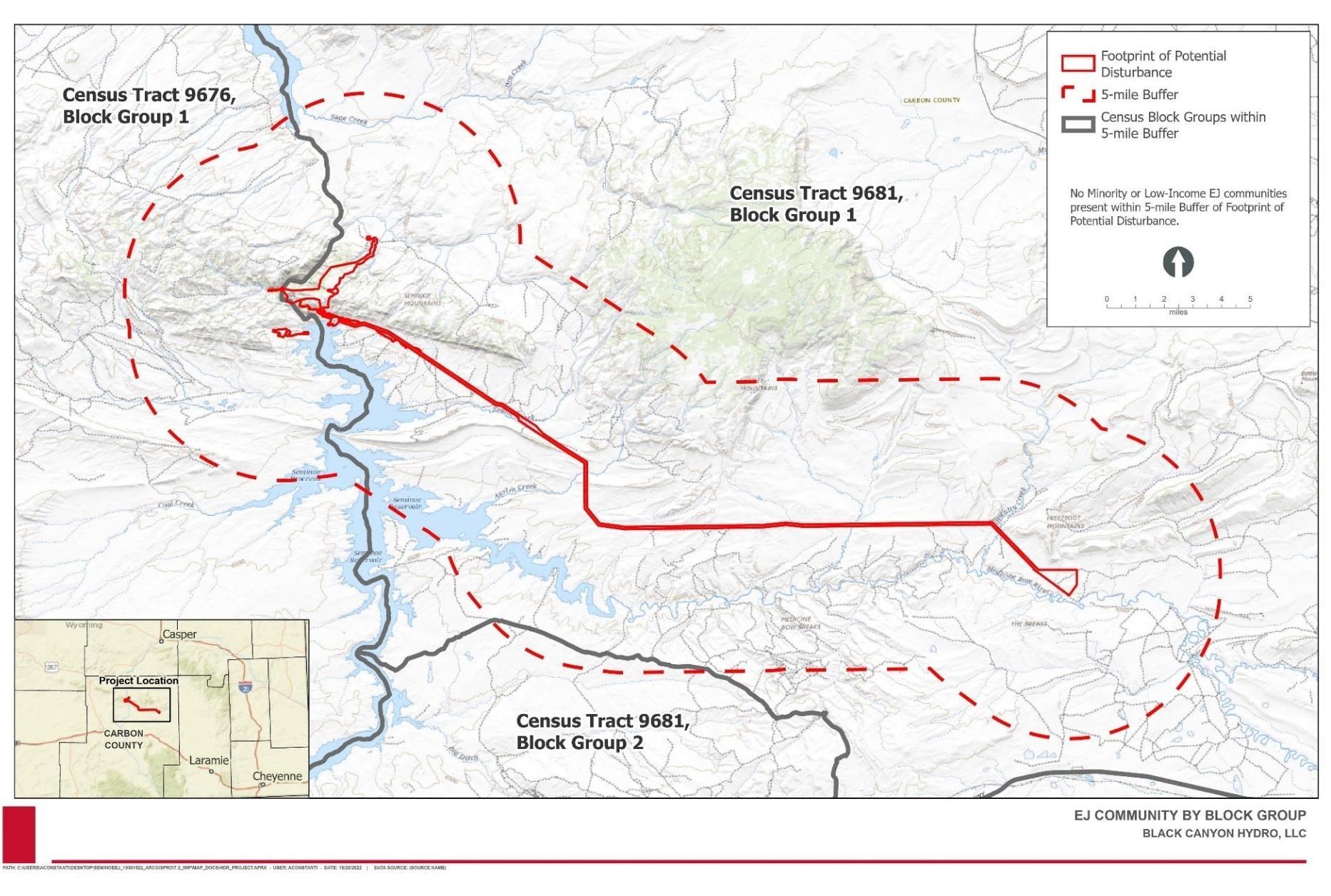
January 2023 | 380
Black Canyon identified environmental justice populations by block group, using the data in Table 3.14-1, by applying the methods included in the Council on Environmental Quality 1997 Guidance (CEQ 1997) and USEPA’s Promising Practices for EJ Methodologies in NEPA Reviews (USEPA 2016)
Figure 3.14-1 shows the census blocks within 5 miles of the Footprint of Potential Disturbance No census blocks are highlighted as environmental justice communities because none were identified, as described in the sections below.
3.14.1.1 Minority Populations
To identify environmental justice communities based on the presence of minority populations, Black Canyon used the “50 percent” and the “meaningfully greater” analysis methods. To use the “50 percent” analysis method, Black Canyon determined whether the total percent minority population of any block group in the affected area exceeds 50 percent. To use the “meaningfully greater” analysis, Black Canyon determined whether any affected block group affected is 10 percent greater than the minority population percent in the county using the following process:
• Calculate the percent minority in the reference population (Carbon County)
• To the reference population’s percent minority, add 10 percent (i.e., multiply the percent minority in the reference population by 1.1)
• This new percentage is the threshold that a block group’s percent minority would need to exceed to qualify as an environmental justice community under the meaningfully greater analysis method.
Using the “50 percent” method, Black Canyon identified no census block groups in which the minority population exceeded 50 percent Using the “meaningfully greater” method of analysis, Black Canyon multiplied the percent minority in the reference population of Carbon County (23.0 percent) by 1.1 to obtain a threshold of 25.3 percent. None of the three census blocks exceeded that threshold, and in fact the minority population of each of the three census blocks is lower than that for Carbon County In conclusion, no minority population block groups were identified within 5 miles of the Footprint of Potential Disturbance
3.14.1.2
Low-Income Populations
To identify environmental justice communities based on the presence of low-income populations, Black Canyon used the “low-income threshold criteria” method. To use the “low-income threshold criteria,” the percent of the population below the poverty level in the identified block group must be equal to or greater than that of the reference population (Carbon County).
The percent of the population with incomes below the poverty level in each of the three block groups in the geographic scope was less than that for Carbon County, as shown in Table 3.14-1 No low-income block groups were identified within 5 miles of the Footprint of Potential Disturbance.
Final License Application – Exhibit E
Pumped Storage Project January 2023 | 381
Seminoe
3.14.1.3
Non-English-Speaking Groups
Black Canyon also used U.S. Census data to identify non-English-speaking groups, within the geographic scope of analysis (regardless of whether the group is part of an identified environmental justice community). The information obtained from U.S. Census Bureau 2016-2020 ACS 5-year Estimates, File # C1601, is presented in Table 3.14-2. Data on languages spoken at home is available only to the county level for the state of Wyoming.
As shown in Table 3.14-2, most people in Carbon County, 85.8 percent of the population, speak English very well. Spanish is the language most commonly spoken by non-English speakers. No linguistically isolated populations have been identified within 5 miles of the Footprint of Potential Disturbance
3.14.1.4 Sensitive Receptors
Black Canyon reviewed available GIS databases and aerial photography to identify sensitive receptor locations (e.g., schools, day care centers, hospitals, etc.) within the geographic scope of analysis. According to the U.S. Department of Homeland Security database Homeland Infrastructure Foundation-Level Data (HIFLD), there are no sensitive receptors within 5 miles of the Footprint of Potential Disturbance (HIFLD 2022).
3.14.2
Direct and Indirect Environmental Effects – Environmental Justice
As described in Section 3.13.1, there are no minority communities, no low-income communities, no linguistically isolated groups, and no sensitive receptors such as hospitals, schools, or child care centers within 5 miles of the Project’s Footprint of Potential Disturbance. Therefore, the Project will not have direct or indirect effects on environmental justice communities.
3.14.3
Cumulative Environmental Effects Related to Environmental Justice
As noted in Table 3.2-1, the geographic scope for environmental justice includes areas within 5 miles of the Footprint of Potential Disturbance. There are no environmental justice communities identified within the geographic scope. Therefore, the Project, in combination with other projects, would not contribute to cumulative impacts related to environmental justice or impacts disproportionately affecting communities of color or low-income populations.
3.14.4
Agency Consultation and Applicant Recommendations
3.14.4.1 Agency Consultation
The NOI and PAD for the proposed Project were filed with the FERC on April 20, 2020. Comments were received from several agencies including BLM and WGFD, and individual stakeholders. Black Canyon held a virtual joint public-agency meeting on July 21, 2020, and has continued consultation with stakeholders since that time. Black Canyon distributed its proposed resource study plans for the Project on August 3, 2020, and March 23, 2021. Black Canyon distributed the DLA on June 6, 2022. Responses to stakeholder comments
Final License Application – Exhibit E
Pumped Storage Project January 2023 | 382
Seminoe
and Black Canyon’s Record of Consultation are provided in Appendix A. FERC provided comments on environmental justice in their comments on the DLA. Responses to comments on the DLA are provided in Appendix L.
3.14.4.2 Applicant Recommendations
Because no environmental justice communities are present in the vicinity of the Project, no PM&E measures are proposed related to environmental justice.
–
E
January 2023 | 383
Final License Application
Exhibit
Seminoe Pumped Storage Project
This page intentionally left blank.
Seminoe Pumped Storage Project
– Exhibit E
January 2023 | 384
Final License Application
Table 3.14-2. Languages Spoken at Home in the Vicinity of the Project
Percent speak only English
Percent speak English less than "very well"
State/ County
Languages
Spoken at Home (5 years and older)
Languages spoken by population of non-English speakers (percent of total non-English speaking population) Spanish: French, Haitian, or Cajun:
German or other West Germanic languages:
Russian, Polish, or other Slavic languages:
Other IndoEuropean languages: Korean: Chinese (incl. Mandarin, Cantonese): Vietnamese: Tagalog (incl. Filipino):
Other Asian and Pacific Island languages:
Arabic: Other and unspecified languages:
Wyoming 93.0 1.9 78.2 1.2 2.1 2.5 3.0 1.3 4.3 0.3 1.1 3.2 1.2 1.5 Carbon County 85.8 3.0 88.3 0.0 0.0 2.1 4.8 0.0 1.9 0.0 1.7 1.2 0.0 0.0
Source: American Community Survey, 2016-2020, File # C1601
Final License Application – Exhibit E Seminoe Pumped Storage Project January 2023 | 385
This page intentionally left blank.
Final License Application – Exhibit E Seminoe Pumped Storage Project January 2023 | 386
3.15 Air
3.15.1 Affected Air Environment
Seminoe Reservoir area is rural and has been designated by the Wyoming DEQ Air Quality Division as in attainment for National Ambient Air Quality Standards and Wyoming Ambient Air Quality Standards (Wyoming DEQ Air Quality Division 2012).
3.15.2 Direct and Indirect Environmental Effects – Air
3.15.2.1 Construction-related Effects
Temporary air quality impacts from construction would include construction vehicle and equipment emissions as well as an increase in particulate matter (dust). Long-term impacts to air quality could include emissions from new equipment such as backup diesel generators and the HVAC system for the power station.
Construction of the proposed project would occur over a 5-year period. Although estimates for type, number, duration, and location of heavy equipment are preliminary, equipment requirements and construction activities can be estimated based on similar construction projects and activities. Construction activities would involve clearing trees, vegetation, and soils from the areas of the proposed reservoirs, powerhouse, and penstock alignment. Blasting would be used to break bedrock structures to the required depth. Dozers, excavators, dump trucks, and other diesel-powered construction equipment would be used to load and remove excavated material. Additional equipment required for construction of the reservoirs, powerhouse, and penstock would include cranes, loaders, concrete delivery trucks, water trucks for dust suppression, and miscellaneous material delivery by over-the-road semi-tractor trailers. It is likely that a portable concrete batch plant would be erected on-site to produce concrete for the project.
Construction activities would result in emissions of criteria pollutants through fugitive dust and vehicle exhaust.
3.15.2.2
Operations-related Effects
Long-term operational effects on air quality would be negligible. A detailed air quality analysis related to stationary or mobile sources is not necessary because Project operation would entail minimal stationary or mobile sources of air pollution. Minor mobile source emissions from vehicles would occur as operators travel to and from the facility and during routine maintenance. The proposed Project would not involve new stationary sources of air emissions following construction. The Project would reduce emissions of criteria pollutants and greenhouse gases to the extent that it reduces the need for peak-hour generation of electricity.
License Application – Exhibit E
January 2023 | 387
Final
Seminoe Pumped Storage Project
3.15.3 Cumulative Environmental Effects Related to Air Quality
As noted in Table 3.2-1, the geographic scope for air is quality during construction is lands within 0.25 mile of active construction. Air emissions during construction would be limited to vehicle and construction equipment emissions and dust and would be localized to the Project’s active construction work areas and areas adjacent to these active work areas. A range of approximately 0.25 mile conservatively captures the distance these emissions would travel before becoming negligible and unlikely to contribute to a cumulative impact.
As the Project stores and generates power without generating carbon emissions, longterm operational effects on air quality would be negligible, and are not included in the cumulative effects analysis.
As detailed in Table 3.2-2, there are two projects that occur within the geographic scope for air quality during construction: 1) Gateway West Transmission Line Project, and 2) Gateway South Transmission Line Project. These projects tie into the existing Aeolus Substation, which represents less than 7 percent (approximately 462 acres) of the Project’s Footprint of Potential Disturbance and the only physical proximity between the Project and others within the geographic scope for potential effects on air quality.
Issues Identified for Analysis
Air pollutant emissions would occur primarily during construction. Air pollutants may include construction sources such as traffic, construction equipment, and fugitive dust from earth moving. These emissions would combine with emissions from other existing local and regional sources of air pollutant to affect ambient concentrations of pollutants.
Results
Construction of the Project would temporarily increase emissions of some criteria pollutants, GHGs, and hazardous/toxic air pollutants surrounding the construction workspaces. This is due to emissions from the combustion engines used to power construction equipment, vehicle traveling to and from construction sites, and fugitive dust resulting from equipment movement on dirt roads and earth-disturbing activities. Construction emissions would cease with the end of construction; thus, the period of influence for cumulative air quality impacts during construction of the Project and other projects would be temporary. The Project, and other projects, would implement mitigation measures to minimize construction impacts on air quality such as applying water or dust control chemicals to minimize fugitive dust (BLM 2013, 2022b). Construction emissions would also disperse within the airshed and diminish in concentration with distance from active work areas. Since the Gateway West Transmission Line Project has completed construction (within the geographic scope) and Gateway South Transmission Line Project is undergoing construction and is expected to be completed prior to Project construction, cumulative air quality impacts would be negligible since there would be no construction overlap.
Final License Application – Exhibit E
January 2023 | 388
Seminoe Pumped Storage Project
3.15.4
Agency Consultation and Applicant Recommendations
3.15.4.1 Agency Consultation
The NOI and PAD for the proposed Project were filed with the FERC on April 20, 2020. Comments were received from several agencies including BLM and WGFD, and individual stakeholders. Black Canyon held a virtual joint public-agency meeting on July 21, 2020, and has continued consultation with stakeholders since that time. Black Canyon distributed its proposed resource study plans for the Project on August 3, 2020, and March 23, 2021. Black Canyon distributed the DLA on June 6, 2022. Responses to stakeholder comments and Black Canyon’s Record of Consultation are provided in Appendix A. USEPA provided comments on air in their comments on the DLA. Responses to comments on the DLA are provided in Appendix L.
3.15.4.2 Applicant Recommendations
As described in Table 2.1-5, the following PM&Es are applicable to air:
• Erosion and Sediment Control Plan: Black Canyon proposes to develop and implement an Erosion and Sediment Control Plan to address erosion associated with Project construction.
• Air Pollution Control Plan: Black Canyon proposes to develop an Air Pollution Control Plan to minimize emissions and control construction dust through the use of BMPs.
3.16 Noise
3.16.1 Affected Noise Environment
The Project is located in a remote region of Wyoming. As noted in Section 3.9.1, land use in the vicinity of the Project’s new reservoir and power plant is primarily undeveloped lands managed by Reclamation and BLM, and Seminoe State Park. Lands within the transmission corridor are primarily undeveloped private lands Livestock grazing, wildlife habitat, dispersed recreation, and scattered rural residences generate little noise Most existing ambient noise is generated by wind, which results in prolonged periods of moderate to high noise levels. Other sources of noise are recreationists, vehicles, thunderstorms, and wildlife including birds and insects.
The state of Wyoming does not have statutes dealing specifically with noise, nor does Carbon County The BLM RFO Approved RMP does not consider noise as an environmental resource. Seminoe State Park regulations require that “Quiet hours shall be maintained in those portions of the park east of U.S. Hwy. 20 and the railroad tracks between the hours of 9:00 p.m. and 7:00 a.m. This rule specifically applies, without limitation, to cars or automobiles or motorcycles which are unusually noisy, to automobile audio devices, or to portable audio devices being used by park visitors. The foregoing prohibition against unusually loud noises specifically applies to the racing or rapid acceleration of motor vehicle engines in such a manner as to cause the vehicle to emit a
Final License Application – Exhibit E
Project January 2023 | 389
Seminoe Pumped Storage
Seminoe Pumped Storage Project
noise louder than normal acceleration.” The nearest residence on private land is 0.66 miles northwest of the Footprint of Potential Disturbance, approximately 1.95 miles northeast of the proposed upper reservoir, as shown on Figure 3.16-1. A residence for employees of Seminoe State Park is approximately 0.2 miles east of the Footprint of Potential Disturbance, and other residences and campsites are shown on Figure 3.16-1. Other potential noise receptors include visitors to the public lands in the vicinity of the Project
– Exhibit E
January 2023 | 390
Final License Application
Seminoe Pumped Storage Project
Figure 3.16-1. Potential Noise Receptors in the Project Vicinity

Final License Application – Exhibit E
January 2023 | 391
3.16.2 Direct and Indirect Environmental Effects - Noise
Construction and operation of the Project will result in short-term increases in ambient noise.
3.16.2.1 Construction
The highest levels of noise associated with the Project will primarily consist of short-term construction noise produced during heavy earthwork. During construction of the upper reservoir and powerhouse, blasting has the potential to be an intermittent annoyance to residents To minimize the effects of project construction and operation-related noise within proposed project lands, the applicant would utilize several strategies to manage noise associated with construction, including sequencing of the use of noise-producing machinery and siting laydown areas and other construction activities to take advantage of natural buffering of noise from vegetation and topography between noise generation and receptors.
Reservoirs and Powerhouse - Construction of the Project is anticipated to occur over a 5year period. Estimates for type, number, duration, and location of heavy equipment are preliminary at this time. However, equipment requirements and construction activities can be estimated based on similar construction projects and activities. Projects of this magnitude may be constructed under a two- or three-shift schedule, but construction schedules usually exclude any significant construction over weekends. Most of the noisegenerating project construction would occur at the upper and lower reservoir sites. Sources of construction noise would include chain saws, blasting, operation of the portable concrete batch plant, and use of large excavators, scrapers, cranes, loaders, dump trucks, concrete mixing trucks, concrete pumping trucks, generators and compressors, water trucks for dust suppression, and miscellaneous material delivery by over-the-road semi-tractor trailers. Because different equipment would be used during different phases of project construction, not all equipment would operate concurrently. For example, the first phase of upper reservoir construction will likely include tree and overburden removal, with chain saws, backhoes, and dozers; later phases would involve bedrock removal, with blasting, excavators, and dump trucks. The noisiest conditions are expected during excavation for the reservoirs and concrete pours for the reservoirs and powerhouse.
Transmission Line Installation - Construction of the transmission lines would also result in short-term and intermittent noise impacts as construction progresses along the ROW. The transmission lines would consist of steel monopole towers constructed on a reinforced concrete foundation. Construction would involve some excavation, followed by form work and concrete pours. A light-duty crane would be used to erect each monopole tower. Construction of one transmission line support tower would take a few days to a week, after which, construction crews would move to a new location. Noise would result from construction and transportation equipment, including vehicles and helicopters. Noise from truck traffic and increased worker trips along the right-of-way would temporarily contribute to existing traffic noise on local roads and highways but is not expected to result in an increase in average traffic noise levels. Where helicopters are used for conductor stringing and pole placement, their presence would result in noise levels that may exceed 100 dBA
Final License Application – Exhibit E
January 2023 | 392
Seminoe Pumped Storage Project
for a brief period Noise associated with helicopter use would be temporary and intermittent. Because the transmission lines would be constructed in rural areas that are located away from noise-sensitive uses and regularly experience machinery noise from agricultural practices, it is unlikely that overall noise levels would change significantly
Mobile Source Noise - Construction materials, equipment, and construction workers would use public roadways, where available, to access the sites for the various components of the project. Where such roadways do not exist, new temporary or permanent access roads would be built. Construction traffic coming from the southwest would likely travel along Seminoe Road or from the southeast along Hanna Leo Draw Road to Kortes Road, as determined during development of the Traffic Management Plan that will be developed prior to construction. Some increase in noise levels associated with construction traffic along these routes is expected during construction of the project. The increase would be temporary and sporadic, occurring only during the daytime. Traffic (semi-trailer trucks or other carriers) related to materials deliveries for the penstocks, turbines, and other Project equipment is expected to total 800 to 1,000 trips over the 5-year construction effort. According to FHWA, a doubling of traffic increases noise levels by approximately 3 dB (FHWA, n.d.), and a 3-dB change in noise levels is barely perceptible. Additionally, the noise generated by one heavy truck (e.g., semi-trailer) traveling at 55 mph is about the same as the noise generated by 28 passenger cars traveling at 55 mph. In a worst-case condition where project-related traffic includes 8 truck trips per day and 500 worker trips per day along Seminoe Road, traffic would not double and noise from the increased traffic would be barely perceptible.
3.16.2.2 Operation
The Project includes three pump-turbine units, enclosed within an underground powerhouse. Noise from operation of the proposed project, including the powerhouse, is not expected to be noticeable at any noise-sensitive area. The facility would employ a small staff who would likely travel to the facility by automobile. No traffic noise increase is anticipated as a result of the small staff. Black Canyon will comply with all regulations regarding worker exposure to noise during operation of the Project.
In conclusion, noise levels in the vicinity of the Project are expected to be temporarily elevated during construction.
3.16.3
Cumulative Environmental Effects Related to Noise
As noted in Table 3.2-1, the geographic scope for noise during construction is within 1 mile of construction of the upper reservoir, underground powerhouse, power tunnel, tailrace tunnel, new intake in the existing Seminoe Reservoir, powerhouse access tunnel, highvoltage transmission tunnel, and switchyard and within 0.25 mile of construction of transmission lines. Noise from construction of the reservoir and powerhouse facilities could affect receptors up to 1 mile away while the areas in the immediate proximity of transmission lines would have the potential to be affects by construction noise. The noise levels due to Project operations are expected to be negligible and therefore were not included in the cumulative effects analysis. As detailed in Table 3.2-2, there are four
Final License Application – Exhibit E
January 2023 | 393
Seminoe Pumped Storage Project
projects that occur within the geographic scope for construction noise: 1) WPCI Project, 2) Two Rivers Wind Energy Project, 3) Gateway West Transmission Line Project, and 4) Gateway South Transmission Line Project. However, only two projects overlap with construction workspaces of the Projects: Gateway West Transmission Line Project, and Gateway South Transmission Line Project. These projects tie into the existing Aeolus Substation, which represents less than 7 percent (approximately 462 acres) of the Project’s Footprint of Potential Disturbance and the only physical proximity between the Project and others within the geographic scope for potential effects on noise.
Issues Identified for Analysis
Reasonably foreseeable future actions with potential to impact noise include most development projects, since all would create noise during construction. Surrounding areas within approximately 1 mile from areas of future development would be periodically subject to construction and potentially operation noise. The degree to which sensitive receptors may experience noise impacts would depend on proximity to new sources of noise. Noise in these areas, particularly during construction, could displace wildlife or impact the experience for visitors to public lands in areas where the development occurs. Long-term noise impacts across the landscape would be less discernable in areas that are already developed, although construction activities would likely increase noise above existing conditions.
Results
Existing noise conditions occur in the geographic scope and are expected to be within the range for a rural area, with periodic louder noise intrusions from boat traffic on Seminoe Reservoir or overhead airplanes. Completing earthwork construction elements of the Project and the other projects within the geographic scope would create a temporary increase in noise. Specifically, noise would have the greatest impact during the following activities:
• Large-scale excavation and blasting to construct the upper reservoir,
• Blasting and tunneling to construct the underground powerhouse and related systems (piping, pumps, penstocks, and power turbines),
• Increased truck traffic to and from construction sites.
There are few homes in the geographic scope and effects from noise are expected to be temporary and occur in areas where very few people could be affected The scattered residences in the geographic scope would experience some increased noise during construction. If multiple projects were to occur within the geographic scope at the same time, the effects of construction noise on nearby residents would be cumulative. However, these residences are sheltered from some noise by hills, mountains, vegetation, and distance, and reasonably foreseeable other projects will not be in construction during the same time period as the Project
It is anticipated that the installation of the transmission lines would require limited equipment and result in minimal noise emissions. Since the Gateway West Transmission
Final License Application – Exhibit E
January 2023 | 394
Seminoe Pumped Storage Project
3.16.4
Line Project has completed construction (within the geographic scope) and Gateway South Transmission Line Project is undergoing construction and is expected to be completed prior to Project construction, cumulative noise impacts would be negligible since there would be no construction overlap Wind energy projects, such as the Two Rivers Wind Energy Project, would have the potential to increase ambient noise levels postconstruction during their operation However, they are required to adhere to industry noise standards and requirements to reduce and mitigate potential direct and cumulative noise impacts, and are physically distant from the Project
Cumulative impacts from noise are highly localized and attenuate quickly as the distance from the noise source increases. If cumulative impacts were to occur, noise levels in the geographic scope would return to baseline levels post construction. Based on publicly available information, it is not anticipated that the Project activities at any one location within the geographic scope would occur concurrently with other projects and therefore cumulative impacts from noise are not anticipated.
Agency Consultation and Applicant Recommendations
3.16.4.1 Agency Consultation
The NOI and PAD for the proposed Project were filed with the FERC on April 20, 2020. Comments were received from several agencies including BLM and WGFD, and individual stakeholders. Black Canyon held a virtual joint public-agency meeting on July 21, 2020, and has continued consultation with stakeholders since that time. Black Canyon distributed its proposed resource study plans for the Project on August 3, 2020, and March 23, 2021. Black Canyon distributed the DLA on June 6, 2022. Responses to stakeholder comments and Black Canyon’s Record of Consultation are provided in Appendix A. BLM and WGFD provided comments on noise in their comments on the DLA. Responses to comments on the DLA are provided in Appendix L.
3.16.4.2
Applicant Recommendations
As described in Table 2.1-5, the following PM&Es are applicable to noise:
• Noise: To minimize the effects of noise related to construction and operation of the Project, Black Canyon will utilize several strategies to manage noise associated with construction, including sequencing of the use of noise-producing machinery and siting laydown areas and other construction activities to take advantage of natural buffering of noise from vegetation and topography between noise generation and receptors.
Final License Application – Exhibit E
January 2023 | 395
Seminoe Pumped Storage Project
4.0
Developmental Analysis
This section evaluates the Project’s use of environmental resources for hydropower purposes to see what effect various environmental measures would have on the Project’s cost and power generation. Following the Commission’s approach to evaluating the economics of hydropower projects, as articulated in Mead Corp 24, this section compares the current Project cost to an estimate of the cost of obtaining the same amount of energy and capacity using the likely alternative source of power for the region (cost of alternative power). In keeping with the policy as described in Mead Corp., the economic analysis is based on current elective power cost conditions and does not consider future escalation of fuel prices in valuing the Project’s power benefits.
For each of the alternatives, the analysis includes an estimate of: (1) the cost of individual measures considered for the protection, mitigation, and enhancement of environmental resources affected by the Project; (2) the cost of alternative power; (3) the total Project cost (i.e., for construction, operation, maintenance, and environmental measures); and (4) the difference between the cost of alternative power and total Project cost. If the difference between the cost of alternative power and total Project cost is positive, the Project produces power for less than the cost of alternative power. If the difference between the cost of alternative power and total Project cost is negative, the Project produces power for more than the cost of alternative power.
4.1 Power and Developmental Benefits of the Project
The United States has set a goal to reach 100 percent carbon pollution-free electricity by 2035. A key benefit of this Project is to facilitate the integration of zero-carbon, variable energy generation in line with this national goal. In Wyoming, wind generation is also the lowest cost form of energy generation. The Project will provide flexibility to the operations of the grid of the future, enabling absorption of excess renewable energy when it is abundant, and store that energy to be released at a later time when transmission line capacity is available and/or when the grid is in need of dispatchable generation.
A pumped storage generating facility includes an upper reservoir, a lower reservoir, and a reversible pump-turbine unit in between the two reservoirs. In generating mode, water from the upper reservoir flows through the reversible unit to the lower reservoir. The water turns the turbine, which is attached to a generator, producing electricity that is transmitted to the electric grid. In pumping mode, power is drawn from the electric grid to “motor” the unit in reverse to act as a pump, pushing water from the lower reservoir back to the upper reservoir. There is a roundtrip efficiency loss, therefore pumped storage facilities are net
24
See Mead Corporation, Publishing Paper Division, 72 FERC ¶ 61,027 (July 13, 1995). In most cases, electricity from hydropower would displace some form of fossil-fueled generation, in which fuel cost is the largest component of the cost of electricity production.
Final License Application – Exhibit E
January 2023 | 396
Seminoe Pumped Storage Project
energy consumers. The value of the pumped storage facility is in bridging the temporal mismatches between generation and load.
There are a number of wind generation facilities planned or proposed throughout Wyoming due to the state’s abundant wind resource. The variability of the output of these facilities can be problematic to the electric grid. Such facilities typically work best when they are located close to generating facilities that can provide system balancing capabilities, such as those provided by pumped storage facilities and gas-fired combustion turbines installed specifically to work in concert with solar and wind farms to provide system stability. Pumped storage facilities are designed to be able to change modes rapidly and can fill gaps due to wind and solar power variability.
The ability of pumped storage facilities to be switched from pumping to generating and back again very quickly, as needed, provides unique benefits to the electric grid. Pumped storage facilities can provide a number of ancillary services to the grid to enhance overall grid reliability. Among these services are spinning reserve, non-spinning reserve, frequency regulation, voltage support and regulation, load following capability, peak shaving, and black-start capability. The following discussion provides more detail of these various services.
• Spinning reserve is the extra generating capacity that is available by increasing the power output of generators that are already connected to the power system. Nonspinning reserve or supplemental reserve is the extra generating capacity that is not currently connected to the system but can be brought online after a short delay.
• Grid frequency is a system-wide indicator of overall power imbalance. These imbalances are removed by requesting generators to operate in frequency control mode, altering their output continuously to keep the frequency near the required value.
• System voltage levels vary over the course of the day due to a variety of factors, including: (1) the location of the local distribution ling, (2) proximity to large electricity consumers, (3) proximity to utility voltage regulating equipment, (4) seasonal variations in overall system voltage levels, and (5) load factor on local transmission and distribution systems.
• Pumped storage facilities can operate as base load, load following, or peaking power facilities and change operating modes seasonally and daily. Most hydroelectric facilities have the ability to start within minutes, if not seconds, depending upon available water supply. When in load following mode, the output of the pumped storage facility can be adjusted as necessary to meet widely varying load requirements.
• Pumped storage facilities can be operated at a generating level that is much lower than a base load facility and can therefore avoid the need to run a base load unit at low efficiencies below the minimum loading rate of the base load unit.
• A pumped storage facility can generate electricity during peak periods when demand is high and available generating output is near its limits and then pump during off-peak periods when demand is low when available generating output is lower.
• Black-start is the procedure to recover from a total or partial shutdown of the transmission system, which has caused an extensive loss of supplies. This entails
Final License Application – Exhibit E
January 2023 | 397
Seminoe Pumped Storage Project
Seminoe Pumped Storage Project
isolated power stations being started individually and gradually being reconnected with each other in order to form an interconnected system again.
4.2 Comparison of Alternatives
The alternative to this Project, consistent with the national goal to reach 100 percent carbon pollution-free electricity by 2035, is to either build other energy storage facilities sufficient to meet the national goal and replace the Seminoe Pumped Storage project, or else to overbuild transmission capacity as well as wind and solar generating capacity and then rely on curtailing the overbuilt capacity when it is not needed to meet load.
4.2.1 No-action Alternative
Under the no-action alternative, the Project would not be constructed and would not provide any capacity resource or flexibility for operations of the grid in support of achieving 100 percent carbon pollution-free electricity by 2035. The United States would either miss the goal of producing 100 percent carbon pollution-free electricity, or else an alternative portfolio of energy resources would need to be constructed capable of replacing the capability of the Project. Any of the no-action alternatives would have associated environmental impacts that are challenging to specifically quantify.
One option for replacing the capability of the Project would be to construct a similar sized battery storage project, or several smaller battery storage projects with a cumulative capability equivalent to the project. The impacts of those projects include the mining of rare earth minerals, likely dependence on internationally produced battery supply from entities that are not friendly to the United States, and the site impacts from construction and operation of those facilities. As explored in Exhibit D, battery storage projects are not cost competitive with pumped storage hydro for equivalent durations of energy storage.
Another alternative would be to overbuild transmission capacity through construction of additional transmission lines, and a concomitant overbuild of wind and solar capacity so that the minimum expected generation capacity would always exceed peak load demand. The excess capacity would then be curtailed when generation exceeds load, which would be most of the time. This alternative would involve a low utilization of those overbuilt resources to ensure that generation is always available to meet demand. The resulting environmental impacts of those excess capacity projects would very likely exceed the impact of the Seminoe Pumped Storage project.
4.2.2
Black Canyon’s Proposal
Black Canyon proposed numerous environmental measures as presented in Table 4.3-1 The Project would have an installed capacity of 972 MW and generate an average of approximately 3,200,000 MWh of electricity annually, assuming a full energy storage cycle each day for 90% of the day through the year.
Final License Application – Exhibit E
January 2023 | 398
4.3 Cost of Environmental Measures
Table 4.3-1 provides the cost of each of the environmental enhancement measures considered in the analysis.
– Exhibit E
January 2023 | 399
Final License Application
Seminoe Pumped Storage Project
Final License Application – Exhibit E
Seminoe Pumped Storage Project
Table 4.3-1. Cost of Environmental Mitigation and Enhancement Measures Considered in Assessing the Environmental Effects of Continuing to Operate the Seminoe Pumped Storage Project
Number Enhancement/Mitigation Measures
1. Erosion and Sediment Control Plan: Black Canyon proposes to develop and implement an Erosion and Sediment Control Plan to address erosion associated with Project construction. The Erosion and Sediment Control Plan will include:
• The use of Best Management Practices (BMPs) recommended by the State of Wyoming, to specify erosion control measures to help minimize potential adverse impacts.
• NPDES permitting for construction activities, as required by Wyoming State law and the Federal CWA.
• Specific actions to be implemented during Project construction and operation to minimize the potential for generating windblown dust from Project activities and to control fugitive dust.
• Actions to address earthworks in soils that are highly erodible.
2. Stormwater Pollution Prevention Plan (SWPPP): Prior to the commencement of construction, Black Canyon proposes to prepare and implement a SWPPP. The SWPPP is anticipated to prevent erosion, scouring, and general water quality degradation during Project construction. The SWPPP will include:
• Description of potential storm water discharges from support activities related to Project construction such as equipment staging areas, material storage areas, and access roads.
• Description of existing vegetation across the portion of the site to be disturbed.
• Discussion of other potential pollutions sources (e.g., vehicle fueling, equipment maintenance).
Entities Capital (2022$) Annual Cost (2022$)
Black Canyon, Staff, Wyoming DEQ
$200,000 $20,000
Black Canyon, Staff, Wyoming DEQ
$50,000 $5,000
January 2023 | 400
Number Enhancement/Mitigation Measures
• The drainage or water body that may receive a storm discharge from Project construction activities.
• Site maps that detail where BMPs will be installed in each major stage of construction, including placement and timing.
• Discussion of BMPs, including those related to erosion prevention, sediment control, temporary and permanent stabilization measures, construction site dewatering, good housekeeping, bulk storage of petroleum products, concrete waste, employee training, maintenance schedule, and inspection schedule.
3. Hazardous
Seminoe Pumped Storage Project
Entities Capital (2022$) Annual Cost (2022$)
Substances
Spill
Prevention and
Cleanup
Plan: Black Canyon proposes to develop and implement a Hazardous Substances Spill Prevention and Cleanup Plan to address potential issues resulting from spills of hazardous substances or fuels during construction, operation, or maintenance. The Hazardous Substances Spill Prevention and Cleanup Plan will:
• Specify materials handling procedures and storage requirements.
• Identify spill notification and cleanup procedures for areas in which spills may occur.
• Identify inventory, storage, and handling methods for hazardous materials.
• Develop employee training procedures to help minimize accidental pollutant releases which could contaminate surface or groundwater or stormwater runoff.
E
January 2023 | 401
Final License Application – Exhibit
Black Canyon, Staff $45,000 $20,000
Number Enhancement/Mitigation Measures
4. Pre- and Post-Construction Stream Flow Monitoring: Black Canyon proposes to conduct pre-construction and post-construction monitoring of water flow in Number One Gulch, Number Two Gulch, and Dry Lake Creek. In the event that reduced streamflows are identified post-construction, Black Canyon will work with the BLM and other agencies (as applicable) to identify mitigation measures.
Final License Application – Exhibit E
Seminoe Pumped Storage Project
Entities Capital (2022$) Annual Cost (2022$)
Black Canyon, Staff $20,000 $0
5. Transmission Line Design: During final design, Black Canyon will complete designs of transmission facilities (including locations of transmission towers and access roads) in a manner that minimizes surface disturbing activity in identified 100-year floodplains, areas within 500 feet of perennial waters and wetland/riparian areas, and areas within 100 feet from the inner gorge of ephemeral channels, as specified in the BLM Rawlins Field Office RMP. If transmission structures cannot be located outside the buffers, Black Canyon will consult with BLM on steps to identify reasonable mitigation measures to minimize adverse impacts to water features.
6. Fish Exclusion Measures: Black Canyon proposes to install and maintain fish exclusion bar racks at the lower reservoir inlet/outlet to reduce fish entrainment.
7. AIS Plan: Black Canyon will develop and implement an AIS Construction Monitoring and Decontamination Plan (AIS Plan) specific to Seminoe Reservoir. The AIS Plan will:
• Include measures for monitoring and decontaminating construction equipment used in areas below the ordinary high-water line of water bodies.
Black Canyon, Staff, BLM $01 $01
Black Canyon, Staff $400,000 $10,000
Black Canyon, Staff, BLM, WGFD $50,000 $10,000
January 2023 | 402
Number Enhancement/Mitigation Measures
• Be developed in consultation with BLM and WGFD following license issuance and during development of final construction plans.
8. Habitat Restoration, Reclamation, and Enhancement Plan: Black Canyon will develop and implement a Habitat Revegetation, Restoration, and Enhancement Plan to identify measures that could be reasonably implemented for management, avoidance, and mitigation of potential habitat and associated vegetation losses during construction and operation of the Project. The Habitat Revegetation, Restoration, and Enhancement Plan will:
• Identify specific measures to be taken to restore vegetation disturbed by Project-related construction activities.
• Describe revegetation efforts to prevent soil erosion and the spread of weeds, maintain or restore existing native plant communities and wildlife habitat, and integrate site features with the surrounding environment.
• Specify native seed mixes which will include milkweed (Asclepias spp.) species, as appropriate.
• Identify restoration measures for Project impacts to RTE plant species.
• Develop measures specific to protection of Limber Pine.
• Address seasonal timing restrictions for vegetation management in areas containing plants used by monarch butterflies to minimize the potential for interference with monarch breeding or sources of nectar used as a food source along the migration route.
Final License Application
Seminoe Pumped Storage Project
Entities Capital (2022$) Annual Cost (2022$)
Black Canyon, Staff $100,000 $20,000
– Exhibit E
January 2023 | 403
Number
Enhancement/Mitigation Measures
9. Biological Resources Protection Training Program: Black Canyon proposes to develop a biological resources protection training program. The program is intended to help inform construction workers and other Project staff of the sensitive biological (botanical and wildlife) resources in the area.
10. Pre-Construction Surveys: Prior to construction, Black Canyon will complete botanical and wildlife surveys and habitat assessments. These surveys will be conducted by trained botanists and biologists in areas that will be disturbed by the Project. Specific pre-construction surveys include:
• At least three consecutive years of surveys for Ute ladies’-tresses;
• Areas where milkweed is likely to occur (i.e., wetlands, roadsides, drainages, mesic areas) for suitable monarch butterfly habitat;
• Conduct winter roost site surveys for bald eagles within suitable habitat;
• Conduct year-of-construction raptor nest surveys throughout the Project Boundary and a 1-mile buffer, wherever access is obtained. Raptor nest surveys were conducted in 2021 and the results of those surveys will be used to inform the year-of-construction surveys.
Based on the findings of the surveys, Black Canyon with consult with applicable regulating agencies to identify reasonable avoidance or mitigation measures to reduce adverse impacts.
Final License Application – Exhibit E
Seminoe Pumped Storage Project
Entities Capital (2022$) Annual Cost (2022$)
Black Canyon, Staff $50,000 $0
Black Canyon, Staff, BLM $500,000 $0
January 2023 | 404
Number
Enhancement/Mitigation Measures
11. Noxious Weed Management Plan: Black Canyon proposes to develop and implement a Noxious Weed Management Plan for construction of the Project. This plan will include measures to reduce the spread or introduction of noxious weed and invasive plant species. The Noxious Weed Management Plan will incorporate restrictions and guidelines for application of pesticides including herbicides, including avoidance of known sensitive plant species. Black Canyon will coordinate with BLM regarding herbicide use on BLM lands. Measures that will be included in the plan include:
• Prevent introduction and establishment by cleaning vehicles and equipment prior to movement to a new location in order to minimize the potential for transporting seeds.
• Work with land managers to develop and implement a plan to assess, treat, and monitor noxious weeds and invasive plants at the Project and in the adjacent landscape where they are present.
• Work with the local weed and pest district to implement and fund long-term plans for successful restoration of disturbed sites.
12. RTE Plant Management Plan: Black Canyon proposes to develop a RTE Plant Management Plan for Project operation in consultation with applicable agencies. The RTE Plant Management Plan will specify the following for applicable RTE species:
• The local occurrences and habitats;
• Disturbance buffers and use restrictions;
• Survey and monitoring requirements (if present);
• Specific mitigation activities;
• Report and consultation requirements.
Final License Application – Exhibit E
Seminoe Pumped Storage Project
Entities Capital (2022$) Annual Cost (2022$)
$100,000 $20,000
Black Canyon, Staff $40,000 $5,000
January 2023 | 405
Black Canyon, Staff, BLM
Number Enhancement/Mitigation Measures
13. Fire Prevention and Protection Plan: Black Canyon proposes to develop and implement a Fire Prevention and Protection Plan for the Project. The Fire Prevention and Protection Plan will:
• Identify potential fire hazards and prevention measures.
• Describe fire prevention during operations and maintenance.
• Discuss fire protection systems and proper housekeeping for fire prevention.
• Identify applicable fire safety requirements including training programs and equipment maintenance schedules.
14. Upper Reservoir Wildlife Exclusion: Black Canyon proposes to fence and monitor the upper reservoir to prevent cattle, wild ungulates, and other medium- to large-sized animals from accessing this area. Based on the current Project design, upper reservoir wildlife exclusion measures may include:
• Installing an 8-foot-tall game fence around the base of the upper reservoir and spillway.
• A gate, or set of gates, will be installed to have continued safe access and egress to the upper reservoir while maintaining a minimum height of at least 8 feet.
• There will be a one-way exit gate, built during construction, to facilitate a safe exit in the event that wildlife were to enter the fencedoff area.
• Black Canyon will provide regular maintenance and monitoring to ensure the fencing has not failed.
Final License Application – Exhibit E
Seminoe Pumped Storage Project
Entities Capital (2022$) Annual Cost (2022$)
Black Canyon, Staff $20,000 $8,000
Black Canyon, Staff $150,000 $5,000
January 2023 | 406
Number
Enhancement/Mitigation Measures
15. Raptor-Safe Transmission Line Structures: Black Canyon proposes to design raptor-safe transmission line structures (i.e., the transmission line design will comply with Avian Power Line Interaction Committee (APLIC) guidelines: Suggested Practices for Avian Protection on Power Lines, The State of the Art in 2006 [APLIC 2006] and Reducing Avian Collisions with Power Lines: The State of the Art in 2012 [APLIC 2012]) to protect avian species from collision or electrocution as a result of landing or perching on transmission lines. This design may include:
• Installing visibility enhancement devices to reduce the risk of collision on new or existing lines (e.g., marker balls, bird diverters).
• Regular maintenance of the transmission line and retrofitting the lines as applicable, which may include covering jumper wires, reframing, or replacing a structure.
• Installing perch guards between closely-spaced conductors above arms and conductors to keep raptors from contacting energized parts.
• Providing safe alternative locations for perching and nesting.
16. Greater Sage-grouse Management: Black Canyon proposes to design a transmission line that minimizes adverse impacts to Greater Sage-grouse, including complying with applicable APLIC guidelines in “Best Management Practices for Electric Utilities in Sage-grouse Habitat” (APLIC 2015). Once a final Project design is developed, Black Canyon will submit that Project design to the DDCT to reduce and mitigate Greater Sage-grouse impacts. The proposed Greater Sage-grouse Management may include:
• Installing anti-perch and/or anti-nesting devices to reduce use by predatory birds.
Final License Application – Exhibit E
Seminoe Pumped Storage Project
Entities Capital (2022$) Annual Cost (2022$)
Black Canyon, Staff $1,720,000 $0
Black Canyon, Staff $3,000,000 $10,000
January 2023 | 407
Number
Enhancement/Mitigation Measures
• Identifying methods to reduce collision risk for Greater Sage-grouse and migratory birds.
• Limiting construction disturbance and access during breeding season.
• Minimizing spacing between existing and proposed transmission lines.
17. Post-Construction Surveys: Post to construction, Black Canyon will complete a Greater Sage-grouse lek survey to comply with the Sage-grouse Executive Order 2019-3 (SGEO). These surveys will be conducted by trained scientists in areas that will be disturbed by the Project.
18. Wildlife Seasonal Restrictions: Black Canyon proposes to work closely with BLM to plan for Project construction windows that provide for both wildlife protection and feasible Project construction timelines. This would include developing manageable timing and scheduling restrictions that can accommodate the construction schedule
Final License Application – Exhibit E
Seminoe Pumped Storage Project
Entities Capital (2022$) Annual Cost (2022$)
Black Canyon, Staff $40,000 $5,000
Black Canyon, Staff, BLM $01 $01
19. Traffic Management Plan: Black Canyon will develop and implement a Traffic Management Plan prior to construction. The plan will include:
• Traffic volume (how many trucks/equipment per day during construction and operation).
• Which roads are to be used and for which activities. Stress and impacts to wildlife (and recreational users) may vary widely depending on which roads are being used.
• Construction traffic will pass over the Seminoe Range and the Miracle Mile.
Black Canyon, Staff $150,000 $20,000
January 2023 | 408
Number
Enhancement/Mitigation Measures
• Plans for winter road maintenance if a year-long schedule is to be kept.
• Gravel roads that would need to be upgraded or surfaced.
• Whether recreational traffic would be diverted onto the Morgan Creek Wildlife Habitat Management Area.
• The difference between pre-construction traffic counts on affected roads.
• The use of the newly proposed access road to the upper reservoir.
• Describe the purpose, frequency, timing, and duration (i.e., construction or operation phases) of use of the proposed bridge over the North Platte River, located 1,000 feet downstream of Seminoe Reservoir to access to the Main Access Tunnel Portal.
• Measures to mitigate impacts to wildlife, including Project speed limits to reduce wildlife-vehicle collisions and methods of enforcement.
• Manage traffic by implementing a speed limit to reduce wildlife injury due to collisions.
20. Biological Construction Monitors: Black Canyon proposes to have biological construction monitors on site during construction to monitor sensitive biological resources, including conducting avian nesting surveys of areas near active construction during nesting season (April 1 to August 31).
21. Raptor Protection Plan: Prior to the onset of ground disturbance at the start of formal construction activities, Black Canyon proposes to prepare and implement a Raptor Protection Plan. The Raptor Protection Plan will include:
• Appropriate seasonal and spatial buffers of active raptor nests and bald eagle roost sites.
License Application
Seminoe Pumped Storage Project
Entities Capital (2022$) Annual Cost (2022$)
Black Canyon, Staff $3,100,000 $0
Black Canyon, Staff $40,000 $5,000
Final
– Exhibit E
January 2023 | 409
Number Enhancement/Mitigation Measures
• Raptor-safe guidelines for all new electrical construction.
• Employee training to ensure plan compliance.
22. Outdoor Lighting Plan: Black Canyon proposes to develop a Project outdoor lighting plan to incorporate lighting design features that help minimize disturbance to wildlife species during construction and operation of the Project. The outdoor lighting plan will include:
• Designing outdoor lighting to incorporate design and operational features to help to reduce impacts on foraging bats and migrating and nocturnal birds.
• Using localized and portable lighting during construction where and when the work is occurring.
• Provisions to power lighting equipment by generators that will have switches to cut power when lighting is not required during construction.
• The use of minimal exterior lighting that will consist of safety lighting. For all safety lighting, Black Canyon proposes to minimize lighting to the extent possible and use dark-sky compliant lighting fixtures.
• Provisions that all lighting will use full cutoff luminaires and be properly shielded and mounted, except as required to meet minimum safety and security requirements (e.g., emergency lighting triggered by alarms)
• The use of lighting that is amber in color, using either low-pressure sodium lamps or yellow LED lighting, which reduces skyglow and wildlife impacts from exterior lighting.
Entities Capital (2022$) Annual Cost (2022$)
Black Canyon, Staff $01 $01
January 2023 | 410
Final License Application – Exhibit E Seminoe Pumped Storage Project
Number Enhancement/Mitigation Measures
23. Public Access: Black Canyon proposes to manage lands over which it has control in the Footprint of Potential Disturbance for appropriate public access. Black Canyon proposes to:
• Prohibit fishing and other recreation in and around the upper reservoir.
• Fence the upper reservoir for site security, public safety, and wildlife protection.
24. Historic Properties Management Plan (HPMP): Black Canyon proposes to develop an HPMP and to conduct cultural resource monitoring during ground disturbing construction activities. The HPMP will:
• Identify the nature and significance of historic properties that may be affected by Project maintenance and operation.
• Identify goals for the preservation of historic properties.
• Establish guidelines for routine maintenance and operation.
• Establish procedures for consulting with SHPOs, THPOs, Indian tribes, historic preservation experts, and the public concerning effects to historic properties.
25.
Final License Application – Exhibit E
Seminoe Pumped Storage Project
Entities Capital (2022$) Annual Cost (2022$)
Black Canyon, Staff $250,000 $1,000
Black Canyon, Staff $3,850,000 $5,000
Paleontological
Monitoring: Black Canyon proposes to develop and implement a plan to monitor construction and if necessary, mitigate adverse impacts to significant paleontological resources (as defined in BLM IM-200911) during construction. This may include:
• Identifying when and what factors may place paleontological resources at risk to damage, destruction, or unauthorized collecting.
Black Canyon, Staff $2,000,000 $0
January 2023 | 411
Number Enhancement/Mitigation Measures
• Identifying monitoring strategies to observe, document, and recognize changes or impacts to paleontological resources during Project construction.
• Measures to identify, record, and evaluate significant paleontological and cultural discoveries during Project construction, as applicable.
26. Visual Resources: Black Canyon proposes to:
• Use BLM environmental colors (Standard Environmental Colors, Color Chart CC-001) for surface coatings of fences, gates, and other above-ground facility features.
• Design the upper reservoir, bridge, and lower intake structure so that materials repeat and/or blend in with the existing form, line, color, and texture of the landscape to the extent feasible.
Final License Application – Exhibit E
Seminoe Pumped Storage Project
Entities Capital (2022$) Annual Cost (2022$)
27. Air Pollution Control Plan: Black Canyon proposes to develop an Air Pollution Control Plan to minimize emissions and control construction dust through the use of BMPs. Elements of such a plan include the following provisions for controlling fugitive dust from the construction site:
• Establish stabilized truck exit areas for washing the wheels of all trucks that enter paved roadways from the construction site and dirt roads leading from the construction site.
• Establish tracking pads at construction exits to prevent dirt from being tracked onto roadways.
• Apply water or dust reducing agents to any truck routes within the construction site as needed (during dry and windy periods) or, in cases where such routes would remain in place for an extended duration, cover the routes with gravel to avoid re-suspension of dust.
Black Canyon, Staff, BLM $1,100,000 $0
Black Canyon, Staff $200,000 $0
January 2023 | 412
Number Enhancement/Mitigation Measures
• Apply water or dust reducing agents to all exposed surfaces as needed during dry weather. Exposed surfaces include, but are not limited to soil piles, graded areas, unpaved parking areas, staging areas, and access roads.
• Cover or maintain at least 2 feet of free board space on haul trucks transporting soil, sand, or other loose material on the site. Cover any haul trucks that would be traveling along freeways or major roadways.
• Use wet power vacuum street sweepers to remove any visible track out mud or dirt onto adjacent paved public roads.
• Pave all roadways, driveways, sidewalks, and parking lots as soon as possible. In addition, lay building pads as soon as possible after grading unless seeding or soil binders are used.
• Incorporate dust control measures (e.g., dust collectors and covers limiting pathways for dust) into the temporary concrete batch plant, if used at the construction site.
o To control vehicle emissions from diesel-powered equipment working at the construction site the plan could also include:
▪ Minimize idling time by either shutting equipment off when not in use or reducing idling time to 5 minutes. Provide clear signage regarding this requirement for workers at the entrances to the site.
▪ Establish protocols for equipment inspection and maintenance programs to ensure work and fuel efficiencies.
▪ Maintain all construction equipment in proper working condition according to manufacturer’s specifications. Ensure that equipment is running in proper condition before it is operated.
Final License Application
Seminoe Pumped Storage Project
Entities Capital (2022$) Annual Cost (2022$)
– Exhibit E
January 2023 | 413
28. Noise: To minimize the effects of noise related to construction and operation of the Project, Black Canyon will utilize several strategies to manage noise associated with construction, including sequencing of the use of noise-producing machinery and siting laydown areas and other construction activities to take advantage of natural buffering of noise from vegetation and topography between noise generation and receptors.
Black Canyon, Staff
1 Cost of this measure is included in the Project’s capital cost.
– Exhibit E
January 2023 | 414
Final License Application
Seminoe Pumped Storage Project
Number Enhancement/Mitigation Measures Entities Capital (2022$) Annual Cost (2022$)
$01 $01 Total $17,175,000 $164,000
5.0
Conclusions and Recommendations
5.1 Comprehensive Development and Recommended Alternative
In deciding whether to issue a license for a hydroelectric project, FERC must determine that the project will be best adapted to a comprehensive plan for improving or developing a waterway (FPA Section 10(a)). In addition to the power and developmental purposes for which licenses are issued, FERC must give equal consideration to the purposes of energy conservation; the protection, mitigation, or damage to and enhancement of fish and wildlife (including related spawning grounds and habitat); the protection of recreational opportunities; and the preservation of other aspects of environmental quality (FPA Section 4(e)). Black Canyon intends that the Project as described in this FLA fulfills the best use of power and non-power resources.
5.1.1 Measures Proposed by the Applicant
PM&E measures proposed by Black Canyon to protect resources are summarized in Table 2.1-5
5.1.2 Agency- and Stakeholder-Proposed Measures
Based on comments received on the DLA, Black Canyon has incorporated appropriate agency and stakeholder proposed PM&E measures. These measures are presented in Table 2.1-5
5.2
Unavoidable Adverse Effects
The Project will provide storage for renewable energy, help achieve climate goals, and provide grid stabilization. The Project will also require the construction of a new 114-acre reservoir and the permanent loss of 139.8 acres of habitat. The vegetation communities that will be lost as habitat are listed in Table 3.6-4 in Section 3.6.2.
5.3 Consistency with Comprehensive Plans
Black Canyon has reviewed the March 2022 FERC List of Comprehensive Plans applicable to Wyoming and adopted by FERC under Section 10(a)(2)(A) of the FPA, 16 USC §803(a)(2)(A). Unless otherwise noted, some of these plans have not been updated or updates have not been submitted to FERC for approval since their development dates noted below. FERC currently lists 13 Federal comprehensive plans and one state comprehensive plan for the state of Wyoming. Of these, seven are potentially relevant to the Project. Carbon County and the BLM have a total of four additional management plans that may be relevant to the management of the lands or waterways. Accordingly, review is
Final License Application – Exhibit E
January 2023 | 415
Seminoe Pumped Storage Project
comprised of the seven FERC-listed plans and the four additional plans (11 plans). The Project's consistency with these pertinent plans is discussed below.
5.3.1 Federal Comprehensive Plans
5.3.1.1 Bureau of Land Management. 1991. Wyoming Wilderness Study Report: Statewide Overview. Department of the Interior, Cheyenne, Wyoming. September 1991.
The Wyoming Wilderness Study Report: Statewide Overview provides wilderness recommendations for 42 wilderness study areas (WSAs) in the state of Wyoming. The Department of the Interior and BLM developed the recommendations from the findings of a 15-year wilderness study process. The wilderness studies considered each area's resource values, present and projected future uses of the areas, public input, the manageability of the areas as wilderness, the environmental consequences of designating or not designating the areas as wilderness, and mineral surveys prepared by the USGS and Bureau of Mines.
The Bennett Mountains WSA is located adjacent to the Footprint of Potential Disturbance in the vicinity of the proposed upper reservoir and transmission corridor. However, no portion of the proposed Project will be located within any designated Wilderness Area Therefore, this plan is not applicable to the Project.
5.3.1.2 National Park Service. 1993. The Nationwide Rivers Inventory. Department of the Interior, Washington, D.C. 1993.
The Nationwide Rivers Inventory is a comprehensive study of one or more of the beneficial uses of a waterway, waterways, and/or water body. It specifies the standards, data, and methodology used in the inventory and is filed with the Secretary of the Commission.
The Project location does not include any rivers listed on the Nationwide Rivers Inventory Therefore, this plan is not applicable to the Project.
5.3.1.3
U.S. Fish and Wildlife Service. 2013. Greater Sage-grouse (Centrocercus urophasianus) Conservation Objectives: Final Report. Denver, Colorado. February 2013.
The Greater Sage-grouse (Centrocercus urophasianus) Conservation Objectives: Final Report presents the findings of a collaborative approach to develop rangewide conservation objectives for the Greater Sage-grouse, both to inform the 2015 decision under the Endangered Species Act and to inform the collective conservation efforts of the many partners working to conserve the species. Recognizing that state wildlife agencies have management expertise and management authority for Greater Sage-grouse, the USFWS convened a Conservation Objectives Team (COT) of state and USFWS representatives. The COT was asked to produce recommendations regarding the degree to which threats need to be reduced or ameliorated to conserve the Greater Sage-grouse so that it would no longer be in danger of extinction or likely to become in danger of extinction in the foreseeable future. The Greater Sage-grouse (Centrocercus
Final License Application – Exhibit E
January 2023 | 416
Seminoe Pumped Storage Project
5.3.1.4
urophasianus) Conservation Objectives: Final Report delineates such objectives, based upon the best scientific and commercial data available at the time of its release. One key component of the report is the identification of Priority Areas of Conservation (PACs), which were described as key habitats that are essential for Greater Sage-grouse conservation.
Black Canyon is consulting with USFWS, BLM, and other applicable resource agencies and organizations to adopt measures to ensure compliance with Greater Sage-grouse management objectives within the Project vicinity.
U.S. Fish and Wildlife Service. 1989. Fisheries USA: The Recreational Fisheries Policy of the U.S. Fish and Wildlife Service. Washington, D.C. December 1989.
This policy, under the auspices of the 1988 National Recreational Fisheries Policy (National Policy), encompasses the guiding principles, goals, and objectives set forth by the National Policy. The Policy defines the USFWS's stewardship role in management of the Nation’s recreational fishery resources, which include not only angling, but fish watching and photographing. With the Fisheries USA, USFWS committed to accomplish three goals:
1. Usability – to optimize the opportunities for people to enjoy the Nation’s recreational fisheries.
2. Sustainability – to ensure the future of quality and quantity of the Nation’s recreational fisheries.
3. Action – to work in partnership with other federal governmental agencies, states, tribes, conservation organizations, and the public to effectively manage the Nation’s recreational fisheries.
Seminoe Reservoir and the North Platte River in proximity to the Project are highly utilized for many different recreational activities. Black Canyon is consulting with USFWS and other applicable resource agencies and organizations on the topics of protection of fish resources and existing recreational fishing opportunities within the Project vicinity. Section 3.5 describes the existing fish resources and recreational opportunities occurring within the Project vicinity.
5.3.1.5
U.S. Fish and Wildlife Service. Canadian Wildlife Service. 1986. North American Waterfowl Management Plan. Department of the Interior. Environment Canada. May 1986.
The USFWS 1986 North American Waterfowl Management Plan, updated in 1998, expands on the 1986 Plan seeking to restore waterfowl populations in Canada, the United States, and Mexico to levels recorded during the 1970s, which was considered a benchmark decade for waterfowl. The plan outlines the following three visions to advance waterfowl conservation:
1. Ensure that Plan implementation is guided by biologically based planning and is refined through ongoing evaluation.
Final License Application – Exhibit E
January 2023 | 417
Seminoe Pumped Storage Project
5.3.1.6
2. Define the landscape conditions needed to sustain waterfowl and other wetland associated species. Participate in the development of conservation, economic, management, and social policies and programs that affect the ecological health of these landscapes.
3. Collaborate with other conservation efforts and reach out to other sectors and communities to form alliances.
These visions are designed to improve the status of North America’s waterfowl, promote sustainable landscapes, and broaden partnerships internationally, nationally, regionally, and locally.
Most initiatives and recommendations contained in this Plan are beyond the scope of the Applicant’s proposed operation of the Project. The most relevant goals of this Plan involve habitat protection and maintenance. Seminoe Reservoir was identified by the BLM as providing important habitat for waterfowl and shorebirds, as well as many other bird species. Proposed construction and operation of the Project will have minimal effects on wildlife or their habitats in the Project vicinity and will continue to provide waterfowl habitat as described in Section 3.7. Additionally, the Applicant’s proposal to protect and maintain the fishery and botanical resources, both of which represent potential forage sources for waterfowl, are identified in Section 3.7 of this Exhibit E.
U.S. Fish and Wildlife Service. 1986. Whooping Crane Recovery Plan. Department of the Interior, Albuquerque, New Mexico. December 23, 1986.
The Whooping Crane Recovery Plan (Plan) was prepared under the authorities of the U.S. Endangered Species Act (ESA) of 1973, as amended, the Canada Wildlife Act of 1974, and the Canadian Species at Risk Act of 2003. The Plan describes management and research actions that are underway and proposes additional actions needed to ensure the recovery of the whooping crane. The revised Whooping Crane Recovery Plan (March 2007) describes recovery actions and costs required for the birds and habitat in both Canada and the United States. The Plan covers the basic biology of the species and its historical and present distribution, states recovery goals, strategy, objectives and criteria, provides an outline of specific actions needed for recovery, describes protective actions to alleviate threats, and provides for an implementation schedule for recovery.
A list of ESA-listed species potentially occurring within the Project Area was prepared using the USFWS IPaC website. The IPaC report indicated that the ESA-threatened whooping crane (Grus americana) has the potential to be affected by the Project. However, the Project Area is located outside of the known range for the whooping crane.
5.3.2 State of Wyoming Comprehensive Plans
5.3.2.1 Wyoming Department of Commerce, State Parks, and Historic Sites. 1990. Wyoming State Comprehensive Outdoor Recreation Plan (SCORP). Cheyenne, Wyoming.
The updated 2019 Wyoming State Comprehensive Outdoor Recreation Plan (SCORP) is intended to serve as a guide for local, state, and federal agencies in the development and
Final License Application – Exhibit E
January 2023 | 418
Seminoe Pumped Storage Project
provision of future outdoor recreation opportunities. Surveys of both recreation providers and users were conducted to gather information about outdoor recreation opportunities, facilities, programs, uses, needs, and desires. In addition, since the 2014 SCORP, the state has created the Wyoming Outdoor Recreation Office (OREC) whose mission is “to enhance and expand the outdoor recreation industry and improve outdoor recreation infrastructure/access within the beautiful state of Wyoming.”
Black Canyon continues to consult with the BLM and the Wyoming Department of State Parks and Cultural Resources, Division of State Parks, Historic Sites, and Trails on access and other potential recreation issues in the Project vicinity throughout the licensing process. The Project is in compliance with the strategies outlined in this Plan.
5.3.3 Additional Management Plans
5.3.3.1
Bureau of Land Management. 2008. Record of Decision and Approved Rawlins Resource Management Plan for Public Lands Administered by the Bureau of Land Management Rawlins Field Office Rawlins, Wyoming. U.S. Department of Interior BLM Rawlins Field Office. December 2008.
The Rawlins Record of Decision and Approved Resource Management Plan (RMP) provides direction for management of renewable and nonrenewable resources found on public lands within the Rawlins Field Office (RFO) planning area and guides decisionmaking for future site-specific actions. The Approved RMP directs the RFO in resource management activities including leasing minerals such as oil and gas; construction of electrical transmission lines, gas pipelines, and roads; grazing management; recreation and outfitting; preserving and restoring wildlife habitat; selling or exchanging lands for the benefit of local communities; military use of the planning area; and conducting other activities that require land use planning decisions. The RFO Approved RMP covers approximately 11.2 million acres of public land in Albany, Carbon, Laramie, and Sweetwater Counties in Wyoming.
The BLM RFO would determine whether to grant a permit for use of BLM-managed lands for the Project. Rights-of-way and other land uses are recognized as major uses of the public lands and are authorized pursuant to Sections 302 and 501 of the Federal Land Policy and Management Act. BLM will evaluate the Project to determine if it is in conformance with the Goals and Objectives of the Rawlins Record of Decision and Approved Resource Management Plan.
5.3.3.2
Carbon County. 2021. Carbon County Natural Resource Management Plan. Y2 Consultants, LLC & Falen Law Offices. April 2021.
The Carbon County Natural Resource Management Plan (NRMP) is a document prepared and adopted by Carbon County that federal agencies are required to review and consider when making decisions that may affect the local area. The Carbon County NRMP serves as a basis for coordinating with federal and state agencies on land and resource management in the County. The County is split into three soil conservation districts in which the Project is located within the Medicine Bow Conservation District in the
Final License Application – Exhibit E
January 2023 | 419
Seminoe Pumped Storage Project
northeastern third of the County. The NRMP discusses the history, custom, and culture of various natural and socioeconomic resources in the County then describes resource management objectives for each.
The proposed Project is not specifically mentioned in the NRMP, but the Project vicinity was analyzed as part of the NRMP and the Project would be in compliance with the NRMP.
5.3.3.3 Bureau of Land Management. 2015. Approved Resource Management Plan Amendment for Greater Sage-grouse, Casper, Kemmerer, Newcastle, Pinedale, Rawlins, and Rock Springs Field Offices. U.S. Department of the Interior Bureau of Land Management Wyoming State Office. September 2015.
The BLM prepared the Approved Resource Management Plan Amendment (ARMPA) for Greater Sage-grouse with an associated Environmental Impact Statement (EIS) to amend resource management plans (RMPs) for Field Offices/District Offices containing Greater Sage-grouse habitat. The planning process was needed to respond to the USFWS’s March 2010 “warranted, but precluded” ESA listing petition decision for Greater Sage-grouse. The purpose for the ARMPA is to identify and incorporate appropriate measures in existing land use plans to enhance, and restore Greater Sage-grouse habitat by avoiding, minimizing, or compensating for unavoidable impacts to Greater Sage-grouse habitat in the context of the BLM’s multiple use and sustained yield mission under the Federal Land Policy and Management Act of 1976. Greater Sage-grouse habitat in Wyoming was delineated by the USGS for the BLM in the 2015 ARMPA for Greater Sage-grouse and included habitat management categories to help apply management guidelines designed to protect and/or manage for Greater Sage-grouse habitat. These habitat management categories are referred to as Priority Habitat Management Area (PHMA) and General Habitat Management Area (GHMA). In 2017, the Wyoming state director of BLM signed the updated Wyoming Sage-grouse ARMPA which changed the PHMA boundaries, bringing them into consistency with the Wyoming Core Areas (version 4) from the current Governor’s Executive Order 2015-4.
Portions of the Project are designated by BLM as PHMA and GHMA. Greater Sage-grouse were observed at two of the four lek locations that were monitored by Black Canyon in 2021. An additional three occupied leks are known to occur within 3.1 miles of the Footprint of Potential Disturbance; these were monitored by WGFD in 2021 and will be monitored by Black Canyon in 2022. No recorded leks are located near the upper reservoir area. Occupied leks within the vicinity of the Project are primarily adjacent to the proposed transmission line.
The Project will not completely comply with the management policies and guidelines identified in the 2015 ARMPA for Greater Sage-grouse. However, Black Canyon will continue to consult with BLM and other applicable resource agencies and organizations to adopt measures to ensure compliance with Greater Sage-grouse management objectives within the Project vicinity.
Final License Application – Exhibit E
January 2023 | 420
Seminoe Pumped Storage Project
5.3.3.4 Bureau of Land Management. 2019. Wyoming Greater Sage-grouse Approved Resource Management Plan Amendment and Record of Decision (ARMPA). U.S. Department of the Interior Bureau of Land Management. March 2019.
The 2019 Plan has been enjoined by court action and the 2015 Wyoming Greater Sagegrouse Approved Resource Management Plan now governs
5.3.3.5
Platte River Recovery Implementation Program
In 1997, Colorado, Wyoming, Nebraska, and the U.S. Department of the Interior (USDOI) formed a unique partnership, the Platte River Recovery Implementation Program (PRRIP), with the goal of developing a shared approach to managing the Platte River. Water users from the three states and local and national conservation groups joined the effort. Together, these stakeholders developed an innovative approach for improving the management of the Platte River (PRRIP undated-a). The PRRIP has three main elements:
• Increasing stream flows in the central Platte River during relevant time periods;
• Enhancing, restoring, and protecting habitat lands for target species (interior least tern, pallid sturgeon, piping plover, and whooping crane); and
• Accommodating certain new water-related activities.
The program is being implemented incrementally. The First Increment initially covered a 13-year period from 2007 through 2019, and the current First Increment Extension covers another 13 years, through December 2032. The overarching goal of the PRRIP is to utilize federal- and state-provided land, water and scientific monitoring and research to secure defined benefits for the target species and their habitats in the central Platte River (PRRIP undated-b).
Under the PRRIP’s Water Plan, the PRRIP’s objective is to use incentive-based water projects to provide sufficient water to and through the central Platte River habitat area to assist in improving and maintaining habitat for the target species. Under the ESA, federal agencies must ensure that water projects do not harm the continued existence of any threatened or endangered species or adversely modify critical habitat. On June 16, 2006, USFWS (2006) issued a programmatic biological opinion (PBO) for the PRRIP and waterrelated activities affecting flow volume and timing in the central and lower reaches of the Platte River in Nebraska. The action area for the PBO included the Platte River basin upstream of the confluence with the Loup River in Nebraska, and the mainstem of the Platte River downstream of the Loup River confluence. The proposed Project is located in the action area (North Platte River Basin). The USFWS concluded that the threatened piping plover and the endangered whooping crane, least tern, and pallid sturgeon could be affected by water diversions and other changes in land use throughout the Platte River Basin. The PRRIP is intended to address the concerns including loss of habitat in Central Nebraska by managing key land and water resources in the central Platte region and in the process avoiding harm to the lower Platte River stretch (PRRIP undated-c).
Final License Application – Exhibit E
Project January 2023 | 421
Seminoe Pumped Storage
Habitat requirements and distributions for the PRRIP’s four target species are discussed in Section 3.7 Wildlife Resources. None of these species occur in the Project vicinity but occur downstream of the Project in the Platte River.
Environmental Effects from the Project on Water Quantity Available to PRRIP Target Species in the Platte River Basin
Black Canyon currently anticipates relying on surface water from existing water rights within the North Platte River Basin as its water source for initial fill and make-up water for the Project. System recharge to replace evaporation and other losses will be conducted during periods when excess water is available to conform to existing water rights. Water supply agreements with existing water right holders and the final water supply plans for the Project will be developed and finalized as the licensing process advances. The Project as proposed will not change the quantity, timing, or frequency of releases from Seminoe Reservoir and will therefore not affect overall water supply or downstream flows; current operations of Seminoe Reservoir by the Reclamation will not be affected by the Project’s pumped storage operations. Based on these factors, water use from the North Platte River system during Project construction and operation activities is not anticipated to affect the PRRIP target species or any of the designated critical habitat that may be associated with a PRRIP target species along the Platte River downstream of the proposed Project.
Application – Exhibit E
Final License
January 2023 | 422
Seminoe Pumped Storage Project
6.0 Literature Cited
AARoads. 2005. Wyoming State Route History. Electronic document, https://www.aaroads.com/wyoming/state-highway-history/, accessed January 27, 2020.
Alaska Department of Fish and Game (ADFG). Undated Accessed Online at https://www.adfg.alaska.gov/index.cfm?adfg=disease.diseaselist#fish. Accessed October 19, 2022.
American Oil & Gas Historical Society. 2019. First Wyoming Oil Well. Electronic document, https://aoghs.org/petroleum-pioneers/first-wyoming-oil-well, accessed January 30, 2020.
American Society of Mammalogists. 2022. Mammal Species List Search for Wyoming. [Online] URL: https://www.mammalsociety.org/mammals-list (Accessed February 22, 2022).
Avian Power Line Interaction Committee (APLIC). 2006. Suggested Practices for Avian Protection on Power Lines: The State of the Art in 2006. Washington D.C. and Sacramento, CA: Edison Electric Institute, APLIC, and the California Energy Commission
Avian Power Line Interaction Committee (APLIC). 2012. Reducing Avian Collisions with Power Lines: The State of the Art in 2012. Edison Electric Institute and APLIC. Washington, D.C.
Avian Power Line Interaction Committee (APLIC). 2015. Best Management Practices for Electric Utilities in Sage-grouse Habitat. Edison Electric Institute and APLIC. Washington, DC.
Bachen, D.A., A. McEwan, B. Burkholder, S. Blum, and B. Maxell. 2020. Accounts of Bat Species Found in Montana. Report to Montana Department of Environmental Quality. Montana Natural Heritage Program, Helena, Montana. 58 p.
Bailey. 2005. Seining effort needed to detect changes in relative abundance of common littoral zone fishes in Wyoming reservoirs. Journal of Freshwater Ecology 20(1):65-69.
Bartos, T.T., Hallberg, L.L., Mason, J.P., Norris, J.R., and Miller, K.A. 2006. Water Resources of Carbon County, Wyoming: U.S. Geological Survey Scientific Investigations Report 2006-5027, 191 p.
Barus, V., M. Peaz, and K. Kohlmann. 2001. Cyprinus carpio (Linnaeus, 1758), in Banarescu, P.M., and H.-J. Paepke (eds.). The freshwater fishes of Europe, v. 5/III; Cyprinidae 2/III, and Gasterosteidae: AULA-G GmbH Wiebelsheim, Germany, p. 85-179.Behnke, R. 2010. Trout and Salmon of North America. The Free Press, New York, NY. 384 pp.
Final License Application – Exhibit E Seminoe Pumped Storage Project January 2023 | 423
Bear Swamp Power Company. 2018. Final License Application. Bear Swamp Power Company, Rowe, MA.
Beck Consulting, AMEC Foster Wheeler, and Carbon County Emergency Management. 2015. Multi-Hazard Mitigation Plan Carbon County, Wyoming and the Communities of Baggs, Dixon, Elk Mountain, Encampment, Hanna, Medicine Bow, Rawlins, Riverside, Saratoga, Sinclair. [Online] URL: https://www.carbonwy.com/DocumentCenter/View/2389/MHMP-compiled final?bidId=. (Accessed February 14, 2022.)
Beeler, Henry C. 1908. A Brief Review of the South Pass Gold District, Fremont County, Wyoming. Third Edition. Wyoming State Geologist.
Bell, M.C. 1991. Fisheries handbook of engineering requirements and biological criteria. Prepared for U.S. Army Corps of Engineers, North Pacific Division, Fish Passage Development and Evaluation Program, Portland, OR. Third Edition.
Bennett, N.B., and Aalto, T.E. 1982. Geologic Feasibility Design Data Report for North Platte River Hydroelectric Study Seminoe Site Oregon Trail Division, Wyoming Pick-Sloan Missouri Program. United States Department of the Interior Bureau of Reclamation Lower Missouri Region, Denver, Colorado.
Bernstein, Y. and W.L. Montgomery. 2008. Rainbow Trout (Oncorhynchus mykiss; Walbaum, 1792): A Technical Conservation Assessment. USDA Forest Service, Rocky Mountain Region. Black Canyon Hydro, LLC. 2020. Pre-Application Document (PAD), Seminoe Pumped Storage Project, FERC Project No. 14787.
Black Canyon Hydro, LLC (Black Canyon). 2020a. Seminoe Pumped Storage Lease of Power Privilege Proposal. Submitted September 16, 2020. _____.
2020b. Seminoe Pumped Storage Project (FERC No. 14787) Notice of Intent to File Application for Original License, Request to Use the Traditional Licensing Process, Pre-Application Document. Black Canyon Hydro, LLC, FERC No. 14787. April 2020.
Blackstone, D.L., Jr and Hausel, W.D. 1992. Field Guide to the Seminoe Mountains. Geological Survey of Wyoming, No. 48. 1992, Laramie, Wyoming.
Blank, M.D., Kappenman K.M., Plymesser K., Banner K., Cahoon J. 2020. Swimming performance of Rainbow Trout and Westslope Cutthroat Trout in an openchannel flume. Journal of Fish and Wildlife Management 11(1):217–225; e1944687X.
BluEarth Renewables. 2022a. Two Rivers Wind Project. Online [URL]: https://bluearthrenewables.com/projects/two-rivers-wind-project-2/. Accessed: October 21, 2022.
Final License Application – Exhibit E
January 2023 | 424
Seminoe Pumped Storage Project
_____. 2022b. Lucky Start I Wind Project. Online [URL]: https://bluearthrenewables.com/projects/lucky-star-wind-project/. Accessed: October 21, 2022.
Bowen, C.F. 1918. Stratigraphy of the Hanna Basin, Wyoming. In, Shorter Contributions to General Geology, 1917: U.S. Geological Survey Professional Paper, v. 108-L, p. L227-L235.
Bradley, Bruce. 2010. Paleoindian Flaked Stone Technology on the Plains and in the Rockies. In Prehistoric Hunter-Gatherers of the High Plains and Rockies, edited by Marcel Kornfeld, George C. Frison, and Mary Lou Larson, pp. 463–498. 3rd ed. Left Coast Press, Walnut Creek, California.
Britannica, The Editors of Encyclopedia (Britannica). 2013. North Platte River. [Online] URL: https://www.britannica.com/place/North-Platte-River. September 6, 2013. Accessed March 18, 2022.
Bryson, R.U. and Bryson, R.A. 2000. The modeled climate history of Green River, Wyoming: since the last glacial maximum. In Pastor, J.V., Thompson, K.W., Talbot, R.K., Eckerle, W.P. and Ingbar, E.E., editors, ‘Seeds-Kee- Dee’ riverine adaptation in southwest Wyoming. Museum of Peoples and Cultures Technical Series No. 99–3, Brigham Young University, Appendix F.
Bureau of Land Management (BLM). Undated-a. Bennett Mountains Wilderness Study Area. [Online] URL: https://www.blm.gov/visit/bennett-mountains. (Accessed October 5, 2022.)
______. Undated-b. Sand Mountain Recreation Area. [Online] URL: https://www.blm.gov/visit/sand-mountain-recreation-area. (Accessed March 22, 2020.)
______. Undated-c. Visual Resource Management. [Online] URL: https://www.blm.gov/programs/recreation/recreation-programs/visual-resourcemanagement. (Accessed March 18, 2022).
______. 1984. Manual H-8400 – Visual Resource Management. [Online] URL: https://www.blm.gov/sites/blm.gov/files/uploads/mediacenter_blmpolicymanual84 00.pdf. (Accessed March 18, 2022).
.1986. Manual 8410-1 – Visual Resource Inventory. [Online] URL: https://www.blm.gov/sites/blm.gov/files/program_recreation_visual%20resource %20management_quick%20link_%20BLM%20Handbook%20H-84101%2C%20Visual%20Resource%20Inventory.pdf. (Accessed March 18, 2022).
______. 1998. Paleontology Resources Management Manual and Handbook: BLM Handbook H-8270-1 (revised).
Final License Application – Exhibit E
Project January 2023 | 425
Seminoe Pumped Storage
Seminoe Pumped Storage Project
______.
2003. Great Divide Basin/Ferris and Seminoe Mountain Watersheds Standards and Guidelines Assessment 2002 Field Season. Prepared by the U.S. Department of Interior BLM Rawlins Field Office. September 2003.
______.
2004a . Final Environmental Impact Statement, Desolation Flats Natural Gas Field Development Project. Online [URL]: https://eplanning.blm.gov/public_projects/nepa/89966/120381/146891/01feis.pdf. Accessed: October 26, 2022.
______.
2004b. Rawlins Resource Management Plan: Draft Environmental Impact Statement. Rawlins, Wyoming: Bureau of Land Management, Rawlins Field Office.
______.
2008a. Proposed Resource Management Plan and Final Environmental Impact Statement for Public Lands administered by the Bureau of Land Management Rawlins Field Office, Rawlins, Wyoming. Prepared by the U.S. Department of Interior BLM Rawlins Field Office. January 2008.
______.
2008b. Record of Decision and Approved Rawlins Resource Management Plan for Public Lands Administered by the Bureau of Land Management Rawlins Field Office Rawlins, Wyoming. Prepared by the U.S. Department of Interior BLM Rawlins Field Office. December 2008.
______.
2008c. Assessment and Mitigation of Potential Impacts to Paleontological Resources: BLM Instruction Memorandum No. 2009-011.
______.
2010. BLM Wyoming Sensitive Species Policy and List. March 31, 2010. [Online] URL: https://www.blm.gov/sites/blm.gov/files/docs/2021-01/wy2010027atch2.pdf (Accessed September 24, 2022.)
. 2011. Visual Resource Inventory, BLM Rawlins Field Office. February.
______.
2013. Record of Decision (ROD) for the Gateway West Transmission Line Project. Wyoming State Office. Online [URL]: https://eplanning.blm.gov/public_projects/nepa/65164/78824/90495/02RODwoutAppendices.pdf. Accessed: January 3, 2023.
______.
2014a. Notice of Intent to Amend the Rawlins Resource Management Plan for Rawlins Field Office and Prepare and Associated Environmental Assessment. Online [URL]: https://public-inspection.federalregister.gov/2014-17007.pdf Accessed: October 26, 2022.
______.
2014b. The Way West: A Historical Context of the Oregon, California, Mormon Pioneer, and Pony Express National Historic Trials in Wyoming. Available at https://wyoshpo.wyo.gov/index.php/programs/planning-historic-contexts/allcontexts, accessed January 24, 2020.Bureau of Land Management, Rawlins, Wyoming.
Final
– Exhibit E
January 2023 | 426
License Application
______.
2015. Approved Resource Management Plan Amendment for Greater Sagegrouse. Casper, Kemmerer, Newcastle, Pinedale, Rawlins, and Rock Springs Field Offices. BLM/WY/PL-15/023+1610. September 2015.
______.
2016a. TransWest Express Transmission Project and Resource Management Plan Amendments. Online [URL]: https://eplanning.blm.gov/public_projects/nepa/65198/92849/113809/BLM_ROD_ FINAL_20161212.pdf. Accessed: October 24, 2022.
______.
2016b. Environmental Impact Statement Continental Divide-Creston Natural Gas Development Project, Air Quality Technical Support Document. Online [URL]: https://eplanning.blm.gov/public_projects/nepa/58344/72255/79264/CDC_AQTS D_04-2016_Full_Document_04-2016_Part1.pdf. Accessed: October 24, 2022.
_____.
2016. Potential Fossil Yield Classification System: BLM Instruction Memorandum No. 2016-124 (PFYC revised from U.S. Forest Service, 1996).
______.
______.
2019. BLM Rawlins Field Office Response (letter). December 5, 2019.
2020a. Volume II: Final Resource Management Plan Amendments/Environmental Impact Statement Wyoming Pipeline Corridor Initiative Appendices October 2020, COI-BLM-WY-0000-2020-0001-RMP-EIS. Online[URL]: https://eplanning.blm.gov/public_projects/1502028/200341243/20028233/250034 435/WPCI_FinalEIS_VOL2_508_10162020.pdf. Accessed: October 24, 2022.
______.
2020b. Volume I: Final Resource Management Plan Amendments/Environmental Impact Statement Wyoming Pipeline Corridor Initiative October 2020, COI-BLM-WY-0000-2020-0001-RMP-EIS. Online[URL]: https://eplanning.blm.gov/public_projects/1502028/200341243/20028232/250034 434/WPCI_FinalEIS_VOL1_508_10162020.pdf. Accessed: October 24, 2022.
______.
2021. BLM National NEPA Register, Atlantic Rim Natural Gas Development Project. Online [URL]: https://eplanning.blm.gov/eplanning-ui/project/64748/510 Accessed: October 26, 2022.
______.
2022a. Comments of Bureau of Land Management, Rawlins Field Office on the Seminoe Pumped Storage Project under P-14787 Available on FERC eLibrary at accession number 20220906-5034. September 2
_____. 2022b. Plan of Development (POD) for Wyoming, Gateway South Transmission Project Volume I. PacifiCorp. Online [URL]: https://eplanning.blm.gov/public_projects/53044/200078762/20061139/25006732 1/WY%20-%20POD%20-%20Vol%201.pdf. Accessed: January 3, 2023.
Burk, C. A. 1954. Faunas and Age of the Amsden Formation in Wyoming: Jour. Paleontology, v. 28, no. 1, p. 1-16, pl. 1.
Final
– Exhibit E
January 2023 | 427
License Application
Seminoe Pumped Storage Project
Burk, C.A., and Thomas, H.D. 1956 The Goose Egg formation (Permo-Triassic) of Eastern Wyoming: Wyoming Geological Survey Report of Investigations, no. 6, 11 p.
Byers, David A., and Craig S. Smith. 2007. Ecosystem controls and the archaeofaunal record: An example from the Wyoming Basin, USA. The Holocene 17(8): 11711183.
Cada, G. F., C. C. Coutant, and R. R. Whitney. 1997. Development of Biological Criteria for the Design of Advanced Hydropower Turbines. DOE/ID-10578. Prepared for the U.S. Department of Energy, Idaho Operations Office, Idaho Falls, Idaho.
Cada, G.F. 1991. Effects of hydroelectric turbine passage on fish early life stages. CONF-910778-2. Prepared for the U.S. Department of Energy, Federal Energy Regulatory Commission. Washington, DC.
Canadian Wildlife Service and U.S. Fish and Wildlife Service (USFWS). 2005. International Recovery Plan for the Whooping Crane. Ottawa: Recovery of Nationally Endangered Wildlife (RENEW), and U.S. Fish and Wildlife Service, Albuquerque, New Mexico. 162 pp.
Carbon County. Undated-a. Things to do in Carbon County, Wyoming. [Online] URL: https://www.wyomingcarboncounty.com/things-to-do. (Accessed January 25, 2022).
. Undated-b. Snowmobiling. [Online] URL: https://www.wyomingcarboncounty.com/index.php/things-to-do/snowmobiling. (Accessed January 25, 2022).
. Undated-c. Cross Country Skiing, Snowshoeing and Dog Sledding. [Online] URL: https://www.wyomingcarboncounty.com/things-to-do/xcountry-skiing (Accessed January 25, 2022).
. Undated-d. GIS/Rural Addressing. Online [URL]: https://www.carbonwy.com/971/GIS-Rural-Addressing. (Accessed February 17,).
Carbon County Board of Commissioners. 2012. Carbon County Comprehensive Land Use Plan. Online [URL]: http://www.carbonwy.com/DocumentCenter/View/515/Comprehensive-Land-UsePlan-Amended-04-03-2012?bidId=. (Accessed February 16, 2022).
______. 2018. Carbon County WPLI Advisory Committee Recommendations to the Carbon County Board of Commissioners. [Online] URL: https://www.carbonwy.com/DocumentCenter/View/4829/WYOMINGPUBLICLANDSINITIATIVE-FINAL-RECOMMENDATIONS?bidId=. (Accessed April 14, 2020.)
. 2021. Natural Resource Management Plan. [Online] URL: http://www.carbonwy.com/DocumentCenter/View/5937/Carbon-County-Natural-
Final License Application – Exhibit E
January 2023 | 428
Seminoe Pumped Storage Project
Resource-Management-Plan-Adoption-Date-07-06-2021. (Accessed February 17, 2022).
Carbon County Department of Planning and Development. 2017. Map, Zoning in Carbon County. [Online] URL: http://www.carbonwy.com/DocumentCenter/View/4288/Carbon-County-ZoningMap?bidId=. (Accessed February 17, 2022).
Carbon County Planning and Zoning Commission. 2015. Carbon County Zoning Resolution of 2015. [Online] URL: http://www.carbonwy.com/DocumentCenter/View/5578/Carbon-County-ZoningResolution-of-2015-Amended-07-07-2020?bidId=. (Accessed February 17, 2022)
______.
2022. Carbon County Planning & Zoning Commission 2021 Annual Report. Online [URL]: https://www.carbonwy.com/DocumentCenter/View/6116/2021Annual-Report?bidId=. Accessed: October 21, 2022.
Carbon County School District #1. Undated. https://www.crb1.net/about. Accessed April 29, 2022.
Carbon County School District #2. 2022. https://www.crb2.org/. Accessed April 29, 2022.
Carbon County Together. 2020. Schools. [Online] URL: https://www.carboncountywytogether.org/schools. (Accessed March 21, 2022)
Carbon County Weed and Pest. 2022 County Declared Weeds and Pests. [Online] URL: https://www.carboncountyweed.com/?page_id=545. (Accessed October 4, 2022.)
Carpenter, L.C. and Cooper, H.T. 1951. Geology of the Ferris-Seminoe Mountain Area. Wyoming Geological Association Guidebook.
Case, J.C., Toner, R.N., and Kirkwood, R. 2002. Basic Seismological Characterization for Carbon County, Wyoming. [Online] URL: http://www.wrds.uwyo.edu/wrds/wsgs/hazards/quakes/seischar/Carbon.pdf. (Accessed February 16, 2022.)
Cassity, Michael. 2011. Wyoming Will Be Your New Home…Ranching, Farming, and Homesteading in Wyoming, 1860–1960. Prepared for the Wyoming State Historic Preservation Office, Planning and Historic Context Development Program, Wyoming State Parks and Cultural Resources.
Chapman, S.S., Bryce, S.A., Omernik, J.M., Despain, D.G., ZumBerge, J., and Conrad, M. 2004. Ecoregions of Wyoming (color poster with map, descriptive text, summary tables, and photographs): Reston, Virginia, U.S. Geological Survey (map scale 1:1,400,000).
Christiansen, T. 2012. Chapter 12: Sage-grouse (Centrocercus urophasianus) in Handbook of Biological Techniques, pp. 12–55. Wyoming Game and Fish Department.
Final License Application – Exhibit E Seminoe
Project January 2023 | 429
Pumped Storage
City of Rawlins. Undated. Carbon County Land Area. [Online] URL: http://www.rawlinswyoming.com/220/Carbon-County-Land-Area. (Accessed February 13, 2020.)
Cobban, W.A. and W.J. Kennedy. 1989. The Ammonite Metengonoceras Hyatt, 1903, from the Mowry Shale (Cretaceous) of Montana and Wyoming: U. S. Geological Survey Bulletin B-1787-L: L1-L11.
Cobban, W. A., and Reeside, J. B., Jr. 1952. Frontier Formation, Wyoming and Adjacent Areas. American Association of Petroleum Geologists Bulletin, 36(10):19131961.
Council on Environmental Quality. 1997. CEQ Guidance: Environmental Justice: Guidance under the National Environmental Policy Act, 10 December 1997. [Online] URL: https://www.energy.gov/sites/default/files/nepapub/nepa_documents/RedDont/GCEQ-EJGuidance.pdf. (Accessed November 2022).
Council on Environmental Quality 2005. Guidance on the Consideration of Past Actions in Cumulative Effects Analysis. Memorandum.
Council on Environmental Quality. 2021. National Environmental Policy Act Implementing Regulations 40 CFR 1500-1508 (2021). [Online] URL: https://ceq.doe.gov/docs/lawsregulations/ nepa-implementing-regulations-deskreference-2021.pdf.
Darton, N.H. 1904. Comparison of the Stratigraphy of the Black Hills, Bighorn Mountains, and Rocky Mountain Front Range: Geological Society of America Bulletin, v. 15, p. 379-448.
Dary, Davis. 2005. The Oregon Trail: An American Saga. Alfred P. Knopf, New York.
Data USA. 2019. Carbon County, Wyoming. [Online] URL: https://jade.datausa.io/profile/geo/carbon-county-wy#economy. (Accessed March 21, 2022).
Denver Museum of Nature and Science (DMNS). 2021. Paleontology Collections Database (Accessed 2020).
Dunk, J.R., B. Woodbridge, T.M. Lickfett, G. Bedrosian, B.R. Noon, and D.W. LaPlante. 2019. Modeling Spatial Variation in Density of Golden Eagle Nest Sites in the Western United States. PLoS ONE 14(9): e0223143. Supporting geospatial data available [Online] URL: https://ecos.fws.gov/ServCat/Reference/Profile/111283 (Accessed August 1, 2021).
Dunlop, E.S., et al. 2010. In Situ Swimming Behavior of Lake Trout Observed Using Integrated Multibeam Acoustics and Biotelemetry. Transactions of the American Fisheries Society 139:420-432.
Final License Application – Exhibit E
Project January 2023 | 430
Seminoe Pumped Storage
eBird. Undated. eBird Field Checklist for Carbon County, Wyoming, US. [Online] URL: https://ebird.org/region/US-WY-007 (Accessed February 22, 2022).
Environmental Laboratory. 1987. Corps of Engineers Wetlands Delineation Manual. U.S. Army Corps of Engineers Waterways Experiment Station Technical Report Y-871, Vicksburg, Mississippi.
EPRI. 1997. Turbine Entrainment and Survival Database – Field Tests. Prepared by Alden Research Laboratory, Inc., Holden, Massachusetts. EPRI Report No. TR108630. October 1997 Department of Energy, Energy Efficiency and Renewable Energy. PNNL-15370. Richland, VA.
Eurofins TestAmerica (Eurofins). 2021. Analytical Report for Soil Testing – Wyoming Site. Report prepared for e4sciences LLC, Newton, Connecticut, by Eurofins TestAmerica, Denver.
Federal Emergency Management Agency (FEMA). 2021. National Flood Hazard Layer. Online [URL]: https://www.fema.gov/flood-maps/national-flood-hazard-layer. (Accessed February 16, 2022).
Federal Energy Regulatory Commission (FERC). 1998. Order Issuing New License for Project No. 1835-013
Federal Geographic Data Committee (FGDC). 2013. Classification of wetlands and deepwater habitats of the United States. Second Edition. FGDC-STD-004-2013. Wetlands Subcommittee, Federal Geographic Data Committee, and U.S. Fish and Wildlife Service. Washington, D.C.
Fishermap.Org. 2022. Seminoe Reservoir Depth Map (Nautical Chart). [Online] URL: https://usa.fishermap.org/depth-map/seminoereservoir/#:~:text=Seminoe%20Reservoir%20is%20located%20in%20the%20US A%20%28state%3A,42.0971%2C%20106.838.%20The%20maximum%20depth%20is%20172%20feet
Forman, S.L., L. Marın J. Pierson, J. Gomez, G.H. Miller and R.S. Webb. 2005. Aeolian sand depositional records from western Nebraska: landscape response to droughts in the past 1500 years. The Holocene 15 (7): 973-981.
Franc Logic. 2018 Stage II Recertification Review for Kingsley Dam Low Impact Hydropower Institute’s (LIHI) #37. [Online] URL: https://lowimpacthydro.org/lihicertificate-37-kingsley-dam-project-nebraska-ferc1417/. (Accessed February 13, 2020.)
French, L. B. 1984 Local Geology Around Bandbox Mountain (Little Belt Mountains) with Emphasis on a Mississippian Age Carbonate Buildup. Judith Basin County Montana.
Frison, George C. 2004. Survival by Hunting: Prehistoric Human Predators and Animal Prey. University of California Press, Berkeley, California.
Final License Application – Exhibit E
January 2023 | 431
Seminoe Pumped Storage Project
Gablehouse, D. W., Jr. 1984. A length-categorization system to assess fish stocks. North American Journal of Fisheries Management 4(3):273-285.
Geomatrix Consultants. 1988. Assessment of Potential for Surface Faulting for Seminoe and Kortes Dams: Prepared for U.S. Department of the Interior, Bureau of Reclamation. Geomatrix Consultants, Incorporated, San Francisco, California, 21p.
Gill, George W. 2010. Advances in Northwestern Plains and Rocky Mountain Bioarchaeology and Skeletal Biology. In Prehistoric Hunter-Gatherers of the High Plains and Rockies, edited by Marcel Kornfeld, George C. Frison, and Mary Lou Larson, pp. 531–552. 3rd ed. Left Coast Press, Walnut Creek, California.
Gill, J.R., and Burkholder, R.R. 1979. Measured Sections of the Montana Group and Equivalent Rocks from Montana and Wyoming: U.S. Geological Survey OpenFile Report 79-1143, p. 202.
Gill, J. R., E. A. Merewether, and W. A. Cobban. 1970. Stratigraphy and Nomenclature of Some Upper Cretaceous and Lower Tertiary Rocks in south-central Wyoming. U.S. Geological Survey Professional Paper 667.
Gordon, M., Jr. 1975. Brachiopoda of the Amsden Formation (Mississippian and Pennsylvanian) of Wyoming: U.S. Geol. Survey Prof. Paper 848-D, 84 p.
Gordon, M., Jr., and Pojeta, J. 1975. Pelecypoda and Rostroconchia of the Amsden Formation (Mississippian and Pennsylvanian) of Wyoming: U.S. Geol. Survey Prof Paper 848-E, 24 p.
Gordon, M., Jr., and Yochelson, E. L. 1975. Gastropoda, Cephalopoda, and Trilobita of the Amsden Formation (Mississippian and Pennsylvanian) of Wyoming: U.S. Geol. Survey Prof. Paper 848-F, 30 p.
Hanser, S.E. 2020. Proportion of All Sagebrush Species Land Cover (270-m scale) in the Wyoming Basins Ecoregional Assessment Area. U.S. Geological Survey. [Online] URL: https://www.sciencebase.gov/catalog/item/5421d0e0e4b06fb4967b9acc (Accessed December 15, 2021).
Hanson, P.R, R.M Joeckel, A.R Young, and J. Horn. 2009. Late Holocene dune activity in the Eastern Platte River Valley, Nebraska. Geomorphology 103:555–561.
Harrison, Abbie L., Jenn Mueller, and Matthew Landt. 2018. Subsistence. In Archaeological Data Recovery in the Piceance and Wyoming Basins of Northwestern Colorado and Southwestern Wyoming, edited by Matthew J. Landt, pp.63-106. Archaeopress Publishing LTD. Oxford, England.
Hausel, W.D. 1994. Economic Geology of the Seminoe Mountains Mining District, Carbon County, Wyoming Wyoming State Geological Survey Report of Investigations No. 50.
Final License Application – Exhibit E
January 2023 | 432
Seminoe Pumped Storage Project
Hausel, W.D. 2006. Geology and Geochemistry of the Leucite Hills Volcanic Field Wyoming State Geological Survey Report of Investigations. 56, 71 p.
HDR Engineering, Inc. (HDR). 2022a Aquatic Resources Delineation Report. Report prepared for Black Canyon, LLC, Boise, ID, by HDR Engineering, Inc.
. 2022b. Resident Fisheries Survey Study Report. Report prepared for Black Canyon, LLC, Boise, ID, by HDR Engineering, Inc.
. 2022c Wildlife Habitat and Rare, Threatened, and Endangered Wildlife Species Assessment. Report prepared for Black Canyon, LLC, Boise, ID, by HDR Engineering, Inc.
. 2022d. Special-Status Plants and Noxious Weeds Study Report. Report prepared for Black Canyon, LLC, Boise, ID, by HDR Engineering, Inc.
. 2022e Greater Sage-grouse Lek and Habitat Study. Report prepared for Black Canyon Hydro, LLC, Boise, ID by HDR Engineering Inc.
2022f. Fish Impingement and Entrainment Study Report. Report prepared for Black Canyon, LLC, Boise, ID, by HDR Engineering, Inc.
. 2022g. Recreation Resources Study Report. Report prepared for Black Canyon, LLC, Boise, ID, by HDR Engineering, Inc.
2022h. Cultural Resources Study Report Privileged. Report prepared for Black Canyon, LLC, Boise, ID, by HDR Engineering, Inc.
2022i. Visual and Aesthetics Resources Study Report. Report prepared for Black Canyon, LLC, Boise, ID, by HDR Engineering, Inc.
Hein, A. 2014. History of Seminoe and Kortes Dams. [Online] URL: https://www.wyohistory.org/encyclopedia/history-seminoe-and-kortes-dams (Accessed February 12, 2020.)
High Plains Regional Climate Center. 2022. County Level Data, Carbon County, Wyoming. [Online] URL: https://hprcc.unl.edu/datasets.php?set=CountyData#. (Accessed February 28, 2022).
Hubber, Ann, and Janene Caywood. 1997. National Register of Historic Places Multiple Property Documentation Form: Grand Teton National Park Multiple Property Submission. Electronic document, https://wyoshpo.wyo.gov/index.php/programs/planning-historic-contexts/allcontexts, accessed February 4, 2020.
Humphreys, Heidi, Mandy Klein, Jan Erickson, Kristina Stelter, and Sarah Nicolaysen. 2018. Energy Vision 2020 Gateway West Transmission Project Shirley Basin to Jim Bridger Class III Cultural Resource Inventory, Carbon and Sweetwater Counties, Wyoming. Prepared by SWCA Environmental Consultants and
Final License Application – Exhibit E
January 2023 | 433
Seminoe Pumped Storage Project
Western Archaeological Services. Submitted to Bureau of Land Management, Rawlins Field Office.
Intermountain Region Herbarium Network. 2022. Records Accessed for Limber Pine and Persistent Sepal Yellowcress. [Online] URL: http://www.intermountainbiota.org/portal/. Utah State University, Utah. (Accessed February 18, 2022.)
Invenergy. 2022. Rock Creek Wind Energy Center. Online [URL]: https://rockcreekwind.invenergy.com/. Accessed: October 24, 2022.
Jones, N.R., and Gregory, R.W. 2011. Preliminary Geologic Map of the Shirley Basin 30' x 60' Quadrangle, Carbon, Natrona, Albany, and Converse Counties, Wyoming. Wyoming State Geological Survey: Open File Report 11-8, scale 1:100,000.
Katopodis, C. and R. Gervais. 2016. Fish Swimming Performance Database and Analyses. DFO Can. Sci. Advis. Sec. Res. Doc. 2016/002. Vi +550p.
Keinath, D., M. Andersen, G. Beauvais. 2010. Range and modeled distribution of Wyoming’s species of greatest conservation need. Report prepared by the Wyoming Natural Diversity Database, Laramie Wyoming for the Wyoming Game and Fish Department, Cheyenne, Wyoming and the U.S. Geological Survey, Fort Collins, Colorado. August 20, 2010.
Klajic, Leisl A. 2000. The Kendrick Project (Casper – Alcova). Bureau of Reclamation History Program, Denver. https://www.usbr.gov/projects/pdf.php?id=128
Accessed April 13, 2022.
Kornfeld, Marcel, George C. Frison, and Mary Lou Larson with contributions by Bruce A. Bradley, George W. Gill, Julie E. Francis, and James C. Miller. 2010. Prehistoric Hunter-Gatherers of the High Plains and Rockies. 3rd ed. Left Coast Press, Walnut Creek, California.
Lackmann, Alec R.; Andrews, Allen H.; Butler, Malcolm G.; Bielak-Lackmann, Ewelina S.; Clark, Mark E. 2019. "Bigmouth Buffalo Ictiobus cyprinellus sets freshwater teleost record as improved age analysis reveals centenarian longevity" Communications Biology 2 (1): 197.
Landt, Matthew J. (Ed.). 2018. Archaeological Data Recovery in the Piceance and Wyoming Basins of Northwestern Colorado and Southwestern Wyoming. Archaeopress Publishing LTD, Oxford, England.
Lillegraven, J.A., and Eberle, J.J. 1999. Vertebrate Faunal Changes Through Lancian and Puercan Time in Southern Wyoming: Journal of Paleontology, v. 73, p. 691–710.
Lillegraven, J.A., and Snoke, A.W. 1996 A New Look at the Laramide Orogeny in the Seminoe and Shirley Mountains, Freezeout Hills, and Hanna Basin, south-central
Final License Application – Exhibit E
Project January 2023 | 434
Seminoe Pumped Storage
Wyoming: Geological Survey of Wyoming Public Information Circular, no. 36, p. 56.
Loope, D.B., Swinehart, J.B., and Mason, J.P. 1995. Dune-dammed paleovalleys of the Nebraska Sand Hills: intrinsic versus climatic controls on the accumulation of lake and marsh sediments. Geological Society of America 107(4): 396–406.
Lowry, J. H, Jr., R. D. Ramsey, K. Boykin, D. Bradford, P. Comer, S. Falzarano, W. Kepner, J. Kirby, L. Langs, J. Prior-Magee, G. Manis, L. O’Brien, T. Sajwaj, K. A. Thomas, W. Rieth, S. Schrader, D. Schrupp, K. Schulz, B. Thompson, C. Velasquez, C. Wallace, E. Waller and B. Wolk. 2005. Southwest Regional Gap Analysis Project: Final Report on Land Cover Mapping Methods, RS/GIS Laboratory, Utah State University, Logan, Utah
Lucas, S. G., and Sullivan, R. M. 2006 Late Cretaceous Vertebrates from the Western Interior: New Mexico Museum of Natural History & Science, Bulletin 35.
Luce, R.J., Dr. M.A. Bogan, M.J. O’Farrell, and D.A. Keinath. 2004. Species Assessment for Spotted Bat (Euderma maculatum) in Wyoming. Prepared for the United States Department of the Interior, Bureau of Land Management, Wyoming State Office, Cheyenne, Wyoming.
Lupton, C.T., 1916, Oil and gas near basin, Big Horn County, Wyoming: U.S. Geological Survey Bulletin 621, p. 157-190.
Maat, Paula B. and William C. Johnson. 1996. Thermoluminescence and new 14C age estimates for late Quaternary loesses in southwestern Nebraska. Geomorphology 17:115-128.
Machette, M.N., compiler. 1999. Fault Number 779e, South Granite Mountains Fault System, Seminoe Mountains Section, in Quaternary Fault and Fold Database of the United States: U.S. Geological Survey. [Online] URL: https://earthquakes.usgs.gov/hazards/qfaults. (Accessed February 14, 2022.)
Madsen, David B., David Rhode, Donald K. Grayson, Jack M. Broughton, S.D. Livingston, Jeffery Hunt, Jay Quade, David N. Schmitt, and Monson W. Shaver lll. 2001. Late Quaternary environmental change in the Bonneville basin, western USA. Palaeogeography, Palaeoclimatology, Palaeoecology 167:243-271.
Manville, A.E. 2002. Bird Strikes and Electrocutions at Power Lines, Communication Towers, and Wind Turbines: State of the Art and State of the Science – Next Steps Toward Mitigation. Paper presented at the Third International Partners in Flight Conference, March 20-24, 2002, Asilomar Conference Grounds, California.
Martner, B.E. 1986. Wyoming climate atlas. University of Nebraska Press, Lincoln, Nebraska.
Final License Application – Exhibit E
Project January 2023 | 435
Seminoe Pumped Storage
Marwitz, T.D. and W.A. Hubert. 1997. Trends in relative weight of Walleye stocks in Wyoming reservoirs. North American Journal of Fisheries Management 17: 4453.
Massey, Rheba. 1992. Transportation: Trails Context. Available at https://wyoshpo.wyo.gov/index.php/programs/planning-historic-contexts/allcontexts, accessed January 24, 2020.
Mason, Joseph A., James B. Swinehart and David B. Loope. 1997. Holocene history of lacustrine and marsh sediments in a dune-blocked drainage, southwestern Nebraska Sand Hills, USA. Journal of Paleolimnology 17, 67–83.
Mason, Joseph A., James B. Swinehart, Ronald J. Goble, and David B. Loope. 2004. Late-Holocene dune activity linked to hydrological drought, Nebraska Sand Hills, USA The Holocene 14:209-217.
Mayer, James H. and Shannon A. Mahan. 2004. Late Quaternary stratigraphy and geochronology of the western Killpecker Dunes, Wyoming, USA Quaternary Research 61: 72– 84.
McNees, Lance M., and C. Smith. 1993. IMACS Form for Site 48SW1834_144. Prepared by Mariah Associates, Inc. Copies available from WYCROGIS operated by the Wyoming State Historic Preservation Office, Laramie.
Merewether, E. A., W. A. Cobban, and R. T. Ryder. 1975, Lower and Upper Cretaceous Strata, Bighorn Basin, Wyoming and Montana. Twenty-Seventh Annual Field Conference Wyoming Geological Association Guidebook, 12 pp.
Metz, Bill. 1992. Wyoming Oil: The First 100 Years in Rheba Massey Oil Industry: Historic and Historic Archaeological Context. Available at https://wyoshpo.wyo.gov/index.php/programs/planning-historic-contexts/allcontexts, accessed January 24, 2020.
Montana Natural Heritage Program (MTNHP) and Montana Fish, Wildlife, and Parks (MTFWP). 2020. Montana Field Guides. [Online] URL: http://fieldguide.mt.gov/displayOrders.aspx?class=Actinopterygii. (Accessed February 25, 2020.)
Morgan, Christopher, Ashley Losey, and Lukas Trout. 2014. Late-Holocene paleoclimate and treeline fluctuation in Wyoming’s Wind River Range, USA. The Holocene 24(2):209–219.
Mueller, Jenn, Rand A. Greubel, Jonathon C. Horn, Alan D. Reed, and Matthew Landt. 2018. Culture History. In Archaeological Data Recovery in the Piceance and Wyoming Basins of Northwestern Colorado and Southwestern Wyoming, edited by Matthew J. Landt, pp. 9–20. Archaeopress Publishing LTD. Oxford, England.
Muhs, Daniel R., Thomas W. Stafford, Jr., James B. Swinehart, Scott D. Cowherd, Shannon A. Mahan, Charles A. Bush, Richard F. Madole, and Paula B. Maat.
Final License Application – Exhibit E
January 2023 | 436
Seminoe Pumped Storage Project
1997. Late Holocene Eolian Activity in the Mineralogically Mature Nebraska Sand Hills. Quaternary Research 48:162–176.
Munn, L.C. and C.S. Arneson. 1998. Soils of Wyoming: A Digital Statewide Map at 1:500,000-Scale. Agricultural Experiment Station Report B-1069. University of Wyoming, College of Agriculture, Laramie, Wyoming.
Murphey, P. C., Knauss, G. E., Fisk, L. H., Deméré, T. A., and Reynolds, R. E. 2019 Best Practices in Mitigation Paleontology: Proceedings of the San Diego Society of Natural History, No. 47, p. 1–43.
Murphy, B.R. and D.W. Willis (eds). 1996. Fisheries Techniques, Second Edition. American Fisheries Society, Bethesda, MD.
National Park Service (NPS). 2017. New Zealand Mud Snail. [Online] URL: https://www.nps.gov/yell/learn/nature/new-zealand-mud-snail.htm. (Accessed February 26, 2020.)
National Park Service (NPS). 2020a. Whirling Disease. [Online] URL: https://www.nps.gov/yell/learn/nature/whirling-disease.htm. (Accessed February, 26, 2020.)
. 2020b. National Trails System. [Online] URL: https://www.nps.gov/subjects/nationaltrailssystem/maps.htm. (Accessed February 15, 2022).
_____.
2021. Nationwide Rivers Inventory. [Online] URL: https://www.nps.gov/subjects/rivers/nationwide-rivers-inventory.htm. (Accessed February 15, 2022.)
National Renewable Energy Laboratory. Undated. Geothermal Resources of the United States Identified Hydrothermal Sites and Favorability of Deep Enhanced Geothermal Systems. [Online] URL: https://www.nrel.gov/gis/assets/images/geothermal-identified-hydrothermal-andegs.jpg. (Accessed February 17, 2020.)
National Wild and Scenic River System. Undated. Wyoming. [Online] URL: https://www.rivers.gov/wyoming.php. (Accessed February 15, 2022).
Newell, N.D., and Boyd, D.W. 1975 Parallel Evolution in Early Trigoniacean Bivalves, Bulletin of the American Museum of Natural History, v. 154, p. 144.
Nico, L., Fuller, P., Neilson, M., and W. Daniel. 2020. Cyprinella lutrensis (Baird and Girard, 1853). U.S. Geological Survey Nonindigenous Aquatic Species Database, Gainesville, FL. [Online] URL: https://nas.er.usgs.gov/queries/factsheet.aspx?SpeciesID=518 (Accessed February 26, 2020.)
Final License Application – Exhibit E
Project January 2023 | 437
Seminoe Pumped Storage
Ohio Department of Natural Resources (ODNR). 2012. Species Guide Index, Fish. [Online] URL: http://wildlife.ohiodnr.gov/species-and-habitats/species-guideindex/fish. (Accessed February 25, 2020.)
Orabona, A. C., C. K. Rudd, N. L. Bjornlie, Z. J. Walker, S. M. Patla, and R. J. Oakleaf. 2016. Atlas of Birds, Mammals, Amphibians, and Reptiles in Wyoming. Wyoming Game and Fish Department Nongame Program, Lander, USA.
Ostlind, E. 2014. The North Platte River Basin: A Natural History. [Online] URL: https://www.wyohistory.org/encyclopedia/north-platte-river-basin. (Accessed February 12, 2020.)
PacifiCorp. 2022a. Gateway West. Online [URL]: https://www.pacificorp.com/transmission/transmission-projects/energygateway/gateway-west.html. Accessed: October 24, 2022.
PacifiCorp. 2022b. Gateway South. Online [URL]: https://www.pacificorp.com/transmission/transmission-projects/energygateway/gateway-south.html. Accessed: October 24, 2022.
Paleobiology Database (PBDB) 2021 The Paleobiology Database. [Online] URL: https://paleobiodb.org/navigator/ (Accessed September 2020)
Paleo Solutions Inc. (Paleo Solutions). 2022. Paleontological Survey Report Report prepared for HDR Engineering, Inc. on behalf of Black Canyon, LLC, Boise, ID, by Paleo Solutions Inc., Denver, CO
Peake, S., R. S. McKinley, and D. A. Scruton. 2000. Swimming performance of Walleye (Stizostedion vitreum). Can. J. Zool. 78:1686-1690.Fish, Wildlife and Parks. 2018, May 11. Fish Rescue Data at BM Canal.
Pearson, E.F. 1971. Conodonts from the Lower Goose Egg Formation (Permian) of Southeastern Wyoming, Rocky Mountain Geology, v. 9 (2), p. 102–105.
Perry, T. G., and Gutschick, R. C. 1959 Bryozoans from the Amsden Formation, Southwest Montana. Journal of Paleontology, 33(2), 313-322.
Pitblado, Bonnie L. 2003. Late Paleoindian Occupations of the Southern Rocky Mountains: Early Holocene Projectile Points and Land Use in the High Country. University Press of Colorado, Boulder, Colorado.
Platte River Recovery Implementation Program (PRRIP). Undated-a. Platte River Recovery Implementation Program Components. [Online] URL: https://platteriverprogram.org/about/program-components (Accessed April 15, 2022).
_____.
Undated-b. Program Information. [Online] URL: https://platteriverprogram.org/about/program-details (Accessed April 15, 2022).
Final License Application – Exhibit E
January 2023 | 438
Seminoe Pumped Storage Project
_____. Undated-c. Water Plan. [Online] URL: https://platteriverprogram.org/about/waterplan (Accessed April 15, 2022).
_____. Undated-d. Interior Least Tern (Sternula antillarum athalassos). [Online] URL: https://platteriverprogram.org/target-species/interior-least-tern (Accessed April 14, 2022).
_____. Undated-e. Pallid Sturgeon (Scaphirhynchus albus). [Online] URL: https://platteriverprogram.org/target-species/pallid-sturgeon (Accessed April 14, 2022).
_____. Undated-f. Piping Plover (Charadrius melodus). [Online] URL: https://platteriverprogram.org/target-species/piping-plover (Accessed April 14, 2022).
_____.
Undated-g. Whooping Crane (Grus americana). [Online] URL: https://platteriverprogram.org/target-species/whooping-crane (Accessed April 14, 2022).
Power Company of Wyoming, LLC. 2022. Putting wind to work for Carbon County. Online [URL]: https://www.powercompanyofwyoming.com/index.shtml. Accessed: October 21, 2022.Pribyl, Paul, and Bryan N Shuman. 2014. A computational approach to Quaternary lake-level reconstruction applied in the central Rocky Mountains, Wyoming, USA. Quaternary Research 82:249-259.
Raleigh, R.F., T. Hickman, R.C. Solomon, and P.C. Nelson. 1984. Habitat suitability information: rainbow trout. USFWS-BSP, Fort Collins, CO.
Reclamation, U.S. Bureau of (Reclamation). 1976. Limnological Reconnaissance of Seminoe Reservoir, Wyoming. Report GF-2-77. Denver, CO.
______. 1981. Limnology of the Upper North Platte Reservoir System, Wyoming. Report No. REC-ERC-81-10. U.S. Department of the Interior. Bureau of Reclamation. Engineering and Research Center. Denver, CO.
______. 2013. Pumped Storage Evaluation Special Study Yellowtail, Seminoe, and Trinity Sites Final Phase 2 Report. U.S. Department of the Interior Bureau of Reclamation Power Resources Office Denver, Colorado, 445p.
______. 2014. Reclamation-Wide Pumped Storage Screening Study Final Report. U.S. Department of the Interior Bureau of Reclamation Power Resources Office Denver, Colorado, 160p.
______. 2015. Seminoe Reservoir Facilities. [Online] URL: https://www.usbr.gov/gp/recreation/semrrec.html. (Accessed January 13, 2020.)
______. 2017 Kortes Reservoir /Miracle Mile Area Facilities. [Online] URL: https://www.usbr.gov/gp/recreation/korrrec.html#:~:text=Kortes%20Reservoir%2 FMiracle%20Mile%20Area%20Facilities%20Managed%20by%20the,miles%20n
Final License Application – Exhibit E
Project January 2023 | 439
Seminoe Pumped Storage
ortheast%20of%20Rawlins%2C%20and%20in%20Carbon%20County. (Accessed November 17, 2022.)
______. 2019a North Platte River Basin: Water Supply and Utilization Report. [Online] URL: https://www.usbr.gov/gp/lakes_reservoirs/wareprts/wsnpmar.pdf. Accessed February 12, 2020.
______. 2019b. Missouri Basin and Arkansas-Rio Grande-Texas Gulf Regions: Daily Data for Multiple Years, One Station, and Multiple Parameters (ARCPOR). 3 Sept. 2019, https://www.usbr.gov/gp/hydromet/hydromet_arcread.html. Accessed November 2022.
______. 2020a Wyoming Lakes and Reservoirs. [Online] URL: https://www.usbr.gov/gp/lakes_reservoirs/wyoming_lakes.html (Accessed February 2020.)
______. 2020b. Projects & Facilities-Projects-Kendrick Project. [Online] URL: https://www.usbr.gov/projects/index.php?id=340 (Accessed February 2020.)
______. 2021. Wyoming Area Office (WYAO) Recreation. [Online] URL: https://usbr.gov/gp/recreation/wyoming_recreation.html. (Accessed January 21, 2022).
. Undated. North Platte Project. [Online]. URL: https://www.usbr.gov/projects/index.php?id=363. (Accessed November 17, 2022.)
Reed, Alan D., and Michael D. Metcalf. 1999. Colorado Prehistory: A Context for the Northern Colorado River Basin. 3rd printing. Submitted by Alpine Archaeological Consultants, Inc. and Metcalf Archaeological Consultants, Inc. for the Colorado Council of Professional Archaeologists.
______. 2009. Synthesis of Archaeological Data Compiled for the Piceance Basin Expansion, Rockies Express Pipeline, and Uinta Basin Lateral Projects, Moffat and Rio Blanco Counties, Colorado and Sweetwater County, Wyoming. Alpine Archaeological Consultants, Inc. and Metcalf Archaeological Consultants, Inc.
Reynolds, Mitchel W. and John T. Neubert. 1988. Mineral Resources of the Ferris Mountains Wilderness Study Area, Carbon County, Wyoming. U.S. Geological Survey Bulletin 1757.
Rhode, David, Lizabeth A. Louderback, David Madsen, and Michael D. Metcalf. 2011. Synthesis of Archaeological Data Compiled for the Piceance Basin Expansion, Rockies Express Pipeline, and Uinta Basin Lateral Projects: 3. Packrats, Pollen, and Pine along the Wyoming Interstate Company, LLC, Piceance Basin Expansion and Kandra Lateral Pipelines, and the Kinder Morgan Rockies Express Pipelines. Prepared by Alpine Archaeological Consultants, Inc. and
Final License Application – Exhibit E
Project January 2023 | 440
Seminoe Pumped Storage
Metcalf Archaeological Consultants, Inc. Prepared for Rockies Express Pipeline, LLC, and Wyoming Interstate Company
Rickard, T. A. 1896. Gold Mining Activity in Colorado. The North American Review 162(473):473–480.
Roberge, M., J.M.B. Hume, C.K. Minns, and T. Slaney. 2002. Life history characteristics of freshwater fishes occurring in British Columbia and the Yukon, with major emphasis on stream habitat characteristics. Fisheries and Oceans Canada. Marina Environmental and Habitat Science Division. Canadian Manuscript Report of Fisheries and Aquatic Sciences 2611.
Roberts, A.E. 1972 Cretaceous and Early Tertiary Depositional and Tectonic History of the Livingston Area, Southwestern Montana, In. Geology of the Livingston area, southwestern Montana: U.S. Geological Survey Professional Paper, 526-C, p. C1-C120, (incl. geologic map, scale 1:62,500).
Roberts, Phil. 2013. A Brief History of Wyoming Oil. Chapter 9 of New History of Wyoming. Electronic document, http://wyomingalmanac.com/wyoming_history/new_history_chap_9_history_of_oi l_in_wyoming, accessed January 30, 2020.
_____. 2015. Lovejoy’s Toy: Wyoming’s First Car. Electronic document, http://wyomingalmanac.com/buffalo_bones_stories_from_wyomings_past_19782015/lovejoys_toy_wyoming_first_car, accessed January 27, 2020.
Robertson, Donald B. 1991. Encyclopedia of Western Railroad History – Volume II - The Mountain States – Colorado, Idaho, Montana, Wyoming. Taylor Publishing Company, Dallas.
Rohde, F.C., Arndt, R.G., Foltz, J.W., and J.M. Quattro. 2009. Freshwater Fishes of South Carolina. The University of South Carolina Press, Columbia, SC.
Rosenberg, Robert G. 1982. Historical Context-Sheepherder Camps in Wyoming. Available at https://wyoshpo.wyo.gov/index.php/programs/planning-historiccontexts/all-contexts , accessed February 4, 2020.
SafeTech Solutions, LLP. 2008. Emergency Medical Services System Assessment –Carbon County Wyoming. [Online] URL: https://health.wyo.gov/wpcontent/uploads/2016/04/21-18323_STS-Carbon_County_final.pdf. (Accessed March 21, 2022).
Schmeisser, McKean, Rebecca L., Ronald J. Goble, Joseph B. Mason, James B. Swinehart, and David B. Loope. 2015. Temporal and spatial variability in dune reactivation across the Nebraska Sand Hills, USA. The Holocene 25(3):523–535.
Schroeder, M. A., J. R. Young, and C. E. Braun. 2020. Greater Sage-grouse (Centrocercus urophasianus), version 1.0. In Birds of the World (A. F. Poole and F. B. Gill, Editors). Cornell Lab of Ornithology, Ithaca, NY, USA.
Final License Application – Exhibit E
Project January 2023 | 441
Seminoe Pumped Storage
Schweigert, Kurt. 1998. Historical Evaluations, Western Power Administration Facilities Colorado, Wyoming, Nebraska, Utah. Western Area Power Administration Rocky Mountain Region, Loveland, Colorado.
_____.
1999. Wyoming Cultural Properties Form for Site 48CR7262 (Cheyenne –Miracle Mile Transmission Line). Submitted to Bureau of Reclamation. On file at the Wyoming Historic Preservation Office.
Scott, W.B., and E.J. Crossman. 1973. Freshwater fishes of Canada. Department of Fisheries and Oceans. Fisheries Research Board of Canada. Bulletin 173.
Seminoe Boat Club, Incorporated (SBC). 2021. Seminoe Boat Club. [Online] URL: https://sites.google.com/site/seminoeboatclub/home?authuser=0. (Accessed December 15, 2021.)
Shuman, Bryan, Paul Pribyl, Thomas A. Minckley, and Jacqueline J. Shinker. 2010. Rapid hydrologic shifts and prolonged droughts in Rocky Mountain headwaters during the Holocene. Geophysical Research Letters, 37, L06701, doi:10.1029/2009GL042196
Smith, C.L. 1985. The Inland Fishes of New York State. The New York State Department of Environmental Conservation, Albany, New York.
Smith, Duane A. 1992. Rocky Mountain West – Colorado, Wyoming, & Montana 1859–1915. University of New Mexico Press, Albuquerque.
Stafford, J.E., Taboga, K.G., Toner, R.T. 2017. Groundwater Atlas of Wyoming: Wyoming State Geological Survey. [Online] URL: https://wsgs.maps.arcgis.com/apps/webappviewer/index.html?id=09ebeedba940 48a0b1ec4dcfc71eb9b5 (Accessed March 6, 2022.)
State of Wyoming. 2019. Wyoming Pipeline Corridor Initiative, State of Wyoming Proposal. Online [URL]: https://eplanning.blm.gov/public_projects/lup/1502028/20008211/250009722/Wy oming_Pipeline_Corridor_Inititiative_State_of_Wyoming_Proposal_July_2019.pd f. Accessed: October 21, 2022.
Stantec. 2021. Interim Feasibility Report 01. Seminoe Pumped Storage Project. November 11, 2021. Prepared by Stantec Consulting Services, Inc. Prepared for Black Canyon Hydro, LLC.
Stokes, Stephen, and David R. Gaylord. 1993. Optical dating of Holocene dune sands in the Ferris Dune Field, Wyoming. Quaternary Research 39: 274–281.
Stokes, Stephen, and James B. Swinehart. 1997. Middle- and late-Holocene dune reactivation in the Nebraska Sand Hills, USA. The Holocene 7:263–272.
Taucher, P., Bartos, T.T., Taboga, K.G., Hallberg, L.L, Clark, M.L., Stafford, J., Gracias, T., Hinckley, B., Worman, B., Clarey, K., Lindemann, L., Quillinan, S.A.,
Final License Application – Exhibit E
January 2023 | 442
Seminoe Pumped Storage Project
Copeland, D., Hays, R., and Thompson, M. 2013. Available Groundwater Determination Technical Memorandum, WWDC Platte River Basin Water Plan Update, Level I (2009-2013), Wyoming State Geological Survey, Laramie, Wyoming. 481 p.
The Diggings. 2022. Mining in Wyoming. [Online] URL: https://thediggings.com/usa/wyoming. (Accessed February 14, 2022.)
Tonnsen, J. J. 1980. The Frontier Formation in Northwestern Wyoming and Adjacent Areas: Wyoming Geological Association, 31st Annual Field Conference Guidebook, pp. 173-184.
TransWest Express, LLC. 2022. Schedule and timeline. Online [URL]: https://www.transwestexpress.net/about/timeline.shtml. Accessed: October 24, 2022.
Travel Wyoming. 2014. Fishing the Miracle Mile: What You Need to Know. [Online] URL: https://travelwyoming.com/article/fishing-miracle-mile-what-you-need-know. (Accessed January 21, 2022).
Travsky, A. and Beauvais, G.P. Species Assessment for the Whooping Crane (Grus americana) in Wyoming. Prepared for United States Department of the Interior Bureau of Land Management Wyoming State Office Cheyenne, Wyoming. October 2004.
Trewartha, G.T. and L.H. Horn. 1980. An introduction to climate. McGraw-Hill, New York, New York.
University of Colorado Museum of Natural History (UCM). 2021. Paleontology Collections Database (Accessed 2020).
University of Wyoming Geological Museum (UW). 2021. Paleontology Collections Database (Accessed 2020).
University of Wyoming. Undated. Wyoming Natural Diversity Database. [Online] URL: http://www.uwyo.edu/wyndd/ (Accessed September 20, 2021).
U.S. Army Corps of Engineers (USACE) 2005. Regulatory Guidance Letter No. 05-05 Ordinary High Water Mark Identification. December 7, 2005.
. 2008a. Regional Supplement to the Corps of Engineers Wetland Delineation Manual: Arid West Region (Version 2.0). J.S. Wakeley, R.W. Lichvar, and C.V. Noble, Editors. ERDC/EL TR-08-28. U.S. Army Engineer Research and Development Center. Vicksburg, Mississippi.
2008b. A Field Guide to the Identification of the Ordinary High Water Mark (OHWM) in the Arid West Region of the Western United States. R.W. Lichvar and S.M. McColley, Editors. ERDC/CRREL TR-08-12. U.S. Army Engineer Research and Development Center. Vicksburg, Mississippi.
Final License Application – Exhibit E
Project January 2023 | 443
Seminoe Pumped Storage
. 2010. Updated Datasheet for the Identification of the Ordinary High Water Mark (OHWM) in the Arid West Region of the Western United States. K.E. Curtis and R.W. Lichvar, Editors. ERDC/CRREL TN-10-1. U.S. Army Engineer Research and Development Center. Vicksburg, Mississippi.
______. Undated-a. CE-QUAL-W2. Online [URL]: https://www.erdc.usace.army.mil/Media/Fact-Sheets/Fact-Sheet-ArticleView/Article/554171/ce-qualw2/#:~:text=CE%E2%80%90QUAL%E2%80%90W2%20%28W2%29%20is%20 a%20two%E2%80%90dimensional%2C%20longitudinal%2Fvertical%2C%20hyd rodynamic%20and,waterbodies%20exhibiting%20longitudinal%20and%20vertica l%20water%20quality%20gradients. Accessed: November 11, 2022.
______. Undated-b. Definition of Terms. [Online] URL: https://www.nap.usace.army.mil/Missions/Regulatory/Definitions/#Eph%20Strea m (Accessed October 11, 2021).
United States Census Bureau. 2010. Quick Facts – Rawlins City, Carbon County, and Wyoming. [Online] URL: https://www.census.gov/quickfacts/fact/table/rawlinscitywyoming,carboncountywy oming,WY/BZA115219#BZA115219. (Accessed March 21, 2022)
. 2020. Quick Facts – Rawlins City, Carbon County, and Wyoming. [Online] URL: https://www.census.gov/quickfacts/fact/table/rawlinscitywyoming,carboncountywy oming,WY/BZA115219#BZA115219. (Accessed March 21, 2022).
. 2021. Quick Facts – Wyoming. [Online] URL: https://www.census.gov/quickfacts/fact/table/rawlinscitywyoming,carboncountywy oming,WY/BZA115219#BZA115219. (Accessed March 21, 2022).
Ur-Energy, Inc. 2022. Shirley Basin. Online [URL]: https://www.urenergy.com/projects/shirley-basin. Accessed: October 24, 2022.
U.S. Department of Agriculture (USDA). 2019. National Agricultural Imagery Program Color-Infrared Carbon County, Wyoming. [Online] URL: https://nrcs.app.box.com/v/naip. (Accessed August 2022).
_____. 2022. Natural Resources Conservation Service, Web Soil Survey. Accessed November 2022.
U.S. Department of Homeland Security. 2022. Homeland Infrastructure Foundation-Level Data (HIFLD) [Online] URL: https://hifld-geoplatform.hub.arcgis.com/ (Accessed October 11, 2022).
U.S. Department of Transportation. Undated. America’s Byways. [Online] URL: https://www.fhwa.dot.gov/byways/. (Accessed November 15, 2019.)
Final License Application – Exhibit E
January 2023 | 444
Seminoe Pumped Storage Project
U.S. Environmental Protection Agency (USEPA) 1977. Seminoe Reservoir, Carbon County, Wyoming, National Eutrophication Survey. Corvallis Environmental Research Laboratory, Corvallis, Oreg., 55 p., August 1977.
______. 2000. Ambient Water Quality Criteria Recommendations-Information Supporting the Development of State and Tribal Nutrient Criteria for Rivers and Streams in Nutrient Ecoregion III. United States Environmental Protection Agency, Office of Water, USEPA 822-B-00-016.
_____. 2016. Promising Practices for EJ Methodologies in NEPA Reviews
_____. 2022. EJ 2020 Glossary. Updated August 18, 2022. [Online] URL: https://www.epa.gov/environmentaljustice/ej-2020-glossary. (Accessed October 25, 2022).
U.S. Forest Service (USFS). Undated. Winter Sports, Medicine Bow-Routt National Forests & Thunder Basin National Grassland. [Online] URL: https://www.fs.usda.gov/activity/mbr/recreation/wintersports. (Accessed January 25, 2022).
U.S. Fish and Wildlife Service (USFWS). 1990. Recovery Plan for the Interior Population of the Least Tern (Sterna antillarum). U.S. Fish and Wildlife Service, Twin Cities, Minnesota. 90 pp.
_____.
2001. Final Determination of Critical Habitat for Wintering Piping Plovers. Federal Register 66:36037-36086. _____.
2006. Biological Opinion on the Platte River Recovery Implementation Program. June 16, 2006. U.S. Fish and Wildlife Service Ecological Services Nebraska Field Office Grand Island, Nebraska. 373 pp. _____.
2007. National Bald Eagle Management Guidelines. [Online] URL: https://www.fws.gov/pacific/eagle/documents/NationalBaldEagleManagementGui delines.pdf Washington D.C.
. 2013. Greater Sage-grouse (Centrocercus urophasianus) Conservation Objectives: Final Report. Denver, CO: United States Fish and Wildlife Service. _____. 2014. Revised Recovery Plan for the Pallid Sturgeon (Scaphirhynchus albus). U.S. Fish and Wildlife Service, Denver, Colorado. 115 pp. _____.
2015. Recovery Plan for the Northern Great Plains Piping Plover (Charadrius melodus) in two volumes. Volume I: Draft Breeding Recovery Plan for the Northern Great Plains Piping Plover (Charadrius melodus) 132 pp. and Volume II: Draft Revised Recovery Plan for the Wintering Range of the Northern Great Plains Piping Plover (Charadrius melodus) and Comprehensive Conservation Strategy for the Piping Plover (Charadrius melodus) in its Coastal Migration and Wintering Range in the Continental United States. Denver, Colorado. 166 pp.
Final License Application – Exhibit E
January 2023 | 445
Seminoe Pumped Storage Project
_____.
. 2017. Interim Survey Requirements for Ute ladies’-tresses Orchid. [Online] URL: https://www.fws.gov/utahfieldoffice/Documents/Plants/SPDI_interimSurveyRequir ements_1992_revised%202017.pdf
. 2021. Information for Planning and Consultation Resource List, Wyoming Ecological Services Field Office, Cheyenne, Wyoming [Online] URL: https://ecos.fws.gov/ipac/ (Accessed December 7, 2021).
. 2022a. Information for Planning and Consultation (IPaC). Environmental Conservation Online System. [Online] URL: https://ecos.fws.gov/ipac/. (Accessed January 10, 2022.)
Undated. Pallid sturgeon (Scaphirhynchus albus). [Online] URL: https://ecos.fws.gov/ecp/species/7162 (Accessed April 15, 2022).
. 2022b. National Wetland Inventory. Wetlands Online Mapper. [Online] URL: http://www.fws.gov/wetlands/Wetlands-Mapper.html (Accessed January 10,2022).
U.S. Geological Survey (USGS). 1978. Feature Detail Report for: North Platte River [Online] URL: https://geonames.usgs.gov/apex/f?p=gnispq:3:0::NO::P3_FID:204647. Accessed February 12, 2020.
. 1983. Hydrologic and Geomorphic Studies of the Platte River Basin.
______.
1985. Geologic map of Wyoming. Compiled by J.D. Love and A.C. Christansen. Sheets 1, 2, and 3. Reston, VA. G85135.
. 2002. SAGEMAP: A Web-based Spatial Dataset for Sage Grouse and Sagebrush Steppe Management in the Intermountain West. [Online] URL: https://pubs.usgs.gov/fs/2002/0124/fs12402.pdf (Accessed March 11, 2022).
. 2011. Gap Analysis Program. 20160513. GAP/LANDFIRE National Terrestrial Ecosystems 2011: U.S. Geological Survey. [Online] URL: https://doi.org/10.5066/F7ZS2TM0. (Accessed October 4, 2022.)
. 2015. U.S. Water Use from 1950-Present. [Online] URL: https://owi.usgs.gov/vizlab/water-use/. (Accessed February 12, 2020.)
. 2016. Gap Analysis Program. GAP/LANDFIRE National Terrestrial Ecosystems 2011: U.S. Geological Survey. https://doi.org/10.5066/F7ZS2TM0.
. 2017. Great Basin Spadefoot Species Habitat Model. USGS GAP Analysis Program. Spatial dataset. [Online] URL: https://doi.org/10.5066/F7DR2SR2 (Accessed November 26, 2021).
Final License Application – Exhibit E
Project January 2023 | 446
Seminoe Pumped Storage
. 2019. National Hydrography Dataset (ver. USGS National Hydrography Dataset Best Resolution (NHD) for Hydrologic Unit (HU) 8 (published 20190822). [Online] URL: http://nhd.usgs.gov/data.html (Accessed May 2022).
______. 2020. Science in Your Watershed. [Online] URL: https://water.usgs.gov/wsc/map_index.html (Accessed March 4, 2022).
. 2021a. National Water Information System: Web Interface. USGS 06630000 N PLATTE RIV AB SEMINOE RESERVOIR, NR SINCLAIR, WY. https://waterdata.usgs.gov/nwis/inventory/?site_no=06630000&agency_cd=USG S. Accessed February 2022.
. 2021b. National Water Information System: Web Interface. USGS 06635000 MEDICINE BOW R AB SEMINOE RESERVOIR, NR HANNA, WY. https://waterdata.usgs.gov/nwis/inventory/?site_no=06635000&agency_cd=USG S. Accessed February 2022.
. Undated. Surficial Geologic Mapping in the Greater Platte River Basins. [Online] URL: Surficial Geologic Mapping in the Greater Platte River Basins | U.S. Geological Survey (usgs.gov). (Accessed February 14, 2022.)
Van Pelt, L. 2014. Carbon County, Wyoming. [Online] URL: https://www.wyohistory.org/encyclopedia/carbon-county-wyoming. (Accessed February 13. 2020.)
Webster, G.R. and McNamee, G.L. 2019. Wyoming. Encyclopedia Britannica, Inc. Published August 2, 2019. [Online] URL: https://www.britannica.com/place/Wyoming-state/History. (Accessed February 17, 2020.)
Western Regional Climate Center (WRCC). 2022. Climate Summary for the Period of Record (1948–2011) in Seminoe Dam, Wyoming (Station 488070). [Online] URL: https://wrcc.dri.edu/summary/. Western Regional Climate Center, Reno, NV. (Accessed October 4, 2022.)
Wilderness Connect. Undated. Maps. Interactive Wilderness Map. [Online] URL: https://wilderness.net/visit-wilderness/maps.php. (Accessed February 15, 2022).
Williamson, K.L, and P.C. Nelson. 1985. Habitat suitability index models and instream flow suitability curves: Gizzard Shad. U.S. Fish and wildlife Service Biological Report 82(10.112). 33 pp.
Wittke, S.J., Stafford, J.E., and Mauch, J.P. 2019. Wyoming Geologic Hazards Map: Wyoming State Geological Survey. [Online] URL: https://wsgs.maps.arcgis.com/apps/webappviewer/index.html?id=916afcace2dc4 164afa04a9f525bc37e (Accessed February 20, 2020.)
Final License Application – Exhibit E
Project January 2023 | 447
Seminoe Pumped Storage
Wyoming Energy Authority. Undated. Wyoming Pipeline Corridor Initiative. Online [URL]: https://www.wyoenergy.org/portfolio/projects/wyoming-pipeline-corridor-initiative/ Accessed: October 21, 2022.
Wyoming Department of Environmental Quality (WDEQ). 2018. Wyoming’s Final 2016/2018 Integrated 305(b) and 303(d) Report.
. 2019. Wyoming’s 2020 Integrated 305(b) and 303(d) Report. Public Review Draft. December 17, 2019.
2022a Water Quality Condition of Streams and Rivers in the North Platte, South Platte and Niobrara Basins, Wyoming. Wyoming Department of Environmental Quality, Water Quality Division – Watershed Protection Program, Cheyenne, Wyoming.
______. 2022b. Harmful Cyanobacterial Bloom (HCB) Action Plan for Publicly Accessible Waterbodies in Wyoming. Online [URL]: https://content.govdelivery.com/attachments/WYDEQ/2021/08/30/file_attachment s/1919871/2021-0616_Wyoming_HCB_Action_Plan_Updated.pdf. (Accessed November 15, 2022).
. Undated-a. Voluntary Remediation Program. [Online] URL: https://deq.wyoming.gov/shwd/voluntary-remediation-program/. (Accessed February 16, 2022.)
. Undated-b. Surface Water Quality Standards. [Online] URL: http://deq.wyoming.gov/wqd/surface-water-quality-standards-2/ (Accessed February 28, 2020.)
Wyoming Department of Environmental Quality-Water Quality Division (WDEQ/WQD). 2007a Wyoming Water Quality Rules and Regulations, Chapter 1, Wyoming Surface Water Quality Standards. Water Quality Division, Cheyenne, WY.
. 2007b. Water Quality Conditions of the North Platte River 1996-2005. November 2007.
Wyoming Department of State Parks and Cultural Resources (SPCR). 2019. Wyoming Statewide Comprehensive Outdoor Recreation Plan (SCORP) 2019-2023. Division of State Parks, Historic Sites, and Trails. Cheyenne, WY. 92 pp.
Wyoming Department of Workforce Services. 2022a. Statistics. [Online] URL: http://wyomingworkforce.org/. (Accessed March 21, 2022).
. 2022b. Wyoming Unemployment Falls to 3.8% in January 2022. [Online] URL: http://doe.state.wy.us/lmi/news.htm. (Accessed March 21, 2022).
Wyoming Game and Fish Department (WGFD). 2010. State Wildlife Action Plan. Cheyenne, WY.
Final License Application – Exhibit E
January 2023 | 448
Seminoe Pumped Storage Project
. 2013. Casper Region Angler Newsletter. [Online] URL: https://wgfd.wyo.gov/WGFD/media/content/PDF/Fishing/CR_ANGLERNEWS_20 13.pdf. (Accessed March 12, 2022)
. 2015. Habitat Priority Area Maps and Narratives. [Online] URL: https://wgfd.wyo.gov/Habitat/Habitat-Plans/Habitat-Priority-Areas (Accessed February 2020).
. 2016. Seminoe 2015 Creel Survey Data. Provided via email from Mark Smith of WGFD Tuesday, October 26, 2921.
. 2017a. Strategic Habitat Plan. [Online] URL: https://wgfd.wyo.gov/Habitat/Habitat-Plans/Wyoming-State-Wildlife-Action-Plan (Accessed February 2020).
. 2017b. ENDOW Sage-grouse Core Area. NREX. [Online] URL: https://nrex.wyo.gov/ (Accessed February 2020.)
. 2017c. Platte River Basin State Wildlife Action Plan. Cheyenne, WY.
. 2018. Wyoming Black-Footed Ferret Management Plan. [Online] URL: https://wgfd.wyo.gov/WGFD/media/content/PDF/Wildlife/Nongame/WyomingBFF-Management-Plan_11-14-2018.pdf (Accessed February 2020).
. 2019a. Black Canyon Hydro, LLC., Pre-Application Request for Information, Seminoe Pumped Storage Project, FERC Information Request – Carbon County, Wyoming. Letter dated December 6, 2019.
. 2019b. Morgan Creek-Wildlife Habitat Management Area. [Online] URL: https://wgfd.wyo.gov/Public-Access/Access2/WHMA/Morgan-Creek (Accessed February 22, 2022).
. 2019c. Casper Region Angler Newsletter. [Online] URL: https://wgfd.wyo.gov/WGFD/media/content/PDF/Fishing/CR_ANGLERNEWS_20 19.pdf. (Accessed February 28, 2021.)
. 2019d. North Platte River Miracle Mile –Public Access Area. [Online] URL: https://wgfd.wyo.gov/Public-Access/Public-Access-Areas/North-Platte-RiverMiracle-Mile. (Accessed February 18, 2020.)
. 2020a. Migration Corridors in Wyoming Map Viewer. [Online] URL: http://wgfd.maps.arcgis.com/apps/webappviewer/index.html?id=1c13ae0431934 438858cc0d7f8e4b856 (Accessed February 2020.)
. 2020b. Phone interview with M. Hahn and E. B. Settevendemio on February 28, 2020.
Final License Application – Exhibit E
January 2023 | 449
Seminoe Pumped Storage Project
. 2020c Ask Game & Fish. [Online URL]: https://wgfd.wyo.gov/Ask-Game-andFish/Mark,-what-is-a-blue-ribbon-stream,- and-where-are. (Accessed February 26, 2020.)
. 2021a. Draft Rapid Response Plan Following Detection of Dreissenid Mussels in Seminoe Reservoir, Wyoming. Casper Regional Fisheries Management Crew, Wyoming Game and Fish Department, Casper, WY 82604.
. 2021b. Email from Mark Smith with several database and fisheries survey files. October 28, 2021.
______. 2021c. Casper Region Angler Newsletter. [Online] URL: https://wgfd.wyo.gov/WGFD/media/content/PDF/Fishing/2021-FMCR-AnglerNewsletter-(Final_Edits).pdf. (Accessed May 2022).
. 2021d. Carbon County Walk-in Areas. Public Access. [Online] URL: https://wgfd.wyo.gov/Public-Access/Walk-In-Hunting/Carbon-County. (Accessed December 15, 2021.)
. 2021e. Good Ice Fishing Expected in Casper Region. [Online] URL: https://wgfd.wyo.gov/Regional-Of fices/Casper-Region/Casper-RegionNews/Good-Ice-Fishing-Expected-in-Casper-Region. (Accessed January 21, 2022).
. 2022a. Wildlife Habitat Management Areas. [Online] URL: https://wgfd.wyo.gov/Public-Access/WHMA (Accessed February 22, 2022).
. 2022b. Wyoming Aquatic invasive Species Locations Mapper. [Online URL]: https://wgfd.maps.arcgis.com/apps/webappviewer/index.html?id=935acbec194f4 d42823af3db59272409. (Accessed March 22, 2022.)
______. 2022c. [Online] URL: https://wgfd.wyo.gov/Regional-Offices/CasperRegion/Casper-Region-News/Fishing-Seminoe Reservoir
Wyoming Mining Association. 2022a Trona. [Online] URL: https://www.wyomingmining.org/minerals/trona/ (Accessed May 19, 2022).
2022b Bentonite Concise Guide. [Online] URL: https://e.issuu.com/embed.html?d=wyominningasso_bentoniteguide20_web&u=c hickencreekcommunications (Accessed May 19, 2022).
Wyoming Natural Diversity Database (WYNDD). 2010. Great Basin Spadefoot (Spea intermontana) Range Map and Distribution Model. [Online] URL: https://wyndd.org/species_list/?pointerType=dataDownloadLinks (Accessed November 26, 2021).
. 2021. Data Explorer (Species Observations, Distribution Models, and Range Maps). [Online] URL: https://wyndd.org/data_explorer.php (Accessed November 26, 2021).
Final License Application – Exhibit E
January 2023 | 450
Seminoe Pumped Storage Project
______.
2022. Wyoming Species List. Available online: https://wyndd.org/species_list/ (Accessed September 28, 2022.)
Wyoming State Engineer’s Office 2021 Interstate Compacts and Decrees. https://seo.wyo.gov/surface-water/interstate-compacts-and-decrees. Accessed April 14, 2022.
Wyoming State Geological Survey (WSGS). 2013. Platte River Basin Water Plan Update: Groundwater Study. Laramie, Wyoming. [Online] URL: http://waterplan.state.wy.us/plan/platte/2013/gw-finalrept/. (Accessed March 18, 2022.)
. 2015. Potential for Geothermal Energy in Wyoming. [Online] URL: https://www.wsgs.wyo.gov/docs/wsgs-web-geothermal.pdf. (Accessed February 14, 2022.)
. 2020. State of Wyoming. Wyoming State Geological Survey, Laramie, Wyoming. [Online] URL: https://www.wsgs.wyo.gov/. (Accessed February 17, 2020.)
. 2022a Wyoming's Energy Resources. [Online] URL: https://www.wsgs.wyo.gov/energy/energy.aspx. (Accessed February 16, 2022.)
. 2022b Geothermal Resources. [Online] URL: https://www.wsgs.wyo.gov/energy/geothermal.aspx. (Accessed February 14, 2022.)
. 2022c Mines and Minerals Map of Wyoming. [Online] URL: Mines and Minerals Map of Wyoming (arcgis.com). (Accessed February 14, 2022.)
. 2022d Oil and Gas Facts. [Online] URL: https://www.wsgs.wyo.gov/energy/oilgas-facts.aspx. Accessed April 15, 2022.)
. Undated. Geology of Seminoe State Park. [Online] URL: https://buckrail.com/wpcontent/uploads/2018/10/WSGS-Seminoe-State-Park-brochure.pdf. (Accessed February 14, 2022.)
Wyoming State Parks, Historic Sites, and Trails (Wyoming State Parks). 2020. WY Parks: Seminoe State Park. [Online] URL: https://wyoparks.wyo.gov/index.php/places-to-go/seminoe. (Accessed January 25, 2022.)
Wyoming State Parks & Cultural Resources. 2022. Wyoming Department of Health Issues New Harmful Cyanobacterial Bloom (HCB) Recreational Use Advisories. [Online] URL: https://wyoparks.wyo.gov/index.php/news-updates-boysen/1842wyoming-department-of-health-issues-new-harmful-cyanobacterial-bloom-hcbrecreational-use-advisories (Accessed November 15, 2022).
Final License Application – Exhibit E
Project January 2023 | 451
Seminoe Pumped Storage
Wyoming State Parks & Cultural Resources. 2020. Seminoe Reservoir: Harmful Cyanobacterial Bloom (HCB) Recreational Use Advisory. [Online] URL: https://wyospcr.wyo.gov/index.php/press-releases/376-seminoe-reservoirharmful-cyanobacterial-bloom-hcb-recreational-use-advisory. (Accessed November 15, 2022).
______. 2022a. Fishing - Seminoe. [Online] URL: https://wyoparks.wyo.gov/index.php/activities-amenities-seminoe/fihsing-seminoe
______. 2022b Hunting - Seminoe. [Online] URL: Hunting at Seminoe State Park. [Online] URL: https://wyoparks.wyo.gov/index.php/activities-amenitiesseminoe/hunting-seminoe. (Accessed October 7, 2022).
Wyoming State Parks, Historic Sites, and Trails (Wyoming State Parks). 2022a. WYO Parks: Camping at Seminoe State Park. [Online] URL: https://wyoparks.wyo.gov/index.php/activities-amenities-seminoe/campsites-for-rvsseminoe. (Accessed December 8, 2022).
Wyoming Water Development Commission. 2016. Platte River Basin Plan 2016 Update. [Online] URL: http://waterplan.state.wy.us/plan/platte/2016/finalrept/2016_Update_All_Volumes .pdf Prepared by Wenck Associates. Accessed February 12, 2020.
Wyoming Weed and Pest Council. 2022 State Designated Noxious Weeds. [Online] URL: https://wyoweed.org/noxious-species/listed-species/state-designatednoxious-weeds/. (Accessed October 4, 2022.)
– Exhibit E
January 2023 | 452
Final License Application
Seminoe Pumped Storage Project
