FERC Deficiency No. 1:
White Pine Waterpower, LLC FERC Project No. 14851-003
Deficiencies Responses
Section 4.32(a)(2)(i) of the Commission’s regulations requires that an applicant identify (providing names and mailing addresses) every county in which any part of the project, and any federal facilities that would be used by the project, would be located. The FLA states that no federal facilities would be used by the project. However, this appears to be incorrect because the proposed project would almost entirely be located within Bureau of Land Management (BLM) -administered land. Therefore, please correct the application in accordance with the Commission's regulations to (a) identify that the project would use BLMadministered land and (b) provide a name and mailing address for the administrator of this BLM land.
Response:
The project will not utilize any government dams or any other federal facilities as those terms are used in the Federal Power Act and Commission regulations. As reflected in Exhibits A and G and throughout the FLA, the project will occupy BLM administered federal land, as that term is used in the Federal Power Act and the Commission’s regulations. The name and mailing address for the administrator of the BLM land that the project will occupy is:
Jared Bybee Field ManagerBristlecone Field Office Bureau of Land Management, Ely District
702 North Industrial Way Office Ely, NV 89301 (775) 289-1800 jbybee@blm.gov
FERC Deficiency No. 2:
Section 4.32(a)(2)(iii) of the Commission’s regulations requires that an applicant identify (providing names and mailing addresses) every irrigation district, drainage district, or similar special purpose political subdivision, (A) in which any part of the project, and any Federal facilities that would be used by the project, would be located, and (B) that owns, operates, maintains, or uses any project facilities or any Federal facilities that would be used by the project. Although comments were previously filed in response to the draft license application by the McGill Ruth Consolidated Sewer and Water District (the District),1 that indicate the District has water supply sources near the location of the proposed project area, the FLA fails to identify this entity and any other irrigation district, drainage district, or similar special purpose political subdivision. Therefore, please revise the FLA to include a contact name and mailing address for the McGill Ruth Consolidated Sewer and Water District and any other irrigation district, drainage district, or similar special purpose political subdivision (A) in which any part of the project, and any Federal facilities that would be used by the project, would be located, and (B) that owns, operates, maintains, or uses any project facilities or any Federal facilities that would be used by the project.
Response:
No part of the project will be located in or will use any facilities or lands owned, operated, or maintained by any irrigation district, drainage district, or similar special purpose political subdivision. In addition, the project will not utilize any government dams or any other federal facilities as those terms are used in the Federal Power Act and Commission regulations. However, the McGill Ruth Consolidated Sewer and Water District (McGill Ruth District) has expressed an interest in the project, even though no part of the project will be located in or will use any facilities or lands owned, operated, or maintained by the McGill Ruth District. As such, a contact name and mailing address for the McGill Ruth District is as follows:
McGill Ruth Consolidated Sewer and Water District
Kurt Carson
Kcarson@mcgillruthwater.com
29 Fourth Street
P.O. Box 1376 McGill, NV 89318
FERC Deficiency No. 3:
Section 4.32(a)(3)(i) of the Commission’s regulations requires that an applicant state that the applicant has made, either at the time of or before filing the application, a good faith effort to give notification by certified mail of the filing of the application to: (A) Every property owner of record of any interest in the property within the bounds of the project, or in the case of the project without a specific boundary, each such owner of property which would underlie or be adjacent to any project works including any impoundments; and (B) The entities identified in paragraph (a)(2) of this section, as well as any other Federal, state, municipal or other local government agencies that there is reason to believe would likely be interested in or affected by such application. The FLA fails to state that White Pine has made, either at the time of or before filing the application, a good faith effort to give notification by certified mail of the filing of the application to every property owner of record of any interest in the property within the bounds of the project, or in the case of the project without a specific boundary, each such owner of property which would underlie or be adjacent to any project works including any impoundments. Therefore, please give notification by certified mail of the filing of the application to every property owner of record of any interest in the property within the bounds of the project, or in the case of the project without a specific boundary, each such owner of property which would underlie or be adjacent to any project works including any impoundments and revise the FLA to state that a good faith effort was made to give notification by certified mail of the filing of the application to those parties. Additionally, please file proof of the certified mailings to each of the parties.
Response:
The applicant made a good faith effort, at the time of the filing of the application, to provide notification by certified mail of the filing of the application to all property owners of record within the bounds of the project. Existing landowners or their designated agents were sent notification of the filing of the application and a copy of Exhibit G by certified mail by February 28, 2023. Proof of compliance is provided in Attachment A.
The applicant notes that one notification letter and copy of Exhibit G that was mailed by certified mail to a private landowner was returned to applicant’s office undelivered. The applicant made additional efforts to inform that private landowner by email and by phone. Proof of the additional outreach is provided in Attachment A.
The project boundary is defined in the application, and the maps included in Exhibit G identify the project boundary. The applicant made a good faith effort to notify by certified mail the existing landowners within the bounds of the project. The applicant did not send notification to landowners adjacent to the project boundary at the time of filing of the application.
Nonetheless, the applicant has identified eight additional landowners who have lands adjacent to the defined project boundary. For completeness, on May 26, 2023, the applicant sent notification via certified mail to these eight additional landowners of the filing of the application and a copy of Exhibit G. Proof of notification of these additional landowners is provided in Attachment A. Not all certified mail Domestic Return Receipts have been received at the time of this response filing.
FERC Deficiency No. 4:
Section 4.38(f)(2) of the Commission's regulations requires that an application must include any letters from the public containing comments and recommendations. However, the FLA fails to document in Exhibit E, Appendix A, Consultation Record, numerous comments filed with the Commission in May and June 2022 by individuals in response to the DLA. Therefore, please correct the FLA in accordance with the Commission's regulations, to include all letters from the public containing comments and recommendations.
Response:
The applicant has added individual letters filed with FERC in May and June 2022 to the Consultation Record. The revised Consultation Record is attached to this filing as Attachment B. For clarity, all pages added to the Consultation Record have been annotated with a red border.
FERC Deficiency No. 5:
Section 4.38(f)(5) of the Commission's regulations requires that an application provide evidence of all attempts to consult with a resource agency or Indian tribe, copies of related documents showing the attempts, and documents showing the conclusion of the second stage of consultation. Although Exhibit E, Appendix A, Consultation Record includes a list of consultation efforts and documentary evidence of many of those efforts, evidence for numerous listed efforts is not provided in Appendix A. Therefore, please correct the FLA in accordance with the Commission's regulations, to include documentary evidence of the consultations for which no evidence is provided; if the consultation type is "For the Record" or "Meeting" please provide all notes for this consultation.
Response:
The applicant has revised the Consultation Record as requested and it is attached to this filing as Attachment B. Entries with a FERC accession number listed are not included as documentary evidence as these filings are publicly available on FERC’s e-Library system. For clarity, all pages added to the Consultation Record have been annotated with a red border.
FERC Deficiency No. 6:
Section 4.38(f)(6) of the Commission's regulations requires that an application provide an explanation of how and why the project would, would not, or should not, comply with any relevant comprehensive plan as defined in Section 2.19 of this chapter and a description of any relevant resource agency or Indian tribe determination regarding the consistency of the project with any such comprehensive plan. Section 2.2.4, Summary of Proposed Environmental Measures, states that White Pine understands that an exception or variance of certain requirements in the BLM Ely District Resource Management Plan would be required to facilitate construction of the project. Additionally, Section 5.3 Consistency with Comprehensive Plans, states that the project, as currently designed, is inconsistent with two of the plans – Bureau of Land Management. 2015. Record of Decision and Approved Resource Management Plan Amendments for the Great Basin Region, Including the Greater Sage-Grouse Sub-Regions of Idaho and Southwestern Montana, Nevada and Northeastern California, Oregon, and Utah. Washington, D.C. September 2015, and Bureau of Land Management. 2019. Nevada and Northeastern California Greater Sage-grouse Record of Decision and Approved Resource Management Plan Amendment. March 2019. Section 5.3 lists eleven other comprehensive plans that are, or could be, applicable to the project. However, the FLA provides no explanation to describe how and why the project would, would not, or should not, comply with any of the listed resource management plans. Additionally, the FLA does not appear to include descriptions of relevant resource agency or Indian tribe determinations regarding the consistency of the project with any of the listed comprehensive plans. Therefore, please correct the FLA in accordance with the Commission's regulations, for all resource management plans relevant to the project.
Response:
In the application, the applicant reviewed the 16 federal and state comprehensive plans listed in FERC’s List of Comprehensive Plans for Nevada The applicant determined that nine of the plans were potentially applicable to the project and initially ruled out the other seven. Upon additional analysis the applicant has determined that of those nine comprehensive plans only one directly guides the use of the project lands: BLM 2015 Nevada and Northeastern California Greater Sage-Grouse Approved Resource Management Plan Amendment (ARMPA).
Table 6-2 below explains how and why the other identified comprehensive plans that were reviewed were determined to not be applicable to the project.
Separately, the BLM Ely District Resource Management Plan (BLM Ely District RMP), as amended (2008) incorporated several comprehensive plans including the Egan Resource Area Management Plan (1987). While the BLM Ely District RMP is not included in the list of the 16 federal and state comprehensive plans identified in FERC’s List of Comprehensive Plans for Nevada, the BLM Ely District RMP has also been identified as an applicable comprehensive plan. Furthermore, the BLM Ely District RMP includes a renewable energy goal to provide opportunities for development of renewable energy sources such as wind, solar, biomass, and other alternative energy sources while minimizing adverse impacts to other resources.” The project complies with this renewable energy goal as it will provide an opportunity for significant energy storage capability for these alternative energy sources.
Table 6-1 summarizes how and why the project would comply with the ARMPA and the BLM Ely District RMP and explains the process to address issues of non-compliance. The applicant has consulted with the BLM, NDOW, and Tribes as listed in the consultation record with respect to the project and its consistency
White Pine Waterpower, LLC | FERC Project No. 14851-003
with the relevant comprehensive plans. For the project to proceed, the BLM will need to issue a right of way (ROW) grant on BLM administered federal lands for project use. The project's compliance with relevant comprehensive plans is part of the BLM ROW authorization process that will follow the FERC NEPA review.
Table 6-1: Summary of Consistency with Comprehensive Plans
Comprehensive Management Plan FLA Reference Section Resource Management Plan Limitation Why Deviation is Required Path Forward
BLM Ely District Record of Decision and Approved Resource Management Plan, as amended. 2008
Introduced in Exhibit E
Section 1.2.2
Exhibit E
Section
3.7.1.9
Sage Grouse
Exhibit E
Section
3.7.1.6
Elk/mule deer/pronghorn crucial summer range Seasonal Limitations
No surface activity would be allowed within two miles of a sage grouse lek from March 1 through May 15 (June 15)
No surface activity would be allowed within winter range for sage grouse from November 1 through March 31.
NOTE: The BLM 2015 Nevada and Northeastern California Greater SageGrouse ARMPA supersedes these 2008 limitations
No surface activity would be allowed within big game calving/fawning/kidding/lambing grounds from April 15 through June 30
Portions of the project footprint are within winter and summer range and cannot be constructed without use of this land. Construction would need to proceed year-round to efficiently develop the project
The applicant is coordinating with the BLM to form a technical working group that will include NDOW and other stakeholders, to develop mitigation strategies that would in part provide a conservation gain to GRSG whereupon the BLM could grant an exception 1
Portions of the project are located within the elk/mule deer/pronghorn crucial summer range and cannot be constructed without use of this land. Construction would need to proceed year-round to efficiently develop the project
The applicant is coordinating with the BLM to form a technical working group to develop mitigation strategies for ungulates (in addition to the GRSG)1.
The applicant will request an exception for this seasonal limitation from the BLM
Section Resource Management Plan Limitation Why Deviation is Required Path Forward
Exhibit E
Section
3.7.1.6
Exhibit E
Section
3.7.1.7
Elk/mule deer/pronghorn crucial winter range Limitations
Active raptor nest sites
No surface activity would be allowed within big game crucial winter range from November 1 through March 31
Portions of the project are located within the elk/mule deer/pronghorn crucial winter range and cannot be constructed without use of this land. Construction would need to proceed year-round to develop the project
No surface activity will be allowed from May 1 through July 15 within 0.5 mile of a raptor nest site that has been active within the past 5 years.
Note that FLA Table 3.7-10 lists a March 1 – July 31 raptor limitation. May 1 –July 15 is a correction to the FLA
Construction would need to proceed year-round to develop the project
The applicant is coordinating with the BLM to form a technical working group to develop mitigation strategies for ungulates (in addition to the GRSG)1.
The applicant will request an exception for this seasonal limitation from the BLM
The applicant will conduct pre-construction surveys for raptors and migratory bird nests. Construction activities that can be delayed until the young have fledged will be scheduled as such. In areas where the construction activities cannot be temporarily halted, the applicant will coordinate with BLM and NDOW to develop appropriate mitigation and request an exception for this seasonal limitation from the BLM
Comprehensive Management Plan FLA Reference Section Resource Management Plan Limitation
BLM 2015 Nevada and Northeastern California Greater SageGrouse Approved Resource Management Plan Amendment (ARMPA)
Introduced in Exhibit E
Section 1.2.2
Exhibit E
Section 3.7.1.9
Sage Grouse Priority Habitat Management Area (PHMA)
Exhibit E
Section 3.7.1.9
Sage Grouse General Habitat Management Area (GHMA)
PHMAs are subject to no surface occupancies (NSOs), with no waivers or modifications. Exceptions would be granted under two circumstances: if the proposed action would not have direct, indirect, or cumulative effects on GRSG or its habitat; or if the action is proposed to be undertaken as an alternative to a similar action occurring on a nearby parcel, and it would provide a clear conservation gain to GRSG.
2015 ARMPA Section 1.4 Table 1-4
Restrictions on development in GHMAs are intended to allow disturbance but minimize adverse effects of disturbance with restrictions. Disturbance is subject to a controlled surface use and timing limitation stipulation and subject to mitigation, with the objective of first avoiding and minimizing potential impacts on GRSG or its habitat and then compensating for unavoidable impacts on GRSG or its habitat
Why Deviation is Required Path Forward
Both temporary and permanent disturbance are within PHMA and the project cannot be constructed without use of this land
The applicant is coordinating with the BLM to form a technical working group to develop mitigation strategies that would provide a conservation gain to GRSG whereupon the BLM could grant an exception 1
Both temporary and permanent disturbance are within GHMA and the project cannot be constructed without use of this land
The applicant is coordinating with the BLM to form a technical working group to develop mitigation strategies that would provide a conservation gain to GRSG whereupon the BLM could grant an exception 1
White Pine Waterpower, LLC | FERC Project No. 14851-003 | Deficiencies Responses
Comprehensive Management Plan FLA Reference
Section Resource Management Plan Limitation Why Deviation is Required Path Forward
Exhibit E
Section
3.7.1.9 PHMA, GHMA Seasonal Timing Limitations
Greater Sage-grouse breeding habitat within 4 miles of active/pending leks: March 1 – June 30
Greater Sage-grouse brood-rearing habitat: May 15 – September 15
Greater Sage-grouse winter habitat: November 1 – February 28
Construction would need to proceed year-round to develop the project. Note that without relief from seasonal limitations there is only a 6-week open period to construct (September 15 –November 1)
The applicant is coordinating with the BLM to form a technical working group to develop mitigation strategies that would provide a conservation gain to GRSG whereupon the BLM and NDOW could grant an exception 1
BLM Nevada and Northeastern California
Greater Sagegrouse Record of Decision and ARMPA Amendment
March 2019
In October 2019, an injunction was granted to prevent the BLM from implementing the 2019 ARMPA and as a result the BLM reverted to the 2015 ARMPA guidance.
1 In mid-2022, the applicant requested the BLM convene a multi-stakeholder technical working group (TWG) to consider various minimization and mitigation measures to address concerns with Greater Sage Grouse (GrSG) habitat within the project area boundary. These measures would then support a potential site-specific amendment to the GrSG - Approved Resource Management Plan Amendment (ARMPA). The BLM indicated in response that pursuit of a site-specific amendment to the GrSG ARMPA would likely conflict with the national policy review of a GrSG Resource Management Plan Amendment that is currently underway.
White Pine Waterpower, LLC | FERC Project No. 14851-003 | Deficiencies Responses
Subsequent consultation with BLM led the applicant to submit in early 2023 a request to BLM – Bristlecone Field Office, Ely District for BLM to convene a GrSG TWG to facilitate discussion and assist in defining acceptable and achievable mitigation measures to help frame a project-specific exception to the current GrSG ARMPA that will result in clear net conservation gain for GrSG population and habitat.
Further discussions with BLM have resulted in broadening the scope of the TWG to discuss and consider mitigation measures for both GrSG and Ungulates. The BLM invited via letter for several federal, state, and local agencies to participate in a TWG and numerous responses were received. Seven individuals over four organizations (NDOW, BLM, WPC, and NV-SETT) have formed the TWG, and a kick-off meeting is currently being scheduled for June 2023. The applicant will actively collaborate with the TWG on comprehensive mitigation plans that will be incorporated into the environmental review process for the BLM and inform the project-specific exception to the comprehensive plans to facilitate construction and operation of the project.
The project is not subject to the Nevada Statewide Comprehensive Outdoor Recreation Plan, the Humboldt National Forest Land and Resource Management Plan, or the Toiyabe National Forest Land and Resource Management Plan, as the principal project features are located entirely on land managed by the BLM Ely District Office The transmission line right-of-way is approximately 25 miles and will cross both public and private lands consisting primarily of BLM land and 13 parcels of private land. The line traverses near USFS lands and through lands subject to White Pine County planning. However, the transmission line will be constructed within an existing designated energy corridor (Corridor 110-114) established under Section 368(a) of the Energy Policy Act of 2005, and parallel to an existing NV Energy transmission line. Section 368 corridors are thoughtfully sited by the DOE and other cooperating agencies. to provide maximum utility and minimum impact on the environment and community. Compliance with applicable federal and local management plans were considered during the Section 368 corridor siting and planning processes.
Greater Sage-grouse are managed under the BLM 2015 Nevada and Northeastern California Greater SageGrouse ARMPA and not under the USFWS Greater Sage-grouse Conservation Objectives. The storage component of the project area also does not contain recreational fisheries and is not subject to the USFWS recreational fisheries policy or the USFWS North American waterfowl management plan.
The applicant reviewed three plans that were suggested by stakeholders: a) White Pine County Public Lands Policy Plan (October 2018), b) Approval of Resolution 2020-051 Adopting White Pine County Water Resource Plan Element to the White Pine County Master Plan (2019), c) White Pine County Open Space Plan (September 2005). The applicant further analyzed and determined that these suggested plans do not meet FERC’s definition of “comprehensive plan” per 18 CFR 2.19. Furthermore, it has been determined that the White Pine County plans do not have jurisdiction over the federal lands administered by the BLM Ely District office, however, they can be utilized as an advisory tool
Table 6-2: Summary of Not Applicable Comprehensive Plans
Comprehensive Plan
BLM Egan RAMP (1987)
BLM Lahontan Resource Area Management Plan (1986)
BLM Walker Resource Area Management Plan (1986)
BLM Shoshone Resource Area Management Plan (1986)
BLM Esmeralda - Southern Nye Resource Area Management Plan (1987)
BLM Elko Resource Area Management Plan (1987)
Department of Conservation and Natural Resources. Nevada SCORP. 2022-2026.
*The FLA referred to the 2008 SCORP, however after further review the applicant determined the 2022 SCORP is not relevant.
Forest Service. 1986. HNFLRMP. Department of Agriculture, Elko, Nevada.
Forest Service. 1986. TNFLRMP. Department of Agriculture, Sparks, Nevada.
NPS. 1993. The Nationwide Rivers Inventory. DOI, Washington, D.C. 1993.
USFWS Service. 2013. GrSG (Centrocercus urophasianus) Conservation Objectives: Final Report. Denver, Colorado.
USFWS. Undated. Fisheries USA: the recreational fisheries policy of the USFWS. Washington, D.C.
Applicability (Y/N)
Justification
N The BLM Ely District RMP (2008) consolidated the Egan RMAP and now supersedes this plan. The BLM Ely District RMP is an applicable comprehensive plan and is included in Table 6-1.
N The project footprint is not within the area covered by this BLM RMP.
N The project footprint is not within the area covered by this BLM RMP.
N The project footprint is not within the area covered by this BLM RMP.
N The project footprint is not within the area covered by this BLM RMP.
N The project footprint is not within the area covered by this BLM RMP.
N The SCORP evaluates the supply and demand of outdoor recreation resources and facilities across all jurisdictions, including lands managed by BLM, and provides recommendations for distribution of Land and Water Conservation Fund (LWCF) monies. The SCORP provides goals, strategic objectives, and recommendations, and does not provide prescriptive land management practices.
Compliance
N/A
N/A
N/A
N/A
N/A
N/A
N/A
N The project footprint does not overlap with lands managed by the Forest Service. N/A
N The project footprint does not overlap with lands managed by the Forest Service. N/A
N The project footprint does not overlap with lands managed by NPS. N/A
N Greater Sage-grouse are managed under the BLM 2015 Nevada and Northeastern California GSG ARMPA. This comprehensive plan is included in Table 6-1.
N This storage portion of the project also does not include waters within the Nationwide Rivers Inventory.
White Pine Waterpower, LLC | FERC Project No. 14851-003 | Deficiencies Responses
N/A
N/A
USFWS and Canadian Wildlife Service. 1986. North American waterfowl management plan. DOI. Environment Canada.
*The FLA referred to the 1986 NAWMA Plan, however after further review the applicant determined the 2018 NAWMA is not relevant.
White Pine Waterpower, LLC | FERC Project No. 14851-003 | Deficiencies Responses
FERC Deficiency No. 7:
Section 4.38(f)(8) of the Commission's regulations requires that an application provide a list containing the name and address of every federal, state, and interstate resource agency and Indian tribe with which the applicant consulted pursuant to paragraph (a)(1) of this section. The FLA does not appear to include this list; therefore, please correct the FLA in accordance with the Commission's regulations to include a list containing the name and address of every federal, state, and interstate resource agency and Indian tribe with which the applicant consulted pursuant to paragraph (a)(1) of this section.
Response:
The applicant clarifies that the distribution list filed with the cover letter of the application includes the name and address of every federal, state, and interstate resource agency and Indian tribe with which the applicant consulted. The applicant has attached this list, with minor modifications, to this filing as Attachment C. Additional consultation information was also included in Appendix A of the FLA.
FERC Deficiency No. 8:
Section 4.41(f)(5)(iv) of the Commission's regulations requires the FLA to include on-site manpower requirements and payroll during and after project construction, including a projection of total on-site employment and construction payroll provided by month. However, the FLA does not appear to include any of this information; therefore, please correct the FLA in accordance with the Commission's regulations to provide the on-site manpower requirements and payroll during and after project construction, including a projection of total on-site employment and construction payroll provided by month.
Response:
The applicant anticipates on-site manpower to consist of a total of 4,963 job-years for the duration of the 7 years of construction (see Table 9 of Appendix I of Exhibit E of the FLA).
Post-construction, the applicant anticipates 38 full time employees (see Table 14 of Appendix I of Exhibit E of the FLA).
The applicant anticipates a total payroll of $303,600,000 of the years of construction (see Table 9 of Appendix I of Exhibit E of the FLA).
Post-construction, the applicant anticipates station staffing to consist of 38 employees and an associated annual payroll of approximately $7,6000,000, or $633,333 per month (see Table 14 of Appendix I of Exhibit E of the FLA).
Projections of total on-site employment and construction payroll per month, adjusted for work scope activities per year of construction, are provided in Tables 8-1 and 8-2; respectively. Calculations of total on-site employment and payroll during construction assume an average annual salary of $61,173 per construction worker per year in 2022 dollars. The on-site construction staff projections included in Tables 8-1 and 8-2 are based on the applicant’s industry knowledge of previously completed pumped storage project construction experience. The estimates provided are subject to change based on Engineering, Procurement, and Construction (EPC) contract specific costs and contracting strategies associated with the project.
Table 8-1: Estimated On-Site Manpower Per Month, Per Year of Construction
White Pine Waterpower, LLC | FERC Project No. 14851-003 | Deficiencies Responses
Table
FERC Deficiency No. 9:
Sections 4.41(f)(5)(v)(A) – 4.41(f)(5)(v)(C) of the Commission's regulations requires the FLA to include the number of construction personnel who currently reside within the project's affected area, would commute daily to the construction site from places outside of the project area, and would relocate on a temporary basis within the project area. Although the FLA indicates the number of non-resident construction workers expected during the construction period, it fails to indicate the number of construction workers who currently reside in the affected area, would commute daily, and would relocate temporarily. Therefore, please correct the FLA in accordance with the Commission's regulations to include the number of construction workers who currently reside in the project area, would commute daily, and would relocate temporarily.
Response:
The construction of the project will require skilled and non-skilled craft personnel to install the specialized equipment and complete the project facilities. The engineering, procurement, and construction management (EPCM) contractor (or contractors) selected to perform the final engineering design and construction management for the project will be encouraged to hire as many local construction contractors and personnel as possible. One of the contractor selection criteria will be the commitment by prospective EPCM contractors to hire a percentage of the construction workforce from the local area.
The applicant defines the local construction workforce as residing in the City of Ely, or the Townships of McGill and Ruth. Local construction employment opportunities within the City of Ely are 4.7 percent (184 workers) (U.S. Census Bureau, Undated(a)), and within McGill is 7.6 percent (87 workers) (U.S. Census Bureau, Undated (b)). There is no construction workforce in Ruth. It is unknown how many of the U.S. Census reported construction workforce will pursue short-term construction opportunities at the project versus maintaining other full-time employment in the area.
The daily commuting distance is defined as approximately 50 miles from the project. Construction workers within a 50 miles radius will largely reside in White Pine County and commute to the project daily. The construction employment within White Pine County is approximately 6 percent (545 workers) (U.S. Census Bureau, Undated(c)). Like the local construction workforce, it is unknown how many of the U.S. Census reported construction workforce within the defined commuting distance will pursue short term construction opportunities at the project versus maintaining other full-time employment in the area.
The applicant estimates that more than 900 on-site workers annually (up to a projected peak of 1,241 workers), residing more than 50 miles away from the project, will relocate on a temporary basis to reside near the project. It is unknown what percentage of local and commutable construction workforce will accept short-term, temporary construction opportunities at the project. At the time of the analysis there were approximately 1,000 vacant housing units in White Pine County. This is potentially sufficient to accommodate most of the non-resident workers during the construction phase of the project. However, the condition, size, pricing, and market availability of the housing needed at the start of each phase of construction are not known at this time. The applicant anticipates that the EPCM contractor selected for a large infrastructure construction project such as the White Pine Pumped Storage project would work with the local communities to update or expand existing RV parks or other temporary housing infrastructure for their non-resident workers.
Citations
U.S. Census Bureau. Undated(a). Ely City, Nevada. Online [URL]: https://data.census.gov/profile/Ely_city;_Nevada?g=160XX00US3223500. Accessed: May 2023.
U.S. Census Bureau. Undated(b). McGill CCD, Nevada. Online [URL]: https://data.census.gov/profile/McGill_CCD;_White_Pine_County;_Nevada?g=060XX00US3203 394560. Accessed: May 2023.
U.S. Census Bureau. Undated(c). White Pine County, Nevada. Online [URL]:
https://data.census.gov/profile/White_Pine_County...?g=050XX00US32033. Accessed: May 2023.
FERC Deficiency No. 10:
Section 4.41(f)(5)(viii) of the Commission’s regulations requires the FLA to include a fiscal impact analysis evaluating the incremental local government expenditures in relation to the incremental local government revenues that would result from the construction of the proposed project; incremental expenditures may include, but are not limited to, school operating costs, road maintenance and repair, public safety, and public utility costs. The FLA does not appear to include this type of analysis; therefore, please correct the FLA in accordance with the Commission's regulations to include a fiscal impact analysis evaluating the incremental local government expenditures in relation to the incremental local government revenues that would result from the construction of the proposed project.
Response:
A fiscal impact analysis was conducted as part of the 2022 Socioeconomic Study that evaluated local government revenues and projected government expenditures that would result from construction of the proposed project (included in the FLA as Appendix I to Exhibit E). Government expenditures resulting from the proposed project are anticipated to be minimal, as discussed in Section 3.0. The towns in the project vicinity (Ely, McGill, and Ruth) have been developed as mining communities and over the years have experienced a boom-and-bust pattern of development related to the business cycle of mineral extraction. Based on publicly available information, there is sufficient existing infrastructure near the project, such as schools, public safety, utilities, hospitals, and housing that has the capacity to support the project. Therefore, it is anticipated that no additional government expenditures resulting from construction of the project would be needed for these elements.
Section 2.4.1.2 discusses the estimated government tax revenue from project construction expenditures by level of government (i.e., local, state, federal) and geography (i.e., White Pine County and Nevada State). Across Nevada, the project is expected to generate approximately $164.3 million in various tax revenues to local, state, and federal governments. Tax revenues generated in White Pine County are estimated at $66.4 million (to all levels of government) over the entire construction period.
The applicant anticipates that non-resident workers will not typically bring family members to the area for the construction period, thus not requiring additional demand for local education services or an increase in school operating costs. Resident workers with families will already be part of the existing school system and will not contribute to additional operating costs.
The applicant anticipates an increase in local traffic due to the construction workforce and the amount of equipment and material deliveries for the project. Subsequently local roads will need increased maintenance and repairs during project construction, with potential replacement post-construction. The applicant will work with local transportation agencies to coordinate any road repairs or maintenance activities. It is anticipated that this will be further detailed in a Traffic Management Plan to be developed by the EPCM contractor for the project, as described in Table 2.2-3 of Exhibit E.
As of a 2019 health care assessment there were 14 licensed physicians in White Pine County. The William Bee Ririe Hospital in Ely is looking to expand its telehealth services to provide care for additional patients. White Pine County’s emergency services (medical and fire protection) appear to have the capacity to serve existing County needs. The applicant also anticipates that the selected EPCM contractor will have on-site health and safety facilities and it is expected that project construction would not put an additional strain
on these services. The applicant does not anticipate a significant amount of local government expenditure related to health care, public education, or emergency services.
At the time of the analysis there were approximately 1,000 vacant housing units in White Pine County. The applicant believes this is sufficient to accommodate most of the non-resident workers during the construction phase of the project. However, the condition, size, pricing, and market availability of the housing needed at the start of each phase of construction are not known at this time. The applicant anticipates that non-resident workers will not typically bring family members to the area for the construction period. Many construction trades will not be required for the entire duration of construction; therefore, most non-resident workers are expected to reside in temporary housing units such as hotels, existing RV parks, or temporary RV parks established for project construction. Within a daily commuting distance of 50 miles of the project, there are 10 RV parks/campgrounds. Based on publicly available information, there are 23 lodging establishments near the project. The applicant does not anticipate a significant amount of local government expenditure related to housing and associated public utility costs.
Job generation during post-construction project operations is estimated at 38 direct jobs which is much smaller in magnitude than jobs needed for project construction. Many of these jobs may be filled locally resulting in limited, if any, noticeable population impacts. The applicant does not anticipate any incremental local government expenditures during project operation. Operations of the project are estimated to generate in White Pine County $7.6 million labor income, $21.4 million value added, and $38 million of output (see Table 14 of Appendix I of Exhibit E of the FLA).
FERC Deficiency No. 11:
Section 4.41(f)(7)(i)(C) of the Commission’s regulations require that a report on recreation provide a description of any areas within or in the vicinity of the proposed project boundary that are included in, or have been designated for study for inclusion in, a wilderness area designated under the Wilderness Act (see 16 U.S.C. 1132). Section 3.8.2 Direct and Indirect Environmental Effects – Recreation, states there are no designated Wilderness Areas within 10 miles of the project. However, this appears to be incorrect because the proposed project upper reservoir would be approximately 4 miles from the High Schells Wilderness and the proposed project transmission line would be approximately 1.2 miles from the Bristlecone Wilderness, at its closest point where the transmission line right-of-way (ROW) would be located just south of the Hercules Gap. Therefore, please correct the FLA in accordance with the Commission's regulations to provide a description of any areas within or in the vicinity of the proposed project boundary that are included in, or have been designated for study for inclusion in, a wilderness area designated under the Wilderness Act.
Response:
The High Schells Wilderness was designated as a wilderness area under the Wilderness Act in 2006 and consists of 121,497 acres in White Pine County, 10 miles northeast of Ely. The eastern portion has canyons that lead down into Spring Valley, a vertical mile below. The east-side canyons are deeply incised and heavily wooded, with riparian thickets along stream banks. Wheeler Park and the South Snake Range, a mountain island surrounded by desert valleys, are to the southeast. Bristlecone Pines and Limber Pines are present in the higher elevation forests. Popular recreation activities include hiking, horseback riding, backcountry skiing, fishing, big game and upland game bird hunting (USFS, Undated). The High Schells Wilderness is discussed in Section 3.8.1.5 of Exhibit E of the FLA as a part of the Humboldt-Toiyabe National Forest. It is approximately 4 miles east of the project’s proposed Upper Reservoir and east of White Pine County Road 486 as shown on the figure below. The Recreation Study Report (Appendix F of Exhibit E of the FLA) also describes the Berry Creek Campground, which supports recreation access to the High Schells Wilderness.
The Bristlecone Wilderness was designated as a wilderness area under the Wilderness Act in 2006 and consists of 14,095 acres in White Pine County near Ely. The Bristlecone Wilderness contains diverse landforms and vegetation types, including sage, grass, and juniper at lower elevations, mixed with aspen stands in the middle elevations, and bristlecone pine and fir stands mixed with grasses and forbs at the upper elevations. It ranges in elevation from 7,400 feet to 9,800 feet in the central Egan Range. Hiking to the summit of Heusser Mountain, the prominent landmark of the Bristlecone Wilderness, is a current recreational activity in the Bristlecone Wilderness. Other recreational opportunities include hunting, camping, scenic viewing and photography (BLM, 2014). The Bristlecone Wilderness is approximately 1.2 miles north of the proposed project transmission line. The project’s transmission lines are proposed to be located adjacent to an existing transmission line and within an existing, permitted Section 368 energy corridor already designated to support connectivity to multiple energy generation sources.
Potential project related visual impacts to the Bristlecone Wilderness were evaluated as part of the applicant’s environmental analysis. As described in Section 3.11.2.3 of Exhibit E of the FLA, key observation point (KOP) 2 (County Road 28) was selected to be representative of views from the Bristlecone Wilderness. From this mid-elevation position across the Steptoe Valley (to the east, southeast),
unobstructed middle-ground views of the project vicinity, Schell Creek Range, and agricultural land within the valley are present. The view represented by this KOP is typical of this desert region.
The High Schells Wilderness and the Bristlecone Wilderness are shown on the figure below in relation to the project 1 .

Citations
Bureau of Land Management (BLM). 2014. Bristlecone and Goshute Canyon Wilderness Preliminary Wilderness Management Plan. BLM Ely District Office. DOI-BLM-NV-L000-2014-0001-EA
U.S. Forest Service (USFS). Undated. High Schells Wilderness. Online [URL]: https://www.fs.usda.gov/detailfull/htnf/home/?cid=stelprdb5238646. Accessed: June 2023.
1 The applicant created this figure in response to FERC Deficiency No. 11. It has not been included in previous FERC filings.
White Pine Waterpower, LLC | FERC Project No. 14851-003 | Deficiencies Responses 24
FERC Deficiency No. 12:
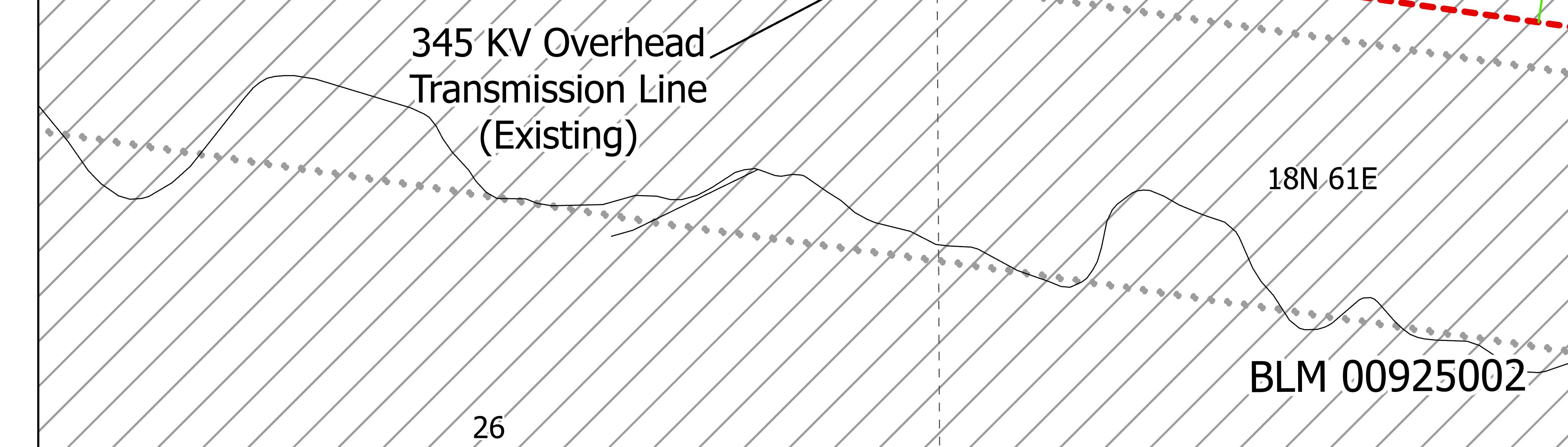
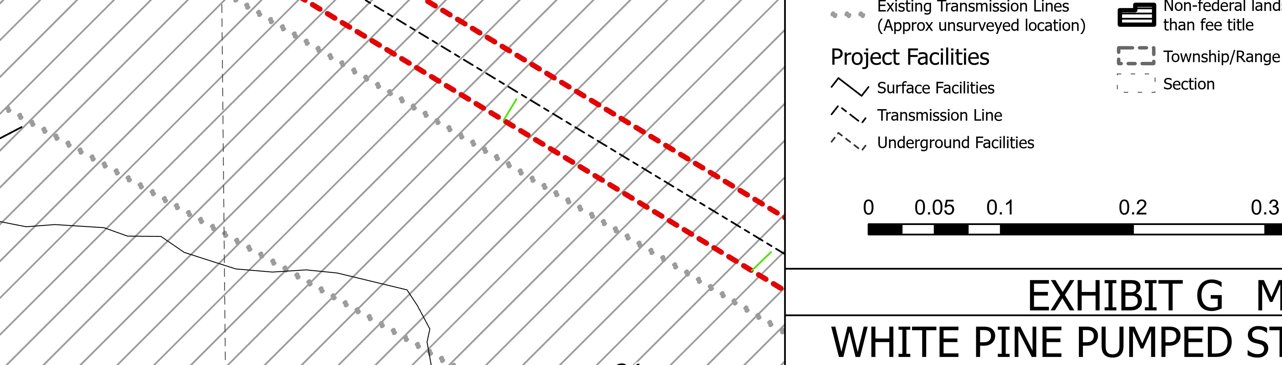
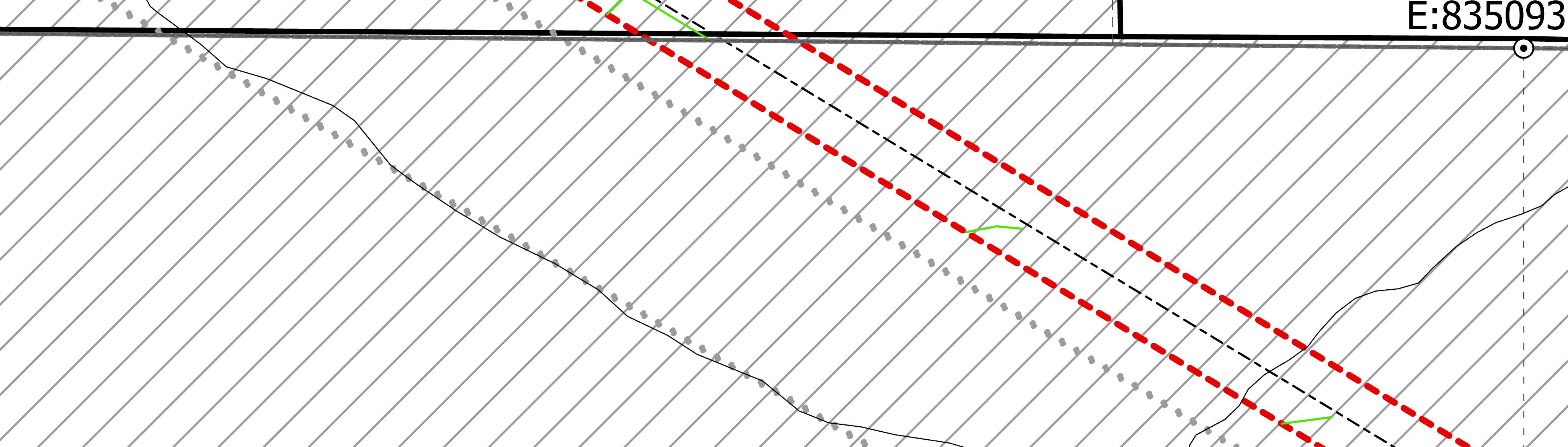
Section 4.41(h)(1) of the Commission’s regulation requires that Exhibit G maps show the location of all project works and principle features. Although Exhibit G, Maps G5 and G6 appear to show that the project boundary encompasses the project's cable, main access, and tailrace tunnels, neither is identified in the maps. Additionally: (a) Map G5 appears to show the switchyard access road, but it is not identified; (b) Map G5 does not appear to show the lower reservoir perimeter road and lower reservoir laydown areas; (c) Map G6 does not appear to show the upper reservoir perimeter road and upper reservoir laydown areas; (d) Map G5 does not appear to show the wellfield conveyance access road; and (e) Maps G1 through G5 do not appear to identify existing access roads and tracks proposed to be utilized by the project and do not appear to identify proposed locations of new access roads and tracks that would provide access to the proposed transmission line ROW. Further, Exhibit G maps do not appear to identify the location of the proposed temporary explosives storage area and the existing roads proposed to be utilized to access the storage area. Therefore, the FLA does not conform to 18 CFR 4.41(h)(1) of the Commission's regulations. Please correct Maps G5 and G6 to identify the project facilities. To aide staff’s review of Exhibit G, please modify the exhibit so that the alignments of proposed project facilities and the proposed project boundary are identified using appropriate colored lines (e.g., dashed, red line for the project boundary; solid, green line for any proposed new access road; bold, orange line for any existing access roads proposed for use by the project.
Response:
The applicant has updated the requested maps to show the location of all project works and principal features.
All principle underground works within the project boundary are now shown and identified including the cable, main access and tailrace tunnels. To facilitate additional labels and facility linework, the applicant has increased the scale and number of maps to allow for additional detail.
Specific FERC requests have been addressed as follows:
a. The switchyard access road is shown and labeled as the “Western Access Road” (See Attachment D - Map G10).
b. The lower reservoir perimeter road is shown and labeled (See Attachment D – Map G10). As noted in the FERC letter on May 25, 2023 the lower reservoir laydown area is not intended to be utilized permanently and is not shown in these updates.
c. The upper reservoir perimeter road is shown and labeled (See Attachment D - Map G10). As noted in the FERC letter on May 25, 2023 the upper reservoir laydown area is not intended to be utilized permanently and is not shown in these updates.
d. The wellfield conveyance road is shown and labeled (See Attachment D - Map G9 and G12)
e. Updated Maps G1 through G9 now show all roads and existing two-track trails that the project proposes to utilize to provide access to the transmission line ROW.
As noted in the FERC letter on May 25, 2023 the applicant confirms that the proposed temporary explosives storage area and existing roads proposed to be utilized to access the storage area are for temporary use during project construction and are not shown in updated Attachment D - Map G10.
To aid FERC staff’s review, the applicant has colored the alignments of the proposed facilities and the proposed project boundary. The following colors have been utilized:
• Project Boundary: Red / Dashed
• New Access Roads: Green / Solid
• Existing Access Roads Utilized by project: Orange / Solid (not used as all permanent access roads are new construction)
FERC Deficiency No. 13:
Section 4.41(h)(2) of the Commission's regulations requires that the project boundary enclose all project features. Because Exhibit G does not appear to show all proposed project features, including the soil disposal area and the features listed above, enclosed by the project boundary, please correct Exhibit G maps to enclose all proposed project facilities and features within the proposed project boundary.
Response:
The applicant confirms that the project boundary encloses all permanent project features. However, as discussed in FERC letter dated May 25, 2023, there are laydown and staging areas that are temporary in nature, used only during project construction, and will be restored and reclaimed after project construction is complete. These areas are not included within the project boundary or identified within the updated Exhibit G Maps.
FERC Deficiency No. 14:
Section 4.41(h)(4) of the Commission's regulations requires that the maps identify by legal subdivision (i) lands owned in fee by the applicant and lands that the applicant plans to acquire in fee and (ii) lands over which the applicant has acquired or plans to acquire rights to occupancy and use other than fee title, including rights acquired or to be acquired by easement or lease. Exhibit G maps identify non-federal lands that would be encompassed by the project boundary. However, the maps don't indicate: (a) which lands are currently owned in fee by the applicant; (b) which lands the applicant plans to acquire in fee; and (c) the lands over which the applicant has acquired or plans to acquire rights to occupancy and use other than fee title, including rights acquired or to be acquired by easement of lease. Therefore, please correct Exhibit G to identify these types of lands.
Response:
Exhibit G Maps are updated to reflect lands the applicant plans to purchase or acquire rights to occupy. Please see Attachment D.
Land Parcel rights are identified with hatching as follows:
• Lands that do not intersect the project are not hatched.
• Federal lands intersected by the project boundary are all Bureau of Land Management and have a diagonal line hatch.
• Non-Federal Lands that the applicant plans to acquire in fee have a vertical line hatch.
• Non-Federal Lands that the applicant plans to acquire rights other than fee title have a horizontal line hatch.
For the majority of Non-Federal lands, a decision on fee or other rights has not been finalized and the parcels have both vertical and horizontal hatching. No lands are currently owned in fee by the applicant. Non-Federal parcels and the applicant’s intent for acquisition in fee or intent to aquire rights other than fee, are listed below in Table 14-1
Table 14-1: Applicant intent for Non-Federal Land Rights
Parcel Map (original Exhibit G)
ment D Map Number Lands currently owned in fee by the applicant Lands the applicant plans to acquire in fee
Lands over which the applicant has acquired or plans to acquire rights to occupancy and use other than fee title, including rights acquired or to be acquired by easement of lease
FERC Deficiency No. 15:
Section 4.61(a)(2) of the Commission’s regulations requires that Exhibit G drawings must have identifying title blocks and bear the following certification: “This drawing is a part of the application for license made by the undersigned this day of _______, 20__.” Please revise the drawings to include this information.
Response:
FERC confirmed on January 18, 2023 that CFR Section 4.61 applies to projects with a total installed generating capacity of 5 MW or less. The project has a capacity of 1,000 MW, as such CFR 4.61 does not apply.

Rhiannon Scanlon
From: Caitlin Skulan <c.skulan@water-law.com>
Sent: Friday, February 3, 2023 4:11 PM
To: Rhiannon Scanlon
Cc: Therese Ure Stix; Lora L. Shadoan
Subject: RE: McGill/Ruth GID. Follow Up to Telemessage 2/2/2023
You don't often get email from c.skulan@water-law.com. Learn why this is important
Caution! This message was sent from outside your organization. Allow sender | Block sender
Ms. Scanlon,
Thank you for reach out. Yes, please include our office on the distribution list:
Schroeder Law Offices, P.C. 10615 Double R. Blvd., #100 Reno, NV 89521 counsel@water-law.com
Best regards,
Caitlin Skulan
Associate Attorney
Schroeder Law Offices, P.C. 10615 Double R Blvd. #100, Reno, NV 89521 P: (775) 786-8800 | F: (877) 600-4971
From: Rhiannon Scanlon <rscanlon@rplusenergies.com>
Sent: Friday, February 3, 2023 2:44 PM
To: Caitlin Skulan <c.skulan@water-law.com>
Cc: Therese Ure Stix <therese@water-law.com>; Lora L. Shadoan <l.shadoan@water-law.com>
Subject: RE: McGill/Ruth GID. Follow Up to Telemessage 2/2/2023
Hello,
I am reaching out on behalf of rPlus Hydro. We are rene wable energy company engaged in developing an approximately $2.8 billion commercial pumped storage project in White Pine County.
I believe your firm has worked with the McGill Ruth Water District regarding the draft license application for our energy storage project. In the next few weeks, we will be submitting a Final License Application to the Federal Energy Regulatory Commission (FERC) relating to this project. As part of this process, we are required to notify local, state, and federal agencies, as well as other stakeholders who may wish to review the application. I reached out to your office as well as Amy Garcia, to confirm who we should include in ou r notification process for the McGill Ruth Water District. Please let me know if I should include you and your law office on the distribution list.
Respectfully,
Rhiannon ScanlonRhiannon Scanlon | Development Associate rPlus Hydro, LLLP | 808.333.2118

From: Caitlin Skulan <c.skulan@water-law.com>
Sent: Thursday, February 2, 2023 5:19 PM
To: Rhiannon Scanlon <rscanlon@rplusenergies.com>
Cc: Therese Ure Stix <therese@water-law.com>; Lora L. Shadoan < l.shadoan@water-law.com>
Subject: McGill/Ruth GID. Follow Up to Telemessage 2/2/2023
You don't often get email from c.skulan@water-law.com. Learn why this is important
Ms. Scanlon,
I was informed that you returned my call today and requested a follow up by email.
I am returning your prior call regarding information about the McGill Ruth Consolidated Sewer and Water District. It is my understanding that you have spoken to the Manager of the District, Amy Garcia and may have obtained the information you needed directly from her. If that is not the case, please let me know what information you are in search of and I will advise if I may provide it.
Best regards,
Caitlin SkulanAssociate Attorney
Schroeder Law Offices, P.C.
10615 Double R Blvd. #100, Reno, NV 89521
P: (775) 786-8800 | F: (877) 600-4971
Join our mailing list!
Confidentiality Notice: This electronic message may contain information that is attorney-client privileged and confidential, intended only for the use of the individual or entity named above. If you receive this communication in error, please notify me immediately and delete all copies of this message.


 Rhiannon Scanlon
From: Jessica Brooks
Sent: Tuesday, March 21, 2023 12:11 PM
To: jpseymour87@gmail.com
Subject: RE: White Pine Pumped Storage - FERC License Application Notification & Introduction
Hi John,
Thank you so much for giving me a call. Again, I apologize for the experiences you’ve had in the past with my team, and I hope that you and I can move forward on the right foot. We don’t need to discuss anything right now. Focus on your health. I truly hope that your doctors’ appointments go well, and I wish the best for you and your family.
Sincerely, Jess Jessica Brooks | Development Associate rPlus Hydro, LLLP | 858.882.7417

From: Jessica Brooks
Sent: Tuesday, March 21, 2023 11:10 AM To: jpseymour87@gmail.com
Cc: Laura Rippentrop <lrippentrop@rplusenergies.com>; Gregory Copeland <gcopeland@rplusenergies.com>
Subject: White Pine Pumped Storage - FERC License Application Notification & Introduction
Good Morning Alyce and John Seymour,
I hope this email finds you well. The purpose for my email this morning is to both ensure you’ve received the attached notification letter and exhibit G, and introduce myself.
On February 24, 2023, rPlus Hydro, LLLP, on behalf of Whit e Pine Waterpower, LLC (“WPW”) filed an application for an original license for the White Pine Pumped Storage Pr oject with the Federal Energy Regulatory Commission. The application is for a closed-loop pumped storage hydroelectric project to be located in the Duck Creek Range and Steptoe Valley in White Pine County, Nevada. WPW developed this License Application in accordance with 18 CFR Part 4, Subpart E of FERC’s regulations. The licen se application and associated appendices can be accessed online at www.whitepinepumpedstorage.com, if you want to read the documents.
I’m Jessica, a Development Associate with the rPlus Hydro team working on the ‘White Pine Project’. You may have spoken with Larua or Greg (cc-ed) in the past, and you’ll likely hear from me as an additional point of contact for you. I look forward to connecting. My cell phone number is 858.882.7417 if you have any questions.
Cheers, Jessica Brooks | Development Associate rPlus Hydro, LLLP | 858.882.7417


Federal Agencies
Bureau of Land Management:
Nevada State Office
State Director
Jon Raby 1340 Financial Blvd. Reno, NV 89502
Bureau of Land Management: Ely District Office
Distict Manager
Robbie McAboy
702 North Industrial Way Ely, NV 89301
Bureau of Land Management: Bristlecone Field Office
Bristlecone Field Manager
Jared Bybee
702 North Industrial Way Ely, NV 89301
National Park Service
Regional Program Manager
Barbara Rice
333 Bush Street Suite 500 San Francisco, CA 94104
Federal Aviation Administration: Reno Flight District Office Manager
Lana Boler
5466 Longley Lane Reno, NV 89511
U.S. Fish & Wildlife Service: Pacific Southwest Region
Regional Director
Paul Souza
Federal Building 2800 Cottage Way Sacramento, CA 95825
U.S. Forest Service: Ely Ranger District District Ranger
Jose Noriega 825 Avenue E Ely, NV 89301
Environmental Protection Agency
Region 9
Regional Administrator
Martha Guzman 75 Hawthorne Street San Francisco, CA 94105
Distribution List
Federal Railroad Administration
Chief Counsel
Allison Ishihara Fultz 1200 New Jersey Avenue SE Washington, DC 20590
U.S. Geological Survey Region 10
Regional Director
Eric Reichard 2800 Cottage Way Federal Building Sacramento, CA 95825
Native American Tribes
Duckwater Shoshone Tribe
Chairman
Warren Graham PO Box 140061 Duckwater, NV 89314
Ely Shoshone Tribe
Chairwoman
Diana Buckner
505 S. Pioche Highway Ely, NV 89301
Te-Moak Tribe of Western Shoshone Indians
Chairman
Joseph A Holley 825 Railroad Street Elko, NV 89801
Confederated Tribes of the Goshute Reservation
Chairman
Rupert Steele P.O. Box 6104 Ibapah, UT 84034
State Agencies
Nevada Division of Environmental Protection Bureau of Water Quality Planning
Environmental Scientist III
Zachary Carter 901 South Stewart Street Suite 4001 Carson City, NV 89701
State of Nevada Sagebrush Ecosystem Program Program Manager
Kelly McGowan
201 S. Roop Street Suite 101 Carson City, NV 89701
Distribution List
White
Pine Pumped Storage Project (FERC No. 14851)
Nevada Department of Wildlife Director
Alan Jenne
6980 Sierra Center Pkwy #120 Reno, NV 89511
Nevada Department of Wildlife Commission
Chair
Tommy Caviglia
6980 Sierra Center Pkwy #120 Reno, NV 89511
Nevada Division of Forestry Program Manager
Rick Morse
2478 Fairview Dr. Carson City, NV 89701
Governor's Office of Energy
Director
Dwayne McClinton
600 E William Street Suite 200 Carson City, NV 89701
Nevada Public Utilities Commission
Director of Regulatory Operations
Anne-Marie Cuneo 1150 E. William Street
Carson City, NV 89701
Nevada Department of Transportation: District III Ely
District Engineer
Sami Yousuf 1951 Idaho St. Elko, NV 89801
Department of Conservation and Natural Resources; Division of Water Resources
State Engineer
Adam Sullivan
901 S. Stewart St. Suite 2002 Carson City, NV 89701
Department of Conservation and Natural Resources; Division of Environmental Protection Administrator
Greg Lovato
901 South Stewart Street Suite 4001 Carson City, NV 89701
Department of Conservation and Natural Resources; State Historic Preservation Office
State Historic Preservation Officer
Rebecca Palmer
901 S. Stewart Street Suite 5004 Carson City, NV 89701
Nevada Dept of Conservation & Natural Resources
Director
James Settelmeyer
901 S. Stewart St. Ste. 1003 Carson City, NV 89701
Southern Nevada Water Authority General Manager
John J. Entsminger PO Box 99956 Ely, NV 89193
Nevada Governors Office of Economic Development
Director
Thomas Burns 808 West Nye Lane Carson City, NV 89703
Nevada Division of State Lands
State Lands Planner
Scott Carey
901 S. Stewart St Ste 5003 Carson City, NV 89701
NV Energy
Director, Renewables Sourcing
Mark Warden P.O. Box 98910
Las Vegas, NV 89151
Mt. Wheeler Power
Kevin Robinson 1600 Great Basin Boulevard Ely, NV 89301
County
White Pine County County Manager
Michael Wheable 1786 Great Basin Blvd Suite 3 Ely, NV 89301
Distribution List
White Pine Pumped Storage Project (FERC No. 14851)
White Pine County Board of Commissioners
Clerk
Nichole Stephey 1786 Great Basin Blvd. Suite 3 Ely, NV 89301
Local
McGill Ruth Water District
Kurt Carson PO Box 1376 McGill, NV 89318
Ely Water and Sewer Department
Carl Siemer 501 Mill Street Ely, NV 89301
City of Ely
Building Official
Craig Peterson 501 Mill Street Ely, NV 89301
Ely City Council
Clerk
Jennifer Lee 501 Mill Street Ely, NV 89301
City of Ely
Mayor
Nathan Robertson 501 Mill Street Ely, NV 89301
McGill Town Council
Secretary
Elaine Blackham
P.O. Box 1334 McGill, NV 89318
Nevada Northern Railway Foundation, Inc. President
Mark S. Bassett
P.O. Box 150040 East Ely, NV 89315