OUTCROP
Newsletter of the Rocky Mountain Association of Geologists


OUTCROP
Newsletter
of the Rocky Mountain Association of Geologists
730 17th Street, B1, Denver, CO 80202 • 720-672-9898
The Rocky Mountain Association of Geologists (RMAG) is a nonprofit organization whose purposes are to promote interest in geology and allied sciences and their practical application, to foster scientific research and to encourage fellowship and cooperation among its members. The Outcrop is a monthly publication of the RMAG.
2025 OFFICERS
PRESIDENT
AND BOARD OF DIRECTORS RMAG STAFF
Matthew Bauer matthew.w.bauer.pg@gmail.com
PRESIDENT-ELECT Sandra Labrum slabrum@slb.com
1st VICE PRESIDENT
Nate La Fontaine nlafontaine@sm-energy.com
1st VICE PRESIDENT-ELECT Rachael Czechowskyj sea2stars@gmail.com
2nd VICE PRESIDENT Ali Sloan ali@sloanmail.com
2nd VICE PRESIDENT-ELECT Lisa Wolff lwolff@bayless-cos.com
SECRETARY Drew Scherer latirongeo@gmail.com
TREASURER
Astrid Makowitz astridmakowitz@gmail.com
TREASURER-ELECT
Walter Nelson wnelson@integratedenergyresources.com
COUNSELOR
John Benton jbenton@haitechinc.com
ADVERTISING INFORMATION
Rates and sizes can be found on page 41. Advertising rates apply to either black and white or color ads. Submit color ads in RGB color to be compatible with web format. Borders are recommended for advertisements that comprise less than one half page. Digital files must be PC compatible submitted in png, jpg, tif, pdf or eps formats at a minimum of 300 dpi. If you have any questions, please call the RMAG office at 720-672-9898.
Ad copy, signed contract and payment must be received before advertising insertion. Contact the RMAG office for details.
DEADLINES: Ad submissions are the 1st of every month for the following month’s publication.
The Outcrop is a monthly publication of the Rocky Mountain Association of Geologists
DESIGN/LAYOUT: Nate Silva | n8silva.com
EXECUTIVE DIRECTOR
Bridget Crowther bcrowther@rmag.org
LEAD EDITOR
Danielle Robinson danielle.robinson@dvn.com
CONTRIBUTING EDITORS
Elijah Adeniyi eadeniyi@slb.com
Nate LaFontaine nlafontaine@sm-energy.com
RMAG CODE OF CONDUCT
RMAG promotes, provides, and expects professional behavior in every engagement that members and non-members have with the organization and each other. This includes respectful and inclusive interactions free of harassment, intimidation, and discrimination during both online and in-person events, as well as any content delivered by invited speakers and instructors. Oral, written or electronic communications that contain offensive comments or demeaning images related to race, color, religion, sex, national origin, age, disability, or appearance are not appropriate in any venue or media. RMAG reminds members of the diversity and mission statements found on our website. Please direct any questions to staff@rmag.org

ERRATA
We would like to note two reported errors in the September edition of The Outcrop. On pages 40 and 41 of the Benitoite feature, the terms "short-wave" and "longwave" were stated in reverse. This has been corrected online—we regret any confusion the errors caused.
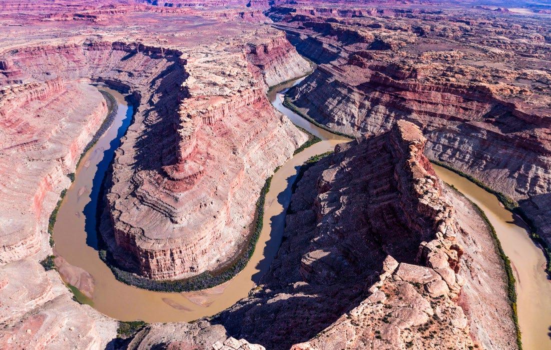
COVER
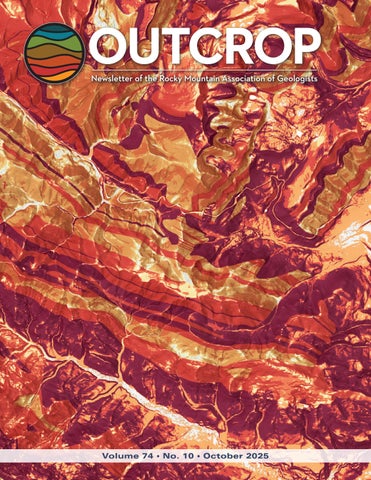
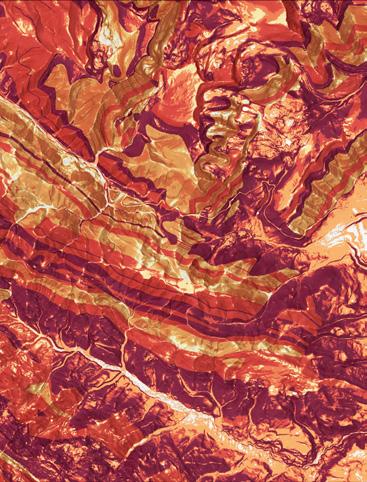
PHOTO
Deep-seated landslide susceptibility in Teton County, Wyoming. Map view is centered over Teton Pass, with Wyoming Highway 22 bisecting the image from east to west. Darker red colors symbolize higher landslide susceptibility. Map scale is 1:50,000. Photo by Wyoming State Geological Survey. Read more on 14.

MEMBERS
EVENT ATTENDEES
WEBSITE VISITORS
OUTCROP READERS
EMAIL SUBSCRIBERS
NETWORKING EVENTS
CONTINUING EDUCATION EVENTS
FIELD TRIPS
COMMUNITY CONTACTS IN 2024YOUR SUMMIT SPONSORSHIP DOLLARS SUPPORTED: 1,200 1,200 8,000 8,000 5,000 4,000 23 13 10

October 30, 2024
Geoscience Community:
We sincerely appreciate the support every Summit Sponsor and Event Sponsor provided over the past year. Your contributions are vital to the success of the Rocky Mountain Association of Geologists (RMAG).
In 2024, the RMAG was proud to host a dynamic lineup of events, including the CCS Workshop, which provided an in-depth look at advancements in carbon capture and storage. Members explored the beauty and geological wonders of the Colorado Rockies with ten diverse field trips and shared our passion for geoscience with students across the region through classroom visits and community festivals. Additionally, we fostered connections among members through monthly lunches, coffees, happy hours, and our annual Golf Tournament.
Looking ahead to 2025, we are excited about new opportunities for RMAG. Your sponsorship will help RMAG realize a robust calendar of continuing education opportunities, an exciting season of field trips, high-impact short courses, and a dynamic lineup of luncheon speakers. In April 2025, we look forward to the North American Helium & Hydrogen Conference, building on the success of our 2023 North American Helium Conference. Your sponsorship empowers RMAG members to impact the next generation at outreach events throughout the community and provides invaluable networking opportunities for the geoscience community. Furthermore, your financial support plays a crucial role in our publication efforts, which include the monthly Outcrop newsletter and the quarterly Mountain Geologist journal.
In recognition of your financial commitment to supporting geoscience in the region we recognize our sponsors through in-person signage, advertising on our website, publications, and social media promotions leading up to each event. With a LinkedIn group of almost 3,000 members, we ensure our sponsors are visible to the geoscience community for both virtual and in-person events.
Thank you to our current Summit Sponsors; we look forward to your continued support in 2025. For those considering sponsoring, we encourage you to explore the many benefits included at each sponsorship level and consider how you can promote geoscience in the Rockies. If an annual sponsorship doesn’t suit your company’s needs or if you wish to sponsor a specific event, please inquire about our single-event sponsorship opportunities. Feel free to reach out to our staff with any questions about sponsorship at bcrowther@rmag.org or by phone at 720- 672-9898 ext. 102.
On behalf of the RMAG staff, volunteers, and myself thank you all for your continued support, and we look forward to connecting with you in 2025.
Sincerely,
Matthew Bauer
Bridget Crowther 2025 RMAG President RMAG Executive Director


RMAG 2025 SUMMIT SPONSORSHIP
All sponsor benefits event tickets follow RMAG event registration deadlines. All benefits end 12 months after registration.
RMAG 2024 ANNUAL SUMMIT SPONSOR OPPORTUNITIES
Platinum Sponsor
Gold Sponsor
Silver Sponsor
Summit Sponsorship benefit term is for 12 months! Specify type of payment on signed form, and send logo and advertisements to staff@rmag.org
Company:
Company Representative:
Address:
City: State: Zip Code:
Phone: Email:
Payment Method: Credit Card ACH Check
Credit Card Information:
Select Card: AMEX Mastercard VISA Discover
Name as it appears on Credit Card:
Credit Card #:
Expiration Date:
Signature:
Security Code:
ACH: contact the RMAG office at staff@rmag.org for directions.
Mail Checks payable to RMAG:
Rocky Mountain Association of Geologists (RMAG)
730 17th Street, B1 Denver, CO 80202
RMAG events are subject to change. Cancellation or rescheduling of events does not give the sponsor the right to refund. Summit Sponsors will receive benefits at any new events added into the RMAG schedule.
Thank you for your generous support!
P: (720)672- 9898 staff@rmag.org www.rmag.org

730 17th Street, B1 Denver, CO 80202
RMAG SEPTEMBER 2025 BOARD OF DIRECTORS MEETING
By Drew Scherer, Secretary flatirongeo@gmail.com
Greetings and welcome to the first Fall 2025 issue of The Outcrop! The Board of Directors most recently met on September 17th, 2025, at 4pm via Zoom in a quorum with 6 of 10 directors present. The office began with an overview of our seven events in August where we maintained at least average attendance levels save for the luncheon. Membership showed a minor increase of thirteen members, as we receive interest in RMAG membership coinciding with the RMS-AAPG conference in early October. Like in the preceding months, the performance of our stock portfolio offset small net operating losses for a positive net revenue gain. The funds within our investment portfolio have begun to approach the threshold of a more conservative approach and our board plans to vote on an investment strategy change in the October BoD meeting.
The Continuing Education Committee has been
prioritizing the Rocky Mountain Rendezvous career fair revival ahead of the RMS-AAPG conference, and has luncheons confirmed through the end of 2025. They are also working on future workshops and events including an upcoming Python short course and planning a 2026 basin conference. The Membership committee reported average attendance at both the August coffee and happy hours but had to postpone the RMAG Mountain Bike trip to next year due to insufficient sign-ups. The Committee is also planning a Clay Shoot fundraiser, tentatively scheduled for H1 2026, as well as the next annual Rockbuster’s Ball.
The Publications committee has Outcrop articles ready to go for the next couple of months and is generating leads for a variety of topics, and the fall Mountain Geologist edition is set to be released shortly, with an additional four articles planned for the Winter edition. The Geoscience Outreach committee will resume outreach events in October with the Jeffco career fair on the 15th and is planning a couple more events in November to round out the year. Lastly the On-The-Rocks committee has a couple more field trips in the fall including the Picketwire Dinosaur Trackway (October 4-5), Pueblo Graneros/Greenhorn/Carlile/Niobrara (October 18), and a trip to the Denver Museum’s Planetarium later this winter. Thank you for a great summer of events, fellowship, and outreach! See you next time!


PRESIDENT’S LETTER
By Matthew Bauer
Greetings from SMRI + A Resource on Evaporite Well Logs
Dear Fellow Members,
I’m writing to you from the Fall Solution Mining Research Institute (SMRI) Conference, where I’ve had the chance to connect with professionals working at the frontiers of solution mining and subsurface energy storage. It’s been a great reminder of how dynamic and diverse our geoscience field is—and how valuable it is when people come together to share their experience and improve our industry.
In that spirit, I’d like to share a composite well log I recently compiled that highlights the properties of various evaporite minerals. One interesting feature: hydrous minerals show elevated readings on the neutron porosity curve, due to hydrogen in the water of the mineral structure—something that can be mistaken for porosity. This log is a handy visual reference, though keep in mind it assumes pure mineral end-members and zero porosity.
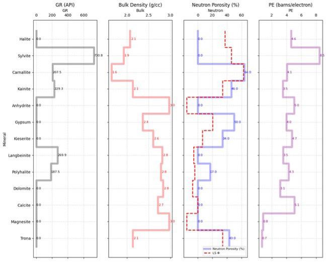
I’m looking forward to seeing many of you at the RMS-AAPG meeting, October 5–7. If you’re there, feel free to find me and say hello!
As always, thank you for being part of our RMAG community.
Stay curious and be good to people,
—Matthew W. Bauer
LANDSLIDES IN WESTERN WYOMING PART 2 SUSCEPTIBILITY MAPPING IN TETON COUNTY
BY JAMES MAUCH
Wyoming State Geological Survey
LAST MONTH’S LEAD STORY explored the causes, triggering mechanisms, and geologic interpretation of the Gros Ventre Slide for its 100-year anniversary. An important takeaway from the Gros Ventre Slide is that the geologic and topographic setting plays an outsized role in making a slope prone to landslides. Under the right initial conditions, minor perturbations can tip the scales to produce a catastrophic slope failure. One method of depicting where conditions are ripe for future landslides is through landslide susceptibility mapping. Landslide susceptibility maps show where landslides are likely to occur according to pre-existing landscape factors, and they are an essential tool for land-use planning.
In April 2025, the Wyoming State Geological Survey (WSGS) published a landslide susceptibility map for central and southern Teton County—an area that encompasses the Gros Ventre Slide and several other
notable landslides from the past 25 years. The map— Susceptibility to Deep-Seated Landslides in Central and Southern Teton County, Wyoming (Mauch and Stafford, 2025)—was produced through a spatial analysis of rock strength and slope angle data, following the principle that landslides are more likely to occur in areas with weak rocks and steep slopes. The map, technical report, and accompanying GIS data are available for free download from the WSGS website, wsgs.wyo. gov. These products are intended to provide officials and the public with a general understanding of where deep-seated landslides are more likely to occur, with the goal of informing land-use planning, infrastructure siting, and risk reduction efforts.
Existing state (Wittke and Stafford, 2019) and national (Belair and others, 2024) landslide susceptibility maps cover Teton County at resolutions of 60 meters and 90 meters, respectively. The study area, which comprises all of Teton County south of
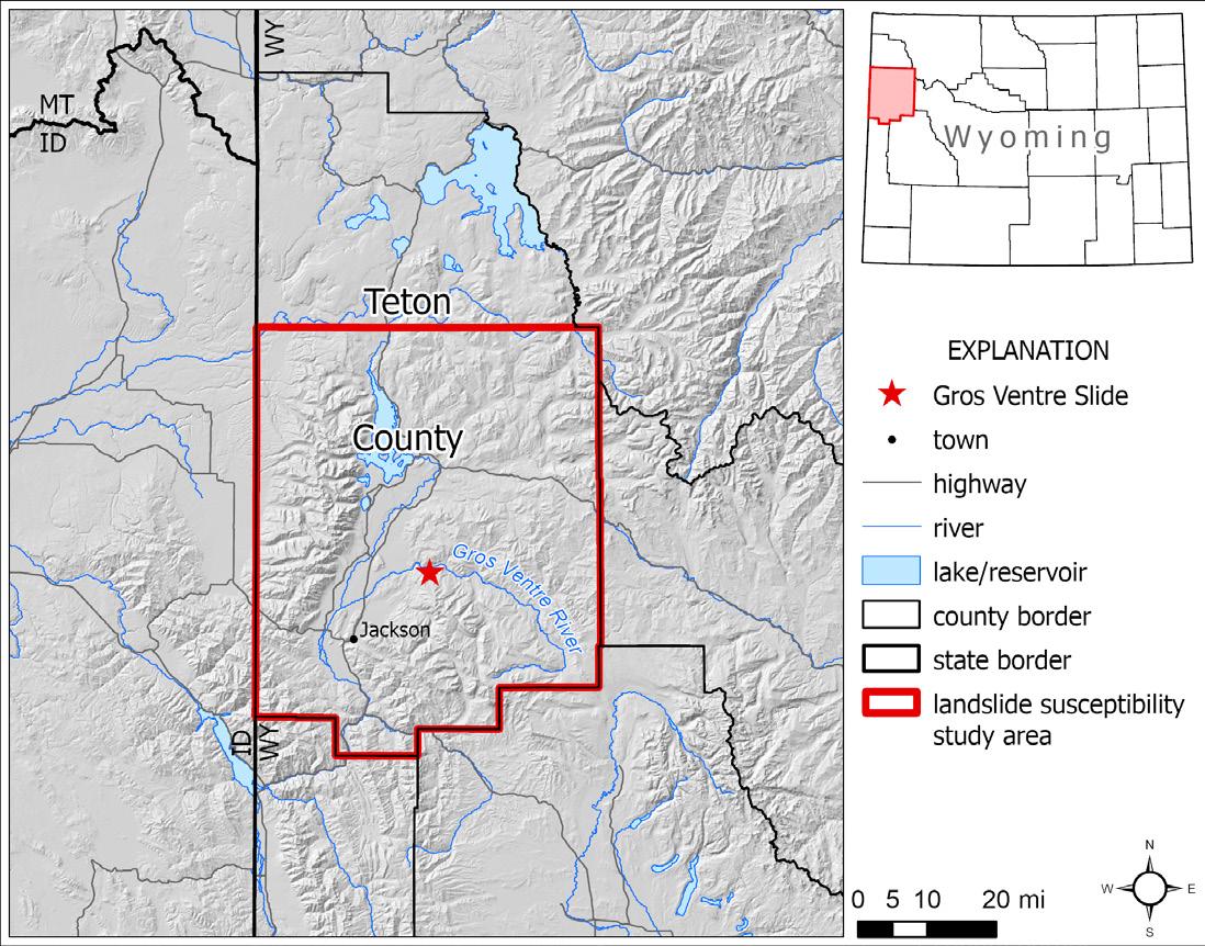
Yellowstone National Park (Fig. 1), was selected because of its history of damaging landslides and because more detailed geologic and topographic datasets than those used in the state and national susceptibility maps are available. Specifically, there is widespread 1:24,000-scale bedrock geologic mapping, 1-meter lidar data is published for the entire study area, and there is recently updated landslide mapping to aid in model validation. These datasets enabled the WSGS to model deep-seated landslide susceptibility in a 10-meter raster grid—a much higher resolution than previous susceptibility mapping in this area.
ROCK STRENGTH AND SLOPE ANGLE
The landslide susceptibility raster was generated through a GIS-based spatial intersection of rock strength and slope angle data. These methods were originally developed to predict earthquake-induced landslides in southern California (Wilson and Keefer, 1985; Ponti and others, 2008), and they have more recently been adopted as a common workflow in regional landslide susceptibility mapping. The rock strength and slope angle classes—along with the classification matrix and values of landslide
FIGURE 1: Regional map showing the study area for the WSGS publication, Susceptibility to deep-seated landslides in central and southern Teton County, Wyoming.
susceptibility—used in this study directly follow those from the statewide landslide susceptibility maps of California (Wills and others, 2011) and Wyoming (Wittke and Stafford, 2019).
The initial step in this analysis was compiling a seamless geologic map of the study area, which was then used to generate the rock strength dataset that was an input to the susceptibility model. Geology was compiled from 57 published and unpublished bedrock geologic maps, 47 of which were mapped at 1:24,000 scale. Most of the remaining maps were produced at scales between 1:31,680 and 1:100,000, and in parts of the Gros Ventre River valley the only existing mapping is at 1:500,000 scale. Map unit polygons from the geologic maps were edgematched, and identical units with different symbols from their respective source maps were merged. Edge-matching required the judgment of the authors where discrepancies existed between maps, and the original geologic mapping was preserved in all other cases.
This process yielded a seamless geologic map with 140 unique map units (Fig. 2), each of which was assigned as many as two basic rock types according to the descriptions of map units in the source maps. These rock types were the basis for classifying each map unit into one of three relative rock strength classes. Class 1 contains the strongest rocks, including carbonate rocks, well-indurated volcanic rocks, and crystalline rocks. Class 2 contains intermediate-strength rocks, including moderate-to-weakly cemented conglomerate and sandstone, moderately indurated volcanic rocks, and carbonate rocks that are interbedded with shale and claystone. Class 3 contains the weakest rocks, including siltstone, shale, claystone, unconsolidated surficial deposits, and preexisting landslides. Map unit polygons were then converted to a 10-meter-resolution raster dataset, with raster values extracted from the rock strength field.
Slope data were generated from 1-meter lidar digital elevation models (DEMs) downloaded from The National Map (U.S. Geological Survey, 2020, 2023, and 2024). The DEMs were mosaicked, clipped to the study area boundary, and downsampled with bilinear interpolation to produce a 10-meter resolution DEM. A slope raster was generated from the
DEM using a 3-by-3-cell (30-by-30-meter) moving window. The slope raster was then reclassified into eight bins, with the lowest-angle slopes (0–3 degrees) in Class 1 and the highest-angle slopes (40–90 degrees) in Class 8 (Wills and others, 2011; Wittke and Stafford, 2019).
The landslide susceptibility model was produced through a raster calculation intersecting the slope and rock strength datasets (Fig. 3). Following the classification matrix that outlines all possible combinations of the three rock strength and eight slope classes, each grid cell was assigned a final susceptibility score (Fig. 4). Scores of 0, 3, 5, 6, 7, 8, 9, and 10 are possible (Wills and others, 2011; Wittke and Stafford, 2019). In general, a score of 0 represents negligible susceptibility, 3–5 indicates low susceptibility, 6–7 indicates moderate susceptibility, and 8–10 indicates high susceptibility, though thresholds vary by application and are the responsibility of the end user. Readers interested in more details about these methods are encouraged to download the technical report that accompanies this study, which is available from the WSGS website.
SUSCEPTIBILITY MODEL VALIDATION
The susceptibility model was validated by comparing the output susceptibility raster with an independent inventory of deep-seated landslides in central and southern Teton County. A total of 2,157 deep-seated landslides, mapped by Case (2004) and Mauch and others (2021, 2022), were merged and edge-matched, and a 120-meter buffer was applied to each landslide polygon to conservatively broaden its footprint and to account for location uncertainty in pre-lidar mapping. Statistics were calculated for the population of grid cells from the susceptibility raster that intersect each buffered landslide polygon, and the mean values were analyzed.
The authors set a requirement for 85% of the buffered landslide polygons to have a mean susceptibility score of 8 or greater for there to be suitable agreement between the landslide susceptibility raster and the independent landslide inventory. This benchmark was chosen to balance the susceptibility raster’s ability to correctly capture a high percentage of landslide-prone terrain (maximizing true

FIGURE 2: Geology of the study area compiled and edge-matched from 57 source geologic maps. See Appendix 2 of technical report—available for free download from the WSGS website, wsgs.wyo.gov—for unit names.
positives) without erroneously cataloging non-landslide-prone terrain as high-susceptibility grid cells (minimizing false positives). The first round of validation yielded a compliance level of 83.4% (the percentage of landslide polygons with susceptibility scores ≥8). After identifying the geologic unit—the Paleocene-age Devils Basin Formation—that was most responsible for the non-complying landslide
polygons and adjusting its rock strength to class 3 accordingly, the second validation iteration produced an acceptable compliance level of 86.6%. As a parallel assessment, after this second validation, 99.8% of mapped landslides have mean susceptibility scores of 6 or greater, meaning that the vast majority of existing landslides are captured by moderate or higher susceptibility scores.
FIGURE 3: Rock strength (left) and slope angle (middle) classification maps, which were the inputs to the landslide susceptibility matrix (right). Reclassifying these rasters using the susceptibility matrix produced the final landslide susceptibility map (Fig. 4). Numbered boxes on the susceptibility matrix show the eight possible susceptibility scores.
Though there was no quantitative target to evaluate the susceptibility map’s ability to limit false positives, the total percentage of the study area mapped as having non-zero susceptibility provides an approximation of performance (Mirus and others, 2024). After the final validation, 83.9% of the study area was mapped with a susceptibility score greater than 0. This is slightly higher than the percentages from the 90-meter slope-relief threshold model of Belair and others (2024) and the 60-meter slope–rock strength model of Wittke and Stafford (2019), for which the proportion of terrain in the study area with non-zero susceptibility is 81.4% and 78.3%, respectively. The higher percentage from our study may be a result of the higher resolution of the input slope and rock strength data, which capture more topographic and geologic variation than the input data used for the coarser scale susceptibility maps. Regardless, classifying approximately 84% of the study area as having some landslide susceptibility
(scores greater than 0) is considered acceptable given Teton County’s primarily mountainous topography. Taken together, these statistics suggest that the model appropriately captures existing landslides and limits the overprediction of susceptibility.
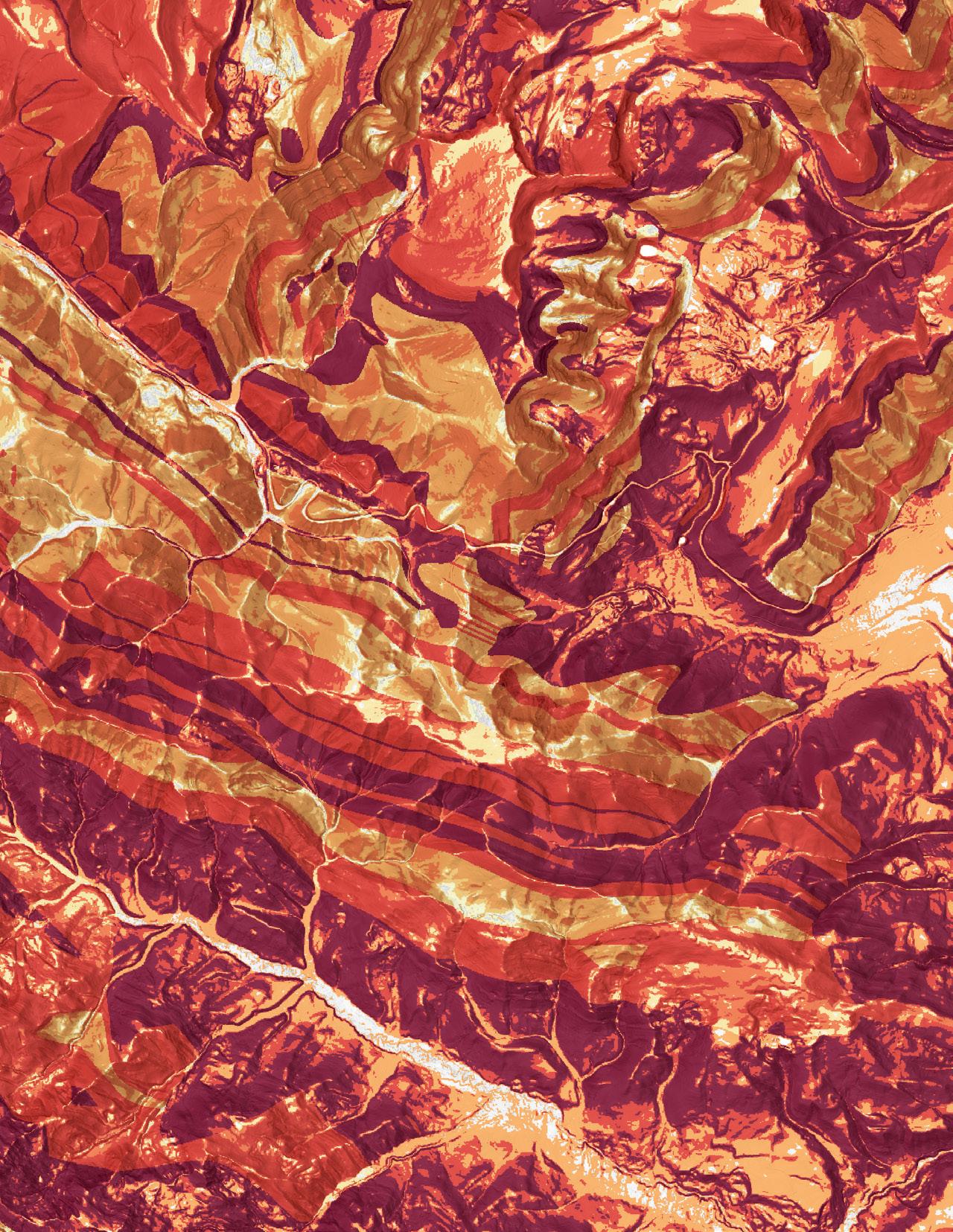
BIG PICTURE TAKEAWAYS
Taken at its simplest, deep-seated landslide susceptibility in Teton County is bimodal, with the valley bottom of Jackson Hole exhibiting negligible to low susceptibility and the surrounding mountain ranges exhibiting moderate to high susceptibility. This illustrates the fundamental and well-known control that topography exerts on landslide processes: landslides are more likely on steep slopes than on gradual ones. The independent influence of rock strength can be teased out by comparing susceptibility values in mountain ranges with different dominant lithologies. For example, the Teton Range—which hosts the steepest terrain in the study area—tends to have
lower susceptibility to deep-seated landslides than does the Snake River Range, primarily because the core of the Teton Range is composed of competent crystalline rocks, whereas the Snake River Range contains weaker sedimentary units.
The 10-meter-resolution susceptibility raster also supports one of our original hypotheses: that landslide susceptibility is highly dependent on local conditions and can change markedly over short distances. For example, on the west flank of the Teton Range north of Alta, susceptibility increases abruptly along drainages that are incised into a low-relief surface capped by the Huckleberry Ridge Tuff. Here, susceptibility values fluctuate between 5 (moderate) and 9 (high) over the span of several tens of meters. Similarly, on the valley-bottom buttes between Jackson and Wilson, susceptibility values occupy the entire range from 0 to 10 over distances of less than 1 kilometer. In this case, the susceptibility fluctuations result from a combination of highly variable slope angles and the complex, patchy distribution of exposed bedrock on the buttes. These examples demonstrate that small changes in location can make large differences in exposure to potential landslide hazards, underscoring both the importance of careful infrastructure siting and the value of high-resolution susceptibility mapping.
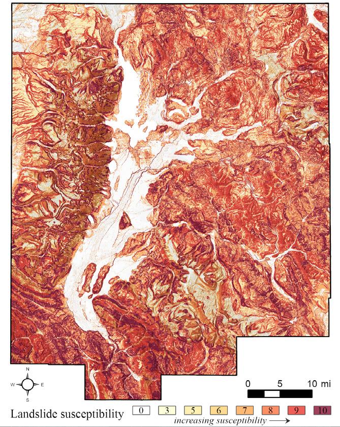
4: Map of deep-seated landslide susceptibility in the study area. Darker red colors symbolize higher susceptibility values.
Interestingly, the model appears to underpredict susceptibility values along the south side of the Gros Ventre River valley. This is where the Gros Ventre Slide occurred, and numerous other deep-seated landslides are mapped along this valley wall (Keefer and Love, 1956; Case, 2004; Mauch, 2022), yet the most frequent susceptibility value in this area is 7 (moderate). Landslide susceptibility in the Gros Ventre River valley is enhanced by slope-parallel bedding and adjacent strata with contrasting competence and permeability (Keefer and Love, 1956; Bailey, 1971), which are variables not included in our
model. The use of a simplified landslide susceptibility model inherently results in some loss of nuance in exchange for an efficient regional analysis, and map users should be aware of the resulting limitations.
LIMITATIONS
Like most models, our landslide susceptibility analysis seeks to provide a useful—albeit imperfect—representation of a natural phenomenon. For proper use of this product, it’s worth discussing several limitations inherent to all landslide susceptibility maps as well as those specific to the dataset from this study. Landslide susceptibility is a spatial
FIGURE
characteristic determined by intrinsic landscape factors, and it is just one component of the total landslide hazard. As such, landslide susceptibility maps are different from hazard or probability maps in that susceptibility maps do not account for landslide magnitude, frequency, or the likelihood of external triggering events such as seismicity or heavy precipitation. Susceptibility maps are also different from risk maps, which display the intersection of the hazard with the assets and values it would affect. Modeling landslide susceptibility at a regional scale comes with inherent uncertainty. Consequently, susceptibility maps may not capture all landslide-prone areas, and a high-susceptibility ranking does not guarantee slope failure. Landslide susceptibility maps are not appropriate for evaluating landslide hazard at any one location and are not a substitute for site-specific geotechnical studies. Instead, susceptibility is a comparative quality that reveals areas with combinations of geology and topography that are more prone to landslide development relative to other areas. This landslide susceptibility map is intended to be a regional overview for central and southern Teton County, and the scale at which it should be used is limited by the resolution of the input rock strength and slope data. The digital landslide susceptibility raster may be used at scales up to the scale of the input geologic mapping, which for most of the study area is 1:24,000. This study pertains only to deep-seated landslides—those that involve material deep in the soil profile and that can incorporate bedrock below the vegetation root zone, such as slumps, translational slides, and block slides. Shallow-seated landslides such as debris flows and rockfalls are not considered. Similarly, this map does not account
John C. Webb Consulting Geologist
Stratigraphy, Sedimentology and Petrography of Clastic and Carbonate Systems
Louisville, Colorado
for long-runout landslides, or those that transition downslope into high-mobility flows. Additional geologic and topographic factors, such as depth to groundwater, geologic structure, and slope aspect may contribute to landslide susceptibility; these variables are not included in the model. Finally, this map does not distinguish between natural and anthropogenic land-surface features, meaning that susceptibility on engineered slopes may be overpredicted.
CONCLUSION
Neither the Gros Ventre Slide nor the multitude of other landslides that have occurred historically in western Wyoming were completely random events. Instead, these slope failures were set into motion by a number of observable and measurable contributing factors. These factors range from the geologic and topographic templates that make slopes predisposed to fail, to acute triggers like rainfall or earthquake shaking. By analyzing and mapping these causal mechanisms, geologists are given some predictive capacity about future landslides. The WSGS’s recent landslide susceptibility mapping in Teton County leverages this concept. Thanks to landslide susceptibility mapping, as well as other modern tools like lidar data, we have a better sense than ever before of where landslides have occurred in the past and where they will likely occur in the future. As today’s landslide researchers forge ahead, their work is underpinned by the legacy of historic events like the Gros Ventre Slide and driven by a vision for communities that are informed, prepared, and resilient to landslide hazards.
WRITE FOR THE OUTCROP
Reservoir Characterization
Petroleum, SWD, CCUS, Geothermal
Johnwebb20@comcast.net
303.917.0644
The Outcrop is the monthly online newsletter of the Rocky Mountain Association of Geologists. The Outcrop circulates to the 1900-plus members of the RMAG and about 200 university libraries and industry associates. It's a great opportunity for young professionals to get their name out to other geologists in the community. It provides articles for the benefit and edification of its readers and gives authors a chance to reach local geologists on subjects that interest or concern them. Learn more here.
REFERENCES
Bailey, R.G., 1971, Landslide hazards related to land use planning in Teton National Forest, northwest Wyoming: U.S. Department of Agriculture, Forest Service Intermountain Region, 131 p., 2 pls.
Belair, G.M., Jones, J.M., Martinez, S.N., Mirus, B.B., and Wood, N.J., 2024, Slope-relief threshold landslide susceptibility models for the United States and Puerto Rico: U.S. Geological Survey data release, https://doi.org/10.5066/P13KAGU3 .
Case, J.C., 2004, Preliminary landslide maps in Teton County, Wyoming (unpublished): Wyoming State Geological Survey, scale 1:24,000.
Keefer, W.R., and Love, J.D., 1956, Landslides along the Gros Ventre River, Teton County, Wyoming: Wyoming Geological Association 11th Annual Field Conference Guidebook, p. 24–28.
Mauch, J.P., Alexander, K.A., and Wittke, S.J., 2021, Preliminary surficial geologic map of the west half of the Jackson Lake 30’ x 60’ quadrangle, Teton County, Wyoming: Wyoming State Geological Survey Open File Report 2021-3, 22 p., scale 1:100,000.
Mauch, J.P., Barrette, N.C., and Wittke, S.J., 2022, Preliminary surficial geologic map of the east half of the Jackson Lake 30’ x 60’ quadrangle, Teton, Fremont, and Park counties, Wyoming: Wyoming State Geological Survey Open File Report 2022-4, 52 p., scale 1:100,000.
Mauch, J.P., and Stafford, J.E., 2025, Susceptibility to deep-seated landslides in central and southern Teton County, Wyoming: Wyoming State Geological Survey Open File Report 2025-1, 17 p., https://doi. org/10.15786/wyoscholar/10054 .
Mirus, B.B., Belair, G.M., Wood, N.J., Jones, J.M., and Martinez, S.N., 2024, Parsimonious high-resolution landslide susceptibility
modelling at continental scales: AGU Advances, v. 5, no. 5, https:// doi.org/10.1029/2024AV001214
Ponti, D.J., Tinsley, J.C. III, Treiman, J.A., and Seligson, Hope, 2008, Ground deformation, section 3c, in Jones, L.M., Bernknopf, Richard, Cox, Dale, Goltz, James, Hudnut, Kenneth, Mileti, Dennis, Perry, Suzanne, Ponti, D.J., Porter, Keith, Reichle, Michael, Seligson, Hope, Shoaf, Kimberly, Treiman, J.A., and Wein, Anne, 2008, The ShakeOut scenario: U.S. Geological Survey Open-File Report 2008-1150 and California Geological Survey Preliminary Report 25, p. 48–87. U.S. Geological Survey, 2020, USGS one meter WY GrandTetonElkRefuge 2014: U.S. Geological Survey 3D Elevation Program, accessed May 2024, at https://apps.nationalmap.gov/downloader/ U.S. Geological Survey, 2023, USGS 1 Meter WY_YellowstoneNP_2020_ D20: U.S. Geological Survey 3D Elevation Program, accessed May 2024, at https://apps.nationalmap.gov/downloader/ U.S. Geological Survey, 2024, USGS 1 Meter WY_North_Converse_2020_D20: U.S. Geological Survey 3D Elevation Program, accessed May 2024, at https://apps.nationalmap.gov/downloader/ Wills, C.J., Perez, F.G., and Gutierrez, C.I., 2011, Susceptibility to deep-seated landslides in California: California Geological Survey Map Sheet 58.
Wilson, R.C., and Keefer, D.K., 1985, Predicting areal limits of earthquake-induced landsliding, in Ziony, J.I., editor, Evaluating earthquake hazards in the Los Angeles region—an earth-science perspective: U.S. Geological Survey Professional Paper 1360, p. 317–345.
Wittke, S.J., and Stafford, J.E., 2019, Susceptibility to deep-seated landslides in Wyoming: Wyoming State Geological Survey Open File Report 2019-7, scale 1:850,000.

Speaker: Ronald S. Bell
Date: October 1, 2025 | 12:00 pm - 1:00 pm

Autonomous Mapping Applied to Geology and Infrastructure
Presenter: Ronald S. Bell, Senior GeoDRONEologist
In 2025, the deployment of an autonomously operated aerial vehicle (UAV) fitted with a specialized sensor or sensor package to map the surface of the earth is widespread, though not quite so prevalent to be considered routine for mapping geology. A UAV (aka “drone”) configured with a magnetometer to map spatial variations in the Earth’s magnetic field is routine when the objective is to detect and
delineate pipelines and O&G wells made of steel or iron and it is a common tool for mineral exploration. Drone enabled electromagnetic methods for mapping near-surface geology and delineate buried metallic objects are gaining acceptance in several market sectors. The recent Notice of Proposed Rule Making (NPRM) announcement by FAA pertaining to the beyond visual line of sight (BVLOS) flight operations will


Honorary Member
Michael S. Johnson Outstanding Explorer
Outstanding Scientist


Distinguished Service to RMAG
Distinguished Public Service to Earth Science
Geosciences in the Media
no doubt lead to a dramatic increase in the utilization of drones for geoscience mapping and assessing the status of buried infrastructure. The Age of Geoscience Autonomy has arrived.
Resource explorationists, environmental geoscientists, and civil engineers are increasingly “on board” with the concept of deploying drones to collect a multitude of geoscience data, including LiDAR, color photo-imagery, multi- and hyper- spectral data, and thermal imagery. For many investigations, the surface geoscience data complimented surface geoscience data including magnetic, electromagnetic, and gamma ray spectrometry geophysics data. The primary reasons are low cost per data point, increased data volume, and diminished risk.
Nevertheless, there are limitations to deploying an airborne robot. Poor weather conditions are the number one deterrent to collecting geoscience data via a drone. As a result, autonomously operated terrestrial or marine vehicles will be deployed to collect geoscience data.
I will begin my presentation by reviewing the benefits and issues of geoscience mapping using drones including a review of the state of the art of UAVs and sensors. This will be followed by the presentation of drone geoscience data from several use cases including applications to groundwater and mineral resource exploration, locating legacy oil and gas wells, and mapping of subsurface infrastructure.
RONALD S. BELL is a globally recognized advocate for the application of airborne robots, aka “drones”, to collect geophysical and remote sensing data, primarily to explore for earth resources and environmental site characterization. He began his career as a mineral exploration geophysicist where he collected, processed, visualized, and interpreted ground, borehole, and airborne geophysical data for base and precious metal exploration. His has worked on resource exploration projects in North and South America, Europe, Africa, Australia, and Far East Russia. In addition, he has performed numerous geophysical surveys for environmental and engineering subsurface site characterization.
In 1986 to 1991, he help found and served as the marketing specialist for a geophysical software company. From 1991 through 2006, he focused on ground and airborne geophysics ( i.e. magnetic and EM) applied to mineral, hydrocarbon, and groundwater exploration. From 2006 through 2009, he worked for hydroGEOPHYSICS, Inc. to build the market for a novel electrical technology for monitoring fluid flow within geologic materials. In 2009, he returned to geophysical services and consulting.
In 2016, Ron conducted a number of drone magnetic surveys map subsurface geology and precisely locate oil and gas infrastructure using the prototype of the MagArrow, an innovative drone magnetometer. In 2022, he deployed the EM61Lite, drone drone-enabled deep-looking EM metal detector to map buried pipelines and locate metallic objects. Also in 2022, he did his first survey using the GEM2 UAV, a drone enabled EMI conductivity meter to map shallow soil and rock.
In 2024, he formed Drone Geoscience, LLC, a geophysical and remote sensing service provider located in the Denver, CO area with office in Houston, TX. Ron holds a BSc in Applied Physics from Michigan Technological University in 1976. In the early 80’s, he completed non-degree geologic course work at the University of Colorado Denver.
D eta ile d a nd ac c ura te g eo lo gy at yo u r fin g ertip s in Pe tra , Ge o Grap h ix, A rc GIS , A cc u Map , ge o S C OU T an d o th er d ig ital ma p pin g a p plica tion s
We ste rn USA
Geol ogi cal Edge Set
Ene rgy Al te rnati ve s & Cri ti cal Mine ral s - USA
We ste rn Cana da Geol ogi cal Edge Set
Ene rgy Al te rnati ve s & Cri ti cal Mine ral s - Ca nada
Ea ste rn USA & Ea st ern Ca nada
Geol ogi cal Edge Set
Cent ral USA
Geol ogi cal Edge Set
Me xi co
Geol ogi cal Edge Set
Map la ye rs p rov ided in s ha pe file fo rma t fo r ea sy impor t into a ll ma ppin g app lic at ions .
De liv er ab le s inc lude : f orma tion limits , o utc ro ps, su bc rop e dge s , O &G fie ld s, st ruc tu ra l eleme nt s, re ef s, sh ore lin es , c ha nne ls, pro duc tion f airw a ys , s ha le ga s tr en ds, st ru ct ure con tou rs , iso pa chs , g en era l cult ure , r ene w able & no n-r en ew ab le ene rg y pr ojec ts , min era l dep os it s, mine s, Pet ra T he mat ic Ma p pro je ct s, G eoG ra phix G e oA tla s pro je c ts , Ar cG IS M XD a nd La y er f ile s, re giona l c ro ss -s ec tion s, an d full te ch nica l s upp ort .
For mo re inf orma tio n: Joe l H a rding at + 1 4 03 87 0 8 12 2 joe lha rding@ g eoe dg es .c om ww w.ge oe dge s.c om
Speaker: John McLeod
Date: November 4, 2025 | 12:00 pm - 1:00 pm
Revisiting the Geologic Resources of Ukraine
Presenter: John McLeod
The 2025 “minerals deal” between the U.S. and Ukraine rekindled interest in a subject I first presented online in 2022 in the earliest days of the Russian invasion. Ukraine is a country blessed with a diversity of geology and geologic resources. Its major geologic provinces include the Caucasus fold belt, the Lviv-Volyn basin, Ukrainian Sheild
and its flanks, the Dnieper-Donets basin, the Donbas fold belt, and the Black Sea coastal plain and offshore shelf. Before the war, it was a major producer of iron ore and titanium, with a complementary steel industry in Mariupol (since destroyed). It had a sizable anthracite coal industry in Donbas, oil and gas production in the Caucuses, Lviv-Volyn,
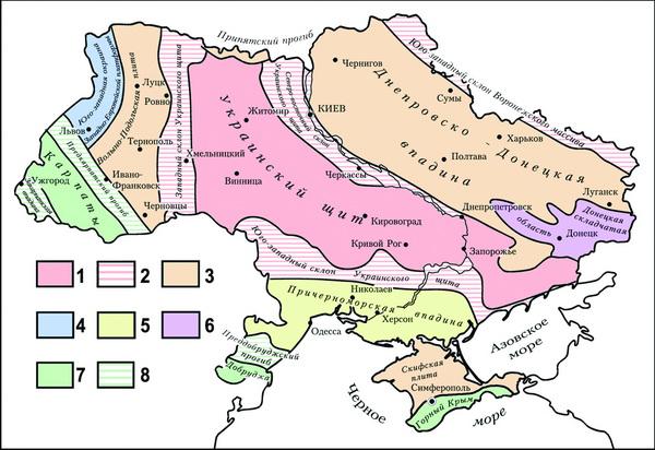
SOURCE: MINERAL RESOURCES OF UKRAINE


Dnieper-Donets and coastal plain (onshore and offshore), and served as an import conduit for Russian gas transported to Turkey and Western Europe. It produced other minerals like uranium, which served as feedstock for its significant domestic nuclear power industry. In exports, Ukraine is an agricultural “breadbasket” due to the

presence of thick Quaternary chernozem soils. Over time, the interest in a deal for Ukraine geologic resources has shifted from rare earth elements to strategic minerals to just “minerals.” The terms are perhaps deliberately vague (or flexible) and have yet to be implemented because of the ongoing conflict.
John McLeod is a geologist whose primary interests are new ventures exploration, petroleum systems analysis, geochemistry and paleontology. He held geologist positions with Mobil Oil, Oryx Energy, EOG Resources, Chesapeake Energy and SM Energy. Since late 2019, he has been an independent geoscientist involved in teaching (QGIS open source mapping), geological research (Ukraine, Oklahoma, Illinois), field geology and geochemistry. He co-lead the RMAG Eagle Basin field trip last year and is an occasional online contributor to LinkedIn. John holds an M.S. in Geology from Northern Illinois University.
IN THE PIPELINE
OCTOBER 1, 2025
RMAG Luncheon.
Speaker: Ronald Bell. “Mapping Applied to Geology and Infrastructure.” 12:00-1:00 PM. DERL, 730 17th Street, B1, Denver.
OCTOBER 4-5, 2025
RMAG On the Rocks Field Trip. Trip Leaders: Dr. Bruce Schumacher. “Picket Wire Canyonlands Dinosaur Tracksite.” La Junta, CO.
OCTOBER 5, 2025
Rocky Mountain Rendezvous-Student Job Fair. Keystone Conference Center.
OCTOBER 5-7, 2025
RMS-AAPG Annual Meeting. Keystone, CO.
OCTOBER 9, 2025
COGA’s Annual Energy Summit.
WOGA Wellhead Wake -Up (Virtual Monthly Coffee Chat) Virtual. 8 AM.
OCTOBER 14, 2025
Fossil Fuels & Frights.
Halloween Happy Hour. 3:00-6:00 PM. Main Event Thornton, 580 E 144th ave., Thornton, CO. Register here.
OCTOBER 16, 2025
WOGA Lean- In.
Speaker: Kelly Saucedo. “Personal BrandingCraft Your Professional Identity.” CANUSA, 600 17th Street, #1400n, Denver. 11:00 AM-12:30 PM.
WELCOME NEW RMAG MEMBERS!
Erin Newton with Alpenglow Harp Studio from Arvada, Colorado
Patrick Mangou from Houston, TX
Kristen Johnson with Adams 12 School District
Nadene Klein with Douglas County School District
Richard Brose from Castle Rock, Colorado
Shawn Williams with GeoSoftware from Richmond, Texas
Anthony Dolan with Dolan Integration Group, LLC from Westminister, Colorado
Keith Coffindaffer with Phoenix Energy from Bridgeport West Virginia
Jessica Gregg with Tallgrass Energy from Lakewood, Colorado
Ryan Gall with Utah Geological Survey from Salt Lake City, Utah
Dr. Gary Bible with Cougar Dome, LLC from Helenwood, Tennessee
Michael Vanden Berg with Utah Geological Survey from Salt Lake City, Utah
Melissa Connely with Stratigraphic Rex LLC from Casper, Wyoming
Alexandra Pearce with SM Energy from Denver, Colorado
Brenna Wilde with Weld County Public Works Department from Greeley, Colorado
RMAG ON THE ROCKS
SALIDA TO CAÑON CITY THROUGH BIGHORN SHEEP CANYON
AUGUST 22–23, 2025
By Mike Tischer, Field Trip Participant
INTRODUCTION
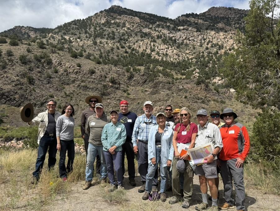
On August 22–23, the Rocky Mountain Association of Geologists hosted another memorable installment of its On the Rocks (OTR) field trip series, exploring the geology along the Arkansas River between Salida and Cañon City. Under the leadership of Tom Karnuta, a seasoned engineering geologist and long-time Salida resident, participants were treated to a journey through 1.8 billion years of Earth history, from the Precambrian basement to Pleistocene river terraces.
Twelve participants, along with trip organizers David Schoderbek and Ralf Topper, gathered Friday evening in Salida for an informal social and overview session. Over snacks and cold beverages at the Hampton Inn, Tom introduced the geologic framework of the canyon and shared highlights from his recently published book on the geology of the Arkansas River, which served as the field guide for the trip.
SETTING THE STAGE
The Arkansas River valley between Salida and Cañon City is not only scenic, but also one of the most geologically diverse transects in Colorado. Here, Precambrian gneisses and granodiorites, Paleozoic marine sediments, Pennsylvanian redbeds shed from the Ancestral Rockies, Oligocene
volcanics, and younger Quaternary deposits are all exposed in close proximity.
Three major tectonic events frame the area’s geologic history:
1. The Ancestral Rockies Orogeny (Pennsylvanian–Permian), when uplift shed thick redbed sequences into adjacent basins.
2. The Laramide Orogeny (Late Cretaceous–early Paleogene), which created the Rocky Mountain front ranges and influenced structural deformation in the region.
3. Rio Grande Rift Extension (beginning ~25 million years ago), which down-dropped the Arkansas Valley and localized the river’s present course.
Overlaying these events are Oligocene volcanic eruptions that blanketed the area with tuffs and lavas, later sculpted by erosion, glaciation, and river incision to produce today’s dramatic landscape.
DAY IN THE FIELD
The group assembled bright and early Saturday morning in the Murdoch’s parking lot in Salida, ready for a full day of stops tracing the Arkansas River downstream through Bighorn Sheep Canyon. Below is a recap of the highlights.
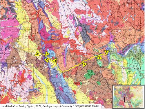
1: Field trip transect with stops.
2: Everybody was excited to start the day (stop 0).
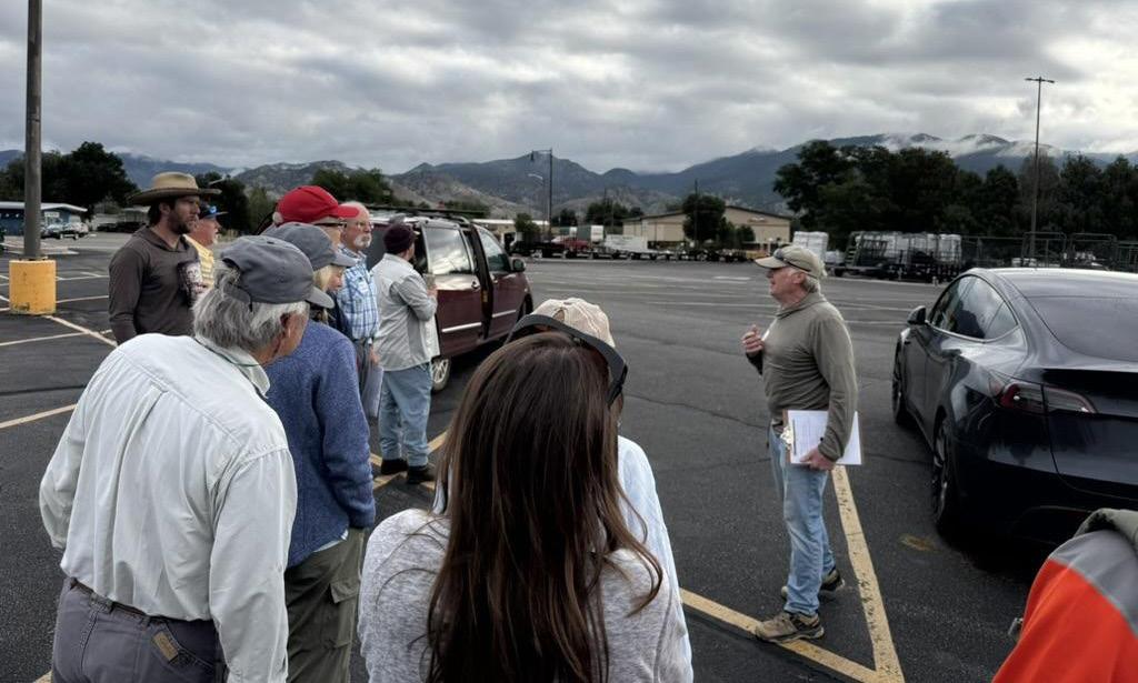
FIGURE 1
FIGURE 2
FIGURE
FIGURE
RMAG ON THE ROCKS: SALIDA TO CAÑON CITY
STOP 0 – SALIDA OVERVIEW
From the parking lot we stood atop the Dry Union Formation, a rift-fill aquifer up to 2,000 feet thick. Across the valley rose Tenderfoot Hill (“S Mountain”) and the enigmatic feature known as The Crater. Once interpreted as a volcanic cone, recent work shows it to be a large landslide scar where a dark andesite flow slid away to reveal underlying light-colored tuffs.
STOP 1 – WELLSVILLE
Here, the structural complexity of the Wellsville thrust fault and the Lofgren anticline was on full display. A short hike revealed a stratigraphic section extending downward through the Leadville Limestone, Devonian Chaffee Group, and Fremont Dolomite. Participants also examined Pleistocene river terraces and a cave/collapse feature within the Chaffee Group, while enjoying discussions on historic coke ovens, limestone kilns, and mineralization in the area.
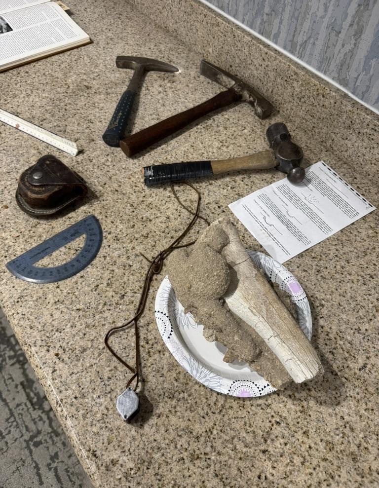
3: The tools of the trade laid out by Tom at Friday’s social/ trip overview.
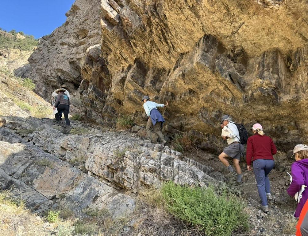
4: Climbing through the strat section near Wellsville. (stop 1)
FIGURE
FIGURE
FIGURE 3
FIGURE 4
STOP 2 – SWISSVALE
At this stop we encountered the dramatic lithologic transition from gray Paleozoic marine sediments to the brick-red Pennsylvanian–Permian redbeds of the Minturn and Sangre de Cristo formations. These deposits, eroded from the Ancestral Rockies, preserve the legacy of Colorado’s late Paleozoic mountain-building and were famously chronicled in RMAG’s Big Red Book (Geologic Atlas of the Rocky Mountain Region).
STOP 3 – HOWARD
This valley overview highlighted multiple Pleistocene terraces and the role of volcanic activity in shaping the landscape. Tom guided us through examples of the Badger Creek Tuff and andesites from Waugh Mountain, reminders of the Oligocene volcanism that influenced the region. Badger Creek Tuff, quarried near Howard, Colorado, was used as a decorative building stone in downtown Denver.
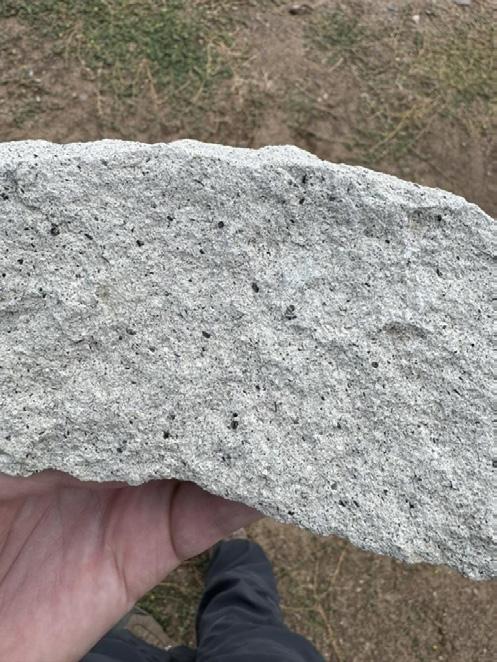
FIGURE 5
FIGURE 6
FIGURE 5:
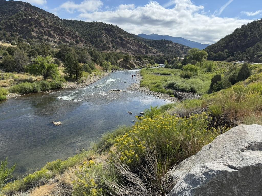
The beautiful Arkansas river cuts through eastdipping Pennsylvanian sediments. (stop 2)
FIGURE 6: Badger Creek Tuff. (stop 3)
RMAG ON THE ROCKS: SALIDA TO CAÑON CITY
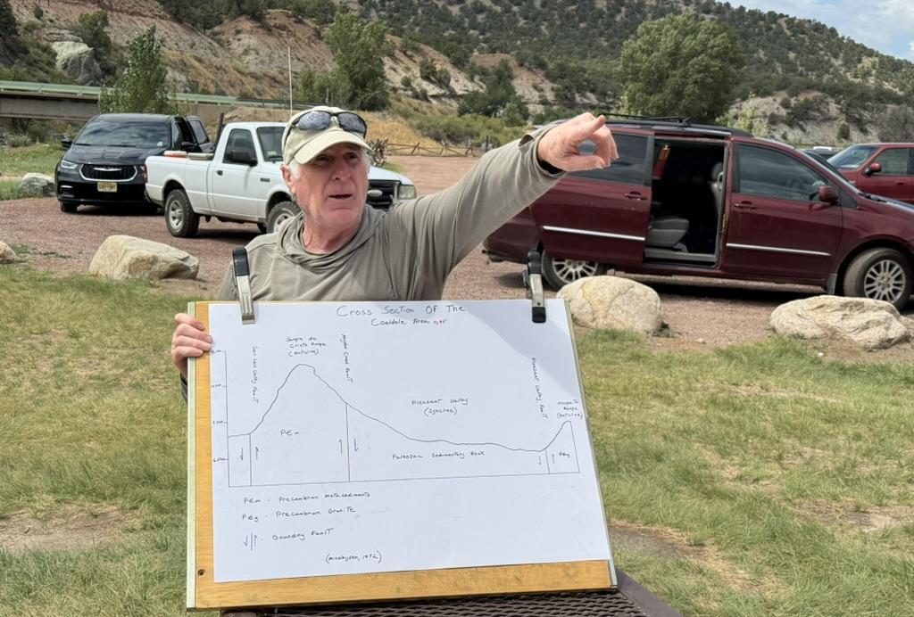
FIGURE 7: Rocks! Tom points out local geology at our lunch stop at Vallie Bridge on the Arkansas River.
FIGURE 8: The Great Unconformity. The contact between the Ordovician Manitou Limestone and the underlying Precambrian is roughly at the center of the rock hammer handle. (stop 6)
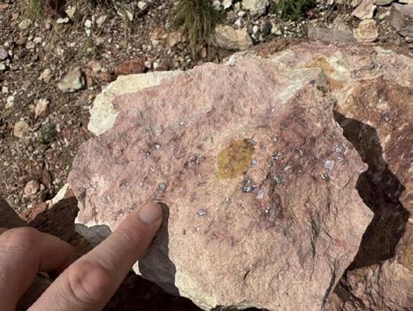
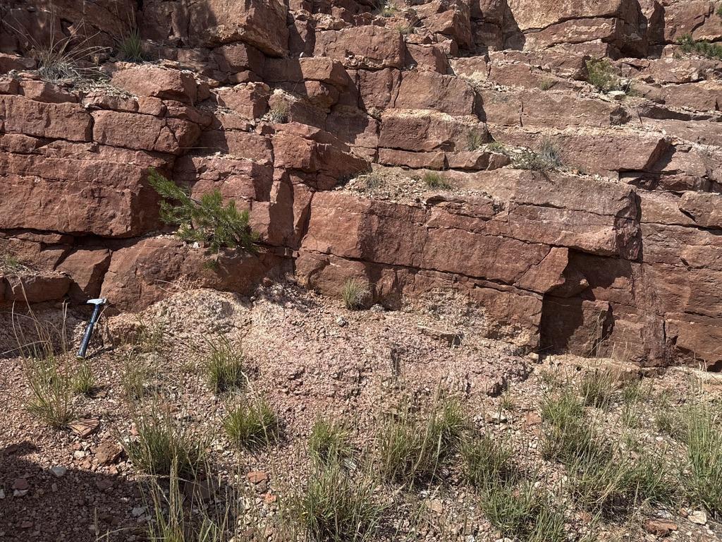
FIGURE 9: Fossilized scales of Astraspis desiderata Walcott (light-colored specks) in the Harding Dolomite. (stop 6)
STOP 4 – MAYTAG BLM RECREATION SITE
Lunch was followed by billion-year-old rocks: Precambrian granodiorites, gneisses, and metasediments. Particularly striking were exposures of relict bedding— ancient sedimentary structures still visible in the highly metamorphosed rocks. The sharp contact between metasediments and granite illustrated the deep-time foundations of the canyon.
STOP 5 – PARKDALE
Here, Mesozoic formations including the Dakota, Purgatoire, Morrison, and Ralston Creek formations rest unconformably atop basement rocks. The site is also remembered for housing the smallest post office in the continental U.S., a human-scale marker amid sweeping geologic stories.
STOP 6 – THE GREAT UNCONFORMITY AND FABULOUS FISH FOSSILS
The day culminated in a hands-on encounter with one of geology’s iconic features: The Great Unconformity, where Ordovician Manitou Limestone directly overlies 1.7 Ga Precambrian granodiorite, representing a missing 1.2 billion years of Earth history. Nearby
FIGURE 10: Field trip participants had a great time! Love those regional dips!
exposures of the Ordovician Harding Formation yielded fossilized plates of Astraspis desiderata Walcott. some of the oldest vertebrate remains on Earth, first described by Charles Walcott in 1887.
REFLECTIONS
This trip was a perfect blend of spectacular scenery, fascinating geology, and great camaraderie. From billion-year-old basement rocks to some of the earliest vertebrate fossils, participants experienced first-hand the geologic richness of the Arkansas River corridor. Special thanks go to trip leader Tom Karnuta for sharing his deep knowledge and passion for the area, and to David Schoderbek and Ralf Topper for organizing the logistics that made the excursion seamless. Whether contemplating the forces that carved Bighorn Sheep Canyon, or simply enjoying the late-summer sun along the Arkansas River, participants left with renewed appreciation for the geologic stories written into Colorado’s landscape.
Postscript: The field guide used for this trip was Tom’s own geologic compendium of the Upper Arkansas Valley. You can find it on Amazon. Look for Road and Riverside Geology of the Upper Arkansas Valley by Tom Karnuta.
BOOK REVIEW
Reviewed by Rasoul Sorkhabi
University of Utah, Salt Lake City
Asking Rocks to Tell Their Stories
Two recent books by female writers – one science journalist and the other geologist – decode stories of our home planet from rock record and deep time.
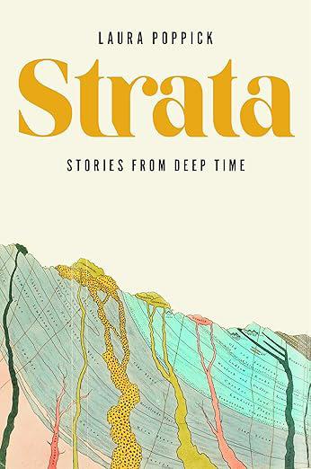
Strata: Stories from Deep Time by Laura Poppick. W.W. Norton, New York, 2025.
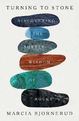
Turning to Stone: Discovering the Subtle Wisdom of Rocks by Marcia Bjornerud. Flatiron Books, New York, 2024.
Strata in the hand of a science writer become pages of Earth’s autobiography. A master writer in this genre is John McPhee, a New Yorker journalist who in the company of geologists visited various roadcuts and outcrops in the USA and narrated the geologic history of America in four bestselling books, Basin and Range, In Suspect Terrain, Rising from the Plains, and Assembling California, published from 1981 through 1993 and later collected in a single volume Annals of a Former World – the winner of Pulitzer Prize for Nonfiction in 1999. It was also John McPhee who coined the term “deep time” in Basin and Range (1981) for the mindboggling geological time expressed in millions of years. A marvelous thing about Earth’s history is that as we investigate it more it reveals more of its deep secrets. That is why it is necessary to re-read Earth’s autobiography from time to time as scientists update and detail it. Two recent books, Strata: Stories from Deep Time by Laura Poppick and Turning to Stone: Discovering the Subtle Wisdom of Rocks by Marcia Bjornerud, report on fascinating stories from Mother Earth’s life spanning
billions of years and showing her fragility, resilience, and creativity.
One day, as Poppick was sitting on a rock and contemplating on the landscape of the Bighorn Canyon, she wondered why “most hikers along that canyon wall in Wyoming probably take in the wide sky and the river down below, and then carry on, warily scanning for venomous things without giving the strata much thought.” That question plus ten years of journalism led Poppick to write a book to share “the language of stratigraphy” with people – hikers and non-hikers alike. The result is this enchanting book Strata. Poppick’s own journey to geology shows how education is critical to creativity. When Laura Poppick was in high school, a science teacher suggested she take a geology course when she got to college even though she had never taken geology in high school. What the teacher had seen in this student we do not know, but Poppick followed his teacher’s advice: When she entered Bates College in Maine she majored in geology. For a year, she worked as an
assistant in a geology laboratory at Princeton University and later graduated from science communication program at the University of Santa Cruz. Popick established a career as a science and environmental journalist. In 2021 as Poppick was writing her book, Robert Oddo, the high school science teacher who had encouraged Poppick to take a geology class, died in Myanmar where he was then living and teaching. Oddo had taught science to students for 35 years both in the USA and overseas. Behind every science writer, there is at least one good science teacher.
Strata opens with an illustration of a human arm as a yardstick for the length of the geologic time. It is well known among geologists that if we consider the Earth’s 4.5 billion years history as extending from the tip of our right hand to the tip of our left hand, humankind’s emergence falls on the nail of the middle finger on the left hand. That is an accessible way to imagine deep time.
via photosynthesis. Prior to that, the Earth’s atmosphere lacked oxygen, and bacterial life was essentially anerobic – living in environments without oxygen. How and at what rates cyanobacteria evolved and how they figured out photosynthesis are still burning questions for some scientists. Moreover, around the same time two other events occurred: the first glaciation event in Earth’s history and the formation of banded iron formation (sediments rich in iron) which are the source of much iron mining today. Investigating the chronological and causal relationships between these events guided by new research is a fascinating piece in Poppick’s narrative.
“The sediments,” wrote Rachel Carson in The Sea Around Us, “are a sort of epic poem of the Earth.” Strata composes this “epic poem” in four parts – Air, Ice, Mud, and Heat – the inspiration for which came from Poppick’s field trip in the Norwegian archipelago of Svalbard: “I felt, I could imagine what this planet may have looked like without us, whittled down to its most basic elements. Air, ice, mud, and heat.” Each part of the book is about a particular event and period in Earth’s history. Poppick frames each story elegantly by blending science, survey of research articles, field trips in the company of geologists, and her own observations and reflections.
Part One (Air) is about what geologists call the Great Oxygenation Event that took place about 2.4 billion years ago. Around this time, the rapid rise of cyanobacteria – commonly known as blue-green algae – increased the oxygen levels in the atmosphere
Part Two (Ice) discusses the Snowball Earth – an extraordinary period in Earth’s history – between 720 to 635 million years ago or what geologists call the Cryogenian period – when the planet’s surface was frozen. We know this from glacial sediments of that period found in various places on Earth. Poppick mentions some of the key areas which led to the discovery of Snowball Earth: Svalbard, Namibia, and Australia. What caused the Snowball and how much of Earth was actually frozen or remained ice-free to let life survive are actively researched and debated by geologists. Most geologists believe that volcanic eruptions releasing greenhouse gases like carbon dioxide into the atmosphere put an end to the Cryogenian period and ushered in a warm period from 635 to 540 million years ago when strange multicellular soft-bodied creatures appeared on sea floors. This Ediacaran period (named after Ediacara Hills of Australia, where these strange fossils were first reported) was probably Earth’s experimental precursor to the Cambrian explosion – the sudden flourishing of multicellular shell-protected marine creatures like trilobites, clams, and snails
some 540 million years ago.
Part Three (Mud) reports on the fascinating discovery of how the spread of plants on Earth’s continents increased soil and mud coverage. Plant life moved to land about 470 million years ago. Prio to that, mud and clay – the finest sediments – accumulated largely on the sea floor but very little on land. By 390 million years ago, when terrestrial forests gained a foothold, mud – essential provider of nutrients for plants –dressed the continents tenfold thicker. It was previously thought that large trees with their deep, vast and chemically active roots helped formation of soil, but, as Poppick reports from new research results, even rootless plants – mosses and liverworts – played a role in this vital process.
Plants and mud changed the face of Earth. Through photosynthesis, plants absorbed carbon dioxide from the atmosphere and released oxygen in return. Moreover, mud and soil stored organic carbon (as they still do today). The result was a rapid increase in the concentration of oxygen in the air and the flourishing of animal life on land. Mud may be the most boring sediment, often treated as dirt, but as Poppick remarks, “the word has roots in munuds, the Latin term for world.”
These two new books demonstrate how much progress scientists have made to unravel and understand the evolution and inner workings of our home planet.
two chapters, with relatively less depth and detail compared to the previous parts of the book. Each part in Strata opens with a black-and-white ink illustration. But that is not sufficient for a book on geology, which is a highly visual field of science. Inclusion of photographs, sketches, maps, and a geologic timescale would have enhanced the comprehensibility of text for readers who have not seen, for example, glacial sediments, the world’s oldest charcoal (430-million-year-old fossil) or Morrison sandstone formation in Wyoming.
Strata is Poppick’s first book. Writing in the tradition of John McPhee, this book establishes her as a rising star in this field, and I would personally love to read more books from her.
Turning to Stone: Discovering the Subtle Wisdom of Rocks by Marcia Bjornerud comes from the pen of a practicing geologist, an experienced geology teacher, and an author with three previous books to her credit: Reading the Rocks: The Autobiography of the Earth (2005), Timefulness: How Thinking Like a Geologist Can Help Save the World (2018), and Geopedia: A Brief Compendium of Geologic Curiosities (2022).
Part Four (Heat) touches on four “hot” stories: A massive volcanic eruption in today’s Siberia caused the worst mass extinction of animals some 250 million years ago (the Great Dying at the boundary between the Permian and Triassic periods). Fifty million years later another major volcanic event caused another mass extinction at the boundary between the Triassic and Jurassic periods. The Jurassic and Cretaceous “greenhouse” helped cold-blooded reptiles including the giant ones – the dinosaurs –thrive and rule Earth for millions of years. Finally, a meteorite impact at today’s Yucatan Peninsula in southern Mexico wiped out the dinosaurs together with 75 percent of marine and terrestrial species about 65 million years ago.
Although Poppick writes that “you can’t rush stratigraphy,” Part Four of the book is a sketchy and swift account of these different four events in just
“Turning to Stone, writes Bjonerud, “is the story of my deepening relationship with our rocky planet.” Apart from prologue and epilogue, the book has ten chapters, each named after a rock type – sandstone, basalt, tuff, diamictite, turbidite, dolomite, granite, eclogite, glass and flint, and quartzite. Most of these terms are unfamiliar in our daily vocabulary, but if the reader commits to reading the chapters, behind each rock type lie rich science, history of geological research as well as field examples. The reader will probably benefit most from reading Bjornerud’s new book if he or she has already taken a geology course in high school or college or has read a popular geology book first (I recommend Bjorneru’s first book Reading the Rocks: An Autobiography of the Earth).
In her interview with YouTube podcaster and fellow-geologist Nick Zentner, Bjornerud says that the idea for this book came from the publisher who wanted her to write a memoir, and she initially

Expanded geologic focus:
Why contribute?
• Reach
• Quarterly
• Permanent
• Quick
• Every
Why contribute?
Expanded geologic focus:
• Entire greater Rocky Mountain area of North America
• West Texas and New Mexico to northern British Columbia
• Entire greater Rocky Mountain area of North America
• Reach a broad industry and academic audience
• Great Plains and Mid-Continent region
• West Texas and New Mexico to northern British Columbia
• Quarterly peer reviewed journal
• Great Plains and Mid-Continent region Why contribute?
• Permanent archiving includes AAPG Datapages
• Reach a broad industry and academic audience
• Quarterly peer-reviewed journal
• Quick turn around time
• Every subdiscipline in the geosciences
• Quick turn-around time
https://www.rmag.org/publications/the
• Permanent archiving includes AAPG Datapages
https://www.rmag.org/publications/the
• Every subdiscipline in the geosciences
Expanded geologic focus:
area of North America
• Entire greater Rocky Mountain area of North America
northern British Columbia region
• West Texas and New Mexico to northern British Columbia
• Great Plains and Mid Continent region
Email: mgeditor@rmag.org
https://www.rmag.org/publications/the -mountain-geologist/

wanted to call the book “The Education of an Earthling,” but the publisher changed it to Turning to Stone.
The book is part memoir dressed in ten rocks and part geology narrated through the life of Bjornerud in various roles and stages of life: As the daughter of a family of Norwegian ancestry based in Wisconsin, as a student who studied at the University of Minnesota and Wisconsin University, as a wife (first married to a college classmate and later to a professor colleague three decades older than her), as mother of three sons from the second marriage, as a professor (initially at Miami University in Oxford, Ohio and then from 1995 – and for most of her career – at Lawrence University in Wisconsin), as a researcher (mainly in structural geology and earthquake studies), as a colleague interacting with other geologists and contributing to the geological community, and as a widow (her second husband died of cancer) raising three boys while doing a full-time academic job.
Bjornerud, when a young student, first wanted to major in linguistics but after taking a geology class changed her major because she loved geological thinking and vocabulary. From her prose, Bjornerud comes across a wellread scholar who cares about her subject. Her love for linguistics is evident from her explanation of word origins for rock types. Bjornerud’s postgraduate research area was Svalbard archipelago in Norway with its ancient glacial sediments (diamictite) of Snowball Earth.
Sandstone (chapter one) is personified in the Cambrian-age sandstone used for the building of a city library in Menomonie, Wisconsin, where Bjornerud grew up in the 1960s and 70s. Quartzite in the last chapter refers to the 1.5 billion-year-old white metamorphosed sandstone outcropped on Baraboo Hills in Wisconsin, where Bjornerud often takes her students (“now all of the students are younger than my children”) to teach structural geology. Wisconsin and Norway feature prominently in Bjornerud’s geologic studies although the book also takes the reader to California, Lake Superior, Ellesmere Island
in Canada, South Island in New Zealand, and Marche region of Italy.
Autobiographical works often contain select photographs of relevant people and places. However, readers will not see such photographs in Bjornerud’s book in which the author, for the sake of privacy, even refers to family and friends with their initials – O, F, K, J, G, P and N.
These two new books demonstrate how much progress scientists have made to unravel and understand the evolution and inner workings of our home planet. Sophisticated instruments can now decipher the records of ancient atmospheres and oceans in rocks and fossils. These books by two female geologists – one journalist and the other professor – are also good signs of improvement in community diversity in geology – traditionally a male-dominated field.
Both Poppick and Bjornerud agree on the importance of geology on many levels – material (think of all those minerals we use in our daily life), intellectual, and even spiritual. Geology makes us humble.
Both Poppick and Bjornerud agree on the importance of geology on many levels – material (think of all those minerals we use in our daily life), intellectual, and even spiritual. Geology makes us humble. Poppick quotes a line from a geologist during a field trip in Ireland: “Field geology should dampen my concept of ego. All that stuff, all that deep Earth history, and then you’re around for what, seventy years? And you think you’re special.” Bjornerud puts this in a bit gentler language. “The experience of being fully immersed in and dwarfed by the object of one’s study leads to a shift in consciousness – akin, perhaps to what writer and philosopher Iris Murdock called unsefling.” In this way, learning about rocks and visiting them is a kind of pilgrimage, meditation, and moral training. Bjornerud borrows the Latin word hierophany (“the sacred made visible”) from philosopher Mircea Eliade to sanctify rock outcrops.
Why should we care about studying rocks? For one thing, Earth history is also our origin. But there is more to it. When Poppick put this question to Woody Fischer, a Caltech geobiologist, Fisher said: “We are asking rocks to tell their history. If you get this right, you know how the Earth works.”

CALENDAR – OCTOBER 2025
Rocky Mountain RendezvousStudent Job Fair.
Fossil Fuels & Frights.
RMAG Luncheon.
COGA’s Annual Energy Summit. WOGA Wellhead Wake -Up
WOGA Lean- In.
On the Rocks: La Junta, CO.
RMS-AAPG Annual Meeting.