UrbanFootprint:MariettaandPublicTransit
RebeccaLee
CRP2000
September30,2022
Map1:ExistingLandUsesinMarietta
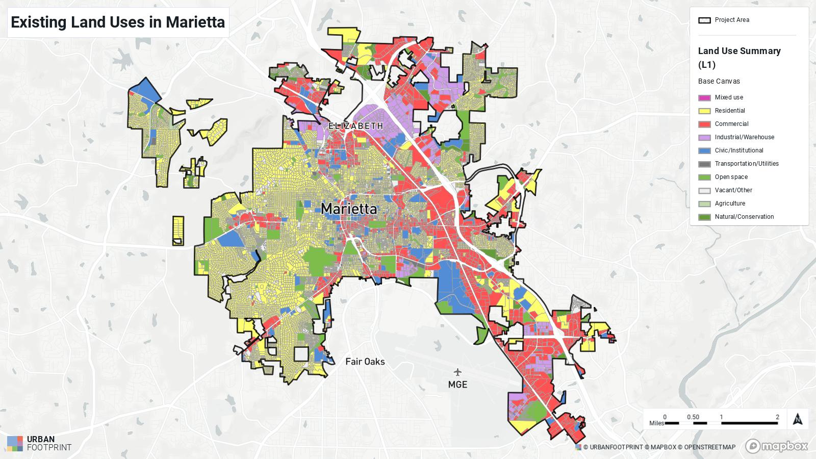
JustthirtyminutesnorthofthebustlingofAtlanta,Georgiasitsthequaintcityof Marietta.Everythinghereiswithindrivingdistance—Ihaveovertengrocerystoreoptions,my elementary,middle,andhighschool,andmore,allwithinaten-minuteradiusofmyhouse.If I’mfeelingadventurousIcandrivepastagrassfieldortwotoneighboringcities.Ichoseto studymapsaboutMarietta,Georgia,whichistheareaIgrewupin,andIenjoyedstudyingdata andmapsofanareathatIamwellacquaintedwith.
StudyingMap1oftheexistinglandusesfromLandUseSummary(L1)fromtheBase Canvaslayer,Inoticedmostcommercialregionsarenearbymajorroadways,namely,US highway41andI-75.Thewesternhalfofthecityseemstobeprimarilyresidentialareaswith therebeinglittletonoindustrialorwarehouseareasinthelargeareaofresidentialzones.Open spacesarefrequentlyfounddottedamongresidentialblocks,andincommercialandindustrial areasopenspacesareloathedontheperimeter
Formynewmapscenario,Ichosetolookatincomedistributionsandpublictransitlines andstops.TheexactlayersIusedare:
1. PublicTransitStops-asofMay29,2021viaTransitland
2. PublicTransitLines-asofMay29,2021viaTransitland
3. Income-CensusPlanningDatabase(2021)viaUSCensus
4. LocalAreaTransportationCharacteristicsforHouseholdsData(LATCHSurvey)via BureauofTransportationStatistics
IchosetoanalyzepublictransportationlinesinMariettabecauseIhaveaninterestin transportationplanningandhaveseenthelackofuseintheinfrastructure.WhenIrememberto lookoutatmysurroundingsfromwhateverautomobileI’min,Iseethehubforthecountybus system,CobbLinc.Theasphalthereisgraying,dandelionssproutingfromcrackstonoend.The bus-stops,ifIeverdoseeone,rarelyhavepeoplewaitingatthem.
Wellplannedtransportationandlandusegivespeoplemorefreedomtogetaroundin theirowncommunity.Furthermore,thegeneralroleoftransportationintermsofeconomic mobilityisextremelycrucialtothehealthofanycommunityinthatphysicalmobilitygrants geographicaccesstojobsandthussocialmobility.Whileovertimetherehasbeenagrowthof manymorejobsinthesuburbsspreadoutoveralargelandareathaninthecentralcity,densities ofpeopleandjobsarestillthehighestinthecentralcity,meaningjobaccessishighestinthe centralcity.Inmostareas,povertyhouseholdsareincreasinglyinvestingincarsasameansof transportation.
AllofthedatafromlayersIusedformymapsarerelativelyuptodate,withthefirst threenamedlayers:PublicTransitStops,PublicTransitLines,andIncomeallhavingbeen updatedinthepastyear.Themost‘outofdate’sourceistheLocalAreaTransportation CharacteristicsforHouseholdsData,whichwasupdatedinlate2018.Becauseofthis,thereisa possibilityforsomeinaccuraciesinmyanalysisastheCOVIDpandemic,whichlikelybeganto showitsimpactsin2020inincomeandtransportationuse.
PublicTransitStopsandLines,bothfromTransitland,togethershowtheroutesand directionsofpublictransitmodes.AlthoughthenearbycityofAtlantahasametroandlightrail systeminadditiontobuses,Mariettaonlyhasabussystem.Althoughthereareoptionstoshow theaverageheadwayorruntimeaveragesofthesepublictransitlines,Isawitmoreeffectiveto onlyshowthelocationsofstopsandroutesforthismap.
IincludedalayershowingtheAverageAggregateHouseholdIncomeintheIncomeCensusPlanningDatabase(2021)layertocomparebuslinedistributionacrossdifferentincome levelareas,becauselowincomeworkersaremorelikelytocommutebypublictransitthan higherincomeworkers.“ThePlanningDatabaseusesselectedCensusandselected2015-2019 AmericanCommunitySurvey(ACS)estimates”(UrbanFootprint).
ThefourthandfinallayerisLocalAreaTransportationCharacteristicsforHouseholds Data(LATCHSurvey)viatheBureauofTransportationStatistics(BTS).Fromthislayer,Ichose todisplaydataaboutvehiclemiles,“estimatedfrommodelsusing2012-2016American CommunitySurvey5-yearestimatetractdata,”whichshowsthemeasureoftheamountofmiles ofmotorvehicletravelinagivenregionandtimeframe(UrbanFootprint).
Map2:IncomeLevelsandBusRoutesinMarietta
ForMap2,whichdisplaysincomelevelsinMariettanexttobusroutes,Iorganizedthe averageaggregatehouseholdincometobeshowninquantileclassificationtorepresentabetter contrastinvarietyofincomelevels.Ialsoreducedthenumberofclassesto5forimproved readability.Firstly,busroutesseemtointersectmostlytowardsthecenterofthecity.Inaddition, itcanbeseenthattherearealmostnobusroutesinareaswiththehigherbracketsofincome ($78,000-$590,000).ReferencingMap1’slandusedata,itcanalsobeseenthathigheraverage incomegroupstendtoliveinthemoreestablishedresidentialareas(i.e.westernhalfofthecity). Thesmallsliverofresidentialareasthatbordersaninterstatehighwayandiswedgedbetween industrialandcommercialareashasmuchmoreimmediateaccesstobuses.

Map3:VMTandBusRoutesinMarietta
InMap3,displayingtheVMToffamiliesinMarietta,VMTdatawasclassifiedusing naturalbreaks.Here,itisinterestingtonotethattheVMTofalmosttheentirecityexceeds30. ThesuburbanareassurroundingMariettaareseentohaveevenhigheraverageVMTs,mostof whichexceed43.ThismaybeduetothefactthatMariettaisnotaverylargenorurbancity.In addition,itsclosedistancetoAtlanta,theprimarycommercialregionofthestateofGeorgiamay havecontributedtothesehighaverageVMTs.So,itisaverylikelycasethatalargeportionof MariettaandthesurroundingregiontraveltoothernearbycitiesifnotAtlantafrequently.The areasinMariettathathaveabusroute,however,seemtoallhavealowerVMTthanregions withoutabusroute.
Ifthereisdataavailableaboutpopulationproportionsthatusepublictransportationor populationproportionspermodeoftransportation(e.g.personalcar,bike,foot,publictransit, etc.),Iwouldliketoincorporatethatintoanewscenario.Fromthepointofviewofconsidering expandingbusroutestoimprovetheconnectivityandlowerVMTs,analyzingdataabout regionalincomelevelsandotherinformationwouldbeuseful.Forinstance,anareaoffocus couldbetoexpanduponexistingroutestoimproveconvenienceandaccesstomorejobsfor lowerincomeregions,throughwhichmostbuslanesalreadyrun.

Everyonceinawhile,myfriendsandIwilltakeonthechallengeoftryingtogetaround Mariettabywalking.It’salwaysarefreshingyetunsettlingexperiencewhenyou’resousedto seeingeverythingfromaslightlyhigherelevationandpassingthroughthecityatamuchfaster speed.Onfoot,everythingisbigger.Thebillboardsandstoresignsthatlookednolargerthana post-itnotefromafarareactuallyasbigasmycarandaresittingatopathree-storytallmetal pole.Crossinganyroadisanordealofitsown,takingalmosthalfaminutetospeed-walkpast theweirdstaresdriversgivetheoccasionalpedestrians.Thenearesthangoutspotfrommy highschoolisagiganticTargetwithatwo-storyparkinggarage.It’sa30minutewalkfromthe backexitofmyschool.
Mariettawasn’tbuiltforourfeet.Themazeofhigher-speedlocalroadwayshasmade drivingapersonalvehiclethedefaultmeansofgettingaround,andhasnecessitatedthemassive parkinglotsthatstretchsofarbetweenthesidewalksandstorefrontsthatcrossingtheseblack topsisanentirelynewjourney
Safefromthecommercialareasofthecity,singlehomesandsubdivisionsaretucked awaybetweenbunchesofoakandpinetrees.Thesidewalksherearebettermaintained,thecars driveslower,andlocalsonajogwiththeirpetdogisacommonsight.Oneverynewwalk aroundtheneighborhood,thewindingroadslinedwithwood-paneledranch-homesflauntanew three-storystonecastle,proudlystandingbehindafountainandirongates.
Mariettaispartofthesprawlingcityoftheforest,withnewsubdivisionsbeingbuiltup fromtheoncebarrengrassfieldsIdrovebyyearsago.Whilethewayfarerlifestyleisnotas feasibleasothertowns,thewaythisplacehasgrowntoembracetheuseofpersonalvehicleshas allowedfornewlengthsofconveniencethatmaynothaveotherwisebeenpossible.