BICYCLE & PEDESTRIAN MASTER PLAN
ACKNOWLEDGEMENTS
Town of Ingalls
Justin Gardner - Pesident, Town Council
Melanie Johnson - VP, Town Council
Teresa Egerton - Council Member
Georgia Parker - Council Member
Crystal Everhart - Council Member
Gregg Morelock - Town Attorney
Kip Golden - Clerk/Treasurer
Planning Commission Board
Melanie Johnson - President
Don Bault - Vice President
Kip Golden - Secretary
Neil Stevenson - Co-Town Manager
Gary Wimmer
Georgia Parker
Joey Hutslar
Terry Moody
Street Department
Carl Marlett - Co-Town Manager
Seth Smith - Street Maintenance
Allen Frost - Street Maintenance
This plan was supported by funds made available from the Centers for Disease Control and Prevention (CDC), Center for State, Tribal, Local and Territorial Support, under NH75OT000073-01-00, administered by the Indiana Department of Health, Division of Nutrition and Physical Activity. The contents of this plan are those of the authors and do not necessarily represent the official position of or endorsement by the CDC.

Chapter 01 Introduction
WHY DEVELOP A MASTER PLAN
The Bike and Pedestrian Master Plan provides a long-term plan for improving biking and walking in Ingalls. The plan provides a measured and consistent strategy for implementing the recommended improvements through prioritization and phasing to ensure implementation is manageable and economically responsible.
The physical improvement recommendations (engineering) in the plan will increase connectivity, accessibility, and safety for pedestrians and cyclists. Education, encouragement, evaluation, and equity programs will foster a culture that values multi-modal transportation and recreation. The improved network will create additional opportunities for people to be healthier, reduce vehicular miles traveled, and support economic development.
PLANNING FRAMEWORK
The planning process began in September 2022 and concluded in March 2023. The diagram below illustrates the process from project initiation to plan completion and adoption. The process included an extensive public input phase providing various opportunities for residents to share the plan’s vision, goals, and recommended facility improvements. The planning process included steps to meet the following key plan objectives:
• Gather meaningful input from a wide cross section of community by providing multiple and various types of public input opportunities.
• Develop goals and objectives that articulate the input received from the public and the Steering Committee.
• Review existing documentation to understand the history of, and future plans for, the pedestrian and bicycle network.
• Evaluate physical conditions to understand the current bicycle and pedestrian facilities.
• Recommend facilities and strategies for implementation to continue the growth of the system.
• Recommend policies and programs for bicycle and pedestrian facilities to support the physical improvement to the network.
PLANNING AREA
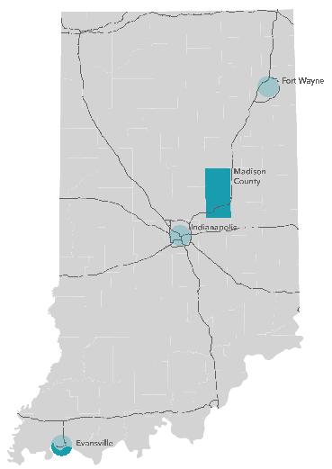
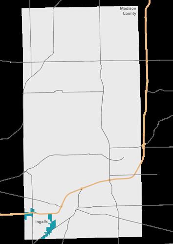
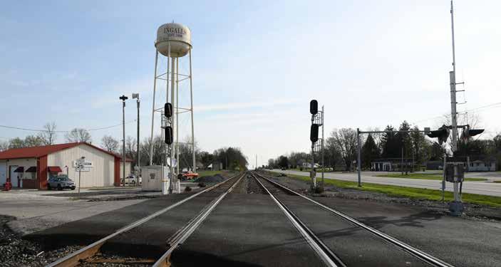
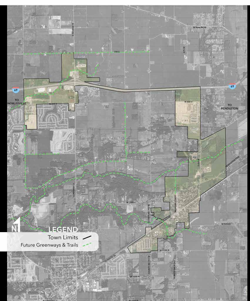
This plan is the first bicycle and pedestrian Master Plan for the Town of Ingalls. Ingalls is located in southwest Madison County, near Fortville, Indiana (located in Hancock County). Interstate 69 is located north of Ingalls, while US-36/SR-67 runs directly through the center of town. Pendleton is located approximately 5 miles northeast of Ingalls. According to the 2020 US census, 2,223 people live in Ingalls. An existing CSX railroad parallels US-36/SR-67 through town and Fall Creek is north of the historic downtown, which flows southwest until joining the White River. Lick Creek is located on the immediate south side of Ingalls and moves through town until joining Fall Creek.
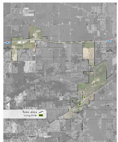
Currently, the town limits are near US-36/ SR-67 but the town has grown along I-69 to the west. It is expected that the town of Ingalls will continue to grow to the west and annex additional property over time. Due to the town’s proximity to Fishers, Pendleton, Fortville, and Indianapolis, connections beyond the existing town boundary are critical to how the town can grow. As a result, the bicycle and pedestrian master plan studies roadways outside of the current town limits.
BENEFITS OF BICYCLING AND WALKING
Creating a complete network of bicycle and pedestrian facilities provides the town with more than a transportation network for various modes of travel. The infrastructure improvements have significant benefits in the form of improved community health, increased property values, greater economic development with new business attraction, lower healthcare costs for residents and safer facilities for all users.
Health Improvements
The use of alternate transportation modes directly benefits the health of the user. Currently, Indiana ranks poorly compared to the rest of the country, ranking as the 12th highest rate for obesity. More concerning, 15% of Indiana youth are considered overweight or obese which would indicate that future obesity related healthcare cost will continue to increase.
It is imperative that public infrastructure, both for cyclists and pedestrians, be provided and be intuitive to use so that they are a part of a daily routine.
Environmental Improvements
Alternate transportation results in the use of less automobile traffic and thus, less greenhouse gas emissions in the environment. Nearly two-thirds of all vehicle trips (63%) have a total travel distance of less than 5 miles. Unfortunately, less than 2% of these trips are made on bicycle. If infrastructure and policy improvements can be made, a majority of local trips can be car-less and as a result provide for a higher quality environment.
Additionally, trees and landscape improvements provided with new sidewalks or shared-use paths improve the quality of
the environment as well.
Economic Improvements
The average cost to own a car rose to $10,728 per year in 2022 according to AAA. For some residents of Ingalls, the cost to own, insure, and maintain a car is not financially feasible. If properly planned, bicycle and pedestrian infrastructure can link neighborhoods, employers, and destinations; local residents will see a direct financial improvement.
Neighborhoods and business districts with improved public infrastructure such as sidewalks and shared-use paths will have higher land values, as these properties will be considered better connected and more easily accessible.
Investment in public infrastructure is important as a economic driver as well. Cities and towns that have new sidewalks, shared-use paths, and bike lanes may be viewed more favorably by private sector businesses looking to locate their headquarters.
Safety and Social Equity
Improvements to local infrastructure for bicycles and pedestrians will allow for more trips or activities to be made by alternate transportation modes. Fewer cars using public streets will relieve some ongoing maintenance concerns, if enough people are walking and bicycling rather than driving. The benefits of these efforts are most likely to be realized on local and neighborhood streets. With safer facilities, more people (including those who do not use cars) are better supported.
Health Benefits


Bicycling and walking help to keep kids and adults active and helps to decrease the prevalence of health conditions such as heart disease, diabetes, and other chronic illnesses.
Environmental Benefits


Walking and biking are more environmentally friendly modes of travel. Replacing driving trips with walking or biking can contribute to lower vehicular emissions which helps the environment and people with respiratory diseases.

Economic Benefits

Increases in property taxes, local spending and tourism activity provide additional tax revenue for local governments, providing strong returns on investment for bicycle and pedestrian projects.
Social Equity Benefits


Walking and biking are the most affordable forms of transportation. Much of the population is unable to drive including children, individuals with disabilities, seniors, and those unable to afford the cost of owning and operating a vehicle.

Safety Benefits

Traffic fatality rates tend to be less in regions with higher rates of walking and biking. Additional bicycle and walking facilities, well designed crossings, and continued education and enforcement efforts can reduce the risk of crashes and injuries.
Quality of Life Benefits


Facilities like trails, greenways and safe places to bike and walk attract tourists and new businesses. Creating communities where walking and biking are accepted and encouraged increases a community’s livability in ways that benefit all residents.
TYPES OF BICYCLISTS AND THE “INTERESTED BUT CONCERNED” PRIORITY USER GROUP
The Bicyclist Design User Profile illustrates the different skill levels and needs of each rider type. The rider types shown below were identified in 2006 by the Portland Bureau of Transportation after they published a paper suggesting this new method to categorize bicycle riders. The profiles classify people by their relationship to bicycling for transportation and is directly related to the comfort level of these users on certain facility types. This method of categorizing bicycle users is widely accepted within the field of bicycle facility
BICYCLIST DESIGN USER PROFILES
* Percentages based on National averages
No Way No How 28%-40%
These individuals are considered non-riders and are very unlikely to ever ride a bicycle for various reasons including ability, effort required, and lack of interest.
design. The percentages shown for each profile are based on National averages. While the exact percentages for Columbus are unknown, the feedback from the public input process of this plan supported the general percentages with the majority of riders falling in the “interested but concerned” category. Understanding the user type for the majority of bicycle riders in the city allows this plan to identify this category as the priority target user group. This group includes families with children and less experienced bike riders. Although this should not be the only group that facilities are designed for, the first priority should be to build facilities and establish a network that meets the needs of the priority target user.
Interested but Concerned 51%-56%
Often not comfortable with bike lanes, may bike on sidewalks even if bike lanes are provided; prefer off-street or separated bicycle facilities or quiet or trafficcalmed residential roads. May not bike at all if bicycle facilities do not meet needs for perceived comfort.


Enthused and Confident 5%-9%
Generally prefer more separated facilities, but are comfortable riding in bicycle lanes or on paved shoulders if need be.

Strong and Fearless 4%-7%
Comfortable riding with traffic; will use roads without bike lanes.

TYPES OF PEDESTRIANS
Pedestrians are considered to be any person who travels from place to place on foot and/or with the assistance from a mobility device such as a wheelchair or guide dog. Pedestrian needs are diverse and should be considered in the design of pedestrian facilities. While design standards are developed to meet the needs of an ‘average’ population, they must be applied in a flexible manner which addresses the needs of different types of pedestrians. For instance, children and older adults typically travel at slower speeds requiring additional crossing time at intersections. Where these populations are more likely to cross intersections, signal timing should be adjusted or refuge islands might be offered to accommodate the slower speeds.
Although pedestrian facilities are not designed for a specific user group it is important to understand the characteristics of each group to ensure that facilities are designed to meet the needs of each.

Older Adults
Access to transit and safe routes to destinations become more important as populations age. Research shows that people over 65 walk more than any other age groups. Columbus has an estimated senior population of 15%, with its aging population expected to grow steadily over the next 20 years.


Others
Pedestrian users include walkers, runners, roller bladers, people with strollers and people walking their dogs, to name a few. This user group includes people traveling at various speeds.


Younger Pedestrians
Young pedestrians often rely on safe walking routes to school, transit stops, and recreation facilities. Very young pedestrians get distracted easily and may dart out into traffic. Younger pedestrians (under 18 years) make up 31% of the population in Columbus.
People with Disabilities
People with disabilities need level, clearly defined easy access with carefully designed facilities that eliminate barriers and address mobility needs based on the particular disability. Many of these barriers are identified as part of the ADA Transition Plan, currently underway in Columbus.
RELATIONSHIP TO OTHER DOCUMENTS
Existing planning documents were reviewed to ensure the recommendations of this plan can be supportive of past studies. The following documents were reviewed:
ANDERSON METROPOLITAN PLANNING AREA BICYCLE FACILTIES PLAN (2016-2040)
• Provide a long-range plan assessing and guiding development of the multimodal transportation network with the Anderson Metropolitan planning area
• Study the area and identified roadways that were suitable for bicycle facilities including road diets, bike lanes and signed routes.
• Final result was a bicycle network of 261 projects compiled of more than 140 miles and 60 intersection improvements.
MADISON COUNTY COMPREHENSIVE PLAN (2035)
• Help guide Madison County over the next 20 years
• Vision for the Future “Madison County in 2035 is a place for collaborative innovation, opportunities, and progress providing positive futures for all”
• Focus Areas: Administrating, Enhancing Service Amenities, Improving Infrastructure, Managing Growth, Promoting Environmental Stewardship, and Strengthening Economic Prosperity
MADISON COUNTY COMPREHENSIVE PLAN (2035)
• Design guidelines should be developed and implemented for streets to maintain a pedestrian-friendly atmosphere and encourage non-motorized travel. The guidelines should include maintaining continuity of the local sidewalk system by requiring linkages between all new developments, neighborhoods, the town center, and nearby communities. In addition, a network of off-road facilities for non-motorized travel, including sidewalks, paths, and multi-use trails, should be developed.
• Sidewalks should be established on both sides of all town streets unless there are cost-prohibitive circumstances.
• Multi-use paths should be established along arterials and a trail system utilizing universal design should be implemented along the Fall Creek corridor due to its unique natural features and in the hopes a park will be created north of town. All trail, sidewalk, and path facilities should be constructed so that they do not interfere with the natural integrity of ecosystems. Facilities should be provided for pedestrians and cyclists to access transit, especially along arterials.
• The Town of Ingalls should build, enhance, and maintain a quality aesthetically pleasing transportation network of streets, sidewalks, bike lanes, and trails that promote safety and connectivity for all users.
INGALLS 5-YEAR PARKS AND RECREATION MASTER PLAN
• SR 67 bisecting the town making it hazardous for pedestrians to cross to access parks was identified as a liability.
• Parks being in residential areas with good pedestrian access were identified as an asset.
• A trail system was identified as a dream for the town’s park system.
• Participants demonstrated they desired a trail stretching from Maple Ridge Elementary School to the heart of Ingalls and to the Town of Pendleton, as well as a trail from Interurban Park to the neighboring church camp and Prairie
Hollow subdivision like in the last plan.
• The Ingalls Park Board budget, Recreational Trails Program, and Safe Routes to School funds were all identified as funding sources for constructing a trail system.
PLANNING GOALS & OBJECTIVES
VISION FOR THIS PLAN
The Ingalls Bicycle and Pedestrian Master Plan is a roadmap for a network of shared-use trails, greenways, and paths that will connect people by foot or bike to neighborhoods, schools, shopping destinations, and parks. These facilities will provide recreational and health benefits for the town and will increase the quality of life for its residents.
The Bicycle and Pedestrian Master Plan contains goals and policies for developing and implementing a network that will create inviting and convenient options for bicycling and walking for the town. The goals provide the long-term vision for the plan and will assist the town with future planning and prioritization of bicycle and pedestrian projects. The objectives supporting the goals show how to accomplish the goals and identify means for measuring fulfillment of the goals.
GOAL 1
Increase the number of cyclist and walkers in the town by identifying and prioritizing bicycle and trail facilities throughout the community. Focus should be given to addressing connectivity issues and providing for under-served residents as well.
Objectives:
• Design and develop bicycle and pedestrian network to link the major activity centers.
• Provide safe and convenient bicycle and pedestrian accommodations for every type of trip and user.
• Make improvements to SR 36 within the town limits of Ingalls.
GOAL 2
Offer direction and priorities for the implementation of policies, initiatives, and infrastructure to support walking and bicycling with a wide variety of funding and support.
Objectives:
• Leverage existing destinations (parks, Town Hall, Dollar General) to begin implementation of recommendations.
GOAL 3
Encourage residents to walk and bike for daily transportation needs such as commuting to work, going out in the evening, and running errands.
Objectives:
• Encourage bicycling and walking as an alternative to the automobile and as a means to reduce pollution and congestion while increasing mobility choices in the community.
• Provide programs utilizing the network of bicycle and pedestrian facilities such as fun runs, festival events, and group rides to increase awareness.
• Design and install signage and mapping to encourage bicycling and walking activities.
Chapter 02 Context
WHAT MAKES INGALLS UNQIUE?
A number of existing information and conditions were reviewed prior to developing recommendations for the bicycle and pedestrian master plan. Existing transportation trends, land uses, and major destinations within Ingalls were idetified. Additionally, demographics were studied.
A survey of the town was also taken to understand where existing facilities are located and how connectivity and accessibility could be improved to reduce the number of barriers that are present for walking and bicycling.
EXISTING TOWN DATA
Ingalls is located in southwest Madison County, Indiana and according to the 2020 cencus has a population of 2,223. However, it is likely that the population of Ingalls will grow quickly as development occurs and the town continues to annex into the future. Additionally, development and access from US 36 and Interstate 69 exit 214 will continue to encourage commercial development. Thus, Ingalls is well positioned to attract both residential and commercial development over time.
Ingalls also provides water services which will have a significant impact on future development and the likelihood of annexation with the town. Future water and utility lines and any related infrastructure easements could be used as an opportunity for expanded bicycle and pedestrian facilities.
TRANSPORTATION
The main thoroughfare in Ingalls is US 36, which connects to Fortville and Pendleton. The roadway is heavily traveled and as a result separates the town into two different areas in regard to pedestrians and bicyclists.
Other important roadways just outside of town limits are S. Indiana 13 (west of Ingalls) which runs north south and connects U.S. 36 to Interstate 69; and State Road 9 (east of Ingalls) which runs north south for a portion of the state.
Major county roads that are used are 800 S, 750 W. and S 650 W.
The CSX railroad parallels US 36 to the north.
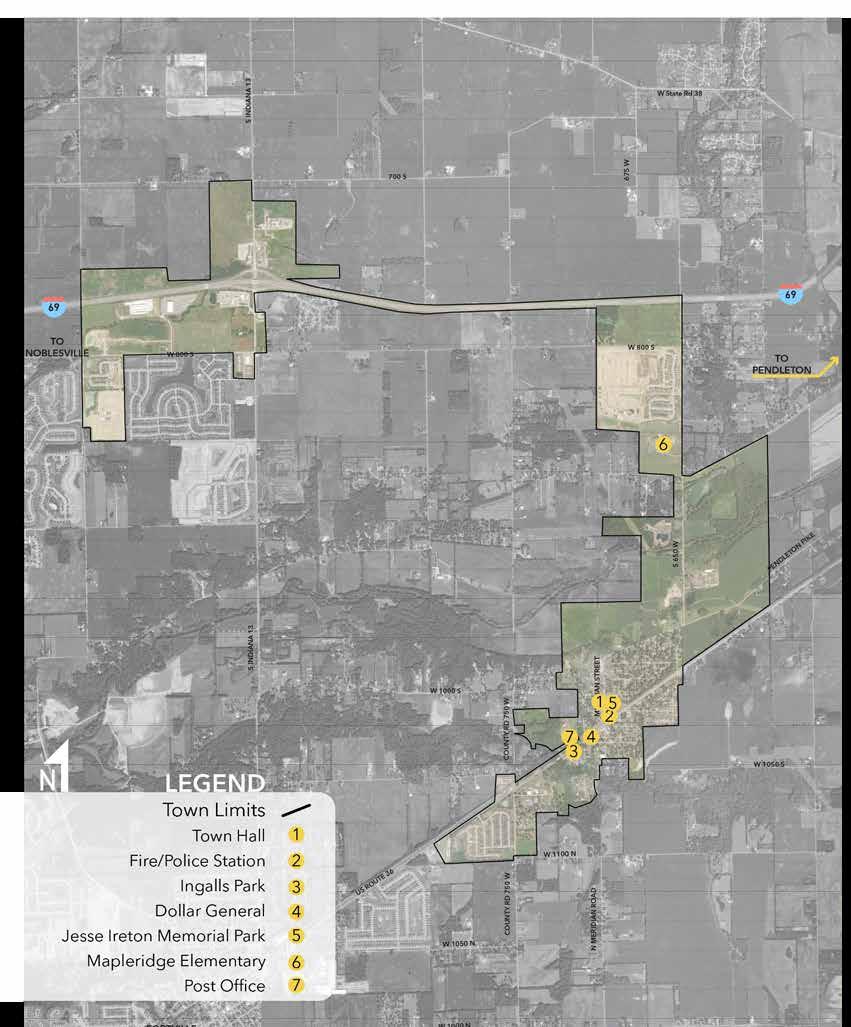
MAJOR DESTINATIONS
The major purpose of the bicycle and pedestrian network is to connect people to destinations with most trips beginning at home and ending at work, school, parks, or shopping.
Besides connecting existing neighborhoods to one another, there are a number of important destinations that should also be considered to enhance connectivity through Ingalls:
Retailers: Dollar General
Government Centers: Post Office, Town Hall, Police Station, Fire Station
Parks: Ingalls Park and Jesse Ireton Memorial Park, there are several large parks within driving distance of the town.
School: Mapleridge Elementary School
LAND USE
Combination of residential, agriculture and little commercial.
Residential and commercial along US Route 36. Town has expanded to the north along Interstate 65 with new neighborhoods popping up.
Existing Natural Features Waterways:
• Lick Creek runs along the western side of town
• Fall Creek that runs west/east and connects to Geist Reservoir
• Thorpe Creek is located to the north side of town near Interstate 69
SOCIAL AND ECONOMIC FACTORS
POPULATION TRENDS
Population has decreased over the years as people move to larger cities, but the average age of the people living in Ingalls has increased slightly. This demonstrates a trend in older residents continuing to remain in Ingalls.
Through the addition of bicycle and pedestrian facilities in Ingalls, it will not only improve the health of those existing residents, but also attract new residents. This ensures Ingalls’ population and its growth in the future.
DIVERSITY
The majority of people who live in Ingalls are white. This demographic is similar to the state of Indiana, 84.2%.
Increasing walkability and bikability in Ingalls has the potential to increase its diversity levels through its probable increase in population.


POVERTY
The median household income for Ingalls, Indiana is $55,043, about $7,000 lower than the Indiana state median household income of $61,944. Furthermore, the poverty rate of 14.4% in Ingalls is higher than the state average of 12.2%. Lower median household incomes combined with a higher poverty rate indicates that multimodal transportation is a key opportunity ensure Ingalls is an afford place to live and work.
DISABILITIES
It is important to not only consider the connectivity of trails and sidewalks, but also to make sure that they are accessible designed for the health, safety, and welfare of the public. Those with disabilities depend on accessible and connected multiuse paths to provide connectivity to various areas of town. As shown in the bar graph to the left, physical imparments is the most common disability.
EXISTING CONDITIONS
A survey of Ingalls was conducted to determine existing conditions throughout the town. The following represents a summary of findings:
1. New residential subdivisions are more likely to have sidewalks. Downtown Ingalls has limited sidewalks, but has many of the destinations for the town such as local businesses and parks.
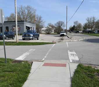
2. Some of the sidewalks that exist within downtown Ingalls are in poor condition. Furthermore, there is a lack of ADA complient curb ramps or crosswalk and pavements markings at intersections.
3. A number of pedestrians can be found walking along the shoulder of US36 and many of the vehicles traveling through town are likely to be doing so over the speed limit.
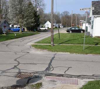
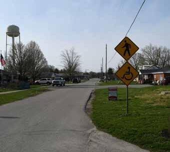
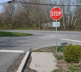
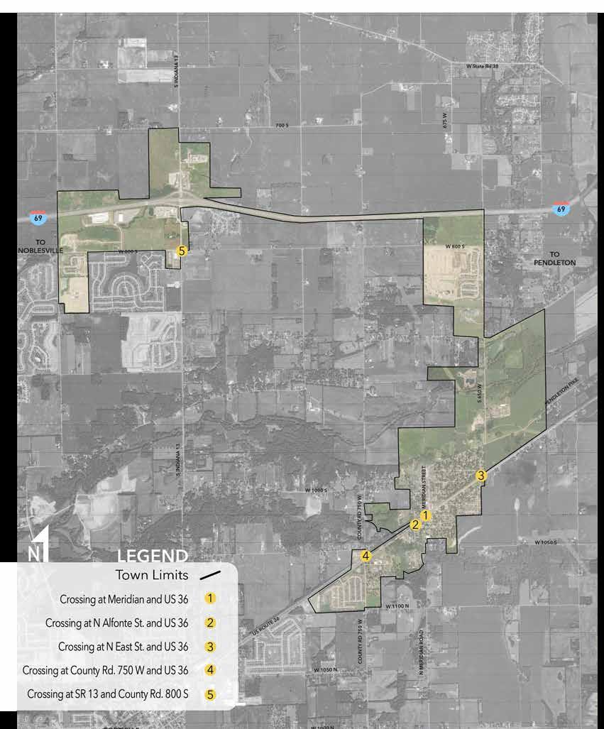
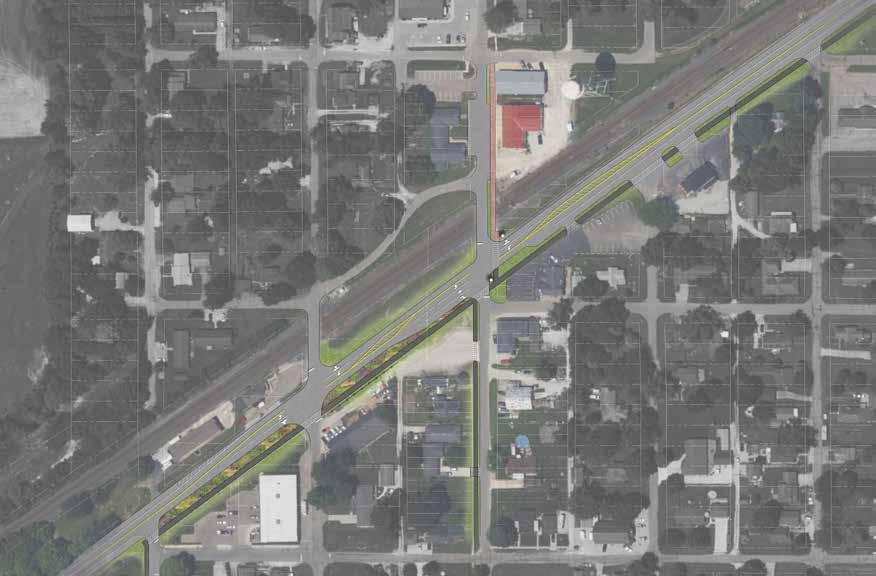
4. Intersections improvements should be considered in a variety of locations along US36. Currently, the only INDOT signed pedestrian or bicycle crossing occurs at Meridian Street and US36. Additional signage or markers could improve safer crossings at this intersection.
5. Ingalls possesses the opportunity to increase and improve the number of bicycle and pedestrian facilities through new development and annexation in the future. It will be important to ensure developers help provide connectivity as new projects are envisioned and realized.
6. Due to annexation growth of Ingalls, connectivity to new residential areas near Interstate-69 is more difficult to achieve
due to limited right-of-way or public access to these areas of town.
7. The existing CSX railroad may cause challenges to implement accessible facilities into downtown Ingalls.
EXISTING PEDESTRIAN AND BICYCLE NETWORK
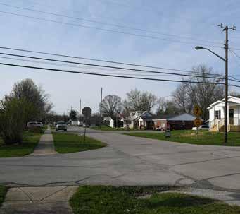
There are very few existing sidewalks located in the downtown area of Ingalls. Some existing sidewalks are narrow and have started to deteriorate.
The neighborhoods on the perimeter of Ingalls have sidewalks but some have gaps where houses or other subdivisions are not built. The town should continue to require sidewalks be constructed with new developments. For areas that are already developed, new sidewalks should be installed over time, beginning with primary walking routes that connect residents to important areas of town (city services, parks) or local businesses. Existing sidewalks should also be connected to future shareduse paths to better connect all areas of Ingalls.
BARRIERS TO WALKING AND BIKING
Barriers to walking and biking may include a variety of factors such as physical infrastructure, existing traffic, or topography and natural features.
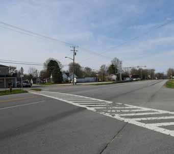
The most identified barrier to walking and biking in Ingalls was US36. Without any stop conditions, traffic is free to move through Ingalls, and usually doing so at speeds higher than posted speed limits. As shown on the following map, there are a number of locations along US36 that could be improved to increase safety and visibility for those trying to cross the road. The railroad that parallels US36 also creates challenges due to the elevation of the rails and lack of sidewalks across the rail corridor.
Where sidewalks do exist, some have physical limitations that may prevent visually or physically impaired persons from using them safely. Some sidewalks do not have connections to sideawalks on the other side of the street or are missing curb ramps. As the town is able, new sidewalks should be built as well as existing sidewalks improved as necessary.
Chapter 03 Public Input
WHAT WE HEARD
In order to understand the current experiences and future expectations of local users, both online surveys and public meetings were conducted to collect data. In summary, the following commentary were recieved from the public input opportunities:
• Improved safety along US 36, specifically reducing vehicle speeds
• Enhanced and safer crossings on US 36
• Improve Ingalls with new sidewalks or trails along existing roadways
• Consider trails along natural stream corridors
• Lack of sidewalks/trails and unsafe roadway crossings are the two largest barriers discourage bicycling and walking
PROJECT
WEBSITE
ONLINE OUTREACH
A project website was created at the beginning of the project to provide residents with an overview of the plan purpose, the planning process, and the timeline for completion.
The website included links for a community survey and interactive mapping tool. Visitors to the website were able to submit comments to the project team through a comment form.
Input was collected during the 2022 Town of Ingalls Fall Festival.
ONLINE SURVEY
In addition to the project website, a community survey was conducted online. The survey had two purposes:
1. As a public participation tool that allowed members of the community to participate in the planning process.
2. Reinforce findings from public involvement activities and planning analyses.
The online survey was advertised through the project website, the town’s website and social media accounts, and hard copies were available at Town Hall and through handouts at community events.
The results of the survey show that there is interest in Ingalls to incorporate the facility types recommended within the master plan. By creating these facilities in Ingalls it will help the town grow and improve.
The survey was available from October 2022 until February 2023. The survey was advertised through the community meetings, project website, hard copies at Town Hall, and through handouts at meetings. The survey received 50 responses.
Results can be found in the appendix, with a few of the responses highlighted on the following pages.
Q 6 W hat would be t he most import ant benef it s and uses of a complet e syst em of paved t rails, sidewalks and bike lanes? Select all t hat apply A ns
E x erc is e
Rec reat ion
Connec t iv it y t o s urrounding areas
Communit y -building and ev ent s
Habit at and env ironment al improv ement s
E c onomic s t imulat ion
Trans port at ion t o work or running errands (groc ery et c )
Ot her (pleas e s pec if y )
E duc at ion (int erpret iv e s ignage)
Tot al Res pondent s : 48
Q 12 W here
Q 9 W hat do you t hink are t he biggest f act ors t hat discourage t rail, sidewalk, or bicycle f acilit y use? Rank Top 3
PUBLIC MEETINGS
INGALLS FALL FESTIVAL
The first public open house was held at the Town of Ingalls Fall Festival, on October 15, 2022, from 10am to 2pm.
Participants were asked to provide feedback about where bicycle and pedestrian facilities should be provided. Furthermore, participants also identified existing issues that may prevent them from walking and biking. ACCESS THE PROJECTWEBSITE WewanttohearfromYOU bicycle and pedestrian improvements are needed for Ingalls! Use the project website listedbelow,orscantheQRcode,forproject updates and opportunities to share your opinion.Pleasevisitthewebsiteandaddyour inputtoguidetheimprovementand developmentoftrails,sidewalks,and greenwaysinIngalls. www.planingalls.com Scan this QR Code to access the Website!
INGALLS


OPEN HOUSE AT INGALLS
TOWN HALL
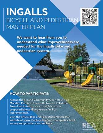
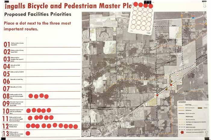
Held on March 13, 2023, from 3:00 p.m. to 6:00 p.m. at Town Hall. Asked the visitors to look at the proposed facilities and improvement locations and to rank these with their top three priority projects.
Respondents identified projects along Meridian Street and US 36 as the most important projects to complete.
Chapter 04 Recommendations
OVERVIEW
This chapter provides a comprehensive set of short and long term recommendations designed to provide a connected, safe and convenient network of bicycle and pedestrian facilities. The recommendations provide the Town of Ingalls with the road map needed to continue their current momentum in pedestrian and bike network growth.
Pedestrian recommendations include sidewalks, shared-use pathways and intersection treatments. The bicycle recommendations include bike lanes, shared-use paths, shared lanes, signed routes, and amenities such as trailheads and bike parking. Recommendations are considered planning-level and should be used as a guide when implementing projects. More detailed analysis, including potential traffic studies, will be required to evaluate specific site conditions and develop designs that reflect conditions and constraints.
RECOMMENDATIONS FOR TRAILS AND SIDEWALKS
All new facility recommendations should meet a minimum level of design standards, as determined by the Town of Ingalls. A potential guide of standards are the following, with additional recommendations located in the Facility Guideline section:
1. Buffer - All trail or sidewalk segments will be constructed to maintain a minimum of a 6’ buffer between the nearest edge of pavement along the adjacent primary roadway and the nearest edge of pavement of the trail. Where prevailing speeds are above 35 mph & a buffer of 6’ cannot be maintained because of excessive cost and/or the need for design flexibility on the project, a barrier (wood, concrete, metal guardrail, or similar) will be constructed to separate the trail segment from the primary roadway.
2. Crossing(s) (trail) - Where trail segments cross the primary public roadway and prevailing speeds exceed 35 mph, enhanced crossing signage, such as Rapid-Rectangular Flashing Beacons (RRFB), Pedestrian Hybrid Beacons (PHB), or similar will be installed along with high visibility crosswalk markings (continental, zebra, or ladder).
3. Crossing(s) (sidewalk) - Where sidewalk segments cross a public roadway, except for alleyways, high visibility crosswalk markings (continental, zebra, or ladder) will be included.
4. Signage – Pedestrian and Bicycle signage as required by the MUTCD Manual and per PROWAG (Public Rightsof-Way Accessibility Guidelines) will also be installed throughout the project. Wayfinding signage, mileage markers, trail markers, and directional trail signage will also be installed throughout the project.
5. Lighting – Pedestrian-oriented lighting,
especially at all pedestrian crossings over/under any public roadway or alleyway, will also be installed throughout the entirety of the project corridor.
6. ADA & PROWAG - The proposed projects will be constructed to maintain ADA Accessibility and continuous pedestrian and bicycle connectivity to achieve standards prescribed in PROWAG (Public Rights-of-Way Accessibility Guidelines). Perpendicular Curb Ramp Pairs will be used unless acquisition of additional right-of-way (ROW) is required and a structure (especially historic) directly abuts the project area and demolition is the only alternate option.
BICYCLE AND PEDESTRIAN
NETWORK IMPROVEMENTS
Facility recommendations include the sidewalks, multi-use paths, and bicycle routes. All proposed facilitiy types should connect to existing facilities when possible.
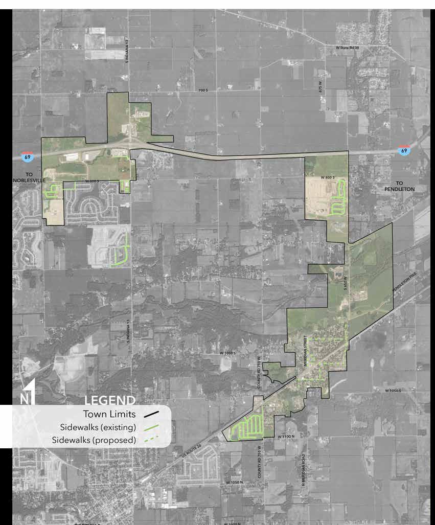
Multi-use Paths
• 800 S
The proposed project will construct an 8’ to 10’ wide multi-use, asphalt trail parallel to W. 800S., 2.5 miles east from S. Indiana 13 to S. 650W.
• S Indiana 13
The proposed project will construct an 8’ to 10’ wide multi-use, asphalt trail parallel to S. Indiana 13, 2.57 miles south from W. 800S. to W. 1050S.
• 650 W
The proposed project will construct an 8’ to 10’ wide multi-use, asphalt trail parallel to S 650 W., 1.13 miles south from Mapleridge Elementary School to Pendleton Pike
• 750W
The proposed project will construct an 8’ to 10’ wide multi-use, asphalt trail parallel to S. 750 W, 4.0 miles south from W. 800S. to W1000N (Hancock County)
• 1050 S
The proposed project will construct an 8’ to 10’ wide multi-use, asphalt trail parallel to W. 1050S., 1.5 miles east from S. Indiana 13 to S. 750W.
• 1100 N
The proposed project will construct an 8’ to 10’ wide multi-use, asphalt trail parallel to W. 1100N., 0.5 miles east from 750 W to Meridian Street.
• 1050 N
The proposed project will construct an 8’ to 10’ wide multi-use, asphalt trail parallel to W. 1050N., 1.5 miles east from S. Indiana 13 to S. 750W.
• 1000 N
The proposed project will construct an 8’ to 10’ wide multi-use, asphalt trail parallel to W. 1050N., 1.5 miles east from S. Indiana 13 to S. 750W.
• US36
The proposed project will construct an 8’ to 10’ wide multi-use, asphalt trail parallel to US36., 1.95 miles northeast from Wyndtone residential subdivision to Inman Rd.
• Meridian St
The proposed project will construct an 8’10’ wide multi-use, asphalt or concrete path parallel to Meridian Street, 0.6 miles south from Pendleton Pike to Mendon Road.
Bicycle Routes
• S. Indiana 13
The proposed project will identify a bicycle route on existing roadways, 1.0 miles north from W 800S to W 700S.
• S. 650 W
The proposed project will identify a bicycle route on existing roadways, 1.0 miles north from W 800S toward the north (northern boundaries should be reviewed during implementation by Ingalls or Madison County).
• N. Meridian Road
The proposed project will identify a bicycle route on existing roadways, 1.0 miles south from W1100N to W1000S. The route will then utilize W1000N to connect to the proposed multi-use path.
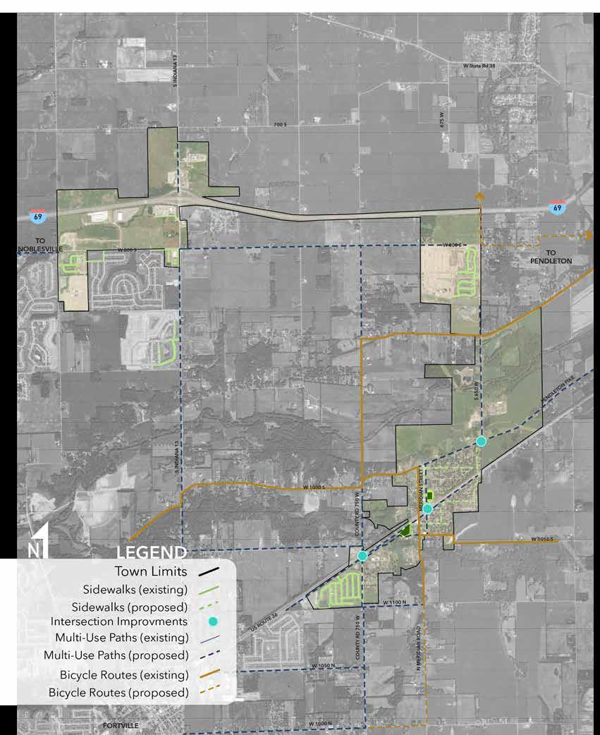

Intersection Improvements
One of the most important corridors Ingalls should focus improvements on is US36 through town. This corridor could foster a number of safety improvements for all modes of transportation. The following intersections are where these improvements should begin; additional intersections may be improved as necessary or when potential coordination allows so:
US 36 and Meridian Street
US 36 and Alfonte Street
US 36 and 750W
US 36 and 650 W
Improvements to these intersections may include rapid flashing beacons, new pavements markings, use of plant material, new signage, or even the potential of a stop light. Coordination with INDOT to reduce speed limits could also be implemented.
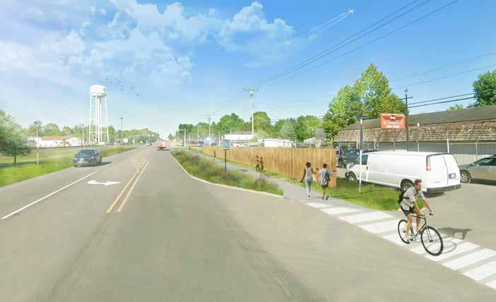
Multi-use Path on US 36
Another important componant of intersection improvements along US36 is a proposed multi-use path parallel to the roadway. This path would connect from S Huston Street and continue to the intersection at US 36 and Inman Road. This proposed facility would look at changing the traffic lanes and provide a more safe connection for users along US 36 that would not be the shoulder, as many people today use.
The path would be an 8’ to 12’ wide asphalt path adjacent to a 10’ planted buffer between the user and the traffic. Each of the road crossings that the path intersects would have improved pavement markings and signage.
Across the Lick Creek bridge, a physical barrier would be recommended due to the physical space restrictions.
FUTURE IMPROVEMENTS
Additional greenways and trails may be considered as part of a set of future improvements. Some of these trails may be more difficult to implement, such as those along various waterways. Private property ownership and lack of public access means these facilities will likely require a more comprehensive approach and greater time to implement.
Fall Creek Trail corridor
Fall Creek is located north of Ingalls. A proposed trail along this corrdior would connect Ingalls to Fortville and Geist Reservoir. Fall Creek’s proximity to downtown Ingalls would offer enhanced connectivity.
Lick Creek Trail corridor
Lick Creek navigates very near the center of downtown Ingalls, which makes a future trail along this corridor a vaulable connection to several existing destinations in Ingalls. This potential project could connect Ingalls Park under US36 Lick Creek Bridge to the north side of US36 along the Lick Creek corridor. This area has historically been used for fishing and other activities.
Thorpe Creek Trail corridor
Thorpe Creek is located north of Ingalls, near Interstate-69. This corridor is less wooded than Lick Creek or Fall Creek, but would still offer connections to the north portions of Ingalls and increase connectivity to other areas of Ingalls and nearby communities.
Meridian Street extension trail corridor: If downtown Ingalls begins to grow, especially toward the north, an extension of the Meridian Street milti-use trail could constructed to provide connectivity to this development.
Secondary Routes
Additional routes along existing county roads should also be considered. Some county roads provide less connectivity than 800S, 650W, or Indiana 13. These secondary county roads would still benefit from bicycle and pedestrian facilities, but may benefit less users. However, additional development and annexation by Ingalls may require some of the secondary county road routes shown to become more critical connections.
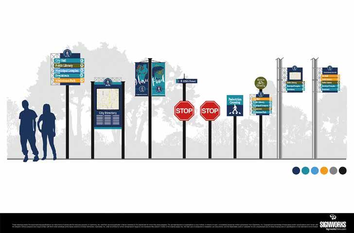
SIGNAGE IMPROVEMENTS
The Town of Ingalls has previously completed a signage plan, with a variety of shapes and sizes for different areas and corridors. These signs should also be utilized to demark multi-use trails and bicycle routes around town.
The image below was provided by the Town of Ingalls and designed by Signworks.
FACILITY GUIDE
FACILITY SELECTION
Facility selection for the bicycle and pedestrian network requires good engineering judgement which can be applied to complex urban environments requiring treatments to be tailored to the individual conditions of each corridor. The process includes design of the broader network and roadway context and then looks at the conditions of the individual corridor to select the appropriate facility. Selecting the appropriate facility type requires consideration of the following:
• What is the function of the corridor in the overall network? (north/south or east/west connector, shorter distance neighborhood connector)
• What user type will the corridor serve? (All Ages and Abilities or Somewhat Confident along with pedestrians)
• What are the physical constraints of the corridor? (Are there buildings close to the right-of-way, are there major utility lines within the corridor)
• What are the land use conditions of the corridor? (residential area with on-street parking and off-street available for each homeowner, busy business district with frequent trips)
• What is the level and speed of vehicular traffic in the corridor?
• Where is there existing bicycle and pedestrian demand?
• Is this facility completing a gap within the existing network?
• Are there short-term and long-term solutions appropriate for the corridor?
• Are there existing facilities which this corridor will connect with and what are the transitions needed to connect the different facilities?
• Are there barriers to completing the route within this corridor?
The following facility design sheets illustrate the toolbox of facility types considered for the Bicycle and Pedestrian Master Plan. Pedestrian facilities are provided through two facility types, the shared-use path and sidewalks. Shared-use paths are appropriate for all user types including cyclists and pedestrians.
Bicycle Facilities include the following:
• Shared-use paths
• Conventional Bike Lanes
• Shared Lane Markings
• Bicycle Routes
Bicycle networks which are designed to be convenient and comfortable are the most effective and increase the number of people riding bikes. The Federal Highway Administration Bikeway Selection Guide identifies seven principles of bicycle network design. The first three of which are the most important. Bicycle and pedestrian facility design solutions should be selected to reduce the number of collisions and reduce conflicts between users. Bicycle facilities should be selected to provide a comfortable facility for the target design user and should reduce the stress, anxiety and safety concerns of that user. A bicycle network should provide complete connections to destinations within the network. Breaks or gaps in the network drastically decrease the number of users on facilities. Transitions between roadways and bikeways should be seamless and clear.
SHARED USE PATH
DESCRIPTION
Shared use paths provide a shared space for both cyclists and pedestrians, and are elevated above adjacent roadways to provide enhanced safety for cyclists and pedestrians. Shared use paths should be used when pedestrian and cyclist volumes are low enough that conflicts rarely occur or in areas where physical space is too constrained to provide for separated facilities. Shared use paths can be on one side of the street or both. As volumes increase over time, the pathway should be monitored for the need to improve the corridor to a separated facility for pedestrians and bicycles.
BENEFITS
• Separated from motor vehicle traffic
• May be more appropriate for children, seniors, and persons with disabilities
• Provides recreational opportunities in addition to transportation
• Can create scenic routes within the bicycle and pedestrian network
CHALLENGES
• Can involve costly and complicated right-of-way acquisition
• Topography and drainage can greatly impact design
• Higher construction costs
• Can present safety concerns when placed adjacent to a roadway with frequent driveway or intersection crossings
• User conflicts such as speed differentials can occur as user volume increases
• Pathways can lose their function as a bicycle commuter route when pedestrian volumes increase
ADDITIONAL CONSIDERATIONS
• A shared use path should be designed to suit the characteristics of bicyclists. This includes establishing a design speed (typically 18 mph) and designing curb radii appropriately.
• To accommodate high volumes and reduce conflicts between different user types, a path wider than the minimum can be provided or modes can be separated by constructing parallel paths for bicyclists and pedestrians.
• On a path that is shared by both transportation and recreational bicyclists, additional path width is desirable to allow users to pass.
• Signage to remind users to keep right except to pass should be provided on wider paths
• Consider adding amenities such as benches, rest areas, and scenic overlooks along paths that provide attractive recreational opportunities
• A 2’ or greater shoulder on both sides of the path should be provided. An additional 1’ of lateral clearance (total of 3’) is required by the MUTCD for installation of signage or other furnishings.
• If bollards are used at intersections or access points, they should be brightly colored or supplemented with reflective materials which are visible at night.
GUIDELINES
Shared Use Path Width: Desired: 12’+ Minimum: 8’ to 10’
• Widths as narrow as 8’ are acceptable for short distances under physical constraints.
• Widths exceeding 10’ are recommended for locations with heavy volumes of pedestrians.
REFERENCES & RESOURCES
• Indiana Design Manual (2013)
• AASHTO Guide for the Development of Bicycle Facilities (2012)
• FHWA Shared-Use Path Level of Service Calculator (2006)
• Manual on Uniform Traffic Control Devices (2009)
CONVENTIONAL BICYCLE LANE
DESCRIPTION
Bike lanes are located on streets and provide lane markings exclusively for bicycle travel. Bike lanes are one-way facility routes that parallel the direction of travel and are located on each side of a two-way roadway or one side of a one-way roadway.
Cyclists with various experience levels usually feel comfortable while using bike lanes depending on the amount of vehicular traffic also using the roadway. Bike lanes are most helpful on streets with posted speed limits of 25 mph or greater and on streets with high transit vehicle volume. Bicycle lanes create separation between cyclists and automobiles and visually remind motorists of bicyclists rights to use the street.
Bicycle lanes are typically low-cost improvements that require roadway restriping and new signage. While each street offers unique conditions, eliminating onstreet parking is occasionally needed to fit bike lanes on streets. In some cases, driving lanes can be reduced to gain additional space if parking is to remain.
Bike lanes may sometimes be painted green, particularly where they cross intersections. This feature alerts motorists of the potential presence of bicycles and reduces the potential for collision.
BENEFITS
• Dedicated space for bicyclists (except near intersections where motorists may enter bike lanes to make right turns).
• Can act as wayfinding aids.
• Established facility type that is understood by most road users.
• May encourage more bicycle travel.
• Can lower motor vehicle speeds in some settings.
• Increases the total capacity of streets carrying both automobile and bicycle traffic.
CHALLENGES
• May not be appropriate for all types of bicyclists.
• Potential risk of “dooring” when placed adjacent to parking.
• Potential for vehicles driving/parking in the bicycle lane.
• Additional roadway width needed which might preclude other possible uses like parking or excess travel lane.
ADDITIONAL CONSIDERATIONS
• May be placed on the left side of oneway roadways to avoid adjacency with on-street parking on the right side.
• May optionally be placed on only one side of a roadway in the uphill direction as a climbing lane if space is limited.
• Depending on the design of the roadway, bicyclists may have to operate in mixed traffic (such as to make turns).
• For high-speed or high-volume roads, alternative routes suitable for users of all abilities should be considered.
• Consider whether passing between two bicyclists is desirable and adjust lane widths accordingly.
• May include buffers (minimum 18”) between bike lane and travel lane and/ or between bike lane and parking lane to provide additional separation.
• Researchers have found that when a bike lane is adjacent to a parking lane adding an edge line to the edge of the parking lane leads to better positioning of cyclists. In busy locations where there is a high turnover of cars parking an additional buffer for car door swing should be included to avoid dooring.
• When a bike lane is placed directly adjacent to a guardrail or other physical barrier an additional 2 feet of width is needed to provide minimum shy distance from the barrier.
• Bike lanes should be plowed clear of snow.
• Bike lanes should incorporate regular street sweeping to keep the lanes clear of debris and trash which can accumulate in bike lanes.
GUIDELINES
Bike Lane Width
Desired: 6’
Minimum: 5’
• Bike Lane: Pavement markings shall be used to define the bike lane.
• Bike Lane signs may be located prior to the beginning of the marked bike lane.
REFERENCES & RESOURCES
• Indiana Design Manual (2013)
• AASHTO Guide for the Development of Bicycle Facilities (2012)
• FHWA Shared-Use Path Level of Service Calculator (2006)
• Manual on Uniform Traffic Control Devices (2009)
SHARED LANE
DESCRIPTION
Share-the-road arrows, or sharrows, are pavement markings in the roadway that indicate to drivers and bicyclists that a lane is to be shared. These routes may be used where vehicle traffic is low, where there is inadequate space for bike lanes on the roadway or where the removal of on-street parking or road widening is not feasible.
Sharrows are often used in combination with other facility types. A common example is for sharrows to be used at intersections where bike lanes cannot be safely routed due to right and left vehicle turn lanes. Sharrows direct cyclists to ride in line with traffic and out of vehicle blind spots.
Sharrows are a lower cost solution for bike facilities than bike lanes or cycle tracks, but alternatively offer little protection from vehicles using the street. Experienced riders may feel comfortable using these facilities, however, novice and recreational cyclists may feel less comfortable riding with traffic.
BENEFITS
• May increase motorist awareness of the potential presence of bicyclists.
• Can act as wayfinding aids.
• The shared space is more likely to be swept and plowed than separated facility types.
• Low cost of implementation
• Improves the usefulness of the bicycle network, especially when routes are diverted away from well-known streets.
• May encourage the use of lower-stress bikeways.
CHALLENGES
• May not be suitable for all users as they do not provide separate space for bicyclists.
• May have higher maintenance needs than other facility types due to the wear and tear presented by motor vehicles driving over the pavement markings.
ADDITIONAL CONSIDERATIONS
• Typically used on local, collector, or minor arterial streets with low traffic volumes.
• Typically feasible within existing rightof-way and pavement width even in constrained situations that preclude dedicated facilities.
• May be used to fill gaps between bike lanes or other dedicated facilities for short segments where there are space constraints.
• Commonly used on bicycle boulevards to reinforce the priority for bicyclists.
• May be used for downhill travel in conjunction with climbing lanes intended for uphill travel.
• Typically supplemented by signs, especially Bikes May Use Full Lane (R411).
When applied on higher speed/volume roads, consider alternative routes suitable for users of all abilities.
GUIDELINES
• Posted speed limits of 35 mph or less.
• The sharrow’s centerline must be minimum 4’ from curb where parking is prohibited.
• The sharrow’s centerline must be minimum 11’ from curb where parking is permitted.
• For narrow lanes, it may be desirable to center shared lane markings along the centerline of the outside travel lane.
REFERENCES & RESOURCES
• AASHTO Guide for the Development of Bicycle Facilities (2012)
• NACTO Urban Bikeway Design Guide (2012)
• Manual on Uniform Traffic Control Devices (2009)
BICYCLE ROUTE
DESCRIPTION
Bike Routes are a system of signs and pavement markings that guide bicyclists along preferred routes to destinations across the town and region. Signs may state distance and destinations or include route numbers. Bike routing is used to establish a preferred route where bikeway infrastructure is not needed or is not feasible. Bike routes are most often used by experienced cyclists who are comfortable riding on roadways. These routes are not often used by less experienced riders or families. Wayfinding and signage can encourage the use of lower-stress bikeways.
BENEFITS
• May increase motorist awareness of the potential presence of bicyclists.
• Can act as wayfinding aids.
• The shared space is more likely to be swept and plowed than separated facility types.
• Low cost of implementation
• Improves the usefulness of the bicycle network, especially when routes are diverted away from well-known streets.
• May encourage the use of lower-stress bikeways.
CHALLENGES
• May not be suitable for all users as they do not provide separate space for bicyclists.
• Can cause unnecessary confusion if the selection of destinations and placement of signs is not optimized.
• Can contribute to sign clutter.
ADDITIONAL CONSIDERATIONS
• Typically used on local, collector, or minor arterial streets with low traffic volumes.
• Typically feasible within existing rightof-way and pavement width even in constrained situations that preclude dedicated facilities.
• Typically supplemented by signs, especially Bikes May Use Full Lane (R411).
• When applied on higher speed/volume roads, consider alternative routes suitable for users of all abilities.
• Bicycle route signs should provide bicyclists with direction, destination, and distance information to commercial centers, rail stations, shared use paths, and other popular destinations.
• The location of signs and represented destinations should be planned in a comprehensive manner, considering the likely routes of bicyclists and probable destinations.
• To assist the bicyclist, the system should provide three general forms of guidance:
• Directional signs: placed at decision points where routes intersect and where routes turn from one street to another.
• Regional route signs: Placed along designated routes.
• Confirmation signs (also called designation signs): used to confirm route choice.
PROGRAM AND POLICY
INTRODUCTION
Ensuring that the bicycle and pedestrian network effectively meets the needs of different users requires the adoption of a comprehensive set of policies that addresses each aspect of biking and walking. This includes new policies specific to the Town of Ingalls as well as the adoption of state and federal policies. Rather than simply focusing on routes and infrastructure, a well-rounded and complete bicycle and pedestrian plan and program is one that is comprehensive in its recommendations and actions. The League of American Bicyclist and the Walk Friendly Communities programs both use the 5 E’s model to help communities develop and document their pedestrian safety and encouragement plans. The 5 E’s include

Engineering
Creating safe and convenient places to ride and park

Giving people of all ages and abilities the skills and confidence to ride
engineering, education, encouragement, enforcement, and evaluation. This chapter is organized around these Five E’s, with each section containing recommendations for new policies unique to Ingalls as well as excerpts from the most relevant state and federal policies. Collectively, the policies recommended in this plan seek to sustain and enhance walking and bicycling conditions for all users, regardless of skill level, physical ability, or whether they walk or bike for transportation or recreational purposes.

Creating a strong bike culture that welcomes and celebrates bicycling

Just and fair inclusion into a society in which everyone can participate and prosper.

Planning for bicycling as a safe and viable transportation option
ENGINEERING
RECOMMENDATIONS
Engineering policies and actions are typically the most significant, in terms of cost and public agency involvement. They include changes to design standards and practices, the construction of infrastructure, and any other action that creates changes in the built environment. The following engineering policy recommendations are largely in response to observed infrastructure issues in Ingalls.
NEW POLICY – NO RIGHT TURN ON RED AT KEY INTERSECTIONS
Many cities across the nation are implementing a “No Right Turn on Red” policy as a part of their Vision Zero plans which are aimed at eliminating all trafficrelated injuries. Banning right turn on red lights has been shown to increase the safety of intersections for pedestrians.
This plan recommends a study to evaluate the implementation of a no right turn on red policy in downtown, school zones and key intersections which have seen high accident rates. The study should evaluate the loss in traffic efficiencies balanced with the increase in safety for pedestrians.
COMPLETE STREETS
Ideally, bicycle and pedestrian facilities and infrastructure will be included with all street projects when they are initially constructed, or when streets are reconstructed. Including bicycle and pedestrian facilities at this time is less expensive than retrofitting facilities as stand-alone projects. Two federal policies support and mandate this approach for projects utilizing federal aid unless a) bicycles are prohibited by law from using the roadway, b) the cost is excessively
disproportionate to the need (exceeding 20 percent of the project cost), or c) where sparsity of population indicates an absence of need.
Following a Complete Streets process for street projects (especially those along or connecting to a planned bikeway) will help further the implementation of this plan. Such a process will ensure that all street users— motorists, bicyclists, and pedestrians—are considered during the design stage and are adequately accommodated. The process should be flexible in terms of design specifics and sensitive to the surrounding context and land uses. The process should also apply to street resurfacing, restoration, and rehabilitation (3R) projects and streets built by private developers, such as interior circulating streets in a newly-developed site when they are part of or are connected to the current and planned bicycle and pedestrian system.
USE NATIONALLY-RECOGNIZED DESIGN GUIDELINES, INCLUDING AASHTO AND NACTO, WHEN DESIGNING ONSTREET BIKEWAYS
The Indiana Design Manual 2013 (IDM) is the statewide guidance used by INDOT and local jurisdictions during the development and design of transportation projects.
Part 3 “Roadway” provides guidance for several subject areas, including accessibility for persons with disabilities (including sidewalks), shared-use paths, and roundabouts. The IDM also contains some guidance for the design of on-street bikeways. Namely, it provides guidance on determining the appropriate type of bicycle facility (bike lane, path, etc.) based on factors such as motor vehicle traffic and speed. However, it does not contain the specific design guidance necessary to design on-street bicycle facilities.
As such, the AASHTO Guide for the Development of Bicycle Facilities, 4th Edition, 2012 (AASHTO Guide) should be used in the design of all on-street bikeways. While the AASHTO Guide serves as a set of minimum standards, the NACTO Urban Bikeway Design Guide (NACTO Guide), which is used by many communities to design innovative bicycle infrastructure that surpasses the AASHTO minimum standards, may also be consulted.
UTILIZE NATIONAL AND INTERNATIONAL BEST PRACTICES AND GUIDES AS SUPPLEMENTAL GUIDANCE FOR PATH DESIGN
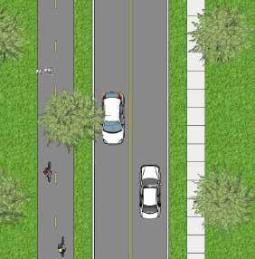
Two-way paths along roadways, which constitute the most common dedicated bicycle and pedestrian facility type in Ingalls, come with many challenges, including:
• Path crossings of driveways and intersections are often blocked by automobiles waiting to turn (motorists typically ignore stop bars).
• Conflicts exist between slow-moving pedestrians (3 mph walking speed) and faster-moving bicyclists (10-15 mph is considered a moderate pace).
• The need for additional traffic control signage, especially at driveways and intersections.
• There is a lack of clarity regarding who has the right-of-way where paths cross minor streets.
• There is an increased risk of crashes due to the limited visibility of drivers (see Figure 30).
• In light of these challenges, paths are most appropriate where driveways and intersections are limited. In areas with high concentrations of driveways and intersections, on-street accommodations (including bike lanes and buffered bike lanes) are preferred because they are
proven to be safer.
The AASTHO Guide states that paths along roadways should be considered a supplement to, but not a replacement for, on-street bikeways. In other words, the provision of a path does not preclude the need to provide on-street accommodations for bicyclists that are more comfortable riding with traffic.
[Figure 30: Visibility limitations of paths along roadways.]
Since the bicycle and pedestrian system primarily consists of paths along roadways, it is important that the town design paths according to the best design guidance available. While the Indiana Design Manual contains a significant amount of detail on path design, there are several issues and situations that it simply does not address. Therefore, the Town of Ingalls should regularly reference additional design guidelines and standards that address more complex issues beyond the limited scope of the IDM. These guidelines and standards include the AASHTO Guide, the NACTO Guide section on two-way cycle tracks, the 2011 Indiana Manual on Uniform Traffic Control Devices, Part 9 (MUTCD), and the CROW Design Manual for Bicycle Traffic (CROW Manual). The CROW Manual is the primary bicycle infrastructure design guide for the Netherlands (a country wellknown for its extensive system of paths along roadways) and while it is not directly applicable to American cities, it contains many relevant concepts for path design. The CROW Manual is especially informative for designing path crossings at intersections and driveways.
DESIGN ALL PATHS WITH A MINIMUM DESIGN SPEED OF 15 MILES PER HOUR
The IDM states that “A bicycle minimum design speed of 15 mph is required. A bicycle design speed of 20 mph is desirable” (IDM 51-7.05(02)). The AASHTO Guide specifies a minimum design speed of 18 mph, which may be lower “in rare circumstances.” Design speed determines sight distances and horizontal alignments. Specifically, curve radii should be at least 60 feet in diameter if the design speed is 18 mph. In locations where physical constraints limit the ability to meet the minimum design speed, warning signage must be used, just like is required for roadway design.
The Town of Ingalls should design all new paths with a minimum design speed of 15 mph, in keeping with the IDM, and should also strive to design all paths with an 18 mph design speed.
DESIGN ALL PATHS WITH A MINIMUM WIDTH OF 8 FEET
Regarding path width, the IDM states that “The desired paved width is 10 feet. The minimum paved width is 8 feet. It may be necessary or desirable to increase the width to 12 ft or 14 ft…” where higher volumes of bicycle or pedestrian traffic is expected (IDM 51-7.05(02)). According to the AASHTO Guide, two-way paths should be a minimum of 10 feet wide (the former minimum was 8 feet). This is the minimum width needed for two bicyclists to safely pass each other. In addition, other path users require wide operating spaces (up to 5 feet for inline skaters), so the 10-foot minimum is justifiable for other users as well. The AASHTO Guide states that 8-foot wide paths “may be used for a short distance due to a physical constraint such as an environmental feature, bridge abutment, utility structure,
fence, and such” (AASHTO 5.2.1).
Several existing paths in Ingalls are 8 feet wide, which reflects the IDM and old AASTHO Guide minimums. However, in keeping with the new AASTHO Guide standard, the Town of Ingalls should:
• Design all new paths to be a minimum of 10 feet wide, unless there are short segments with physical constraints that will only allow an 8-foot wide path
• Funding that originates from the federal government—such as the Fixing America’s Surface Transportation (FAST) Act requires that AASHTO standards be met in order for projects to be eligible.
DESIGN ALL PATHS WITH A MINIMUM CROSS-SLOPE OF 2 PERCENT
The IDM (section 51-1.05(01) and the AASHTO Guide both allow a maximum path cross-slope of 2 percent. The United States Access Board’s Public Rights-of-Way Accessibility Guidelines (PROWAG), which is the new design standard for meeting the com pliancy requirements of the Americans with Disabilities Act (ADA), also mandates a 2 percent maximum cross-slope for sidewalks and paths. This maximum also applies to sidewalk and path driveway crossings, which should be relatively flat.
The majority of paths and sidewalks in Ingalls do not exceed a 2% cross slope. However, excessive cross-slopes of paths are present at several older driveway crossings. The Town of Ingalls should ensure cross-slopes do not exceed 2 percent for new path and sidewalk construction and reconstruction projects. Achieving flat driveway crossings may require offsetting the path or sidewalk away from the roadway and around the driveway apron.
DESIGN ALL PATHS WITH A MAXIMUM GRADE OF 8 PERCENT
Grade or longitudinal slope should be as flat as practical, according to the IDM and AASHTO Guide. Furthermore, in order for a path to be ADA-compliant, its grade cannot exceed 8 percent or the grade of the adjacent roadway. The IDM and AASHTO Guide support these limits as preferable for bicyclists, though the IDM allows grades in excess of 8% under extenuating circumstances (IDM 51-1.05(02)). The Town of Ingalls should minimize the grade of paths and ensure that new path construction/reconstruction projects do not exceed the grade of the adjacent roadway.
DESIGN STREET CROSSINGS THAT ARE SAFE AND EASY TO UNDERSTAND
Street crossings should be designed to minimize conflicts and increase safety. The operation of off-road facilities is especially challenging at street crossings due to limited visibility, blocked crosswalks, and confusion regarding right-of-way. Statistics from around the country show that cyclists using paths along roadways are at higher risk than bicyclists riding in the street, primarily due to street crossings. Some of the greatest challenges associated with path street crossings relate to the location of the facility as it approaches the intersection. A straight approach to the intersection does not require bicyclists to slow down. Paths that cross too close to the parallel street are often blocked by cars waiting to turn and place bicyclists in a location that is not highly visible for turning motorists. Best practices support taking one of two approaches, moving closer or moving farther away.
MOVING CLOSER (MORE APPROPRIATE FOR URBAN SETTINGS)
Moving crossings as close to the curb line of the parallel road as possible (and reducing corner radii significantly) is one approach. The IDM recommends that path crossings be located “close to the roadway intersection so as to allow the motorist and path user to be able to recognize each other as intersecting traffic” (IDM 51-7.09(01)). Such a treatment is shown in the photographs in Figure 31, Alternate B. While “close to the roadway intersection” is ambiguous, the referenced Figure 51-7R shows a path setback of what appears to be 10 to 12 feet. However, this results in the aforementioned visibility and crosswalk blockage issues. The only national guidance that is relevant in this case is the NACTO Guide’s section on two-way cycle tracks, which recommends very small corner radii (e.g., 5 to 10 foot actual radius) and highvisibility pavement markings (such as solid green paint bordered by white dashed stripes). However, the NACTO Guide is largely designed for urban contexts and such treatments may not be appropriate in many locations in Ingalls outside of the downtown area.
MOVING FARTHER AWAY (MORE APPROPRIATE FOR SUBURBAN AND RURAL SETTINGS)
Moving crossings farther away from the curb line so that the crossing functions as a second intersection. Moving the path crossing farther from the curb line of the parallel road has many advantages, including:
• Increasing the visibility of bicyclists and pedestrians in the crossing by motorists turning off of the parallel street, since the crossing is now directly in front of the motorist once he has turned, instead of in his peripheral view.
• Allowing space for cars turning from the parallel street onto the cross street to wait outside of the flow of traffic on the parallel street.
• Slows bicyclists as they approach the intersection, meaning they enter the crossing at slower speeds, making them more visible to motorists.
• Allows one or more cars waiting to turn onto or cross the parallel street from the cross street to queue without blocking the path crossing.
Right turning Driver A is looking for traffic on the left. A contraflow bicyclist is not in the driver’s main field of vision.
Left turning Driver B is looking for traffic ahead. A contraflow bicyclist is not in the driver’s main field of vision.
Right turning Drive C is looking for left turning traffic on the main road and traffic on the minor road. A bicyclist riding with traffic is not in the driver’s main field of vision.
Figure 30 - AASHTO Guide for the Development of Bicycle Facilities, 4th Edition, 2012.
The primary disadvantage is that offset crossings require more right-of-way and additional traffic control (warning signs for motorists). The IDM provides some support for moving path crossings farther from the curb line. IDM Figure 51-7R shows an alternative configuration placing the crossing at least 100 feet from the intersection and treating it as a mid-block crossing. However, this would require an excessive amount of right-of-way at intersections and places the crossing far enough from the intersection that motorists would have enough time to gain a considerable amount of speed.
Instead, the most applicable design guidance for suburban two-way paths along roadways is the Dutch CROW Manual. Its guidelines recommend 16-23 feet of setback from the curb line of the parallel road, with the path offset bend beginning at least 115 feet from the intersection with curve radii at least 39 feet (which serves to slow bicyclists). These recommendations are for intersections between arterial roads and collector/local roads. For intersections between two arterial roads, the crossings should be closer to the intersection and bicycle-specific signal heads should be used.
For locations where paths along roadways cross moderate-volume streets, especially those with moderate to high volumes of turning traffic, the Town of Ingalls should carefully review the NACTO Guide and CROW Manual and apply the former to urban settings (i.e., downtown) and the latter to all other locations in the community. Using the NACTO Guide and CROW Manual.
REPLACE CURB RAMPS AS PART OF RECONSTRUCTION AND RESURFACING PROJECTS IN ACCORDANCE WITH THE ADA TRANSITION PLAN
The US Department of Justice’s and US Department of Transportation’s Joint Technical Assistance on the Title II of the Americans with Disabilities Act Requirements to Provide Curb Ramps when Streets, Roads, or Highways are Altered through Resurfacing mandates that curb ramps be provided (or replaced if existing curb ramps are non-compliant with current ADA requirements) when a street is reconstructed or resurfaced. This ruling includes the following provisions:
• Curb ramps are required where any sidewalk or pedestrian walkway crosses a curb.
• Resurfacing of a roadway is considered an alteration (thereby requiring the provision of curb ramps) when it spans from one intersection to another.
• Resurfacing includes overlays, with or without milling (new asphalt, concrete rehabilitation, open-graded surface courses, cape seals, etc.).
• Maintenance treatments do NOT trigger the requirement to provide curb ramps (pavement markings, crack sealing, chip seals, joint repairs, friction treatment, etc.). However, multiple maintenance treatments occurring over a short span of time might constitute an alteration.
• If a crosswalk is resurfaced, curb ramps must be provided—regardless of project scope.
The IDM includes a comprehensive set of guidelines for curb ramp design that is in keeping with the United States Access Board’s Public Rights-of-Way Accessibility Guidelines (PROWAG), which is the latest set of standards for complying with ADA requirements. The Town of Ingalls follows
the IDM when constructing new curb ramps and has an ADA transition plan that is used to identify and replace all non-compliant curb ramps in the community. Whether constructed by the town or by developers, curb ramps (not including flared sides) must equal the width of the sidewalk or path to which they connect. When connected to paths they must be of the perpendicular or depressed-corners types, as described in the IDM.
DESIGN HIGHLY-VISIBLE CROSSWALKS THAT ARE FREE OF OBSTRUCTIONS
Off-road facility crossings at streets are highconflict locations. Crosswalks must be clear of obstructions and visible to pedestrians, motorists, and bicyclists. For every marked crosswalk, the Town of Ingalls should, at a minimum, provide two solid white lines (each between 6 and 24 inches wide) in keeping with MUTCD Section 3B.18. This shall be in addition to any colorized concrete or pavers. Alternatively, the town may provide other types of marked crosswalks, including solid, continental, zebra, or ladder patterns. Ingalls should repaint all crosswalks every one to two years or as fading occurs. Alternatively, the town may utilize more durable materials (non-slip thermoplastic, preformed tape, epoxy, etc.) to increase maintenance intervals.
DESIGN ALL FACILITIES WITH NECESSARY REGULATORY AND WARNING SIGNAGE
Regulatory and warning signs are crucial elements for bicyclists and pedestrians in terms of mitigating safety hazards (especially where physical constraints and age of infrastructure results in noncompliance with current IDM and AASHTO standards) and indicating who has the right-of-way at intersections. Warning and regulatory signage makes the transportation system (streets and paths) safer and more efficient.
Several parts of the town’s bicycle and pedestrian network is lacking in regulatory and warning signage. It can then begin a program to purchase and install the necessary signage. Signage for paths along roadways should follow the same regulatory controls as the parallel roadway. For example, a stop sign should not be placed along the path at an intersection or driveway unless the parallel roadway also has a stop sign at the same location. Instead, the perpendicular street will include a stop bar behind the path crossing and warning signage for both the motorists and the path users. At these locations, the motorist should always yield to the path user. Warning signs for motorists turning across shared-use paths may be appropriate at high traffic areas.
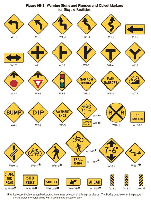
Figure 33 - MUTCD Warning Signs and Plaques
EDUCATION
RECOMMENDATIONS
Education policies and programs are instrumental to the success of networks as they encourage users to use the facilities. Education policies and actions range from media campaigns to practical training, such as how to ride safely or properly wear a helmet. The Town of Ingalls should develop a comprehensive education campaign for bicyclists, pedestrians, and drivers. The goals of the program could include outlining the rights and responsibilities of all road users, familiarizing all users with the rules of the road, and explaining the various pavement markings and signs associated with sharing the road. The following policies provide ways to facilitate the creation of this program.
BICYCLE EDUCATION PROGRAMS FOR KIDS
Many children ride with their families in the Town of Ingalls. Providing early education will create a more educated generation of users as they grow but children can also educate their families as they learn. Levereaging existing town festivals events are a great way to direct and deliver bicycle related education to children, or to pass out safety equipment such as bike helments or reflective stickers. Similar events and classes can be held for adults. Topics discussed typically include the parts of a bicycle, how a bike works, how to fix a flat tire, proper helmet fitting, rules of the road, road positioning, and on-bike skills. These events may be facilitated by local police departments and cycling clubs and model programs are available through the League of American Bicyclists website.
AMBASSADOR PROGRAM
While many forms of education are available for motorists, cyclists and pedestrians, people don’t always see or understand the information. An Ambassador program would include trained experts for the different user groups. Ambassadors would reach people on the trails and facilities, helping to educate on proper etiquette and use of the trail system. Ambassadors would not only be used to distribute information but would serve as good examples by pledging to ride responsibly and follow the laws. Ambassadors would not be expected to enforce rules and laws but would instead distribute information and set a good example of proper use.
The most effective ambassador programs include events during warmer months (helmet and light giveaways, bike rodeos), attending existing community events (festivals, farmers markets), and educating school age children during the school year (classroom presentations).
EDUCATIONAL MATERIALS FOR CYCLISTS AND PEDESTRIANS
Imparting the same knowledge to all road users will help create proper expectations of behavior among different modes. New facilities can also lead to confusion about proper use of the facility. Brochures or pamphlets can be developed to enable all transportation user groups to be on the same foot in terms of knowledge. The brochure should cover the range of bicycling and pedestrian issues which might be encountered while using new and existing facilities. Information should include traffic laws, town regulations, basic equipment safety and tips for crossing intersections.
INCLUDE AT LEAST ONE PIECE OF ROAD USE
EDUCATION ANNUALLY IN TOWN COMMUNICATIONS TO RESIDENTS
Including educational pieces in utility or tax bills is an easy way to reach a large group of people. Simple communications could cover a seasonal topic such as rules of the road, local bicycling ordinances, and back-to-school safety information. At least once per year, the Town of Ingalls should distribute hard-copy educational materials explaining the rules of the road for drivers, bicyclists, and pedestrians.
SAFETY TRAINING AND COMMUNICATIONS MATERIALS FOR DRIVERS
Although riding and walking are common in Ingalls there is still misperception or misunderstanding for some of the rules of the road. By creating training sessions and communication materials such as pamphlets, the town can educate motorists in addition to continued education of cyclists and pedestrians. The communication materials could be distributed at businesses and training sessions could be conducted at larger businesses.
LAUNCH A MARKETING CAMPAIGN TO PROMOTE MUTUAL RESPECT AND AWARENESS
Members of the community do not necessarily have an inherent understanding of the motivations, needs and behaviors of those traveling by other modes of transportation. For example, a driver may not understand the importance of
using a turn signal to notify a bicyclist of an upcoming turn. A bicyclist may not appreciate how their travel speeds impact the comfort of pedestrians on shared pathways, and a pedestrian may not understand how important it is to make eye contact with a driver or bicyclists when crossing the street. Each of these situations can lead to misunderstanding and animosity which does not promote productive interactions on streets and pathways.
Creating a marketing campaign with simple but targeted messaging is a highly effective way to increase awareness of the perspective of other users. Marketing materials might include bus ads, posters and stickers with a hashtag for social media.
SAFE ROUTES TO SCHOOL PROGRAM
Continue to implement educational programs identified in the Safe Routes to School study. Emphasize projects that make it easier to walk and bike to school. Provide bike parking at schools and teach students how to securely lock their bikes. School administrators should meet annually to coordinate progress.
EQUITY & ACCESSIBILITY RECOMMENDATIONS
According to the League of American Bicyclsits, Equity is the just and fair inclusion into a society in which everyone can participate and prosper. The goals of equity must be to create conditions that allow all to reach their full potential, by erasing disparities in race, income, ability, geography, age, gender and sexual orientation.
The principle of equity acknowledges that there are historically underserved and underrepresented populations, and that fairness regarding these unbalanced conditions is needed to assist equality in the provision of effective opportunities to all groups.
Accessibility refers to improving and increasing access and mobility options for everyone, including, and in particular, for people with disabilities. It is understood that not every disability is visible to others, and that not every person with a permanent or temporary mobility or accessibility need identifies as ‘disabled’. Whether from a cognitive, sensory, or physical disability, or from age, temporary illness, or injury, there are people in every community who face a range of mobility challenges for whom a bike or cycle may open a world of possibilities to increase accessibility. (Equity and Accessibility statements provided by the League of American Byciclists)
DEMOGRAPHIC STUDY
As the Bicycle and Pedestrian plan is updated in the future, or as new studies examine demographic trends within the town, these demographic results should be anaylized to determine wheather bicycle and pedestrian facilities are still
being provided to all within the community and especially those areas that may be historically underserved.
If these studies begin to identify areas where bicycle and pedestrian trails should be located to promote equity and accessibility, this plan should be updated to reflect such results.
ZONING AND SUBDIVISION ORDINANCE
The Town of Ingalls zoning and subdivisions ordanices should support and reinforce the recommendations in this plan and offer the opportunity for those residents to be connected to other areas of the town.
ENCOURAGEMENT RECOMMENDATIONS
Encouragement policies and programs should build enthusiasm and interest in bicycling and walking. Programs can include National Bike Month activities, Cyclovias, Walk to School days, launch parties for new facilities and marketing campaigns to encourage more riding and walking.
SPONSOR BIKE TO WORK WEEK AND BIKE & WALK TO SCHOOL DAY
Bicycling to work or to other destinations is a great way to get exercise, save money, reduce pollution, and have some fun. Bike to Work Weeks and Bike and Walk to School Days are national activities that are part of National Bike Month (May of each year). Bike/Walk to School Day is an important component of Safe Routes to School programs as it both encourages and educates students on how to get to school via bike or their feet. Activities for these events may include:
• Morning commute stations where cyclists are treated to free coffee and breakfast, bike tune ups, and other incentives;
• Group rides with local civic leaders;
• Themed rides, such as a bike parade to school; and
• Discounts at local businesses for commuters and participants.
SPONSOR AND/OR SUPPORT LOCAL FAMILY-FRIENDLY EVENTS THAT PROMOTE BICYCLING OR WALKING
Family friendly events can be a great way to capture the interested but concerned portion of the cycling population, as well as a great way to introduce kids to cycling as part of everyday normal life. Often these events are community oriented and can be as simple as a group ride organized on a Sunday. Other events include Cyclovias, themed rides, and rides organized around existing neighborhood festivals, parks, or cultural destinations.
DEVELOP BICYCLING AND WALKING MAPS
As facilities are constructed the Town should continue to update the bicycle network map. This map should be produced in hardcopy and digital format and should continue to be available to residents and visitors. The maps should include local destinations which encourage active lifestyles including grocery stores, trails and parks.
EVALUATION
RECOMMENDATIONS
Evaluation and planning policies include monitoring and documentation of the results of implementing the other E’s and planning subsequent actions. Data collection is critical to measuring the overall effectiveness of the network. The following section provides recommendations for collecting the data both before and after infrastructure improvements and programs are implemented.
CONSIDER FORMING A BICYCLE AND PEDESTRIAN PLANNING TEAM
This interagency group will identify infrastructure projects such as roadway, sewer and utility projects, which need to incorporate bicycle and pedestrian improvements in addition to driving specific bicycle and pedestrian facility projects. The Bicycle and Pedestrian Planning Team will continue to act as the champion for the Bicycle and Pedestrian Way Master Plan with the goal of developing a complete and connected network for the town.
CONDUCT ANNUAL BICYCLE AND WALKING COUNTS
Annual counts provide data for measuring biking and walking trends throughout the town and over time. The data will help determine the impact of projects, policies and programs. Counts should be conducted utilizing the National Bicycle and Pedestrian Documentation Methodology. There are three methods available for performing the counts:
• Volunteer-based visual counts
• Electronic counts
• Estimates using GPS data
The National Bicycle and Pedestrian Documentation Project provides a recommended methodology, survey and count forms, and reporting forms online for free. Local trainers for the program are also available. Each of the methods have varying costs but can be economical when used in combination with volunteers. It is important for the data that is taken each year to be taken at the same locations, times of day, week and year for data to be comparable from year to year.
CREATE AN ANNUAL REPORT CARD ON WALKING AND BICYCLING
Create an annual report card for new or modified bicycle and pedestrian infrastructure. Include bicycle and pedestrian count data when collected, and share year-to-year changes. The purpose of the report card is to gauge the success of projects and to evaluate where facilities may need further improvements to fully capture their potential.
CONTINUE TO DEVELOP AND MAINTAIN A CAPITAL IMPROVEMENT PLAN FOR BICYCLE AND PEDESTRIAN FACILITIES
Without a multi-year plan projects are often implemented on an opportunity basis and not on a need basis. Developing a multi-year capital improvement plan for bicycle and pedestrian projects will allow the town to track the total amount of bicycle and pedestrian facilities being built by the town. The capital improvement plan would focus on filling gaps in the system and on completing high-priority corridors. Long-range budget planning for the overall network will allow the town to implement improvements in a measured and responsible manner.
MAINTENANCE AND OPERATIONS
INTRODUCTION
An important part of any bicycle and pedestrian master plan is ensuring that the existing and proposed improvements are cared for and maintained. One of the most important reasons to properly maintain the facilities within the system is to maximize safety while minimizing the local landowners concerns regarding liability. Planning for the maintenance and management of the bicycle and pedestrian system will ensure safety and will prolong the life of the facilities within the system. Budgeting and planning for the maintenance of the existing and proposed facilities is imperative for the long-term success of the system.
The operations and maintenance plan for the Ingalls Bicycle and Pedestrian Master Plan provides guidance for tasks that need to be undertaken by the managing agencies and project partners. This plan provides a series of work items that need to be completed in order to maintain the system as an attractive, safe and enjoyable amenity. The following defines key aspects of facility management beginning with operational policies, followed by facility assessment, maintenance, maintenance costs, management, safety and liability policies, and funding alternatives for the operations and maintenance tasks.
OPERATIONS
The operation of the bicycle and pedestrian systems includes day-to-day management of the system. This includes law enforcement, map and brochure updates, marketing, conducting special events, and other functional tasks.
Hours of Operations Policy
With many of the existing and proposed facilities within the system being incorporated into the living and working areas of the town, there will be no specific hours of operation for these facilities. However, the greenway and trail facilities will be operated as a non-lighted (except where existing lights exist and are maintained) system of facilities and shall be open from dawn to dusk, 365 days a year. Where users are found using the non-lighted portions of the greenways or rail-trail, they can be deemed in violation of these hours and may be subject to fines. The town will need to coordinate with the Police Department on the level of enforcement and methods to enforce this policy.
Care and Management Policy
Ingalls Parks and Recreation Department? and the Ingalls Street Department? will be responsible for the care and upkeep of the facilities and the surrounding land, drainage features, signage, fencing, bridges, trail heads, landscape plantings and facility amenities such as benches and trash receptacles. A management and maintenance policy detailing the responsibilities of each department in terms of bicycle and pedestrian facility care shall be implemented to avoid overlap or gaps in maintenance. Gaps in care are the largest complaint of residents with existing facilities across the nation.
Trail Users
One of the goals when planning the bicycle and pedestrian system was to provide facilities and routes that would accommodate all users. However, there may be occasions where multiple users are not appropriate. In such instances, such as with bike trails and hiking trails, the town may want to limit the user type allowed on the trail with signage. Although enforcing these limits may not be possible on a regular schedule, providing signage will reduce the number of conflicting users on the facility.
Established guidelines provide for the following policy recommendations concerning users on the system:
Multi-use Trails
• Bicyclists should yield to pedestrians
• Access for motorized vehicles on trails is limited to authorized vehicles such as maintenance vehicles and emergency response vehicles
• Unauthorized motorized vehicles such at dirt bikes and ATV’s are prohibited on multi-use trails
• Wheelchairs are allowed on multi-use trails when used solely for use by a mobility impaired person.
Environmental Resources Policy
Habitat enhancement and control can improve aesthetics, help prevent erosion, and provide for wildlife habitat. Habitat control involves mitigation of damage caused by wildlife. Where possible, environmental preservation and restoration should be included in the bicycle and pedestrian facility design, especially along greenways and naturalized trails. Policy measures to enhance environmental resources include:
• Plant vegetation, such as trees and shrubs
• Take preventative measures to protect. environmental features from wildlife,
such as installing fencing around sensitive or newly planted materials.
• Apply herbicide to eliminate any problem plant species, such as poison ivy or crown vetch.
• Apply herbicide to maintain facility edges and prevent encroaching vegetation, such as along trails and sidewalks.
• Deter interaction between users and wildlife such as feeding the wildlife and people gathering wildflowers.
• Prohibit and sign litter and dumping along facilities. Users violating the littering laws may be issued a citation.
• Dogs should be kept on leashes at all times.
Emergency Response
Emergency services to the trails and facilities will be provided by various agencies depending on location. In many cases, the closest public safety agency will respond, which might include county sheriffs, town police or parks department personnel.
Closure Policy
There will be times when specific facilities will need to be closed for repair or during emergencies such as flooding. When the facilities are closed signs shall be posted and information regarding the closing shall be posted on the town website. Alternate routes shall be designated and signed. Barriers shall be installed to prevent access to the closed portion of the facility. Due to safety and liability issues, individuals who are found using the facilities while they are closed are subject to fines and prosecution.
ASSESSMENT
Create a Facility Assessment and Repair Sheet
A facility assessment process should be conducted to ensure all facilities are inventoried and the condition documented prior to performing maintenance tasks. A facility assessment and repair sheet should be developed to keep this process consistent across facility types and through the years as facilities age. The form should include information needed to document needed maintenance and repair locations and types of repair. Items to be included on the form include: maintenance issue description, strategies to repair, notes on the trail or facility condition, space for sketches of the problem and/or solution, and action to be taken. The assessment and repair sheet should be completed on-site and should include the date conducted and name of person conducting the assessment. Preliminary training should be given to ensure consistency between staff members conducting the assessments.
Walk or Ride the Bicycle and Pedestrian Facility
Assessment of the facilities should include walking and riding the facility. Facilities should be inspected on a routine basis to identify current conditions, drainage issues, erosion, and other areas of needed repair. In addition, amenities such as fences, restrooms, kiosks, and wayfinding should be assessed. Walking or riding the facility will allow the person conducting the assessment to perform a more accurate assessment in terms of facility use and safety.
Coordinate with Land Owners
When possible, discuss any proposed repairs or maintenance with adjacent land owners to the facilities prior to scheduling the repair work. The assessment sheet will help describe the problems to the adjacent land owners and describe the repairs that will take place.
Work Crews
Special training should be provided to maintenance crews responsible for maintaining the facilities including how to identify potential hazards, most efficient methods of repair, and types of repairs that can be performed by in-house staff. Issues identified by the maintenance crews should be included in the overall maintenance and repair budget and schedule.
MAINTENANCE
The maintenance of the bicycle and pedestrian system includes many activities involved in keeping the facilities in a safe and usable condition. This includes several tasks ranging from mowing and brush removal to repair and reconstruction of facilities. Lifetime maintenance will place ongoing costs on the different agencies maintaining the system and should be considered when planning and funding new and existing projects.
A guideline for the most commonly performed tasks should be developed by the agency responsible for performing for both annual and seasonal maintenance. The recommendations should be reviewed on an annual basis and adjusted as experience determines more or less frequent applications are needed. Maintaining safe facilities will be the determining factor when scheduling tasks as outlined below.
Mowing and Spraying
Mowing along trails and other facilities should occur on a regularly scheduled basis. Mowing can be used to maintain certain types of vegetation such as turf and invasive species control. Schedule mowing and spraying regularly, based on knowledge of how fast such growth occurs to that facility so that it is not significantly inhibited. With some types of fast-growing species, it may be necessary to consider the use of herbicides. Special precaution and certified training must be included with any spraying operations. Environmentally safe weed removal methods should be used, especially along waterways. Facilities with mowed areas should have four (4) feet mowed from the edge of the facility.
Tree and Brush Trimming
Trimming is performed to maintain clearance for users of the bike and
pedestrian facilities. Workers performing the pruning must be trained in proper pruning to provide aesthetic treatments while protecting the health of the vegetation. Such work is usually done with clippers, string trimmers, and chainsaws. In some situations, it may be necessary to clear root systems or remove embedded plant material with more industrial equipment. Operators must have proper training and education to operate machinery in a safe manner. Limbs should be trimmed four (4) feet back from the facility. In high use sections of trail or pathway use, dead or dying trees that have the possibility of falling on the facility should be removed.
Debris Removal
Removal of debris is one of the fundamental needs of the bike and pedestrian system and is necessary to provide safe facilities while extending their life expectancy. Keeping the facilities clear of mud and sediment, fallen leaves, branches and fallen trees will increase use while providing a safe environment for users.
Drainage Control
Proper drainage protects the bicycle and pedestrian system facilities from erosion damage. Facilities should be routinely inspected to ensure that all culverts, dips, bridges, low water crossings, drainage ditches, and open box culverts are free of debris and ready to function in the proper manner especially during the rainy season in the spring. Routine maintenance is not only necessary but valuable in terms of labor, material, and money saved on emergency repairs, and in the number of days the facility is useable. Erosion repairs should be made as quickly as possible to prevent further damage to the facility.
Signs and Other Amenities
Signs, benches, kiosks, bollards and fencing need to be kept clear to provide safe and aesthetically pleasing elements along the trail, path or sidewalk. Amenities that fall into disrepair are more susceptible to vandals. Prompt repairs are essential to keep vandalism from becoming a recurring problem. These items also have life-cycle limits which should be considered in the annual maintenance budget.
Signs provide both safety and information for users. They provide users with their location, where they are going, and the rules to safely use the facilities. Upkeep of the signage along the system should be a high priority.
Graffiti Removal
Prompt removal of graffiti will deter additional graffiti and other destructive acts to the facilities within the system. Once graffiti has been reported, it should be removed as soon as possible. Providing a system free of graffiti will increase usership by increasing the perception of safety.
Facility Repair or Replacement
All of the facilities will require repair or replacement at some time. Repair and replacement should be closely tied to the inspection schedule. Setting priorities for the repairs will be a part of the inspection process. The time between observation and the repair or replacement will depend on the nature of the issue. If the problem requiring the repair is deemed to be a hazard, and will affect the safety of the user a higher priority will be set. The time delay will also depend on whether the repair can be performed by in-house maintenance staff or if it so extensive that it will require an outside entity. Some repairs are minor enough in nature that they can be done with other capital projects such as resurfacing a
bike lane at the same time as repaving an adjacent street. When repairs are required, they should meet or exceed the original construction specifications.
Seasonal Maintenance
Seasonal maintenance tasks should be performed as needed and include leaf, snow, and ice removal. When conditions cannot be improved to provide for safe use, the facility should be closed to prevent the risk of injury to the user. Designated maintenance crews shall remove leaf debris, snow and ice from the facilities. Leaf debris can be hazardous when wet and special attention should be given to facilities with higher usage. Ice and snow removal is necessary for user safety but also to prevent damage caused to the facility from the freeze-thaw cycle.
• Leaf removal should be done through raking, blowing and mulching as needed to provide a clear and safe facility for users and to prevent any storm water drainage or erosion issues.
• Remove snow and ice from the facilities by shoveling, picking, salt and sand as soon as possible after a storm.
FUNDING OPERATIONS AND MAINTENANCE
Identifying current and future funding sources specifically for the maintenance and management of the bicycle and pedestrian system must be done to ensure the longevity of the facilities. Development of new facilities should only occur when a plan has been completed for maintenance of the facility. Several types of funding sources should be identified and used in combination to fund the maintenance rather than relying on one source of funding. This will lessen the impact when one source has a short-fall. The following are potential sources for funding the operations and maintenance of facilities within the system.
Budget Allocations
The most common source is through budget allocations of existing departments. As facilities are added to the system these budgets should be increased to plan for the continued maintenance and repair of the facilities. This is usually the base revenue for the operations and maintenance of the facilities.
Public/Private Partnerships
The development of the new facilities will serve many public and private entities providing benefits for multiple departments including floodway and ditch maintenance, street maintenance, utility access, and enhancement of adjacent properties such as with new sidewalk and cycle track development in the downtown area. These shared benefits may present the opportunity to share funding for tasks associated with the up-keep of the facilities. This may include business and residential association partnerships with the town.
In-kind Services
In-kind services can be an important tool in funding the maintenance of the bicycle and pedestrian facilities. These services might include routine maintenance performed by volunteers, youth groups, student labor and seniors. Services might also include donations of materials and labor.
Revenue from Programming
The Ingalls Parks and Recreation Department should work to capture and direct fees and revenues that are obtained from facility events and activities into a fund that can be dedicated to operating and maintaining the system. Programming events such as fun-runs, bicycle races and other races can generate revenues for the bicycle and pedestrian system.
MANAGEMENT
Ingalls Parks and Recreation Department
The Ingalls Parks and Recreation Department should act as the lead agency for coordinating maintenance tasks for the bicycle and pedestrian network. Duties for the Parks Department include conducting routine maintenance of greenways, naturalized trails and other bicycle and pedestrian facilities located on Parks Department property, and overseeing the safety and operations of all facilities through Parks Department property. Parks Department staff will also be responsible for updating and publishing maps, coordinating community events utilizing the new facilities and running parks programs to help supplement the facilities.
Ingalls Street Department
The Ingalls Street Department should continue to oversee the construction, dayto-day maintenance tasks, and seasonal maintenance tasks of the multi-use trails
adjacent to roadways, sidewalks, bike lanes and any other bicycle and pedestrian facilities located within or next to the street right-of-ways.
Indiana Department of Transportation (INDOT)
INDOT should continue to design and build on-road facilities along with maintaining all pedestrian and bicycle facilities within the road right-of-ways that are owned by the state. This includes paved shoulders, bike lanes, crosswalks, pedestrian signals, and sidewalks along state roads. Ingalls should coordinate with INDOT anytime new projects are proposed, or when repairs on existing facilities are scheduled, to implement facilities as proposed on the master plan.
Ingalls Police Department
The Ingalls Police Deparment should act as the lead agency for enforcement issues regarding the bicycle and pedestrian system. Law enforcement along new facilities should be dealt with in the same manner as on any other public or private land within Ingalls. All local police officers should go through training courses so that they are up to date with the most current laws governing bicyclists and pedestrians in Indiana. Safe use of the facilities will depend largely on enforcement of policies identified for the network especially on infrastructure in the outlying areas with less exposure to surrounding traffic. The Parks and Recreation Department should work with the Police Department to assess current needs and availability for assisting in enforcement of network facility rules.
Volunteers
Volunteers can provide services to help offset or reduce the costs of construction and maintenance for the system of facilities. The use of volunteer citizen groups are especially valuable for a variety of activities such as: trail construction and maintenance, trash and litter control, exotic vegetation removal, safety patrols, and educational outreach. Volunteer groups can work with the Town of Ingalls and stakeholders to promote growth and maintenance of the system. By developing an organized volunteer program, it will allow people to get involved with implementation and upkeep of the system. The Parks Department and the Street Department should organize/coordinate volunteer groups for the facilities maintained by each respectively. Volunteer opportunities might include:
• Civic groups, youth organizations, or businesses might want to adopt a section of a trail or greenway and assume responsibility for litter patrol and light maintenance.
• Youth corps can provide assistance for a variety of labor-intensive projects including trail construction, stream bank restoration, habitat improvement, and tree planting.
• Schools and historical societies could help create and manage web pages, interpretive materials, curriculum guides, etc.
• High school and college students seeking recreation or conservation internships could be recruited to provide a somewhat long-term commitment maintaining facilities within the network.
• Law enforcement agencies could train volunteer ‘trail stewards’ to assist with enforcement of trail policies and rules.
• High school and middle school students wishing to perform community service might assist in a trail clean-up day.
SAFETY AND LIABILITY
ISSUES
Safety
The owner of a bicycle and pedestrian facility must provide a safe facility for those that use it. The basic components of a risk management program include identification, evaluation, and treatment.
• Identification – regular inspections shall be conducted to identify potential risks and hazards.
• Evaluation – evaluating the risk to determine the likelihood of an accident due to the age of the facility, amount of use, or poor design.
• Treatment – treating the risk or notifying the user. Treating the risk can include repair, redesign, increased maintenance or reducing the use of the facility. Treatment also might include prohibiting use of the area. Notifying the user can include posting signs notifying the user of the danger, or by obtaining waivers from users of the facilities. Implementation of such risk management programs will minimize safety problems.
Liability
The public operating agency of the bicycle and pedestrian facilities should fully understand the liability associated with the specific types of facilities and verify that insurance is adequate.
Some techniques which can help limit liability issues include:
• Implement a volunteer program to report problems and safety issues.
• Limit facilities to bicycles and pedestrians, prohibiting motorized use.
• Educate users and adjacent land owners concerning private property rights through signage, brochures and outreach.
• Provide private property buffers such as vegetative screens and fencing where possible.
• Notify adjacent property owners of any development plans or changes in policy.
• Keep the lines of communication open between public agencies and adjacent property owners.
Conflict Reduction
When a facility serves multiple user groups there will be inherent conflicts that will arise. The bicycle and pedestrian system shall work to reduce these conflicts where possible. Some conflict reduction methods include:
• Recognize the different goals of different users such as hikers and mountain bikers and separate facilities where feasible
• Plan and design to reduce conflicts between users and adjacent property owners. Post rules and regulations concerning reckless and unsafe behavior, trespassing, littering and disturbances.
• Provide user education through signage, brochures and media.
• Provide contact information for user input to report problems, complaints and concerns.
• Promote facility user etiquette
• Develop a plan to respond to any illegal or disturbing activity quickly.
• Avoid excessive regulatory signage while providing adequate signage to inform facility users.
Chapter 05 Implementation
OVERVIEW
The proposed bicycle and pedestrian netowrk will be implemented over time as resources become availble. There are many factors that weigh into decisions concerning sequencing of implementation including availbility of funds, the funding source, user needs, land ownership and political will. Implementation of this system will be a long-term investment for the community that will last for many generations with proper care and maintenance. An important part of the plan also involves planning for funding, construction, marketing, and mainenance of the project. This chapter provides a general introduction to these tasks.
COST OPINION
The following matrix offers a potentential cost opinion for proposed facilities as noted in the previous chapter. Costs may increase due to inflation, material availability, land acquisition, contractor costs, or construction level of difficulty. These factors are not accounted for in the total cost opinions. Other items not included are lighting, plantings, furnishings, special excavation, and signage.
The facilities assume the following: 10’ wide asphalt path: $150/LF ($15/SF for asphalt) 8’ wide concrete path: $200/LF ($25/SF for 4” concrete)
FUNDING
INTRODUCTION
The town has utilized many funding sources for infrastructure improvements and will need to continue to be flexible to capitalize on partnerships, in-kind matches, and other non-traditional opportunities to implement the Plan. Funding the physical improvements will mostly come from traditional transportation sources, through Federal, State and town capital programs. Certain designated programs that are part of the Federal Transportation Program may be particularly important for implementing pedestrian and bicycle plan recommendations. Federal funding programs may change when new authorization is passed by Congress. This may open up new or restrict existing opportunities for funding pedestrian and bicycle improvements. The following section provides an overview of funding sources that could be utilized.
SURFACE TRANSPORTATION BLOCK GRANT PROGRAM (STBGP)
The Surface Transportation Block Grant Program was implemented into law in October fo 2021 as a part of the Bipartisan Infrastructure Law (BIL) and replaces the STBG Grant Program implemented as a part of the FAST Act dated March 7, 2016.
The STBG program promotes flexibility in State and local transporation decisions and provides flexible funding to address State and local needs. Eligbile projects relevant to
this plan include:
• Maintenance and restoration of existing recreational trails.
• Projects to enhance travel and tourism.
TRANSPORTATION INFRASTRUCTURE FINANCING AND INVESTMENT ACT (TIFIA)
The Transportation Infrastructure Financing and Investment Act provides credit assistance for qualified projects of regional and national significance. Many communities have individual trails, protected bike lanes or sidewalks scattered throughout neighborhoods, but filling in the gaps will enable more people to safely walk or bike to their destinations. Key points of the TIFIA include:
• The minimum project size is $10 million for projects involving local governments.
• Multiple segments of a network can be bundled into a single project, called a “Master Credit Agreement”, to meet the $10 million threshold, thereby making it possible for communities to complete projects faster and more cohesively.
• The application process is streamlined for low-cost, low-risk projects—like trail networks—to reduce the transaction costs and make it affordable to apply. In addition, at least $2 million per year will be available to defray application costs for smaller projects.
• State Infrastructure Banks may use TIFIA funds to make financing more accessible for rural projects.
LAND AND WATER CONSERVATION FUND (LWCF)
The goal of the Land and Water Conservation Fund is the creation and maintenance of high quality recreation amenities through the acquisition and development of public outdoor recreation areas and facilities. The local sponsor
matches 50% of the project cost prior to applying for the grant. After the project is approved, the sponsoring park and recreation board receives a reimbursement of 50% of the actual project costs. Applicants must submit a bill to the grant coordinator to request the federal share of the cost throughout the grant term. Only park and recreation boards established under Indiana law are eligible for the program. These entities must currently have a five-year parks and recreation master plan on file, approved by the Division of Outdoor Recreation. Funding ranges from $50,000$500,000. Local agencies in Indiana have received over $90 million to date.
COMMUNITY DEVELOPMENT BLOCK GRANT PROGRAM (CDBG)
While not traditionally viewed as a source of funding for bicycle and pedestrian projects, the Community Development Block Grant (CDBG) program provides money for streetscape revitalization and other improvements that can enhance walking and bicycling. Federal Community Development Block Grant grantees may “use Community Development Block Grant funds for activities that include, but are not limited to: acquiring real property; reconstructing or rehabilitating housing and other property; building public facilities and improvements, such as streets, sidewalks, community and senior citizen centers and recreational facilities; paying for planning and administrative expenses, such as costs related to developing a consolidated plan and managing Community Development Block Grants funds; provide public service for youths, seniors, or the disabled; and initiatives such as neighborhood watch programs.”
STATE FUNDING SOURCES
INDIANA HERITAGE TRUST PROGRAM
The Indiana Heritage Trust Program was instituted to protect natural resources using funds generated through the sale of personalized environmental license plates. Greenways are eligible under the Division of Outdoor Recreation section of the program. The Division’s mission is to increase these opportunities for underserved regions and populations, regardless of their location in rural or urban settings. All projects must maintain state interests through conservation easements or similar agreements. The facilities must also be assumed by local interests, other division, or agencies. Greenways that make use of abandoned rail lines or other rightsof-way previously used for private/public transportation are eligible projects. The program has generated funds to protect over 71,200 acres of Indiana’s natural heritage in license plate revenue.
NEXT LEVEL TRAILS GRANT PROGRAM
The Next Level Trails (NLT) program was initiated in 2019 and included three rounds of funding with the final round awarded in 2022. Although this program is not currently funded for years beyond 2022, the program has seen wide popularity and support and has the potential to return for additional rounds of trail funding.
INDIANA TRAILS PROGRAM (ITP)
The Indiana Trails Program (ITP) replaced the Recreational Trails Program (RTP) in 2021. Prevously, RTP funds were provided through federal dollars. The new Indiana Trails Program will include state funds but will otherwise be very similar to the RTP program. The ITP will provide a minimum of $50,000 and maximum of $250,000 in grant assistance with a 20% local match requirement. Projects can include construction of trails, development of trailheads, construction of bridges, and acquisition of easement or property for trails. The ITP is managed by Indiana Department of Natural Resources.
SAFETULU AND SAFE ROUTES TO SCHOOLS
Safe Routes to Schools and SAFETULU funds can be used for trail improvements which create connections to schools. Safe Routes to Schools requires no match and SAFETULU funds require a 20% match.
CENTRAL INDIANA BICYCLING FOUNDATION (CIBA) GRANT
The CIBA Foundation was organized to inform, educate, advise and promote the general public awareness of the health, recreational, economic, social and cultural benefits of bicycles. Grants range in size from $500 to $5,000 and preference is given to communities promoting bicycling with a focus on the above goals. These grants are especially beneficial in accomplishing education policies and programs associated with the bicycle and pedestrian network.
LOCAL FUNDING SOURCES
While external funding sources for pedestrian and bicycle projects and programs continue to be in short supply and high demand, local funds can often be the most reliable funding source to get projects built. In addition, local funding is often required as a match for external funding sources. Because of this, Ingalls should identify and pursue local funding strategies as a means of implementing the plan.
CAPITAL IMPROVEMENT PLAN SET-ASIDE
As with most towns and cities, Ingalls has limited funds. With other transportation and infrastructure projects pulling at the same source of funds it can be challenging to implement new pedestrian and bicycle facilities. By creating a dedicated set-aside in the Capital Improvement Plan, the town can focus, prioritize, and plan for capital expenditures for pathways, trails, and sidewalks. This set-aside may also be used as a local match for external funding sources, or as contributory toward bicycle and pedestrian elements of larger projects.
PRIVATE AND FOUNDATION FUNDING SOURCES
PEOPLE FOR BIKES
COMMUNITY GRANTS PROGRAM
People for Bikes, formerly known as Bikes Belong, is a national organization working to make bicycling better throughout the United States through programs and advocacy work. People for Bikes has funded numerous infrastructure projects and education and encouragement programs since it first launched in 1999. Although the typical grant amount is small, these grants can be particularly useful in adding bicycle and pedestrian infrastructure such as bike parking and benches.
COMMUNITY FOUNDATIONS
Community and corporate foundations can play an important role in funding pedestrian and bicycle improvements. With a growing understanding of the connection between pedestrian and bicycle infrastructure improvements and the health of the community, health foundations through the country have joined with environmental foundations to support pedestrian and bike projects that increase opportunities for walking and bicycling within communities. Many corporate and national foundations have supported programs which reduce obesity, increase physical activity, and achieve other positive health related outcomes.
LOCAL BUSINESS COMMUNITY
More and more businesses have begun to recognize the benefit of walking and bicycling as economic drivers and indicators of quality of life. Businesses have expressed interest in investing in bicycle and pedestrian infrastructure that supports healthy and active communities. Support from the business community is often the result of strong relationship-building efforts and may come in a variety of forms from the funding of capital projects or associated amenities to the provision of volunteers to assist in trail maintenance activities.
Chapter 07 Appendix
MEETING #1 - BOARD COMMENTS
Ingalls Bike and Pedestrian Plan
What are your walking and biking routes in Ingalls?
Please draw a line showing the routes your walk/bike.
Ingalls Bike and Pedestrian Plan
What are your walking and biking routes in Ingalls? Please draw a line showing the routes you walk/bike.
Ingalls Bike and Pedestrian Plan
Where are the dangerous road crossings in Ingalls?
Please place a RED dot at these locations.
Where do you like to walk/bike in Ingalls?
Please place a GREEN dot at these locations.
Ingalls Bike and Pedestrian Plan
What facility type would you like to see in Ingalls?
Please place a DOT in the box that corresponds with your selection.
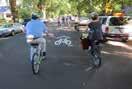
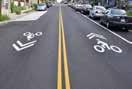
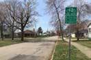
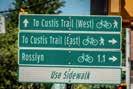
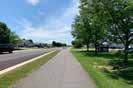
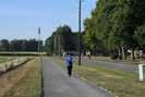
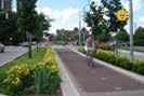
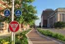


BICYCLE ROUTE - a suggested route to get to a specific destination designated by signage only.
BIKE LANE - a portion of the roadway that has been designated by striping, pavement markings and signs for preferential or exclusive use for bicyclist.
SIDEWALK - the portion of a street right-of-way designed for use by pedestrians and bicyclists.
SHARED LANE - shared lane for vehicles and bicyclists with “sharrow” symbol to indicate route.
PAVED TRAIL NEXT TO ROAD - a pathway separated from motorized vehicular traffic for use by pedestrians, bicyclist, joggers, wheelchair users, skaters, and other non-motorized users.
URBAN TRAIL - a pathway made of pavers or concrete separated from vehicular traffic for use by pedestrians, bicyclists, joggers, wheelchair users, skaters, and other non-motorized users.
MEETING #2 - BOARD COMMENTS
Ingalls Bicycle and Pedestrian Master Plan
Proposed Facilities Map
Did we miss anything? If so where would you like to see a pedestrian or bicycle facility.
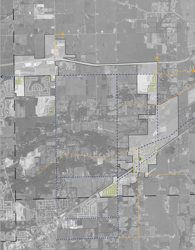
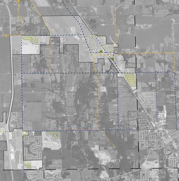
Ingalls Bicycle and Pedestrian Master Plan
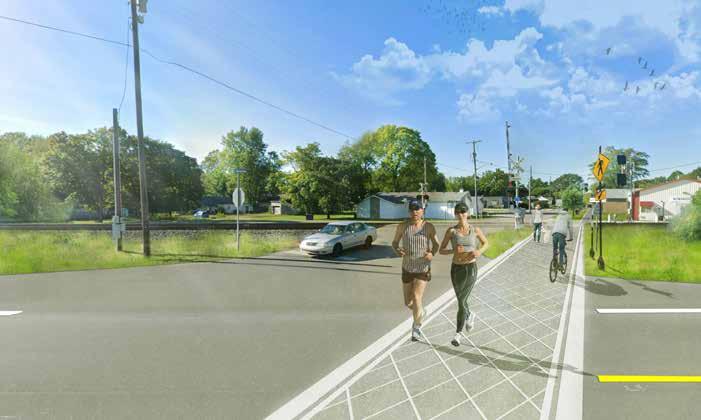
Ingalls Bicycle and Pedestrian Master Plan
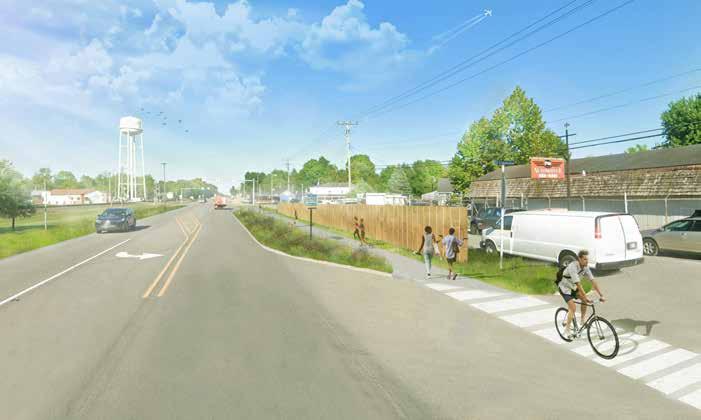
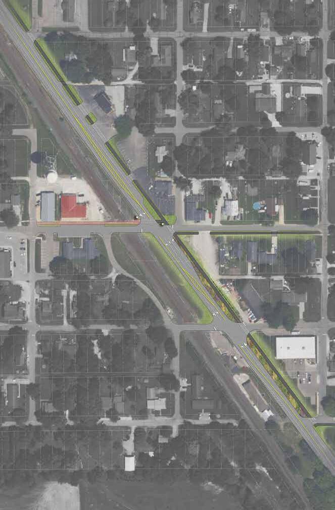
COMMUNITY SURVEY
Ingalls Bic yc le and Pedestrian M aster Plan
Q 1 How import ant t o you or your f amily is t he goal of creat ing more bicycle and pedest rian f acilit ies in I ngalls?
Q 2 How of t en do you run/ walk/ bike in f air weat her now f or t ransport at ion or recreat ion (select one)?
5+ t imes per week
Few t imes per mont h Nev er
Ingalls
Ingalls Bic yc le and Pedestrian M aster Plan
Q 3 How of t en do you run/ walk/ bike in cold weat her now f or t ransport at ion or recreat ion (select one)?
Bic yc le and Pedestrian M aster Plan
Q 4 W ould you run/ walk/ bike more of t en if you were closer t o bike and pedest rian f acilit ies (sidewalks, paved t rails, bike lanes)?
Ingalls
Ingalls Bic yc le and Pedestrian M aster Plan
Q 5 F or what purposes do you walk/ bike most now? (Rank Top 3)
Co nnect ivit y t o s ur r o undi
Co mmunit y-buil d
Q 6 W hat would be t he most import ant benef it s and uses of a complet e syst em of paved t rails, sidewalks and bike lanes? Select all t hat apply
Habit at and env ironment al improv ement s E c onomic s t imulat ion
Trans port at ion t o work or running errands (groc ery et c )
Ot her (pleas e s pec if y )
E duc at ion (int erpret iv e s ignage)
Q 7 W hat dest inat ions would you most like t o get t o by bike/ f oot ? Rank Top
Q 8 Are t here ot her places t hat you f eel are import ant t o connect t o t hrough sidewalks, paved t rails and bike lanes? A ns wered: 13 S k ipped: 37
# RE S P ONS E S
1
2
3 No 3/ 1/ 2023 5: 13 P M
4 pos t of f ic e lot and RR c ros s ing uns af e 1/ 11/ 2023 10: 57 A M
5 no 11/ 29/ 2022 2: 34 P M
6 B ank s , ot her s ubdiv is ions
7
8 No
9
10 No 11/ 16/ 2022 5: 43 P M
11 I t hink t he whole idea is a was t e of t ax pay er money - t here’s ot her t hings t o c ons ider ! ! ! 11/ 16/ 2022 4: 02 P M
13 S ome wa y f or k ids and adult s t o get ac ros s P endlet on pik e s af ely f rom bot h s ides of t own 11/ 16/ 2022 11: 01 A M
/ 1
Lac k of s idewalk s and t rails
Uns af e c ros s ings
Traf f ic
P edes t rian unf riendly s t reet s
Lac k of int eres t A ggres s iv e mot oris t behav ior
Lac k of t ime
Lac k of nearby des t inat ions
Run-down s idewalk s P ers onal s af et y c onc erns
S
Q 11 W hat are your most desired bicycle rout e t ypes? Please select t op 3
Ingalls Bic yc le and Pedestrian M aster Plan
Q 12 W here would you like t o see capit al f unds f or bicycle and pedest rian f acilit ies f ocused? (rank in order wit h 1 being t he most import ant )
Ingalls Bic yc le and Pedestrian M aster Plan
Q 13 Are t here specif ic issues or problems wit h sidewalks and pat hs wit hin your neighborhood?
A ns wered: 23 S k ipped: 27
# RE S P ONS E S
1 B rok en up walk way s , poorly light ed, t oo c los e t o peoples y ards (meridian s t , Lee Orr res idenc e t he dogs in f enc ed y ard at t ac k when y ou t ry t o walk on s idewalk ) 3/ 4/ 2023 6: 25 A M
2 They don’t ex is t in my neighborhood 3/ 2/ 2023 6: 37 P M
3 The lac k t here of 3/ 1/ 2023 8: 42 P M
4 There aren t any 3/ 1 / 2023 5: 13 P M
5 lac k of 1/ 11/ 2023 10: 57 A M
6
7 Current ly we hav e no s idewalk s in our neighborhood
8 There are no s idewalk s 12/ 2/ 2022 3: 35 A M
9 no 11/ 29/ 2022 2: 34 P
20 General lac k of s idewalk s and t rails
#
2
3
4
5
6
8
Q 14 Are t here specif ic issues or comment s pert aining t o walking and biking in I ngalls t hat you would like t o share?
e t o in t own f or s hopping or ot her needs 11/ 28/ 2022 9: 21 P M
9 Do not need a bik e lane To c los e t o t raf f ic 11/ 28/ 2022 6: 53 P M
10 Connec t ing des irable loc at ions would be a huge benef it if done well 11/ 28/ 2022 6: 38 P M
11 Cros s ing S t at e Road 67 is uns af e I t would be nic e if t here were a pedes t rian bridge or t unnel May be a pedes t rian s t op light or roundabout 11/ 28/ 2022 6: 22 P M
12 You hav e t o us e t he roads in mos t plac es 11/ 28/ 2022 4: 12 P M
13 The t hings in t his s urv ey 11/ 28/ 2022 12: 30 P M
14 I don’t I dent if y 11/ 28/ 2022 10: 10 A M
15 No 11/ 16/ 2022 5: 43 P M
16 Uns af e c ros s ings wit h t he railroad and S R 67 11/ 16/ 2022 3: 40 P M
17 Very bus y h ighway s run t hrough part s of I ngalls New dev elopment s only add t o t raf f ic 11/ 16/ 2022 10: 56 A M
Q 15 W hat is your gender?
Ingalls Bic yc le and Pedestrian M aster Plan
Q 16 W hat is your age?
Ingalls Bic yc le and Pedestrian M aster Plan
Q 19 Do you own a bike?
A ns wered: 49 S k ipped: 1
Ingalls Bic yc le and Pedestrian M aster Plan
Q 20 How many in your household run/ walk/ bike?
Ingalls Bic yc le and Pedestrian M aster Plan