3 minute read
Thierry Dupradou, Cartografía visual del territorio

THIERRY DUPRADOU
FR / CL
Advertisement
CARTOGRAFÍA VISUAL DEL TERRITORIO
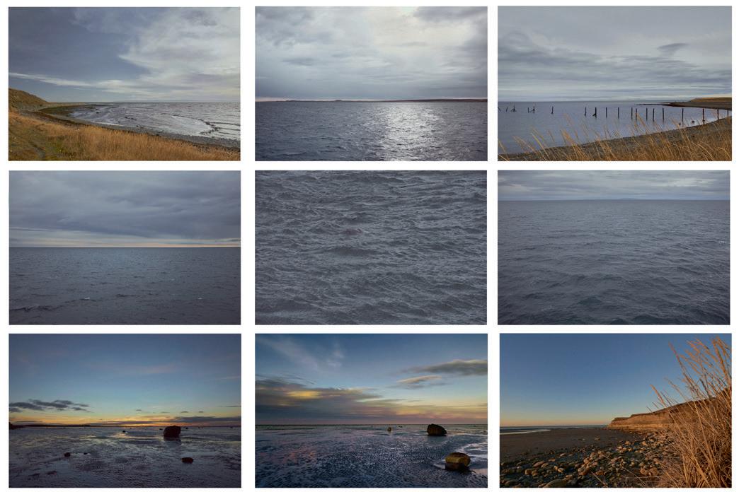
Thierry Dupradou, en estas imágenes tomadas por toda la Región de Magallanes y la Antártica Chilena, elimina los horizontes y el contorno preciso de las formas, para centrarse en los detalles casi abstractos, en los dibujos caprichosos de la geología y la vegetación, acercándonos a la esencia de ese medio, a la mirada de quienes lo habitaron y obtuvieron de él, gracias a un conocimiento minucioso de todos sus pliegues, los recursos necesarios para vivir en simbiosis con él durante milenios.
–
VISUAL CARTOGRAPHY OF THE TERRITORY
Thierry Dupradou, in these images taken throughout the Magallanes Region, removes the horizons and the precise contour of the forms, to focus on the almost abstract details, on the whimsical drawings of geology and vegetation, he brings us closer to the essence of that environment, to the gaze of those who inhabited it and obtained from it, thanks to a meticulous knowledge of all its folds, the necessary resources to live in symbiosis with it for millennia.
Serie de 12 fotografías / Series of 12 photographs 40 x 40 cm c/u. 2012 - 2015
De izquierda a derecha y de arriba a abajo: Contexto de un liquen Nephroma antarcticum Pinturas rupestres Textura del liquen Caloplaca digitaurea Enfoque textural de un bosque archipelágico austral Espejo costero de un canal magallánico Pinturas naturales de líquenes antárticos Composición de turbas y su flor Humedales de turberas fueguinas Glacial artificio en un archipiélago austral Artificia otoñal de un bosque fueguino Pozo de agua en la turbera Esquema de una turbera patagónica From left to right and from top to bottom: Context of a lichen Nephroma antarcticum Rock paintings Texture of lichen Caloplaca digitaurea Textural approach to an Austral archipelagic forest Coastal mirror of a Magellan channel Natural paintings of Antarctic lichens Composition of peats and their flower Fuegian peats wetlands Glacial artifice in an Austral archipelago Autumnal artifice of a Fuegian forest Waterhole in the peat Scheme of a Patagonian peat
THIERRY DUPRADOU
FR / CL
CARTOGRAFÍA VISUAL DEL TERRITORIO El faro, el viaje y el naufragio
El fotógrafo Thierry Dupradou ha recorrido con su cámara la pampa magallánica, el estrecho de Magallanes y sus canales adyacentes, la Isla Grande de Tierra del Fuego, el cabo de Hornos y la Antártica. Su objetivo era descubrir el patrimonio de la Patagonia –natural, paisajístico, cultural y científico– y mostrarlo en su belleza extrema y un poco descarnada. Para ello, el artista tuvo antes que “vivir” ese territorio, en su grandeza y en su dureza: horas o días de caminatas difíciles por los cerros más altos y panorámicos y los parajes más expresivos y recónditos o de esperas en busca de la luz precisa, el estado adecuado de la atmósfera, como él dice, “de la furia o la calma”.
–
VISUAL CARTOGRAPHY OF THE TERRITORY The lighthouse, the journey and the shipwreck
The photographer Thierry Dupradou has traveled with his camera the Magellan pampas, the Strait of Magellan and its adjacent channels, the Isla Grande de Tierra del Fuego, Cape Horn and the Antarctic. His objective was to discover the heritage of Patagonia –natural, scenic, cultural and scientific– and show it in its extreme beauty and a bit stark. For it, the artist had before to “live” that territory, in its greatness and hardness: hours or days of difficult walks through the highest and most panoramic hills and the most expressive and remote places or of waiting in search of the precise light, the proper state of the atmosphere, as he says “of fury or the calm”.
Tríptico de fotografías, 35 x 160 cm c/u El faro 2012 - El viaje 2015 - El naufragio 2018 Triptych photography, 35 x 160 each photograph The lighthouse 2012 - The journey 2015 - The shipwreck 2018