
PARAGON OF A POROS(CITY)
DEVLOPEMENT OF A COASTAL PROMENADE & CULTURAL HUB


“Stretched into the Arabian Sea – lies Bombay a great metropolis”
- Charles Correa
Water is an important defining element of settlements across the world and can be traced back through a city’s historical structure and morphology. The relationship between a city and its waterfront is unique and always changing, depending on the functions carried out on adjoining land.
The city of Mumbai sings out two things – the sea and its monsoon. The essence of the city is its vast coastline on all sides, combined with various rivers and creeks making a lot of water edges prominent in it.


To establish an understanding of various associative factors relating to the land water edges and delve out issues faced by users in the present. To also consider the future issues projected and draw out a parallel to define a paradigm by proposing an architectural intervention at an urban level that affects the contextual setting of the land water edge, forming an image of the city through it.
OBJECTIVES
o To deploy a sectional view of the water – land interface, and understand how various intersections differ.
o To determine how development decisions played a role in the land water edge
o To analyse different land water intersections in the city of Mumbai, and draw a comparative between them.
o To determine the humanised aspect as well as a de human aspect of the edge.
These are relating to memories of a place or person, or experiences good or bad that have impacted us in a certain way. One important aspect in everyone’s life is the ‘Place’, either their place of livelihood or a place of relaxation or a native place.
o To understand different perceptions of people towards these edges –analyse the needs and issues from their perspectives


o To study solutions – both nature based as well as technological to pose an intervention to solve these.
o To propose a program as a solution against the issues – that would humanise the edge and increase the public dialogue with the sea.
BOMBAY MUMBAI
Extensive reclamations

Aim to colonize to make Mumbai a port city

Aim to increase trade
Land use patterns defined Efforts to agglomerate

Develop routes & networks
Set forth boundaries
What a journey has the city seen, from Bombay to Mumbai, throttling at a speed that waits for none, and just grows. It is evolved into a beauty from seven separate island pieces to a conglomerate that is today one of the most prominent and strongest city in the world.
The city has always had a major advantage of being a peninsula, surrounded on three sides by water. It was the only form of major transport at that time, thus having it on all sides could help it develop into a major port for the country.
The left maps symbolize the evolution of associations throughout the decades. It shows how the original seven islands were displaced from one another with water inlets making their way in and out. Until the British invasion, they began reclaiming in the 1700’s.

COMPARATIVE ANALYSIS OF LAND WATER EDGES OF MUMBAI
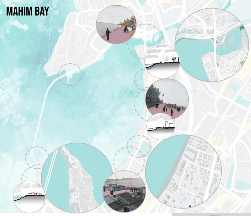
Marine Drive Haji Ali Coast Mahim Bay Bandra bandstand Colaba
There is a strong visual connection, which gives a good experience for sitting and walking. It is also a limitation a rigid boundary and make the water seem far away. No other kind of activities except recreational happen here. In the past lot of public events took place, it has somehow lost its humanising aspect and is limiting interactions. The permeability of change is very less, adversely affected in monsoons, no provisions for run off of no shelter for people to go to.
This edge is bustling with people all year round, but only a specific user group. It is not perceived as a holistically developed edge. Although it has a similar nature as Marine Drive there aren’t people who would come and sit at the edge of this site. The observation was the seawall height was quite low as compared to other edges A lot of fisher boats are also lined on the side of the walls, to probably form an ease in pushing into water
The centre of the city, this area is frequented by a lot of users. The interfaces are changing constantly. They change and evolve with time and seasons. The users & activities also vary accordingly. This edge has a direct connect to the water without a defining boundary. The informal settlements or the beach connects directly without walls blocking, thus making a connection more felt


This edged has developed a lot throughout the years. From being a poorly maintained open space that no one used, to today showing how a collective of people can design a connect with the sea and land and flourish. The entire promenade steps down into the rocky shore, this creates intercepts of tide pools when the tides change It is inhabited with all kinds of people from old to young meeting regularly It is a responsive edge to the landscape and respecting the ecosystem, the users and the built neighbourhood.
Being one of the oldest parts of the city, the heritage value of every parcel of land is accounted for. This leaves little room for interaction of users and the edge in most parts. The rest is not maintained well to create a holistic development. The fishing docks are extremely old, which directly open out the city’s tip into the Arabian Sea, but the area therefore is very confined to only them This edge has immense potential to create a strong city identity by carefully developing it.
Conclusion of research
SEA LEVEL RISE & COASTAL FLOODING

● Sea level rise has become a major concern for coastal cities due to the economic and cultural importance tied to their proximity to water.
● Mumbai’s maximum city, is sitting on reclaimed land and will be at the forefront when it comes to global warming impact in the region.
● This situation is aggravated by the manmade geography; as in Mumbai; large areas of the land are reclaimed.
● The main reason of flooding in Mumbai is its geography, both natural and manmade. The city’s location leaves it exposed to heavy rainfall during the monsoon.
A PLACE in the city by the sea,
A PLACE to feel calm and free,
A PLACE To unwind and pause.
A PLACE to conserve and prevent loss,
A PLACE to awaken and to fight a cause.
A PLACE to protect and to collect,
A PLACE to think and to reflect.
• Providing public access

• Strengthening the visual access
• Improving the visual quality of the water, coast and the neighbouring developments


• Creating and ensuring a sustainable unique identity throughout the waterfront
• Using the advantages of water
• Compliance of public access with positioning, design and management strategies
• In the realization of development objectives for waterfront, cooperation of public and private enterprises, civil society organizations and the public


