PARAGON OF A POROS‘CITY’
By PRIYAL NIMESH VANDANA PAREKH
GUIDED BY Ar. Rohit Shinkre
A Dissertation submitted in partial fulfilment
Of the requirements for SEM-IX
The Degree
BACHELOR OF ARCHITECTURE
MUMBAI UNIVERSITY MUMBAI, MAHARASHTRA.
5TH YEAR, SEM-IX, BARD 911, DEC’2020
Conducted at: RACHANA SANSAD’S
ACADEMY OF ARCHITECTURE, UN-AIDED COURSE
RACHANA SANSAD, 278, SHANKAR GHANEKAR MARG, PRABHADEVI, MUMBAI 400025.

A P P R O V A L C E R T I F I C A T E
The following Under-Grad Design Dissertation Study is hereby approved as satisfactory work on the approved subject carried out and presented in a manner sufficiently satisfactory to warrant its acceptance as a pre-requisite and partial fulfilment of requirement to the 5th Year Sem IX of Bachelor Of Architecture Degree for which it has been submitted.
This is to certify that this student Priyal Nimesh Vandana Parekh is a bonafide Final Year student of our institute and has completed this Design Dissertation under the guidance of the Guide as undersigned, adhering to the norms of the Mumbai University & our Institute Thesis Committee.
It is understood that by this approval and certification the Institute and the Thesis Guide do not necessarily endorse or approve any statement made, opinion expressed or conclusions drawn therein; but approves the study only for the purpose for which it has been submitted and satisfied the requirements laid down by our Thesis Committee.
Name of the Student: Priyal Parekh
Date: 13th December 2020
Approved By Principal Ar. Prof. Rohit Shinkre College Seal
By Thesis Guide Ar. Prof.
Shinkre Certified Seal
By External Examiner-1 External Examiner-2 ( ) ( )
Certified
Rohit
Examined
DECLARATION
I hereby declare that this written submission entitled “Paragon of a PorosCity” represents my ideas in my own words and has not been taken from the work of others (as from books, articles, essays, dissertations, other media and online); and where others’ ideas or words have been included, I have adequately cited and referenced the original sources. Direct quotations from books, journal articles, internet sources, other texts, or any other source whatsoever are acknowledged and the source cited are identified in the dissertation references.
No material other than that cited and listed has been used.
I have read and know the meaning of plagiarism* and I understand that plagiarism, collusion, and copying are grave and serious offences in the university and accept the consequences should I engage in plagiarism, collusion or copying.
I also declare that I have adhered to all principles of academic honesty and integrity and have not misrepresented or fabricated or falsified any idea/data/fact source in my submission.
This work, or any part of it, has not been previously submitted by me or any other person for assessment on this or any other course of study.
Signature of the Student

Name of the Student: Priyal Nimesh Parekh Exam Roll No: 2092UBARC030F
Date: 13th December 2020 Place: Mumbai
*The following defines plagiarism: “Plagiarism” occurs when a student misrepresents, as his/her own work, the work, written or otherwise, of any other person (including another student) or of any institution. Examples of forms of plagiarism include: the verbatim (word for word) copying of another’s work without appropriate and correctly presented acknowledgement; the close paraphrasing of another’s work by simply changing a few words or altering the order of presentation, without appropriate and correctly presented acknowledgement; unacknowledged quotation of phrases from another’s work; The deliberate and detailed presentation of another’s concept as one’s own.
“Another’s work” covers all material, including, for example, written work, diagrams, designs, charts, photographs, musical compositions and pictures, from all sources, including, for example, journals, books, dissertations and essays and online resources.
I am grateful, for this opportunity to be able to do this thesis with utmost passion, which would not be possible without the following.
The guidance, insightful discussions & questions of my guide Ar.Prof.Rohit Shinkre
The support of Harshada ma’am and Tushar sir has also been a guiding light.
The strength Apurva ma’am gave me throughout my architectural journey.
My mum for her creative genes and everything she ever does for me.
My dad for believing in me, pushing me & finding his dreams in mine.
My grandparents for all the wise words and blessings.
My friends and family for their motivation throughout.
Lastly, to my Dadi who is smiling somewhere
I will be thankful to all of you eternally, for giving me the drive & vigor to achieve this.
Thank you.
A C K N O W L E D G E M E N T S
Paragon of a Poros‘CITY’
A story of Mumbai through the lens of its water edges

I. THE PROLOGUE
1. Preface 2 2. Abstract 3 3. Keywords 4
II. THE QUEST
1. Aims & Objectives 5 2. Architectural Questions 6 3. Methodology 7
III. THE PERSPECTIVES
1. Chapter 1 – Looking into the PAST 1.1History of Mumbai Literature Review - Gazetteer of Bombay 12 1.2 Mumbai’s Water Terrain Literature Review – Soak 15 1.3 City on the Water 18 1.4 Interviews with experts (Dilip da Cunha, Debi Goenka, Roberto Rocco) 19 1.5Perspectives 22 1.6Inferences
2. Chapter 2 – Delving in the PRESENT 2.1Qualities water adds to an edge 25 2.2 Power of a waterfront in urban environment 27 2.3Understanding the land water edge 30 2.4Duality of the edge 31 2.5Publicness and water edge 33 2.6The Urban Transect Method 35 2.7Architectural response to land water edges in India 37 2.8Analysis of various cities 40 2.9Living with Water – Humans & water relation 49 2.10 Multisensory human experience at water edge 53 2.11 Associations & Human perception 55 2.12 Types of coastal edges 58 2.13 Di (section) of Mumbai’s terrain i. Edges considered 63 ii. Mapping out various edges 65 1. Marine Drive 68 2. Haji Ali 71 3. Mahim Bay 75 4. Bandra Bandstand 79 5. Colaba 83
C O N T E N T S
3. Chapter 3 – TRIGGER - the Issue 3.1The impact 91 3.2Sea level rise 93 3.3Susceptibility Of Mumbai 94
iii. Observations 87 iv. Intentions 90
3.
5.
4. Chapter 4 – Reflection of the FUTURE 4.1Edging towards solutions 97 4.2Blue Green infrastructure 99 4.3Micro to macro level intervention 101 4.4Adaptive strategies against flooding I.Nature Based Strategies 104 II.Foundation 107 III. Structures 108 IV. Material Resistance 109 4.5Case studies 1. The Cove 111 2. Little Island Project 113
Resilience by Design 115 4. Jellyfish Barge 117
City Apps 119 CONCLUSION 122
1. Scope
2.
3.
4. CRZ
5.
6. Case
IV. THE POSSIBILITIES
124
Towards an architecture intervention 125
Selected site 127
norms 129
Proposed program 130
studies 131
1. Conclusion
2. Bibliography
3. References
4. List of figures
Appendix
V. THE EPILOGUE
136
137
138
/
139
1
PREFACE
Water is an important defining element of settlements across the world and can be traced back through a city’s historical structure and morphology. The relationship between a city and its waterfront is unique and always changing, depending on the functions carried out on adjoining land.
The city of Mumbai sings out two things – the sea and its monsoon. The essence of the city is its vast coastline on all sides, combined with various rivers and creeks making a lot of water edges prominent in it.
Often we ponder about ‘what ifs’, how a particular thing would have been if certain events did not happen. We definitely we cannot change them now, yet we try to shuffle and adjust between these. These are relating to memories of a place or person, or experiences good or bad that have impacted us in a certain way. One important aspect in everyone’s life is the ‘Place’, either their place of livelihood or a place of relaxation or a native place. A city, where millions toil & live, even more aspire to come, where even more create their aspirations into reality – Mumbai. Through centuries Mumbai has seen growth in all forms of infrastructure. From its economic infrastructure to social to colonizing land leading increase in grey infra, but in this the Blue-Green infrastructure have taken a hit in some way or the other. A compromise, in order to grow the socio-economic scene, the green spaces and water edges got neglected. Our development over decades has not respected these elements enough, and its high time since just in a few decades we will pay the repercussions will be much bigger and combating these issues will be almost impossible if not acted now.
Mumbai has a list of factors that make it how it is today, majorly the reclamation of the seven islands into one is what helped its growth so rapidly. Today studies show, in a few decades down the line the city is on the threat of coastal flooding to an extent to make the city like separate islands in water once more. This research will further talk about the city, through its own perspective a journey through the past - present and future, but all in respecting the aqueous edges
2
H E P R O L O G U E
T
ABSTRACT
The architecture for water transcends time and space in its proliferation across geographies and cultures. These unique and diverse structures articulated the anthropogenic relationship to water, seamlessly weaving in the spiritual with the mundane.
This book proposes that the architecture for water represents an ecosystem of entities forming a network of relations, perceptions and associations with water. The research tries to understand these networks and links. The potential needs to be realised to act upon, to prevent these edges from becoming obsolete, and informal. A revitalisation process needs to begin through this research which aims to tie these and pose a possible outcome to sustain in the future. This research is looked at in the contextual framework of urban scenario of the city of Mumbai, which is essentially a coastal city, but in the realm of infrastructure is losing out on its natural entities. This research aims to recognise these qualities that can bring out spatial and experiential narratives through place making power of a water edge. They must be ecologically and spatially coherent and responsive to a humanised scope.
Ebb & Flow
(By Priyal Parekh)
I am the giver of all birth, every organism on this Earth, is a part of me in disguise, yet why is it me you despise?
I constitute half of every living, aid create the non-living, yet why do you overlook my quality of giving?
In every shape and form I remain versatile, yet toward me it’s you humans who are hostile?
An indispensable cycle I follow, it contains of precipitation condensation and my ebb and flow, throughout these I help you grow.
I hide my tears in my bountiful expanse, rather I take you to a place of tranquil and trance.
In return a small request is what I pose, respect me as much as the motherland you chose.
I promise to not be the enemy you see, but a boon till eternity.
3
KEYWORDS (Definition of words in relation to this dissertation)
Edges - Edges are the linear elements not used or considered as paths by the observer. They are the boundaries between two phases, linear breaks in continuity: shores, railroad cuts, edges of development, walls.
Ubiquitous - seeming to be everywhere or in several places at the same time. The quality of water to be present in every place in different forms of precipitation and levels of wetness
Transect - The urban-to-rural transect is an urban planning model created by New Urbanist Andrés Duany. The transect defines a series of zones that transition from sparse rural farmhouses to the dense urban core. Each zone is fractal in that it contains a similar transition from the edge to the centre of the neighbourhood.
Porosity - is the volume of pores relative to the total space, and it's a good measure of how much water the ground can hold.
Place making - a multi-faceted approach to the planning, design and management of public spaces. Place making capitalizes on a local community's assets, inspiration, and potential, with the intention of creating public spaces that promote people's health, happiness, and well-being.
Intertidal - of or denoting the area of a seashore which is covered at high tide and uncovered at low tide
Water urbanism – it is an innovative approach to design practice and pedagogy that holistically joins the study of social and physical infrastructures, public health, and hydrological systems. Water Urbanism posits that water and cities must be understood within an expanded notion of a constructed ecosystem.
Blue infrastructure - It refers to urban infrastructure relating to water. Blue infrastructure is commonly associated with green infrastructure in the urban setting and may be referred to as "blue-green" infrastructure when in combination.
4
AIM
To establish an understanding of various associative factors relating to the land water edges and delve out issues faced by users in the present. To also consider the future issues projected and draw out a parallel to define a paradigm by proposing an architectural intervention that affects the urban setting of the land water edge, forming an image of the city through it.
OBJECTIVES
o To deploy a sectional view then a plan view of the waterbody – land interface, and understand how intersections differ.
o To determine how development decisions played a role in the land water edge
o To analyse different land water intersections in the city of Mumbai, and comparatively differentiate between them.
o To determine the humanised aspect as well as de human aspect of the edge.
o To understand what is retained, what is proposed? What is changing? What needs change? All near the water edges of the city
o To understand different perceptions of people towards these edges – analyse the needs and issues from their perspectives
o Study human and environment responses to calamities like flooding
o Analyse data maps on issues of these areas – 1. Altitude 2. Sea level increase mark 3.Year projection 4. Risk zone map 5. Risk data analysis 6.Proposed land use
o To study solutions – both nature based as well as technological to pose an intervention to solve these.
o To propose a program as a solution against the issues – that would humanise the edge and increase the public dialogue with the sea.
5 T H E Q U E S T
ARCHITECTURAL QUESTIONS
Primary Questions –
1. How do people perceive an edge of land and water in the city?
2. What is the experiential and spatial quality of various edges in the city, what way does it impact the overall fabric?
3. How to assess the issues faced in these different ecological realms of the city?
4. What architectural intervention can be proposed to create an urban paradigm in the city for combating the issues assessed?
Secondary Questions –
1. Why do we draw a border between land and water that defines perceptions of only land as habitable?
2. Is the cartographic conventional mapping practice justified to understand the quality of understanding the estuarial nature of Mumbai?
3. Can an architectural intervention be made with adaptive biotechnologies or nature based solutions, which is a better solution?
4. How will nature claim back its pieces in the city, how can users be equipped for it?
6
METHODOLOGY
Delving from the past of the city to the future, this research is a bridge to understand the land and water edges of the city and make use of adaptive bio solutions to cope with the forthcoming problems. It is a futuristic approach to the city addressing a serious concerns that are rising in the urban fabric of the major metropolitan city.
It is a culmination of data showing the issues and impacts that will raise the load on urban area in upcoming decades. Architecture that is not only responsive but resilient and symbiotic with all the elements of the Earth. To give nature what is rightfully it’s and claim our space and make our place because there is no planet B.
The book will be divided into three POVs - Past, Present Future. The latter holding the most important in design forward.
1.
The Past - Point of View
Suggestively this chapter is the literature review of all that has been written about Mumbai and its relation of built, in sync with the water terrain of it. A historical analysis from books, articles, essays and drawings of the city’s development.
2.
The Present Point of View

This is the chapter which describes today’s developments in the city. The urban and environment connect. It will include the main issue of study. All firsthand interviews and data is necessary for this part, which will convince why it is the need for the future.
3.
The Future Point of View
This is the most technical part of the book, including inferences of all culminated data. It will be a projection on the adaptive technologies we need to adapt and the changes we need to make to be able to sustain the catastrophe. It highlights this kind of practice called Archi (Bio) tecture which is symbiotic style of design that includes adapting biotechnologies and biomimicry to create a sustainable and dependable future.
7
Three parts of architecture – 1. Site 2. People/User 3. Structure All of these aspects are prioritised and linked in this dissertation in the following ways.
1. Site – Context of Mumbai
Looking at the urban metropolis of the city of Mumbai, the dissertation talks about a site specific approach through the edges of land and water in the city. This is done by intensive mapping of various factors these different edges. A comparative analysis as well as comprehensive inferences are made. Furthermore after analysis and detailing out five specific edges, it is narrowed down to two which have the highest potential and requirement.
2. User – People using the various edges of the city
The relation of water and civilisations is what connects our past into the present. This is associations of various religions, traditions, cultures and personal memories of spaces with water edges. These qualities are mapped out and compared for different sites. The way different associate and use this edge in various contexts is extremely different. Potential is tried to be marked out from this as well to furthermore. Their needs for space and the quality of place making of water are what go hand and hand to create a proposal.
3. Structure – Resistant and inclusive technological responses
Taking various issues like flooding, monsoon waterlogging, runoff wastage and sea level rise as future triggers, the need arises to create something that would combat these. Architecture that is inclusive, and not sustaining but resilient to these as well helps positively pose solutions is what is aimed at. This architectural intervention involves the need for use of new adaptive strategies and technologies. Two lenses of technological advancements as well as selfsustenance can be taken as study measure. In accordance to the requirements of the function and responsiveness of the site a couple of the strategies will be designed in the proposal trying to pose as a paradigm for buildings to follow for a step towards a more blue and green future.

8
9
LOOKING THROUGH THE P A S T

10
11
1.1 HISTORY OF MUMBAI
A famous quote goes by saying “Mumbai is my heart, Bombay is my soul.”
Oh what a journey has the city seen, from Bombay to Mumbai, throttling at a speed that waits for none, and just grows. It is evolved into a beauty from seven separate island pieces to a conglomerate that is today one of the most prominent and strongest city in the world.
It has always been described as an archipelago, from historic times it was always chanced on. The Magadha Empire of King Ashok is assumed to be the oldest settlers in Mumbai, who left behind the Koli (fishermen) community, and various temples and stone carvings. One of which the Mumba Devi Temple, on which the city soon seem to be named. Bombay changed hands from many dynasties and rulers, the oldest structures in the archipelago the caves at Elephanta, and part of the Walkeshwar temple & Banganga Tank probably date from this time, are still present today.
“On the other side of the great inlet to the sea is a great point abutting against Old Woman's Island, a rocky woody mountain which sends forth long grass. Atop of all is a Parsee tomb, lately reared: on its declivity, towards the sea is the remains of a stupendous Pagoda near a tank of fresh water (Walkeshwar) which the Malabars visited it mostly.’ – Description of Banganga Tank.” – Gazetteer of Bombay, 1909
The seven islands were – Colaba, Little Colaba, Bombay, Mazgaon, Mahim & Parel namely. They started developing on their own, little trades flourished on the coasts, sea transport becoming one of the most important then. Soon the reclamations began when they transformed the archipelago into one landmass. The ecological boundary of Bombay being formed as the beautiful interface of land and sea, with many rivers and creeks making their way through the topography.

“In the north and east large schemes of reclamation have similarly shut out the sea anti partly redeemed the foreshore for uses. In the extreme north of the island a large tract of salt marsh still remains unclaimed. Old Marathi documents and the statements of early European writers have proved that Bombay originally consisted of several separate islands, which remained practically unaltered in shape until the eighteenth century. During the era of later Hindu and Muhammadan sovereignty, the two southernmost islands, afterwards named Colaba and Old Woman's Island, formed a broken tongue of rocky laid marked by a few fishermen's huts and divided from the third Island by a wide strait of considerable depth at high tide.” – Gazetteer of Bombay, 1909
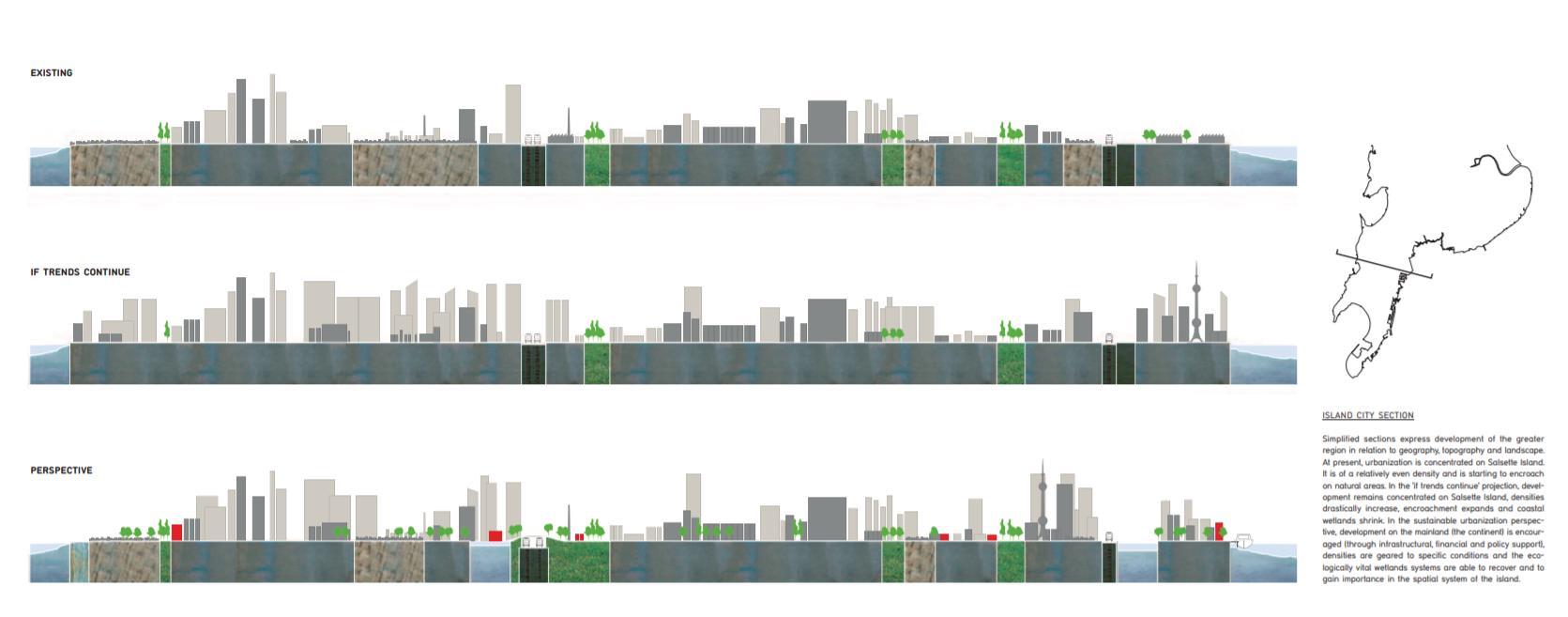
Fig 1. Mumbai development through the years
12
The city has always had a major advantage of being a peninsula, surrounded on three sides by water. It was the only form of major transport at that time, thus having it on all sides could help it develop into a major port for the country. The waters were known to be rich in biodiversity. Sea farers have seem to have spotted whales in its waters. This not only gave a boost to the Koli fishing community for trade, but also made the city an attractive spot for all. It expanded beyond limits to become the metropolis of Mumbai it is today, due to various trades that were boosted due to its geography.
“From time to time whales have appeared in the neighborhood of the island...In April 1906 a whale, 63 feet in length and apparently belonging to the Greenland species, drifted ashore at Bassein in the Thana District. Sea-snakes are common in Bombay waters, and prior to the building of the causeway, Colaba was famous for turtles.” –Gazetteer of Bombay, 1909
Fig 2. Fig 3.
Original seven islands of Bombay First Reclamation by British in 1700’s

The Bombay Dockyard, 1983, explains how Colaba Causeway was built in the mid1800s. Like the iconic Marine Drive, the Causeway was also born out of extensive reclamation.
“In the beginning of the 16th century Colaba was joined to the Island of Bombay by a ledge of rocks over which the sea water flowed. This channel was usually crossed in a ferry...In later times it became a pleasant residential quarter, but often at high tide...it became difficult to cross the channel. This inconvenience was at length overcome by the erection of a solid and handsome vellard with a footpath protecting the level and elevated road.” – Gazetteer of Bombay – 1909.
13
Soon after the Portuguese, the British East India Company settled in the islands of Mumbai. They documented the city during summers, and saw much more land. They began to reclaim land from the sea to join the masses of islands in a conglomerated land parcel. Historian Gyan Prakash calls it ‘‘Double colonization of Earth and sea.” This has us battling still every year when the monsoons being back to life the contours of the old archipelago. The rivers and sea comes back fiercely every year proving it will claim back it’s rightful. The British aimed this colonization as an economic gain aspect, to develop the city to a major port just like they had of Surat and Ahmedabad in those times.
“The island of Bombay should now no longer be considered a settlement of a separate colony but as the metropolis...of an extensive domain. For this island, only 20 miles in circumference and almost covered with houses and gardens, will soon become a city similar to the outer towns of Surat and Ahmedabad.” – Gazetteer of Bombay 1909.
Fig. 4
Fig 5.
Reclaimed land map 2000s connections Flood prone areas current map

The above maps symbolize the evolution of associations throughout the decades. Figure 2 shows how the original seven islands were displaced from one another with water inlets making their way in and out. Until the British invasion, they began reclaiming in the 1700’s (figure 2). The city grew and became one of the biggest trading ports of that times. The reclamations continued further north, making Bombay to Mumbai, one of the biggest metropolitan cities today. With this exponential growth, it came with its own set of problems, lack of infrastructure to support this led in lot of issues especially every monsoon it saw flooding. Figure 5 shows the overlaid old reclaimed map with the current flooding areas which takes us back to Fig. 2 the original seven islands are spared and most of the areas that get flooded are the reclaimed bits, which support majority of the city. This shows how nature will rightfully claim back what is rightfully it’s.

14
1.2. MUMBAI’S WATER TERRAIN
Mumbai a city that smiles at you at any realm of life. As inviting as she is, as endearing as she is, as empathetic she is, absorbs everything in her stride. Today she is a pride for the country. What more can be said about the splendour. The development from the seven islands to the megacity that it is today, a lot has already been written and said about the city. A peninsula or island city as it is called, is the highlight of this chapter. The water terrain of the city.
The book ‘Soak’ by architect-activists Anuradha Mathur and Dilip da Cunha, talks a lot about respecting the rich aqueous terrain of the city of Mumbai. They raise a question on our century long practice of cartography. An in-depth study from Mumbai’s first ever map to the recent ones is made by them, which shows a timeline of surveyors that took to make an accurate map of Mumbai. The city always had a changing terrain. The British who took to surveying the city, initially they even measured the water expanses between the seven islands as Bombay was known to be. Each developing connections in their own way. This is where the issue lies, they question why do we even draw this definite boundary between land and water everywhere? Why do we try to define only land as habitable? Is it all about land and land value and real estate? The practice of mapping shows as water a separate entity, and land as the valued possession.
“As designers we advocate approaches to water that accommodate rather than control its complicated nature approaches that do not position water as inevitably separate from land, as blue separate from brown. Water challenges us to consider ambiguity as a condition to embrace rather than erase. Water constructs a keen awareness of time through its absence and its presence; it draws us into a sectional world, an appreciation of depth.” – Interview for Places Journal by Anuradha Mathur & Dilip Da Cunha
The questions raised further are in numerable, is the element of water given as much respect in development? But we are forgetting one of the most important things, in the World Architecture Forum talks in Netherlands, Mathur said that water maybe somewhere, but wetness is everywhere. It is ubiquitous in nature, which is what we must be aware of. It creeps through cracks, it soaks, and it settles, it leaks, wetness is a quality that is not even understood properly today. How can we define such a transitional and abstract quality of water? Just maybe how we defined, how we made tough sea walls to push away the sea water, or how we mapped the boundary of a river to only limit between these two lines.
Is that all really true? Have we thought about how the landscape changed between monsoons to summer? They point out that on a rainy day we might not even see a boundary, that limited horizon line might just be a blur. This is the problem from centuries ago, none of the mapping practices ever thought to map a piece of land according to how the water landscapes change during monsoons. This is what has cost to so many cities losses through disasters like flooding etc. But water flows, it rises and falls, it seeps and soaks, it is stagnant, it forms ripples, it expands, it crashes into waves – it is a dynamic component. However we have made it into a static one that will only be defined with the line we draw it to follow, we think it is under our command to shape its nature.
15
“It takes a considerable effort to enforce firm ground anywhere, but it is particularly difficult to do so in an estuary, the primary ecology of Mumbai. Unlike deltas where rivers reach into the sea, estuaries allow the sea in. As such the rise and fall of the sea is not restricted to a coastline but is carried inland on a gradient that takes with it not just predictable tidal levels but the complexities of the world’s oceans where the unexpected reaches beyond the horizon and often beyond control. Here the war against the monsoon is also a war against the sea.”Soak
An estuary is the place where the river meets the sea, which means freshwater meets saltwater. This often forms the most fertile piece of land around it. Half of the city is filled with creeks and rivers that meet the sea at intervals forming an asset to the city, which remains unknown. Through their exhibition they tried to draw attention to this fact, that during the monsoon the city doesn’t flood but just becomes into the estuary it always was naturally. It is nature’s play of taking its form back. Of claiming her rightful territory.
‘An estuary demands gradients not walls, fluid occupations not defined by land use, negotiated moments not hard edges. In short it demands the accommodation of the sea not the war against it…’
Soak is an appreciation of an aqueous terrain. It encourages designs that hold monsoon waters rather than channel them out to sea; that work with gradient of an estuary; that accommodate uncertainty through resilience, not overcome it with prediction.’ – Soak

16
Fig. 7 Timeline from Bombay to Mumbai
Their experiences are documented through a series of sections and elevations of the city.
The most important aspect to mark water is the topography of the land, the slope is what defines its flow. Hence they map out the land parcels, and correspond the sections on it. The concurrence, of monsoon waters and land is what must be documented, this will be kind of like an eye opener to the public as well as planners, as well as the government. This would help solve a lot of future prediction catastrophes that we might face.
“Is this time of water and watery imagination a moment to re-invent our relationship with water? Is it a time to look to the past, present and future and ask if in seeing water somewhere rather than everywhere we have missed opportunities, practices and lessons that could inform and transform the design project? What role has representation and visualization played in confining water on terra firma? Can we look at projects in history and projects emerging today – cities, infrastructures, buildings, landscapes, artworks – with a cultivated eye for water that rains, soaks, spreads, and blurs?” –Design on the Terrain of Water
With Mathur and da Cunha’s sectional techniques and iterative process, there is an experiential richness and temporality that simple orthographic projections and remote imaging cannot convey. These are the processes that would help us design with water for future potentialities. They express that the experiential gain of walking around photographing and studying the sites, is something no drawing or book could explain.
Fig 8. Mumbai water narratives through a sectional lens

17
1.3 City on the Water - A movie by Charles Correa, 1975
This short film is a documentation of the city of Mumbai in 1975. It was created by pioneer architect Charles Correa. It is named correctly on Mumbai since 300 years ago seven islands were joined by the British to make a trading port, which made it from Bombay to Mumbai. This is was them planting the seeds for an extraordinary future.

It talks about how Bombay grew phenomenally, attracting people from all over the country, and staggering amount of initiative, energy and imagination anything new tech, in Asia came first to Bombay. Due to its magnificent harbour, it soon became one of Asia’s finest port. This city had soon turned into the ‘nerve centre of the nation’s economy’. All the growth of the city through the post-colonial era was through the harbour that Bombay hosted. All new technologies came to the country through this port city. Good skills services exchange through here.
Nearly half the revenue of India came from Mumbai. The mill lands started developing near the Eastern harbours where trade to occur easily. With expanses of Cotton Mills booming, the workers started needing settlements to live close by, thus they started living illegally near the mills, around stations, near waterbodies on empty lands.
From 1975 till today 2020, these settlements have just kept increasing, almost all land and sea edges are lined with slums occupying acres of land.
Figure 9. Ships docking in the Port

Figure 10. Girgaon Chowpatty beach
Figure 11. Floods in monsoon (1975)
The British had set patterns for development when they ruled, after they left those were not altered and continued. The Eastern edge of the city was reclaimed into the sea, stretching out far and wide and as the map developed it soon was defined, The western edge was almost untouched by the British, which stayed almost organic boosting with development till date!

18
“Stretched into the Arabian Sea - Bombay lies, a great metropolis”
INTERVIEWS
Interview with Dilip Da Cunha – Pennsylvania, USA
INTRO : Dilip da Cunha, an architect and planner, has taught at the University of Pennsylvania, Parsons School of Design and Harvard University. He is currently Adjunct Professor GSAPP at Columbia University. He and Anuradha Mathur have published various books - Mississippi Floods: Designing a Shifting Landscape (2001), Deccan Traverses: the Making of Bangalore’s Terrain (2006) and Soak: Mumbai in an Estuary (2009), and co-editors of Design in the Terrain of Water (2014). Da Cunha’s new book The Invention of Rivers: Alexander’s Eye and Ganga’s Descent was published by the University of Pennsylvania Press in 2019. Mathur and da Cunha are currently working on a book and exhibition titled Ocean of Rain.
Interview:
- Disagree with the history of Bombay, the story of seven islands is a farce. How do you count seven islands? If you think of the sea rising falling and breathing, if it defines a ground is not necessary the idea of islands. It is an estuary. Sea is not the only edge.
- Make a decision, you must give up the idea of an island, it is a plan driven view of land with a surface. Sea does not have surface, when the rain is falling is it on a surface? Sea becomes an entire part. Plan is a very land centric. The sea does not have an edge
- Hydrological phenomenon, sea is constantly evaporating, precipitating
- What is site? Not a geographic space, it becomes a situation in time?
- Challenge what is happening in Chow patty? I don’t see flood, I don’t see a Mithi River. These are constructions that came up in 2005, it is nallah not a river, created to some extent as an overflow to the reservoirs the British built. It came from the Earth, the water rose.
- Rain soaks the ground and rises.
- Give up the notion of an edge, a lands edge. How do you define the past will define the present. People are land centric. Extend the edge in reclamation
- In soak they say it is not an island, it is an estuary.
- Not talking about inhabiting a surface, but a zone of wetness – from clouds to aquifers, there is no surface.
- Many farmers live in an ‘ocean of rain’, don’t look at floating not as floating on a sea, but swimming in a depth of wetness
- Sea surface – in the language of land; language of water is wetness
- Chose – colonial past and post-colonial past? – Mumbai in an estuary
- Ganapati in Chowpatty – clay idols made with wetness. – Idols made from mud of tank bed, then immersed back in tank – clay to clay – cycle of wetness –different modes of water appreciation, drying of idol – can become a practice to focus on.
- Informal living in Bombay – the live with a wetness, fishermen’s dwelling – mud adobe hut. Ways to negotiate wetness – inhabiting the sea.
- I see the scope – we need to be more inventive how we will, a broader concern, embrace the flood.
19
- Interview people – give them the possibility of another way of looking at something – situations where you can draw fresh water from salt water
- Aquifers underneath – building a sea wall? Does not register the sea already is coming inside
- The sea does not have an edge, people would say there is a freshwater well in the middle of saltwater
- Construct an alternate vision, play out sections, rising and falling intensity of wetness
- The sea surface coming inside the city
- Rain does not have to exit from the city, there is a field of backwaters – a place where you have monsoon and the sea mixing, you can go out a mile in the sea and there would be freshwater
- A temporal phenomenon
- Estuary as a rain ecology – it is not the mouth of the river, but RAIN and TIDE.
- SEA + MONSOON = Rain Ecology
- Permeability – the water channel is obvious in section, not in plan. Section in depth from aquifers to clouds
After land and water, the old demon builds castles in the air. (The Hindu 15.09.18)
Interview of Dr.Roberto Rocco – Delft, Netherlands
INTRO: Roberto Rocco, PhD, Associate Professor of Spatial Planning and Strategy at TU Delft; Section of Spatial Planning and Strategy, Department of Urbanism in Netherlands. He is currently a faculty of Architecture and the Built Environment of the Delft University of Technology. He recently worked on editing the book titled – “The Routledge Handbook on Informal Urbanization”
Q: The Netherlands is a classic worldwide case study on Floating buildings and its response to the sea, do you feel it is the ultimate paradigm for hydrophilic sustainable design with water?
A: No, I think there are better solutions of designing with nature.
Q: Are callous construction techniques like land reclamation responsible for serious issues that cities are facing like coastal flooding?
A: No, they do not affect flood control in cities, but land reclamation can be very damaging for the environment (fauna and flora).
Q: For developing countries like India who are already combating with large problems, is this an investment of the present or should they act after a few decades?
A: It is more expensive to act after urbanisation has taken place. It is best to act now and prevent problems, designing with nature
20
INTRO: Debi Goenka an environmentalist, he is the Executive Trustee, Conservation Action Trust. He tries to spearhead the issues regarding the conservation and protection of the environment. He has pioneered several successful campaigns to protect the natural environment. Some of the most notable success stories have been the protection of mangroves, the protection of the Borivili National Park, Mumbai The Conservation Action Trust is a registered non-profit organization formed to protect the environment, particularly forests and wildlife.
Q. According to studies, the issue of rising sea levels is a major threat to coastal flooding in Mumbai, what other factors do you feel are contributing to this threat?1 response
A. The destruction of wetlands - mangroves, mud flats and salt pans. 2. Extraction of ground water and the construction of multi-storeyed buildings leading to sinking. 3. Continuing reclamation.
Q. Is Mumbai facing problems like flooding and loss of ecosystems due to callousness in development of urban infrastructure? For instance the land reclamation of the coastal road is it the reason for environmental damage?
A. Yes, very much so. Even the Bandra Kurla complex was built after destroying the mangroves.
Q This week Mumbai faced severe flooding and extreme loss of decade old trees falling from their roots, do you feel this will only worsen in the upcoming years? Is there any way to environmentally combat this problem? The only way is to stop the destruction of our natural assets, and decongest the city.
A. What part of Mumbai’s water ecosystem do you feel is the most adversely affected? Almost all our natural water bodies have been polluted, contaminated, filled up and destroyed.
Q. Could you suggest any possibilities of solutions that can be designed that can be used to rejuvenate our lost ecosystems and create a city with a great blue green infrastructure practice?
A. We should start with protecting what we have, and cleaning up what we have contaminated. We need to plant mangroves in areas where they have been destroyed such as the 500 acres of land off Malad Creek. We need to use our natural wetlands and constructed wetlands for sewage treatment.
21
Interview of Mr. Debi Goenka – Mumbai, India
1.5 PERSPECTIVES
The interviews with three professionals with tones of experience, gave a new perspective to looking at the water. Whereas some very radical views, and some eye openers they all are an important part of further analysis of this dissertation.
The perspective shown in ‘Soak’, iterated by the author himself Dilip Da Cunha is important in understanding the ubiquitous quality of water. If we look at it not like a boundary but a mingling of various ecosystems we would have far better solutions at hand. Whereas upcoming infrastructure is strongly declining what we already have, it’s time to act up. The countries like Netherlands who are the ‘water experts’ lived for years building sea walls and dykes but now experts there talks about adapting nature based solution strategies to adapt to the upcoming problems.
These interviews pushed me to find a middle ground, of how to increase the public connect to the sea, at the same time preserving and respecting it as much as land through solutions and strategies that benefit all.
1.6 ANALYSIS & INFERENCES:
o Trying to find solutions to not separate but include water in its most organic and natural way to create way for nature based solutions.
o Seasonal mapping, in the city during monsoon the landforms, and boundaries how different will our perspective be.
o The ubiquitous quality of wetness, how it surrounds us and how we try to avoid it whereas we must not make enemy of it, instead embrace as an opportunity for design.
o The importance of topography in understanding the flow of water, and how it cannot be imagined confined or restricted it.
o Importance of perception of experience of sectional observations of changes in tides, flows and seasons through documentation.
22
Figure 12. Sections of the city of Mumbai
23
DELVING IN THE P R E S E N T

24
2.1. QUALITIES WATER ADDS TO AN EDGE
Water is a prerequisite for life on our planet. Nothing can live without it. The history of water connects the cells of our bodies and all living creatures on earth to the oceans, rivers, icecaps, rain, and with water as it reliably pours out of the taps and, equally reliably, disappears down the drain. It moves, it flows it rises in highs and lows. The hydrological cycle of water is what defines the natural flows of almost everything.
Urban waterfronts are interface between city and water bodies of sea, river and lake. The host city maintains visual image as well functional characteristics of it.
Water is one of the most important elements of survival, and undoubtedly, for urban growth. And that’s why whenever we see traces of ancient cities, business centres, and the growth of modern cities, we see their unequivocal connection with water. But somehow, this thread snapped somewhere in history.
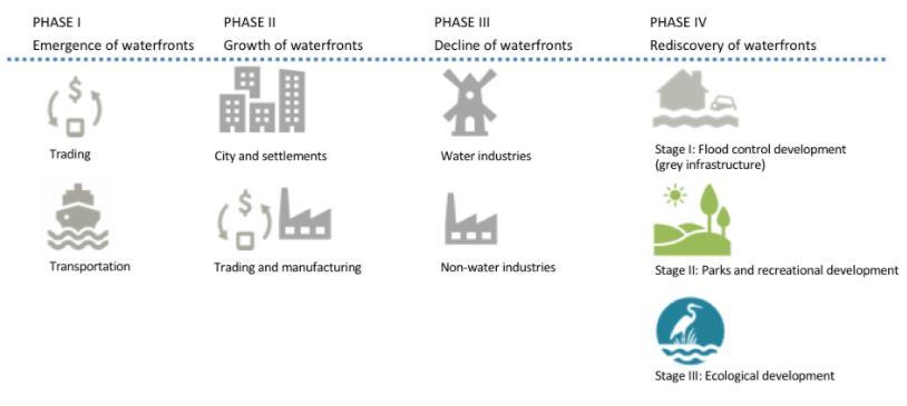
Figure 1. Evolution of waterfront development
It’s high time that we think of water as the driving force of urban development, which includes the context, topography, ecology, and the people living in cities.
This approach, known as “Water Urbanism”, opens an avenue leading to the sustainability of the new age, where we care for nature and solve urban issues by creating a synergy. In the age where many cities worldwide face natural disasters regarding climate change, resiliency matters the most. Water urbanism, thus, provides a unique toolset to the architects to make a resilient future.
Figure 2. Elements for waterfront development

25
We now see a break in the symbiosis between us and our surroundings. Why is it that urban life halts when we face seasonal floods which we know return every year? And in severe cases, like the flooding of Mumbai in 2005, why do all our protective measures fail? And at the same time, our rural population still can sustain their lifestyle in times of seasonal floods as they still maintain that connection. Water urbanism kind of points out this irony and urges to take measures from micro to macro level to establish that connection again.
As urban habitats continue to be governed through fragmented and disconnected processes, policies and departments will provide a path forward for urban regeneration that is based on integration to enable future generations to reconstitute their essential relationship to water and acquire meaningful ways of dealing with urban infrastructure.
The balance is established between nature and social life for a sustainable development of cities. Urban natural water elements play an important role in the establishment of this balance. Water is the most important planning element which is comfort of human physical and psychological. In addition, it brings existing environment in a number of features in term of aesthetic and functional. One reason for the importance of natural water source in urban area is aesthetic effects which are created on humans. These effects are visual, audial, tactual and psychological effects.
Figure 3. Effects of water as a planning element in an urban area
The primarily power of attracted people on waterfronts is visual landscape effects of water on relaxation. Throughout, designs related to water takes over motion and serenity factors. Moving water adds vibrancy and excitement to a space. Stagnant water creates the mirror effect in its space as a visual.

26
In Mumbai a city with water on almost all its sides, has all kinds of water ecosystems. It has a beautiful coastline, so a sandy shore on sides from Juhu to Chowpatty in South Bombay. Rocky shores on Haji Ali and Bandra interfaces, whereas a completely different mangrove system on Airoli or Sewri sides. Although different, they react in similar ways. They merge during the monsoons and often turn Mumbai into intertwined ecologies of an estuary. Our land and ecology are formed considering the fluidity of the elements, but in development practices we have often neglected the water terrain, and still are continuing to do so. Water Urbanism is a bold step to evolve from that.
If we try to impose infrastructure, problems like water-logging, water scarcity, etc. plaguing our city will begin to grow more and more sinister. What water urbanism proposes is to intervene by merging with our environmental factors, not impeding them. That changes with the cyclic aspect of nature. If developments are made looking at that it would create solutions for a lot of upcoming issues in the city’s fabric.
2.2 POWER OF A WATER FRONT IN URBAN ENVIRONMENT
1. ‘Place’ making = Urban blue green space + people
An urban waterfront has a special place in the modern resident’s heart because it connects them with nature. An urban water edge can enhance the association of its city with water Fostering people’s interaction with the water-land interface, lends it a distinct character. Hence, equitable access to urban waterfront if ensured at all times, proves fruitful.
In doing so, preserving the heritage and historic fabric of the city’s urban waterfront and its past connection with water should also be considered. A mixed-use development plan, celebrating the rich history, along the urban waterfront can make the place vibrant. An understanding of the broader context of how the society is involved in and around the urban waterfront area helps create inclusive spaces. This in turn fosters an area that is conducive of a plethora of socioeconomic activities. In order to develop and maintain this dynamic nature, these cities designed optimum and equitable public access.
2. Collaborative Governance
Developing an urban waterfront sees diverse sets of actors and organizations (Government, Private, Public, Services) come together. They are directly or indirectly dependent on this space and identifying their roles and interests at the inception of a project can be useful. Involving them through innovative and interactive governance mechanisms, like the multi-stakeholder engagement (example Bandra Carter Road) is valuable for holistic and inclusive transformation of any urban blue-green space.
A more bottom-up and participatory approach, with city leadership buy-in, might help in removing such road blocks, speed up approval process, and create mutual benefits for all stakeholders.
Collaboration between local government, planning and development authorities, and residents can help pave the way towards an inclusive and active urban waterfront management. Setting up of interdepartmental bodies, like the special purpose vehicle
27
or waterbody improvement trust/group, can also facilitate smooth collaboration between stakeholders.
3. Environment always at the heart
Ideally, urban waterfronts should be developed keeping nature and ecology at their heart. In the cases when they are not, it can prove to be detrimental to the surrounding environment like in the case of Ahmedabad’s Sabarmati riverfront. It is important to remember that the development of public spaces should happen in close association with environmental restoration. The proposal of any such regeneration project should take environmental and climate change impacts into consideration at the ideation stage itself, as it can influence the project cost estimation. Projects should aim for low impact and resilient design which will most importantly improve the quality of water and help adapt to any future climate vulnerabilities.
4. Financial viability and sustainability
Financing is one of the major challenges that urban waterfront projects face. Since the nature of most such projects is ambitious, and local governments lack the required funding, in many cases secondary sources are sought. The operations and maintenance cost of the project also play a key role in deciding the financial viability of such large-scale urban developments. Innovative funding options and partnerships involving the private sector have been tried by Singapore, Seoul, London, New York, etc. They feature a combination of phased land sale and value capture, TDR and zoning incentives that helped the local government generate revenue through the private sector. The financial success of urban waterfront projects lies in identifying multiple avenues for revenue generation. Combinations of direct (incremental revenue generation) and indirect (environmental and social) benefits should be considered together as return on investment.
5. Organic Transformation
Any regeneration project is time intensive so aiming for short-term benefits might not be sustainable. The development should seize the benefits of as many low-hanging fruits, but long-term vision is indispensable. Instead of a masterplan approach, a strategic vision which frames the shared community interests for the place are more holistic. Although a masterplan (a statutory document) for development helps by safeguarding it from political cycles, but its rigid nature hinders organic transformation that is incremental and flexible to the changing needs of the city and its people. A shared vision is adaptable and can be implemented gradually, starting with small changes, guiding developments as the transformation of the urban waterfront gains credibility.
Sustainable development of urban waterfront involves a number of physical and social considerations. 1A balanced approach to urban waterfront development, where ecological, environmental and water concerns are addressed harmoniously along with development can accrue multiple benefits to people and ecosystems while generating economic dividend for Indian cities.
28
1 https://wri-india.org/blog/reinventing-urban-waterfronts-indian-cities-five-ideas-step-way-forward
29
2.3 UNDERSTANDING THE LAND WATER EDGE
IMAGEABILITY OF EDGES
“The disruptive character of an edge must be reckoned with” – Kevin Lynch, Image of the City 1960
“
Edges. Edges are the linear elements not used or considered as paths by the observer. They are the boundaries between two phases, linear breaks in continuity: shores, railroad cuts, edges of development, walls. They are lateral references rather than coordinate axes. Such edges may be barriers, more or less penetrable, which close one region off from another; or they may be seams, lines along which two regions are related and joined together. These edge elements, although probably not as dominant as paths, are for many people important organizing features, particularly in the role of holding together generalized areas, as in the outline of a city by water or wall.”
Water bodies, the breathable spaces that majorly encompass the void in the urban fabric are naturally the key to healthy living environments. Right from the birth of the waterbody, it undergoes traceable morphogenesis over a period of time, witnessing diverse environmental conditions and user nature. With the steady increase in the density of the urban fabric, these breathable zones have become unnoticeably sizeable. This obscured the vision of the water bodies amongst the tall, dense skyline of the cities. Though the large water bodies occupied a major part of the skyline, small ones were left as the un-noticed ground in the middle of dense urban figures
The freshwater bodies that have a higher impact on the surrounding urban life tend to have a part in the lifestyle of the people. They are generally the major water source for the population and are traditionally a place of congregation. Farming communities of India are majorly dependant on freshwater bodies such as river for potable water & irrigation and worship them as a part of their living culture.
Saltwater bodies such as lakes are the recreation points for the population. Apart from having a rich saltwater ecosystem, it enhances the micro-climate and opens up opportunities for various water affiliated activities and entertainment. Lakeside recreation is considered to have a rich cultural impact and tourist attraction that would further provide economic support for local maintenance. Thus a flourishing neighbourhood is achieved.
“While continuity and visibility are crucial, strong edges are not necessarily impenetrable. Many edges are uniting seams, rather than isolating barriers, and it is interesting to see the differences in effect.
Edges are often paths as well. Where this was so, and where the ordinary observer was nor shut off from moving on the path then the circulation image seemed to be the dominant one. The element was usually pictured as a path, reinforced by boundary characteristics.”
30
2.4 DUALITY OF THE EDGE
There are two sides to an edge. Webster's II New Riverside University Dictionary defines edge as: "A dividing line or point of transition, the line of intersection of two surfaces of a solid." The water's edge is a dividing line between two zones: land and water, water and sky and the two sides of land as a river or harbour dissects a city. It can also act as a point of transition for two spaces, a line of exchange, a line or a plane of intersection that separates and joins two elements.
The waterfront is the edge that divides land and water. Historically, cities around the world have increased their footprints by infilling the water for more land. In some cases, the water disappears at the end of the process. This one sided expansion at the edge causes cities to overlook the value of waterfront.

Water, sky and land are the three main components of the earth. When one views the city from the water, the land divides the sky and from the water. However, when viewed from the city, the water and the sky merge into one at the horizontal line. From the sky, water and land share an adjoining line. Water, land, and sky knit with one another in three dimensions.
Types of Edge Conditions:
Besides being an in-between zone, an edge can in fact act as a zone with its own identity.
A Distinct Line of Separation
The waterfront acts as a city's boundary, there are cities surrounded by water-islands, or cities with inner harbours or dissected by a river, and lastly, cities with water on one edge-coastal cities. Harbour front, riverfront, seafront, lakefront, canal edge, all have different boundaries. The water's edge is a dividing line to separate the viewer from the city or the dense built form from the openness of the water. The skyline then becomes every city's urban identity. The containment of a large body of water allows people to look at a city or a building from a distance. Driving along the Bandra Worli sea link in Mumbai, one perceives a contrast between the openness of the water and the density of high-rises. These simultaneous views of different characters change constantly along the edge of the city.
Figure 4. The boulders form a boundary
31
An Adjoining Line
The horizon line joins the sky and water. In addition, the body of water on the surface of earth links the continents while the edge separates land from water. Therefore, a port city has a dialectic identity of being individual and being a part of a collective system.
A Line of Exchange
The water's frontier is the threshold where goods
Figure 5. Buildings adjoining sea and people from different parts of the world enter and exit. It is a line or an interface of exchange. The ports and harbours of Mumbai are the reason for it flourishing so much in trade since the colonial times.


An Inhabited Edge
One can interpret the dimensions of the water's edge and thus in a large scale the edge can be inhabited. Buildings by the edge of canals are often built up to the edge and let the base of the building open up as arcades or so. Activities like eating can happen at the edge.
Figure 6. A busy harbour for exchange of goods
The Changing Edge
Sometimes, the edge condition can be a blurred separation or an ambiguous zone since the edge changes constantly. The beach exemplifies this idea and the process of urban infill for land made cities creates a changing shoreline. Due to the land reclamation through centuries in Mumbai the edge has constantly kept changing and evolving. In such a densely populated city where even an inch of land has value, reclaiming land from the sea and developing it is a phenomena observed often, yet again the edges are set to change for the coastal road project.
Figure 7. Dynamics of an edge
32
2.5 PUBLICNESS AND THE WATER EDGE
Building Form and Public Space on the Edge -
A city should conserve some of its water's edge for developing active open spaces and protecting it from inaccessible privatization. View corridors should lead to the water where the public can easily gain access to the edge from the city.
Some well-developed and emerging relationships between cities can be analysed by understanding the city's association with water. We can differentiate city typologies based on their historic and current connections with water, such as cities on a river, harbour, bay, estuary, delta or ocean shore. Many cities have originated near or on the edge of water bodies, because water is essential in terms of sustaining life, having historically enabled trade and commerce, and, today water is still an essential part of cities and their transformative development. The sustainable design of water’s edge public spaces is an integral part of the realisation of the cities of tomorrow. Historically, trading posts and routes have facilitated cultural exchange and interaction at levels surpassing other spaces. Areas alongside harbours and docking points have been fertile ground for the display of commercial, social, architectural and cultural hierarchies. These dynamics are continually changing and, as populations and economic relationships alter over time, the physical manifestations remain visible in the architecture, buildings, structures and, most prominently, the design of public spaces.
Figure 8. Factors affecting water’s edge public spaces – Density, diversity & design
In association with physical manifestations, virtual aspects (i.e. online versions of reality, animated connections, gaming strategies, virtual landscapes and technological reminders) allow us to understand and appreciate changing architectural forms. Public spaces are constantly evolving due to people’s thoughts, views, interests and use of them. The nature of associated private space is also changing, from primarily retail and commercial to mixed use, recreational and technological.

33
P K Das writes in his book – On the Waterfront, about this edge changing and becoming a public space.

“The seafront is the largest open space and the most attractive and crucial feature of Mumbai’s landscape. For millions who live in this crowded city, the waterfronts, be it at Marine Drive or Chowpatty, Haji Ali or Worli Sea Face, DadarPrabhadevi, Shivaji Park, Mahim, Bandra, Juhu Beach or Versova, are the only major open spaces apart from few parks and maidans. People flock there to catch a breath of fresh air, to soak in the golden light of the setting sun in the far horizon or to share a moment of togetherness with a loved one, Bollywood style.
Open spaces along the seafront and other public spaces have been an integral part of Mumbai’s landscape. Old municipal gardens such as Victoria Gardens, now known as the Jijamata Udyan, and the Hanging Gardens, continue to be popular with morning walkers and picnickers. Big grounds like the Cross, Azad, Oval, Cooperage and Shivaji Park have hosted historically significant social movements, and today, are sites for community celebrations, political demonstrations and meetings, sports and cultural programmes, so integral a part of the public life of the city. One of the distinctive features of Mumbai’s coastline is the presence of many forts in Vasai, Bandra, Mahim and Worli which, unfortunately, are in a state of total disrepair at present. Temples, such as Mahalaxmi, Babulnath, Walkeshwar, the dargah at Haji Ali and the churches of Mount Mary and St Andrew’s at Bandra are important landmarks. Along the coastline of Mumbai, and attract large numbers of people within and outside the city.”

34
Figure 9. Haji Ali Bay fishermen’s boats
Figure 10. Sassoon Docks fisher’s wharf
2.6 THE URBAN TRANSECT METHOD
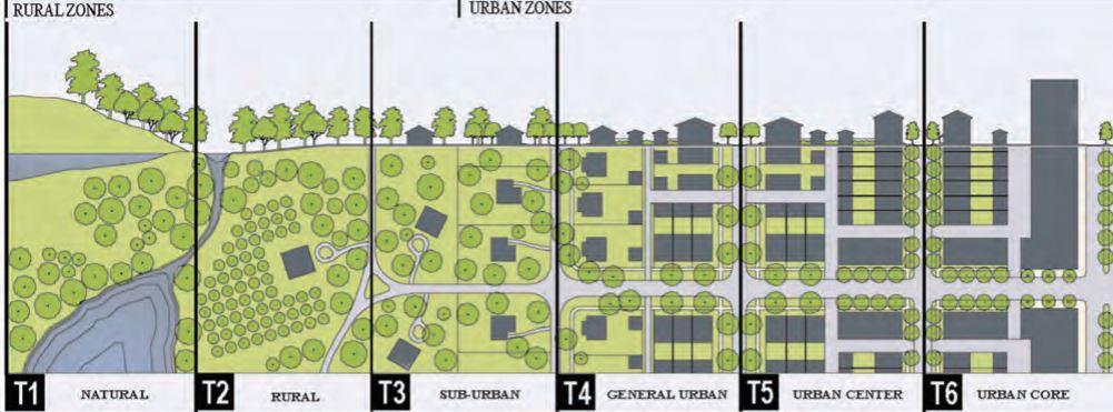
“A transect, in its origins (Von Humboldt 1790), is a geographical cross-section of a region used to reveal a sequence of environments. Originally, it was used to analyse natural ecologies, showing varying characteristics through different zones such as shores, wetlands, plains, and uplands. For human environments, such a cross-section can be used to identify a set of habitats that vary by their level and intensity of urban character, a continuum that ranges from rural to urban. In Transect planning, this range of environments is the basis for organizing the components of urbanization: building, lot, land use, street, and all of the other physical elements of the human habitat.”2
Analysis by transect was first used by geographers and naturalists to describe and understand the workings of natural systems, including human habitats. In this spirit, in addition to providing a place-based approach to planning regulation, the rural-tourban transect aims to better integrate environmentalist and urbanist values.
Urbanists often argue that well-meaning environmental regulations hinder the dense, contiguous form of traditional towns and cities, causing development to spread out over greater areas. But the relatively dense cities and towns urbanists advocate may conflict with environmental advocacy for uncompromised riparian corridors and animal habitats in even the densest human settlements.
Environmentalists also speak of a need to “green the city” which urbanists worry will damage the pedestrian continuity associated with successful urbanism. In general, urbanists believe the integrity of human settlements should be given equal standing with that of the natural world.
Environmentalists, on the other hand, believe that human settlements must conform to natural ecosystems to function correctly. They argue that cities must incorporate green strategies and technologies to reduce environmental impacts and improve the quality of life. Although many people take positions between the extremes, new tools are needed to reconcile these differences. By considering urban and environmental values on a regional basis, transect-based planning may be a step forward in this area. Its advocates argue that by reducing the impact of sprawl, it may enable both dense human settlement and healthy environmental performance. It remains to be seen how far the opposing views can be reconciled in practice, however.
35
2 https://transect.org/analysis_img.html
Figure 11. The Urban Transect of six zones
In ecological analysis, the transect method may be used to understand how physical and biological systems interact to create living environments. Ian McHarg’s Design with Nature (1963) used this technique to describe the eco-zones of a typical stretch of land from beach to inland bay. The transect may also be used to generate detailed environmental assessment. Similar techniques may be used to understand the character of urban districts.
"A town is saved, not more by the righteous men in it than by the woods and swamps that surround it."
— Henry David Thoreau
A transect is a cut or path through part of the environment showing a range of different habitats. Biologists and ecologists use transects to study the many symbiotic elements that contribute to habitats where certain plants and animals thrive.
Quadrat & Dissect in Nature
The environmental assessment of a site requires the identification of typical ecozones (or habitats) by means of a Synoptic Survey, which has two analytical protocols, the Dissect and the Quadrat. A natural transect is shown at the top. The Dissect (left) is a sectional cut that includes what is on the surface of the ground, above the ground (including the microclimate) and what is underground (the humidity and water table). For the Quadrat (right), a normative area is delineated within which all the flora and fauna are quantified. From this sampling, the characteristics of other similar zones can be assumed.

 - Duany Plater-Zyberk & Company
36
Figure 12. Landscape ecological transect
Figure 13. Axonometric of the different transect zones
2.7
RELIGIOUS AND CULTURAL SIGNIFICANCE OF WATER LAND INTERFACE IN INDIA


Charles Moore in his book “Water and Architecture” mentioned that the key to understanding the water of architecture is to understand the architecture of water –What physical law governs its behaviour, how liquid acts and reacts with our senses, and most of all how its symbolism relates to us as human beings.
The nature of water can be termed as a fundamental soft element which is a sculptural medium unsurpassed in its potential to make the most of its form, transparency, reflectivity, sound, movement, refractivity, and colour.
The Architectural response to water is not only limited to the physical built form but it is also interlinked with the psychological response. Hence, the responses are in both ways where one is interrelated to the other. Further, the Architectural response can be manifested in many ways like Physical, Spatial, Visual, and Sensorial. It can be classified that these responses are tangible and intangible.
The physical and aesthetic properties of water give it a unique mythical-religious potential and therefore it has played an important role in myths and religious rituals.
The Rig Veda proclaims:
‘‘These waters are pure and auspicious (which cleanses); these are the medicines (healers, physical and spiritual) of all; these waters help growth and provide prosperity for all."
Hinduism believes that water has spiritually cleansing powers. Water from rivers is considered sacred, but the seven rivers in India namely the Ganga, Yamuna, Saraswathi, Godavari, Narmada, Sindhu, and the Kaveri have been accorded a greater sanctity than the others. Holy places located on the banks of rivers (Srirangam), coasts (Rameswaram, Tiruchendur), confluence of rivers (Mukkoodal) carry a special significance, where major festivals are celebrated. The waters in these sacred places are considered great equalisers people of different castes bathe together.
37
Figure 14 & 15. City of Varanasi, having a religious connection to River Ganga
Waterfronts are termed as those areas, which are located in an urban context having direct contact with water or adjoining lake, river, or harbour. Various activities are prevailing on the Waterfront which keeps the interface active. These activities can be classified into various types such as mixed-use, recreational, working activities, historic, cultural, environmental, residential, etc. It is said that Waterfronts provide a city level place for public enjoyment and engagement. These waterfronts provide an ample amount of visual and physical access. Cities do want a waterfront that serves multiple purposes such as a place to work, to live, to relax, etc. Therefore, Waterfronts contribute to aspects like Social, Cultural, and Economical.
Waterfronts are perceived very differently in the Indian context and have a diverse context. During ancient times, waterfronts in the Indian context were never celebrated as a recreational public place. Waterfront is not very well emphasized in the Indian culture if compared to the western concept of such waterfronts. Water and religion are intricately woven in the pattern of lifestyle of Indians.
Along with that due to the subtropical climate, the preference to the waterfronts is more on the socio-cultural aspects such as the bathing rituals. In India, many cities have flourished on the banks of waterfronts i.e. seafront, riverfront, and lakefronts which are marked in the map. All these cities have their own identity achieved due to the dominance of water as a core element. So, it can also be said that the city structure as a whole responds to the waterbody in a certain manner whereas, on a micro-level, the elements which are physically related to water have also evolved in the Indian context. In the Indian context, it is believed that rivers are sacred, the kunds and stepwells have shrines and idols of God, lakes were used to offer prayers and worship water as God. Therefore, layers of activities along with built form typologies and their architectural responses exist altogether with the current era.
“
The Ganges still retains a religious significance. The development of the Hindu religion in the I n d u s Valley endued the Ganges with a sacred role, and River cities, such as Benares, Hardwar and Allahabad, became important centres of pilgrimages and sacred festivals. T h e riverside temples and the steps (the Ghats) leading down to the water provide both access and a visual link between water activities and the sacred buildings.” –Aquatecture (book) – Anthony Wylson
The main feature of the waterfront can be said as the physical accessibility to water that also leads to a specific response to the water edge. Therefore, the particular architectural elements such as Ghats, Ovara (a gateway to access the water body), step-wells, and bathing pavilions can be said as the evolution of built form with architectural conceptions along the water edge. So, it can be said that the water edge also reflects the evolution pattern respecting all the socio-cultural aspects.
38
Historically, cities across the country expended resources in the creation of some of the most beautiful public spaces around water, the most prominent being the ghats of Benaras, the stepwells of Gujarat and the kunds of Rajasthan. These constitute some of the most vibrant, dynamic, diverse and multi-faceted manifestations of spaces within the fabric of traditional Indian cities. Emerging out of India’s climatic and socio-political and cultural composition, these spaces were public, inclusive and active participants of the daily life of people. They offered citizens opportunities of engagement at several scales for a multitude of activities. They were designed and carefully calibrated. They were spaces of social recital, of public participation, political deliberations and lived experiences that formed the base of celebration of life – Living waters museum

Indian rivers are mighty and have accredited for development of civilisation from the Indus valley, to the mythological significance of gods performing religious activities, to historic empires being formed at their banks. Cities flourished and grew only due to their proximity to a waterbody. Even ones in difficult terrains like landlocked ones develop due to presence of lakes or underground sources or even manmade tanks.
Architecture forms related and responded to water as though it is considered man’s best friend and worshipped as their sole source to survive. As times passed the development devil took over and they starting slowly forgetting the resource. Rampant growth led to a point that today it is neglected and growth is not only stunting but negatively affecting.
39
Figure 16. Collage showing religious significance
2.8 ANALYSIS OF VARIOUS CITIES
Points Ratnagiri Alleppey Haridwar Panjim Mumbai
Area 72. 6 sq. km 42.6 sq. km 12.3 sq. km 8.27 sq. km 603.4 sq. km
Kind of edge(s) Rocky edge meeting sea, at high terrain
Type of land use
Mainly Agricultural, residential. Less commercial
Sandy coastal edge + Soil loamy edge
Mixed use of residential & commercial, as well as lot of tourist activities
Soft soil edge meeting river freshwater
Mainly religious, commercial and residential
Impact of water edge
Livelihoods depend on it, agriculture and fishing are main occupations of the city
Developm ent through the years
Organic settlements through the years expanding not directly touching
Public Relations Commercial relations for sustaining themselves through livelihood
Development of the entire city has been due to its connect of backwater rivers in and out of the city
Organic growth, developed lot in recent years, keeping buffers to edges of various kinds
Close connect of individuals due to tourism & shelter in house boats in back waters
Utmost imp is its religious significance, flooded with tourists all year round, activities relate


Contained development due to high terrain and river flow, labyrinthine growth
Worship and daily ritual / festive relation with river water
Sandy coastal + rocky edge Sandy, Rocky, Mangrove, hard concrete, mudflats
Mix of commercial, administrative, residential & leisure
Planned developed as capital city due to inlets making its ports active, increasing settlements
Denser growth towards edges, lesser inwards, a balanced organic development.
Commercial relations to help the city develop through waterways
Mix use of ALL residential , cultural, commercial, industrial, recreational
Became largest port from colonial times, due to water on all sides. Trade caused it to flourish in dev.
A colonised development, of extensive reclamation and developments touching the edge
Earlier imp for trade, now only fishing, rest all edges for recreation. East for port activities
Hazards / Risks
Very less risk of getting affected by rising levels, or floods since dev is not close to edge.
Few chances of flooding in case of worse scenario, but water managed well through channels
Few chances of flooding, only in disaster like situations for river overflowing since close.
Less risk of flooding through coastal, since organically developed and altitude factor

High vulnerability to coastal floods & rise, especially in monsoon due to callous development & reclamation Diagrams

Table 1 – Comparative analysis of various cities having a connect with water

40
I. RATNAGIRI – Maharashtra
About: Surrounded by the Sahyadris (India's western ghats) and the Arabian Sea, The scenic beauty of Ratnagiri is mesmerising. The region is blessed with hills, beaches, rivers, hot water springs, forests and waterfalls. It is a jewel of the Konkan coastline due to its lush green and blue landscape.
Elevation: 77 M
Figure 17. Axonometric transect Kind of development: Organic settlements

Forms of livelihood: Mainly known for commercial activities - Farming, Fishing, Tourist activities.
Response to land water interface:
o Despite being on such an elevation it has a great history, known through the colonial times.
o This historic and cultural significance has given rise to many architectural buildings to commemorate, thus increasing value of this town and making it a popular tourist hotspot.
o It has a rich biodiversity due it the landscape. This is which also forms a fertile land for growing various agricultural produce- it is famous for its mangoes all over the country.
o The coastal waters and mangroves make the waters rich for fishing as an important activity in the town for livelihood.
o Small pitch roofed houses are located near the lower lying coastal regions for the native folks. The higher terrain are mainly lined with forts and historic monuments thus famous for tourist activities.
o It has a mix of all interfaces like an estuary, a lot of mangroves, a coast, waterfalls and even hot water springs. These result in various interactions in different seasons of this area, specially the transformations in monsoon.
Inferences:
o Respecting the natural boundary in development has caused this town to retain its biodiversity and grow beautifully in an organic manner.
o The development has been a gradient towards the water, despite the different kinds of terrains.
41

II. ALLEPPEY – Kerala
About: Alappuzha (or Alleppey) is a city on the Laccadive Sea in the southern Indian state of Kerala. It's best known for houseboat cruises along the rustic Kerala backwaters, a network of tranquil canals and lagoons. It is a city in which Mother Nature has gone all out and ornamented herself with serene lakes, lazy rivers and swaying palm trees. The city's Mullakkal Temple features a traditional design. Punnamada Lake's snake boat races are a well-known annual event.
Elevation: 6 M Figure 18. Axonometric transect

Kind of development: Organic growth development
Forms of livelihood: Known for commercial activities of fishing and farming of paddy, accompanied by tourist activities.
Response to land water interface:
o As its name suggests it is truly known as the ‘Venice of East’ due to the various water channels that keep coming in and out of the land of the city. These resulted in boats become a major aspect of this beautiful town.
o Living on house boats is the main cultural significance of this place that draws people from all over to experience a stay floating on the serene backwaters of Kerala.
o The countryside fringed with palm-fringed nature trails, sun-kissed beaches, heritage sites, temples and so much more.
o The traditional involvement with the water is not just of visual or commercial but the people live, eat and celebrate all with water. Their main festival of a boat race that happens annually is known all over the country.
o Their built forms are also all facing the nearest water stream, or bay or coast itself. This has resulted in a new rich kind of typology of vernacular low-rise houses all over the town, developing more and more over the years.
Inferences:
o This water interwoven landscape is this such a significant part of their cultural, history, has resulted in their present. It truly shows how we can live and grow organically respecting the natural terrain.
43

III. HARIDWAR – Uttarakhand
About: Located amidst the beautiful natural landscapes beside the holy river Ganga it is considered as one of the seven holy seats of Hinduism, Haridwar can be proud of its cultural heritage. The old havelis, temples and mansions carry the rich Hindu architectural brilliance. Set amidst beautiful mountainous landscapes. As per religious beliefs, god has left his footprints in this holy city and the folk songs of the land still chant that incident.
Elevation: 289 M Figure 19. Axonometric transect

Kind of development: Organic settlements
Forms of livelihood: Mainly known for religious activities – festivals, yoga, temple related earning, few tourist activities, and hosting mela’s are in important part of the city’s fabric for means of livelihood as well.
Response to land water interface:
o Festivals and fairs are integrally associated with culture of Haridwar. Apart from the usual Hindu festivals, Kavad Mela, Somvati Amavasya Mela and Kumbh Mela are celebrated with great fervor and respect. These are all hosted in this city due to its significance associated of being holy due to its location of being at the banks of the River Ganga.
o This religious historical context of the river is what defines almost activity and tradition from decades till date. From a daily routine of bathing, to a twelve year ritual of hosting the Kumbh Mela for purification where thousands of people gather in this small city, everything is defined by the presence of water.
o All the settlements, temples and structures are all built to face the river as though in respect bowing to it, including the street layouts are panned out for the religious activities of the river context.
Inferences:
There is a direct connect with the built opening up into the river water, since the usage of people is direct immersion daily and in large numbers the water landscape is definitely more dominant and important in this city.
45

IV. PANJIM - Goa
About: Panaji (also known as Panjim) is the state capital of Goa, in southwest India. Located on the banks of the Mondovi River, the city has cobblestone streets lined with colourful villas and buildings from the Portuguese colonial era.
Palm-fringed Miramar Beach sits at the confluence of the river and the Arabian Sea.
Elevation: 55 M
Kind of development: Planned development Figure 20. Axonometric transect

Forms of livelihood: Mainly known for commercial activities - Farming, Fishing, Tourist activities.
Response to land water interface:
o The arrival of the Portuguese in the 16th century saw a dramatic impact on the cultural landscape of coastal Goa, particularly the capital city of Panaji.
o Today, the city is a vibrant kaleidoscope of Indian and Portuguese influences. Often overlooked in favour of the wild north and sleepy south, Panaji has plenty to offer visitors, from its dynamic theatre and music scene to its historical buildings, galleries and statues.
o The coastal influence from colonial times was great from trading aspect resulting in development to becoming the capital city of Goa.
o The undulating terrain influences the built environment of the city. The structures located not directly near the water. Higher cliff areas have almost no built due to the distance from the coast.
Inferences:
The changing topography forms lot of channels and promontories, as well as sandy and rocky edges. Activities are scattered with these formations. Being the capital of the state this city is developed in a sort of organic as well as planned method, respecting all its topography.
47

49
2.9 LIVING WITH WATER - HUMANS AND WATER RELATION
“Cities seek a waterfront that is a place of public enjoyment. They want a waterfront where there is ample visual and physical public access – all day, all year - to both the water and the land. Cities also want a waterfront that serves more than one purpose: they want it to be a place to work and to live, as well as a place to play. In other words, they want a place that contributes to the quality of life in all of its aspects – economic, social, and cultural”.
- Remaking the Urban Waterfront, the Urban Land Institute (Seattle Department of Planning and Design, 2012)
Waterfronts, the unique places where land and water meet, are a finite resource embodying the special history and character of each community. Urban waterfronts, like the cities help define, dynamic places. In each era, the needs for relaxation and the pursuit of leisure activities resulted in planning forms and architecture solution that expresses the human response to lakeside or seaside. Waterfronts are often the most valuable resource of a city and many people feel they are a stakeholder: from the resident’s beautiful view to marine industry to waterfront shops, everyone wants their interests protected.
On a general scale, humans like to live close to water. As architects resolve these spaces, they consciously enrich the community. In these spaces, water is used as an entity to derive certain experiences, enhancements and character in a micro scale. The power of water in architecture comes from using the senses by seeing, hearing, feeling, touching and communicating. Land and water have always had a visual relationship. Water’s reflective property, along with the audio-visual effects of moving water, offers architects a tool for creating energy and space
This generates the idea that, if water is such an important aspect of life and has so many forms, effects and phenomena which we do not experience on a regular basis and can make us learn so much, people must visit places near the interfaces to understand and experience how versatile this element of water is.
To understand how people’s moods were related to sense of space, just how you see the weather and climate has a mood impact on us. Eg: a gloomy day, movies showing sad scenes or negative scenes misery. What human aspect is hidden, does even nature feel the same way when this happens?
“Whether for ritual or recreation, people seek the water's edge. Urban waterfronts are important and special assets and that, when redeveloped, they often contribute to healthy traditional communities.” - Ann Breen, in her book Waterfronts: Cities Reclaim their Edge
50
1. PHYSICAL RELATION WITH WATER – visual, spatial
We humans have various associations with a waterbody. A constantly changing form of nature, it condenses, rises, flows, precipitates and percolates. We have developed various activities around it. From recreational like bathing, washing, swimming, diving, surfing, boating, to commercial and industrial fishing, to actually aquaculture farming on the surface of waterbodies. These activities involve us in close contact with water and its various forms. Monsoon being a time when everyone even on land develops a connection with it. We are very closely knit with the ubiquitous quality of it especially in a city surrounded by all sides by a waterbody. For example, people flock to the shores, when it rains to experience the touch of water.
2. SOCIO – CULTURAL RELATION WITH WATER – religious, recreational
Since mythological times water is considered to be holy in our Indian religions. Cultures have evolved based on these beliefs that eventually designed architecture spaces with respecting this element. Almost every religion from Hinduism to Islam, all have close associations. A water element is usually present in or near their place of worship. All over, a lot of temples are located near the shore, or in between a waterbody. In Mumbai, a very vital part of the city’s cultural fabric resonates with the ten day long religious festival of Ganesh Chaturthi. This involves the immersion of an idol of god in the sea. It is closely woven with people’s beliefs and all the city’s water edges become activated. Hundreds flock to the sea or close water ponds or tanks for this festival it is extremely a vital part of the city’s cultural fabric. Examples- Banganga Tank retains its religious value since centuries. Ramleela takes place on beaches during festival of dusshera.
3. ECONOMIC RELATION WITH WATER – commercial , industrial
The city of Mumbai flourished and formed the mega metropolis it is today only due to its sea route access. At a time when only sea trade was possible, the advantage of having ports on almost all sides turned out to write its story. The city has a rich history of commercial trading that helped it grow economically strong. This aspect of accessibility of trade with foreign boosted a lot of businesses making it the economic capital of the country. Not only commercially but also a lot of industries cropped on the eastern port side of the city. Making it an industrial area hotspot. Also helping procure water for their functions and waste disposal. The city’s water edge thus brought economic opportunities for all. Even if you look at the land use current pattern it is all formed due to its geographical coastal influence. It is an affluent mix of residential commercial and industrial land use patterns. Examples- the fishermen selling their daily catch. The trading activities at the Eastern Waterfront.
51
Figure 21. Physical relation of water and edge – people at the beach
Figure 22. Cultural relation of water and edge – Ganesh Visarjan


Figure 23 Economic relation of water and edge – Fisherfolk selling

52
2.10 MULTISENSORY HUMAN EXPERIENCE AT THE WATER EDGE
In the application of water in design, an understanding of the interaction of water with other elements is mandatory. These elements appeal to the five senses of human to experience the drama of water in our visual, acoustic, olfactory, tactile, and cognitive environments. All of these experiences are which are etched in our minds that connect us so closely personally, and often the shore becoming a public breathing space, because it is the only place in the density of the concrete urbanity that gives a little relief. There are very few areas in the city that are still maintained enough, which allow us to be close by this important element in its truest form and connect to the peace by staring in the horizon.
Light and Water
One of the most prominent features of water is the play of light and shadow, or even colour, its property of capturing the light. As light reflects off water, it creates a unique shadow of ripples. The crescent bay lined with street lights popularly known as Queen’s necklace, causes a golden reflection in the sea at night, giving it the name, and the city an identity. This acts as an example of using water and its reflection to complete the penetration of spaces. The concept of reflecting pools applies to this principle which enhances the monumental quality of the building or to reinforce the axis to establish a visual continuity
Sound and Water
The sound of water is one of the first few stimuli to our acoustic sense ever. The continuous sound of water in public spaces can enliven the space. It can also act as an acoustic screen from background noises. It becomes part of an experiential sequence when one progresses to the space. After establishing a distant visual connection, one can then hear the sound of water in increasing intensity through the progression.
Figure 26. The road by the sea

Figure
27. Reflection of the sea
Figure 28. Sound of waves
53
The sound of waves crashing on the rocky boulders, is one of the most peaceful sounds we can feel. It creates a kind of disconnect and brings a sense of calmness in chaos of the city.
Smell and Water
The olfactory sense of water gives an identity to waterfronts. One can often smell the harbour when approaching the city. Or vice versa, one can smell the saltwater when standing close to the sea, or even living near it impacts everything. The smell of the sea salt carried by winds for meters around. It has a typical aroma of freshness and saltiness as the same time, which makes you feel connected to nature even in the dense urbanity.
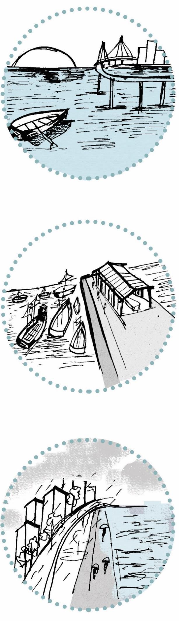
Taste and Water
It is essential in all its forms, not only potable water, but the experience of sitting by the shore when a high tide wave splatters drops of salt and sand in your mouth. Or the taste of the first monsoon that in Mumbai, we all feel. Some communities, like the native Koli’s, are who live in a wetness throughout every day and season, they live on it, and the taste of the sea has lot of memories etched in their life.
Touch and Water
The quality of touching water is a powerful experience. Some fountain and water garden designs push the limits to provide an option for people to enjoy water by getting wet. In addition, materials share a close relationship with water. As in a water wall, glass allows people to see water flow in a controlled but transparent way. It allows light to penetrate into the interior space through the refraction by water. Stone, sand, and gravel submit to nature's process. Water erodes, polishes, and deposits these materials onto the shore.
54
2.11 ASSOCIATIONS & HUMAN PERCEPTION
A survey was conducted among various age group of people living in Mumbai since decades. The aim was to identify users in different areas of the city, to understand their perceptions on the nearest waterbody. The perspective of citizens is necessary to further analyse the relations of the humanising or de humanising aspect of the waterbodies.


From various areas the user identified the closest waterbody that is marked in the map on the left. Arabian sea, Powai Lake, Mithi River, Banganga Tank are some of the various.
The mapped waterbodies, all very different from each other, are all parts of various ecosystems, such as a river, coastal, estuarian, mangroves, or lakes.
These all have developed differently throughout the years in Mumbai. Many are maintained and used as open public spaces, where the users visit frequently as a mode of respite and calm, whereas most of them are ill maintained, and have a bad perception on the people living nearby. Some such examples of the Mithi River being polluted and dirty, or the Colaba edge being under-utilized due to it becoming a dump, and fishing smell coming across. Whereas, Marine drive or Bandra or Juhu being an attraction for those living near or far.
55
Figure 30. Various types of waterbodies in different parts of the city
Figure 31. Peoples experiences around the waterbodies
Due to the varied activities, the kinds of users differ during different times of the year or day. Some having religious use visit the waterbody only once or twice a year during festival of Ganpati. Others who associate with commercial use such as fishing use it on a daily basis, almost live on it. Other uses are for leisure, recreation which also users frequent, due to lack of open space in the dense urban fabric of Mumbai. The user density also would depend on the season, since Mumbai has heavy monsoon tides. Some waterbodies that have become stagnant and dirty as good as waste areas and are not visited or used by any such as the Mithi.
The users associate the waterbodies due to the activites that take place at them. This comes to the development of the city. From the colonial times the Eastern edge was reclaimed to create port lands, whereas the Western edge remained quite the same throughout the years. Thus became the nature of activities, commercial trading and industrial land uses began developing in the similar fsshion on the East. The West side remains to have an organic retention with residential landuse. These resulted in recreational use of land water edge on the Western Waterfront of Mumbai & commercial port trading uses on the Western. Adding religious uses on most of the water edges during festivals specially.
Fig 33. Major activities near waterbodies


56
Fig 32. User visit near waterbody
Figure 34. Kinds of coastal edges in Western Mumbai


57
Figure 35. Sandy shore :Girgaon Beach
Figure 36. Rocky Intertidal Shore: Bandra
Figure 37. Settlements at edges: Worli
2.12 TYPES OF COASTAL EDGES IN MUMBAI
Every city is defined by landmarks and quirks of nature. Mumbai has abundance of natural treats, it has some of the richest biodiversity for such an urban city in the world. Ranging from a national park occupying acres of the city, to its beautiful mangroves, to the long coastline, to various lakes and rivers that form estuaries meeting the sea in different ways. Amongst all of these for many, Mumbai is associated with its coastline, characterised by a variety of sea faces – rocky promontories, patches of mangrove, sandy stretches, rocky and shingle beaches, creeks, tidal pools, mudflats, salt pans and even coral beds.
The city’s coast is rich with historical sites. There are forts built by a variety of rulers and shrines that are considered sacred by people of the city’s many faiths. These land use patterns kept changing as the city developed, from the historic cultural uses, it changed to becoming spots in the city for open space recreation and leisure. As density continues to grow, we are bound geographically by the Arabian Sea. The future proposals are reclaiming land to create space to accommodate the density and combat problems.
The chart below shows how the land use of ecological areas has reduced due to urbanisation in the city of Mumbai.
Figure 38. Land use changes in area through the years

58
1. NATURAL i. Sandy shore ii. Rocky shore iii. Intertidal
iv. Mangroves v. Mud
2. MANMADE i. Concretised edge – Sea wall ii. Settelements at edge – informal iii. Compound Wall edge iv. Open playgrounds
The different edges are as follows : -
coast
Flats

59
Figure 39- Eastern & western coast of Mumbai
POINTS
WESTERN EDGE
About : It is a reclaimed concretised edge. The western part of the city, has all the main hubs for what the city is known for. From the recreational hotspots of Bandra and Marine Drive to old fishing docks of Worli & Mahim.
Accessibility: Road and rail are main forms of access. The mode of water transport is not open on this edge of the city, even though it is a long stretch of water. The sea link is one major connect, that connects the two ends of Mahim bay.
Kind of land water edge
Major Activities
It varies from sandy beaches on Chowpatty, or Juhu to rocky shores. Concretised sea walls lined with boulders is a common site on the interfaces of the western coast. It is mainly the sea meeting the land ecosystem.
The major activities on the various edges of the western coast are recreational, leisure and some for commercial like fishing, but no other activities are permitted.
EASTERN EDGE
This edge is more natural, consisting of mangroves. This area gives the name of Mumbai a Port city, because it is entirely owned by the Port Trust authorities. The major areas Wadala, Sewri all have dockyards and ports lines.
The sea front plays a role in accessibility, since the land use is majorly port land. All ship trading, loading, unloading activities take place through this coast. A harbour train link connects them on land.
The Eastern edge of the city has a rich mangrove ecosystem spanning for acres, as well as mudflats and salt marshes throughout that make it ecologically sensitive to development as well. It has lot of creek inlets that form estuaries.
A lot of commercial and industrial activities are lined up in these areas. Large scale industries are set up which are the major land use, as well as activities like ship breaking yards are present here. Tourists are attracted to this coast during flamingo breeding season.
Current status
The waterfronts are used as open spaces, also called the breathing spaces of the city. They are frequented by users from all parts of the city as promenades and beaches to sit and walk. The proposed reclamation is also set to create more of these spaces on this edge.
The area is majorly adhering to its land use typologies of port amenities. It limits the users and activities as well due to this it has a different perception in the city. It is a functional active edge and important connection for trade and port activities that are necessary.
Development plans
The proposed Coastal Road is a long term development of reclaiming the western edge, to connect the rear ends. It also is trying to create open public spaces as well as increasing connectivity and reducing congestion in the city.
The Eastern Waterfront development proposal is an all rounded approach to revitalise this entire long stretch. It includes to change a lot of land use patterns, by providing social amenities, opportunities for trade, tourism as well as housing for the informal settlements and more, also includes ample open spaces for public.
Comparative Analysis of Eastern & Western Edge
60
Table 2 –
Factor considered Marine Drive Haji Ali Coast Malabar Hill Mahim Bay Sewri Creek Mithi River
Type of edge
Coastal – Natural + Manmade Coastal –Natural + Manmade
Development Major reclamation and redevelopment over the years
User Groups All age groups + Mix castes, communities, prof, tourists, etc
Communities Mix use - All kinds – mainly HIG, MIG from nearby; occasional LIG visitors
Kind of Activities
Recreational, Religious during festivals
Nature of Activities All year round active; shore only during festivals
Material Quality Concrete edge and promenade
Perception Forms image of the city ; imp promenade in south side
Sensorial connect Visual & Audio –main ; Taste & Sound –secondary
Nature of neighbouring land use
Mainly residential and recreational use buildings –Art deco of Mumbai
Current State Well maintained ; certain future dev proposed
Character of Edge Hard edge Passive edge
Proposed road development
Mainly Islamic crowd due to mosque + Koli’s
Mainly MIG + LIG communities crowds
Religious daily use, Commercial –fishing activities
All year round active for fishing
Rocky boulder shore + concrete edge
Imp for mosque + precious bay for fishing
Visual ; touch and taste is main
Commercial + Residential + recreational spaces
Coastal –Natural
Coastal –Natural Mangrove /wetland –Natural
Retained natural edge Sea link dev but not abutting edge
Residents from nearby areas –older crowd more
Mostly HIG level communities found here
Koli fishermen, commuters, visitors etc
Mix use –MIG + LIG + HIG all in equality
Retained natural edge, proposed dev
Koli community ; Tourists
Combination of LIG + MIG
Recreational + Leisure activities use
All year round for recreational
Sandy soil near shore+ natural edge
No direct access to coast, view of sea from all sides
Visual – main ; Audio & sound
Recreational + Commercial
River –Natural + Manmade
Not much development
Slumdwellers from the nearby slums
Only the LIG communities
Commercial + Tourist Commercial dumping
All year round active for fishing + commuting
Sandy soil near shore+ natural edge
Fertile fishing waters + beach coast connect
Perennial active during flamingo season
Mix of salt and fresh water + trees form edge
Tourist attraction for flamingos
Touch & Visual – main; Visual + smell Audio – main Sound also
All year round commercial
Clayey soil + lot of dirt + polluted water
Very polluted and ill maintained
Touch + Smell – main
Residential land use with few recreational parks
Proposed redevelopmen t
Not much proposed, current state to be retained
Soft edge Active edge Hard edge Passive edge
Mix land use of commercial + industrial & Residential
Proposed coastal road passing through
Industrial and informal settlements nearby
Not much development to hamper
Commercial + informal settlement
Proposed redevelopmen t for betterment
Soft edge Active edge Soft edge Passive edge Soft edge Active edge
Table 3 – Analysis of different edges according to factors listed
61
Factor considered Bandra bandstand
Type of edge Coastal –Natural + Manmade
Development Major reclamation and redevelopment over the years
User Groups All age groups + Mix castes, communities, tourists, etc
Communities Mix use - All kinds – mainly HIG, MIG from nearby; occasional LIG visitors
Kind of Activities
Recreational, festive –interactions
Colaba Sassoon Docks
Coastal –Natural
Versova/Juhu beach Banganga Tank Mithi River
Coastal – Natural Coastal –Manmade River – Natural + Manmade
Retained natural edge Retained natural edge Retained manmade tank since early 1700
Residents from nearby areas –many tourists
Mix use – MIG + LIG + HIG all in equality
Residents from nearby areas –older crowd more
Mix use - All kinds – mainly HIG, MIG from nearby; occasional LIG visitors
Commercial –fishing, docks, navy
Nature of Activities All year round –recreational All year round active for fishing
Recreational, festive –interactions
All year round –recreational + commercial stalls
Not much development
Religious visitors; occasional tourists Slum - dwellers from the nearby slums
Mostly belonging to the Hindu community
Only the LIG communities
Religious -primary daily use Commercial dumping
All year round + Festive more All year round commercial
Material Quality Rocky edge –direct connect Concrete edge + soil soft edge Sandy shore Manmade stepsstone quality Clayey soil + lot of dirt + polluted water
Perception Relaxing open space for activities , imp part of western side
Sensorial connect
Nature of neighbouring land use
Touch & Visual –main;
Fertile for fishing, but bad image for visiting or other activities
Touch & Visual, Smell and Taste
Residential land use with few commercial buildings
Current State Developed well in recent years, well maintained
Mix use development. All kinds from resdi, commercial to informal
Not developed, very rough and ill maintained edge
Relaxing open space for activities , imp part of western side
Touch & Visual –main;
Historic and religious value Very polluted and ill maintained
Touch, Taste , Smell and Visual – all imp
Residential land use Residential _ informal living + recreation + commercial
Same since years, future proposed coastal road to cause changes
Character of Edge Hard edge Active edge
Retained as it is –heritage value attached
Touch + Smell –main
Commercial + informal settlement
Proposed redevelopment for betterment
Soft & Hard edge Active edge Soft edge Active edge Hard edge Active edge Soft edge Active edge
62
63
2.13 DI ‘SECTION’
OF
MUMBAI’S WATER EDGES
Mumbai has acres of coastlines, mostly all underutilised and under maintained. The potential of these areas is wasted in the city. A lot
Figure 40. Sites chosen to study

64
Table 4 –


Analysing chosen sites according to factors listed
Site Movement Permeability
Temporal aspect Need / Scope in area
Movement - The amount of users coming, on daily basis according to nature of activities and possibility of occupations around. The scope is considering the various proposals coming up, that will increase or decrease footfall of the area considered.
Permeability - The amount the boundary allows the water to enter lands territory is the permeability factor. The nature of the kinds of material quality provided by the edge, if natural or manmade. Considering the level of how the edge allows the waterbody to come through if directly connected, if not how it soaks in through the boundary inside.
Temporal aspect – This means the change in the nature of the edge with passing time, it considers two factors, from high tide to low tide and from summer to monsoon. How the edge responds to these two changes, if it changes drastically for a need for measures or it is connected in a way that land is well left out of the change and doesn’t need to adapt. Since water flows are dependent on the lunar cycle these also need to be thought of in accordance to adaptive quality.
65
Marine Drive
Haji Ali Bay
Mahim Bay Bandra Bandstand Colaba Sassoon docks
1.
Table 5 –
Analysis of chosen sites from history to future in their development
SR. NO NAME OF SITE PAST PRESENT FUTURE
1. MARINE DRIVE
Reclaimed piece of land; city’s important open space for public gatherings; no wall –open connect people to sea; Daily activities included commercial on coast as well.
Not much change, the promenade is used only for recreational activities, not commercial anymore
2.
2. HAJI ALI SEA FACE
Reclaimed land parcel; known for commercial fishing activities, and religious activities. Quite an active bay and important connection.
Changed developments around, lot of new buildings in the area, the mosque part is same since decades.
Proposed coastal road project to reclaim this piece even more.
3.
3. WORLI
Natural terrain - part of the original island city, considered a hub for fishing commercial activities, oldest community Koli settled here.
Undergone a lot of development, mostly new residential buildings / bungalows. Lots of informal settlements also propped up
Proposed road to reclaim a part in order to increase open spaces, and form a more direct connection.
Proposed coastal road, to uproot original Koli community fishing areas and settlements.
4.
4. MALABAR HILL
Natural heighted hill in island city of Bombay, almost its own peninsula shape itself, mainly known for residents settling.
Remained quite the same, not much change, nor is it adversely affected – i.e. monsoons , due to its altitude
Not much proposed, coastal road from small part of the hill, not much changes in the overall area.
5.
5. SEWRI CREEK
Natural mangrove wetland ecology, not much activity, mainly tourist and fishing cause fertile breeding grounds due to mangrove ecology.
6. 6.
MITHI RIVER
A river forming an estuary with the sea, supposed to be a fertile piece of water. Flows through major parts of North west Mumbai.
Remained quite the same, mangroves have been depleted due to the urbanisation. Although laws have been made to protect them hence they are being conserved now.
Rampant urban growth has completely polluted this water strip, perceived as dirty and unhygienic hence only abutting informal settlements interact.
Mumbai Trans Harbour Link is an upcoming road network through this area, also the development of the Eastern Waterfront are two upcoming major projects.
Regeneration plans coming up, to detoxify and clean the river using natural methods
7. 7. BANDRA BANDSTAND
8. 8. COLABA SASOON DOCKS
Reclaimed land parcel, historic cultural value of fort. Had been in bad state for a long period; not maintained for years.
One of first few areas to develop and flourish in colonial times, lot of commercial fisher activities.
Redeveloped a major part of the edge, thus lot of planned out interactive edges working well becoming a major attraction.
Remained the same state since all these years. Rapidly detreating for the communities around.
Proposed plans by Bandra Collective as well as upcoming coastal road to affect future developments.
Not much proposed to change.
66

Your skyline reflects through my setting sun, The horizon I provide is what you yearn. The image my necklace creates as she glows, Is a compromise to your tides and flows? Come sit and stare out and ponder
About the perils to come in the future causing wonder.
68

About: The iconic stretch that has become the identity of the city. One of the first parts of the city to be developed. This is an expanse on the south part of the city. It has a really high footfall all year round. The age old promenade, redeveloped to become one of the most attractive parts of the city. There is a direct connect of this promenade to the sea
Major activities: Activities ranging of all kinds take place.
1. Recreational – Users frequent this promenade from almost daily to often for activities such as walking, exercising and meeting

2. Religious / Festive – The Chowpatty beach right at the start of this bay, is the largest beach in the city. Throughout the year it is used for recreational activities, but during the ten day Ganapati festivities it transforms into herds of people gathering to immerse the idols into the sea. This time people walk to almost half the depths just to reach the sea. This is the most active time of the interaction of the shore and the sea with people.
Kinds of user groups: Most of the people who come for recreation are from nearby localities, mostly High Income and Middle Income Group of people. Weekends have visitors from suburban parts of the city who travel for experience of the sea. Occasional visits from people from other parts for weddings in the Gymkhanas is also a factor of user group. The connection between the sea and land is quite undisturbed and peaceful hence becoming a major attraction. Over the years the walls have heightened, reducing the overall reachability to the sea. Also since almost no commercial or industrial activities take place here. The ports are all on the eastern side. It remains a calmer horizon.
Relation of people with this shore: The relation of the sea is more of a visual connect. The factor of having an infrastructure to sit on the sill provides a medium to sit and look at the sea for long periods of time. Thus people end up spending more time here.
Inferences: There is a strong visual connection, which gives a good experience for sitting and walking. It is also a limitation a rigid boundary and make the water seem far away. No other kind of activities except recreational happen here. In the past lot of public events took place, it has somehow lost its humanising aspect and is limiting interactions. The permeability of change is very less, adversely affected in monsoons, no provisions for run off of no shelter for people to go to.
70

My crescent shape is symbolic of two one might say, The plentiful fish I hold, and people of Islam that come to pray. My waters signify holiness, One comes to pray when in distress. My water provide food and more, Lined with boats is my shore. Other two crescents you will see on your ride, The reflection of the moon and my smile wide.
72

About: This small bay on the west coast of the city is famous for the mosque that is present in the water. It carries great historic value, and immense religious value. The rest of the bay is used just for connecting Peddar road to the Worli side of the city. The typology is a rocky shore.

Major Activities: The location of the major landmarked mosque of the city is visited by people from far and wide due to its context of being right between the water. The religious significance attached to it is the most driving activity taking place. Although the waters of the bay are inhabited by the Worli Koliwada fishermen. It is a very important water territory for fisher folk. They cast their nets almost every day, the bay is seen lined with colourful boats.
Kinds of user groups: The two main kinds of users are differentthe people of the Worli Koli community who are settled there since generations practicing the activity for fishing, and the other the Islamic community people who visit the mosque. The commuters are also one kind who use this by pass daily to travel from the south to the western city and vice versa.
The kind of amenities lined on the shore is also important, they are majorly for recreation like the NSCI club, and Mahalaxmi Racecourse which landmarks for recreational programs and attract users.
Relation of people with this shore: The association of user with this land water interface is close one. They associate themselves going for a religious purpose, hence this water is kind of perceived holy. Even they are rich water for fishing. The sensorial aspect of touch is very important cause there is direct connect of the sea water with the land, people experience as though they are going inside the sea. This is a rare phenomenon connection in the city.
Inferences: This edge is bustling with people all year round, but only a specific user group. It is not perceived as a holistically developed edge. Although it has a similar nature as Marine Drive there aren’t people who would come and sit at the edge of this site. The observation was the seawall height was quite low as compared to other edges. A lot of fisher boats are also lined on the side of the walls, to probably form an ease in pushing into water.
74

A connection some might say, Some might call me the most important bay.
The large expanse I cover,
Daily makes dozens of people hover. I attract all users from far and away, Travelling from Bandra to Worli through my bay. My sandy shore change and contain, To rocky outcrops to settlements I sustain.
I am that part of the city, Known for my versatility.
76

About: One of the most important edges of the city is the Mahim Bay. This crescent shaped is visibly one of the busiest land water edges of the city. It is a mix of all typologies of interfaces and a variety of communal interactions happen at its various sections.
Major Activities:
A mix of lot of kinds of activities ranging from commercial like fishing from the Worli villages to recreational activities on a few sandy beaches, to the transit activities of the sea link. The important feature of this edge is that, it is a long narrow strip beach, it does not have a built edge it is a gradient which hence involves more fluidity in the activities. The Worli peninsula is filled with informal settlements all over, it is mainly of the Koli fishing community. It is densely packed and the users that live there perform their daily activities right on the edge. Also the presence of the historic Worli fort located in it of heritage and cultural significance. Due to the direct sea transition it is also important during the Ganesh festival in the year.
Kinds of users:
Being quite a large area, it has quite a verity of users. Mainly three broad groups – the commuters who just pass through it in their vehicles on the sea link. The other major user group is the Koli fishermen. This bay one of the first ever fishing villages from the times of the British, and still continues to layer that in the cultural fabric. The beach has often residents of nearby areas for recreational purposes, also by visitors for the same. The footfall of these beaches is not as much as many other in the city. They belong to mainly the MIG or LIG communities.
Relation of people with the shore:
The main connection of people with the shore is occupational for the fishermen; recreational for the residents nearby. During festivals it is perceived as a major open sandy edge, it has a direct connect no sea wall hence even the walkways adjoining it give a feel of liberality on visiting or just sitting by it.

Inferences:
The centre of the city, this area is frequented by a lot of users. The interfaces are changing constantly. They change and evolve with time and seasons. The users & activities also vary accordingly. This edge has a direct connect to the water without a defining boundary. The informal settlements or the beach connects directly without walls blocking, thus making a connection more felt.
78

Developed and contained by you all,
A collective initiative in the city is what they call. I transformed from the rough, mistreated edge in my past Stepped and gradual I allow the waves to last.
Now, I have a new found meaning, A place where children and old come from morning to evening!
I provide and nurture, And conserve this gift of nature.
80

About: This is a 1.2 km long stretch on the western edge of the city in the neighbourhood of Bandra. It is a popular attraction for people in the city for recreation, especially those from the neighbourhood. It also has historic and cultural significance, since Bandra fort is located in close context to it. Also Mount Mary Church which is the most prominent church in the city is located on a hillock close by. This serves as an open space to all those visiting these attractions in the city too.
Major Activities:
This stretch is known for recreational and cultural activities it provides in the city. Daily activities like walking, jogging, exercising, meeting friends are some of the few recreations that take place. On weekends it attracts way more public, for cultural activities happening in the amphitheatre part of it. It does not have commercial activities happening here, hence it is a peaceful hangout spot, the stepped edge, benches and all add to the ease of interactive lively spaces.
Kinds of users:
The nature of this edge is predominantly for users of the MIG and HIG communities, mainly nearby residents. Sometimes for cultural events, it might attract larger crowds of visitors from near or far belonging to LIG as well. Since the neighbourhood does have a few informal settlements, but they do not form the edge, they might visit for events or to relax by the sea.
Relation of user with edge:
The publicness of this edge is the main associational factor. It makes one feel elements of visual and functional interpretation as one walks through it. The use is limited to non-commercial only, thus becoming a hub for culture, leisure and heritage. The main feature is the edge is a gradual slope toward the rocky shore it has. It is lined with stepped seating’s facing the sea, lined with a walking path covered with trees which is a curated user experience, creating a setting for its users.

Inferences:
This edged has developed a lot throughout the years. From being a poorly maintained open space that no one used, to today showing how a collective of people can design a connect with the sea and land and flourish. The entire promenade steps down intor the rocky shore, this creates intercepts of tide pools when the tides change. It is inhabited with all kinds of people from old to young meeting regularly. It is a responsive edge to the landscape and respecting the ecosystem, the users and the built neighbourhood. It is what we can call a humanised edge.
82

From centuries and decades I remain, The southernmost tip of the city I proclaim. Whether it was the soldiers of times colonial, Or the chirpy young adults called millennials!
I haven’t changed at all much, My edge has remained quite the same as such. Famous for the landmarks and heritage, Colourful boats and fishermen’s stories continue their lineage. A symbol of culture and tradition, I aim not to be a part of the city’s contradiction.
84

About: One of the oldest and one of the two peninsula edges of the city of Mumbai, is surrounded on its three sides with rich coastal waters. The little Colaba Island was reclaimed by the British with the main island to give its shape that it is today. It was known for its fishermen wharf communities back then, and that hasn’t changed much yet.
Major Activities:
The Southern part of the island is mainly residential area for Navy officers, hence it has land use and all amenities for them primarily. Like recreational activities for the officers when they are back home. The west edge is lined with a lot of informal slums, whereas the eastern has the large fishing village of Sassoon docks. Fishing activities are major for the communities here. The presence of old warehouses and mills lining this edge also speaks about industrial activities happening here, which are now obsolete and dilapidated. The kind of edge does not have a defining boundary, thus it has a gradient directly into the sea from
Kinds of Users:
The fisher folk community is a major user group, they mostly belong to the LIG community or some MIG. The rest of the area has a mix use. It includes residential users staying who belong to the MIG or HIG user groups. Also a lot of tourist’s users are frequent here due to the age old five star hospitality, they prefer to stay in this area. It has old heritage of the city hence frequented by not only tourists but also lot of daily visitors for the attractions in this part. An extremely huge and diverse groups of users’ blends in Colaba.
Relation of people with the edge: A major relation is the activity of fishing, it is associated with their means of livelihood thus it has extreme sentimental and economical value. Also their houses located in the slums nearby just lining the edge of the sea, hence add even more value for the fisher folk with the LIG communities staying there. The residents do not associate much, but occasional recreational activities in smaller parks, it is a visual association with them.
Inferences:
Being one of the oldest parts of the city, the heritage value of every parcel of land is accounted for. This leaves little room for interaction of users and the edge in most parts. The rest is not maintained well to create a holistic development. The fishing docks are extremely old, which directly open out the city’s tip into the Arabian Sea, but the area therefore is very confined to only them. This edge has immense potential to create a strong city identity by carefully developing it.

86
Over time, when waterbodies lack significant user access, they form areas of urban blight and lose their function. Many urban water bodies have been victims of garbage dumping, antisocial activities, etc. due to human ignorance. These altogether reflect on the environmental cycle in the zone that brings a drift in the health of the neighbourhood. Issues such as recent urban floods in India came into picture due to the improper functioning of the neglected water bodies and their underground network. Their impact on the diminishing flora and fauna has also intensified the effects of natural disasters such as a cyclone. The urban blight brought in the unhealthy transformation of the environment letting it fail in natural protection against disasters.
Perception of a good water edge – but it has dehumanizing aspects.
Whereas, a humanised edge –might not well perceived in the city, not frequented.
We humans often perceive a space or place or edge on a built up image, but they are often dehumanised. E.g. the user experience at marine drive is not pleasant as compared to a natural gradient edge, or even a developed sensitive one like Bandra.
Edges are being looked as breathing spaces, just an open space for recreation for majority users. Some that live near them are faced with hazards before anyone else due to not taking precautions.
A walled edge, is more restrictive and does not provide that sense of connect to the water, retaining it from effects of qualities that it otherwise provides. It has psychological qualities are not even realised.
Whereas in an edge which may be less frequented or known, has all the qualities that can utilise its effects in manners beneficial for all, humans and the ecosystem.
This would not only increase spatial quality, but would provide solutions to a lot of natural issues as well.
87
B S
V A T I O N S
O
E R
SITE HUMANISING ASPECT
MARINE DRIVE
Simple, clean vistas created, Vast open space, maintained by the government, major tourist attraction due to reflection and soothing aspect of buildings.
DEHUMANISING ASPECT
No relief space in long stretch. Ends of both – Chowpatty and NCPA are abrupt, not a rest stop. Suitable for vehicular. Seating faces opposite of sea, lined with amenities having restricted access.
HAJI ALI BAY
Presence of low compound walls, and scalability in walkways. Direct unblocked horizon. Easier access to shore.
Lined with ample green trees. Food stalls nearby.
Opposite side of road is lined with playgrounds, amenities for elite which has very restricted access. Prohibited for most user groups. Accessibility is an issue to this part, very further away from main lines.
DADAR-MAHIM BAY
Direct connect, no barriers. Boulders are at a distance which makes it better.
A more human eye level connection is formed. Buildings response to the edge is respecting, not directly touching.
BANDRABANDSTAND
An integrated designed waterfront, has relief stops, seating, and stepped down to the edge to the water which creates enough space for the ecosystems to flourish. Well preserved & maintained, aspects of nature and heritage, inclusivity for all considered.
The informal settlements edging are extremely susceptible to coastal damage. Completely touching and dumping wastes directly into the sea can get hazardous for all.
Accessibility, circulation can be an issue. Needs distinction. During high tide space reduces.
COLABA
The mix of uses around the edge having immense potential but conflict of maintenance resulting in a connection lost to most of the edges of this part. Ending up lining for the fisher folk settlements being illtreated and neglected.
The edges are have a perception of being lines with the smell of fishing boats, and waste being dumped. The informal settlements edging are extremely susceptible to coastal damage.
88
89
o Blur the boundary between land and water by creating a gradient.
o Embrace water to create a sociable, liveable part of the city.
o Activate the edge between land water through an urban renewal and environmental restoration architecture response.
o Weave together activities on land and water
o Create inclusivity of water in its every form, when it precipitates, rises, and flows. Adapt to changes according to seasons- considering monsoon as crucial.
o Adapting changes according to future risk predictions of flooding and rising sea levels, through mitigation and resilient strategies, through nature based solutions
o Paradigm for a module in the city to propose in various areas.
o Make water an asset not a liability.
90 I N T E N T I O N S
Rampant urbanization and climate change are twin triggers causing severe and frequent urban flooding across India. Traditional grey stormwater infrastructure such as gutters, storm drains, collection systems and pumps, are designed to quickly move urban stormwater away from the built environment. But every year we see recurring cases of such infrastructure failing to reduce urban flooding events across a range of Indian cities.
Global warming will lead to melting of land ice and thermal expansion which will lead to rise in sea level.
o Sea level rise estimates for 2100
IPCC WG1 Fourth Assessment Report, 2007 (Global): 18-59 cm
Royal Dutch Meteorological Institute, KNMI, 2006 (North Atlantic): 35-85 cm
“Al Gore” scenario: 50-150 cm

o GIEC (Intergovernmental Group on the Evolution of the Climate): 20-90 cm
o People living in low delta regions will face flooding due to sea level rise. in 2030, it is predicted of the world population will live within 100 km of the coast.[IPCC 2007]

Over time, when waterbodies lack significant user access, they form areas of urban blight and lose their function. Many urban water bodies have been victims of Garbage dumping, antisocial activities, etc. due to human ignorance. These altogether reflect on the environmental cycle in the zone that brings a drift in the health of the neighbourhood.
Issues such as recent urban floods in India came into picture due to the improper functioning of the neglected water bodies and their underground network. Their impact on the diminishing flora and fauna has also intensified the effects of Natural disasters such as a cyclone. The urban blight brought in the unhealthy transformation of the environment letting it fail in natural protection against disasters.
Figure 1 – 3 Rising sea levels illustrations

91 T R I G G E R
3.1 THE IMPACT
As climate change will put three times more people at risk of coastal flooding India by 2050 than previously thought, Mumbai and Kolkata are on the list of global cities that face the risk of being wiped out, according to a latest research report.3
Figure 4 – Major factors causing floods in India

A recent IPCC report had warned that a mere 50 cm rise in sea level is enough to flood major port cities around the world.

Cyclones in the Arabian Sea are likely to increase in the near future.
Grey stormwater infrastructure such as drains, pumps and outfalls are frequently overwhelmed by extreme rainfall events or high levels of stormwater runoff from roads and streets. Not just Indian cities like Bengaluru, Delhi, Hyderabad, Mumbai, and Surat, but many cities in the global south are flooding frequently. With multiple, recurring failure of grey infrastructure globally, alternatives are now being sought. Natural ecosystems such as lakes, floodplains or parks, forests -are nature-based solutions (blue-green infrastructure) and offer flexible, low-cost solutions for flood mitigation and management and offer multiple co-benefits.
Urban flood management in India continues to focus only on improving grey infrastructure, rescue and relief, instead of building sustainable solutions to increase resilience. Cities continue to extend/expand stormwater networks, clean/de-silt channels and separate sewage and stormwater drains. These are all necessary activities and cities bear high costs to build stormwater (grey) infrastructure; but repeated floods indicate that these actions are insufficient.
92
3 https://www.terraconindia.com/2020/04/15/nature-based-solutions-smart-sustainable-cities/
Figure 5 - Predicted flood risk map - Mumbai 2050
3.2 SEA LEVEL RISE
o Sea level rise has become a major concern for coastal cities due to the economic and cultural importance tied to their proximity to water. These cities have sustained their livelihood in low-lying elevations through the process of filling, bridging, and raising land over coastal ecosystems, replacing their ecological value with infrastructures focused on defining the edge between city and nature. Hard infrastructures have been employed to maintain urban landscapes but have minimal capacity for both human and non-human engagement due to their nonfunctional applications focused on separating conditions rather than integrating them. They produce short-term gains with long-term consequences, replacing and restricting ecosystems and acting as physical barriers in a context defined by seasonal transition.
o According to the United Nations, three-quarters of the world’s largest cities are located along the coast and we are expecting 70 percent of the world’s population to live in cities by 2050. Another significant effect of climate change is the increased amounts of rainfall, which is already causing more frequent floods around the world. With the increase in population living in urban areas, the number of people exposed to floods will grow substantially in the future, augmenting as well the consequences of climate change4
o Climate Central, research says a science organization based in New Jersey, and published in the journal ‘Nature Communications’. However, the projections don’t account for future population growth or land lost to coastal erosion.
o Every Monsoon, coastal areas are the worst affected place when it comes to seawater rise or high tide. Recently many states have experienced floods in India. Mumbai is facing risk due to heavy infrastructure development near the coastal area and construction of bridges over the sea is also another reason for water rise. People who live in an exact coastal area are living in grave danger. Even the occupation of fisheries is worst affected. Already Mumbai coastal area is suffering from plastic pollution despite the ban of it still tonnes of plastic is covered over the sea.
93
4
2993.pdf?sequence=1&isAllowed=y
https://digital.lib.washington.edu/researchworks/bitstream/handle/1773/26705/HUANG_washington_0250O_1
3.3 SUSCEPTIBILITY OF MUMBAI -
There are many reasons and some of the important arguments include both natural and manmade activities responsible for flooding in Mumbai. The geographical condition makes Mumbai susceptible for heavy rainfall. Impact of anthropogenic activities i.e. unsustainable use of resources, reclamation of low lying areas, climate change and global warming, antiquated drainage system and chocked sewers, uncontrolled and unplanned development of the city especially in Northern suburbs, destruction of mangrove and natural ecosystem because of the encroachment by the builders and irresponsible city dwellers, violation of Coastal Regulation Zone (CRZ) rule, loss of wetlands, lack of disaster management plan and no clear coordination between several agencies responsible for city development and planning.
The main reason of flooding in Mumbai is its geography, both natural and manmade. Firstly, the city’s location leaves it exposed to heavy rainfall during the summer; typically, 50% of the rainfall during the two wettest months, July and August, falls in just two or three events. This situation is aggravated by the manmade geography; as in Mumbai; large areas of the land are reclaimed from the Arabian Sea and are situated only just above sea level and below the high-tide level. This inhibits natural runoff of surface water. Complicated network of drains, rivers, creeks and ponds drains directly into the sea but at the time of high tides, sea water can enter the system preventing drainage and in extreme events, leading to Sea water natation. This occurred during the July 2005 event; a massive inundation of the drainage systems caused as almost 1000 mm of rainfall fell on the city in 24 h was combined with a failure of the system as sea water entered during high tide. 5


Mumbai’s maximum city, is sitting on reclaimed land and will be at the forefront when it comes to global warming impact in the region. A 2 degree Celsius change has more impact east of the Eastern Expressway as well as areas near Versova and Khandivli. However, if temperatures go two more degrees up, then most of south Mumbai, Juhu and Santacruz go down under along with Vashi. In this estuary, there were lot acres of ecologically rich tidal marshlands that were filled in during the late 1800s.
5 https://indianexpress.com/article/technology/science/interactive-still-harbouring-doubts-about-globalwarming-see-what-a-change-in-temperature-does-to-indian-cities
94
Figure 6 – Mumbai predicted to sink by 2050 due to rising sea levels
95
REFLECTION OF THE F U T U R E

96
4.1 EDGING TOWARDS SOLUTIONS
Resistance or Resilience
For a long time, our approach against storms, floods, and surges was to build dams and dikes. The more climate change is occurring, the bigger the dams and dikes are built. It will soon reach a point where our approach of resistance no longer be able to support This questions the validity of considering water as the enemy, rather our lifestyle should incorporate these changes. Water urbanism promotes that our architecture and urban interventions must consider the changing climate as the new ‘normal’. The global trend of urban change should respond to our historical and cultural aspects6 .
Figure 1 – spatial definition of resilience
Undoing and Unthinking
“Thinking about anything is hard. But unthinking- undoing the way we have thought about anything is infinitely harder” (From ‘Soak- Mumbai in an Estuary’).
This quote essentially captures one of the most prevailing and fundamental problems in the practice of modern urbanism. We are opting for measures practiced traditionally, and our mentality regarding urban development still is residing in the past. Water Urbanism is a bold step to evolve from that. Our land and ecology are formed considering the fluidity of the elements. If we try to impose infrastructure, problems like water-logging, water scarcity, etc. plaguing our city will begin to grow more and more sinister. What water urbanism proposes is to intervene by merging with our environmental factors, not impeding them.
6 https://www.re-thinkingthefuture.com/fresh-perspectives/a1398-what-architects-must-know-about-waterurbanism/

97
Hard Edge vs Soft Edge
The more we expand our impermeable surface like concrete, the more we lack soak-able surfaces, cities’ groundwater resource begins to shorten day by day, run off rainwater cannot be drained quickly resulting in a severe waterlogging crisis. The harder engineering strategy we take or not, in the long term the softer strategies like permeable green, revitalizing urban water streams, creating more public green areas, etc. are what make our cities more liveable.
Road-Based to Water-Based Urbanity
History tells the importance of roads and railways in the formation and growth of cities. As we began to depend on roads, we started building them disrupting the natural water flow.
Before the massive urbanization started, roads were built parallel to the streams of rivers or canals; the moment we started burying and stopping those streams by intersecting roads in between, the cycle of synergy started to break. Canals were considered as drainage, rivers started to shrink. As a result, the economy of those depending on these sources was disrupted.
Roadmap to a Water-Smart City

Density is a common factor in modern cities, especially in the global south. Often, we trade our sustainability in exchange for more development, not regarding the hydrological system or geography.
As a result, more and more unliveable slums grow, homogenous apartment complexes begin to create gentrification all around the city.
From micro-level like houses to the macro level like cities, the scope of incorporating a watersmart system is manifold.

Figure 2-4 - City to district level implementations

98
4.2 BLUE GREEN INFRASTRUCTURE
It is a means to incorporate landscape, water design and management. This forms a working method to our whole environment. It benefits by understanding the connections and links between land and water. We achieve this by combining and protecting hydrology and ecology. It makes our urban landscape resilient and adaptive. It creates an integrated landscape to mitigate flood events. The most defining quality of BGI is this overlapping of blue and green features and processes that provide relevant functions and services.
Its services are (1) water related, (2) ecosystems related, (3) have benefits on the social life (4) financially relevant.
Blue Green Infrastructure is a method to work with local ecology. Designing from the regional scale right down to individual species.
Figure 5: Comparative analysis of different kind of infrastructures

Urban flooding is managed through a combination of new blue-green infrastructure (nature inspired) with traditional/conventional grey water infrastructure. This integrated blue-green-grey approach makes use of natural systems (either intact or engineered) to provide urban services; for example, parks/squares absorb stormwater runoff, wetlands/lakes retain stormwater and mangroves mitigate impacts of storm surges and coastal erosion.
Integrated solutions aid water resource management, disaster risk reduction and climate change adaptation; they also offer ecosystem benefits, improved public health, bringing urban dwellers closer to nature, and biodiversity conservation. Globally, water prudent urban development is gaining prominence with cities adopting hybrid approaches of integrating or replacing grey infrastructure with new blue-green solutions.
These hybrid interventions are designed to operate at (local) street/ neighbourhood scale and (larger) city scale; national policies can also enable planning and financing to increase urban flood resilience.
99
Figure 6. Important aspects for hybrid approaches in infrastructure practices

100
4.3 MICRO TO MACRO LEVEL INTERVENTIONS
1. Street Scale
In the last two decades, many global cities like Seattle, New York, have successfully transformed their hard streets into porous, green landscapes. They have mitigated the risk of urban floods with integrated blue-green-grey solutions. These include solutions i.e., street trees, permeable pavements, bioswales and retentions planters and rain gardens at local street scale to help build resilience. Successful cases of such interventions use a multi-disciplinary approach to transport infrastructure planning and design one that integrates engineering, landscape design and hydrology7
2. Locality Scale
Many cities like Paris, Singapore, Rotterdam, New Orleans, have transformed existing open/vacant spaces such as city parks, playgrounds and post-industrial zones into water-prudent landscapes using green interventions. These spaces integrate nature into the urban fabric increasing biodiversity and reconnect urban dwellers to nature both visually and physically. These aid in retention and absorption of rainwater to mitigate frequent inundation. Global South cities have started creating versatile and porous landscapes, albeit small-scale in informal settlements that transform into stormwater retention areas after rain events, adding high quality community public spaces and increasing resilience.
3. Neighbourhood scale
Most neighbourhood scale examples of integrated blue-green solutions use medium to large open spaces (parks/rooftops) to absorb and/or store excess stormwater. Integrating these spaces with networks of smaller blue-green interventions (green roofs and streets) across neighbourhoods can help create decentralized off-grid systems for effective urban flood management.
Example: Thammasat University rooftop farm with cascading roof designed to slow down rainwater run-off, and form unique clusters of micro-watersheds along the terrace to help absorb, filter and purify rainwater while growing food for the campus.
4. Regional & City-scale:
Vancouver and Copenhagen offer examples of city-wide strategies to mitigate urban floods through nature-based stormwater management. Vancouver’s hybrid rain city strategy focuses on adaptive management; stormwater infrastructure is flexible and adapts to varying rainfall conditions. Example: Netherlands Room for the River program seeks to implement regional interventions to manage higher water levels across four rivers and prevent flooding in cities along the rivers. The idea is to remove artificial constraints in the river so that water retention capacity can be increased during flood events. Even Berlin is adapting a Sponge city concept.
101
7 https://wri-india.org/blog/living-water-integrating-blue-green-and-grey-infrastructure-manage-urban-floods

102 PRIMARY GUIDELINES FOR LANDUSE OF WATERFRONT DEVELOPMENT: o Flood Mitigation And Cc Responsiveness o Improving Mobility And Walkability o Public Placement o Ecological Approach o Rethinking Waste Management Systems o Socio Economic Sensitivity o Sustainable Low Income to High income amenities FACTOR MARINE DRIVE HAJI ALI MAHIM BAY BANDRA BANDSTAND COLABA STREET SCALE BUILDING SCALE LOCALITY SCALE NEIGHBOURHOOD SCALE REGIONAL SCALE v v v v v v v v
4.4 ADAPTIVE STRATEGIES AGAINST FLOODING – STRUCTURAL & NON STRUCTURAL

Natural hazards have historically posed a threat to our daily lives. Urban areas are often more susceptible to damage caused by natural hazards due to high population densities and poor infrastructure design. In recent years, climate change has been attributed to induce increasingly more common extreme weather events, and the resulting disasters can quickly destroy any efforts made in urban development. Thus, we need cities to be more sustainable in order to face hazards.
It comes to one’s mind, “What is an effective way to prevent or reduce losses from flooding due to rainfall?” and “How can we effectively utilize local resources for flood management?"
STRUCTURAL Figure 7. Strategies classification
Structural strategies address flooding with physical measures, and may involve substantial engineering and technical design. Common examples of structural strategies include levees and flood walls. They control floods by decreasing the flow or depth of flooding, but in some cases are unable to handle increasing flood levels. In these circumstances, these flood management measures may be rendered useless or be severely compromised.
NON STRUCTURAL
The Non-Structural strategies try to reduce the flood impact for each individual building. The strategies will deal with the flood in law or policy or, for example, establishing land use policies and regulations to prevent overdevelopment. These measures will also focus in engineering flood management structures. They often promote advance flood forecasting and preparation. Aside from preparedness, these measures may also try to reduce the recovery time when a flooding event does occur. These measures usually are less costly and easier to implement than structural strategies. The drawbacks to these non-structural strategies are that they can often be hampered by politics and bureaucracy as they may involve many stakeholders. Modern methods may take a holistic environmental approach and try to create sustainable environments which are resilient to any future flooding. They not only restore an ecosystem’s ability to manage runoff, but may also further increase its ability to do so. Thus, they often employ both Structural strategies and Non-Structural strategies. Here we discuss common strategies in terms of capability – small, medium and large.
103
i. NATURE BASED STATEGIES
8. Various kinds of nature based solutions
RAIN GARDENS
Rain gardens8 are planted basins which have several key purposes including, increasing infiltration of run-off into the ground, improving water quality by removing pollutants from run-off and reducing the volume of stormwater runoff which ultimately enters the stormwater management system. Rain gardens appear similar to a “regular” garden, however, they are unique in shape. Rain gardens are typically bowl- or saucer-shaped and specifically designed to collect runoff and hold it for up to a day or two as the water infiltrates into the surrounding soil.
Rain gardens may be designed in styles ranging from natural to highly manicured, incorporating perennials, shrubs, wildflowers, and/or grasses. Rain gardens function year-round to provide short-term water storage and water filtration benefits.
Hazard Mitigation

Rain gardens reduce the volume of stormwater that enters the larger stormwater management system by increasing infiltration of run-off into the ground during rain events.

104
Figure
8 http://nrcsolutions.org/strategies/?fwp_hazards=coastal%2Cstormwater
GREEN PARKING LOTS
Green parking lots incorporate permeable or semipermeable paving and porous design techniques to reduce stormwater runoff volume. In addition to permeable pavement, they often reduce or eliminate curbing and include extensive landscaping which treats runoff and improves the appearance of the parking lot while also improving water quality by filtering and removing pollutants from stormwater.
In addition to engineered design solutions, green parking lots may also incorporate local codes designed to minimize the land area devoted to parking. This may include reduced parking stall dimensions, shared parking arrangements, and/or reductions in the minimum number of parking spaces required.

Hazard Mitigation
Green parking lots provide on-site stormwater management by allowing infiltration of run-off into the ground during storm events, thus greatly reducing runoff volume and rate. They may completely eliminate runoff from small storm events and have the ability to capture as much as 50-80 percent of runoff from larger events.

BIOSWALES
Bioswales are an aesthetically-pleasing alternative to concrete gutters and storm sewers, employing vegetated low-lying areas or troughs that use plant materials and specialized soil mixes to treat, absorb, and convey stormwater runoff. They convey stormwater runoff from a roadway or parking lot into a storm sewer system or other retention area. Bioswales provide landscaping that, depending on the plant species chosen, may create habitats for birds, butterflies, and local wildlife.
Bioswales may be effective in any region as they can be tailored to the specific installation location by incorporating native plants. They may be designed to convey any size storm but are most effective in dealing with frequent, small rain events.
Hazard Mitigation
Bioswales are able to absorb runoff from small rain events and treat larger amounts of runoff which are then directed to the larger stormwater management system. In turn this also reduces the overall runoff volume and flow rate which is received by the larger stormwater system.
105
FLOODWATER DETENTION AND RETENTION BASINS
A detention basin is an area that has been designed and designated for the temporary or permanent retention of floodwaters during rain or flood events. Detention basins are generally designed in two forms- dry or wet basins. Dry basins retain water only during storm events, later releasing the water at a controlled rate until the basin empties. Hence the basin remains dry between rain events. Wet basins, on the other hand, retain a permanent pool of water, similar to a pond, irrespective of storm events and hence are wet year-round. The depth of the permanent pool of water is generally designed taking into consideration water quality volumes and hence wet retention basins also act as water treatment devices. Additional storage capacity is provided above the permanent pool for temporary run-off storage.
Hazard Mitigation
Flood water detention and retention basins are designed to capture and slow stormwater runoff to prevent downstream flooding. They may also be designed to accept and store floodwaters during high-water events, increasing the overall flood storage of a system and reducing flood damages as waters can be held long enough to reduce the peak flow downstream.
GREEN ROOFS

A green roof is a contained vegetated space that is built on top of a structure. They typically include a waterproof membrane, drainage and filtering layers, growing media (soil), irrigation, and plant materials. Green roofs may be installed strictly for stormwater management and energy savings, or they may be an amenity in the form of rooftop gardens, educational space, or urban food production. Large9 commercial or public buildings are more likely to have high-intensity (and higher-cost) green roofs that can support nearly any type of plant material, while smaller buildings or residences are more likely to have simpler, low-maintenance types of green roofs.
Hazard Mitigation
Green roofs use vegetated areas to absorb and store rainfall, reducing stormwater runoff from the roofs of individual buildings.

106
9 http://nrcsolutions.org/strategies/?fwp_hazards=coastal%2Cstormwater
iii. STRUCTURE : COASTAL BUILDING MATERIAL COMPONENTS
o Materials and construction methods in a coastal environment should be resistant to flood and wind damage, wind-driven rain, corrosion, moisture, and decay (due to sunlight, aging, insects, chemicals, temperature, or other factors).11
o Ease of installation or the ability to properly install the material should be a major consideration for the selection of materials.
o This tables list examples of flood-resistant materials used in coastal homes.

Figure 12. Table showing what kind of materials need to be used for coastal construction

108
11 HOME
CONSTRUCTION
BUILDER’S GUIDE TO COASTAL
Technical Fact Sheet No. 1.7
iv. MATERIAL RESISTANCE REQUIREMENTS
Wind Resistance
Homes in many coastal areas are often exposed to winds in excess of 90 mph (3second peak gust). Choose building materials (e.g., roof shingles, siding, windows, doors, fasteners, and framing members) that are designed for use in high-wind areas.
Examples:
o Roof coverings rated for high winds
o Double-hemmed vinyl siding Deformed-shank nails for sheathing attachments
o Wind-borne debris resistant glazing
o Reinforced garage doors
o Tie-down connectors used throughout
o Wider framing members
Corrosion and Decay Resistance
o Buildings in coastal environments are prone to damage from corrosion, moisture-related decay, and termite damage to building materials. Metal corrosion is most pronounced on coastal homes (within 3,000 feet of the ocean), but moisture-related decay and termite damage are prevalent throughout coastal areas.
o Use hot-dip galvanized steel or stainless steel hardware.
o Reinforcing steel should be protected from corrosion by sound materials
o Use galvanized or epoxy-coated reinforcing steel in areas where the potential for corrosion is high
o It is important to verify that the connector plate and the fastener are the same type of metal. Avoid joining dissimilar metals, especially those with high galvanic potential (e.g., copper and steel) because they are more prone to corrosion.
Moisture Resistance
o Moisture-resistant materials can greatly reduce maintenance and extend the life of a coastal home. However, such materials by themselves cannot prevent all moisture damage.
o Recommendations
o Control wood decay by separating wood from moisture, using preservativetreated wood, using naturally durable wood, and applying protective wood finishes.
o Use proper detailing of wood joints and construction to eliminate standing water and reduce moisture absorption by the wood (e.g., avoid exposure of end grain cuts, which absorb moisture up to 30 times faster than the sides of a wood member).
o Do not use untreated wood in ground contact or high-moisture situations. Do not use untreated wood in direct contact with concrete.
109
o For structural uses, employ concrete that is sound, dense, and durable; control cracks with welded wire fabric and/or reinforcing, as appropriate.
o Cavity wall systems (two masonry wall systems separated by a continuous air space) should be avoided in flood-prone areas since they can fill with water.
o
Termite Resistance
Termite damage to wood construction occurs in many coastal areas (attack is most frequent and severe along the southeastern Atlantic and Gulf of Mexico shorelines, in California, in Hawaii, and other tropical areas). Termites can be controlled by soil treatment, termite shields, and the use of termite-resistant materials.
o Incorporate termite control methods into design in conformance with requirements of the authority having jurisdiction.
o Where a masonry foundation is used and anchorage to the foundation is required for uplift resistance, the upper block cores must usually be completely filled with grout, which may eliminate the requirement for termite shields
o Use preservative-treated wood for foundations, sills, above-foundation elements, and floor framing.
o In areas with infestations of Formosan termites, wood products treated with insect-resistant chemicals or cold-formed steel framing are material options for providing protection against termite damage.
“I think the relationship between architecture and nature is very important – especially now. We have seen in the last ten or fifteen years, that there is more of a concern about the building within nature and with respecting the nature and really announcing the landscape.”
Emilia Terragni - Editorial Director, Phaidon Press, Editor of ‘Living on Water’
110


121
This research led me to find and infer a lot of things that need to be looked at like a paradigm for any development that happens near any edge of land and water. The qualities and potential of the sites analyses is limitless. These associations are timeless, they have evolved into complex dynamics over the decades, but what I observed there is a stagnancy and static perspective that has come into dealing with edges. The image of the city of Mumbai on the water edge is lined with roads, these depict movement. In this fast moving sitting it is like you don’t have the infrastructure to ‘stand and stare’ as said by H.W Davis in his poem leisure.
There is strong need to realise and make aware of the bountiful benefits and qualities of the coast. A change in perception of it being only a line of separation, a public sense needs to be awakened. Thus introduction of public activities, rather than just recreation and leisure need to be looked at near a water edge. Settlements need to be careful to avoid the future ill effects that are here to worsen situations.
After an in-depth analysis of the potential qualitative effects of a land water interface my aim is to create an integrated solution offering a harmonious blend with ecology of the sea. The proposal would need to create BLUR, not be distinctive restrictive boundary. on the edge proposal.
The architecture response should be to the waterbody, allowing it to flow through its tides. It must embrace the dynamic of the tidal pattern as well as the monsoon rainfall pattern. Spaces must be looked at in respect to all forms and conditions of this element of water.
The sea is often looked at like an enemy due to its massive scale, even the current developments that we propose look from a larger perspective. Humanising the scale to proportional micro interventions could create a ripple effect in the city, and thus offer a solution to larger problems from grass root levels.
As per my inferences I feel we need -
A PLACE in the city by the sea,
A PLACE to feel calm and free,
A PLACE To unwind and pause
A PLACE to conserve and prevent loss,
A PLACE to awaken and to fight a cause
A PLACE to protect and to collect,
A PLACE to think and to reflect
122 C O N C L U S I O N
123
5.1 SCOPE
The aim of the research, is to culminate the inferences from the past and present and propose a design for the future. Understanding and studying the various edges of the city, analyzing them and finding out the needs for the chosen one. The solution edging towards is to increase the connect of the city with its sea in an organic manner.
The architectural intervention must have fluidity in spaces, a structure with changing functions according to need of time passing. It will be a mixed use program for various categories of users, this arrives since the temporal aspect of seasons and climate is an important one. The structure must also make the users and people aware of the scenarios to come, and how a piece of architecture serve as a paradigm to solve risks through these very water edges to settlements, keeping in mind the future costs.
The design will try to look at adaptive biotechnologies, in the form of space and structure. It is a response to our urban scenario of dealing with water edges
The city of Mumbai has immense potential to develop into a risk and issues free city, just by correct responses to its water edge. Most of the edges as identified are either underutilized, or dehumanized. The lands abutting them are also just used as open spaces. There is a lack of the response from the built from, except for orientation according to vistas. Future proposals like in the Eastern Waterfront are looking at involving, but the Western areas remain the same.
Figure 1. Cities relation with water

124 T H E P O S S I B I L I T I E S
5.2 TOWARDS AN ARCHITECTURAL INTERVENTION
o Develop the edge between land and water into an inviting public space in the city.
o Idea for a flexible adaptive program that changes according to seasons and time periods, especially spaces changing in monsoon.
o The main spaces need to be large spanned, which can be on amphibious foundations, able to survive hazards. This structure would become a relief centre in times of need.
o Integrating futuristic building technologies as well as use of materials that are sensitive to conditions of being close to the sea, as well adapt according to climate change.
o Use of sustainable techniques, to make the structure self-reliant, creating negligible waste and by-products that harm the surrounding ecosystem.
o Resilience towards coast, strategies on site to integrate correct blue – green infrastructure practices. Use nature based solutions to integrate water, waste and energy management in the site.
o Reflect changing conditions. The daily changes, from day to night, to dawn to dusk , to fortnightly changes – like the change in tides according to lunar, to seasonal, monsoon or summer, to overall humidity, to a larger picture of sea level rise due to global warming.
o Facilitate development that will reconnect the neighbourhood to the waterfront. Create a continuous waterfront and maximize public access to it.
o An assembly building creating inclusivity for all kinds of user groups in program, it will address various users and different time zones.
o The design of the edge of the site will be the most vital, which can become a paradigm to replicate in the city for all kinds of sites adjoining a coastal edge. All factors will need to be taken into account.
125
5.3 DESIGN PROPOSALS
1. STREET LEVEL
Site Chosen: Bandra Bandstand
Design Intent: To implement smaller natural solutions that showcase permeability is key to dealing with a land water edge. A small watch tower/pavilion will be the design element along with the street to increase public access to the street as well as ingrate it.
2. LOCALITY LEVEL
Site Chosen: Worli Koliwada
Design Intent: Aim to create a holistic environment integrating solutions on a community level, i.e. The Koliwadas. A market space near the centre of is a proposed intervention. They had a culture of gathering in the centre. This will aim to attract them and utilise this natural edge lined with existing informal settlements in a new light of public engagement and use.
3. NEIGHBOURHOOD LEVEL
Site Chosen: Colaba Sassoon Docks


Design Intent: A public assembly building for a varied number of users, that keeps adapting according to seasons. A convention centre for events of culture and heritage, becoming the city’s new waterfront public identity.

126
Name: Mukesh Mills, Colaba
Current Status: Dilapidated mill land
Site Area: 40,000 square meters

Ownership: Privately owned
STRENGTHS WEAKNESS OPPORTUNITIES THREATS
Very strong heritage value
Lots of different communities of users situated around
Strong connection to coast, almost edge of the city
Activities take place from day to night
Needs redevelopment since abandoned since decades
Access to plot is through a narrow road
People have a perception of the fishing dock nearby being dirty
Underutilised edge, with strong connections on two sides
Large site area, proposal can lead to impact an entire neighbourhood
Privately owned property Can become an attraction for seasonal/ regular events
A bit disconnected from main activity area
Networks and connections are weak
Revival can give the needed connect of residents and edge
Lot of tourists and visitors frequent the area
Tides can enter directly from two sides of the site
Lot of informal settlements
Constant noise and smell of fishing dock
Heritage area hence need to be careful
Naval & Koli community area
127
T H E S I T E
5.4 SITE ANAYLSIS OF MUKESH MILLS, COLABA

128
5.5 COASTAL
REGULATION
ZONE NORMS
1. The High Tide Line (HTL) has been demarcated by the National Centre for Sustainable Coastal Management (NCSCM) and shall be reckoned as a universal standard for the HTL for all regulatory purposes under the CRZ Notification, 2018.
2. Hazard line mapping has also been carried out by Survey of India. The Hazard Line has, however, been delinked from the CRZ regulatory regime and shall be used only as a tool for Disaster Management and planning of adaptive and mitigation measures.
3. CRZ limits on land along the tidal influenced water bodies has been proposed to be reduced from 100 meters or the width of the creek, whichever is less, to 50 meters or the width of the creek, whichever is less.
4. The procedure for CRZ clearances has been simplified and delegations have been made at various levels for recommending/according CRZ clearances to the projects/activities. Only such projects/activities, which are located in the CRZ-I & IV areas, shall be dealt with for CRZ clearance by the MoEF&CC. For all other project activities located in CRZ-II/III areas, CRZ clearance shall be considered at the level of the CZMA.
5. As per CRZ, 2011 Notification, for CRZ-II areas, Floor Space Index (FSI) or the Floor Area Ratio (FAR) had been frozen at 1991 Development Control Regulation (DCR) levels. In the Draft CRZ, 2018 Notification, it has been proposed to defreeze the same and permit FSI for construction projects, as prevailing on the date of the new Notification.
6. Temporary tourism facilities such as shacks, toilet blocks, change rooms, drinking water facilities etc. have been proposed in Beaches. Such temporary tourism facilities are also proposed to be permissible in the No Development Zone (NDZ) of the CRZ-III areas.
ACTIVITIES PROPOSED
Mix use of Cultural, religious, commercial and recreational uses.
Temporary activities like stalls for food festivals, shopping fests, and religious pandals will be overlaid in design
Need based facilities also need to be included in small scale intervention – like a toilet, storage space for market, food stall, lighting, etc. as per requirement of area.
Activities like cycling, leisure, theatrical shows and performance related uses will be integrated in the urban fabric of the design.
Commercial selling and buying activities will take place at all three intervention levels.
129
–
5.6 PROPOSED PROGRAM: Exhibition cum Convention Centre
The design idea: “An urban renewal and environmental restoration project in Colaba, is an open, public building intended as a social hub and environmentally conscious building.”
It is a complex comprising buildings, halls and open spaces which are designed to host/ co – host or organise:
a) Business to business and business to consumer exhibitions where products, machinery, art, skills, services, activities, etc. are displayed on permanent or temporary basis.
b) Large congregations for the purpose of conventions, meetings, conferences, assemblies, rallies, concerts, cultural activities and performances.
CONDITIONS FOR DEVELOPMENT OF EXHIBITION CUM CONVENTION CENTRE:
o FSI: can be extended up to 4.00 (island city)
o Plot type permitted: R/C/I
o Minimum size of plot : 5 hectares (excluding proposed road development)
o Ground coverage of the structure should not exceed 2/3rd of the gross plot area excluding development plan proposals if any.
LIST OF FUNCTIONS AND SPACES
130
–
o
o
o
o
o
o
o
o
o
o
o
o
o
o
1. Convention / Exhibition halls – long span
Adaptable space 2. Additional uses/ spaces:
Organizers office
Protocol Lounge
VIP Lounge
Press Lounge,
Registration Area
Pre-function Area
Canteen cum refreshment area
Surveillance and security rooms
First aid and emergency response room
Food court,
Fine dining,
Restaurant area
Selling & shopping
Art and culture related uses
5.7 CASE STUDY 1
WATERFRONT CULTURAL CENTRE
O LOCATION: Copenhagen , Denmark
O ARCHITECT: Kengo Kuma & Associates

O PROJECT TYPES: Cultural
O PROJECT SCOPE: New Construction
O SIZE: 53,820 sq. feet
o Urban approach – between Cityscape & Waterscape
The distinctive feature in the masterplan building is that the architecture does not have a single front, but it is multi directional to be easily recognized and accessible from various directions.
o It is to offer spontaneous, open and tangible place that carries the memory of vibrant and dynamic nature of the present Paper Island.
o Taking advantage of the prominent corner site of the project defined in the masterplan, the ground floor plane of the indoor to outdoor and to the sea is designed in a single gesture.


o Landscaping the ground plane in terracing and cascading manner creates expansive, continuous perception of water surface from indoor all the way to the harbour.
o Our design attempts to soften and dissolve the edge and blur the sense of boundary of the land.

131
CASE STUDY 2
DUNE LANDSCAPE
O LOCATION: Belgium
O ARCHITECT: ZJA
O PROJECT TYPES: Town centreCasino Building
O PROJECT SCOPE: New Construction

o Submitted as part of the Nautilus consortium, the design aims to seamlessly connect the building with its surrounding landscape adjoining the North Sea


o The project also aims to work on flood risk management and make the seawall car-free to connect Epernay square to the sea.

o According to the mayor Jean-Marie Dedecker. “It transmits strength and soberness as well as sophistication, with a lot of love for the sea and the dunes In addition, this project may mean the beginning of the renewal of Middelkerke’s town centre as an appealing place to live and visit.”
o The design team plans to use recycled materials, as well as specify more efficient production processes. Embracing the waterfront, the highest point of the dune landscape will offer panoramic views of the North Sea and the sunset.
Source: ArchDaily
132
CASE STUDY 3
BETAN HALA WATERFRONT CENTRE
O LOCATION: Belgrade ,Serbia
O ARCHITECT: Sou Fujimoto Architects
O PROJECT TYPES: Exhibition centre & Ferry Terminal


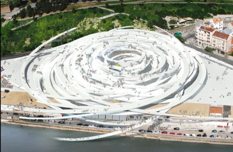
O PROJECT SCOPE: New Construction
O Contrasting the medieval fabric of the capital city, Sou fujimoto’s “floating cloud” intertwines an array of various kinds of social and transportation programs into an organized tangle of suspended ramps that emerge from the static platform of the Beton hala.
o The new, vibrant pedestrian square will serve as the principle access point from the capital’s riverfront to it’s historic core. It will house retail space, cafes and restaurants, exterior exhibition space and a viewing platform, as it is perched atop a subterranean parking garage and transportation hub linking the ferry terminal, tram and bus.

133
Source –Archdaily
CASE STUDY 4
DARLING HARBOUR PUBLIC REALM
O LOCATION: Sydney, Australia
O ARCHITECT: HASSEL
O PROJECT TYPES: Urban Renewal

O PROJECT SCOPE: 2018 completed
O An integrated design amplifies the spaces and experiences Darling Harbour’s public realm was delivered through a close, interdisciplinary collaboration. This approach enabled an elegant design that integrates the public landscape and customized artworks with the architecture – maximizing the public open space, cultural features, connectivity, and views.
o By reinvigorating parklands, integrating landscapes and open space and incorporating water features, public artworks, plazas and event spaces, HASSELL has created opportunities for events and activities as varied as open-air concerts, circus events, market stalls etc.


134
Source –Archdaily
135
Look at land water edge as a GRADIENT and not a boundary.
Having analysed the various aspects that have made the water edges of the city to become obsolete, ill maintained and inhuman, along the course of this study, it is observed that we the more we try to block it out it will cause peril. To make these edges habitable and treat water like in its dynamic sense and allow it to follow its natural course.
The perception of a boundary between land water should be in turn looked at a gradient, which is gradual and respects both the ecosystems in their due courses.
Development must be done looking at these factors in the future, then we will have a sustainable and water resilient city. The qualities of water are also understood, which help give an architectural and place making nature. These must be further acted on and not neglected, which help bring out a character and response in architectural interventions as a blend in the fabric.
I would like to conclude with a poem I wrote, which envisions a harmonic design with all elements of nature being respected.
“As the hues fade away into the horizon, the skyline subtly casting its reflection. The city life is another mood of its own, as twilight approaches sitting on the same stone,
Lost in thought you sit & wonder, how bountiful is the planet you ponder.
The shadows slowly lengthen as falls the night, as darkness fills with an eerie plight. Walking back felt so blissful, the silence in the chaos is serene & peaceful. The structure you designed stands tall, but that old banyan tree’s smile says it all. “
136 E P I L O G U E
BOOKS
Gazetteer of Bombay 1909 I
Soak I Anuradha Mathur & Dilip Da Cunha
Design on the terrain of water I Anuradha Mathur & Dilip Da Cunha
On the Waterfront I P K Das
Open Spaces I P K Das
Image of the City I Kevin Lynch
Aquatecture: Architecture & Water I Anthony Wylson
Water & Architecture I Charles Moore
Adapting cities to sea level rise I Stefan Al
A Mill By the Sea I Pallon Daruwala
ARTICLES & PUBLISHED THESIS
Towards water smart cities I Tim van Hattum
Reclaiming of urbanism of Mumbai I Kelly Shannon, Janina Gosseye
Phenomena and Form at the water’s edge I Grace W. Cheng
The Sustainable Design and Renewal of Water’s Edge Public Spaces in the AsiaPacific Region I Mabel John , Steffen Lehmann & Alpana Sivam
Building with water: innovative approaches for sustainable architecture I Laura Daglio
Urban Waterfront Regenerations I Umut Pekin Timur
Aquatecture: Architectural Adaptation to Rising Sea Levels I Erica Williams
Integrating the Grey, Green, and Blue in Cities: Nature-Based Solutions for Climate Change Adaptation and Risk Reduction I Yaella Depietri & Timon McPhearson
COURSES
SITE PLANNING – MASSACHEUSETTES INSTITUTE OF TECHNOLOGY I EDX
NATURE BASED SOLUTIONS - LUND UNIVERSITY I COURSERA
INTRODUCTION TO WATER & CLIMATE TU DELFT UNIVERSITY I EDX
137
Y
B I B L I O G R A P H
https://wri-india.org/blog/living-water-integrating-blue-green-and-grey-infrastructure-manage-urbanfloods
https://thewaterproject.org/water-crisis/water-in-crisis-india
https://choices.climatecentral.org/index.html#12/19.0743/72.9588?compare=temperatures&carbonend-yr=2100&scenario-a=warming-4&scenario-b=warming-2
https://www.indiawaterportal.org/search/site/sea%20level%20rise?solrsort=ds_created%20desc https://www.buoyantfoundation.org/#:~:text=Amphibious%20architecture%20is%20a%20sustainable, create%20resilience%20within%20vulnerable%20communities.
https://www.re-thinkingthefuture.com/fresh-perspectives/a1398-what-architects-must-know-aboutwater-urbanism/
https://isscbookofblogs.pressbooks.com/chapter/the-role-of-water-for-sustainable-urbandevelopment/
https://studyarchitecture.com/blog/student-work/2020-student-thesis-showcase/ https://www.re-thinkingthefuture.com/article/the-life-of-water-bodies/
http://nrcsolutions.org/floodwater-detention/ https://land8.com/what-is-amphibious-architecture-and-how-will-it-help-cities-adapt-to-climatechange/
https://wri-india.org/blog/reinventing-urban-waterfronts-indian-cities-five-ideas-step-way-forward http://nrcsolutions.org/strategies/?fwp_hazards=coastal%2Ctidal%2Cstormsurge%2Criverineerosion %2Criverineflood%2Cstormwater
https://scroll.in/article/971519/indian-cities-get-drowned-every-monsoon-heres-what-can-be-doneabout-it
https://snazzymaps.com/build-a-map/edit/260465 https://sealevel.climatecentral.org/global-mapping-choices/ http://akshaykore.github.io/mumdata/ https://oldphotosbombay.blogspot.com/2012/06/ https://scroll.in/roving/691090/from-15000-feet-architect-documents-mumbais-aerial-geographyand-pollution
https://housing.com/news/old-mumbai-images-from-bombay-to-mumbai/ https://www.coroflot.com/moishoi/Architectural-Thesis-Post-Apocalyptic-Architecture-An-UrbanSettlement-at-Sea-Mumbai-India
138 R E F E R E N C ES
LIST OF FIGURES
Chapter 1
Figure 1- Reclaiming the Urbanism of Mumbai book
Fig 2 - 6 - Author
Fig 7 - Author
Fig 8 - Soak book + exhibition
Fig 9 -11 - City on water
Fig 12 - Reclaiming the Urbanism of Mumbai book
Chapter 2
Fig 1. - Adapted from Redzuan & Latip 2016
Fig 2. - Urban Waterfront Regenerations
Fig 3. - Urban Waterfront Regenerations
Fig 4 – 7 - Author
Fig. 8 - The Sustainable Design and Renewal of Water’s Edge Public Spaces
Fig 9 – 10. Pic credits – author
Fig 11 – 13 – Centre for applied transect studies
Fig 14 – 15 – Google images
Fig 16 – Google images
Fig 17 - 20 – google maps + author
Fig 21 – 23 – Author + google images
Fig. 24 – 29 – Author
Fig – 30 – 33 – Author
Fig 34 – P.K. Das – Mumbai open spaces
Fig 35 – 37 – Author
Fig 38. International Journal of Applied Research
Fig 39 – Author + google images
Fig 40. - Author + Soak
139 A P P E N D I X
Chapter 3
Fig 1 – 3 - Illustrations: Lauren Nassef | Art Direction: Jelena Schulz
Fig 4 –Terracon India article
Fig 5 - Climate Central
Fig 6 – Dr. Sara Anand
Chapter 4
Fig 1 – 4 – Towards Water Smart cities – book
Fig 5 – 6: Integrating the Grey, Green and Blue in cities book (Adapted from Grimm)
Fig 7 – 8 – NCR solutions
Fig. 9 - 10 – Buoyant Foundation.org
Fig. 11 Amphibious Architecture and Design: A Catalyst of Opportunistic Adaptation thesis
Fig 12. – Home Builders guide to coastal construction – Fema
Chapter 5
Fig 1. - Author
Fig. 2-5 – Author
140
INTERVIEW QUESTIONNAIRES:
1. How should we as architects and futurist visionaries try to create awareness about respecting water as an element in design?
2. There are two sides to when you read about tackling rising sea levels, one side that looks at futuristic floating cities and amphibious architecture, to flipping another side where you actually look at the existing. Which do you feel is a better solution in your opinion?
3. Do you believe there are two different perspectives at looking at river landscapes and coastal landscapes?
4. Sir you emphasize on saying there is no such thing as dryness, rather on the quality of wetness which I think is something half the people aren’t even aware about, how do you feel we can bring this change in perspective?
5. Mumbai has been talking about reinventing its waterscapes with projects like the coastal road and Mithi rejuvenation, do you think they will reduce the connect between land and sea and us users?
6. With so much concretization, does the natural terrain really retain its natural property of flow of water? Do you believe nature will rightfully retake all that is its?
7. A lot of informal temporary settlements of slums are located on the edge boundaries of Mumbai, at what peril do you feel they are at? Is there a solution to save them?
8. For developing countries like India who are already combating with large problems, is this an investment of the present or should they act after a few decades?
9. Certain key factors in developing a design with the water terrain we must consider always ?
10.According to studies the rising sea levels are a major threat to coastal flooding in Mumbai, what other factors do you feel are contributing to this threat?
11.Is Mumbai facing problems like flooding and loss of ecosystems due to callousness in development of urban infrastructure? For instance the land reclamation of the coastal road is it the reason for environmental damage?
12.Just last week Mumbai faced severe flooding and extreme loss of decade old trees falling from their roots, do you feel this will only worsen in the upcoming years? How can we combat this problem and prevent
13. What part of Mumbai’s water ecosystem do you feel is the most adversely affected?
14.Do the government regulations do justice to the environment problems? Do we respect our green spaces and aqueous terrain?
15.What advice would you give to upcoming urban designers on methods to protect the environment and create a sustainable eco-city?
16.The Netherlands is a classic worldwide case study on Floating buildings and its response to the sea, do you feel it is the ultimate paradigm for hydrophilic sustainable design with water?
141
17.What challenges did architects in Netherlands face that made them innovate design technologies integrated the water environment with the built environment?
18.How serious do you feel is the issue of rising sea levels, how can architecture help to combat these issues?
19.Do you as a designer feel the way we map our living spaces, like a clear demarcation between land and sea, is this the correct norm? Why do we mark our land as habitable and water as inhabitable?
20.How should we as architects and futurist visionaries try to create awareness about respecting water as an element in design?
21.Are callous construction techniques like land reclamation responsible for serious issues that cities are facing like coastal flooding?
22.Can adaptive building technologies like floating buildings be used in dense urban contexts of Mumbai, as a way to solve this problem?
23.Does the urban public accept the norm of living on water or is it something still far from reality even in European countries? How supportive are governments for making eco cities on water?
24.Do you believe in the principle that one day the environment will claim what is rightfully its, taking back all the constant harm we have caused with unsustainable development?
25.For developing countries like India who are already combating with large problems, is this an investment of the present or should they act after a few decades?
26.Certain key factors in developing a design with the water terrain we must consider always?
27.What kind of programs and users are best suitable for architectural spaces on water?
28.Do you feel for over decades, humans kept constructing without keeping the aqueous terrain in mind and now is the time to act to preserve this element of nature?
142
144
