8 minute read
Navigating new requirements


Vicky Laymon-Hodson, INS/GIS Analysis Team Lead and Matthew Reynolds, INS/GIS Level 4 Analyst, Enduro Pipeline Services, USA, discuss staying up-to-date with PHMSA CFR 192 and 195 requirements.
ipeline operators across the world are migrating to the concepts of geospatial data and developing a digital twin of their organisation. When you hear the name Enduro, what comes to mind? Pipeline cleaning programmes? ILI combo smart pigs? How about GIS experts? As the industry is evolving, so is Enduro. Family-owned and operated since 1988, the next generation is now bringing the next stage of growth. With this growth, Enduro is ready to offer even more services to the industry, and aid in the process of operators developing the coveted digital twin.
A long-time provider of sub-meter centrelines, Enduro now has over 25 years of combined expertise within our in-house GIS Team. Having such a well-versed team gives Enduro a unique advantage in the industry; this team uses advanced IMU navigation equipment within our ILI tools that complement our PigProg software containing specialised GIS tools. When pairing the tools available, and the team’s extensive knowledge of the industry, clients can be confident in the centreline data produced. PigProg also connects to a geospatial system utilising ArcGIS to produce deliverables the client can integrate into their GIS database with ease. Clients will find that working with Enduro to produce submeter centrelines is a seamless process and budget-friendly. Imagine having one data set to integrate into your organisation’s GIS database, vs multiple imports that are difficult to align.
Moving towards efficiency, Enduro has developed an in-house app used for tracking and developing AGM Site Documentation. We have created a GIS tracking crew that can now multi-task in the field using our Enduro PigTrack App. This app allows our GIS crew to collect data in the field directly into a database, eliminating human errors that can occur when manually transferring data. From collecting XYZ data, to snapping the appropriate site pictures, our crews create the site documentation required while in the field. Clients will now
have the final deliverable within days, vs weeks with previous industry methods. When preparing for IMU services, and in order to ensure sub-meter mapping, our crew will collect additional control points while they are in the field, saving time and money for our client. Long gone are the days of sending crews to the field multiple times to collect the extra data needed.
Tackling pipe strain The industry now seeks the advanced services of pipe ‘bending’ strain and pipe movement. Hiring an additional vendor to supply this data is now a thing of the past; Enduro has worked with strain experts to develop systems to accurately detect and report strain along the pipeline. Geotechnical threats, particularly landslides, have brought pipelines into the spotlight with increased pipeline construction in the Marcellus region. Operators look towards early detection of strain in areas where there is a high incidence of landslides and other geohazard threats. Spatial analysis utilising ArcGIS, coupled with specialised strain analysis tools, helps our analysts identify the strain on pipelines in these regions. Many strain events are associated with pipeline construction and have
Figure 1. DOT CFR 192 Analysis 01.
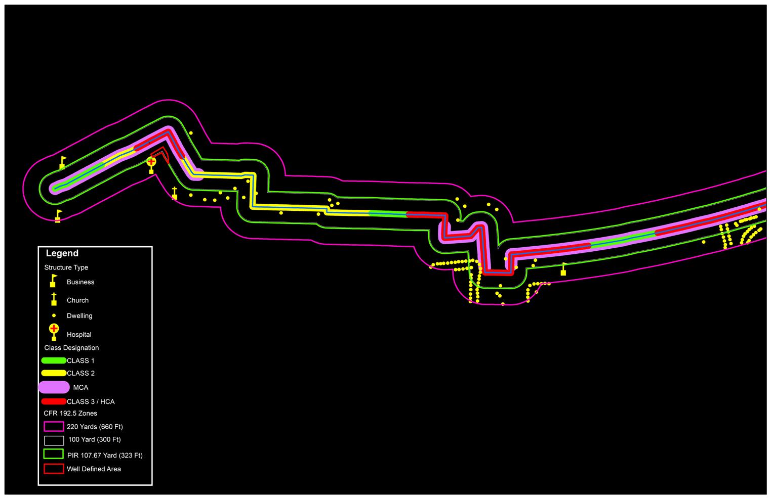
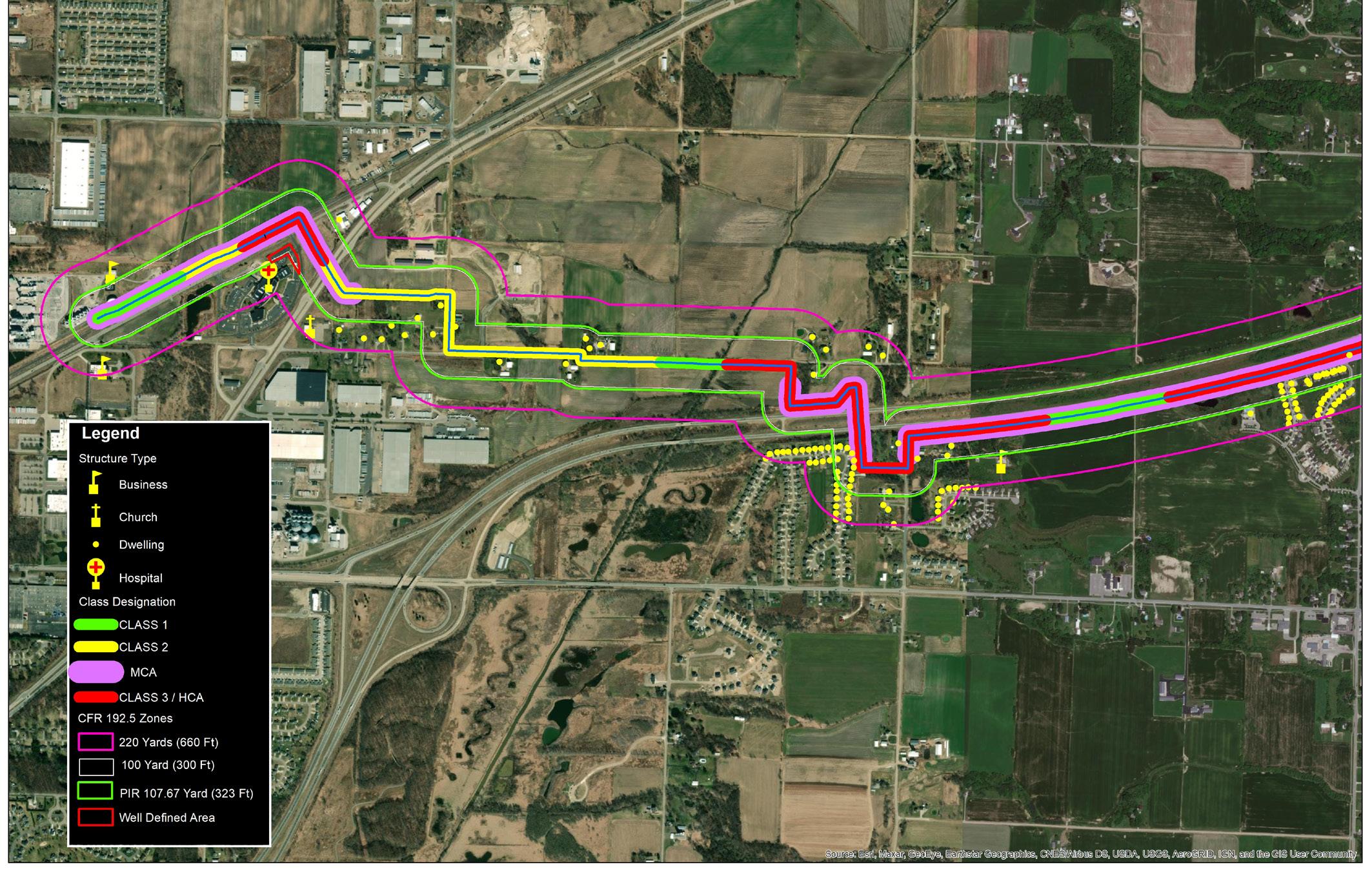
Figure 2. DOT CFR 192 Analysis 01.


been hidden away from the time the spoil pile was backfilled over the new pipe. Nevertheless, pipe strain introduced into the pipe during construction (e.g., misaligned welds and/or an uneven trench) can be discovered using IMU technology and our advanced analysis tools. With an archive of excellent IMU data going back several years, we can uncover this historical strain data. In addition, using previous IMU data presents the opportunity to analyse pipelines for horizontal and vertical pipe movement.
Enduro has had the opportunity to work with several pipeline operators to successfully locate and monitor these potential areas of concern. For example, Enduro had the opportunity to work with an operator to monitor an area of concern within a long wall mining project. This operator was proactive and deployed Enduro’s Caliper tool, paired with an IMU, to get a base centreline for the section that would potentially be affected by the future mining project. After the mining project was complete, Enduro returned to the field to collect the second data set. Enduro used the same Caliper tool along with the operator, creating a similar environment in the second survey. The Enduro GIS Team then compared the two data sets, utilising the mining boundaries supplied by the customer to locate discrepancies in the data. During this analysis, several strain areas were identified in the second data set. These strain events coincided with the boundaries of the mining project. The client then developed a plan to remediate these areas of concern according to their integrity management plan (IMP). Enduro and the operator were very satisfied with the analysis of this project.
Operating in high consequence areas As the industry evolves, so do the regulations. Pipeline operators are becoming very familiar with new regulations pertaining to CFR 192 and 195 compliance. With new regulations, operators are under greater pressure to make sure their pipeline assets remain in compliance. PHMSA’s new ‘mega rule’ brings many previously unregulated lines under scrutiny by including four lane highways and five or more structures into the requirements. Pipelines affected by these new regulations will need accurate mapping along with moderate consequence area (MCA) determination.
Similarly, as the ‘mega rule’ applies to natural gas gathering and transmission pipelines already under regulation, these lines also need to be updated. Moreover, urban sprawl and growing suburban neighbourhoods are increasingly putting people and businesses into the 100 yd, 220 yd, and potential impact radius (PIR) extents of active pipelines. With increasing populations living near pipelines and newer and stricter regulations, compliance becomes an increasing challenge for pipeline operators to manage. With Enduro’s advancements in GIS, class location, HCA, and MCA determination


for natural gas pipelines is now a service we are offering. We are not leaving out liquid lines; Enduro has the expertise and the tools to work with the pipeline operators for HCA determination using the unusual sensitive area (USA) licensed data sets. As part of HCA determination for liquid pipelines, Enduro will provide overland spill analysis. These services will ensure clients are up to date with PHMSA CFR 192 and 195 requirements. Our regulatory analysis can be included as part of an inline inspection project for any individual run or multiple pipelines. When we have accurate up-to-date HCA, MCA, and class location analysis, we can better support our client’s IMP. When we have accurate up-to-date information, we can approach our analysis from a more informed position, and our reporting will be seamless with the customer IMP. In addition, providing regulatory analysis as a service to our customers puts Enduro in the position to offer corrections when we come across errors in the HCA, MCA, class location, and US boundaries. Enduro will include the regulatory analysis in the final report, and we are equipped to provide the spatial deliverables for GIS Integration. Enduro is dedicated to accurately reporting pipeline anomalies so that operators can make informed decisions regarding the integrity of their pipelines. Similarly, Enduro has been able to offer updates to operators in HCA, MCA, and class location placements; working with our clients as a team brings the best results possible.
Portal technology It is becoming more common for established pipeline operators to develop and manage a GIS database. As this is true, not all pipeline owners have the resources for this type of management. Enduro now has the capability to offer GIS database management to these operators. With smaller operators having access to a GIS database, if they are acquired by a larger operator, their value is increased; the new operator will have the ability to seamlessly integrate all their data into one GIS database. For many years, Enduro has provided industry-respected analysis. The resulting data from this analysis has been carefully archived, and will now be available through a GIS portal. This service will provide smaller operators with the ability to access their data using Enduro’s GIS Portal, featuring ArcGIS, at any time. The Enduro GIS team will load and manage the data from our ILI projects and previous projects from other vendors. The GIS Portal will allow Enduro clients to access their own data space protected by the Enduro Firewall. Within this space, the client will find their pipelines plotted on a map in a spatial format. The portal will have a dashboard where the client can interactively slice through pipeline data. They can see pipeline-specific information or analysis across multiple pipeline surveys, such as anomaly growth over time.

Conclusion Enduro is the go-to pipeline service company that meets your needs; Enduro will work with operators to develop specialised cleaning programmes, ILI surveys, establish sub-meter centrelines and deliver advanced GIS services. It really comes down to teamwork and developing the best plan to fit the operator’s needs. Being that Enduro is capable of supplying a broad range of services, pipeline operators can now make one call to handle all of their pipeline inspection and GIS needs.
WORLD LEADERS IN SOLID-STATE DECOUPLING
WE MAKE THEM
SO YOU CAN TRUST THEM TO PERFORM
Dairyland Electrical Industries is the world’s leading manufacturer of solid-state decoupling products for the corrosion protection industry. We’ve been making rugged and reliable products since 1983. After nearly 40 years, 99.99% of them still work.