All photographs in this book are the property of OUCRU Indonesia and are used with written permission from the photographers and the individuals depicted. Every effort has been made to properly acknowledge the rightful owners of these photographs. All illustrations used in this book are in the public domain.
This book is part of the study titled “Digital Diaries for Climate and Health: An Engagement Project to Explore Community Understandings and Perceptions”, fully funded by the Medical Sciences Division, University of Oxford. The book production—including its printed version, poster, and merchandise—was funded by Wellcome through the Climate Change Mini Grant scheme.
INTRODUCTION
Climate change is the greatest health threat facing humanity today. Extreme weather events—such as heatwaves, floods, and droughts—can directly affect health through heat stress, deteriorating air and water quality, food insecurity, and changes in the distribution and ecology of disease vectors. These events also compromise food and water security, contributing to malnutrition and undernutrition. Furthermore, the combustion of fossil fuels not only drives greenhouse gas emissions but also leads to hazardous levels ofairpollution.
Climate change also threatens the broader social determinants of health, includinglivelihoods,equity,accesstohealthcare,andtheresilienceofsocial support systems. These climate-sensitive health risks are not evenly distributed; they disproportionately affect vulnerable and marginalized populations such as women, children, ethnic minorities, underserved communities,olderadults,andindividualswithpre-existinghealthconditions.
This study, conducted in Indonesia, Vietnam, and Nepal, seeks to explore how communities perceive and experience the impacts of climate change on their health, well-being, and livelihoods. It also examines the adaptive actions they are taking in response. By capturing these lived experiences, we aim to deepen our understanding of how climate change is affecting health at the communitylevel.
The Process of Collecting Stories
2
Ten students who participated in the workshop subsequently began developing their visual stories. This process took place over a threemonth period (October–December 2023), supported by one-on-one coaching sessions held primarily online. On average, each student submitted two to three stories reflecting their personal experiences, including narratives shared by their parents or relatives.
4
Over the six-month period, we generated more than 70 visual stories and hundreds of photographs. All stories were then categorised into three themes: the perspective, the causes, and the health impact and risks. It will also be compared with stories from other countries as well as used as a public awareness campaign
1
In partnership with the Faculty of Art and Design at the Bandung Institute of Technology, we conducted a two-day workshop on participatory visual methods, including photovoice. The workshop aimed to enhance participants’ understanding of how images can be ethically used in health research.
3
To broaden community engagement, we also launched an online photo competition inviting social media followers to share images and narratives about their climate change experiences. Approximately 35 participants submitted entries.
#01
THEIR PERSPECTIVES
In Indonesia, climate change is not just a headline – it’s a lived reality. Prolonged droughts, relentless floods and rising seas that swallow homes and even graves serve as nature’s stark reminder: when we stop living in harmony with the earth, disaster follows. These images are not just experiences – they are warnings!
MY BREATHTAKING
SOLO JOURNEY
Cianjur district in West Java is one of Indonesia’s earthquake-prone areas. In 2022, a major earthquake devastated Cugenang village, destroying thousands of homes and taking hundreds of lives. We once thought these quakes were solely due to unstable geology—beyond human control. But experts now link them to the growing effects of climate change, which may trigger movement along the Cimandiri Fault. It’s hard to grasp how shifting weather can move the Earth, but if human actions fuel climate change, and climate change intensifies earthquakes—don’t we share some of the responsibility?
Photographer: Andaru Firmansyah
Location: Cugenang, Cianjur, West Java
Despite being a world-renowned tourist destination, the people of Bali continue to uphold the philosophy of Tri Hita Karana, a Hindu philosophy that emphasises the importance of maintaining harmonious relationships with God (Parahyangan), human beings (Pawongan), and nature (Palemahan). Guided by this principle, the Balinese view nature as a manifestation of divine love, and caring for it is seen as an expression of devotion to God.
Photographer: Naurah Assyifah Rilfi
Location: Batur Bangli, Tabanan, Bali
This is the common condition of homes in Clumprit, Degayu—low roofs, poor ventilation, and houses built below road level, making them prone to flooding. Repeated soil layering to block seawater has worsened indoor heat, while the lack of shade trees outside eliminates natural cooling. These are the worsening effects of tidal flooding. Although their livelihood sources like paddy fields and fish farms projected to be entirely underwater by 2035. Yet, the community remains unwilling to relocate, trusting that the Almighty will protect and guide them without leaving their homeland.
Photographer: Ludvia
SMPN 1 Bojongsoang is located in the Dayeuhkolot area of Bandung, a region that experiences recurring flooding every rainy season.
Due to its distance from the river, flooding typically affects only the school’s front yard and entrance road. However, this year’s seasonal flood has been much more severe, submerging nearly all of the classrooms and forcing the suspension of lessons.
Photographer: Andaru Firmansyah
Location: Dayeuhkolot, Bandung, West Java
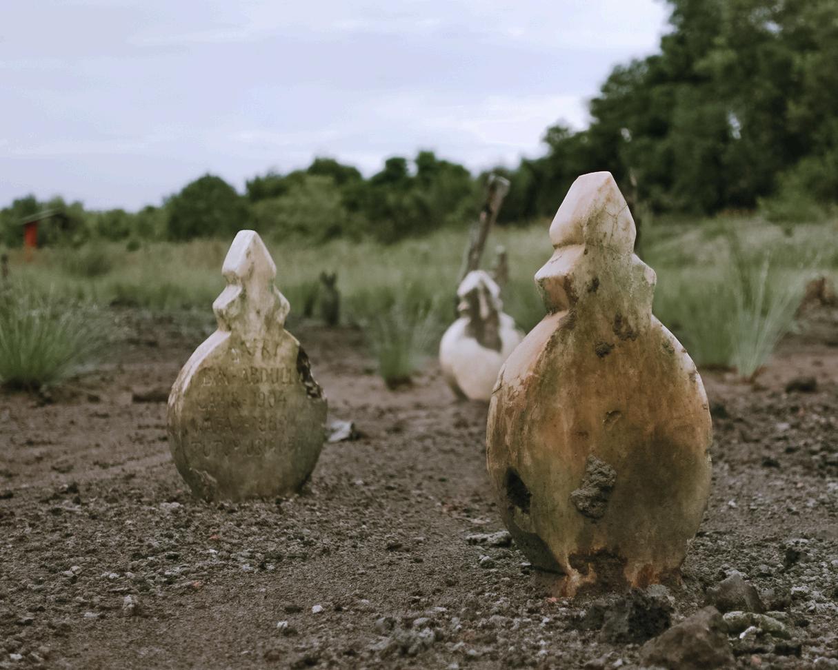
In Indonesia, graves are typically marked with two headstones—one at the head and one at the foot—to indicate the orientation of the body and to help visitors identify the person buried there.
In Lubuk Kertang, North Sumatra, the headstones in this public cemetery are gradually being buried under layers of sand deposited by tidal flooding. The degradation of the mangrove forests, which once served as natural wave barriers, has led to the intrusion of seawater into residential areas— including the cemetery.
Photographer: Ade Indah Hutasoit
Location: Lubuk Kertang/ P. Susu, North Sumatera
It has been two years since Cyclone Seroja struck us, marking the first time such a storm hit Sumba.
Cyclone Seroja not only destroyed the homes of residents but also damaged other public facilities. One of the most severely affected was the large dam located in Lambanapu village. This dam was a crucial water source that irrigated many rice fields, including ours. Since the dam was damaged by the cyclone, the flow of irrigation water has ceased. As a result, the rice fields have dried up and can no longer be cultivated. In the past, we always had a stockpile of rice, which we would mill into rice every month. Now, there is no rice to store. Previously, we would sell rice from our fields, but now, we have to buy rice.
Cyclone Seroja not only drastically reduced our income from farming, but it also created additional expenses with the need to purchase rice—something our family had never done before.
Photographer: Umbu Ronaldi
Location: Mauliru, East Sumba, East Nusa Tenggara
Just after the 2021 Easter celebrations at church, the panic broke out: "The river is rising — FLOOD!" We grew anxious when the water kept rising, submerging paddy fields, including crops ready for harvest. Strong winds and heavy rain brought down trees, tore off roofs, and let cold rain pour into homes. Power was out, and we were lit by a few candles from the Easter mass. It was our first experience with a cyclone, considered it as a reminder that the climate is changing and nature is responding in unpredictable ways. Today, we face every rainy season differently, the fear is still there, and will not be less.
This photo was taken on Monday, December 18, 2023, showing a landslide that caused total gridlock on the Batusangkar–Bukittinggi road.
The landslide was triggered by continuous heavy rain throughout the day. That afternoon, a tragic accident occurred: three motorcyclists had stopped beneath a cliff to wash their feet when a sudden landslide struck. Two managed to escape, but one man was buried and died at the scene. According to his family, he had just returned from taking his child to university in Bukittinggi. This event deeply affected the local community and left a lasting impact on my mental health. Witnessing the tragedy firsthand caused me intense anxiety and fear. Since then, I’ve become afraid to travel by motorbike or go out without my parents’ permission. The fear of another landslide haunts me, and I often imagine, “What if that happens to me?” This disaster has made me realize how deeply natural events can affect mental well-being.
Photographer: Fhebyola
Location: Batu Sangkar - Bukti Tinggi, West Sumatera
Photographer: Erick Namuratu
Location: Mauliru, East Sumba, East Nusa Tenggara
Photographer: Erick Namuratu
Location: Mauliru, East Sumba, East Nusa Tenggara
THE CAUSES
Air pollution and poor waste management are often seen as the leading causes behind the impacts of climate change people talk about. Many also point to the massive construction of apartment complexes as a growing trend in Jakarta’s urban landscape. Interestingly, youth participants brought different concerns: the abandoned amusement parks, hotels and restaurants left behind since the COVID-19 pandemic, and the widespread sale of coral reefs and marine fishes which they believe is disrupting the delicate balance of ocean ecosystem.
MY BREATHTAKING
SOLO JOURNEY
In the isolated Bungin Island, a community of goats faces an unexpected struggle as the once lush grasslands dwindle due to the harsh effects of climate change. With the diminishing vegetation, the resourceful goats, begin to adapt by foraging through accumulating piles of trash. As their diet transforms, a unique correlation unfolds, shedding light on the broader impact of climate change on this fragile ecosystem. The photos explores the interconnectedness of environmental shifts and the resilient spirit of creatures forced to adapt to a changing world.
Photographer: Anindya Nabila Aletha Zulham
Location: Bungin Island, Sumbawa, West Nusa Tenggara
Climate change has never felt so real to me. As a migrant working in Jakarta and having not returned to my hometown of Pekalongan for a long time, I am truly astonished by the changes. It doesn’t seem long ago that the banks of the Kali Loji River were renovated, but now the water has turned black and emits a foul odor due to pollution from batik waste and piles of garbage. Previously, the river served as a reservoir for rainwater during the regular tidal floods, but the local community has worsened the situation by indiscriminately dumping waste.
Photographer: George Joseph Kristian
Location: Pekalongan, Central Java
Foto diambil oleh: Angela Sunaryo Lokasi pengambilan foto: Jakarta
Research shows that large-scale infrastructure development contributes to over 50% of carbon emissions worldwide. Reducing carbon emissions is crucial for the environment, but it also leads to cost savings. Lowering the carbon footprint of infrastructure projects creates efficiencies in materials, energy, and labor, which reduces capital and operational costs, resulting in savings at every stage. In Jakarta, the concept of townships is being heavily promoted as a solution to the city's housing issues. Unfortunately, due to various factors, particularly during the pandemic, the development of townships or apartments often fails to meet deadlines. In addition to financial losses, these delays can contribute up to 544 million tons of carbon emissions annually.
Subang, West Java, is known as a popular tourist destination due to the Tangkuban Perahu Mountain, frequently visited by domestic tourists for sulfuric hot spring baths while enjoying the scenic views at the foot of the mountain.
The massive development of supporting tourism infrastructure, such as hotels and restaurants, has disrupted the natural flow of groundwater. As a result, sulfuric water from Tangkuban Perahu Mountain is now flowing into irrigation systems, rivers, and wells used by locals for farming and daily needs. The high sulfur content in the water increases the acidity of the surrounding soil. This elevated soil acidity negatively affects rice growth, as it can hinder the absorption of essential nutrients. The water flow from the mountain plays a crucial role in irrigation, which has caused the irrigation water to appear oily.
Photographer: Angela Sunaryo Location: Cikarang, Bekasi, West Java
Photographer: Diaz Shakira Hana Location: Subang, West Java
The growing popularity of ornamental fish markets, increasingly favoured by the public, hides a less favourable story. To some extent, the extraction of coral reefs has a detrimental effect on marine ecosystems that have taken years to develop. In a small fish market in Bandung, several shops sell both live and dried coral. Unlike fish, which can be quickly cultivated, corals require much more time to grow. Coral ecosystems may take 5,000 to 10,000 years to develop, with some coral species growing as slowly as 0.5 to 2 cm per year. This extremely slow growth rate means that the indiscriminate extraction of coral has a significant impact on the survival of marine life.
Pasteur Street is well-known as one of the icons of Bandung. However, there is a stark contrast in the stories shared by the long-time residents of this street and the newcomers to the city. For the elderly, Pasteur Street is remembered as a green area, once lined with lush trees and rice fields. In contrast, newcomers describe Pasteur Street as a crowded area, constantly plagued by traffic jams. The trees have been replaced with buildings, and the once-cool atmosphere is now much hotter.
Foto diambil oleh: Angeline Lokasi pengambilan foto: bandung, Jawa Barat
Foto diambil oleh: Sadira Nawwar Lokasi pengambilan foto: bandung, Jawa Barat
The prolonged dry season in Wonogiri this year has significantly affected the water level of the Gadjah Mungkur Reservoir. This situation has been worsened by the degradation of the green belt area due to illegal logging and the irresponsible disposal of waste along the reservoir’s edges by local residents. As a result, the once expansive body of water has turned into dry land. Residents now have to walk long distances to fetch or even purchase clean water. Although no official health reports have been released, I am certain that this condition will eventually impact the well-being of the local community.
Photographer: Joko Dwiwahyudi
Location: Wonogiri, Central Java
This amusement park was once a vegetable farm owned by residents. The park was built when Lembang was becoming one of the most popular tourist destinations for domestic visitors. Unfortunately, when the pandemic hit and the government imposed restrictions on mobility and social activities, the amusement park ceased operations and was eventually closed due to bankruptcy. In addition to the financial losses, the materials used to construct the park, such as concrete, stone, and asphalt, have the ability to absorb sunlight, thus contributing to greenhouse gas emissions. Moreover, large structures like amusement parks, when unused, tend to become more humid, which accelerates the growth of mold. Mold releases carbon dioxide and other gases into the atmosphere as it breaks down building materials.
In older buildings that still contain asbestos, the material gradually releases tiny fibers when damaged, which remain airborne for extended periods. When inhaled, these asbestos fibers can cause serious health issues.
Photographer: Sadira Nawar
Location: Bandung, West Java
Dayeuhkolot in Bandung, West Java, is a flood-prone area every rainy season. Situations like the one in this photo are common: children temporarily stop going to school — either because their school is flooded, they are helping their parents as seasonal boat taxi drivers, or sometimes both. There are many reasons why this climate-driven disaster frequently occurs in this area, ranging from geographical structure and inadequate drainage systems to the increasingly severe impacts of changing climate
Photographer: Andaru Firmansyah
Location: Dayeuhkolot, Kab.Bandung, West Java
Telaga Menjer and the surrounding forest play an important role in maintaining and preserving the ecosystem, preventing natural disasters such as landslides, floods, and droughts during the dry season. Deforestation, tourism development, and unplanned land use can disrupt the lake’s ecosystem. If this continues unchecked, it will have a negative impact on the local communities who rely on Telaga Menjer both as a source of livelihood and for access to clean water.
Photographer: Joko Dwiwahyudi
Location: Garung, Wonosobo, Central Java
For over a week, floods have inundated Sungai Penuh in Kerinci, Jambi Province. The flooding was caused by the overflow of the Batang Merao River, the longest and largest river here. However, the flood in 2023 is the worst in our history; over 26,000 residents have been affected, with water levels reaching up to 2 meters. The disaster is linked to upstream sand mining, deforestation, reduced water catchment areas, river shallowing, and the lack of normalisation and river widening efforts.
Photographer: Anggi Gustiawan
Location: Sungai Penuh, Kerinci, Jambi
HEALTH
IMPACT & RISKS
Community members seldom associate changes in their health conditions with exposure to climate related stresses. This tendency, compounded by the prevalent practice of self-medication hrough traditional remedies or the purchase of non-prescription drugs, presents a significant challenge for researchers in assessing the impacts and health risks posed by climate change.
MY BREATHTAKING
SOLO JOURNEY
Ringinarum in Kendal has become a silent witness to severe drought. Unbearable heat has dried up agricultural land and rivers that used to flow. Farmers are now struggling to survive due to crop failure. Health complaints have begun to emerge due to limited clean water supplies. Although there have been no official reports regarding the impact of this prolonged drought on the health situation of the local community, residents have begun to carry out independent water conservation programs. They have started to create water catchment systems, build water storage tanks, and manage water wisely.
Photographer: Eko Sariwijayanto
Location: Kendal, Central Java
Although no longer operational, the Marunda Coal-Fired Power Plant (PLTU) continues to impact nearby communities. Since opening in 2017, it has contributed to environmental pollution, mainly from dust produced during coal unloading and plant operations. The Marunda apartment complex is among the hardest hit, with around 11,000 residents reporting health issues—especially skin, respiratory, and vision problems. One such case is DT (64), who sought treatment for shortness of breath. Doctors later linked white spots on her lungs to air pollution from the plant. Meanwhile, ND (2.5) and NS (10) suffer from unexplained skin rashes, with conflicting medical opinions citing either mites or bacteria as the cause.
Photographer: Syifa Kautsar
Location: North Jakarta
Akbar left Sulawesi in the 1980s to seek his fortune in Jakarta. For decades, he worked at the fish auction market, facing the ups and downs of an unpredictable economy, all dependent on Jakarta’s increasingly depleted marine resources. As conditions worsened and the market collapsed, Akbar decided to become a fisherman. Using the last of his savings, he began building a fishing boat — not only as a means of livelihood but also as a place to live.
While this shift may offer some financial relief, new challenges arise: living near coastal garbage stalls with limited access to clean water and proper sanitation raises serious concerns for his long-term health and well-being.
Photographer: Izhar Alkhalifard
Location: North Jakarta, Jakarta
The Cilemahabang River serves as the central source of daily activity for 56,525 residents in the villages of Karang Raharja and Karang Asih, North Cikarang, Bekasi.
The river stretches from Karang Raharja Village to Karang Asih Village, with its banks being a focal point for the local community. Despite the river's water now being thick black and emitting an unpleasant odor, the residents continue to use it for washing and even bathing. This is due to the presence of housing developments and factories in the area that discharge waste into the riverbanks. Purchasing water at 5,000 IDR per gallon would be too costly for many households, consuming a significant portion of their monthly budget. As a result, the community has no choice but to rely on the river water for daily activities. Some residents have suffered from the polluted Cilemahabang River, experiencing skin diseases such as rashes, ringworm, and
Photographer: Rayhan Prattama Yudha Syahputra
Location: Karang Raharja dan Karang Asih, Bekasi, West Java
THE TEAM
Prof. Sonia Lewycka, MA (Cantab), MPhil, PhD
Principal Investigator
Oxford University Clinical Research Unit (OUCRU) Vietnam email: slewycka@oucru.org
Dr. Ruly Darmawan, M.Sn
Site Investigator for Indonesia Faculty of Art and Design, Bandung Institute of Technology
Soraya Weldina Ragil Dien, BA., MComm Co-investigator and Site Coordinator for Indonesia
Oxford University Clinical Research Unit (OUCRU) Indonesia email: rdien@oucru.org
Eva Simarmata, BA Research Team Member
Oxford University Clinical Research Unit (OUCRU) Indonesia
Dr. Mary Chambers
Head of Public and Community Engagement of OUCRU Vietnam, Indonesia, and Nepal