

1 2 3 4
Interact
Indeterminant New York
Imagine The Deep Section as a Tool for Thinking About Context
Stratify Towards a Rhetoric of Ground
3.1 Between Imagination and Myth: From Lower Manhattan (1999) to the Viele Map (1865)
3.2 Stratigraphic Operations: Seismic-Architectural Devices, Heterotopic Fragments, and Geofollies
3.3 SF and Other Metrical Strategies for the Underground
Extrude Delirious Fields and Paranoid Critical Fragments
4.1 Unfolding Urban Deliria: The Commissioners’ Plan (1811) Through Delirious New York (1978)
4.2 Paranoid Critical Extrusions
4.3 From Gold to Light – Quarrying Manhattan’s Cultic Dimensions
4.4 Light Passes: Streams of Unconscious Consciousness
5
De-Sediment
Seismic Forces Through the Slightest Tremor
5.1 Weaving an Architecture of Anthropocenic Events
5.2 De-Sedimenting Manhattan: From The Manhattan Transcripts (1981) to The Greensward Plan (1858)
5.3 Insular Events: Central Park, Seneca Village and Other Stories of Erasure
5.4 Diffracted Archipelagos and the Fantasy of Erasure
6
Intra-Act Architecture as a Geologic Condition
6.1 Contact Zones: Architecture as a Condition for the Fault
6.2 Towards an Ethics of Ground

1
Interact
Indeterminant New York
In his 1925 novel The Great Gatsby, F. Scott Fitzgerald offers the reader what could be regarded as a quintessential literary depiction of Manhattan. He writes that ‘[t]he city seen from the Queensboro Bridge is always the city seen for the first time, in its first wild promise of all the mystery and the beauty in the world.’ 1
Conventional representations of Manhattan often offer an idea of the island as a dense city condition emblematic of twentieth-century neoliberal forms of capitalism. This urban condition reinforces readings of the city as a series of architectural extrusions along an orthogonal urban grid. Manhattan is also a laboratory of ideas that tells the ‘social history of the world’ but somehow has ‘all the iridescence of the beginning of the world.’ 2
Yet, like many other coastal and insular conditions, twenty-firstcentury Manhattan faces adverse anthropogenic climate change. Stronger storm surges and sea level rise now demand that the island recalibrate its social and environmental positions. The city needs to consider once again its fluid archipelagic conditions at the mouth of a large watershed that engages in tidal fluctuation with the bay, and its old geologies inherited from glacial dynamics on which it has laid its foundations. Tangled in exponentially unstable planetary conditions, the city also needs to re-examine its ongoing indeterminacy influenced by unbalanced power and land dynamics.
The development of the island-city has responded, systemically yet with varying degrees of success, to logics that try to make capitalist progress compatible with the territory’s geological, topographical and hydrological conditions. Even though these logics of land, water and ground – here called geologics – are perhaps less dominant than the dense urban culture and, therefore, less predominant in the city’s representational cosmos, they are still important to explain why Manhattan has evolved to its current condition.
The examination of Manhattan’s geologics requires a contextual
Standing on the northern tip of Manhattan, Inwood Hill Park can be read as an Anthropocenicinfused geology, where novel ecologies coexist in tension with scars of erasure through violence, theft and war. The apparent stability of the large rock on which the park stands is read against the fluidity of marshes draining to the Hudson and the Harlem rivers.

The old scale of Manhattan’s skyscrapers – ‘those small human scratchings on the surface of the Earth’ –recalibrated against a new experimental scale of deep space and time. The city perceived as a more recent layer in the island’s complex stratigraphy also raises a cognitive challenge to its perceived limits and to our own limitations as humans.
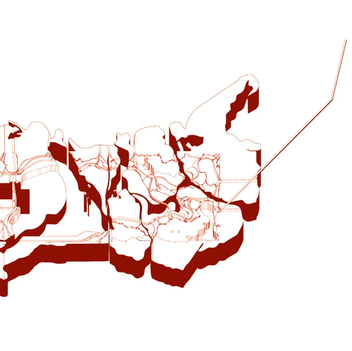
and in plain sight. It keeps cutting. The cut expands upwards through the wind tunnel and the Venturi effects caused by the skyscrapers. Wind shifts direction perpendicularly to flow along the grid. The deep canyon gorges disorient birds and insects, the perfect urban habitat for birds of prey. It keeps cutting.
The cut grabs traces of the flight patterns around the island; arches traced from the asphalt of airport runways into the sky. It cuts through the chemistry of polluted clouds made of carbon molecules, nitrates and acidic water. It grabs the direction of the dominant winds blowing from the bay and the ocean on the southwest. It keeps cutting. The cut expands further to capture trajectories of satellites scanning, triangulating, and photographing from the earth’s low orbit.
It keeps cutting. It cuts through brief choreographies of planets, meteorites, asteroids, stars, gas and dust. It keeps cutting. The cut expands inwards to the deepest layers of the lithosphere. It cuts through unstable


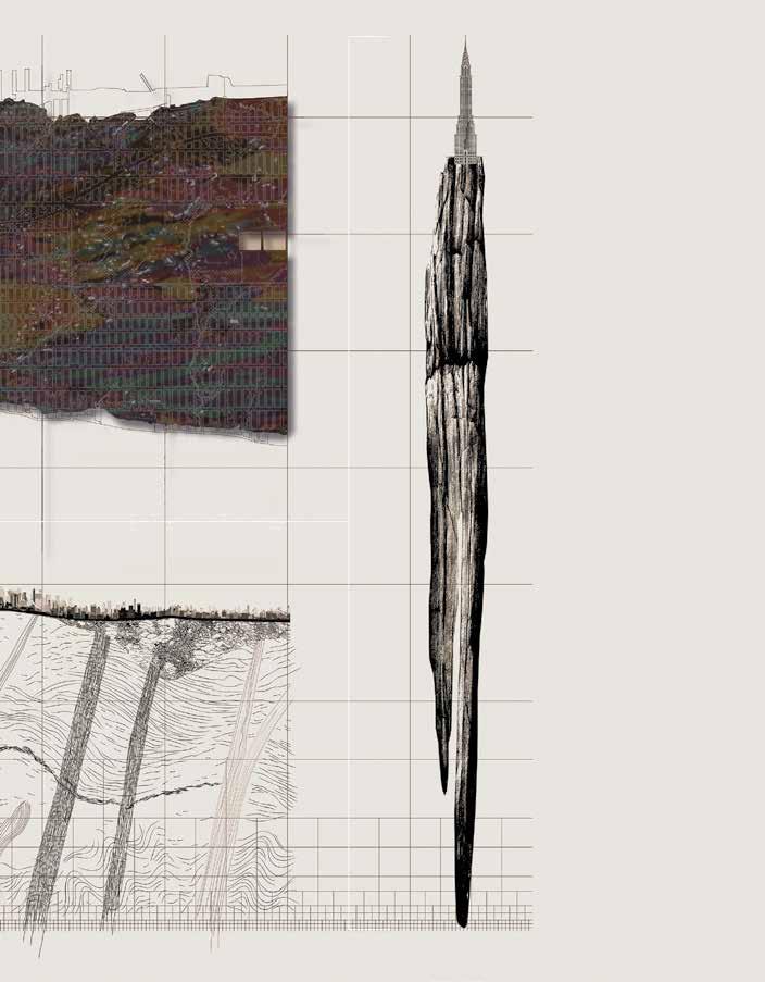
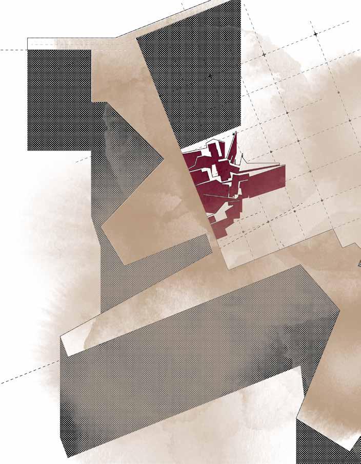
operationsGeological totestthresholds, discontinuitiesinsingularatitiesand DrawingManhattan. andsurveyor’sdeviceasa chain.

The island tested as a geological raft adrift in an underground sea of semiliquid rock.

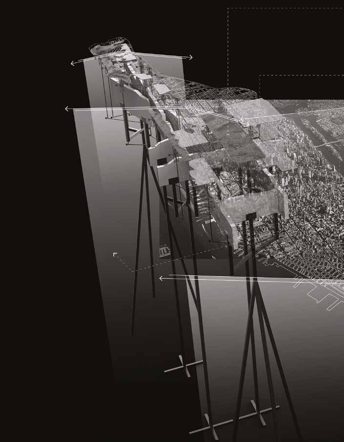
leap of creativity in the spatial narrative of the island’s hydrological and topographical conditions, since most of the territory he depicted no longer existed, especially south of Central Park. 83 Thus, the map can be described as a speculative spatial fiction performing in at least two interesting ways: first, it enacts a temporal compression of the island by rendering some of its previous territorial conditions on top of the city in construction, thus, providing an impactful and immersive visual glimpse of the otherwise inaccessible foundational layers of bedrock.
Second, it stages a potent perceptual manipulation of territorial evolution by highlighting with yellow demarcations the edge portions of the island that were landfilled as additions to the original insular perimeter. 84 The map registers the material exchange involved in ‘the consolidation of port commercial activities and their success for many years to come.’ 85
With a proposal to recalibrate the mediation between technology and nature, the Anthropocene theory advocates for the dissolution of boundaries between interior and exterior. The technological sublime is another way of referring to the resulting aesthetic engagement with and sensibility of nature associated with an increasing scale of human artifice. 86 The aesthetic experience of the sublime moves away from a feeling of being awestruck by the power of nature to an overwhelming sensation caused by the impossibility of escaping or even stepping outside of the technospheric milieu of which we are but a subcomponent. 87
When studied from the perspectives offered by the Anthropocene, the Viele Map supports methodological approaches to conceiving of alternative recalibrations of city and bedrock, where both are conceptualized as transcalar actants that cut across an infinite range of connected scales. 88 Reconfigured as an artefact that contains the possibility of cutting through the island’s spacetime conditions – in a way, a planar view that almost works as a section – the cartography informs a strategy with which to analyze and manipulate the city’s present conditions and its future possibilities. The map activates readings of the city-rock entanglement across dispersed conditions of connectivity by gesturing towards what exceeds it and, in doing so, it indicates what can no longer be seen in the city. With an unusual depth in space and time, it evokes a perhaps unusual sublime experience of the island on a planimetric view; an aesthetic engagement that allows for the reading of what usually escapes comprehension and attention in more conventional depictions.
The map is, therefore, less of a cartographical survey and more of a speculative survey of conditions that no longer existed completely or existed in a not-completely solid way. It suspends time in this transitional paper space that translates the previous conditions that were no more on to a new city that was yet to come.


“trained” to use a park “properly so-called,” by which he meant a picturesque landscape in the English tradition.’ 311 In other words, the park was to be used by the wealthy and affluent who defended its construction for different reasons. Several rules on how to use the park were imposed on the city to, in effect, prevent lowerincome workers and non-White people from using it. Questions about the meaning of public, as well as of park, raised equally complex questions about the meaning of democracy and the rhetoric involved in defining it in political, economic, and social terms.
312
Besides requiring clarity on what a public park may mean to a largely polarized nineteenthcentury society in New York, the construction of Central Park also demanded a shift in municipal management, and more specifically in the management of public resources. The creation of the park ‘initiated a remarkable redefinition and expansion of city government’s responsibilities to its citizens.’
313
Historians Roy Rosenzweig and Elizabeth Blackmar explain that the park not only meant a totally new attitude of public life in an increasingly congested city, but it also ‘emerged out of a complex mix of motivations – to make money, to display the city’s cultivation, to lift the poor, to refine the rich, to advance commercial interests, to retard commercial development, to improve public health, to curry political favor, to provide jobs.’ 314 The idea of public was, maybe above all else, born out of necessity. The magnitude of the park’s construction – more than ten million dollars, or ‘three times the city’s total
37 (left) Map of Central Park, Calvert Vaux and Frederick Law Olmsted, 1870.
38 (right) Greensward Plan, Proposal for Central Park, winning project, Calvert Vaux and Frederick Law Olmsted, 1858.
budget in 1850’ – on more than three hundred hectares of prime real estate land meant that no single individual, or even isolated entity, could afford it on their own. 315
The Greensward Plan has been explained by different scholars as Olmsted’s strong reaction against the city grid. The landscape architect, who often referred to the park and the city seemingly interchangeably, advocated for a landscape that ‘“should present an aspect of spaciousness and tranquility with variety and intricacy of arrangement, thereby affording the most agreeable contrast to the confinement, bustle, and monotonous street-division of the city.”’ 316 For Olmsted, Central Park was not just the rejection of the city, it was an active anti-city, a ‘Paradise Lost of New York,’ an alternative vision for Manhattan, developed at scale – a living colossal miniature of sorts – based on the ideals of the European city. 317
Few other landscapes have been as theorized, discussed and scrutinized as Central Park; none other holds as much symbolic power. The park is quintessential to the American rhetoric of democracy, and a powerful statement of the virgin land that resists the advances of the city or, even more appealing, that restores this virginity, once lost to the city inferno. It is widely known that this is not the case: that Central Park is as artificial a construct as the city on the island; that this is a highly curated and staged landscape that took more dynamite to get its smooth curves than the Battle of Gettysburg; that its species try to serve the ideal of a pre-Manhattan landscape but not all of them are endemic to the East Coast. Yet, the narrative is what persists, the way the park projects its image to media, and what people choose to believe in.
Central Park as an anti-Manhattan is intriguing also because it does not seem to be essentially true: the park has in it an implicit grid. Besides its obvious inscription in the city grid, with important alignments with streets and avenues both transversally and longitudinally, it includes a system


A Park and a Village.
Two main characters in a myriad of mundane stories.
Domestic, even if groundbreaking stories. The Village was there before the Park. It was erased by its picturesque ambitions. For more than a century the City forgot the Village, the stories were reduced to one character.
Some remained curious about the lost Village. It was now the stuff of urban myths.
The ground kept its promise: it preserved the memory of the Village, shards of its domesticity.
Slowly, it began to move inside, like food along a digestive system.
Old artifacts emerged to the surface of the Park. It was a new surface to them; one they no longer recognized.
A long process led to an excavation.
Ruins were dug out, the footprint of the villagers.
The artifacts were classified, attributed, given retrospective meaning. The pits were covered once again.
The Village remains as a character made of fragmented memories.
The Park resumed its public life.


MT3 starts with five variations on an archetypal sequence of spaces (rooms along a corridor), then progressively modifies them through the introduction (transgression of movement patterns. On a second stage, it then performs what might be called a ‘zooming’ operation, as it suddenly focuses on one detail of the final operation and enlarges it to a new scale (the scale of communal courtyards as opposed to the earlier scale of single cells). In turn, these frames (which here coincide with the yards and their institutional use: prison, hotel, asylum, etc.) are transformed (transgressed) by a further movement or event (a falling body) and lead to the final configuration of a continuous and vertical sequence of spaces. MT3 thus sees event and movement coincide in formal terms, even if the event’s cultural implications inevitably differ from the significance of the movement pattern (which in this case it taken to be neutral).
Archaeologics of Domesticity (AD) starts with six regular perimeters prepared for archaeological digs on three archetypal spaces (landscape rooms along the park’s paths), then progressively modifies them through the introduction (transgression) of movement patterns. On a second stage, it then performs what might be called a ‘zooming’ operation, as it suddenly focuses on one detail of the final operation on one of the perimeters and enlarges it to a new scale (the scale of a pit as opposed to the earlier scale of single cells). In turn, these extrusions (which here coincide with the yards and their archaeological use: sites of excavation) are transformed (transgressed) by a further movement or event (fallen artifacts of a former village) and lead to the final configuration of a continuous and horizontal sequence of spaces. AD thus sees event and movement partially coincide in formal terms, even if the event’s cultural implications inevitably differ from the significance of the movement pattern (which in this case is taken to be neutral).


Archipelago of Intra-Dependencies

The vertical backstage confronts the park’s insular conditions with the wider city grid in which it is inscribed. The configuration of the park territories follows the first design exploration in Under the Rug. Similar to McNeur’s speculation of Broadway as a Grand Promenade, this stage became the basis upon which to imagine Broadway as a city probe to study some of the insular conditions within Manhattan. The study of Seneca Village in Archaeologics of Domesticity created an interest in the theoretical excavation of other dissonant territories in Manhattan, either present or past.
with the wider geographies specific socio-political, conditions. The enclaves but they are usually subordinated The axis crossing the island investigation.
The tensions between clearly defined territories, often called villages for their tight communities, geographies on the island arise due to their socio-political, racial, environmental or geological enclaves extrude as transgressions in the grid, subordinated to Broadway’s sinuous path. island diagonally becomes a de facto line of
Following Broadway to the south of Central Park, three main territories emerge: San Juan Hill (currently occupied by the Lincoln Center); Little Africa (currently occupied by Greenwich Village and Soho); and Five Points (currently occupied by Chinatown and the Civic Center). The line also activates dissonant territories to the north, some of which were identified earlier in the work: Morningside and Saint Nicholas; part of Harlem; Fort George; Washington Heights and Inwood Hill. Through this study, Manhattan emerges as an Archipelago of Intra-Dependencies
