Transparency and compliance weaknesses in GFCM Fisheries Restricted Areas
How continuous IUU fishing inside the Strait of Sicily FRAs undermines fisheries sustainability and the credibility of the GFCM
Transparency and compliance weaknesses in GFCM Fisheries Restricted Areas
Contents
Introduction
Methodology
Apparent illegal bottom trawling in Fisheries Restricted Areas (FRAs) in the Strait of Sicily
A. Apparent illegal trawling activity in the FRAs
B. Vessels with mixed gears fishing in the FRAs
Lack of public information on fishing activities in FRAs
Recommendations
Annex I
Annex II
References
Credits
Suggested citation: Álvarez, H., Vulperhorst, V., Blanco, J., Fournier, N., Marin, P., Perry, A.L. and Coelho, V. 2021. Transparency and compliance weaknesses in GFCM Fisheries Restricted Areas. How continuous IUU fishing inside the Strait of Sicily FRAs undermines fisheries sustainability and the credibility of the GFCM. Oceana. Madrid, 24 pp.
DOI: 10.5281/zenodo.4785083
Text: Helena Álvarez, Vanya Vulperhost, Nicolas Fournier, Pilar Marín
Review: Allison Perry, Vera Coelho
Geographic Information Systems: Jorge Blanco
Editorial Support: Ángeles Sáez, Irene Campmany
Design: Yago Yuste
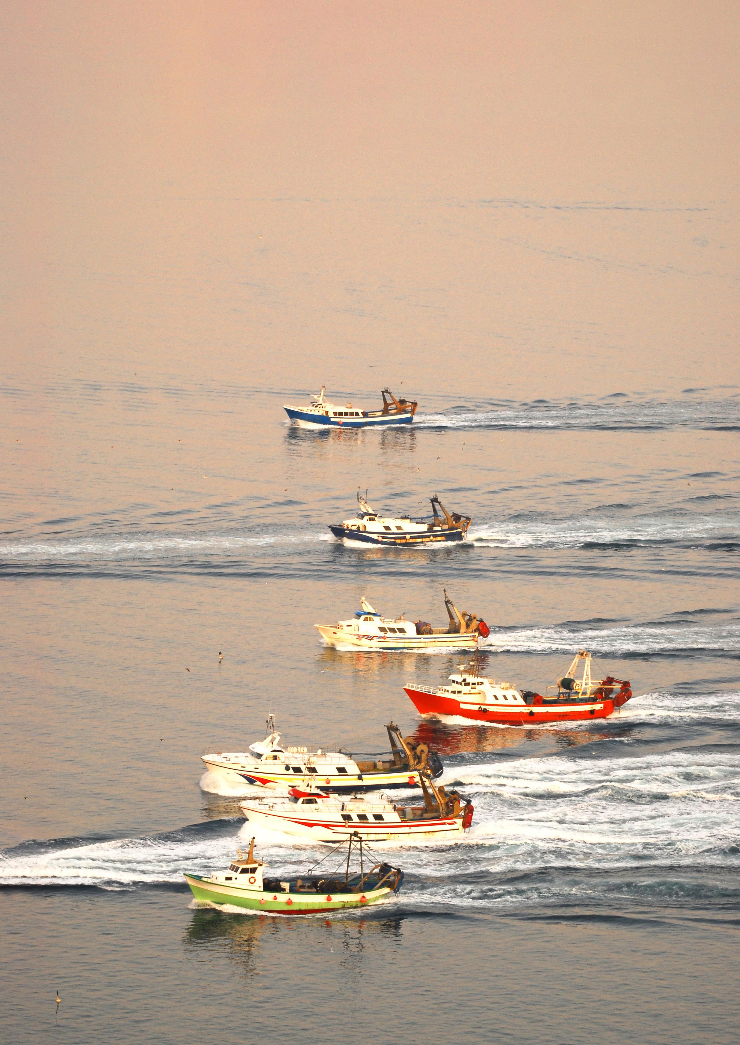
Cover photo: Trawlers sailing. © OCEANA / Juan Cuetos
The European Commission support for the production of this publication does not constitute endorsement of the contents which reflects the views only of the authors, and the Commission cannot be held responsible for any use which may be made of the information contained therein.
All photos are © OCEANA unless specified otherwise in the caption. The information contained in this report may be reproduced provided that © OCEANA is acknowledged as the source.
Global Fishing Watch, a provider of open data for use in this report, is an international nonprofit organization dedicated to advancing ocean governance through increased transparency of human activity at sea. The views and opinions expressed in this article are those of the authors, which are not connected with or sponsored, endorsed or granted official status by Global Fishing Watch. By creating and publicly sharing map visualizations, data and analysis tools, Global Fishing Watch aims to enable scientific research and transform the way our ocean is managed. Global Fishing Watch’s public data was used in the production of this publication.
AIS Automatic Identification System
AVL Authorised Vessel List
CAS Compliance Assessment Scheme
CoC Committee of Compliance
CPC Contracting Parties and Cooperating Non-Contracting Parties
EU European Union
FRA Fisheries Restricted Area
GFCM General Fisheries Commission for the Mediterranean and Black Sea
GFW Global Fishing Watch
IMO (United Nations) International Maritime Organisation
IRCS International Radio Call Sign
IUU Illegal, Unreported and Unregulated fishing
MAP Multi-annual Management Plan
MCS Monitoring, Control and Surveillance
RFMO Regional Fisheries Management Organization
RPoA Regional Plan of Action
FAO (United Nations) Fisheries and Agricultural Organisation
VMS Vessel Monitoring System
2 3
Acronyms Executive Summary 04 1. 2. 06 08 3. 09 10 12 4. 15 5. 17 22 19 20
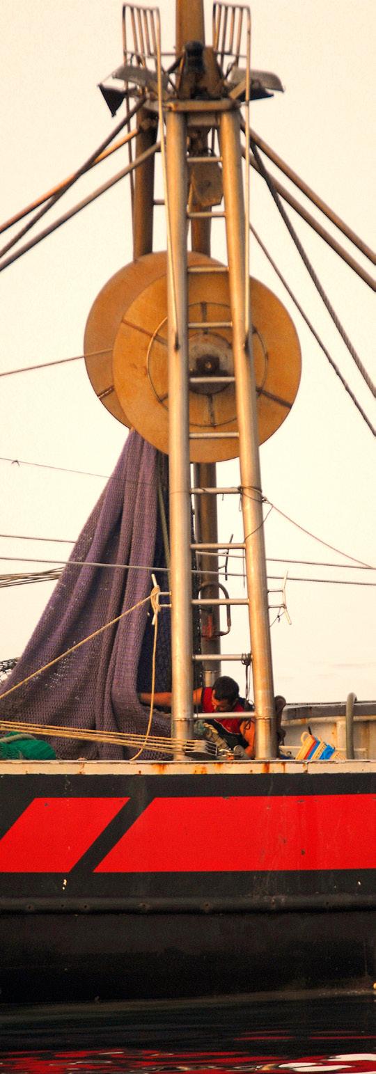
© OCEANA / Juan Carlos Calvín
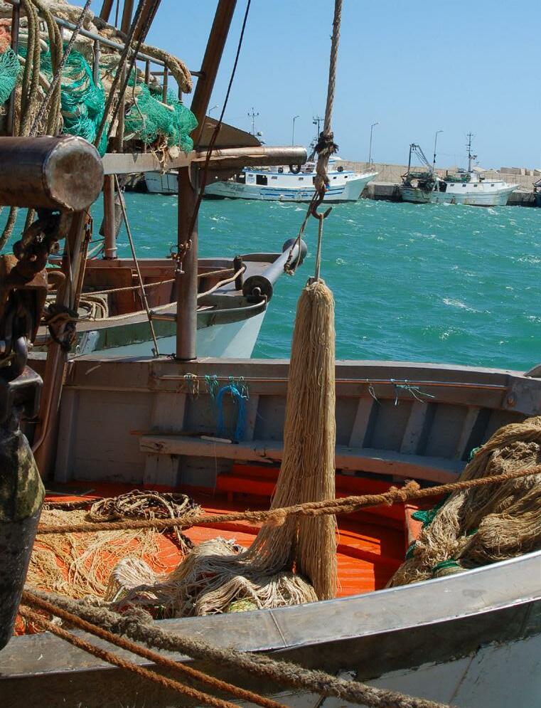
Detail of the deck of a trawler.
Fisheries Closures
Monitoring, control, and surveillance (MCS) are crucial to ensuring proper fisheries management and rebuilding stocks, particularly in the Mediterranean Sea, where 75% of stocks are considered overfished. 1 The General Fisheries Commission for the Mediterranean and Black Sea (GFCM) has taken significant steps in recent years to improve MCS of the fisheries in its area of competence, through various binding decisions that strengthen the compliance framework of fisheries management. Steps taken include the adoption of a Regional Plan of Action (RPoA) to combat illegal, unreported and unregulated (IUU) fishing, as well as a mid-term strategy (2017–2020) towards the sustainability of Mediterranean and Black Sea fisheries, 2 which includes specific actions and targets on IUU fishing.
Spatial fisheries closures – also called Fisheries Restricted Areas (FRAs) – are one of the most effective measures adopted by the GFCM to protect essential habitats for fish stocks in sensitive areas or unique deep-sea ecosystems. Nevertheless, IUU fishing cases have been reported within these areas, and related MCS efforts have been inconsistent and uneven.
In 2016, the GFCM adopted three FRAs in the Strait of Sicily, 3 protecting nursery grounds for hake and shrimp for the first time. These three FRAs are the main focus of this report, which presents an analysis by Oceana of potentially illegal fishing by bottom otter trawl vessels inside FRA boundaries, based on publicly available satellite data accessed through the Global Fishing Watch website. 4
Oceana detected over 126 hours of apparent 5 illegal fishing activity that took place between the beginning of July 2019 and the end of December 2020.
2021 is a key year for the GFCM. A new strategy for the coming years is to be adopted in June, including roadmaps for FRA monitoring and the implementation of MCS measures. This study highlights continued apparent illegal fishing inside FRAs, which shows the importance of continuously reinforcing controls, increasing transparency, and deterrent sanctioning by GFCM Members, in order to more effectively deliver on the aim of sustainable fisheries in the Mediterranean and Black Sea.
Oceana’s recommendations against continued illegal fishing in the GFCM area:
Improve the public GFCM Authorised Vessel List (AVL) –make it complete, accurate, transparent, and functional, especially for vessels authorised to fish in FRAs.
Strengthen monitoring, control and surveillance –extend AIS requirements to all GFCM vessels over 15 metres in length, and require Vessel Monitoring Systems (VMS) for all GFCM fishing vessels. For fishing activities within and around FRAs, the GFCM should adopt stricter VMS and AIS reporting requirements to closely monitor vessels that are authorised to fish in those areas, such as an increased ping frequency to improve MCS, with real-time alerts for vessels entering the FRAs (including buffer areas).
Adopt effective sanctions for non-compliance –establish sanctions for non-compliant vessels or Contracting Parties that fail to report the required information.
5
2016 In 126
Executive Summary 75% Spatial
of stocks are considered overfished in the Mediterranean Sea.
are one of the most effective measures adopted by the GFCM to protect essential habitats for fish stocks.
the GFCM adopted three FRAs in the Strait of Sicily. hours of apparent illegal fishing activity between the beginning of July 2019 and the end of December 2020.
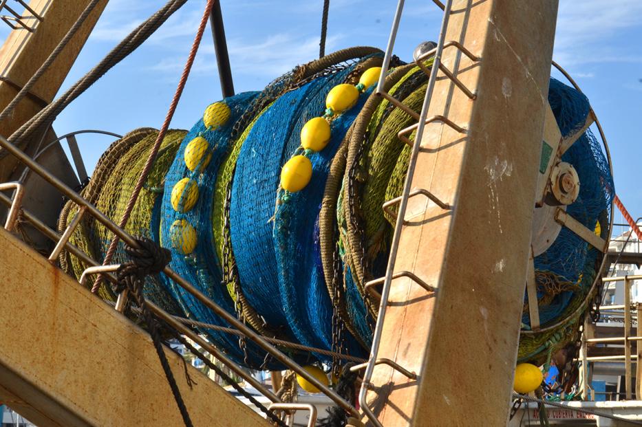
© OCEANA / Enrique Talledo
4
Detail of winch in a trawler.
Transparency and compliance weaknesses in GFCM Fisheries Restricted Areas
1. Introduction
One of the most representative management measures adopted in the Mediterranean region by Contracting Parties (CPCs) to the GFCM Agreement are spatial closures to damaging fishing practices (primarily bottom-towed gears) in areas recognised for their uniqueness and sensitivity (vulnerable marine ecosystems) and/ or as critical habitats during fish stock lifecycles (essential fish habitats). These spatial closures are known as Fisheries Restricted Areas (FRAs). They are adopted by the GFCM Commission and generally enter into force 120 days after their notification, in line with Article 13(2) of the GFCM Agreement. 6
Since 2006, 7 eight FRAs have been declared in the GFCM jurisdiction, 8 including three in the Strait of Sicily. These three FRAs entered into force on 1 October 2016, 3 establishing areas closed to bottom trawl gears to protect critical habitats for overfished hake and deep-sea rose
shrimp, under a multi-annual plan. 9 However, monitoring, control, and surveillance (MCS) within these critically important areas have been inconsistent and uneven. According to the 2019 GFCM Scientific Advisory Committee assessment, 10 several stocks in the area where the Strait of Sicily FRAs are included (Central Mediterranean - GSA 12-16) continue to be severely overfished. In particular, European hake – a key species for which these FRAs were established – was overfished in this area at 4.6 times above sustainable levels.
Among other key steps in the MedFish4Ever Declaration, the GFCM committed to create a network of protected essential fish habitats by 2018 and to develop a culture of compliance to eliminate IUU fishing.
Oceana brought possible cases of illegal fishing (by Italian vessels fishing with bottomtowed gears in 2016, 2017, and 2018) in the Strait of Sicily FRAs to the attention of the GFCM in 2018 and 2019. 11 Although GFCM Recommendations such as the one establishing the FRAs in the Strait of Sicily are binding on all CPCs even before being transposed into EU legislation, no action was taken by Italy between 2016 and 2020 to remedy the apparent 5 illegal fishing in the FRAs . The GFCM decisions on the establishment of these three FRAs were not transposed into EU law until 15 July 2019 (EU Regulation 2019/982). 12
In this analysis, Oceana detected further apparent illegal fishing inside the Strait of Sicily FRAs, during the period from 15 July 2019 to 31 December 2020. We therefore ask the GFCM to investigate these suspected infringements and, if illegal fishing is confirmed, quickly take action by proposing to add these vessels to the GFCM IUU vessel list .
Among other key steps in the MedFish4Ever Declaration, the GFCM committed to create a network of protected essential fish habitats by 2018 and to develop a culture of compliance to eliminate IUU fishing. 13 This was reinforced during the 2019 Marrakech Conference, where ministers reiterated their commitment to implementing the Malta Declaration.
This is a crucial moment for action. On the one hand, the new GFCM strategy that will be adopted at high-level meeting in June 2021, which offers an occasion to strengthen existing management measures with a sound regional framework to tackle IUU fishing and implement the FAO International Plan of Action to prevent, deter and eliminate IUU fishing (FAO IPOA-IUU) 14 with an effective and upto-date approach. On the other hand, it is an opportunity to propose recommendations that increase transparency and address IUU fishing ahead of the upcoming GFCM Commission.
Anti-IUU fishing measures in place within the GFCM
Allowing illegal fishing to continue goes against the commitment made by GFCM CPCs in the 2017 Regional Plan of Action (RPoA) 15 to combat IUU fishing in the GFCM area of application, and especially Recommendation 14, which states that:
‘The CPCs shall ensure that sanctions against vessels engaged in IUU fishing activities as well as nationals under their jurisdiction are of sufficient severity to effectively prevent, deter and eliminate IUU fishing and to deprive offenders of the benefits accruing from such fishing’.
In addition, Recommendation 15 states that:
The CPCs shall ensure the consistent and transparent application of sanctions, in particular against the following serious violations: […];
c) fishing in a closed area, fishing during a closed season;
d) fishing for stocks which are subject to multiannual management plans adopted by the GFCM in a manner that undermines their implementation;
g) multiple violations which together constitute a serious disregard of GFCM Recommendations or such other violations as may be specified in procedures and requirements established by the GFCM.
6 7
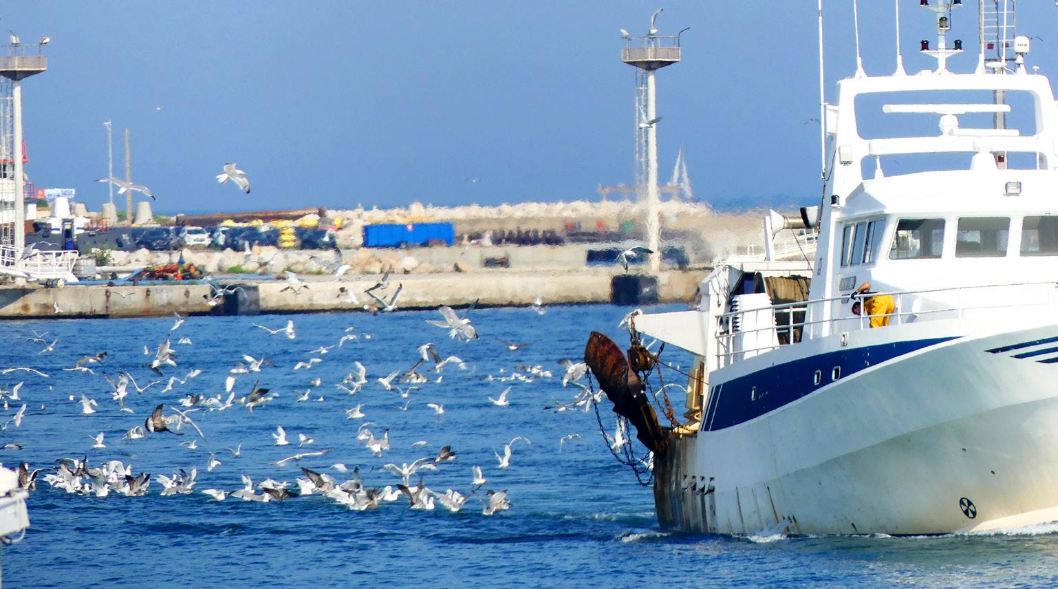
© OCEANA / Nicolas Fournier
Trawler arriving to the port followed by gulls.
Transparency and compliance weaknesses in GFCM Fisheries Restricted Areas
2. Methodology
Global Fishing Watch (GFW) is an international non-profit organisation that uses cutting-edge technology to visualise, track, and share information about global fishing activity, in near real-time for free. GFW utilises public broadcast data from AIS, 16 collected by satellite and terrestrial receivers, to show the movement of fishing vessels over time. 4 AIS was initially designed as a safety mechanism for vessels to avoid collisions at sea; a vessel equipped with an AIS transponder autonomously broadcasts a signal as frequently as every few seconds, with vessel identity and location information that includes vessel name, position, speed, and direction. GFW applies machine learning to this global feed of AIS data to classify apparent fishing or non-fishing (i.e., transiting) activity based on vessel activities such as speed, direction and rate of turn. 17 Oceana used this tool to examine fishing activities in the GFCM area between July 2019 and December 2020.
Fishing effort was calculated by aggregating apparent fishing hours per vessel, defined as the time each vessel spent apparently fishing. Data on aggregated apparent fishing hours per vessel were obtained using GFW data analysed by Oceana. Data were retrieved in March 2020 (2019 data), and in March 2021 (2020 data). Active vessels from the European Union (EU) were confirmed by matching the vessel name, International Radio Call Sign (IRCS) and International Maritime Organization (IMO) number to the EU Fleet Register 18 and the GFCM Authorised Vessel List (AVL) 19 by consulting publicly available data sets.
Oceana only considered the vessels that were detected by the GFW algorithm as having fished for more than 20 hours during the entire period assessed. A potential limitation of this analysis relates to weaknesses in the regulations and requirements for vessels to be equipped with AIS
3. Apparent illegal bottom trawling in Fisheries Restricted Areas (FRAs) in the Strait of Sicily
1493 km2
transponders. The IMO requires all ships over 300 gross registered tonnes engaged in international voyages to be fitted with AIS transponders,20 though fishing vessels are exempt unless AIS is required by the flag or coastal State (for example, the EU mandates that AIS transponders be installed and used in all vessels over 15 metres length).21 Therefore, AIS data are biased to represent larger vessels whose flag State requires them to use AIS transponders. Even those vessels, however, can cheat the system by falsifying their location or by turning off their AIS transponders at will. It is also reasonable to assume that some vessels engaged in illegal fishing will intentionally not broadcast their AIS to avoid being caught.
Oceana was unable to document the fishing effort of vessels that did not transmit AIS signals; therefore, the results of this analysis are a conservative estimate of fishing effort in this region.
In order to access Global Fishing Watch to view the data and images presented in the text and tables of this report, it is necessary to first create a username and password. Only by logging into the Global Fishing Watch
available.
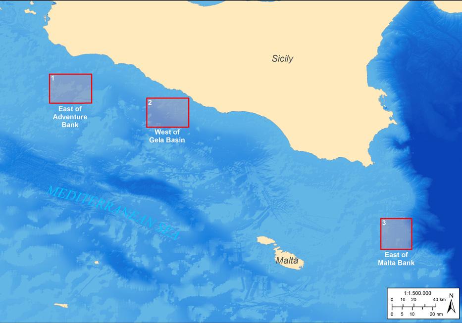
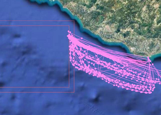
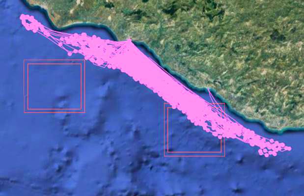
The three FRAs in the Strait of Sicily, named ‘East of Adventure Bank’, ‘East of Malta Bank’ and ‘West of Gela Basin’ (see Map 1) , were established under a multi-annual management plan (MAP) covering Geographical Sub-Areas (GSAs) 12 to 16. 3 This MAP entered into force on 1 October 2016, pursuant to Article 13 of the GFCM Agreement. In 2018, the MAP was revised under Recommendation GFCM/42/2018/5, 22 which simplified the rules for monitoring and control in such areas.
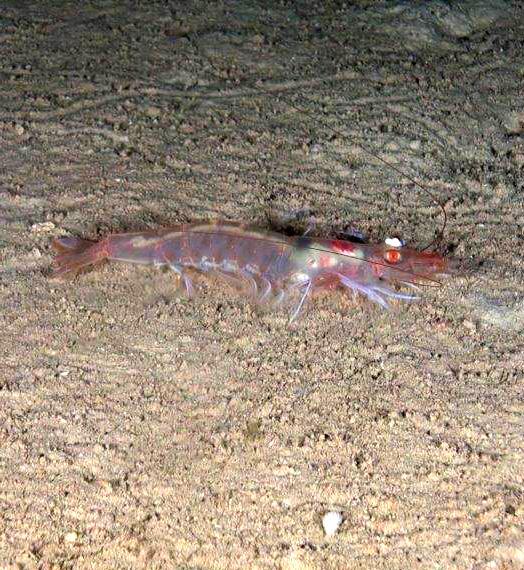
The FRAs extend over a total of 1493 km 2 and, according to the MAP, any bottom trawling activity is banned inside these areas A buffer area of 1 nautical mile was established around each of the FRAs in order to avoid accidental access to the restricted areas. The main objective of the FRAs is to improve management of overexploited key commercial species such as European hake ( Merluccius merluccius ) and deep-water rose shrimp ( Parapenaeus longirostris ), as well as their nursery habitats.
1 nautical mile
8 9
free online tool will full access to the linked information be
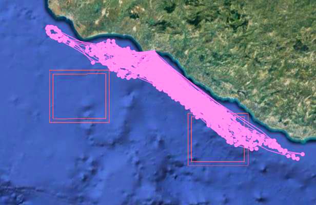
Map 1. FRAs in the Strait of Sicily
Deep-water rose shrimp (Parapenaeus longirostris) in the Strait of Sicily.
Note on accessing Global Fishing Watch data from this report:
The FRAs extend over a total of
A buffer area of
and any bottom trawling activity is banned inside these areas.
was established around each of the FRAs in order to avoid accidental access to the restricted areas.
Transparency and compliance weaknesses in GFCM Fisheries Restricted Areas
© OCEANA
A. Apparent illegal trawling activity in the FRAs
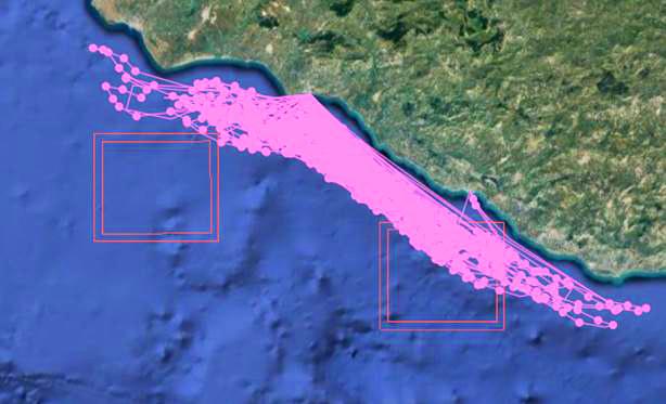
In this analysis, using GFW data, Oceana detected 126 hours of apparent illegal fishing activity, conducted by two single fishing-gearlicensed bottom otter trawl vessels fishing within the West of Gela Basin FRA between 15 July 2019 and 31 December 2020 (see Table 1, and Annex I for their fishing tracks according to GFW). These vessels, both Italian-flagged, are only registered with a single fishing gear (bottom otter trawls) in the EU Fleet Register 18 and are registered under “single boat bottom otter trawls” in the GFCM AVL. 19 This means that they cannot legally fish with any gear other than bottom otter trawls. Oceana could find no authorisation for any secondary gear. Therefore, there is reason to suspect that these vessels may have been bottom trawling in these FRAs in violation of EU and GFCM rules.
Oceana has requested the European Commission and the Italian authorities to comment on these findings. The European Commission and the Italian authorities did not reply to this request. Oceana could not find publicly available contact details of the vessels’ owners 23 and requested information from the European Commission and the Italian authorities on the owners of the two vessels, to be able to contact them and request comments on these findings. Unfortunately, neither the GFCM AVL nor the EU Fleet Register includes any information on vessel ownership. The European Commission and the Italian authorities did not reply to this request either.
These recent apparent infractions are not the first apparently committed by Italian-flagged bottom trawl vessels operating in the three FRAs. The estimates in the previous analysis of apparent fishing activity from 2016, 2017 and 2018 are likely high estimates as the buffer area was not considered, however apparent illegal bottom trawling inside the FRA boundaries was pervasive in this period. Oceana earlier notified the GFCM as follows: 24
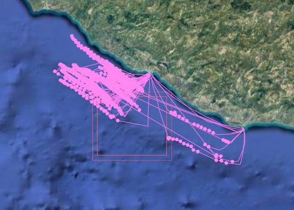
The inner red square delimits the boundary of the FRA, where bottom trawling is prohibited, while the outer red square delimits the 1 nautical mile buffer area surrounding the FRA, where bottom trawling is allowed.
Each point represents apparent fishing activity as recognised by the GFW algorithm.
Oceana estimated that there could have been more than 20 Italian bottom trawl vessels that apparently fished illegally between December 2016 and December 2017, for more than 10 000 hours within the FRAs (information submitted to the 2018 Compliance Committee). 25
For the year 2018, Oceana estimated that there could have been 56 EU-flagged bottom trawl vessels that apparently fished illegally for 14 000 hours in the same FRAs (information presented during the GFCM Working Group on IUU Fishing in 2019). 26
Our analysis suggests that apparent illegal fishing persists within the FRAs, more than four years after they entered into force. In October 2020, the European Commission analysed Oceana’s data from 2019 with the support of the European Fisheries Control Agency, and replied that “ […] some activity by one of the identified vessels, which may be allegedly illegally trawling within the FRAs, has been indeed identified and we are informed that Italy had already initiated procedures in accordance to its national law”. In a meeting with the European Commission in February 2021, Oceana was informed that there would be an update from the Italian authorities on their investigation at the upcoming Committee of Compliance of GFCM in May 2021. Unfortunately, such update was not provided.
10 11
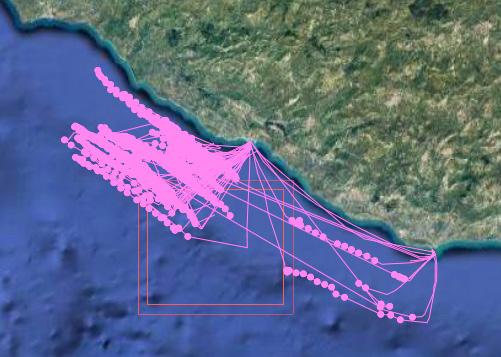
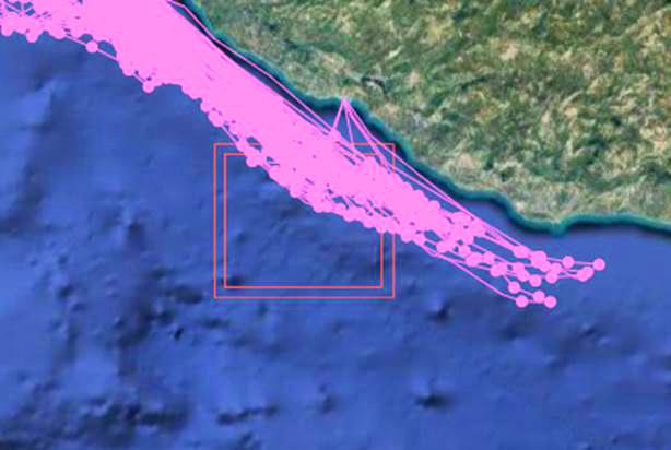
Map 2. Fishing tracks representing cumulative apparent fishing effort (number of fishing hours per square kilometre) for the vessel Calliope both around and inside the West of Gela Basin FRA from July 2019December 2020.
Table 1. Fishing vessels that were apparently operating illegally within the boundaries of the West of Gela Basin FRA (Strait of Sicily), according to GFW data. Vessels are listed in order by total hours of apparent fishing within the boundaries of the FRA (which do not include apparent hours of fishing within the buffer area). Sources: GFW; EU Fleet Register; GFCM Authorised Vessel List.
CALLIOPE
FRECCIA NERA 2 ITA000010623 ITA000010697
Italy Italy 247142930 247142990
Bottom otter trawls Bottom otter trawls
None None
Single boat bottom otter trawls Single boat bottom otter trawls TOTAL
103 23 126
VESSEL NAME Gear authorised in GFCM Authorised Vessel List19
Secondary Gear in EU Fleet Register18
Primary Gear in EU Fleet Register18
Maritime Mobile Service Identity
Community Fishing Fleet Register Number Flag
Total apparent fishing hours in West of Gela Basin FRA 15 July 2019 - 31 December 2020
Transparency and compliance weaknesses in GFCM Fisheries Restricted Areas
Transparency and compliance weaknesses in GFCM Fisheries Restricted Areas
B. Vessels with mixed gears fishing in the FRAs
Vessels with licenses for multiple gears add another layer of complexity for monitoring purposes, because it is challenging to identify whether such vessels operating within the FRAs are using gear types that are authorised or prohibited for use in those areas.
Following the same methodology as above, Oceana examined fishing activity within the FRAs by vessels that were listed as using bottom otter trawls as their main gear (according to the EU Fleet Register and the GFCM AVL) but that were also authorised to use a secondary gear type (according to the EU Fleet Register). Oceana detected 31 such vessels that were apparently fishing within the three FRAs. All of these vessels were Italian-flagged. Their secondary gear types varied between midwater pair trawls (11 vessels), purse seines (9 vessels), set longlines (9 vessels), set gillnets (1 vessel), and driftnets (1 vessel). Publicly available AIS data is insufficient to discern whether these vessels were using prohibited gears (i.e., bottom otter trawls) when fishing inside the FRAs. Although authorities that receive information through vessel monitoring systems (VMS) are able to analyse the fishing activity of these vessels, currently VMS data are not publicly accessible.
These 31 vessels apparently operated within the three FRAs for a total of over 2219 hours, most of them in the West of Gela Basin FRA, followed by the East of Adventure Bank FRA, and the East of Malta Bank FRA. Table 2 lists the 31 bottom trawlers with mixed gears according to their apparent fishing hours inside FRAs, and their fishing tracks according to GFW data are shown in Annex II
Unfortunately, the GFCM AVL does not include details of secondary or tertiary (if any) fishing gears, despite the requirement to disclose these data publicly under Recommendation GFCM/33/2009/6. 27
Using solely the information on primary gear from the GFCM AVL, all of these vessels would be suspected of IUU fishing inside FRAs. In the case of EU-flagged vessels, additional information about authorised fishing gear can be found on the EU Fleet Register. For non-EU flagged vessels, however, this information is not available, which hinders monitoring, control, and surveillance efforts. To ensure effective enforcement, especially in the Strait of Sicily where bottom trawl gears are banned in the three FRAs, information should be added to the GFCM AVL about vessels’ secondary and tertiary gear types. Oceana calls on the GFCM to add this information to the AVL for all listed vessels.
These apparently operated within the three FRAs for a total of over
31 vessels 2219 hours
Table 2. List of the 31 vessels with multiple gears that may have been operating illegally inside the boundaries of the Strait of Sicily FRAs: East of Adventure Bank, West of Gela Basin and East of Malta Bank, according to GFW data. Vessels are listed in order by total hours of apparent fishing within the boundaries of the FRA (which do not include apparent hours of fishing within the buffer area).
Sources: GFW; EU Fleet Register; GFCM Authorised Vessel List. Names have been anonymised for identity protection.
12 13
on next page.)
(Continued
© OCEANA / IV
Vessel number (anonymised) Flag GFCM Authorised Vessel List19 Primary Gear in EU Fleet Register18 Secondary Gear in EU Fleet Register18 East of Adventure Bank apparent fishing hours West of Gela Basin apparent fishing hours East of Malta Bank apparent fishing hours Total apparent fishing hours in FRAs July 2019December 2020 #1 Italy Single boat bottom otter trawls Bottom otter trawls Purse seines 168 168 #2 Italy Single boat bottom otter trawls Bottom otter trawls Purse seines 162 162 #3 Italy Single boat bottom otter trawls Bottom otter trawls Set longlines 159 159 #4 Italy Single boat bottom otter trawls Bottom otter trawls Midwater pair trawls 133 133 #5 Italy Single boat bottom otter trawls Bottom otter trawls Purse seines 1 129 130 #6 Italy Single boat bottom otter trawls Bottom otter trawls Midwater pair trawls 1 127 128 #7 Italy Single boat bottom otter trawls Bottom otter trawls Midwater pair trawls 125 125 #8 Italy Single boat bottom otter trawls Bottom otter trawls Midwater pair trawls 1 120 121 #9 Italy Single boat bottom otter trawls Bottom otter trawls Midwater pair trawls 113 113 #10 Italy Single boat bottom otter trawls Bottom otter trawls Purse seines 91 91 #11 Italy Single boat bottom otter trawls Bottom otter trawls Purse seines 88 88 #12 Italy Single boat bottom otter trawls Bottom otter trawls Set longlines 2 72 74 #13 Italy Single boat bottom otter trawls Bottom otter trawls Midwater pair trawls 70 70 #14 Italy Single boat bottom otter trawls Bottom otter trawls Midwater pair trawls 63 63 #15 Italy Single boat bottom otter trawls Bottom otter trawls Purse seines 63 63 #16 Italy Single boat bottom otter trawls Bottom otter trawls Set longlines 62 62 #17 Italy Single boat bottom otter trawls Bottom otter trawls Purse seines 54 54 #18 Italy Single boat bottom otter trawls Bottom otter trawls Set longlines 31 22 53
Transparency and compliance weaknesses in GFCM Fisheries Restricted Areas
4. Lack of public information on fishing activities in FRAs
To prevent illegal fishing in the FRAs, it is essential to know who is authorised to fish, as well as where , when , how , and what . Currently, the GFCM does not provide sufficient public information to answer these simple questions. This lack of information not only allows unauthorised fishing to continue, it is also a major impediment to achieving sustainable fisheries management and stringent fisheries enforcement.
Need to expand the GFCM Authorised Vessel List
In 2009 the GFCM adopted an Authorised Vessel List (AVL), establishing a repository of all vessels that are authorised to operate in the GFCM area. 27 However, Oceana has detected a series of issues that makes the list not fit for purpose. 28 First, the GFCM AVL only includes vessels over 15 metres length. Consequently, small-scale fishing vessels under 15 metres length are not required to be included in the list. Second, it is incomplete, as various key details are not included, such as information on secondary gears (if any) and target species. Finally, it is not transparent, as important information is not publicly available, such as the vessel’s type of authorisation, whether the vessel is authorised to fish in a FRA, and previous vessel names and flag States. These deficiencies in the GFCM AVL undermine the effectiveness of the FRAs, hindering GFCM members and stakeholders from discerning who operates legally and who does not.
Oceana therefore calls for the strengthening of the GFCM AVL, which should include all vessels actively fishing for species managed by the GFCM – including vessels under 15 metres length, especially if they operate in FRAs – and subject to its management rules. We request that public information be provided about the type of authorisation, including whether a vessel is authorised to operate in FRAs and under which conditions, in line with best practice in other RFMOs.
14 15 (Continued from previous page.)
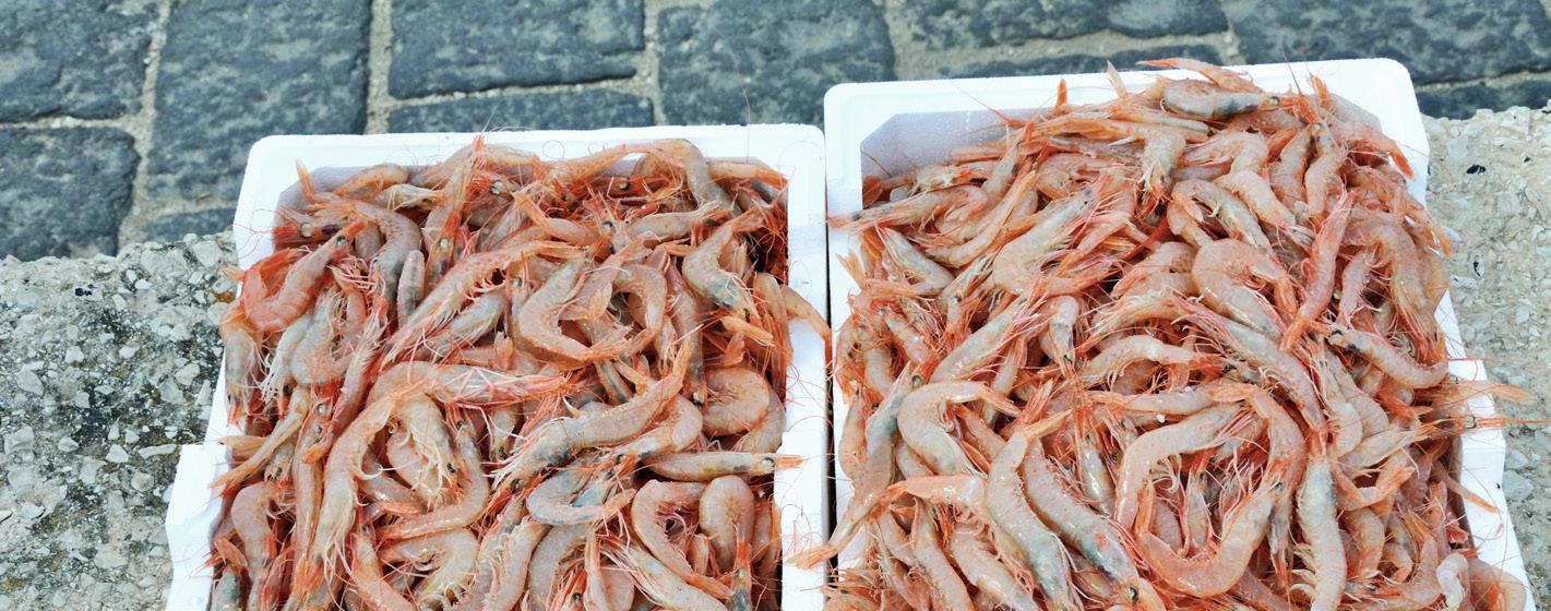
Deep-water rose shrimp (Parapenaeus longirostris) landed from a vessel in the port of Sciacca, Sicily, Italy.
A trawler in the port of Sciacca, Sicily, Italy.
© OCEANA / IV
Vessel number (anonymised) Flag GFCM Authorised Vessel List19 Primary Gear in EU Fleet Register18 Secondary Gear in EU Fleet Register18 East of Adventure Bank apparent fishing hours West of Gela Basin apparent fishing hours East of Malta Bank apparent fishing hours Total apparent fishing hours in FRAs July 2019December 2020 #19 Italy Single boat bottom otter trawls Bottom otter trawls Midwater pair trawls 43 43 #20 Italy Single boat bottom otter trawls Bottom otter trawls Set longlines 35 35 #21 Italy Single boat bottom otter trawls Bottom otter trawls Set gillnets 2 32 34 #22 Italy Single boat bottom otter trawls Bottom otter trawls Driftnets 23 7 30 #23 Italy Single boat bottom otter trawls Bottom otter trawls Midwater pair trawls 13 16 29 #24 Italy Single boat bottom otter trawls Bottom otter trawls Purse seines 2 26 28 #25 Italy Single boat bottom otter trawls Bottom otter trawls Set longlines 26 26 #26 Italy Single boat bottom otter trawls Bottom otter trawls Set longlines 25 25 #27 Italy Single boat bottom otter trawls Bottom otter trawls Set longlines 22 1 23 #28 Italy Single boat bottom otter trawls Bottom otter trawls Midwater pair trawls 23 23 #29 Italy Single boat bottom otter trawls Bottom otter trawls Purse seines 23 23 #30 Italy Single boat bottom otter trawls Bottom otter trawls Set longlines 22 22 #31 Italy Single boat bottom otter trawls Bottom otter trawls Midwater pair trawls 21 21 TOTAL: 201 1874 144 2219
© OCEANA / María José Cornax
CPCs already provide the GFCM Secretariat with the lists of vessels authorised to fish in most of the eight FRAs established by the GFCM. Making these lists public and adding these details to the AVL would improve accountability of both fishers and CPCs. It would also assist enforcement efforts by enabling the crosschecking of information and facilitating the detection of non-compliance cases.
The GFCM MAP for demersal fisheries in the Strait of Sicily, which established the three FRAs in those waters, applies to all bottom trawls above 10 metres overall length that fish for European hake and deep-water rose shrimp.3 We welcome that the GFCM recently updated its authorised vessel lists for two MAPs adopted in 2019: for deep-sea
shrimp in the Strait of Sicily and seabream in the Alboran Sea. For the first time, the GFCM has made public the list of vessels that are authorised to fish under these plans, with information on vessel identification such as name, fishing gear, target species, and port of registration. We call on the GFCM to make these authorised vessel lists available for all MAPs, including specific lists of those vessels authorised to fish inside FRAs. Doing so will address the inconsistencies that currently exist among FRAs in the rules and requirements for information provision, which create an uneven playing field and affect the monitoring, control, and surveillance of these areas. Table 3 below summarises some of these inconsistencies across current FRAs and illustrates some of the MCS challenges.
5. Recommendations
Oceana’s findings highlight the clear urgency of tackling illegal fishing in FRAs, as well as the need to strengthen the culture of compliance with GFCM conservation measures. Improving the status of stocks and the unique marine biodiversity of the Mediterranean Sea is a priority for all GFCM CPCs. Proper implementation and compliance with FRA regulations is crucial, to ensure that these areas are effective in supporting stock recovery and the livelihoods of fishers and coastal communities.
Transparency, accountability, and an effective and deterrent monitoring and sanctioning system are the best tools with which to tackle IUU fishing.
With this in mind, Oceana proposes the following recommendations to stop illegal bottom trawling in FRAs:
1.
List of vessels authorised to fish inside the FRA(s), including information on:
Type of vessel (e.g., trawler, long-liner)*
Permitted fishing gears
Authorisation for target species or species group(s)
Area and period authorised (if applicable) for fishing in the FRA
Number of fishing days authorised in the FRA
List of authorised vessels is publicly available
Specific requirements for VMS/AIS for vessels authorised to fish inside the FRA(s)
Established scientific monitoring programme for the FRA(s)
The GFCM AVL should provide detailed information about all vessels that are authorised to operate in FRAs, such as: FRA name, authorised gear(s) (including secondary and tertiary gears, if applicable), targeted species, authorised periods, authorised number of days, and authorised zones. CPCs are already required to provide these data to the GFCM Secretariat for most FRAs, and adding this information to the AVL would facilitate cross-checking of information and detection of non-compliance cases.
16 17
*The public AVL only includes incomplete information about the fishing gear, not vessel types.
© OCEANA
/ María José Cornax
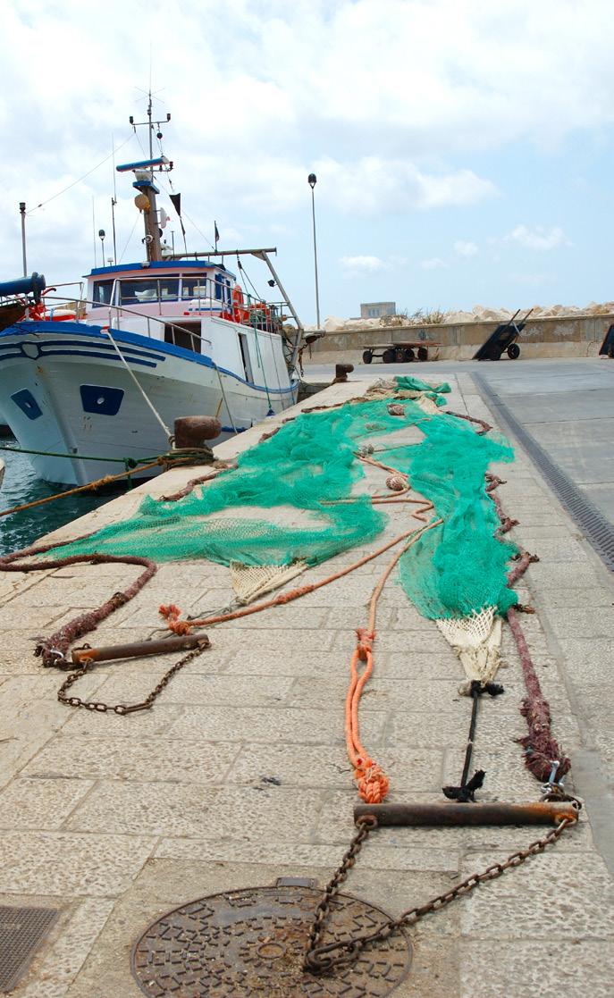
Trawler and trawl net on the dock in the port of Trapani, Sicily, Italy.
Improve public information on fishing activities in GFCM FRAs
Table 3. Comparative table of GFCM FRAs and their respective current MCS requirements. Green tick marks indicate where information is required; red crosses indicate where information is not required.
MCS measures Gulf of
(GFCM/33/2009/1)
(GFCM/41/2017/3)
Lion
Jabuka/Pomo Pit
Santa Maria di Leuca, Eratosthenes Seamount & Nile Delta (GFCM/2006/3)
West of Gela Basin, East of Adventure Bank & East of Malta Bank (GFCM/42/2018/5)
Transparency and compliance weaknesses in GFCM Fisheries Restricted Areas
2. Strengthen monitoring, control, and surveillance
The GFCM should require that all fishing vessels above 15 metres length, including all fishing vessels authorised under a GFCM multiannual management plan, be equipped with and continually transmit positions via AIS, in line with what is currently required by the EU. In parallel, Oceana encourages GFCM to expand the requirement to have a vessel monitoring system (VMS) to all vessels.
For fishing activities within and around FRAs, the GFCM should adopt stricter VMS and AIS reporting requirements to closely monitor vessels that are authorised to fish in those areas, such as increased ping frequency to improve MCS. This is especially relevant for vessels that are authorised to use multiple gear types or for small-scale vessels.
The GFCM should harmonise and strengthen the MCS requirements for all FRAs, including in relation to AVL, VMS measures, and scientific monitoring programmes.
The GFCM should establish buffer zones (of at least one nautical mile) around FRAs, combined with real-time alerts (AIS and VMS) when vessels enter these zones. These measures serve to prevent illegal fishing and to alert authorities when vessels are approaching FRAs.
Annex I
3. Adopt effective sanctions for non-compliant cases
The Compliance Committee (CoC) should regularly review MCS measures that are currently in force in FRAs by each CPC, as an integral part of the annual Compliance Assessment Scheme (CAS) pursuant to Resolution GFCM/43/2019/5.29
The CoC should pay particular attention to the full transposition of the GFCM FRA decisions into CPCs’ national legislation as a basic indicator of compliance; failure to report transposition should be considered significant non-compliance.
When non-authorised vessels operate inside FRAs, the CoC should categorise these activities under “category C” as significant non-compliance and adopt deterrent sanctions accordingly, including listing the non-compliant vessels on the Provisional GFCM IUU Vessel List.
If CPCs do not provide the required information about implementation of MCS measures in FRAs or do not report information on the AVL list about vessels operating in FRAs, the CoC should categorise this under “category B” as significant non-compliance and adopt deterrent sanctions accordingly.
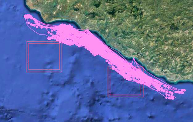
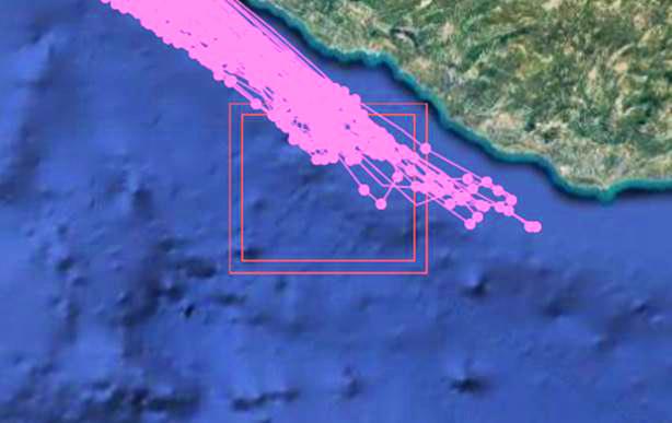
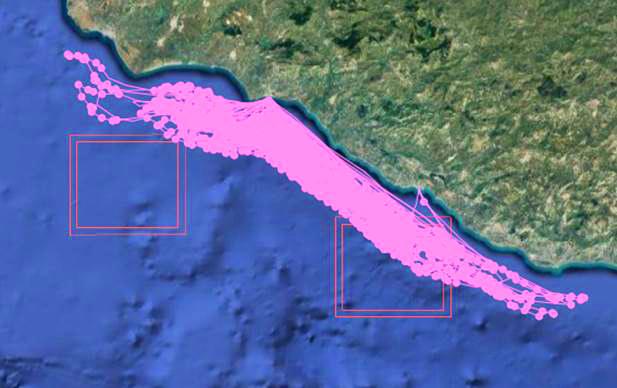
The following maps show fishing tracks representing cumulative apparent fishing effort (number of fishing hours per square kilometre) 5 for otter trawl vessels with no secondary gear inside and around the West of Gela Basin FRA (July 2019 to December 2020), based on data from Global Fishing Watch. The inner red square delimits the boundary of the FRA, where bottom trawling is prohibited, while the outer red square delimits the 1 nautical mile buffer area surrounding the FRA, where bottom trawling is allowed. Each point in the map represents apparent fishing activity as recognised by the GFW algorithm.
The outer red square delimits the 1 nautical mile buffer area surrounding the FRA, where bottom trawling is allowed.
The inner red square delimits the boundary of the FRA, where bottom trawling is prohibited.
Each point in the map represents apparent fishing activity as recognised by the GFW algorithm.
18 19
© OCEANA / Nicolas Fournier
Image 1. Vessel Calliope inside West of Gela Basin FRA
Image 2. Vessel Freccia Nera 2 inside West of Gela Basin FRA
Transparency and compliance weaknesses in GFCM Fisheries
Restricted Areas
Annex II
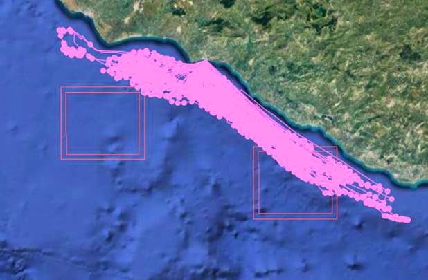
The following maps show examples of fishing tracks representing cumulative apparent fishing effort 5 (number of fishing hours per square kilometre) for bottom otter trawl vessels with secondary gear (i.e., mixed gear vessels) inside and around West of Gela Basin FRA (July 2019 to December 2020), based on data from Global
Fishing Watch. The inner red square delimits the boundary of the FRA, where bottom trawling is prohibited, while the outer red square delimits the 1 nautical mile buffer area surrounding the FRA, where bottom trawling is allowed. Each point in the map represents apparent fishing activity as recognised by the GFW algorithm.

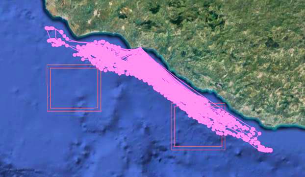
20 21
Image 1. Vessel #1 inside and around West of Gela Basin FRA.
Image 5. Vessel #5 inside and around West of Gela Basin FRA.
Image 3. Vessel #3 inside and around West of Gela Basin FRA.
Image 7. Vessel #7 inside and around West of Gela Basin FRA.
Image 9. Vessel #9 inside and around West of Gela Basin FRA.
Image 2. Vessel #2 inside and around West of Gela Basin FRA.
Image 6. Vessel #6 inside and around West of Gela Basin FRA.
Image 4. Vessel #4 inside and around West of Gela Basin FRA.
Image 8. Vessel #8 inside and around West of Gela Basin FRA.
Transparency and compliance weaknesses in GFCM Fisheries Restricted Areas
Image 10. Vessel #10 inside and around West of Gela Basin FRA.
References
FAO. 2020. The State of Mediterranean and Black Sea Fisheries. General Fisheries Commission for the Mediterranean. Rome. 172 pp. http://www.fao.org/3/cb2429en/CB2429EN.pdf
FAO. 2017. Mid-term strategy (2017-2020) towards the sustainability of Mediterranean and Black Sea fisheries (Mid-term strategy). General Fisheries Commission for the Mediterranean. Rome. 24 pp. http://www.fao.org/gfcm/activities/fisheries/mid-term-strategy/en/
Recommendation GFCM/40/2016/4 establishing a multi-annual management plan for the fisheries exploiting European hake and deep-water rose shrimp in the Strait of Sicily (GSAs 12 to16).
Global Fishing Watch. 2021. https://globalfishingwatch.org/
Any and all references to “fishing” should be understood in the context of Global Fishing Watch’s fishing detection algorithm, which is a best effort to determine “apparent fishing effort” based on vessel speed and direction data from the Automatic Identification System (AIS) collected via satellites and terrestrial receivers. As AIS data varies in completeness, accuracy and quality, and the fishing detection algorithm is a statistical estimate of apparent fishing activity, therefore it is possible that some fishing effort is not identified and conversely, that some fishing effort identified is not fishing. For these reasons, Global Fishing Watch qualifies all designations of vessel fishing effort, including synonyms of the term “fishing effort,” such as “fishing” or “fishing activity,” as “apparent,” rather than certain. Any/all Global Fishing Watch information about “apparent fishing effort” should be considered an estimate and must be relied upon solely at your own risk. Global Fishing Watch is taking steps to make sure fishing effort designations are as accurate as possible.
FAO. 2014. Agreement for the Establishment of the General Fisheries Commission for the Mediterranean. General Fisheries Commission for the Mediterranean. Rome, 22pp. Available at: http://www.fao.org/gfcm/about/legal-framework/es/
Recommendation GFCM/30/2006/3 on the establishment of fisheries restricted areas in order to protect the deepsea sensitive habitats.
This analysis deliberately excludes from its scope the deep-water area below 1000 m depth protected by Recommendation GFCM/29/2005/1.
Pursuant to Article 13 of the GFCM Agreement, this MAP entered into force on 1 October 2016.
FAO. 2019. Report of the twenty-first session of the Scientific Advisory Committee on Fisheries, Cairo, Egypt, 24–27 June 2019. General Fisheries Commission for the Mediterranean. Report No. 1290. Rome. 183 pp.
Further detail is provided in Chapter 3.
Regulation (EU) 2019/982 of the European Parliament and of the Council of 5 June 2019 amending Regulation (EU) No 1343/2011 on certain provisions for fishing in the GFCM (General Fisheries Commission for the Mediterranean) Agreement area.
Ministerial Conference on the Sustainability of Mediterranean fisheries, Malta 30 March 2017, Malta MedFish4Ever Declaration.
FAO. 2001. International Plan of Action to prevent, deter and eliminate illegal, unreported and unregulated fishing. Rome, 24pp.
Recommendation GFCM/41/2017/7 on a regional plan of action to combat illegal, unreported and unregulated fishing in the GFCM area of application.
AIS data can be limited by the accuracy of information transmitted by vessels and low satellite coverage. The Strait of Sicily has a relatively strong Class-A AIS according to the Taconet et al. (2019) Global Atlas of AIS-based fishing activity , with most vessels using high-quality Class A devices.
Kroodsma, D.A., Mayora, J., Hochberg, T., Miller, N.A., Boerder, K., Ferretti, F., Wilson, A., Bergman, B., White, T.D., Block, B.A., Woods, P., Sullivan, B., Costello, C. & Worm, B. 2018. Tracking the global footprint of fisheries. Science, 359(6378): 904-908.
European Commission. 2020. Management of fishing capacity - fishing fleet. Available at: http://ec.europa.eu/fisheries/fleet/index.cfm
GFCM. 2020. Authorised Vessel List. Available at: http://www.fao.org/gfcm/data/fleet/avl/en/
IMO. 2014. Implications of the United Nations Convention on the Law of the Sea for the International Maritime Organization. 137 pp.
Council Regulation (EC) No 1224/2009 of 20 November 2009, Art. 10, available at https://eur-lex.europa.eu/LexUriServ/LexUriServ.do?uri=OJ:L:2009:343:0001:0050:EN:PDF
Recommendation GFCM/42/2018/5 on a multiannual management plan for bottom trawl fisheries exploiting demersal stocks in the Strait of Sicily (geographical subareas 12 to 16), repealing Recommendations GFCM/39/2015/2 and GFCM/40/2016/4 (2018).
Oceana has consulted the EU fleet register as well as the GFCM AVL. In addition, IHS-Seaweb was consulted for any additional information. No results were obtained.
The buffer area around the FRAs was not considered during the analyses carried out by Oceana of fishing activity from December 2016-December 2017, and during 2018.
Oceana. 2018. Building a GFCM framework to combat IUU fishing. Oceana case studies and recommendations. Oceana submission to the Working Group on IUU Fishing Beirut, Lebanon 24-27 April, 2018. Madrid, 13 pp. Available at: https://eu.oceana.org/en/publications/reports/building-gfcm-framework-combat-iuu-fishing
Oceana. 2018. Press release. Available at: https://eu.oceana.org/en/press-center/press-releases/oceanadenounces-potential-cases-illegal-unreported-and-poorly-regulated
Recommendation GFCM/33/2009/6 concerning the establishment of a GFCM record of vessels over 15 metres authorised to operate in the GFCM area of application, amending Recommendation GFCM/29/2005/2 (2009).
Oceana. 2020. Amend the public GFCM Authorised Vessel List to strengthen compliance and transparency. Available at: https://eu.oceana.org/sites/default/files/oceana_gfcm_2020_amend_authorised_vessel_list.pdf
Recommendation GFCM/43/2019/5 on a compliance assessment scheme for the implementation of Recommendation GFCM/38/2014/2 concerning the identification of non-compliance.
Central Office - Madrid, Spain
Phone: + 34 911 440 880
Email: europe@oceana.org
EU Office - Brussels, Belgium
Phone: + 32 (0) 2 513 2242
Email: brussels@oceana.org
North Sea and Baltic OfficeCopenhagen, Denmark
Email: copenhagen@oceana.org
UK Office - London, UK Phone: +44 20 346 87908
Email: oceanauk@oceana.org
22
1 18 2 19 23 3 20 24 27 4 21 25 28 5 22 26 29 6 7 8 9 10 11 12 13 14 15 16 17
©
OCEANA / Carlos Suárez
Contact
Transparency and compliance weaknesses in GFCM Fisheries Restricted Areas
Follow @OceanaEurope on Facebook Instagram Twitter
