Paper parks in Spain
Bottom trawling inside marine protected areas

Credits
Authors: Silvia García, Jorge Blanco, Pilar Marín, and Nicolas Fournier.
Suggested citation: García, S., Blanco, J., Marín, P., Fournier, N. (2021). Paper parks in Spain - Bottom trawling inside marine protected areas. Oceana, Madrid.
DOI: 10.5281/zenodo.6225508
Editorial review: Allison L. Perry, Vera Coelho.
Editorial support: Ángeles Sáez, Silvia García.
Design: Yago Yuste.
All photos are © OCEANA unless otherwise specified in the caption. The information contained in this report may be reproduced provided that © OCEANA is acknowledged as the source.
The European Commission support for the production of this publication does not constitute endorsement of the contents which reflects the views only of the authors, and the Commission cannot be held responsible for any use which may be made of the information contained therein.
Summary Overview of marine protected areas and fisheries in Spain Analysis of fishing activity in Spanish marine protected areas Conclusions and recommendations References 1. The network of marine protected areas 1. Methods 2. The Spanish trawl fishing fleet 2. Results 3. Trawling and Natura 2000 network legislation 3. Case studies Introduction 3 6 9 24 26 6 9 7 11 7 14 4
Contents
Cover photo: Photo mosaic of marine areas, bottom trawlers and trawl mark. @OCEANA / Carlos Suárez / Juan Cuetos / Jesús Renedo. December 2021.
Paper
in Spain Bottom
2
parks
trawling inside marine protected areas
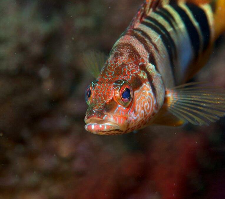
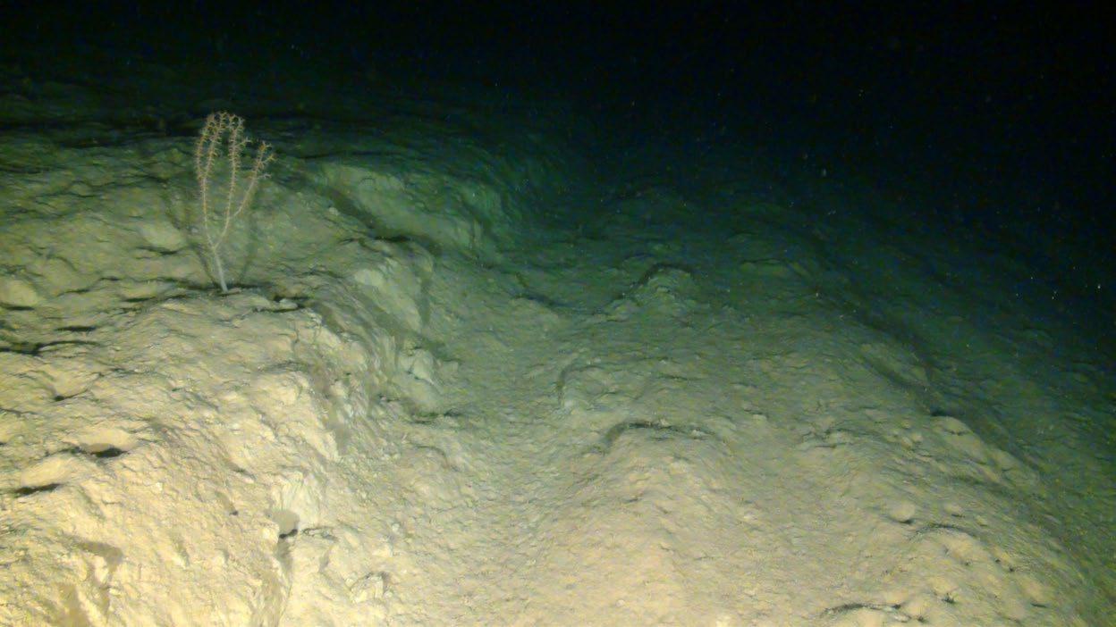
© OCEANA / Enrique Talledo
Summary
Spain has an extensive network of marine protected areas covering more than 13% of its marine surface area. These areas have been designated to protect very rich and varied biodiversity, but their management is inadequate.
In most of these areas, which form part of the Natura 2000 network, the status of the habitats and species to be protected has been assessed as unfavourable. Yet, activities that impact them continue to be carried out even after they were declared protected.
This reveals a problem of management in the network and, therefore, of non-compliance with nature protection regulations, as these require preventing any deterioration of habitats and species that are protected, in favour of their conservation and, if necessary, their restoration.
One of the greatest threats to the integrity of the seabed and its habitats, even within marine protected areas, is bottom-contact fishing, such as bottom trawling and dredging.
To analyse the extent of these activities in the Spanish network of marine protected areas, Oceana has made a detailed analysis of the incidence of high-impact fishing activities on the seabed in Spanish Natura 2000 areas specifically designated for the protection of the seabed and its habitats.
This analysis reveals that at least 21% of these areas are being trawled, including heavily impacted areas, cases of trawling over habitats expressly protected under the Habitats Directive, and evidence of trawling over areas where this activity is restricted and therefore illegal. This report sets out the details of this analysis, its results, a series of case studies, and provides specific recommendations for improving the management of Spanish marine protected areas.
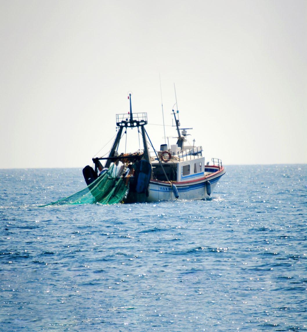
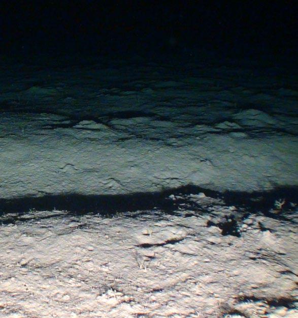
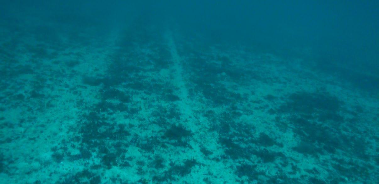
 Avilés Canyon, Asturias, Spain. Trawler fishing in Cudillero.
3 Paper parks in Spain Bottom trawling inside marine protected areas
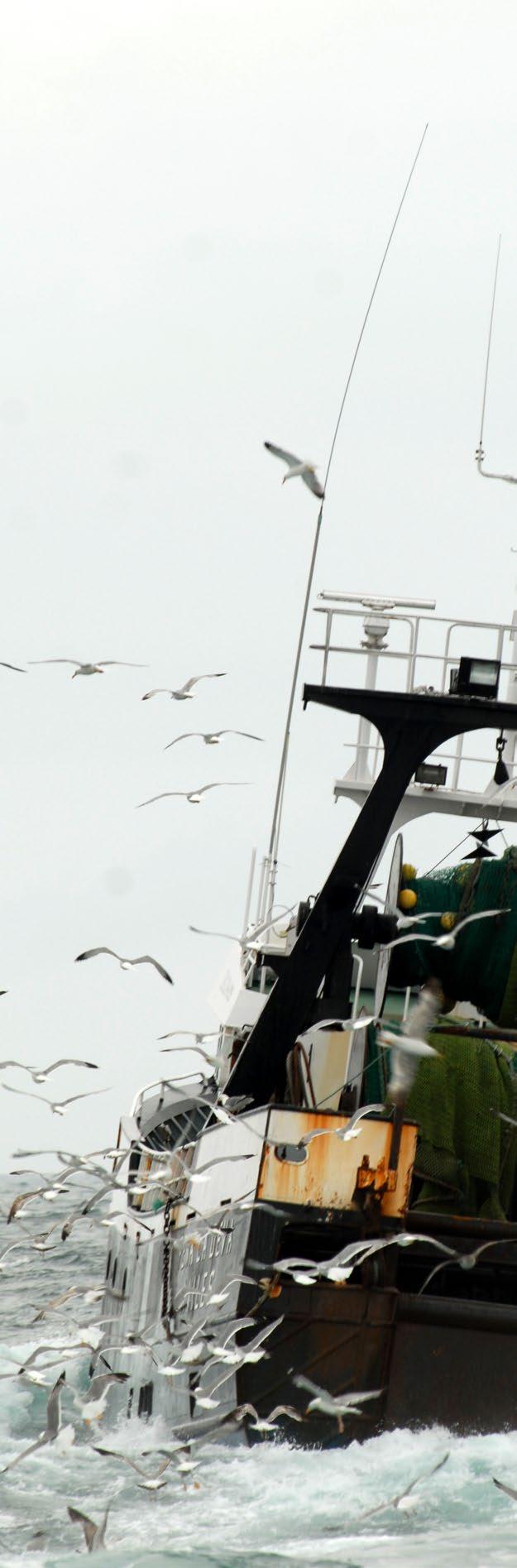
Spain has one of the largest marine zones in Europe, more than one million square kilometres, of which 13.1% is currently designated as marine protected areas (MPAs) 1 , most of which are included within the Natura 2000 network. However, activities such as bottom trawling and dredging, two of the most serious threats to marine ecosystem, are still tolerated in many of these supposedly protected areas. 2 Even within MPAs, fishing is typically recognised as the main threat to the benthic habitats that these areas are supposed to protect. 3
activities that make direct contact with the seabed include the degradation or destruction of habitats, the by-catch of unwanted species – including protected species – and the release of carbon stored on the seabed. They are therefore incompatible with any conservation efforts.
The Habitats Directive is the main legislation protecting the natural environment in Europe, establishing, together with the Birds Directive, the Natura 2000 network, which is the largest ecological network in the world. The directive obliges Member States to ensure that these protected areas maintain a favourable conservation status and, if necessary, to restore them to such status. They must also establish management priorities in light of existing threats, to avoid any deterioration of habitats and species. Despite all the efforts made to designate protected areas, the status of the marine habitats protected under the Habitats Directive has been assessed as unfavourable or unknown. In Spain, none of these habitats, in any of the Spanish marine bioregions (Atlantic, Macaronesian and Mediterranean), are currently in a favourable status.4
There are other policies also designed to protect the sea that would reinforce the Habitats Directive, such as the Marine Strategy Framework Directive, aimed at achieving good environmental status of the marine environment, and the EU Biodiversity Strategy 2030, which sets out the roadmap for delivering the nature protection aspect of the European Green Deal. The latter foresees the establishment of binding restoration targets, which is of particular interest for the recovery of areas devastated by trawling. At national level, the Ley de Protección del Medio Marino (Marine Environment Protection Act) and other regulations related to the Red de
Introduction
The negative effects of fishing
© OCEANA
Paper
4
Mallorca Channel, Balearic Islands, Spain. Trawl marks in a pockmarks zone.
parks in Spain Bottom trawling inside marine protected areas
Áreas Marinas Protegidas de España (RAMPE) (Network of Marine Protected Areas of Spain) set the targets for marine protection, prioritising both the conservation and recovery of natural heritage and marine biodiversity. Surprisingly, these policies are not being applied to end the ongoing use of destructive fishing gear inside MPAs.
In 2020, Oceana published an analysis of the main threats affecting Europe’s Natura 2000 network sites, showing that activities with negative impacts are permitted across 96% of its surface area. 5 Fishing was shown to be the second most commonly found activity in protected areas, after maritime traffic.
This is despite the fact that almost three quarters of Europe’s Natura 2000 sites (1945 out of 2671 in 2018) have been designated specifically to protect seabed (benthic) habitats, such as reefs and seagrass meadows. The analysis of the fishing activity showed that 26% of these sites suffer from fishing that poses a high risk to the seabed (such as dredging, bottom trawling and longlining). It also revealed a worrying situation for Spain, which is the country with the highest number of MPAs with fishing activity within them in Europe. 5 Following this study, it has been estimated that 34% of the Spanish areas designated to protect the marine benthos are exposed to highrisk fishing. 6
In light of these findings, Oceana carried out a more detailed analysis of trawling and dredging in Spain, focusing on Natura 2000 areas set up to protect the benthos, the results of which are presented in this report. In addition, we present four case studies of MPAs that appear to be under heavy fishing pressure from bottom trawling and where fisheries management measures are either inadequate or nonexistent. Finally, bottom trawling has also been observed in areas where it is specifically forbidden, indicating possible illegal fishing activities.
© OCEANA / Juan Cuetos Sant Carles de la Ràpita, Tarragona, Spain. Bottom trawler fishing.
5
Paper parks in Spain
Bottom trawling inside marine protected areas
Overview of marine protected areas and fisheries in Spain
1. The network of marine protected areas
Most Spanish MPAs are part of the Natura 2000 network (309 sites in 2020). This network comprises 234 sites designated under the Habitats Directive for the protection of certain habitats and species, known as Sites of Community Importance (SCIs) or Special Areas of Conservation (SACs). The network also includes 137 sites designated under the Birds Directive as Special Protection Areas for birds (SPAs), which often overlap with the aforementioned sites. The national MPA network currently covers 13.1% of Spain’s marine surface area, 1 above the world average, although far from the 30% target for protection and effective management committed to under the EU’s Biodiversity Strategy for 2030. 7 This commitment states that by 2030 at least 10% of the marine area in the EU will also be fully protected, in other words, completely safe from harmful human impacts. Currently, this type of strict protection only applies to 0.2% of the Spanish MPA network. 7
Many Natura 2000 areas totally or partially overlap with other types of MPAs, established under national environmental or fisheries regulations, or under international conventions (OSPAR, Barcelona Convention, UNESCO or RAMSAR). Despite the numerous protection categories that can often be found in the same area, effectively
multiplying its protected status, the management of the Natura 2000 has proven to be deficient in terms of fishing activities.5
In Spain, fisheries are frequently excluded from management consideration when it comes to protected areas, as they are subject to fishing regulations, and are therefore outside of the scope of nature conservation objectives. This is despite the fact that fishing has been recognised as one of the activities with the greatest impact on the marine benthos, including within MPAs.2,3
© OCEANA / Carlos Minguell
Paper parks in Spain Bottom trawling inside marine protected areas 6
La Bocayna Strait, Fuerteventura, Spain. School of salema (Sarpa salpa) in the Sebadales de Corralejo SAC.
2. The Spanish trawl fishing fleet
The Spanish fishing fleet is the largest fishing fleet in the European Union, both in terms of volume and value of catches.8 According to data from 2020, the entire professional fishing fleet was made up of 8,839 vessels, of which 10.5% are bottom trawlers which operate in national fishing grounds (66 in the Cantabrian and Northwest fishing grounds, 126 in the Gulf of Cádiz and 580 in the Mediterranean Sea), with the rest in other EU waters (74 vessels) and international waters (81 vessels).9
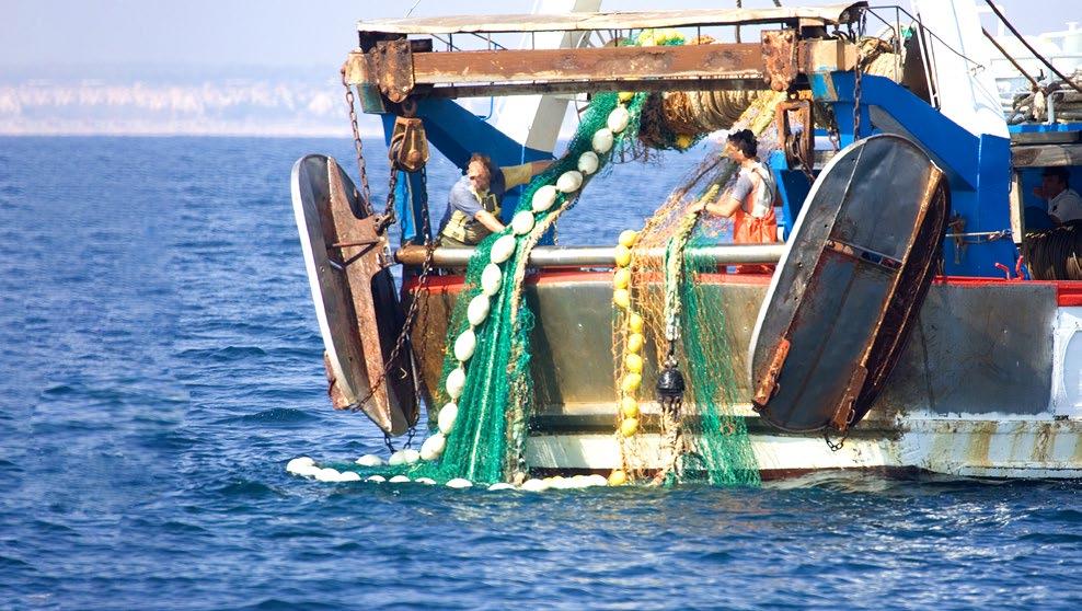
A bottom trawl is a large and heavy net that has a high potential to damage the seabed. The following data shows the dimensions this fishing gear can have and illustrates the potential environmental impact of the gear. According to a study on the Mediterranean trawling fleet, on average the bottom trawls used are 62 metres long, 90 metres wide and weigh 280 kg, but the largest reach lengths of 220 metres, widths of 292 metres and can weigh up to 778 kg.10
8,839 vessels
Of which
10,5% are bottom trawlers
In the Mediterranean Sea, this type of fishing gear can be as large as:
220 metres long
292 metres wide
778 kg in weight
3. Trawling and Natura 2000 network legislation
Designation of Natura 2000 sites
In articles 4.5 and 6.2, the Habitats Directive legally established the obligation to prevent the deterioration of natural habitats and disturbance of species of Community interest in MPAs, from the moment these sites are proposed to be protected.
However, in general terms, the new Natura 2000 designation does not
entail specific fisheries management. Consequently, in those MPAs where destructive fishing was ongoing prior to designation, it generally continues after designation despite the outstanding natural value the sites are designated for. New Natura 2000 sites are usually designated by their inclusion in the lists published in the Official Journal of the European Union (OJEU), without any management measures being adopted.
7 Paper parks in Spain Bottom trawling inside marine protected areas
Management plans for Natura 2000 sites
When they are initially designated, Natura 2000 areas generally have no management plan in place, a situation that continues until such specific measures are developed, approved and implemented. The Habitats Directive and the Spanish Natural Heritage Law11 establish a maximum period of six years to establish these measures, a time during which fishing often continues to be managed independently of the area’s conservation objectives, without halting or avoiding its possible negative effects on the ecological integrity of sites. In Spain, according to data from the European Environment Agency (EEA), 12 of the 218 MPAs analysed, only 62% have a management plan in force, and for the rest, the six-year period has expired or almost expired. This is the case with the
In cases where new MPAs do have designation regulations, these include a preventive protection regime which, as a general rule, does not affect fishing activity. This is the case, for example, with the areas designated under the LIFE+ INDEMARES project, for which the ministerial declaration orders expressly indicate this exclusion for fishing. It may also be the case that previously implemented environmental regulations apply. This occurs when there is a partial or total overlap with other environmental protection measures, such as the two marine national parks in Spain (Archipiélago de Cabrera and Islas Atlánticas) where bottom trawling is prohibited by law and, as a result, is also prohibited in the sections of the Natura 2000 sites which overlap with these national parks.
INDEMARES sites that were declared SCIs in December 2015 (OJEU), 13 which should have a management plan in place before the end of 2021. These plans are being developed as part of another major marine conservation project - LIFE IP INTEMARES - in Spain, whose purpose is to achieve, through participation and research, a properly managed network of Spanish MPAs.
 © OCEANA / Carlos Minguell
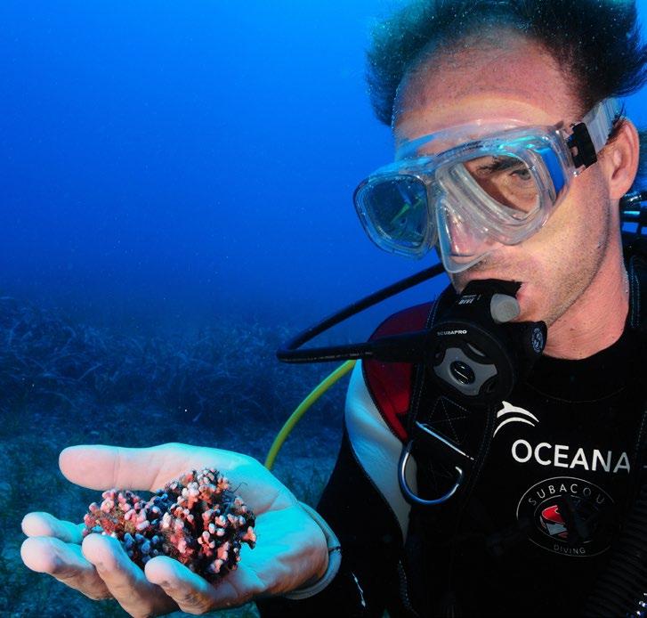
Punta Entinas-El Sabinar, Almería, Spain. Diver showing a rhodolith.
© OCEANA / Juan Cuetos
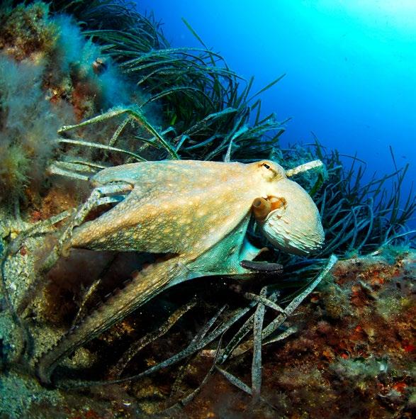
El Arco, La Azohía, Murcia, Spain. Common octopus (Octopus vulgaris) in a Posidonia oceanica meadow.
© OCEANA / Carlos Minguell
Punta Entinas-El Sabinar, Almería, Spain. Diver showing a rhodolith.
© OCEANA / Juan Cuetos
El Arco, La Azohía, Murcia, Spain. Common octopus (Octopus vulgaris) in a Posidonia oceanica meadow.
8
Paper parks in Spain Bottom trawling inside marine protected areas
Fishing regulations
As mentioned above, many Natura 2000 areas overlap totally or partially with other types of protected areas. These may already have fisheries management measures in place, including express
restrictions on trawling, which therefore also apply to the Natura 2000 areas with which they overlap. Other restrictions on trawling, arising from fisheries regulations, exist, such as:
Fishing restricted areas , including marine reserves, fishing reserves, and fishing protected areas, where trawling is generally prohibited, although there may be certain exceptions.
Spatial closures in particular areas of the various marine regions, such as the Gulf of Cádiz (within 6 nautical miles from shore or the 50 metres isobath 14); the Mediterranean Sea (below 1000 metres depth and within 3 nautical miles from shore or within the 50 metres isobath; 15); throughout the entire Canary Islands National Fishing Ground;20 and below 800 metres in the North East Atlantic. 16
Closures around specific sensitive habitats csuch as seagrass meadows, coralligenous habitats and rhodolith beds. 15
On the other hand, since the 2013 reform of the EU Common Fisheries Policy, Spain has still not yet adopted any management measures relating to Article 11 pursuant to the adoption of conservation measures necessary to comply with environmental
legislation. This mechanism is directly relevant to manage fisheries in MPAs where other EU countries have fishing interests, a situation applicable to several Spanish MPAs like El Cachucho SAC (see Case Studies ).
Analysis of fishing activity in Spanish marine protected areas
1. Methods
Fishing
This study focuses on bottom trawling and dredging as these are the fishing gears that have the greatest impact on habitats, according to the European matrix of potential vulnerability to fishing gear, 17 as this towed gear comes into direct contact with the sea floor.
Fishing records have been obtained from Global Fishing Watch (GFW), a tool that uses data publicly transmitted through the Automatic Identification System (AIS), to differentiate apparent fishing activity from non-fishing activities (such as sailing).
9 Paper parks in Spain Bottom trawling inside marine protected areas
From this point onwards, references to fishing activities should be understood as apparent fishing activities, as they are based on GFW analysis. 18 Only vessels of at least 15 metres in length (19% of the professional fleet in Spain) are required to be equipped with AIS, so the activity of smaller trawlers, some 80 vessels, 19 could not be analysed. Vessels can also trick the system by falsifying their locations or turning off their AIS transponders
Protected areas
Due to the potential interactions of bottom fishing with benthic habitats, our analysis focused on MPAs designated for the protection of benthos. Of these, the Natura 2000 areas that protect benthic habitats were ideal for the study, given the abundance and homogeneity of data on these MPAs in the EEA database, 12 and the fact that they are all governed by the same regulations. The study included the 218 areas designated up to the end of 2019, thereby ensuring that the analysis was carried out on protected areas that had already been declared as such at the time that the fishing activity was analysed.
Benthic habitats
To analyse how fishing activity directly interacts with the habitats present in the MPAs, the few detailed habitat maps available have been used, such as those derived from the LIFE+ INDEMARES on habitats of Community interest (listed in Annex I of the Habitats Directive), the MEDISEH project on Posidonia meadows, coralligenous communities and rhodolith
whenever they wish. Consequently, the impact of the fishing activity recorded in this analysis is likely to be underestimated. The analysis was undertaken using the most recent GFW data available, from January to December 2020. In order to minimise the incidence of possible signal errors, areas where the annual fishing hours was less than one hour have been considered to be trawl-free areas.
beds in the Mediterranean, and those resulting from management plans, in the case of El Cachucho SAC. In connection with this study, a request was made to the Ministry for Ecological Transition to get all existing mapping of benthic habitats in Spanish MPAs, but at the time of finalising this report, no answer was received.
© OCEANA / Juan Cuetos
Isla de las Palomas, Murcia, Spain. Sponge (Oscarella lobularis), bryozoan (Myriaporatruncata) and tower shells (Turritella sp.).
Paper parks in Spain Bottom trawling inside marine protected areas 10
2. Results
The analysis of fishing records shows that bottom trawling and dredging appear to occur inside MPAs in all Spanish marine regions, including with apparent highly impacted areas (Figure 1), with the
exception of the Macaronesian region (Canary Islands) where this activity has been expressly prohibited since 2015.20 The main results of the analysis are as follows:
O 73% of the fishing activity recorded within Spanish Natura 2000 areas corresponds to trawlers and one dredging vessel (Irish - hereafter, mentions of these trawlers will include this dredge).
O Trawling activity has been detected in 45 of the 218 Natura 2000 areas designated for seabed protection. . This means that, in Spain, 21% of the areas that should be protecting benthic habitats could actually be impacted by bottom trawling. This percentage rises to 24% when excluding MPAs in the Macaronesian region, where trawling is prohibited.
O In terms of surface area , excluding the Macaronesian region, areas directly or indirectly impacted by trawling account for 64% of the total surface area of Natura 2000 sites designated to protect benthic habitats.
O In 2020, these 45 MPAs were trawled by 404 vessels for a total of 73,100 hours, with some locations exceeding 22,200 hours (Box 1).
O Of these 45 MPAs, less than half have a management plan in place . These include both areas designated several years ago - such as the Área marina de Tabarca SCI and the Alborán SCI, both designated in 2006 – and more recent areas established under the INDEMARES project (2015).
O Almost 50% of the trawlers operating in the national fishing grounds (at least 349 out of 772), recorded activity within one or more Natura 2000 areas. Of these, up to 20 vessels (all Spanish), fished for 1,000 hours or more each, within Natura 2000 sites.
O The trawling is mainly carried out by Spanish vessels, but significant activity by foreign vessels has also been detected in Natura 2000 areas (Table 1).
O 80% of the trawling activity (in number of hours) was carried out within the 12 nautical miles limit (territorial sea) in 39 protected areas; the remaining 20% occurred in waters beyond 12 nautical miles, in six large MPAs (the El Cachucho SAC, and the SCIs Canal de Menorca, Sistema de cañones submarinos de Avilés, Sistema de cañones submarinos occidentales del Golfo de León , Sur de Almeria – Seco de los Olivos , and Volcanes de fango del Golfo de Cádiz ). About 15% of these records beyond the territorial sea, correspond to foreign-flagged bottom trawlers.
© OCEANA
11 Paper parks in Spain
Fort d’en Moreu, Cabrera National Park, Spain. Trawl net on coralligenous reef.
Bottom trawling inside marine protected areas
Box 1 | Spain’s top ten most trawled marine “protected” areas

In 2020, ten Spanish Natura 2000 marine sites accounted for 97% of the total bottom trawling hours recorded in MPAs ( Table 2 ). Most of these areas are extensive, totalling more than 16,000 km 2 (2% of the Spanish marine surface area), and cover a wide variety of habitats ranging from shallow to deep-sea. They include some of the most densely trawled sites designated to protect benthic habitat among all the those analysed in Spain, like Sur de Almería – Seco de los Olivos ; the Aviles submarine canyon system ; and the Valles sumergidos del escarpe de Mazarrón . In total, more than 50,000 hours were registered in 2020, with more than 11,000 hours in each site. These results juxtapose starkly with the enormous ecological relevance of the sites (see Case Studies ).
Flag Hours of apparent fishing activity % of hours of apparent fishing activity Nº of vessels % of vessels Gear type19 Spain 70,327 96.2 349 85.8 349 bottom trawlers France 1,190 1.6 21 5.2 13 bottom trawlers; 1 pair trawler; 7 twin trawlers Portugal 717 1 22 5.4 22 bottom trawlers Ireland 649 0.9 11 2.7 10 bottom trawlers; 1 dredger United Kingdom 207 <0.3 2 0.5 2 bottom trawlers Croatia 9 <0.1 1 <0.3 1 bottom trawler Italy 1 <0.1 1 <0.3 1 bottom trawler TOTAL 73,100 100 407 100
Table 1: Fishing activity in 2020 involving trawlers and dredgers in Natura 2000 areas designated for benthic habitats.
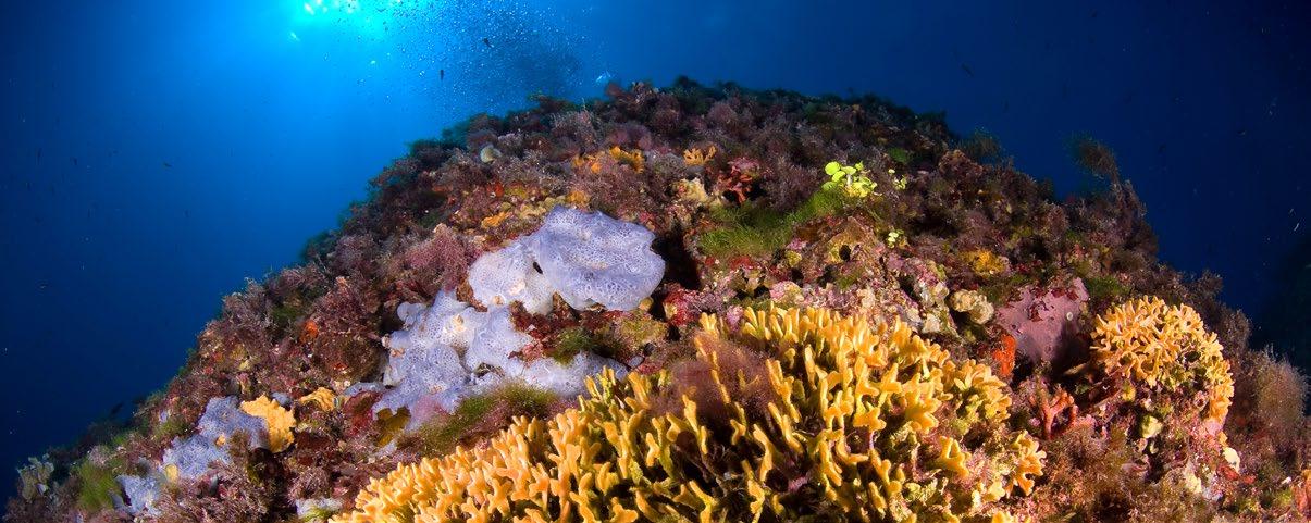
Seco de los Olivos, Alboran Sea. Gorgonian garden.
Paper parks in Spain Bottom trawling inside marine protected areas 12
© OCEANA
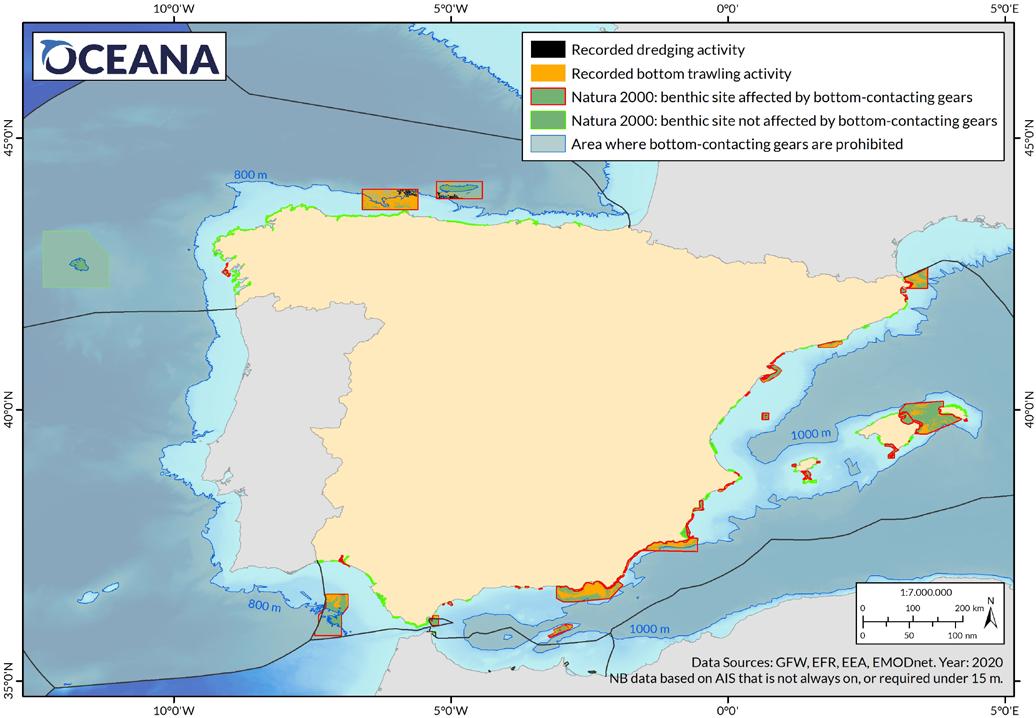 Table 2: The ten Spanish Natura 2000 areas designated for the protection of benthic habitats that were the most densely trawled in 2020.
Site code Site name Marine demarcation Protected area [km2] Apparent fishing hours Density of fishing activity [h/km2] Nº of vessels ESZZ16003 Sur de AlmeríaSeco de los Olivos Estrecho y Alborán 2,831 22,222 8 39 ESZZ12003 Sistema de cañones submarinos de Avilés Noratlántica 3,388 15,863 5 85 ES6200048 Valles submarinos del Escarpe de Mazarrón LevantinoBalear 1,539 11,931 8 33 ESZZ16001 Sistema de cañones submarinos occidentales del Golfo de León LevantinoBalear 938 7,903 8 31 ESZZ16002 Canal de Menorca LevantinoBalear 3,356 5,554 2 16 ESZZ12002 Volcanes de fango del Golfo de Cádiz Sudatlántica 3,178 2,238 1 31 ES5110020 Delta de l’Ebre LevantinoBalear 372 2,122 6 54 ES0000020 Costes del Garraf LevantinoBalear 265 1,980 8 32 ESZZ16005 Espacio marino de Alborán Estrecho y Alborán 109 702 6 24 ES6120032 Estrecho Oriental Estrecho y Alborán 263 532 2 6 TOTAL 16,239 71,047 325 13
Bottom trawling inside marine protected areas
Figure 1: Records of trawling activity in 2020 inside Spanish Natura 2000 sites designated for the protection of benthic habitats. (The Macaronesian region is excluded).
Paper parks in Spain
3. Case studies
Block 1. Trawling in LIFE+ INDEMARES areas
The LIFE+ INDEMARES project was designed to be one of the largest marine conservation projects in Europe over the past decade, with a budget of 15.4 million euros, 50% of which was co-financed by the European Commission. Its main goal was to improve the representation of the marine Natura 2000 Network in Spain with the creation of 10 new marine MPA areas that cover almost 50,000 km2 and are home to exceptional marine biodiversity.
However, the findings from Oceana’s analysis are worrying. Six of these sites are among the most heavily trawled protected areas in Spain: Sur de Almería – Seco de los Olivos, Sistema de cañones submarinos de Avilés, Sistema de cañones submarinos occidentales del Golfo de León, Canal de Menorca, Volcanes de fango del Golfo de Cádiz, and Espacio marino de Alborán.
They were designated as SCIs in December 2015, meaning the six-year deadline for adopting the corresponding management plans has almost expired, and yet today they still lack both a plan and specific fisheries management measures. These sites are currently subject to preventive measures to avoid damage; however, these exclude fishing activities. This lack of management results in continuous trawling activity inside protected sites, that can have major impacts on the seabed of the sites
and the protected habitats they support, despite Spain’s legal obligations to prevent their deterioration.
The analysis of fishing in these sites showed that six of these 10 SCIs are intensively trawled: from the Espacio marino de Alborán , with more than 700 hours of activity; to the Sur de Almería –Seco de los Olivos , with more than 22,200 hours ( Table 2 ). 75% of the trawling activity recorded in the 45 Natura 2000 areas analysed occurs in these six INDEMARES sites. The remaining four SCIs that are part of that project showed very low or no trawling activity: in the Espacio marino de Illes Columbretes , just two hours of trawling were recorded; two other sites are in Canary Islands waters, where trawling is prohibited and no activity was observed; and there was no activity in the Banco de Galicia site, probably because this is not a fishing ground for trawling.
Seco de los Olivos, Alboran Sea. Tree coral (Dendrophyllia ramea).
© OCEANA
Bottom trawling inside marine protected areas 14
Paper parks in Spain
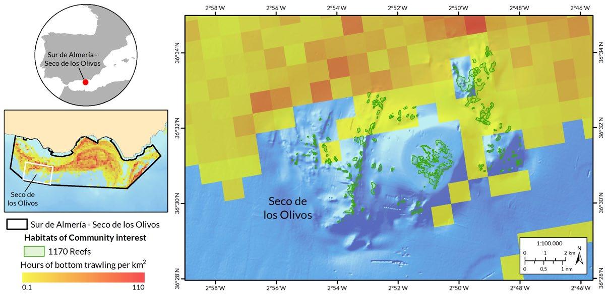
Case 1. The most trawled area, the Sur de Almería – Seco de los Olivos SCI
The ecological importance of the Sur de AlmeríaSeco de los Olivos site lies in the enormous diversity of habitats it harbours, including Posidonia meadows, coral reefs, as well as gorgonian and sponge forests, and in the importance of its waters for sea turtles and numerous species of cetaceans. The area is also home to many other habitats and species of great scientific and conservation interest: rhodolith beds, soft bottoms with structural fauna (corals, sponges, sea pens), endangered species and species of high commercial value. It also has a varied geomorphology, including the Seco de los Olivos seamount, studied in detail during the INDEMARES project, along with rocky outcrops, escarpments, canyons, ridges and valleys that have yet to be explored and described. However, six years after its designation as an SCI, the area still lacks a management plan.
The greatest number of trawling hours of all the MPAs analysed in 2020 was recorded within its limits, accounting for 30.4% of the total number of trawling hours (Figure 2). It is also one of the areas where fishing activity has been the densest, in terms of annual fishing hours per
square kilometre, despite its large surface area of almost 3,000 km2 (Table 2). This fishing activity can be attributed to to 38 Spanish trawlers, mainly from the ports of Almería, Motril and Carboneras, as well as to one Croatian vessel. These boats target, among other species, horse mackerel, hake, blue whiting, deep-water rose shrimp, red shrimp and Norway lobster.21,22
Fishing activity directly over the mapped Reefs habitat type of the Seco de los Olivos seamount is low (Figure 2), although by definition23 seamounts, and other topographic features, can actually be considered Reefs themselves. On this basis, the surface area of impacted Reefs would actually be much larger. Some of the flatter areas of the Seco de los Olivos seamount are subject to high trawling activities, affecting other habitats of high natural value, such as the soft bottoms with structural species such as the bamboo coral (Isidella elongata), a critically endangered species in the Mediterranean Sea. Other affected areas, both around the seamount and within the entire MPA, also contain vulnerable and critical habitats that are being impacted by trawling.
15
Figure 2: Records of trawling activity in the Sur de Almería - Seco de los Olivos SCI. The image on the right shows the Seco de los Olivos seamount area.
Paper parks in Spain
Bottom trawling inside marine protected areas
Case 2. Trawling over habitats of Community interest
The Habitats Directive clearly establishes that as soon as an area becomes part of the Natura 2000 Network, the primary conservation objective is to protect the habitats and species of Community interest, such as Sandbanks which are slightly covered by sea water all the time, Reefs, Submarine structures made by leaking gases, or several species of sea turtles and cetaceans (articles 4.5 and 6.2). The analysis of fishing data over protected habitats mapped under the INDEMARES project has shown a total of 660 hours of trawling activity that took place exactly over these habitats of Community interest.
Because these INDEMARES areas still lack any fisheries management, damaging fishing like bottom trawling could be deteriorating these protected habitats, as well as other habitats of high natural value present in these sites. All the habitats, whether mapped or not, are part of rich ecosystems that should be properly protected. This should be done following the precautionary principle and a whole-site approach to management that takes into account broader ecosystems beyond those protected to ensure their health and functioning. The following are four of the most striking cases of possible trawling over habitats of Community interest inside INDEMARES sites.
The Sistema de cañones submarinos occidentales del Golfo de León SCI has been protected due to the presence of the Reefs habitat of Community interest, which hosts communities that are very sensitive to trawling, such as coralligenous reefs, sponge aggregations or white coral reefs, 24 as well as species of Community interest such as the loggerhead turtle ( Caretta caretta ) and bottlenose dolphin ( Tursiops truncatus ). Other vulnerable habitats are also present, as proposed in the framework of the INDEMARES project for inclusion in Annex I of the Habitats Directive due
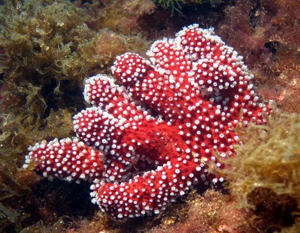
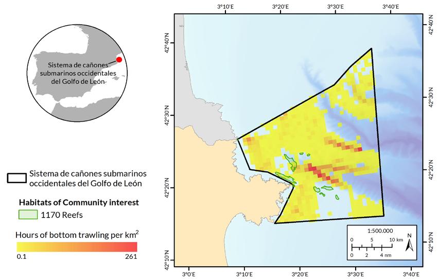 Figure 3: Trawl records over habitats of Community interest in the Sistema de cañones submarinos occidentales del Golfo de León SCI.
Cape Norfeu, Girona, Spain. Mediterranean soft coral (Alcyonium acaule).
© OCEANA / Thierry Lannoy
Paper parks in Spain
Figure 3: Trawl records over habitats of Community interest in the Sistema de cañones submarinos occidentales del Golfo de León SCI.
Cape Norfeu, Girona, Spain. Mediterranean soft coral (Alcyonium acaule).
© OCEANA / Thierry Lannoy
Paper parks in Spain
16
Bottom trawling inside marine protected areas
to their high natural value and ecological importance, 25 including soft bottoms with sea pens, tube anemones or sea lilies. The area is rich in plankton and krill which is essential for fish and for the cetacean and bird populations it supports. The canyon system itself, as well as the continental shelf that make up this SCI, may well harbour many other habitats, yet to be described, which
could be equally threatened by the current lack of management, particularly by bottom fishing activities. In total, 7,900 hours of trawling were detected within this SCI, involving 31 vessels, all with flags of Spain apart from three French vessels (13 hours of trawling). Of these hours, 29 correspond to trawling over Reefs ( Figure 3 ), carried out by 12 Spanish vessels.
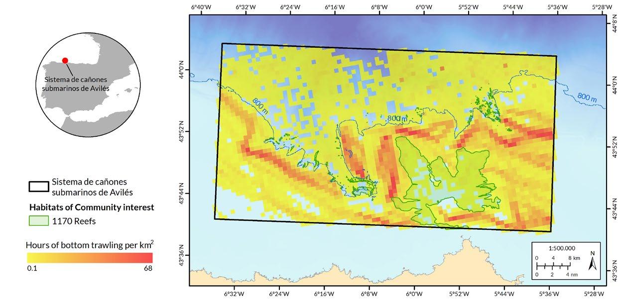
The Sistema de cañones submarinos de Avilés SCI, comprises three large canyons and a system of tributary canyons and is home to a great diversity of habitats and species. The area has been protected because of the presence of Reefs , a habitat of Community interest, and other cold-water coral communities, gorgonian forests and sponge aggregations, as well as populations of various species of Community interest, such as the bottlenose dolphin ( Tursiops truncatus ), harbour porpoise ( Phocoena phocoena ) and loggerhead turtle ( Caretta caretta ) which live and feed in these waters. 26 The area contains other vulnerable habitats proposed in the framework of the INDEMARES project for inclusion in Annex I of the Habitats Directive, 25 such as its sedimentary seabed that
hosts structural species of high natural value, like sea pens and gorgonians. These soft bottoms are affected by trawling, which has been altering their structure for decades and compromising the health of this ecosystem. In total within this SCI, 15,863 trawling hours were detected by 85 vessels, of which 13,900 hours from 37 Spanish vessels, and the rest from Portuguese, French, Irish and British vessels. 339 hours correspond to trawling over Reefs (Figure 4) by 29 vessels (14 Spanish, 10 Portuguese, four French and one British). Apparent trawling has also been detected at depths greater than 800 metres (13 of these over Reefs), which is illegal according to EU legislation16 (see Regulations on trawling and the Natura 2000 Network).
Figure 4: Records of trawling over habitats of Community interest in the Sistema de cañones submarinos de Avilés SCI. The map also shows apparent illegal trawling activity below the 800 metres bathymetric line.
17
Paper parks in Spain
Bottom trawling inside marine protected areas
The Volcanes de fango del Golfo de Cádiz SCI is home to submarine structures that are unique within the Spanish network of MPAs, i.e., the habitat of Community interest Submarine structures caused by leaking gases , which is also the main reason for this area to be protected. These mud volcanoes are produced by gas emissions at great depths, and form chimneys that can reach several metres high. 27 The structures are rich in biodiversity and host environments of great ecological interest, that are particularly sensitive to the impact of activities that contact the seabed. The area also features Reefs habitats of Community interest, with white corals and other cold-water corals, together with soft bottoms with sea pens, bamboo corals and other valuable structural species, the latter having been proposed for inclusion in Annex I of the Habitats Directive. The area also supports populations of species of Community interest, such as bottlenose dolphin ( Tursiops truncatus ) and loggerhead turtle ( Caretta caretta ). In this area, 2,238 hours of trawling were detect -
ed involving 31 trawlers (all Spanish except for three Portuguese vessels trawling for 79 hours). Of these, 144 trawling hours took place over Submarine structures caused by leaking gases ( Figure 5 ), by 13 Spanish vessels and one Portuguese vessel.
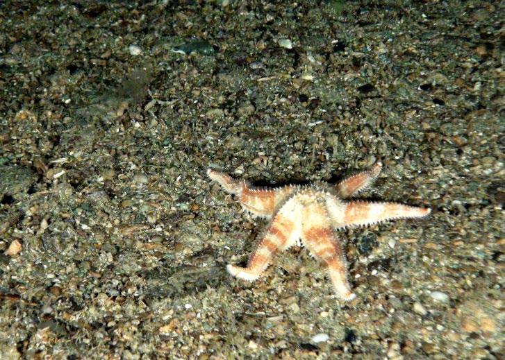
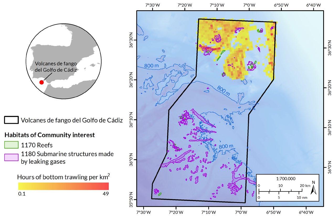 Figure 5: Trawling records over habitats of Community interest in the Volcanes de fango del Golfo de Cádiz SCI.
© OCEANA
Figure 5: Trawling records over habitats of Community interest in the Volcanes de fango del Golfo de Cádiz SCI.
© OCEANA
Paper parks in Spain Bottom trawling inside marine protected areas 18
Gazul mud volcano, Gulf of Cadiz, Spain. Starfish (Sclerasterias neglecta).
The Canal de Menorca SCI has been protected for its wide variety of marine environments, including the shallow water habitats of Community interest Sandbanks which are slightly covered by sea water all the time and Posidonia beds , as well as Reefs . This latter habitat is composed of interesting communities such as coralligenous, gorgonian gardens, sponge aggregations and corals. The area is also known for its diverse and rich soft bottoms, with structural species such as sea pens, tube anemones and sea lilies, as well as extensive rhodolith beds and forests of endemic kelp ( Laminaria rodriguezii ),
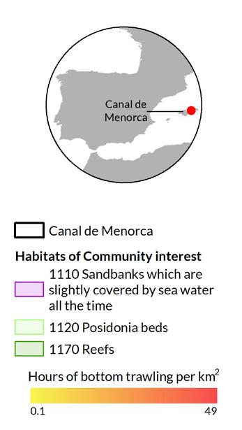
which are essential for many ecologically important species and extremely sensitive to trawling. 28 This seabed also supports important populations of species of Community interest, namely bottlenose dolphin ( Tursiops truncatus ) and loggerhead turtle ( Caretta caretta ). In this area, 5,554 hours of trawling were detected by 15 Spanish vessels and one Croatian vessel. 100 of these hours correspond to trawling over Reefs , 33 hours over Posidonia beds and six hours over Sandbanks which are slightly covered by sea water all the time ( Figure 6 ), all carried out by 12 Spanish vessels.
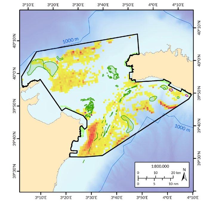 Figure 6: Trawling records over habitats of Community interest in the Canal de Menorca SCI.
© OCEANA / Carlos Suárez
Figure 6: Trawling records over habitats of Community interest in the Canal de Menorca SCI.
© OCEANA / Carlos Suárez
19
in
Cape Bajolí, Menorca Channel, Spain. Rock covered with bryozoans, algae and sponges.
Paper parks
Spain Bottom trawling inside marine protected areas
Block 2. Trawling in large “managed” sites
Unlike the INDEMARES areas, other Natura 2000 areas already have management measures in place, such as the El Cachucho SAC and the Valles sumergidos del escarpe de Mazarrón SAC. But the fact that an area is theoretically managed does not mean real protection against bottom trawling necessarily, as the sites often still permit damaging fishing techniques that alter the structure of the seabed and destroy natural
habitats, including the habitats they are intended to protect. These two large “managed” areas have management plans that recognise the impacts of trawling on the ecosystem (both habitats and species) they are meant to protect, but still this destructive activity takes place within their boundaries, resulting in ineffective plans that undermine the conservation objectives of the sites.
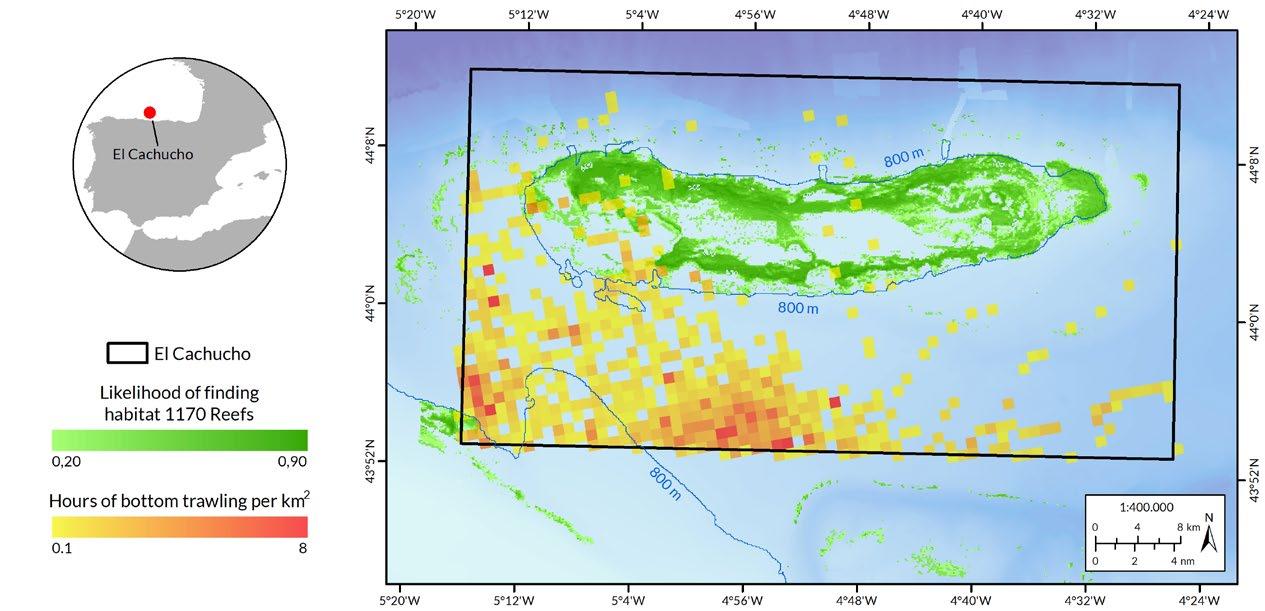
El Cachucho is a large seamount located off the territorial waters (beyond the 12 nautical miles) of Asturias. The seamount, which spans a bathymetric range of 400 to over 4,000 metres, is considered a haven for biodiversity, with species like corals, sponges, sharks, sea pens, as well as a refuge for species of commercial value, such as blue whiting and hake. 29 Under the Agreement of the Council of Ministers in 2008 30 the area was protected – under preventive measures at that time –, reaching an international milestone for marine conservation in Spain, as it was the first Spanish MPA to become part of the network of MPAs of the OSPAR Convention for the Protection of the Marine Environment of the North-East Atlantic. However, although these preventive measures did include mining, military manoeuvres and hydrocarbon research, it did not include any fisheries management measures. Three years later El Cachucho was designated as Spain’s first MPA, it became a SAC, and management measures were established. 31 Trawling was specifically prohibited in the area, both in its 2011 management plan and in the recent update in 2021. 32 However, despite the closure of the area to trawling, no action has been taken against the foreign-flagged fleet that continues to bottom trawl inside the site. Back in 2008, the agreement for the protection of the area recognised the need to request to the Eu -
ropean Commission appropriate fisheries management measures, due to the presence of an EU foreign fleet, but Spain has not yet initiated this process (see Fishing Regulations ). The area is also affected by the 2016 EU Regulation that bans bottom trawling in the North-East Atlantic at depths below 800 metres to protect vulnerable ecosystems. 16 Even so, 526 hours of apparent trawling have been detected within the area ( Figure 7 ), all by foreign-flagged vessels (13 French and 11 Irish), with in particular 449 hours at depths below 800 metres. The records include 14 hours over Reefs , a habitat of Community interest and whose presence was the main reason to protect the area in 2008.
Case 3. El Cachucho and EU foreign vessels
Cudillero, Asturias, Spain. Trawlers in the Avilés Canyon.
Paper parks in Spain Bottom trawling inside marine protected areas 20
© OCEANA / Enrique Talledo
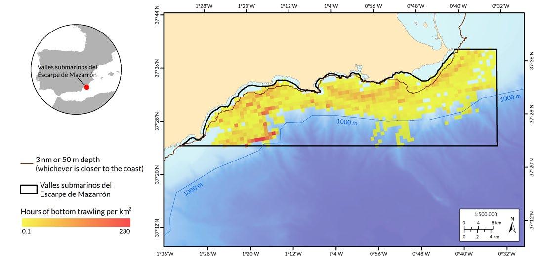
The Valles sumergidos del escarpe de Mazarrón SCI was proposed as a SCI in 2006, through its publication in the OJEU, and later designated a SAC in August 2016. 33 This site has amongst the highest trawling activity recorded from all the areas analysed ( Table 2 ), and is actually the most heavily trawled MPA that has a management plan in place. Its high natural value lies in the special orography of its seabed, a system of submerged valleys and an imposing escarpment, which support rich marine biodiversity and determine the presence of species of great interest, right from the surface to the great depths of its sea bottoms. The area was designated as a Natura 2000 site due to its Reefs , 23 bottlenose dolphins ( Tursiops truncatus ) and loggerhead turtles ( Caretta caretta ). It hosts other habitats of great natural value and vulnerable to trawling, such as soft bottoms and rhodolith beds, as well as important populations of other cetacean species, like resident populations of dolphins and pilot whales, and sperm whales and fin whales which use the area as feeding grounds on their migratory routes.
The area has a management plan since 2016. 33 The plan recognises the impact that trawling can have both on habitats, through direct destruction, and on cetaceans and turtles, through accidental capture and destruction of the habitats and prey that support these species. The plan itself specifically states that “ any human activity that degrades the habitat of prey, e.g., damage caused by bottom trawling, can negatively impact predator species ”, clearly recognising the disturbance that trawling causes throughout the ecosystem, destroying the bottom and impacting the availability of food. Despite this, the activity has not been prohibited or managed in any way. The occurrence of trawling in this theoretically protected area is enormous. Nearly 12,000 trawl hours have been recorded by 33 vessels (32 Spanish and one French) ( Figure 8 ), including over shallow and nearshore bottoms where trawling is restricted ( Box 2 ).
 Case 4. Trawling and cetaceans in the Mazarrón escarpment
21 Paper parks in Spain Bottom trawling inside marine protected areas
Figure 7: Trawl records in the El Cachucho SAC. The map also shows illegal trawling activity below the 800 metres bathymetric line.
Box 2 | Alert! Illegal trawling
The analysis of the 2020 fishing data in MPAs has not only allowed Oceana to detect the high pressure that trawling exerts on areas that are theoretically protected, but it has also revealed a number of cases of apparent illegal trawling inside MPAs in restricted areas (by environmental and/or fishing regulations). The below list only corresponds to records found within Natura 2000 areas analysed and shows some of the most striking cases of infringements.

Illegal trawling according to environmental regulations
O Habitats in Annex I of the Habitats Directive in Natura 2000 areas (according to INDEMARES cartography)
Q Sistema de cañones submarinos de Avilés SCI, 339 hours of trawling over Reefs
Q Volcanes de fango del Golfo de Cádiz SCI, 144 hours of trawling over Submarine Structures caused by leaking gases
Q Sistema de cañones submarinos occidentales del Golfo de León SCI, 29 hours of trawling over Reefs
Q Canal de Menorca SCI, 100 hours of trawling over Reefs , 33 hours over Posidonia beds and 6 hours over Sandbanks which are slightly covered by sea water all the time .
O Natura 2000 areas whose management plan prohibits trawling within them
Q El Cachucho SAC, 526 trawling hours by EU foreign vessels.
Figure 8: Trawling in the Valles sumergidos del escarpe de Mazarrón SAC . The map also shows apparent illegal trawling activity above the 50 metres or 3 nautical miles bathymetric line, as well as below 1000 metres.
Paper parks in Spain Bottom trawling inside marine protected areas 22
© OCEANA
Illegal trawling according to fishing regulations
Q 270 hours in the Canal de Menorca Fishing Protected Area, coinciding with the Canal de Menorca SCI, in breach of Order AAA/1479/2016 34 and Regulation (EC) 1967/200615
Q 116 hours below 1,000 metres depth in the Valles sumergidos del escarpe de Mazarrón SAC, in breach of Regulation (EC) 1967/2006 15
Q 2,467 hours of illegal trawling at a depth of less than either 50 metres or 3 nautical miles from the coastline, in 28 Natura 2000 areas in the Mediterranean Sea, in particular the SACs Costes del Garraf, Valles sumergidos del escarpe de Mazarrón and Delta de l’Ebre, with more than 500 hours of illegal trawling in each, in breach of Regulation (EC) 1967/200615
Q 283 hours of illegal trawling over Posidonia beds in 12 Natura 2000 areas in the Mediterranean Sea, with 98 hours in the Costes del Garraf SAC, 33 hours in the Canal de Menorca SCI, 41 hours in the Espacio marino de Tabarca SAC and 31 hours in the Litoral meridional tarragoní SAC, in breach of Regulation (EC) 1967/200615
Q Six hours of illegal trawling over rhodolith beds in the Valles sumergidos del escarpe de Mazarrón SAC, in breach of Regulation (EC) 1967/200615
Q 1274 hours below 800 metres depth in the Sistema de cañones submarinos de Avilés SCI and 449 hours, by EU foreign vessels, in the El Cachucho SAC, in breach of Regulation (EU) 2016/233616
Q Three hours in the Canary Islands fishing ground, in the Área Marina de la Isleta SAC, by a trawler registered to fish in international waters and third countries,35 in breach of Order APA/441/201920

23
Fort d’en Moreu, Cabrera, Spain. Trawl marks.
Paper parks in Spain
Bottom trawling inside marine protected areas
in Spain
Conclusions and recommendations
Destructive fishing activities are incompatible with the conservation objectives of MPAs . Bottom trawling can damage and destroy entire ecosystems, either through direct or indirect impacts on their constituent elements. This activity is also detrimental to sustainable activities, such as smallscale artisanal fishing. 36 Trawling is also ludicrous if it occurs within protected areas specifically designated and supposedly managed to protect the marine ecosystem, and particularly habitats. Despite this, trawlers accounted for 73% of the fishing activity recorded within Spanish Natura 2000 areas in 2020. Furthermore, 80% of this activity was carried out in territorial waters, where the artisanal fleet predominantly operate.
The Natura 2000 network covers almost all of the country’s protected marine surface area. a However, the creation of new protected areas rarely alters the way fisheries are managed , as this activity remains subject to fisheries regulations. This perpetuates the impact of trawling on habitats that were specifically identified for protection, and probably also shelter other threatened or endangered species. This weak and ineffective management turns protected areas into so-called paper parks , in other words, areas that are just protected on paper, but which are ineffective in terms of conservation. In addition, these findings indicate a possible breach of Spain’s legal obligations under the Habitats Directive, specifically articles 4.5 and 6.2, whereby Member States must that natural habitats and habitats of species are deteriorated from the moment an area is designated as an SCI. This provision has also been transposed into national law, and could be subject to potential litigation, as has already happened in other European countries. 37
This systematic failure to adopt appropriate fisheries management measures compromises the effectiveness of the Spanish network of MPAs. Spain needs to act decisively upon this, by bringing fisheries management in MPAs in line with established conservation objectives, as with other harmful human activities, to provide more effective ecosystem-based management, both in areas that have already been protected but that still lack real protection, as well as in future MPAs .
In view of the above, Oceana makes the following recommendations:
Both preventive measures and management plans should expressly prohibit bottom trawling in marine protected areas . Adequate and effective protection must explicitly prohibit this damaging activity in all MPAs. This would contribute to achieving the target of 30% of seas protected and effectively managed, set out in the EU 2030 Biodiversity Strategy.
 a Not including the Corredor de cetáceos del Mediterráneo MPA (Royal Decree 699/2018), the percentage is 91.6%
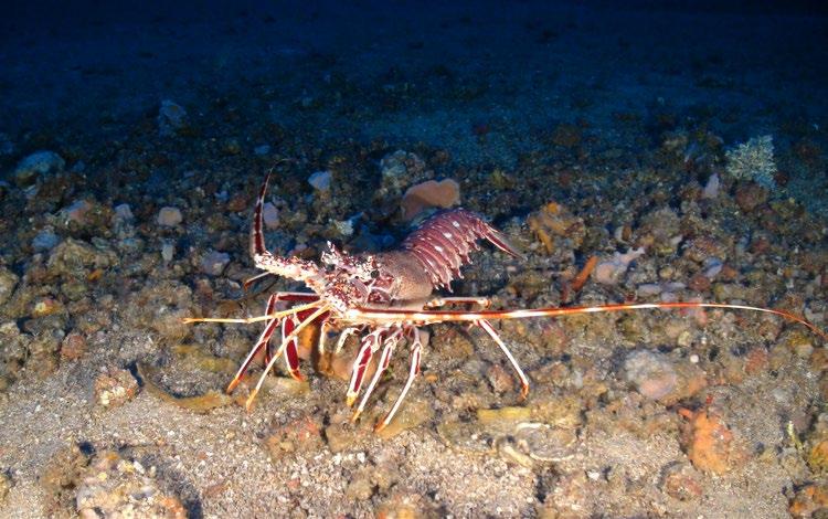
Seco de los Olivos, Almería, Spain. European spiny lobster (Palinurus elephas).
a Not including the Corredor de cetáceos del Mediterráneo MPA (Royal Decree 699/2018), the percentage is 91.6%
Seco de los Olivos, Almería, Spain. European spiny lobster (Palinurus elephas).
24
Paper parks
Bottom trawling inside marine protected areas
Spain must strictly protect 10% of its waters
Strictly protected areas have proven to be effective for biodiversity conservation and are also an excellent tool for strengthening the resilience of marine ecosystems, enhancing their ability to cope with climate change impacts. 38 EBottom trawling is even more problematic as new scientific evidence has proven its climate impact as it releases huge amounts of carbon stored in ocean sediments, limiting the seabed’s 39 potential to sequester carbon and exacerbating ocean acidification. Protecting marine habitats is therefore one of the priority areas of action for Spain in line with its Declaration on Climate and Environmental Emergencies. 40
MPA management should consider threats from an ecosystem-based approach, considering the entire protected site and not individual features. The negative effects of trawling are not only limited to the area trawled but may also affect neighbouring areas through sedimentation of the disturbed substrate.41,42,43 Furthermore, the habitats present in an MPA may cover large areas, but may also be fragmented or patchy, but management of pressure should be for the entire site. The management of an MPA must ensure full protection of the habitats present, throughout the whole site to include all components of the ecosystem that are essential for the MPA’s ecological functions.44
After closing protected areas to trawling, the next step is to restore healthy ecosystems
The future European law on nature restoration will come into force in 2023 and will be a key tool for restoring the health of the marine environment. Areas damaged by trawling within MPAs could represent “natural capital” in terms of the recovery of degraded habitats, with benefits for the productivity and improvement of ecosystem services in these protected areas.45 At the same time, closure to trawling would not only contribute to recovery, but also to reaching the 10% strict protection target. Fully protected areas would serve as effective passive restoration46, allowing habitats to recover and species to recolonise, making these MPAs more productive and resilient overall.
The management of MPAs should support long-term sustainable fisheries such as small-scale, low-impact artisanal ones. Fisheries and conservation can coexist in protected areas, as long as their impacts are limited and controlled, and that fisheries regulations do not undermine marine environmental protection objectives.
In view of the apparent cases of illegal fishing detected, it is clear that surveillance and control in MPAs should be improved, and if confirmed, sanctions should be applied accordingly. A good solution, that should be coordinated at national level, would be to expressly prohibit gears with a high risk of impacting the seabed. This would be not only beneficial in terms of preventing illegal activities, but also in terms of facilitating the monitoring and surveillance of MPAs.
Spain has a special connection with the sea and deserves to be surrounded by healthy, productive and resilient seas. At national level, enormous efforts have been and continue to be made, through large marine conservation projects such as LIFE+ INDEMARES and LIFE IP INTEMARES. These projects have positioned the country in an advantageous position, considerably improving its percentage of area designated as MPAs, in comparison with other European countries and even globally. However, this apparent success is overshadowed by poor fisheries management, a matter that needs to be addressed immediately. This is particularly important because Spain also runs the risk of legal proceedings and could be subject to litigation for breaching obligations imposed by various national and European regulations. Europe’s leading fishing nation needs to urgently address this situation, to also become a leader in marine conservation at regional and international level, insuring a productive, healthy and sustainable future for Spain’s marine environment and the communities that depend on it.
25
Paper parks in Spain
Bottom trawling inside marine protected areas
Oceana, own elaboration based on data provided by: European Environment Agency. (2020). Downloadable data about Europe’s environment [Database].
https://www.eea.europa.eu/data-and-maps/data/
European Environment Agency. (2019). Marine messages II: Navigating the course towards clean, healthy and productive seas through implementation of an ecosystem-based approach https:// www.eea.europa.eu/publications/marine-messages-2/file
Aronsson, M., Bailly Maitre, Gavilan, L.-P., & Richard, D. (2014). Draft pre-scoping document for the marine regions, First part: Core document. ETC/BD report for the EEA. https://ec.europa.eu/ environment/nature/natura2000/platform/documents/first_marine_ biogeographical_process_seminar/prescop_doc_marine_en.pdf
European Environment Agency. (2020). State of nature in the EU. Results from reporting under the nature directives 2013– 2018 (EEA Report No 10/2020). https://www.eea.europa.eu/publications/ state-of-nature-in-the-eu-2020
Perry, A. L., Blanco, J., Fournier, N., Garcia, S., & Marín, P. (2020). Unmanaged = Unprotected: Europe’s marine paper parks. Oceana, Brussels. https://europe.oceana.org/sites/default/files/oceana_2020_ unmanaged_equals_unprotected_marine_paper_parks.pdf
Oceana, unpublished data.
Ministerio para la Transición Ecológica y el Reto Demográfico. (24 de septiembre de 2020). España avanza en el cumplimiento de los objetivos nacionales e internacionales de conservación marina [Nota de prensa]. https://www.miteco.gob.es/es/prensa/ultimas-noticias/ espa%C3%B1a-avanza-en-el-cumplimiento-de-los-objetivosnacionales-e-internacionales-de-conservaci%C3%B3n-marina/ tcm:30-512162
Confederación Española de Pesca. (2019). Informe del sector pesquero español 2019 https://cepesca.es/wp-content/ uploads/2019/06/INFORME-SECTOR-PESQUEROESPAN%CC%83OL-2019.pdf
Ministerio de Agricultura, Pesca y Alimentación. (2021). La flota española – Situación a 31 de diciembre de 2020 https://www.mapa.gob.es/es/pesca/temas/registro-flota/catalogoflota-19-04-2021_tcm30-556538.pdf
Sala, A., Notti, E., Bonanomi, S., Pulcinella, J., & Colombelli, A. (2019). Trawling in the Mediterranean: an exploration of empirical relations connecting fishing gears, otterboards and propulsive characteristics of fishing vessels. Frontiers in Marine Science, 6, 534. https://doi.org/10.3389/fmars.2019.00534
Ley 42/2007, de 13 de diciembre, del Patrimonio Natural y de la Biodiversidad (BOE núm. 299, de 14 de diciembre de 2007).
European Environment Agency. (s.f.). Natura 2000 data - the European network of protected sites [Database]. https://www.eea.europa.eu/data-and-maps/data/natura-12
Commission Implementing Decision (EU) 2016/2328 of 9 December 2016 adopting a tenth update of the list of sites of Community importance for the Mediterranean biogeographical region (Official Journal of the European Union L 353, 23 December 2016).
Real Decreto 632/1993, de 3 de mayo, por el que se regula el ejercicio de la pesca de «arrastre de fondo» en el golfo de Cádiz (BOE núm. 118, de 18 de mayo de 1993).
Council Regulation (EC) No 1967/2006 of 21 December 2006 concerning management measures for the sustainable exploitation of fishery resources in the Mediterranean Sea, amending Regulation (EEC) No 2847/93 and repealing Regulation (EC) No 1626/94 (Official Journal of the European Union L 409/11, 30 December 2006).
Regulation (EU) 2016/2336 of the European Parliament and of the Council of 14 December 2016 establishing specific conditions for fishing for deep-sea stocks in the north-east Atlantic and provisions for fishing in international waters of the north-east Atlantic and repealing Council Regulation (EC) No 2347/2002 (Official Journal of the European Union L 354/1, 23 December 2016).
The N2K Group – European Economic Interest Group. (2014). Overview of the potential interactions and impacts of commercial fishing methods on marine habitats and species protected under the EU Habitats Directive https://ec.europa.eu/environment/nature/natura2000/marine/docs/ Fisheries%20interactions.pdf
Any and all references to “fishing” should be understood in the context of Global Fishing Watch’s fishing detection algorithm, which is a best effort to determine “apparent fishing effort” based on vessel speed and direction data from the Automatic Identification System (AIS) collected via satellites and terrestrial receivers. As AIS data varies in completeness, accuracy and quality, and the fishing detection algorithm is a statistical estimate of apparent fishing activity, therefore it is possible that some fishing effort is not identified and conversely, that some fishing effort identified is not fishing. For these reasons, Global Fishing Watch qualifies all designations of vessel fishing effort, including synonyms of the term “fishing effort,” such as “fishing” or “fishing activity,” as “apparent,” rather than certain. Any/all Global Fishing Watch information about “apparent fishing effort” should be considered an estimate and must be relied upon solely at the user’s own risk. Global Fishing Watch is taking steps to make sure fishing effort designations are as accurate as possible.
European Commission. (s.f.) European Fleet Register 1.0.8.8 [Database]. https://webgate.ec.europa.eu/fleet-europa/search_en
Orden APA/441/2019, de 9 de abril, por la que se modifica la Orden AAA/2536/2015, de 30 de noviembre, por la que se regulan las artes y modalidades de pesca marítima y se establece un plan de gestión para los buques de los censos del Caladero Nacional Canario (BOE núm. 91, de 16 de abril de 2019).
de la Torriente, A., Aguilar, R., Serrano, A., García, S., Fernández, … & Sagarminaga, R. (2014). Sur de Almería - Seco de los Olivos. Proyecto LIFE+ INDEMARES. Fundación Biodiversidad del Ministerio de Agricultura, Alimentación y Medio Ambiente. https://www.indemares. es/sites/default/files/sur_de_almeria_-_seco_de_los_olivos.pdf
Dirección General de Pesca y Acuicultura de la Junta de Andalucía, Federación Andaluza de Asociaciones Pesqueras, & Federación Andaluza de Cofradías de Pescadores. (2016). Especies objetivo y medidas de gestión para las pesquerías de arrastre de fondo, cerco y artes menores de la zona GSA-1 Andalucía 2016-2020 https://www. juntadeandalucia.es/export/drupaljda/20170915_Documento%20 Diciembre%202016%20def%20Medidas%20Gesttion%20GSA1_ESPA%C3%91OL.pdf
European Commission. (2013). Interpretation manual of European Union habitats. EU 28. https://ec.europa.eu/environment/nature/ legislation/habitatsdirective/docs/Int_Manual_EU28.pdf
1 13 22 23 14 15 16 17 18 19 20 21 2 3 4 5 6 7 8 9 10 11 12
26
References Paper parks in Spain Bottom trawling inside marine protected areas
Domínguez-Carrió, C., Requena, S., & Gili, J. M. (2014). Sistema de Cañones Submarinos Occidentales del Golfo de León. Proyecto LIFE+ INDEMARES. Fundación Biodiversidad del Ministerio de Agricultura, Alimentación y Medio Ambiente. https://www.indemares.es/sites/ default/files/sistema_de_canones_submarinos_occidentales_del_ golfo_de_leon.pdf
VVAA. (2014). Propuesta de inclusión de tres nuevos hábitats marinos en el anejo I de la Directiva Hábitats. Proyecto LIFE+ INDEMARES. Fundación Biodiversidad del Ministerio de Agricultura, Alimentación y Medio Ambiente. https://www.indemares.es/sites/default/files/propuesta_nuevos_ habitats_dh.pdf
Sánchez, F., Gómez-Ballesteros, M., González-Pola, C., Punzón, A. (2014). Sistema de cañones submarinos de Avilés. Proyecto LIFE+ INDEMARES. Fundación Biodiversidad del Ministerio de Agricultura, Alimentación y Medio Ambiente. https://www. indemares.es/sites/default/files/sistema_de_canones_submarinos_ de_aviles.pdf
Díaz del Río, V., Bruque, G., Fernández-Salas, L. M., Rueda, J.L., González, E., … & Arcos, J. M. (2014). Volcanes de fango del golfo de Cádiz. Proyecto LIFE+ INDEMARES. Fundación Biodiversidad del Ministerio de Agricultura, Alimentación y Medio Ambiente. https:// www.indemares.es/sites/default/files/volcanes_de_fango_del_ golfo_de_cadiz.pdf
Barberá, C., Arcos, J. M., Druet, M., Grinyó, J., Requena, S., Gili, J. M, … & Campillos, M. (2014). Canal de Menorca. Proyecto LIFE+INDEMARES. Fundación Biodiversidad del Ministerio de Agricultura, Alimentación y Medio Ambiente. https://www. indemares.es/sites/default/files/canal_de_menorca.pdf
Ministerio para la Transición Ecológica y el Reto Demográfico. (s.f.). Ficha ZEC El Cachucho https://www.miteco.gob.es/es/ biodiversidad/temas/biodiversidad-marina/Ficha_ZEC_El_ Cachucho_tcm30-521072.pdf
Orden PRE/969/2008, de 3 de abril, por la que se publica el Acuerdo de Consejo de Ministros, por el que se adoptan medidas para la protección de la zona marina «El Cachucho» (BOE núm. 86, de 9 de abril de 2008).
Real Decreto 1629/2011, de 14 de noviembre, por el que se declara como Área Marina Protegida y como Zona Especial de Conservación el espacio marino de El Cachucho, y se aprueban las correspondientes medidas de conservación (BOE núm. 295, de 8 de diciembre de 2011).
Real Decreto 686/2021, de 3 de agosto, por el que se amplía el Área Marina Protegida «El Cachucho» y se aprueba su segundo plan de gestión (BOE núm. 185, de 4 de agosto de 2021).
Orden AAA/1366/2016, de 4 de agosto, por la que se declaran zonas especiales de conservación de lugares de importancia comunitaria de la Región Marina Mediterránea de la Red Natura 2000, se aprueban sus correspondientes medidas de conservación y se propone la ampliación de los límites geográficos de dos lugares de importancia comunitaria (BOE núm. 193, de 11 de agosto de 2016).
Orden AAA/1479/2016, de 7 de septiembre, por la que se establece una zona protegida de pesca en el área del Canal de Menorca y se modifica la Orden AAA/1504/2014, de 30 de julio, por la que se establecen zonas protegidas de pesca sobre determinados fondos montañosos del Canal de Mallorca y al este del Parque Nacional Marítimo-Terrestre del Archipiélago de Cabrera (BOE núm. 224, de 16 de septiembre de 2016).
Bottom trawling inside marine protected areas
Ministerio de Agricultura, Pesca, y Alimentación. (s.f.). Registro General de la Flota Pesquera https://servicio.pesca.mapama.es/ censo/ConsultaBuqueRegistro/Buques/Search
Cadiou, G., Boudouresque, C. F., Bonhomme, P., & Le Diréach, L. (2009). The management of artisanal fishing within the Marine Protected Area of the Port-Cros National Park (northwest Mediterranean Sea): a success story?. ICES Journal of marine science, 66(1), 41-49. https://doi.org/10.1093/icesjms/fsn188
ClientEarth. (2014). Revised approach to fishing in European Marine Sites: A status report https://www.documents.clientearth.org/wpcontent/uploads/library/2014-12-01-revised-approach-to-fishingin-european-marine-sites-a-status-report-ce-en.pdf
Sala, E., & Giakoumi, S. (2018). No-take marine reserves are the most effective protected areas in the ocean. ICES Journal of Marine Science, 75(3), 1166-1168. https://doi.org/10.1093/icesjms/fsx059
Sala, E., Mayorga, J., Bradley, D., Cabral, R. B., Atwood, T. B., Auber, A., ... & Lubchenco, J. (2021). Protecting the global ocean for biodiversity, food and climate. Nature, 592(7854), 397–402. https:// doi.org/10.1038/s41586-021-03371-z
Gobierno de España. (2020). Acuerdo de Consejo de Ministros por el que se aprueba la Declaración del Gobierno ante la Emergencia Climática y Ambiental https://www.lamoncloa.gob. es/consejodeministros/resumenes/Documents/2020/210120Declaracion_emergencia-climatica.pdf
Farriols, M. T., Ordines, F., Somerfield, P. J., Pasqual, C., Hidalgo, M., … & Massutí, E. (2017). Bottom trawl impacts on Mediterranean demersal fish diversity: Not so obvious or are we too late? Continental Shelf Research, 137, 84–102. https://doi.org/10.1016/j.csr.2016.11.011
Maynou, F., & Cartes, J. E. (2011). Effects of trawling on fish and invertebrates from deep-sea coral facies of Isidella elongata in the western Mediterranean. Journal of the Marine Biological Association of the United Kingdom, 92(7), 1501–1507. https://doi.org/10.1017/ S0025315411001603
Palanques, A., Martín, J., Puig, P., Guillén, J., Company, J. B., & Sardà, F. (2006). Evidence of sediment gravity flows induced by trawling in the Palamós (Fonera) submarine canyon (northwestern Mediterranean). Deep Sea Research Part I: Oceanographic Research Papers, 53(2), 201–214. https://doi.org/10.1016/j.dsr.2005.10.003
Pikesley, S. K., Solandt, J. L., Trundle, C., & Witt, M. J. (2021). Benefits beyond ‘features’: Cooperative monitoring highlights MPA value for enhanced seabed integrity. Marine Policy, 134, 104801. https://doi.org/10.1016/j.marpol.2021.104801
Haines, R., Russi, D., Haines, R., & Pantzar, M. (2018). Study on Economic Benefits of MPAs. Final report. Luxembourg, European Commission. https://doi.org/10.2826/449575
Belgrano, A., Novaglio, C., Svedäng, H., Villasante, S., Melián, C. J., Blenckner, T., ... & Tönnesson, K. (2021). Mapping and evaluating Marine Protected Areas and Ecosystem Services: a transdisciplinary Delphi forecasting process framework. Frontiers in Ecology and Evolution, 9, 210. https://doi.org/10.3389/fevo.2021.652492
24 25 26 27 28 29 30 31
32 33 34 35 36 37 38 39 40 41 42 43 44 45 46 27
Paper parks in Spain
El Hierro, Spain. Small-scale artisanal fishing.
 © OCEANA / Carlos Minguell
Paper parks in Spain Bottom trawling inside marine protected areas 28
Central Office - Madrid, Spain
Email: europe@oceana.org
EU Office - Brussels, Belgium
Email: brussels@oceana.org
North Sea and Baltic OfficeCopenhagen, Denmark
Email: copenhagen@oceana.org
UK Office - London, UK
Email: oceanauk@oceana.org
Follow @OceanaEurope on Facebook Instagram Twitter
Contact
