By protecting the areas surrounding national parks, the US can build resilient landscapes that help prevent the worst effects of climate change and species loss.

Often seen as untouched wilderness, our national parks are not immune to habitat loss and fragmentation, climate change and development — all of which threaten wildlife, healthy forests and the magical park experiences we never forget.
The areas that surround national parks are crucial for their health — and the health of nearby communities. Their lands, waters, and wildlife support jobs and economic activity. They form the foundation for a healthier environment and climate. Americans turn to them for recreation. They connect people to nature and to each other, holding histories and cultures. But over time, these cherished landscapes have been fracturing.
The National Parks Conservation Association is working to protect and connect large landscapes to secure their long-term health and ensure they’re here for future generations to enjoy.
That’s why NPCA’s advocacy extends beyond park boundaries to include the wider landscapes. Our program experts, committed volunteers and community champions, use a powerful combination of non-partisan advocacy, partnership and on-the-ground conservation to ensure our nation’s most beloved places and iconic landscapes are protected for generations to come.
With your support, NPCA has a plan to protect and connect 20 landscapes across the country that are critical for the long-term health of our most beloved parks and the communities that surround them. Protecting each of these places requires a response as unique as the landscape itself. The National Parks Conservation Association is up to the challenge.
NPCA is working on the ground and in Washington, D.C. to find dynamic and equitable conservation solutions to protect and enhance the air, lands, water, wildlife and climate of our national parks. We are doing this by combining policy and community organizing, using science to inform our advocacy and drive decision-making for smart and effective solutions.
From mapping and research partnerships to data-driven decision-making, science empowers advocacy at NPCA.Through the integration of multidisciplinary science, we are revolutionizing the way we approach building resilient landscapes that combat the devastating effects of a changing climate. At NPCA, we leverage the most relevant data available to ensure that our evaluations — from wildlife migration patterns to ecosystem resilience — are always rooted in rigorous conservation science.
By integrating the tools and resources of multidisciplinary science, NPCA is unlocking new avenues for innovation and creativity in the fields of land and seascape conservation. One of our most valuable tools is geospatial science, which allows us to visualize data through sophisticated mapping techniques. Geospatial science identifies high-priority areas for conservation efforts, recognizing that protection of national parks is only as strong as the integrity of the surrounding landscapes. Our work extends beyond park boundaries, encompassing large landscapes, watersheds, as well as many important values within the gateway communities outside parks.
National parks are often thought of as conservation anchors to their surrounding regions — and because threats and impacts are widespread, national parks offer a unique opportunity to empower large landscape conservation. NPCA’s science-driven national park framework allows us to pinpoint vulnerable areas in need of conservation action, ensuring the long-term health of these landscapes. From biodiversity assessments to climate resilience studies, the collective work and knowledge of NPCA staff and partners (scientists, experts and key researchers) informs all of our land and seascape conservation strategies.
At NPCA, we believe in harnessing the power of science to drive impactful conservation efforts. With the support of our donors, we can bring more science to the forefront of our organization and revolutionize our approach by building resilient landscapes that help prevent the worst effects of climate change and species loss. Your gift will enable us to expand our use of geospatial science - mapping and cartography, allowing us to identify and understand high-priority areas for conservation efforts across diverse landscapes. Together, we will continue integrating multidisciplinary science into every aspect of our work, driving smart and effective climate solutions that benefit both people and parks. And simultaneously, we can build a future where science helps lead the way toward a more sustainable world. Join us in empowering science-based conservation advocacy today.
Our national parks are treasured places that people know and love.
NPCA will leverage that support. We will bring people together. And we will build out from these protected ecosystems to other landscapes that need protecting too.

A haunting human past lives in this landscape. The Creek Nation driven from their homeland after Andrew Jackson forced them to cede 21 million acres for American settlement. Enslaved African men, women and children sold from warehouses in Montgomery. Union troops, including 5,000 members of the U.S. Colored Troops, fighting Confederate soldiers at Fort Blakeley on the same day Lee surrendered at Appomattox. The violence that met civil rights marchers from Selma to Montgomery.
Yet a wealth of natural resources, from the Alabama River south to the vast delta bracketed by the Mobile and Tensaw Rivers, also supported some of North America’s greatest Native American cities in the time before
Columbus. By the mid-nineteenth century, those resources had made this region one of the nation’s richest. Today, it’s now one of America’s most imperiled places.
To tell the story of the land and its people, NPCA is helping bring together diverse organizations to stand up a new Alabama Black Belt National Heritage Area and preserve battlefields related to the Indian Removal Act and the War of 1812.
NPCA will help build coalitions and political capital in local communities across Alabama on the way to fully protecting this one-of-a-kind landscape, which will provide much-needed economic benefits while protecting rare and critically endangered species, wildlife and habitat.


Established of Alabama Black Belt National Heritage Area (ABBNHA).
Strengthened of the Alabama River Diversity Network, the main vehicle for establishment of ABBNHA, this group will also be important for the protection of the Mobile Tensaw Delta.
Leading and supporting work that honors the Selma to Montgomery voting rights march during its 60th anniversary year in 2025.
The Environmental, Cultural & Community Value Your Investment Will Produce:
Standing up of the Alabama Black Belt National Heritage Area.
Transfer of appropriate parcels in the river corridor to the National Park Service, lending themselves to NPS interpretation and visitation, and keeping them safe from development.
Restoration of long leaf pine on public and private lands, repatriation and protection of heirs’ lands and sustainable farming, all accomplished by utilizing public-private partnerships, conservation easements and USDA programs.
Acquisition of important parcels of private land, Blakeley Battlefield and Holy Ground, through the NPS and historic designations.
CULTURAL ELEMENTS
Ancient Native American mounds
The Indian Removal Act, Trail of Tears, and early European settlement
Black Belt heritage and culture
The Clotilda, the last illegal ship of enslaved people, and Africatown, the settlement they established
Civil War history and the role of African American forces War of 1812 sites
ECOLOGICAL FEATURES
“America’s Amazon”, the Mobile Tensaw Delta is one of the world’s richest aquatic environments
High bluffs and pinelands, and bottomlands
The second largest delta in the Lower 48 Longleaf pine forests host 40 to 60 plant species per square meter, the highest concentration in North America
WILDLIFE
North America’s greatest tree, salamander and fish species diversity
World’s greatest variety of turtles
200+ species of birds
PARKS & PROTECTED AREAS
Tuskegee Institute and Tuskegee
Airmen National Historic Sites
Talladega and Tuskegee National Forests
Bartram Trail and Upper and Lower Bartram Canoe Trails System
Selma to Montgomery
National Historic Trail
Old Federal Road Historic Trail
Old Cahawba Archeological Park
Bottlecreek National Historic Site
Fort Morgan Historic Site

Victory! — The designation of Avi Kwa Ame National Monument provides the space and interconnectedness that human communities and native species will need to adapt to a changing climate.
This is sacred ground — this rare, intact stretch of the East Mojave Desert between Mojave National Preserve in California and Lake Mead National Recreation Area in Nevada. For the Yuman tribes, it’s home to the most sacred place in the universe: Avi Kwa Ame — Spirit Mountain. Centuries of human history have passed through here.
You can see it in ancient petroglyphs, abandoned mines, even a ranch where early Hollywood stars escaped the limelight.
The area is part of a corridor that provides critical habitat for countless desert species,
including threatened desert tortoises and migratory birds and animals. It’s also rich in recreational opportunities.
With some of the most visually stunning, biologically diverse and culturally significant lands in the entire Mojave Desert, the Avi Kwa Ame landscape is worthy of National Monument status.
The area consists of 506,000 acres of public lands managed by the Bureau of Land Management and the National Park Service that are rural and undeveloped. With the designation of Avi Kwa Ame National Monument, NPCA will advocate for a management plan that protects Native American cultural sites, native plants, and vulnerable wildlife.


Designation of Avi Kwa Ame National Monument, providing permanent protection to 506,000 acres.
Defeated several large-scale development projects proposed within the monument boundary prior to designation.
The Environmental, Cultural & Community Value Your Investment Will Produce:
Protection for sacred Native American cultural sites, values and practices.
Finalization of a management plan that best protects Native American cultural sites, native plants, and vulnerable wildlife.
Prevention of large-scale development on public lands that would fragment the area’s natural and cultural landscape and erode its rural character.
CULTURAL ELEMENTS
Sacred area for 12 Tribes
Crossroads of the American West
ECOLOGICAL FEATURES
Thriving desert with 4 major springs that maintain biodiversity and ecological linkages
High-quality shrub canopy habitat, critical for vulnerable species
Key migration corridor for bighorn sheep and birds
900-year-old Joshua trees in earth’s largest Joshua tree forest 28 species of native grasses
WILDLIFE
Desert tortoises in Nevada are connected to a high-density California population
Audubon designation as an Important Birding Area including Nevada’s highest known density of golden eagles
Bighorn sheep, Gila monsters and raptors
PARKS & PROTECTED AREAS
506,000 acres of Avi Kwa Ame National Monument
Mojave National Preserve
Lake Mead National Recreation Area
Castle Mountains
National Monument
Spirit Mountain Traditional Cultural Property
ECONOMIC RETURNS
Increases in population, employment and income result from new national monuments (Headwaters Economics study)
42% of small business owners look for outdoor opportunities when choosing where to live and own a business (Small Business Majority poll)
87,000 jobs created annually by Nevada’s outdoor industry (Outdoor Industry Association analysis)

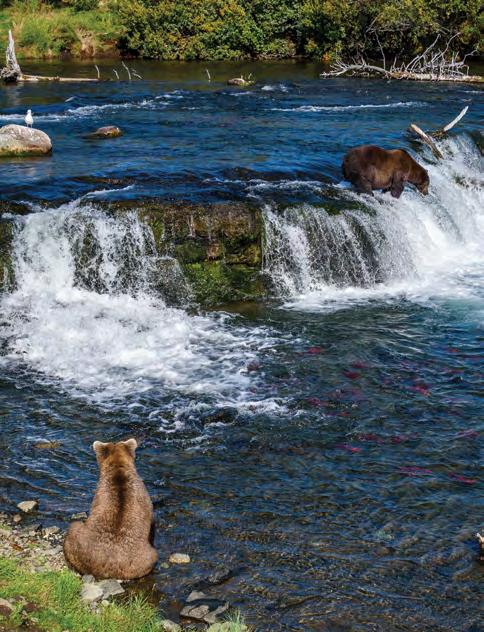
Each spring, some of the world’s largest brown bears leave their mountain dens for Alaska’s Bear Coast to eat sedge grasses and clams. Summer brings a salmon feast. This population of massive bears — perhaps the densest population on earth — both depends on and defines this incredible ecosystem.
The bears are a keystone species with an outsized impact — on the landscape and the local economy. Alaska Native people have relied on these lands for more than ten thousand years. Thousands of visitors come for a bear viewing experience like nowhere else. Thousands more come for the fishing and clamming.
But this vital landscape faces the impacts of climate change. Warming waters are altering the fisheries and increasing
temperatures are changing vegetation. These impacts would be compounded by a proposal for mining in Lake Clark National Park and offshore oil and gas development, plus an industrial transportation corridor and port for the massive, proposed Pebble Mine. The region’s resilience may also be reduced by overhunting and excessive bear-viewing.
For this coastal ecosystem to survive, it must remain intact. Going forward, NPCA will build strong partnerships across interest groups to advocate for long-term protection. Uniting parks, landowners, commercial fishers, subsistence users, bear viewers and others will ensure this unique landscape is conserved for future generations to enjoy.


Supported Bristol Bay tribes and engaged in parks-focused advocacy to convince the EPA to veto the proposed Pebble Mine.
Completed two resource assessments including 46 interviews with NGO’s, federal, state, tribal, and native corporations assessing sociocultural, ecological, and economic change across the landscape.
Organized groups and received an extension for public comments on runway extensions, roads and bridge building for the potential Johnson Tract Mine.
Built a group of veteran advocates grounded in our work.
Worked with partners to stop additional oil and gas leasing in Cook Inlet.
The Environmental, Cultural & Community Value Your Investment Will Produce:
Wildlife undisturbed by harmful mining and infrastructure development or offshore oil and gas development.
Management structures that build equity and community climate resilience by including Alaska Native communities with an interest in the region.
Habitat connectivity and a healthy, climateresilient landscape for bears, salmon, and the other unique species that call the Bear Coast home.
Science-based, community approved regulations for hunting and bear viewing that result in sustainable wildlife populations. Protected bear populations and incredible opportunities to view bears and other wildlife in the Bear Coast region.
Over ten thousand years of cultural heritage preserved, with robust relationships between Tribes and the parks to provide opportunities for co-management.
CULTURAL ELEMENTS
Traditional fishing, clamming and hunting subsistence area for the Dena’ina people of southcentral and southwestern Alaska
Traditional trade routes connecting Cook Inlet with southwestern Alaska
Several Alaska Native corporations own land in the region as compensation for loss of ancestral title to extensive portions of Alaska
ECOLOGICAL FEATURES
A broad strip that runs northsouth between Cook Inlet and the Aleutian Mountain Range
Two active volcanoes
Abundant fish-bearing streams, rich sedge meadows and tidal mudflats
WILDLIFE
2,500 brown bears (estimated)
All 5 species of Pacific salmon Shorebirds, shellfish and marine mammals, including an endangered population of beluga whales
PARKS & PROTECTED TARGETS
7,000,000 acres
Lake Clark National Park Katmai National Park
McNeil River State Game Refuge and Sanctuary
$34.5 million in related bear-viewing services
$10 million in bear-viewing wages/benefits
371 bear-viewing jobs on average 40-50,000 visitors to the overlapping Bristol Bay region for bear viewing and sport fishing
RECREATIONAL OPPORTUNITIES
Hiking, backcountry travel, wildlife watching, birding and sport fishing

It took nearly 50 years, but in 1974 Texans established one of America’s first national preserves in the Big Thicket region.
This biological crossroads is home to complex and diverse ecosystems where east meets west. For centuries, indigenous hunters relied on the region’s dense forests for food and other resources. Later European immigrants did, too. But eventually, logging and development wiped out millions of acres of wilderness. By the time the Big Thicket achieved national preserve status, only pockets of intact landscape remained.
Even so, the preserve’s separate units are a string of pearls protecting samples of the original ecosystems. They provide refuge for vulnerable species and help mitigate im-
pacts from floods and storms. And they’re rich in recreation opportunities. With multiple units spread across seven counties, recreation offers economic benefits to the local community.
NPCA engaged and grew Big Thicket advocates while re-establishing the preserve’s storm-resilient longleaf pine habitat. Volunteers planted nearly 200,000 seedlings, creating a more sustainable native forest. They also began to speak up for the park’s needs. Trees and advocates are critical in the face of growing development and increasingly devastating storms. Equipped with local expertise and partnerships, NPCA will continue to fortify this essential part of the Gulf Coast’s community, economy and resiliency.


Reduced impact of highway expansion along the Big Thicket National Preserve, preserving acres of trees to retain the scenic character of the region.
Restored over 700 acres to date of the historic Longleaf range in Texas with continued work happening throughout the year.
Identified suitable habitat for the possible reintroduction of the RCW.
Working with governmental agencies and other NGO’s to further protect the Big Thicket region through nature-based flood mitigation projects and solutions.
Advancing initiatives to connect the units of the Big Thicket National Preserve to protect the 100-year floodplain.
The Environmental, Cultural & Community Value Your Investment Will Produce:
Preservation and enhancement of the landscape’s natural and cultural heritage.
Restoration of historic longleaf pine habitat that will help threatened and endangered plants and animals like the red-cockaded woodpecker recover.
Resilient watersheds and rivers that provide a natural solution to minimize the worst effects of catastrophic storms and flooding.
Increased connection between the preserve’s fragmented units to better protect the resources preserved within its boundaries. More engaged supporters speaking up on behalf of Big Thicket’s natural and cultural resources.
CULTURAL ELEMENTS
Hunting and fishing heritage of the Atakapa-Ishak and Alabama Coushatta Tribes
Logging and oil and gas industry historical sites
ECOLOGICAL FEATURES
Big Thicket Preserve protects 113k acres of the region’s historic range — 3.5 million acres
Unique ecosystems including piney woods, coastal plains and swamps
Supports 2 migratory flyways
Longleaf pine ecosystem and riverine systems provide natural storm and climate resiliency
WILDLIFE
Endangered red-cockaded woodpecker
Black bear
4 of the 5 known North American carnivorous plants
Diverse migratory birds
PARKS & PROTECTED AREAS
Nature Conservancy — Roy E. Larsen Sandylands Preserve
Village Creek and Martin Dies Jr. State Parks
Angelina National Forest
Sam Houston National Forest
Trinity River National Wildlife Refuge
ECONOMIC RETURNS
277,000 visitors, 263 jobs, $27.5 million economic output (2022)
RECREATIONAL OPPORTUNITIES
Hunting, fishing, birding, hiking, paddling, bicycling, backcountry camping

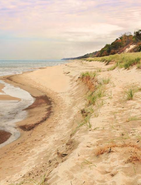
Home to 1.5 million people, exceptional biodiversity and rich cultural history, the Calumet Region hugs 50 miles of Lake Michigan shoreline from Pullman National Historical Park on Chicago’s far south side through the windswept dunes of Indiana Dunes National Park, including parts of the Illinois and Michigan Canal and Bronzeville-Black Metropolis national heritage areas, as well as multiple sites in the National Underground Railroad Network to Freedom.
Though it possesses all these features, the Calumet is a fragmented urban landscape, made so by more than a century of booming industrialization and later decline. Today, Gilded Age architecture, miles of smokestacks and mazes of pipes crisscrossed with
highways and railroad tracks are interspersed with rare habitat, restored wetlands and resilient communities.
NPCA envisions a cohesively managed and experienced national park landscape throughout the Calumet that allows for people, stories and ecosystems to thrive. To achieve this vision, NPCA will advance discrete projects at Pullman and Indiana Dunes and foster cohesion throughout the region by building a shared national park identity.
The challenges are great, but NPCA will see it through with these efforts because the Calumet landscape’s exceptional mix of human history and rare habitat is worth saving for a more resilient future.
mix of human history and
habitat is worth saving for a more resilient future.


Championed Pullman National Monument’s redesignation as Pullman National Historical Park, providing NPS with the ability to enter cooperative agreements, provide technical assistance and acquire land from willing sellers.
Secured $1 million in state funding for a shoreline erosion study at Indiana Dunes National Park that will identify long-term solutions to the park’s disappearing beaches.
Worked with partners to produce a series of coordinated Conservation Action Plans to identify conservation targets, threats and strategies to meet emerging opportunities across the Calumet region.
Collaborate with NPS and community partners to establish a Cultural Trail throughout Pullman National Historical Park that uses public art and historical markers to bring Pullman’s unique history and untold stories to life.
Advocate for the implementation of a long-term solution to shoreline erosion at Indiana Dunes National Park that protects park resources and maintains a positive visitor experience. Achieve the designation of the Calumet National Heritage Area, which will ensure that the region’s environmental and cultural resources are preserved and that its nationally significant story is told for generations to come.
Ensure that more of the Calumet’s lands and waters are restored and better maintained to improve wildlife habitat, expand recreational opportunities and connect more people to parks.
CULTURAL ELEMENTS
Labor and industrialization history
Great Migration and Underground Railroad history and legacy
Architectural heritage
Environmental justice
Indigenous history and legacy
ECOLOGICAL FEATURES
Eastern temperate forest, including old growth and black oak savanna
Tall grass prairie remnants
Rare dune and swale habitats
Great Lakes shoreline, including rivers and wetlands
Industrialized urban landscape
WILDLIFE
A top 10 national park for biodiversity
Rare species, including piping plover and Blanding’s turtle
Great Lakes flyway migratory corridor
More native orchids than found in Hawaii
PARKS & PROTECTED AREAS
Protected Target: 61,000 acres
Pullman National Historical Park
Indiana Dunes National Park
Indiana Dunes State Park and Marshall Preserve
Indian Ridge Marsh, Hegewisch Marsh and other municipal parks
Private conservation lands
ECONOMIC RETURNS
$141 million in visitor spending generated by Indiana Dunes National Park
$40 million sustained economic impact projected at Pullman National Historical Park
RECREATIONAL OPPORTUNITIES
Beach-going, hiking, paddling, bird watching, swimming, biking, fishing, camping, horseback riding, heritage tourism

Shenandoah National Park, Gettysburg National Military Park, and C&O Canal National Historical Park, though spread across three states, all share a common bond. Their streams and rivers flow into the Chesapeake Bay, the largest estuary in North America and one of the most biologically productive in the world.
Spanning 64,000 square miles across six states and the District of Columbia, the Chesapeake is home to 18 million people and more than 3,600 plant and animal species. It is home to national park sites that tell America’s stories — from Indigenous history, early colonies at Jamestown, and the arrival of enslaved Africans to the battlegrounds of the Civil War and of Harriet Tubman’s heroic journey to freedom. Yet, these national park sites
do not holistically capture the stories of the Chesapeake or fully protect its unique natural assets.
NPCA helped establish the United for a Chesapeake National Recreation Area campaign to support the designation of the Chesapeake National Recreation Area (CNRA), a collection of new and existing parks and public lands as part of the National Park System. Places across Maryland and Virginia could become part of the CNRA and benefit from National Park Service resources to help improve the visitor experience, expand public access to the Bay, protect the natural environment, and advance landscapescale conservation.


Successfully supported passage of the Chesapeake WILD Act, which boosts conservation efforts by creating a new grant program to support habitat restoration in the Bay region.
Advocated for the expansion of new public access along the Captain John Smith Chesapeake National Historic Trail for water-based recreational opportunities to support a goal of 300 new public access sites by 2025.
Achieved increased funding for the Chesapeake Bay Program to protect clean water and support partnership and collaborative efforts to increase water quality.
Led advocacy efforts that resulted in a bipartisan Congressional delegation introducing the Chesapeake National Recreation Act in both the House and Senate in 2023.
The Environmental, Cultural & Community Value Your Investment Will Produce:
A designated Chesapeake National Recreation Area established through congressional action.
An additional two million acres of lands protected throughout the watershed — currently identified as high-conservation priorities at the federal, state, or local level — including 225,000 acres of wetlands and 695,000 acres of forest land of highest value for maintaining water quality.
Protect three National Historic Landmarks: Burtis House, Thomas Point Shoal Lighthouse, and Whitehall.
CULTURAL ELEMENTS
Ancestral home of the Piscataway, Susquehannock, Pamunkey, Chickahominy, Rappahannock, Mattaponi, and Nansemond Tribes
Historical remnants of early civilization, colonial settlements, Civil War Battlefields, and watermen’s villages and harbor towns
ECOLOGICAL FEATURES
Largest estuary in North America, spanning 64,000 square miles
Shallow water areas, tidal marshes, oyster reefs and deep channels that support high biodiversity
Crucial stopover and breeding ground for numerous migratory species
WILDLIFE
Nearly 350 species of fish 173 species of shellfish, including Eastern Oysters and iconic Blue Crabs 30 species of waterfowl
PARKS & PROTECTED AREAS
More than 50 national park sites
Chesapeake Gateways and Watertrails Network
Blackwater National Wildlife Refuge, Chesapeake Bay National Estuarine Research Reserve, and Mallows Bay-Potomac River National Marine Sanctuary
Home to two major North Atlantic ports
Recreation opportunities for more than 18 million people
More than $1 billion in economic
RECREATIONAL OPPORTUNITIES
Boating, sailing, fishing, paddling, kayaking, coastal recreation, bird watching, wildlife viewing, hiking, sightseeing, biking, and visiting historic sites

A wild and intact California Desert ecosystem that, if protected, would be the largest protected area of the bioregion and create an interconnected landscape stretching from the Coachella Valley east to the Colorado River.
The California Desert is a unique and delicate landscape, home to iconic wildlife such as the desert bighorn sheep and the Mojave Desert tortoise.
The Chuckwalla area, east and south of Joshua Tree National Park, is named for the Chuckwalla lizard — a large, colorful iguana species specifically adapted to the rocky desert landscape. The Chuckwalla bench is also a living landscape with interconnected cultural, natural, and spiritual significance for the Iviatim, Nüwü, Pipa Aha Macav, Kwatsáan, and Maara’yam peoples.
The region is currently managed as a patchwork of protected lands, such as Joshua Tree National Park, surrounded by unprotected lands. The National Parks Conservation Association has come together with a diverse coalition of local and national organizations to define a historic vision of protection for the Chuckwalla bench.
Alongside our partners, NPCA will work to designate Chuckwalla National Monument and expand Joshua Tree National Park, protecting 677,000 acres and stitching together islands of protected lands into an unbroken landscape. It would help ensure equitable access to nature for local residents, honor the cultural landscape, and protect the desert’s biodiversity and habitat connectivity in the face of the climate crisis.

as a patchwork of
lands, such
CULTURAL ELEMENTS
Natural and spiritual significance for the Iviatim, Nüwü, Pipa Aha Macav, Kwatsáan, and Maara’yam peoples (Cahuilla, Chemehuevi, Mojave, Quechan, and Serrano nations)
Sacred sites and objects, traditional cultural places, geoglyphs, pictographs and petroglyphs
ECOLOGICAL FEATURES
Joshua Tree National Park, surrounded by unprotected


Legislation introduced to protect the Chuckwalla region by Representative Raul Ruiz
Called on President Biden to designate Chuckwalla National Monument and expand Joshua Tree National Park alongside Representative Ruiz, community leaders, and coalition partners.
Both the Chuckwalla National Monument and the lands adjacent to Joshua Tree National Park protected by securing a designation under the Antiquities Act.
Desert biodiversity and connected habitats protected in the face of the climate crisis.
Equitable access to outdoor recreation for local residents.
Places of cultural, natural and spiritual significance for the Iviatim, Nüwü, Pipa Aha Macav, Kwatsáan, and Maara’yam peoples preserved.
Desert mountains, steep-walled canyons, inland valleys, desert pavement, washes, and isolated rock outcroppings
Unparalleled desert wash woodland
Endemic plant species, ancient creosote and perennial shrubs
Large areas of undisturbed desert that aid in carbon sequestration
WILDLIFE
Threatened desert tortoise Desert bighorn sheep
Numerous lizard species including the Chuckwalla Golden eagles
PARKS & PROTECTED AREAS
Joshua Tree National Park
Palen/McCoy Wilderness
Chuckwalla Mountains Wilderness
Orocopia Mountains Wilderness Mecca Hills Wilderness
Corn Springs Area of Critical Environmental Concern
Chuckwalla Valley Dune
Thicket Area of Critical Environmental Concern
ECONOMIC RETURNS
Joshua Tree National Park generates $171 million in local spending and brings a total benefit of $209 million to nearby communities
RECREATIONAL OPPORTUNITIES
Hiking, camping, recreational off-highway vehicle use, stargazing, rockhounding, birding and other wildlife watching

A wild and intact Rocky Mountain ecosystem sprawls across northwest Montana and into Canada. It’s the Crown of the Continent, and its wild beating heart is Glacier National Park.
The futures of Glacier and the Crown are mutually dependent. Both need strong connections between the region’s habitats, wildlands and wildlife. Threats outside the park’s boundaries — habitat loss and fragmentation, development, extractive industries and highway infrastructure — threaten to sever it from the rest of the Crown’s wild areas. Climate change makes Glacier even more vulnerable to genetic isolation and localized extinctions.
NPCA and our partners recognized this more than a decade ago.
We began searching for ways to scale conservation efforts
across millions of acres and multiple jurisdictions, from local to international. The result: a 2-million-acre protective corridor around Glacier, critical to connecting the park to adjacent habitats.
NPCA’s work with social scientists and economists also revealed that protecting Glacier and adjacent wildlands was key to a vibrant economy and high quality of life. Leveraging community connections to the landscape, we nurtured a regional Crown-centered identity and cultivated alliances with Tribes, First Nations, recreation and business stakeholders. We all rely on a protected and connected Crown of the Continent.
These relationships have matured into a powerful community that’s working together to face tomorrow’s threats.


Created new protected areas, reintroduced native species including wild bison, and increased public-land authorities for Tribal natural and cultural resource managers
Increased protections from oil and gas — Retired all oil and gas leases in the BadgerTwo Medicine region and enacted a ban on future leasing
Protected from mining — Suspended a critical Canadian coal mine permit, achieved new standards for mining pollution, and created an international watershed board under the U.S.-Canada Boundary Waters Treaty
The Environmental, Cultural and Community Value your investment will produce:
Formal co-stewardship and co-management agreements between federal land managers and Tribes.
Solutions that address increasing development and recreation pressure.
Increased biological integrity of the landscape through connectivity projects, new and expanded protected areas, wildlife corridor designations, highway mitigation measures, and conservation easements on private lands.
Intact, resilient ecosystems with room to roam for everyone — two-legged, four-legged, furred, finned or feathered.
Sustainable and robust economies across the Crown.
CULTURAL ELEMENTS
Traditional territory of multiple Indigenous communities, Tribes and First Nations
Culturally significant and sacred lands, waters, animals and other resources essential for ongoing cultural practice
ECOLOGICAL FEATURES
Ecological mixing zone at intersection of Rocky Mountains and American Prairie
Convergence of Arctic, Pacific, Continental and Southwest climatic patterns
Elevations range from 3,000foot wetlands to 10,000-foot alpine tundra
Grizzly bears, wolves, mountain lions, wolverines, bighorn sheep, mountain goats, elk and bull trout
PARKS & PROTECTED AREAS
Glacier National Park
Bob Marshall, Great Bear, Scapegoat, Mission Mountain and Rattlesnake Wildernesses
Multiple federal Wilderness Study Areas and Recommended Wilderness Areas
Badger-Two Medicine Traditional Cultural District State and local parks
ECONOMIC RETURNS
$548 million generated annually by Glacier National Park visitation
$900 million total economic impact from statewide national parks
5,700 local jobs
RECREATIONAL OPPORTUNITIES
Hiking, backpacking, camping, climbing, fishing, hunting, horseback riding, skiing, birding, wildlife viewing, outdoor adventure recreation

The Delaware River watershed is home to native trout-filled clean waters and luscious green forests and important historical and cultural sites. The watershed includes one of the country’s most visited national parks sites, the Delaware Water Gap National Recreation Area, and more than 400 miles of National Wild and Scenic Rivers.
Natural landscapes and historical sites are at risk of destruction from bigger, more frequent storms. In 2021, the remnants of Hurricane Ida hit the region with widespread flooding and destruction. Parts of Valley Forge National Historical Park, including Washington’s Headquarters, and First State National Historical Park were closed due to major flooding. Within this watershed, 800-pound black bears forage and raise their cubs. Three-
inch-long ruby-throated hummingbirds hover over wildflowers. American horseshoe crabs, whose blood is critical to medical research, are found in greater numbers here than anywhere else.
Humans rely on the landscape, too. Rich floodplains support bountiful farms. Since the 19th century, the region has been known for its recreation opportunities, though access is uneven, especially in Spanish-speaking and other immigrant communities.
NPCA has already built a foundation to help solve the inequities and looming threats. Using science to inform strategy and partnering with conservationists, state and local authorities, hunters and fishers and communities that rely on tourism, NPCA is ready for the next step.

is home to native trout-filled clean waters and luscious green forests and important historical and cultural sites.


Successfully advocated for an increase of $11.5 million for the Delaware River Basin Restoration Program to support improving water quality, protecting sensitive habitats, and expanding recreational access.
Secured new investments in Delaware River watershed national parks, including $3 million to convert open lands and agricultural fields into native grasslands, as well as a new Tribal Liaison in the watershed for the National Park Service.
Advanced data and research, including a partnership with NatureServe to highlight opportunities for conservation and priority biodiversity areas, as well as completed a stakeholder landscape assessment to inform our policy strategy.
The Environmental, Cultural and Community Value your investment will produce:
Conservation and increased connectivity of riparian habitat for native species, including those that are rare, threatened and endangered, like the bog turtle.
Improved climate resilience and corridors for the animal and human populations that depend on the landscape.
Better connections with the Lenape Tribal partners and ancestral lands, including national parks, in the watershed.
Design and implementation of new recreational opportunities for the changing demographics of neighboring communities.
New strategies for Latino engagement at parks in the watershed to create a welcoming visitor experience and diversify the constituency for clean water policies.
State policy reforms that would prevent large-scale industrial development adjacent to national park units that could harm biodiversity and water quality.
CULTURAL ELEMENTS
Ancestral home of the Lenape People
Native American archeological sites
Historic rural villages & colonial settlement landscapes
ECOLOGICAL FEATURES
The Delaware is the largest undammed river east of the Mississippi River
Watershed includes dry ridge tops and alpine meadow as well as coniferous, eastern broadleaf and mixed forests
WILDLIFE
60+ resident and migrant fish species
Other marine life including horseshoe crabs, oysters and blue crabs
400+ resident and migratory bird species
Rare, threatened and endangered species of mammals
PARKS & PROTECTED AREAS
Upper Delaware Scenic and Recreational River
Valley Forge and Independence National Historical Parks
Middle Delaware National Scenic River
Delaware Water Gap National Recreational Area
First State National Historical Park
Appalachian National Scenic Trail
ECONOMIC RETURNS
4.6 million visitors
$155.3 million spent in local gateway regions
2,089 jobs generating
$87.5 million in labor income
RECREATIONAL OPPORTUNITIES
Scenic driving, picnicking, bird watching, biking, swimming, fishing, hunting, paddling, boating, camping, hiking, horseback riding, historical sightseeing

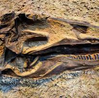
History lives in this stony landscape. The fossils of dinosaurs who roamed here 150 million years ago. The thousand-year-old rock art of the Fremont Indigenous people who called this place home. The homesteads of European settlers who passed through and stayed, and the Ute Indian Tribe communities who still live here. Dinosaur National Monument originally protected only 80 acres. In 1938, President Franklin Roosevelt expanded the protection to encompass the confluence of the Green and Yampa Rivers, including their ruggedly beautiful river canyons.
Those boundaries persist to this day. But beyond them, the Greater Dinosaur landscape connects the Wyoming sagebrush steppe to the Rocky Mountains
and the Colorado Plateau. It’s a connection that both communities and wildlife depend on, especially as the climate changes. Currently, the Greater Dinosaur region contains the largest concentration of Bureau of Land Management wildlands in Colorado — estimated at more than half a million acres. With half the region anchored by the Monument, NPCA is working to conserve the history embedded in the lands surrounding the national monument.


Successfully fought off nearly 6,000 acres in the landscape that was slated for oil and gas leasing.
Engaged in management planning for the adjacent John Wesley Powell National Conservation Area.
Connected with partners around a long term vision for the site.
The Environmental, Cultural and Community Value your investment will produce:
Permanent protection for wildlands in the Greater Dinosaur region, including no new oil or gas drilling.
Thriving, intact wildlife corridors
A comprehensive vision for the protection of the larger landscape that includes meaningful engagement and consultation with Indigenous communities.
CULTURAL ELEMENTS
Traditional lands of Ute Indian people
10,000 years of human habitation
1,000-year-old petroglyphs & pictographs
Pioneer homesteads
Quarry Exhibit Hall
ECOLOGICAL FEATURES
5+ diverse habitats: riparian, sagebrush, pinyon-juniper woodland, grassland, montane forest
1,000 native plant species
WILDLIFE
70 mammal species — bighorn sheep, elk, black bear, mountain lion, mule deer, river otter, prairie dogs
200 bird species
Wolf pack sightings
14 native fish species, 4 endangered
PARKS & PROTECTED AREAS
Protected target: 500,000 acres
210,000 acres currently protected by Dinosaur National Monument
91+ percent of Dinosaur recommended for wilderness protection
Dinosaur National Monument
ECONOMIC RETURNS
$20+ million in cumulative economic benefits to local communities
RECREATIONAL OPPORTUNITIES
River rafting, camping, hiking, horseback riding, bicycling, stargazing, viewing of petroglyphs, fossils and wildlife

Ocmulgee River Corridor
The largest archaeological dig in American history documented Native American life here, from the last ice age through the tragic period of Indian Removal. Today, the Muscogee Nation of Oklahoma and other Native groups trace their ancestry to this place. The river system’s unbroken habitat is unique on the East Coast, hosting a major wildlife corridor and migratory flyway alongside recreation opportunities. NPCA is working with allies to link and expand protected areas along a 50-mile stretch of the river.
Okefenokee Swamp
At over 400,000 acres, the Swamp is the largest wildlife refuge east of the Mississippi and one of the planet’s largest freshwater ecosystems.
A designated Wetland of International Importance and a prospective UNESCO World Heritage Site, the Swamp is threatened by a proposal to extract heavy mineral sands on a ridge crucial to the Swamp’s hydrological integrity, with potentially catastrophic ecological results. NPCA is a founding member of the Okefenokee Protection Alliance working to prevent this.
Ocmulgee and Altamaha Rivers
One of the longest undammed river systems in the eastern U.S. is home to crucial wildlife corridors, connecting habitat in central and southern Georgia. But there are gaps. So NPCA and our partners are strategizing ways to bridge those gaps and create a unified conservation landscape.

River
one of the longest undammed river systems in the eastern U.S., is home to crucial wildlife corridors, connecting habitat in central and southern Georgia to the wildlife corridor network of Florida.


Ocmulgee River Corridor determined to be nationally significant and suitable for inclusion in the National Park System after advocacy by NPCA.
Advocated for introduction of legislation expanding protection of this landscape through a new designation that contains Tribal co-stewardship elements to Georgia Congressional champions.
Built local support for increased protection for the Okefenokee Swamp through targeted outreach to the Cherokee of Georgia, local clergy and education and local business leaders.
Advocated for the nomination of the Okefenokee National Wildlife Refuge to the proposed list of U.S. World Heritage Sites.
The Environmental, Cultural and Community Value your investment will produce:
Innovative conservation protections through new designations and expansion of existing units across Georgia.
Preservation of sites associated with the Native American mound-builders and the cultural and historical heritage of the Muscogee people. Increased economic development opportunities based on tourism and recreation.
Multi-partner collaboration to expand a major wildlife corridor along 50 miles of the Ocmulgee River.
Exploratory initiative with The Nature Conservancy and others to address the Ocmulgee and Altamaha Rivers as a unified conservation landscape.
CULTURAL ELEMENTS
17,000+ years of human presence, one of the nation’s richest archaeological landscapes
Potential Native American Traditional Cultural Property
Historic homeland of Muscogee people
ECOLOGICAL FEATURES
Largest block of contiguous swamp-forest habitat on the upper Coastal Plain
One of the largest wilderness areas in the eastern U.S.
One of the longest undammed river systems in the eastern U.S.
WILDLIFE
Important migratory, breeding, and wintering bird habitat, isolated bear population, high reptile and amphibian diversity
Haven for imperiled species like red-cockaded woodpeckers, wood storks and eastern indigo snakes
Critical aquatic and migratory fish connectivity
PARKS & PROTECTED AREAS
Protected target: Ocmulgee River Corridor: 80,000-100,000 acres; Okefenokee Swamp: 100,000 acres; Ocmulgee and Altamaha Rivers: up to 1-2 million acres
Ocmulgee Mounds National Historical Park
Bond Swamp National Wildlife Refuge
Ocmulgee Wildlife Management Area
Okefenokee National Wildlife Refuge
Fort Frederica
National Monument
Cumberland Island
National Seashore
RECREATIONAL OPPORTUNITIES
Paddle sports, hiking, cycling, horseback riding, wildlife watching, camping, hunting and fishingriding, heritage tourism

The Colorado River took 5 to 6 million years to carve the Grand Canyon, exposing layer of rock nearly 2 billion years old. The canyon’s diverse habitats support uniquely American wildlife, from desert bighorn to condors. It’s a place of cultural significance for the Havasupai, Hualapai, Hopi, Navajo, Zuni, and Paiute peoples, the Yavapai-Apache Nation, and the Colorado River Indian Tribes, its original stewards. Millions of people depend on its waters. But for a century, it’s been under threat.
To safeguard it destructive exploitation, President Theodore Roosevelt established the Grand Canyon National Monument in 1908. Eleven years later, Congress made it a national park. Still, in the 1960s, hydroelectric dams were planned in Marble Canyon and Lower Granite Gorge. They would have
changed the Grand Canyon forever. NPCA helped prevent that. But a coal-fired power plant was built nearby instead, polluting the air and obscuring the park’s viewsheds. Sustained pressure from NPCA and our coalition partners shut it down in 2019. Recently, a mega-development threatened the Grand Canyon’s ground water, and a tramway threatened viewsheds and sacred sites. NPCA worked with canyon Tribes and other partners to stop both projects. Uranium mining claims have long threatened the Grand Canyon’s watershed — NPCA has worked for over a decade to stop uranium mining in the surrounding landscape. Until protection is extended to all public lands integral to Grand Canyon National Park, the threats will keep on coming.

Greater Grand Canyon supports uniquely American wildlife, provides water for millions of people, and is a place of deep cultural significance for many Native Tribes.

Victory! — Led by the Grand Canyon Tribal Coalition, nearly a million acres on both rims of the canyon were designated as Baaj Nwaavjo I’tah Kukveni — Ancestral Footprints of the Grand Canyon National Monument, stopping all new mining claims!


The Environmental, Cultural and Community Value your investment will produce:
Protection of the landscape’s unique ecological, cultural and recreation values.
A permanent ban on new mining claims and inappropriate development to prevent water and air pollution and stopping the development of existing mining claims within the monument. Protection of existing and historical uses, including water rights, hunting, grazing, recreation and private property.
Meaningful Tribal engagement in management of Baaj Nwaavjo I’tah Kukveni — Ancestral Footprints of the Grand Canyon National Monument through a co-stewardship agreement.
Management plan for the new monument that ensures robust protection of its unique national and cultural resources.
CULTURAL ELEMENTS
11 Tribes’ homelands, sacred places, sacred waters
3,000+ ancient Native American archaeological sites, some more than 12,000 years old
ECOLOGICAL FEATURES
Mountain meadows among aspen groves and dense conifer forests
Riparian areas along creeks and biologically-rich springs
Arid juniper-pinyon woodland
Desert scrub and sparse grasslands
WILDLIFE
Internationally renowned mule deer herd
Kaibab squirrel, found nowhere else
22 species of concern
PARKS & PROTECTED AREAS
Protected target: 1.7 million acres
Grand Canyon National Park
Vermillion Cliffs
National Monument
Grand Staircase-Escalante
National Monument
ECONOMIC RETURNS
6,000,000 visitors per year
$900 million contributed to the regional economy
10,000 jobs supported
RECREATIONAL OPPORTUNITIES
Hiking, camping, sightseeing, photography, painting, night sky viewing, river rafting, burro packing, nature study
Florida’s famed River of Grass filters life-giving water through the state’s southern peninsula. The Greater Everglades ecosystem once stretched from the headwaters of the Kissimmee River near Orlando to the Florida Keys, flowing through Lake Okeechobee and what is now Big Cypress National Preserve, Everglades National Park and Biscayne National Park.
Today, half of this historical paradise has been drained, dredged or paved. Water that once flowed south is diverted to the Atlantic Ocean and the Gulf of Mexico. Acquiring and protecting land for wetland conservation and habitat restoration would increase freshwater flows into protected areas of the Greater Everglades ecosystem and benefit coastal South Florida’s vital fisheries and blue carbon habitats.
NPCA safeguards against threats while advancing conservation opportunities. We are fighting the imminent threat of industrial oil development in Big Cypress National Preserve — the only national park unit facing proposed new oil development within its borders. To prevent destruction of park wetlands and endangered wildlife habitat, NPCA supports the Park Service acquiring all mineral rights within the preserve.
Protecting and restoring the Everglades is a unifying issue for Floridians. NPCA’s bipartisan track record positions us to succeed. Together, we can conserve this landscape and enhance Florida’s climate change resilience.

a unifying
NPCA’s bipartisan track record positions us to succeed.


Broke ground on the Everglades Agricultural Area Reservoir in 2023, which will move clean water into critical conservation areas and south to Everglades National Park.
Secured greater protections for vital marine areas in the Florida Keys National Marine Sanctuary to be adopted and implemented in 2024.
Increased efforts to safeguard iconic ghost orchids in the western Everglades through Endangered Species Act protection.
Supported the Everglades to Gulf Conservation Area recently established by the U.S. Fish and Wildlife Service which will safeguard wildlife corridors and essential watersheds.
The Environmental, Cultural and Community Value your investment will produce:
Restoration of water flow from Lake Okeechobee south through Everglades National Park and the Florida Keys, and protection of the coastal St. Lucie and Caloosahatchee Estuaries.
Full implementation of existing policy to establish a marine reserve within Biscayne National Park, and policy improvement in Florida Keys National Marine Sanctuary to expand and connect existing marine reserves.
Permanent protection for vulnerable park lands and waters threatened by extractive uses, especially Big Cypress National Preserve.
Creation of a connected network of water storage and treatment infrastructure by securing publicly-owned protected lands.
CULTURAL ELEMENTS
Shellworks & canoe trails of early Calusa and Tequesta societies
Seminole & Miccosukee Tribal lands and communities
Saltwater Underground Railroad Maritime Heritage Trail
ECOLOGICAL FEATURES
Largest subtropical wilderness in the United States
Largest protected mangrove swamps in North America
Globally imperiled pine rocklands
Diverse wetlands
Coastal and marine habitats
Dark sky designation
WILDLIFE
One of the country’s richest bird rookeries
Rare and endangered species, including West Indian manatee, American crocodile and Florida panther
200+ native species of grass, and lush tropical plants like orchids, bromeliads and ferns
PARKS & PROTECTED AREAS
Everglades, Biscayne and Dry Tortugas National Parks
Big Cypress National Preserve
Florida Keys National Marine Sanctuary
Florida Panther, Ten Thousand Islands and Key Deer National Wildlife Refuges
ECONOMIC RETURNS
Drinking water for 9 million Floridians
Nearly 5 million annual visitors
Over $440 million in visitor spending (2022)
RECREATIONAL OPPORTUNITIES
Biking, boating, kayaking, canoeing, fishing, camping, wildlife viewing, photography, stargazing, hiking and nature study

The Greater Yellowstone Ecosystem encompasses 22 million acres at the intersection of Wyoming, Idaho and Montana. With Yellowstone and Grand Teton at its center, this ecosystem is one of the few places left in this country still able to support all the wildlife that thrived on the landscape 10,000 years ago, including grizzly bears, bison, wolverine and pronghorn. However, the ancient migratory corridors that sustained these animals for millennia are threatened by development, habitat loss, extractive industry and increasing recreation pressure, all intensified by a rapidly changing climate. NPCA has a long history working with local communities, Tribes and partners to protect the ecosystem and all it represents. Working together, we’ve expanded winter
habitat for bison, prevented industrial mining on Yellowstone’s border and oil and gas development outside of Grand Teton, restored ancient pronghorn migration routes, and upheld protections for grizzly bears and the habitat they depend on. NPCA has proven expertise and experience needed to protect Yellowstone’s wildlife today and into the future.
Our goal in the Greater Yellowstone Ecosystem is to work with partners to protect and restore habitat connectivity in Greater Yellowstone and Glacier, ensuring the iconic wildlife of the region such as the grizzly bear and pronghorn survive the intensifying threats of development, magnified by the impacts of climate change.

The
is one of the few places in America still able to support wildlife that has been here for 10,000 years.


Launched a partnership with landowners, watershed groups, conservation organizations and Tribes to work collaboratively to facilitate wildlife movement, minimize conflicts with carnivores and keep private working lands, critical to connectivity, from being developed.
Raised over $100,000 to support local communities after the historic flooding of the Yellowstone River and established a flood relief fund to help local landowners rebuild fencing lost to the flood using wildlife friendly designs.
Helped secure a $11 million in federal funding to help landowners prevent conflicts with carnivores.
15 years working with private landowners and public land managers to remove and modify fencing across working lands to restore migration corridors for park wildlife in the Northern GYE.
Increase resources available to support working lands and Yellowstone’s large carnivores.
Implement innovative solutions to repair and prevent habitat fragmentation caused by livestock fencing, roads, and human development.
Create predictive model to determine site-specific impact of climate change to drive restoration and resource management in the GYE.
Work with agencies to advance multi-jurisdictional, landscape scale planning efforts within the GYE.
Protect the heart of the Ecosystem — Yellowstone and Grand Teton — using the power of the parks to influence policy decisions and safeguard wildlife habitat and connectivity on park landscapes in Idaho, Montana and Wyoming.
Expanded species-specific habitat protections for wildlife such as grizzlies, bison and pronghorn antelope.
CULTURAL ELEMENTS
11,000+ years of human history
27 Tribal nations with connections to the landscape
Two Tribal reservations within the landscape
World’s first national park
ECOLOGICAL FEATURES
One of Earth’s largest intact temperate zone ecosystems
World’s largest geyser field and one of its largest active volcanoes
Continent’s largest high elevation lake
Seven great rivers located here flow to the Pacific Ocean and the gulfs of California and Mexico
WILDLIFE
Supports some of the last remaining intact long-distance wildlife migration corridors in the Lower 48, including Wyoming’s Path of the Pronghorn One of the last remaining grizzly populations in the Lower 48
Large carnivores including gray wolves, black bears, wolverine and lynx
Largest free-roaming, wild herd of bison in U.S. 9 native fish 285 species of birds
PARKS & PROTECTED AREAS
Yellowstone and Grand Teton National Parks
John D. Rockefeller Jr. Memorial Parkway
U.S. Forest Service and Bureau of Land Management public lands
State-owned lands in Wyoming, Idaho, Montana

Rock imagery of hunters on horseback pursuing bison. Empty windows peek out from walls of stacked stone wedged into cliffsides. Ceremonial sites lie beneath exceptionally dark night skies awash in stars.
For 10,000 years, people have lived among these canyons and mesa tops between Bears Ears, Canyons of the Ancients and Hovenweep National Monuments in Southeast Utah. They left behind a staggering number of ancient villages, roads, artwork and sacred sites, most of them unsurveyed across almost 325,000 acres of what is now public land. These are “The Lands Between.” They’re an integral part of a contiguous cultural landscape that includes the neighboring national monuments. Yet, The Lands Between
remain the missing, unprotected piece — the country’s most archaeologically rich area of public lands that is not protected from oil and gas leasing.
The Bureau of Land Management oversees most of it. In recent years, more than 100,000 acres of The Lands Between were sold at lease sales to speculative oil and gas companies. The process was rushed, inconsistent and allowed only limited input from Tribes and the public.
But Tribal and conservation organizations refused to give up. NPCA is helping build capacity for tribal leadership and providing support as needed. Working closely with a core group, NPCA will continue to put our experience with administrative, legislative and legal solutions into action.

CULTURAL ELEMENTS
Cultural, ancestral and traditional lands of the Hopi, Zuni, Rio Grande Pueblos, Ute, Diné (Navajo), Paiute and other indigenous people
The greatest concentration of unprotected archaeological sites in the country
Celebrated dark-night skies
ECOLOGICAL FEATURES
missing,


Worked to ensure there have been no new oil and gas leasing in the landscape since 2019.
Deepened tribal relationship with trips to the landscape for tribal leaders including the Hopi, Zuni, Acoma, and Ute Mountain.
Pueblos of Acoma, Zuni, Hopi and All Pueblo Council of Governors co-hosted a partner meeting to deepen tribal understanding and engagement on the landscape.
The Environmental, Cultural and Community Value your investment will produce:
Cancellation of oil and gas leases, including 2018 lease sales covering nearly 47,000 acres, and pause on new leasing of the targeted protected area, followed by long-term landscape protections based on a process led by the Tribes.
Protection for outstanding cultural resources that honor indigenous connections to the landscape.
A connected, protected corridor of culturally significant land stretching all the way from Grand Canyon National Park to Canyons of the Ancients National Monument and Mesa Verde National Park.
Preservation of precious water resources for local communities and the broader arid Colorado Plateau ecosystem.
Preservation of dark night skies, wildlife corridors and a climate resilient landscape. Strengthened and deepened relationships with the Navajo Nation and other interested tribes, and the formation of a tribal working group and increased direct engagement between tribes and the Bureau of Land Management.
Colorado Plateau ecosystem, a complex of canyons and mesa tops
Critical wildlife corridors
Dark night skies
WILDLIFE
Elk, mule dear, black bear, and mountain lions
Wild turkey, Gunnison sage grouse, band-tailed pigeon
One-of-a-kind paleontology, active dinosaur quarry excavating late Jurassic dinosaur fossils
PARKS & PROTECTED AREAS
Protected target: roughly 325,000 acres of mostly public land
Bears Ears National Monument Canyons of the Ancients National Monument
Hovenweep National Monument
TBD Wilderness Study Area
Cross Canyon Wilderness Study Area
Areas of Critical Environmental Concern
RECREATIONAL OPPORTUNITIES
Respectfully viewing archaeological sites and rock art, hiking, horseback riding, camping, hunting, wildlife viewing

Maine’s 100-Mile Wilderness is an unbroken forest with alpine peaks, lakes, and rare plant and animal species. Named for the famously rugged, remote and strenuous final 100 miles of the Appalachian National Scenic Trail, it draws hikers, hunters, and visitors of all stripes. This landscape is the traditional and present-day homeland of the Wabanaki Native American tribes, particularly the Penobscot Nation. Ensuring these woods and waters remain intact can safeguard Maine’s tribal heritage and protect healthy ecosystems that support wildlife and absorb carbon emissions. Unfortunately, this landscape is threatened by development and fragmentation. Proposals for energy transmission, resource and mineral extraction, and commercial and residential development threaten this
wild place. While 90 percent of Maine’s land is forested, only 22% percent is conserved, making this forest oasis vulnerable to fragmentation and irresponsible development.
Maine’s 100-Mile Wilderness provides critical habitat for wildlife and rare plant species. It contains century-old hunting camps, a network of logging roads and narrow ski and hiking trails. Intact second growth forests attract moose hunters, lumberjacks and endurance hikers from all over the world.
The pressure for development threatens Maine’s boreal and temperate forests. Globally, ecosystems like these sequester one-third of the world’s carbon emissions. NPCA’s ability to protect this landscape will help ensure its future — and ours.


Advocated for funding for the Forest Legacy Program, which has made significant progress to conserve key parcels in Maine’s 100-mile wilderness.
Conducted a listening tour that included 12 interviews with conservation partners for an assessment of opportunities and challenges in protecting and promoting the 100-mile wilderness.
Helped establish and lead the Northern Appalachian Trail Landscape Partnership to coordinate efforts to conservation and provide access to the Appalachian Trail.
Joined the Wabanaki Alliance to advocate for sovereignty for four Native American tribes in Maine and deepened relationships with Maine tribal members.
Worked with our partners to successfully stop a proposed zinc mine seven miles from Katahdin Woods and Waters National Monument in the Penobscot River watershed.
The Environmental, Cultural and Community Value your investment will produce:
State and federal policies that connect land and waters adjacent to the Appalachian National Scenic Trail and protect critical wildlife habitat in the Maine 100-Mile Wilderness.
Authentic and non-transactional relationships with regional partners, including tribal members, who are deeply committed to conserving this landscape now and for future generations.
A protected and connected landscape that enhances recreational access to Katahdin Woods and Waters National Monument benefiting the economies of local communities.
Plans backed by NPCA’s research and expertise that support increased visitation, sustainable economic development and provide benefits to local communities.
Federal and state conservation funding to ensure partners have access to critical matching funds to bring conservation projects along the Appalachian Trail to completion.
Ancestral homelands of the Wabanaki tribes, including the Penobscot Indian Nation
Indigenous artifacts and archeological resources
Timber industry, which shaped the North Woods way of life
Century-old traditional wilderness sporting camps
Katahdin Woods and Waters National Monument
Katahdin Woods and Waters
National Scenic Byway
Appalachian National Scenic Trail and International Appalachian Trail
Onawa Trestle
Katahdin Iron Works State Historic Site
ECOLOGICAL FEATURES
Forests, alpine and subalpine ecosystems, exposed rock cliffs, ice caves, slate gorges, waterfalls, floodplains, marshes, fens, peatlands, and fast-flowing, rocky rivers
WILDLIFE
Moose, Canadian lynx, bobcat, river otter, endangered sea-run Atlantic salmon, native Brook trout, Loons, Bald Eagles, Ruffed Grouse, American Woodcock 21 globally rare species such as the endangered Katahdin arctic butterfly
ECONOMIC RETURNS
Farming, forestry and outdoor recreation services
RECREATIONAL OPPORTUNITIES
Hiking, fly fishing, canoeing, kayaking, white water rafting, birding, camping, mountain biking, hunting, snow shoeing, rock climbing, ice climbing, alpine and cross-country skiing, snowmobiling
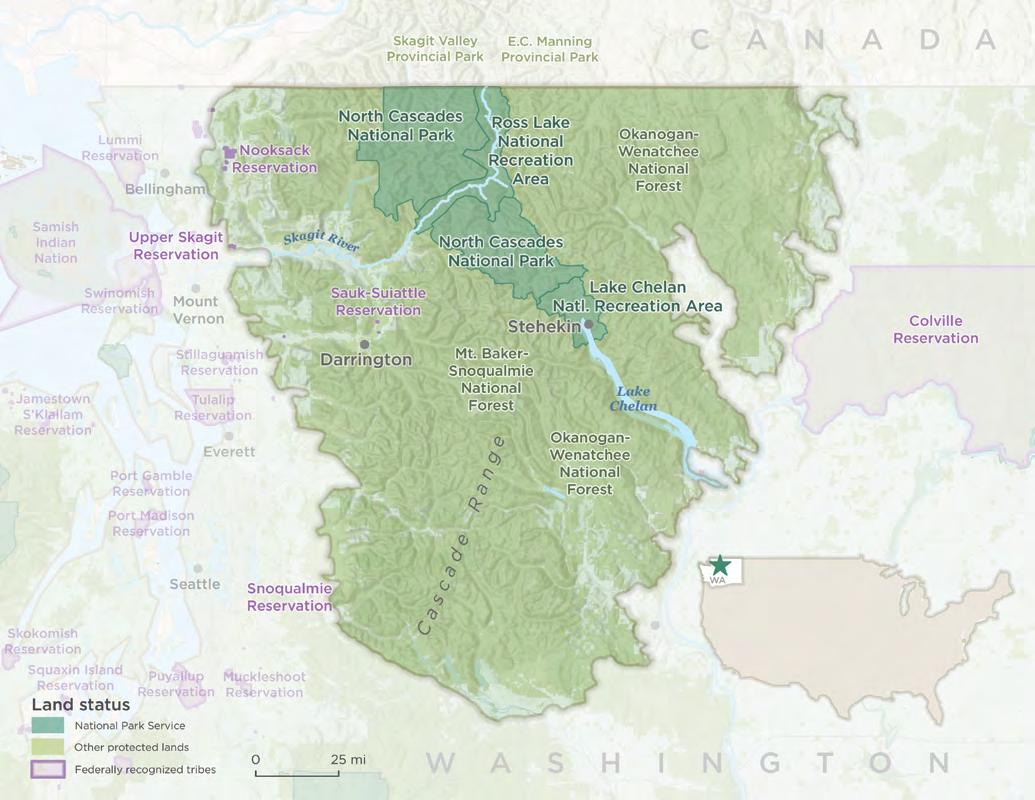
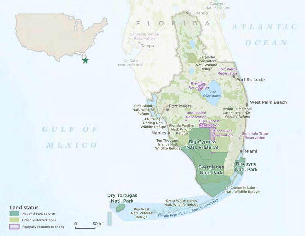
For thousands of years, before intense European settlement, people coexisted with grizzly bears in the North Cascades. Today, only a few grizzlies may remain in the wildest, most rugged portions of the North Cascades. Local Tribes grappled to sustain their cultural heritage. And for a time, the natural health of the North Cascades declined.
A decades-long project is now underway to restore Washington state’s endangered grizzly population. Securing grizzly bears’ future in this unique and wild ecosystem requires action on two fronts — land protection and community support. NPCA is uniquely equipped to fight for both.
Core habitat is present within the park and adjoining wilderness areas. To secure that habitat in a changing climate, these public lands
require careful management with an emphasis on wildlife restoration. Without it, the North Cascades is vulnerable to degradation and fragmentation, threatening all wide-ranging species. A protected landscape will nourish local cultures and economies and support climate adaptation and resilience.
But more is needed. Wildlife recovery cannot happen without community support. NPCA’s science-based efforts and local presence have a track record of helping build support to recover the region’s most iconic missing critter — the grizzly bear.
and their historic grizzly bears, is critical for restoring this


Advocated for protecting the Stephen Mather Wilderness and Pacific Crest Trail from new road building in the upper Stehekin River valley.
Urged native fish recovery and continued support for the Environmental Learning Center through the Skagit River dam relicense process.
Successfully advocated for retiring mineral tenures in British Columbia in the upper Skagit River watershed.
Organized significant public support to advance grizzly bear recovery in the North Cascades ecosystem.
The Environmental, Cultural and Community Value your investment will produce:
Landscape protections and development limitations to keep one of the last remaining, largely intact ecosystems wild enough to support at-risk wildlife populations.
A more climate-resilient landscape that offers expanded protections for wildlife habitat, connectivity and biodiversity on lands and waters adjacent to the national park and national forests.
Improved collaboration and coordination across the region’s conservation community, uniting local communities around a shared vision and cultural values.
Finalized recovery and management plans for grizzlies, with more than 6 million acres of the North Cascades managed for the bears’ recovery.
CULTURAL ELEMENTS
Temperate coniferous forests with alpine, subalpine, wet and dry types
300 glaciers
Rugged, remote mountains
ECOLOGICAL FEATURES
Threatened grizzly bears
Endangered gray wolves
Bald eagles and spotted owls
Salmon and trout, including threatened species
Wolverines
Canada lynx
WILDLIFE
260 prehistoric sites
Significant cultural resources for regional Native American Tribes
Mining, trapping, timbering, sheep herding, homesteading history
PARKS & PROTECTED AREAS
North Cascades National Park
Mt. Baker-Snoqualmie
National Forest
Okanogan-Wenatchee
National Forest
ECONOMIC RETURNS
The park and adjacent federal lands are significant economic drivers for local communities in the U.S. and Canada — especially for fishing and outdoor recreation
RECREATIONAL OPPORTUNITIES
Hiking, camping, fishing, hunting, horseback riding, mountain biking, climbing, boating, river rafting, skiing, snowmobiling and bird watching

The mountains surrounding the San Fernando Valley offer open green spaces known as the Rim of the Valley for residents of the greater Los Angeles area. But they are threatened by encroaching development and invasive plants, signage and access are often unclear, and people in the surrounding communities don’t always feel welcomed there.
That’s why NPCA is advocating for legislation that will expand the nearby Santa Monica Mountains National Recreation Area to include the Rim of the Valley. Currently, the park protects over 150,000 acres of popular mountain terrain, woodlands and rocky beaches and provides Angelenos with opportunities for outdoor recreation with over 500 miles of hiking trails. It contains centuries
of Chumash and Tongva history and safeguards more than 1,000 plant and 450 animal species, including more than 50 that are rare and threatened.
The proposed expansion would nearly double the size of the park and improve habitat connectivity for a wide range of wildlife including mountain lions, which were recently found to number much less in than previously estimated in California. And it would bring the recreation area’s benefits, including the National Park Service’s robust community outreach, education and engagement programs, to even more communities in the LA area.


Built a broad coalition of supporters from across the region representing diverse interests including outdoor recreation, public health, environmental justice and historic preservation.
Secured bipartisan support and introduction of legislation expanding the boundaries of Santa Monica Mountains National Recreation Area to include the Rim of the Valley.
The Environmental, Cultural and Community Value your investment will produce:
Pass legislation that expands the boundaries of SMMNRA to include the Rim of the Valley.
Enhanced resources and management expertise and new opportunities for local governments and communities to partner with the National Park Service to address habitat restoration, recreation, and wildfire management.
Improved habitat connectivity between the region’s natural landscapes, from the Santa Monica mountains to the San Gabriel mountains, with linkage to the 1 million-acre Los Padres National Forest.
More equitable access to outdoor recreation and education in underserved urban communities.
CULTURAL ELEMENTS
Early Native American settlements and trading routes
Original Spanish colonial pueblo that became Los Angeles Oil and energy
development history
Water resource history
ECOLOGICAL FEATURES
One of the world’s best examples of a Mediterranean climate ecosystem
Chapparal, coastal scrub and oak woodlands, riparian areas
Critical wildlife corridors and watersheds
Stopover for migrating birds on the Pacific Flyway
WILDLIFE
Mountain lion, bobcat, gray foxes, shorebirds, songbirds, woodpeckers and raptors
Endangered steelhead trout and red-legged frog
PARKS & PROTECTED AREAS
Protected target: 118,000 acres
Santa Monica Mountains
National Recreation Area
Los Padres and Angeles National Forests
State, county and city parks and open spaces
ECONOMIC RETURNS
More than doubles the size of the current Santa Monica Mountains NRA, which generates more than $30 million in annual visitor spending, supports 400+ jobs
RECREATIONAL OPPORTUNITIES
Hiking, mountain biking, horseback riding, climbing, camping

Every day, 26,000 vehicles race through the Pigeon River Gorge on Interstate 40. As the highway winds between western North Carolina and eastern Tennessee, it passes along the northeastern corner of Great Smoky Mountains National Park, one of America’s most-visited national parks. When animals leave the protection of the park and try to cross that multi-lane highway to reach additional protected habitat, it often ends badly. For everyone. Not far away is another highly visited national park: The Blue Ridge Parkway. For the wildlife there, even being in a protected area is no guarantee of safety. Both parks are in the vast forested landscape of the Southern Appalachian Mountains. The region hosts natural wonders
and a mountain culture that’s a treasured regional heritage. Protecting this legacy is crucial, even as population growth and development encroach on the remaining undeveloped spaces — many on the edge of protected lands. Individual efforts to increase protections are already underway. These include creating safe passage for wildlife to cross roads, improving connections between existing protected spaces, working with landowners to conserve their lands and preserving cultural heritage sites. What’s needed is a collective vision for the region as a whole. That’s where NPCA comes in.


Conducted an assessment of the threats and opportunities within the geography, leading to goal and objective setting for the first stages of the Southern Appalachian Landscape Project.
Worked with partners to identify shared challenges, opportunities and priorities across organizations to inform the creation of a 10-year shared vision for the landscape.
Continued cerulean warbler and avian diversity research and began pilot research on the federally endangered northern long-eared bat.
Secured new wildlife-friendly infrastructure on Interstate 40 on the northern edge of Great Smoky Mountains and commitments for additional improvements to provide safe passage for park wildlife along this dangerous section of road.
Secured over $2 million in new dollars for wildlife-friendly infrastructure in the NC State Legislature.
The Environmental, Cultural and Community Value your investment will produce:
Reduction in wildlife mortality from vehicle collisions and improved habitat connectivity, leveraging new science, collaborative efforts, crossing structures and fencing.
A new transportation and visitor use management plan that will protect keystone species in Great Smoky Mountains National Park, along the Foothills Parkway, the Blue Ridge Parkway and on adjacent land.
Expansion of Cumberland Gap National Historical Park, designation of a Kentucky Wildlands National Heritage Area and establishment of a Craggy Wilderness and National Scenic Area to protect 16,000 acres that includes old growth forest adjacent to the Blue Ridge Parkway.
A strategic plan to identify lands and waters adjacent to national park units in the landscape to acquire for improved habitat connectivity, biodiversity, and land protection reflective of the shared 10-year vision.
Original home of the Cherokee Nation
Culturally and spiritually important to many Native American tribes
Early European settlement
African American history
American Revolution and Civil War history
Regional music and culture
One of the world’s most ecologically diverse temperate zone forests
Largest interconnected protected space in the eastern U.S., ranging across a four-state region
Globally significant biodiversity in the waters and land
Nearly 100 rare plants and animals, some found nowhere else
Unique or rare: Eastern hellbender, blackside dace, painted trillium, cerulean warblers plus many threatened and endangered species
PARKS & PROTECTED AREAS
Protected target: 16,000 acres
Great Smoky Mountains
National Park
Blue Ridge Parkway
Appalachian National Scenic Trail
Big South River National River and Recreation Area
Obed Wild and Scenic River
Cumberland Gap National Historical Park
Little River Canyon
National Preserve
Pisgah, Cherokee and Nantahala National Forests
Hiking, mountain biking, horseback riding, paddling, climbing, camping, fishing, hunting, wildlife viewing, fall colors, photography, visiting historic sites, scenic driving tours, night sky viewing

It’s one of the world’s greatest natural wonders: The Western Arctic Caribou Herd. More than a hundred and fifty thousand animals. An annual migration of 2,700 miles, the second longest land migration on Earth. The herd’s full range is a staggering 100 million acres. Within that, six national park units provide more than 20 million undisturbed acres without a single mile of road. But that could soon change. The state of Alaska has proposed building a 211-mile industrial access mining road through the eastern half of the herd’s migration corridor. Developing the Ambler Mining District could result in multiple massive open-pit mines operated by international companies — all in the midst of this uniquely intact landscape.
Studies indicate that roads directly impact caribou migration behavior, threatening the long-term health of herds that 37 Alaska Native villages in the region depend on for food. By leveraging some of the most remarkable park landscapes in the national park system, NPCA is leading the fight to protect the herd in partnership with the people who depend on it.
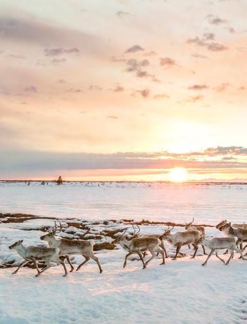


Led a powerful coalition of Tribal, regional, and national partners in bringing national attention to this issue, engaging over 135,000 people in the environmental review, pushing the Biden administration toward a collective call to revoke the existing road permits.
Amplified the voices of the 89 indigenous tribes that have spoken out in opposition to the mining road, requesting the Biden administration revoke the road permits due to cultural, social, and subsistence impacts.
Joined with partners in a lawsuit that pushed the Department of Interior to concede its initial review of the mining road project was flawed and revisit its decision to allow the road.
The Environmental, Cultural and Community Value your investment will produce:
A stop to the proposed 211-mile Ambler industrial mining road, which would cross the roadless Gates of the Arctic National Preserve.
Sustainable, indigenous-led management of the Western Arctic Caribou Herd, which continues to thrive across their entire 100-million-acre range, unhindered by industrial development of the Ambler mining road and Ambler Mining District.
Protection for the ecological integrity, connectivity and climate resilience of the largest contiguously protected wildlands in the National Park System for generations to come.
Greater public awareness of the Western Arctic Caribou Herd and Northwest Alaska National Parklands. Empowerment for Tribes to build lasting management and stewardship roles on parklands in Northwest Alaska, working private-public partnerships to protect the Western Arctic Caribou herd and the landscape on which it depends. Additional conservation safeguards to limit future threats from industrialization of the Brooks Range.
CULTURAL ELEMENTS
The caribou herd is central to Alaska Native lifeways in the region
ECOLOGICAL FEATURES
Tundra and taiga
Western Brooks Range mountains
WILDLIFE
The 150,000-strong Western Arctic Caribou Herd
Culturally significant salmon, whitefish and sheefish fisheries 900 other species of animals and plants
PARKS & PROTECTED AREAS
Protected target: 100 million acres
Gates of the Arctic National Park Kobuk Valley National Park Noatak National Preserve Gates of the Arctic National Preserve Bering Land Bridge
National Preserve Cape Krusenstern
National Monument
ECONOMIC RETURNS
Sustainable, traditional, subsistence food resources offset extreme cost of importing food to the region. Sustainable eco-tourism and commercial outfitters.
RECREATIONAL OPPORTUNITIES
Hiking, backpacking, camping, climbing, fishing, hunting, birding, wildlife viewing