Nicola Culliford
11th December 2023
MSc Architectural Technology and Design
Inclusive Master Planning
This report has been prepared to consider and appraise three development proposals across sites within two overlapping strategic policy areas known as ‘South Bank’ and ‘Aire Valley’ in Leeds, West Yorkshire.
The sites are spread across five distinct zones identified by the Leeds Aire Valley Action Plan for mixed use development (AV14,15,32,33,34) (1) and form part of an ambitious vision to develop and grow Leeds city centre during the next decade and beyond.
The sites are introduced and analysed in context of the history, identity and emerging future of the Leeds city and the specific localities of South Bank and Aire Valley.
External and landscaping components of three existing development proposals are appraised against policy and guidance that legislate and steer best practice regarding inclusion, accessibility and local planning context.
The report concludes with the communication of a high-level concept for the development of the remaining site (AV15) in response to this appraisal.
Please note: All narrative and image referencing details, by page, are provided towards the end of the report.
Location & Population
The Metropolitan Borough of Leeds is centrally located within the county of West Yorkshire and serves as the ‘regional capital’ of Yorkshire and the Humber (1).
With an estimated population of 811,953 (2), it is the second largest city in the UK, exceeded only by Birmingham.
Originally granted city status in 1893, the area is spread across 213 square miles (551 km2) stretching from Otley and Wetherby (north west and north east) to Rothwell and Morley (south and south west).

Economy
A diverse industrial history has seen Leeds progress from a small agricultural village in the Middle Ages, through significant growth in wool and textile trading, to the development of manufacturing and engineering centres as a result of opportunities presented by the industrial revolution and rail travel during the 19th century.
Today over 4000 people work in Leeds city and it retains one of the largest manufacturing sectors in the UK, alongside a leading financial and business services sector (3). More recent growth continues to emerge across digital and creative industries, supported by an increasingly robust educational offer across the city.

Geography
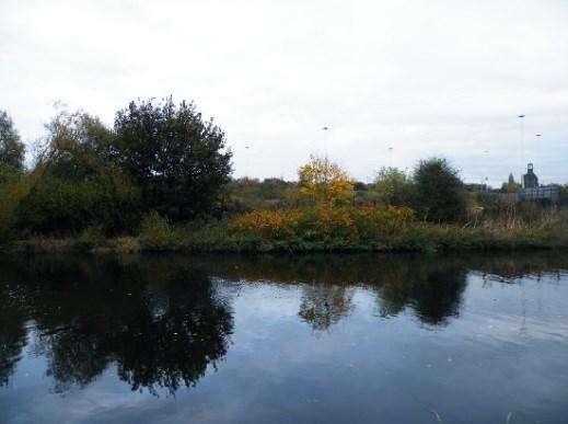
Yorkshire’s River Aire passes directly through Leeds centre, creating a North, South divide that has historically been reflected in a disconnect between the development and use of sites located either side.
The area from the North bank of the river towards the inner ring road (A64/A58) is recognised as Leeds ‘city centre core’ and incorporates key cultural and retail landmarks including Briggate, The Victoria Quarter, The Grand Theatre, Leeds Railway Station and City Square. (4)
In contrast, the area to the south of the river stretching towards Richmond Hill (NE), Hunslet (SW), Beeston (SE) and Holbeck, known as ‘south bank’, has remained a less developed and utilised part of the city.

Site Significance
The sites this report considers occupy a portion of south bank land bordered by the river Aire (north to east) and the inner ring road and Hunslet Road (south to west). Their position presents a significant opportunity to contribute to local development by:
- Connecting outlying neighbourhoods to the city centre
- Enhancing regeneration of the waterfront
- Contributing to strategic green network and flood resilience solutions
- Creating a mixed-use backdrop for the evolution of vibrant communities
Under policy AV7 of the Aire Valley Action Plan, these sites form part of cluster of development zones designated for ‘mixed - use Development to include a significant proportion of housing’ (5).

Iconic Landmarks


Blended Character


A Waterside City


Leeds in Context...


24% of residents live with physical or mental health condition (3)


Household Tenure
52% owned
48% rented (4)


0.75M 0.8M
World's first steam locomotive

First British Internet Service Provider


Roundhay: UKs largest park
River Aire: meanders through city for 6.5 miles

1515 annual hours of sunshine
620mm annual rainfall
Leeds South Bank Regeneration Framework (SBRF) outlines an ambitious vision for the development of sites and buildings across this 253 hectare city region.
The future South Bank serves as a flagship destination for investment, sustainable living, learning, culture, creativity and leisure (1). The SBRF outlines key challenges currently restraining this ambition and the strategic approaches and principles required to realise it:
The Challenge
* Actual (via road, rail, river) and perceived separation from the city centre core
* Isolated surrounding neighbourhoods, reducing the sense of community and place
* A disconnected enterprise base, limiting opportunities to create a vibrant employment centre
* Absence of quality, connected transport networks to facilitate movement across and within the area
* An underutilised waterfront and shortage of connected, public open spaces to link and serve sites and communities
* Significant flood risk across high volume of land
The Approach
* Green Network / Creating attractive and healthy spaces that unite communities and ease movement through south bank
* Movement and Transport / Reduce congestion, encourage cyclists and pedestrians, expand and improve public transport network, improve east to west movement,
* Waterfront Regeneration / Embracing and reframing the river opportunity to connect landmarks and neighbourhoods and facilitate recreation and culture
* Sustainability / Embedding climate and flood resilience in development and attracting knowledge and investment in climate innovation
* Culture, Heritage, Community / Showcasing and connecting heritage assets, valuing diversity and combining mixed land uses to create active, vibrant neighbourhoods


Early Success
Examples of development projects leading the way in evolving the vision for South Bank include:
Tower Works / £57M sustainable mixed use scheme significantly addressing rental market need
Victoria Riverside / Restoration and extension of historic flax mills delivering residential space
The Tetley / Repurposing of heritage asset as cultural space for arts & exhibitions


Building Blocks
Significant projects are identified that form the physical framework for future development and underpin the delivery of the overarching South Bank Vision.
City Boulevard / Diverting vehicular traffic around the city and favouring pedestrian and cycle movement (2)
The Arbour / An 800m east to west green axis connecting Temple Works to Leeds Dock (3)
City Park / A major element of the green network and a destination for leisure, culture and public events (4)
‘the goal is to stitch the city back together’ (Leeds City Councill)
The vision for South Bank is a crucial delivery component of the Leeds Local Development Framework. Led by the Core Strategy. This evolving framework incorporates local development plans (DPDs) and supplementary planning documents (SPDs) to create an overarching approach to the area’s long term development (1).
The adopted Core Strategy strives to position Leeds as the ’best city in the UK’ (2) and highlights the significance of south banks’ contribution to realising this vision (3).
Specific policies and objectives outlined in the Core Strategy are magnified via the South Bank Regeneration Framework and steer the approach and principles it communicates:
SP3 Role of the city centre

CC1 City centre development
CC3 Connected communities
P11 Conservation of heritage


SP11 Transport infrastructure
CC2 City centre south

P10 Inclusive, considered design

A major portion of south bank’s eastern edge also forms part of the Aire Valley region, for which a dedicated plan exists as part of the Development Framework. The plan informs the principles of regeneration across Aire Valley, including aspirations for South Bank sites via five dedicated policies (4):
SB1 Connected non vehicular routes
SB2 A new park for the city
SB3 Enhanced green network


SB4 Mixed site use
SB5 Temporary use of sites


Leeds Transport Plan and Accessible Leeds supplementary planning documents provide additional and detailed guidance to steer and inform inclusive, high quality development of sites across the city.
The south bank sites identified below are examples of developments that are proposed, approved or under construction to date. Plans for the two sites spanning the east and west riverbank (A-C) are those being considered in the ‘Access Audit’ element of this report:


Leeds Core Strategy
Leeds Core Strategy
The principal strategic outlining key delivery policies to pursue the district’s development ambitions to 2028
South Bank Regeneration Framework
South Bank Leeds Regeneration Framework: Supplementary Planning Document
Aire Valley Area Action Plan
Aire Valley Area Action Plan
A local plan steering planning policy and regeneration measures for the Aire Valley region of Leeds
Leeds Street Design Guide
Leeds Transport: Supplementary Planning Document
A recently adopted SPD delivering local guidance on the development of highways, streets and public realm


Centre for Inclusive Mobility (UK Govt. Department for Transport)
A national best practice document providing guidance on approach to design and development of pedestrian and transport infrastructure
Accessible Leeds :Supplementary Planning Document
A local document delivering guidance and standards to drive accessible and inclusive development across Leeds
The Principles of Inclusive Design (CABE)
A document communicating the high-level approach and principles that are fundamental to achieving inclusive space and building design
UK Building Regulations: Approved Document M
A document outlining minimum UK standards for designing access to and use of new of or existing buildings
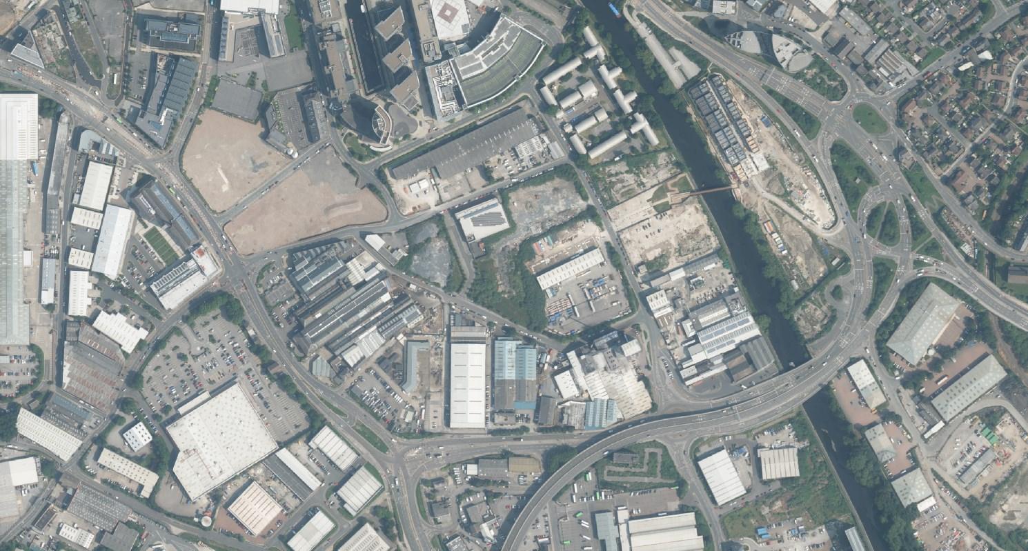
The area for analysis encompasses three brownfield development sites to the south eastern corner of the city’s South Bank region, approximately 1.5km from the city centre. The combined space of just over four hectares is bordered by Clarence Dock (north), South Accommodation Road/Inner Ring Road (east, south) and Sayner Lane (west) and incorporates nearly half a kilometre of disconnected east and west river bank.
Area is relatively level with river side zones sloping gently towards to east and west banks. Variation is from 25AMSL* along Clarence Road 30AMSL** at A61 boundary Sites span flood zones 1-3, with highest risk being along riverside belt. No historic flood events are recorded (1)
Land primarily hard standing with secondary vegetation


Architectural character in the vicinity is mixed, with predominantly traditional industrial and contemporary commercial design


Surrounding Development
The maps below capture evolution of the sites being considered in the report commencing in the 1850s, prior to which the land was primarily undeveloped.
For over sixty years the space was dominated by Clarence Iron and Steelworks, housing industrial foundries and mills alongside worker housing. By 1920, following numerous changes of ownership, the works were relocated and activity ceased (1).
The industrial legacy of the area is retained today via Allied Glass (formerly Hunslet Glassworks) and reflected in the renovation of surrounding sites including Hunslet and Victoria Mills.


Images D-F above show Clarence Steel and Iron Works (1920s), newly developed Hunslet and Victoria Mills, and Allied Glassworks.

- Congestion management via single split entry from A61 inner ring road (40mph) with left turn only on exit
- Carriageway and adjacent pedestrian routes meet minimum widths outlined by Leeds ‘shared space streets’ standards (1)
- Shared carriageway encourages low speeds (2) and adopts South Bank approach to favouring non vehicular movement (3)
- Re-introduction of controlled crossings at entry and exit lanes enhances safety for pedestrians and cyclists
-Turning space provided for larger service vehicles, meeting safety and design standards (4)


- Primary access shared with vehicles at south offering step free entry and direct connection to National Cycle Route 67 (5)
- Controlled crossings with flush level and tactile surface enhance safety and meet local design standards (6)
- Non vehicular access to east boundary provides stepped route into site, with surface covering and step/landing design to meet UK building regulaition (7)
- Existing safety barriers and street lighting along approach to primary and secondary entry contribute to security and safety
- Three bus stops (serving five local bus routes) within five minute walk from west access points
-Shared pedestrian/cycle access at west boundary via proposed footbridge towards west bank canal
Appraisal is based on detail provided transport assessment documents submitted


provided in site plan, landscaping plan and travel submitted as part of development proposals

- A permeable path provides the most direct nonvehicular access through the site from east to west with benches offering opportunity for rest and socialisation
- Slope gradient from street to site necessitates stepped entry
- Users with limited mobility enter the site via the longer, sloped shared access road leading to a north/south looped path connecting to a proposed footbridge at the west exit
- A permeable footpath loops the site north: south providing resident access to accommodation blocks, as well as an alternative, meandering route for users moving east: west

- The looped path route necessities negotiation of steps to manage slope gradient at north and south boundaries, but remains level across the west boundary
- General vehicular access is limited to the primary shared route leading to under croft parking; however, appropriate service and emergency access is provided (8) via a widened stretch of the loop path along the west boundary with turning points at north and south points
-Proposed landscape improvements along east river bank provide additional amenity and enhances experience of movement along west boundary

- Level entry points are provided to private accommodation with sloped access towards shared terraces (east) alongside alternative stepped entry points (west)
-Under croft parking provides 79% (car) and 100% (cycle) space provision per household, concealing vehicles to improve visual amenity and congestion
-Disabled parking provision is not detailed, but should be provided at appropriate volume and design (9) as required by local design standards and UK building regulation
Appraisal is based on detail provided in part of development


- Transition from A61 across Low Fold development towards the west riverbank is enhanced by the bridges angled design (running subtly south east: north west) connecting primary east and west access points
- Pedestrians and cyclists are offered an alternative east: west route across the city, reducing exposure to noise and air pollution
- East bank entry point connects users to existing canal path towards north and south destinations , incorporating national cycle route 67
- Proposed landscape improvements, incorporating public green space, to east and west riverbank enhance views from bridge and encourage route use


in the design and access statemen submitted as development proposals


- Mandatory cycle dismount enhances pedestrian safety and experience, particularly for users with mobility, visual or hearing impairment
- variation in surface treatment (timber deck and paving) facilitates users travelling at varying speeds to safely share route
- Balustrade integrates appropriate safety and support standards with bridge aesthetics, enabling subtle use where required
- 150mm upstand along decked surface edges provides appropriate stability for wheelchair users and pushchairs
‘Fin’ design of balustrade enables lower views user views of landscaping and activity to east and west riverbank
- Optional ramped and stepped access accommodates transition for all users between more varied land levels at east bank access point, supported by surface changes to denote proximity
- Approach to vehicular access points (x2) at north west and south west site corners is via Clarence Road
-Two-way entry roads (shared with pedestrians and cyclists) meet minimum width standards (1) and extend to under croft parking entry points only, limiting congestion around development
-Proposed entry barriers limit site access, adopting South Bank approach to favouring non vehicular movement (2)
-One-way loop road (shared with pedestrians and cyclists) enables essential and emergency service vehicle movement through site
- Vehicular passing width provided at multiple points, meeting safety and design standards (3)
Improvements to Clarence Road deliver a more pedestrian friendly approach to eastern access points via narrowed vehicular carriageway and raised, contrasting surface crossing points
Non-vehicular access points are available across east and west boundaries, including a direct, step free route across the development east: west
Proposed footbridge and landscaping improvements to east boundary create ease of transition to the A61 (via Low Fold), Leeds Dock and north/south canal path, incorporating National Cycle Route 67 (4)
An opportunity is created to encourage alternative movement west towards the Discover Centre and Leeds City Centre (via future development of adjacent site AV15)
Appraisal is based on detail provided transport assessment documents submitted


provided in site plan, landscaping plan and travel submitted as part of development proposals

- Routes through and around the development prioritise non-vehicular movement
- A step free path is available as the most direct pedestrian east: west route through the site, with mid-way timber seating providing opportunity for rest
- Shared loop road and pathways between accommodation blocks provide an alternative, meandering route through site via connected pockets of landscaping, planting and seating

Pathway is ramped to facilitate access to higher land level towards east exit, with steel handrail at appropriate height (1.1m) to support rest and safety (5)
Pathways are ramped and/or stepped at additional points across site to accommodate level variation , with steel handrails supporting rest and safety where variation is 600mm or greater
- Stepped access includes bicycle rails to enforce dismounting but ease movement for cyclists across site

A direct cycle route connected to the shared lop road appears available leading to the north east exit, distinguished by surface variation
Surface variation along with proposed kerb or stud features distinguish dedicated pedestrian routes from vehicle/cycle space across the site, predominantly along the shared north: south loop road.
- Proposed 10mph limit and frequent crossing points (matching surface of dedicated pedestrian routes) prioritise non - vehicular movement
- -Under croft parking provides 60% (car) and 100% (cycle) space provision per household, concealing vehicles to improve visual amenity and congestion.
The following details are not discernible from proposal plans and supporting documents. Further review is recommended to validate quality of provision:
Handrails (Low Fold)
These should be provided at both sides for all steps. Height, material and colour should meet standards outlined in BS8300:2009 5.10 (1) to ensure safety, grip and visibility for all users.
External Lighting
Where sites are accessed outside of daylight hours, lighting is an important factor for surveillance, user safety and comfort (2). Appropriate lighting also enhances wayfinding and, for public outdoor spaces, should meet standards set out in BS 5489-1:2020 (3)
Wayfinding
Supporting the most vulnerable users to navigate a site will often enhances the experience for all. UK Government’s Inclusive Mobility Guide is one source of insight available to steer best practice in public space wayfinding (4)
Surface Variation
Where pedestrian routes are shared with vehicles or cyclists, surface distinction is important to aid visually impaired users who often rely on kerbs for navigation (5). Colour and texture variation should be considered.
‘Inclusive


design is everyone’s responsibility’ CABE
The following opportunities exist to enhance provision across the sites and deliver a more inclusive experience to all users:

Extending Permeability
Providing a more direct step, free east: west route through the Low Fold development enhances permeability between A61 and Clarence Road and affords a more inclusive nonvehicular experience of entering and crossing the site
Additional Resting Places
Increasing the provision of resting places throughout pedestrian routes provides supports users with limited mobility to navigate safely and comfortably. Ensuring rest places are available every 50 metres (minimum). This also affords respite for those with pushchairs or carrying goods (6) .

Accommodation Choice for Disabled Residents
Accommodating an appropriate volume of disabled parking spaces within accessible distance of residential blocks not served by under croft provision, enhances choice and inclusivity for future prospective disabled residents
Community Led Evolution
Engaging with diverse user groups and, over time, those living within and visiting the sites informs evolving site improvements and encourages user care and ownership
‘Good design should reflect the diversity of people who use it’ CABE
Existing
A significant lack of quality green space and infrastructure limits opportunity for connected neighbourhoods and streets...
Minimum 1km to access nearest sports fields and parks towards city centre (north), or surrounding neighbourhoods (east)
Significant proportion of derelict, non-permeable land
Proposed
The introduction of landscaped spaces and routes contributes routes and assets to the South Bank green network (2)...
Public recreation space within the South Bank X1 scheme


Planting and amenity as part of the Sayner Lane multigenerational development


Majority of routes dominated by unmaintained hard and soft

Where present, green amenity is basic, with limited aesthetic or ecological value (1)


CITU footbridge affords revival of riverbanks including soft landscaping and public space
Example of ‘pocket park’ feature at Hydro Works
Existing
The area is lacking in sustainable features, due to industrial legacy and absence of recent development...
Majority hard, non-permeable landscape - polluting surface water and increasing flood risk
Lack of screening exposes sites to noise and air pollution from surrounding traffic and industry


Proposed
Proposed schemes contribute sustainable space and infrastructure to the South Bank masterplan...


Reducing congestion and facilitating walkable neighbourhoods

Mitigating flood risk and encouraging biodiversity via considered, permeable landscaping features

to encourage biodiversity and carbon absorption
Derelict sites create disconnect public space and neighbourhoods, and discourage a sense of place


effect
carbon, ‘fabric first’ approach to building design and construction (1)
Connecting and inspiring communities with the introduction of shared green routes and spaces


Isolated site, disconnected from surrounding attractions
Lack of public amenity in vicinity


No direct access to riverside
Retention of large commercial unit

Connect to new east: west pedestrian route
Repurpose and extend indoor space
Expand strategic green network
Enhance nonvehicular routes

Road perimeter (east, south, west)
Noise exposure from surrounding industry


Create a destination for emerging communities

Connection to city and dock
Contribute to flood mitigation and biodiversity


A larger format site plan is provided in appendix 1.
T H E E D G E, S O U T H B A N K
An inspiring, shared space to head to or through
The approach to developing site AV15 is in considerately blending use as both a destination and a space for transition; the concept of encouraging and rewarding movement to and through the site.
Through repurposing and extension of a retained industrial unit, the site accommodates a community hall and adjacent coffee shop with retail area fronting onto landscaped outdoor space for both casual and organised recreation. An opportunity to extend the city’s electric cycle hire network is also incorporated.
Additional hard and soft landscaping to the north boundary provides a safe and inviting non-vehicular route to users moving east towards the river and A61 and west towards the city centre and Holbeck
Inspired by the long term vision for development across Leeds South Bank, the proposal intends to:
* Afford a walkable community space to serve evolving residential sites
* Create an inspiring, inclusive destination for residents and visitors to rest, meet and play
* Enhance the new east west route opened up to pedestrians and cyclists via the proposed CITU footbridge over the River Aire
* Contribute to an evolving green network connecting south bank to the city centre,
* Introduce amenity and sustainable features to undeveloped land


Accessibility
*A walkable destination linking surrounding residential sites
*A safe, vibrant space to walk or cycle to and through
*Connectivity to local bus and cycle routes
*Route permeability via east, south and west entry points
*Level entry and passage for ease of use
*Vehicle free movement around primary site features
People
*Encouraging connection through shared amenity
*A diverse space to work, rest, meet and play
*Fostering a sense of ownership through local use and input
*Inspiring multi generational use and engagement
*A destination for community collaboration and events
*Opportunity to create evening neighbourhoods
Sustainability
*Enhancing flood resilience with new green and permeable spaces
*Encouraging biodiversity through considered landscaping
*Contributing to vehicle free city routes
*Flexible construction methods support responsive future development
*Evolving and securing future use through local community pride
Context
*Developing with and for surrounding communities
*Creating space and facilities that unite diverse groups
*Respecting the heritage of south bank and surrounding sites
*Enhancing and extending the benefits of surrounding development
*A flexible, inpermenant approach to evolving space and use
Invested Users


Engaged Users
Those visiting the site regularly or consistently to access services and facilities


Those more proactively engaging with the site and taking ownership of community led use


V Transitional Users
Those passing through the site as part of their journey


Casual Users
Those visiting the site occasionally for services or recreation


Destination Users
Those travelling to the site to attend a special event or for planned recreation


Leeds south bank presents a significant opportunity to develop mixed-use neighbourhoods and spaces that contribute to the vison of a more sustainable, connected city.
The sites considered in this report have a crucial role to play in addressing the current challenges of a north: south city divide, isolated communities and a lack of connected, shared green space across the area.
The existing development proposals for Low Fold, Hydro Works and the CITU footbridge afford a mix of new homes and facilities the fringe area of the city and create new and inclusive public realm to connect with emerging developments to the west of the river and the existing canal path to Leeds Dock. The replacement of legacy industrial land with permeable surfaces and soft landscaping also contributes to the City’s ambitious sustainability objectives and opens up a new and direct east: west non-vehicular route across the River Aire.
These plans have been considered in the report and a number of recommendations made to enhance their impact and contribution towards a more accessible and inclusive city.
There remains an opportunity to develop site AV15 in response to these proposals, as well as emerging development across surrounding sites. The concept presented within this report proposes community led use, to service the growing number of new residents expected from adjoining developments.
The Edge, South Bank will create a destination for recreation, play and community engagement as well as an inspiring non-vehicular route to extend east: west permeability between the city, the river and beyond. Initially designed as a cost effective, flexible solution, there is opportunity to evolve and grow the site and facilities as the needs of community users evolve. The long term aim to is to encourage a sense of ownership amongst local users who can steer and secure future use.
Page 3
1/ Leeds City Council (2017) pp.26-27
A/ Ordinance Survey (2023a)
Pages 4-5
1/ Leeds City Council (2019) p.10
2/ Office for National Statistics (2022)
3/ Leeds City Council (2018) p.10
4/ Leeds City Council (2018) p.10
5/ Leeds City Council (2017) pp.26-27
A/ Secret Library Leeds (2023)
B/ Secret Library Leeds (2023)
C/ Clifford Stead (2023)
D/ Ordinance Survey (2023a)
E/ Leeds City Council (2018) p.13
Pages 8-9
1 / Office for National Statistics (2022)
2 / Office for National Statistics (2023)
3 / NOMIS (2023)
4 / NOMIS (2023)
Pages 10-11
1/ Leeds City Council (2018) p.2
2/ Leeds City Council (2018) p.58
3/ Leeds City Council (2018) p.48
4/ Leeds City Council (2018) p.49
A/ Leeds City Council (2018) p.12
B/ Leeds City Council (2018) p.37
C/ Leeds City Council (2018) p.37
D/ Leeds City Council (2018) p.53
E/ Tower Works (2023)
F/ JM Construction (2023)
G/ Arts Together Leeds (2023)
Pages 12-13
1 / Leeds City Council (2019) pp. 4-5
2 / Leeds City Council (2019) p.10
3 / Leeds City Council (2019) p.64
4/ Leeds City Council (2017) pp. 68-79
A/ Leeds City Council (2018) p.13
B/ Nick Brown Architects (2015) p.8
C/ DP2 and Gagarin Studio (2017) p.2
D/ Ollier Smurthwaite Architects (2016) p.16
E/ Leeds City Council (2023)
F/ Nick Brown Architects (2015) p.7
G/ Bbc.co.uk (2013)
H/ Ordinance Survey (2023)
Pages 16
1/ Weetwood Services (2015) p.
Page 17
1 / Sheffield City Council (2023)
A/ Ordinance Survey (2023c)
B/ Ordinance Survey (2023d)
C/ Ordinance Survey (2023e)
D/ South Leeds Life (2023)
E/ JM Construction (2023)
Pages 18-19
1/ Leeds City Council (2023) pp.66-67
2/ Leeds City Council (2023) pp.66-67
3/ Leeds City Council (2018) p. 36
4/ Leeds City Council (2023) pp.88-90
5/ Sustrans (2023)
6/ Leeds City Council (2023) p. 91
7/ HM Government (2015a) pp. 9-20
8/ HM Government (2015b) p. 98
9/ Leeds City Council (2018) pp. 132-135
Pages 22-23
1/ Leeds City Council (2023) pp. 66-67
2/ Leeds City Council (2018) p. 36
3/ Leeds City Council (2023) pp. 62-68
4/ Sustrans (2023)
5/ Leeds City Council (2016) p.33
6/ HM Government (2016a) p. 30
Pages 24-25
1 / Leeds City Council (2013) p.37
2 / Leeds City Council (2023) p.151
3 / HM Government Department for Transport (2021) pp. 121-122
4 / HM Government Department for Transport (2021) pp.115-120
5 / HM Government Department for Transport (2007) p.67
6 / HM Government Department for Transport (2007) p.30
Pages 26-27
1 / Brookes Ecological (2016) pp.10-12
2 / Leeds City Council (2018) p.34
Pages 28-30
1/ Nick Brown Architects (2015b) p.15
Reference List
A2Arts Together Leeds (2023) Photographic Image of The Tetley (online image). Available from <https://artstogetherleeds.co.uk/partner/the-tetley/> [accessed 01Deecember 2023) +A2A1:A39
Bbc.co.uk (2022) Leeds City Centre 'Multi-Generational' Complex Approved (online image). Available from <https://www.bbc.co.uk/news/uk-england-leeds-62519219> [accessed 29November 2023]
Brookes Ecological (2016) Preliminary Ecological Appraisal: Land Opposite Low Fold, Leeds (2016) (online). Available from <https://publicaccess.leeds.gov.uk/online-applications/ applicationDetails.do?keyVal=NIMQG0JB1SR00&activeTab=summary> [accessed 04December 2023]
Clifford Stead (2023) Photographic Image of Leeds Skyline (online image). Available from <https://www.flickr.com/photos/cliffordstead/5586063732> [accessed 20November 2023]
Collective Agency (2023a.) X1 Southbank Leeds City Centre (online image). Available from <https://www.collective-agency.com/work/item/x1-southbank/> [accessed 05December 2023)
Collective Agency (2023b.) CITU Leeds City Centre (online image). Available from <http:// www.collective-agency.com/work/item/citu/> [accessed 05December 2023]
Commission for Architecture and the Built Environment (CABE) (2006)
Gagarin Studio (2023) Low Fold Bridge (online image). Availabe from <https:// www.gagarinstudio.co.uk/2015/06/10/low-fold-bridge/> [Accessed 04December 2023)
HM Government (2015a) UK Building Regulations Approved Document M2 - Access to and Use of Buildings
HM Government (2015b) UK Building Regulations Approved Document K - Protection from Falling, Collision and Impact
HM Government Department for Transport (2007) Manual for Streets
HM Government Department for Transport (2021) Inclusive Mobility: A Guide to Best Practice on Access to Pedestrian and Transport Infrastructure
JM Construction (2023) Photographic Image of Hunslet Mill Redevelopment (online image). Available from <https://www.jmconstructionleeds.co.uk/victoria-riverside/> [accessed 01December 2023]
Leeds City Council (2016) Accessible Leeds: Supplementary Planning Document
Leeds City Council (2017) Aire Valley Leeds Area Action Plan: Leeds Local Plan Development Plan Document
Leeds City Council (2018) Press Release: X1 secures approval for new Leeds neighbourhood (online image). Available at <https://news.leeds.gov.uk/news/x1-secures-approval-for-newleeds-neighbourhood> [accessed 29November 2023)
Leeds City Council (2018) South Bank Leeds Regeneration Framework: Supplementary Planning Document
Leeds City Council (2019) Core Strategy: Leeds Local Plan
Leeds City Council (2023) Leeds Transport Supplementary Planning Document
Nick Brown Architects (2015a) Low Fold Leeds: Design Statement Document 5
Nick Brown Architects (2015b) Low Fold Leeds: Design Statement Document 7
Nick Brown Architects (2021) Sayner Lane: Design and Access Statement (online report). Available from <https://publicaccess.leeds.gov.uk/online-applications/ simpleSearchResults.do?action=firstPage> [accessed 05December 2023}
Nomis (2021) Leeds Local Authority 2021 Census Area Profile. (online). Available from <https://www.nomisweb.co.uk/sources/census_2021/report?compare=E08000035> [accessed 22 November 2023]
NOMIS (2023) Leeds Local Authority: Local Area Report. Available from <https:// www.nomisweb.co.uk/reports/localarea?compare=E08000035> [accessed 09December 2023)
Office for National Statistics (2022) Estimates of the population for the UK, England, Wales, Scotland and Northern Ireland (online dataset). Available from <Estimates of the population for the UK, England, Wales, Scotland and Northern Ireland> [accessed 22November 2023]
Office for National Statistics (2023) How the population changed in Leeds: Census 2021 (online report). Available from <https://www.ons.gov.uk/visualisations/ censuspopulationchange/E08000035/> [accessed 22November 2023]
Optima Highways (2023) Low Fold Leeds Project (online image). Available from <https:// www.optimahighways.com/projects/low-fold-leeds> [accessed 05December 2023)
Ordinance Survey (2023a) Ariel view map of South Bank Leeds (Online), 1:5000, OS VectorMap® Local. Available from <https://digimap.edina.ac.uk/roam/map/os> [Accessed 01 December 2023]
Ordinance Survey (2023b) Street view map of South Bank Leeds (Online), 1:5000, OS VectorMap® Local. Available from <https://digimap.edina.ac.uk/roam/map/os> [Accessed 01 December 2023]
Ordinance Survey (2023c) Historic map of South Bank Leeds 1890 (Online), 1:5000, OS VectorMap® Local. Available from <https://digimap.edina.ac.uk/roam/map/os> [Accessed 01 December 2023]
Ordinance Survey (2023d) Historic map of South Bank Leeds 1920 (Online), 1:5000, OS VectorMap® Local. Available from <https://digimap.edina.ac.uk/roam/map/os> [Accessed 01 December 2023]
Ordinance Survey (2023e) Historic map of South Bank Leeds 1950 (Online), 1:5000, OS VectorMap® Local. Available from <https://digimap.edina.ac.uk/roam/map/os> [Accessed 01 December 2023]
Secret Library Leeds (2023) A Brief History of Leeds. (online image). Available from <https:// secretlibraryleeds.net/2022/08/04/a-brief-history-of-leeds-4-the-18th-century/> [accessed 23
South Leeds Life (2023) Photographic Image of Clarence Steel and Ironworks Leeds in the 1920s (online image). Available from <https://southleedslife.com/local-history-leeds-steelworks/> [accessed 04December 2023]
Sustrans (2023) Interactive Map of National Cycle Routes (online). Available from <https:// explore.osmaps.com/?lat=51.641136&lon=2.923634&zoom=8.4445&style=Standard&type=2d&overlays=os-ncn-layer> [accessed 20November 2023]
Tower Works (2023) Photographic Image of Tower Works Residential Scheme (online image). Available from <https://https://www.tower-works.com/> [accessed 03Decembr 2023]
Weetwood Services (2015) Land Off Clarence Road ("CITU WORKS"), Leeds Flood Risk Assessment (online report). Available from <https://publicaccess.leeds.gov.uk/onlineapplications/applicationDetails.do?keyVal=NYO3HFJB17S00&activeTab=summary>
Appendix 1.
Larger Format Block Plan (Site Avl15)