


Lexington City Council
Mark Kurth, Mayor
Kim DeVries, Council Member
John Hughes, Council Member
Mike Murphy, Council Member
Diane Harris, Council Member
Lexington Planning Commission
Mark Vanderbloomer, Chairperson
John Bautch, Commission Member
Michelle Koch, Commission Member
Gloria Murphy, Commission Member
Ron Thorson, Commission Member
Christopher Olsson, Former Chairperson (ended March 2018)
John O’Neil, Former Chairperson/Commission Member
Bill Petracek, City Administrator
Kurt B. Glaser, City Attorney
MSA Professional Services, Inc.
Christopher Janson, AICP - Project Manager
Josie Matteson, - Project Planner
Shawn O’Shea, AICP - Project Planner
Steve Winter, PE - City Engineer
Claire Michelson, Project Planner
Chapter 1: Introduction................................................................................1-2
1.1 The Plan as a “Living Guide”
1.2 Plan Organization
1.3 A Snapshot of Lexington
1.4 Key Community Indicators
Chapter 2: Planning Process & Public Participation....................................2-2
2.1 Overview & Schedule
2.2 Project Website & Steering Committee
2.3 Community Survey
2.4 Public Review
Chapter 3: Land Use................................................
3.1
3.2 Community Designation
3.6
3.7 Design Guidelines Considerations
3.8 Staged Development and Redevelopment
3.9 Natural & Special Resources
Chapter 4: Transportation............................................................................4-2
4.1 Transportation Goals & Policies
4.2 Transportation Analysis Zones
4.3 Roadways System Overview
4.4 Planned Roadway Improvements
4.5 Transit
4.6 Bicycling & Walking
4.7 Aviation
4.8 Freight
Chapter 5: Housing.......................................................................................5-2
5.1
Chapter 6: Water Resources.........................................................................6-2
Chapter 7: Parks and Trails...........................................................................7-2
7.1 Goals and Policies
7.2 Existing Parks and Trails
7.3 Planned Improvements
Chapter 8: Resilience....................................................................................8-2
8.1 Resilience Goals and Policies
8.2
Chapter 9: Economic Competitiveness........................................................9-2
Chapter
This chapter provides the foundation for the Comprehensive Plan, outlining why we plan, the planning process, Thrive MSP 2040 requirements and the planning area. In addition, Chapter 1 also provides community background information including key community indicators.

It is difficult to know what the future may bring for Lexington, or for any community. As residents and businesses come and go, and economic trends rise and fall, changes will occur. The purpose of this plan is to establish a shared vision for Lexington to guide future actions and decisions. This guidance provides predictability and consistency over time, which encourages investment. We plan so that we can act and react in a changing world with a confident understanding of our common values and goals.
This planning document is a “living” guide for growth and change in the City of Lexington. The plan represents the City’s best effort to address current issues and anticipate future needs; however, it can and should be amended from time to time if conditions warrant reconsideration of policies in this plan. If decisions are being made that are not consistent with this plan, then the plan has lost some relevance and may need to be amended. The process of amending the comprehensive plan should not be onerous, but it should trigger a brief pause to consider again the long term vision for the community. This plan’s value is dependent upon frequent use and occasional updates.
Thrive MSP 2040 is the vision for the Minneapolis -St. Paul Metropolitan Region over the next 30 years. It reflects the regions joint concerns and aspirations, anticipates future needs in the region, and addresses our responsibility to future generations.
Under state law, the Council prepares a long-range plan for the Twin Cities region every 10 years. Thrive MSP 2040 sets the policy foundations for systems and policy plans developed by the Council:
• Transportation Policy Plan
• Water Resources Policy Plan
• Regional Parks Policy Plan
• Housing Policy Plan
Thrive MSP 2040 addresses issues that transcend any one neighborhood, city, or county, as we build and maintain a thriving metropolitan region. Our region’s investments provide an important economic foundation so all residents of the region can prosper. Transportation, jobs, community development, affordable housing – these are the bricks-and-mortar basics that make other things possible health outcomes, and safeguard Minnesota’s exceptional quality of life.
Choice, Place and Opportunity examines where opportunities in the region are, which residents have access to those opportunities, and how future public investments - made the by the Council

and other agencies - can assure equitable access to opportunity for all residents of the region. Recommendations outlined in the assessment influences Thrive MSP 2040, which identified “equity” as one of five outcomes of the regional planning process over the next decade.
While Lexington will establish a unique local vision, the City’s plan must also reflect the adopted regional policies outlined in the system and policy plans. Local plans contain much greater detail than regional plans by identifying local street connections, neighborhood parks, residential development standards, and phasing of utility extensions and improvements necessary for the individual community. But these local planning efforts tie into the larger regional infrastructure of parks and trail systems, arterial road networks, and wastewater infrastructure. It is the efforts of the 188 cities, townships, and counties together that implement a shared regional vision.
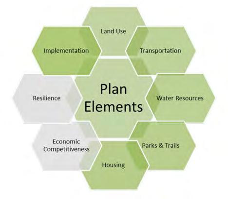
Minnesota Statute requires certain topic areas to be included in local comprehensive plans. The Local Planning Handbook is organized around these Plan Elements and provides guidance on how to meet requirements within these planning areas. These Plan Elements in the Local Planning Handbook are:
• Land Use
• Transportation
• Water Resources
• Park & Trails
• Housing
• Plan Implementation
• Resilience
• Economic Competitiveness
Chapter 1: Introduction
Discusses the role of the plan, Thrive MSP 2040 requirements, and key community indicators.
Chapter 2: Planning Process and Public Participation
Outlines the planning process, public participation methods and a summary of all feedback.
Chapter 3: Land Use
Covers growth forecast, community designation, existing land use, future land use, density calculations, staged development and redevelopment, natural resources and special resources protection.
Chapter 4: Transportation
Addresses the topics of transportation analysis zones, roadways, transit, bicycling and walking, aviation, and freight.
Chapter 5: Housing
Describes current housing conditions and projected housing needs.
Chapter 6: Water Resources
Details the existing conditions and future needs for the City’s wastewater, water supply and surface water systems.
Chapter 7: Parks & Trails
Summarizes the regional and local parks and trail systems.
Chapter 8: Resilience
Describes the City’s capacity to respond, adapt and thrive under changing conditions and covers the areas infrastructure & environment, energy infrastructure & environment, healthy communities, and economy & society.
Chapter 9: Economic Competitiveness
Provides community context regarding key industries/centers of employment, redevelopment, education and workforce, business development, as well as economic information, monitoring and strategic initiatives.
Chapter 10: Implementation & Action Plan
Identifies the tools and procedures by which the plan will be implemented and provides steps and procedures for successful implementation of the plan.
Appendix A: Survey Results
Appendix A contains the results of the community wide survey.
Appendix B: Local Watershed Management Plan
Appendix B contains the City of Lexington’s Local Watershed Management Plan.

Archeological investigations show that Dakota or Ojibwa tribes were the first inhabitants to make camps along local area lakes and Rice Creek because of the abundant fishing and ricing resources. In 1862, Phillip Laddy became the first recorded white settler in what later became known as Blaine Township. Laddy settled near the lake that still carries his name (often called Laddie Lake today) near Highway 65 and Anoka County 10. In 1877, “Blaine” was selected as the name for the township that contained what is now the cities of Lexington, Circle Pines, and Blaine. The actual settlement of Blaine Township lagged for many years because of the wet conditions and poor soil. The population of Blaine Township was 128 in 1880, 205 in 1890, and 374 in 1900.
On May 5, 1950, an election of settlers was held to incorporate what is now known as Lexington. The incorporation proposal passed 93-61, and Lexington was incorporated as a village on May 21, 1950, with a population of 569. The first mayor was Cyrus Palmquist. Leo Ryan, who had moved to the area in 1946, was instrumental in organizing a petition for the new village. Ryan suggested the name “Lexington” for the new village. The area had been generally known as Lexington Park, because Lexington Avenue was the eastern boundary. In addition, Ryan suggested the name in honor of his old Army unit. The “First Pioneer Infantry Regiment” of Boston had formed at the beginning of the Revolutionary War. That unit met the British in the Battle of Lexington.
Various city themes and names now revolve around the Revolutionary War and Battle of Lexington, including Paul Revere Mobile Home Park, Minutemen Lane, Patriot Lane, Liberty Lane, and the city’s minuteman logo. In 1950, Lexington became a city.
Source: http://www.ci.lexington.mn.us

https://www.lib.umn.edu/apps/mhapo/
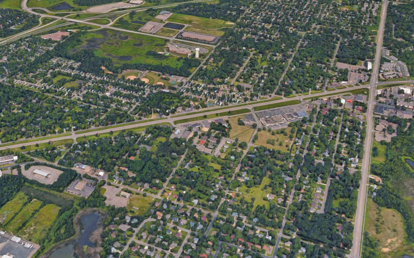
The study area for this Plan includes all lands within the current municipal limits. The City of Lexington and corresponding planning area is approximately 441 acres or 0.69 square miles in size. The City of Lexington acknowledges that the Metropolitan Council’s community designation for the City of Lexington is “Suburban” with a plan of 5 units/acre. The map below shows Lexington’s city limits/planning area, City’s community designation and the community designations of the surrounding jurisdictions.
City of Lexington, Anoka County
Metropolitan Council Growth Forecasts for Lexington through 2040
The City of Lexington is located in Anoka County, Minnesota and is a member of the Twin Cities Metropolitan Area. Lexington shares borders with the cities of Blaine and Circle Pines, Minnesota. Lexington is in a great location for residents to reside in the city and easily commute to nearby areas for work, entertainment, and trade. Lexington strives to provide a high quality of life and remain a great location to live and do business in the Twin Cities.


This section analyzes population and demographic trends for the City of Lexington. Examination of these trends provides a foundation for the planning process and implementation of the plan.
According to Metropolitan Council the City of Lexington has lost population since 1970. The city has lost approximately 7.5% of its population between 2000 - 2010. The estimated population for 2020 from the Metropolitan Council is 51 people up from 2010 at 2,100.
For the same time period the number of households in Lexington has fluctuated, with a high of 819 in 2000 and down to 787 in 2010. The Metropolitan Council projects the City will gain 33 households by 2020 for a total of 820. Household numbers are project to continue growing to 880 households in 2040.
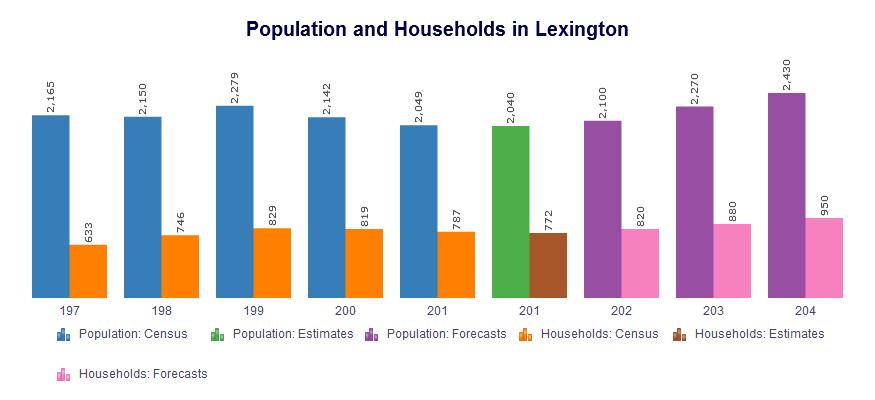
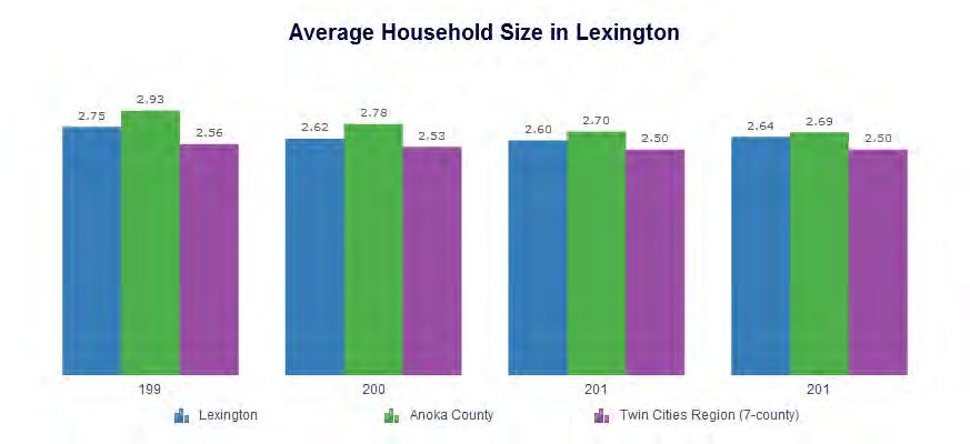
The average number of people per household in Lexington stayed steady at 2.62 in 2000 to 2.60 in 2010. Anoka County and the Twin Cities Region also saw a fairly steady average household size over this period of time. The estimated average number of people per household in Lexington for 2015 is 2.64 according to the Metropolitan Council’s estimates; a slight increase from 2010.
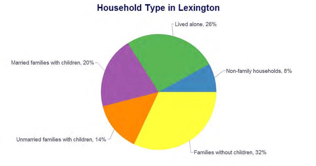
Families without children and people who live alone make up about 58% of the households in Lexington according to the Metropolitan Council and 2010 Census.
Source: Metropolitan Council and U.S. Census 2010
A majority of the people living in the City of Lexington appear to be adults less than 60 years of age and children. There is a steep drop-off in the percentage of retirement age adults which may indicate a lack of housing options for retirees.
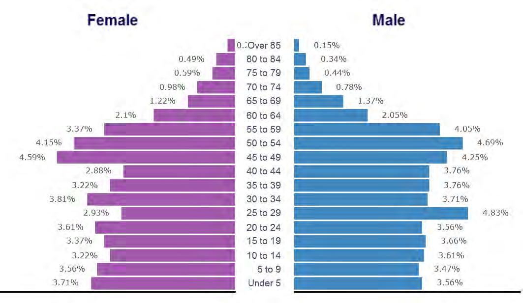
Source: Metropolitan Council and U.S. Census 2010
Education attainment data can provide insight into the quality of the existing labor force, including the availability of skilled and professional workers and the need for training opportunities. Data from the Metropolitan Council and the American Community Survey (2011-2015) show that the percentage of Lexington’s residents 25 years or older had at least a high school diploma is estimated to be 87%. Bachelor’s and graduate degree holders make up 14% of the City’s population over 25. People with a high school to associates degree account for approximately 50% of the City population over the age of 25.
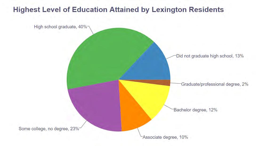
Source: Metropolitan Council and American Community Survey 2011-2015
A majority of the people in the City of Lexington identify as white, and the second largest identification is Hispanic or Latino. The community has become more diverse since 2000 and will likely continue to see a more diverse mix as the region continues to grow more diverse as a whole.
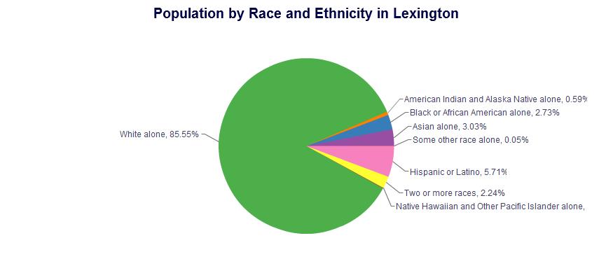
Source: Metropolitan Council and U.S. Census 2010
Appendix A Appendix B
This chapter outlines the planning process, public participation methods and a summary of all feedback.
A transparent public participation process is the foundation of a successful plan. The involvement of residents, business owners, and other stakeholders is essential to the creation and implementation of the plan. Elements of public participation for the 2040 Lexington Comprehensive Planning process included:
• Planning & Zoning Commission Meetings
• Public Workshop/SWOT Analysis
• Community Wide Survey
• City Council Meetings
• Public Open House & Hearings
The Planning and Zoning Commission served as the Steering Committee for the comprehensive plan update. The commission met several times during the planning process to review draft plan materials. All meetings were open to the public.
The goals, objectives and policies of a comprehensive plan support the community’s vision for the future of Lexington and address barriers to realizing this vision. Elements of the plan have been crafted from individual participant’s ideas, discussions and debates among committee members and the past experiences of the community as a whole.
This input allows us to construct underlying themes as a frame for the plan, and provides information on what specific issues and ideas are most important to Lexington’s citizens. This foundation ensures that the plan is not just a hollow document, but a guide for future decisions in Lexington that are in line with the community’s ideals. From this foundation, the City of Lexington will continue to grow and thrive along with the Twin Cities region as a whole.
• Project Kick-Off Meeting with City Staff
February 2017
March 2017
April 2017
May 2017
June 2017
July 2017
February 2018
March 2018
April 2018
May 2018
November 2018 - June 2019
July 2019
September 2019September 2021
October 2021
• Begin Existing Plan Review, Demographics and Exiting Conditions Analysis
• Ongoing - Begin Existing Plan Review, Demographics and Exiting Conditions Analysis
• Steering Committee/Planning & Zoning Commission Meeting #1
• Start Survey
• Launch Project Website
• Ongoing - Begin Existing Plan Review, Demographics and Exiting Conditions Analysis
• Ongoing- Online Survey
• Public Workshop - SWOT Analysis
• Steering Committee/Planning Commission Meeting #2
• Prepare Draft of Comprehensive Plan
• Steering Committee/Planning Commission Meeting #3
• Steering Committee/Planning Commission Meeting #4
• Public Workshop to Review Draft Plan
• Steering Committee/Planning Commission Meeting #5 - Review Final Draft Plan and Input from Public Workshop
• Planning Commission Review for Recommendation
• City Council Review
• Final Draft Edits
• Surrounding Jurisdiction Review
• Complete Draft of Local Watershed Management Plan
• Adjacent Jurisdiction Edits
• Required Planning Commission Public Hearing
• City Council Resolution to Submit to Met Council
• Metropolitan Review and Edits
• Metropolitan Council Approval
• City Council Approval
A project website was developed where posts and feedback were shared such as the project schedule and draft documents. It also provided a venue to share draft materials and solicit comments throughout the planning process. This aspect of the communication and participation strategy was important for transparency, and for sharing information with stakeholders who where unable to attend meetings.
A Steering Committee was established to oversee the process and ensure that the established goals and objectives were being accomplished in a timely manner. The Steering Committee, comprised of the members of the Planning & Zoning Commission, was a primary review body throughout the planning process. The Steering Committee held five meetings during the course of the planning process. These meetings were open to the public. Steering Committee presentation materials were posted on the project website for public access.
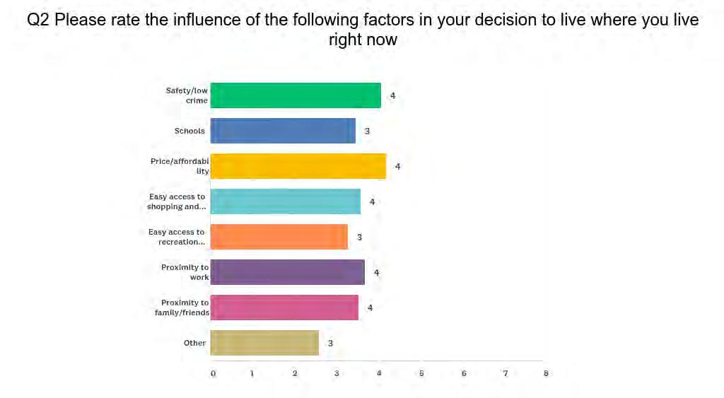
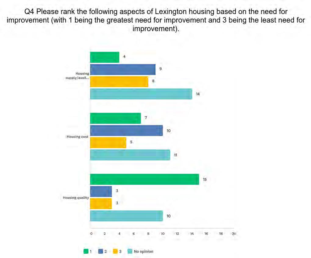
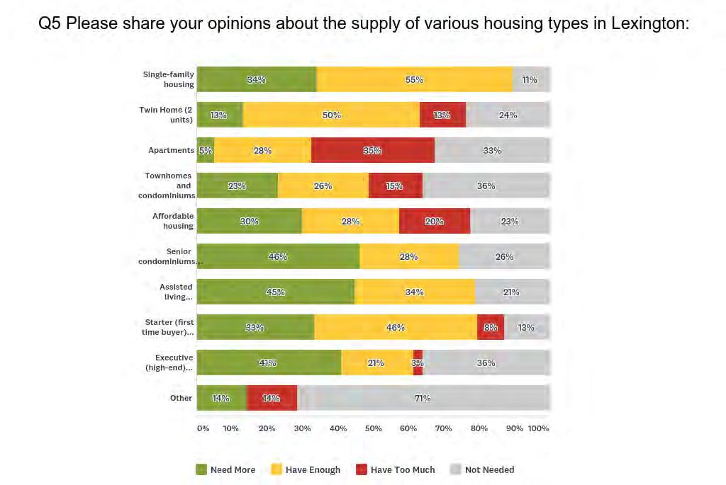
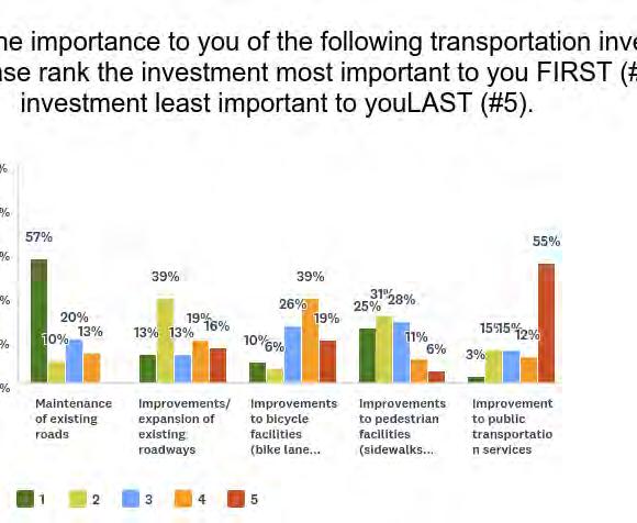
The development of a community wide survey served as an essential tool to reach those that could not attend the Public Workshop and to give individuals an anonymous platform to voice opinions and concerns. The survey was primarily online, distributed via Survey Monkey. Every household in the City was sent a postcard noticing the Public Workshop and included the address for the online survey. There were also paper copies available at City Hall for those who preferred to complete a printed survey. 44 surveys were received. There are several key questions included in this chapter and the complete results are included in Appendix B.


7:00PM to 8:00PM

Lexington City Hall
The consulting rm MSA Professional Services Inc. is working with the City of Lexington to complete all aspects of a comprehensive plan update. MSA will be facilitating a public workshop at the regularly scheduled Planning and Zoning Meeting at the Lexington City Hall 9180 Lexington Avenue on April 11th at 7:00pm. Please join us to give your input and insight regarding the City of Lexington’s future.

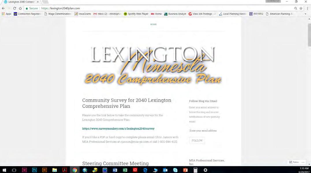
For project updates please visit the project website at: www.lexington2040plan.com Project survey is located at:

https://www.surveymonkey.com/r/lexington2040survey
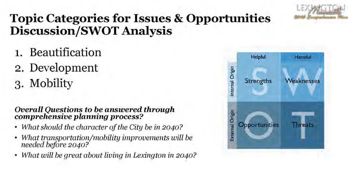
The City desires a clear vision for the futureLexington as we want it to be in 2040. A Public Workshop was held on April 11, 2017. The purpose of the meeting was to gather input on the City’s strengths, concerns and opportunities to provide direction to the comprehensive planning process. Many citizens shared their opinions on the future of Lexington.
The meeting was structured in a public workshop format and focused on three overarching topics; Beautification, Development and Mobility.
Consultants, City Staff and Steering Committee members were available to discuss topics and answer questions about the plan and planning process. Participants discussed Strengths, Weaknesses, Opportunities, and Threats (SWOT) in the various categories. The following pages provide a brief summary of the feedback and comments collected from each category.
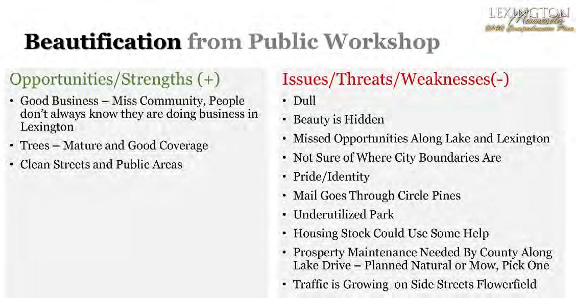
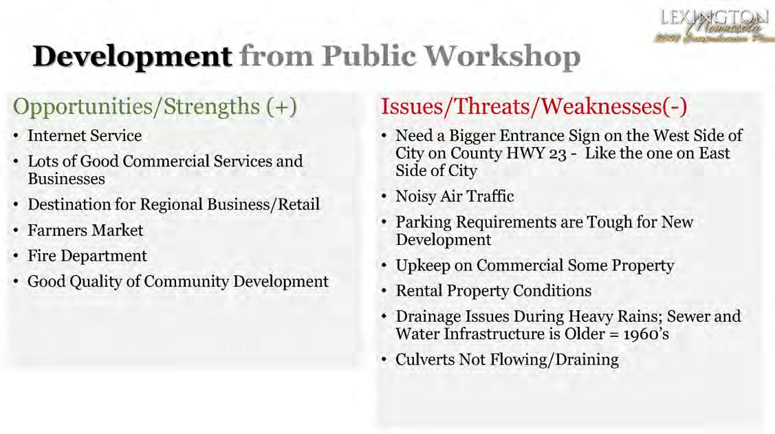
Overall, the meeting participants felt the community had good tree coverage and had clean and streets and other public areas. The community has a number of great businesses, but sometimes visitors from the region and beyond don’t know they are in Lexington and instead think they are in Blaine or Circle Pines. There were some concerns on the unkept properties, identity to visitors, and missed opportunities for aesthetic improvements along Lake and Lexington. Overall, growing traffic and regional roads designed to move traffic through the City as fast as possible have had a negative impact on the feel and safety of the community.
There are few new development opportunities in Lexington as the City is surrounded by the cities of Blaine and Circle Pines but there are great opportunities for redevelopment that need to be identified and pursued. The community has a good business climate, good internet services, is a regional destination for many and recent development have been of good quality materials that add to the character of the community.
Workshop attendees felt there needed a better entrance sign on the west side of the City on County HWY 23. The air traffic from the nearby regional airport can be an issue at times for residents and businesses. The City should look at a parking requirement, but they are sometimes tough to meet for infill developments and there are also drainage issues that arise during heaving rains. Surrounding development, in adjacent jurisdictions, has a big impact of the infrastructure of Lexington and causes issues at times.
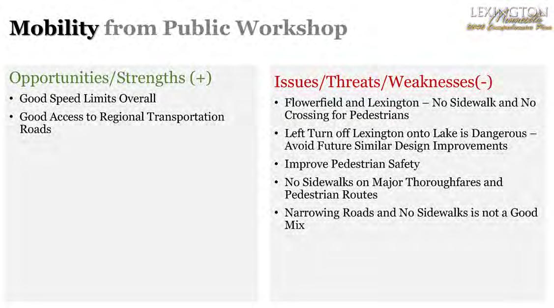
The access and close proximity to Interstate 35 and regional highways are great assets for the residents and businesses of Lexington. Speed limits across the City are at good levels and people generally drive the appropriate speeds throughout the City.
Overall there are a number of areas along Lake Drive/County HWY 23 and Lexington Avenue/ County Highway 17 where there needs to be better pedestrian/trail connections and crossing. Any redevelopment of these highways should include better pedestrian/trail connections and amenities.


A Draft Plan Open House was held at City Hall on February 13, 2018 at 7:00pm. The event was well attended and provided the consultant team and the Steering Committee with great feedback for the draft plan.
The evening started with a 20 minute presentation of the draft plan by MSA Professional Services, Inc. The presentation was followed by 20 minutes of continued review of the draft plan and maps.
Natural areas, trails, roadways, and infrastructure often cross municipal boundaries. Reviewing and collaborating with adjacent jurisdictions provides potential opportunities to work together on shared areas of importance as well as communicate on potential concerns. As part of the 2040 Comprehensive Plan process, Lexington was required to share its proposed Comprehensive Plan Update (CPU) with its adjacent and affected jurisdictions at least six months before official submittal to the Metropolitan Council (MN §473.858 Subd. 2).
The following Affected Jurisdictions were contacted by Lexington in November 2018 and any comments are included in the following pages.
From: Bill Petracek <bill.petracek@cityoflexingtonmn.org>
Sent: Wednesday, December 5, 2018 11:14 AM
To: Chris Janson
Subject: FW: 2040 Comp. Plan
Importance: High
Hey Chris!
I received these comments below from the Anoka County Transit Program Coordinator to incorporate into our 2040 Comp Plan.
Bill Petracek City Administrator
City of Lexington, MN. Direct Phone# 763-354-2805 Cell# 651-308-2576
From: Mark Schermerhorn <Mark.Schermerhorn@co.anoka.mn.us>
Sent: Wednesday, December 05, 2018 11:09 AM
To: Bill Petracek <bill.petracek@cityoflexingtonmn.org>
Cc: Meghan L. Mathson <Meghan.Mathson@co.anoka.mn.us>
Subject: 2040 Comp. Plan
Good Afternoon Mr. Petracek
My name is Mark Schermerhorn. I am the new Transit Program Coordinator with the Anoka County Transit Unit. You may remember my previous supervisor Tim Kirchoff. He retired in March and with other vacancies at the Transportation Division there was a restructuring that among other things created this position. I’ve spent 18 years in the Transit Office and thought I’d take this opportunity to introduce myself while taking a look at the Transit section of City of Lexington’s 2040 Comp. Plan. Sorry if this is late getting to you but with the changes in the office things were a little held up. In your plan I just had a couple comments.
Pg. 4‐10
It says the existing transit service was detailed in section 4.2, I think it’s 4.5?.
Other services
Anoka County Traveler Transit Link provides dial‐a‐ride service in Anoka County as well as NW Ramsey County (Arden Hills, Falcon Heights, Lauderdale, Mounds View, New Brighton, Roseville, St. Anthony, and Shoreview.). Operating hours are Monday‐Friday 6:00 a.m. to 7:00 p.m.
Anoka County Medlink formerly Anoka County Volunteer Transportation operates Monday‐Friday from 8:00 a.m. to 4:30 p.m.
Feel free to contact me if you have any questions or thoughts about:
Anoka County Traveler fixed routes
Anoka County Traveler Transit Link
Anoka County Medlink or
Anoka County Commute Solutions
I look forward to working with you.
Mark Schermerhorn Transit Program Coordinator
763 324 3108
Anokacounty.us/transit
Anoka County Transit
1440 Bunker Lake Blvd. NW
Andover, MN 55304
Transit Office 763 324 3250 Fax: 763 324 3020
NOTICE: Unless restricted by law, email correspondence to and from Anoka County government offices may be public data subject to the Minnesota Data Practices Act and/or may be disclosed to third parties.
From: Lauren Sampedro <LSampedro@ricecreek.org>
Sent: Tuesday, June 25, 2019 11:57 AM
To: Chris Janson; Steve Winter
Subject: RE: Lexington 2040 Comprehensive Plan - Request for Comments
Attachments: Draft Lexington MN Local Watershed Management Plan_LS Prelim Comments.pdf; IntercommunityFlow_20180329.pdf; Willernie CIP Table.pdf
Hi Chris,
I have completed a preliminary review of Lexington’s Local Water Management Plan. I’ve added comments on the pdf itself with recommendations or required changes. There are also a few required items that are missing from this draft, which I’ve listed below. To assist with a CIP table, I’ve attached an example from the City of Willernie to this email.
Missing Items:
1. Brief description of existing & proposed physical environment and land use (the City can include reference to the City’s Comprehensive Plan Chapter 3 Land Use for more detail).
2. Land use & zoning maps for present and future conditions (can include via reference to the City’s Comprehensive Plan Chapter 3 Land Use).
3. I previously indicated to the City that it didn’t need to address intercommunity flow rates in its plan, however recent RCWD modeling has identified an intercommunity flow rate for Lexington that will need to be included (see attached intercommunity flow table). To address RCWD’s requirements related to intercommunity flows, the City could include something similar to the following:
RCWD’s District‐wide Modeling has identified an existing point of discharge from the City of Lexington into the City of Blaine. This intercommunity flow rate is identified in Table X Through its stormwater goals and policies as well as deference to RCWD rules, the City will regulate to either maintain or reduce existing intercommunity flow rates.
Table X outlines known existing intercommunity flow rates in the City.
Lexington Blaine ARJD1 Branch 2 11 23 54 33
4. An assessment of existing and potential water resource related problems section and solutions to identified problems (I’ve provided some examples of problems to include in the attached annotated pdf)
5. Implementation Program with a CIP table (needs to meet the requirements in 8410.0160 Subp. 3.E)
6. MLCCS map or other land cover classification map
7. A link or full copy of the City’s erosion control ordinance (and floodplain ordinance if applicable)
8. Brief discussion of the City’s geological features. The City can include reference to other resources (RCWD’s WMP, Anoka County Geologic Atlas or the City’s Comprehensive Plan sections) for more detail.
9. If applicable: a discussion of any conflicts between infiltration requirements & wellhead protection (can ignore this if not applicable).
10. Discussion of the Upper Mississippi River TMDL and the City’s policies or actions to help address this TMDL
Please feel free to contact me with any questions on the above or my attached comments. Let me know if you need any assistance with addressing these items and I’ll be happy to help. We can also set up a meeting to discuss if that would be more helpful as well.
Best,
Lauren Sampedro
District Technician
Rice Creek Watershed District
4325 Pheasant Ridge Drive NE #611
Blaine, MN 55449‐4539
Direct: (763) 398‐3078
WCell: (612) 437‐6643 www.ricecreek.org

Please consider following the RCWD on Facebook.
From: Lauren Sampedro
Sent: Thursday, June 20, 2019 8:23 AM
To: Chris Janson <cjanson@msa‐ps.com>; Steve Winter <swinter@msa‐ps.com>
Subject: RE: Lexington 2040 Comprehensive Plan ‐ Request for Comments
Ok I’ll provide informal comments with my preliminary review, likely in the form of comment notes on the pdf. I’ll get them to you either this week or next week, but definitely before July.
Best,
Lauren Sampedro
District Technician
Rice Creek Watershed District
4325 Pheasant Ridge Drive NE #611
Blaine, MN 55449‐4539
Direct: (763) 398‐3078
WCell: (612) 437‐6643 www.ricecreek.org

Please consider following the RCWD on Facebook.
From: Chris Janson <cjanson@msa‐ps.com>
Sent: Thursday, June 13, 2019 6:00 PM
To: Steve Winter <swinter@msa‐ps.com>; Lauren Sampedro <LSampedro@ricecreek.org>
Subject: Re: Lexington 2040 Comprehensive Plan ‐ Request for Comments
Hi Lauren!
I'll defer to Steve but my vote is for a preliminary review. We can then make any edits you would like us to and present to the Council in July along with the Comp Plan. Then submit to MetCouncil for review.
-Chris
From: Lauren Sampedro <LSampedro@ricecreek.org>
Sent: Thursday, June 13, 2019 2:19:42 PM
To: Chris Janson; Steve Winter
Subject: RE: Lexington 2040 Comprehensive Plan ‐ Request for Comments
Hi Chris,
I apologize for my delayed response! Thank you for providing this. Is this ready for a formal review or are you looking for a preliminary review from me before a formal submittal? If this a formal submittal for review it will also need to be sent to Judy Sventek with the Metropolitan Council for their concurrent review.
Let me know and I’ll review accordingly.
Thanks!
Lauren Sampedro District Technician
Rice Creek Watershed District 4325 Pheasant Ridge Drive NE #611
Blaine, MN 55449‐4539
Direct: (763) 398‐3078
WCell: (612) 437‐6643 www.ricecreek.org
Please consider following the RCWD on Facebook.
From: Chris Janson <cjanson@msa‐ps.com>
Sent: Tuesday, June 4, 2019 4:22 PM
To: Lauren Sampedro <LSampedro@ricecreek.org>; Steve Winter <swinter@msa‐ps.com>
Subject: RE: Lexington 2040 Comprehensive Plan ‐ Request for Comments
Hey Lauren,
Thank you for checking back and attached is a draft of Lexington’s Local Watershed Management Plan. Please review and let Steve Winter and I know what thoughts, questions or edits you have for the plan.
‐Chris

Christopher Janson,
AICP
MSA Professional Services, Inc.
800.844.4122
From: Lauren Sampedro <LSampedro@ricecreek.org>
Sent: Wednesday, May 22, 2019 9:00 AM
To: Chris Janson <cjanson@msa‐ps.com>
Subject: RE: Lexington 2040 Comprehensive Plan ‐ Request for Comments
Hello Chris,
I wanted to follow up with you on the City of Lexington’s Local Water Management Plan. Do you need any assistance with the Local Water Management Plan requirements or have any questions on my comments on the City's Comp. Plan?
Please feel free to reach out if you have any questions.
Best,
Lauren Sampedro District Technician
Rice Creek Watershed District
4325 Pheasant Ridge Drive NE #611
Blaine, MN 55449‐4539
Direct: (763) 398‐3078
WCell: (612) 437‐6643 www.ricecreek.org

Please consider following the RCWD on Facebook.
From: Lauren Sampedro
Sent: Thursday, January 3, 2019 8:51 AM
To: Chris Janson <cjanson@msa-ps.com>
Cc: Phil Belfiori <PBelfiori@ricecreek.org>
Subject: RE: Lexington 2040 Comprehensive Plan - Request for Comments
Sounds good, thanks! Let me know if you need any assistance on the Local Water Management Plan.
I have finished RCWD’s review of the City’s current draft 2040 Comprehensive Plan. Please see the attached comments.
Please let me know if you have any questions.
Sincerely,
Lauren Sampedro
District Technician/Inspector Rice Creek Watershed District
4325 Pheasant Ridge Drive NE #611 Blaine, MN 55449-4539 Direct: (763) 398-3078
WCell: (612) 437-6643 www.ricecreek.org

Please consider following the RCWD on Facebook.
From: Chris Janson <cjanson@msa-ps.com>
Sent: Monday, December 17, 2018 1:40 PM
To: Lauren Sampedro <LSampedro@ricecreek.org>
Cc: Sventek, Judy <judy.sventek@metc.state.mn.us>
Subject: RE: Lexington 2040 Comprehensive Plan - Request for Comments
Lauren,
I have confirmed that the City has complete a draft (separate) watershed management plan, which needs and executive summary and then needs to be reviewed and added to the Comprehensive Plan. The City engineer has asked that I complete the summary, which I will do and then add it to the DRAFT 2040 Comprehensive Plan as an appendix as well as update some of the text and goals of the plan to address supporting the Local Watershed Management Plan.
The City has formally requested an extension for submittal of their Comprehensive Plan to May 2019 from the Metropolitan Council as they are still in the comment period for affected and surrounding jurisdictions. I will update the draft plan in the next week or so and then email you a link to the updated draft/chapters/appendix for review.
Hopefully this will work for your both and please email me with any questions.
Thanks!
-Chris
From: Chris Janson
Sent: Monday, December 17, 2018 1:11 PM
To: Lauren Sampedro <LSampedro@ricecreek.org>
Cc: Sventek, Judy <judy.sventek@metc.state.mn.us>
Subject: RE: Lexington 2040 Comprehensive Plan - Request for Comments
Hey Lauren and Judy,
I believe they are working on a separate plan and I am not sure where that is at in terms of completion and Council consideration.
I will check on this with the City Engineer and get back to you both.
Regards, Chris
From: Lauren Sampedro <LSampedro@ricecreek.org>
Sent: Friday, December 14, 2018 1:59 PM
To: Chris Janson <cjanson@msa-ps.com>
Cc: Sventek, Judy <judy.sventek@metc.state.mn.us>
Subject: RE: Lexington 2040 Comprehensive Plan - Request for Comments
Hello Chris,
Thank you for sending the City of Lexington’s proposed 2040 Comprehensive Plan. I am currently reviewing the plan and have a question for you. Is the City’s Surface Water Chapter 6.3 also serving as the City’s Local Water Management Plan?
Thank you,
Lauren Sampedro
District Technician/Inspector Rice Creek Watershed District
4325 Pheasant Ridge Drive NE #611 Blaine, MN 55449-4539
Direct: (763) 398-3078
WCell: (612) 437-6643 www.ricecreek.org

Please consider following the RCWD on Facebook.
From: Chris Janson <cjanson@msa-ps.com>
Sent: Wednesday, November 21, 2018 12:57 PM
To: dbugge@blainemn.gov; pantonen@ci.circle-pines.mn.us; nyle.zikmund@moundsviewmn.org;
jerry.soma@co.anoka.mn.us; Bdietz@isd12.org; Phil Belfiori <PBelfiori@ricecreek.org>; Karen.Blaska@co.anoka.mn.us; metrodevreviews.dot@state.mn.us; martha.vickery@state.mn.us; Bridget.Rief@mspmac.org
Subject: Lexington 2040 Comprehensive Plan - Request for Comments
Hello,
The City of Lexington recently finished a draft of our proposed 2040 Comprehensive Plan. The City of Lexington has put a great deal of effort into an outreach campaign as part of the planning process. Our outreach campaign includes requesting your comments on this important plan as a Metropolitan Council designated “Affected Jurisdiction”. Please visit the site below to review the plan and provide comments electronically with the Survey Monkey link below.
Thank you in advance for your time!
Please follow the link below to view the plan and provide Comment: https://www.surveymonkey.com/r/lexington2040review
-Chris

Christopher Janson, AICP
MSA Professional Services, Inc.
800.844.4122

Parks and Recreation Office
763-324-3300
Park Maintenance
763-324-3326
Park Services
763-324-3425
Natural Resources
763-324-3413
Bunker Beach Water Park
763-324-3310
Chomonix Golf Course
763-324-3434
Wargo Nature Center
763-324-3350
January 7, 2019
Mr. Bill Petracek, City Administrator City of Lexington 9180 Lexington Avenue Lexington, MN 55014
RE: Anoka County comments on the City of Lexington’s 2040 Comprehensive Plan Update
Dear Mr. Petracek:
Thank you for providing the County of Anoka an opportunity to comment on the City of Lexington’s draft 2040 Comprehensive Plan Update. You should have already received comments from the County Highway Department and Transit Department regarding your plan. The following comments are from a variety of different departments within the County.
Community Development:
The Anoka County Community Development Department has reviewed your comprehensive plan and supports your housing and economic development plans. The Department has no additional comments to provide related to your Comprehensive Plan.
Regional Parks and Trails:
The Anoka County Parks Department has reviewed your comprehensive plan and supports your parks and trails plans. The Department has no additional comments to provide related to your Comprehensive Plan.
Public Health and Environmental Services:
The Anoka County Public Health and Environmental Services Department offers the following comments regarding the draft City of Anoka 2040 Comprehensive Plan to provide additional (possibly alternative) planning views that may enhance their plan.
Chapter 6
The Plan references the City of Lexington as a member of the Anoka County Municipal Wellhead Planning Group that was established in 1997 (emphasis added). That joint powers organization was formed for the purpose of member communities to collaborate in the preparation of their wellhead protection plans. In 2010 the ten communities completed their wellhead plans. The "planning" joint power agreement (JPA) between member communities was terminated according to the conditions of the agreement.
Anoka County comments on the City of Lexington’s 2040 Comprehensive Plan Update
In 2011, Lexington and 7 communities established the Anoka County Municipal Wellhead Protection Group to jointly implement common elements of its wellhead protection plans in a coordinated and cost effective manner.
Unlike the 1997 planning JPA, the 2011 protection (implementation) JPA does not establish the termination of the agreement with the exception that each community may end their participation by notifying the members.
We Recommend (#1): that reference to the current Anoka County Municipal Wellhead Planning Group be replaced with Anoka County Municipal Wellhead Protection Group.
Page 6-16: "The Minnesota Department of Health has developed a ranking program to phase public water supply systems into the wellhead protection program. Part 1 has been completed at this time. The City of Lexington will complete Part II . The ranking program is based on the number and vulnerability of wells in a system and the population served. Lexington has been assigned a Tier 5 classification, meaning that its wells are not particularly susceptible to contamination. The City’s ranking was originally established at 1,071 out of 1,586 community and non-transient, noncommunity water systems in Minnesota. However, because of the construction of new wells and systems in other cities, the City’s ranking has moved to 1,036."
“... The City expects to continue its cooperative efforts with the Anoka County Municipal Wellhead Planning Group and the Department of Health in completing all components of its wellhead protection program. The deadline for completing the wellhead protection plan is February 12, 2003 as determined by the Department of Health.”
Discussion of the MDH system of phasing Lexington into the initial wellhead protection planning process is not current. Lexington has completed its initial wellhead protection plan that is reaching its ten-year implementation period at which point community water suppliers usually must update their plans. The City is eligible to have its plan extended for ten (10) years due to the MDH determination that the City well is not vulnerable based on the MDH assessment.
After the completion of wellhead protection plans by Lexington and the cooperating community water suppliers, a new joint powers organization was formed (Anoka County Municipal Wellhead Protection Group) to jointly implement the common elements of their plans.
We Recommend (#2): that. the discussion of the MDH ranking and phasing of Lexington into the MDH Wellhead Protection planning process be replaced with a simple statement that Lexington completed its Wellhead protection plan. Also, discussion of updating the approved Wellhead Plan - through ten-year an extension of the current plan.
We Recommend (#3): that. the discussion of the February 12, 2013 be removed. The statement that the City expects to continue cooperative efforts should be replaced with a statement that Lexington and other communities have established a new joint powers organization (the Anoka County Municipal Wellhead Protection Group) to implement common elements of their wellhead plans in a coordinated and efficient manner.
Anoka County comments on the City of Lexington’s 2040 Comprehensive Plan Update
Thank you again for providing the County an opportunity to comment on your City’s Comprehensive Plan. Please review the County’s comments and feel free to contact me with any questions you may have. I can be reached at 763-324-3412 or karen.blaska@co.anoka.mn.us.
Sincerely,

Karen Blaska Park Planner
cc (by email): Jerry Soma, County Administrator
Jeff Perry, Parks Director
Doug Fischer, Transportation Division Manager
Karen Skepper, Director of Community and Government Relations
Dan Disrud, Manager of Environmental Services
Jack Forslund, Transportation Planner
Renee Sande, Community Development Manager
Bart Biernat, Environmental Health Specialist
Mark Schermerhorn, Transit Program Coordinator
Meghan Mathson, TMO Coordinator
Chris Janson
From: Elvin, David (DOT) <David.Elvin@state.mn.us>
Sent: Thursday, December 20, 2018 9:17 AM
To: bplexington@comcast.net
Cc: Sherman, Tod (DOT); Scheffing, Karen (DOT); Muhic, P Cameron (DOT); Barnes, Melissa (DOT); Roup, Ashley (DOT); Parzyck, Rebecca (DOT); Olson, Nicholas (DOT); Rones, Jeffrey (DOT); Craig, E (DOT); Jensen, Carl P (DOT); Chris Janson
Subject: MnDOT review of Lexington 2040 Comp Plan CPA18-096
Dear Mr. Petrecek,
MnDOT has reviewed the Draft Lexington 2040 Comprehensive Plan update and has no comments. Thank you for the opportunity to review, and please contact me with any questions.
Best,
David Elvin, Senior Planner MnDOT Metro District Planning, Program Management, and Transit 1500 West County Road B‐2, Roseville MN 55113 651‐234‐7795

The Metropolitan Council develops forecasts of when, where and how much population, household and job growth the region and its communities can expect. They update the 30-year regional and local forecasts at least once per decade.
The regional forecast looks at the seven-county region’s position within the larger, national economy. The region’s business conditions and competitive advantages determine economic and employment levels which, in turn, drive population growth by attracting people to the Twin Cities.
Once the regional forecast is complete, additional land use modeling locates future population, households and employment to specific communities within the region. The Metropolitan Council’s model looks at how demographics, regional policies, and available land affect real estate supply and demand.
Modeling only takes our forecasts so far. Working with local governments and planners to incorporate their on-the-ground knowledge about local development to adjust our forecast results is the next important step in the process.
The Metropolitan Council has developed policies related to the orderly and efficient use of land for the 7-county metropolitan area and identified 10 different community designations for land use policy across the region. Lexington, being an established and developed suburban community has been designated by the Metropolitan Council to be “Suburban” for the 30 year planning period.
The Metropolitan Council has established the following policies for the Community of Lexington to follow regarding land use planning based on this determination:
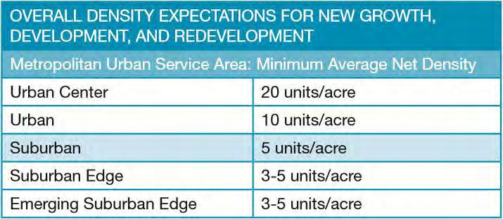
• Plan for forecasted population and household growth at overall average densities of at least 5 units per acre, and target opportunities for more intensive development near regional transit investments at densities and in a manner articulated in the 2040 Transportation Policy Plan.
• Identify areas for redevelopment, particularly areas that are well-served by transportation options and nearby amenities and that contribute to better proximity between jobs and housing.
• In collaboration with other regional partners, lead major redevelopment efforts.
• Lead detailed land use planning efforts around regional transit stations and other regional investments.
• Plan for and program local infrastructure needs (for example, roads, sidewalks, sewer, water, and surface water), including those needed to accommodate future growth and implement local comprehensive plans.
Source: Metropolitan Council
Source: Metropolitan Council
Additionally, the City Council’s Role is to do the following:
• Maintain and improve regional infrastructure to support adaptive reuse, infill development, and redevelopment.
• Support local planning and implementation efforts to target growth in and around regional transit as articulated in the 2040 Transportation Policy Plan.
• Coordinate regional infrastructure and program funding with other efforts designed to mitigate Areas of Concentrated Poverty and Racially Concentrated Areas of Poverty and better connect the residents of these areas with opportunity.
• Provide technical assistance to communities undertaking planning efforts around regional transit stations and other regional investments.
• Partner with local communities to improve land use patterns to reduce the generation of carbon emissions.
There are many unique uses of land across Lexington, and many more ways to configure those uses. It is the City’s responsibility to regulate where and how development occurs through planning and zoning regulations so that conflicts between incompatible use is minimized, and so that land and infrastructure are used as efficiently as possible.


Source: Metropolitan Council
As Lexington continues to grow through redevelopment, thoughtful land use planning is critical to keep the community a pleasant, attractive place to live, work, and play. This chapter features goals, objectives, and policies that apply to land use in general. It also contains strategies and guidelines for specific types of land use and their location within the City.
Most of the City’s residential area was developed in a grid iron layout. However, these blocks were designed to be large enough to potentially accommodate additional subdivision in the future. As a result, there is a diversity of housing types and lot sizes in the community. Some larger blocks have been entirely or partially split.
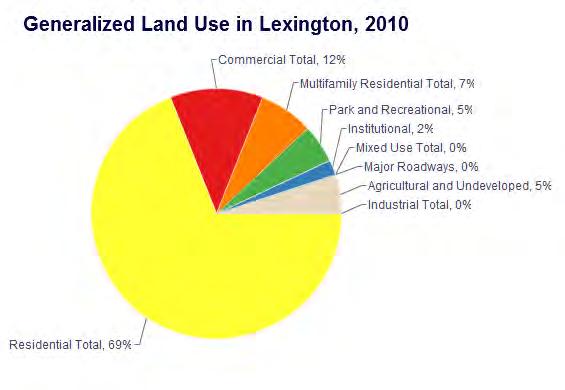
2016 Generalized Land Use
These include blocks that include Jackson Avenue in the southeast and Ryan Place in the center of the community. Subdivision has also occurred along the side streets of large blocks, where road access was immediately available. Jackson Avenue was extended in 2004. The street extension with a culde-sac services ten twin homes that were built on the west side of Jackson Avenue.
The map to the right shows the City’s existing land uses. The Lexington planning area includes the current municipal limits, which encompasses approximately 441 acres. The majority of the City is currently comprised of Single Family Detached Residential (65%). Other prominent land uses in the City are Retail and Commercial (11%), Single Family Attached Residential (6%), and a Manufactured Housing Park (4%). Only 5% of land inside the City Limits is currently undeveloped. Refer to Appendix A for full size maps of existing and future land uses and development limitations.

The City has established a set of goals and policies for land use planning and development to help guide the community, particularly with regard to roles and responsibilities of the City government.
These are official statements that reflect, to the degree possible, mutual goals of all participants in the planning process. They represent desired outcomes or conditions related to the physical, natural, and economic characteristics of the community.
• Maintain distinct land use districts that minimize the conflict between residential and commercial/ industrial areas.
• Maintain strong residential neighborhoods that build upon their existing character.
• Support commercial development that creates and maintains nodes and corridors of vibrant commercial activity.
• Create and maintain a cohesive commercial “identity” or “character” for the City’s commercial area(s).
• Create a landscape, open space, and recreational facility plan for the City.
Polices are specific, official positions of the City that guide day-to-day planning, administration and implementation strategies such as capital improvements, zoning and other official controls.
• Identify and target specific areas of the community that are appropriate for new housing and commercial opportunities, including infill and redevelopment.
• Require vegetative or other type of screening, when appropriate, to mitigate negative impacts on uses in adjacent land use districts.
• Require landscaping along all public rightsof-ways for all commercial uses.
• Maintain sign regulations compatible with the goal of developing a cohesive and aesthetically pleasing commercial area.
• Prioritize and assist development in the City’s commercial areas.
• Investigate public improvements to improve safe pedestrian access within and between neighborhoods and commercial areas.
The Future Land Use Map (opposite) identifies categories of similar use, character and density. These categories are described in the subsequent pages, including explanation of the City’s intent, design and development strategies for each.
This map, and the corresponding text, are to be consulted whenever development is proposed. Development shall be consistent with the use category shown on the map and the corresponding text.
Where uses in this map differ from the current use, it is not the general intent of the City to compel a change in use. Except in rare instances when the City may actively facilitate redevelopment of a priority site, the City’s use of this map will be only reactive, guiding response to proposals submitted by property owners.
It may, from time to time, be appropriate to consider amendments to the Future Land Use Map. The following criteria should be considered before amending the map.
The proposed development, or map amendment, will not have a substantial adverse effect upon adjacent property or the character of the area, with a particular emphasis on existing residential neighborhoods. A petitioner may indicate approaches that will minimize incompatibilities between uses.
The land does not include important natural features such as wetlands, floodplains, steep slopes, scenic vistas or significant woodlands, which will be adversely affected by the proposed development. The proposed building envelope is
not located within the setback of floodplain zones (raised above regional flood line). The proposed development will not result in undue water, air, light, or noise pollution. Petitioner may indicate approaches that will preserve or enhance the most important and sensitive natural features of the proposed site.
The lay of the land will allow for construction of appropriate roads and/or driveways that are suitable for travel or access by emergency vehicles.
Provision of public facilities and services will not place an unreasonable financial burden on the City. Petitioners may demonstrate to the City that the current level of services in the City, or region, including but not limited to school capacity, transportation system capacity, emergency services capacity (police, fire, EMS), parks and recreation, storm water, library services, and potentially water and/or sewer services, are adequate to serve the proposed use. Petitioners may also demonstrate how they will assist the City with any shortcomings in public services or facilities.
There is a clear public need for the proposed change or unanticipated circumstances have resulted in a need for the change. The proposed development is likely to have a positive fiscal or social impact on the City.
The proposed development is consistent with the general vision for the City, and the other goals and policies of this plan.
If your community changes any part of your adopted comprehensive plan, you must submit the comprehensive plan amendment to the Council for review. Communities amend their comprehensive plans for various reasons, such as:
• Changes resulting from neighborhood or small area planning activities
• Land use changes to allow a proposed development
• Proposed forecast changes or proposed MUSA changes in service or staging
• Text changes to revise a policy or land use category
• Routine updates to incorporate new information or update a public facilities element
Before submitting a comprehensive plan amendment to the Council for review, you must take the following steps:
• Planning Commission recommendation for approval by the governing body.
• Local governing body authorization for the amendment to be submitted for Metropolitan Council review.
• Adjacent governmental units and affected school districts review.
For more assistance contact the Metropolitan Council.


The City can create a “vision” for how a community will grow and change by officially designating future uses of land. This is a basic comprehensive planning requirement that forms the basis for regulations such as the zoning and subdivision ordinances. These designations inform individuals and investors as to what policies, regulations and plans the City may implement over time. Designations can also minimize costs and risks to both individuals and the City. This is because the City can adequately plan for investments in infrastructure, programs, and services. Although no individual landowner or resident can expect to use their land for any or all purposes, each landowner will be able to use their property for “reasonable” economic purposes. This is based upon a number of factors, including, but not limited to, the following:
• Household and employment growth trends.
• Encouraging economic activity in the community.
• Encouraging reinvestment and redevelopment in the community.
• Protecting residential uses from the negative effects of commerce and industry, including noise and pollution.
• Prior use or prior development rights of the property.
• Minimizing future City expenses. The five categories designated on the Future Land Use Map are:
• LDR - Low Density Residential
• MDR - Medium Density Residential
• HDR - High Density Residential
• CRD - Commercial Redevelopment Districts
• PR - Parks and Open Spaces
• CBD - Commercial Business District
The majority of the land area in the City will be designated as Low Density Residential. This includes three distinct areas of the community: north of Lake Drive/north of Restwood; between Restwood Avenue, Naples Street and Lake Drive in the southwest corner of the community; and south of Lake Drive. Most uses in this area should remain as low density residential, including single-family homes and two-family homes. Zoning districts should reflect the general character of each area, ranging from approximately 3 to 5 units per acre.
Other uses in this area should be limited to those that are amenities to residential areas or that is similar in use and character as residential areas. These may include small childcare facilities in residential homes, small residential group homes, or neighborhood parks. Uses such as churches and home occupations would be allowed under conditions that are articulated in the City’s Zoning Code.

This land use designation is limited to the existing manufactured home park. This area provides low-cost home ownership opportunities for a large number of residents. The City will allow from 5 to a maximum of 10 residential units per acre. This area will likely remain as manufactured housing, but future uses of land could include other types of medium density housing. Other planning considerations with regard to this area may include:
• Consideration of the relationship with surrounding areas.
• Consideration of the location of park, recreational and open space resources relative to these areas.
• Ensuring enforcement of City codes in these areas to protect residents and surrounding investments.
• Identification of programs and services to meet any special needs of residents of these areas, including youth and seniors.
High Density residential uses, which include multi-story residential buildings, provide opportunities as well as challenges for the City. Due to the high level of activity associated with such uses, they should be located in areas where the infrastructure is sufficient for parking and circulation.
Multiple-family residential uses meet the housing needs for a significant number of residents, including young adults, single individuals, seniors, or families of modest means. Residents may also appreciate the convenience or value of multiple-family housing. Residents may also have limited transportation options; therefore, these areas are close to goods, services and transportation services. This strategy also provides a transition in scale between low-density residential areas and commercial areas.
The City will allow from 10 units to a maximum of 20 residential units per acre in this area. Higher density developments have been recently approved by the City that exceed 20 units per acres utilizing Planned Unit Development zoning procedures. Other planning considerations for highdensity residential areas may include the following:
• Consideration of the relationship of high-density residential buildings with surrounding areas.
• Providing sidewalks in busy areas to provide safety for pedestrians and to connect residents with commercial areas.
• Consideration of the location of park, recreational and open space resources relative to these areas.
• Ensuring enforcement of building codes and other City codes in these areas to protect residents and surrounding investments.
• Identification of programs and services to meet any special needs of residents of these areas, including youth and seniors.
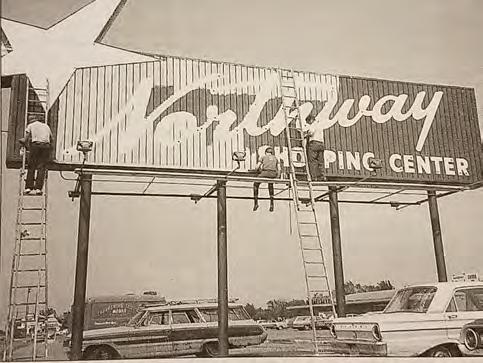
The shopping district along Lake Drive is an important part of the City of Lexington. It is, in effect, the community’s “downtown”. Northway Shopping Center and other commercial establishments along Lexington and Lake Drive provide important goods and services, as well as jobs, for the area. The City wishes to strengthen the long-term commercial viability and desirability of this area as a retail hub; and the City is willing to assist with planning and implementation of development or redevelopment that contributes to the vitality of the area.
The City wishes to encourage a range of activity and services where the whole will be greater than the sum of its parts. The general “vision” for this area includes the following ideas:
• A mix of office, retail, entertainment-oriented, and institutional uses.
• Uses that have a high job “density” and which strengthen local employment opportunity.
• Uses that provide a range of goods and services.
• Development and redevelopment that contributes to a downtown character or “sense of place”.
• Development and redevelopment that maximizes the use of limited space.
• Green spaces, including those that buffer adjacent residential uses.
The Commercial Redevelopment Districts represent areas that the City feels should be targeted for redevelopment for the health, safety and welfare of the community. The community could benefit greatly from new commercial uses in these areas if they are appropriately planned and designed. These areas will be planned to accommodate primarily highway-oriented and service uses. Detailed requirements for these districts will be outlined in City ordinances, which would be addressed in redevelopment proposals. Residential zoning or mixed use concepts shall not be considered in conflict with this land use designation; and the City may choose to maintain residential zoning until a redevelopment proposal meets criteria outlined in City ordinances. The following principals guide the establishment of this designation:
• Lack of buffering between residential and commercial uses.
• Highway access conflicts or lack of service/frontage road.
• Unusual or inefficient configuration of lots for commercial uses.
• Poor physical condition and appearance of structures.
• Lack of conformance with City regulations.
• High visibility of area from roadways with large volumes of traffic.
• Large enough area to make redevelopment attractive.


Residents of the City of Lexington have access to recreational and open space resources both within the City and within the immediate area. The City plans to maintain and enhance Lexington Memorial Park for the future enjoyment of community residents, explore new park resources, and create trails when opportunities arise. The existing “Tot Park” is located adjacent to vacant land in the Central Business District. The City may wish to negotiate with the owners of the adjacent vacant property when these owners are ready to develop this land. It may become appropriate to do one of the following:
• Trade land with owners for better park/playground land somewhere else south of Lake Drive.
• Incorporate land into development in exchange for new open space/ playground within development.
While there are not any existing or planned regional park or trail facilities as identified in the 2040 Regional Parks Policy Plan within the City, the City is within close proximity to regional park facilities and trails. The Rice Creek Chain of Lakes Regional Park is located in the adjacent communities of Circle Pines and Lino Lakes. Anoka County regional trail, “East Anoka County Regional Trail”, was built along Lexington Avenue at the time Lexington Avenue was re-constructed. The trail connects with the Rice Creek Regional Trail. Due to the City’s concern about the acquisition of additional right-of-way from residential property owners along this busy street, the City thought it was in the best interest of property owners to decline the trail. The cities of Circle Pines and Blaine constructed trails on the eastern side of Lexington Avenue.
The City has identified potential trail corridors within its City limits. These trails emphasize connection between parts of the community rather than recreation. Areas include Lexington Memorial Park, higher density residential areas and along commercial areas. Trails may become possible as a result of requirements for development and redevelopment, reconstruction of roadways, and expenditures of park and recreation funds.
Undeveloped area are parcels/properties that have no existing structures on them, are not accessory to a nearby structure, and are not designated as open space, park or right-of-way.
Right-of-way is undevelopable area that allows legal right of passage, access and transmission.

According to the Metropolitan Council in 2020 there is an estimated 820 housing units and 266 acres of developed residential area in Lexington. Based on these estimates the current density of housing development in Lexington is approximately 3.078 housing units per acre. Lexington is predicted to have 950 households in 2040 and 280 acres of developed housing. Based on these estimates the 2040 estimated net density will be approximately 3.392 housing units per acre. This projected net density is higher than the current estimate of 3.078.
Estimated Net Density (Total Residential Acres/Households)
The table below reflects net developable acres guided for residential development and that are intended for urban services by planning period. The table also reflects the projected units that could be supported using the minimum density allowed within each land use category. This projection slightly exceeds the Metropolitan Council’s forecasts and shows that there is land available to support the Metropolitan Councils forecasts.
Projecting new residential growth and the potential affordability of that growth is a required and important part of Lexington’s future land use planning for 2040. The two tables at the bottom of this page explore the potential affordability of projected new residential growth in Lexington from 2021 - 2030 and from 2031 - 2040. The regional total need for affordable housing for 2021 – 2030 is 37,900 units. Lexington’s 2021 – 2030 allocation of need is 14 units, as show to the in the chart to the left.
Based on the target density ranges, net developable acres and calculations in the tables below Lexington has developed a future land use plan that provides the potential to greatly exceed the required minimum 14 affordable housing units. Lexington has the potential to attract an estimated 137 to 274 affordable housing units through 2030.
The Low Density Residential areas are intended for housing with densities that range from 3 to 5 units per acre. Neighborhood areas classified as LDR will typically be predominately single-family homes.
LDR-1: Urban services will be required for all new development, including municipal water, wastewater, and stormwater management systems.
LDR-2: Though low density housing is the predominant use in most neighborhoods, healthy, balanced neighborhoods may also include other uses that support the needs of residents, including:
• Parks and recreational facilities
• Small municipal and institutional facilities (e.g. learning center, library, fire station, etc.)
• Community centers
• Places of worship
LDR-3: Infill development will protect the character of existing residential neighborhoods. Where possible, infill development should be single-family homes and should be built within areas that are already zoned and compatible for this type of residential use.
The City encourages residential projects (new construction and remodeling) to incorporate design strategies that will maintain neighborhood property values over time and enhance the social function and safety of the neighborhood.
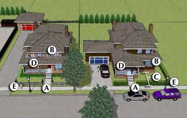
Relationship to the Street: Buildings and sites should be designed to establish visual and physical connections between the public realm of the street and the private realm of the home, with layers of increasingly private space in between.
Consider the following techniques (see side bar):
A) The front door should face the street and there should be a clear route to the door from the street or sidewalk.
B) There should be windows on the street facade
C) Building setbacks will vary according to building type and lot size, but should generally not exceed 30 feet.
D) Incorporate a covered front porch, or at least a raised stoop, preferably covered.
E) When appropriate for the style of the area, utilize low fences, hedges, or other landscaping to establish a layer of privacy behind the sidewalk.
Relationship among buildings: Buildings within a neighborhood should be both cohesive and varied.
Consider the following techniques:
A) Homes along a street should utilize similar setbacks to establish a consistent “street wall”.
B) Home sizes may vary along a street, but should utilize design techniques such as similar roof line heights and deeper setbacks for portions of wider houses to minimize apparent size variations.
C) The mix of architectural themes or styles should generally be consistent within a neighborhood, but repeated use of identical floor plans or colors is strongly discouraged, especially for adjacent buildings.
Remodeling and Additions: Changes and additions to existing structures should complement the design of the existing structure.
Consider the following techniques:
A) Select window types and proportions that match the rest of the house.
B) New exterior materials should match, or be complementary, to existing materials.
C) Avoid enclosing covered porches, when possible. If enclosing a covered porch, maintain the appearance of a porch, rather than attempting to blend the porch seamlessly with the rest of the house.
Garages: Two to three stall garages are encouraged in all residential zones.
Landscaping: Provide generous landscaping, with an emphasis on native plant species.
Lighting: Exterior lights should be full-cutoff fixtures that are directed to the ground to minimize glare, light trespass and light pollution (see side bar). Limited up-lighting is acceptable for architectural accentuation, flag lighting, and to highlight key civic features (e.g. church steeples).


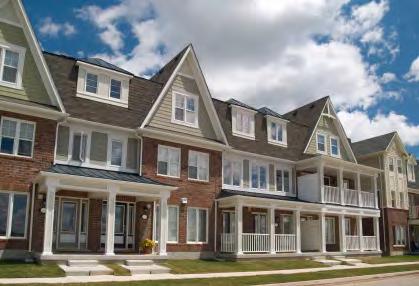
Medium Density Residential areas are intended for housing at densities not to exceed 10 living units per acre. Uses in this category include single-family attached duplexes/twinhomes, townhouses, row houses, small apartment buildings, and senior housing.
MDR-1: MDR could be an alternative for someone that wants to own but needs to meet a lower price point than new detached housing stock.
MDR-2: MDR uses are an appropriate transition use between commercial areas and Low Density Residential areas.
MDR-3: Multi-family residential units are scattered throughout the City. This type of housing provides an alternative dwelling unit for those who are not interested in purchasing a home in Lexington. Multi-family development has occurred throughout the City of Lexington.
The City encourages residential projects (new construction and remodeling) to incorporate design strategies that will maintain neighborhood property values over time and enhance the social function and safety of the neighborhood.
Relationship to the Street: Buildings and sites should be designed to establish visual and physical connections between the public realm of the street and the private realm of the building, with layers of increasingly private space in between.
Consider the following techniques (see side bar):
A) The front door should face the street and there should be a clear route to the door from the street or sidewalk.
B) There should be windows on the street facade
C) Building setbacks will vary according to building type and lot size.
Relationship among buildings: Buildings within a neighborhood, or within a single development, should be both cohesive and varied.
Consider the following techniques:
A) When adjacent to lower density residential buildings, larger buildings should incorporate strategies to minimize the apparent size of the building, including flat roofs instead of pitched roofs, deeper setbacks for upper stories, and/or variation in the depth of setback along the building facade.
B) The mix of architectural themes or styles should generally be consistent within a neighborhood or development, but there should be variation in floor plan, facade design, and color choice to avoid monotony.
Garages: Two stall garages are encouraged in all residential zones.
Landscaping: Provide generous landscaping, with an emphasis on native plant species.
Lighting: Exterior lights should be full-cutoff fixtures that are directed to the ground to minimize glare, light trespass and light pollution. Limited up-lighting is acceptable for architectural accentuation, flag lighting, and to highlight key civic features (e.g. church steeples).
Common Open Space: Provide gardens, grass areas, and playgrounds to serve the needs of residents.
Service Areas: Trash and recycling containers located or screened so that they are not visible from a public street. Screening should be compatible with building architecture and other site features (see side bar).
City of Lexington 2040


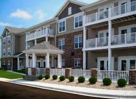
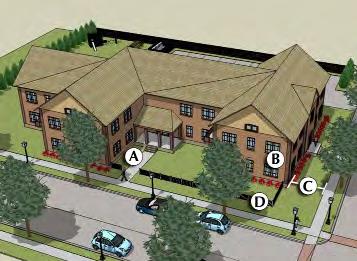
Higher Density Residential areas are intended for housing at densities exceeding 10 living units per acre. Uses in this category include apartment buildings and senior housing.
HDR-1: HDR uses will generally be located where there is access to bike trails and a pedestrian network.
HDR-2: HDR uses will generally be located where there is convenient access to restaurants, retail and service businesses.
HDR-3: HDR uses are an appropriate transition use between commercial areas and Medium Density Residential areas.
The City encourages residential projects (new construction and remodeling) to incorporate design strategies that will maintain neighborhood property values over time and enhance the social function and safety of the neighborhood. The following strategies apply mostly to multi-family formats.
Relationship to the street: Buildings and sites should be designed to establish visual and physical connections between the public realm of the street and the private realm of the building, with layers of increasingly private space in between.
Consider the following techniques (see side bar):
A) The front door should face the street and there should be a clear route to the door from the street or sidewalk.
B) There should be windows on the street facade
C) Building setbacks will vary according to building type and lot size.
Relationship among buildings: Buildings within a neighborhood, or within a single development, should be both cohesive and varied.
Consider the following techniques:
A) When adjacent to lower density residential buildings, larger buildings should incorporate strategies to minimize the apparent size of the building, including flat roofs instead of pitched roofs, deeper setbacks for upper stories, and/or variation in the depth of setback along the building facade.
B) The mix of architectural themes or styles should generally be consistent within a neighborhood or development, but there should be variation in floor plan, facade design, and color choice to avoid monotony.
Landscaping: Provide generous landscaping, with an emphasis on native plant species.
Lighting: Exterior lights should be full-cutoff fixtures that are directed to the ground to minimize glare, light trespass and light pollution. Limited up-lighting is acceptable for architectural accentuation, flag lighting, and to highlight key civic features (e.g. church steeples).
Common Open Space: Provide gardens, grass areas, and playgrounds to serve the needs of residents.
Service Areas: Trash and recycling containers, street-level mechanical, rooftop mechanical, and outdoor storage, should be located or screened so that they are not visible from a public street. Screening should be compatible with building architecture and other site features. (see side bar).


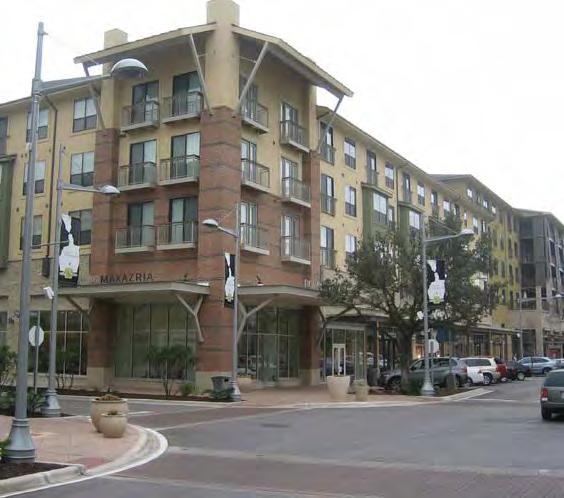
Commercial areas are intended for retail, service, and office uses that serve neighborhood, community and regional markets. Examples include large retail and service businesses, offices, clinics and health care facilities, hotels, restaurants and entertainment businesses, storage, and automobile sales and services. The type and size of use will be determined by location and market forces.
C-1: Commercial areas should generally be served by a contiguous sidewalk network, and safe bike routes.
C-2: The City encourages and supports investment in small neighborhood commercial uses and sites in existing neighborhoods. Sites deemed no longer viable for commercial use should be considered for redevelopment with housing.
C-3: Way-finding signage to key downtown locations is critical, especially for visitors. The City will develop a signage system from primary downtown entry points to key locations throughout the community.
C-4: Highway commercial use is typically characterized by grocery stores, car lots, convenience stores and other commercial uses that require efficient highway infrastructure and adequate space for parking a significant amount of vehicles.
The City encourages the use of design strategies that will maintain property values over time for all commercial projects. This section offers different strategies for highway settings and neighborhood settings in some categories.
Relationship to the Street: The building should be designed such that the primary building facade
is oriented towards the street (toward the larger street on corner lots) and should have a public entrance.
Architectural Character: The building should be designed using architectural elements that provide visual interest and a human scale that relates to the surrounding neighborhood context. For commercially zoned districts in the neighborhood City clusters or the City Town Center, new development shall be compatible with height and scale of surrounding buildings and present a two-story facade appearance.
Building Materials: The building should be constructed of high quality, long lasting finish materials, especially along prominent facades with frequent customer traffic.
Building Projections: Canopies, awnings, and/or gable-roof projections should be provided along facades that give access to the building. (see side bar)
Signs: Signs should be not larger or taller than necessary based on the context of the site. Signs are subject to the sign ordinance and all permanent signs require a permit.
Highway Commercial: Desired sign types include building-mounted, monument. Signs are subject to the sign ordinance and all permanent signs require a permit.
Neighborhood Commercial: desired sign types include building-mounted, window, projecting, monument and awning.
Parking: Front yard parking should be limited; side yard, rear yard, or below building alternatives are preferred. Shared parking and access between properties is encouraged to minimize curb cuts and make more efficient use of land and paved surfaces. Landscaping and trees should be incorporated into all surface parking areas to improve aesthetic and environmental
performance. Vegetative buffers should be provided between pedestrian circulation routes and vehicular parking/circulation. Access drive lanes should be separated from parking stalls to reduce congestion. (see side bar)
Landscaping: Generous landscaping should be provided with an emphasis on native plant species. Landscaping should be placed along street frontages, between incompatible land uses, along parking areas, and in islands of larger parking lots. Use trees and low bushes in and around parking areas to partially obscure views of parking while retaining visual connections to maintain personal safety. (see side bar)
Lighting: Exterior lights should be full-cut-off fixtures that are directed to the ground to minimize glare and light pollution, and especially to avoid light trespass to nearby residential property. Limited uplighting is acceptable for architectural accentuation, flag lighting, and to highlight key civic features (e.g. church steeples).
Stormwater: Rain gardens, bio-retention basins, permeable pavement and other stormwater management technologies should be utilized to filter pollutants and infiltrate runoff.
Service Areas: Trash and recycling containers, street-level mechanical, rooftop mechanical, outdoor storage, and loading docks should be located or screened so that they are not visible from a public street. Screening should be compatible with building architecture and other site features.
City of Lexington 2040


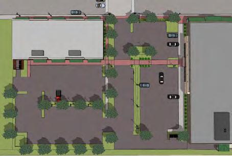


including
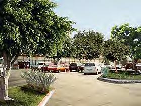

This plan recommends the adoption of more detailed design guidelines for Lexington’s commercial areas. These pages present the basic categories that should be addressed by any such guidelines and some specific sample guidelines to inform the development of adopted standards.
• Street Relationship: Design the building such that the primary building façade is orientated towards the street and built to the front property line. Minor setbacks may be allowed if space created provides an outdoor seating area, a hardscape plaza, or similar pedestrian space. Provide a public entrance on the primary façade.
• Lighting: Pick fixtures that complement the character of the building. Illuminate parking lots and pedestrian walkways uniformly and to the minimum level necessary to ensure safety. Lighting should be energy efficient and should render colors as accurately as possible. Preferred light types include: LED, fluorescent, and high-pressure sodium.
• Parking: Place parking on the side or back of the building, wherever feasible. Provide shared parking and access between properties to minimize the number of curb cuts. Provide vegetative buffers between pedestrian circulation routes and vehicular parking/circulation. Access drive lanes should have adequate throat depths to allow for proper vehicle stacking.
• Landscaping: Provide generous landscaping, with an emphasis on native plant species. Landscaping should be placed along street frontages, between incompatible land uses, along parking areas, and in islands of larger parking lots.
• Stormwater: Use rain gardens and bioretention basins on-site (i.e. in parking islands) in order to filter pollutants and infiltrate runoff, wherever feasible. Consider using permeable surfaces, pervious asphalt, pervious concrete, and/or special paving blocks.


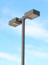

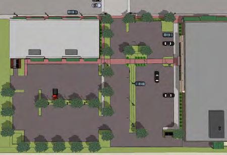


Examples of full cutoff fixtures that minimize glare and light pollution.
An example of parking being shared between two developments with parking limited to the side or rear yards (no front yard parking).
Trees and shrubs within and around parking areas greatly improve the aesthetic appearance and overall pedestrian experience.

Examples of permeable surfaces.
• Service Areas: Trash and recycling containers/ dumpsters, street-level mechanical, rooftop mechanical, outdoor storage, and loading docks should be located or screened so that they are not visible from a public street. Screening should be compatible with building architecture and other site features.
• Scale & Articulation: Design the building using architectural elements that provide visual interest and human scale that relates to the surrounding neighborhood context and the downtown’s overall character.
• Windows, Doors & Garages: Buildings should activate the street by providing significant visibility through the street-level facade to activities/displays within the building. Clearly define door entryways and design garage doors to be screened from street view (i.e. not on street facade, landscaping, walls), to the greatest extent possible.
• Building Projections: Canopies and awnings should be provided along facades that give access to the building.
• Signage: Use pedestrian-scaled sign types: building-mounted, window, projecting, monument, and awning. Signs should not be excessive in height or square footage.
• Colors & Materials: Use high-quality, longlasting finish materials such as kiln-fired brick, stucco, and wood. All exposed sides of the building should have similar or complementary materials and paint colors as used on the front façade.


An example of large windows providing significant visibility into the building.
A good example of mounted awnings placed below the horizontal expression line.


Free-standing and roof signs are not conducive for a downtown, pedestrian-friendly district.

Examples of secondary facades continuing the design quality, material palette, and color palette of the primary facade.
Metropolitan Council policies are designed to encourage the development of vacant parcels, increase density, and maximize the efficiency of infrastructure. Metropolitan Council forecasts clearly reflect this policy, particularly as it relates to employment growth. The City of Lexington supports “infill” development and redevelopment opportunities where the community deems appropriate.
The City supports the infill development of residential areas. This includes parcels of record, provided that development can meet reasonable standards contained in City ordinances, including stormwater drainage. The City does not take a position with regard to the division of existing residential blocks. Proposals should originate with property owners, meet access and dimensional criteria contained in City ordinances and have the support of property owners.


Commercial infill development and redevelopment should meet the goals and policies contained in this Comprehensive Plan, as well as development criteria outlined in City ordinances. The City has prioritized and a Commercial Redevelopment Area and Residential Redevelopment that are potential candidates for infill and redevelopment, including possible assistance and involvement from the City. These are:
• Commercial Redevelopment District on north side of Lake Drive as shown below (yellowdashed outline).
• Residential Redevelopment Areas shown on the 2040 Future Land Use Map and the map insert below; blue cross-hatch for 2021-2030 and blue diagonal-lines for 2031-2040.
In 2018 the City approved two high density residential redevelopment projects, The Ephesians at Lexington and the Landings at Lexington. These two projects have added a total of 225 rental apartment housing units to the community on roughly 7.34 acres; a overall density of about 30 units/acre. These projects and another proposed development allow for the City to easily meet the 8 units/acre minimum of Option 1 and reach their 2040 growth forecasts.


The Commercial Redevelopment District (CRD) presents special challenges to the City and property owners. Many structures have not been modernized and access can be an issue. The City anticipates that there will be property redevelopment in the (CRD) that will provide additional employment opportunities in Lexington.
Residential Redevelopment Areas for 2021-2030 are shown to the left in blue cross-hatch and Commercial Redevelopment Districts are outlined in a yellow dashed
Goal:
It is the goal of the City of Lexington to protect the environment from the negative impacts of growth and redevelopment.
Policies:
• Implement relevant policies of the Rice Creek Watershed Management Plan.
• Establish erosion and sedimentation control standards consistent with MPCA’s best management practices.
• Require that stormwater ponds meet the design standards of the National Urban Runoff Program (NURP).
• Coordinate efforts with appropriate authorities to minimize noise and other negative impacts of area highways and airports.
• Maintain landscaping standards in all new developments.
City of Lexington 2040
According to the Register of National Historic Places in the State of Minnesota, there are no historically designated properties in the City of Lexington.
The City of Lexington is committed to preserving the quality of life and character of the City. This includes policies that serve to maintain and enhance the Central Business District and the identification of buildings that may require preservation through assistance from the City.
1 2 3 4 5 6 7
Appendix A Appendix B
chapter addresses the topics of transportation analysis zones, roadways, transit, bicycling and walking, aviation, and freight.
• Maintain a network of streets that promote the safe and efficient movement of people and goods.
• Create and maintain a system of safe pedestrian ways in areas of the community where there is conflict between cars and pedestrians.
• Create and maintain convenient and safe transit stops.
• Ensure that the negative impacts of aircraft noise are limited.
• Coordinate transportation planning and system improvements with the Anoka County and neighboring jurisdictions.
• Maintain development standards that promote safe and efficient access to arterial roadways.
• Assist or provide comment to area transit providers in planning the expansion or adjustment of transit services in Lexington.
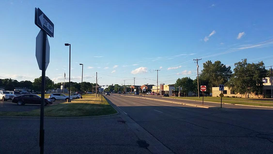
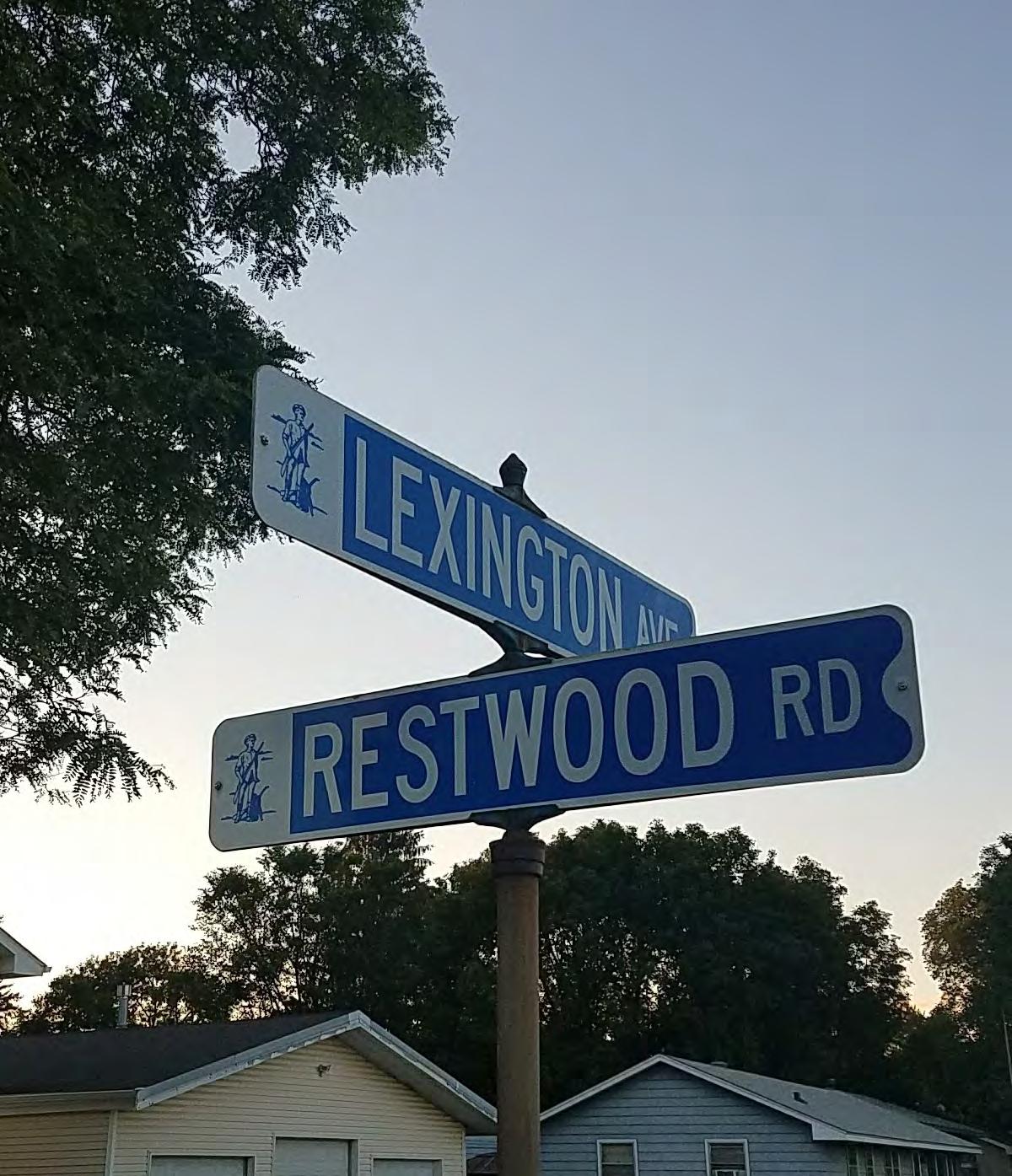
The Metropolitan Council conducts research on travel behavior and forecasts future transportation conditions as a result of regional growth. They maintain a regional travel demand model. The geographic unit for this analysis is the transportation analysis zone, or TAZ. While they allocate a portion of the forecasted regional growth to each community, the distribution of that growth within each community depends on local land use decisions. The ask each community to allocate forecasted future growth of population, households, and employment to each TAZ, reflecting the community’s land use planning efforts.
The table and map to the right identify the City’s 5 TAZ zones and details the forecasted growth of population, households and employment for the City of Lexington through 2040. Lexington’s Future Land Use Map for 2040, located in Chapter 3 of this plan, allocates corresponding residential and commercial growth to areas accessible by the TAZ’s existing and planned major roadways and transit corridors.
As a landlocked City, serviced by two County Highways, the Metropolitan Transit (Bus) System, and a nearby regional airport they City’s future growth in all areas will be a combination of infill development and redevelopment. The City is planning for development within their existing boundaries. Any of development will be well served by existing as well as planned roadway and transit improvements.
The City’s current and planned transit service will be on the two existing bus corridors; Flowerfield Road on the souther edge of the community and Lovell Road in the northern half of the community. A majority of the City is accessible to pedestrians from these routes. The City anticipates that any new residential development within 1/4 mile of these bus routes would meet the minimum 10 units per acres density expectations listed in the chart below from the Metropolitan Council.
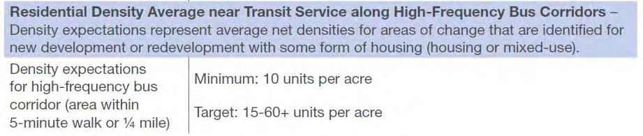

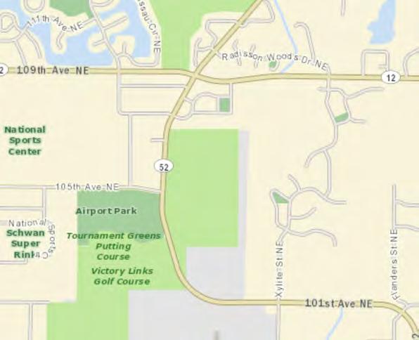
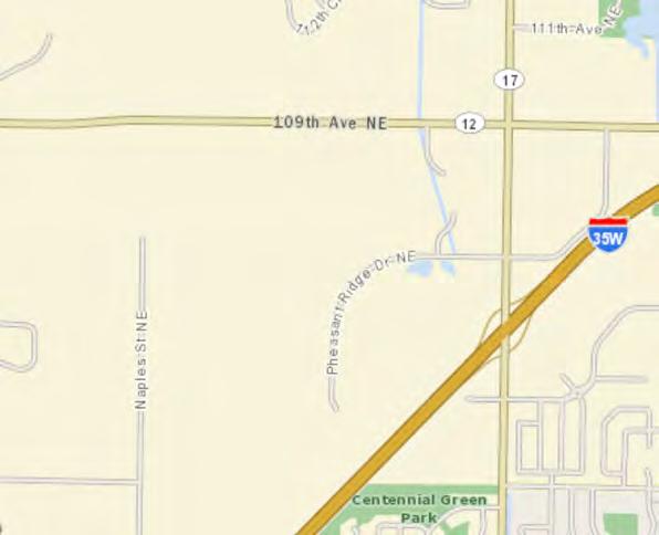

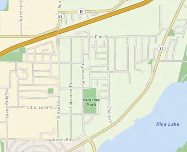

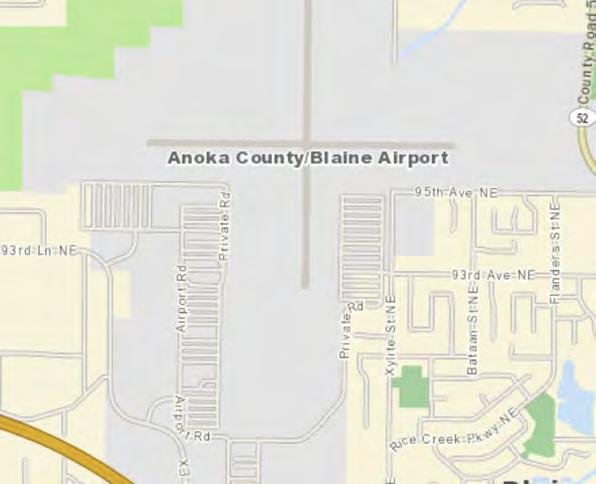
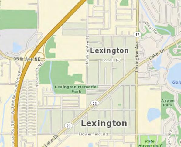


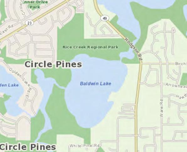
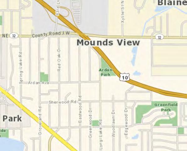
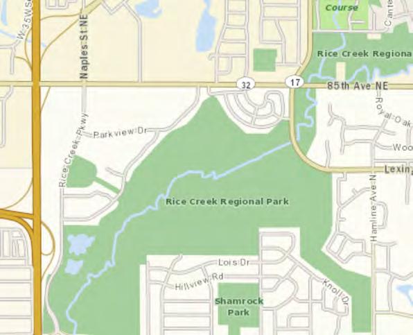
Source: https://gisdata.mn.gov/dataset/us-mn-state-metc-trans-anlys-zones-frcst-taz-com
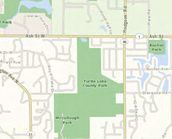
The map to the right identifies roadways in the City of Lexington, including their jurisdiction and “functional classification”. These roadways are under the jurisdiction of the State, County and the City. Limited access roadways that carry larger volumes of traffic at higher speeds tend to be under the jurisdiction of the State of Minnesota (e. g., Interstates, U.S. Highways and State Trunk Highways), including Interstate 35W, which is just outside the City. Roads that carry mostly local traffic are under the jurisdiction and are the responsibility of the City. Anoka County has jurisdiction of roads that carry intermediate levels of traffic and which provide connections among communities in the County. County roadways include those that receive direct aid from the State of Minnesota, which are called County State Aid Highways. Roadways in the City are described by their functional classifications in the sections that follow.
The metropolitan highway system is made up of roads called “principal arterials”. They include all interstate freeways and other major roadways that provide long distance connections within the metropolitan area. Connections with other roadways are limited to other principal arterials and to a minimal number of other roads. Interstate 35W is the nearest principal arterial that serves the City of Lexington. Interstate 35W provides important connections to the metropolitan area to the south and north. This roadway is under the jurisdiction of the Minnesota Department of Transportation (MN/DOT) but no exit or planned improvement to this principal arterial is located within the City of Lexington.
“Minor Arterials” are roadways that generally provide mobility for shorter distances than principal arterials, providing interconnection
between other arterial roadways and between regional business concentrations. They often supplement principal arterials. Minor arterials are subdivided between A-minor arterials and other minor arterials for planning and administrative purposes. The former roadways are eligible to compete for federal funding in State applications. The spacing of interconnections generally occur between one and two miles.
In 2006 Lake Drive from 35W to Lexington Avenue was completely re-constructed. Turning lanes were constructed reducing the accident rate. Lake Drive is a major corridor through the City and is classified as an A minor reliever.
County State Aid Highway (CSAH) 17 (Lexington Avenue NE) is the only A-minor expander located in the City, and is under the jurisdiction of Anoka County.
In 2000, the City of Lexington signed a Joint Powers Agreement for the Reconstruction of County State Aid Highway 17 (Lexington Avenue) from County State Aid Highway 32 (85th Avenue) to Austin Street in Blaine. The reconstruction involved an expansion of the roadway and acquisition of additional right-of-way creating a four-lane roadway with center turn lanes.
“Major Collectors” are roadways that are designed to serve shorter trips. Their function is to collect and distribute automobile traffic from neighborhoods and commercial/ industrial areas onto the reliever roadway system. These roads are designed to provide access as much as mobility. County State Aid Highway (CSAH) 52 (Lovell Road) and County Road 105 (Naples Street) are the two Collector streets in the City of Lexington.
The County has proposed that County Road 105, (Naples Street), be widened from a two- lane roadway to a four-lane, undivided roadway. The County has also proposed that County Road 105,
(Naples Street), be deleted from the County Road system. The City of Lexington would then share jurisdiction of this roadway with the City of Blaine where it forms the border between the two cities. The City of Lexington does not support the widening of this roadway.
The County is also proposing to widen CSAH 52 from CSAH 12 in Blaine to the border with Lexington at Hamline Avenue. This improvement, which will result in a four-lane undivided roadway, may occur sometime in the future.
Although no portion of this project falls within the corporate limits of Lexington, the City is concerned about the potential impact of additional traffic in Lexington, particularly on Lovell Road. The City will work with the County and the City of Blaine to ensure that the City’s concerns are addressed with regard to through traffic.
All other roadways in Lexington are under the jurisdiction of the City of Lexington and are classified as local streets. Local streets primarily provide access to individual properties rather than long distance or direct travel; and speed limits are kept low to ensure safety. Most residential streets are local. The City is committed to maintaining policies that assess property owners fairly for the reconstruction and sealing of local streets.
Transportation System - Functional Class Roads


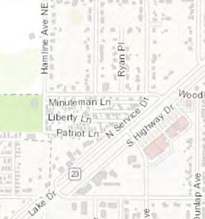


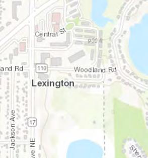


The map above shows the most current traffic volumes (HCAADT and AADT) available from the Minnesota Department of Transportation using their Traffic Mapping Application found at https:// www.dot.state.mn.us/traffic/data/tma.html
The City of Lexington has no current issues with traffic levels on municipal streets and Anoka County and State have made continued improvements to Lake Drive/CSAH 23 and Lexington Avenue NE/ CSAH 17 to address traffic volume and level of service needs.
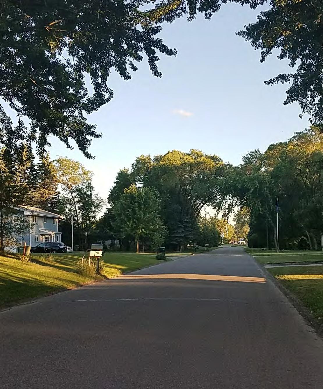
The City of Lexington is inside Transit Market Area 3. Transit Market Area 3 has moderate density but tends to have a less traditional street grid that can limit the effectiveness of transit. It is typically Urban with large portions of Suburban and Suburban Edge communities. Transit service in this area is primarily commuter express bus service with some fixed-route local service providing basic coverage. General public diala-ride services are available where fixed-route service is not viable.
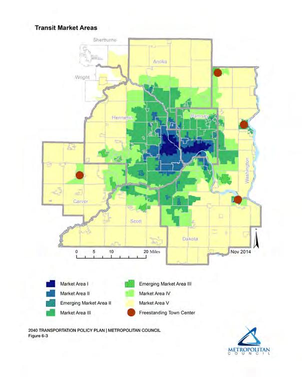
It is the policy of the City of Lexington to support and participate in coordinated transportation planning that meets the needs of residents and businesses, including the availability of alternatives to driving alone. The City’s existing transit services were described in the section 4.5. Lexington, when possible, will assist or provide comment to area transit providers as they plan the expansion or adjustment of transit services in and around Lexington. The City often experiences problems with commuter parking in neighborhoods where there is transit service. The City supports improvements to park and ride facilities that service the system and alleviate commuter parking issues. The City also supports the development of Light Rail Transit or other transit investments in the northern metropolitan area. Lexington will work with transit providers to identify potential future transit service options and facilities that are consistent with the TPP and the applicable Transit Market Areas.
Metro Mobility is offered in the City of Lexington. This is a service provided for certified riders that are unable to use regular fixed route buses due to a disability or health condition. Its hours in Lexington are Monday - Friday 5:15 AM - 6:45 PM and Saturday & Sunday 8 AM - 4 PM. This service is provided by Metro Transit and you can schedule your trip by phone.
Through Metropolitan Council Contract, Anoka County Traveler Transit Link provides dial-a-ride service in Anoka County as well as NW Ramsey County (Arden Hills, Falcon Heights, Lauderdale, Mounds View, New Brighton, Roseville, St. Anthony, and Shoreview.). Operating hours are Monday-Friday 6:00 a.m. to 7:00 p.m.
Anoka County Medlink formerly Anoka County Volunteer Transportation operates MondayFriday from 8:00 a.m. to 4:30 p.m.
Existing and Planned Transit Facilities
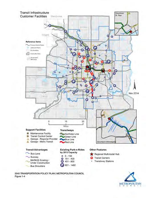
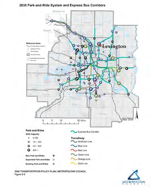
The two maps above identify both the existing and planned transit facilities that impact the City of Lexington. The City sits just off Interstate 35W - a planned Express Bus Corridor. The 95th Avenue Park-n-Ride facility sits just west of the City across Interstate 35 and offer nearly 1,500 parking spaces. Three routes are serviced from the facility: Route 250 to downtown Minneapolis, Route 252 to the University of Minneapolis and Route 262 to downtown St. Paul. As shown in the map below, routes 262 and 250 also transect the City of Lexington, along Lovell Road and Flowerfield Road respectively, on their way between terminuses.
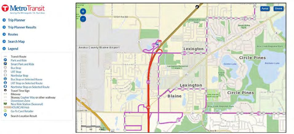
Bicycling & Walking Plan
The City of Lexington is committed, through its policies and through administration of its zoning and subdivision ordinances, to create reasonable biking and pedestrian facilities to serve residential and commercial areas of the City. The City has identified key corridors where the creation of sidewalks or trails would encourage non-vehicular transit or provide greater safety for those who now bike and walk. The City will emphasize establishing sidewalks or trails within the commercial area with links to adjacent, higher density residential areas and Lexington Memorial Park.
The City’s position is that it is neither cost effective nor politically feasible to install sidewalks in existing low-density neighborhoods. The City


will, rather, focus in areas with redevelopment potential and/or excess right-of-way. Potential trail areas are described to the right and indicated on the map on the following page:
• Along either side of much of Lake Drive, to connect with the Anoka County Regional Trail.
• Along Griggs Avenue in the central business district; connecting with multi- family buildings on the south and the Paul Revere Co-op Manufactured Park on the north.
• Along Hamline Avenue, possibly in cooperation with the City of Blaine.
• Along the north side of the Service Commercial area on Lake Drive, possibly associated with redevelopment of this area, to connect residential areas to the north with the Park and central business district.

City of Lexington 2040 Comprehensive Plan
Regional Bicycle Transportation Network (RBTN)
City of Lexington, Anoka County

RBTN Alignments
Tier 1 Alignment
Tier 2 Alignment
RBTN Corridors (Alignments Undefined)
Tier 1 Priority Corridor
Tier 2 Corridor
Major Sport & Entertainment Centers Potential Trail Connections
Regional Destinations
Metropolitan Job Centers
Regional Job Centers
Subregional Job Centers
Large High Schools
Colleges & Universities
Highly Visited Regional Parks
Regional Trails (Parks Policy Plan)
Existing Planned
County Boundaries
City and Township Boundaries
NCompass Street Centerlines
Open Water Features
Existing State Trails (DNR)
Mississippi River Trail
ANE is located within a few miles from Lexington’s border and is the largest of the reliever airports. Two Lexington residents are appointed each year to serve on the airport commission. Noise is the major concern by Lexington residents and business. The airport’s east-west runway (9/27) is in-line with the northern portion of the City, just north of Lovell Road. Although the area is developed in mostly residential single family homes, height of structures would be a concern with any infill or redevelopment. The city restricts height through its zoning ordinance.
ANE is a general aviation facility serving single- and multi-engine propeller aircraft and corporate jet aircraft that are operated by private, recreational and corporate pilots. ANE is used by the most diverse aircraft mix in the Metropolitan Airport Commission (MAC) reliever airport system.
There are two runways: Runway 9/27, which is 5,000’ x 100’, and Runway 18/36, which is 4,855’ x 100.’ The 1,800-acre airport has multiple fixed base operators and a non-federal aircraft control tower that is operational from 7 a.m. to 9 p.m. in the winter and from 7 p.m. to 10 p.m. in the summer.
ANE has undergone a series of recent improvements, including:
• Extending and widening east-west Runway 9/27 to 5,000’ x 100’
• Lengthening the adjoining taxiway
• Installing an instrument landing system with approach lighting and runway identifier lights
• Developing a new building area anchored by a fixed based operator with an executive terminal and an 80,000 square-foot hangar
Click on or type in the following web address to access the Long Term Comprehensive Plan for ANE: http://metroairports.org/General-
Aviation/Airports/Anoka-County-Blaine.aspx
The two maps on the following page are from the Long Term Comprehensive Plan for ANE and show land use, preferred noise contours for 2025 and the current Runway Protection Zones. All show no planned direct impact on existing development in Lexington.
The MAC website includes a noise abatement plan, specific to ANE, that works to meet the need to make the airport and the surrounding community as environmentally compatible as possible. In short, the plan directs the bulk of traffic over the least densely populated areas surrounding the airport, to reduce noise levels over nearby residential areas. The plan call for runways 18/36, the north/south runways, to be the preferred runways used on calm days.
The noise abatement plan can be found here: http://www.macnoise.com/sites/macnoise. com/files/pdf/ane_nap.pdf
Additionally, the MAC has additional information for Land-Use Zoning and Safety Areas and Height Assessments available on there website here: https://www.macnoise.com/our-neighbors/ noise-contours-land-use-zoning.
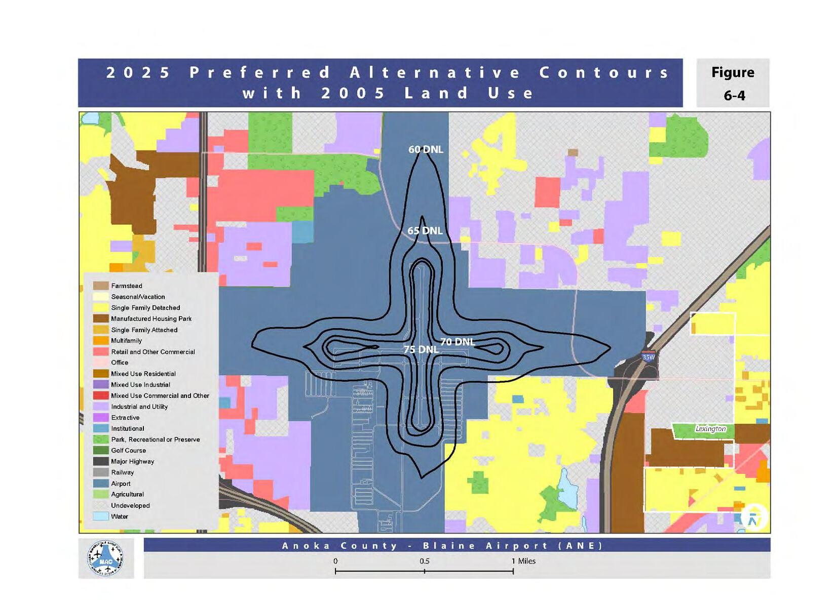
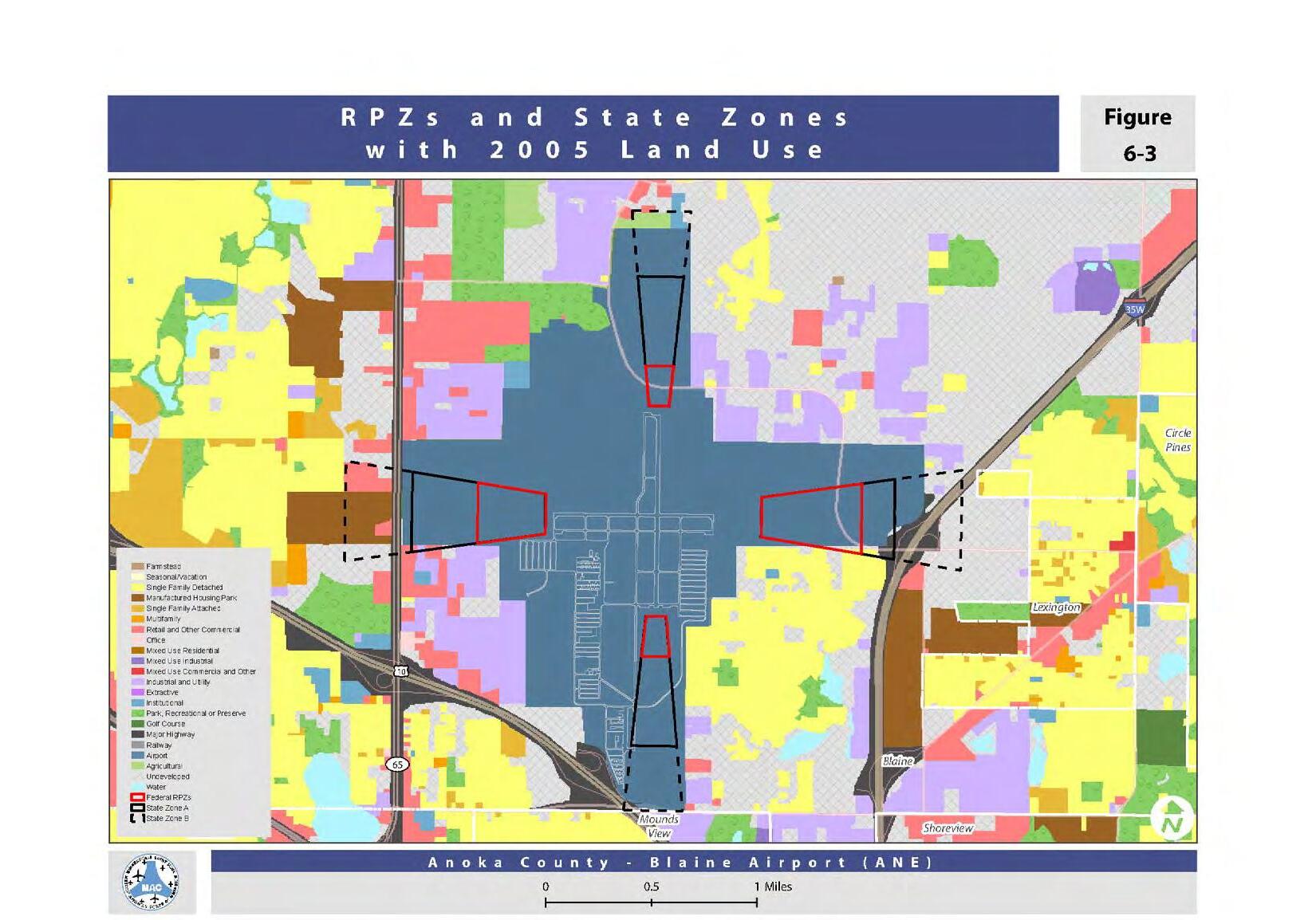
Lexington has several nodes that generate semitrailer based freight movement. The biggest generators are along the southeast side of lake Drive - County Highway 23. The Northway Shopping Center is likely the largest freight traffic generator in the City. There are no regular or repeated issues with facilitating good movement on the City’s roadways.
According to the most current Minnesota Department of Transportation Heavy Commercial Average Annual Daily Traffic (HCAADT) Map (see below) the commercial freight traffic along Lake Drive - County Highway 23, from Lexington or through to/from Interstate 35W, was not counted so it is uncertain how much HCAADT traffic is on that roadway. Additionally, there were no other location measure with the City limits but Interstate 35W, just west of the City, sees an average count of 3,200 heavy commercial vehicles per day.
There are no existing rail lines that service property within the City limits.
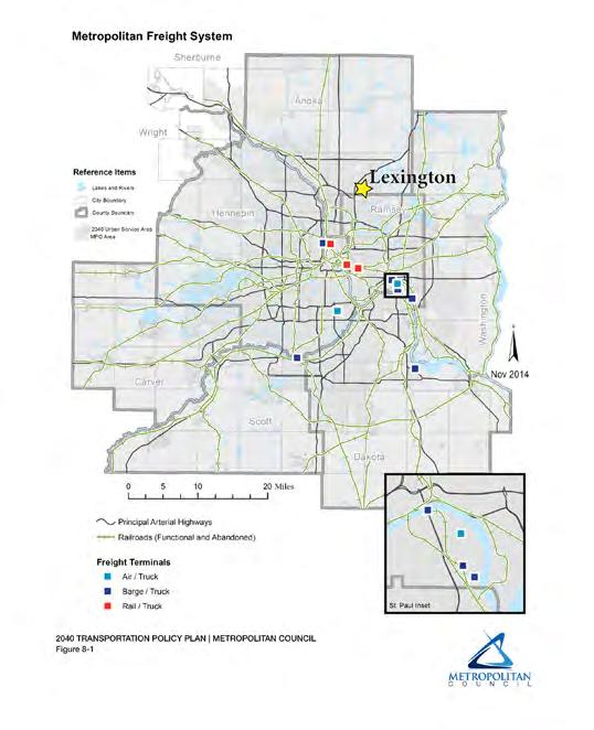
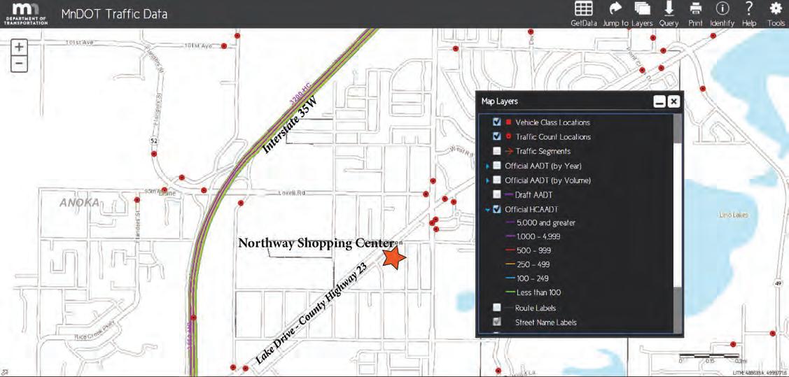
• Maintain a variety of housing opportunities for all income and age groups.
• Encourage ongoing maintenance and rehabilitation of existing residential properties.
• Develop additional owner-occupied single family housing opportunities.
• Maintain investments in residential property by minimizing conflicts with other land uses.
• Maintain zoning provisions that do not burden the development of low and moderate income housing opportunities.
• Provide information to residents and prospective developers about housing assistance, maintenance and rehabilitation programs.
• Work cooperatively and constructively with the Anoka County HRA, Anoka County Community Action Council and other agencies involved with housing assistance.
• Enforce provisions of the building code and provide information on sources of assistance for housing maintenance and revitalization.
• Enforce land use policies to prevent incompatibility of housing and commercial or industrial land uses.
• Prioritize and redevelop vacant, deteriorated or abandoned properties.
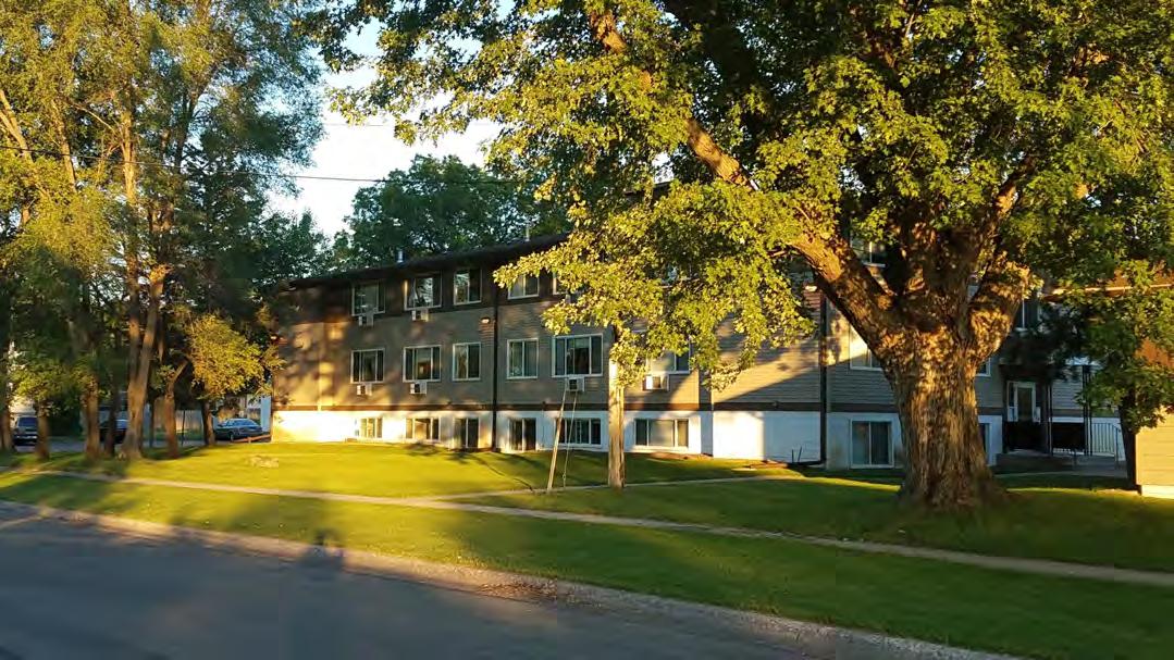
City of Lexington 2040
An Existing Housing Assessment is the first step in identifying current housing needs for your community. This information meets the minimum data requirements for your Existing Housing Assessment. You are free to copy and paste this table directly into your Housing Element, recreate it using the same data, or incorporate it into a table with additional or alternative data using reliable sources. This table is not a comprehensive picture of your community’s housing stock, but a solid starting point to identify and address your existing housing needs. Please contact Council staff if you have any questions.
1 Source: Metropolitan Council, 2015 housing stock estimates
One of the most important housing needs is to preserve the bulk of the city’s existing, relatively affordable housing stock while encouraging development of additional housing to meet needs not addressed by the city’s existing housing stock. Another housing need is the preservation of existing affordable housing. And development of high density residential housing.
2 Source: Metropolitan Council staff estimates for 2015 based on 2015 and 2016 MetroGIS Regional Parcel Datasets (ownership units), 2009-2013 Comprehensive Housing Affordability Strategy data from HUD (rental units and household income), and the Council's 2015 Manufactured Housing Parks Survey (manufactured homes).
3 Source: U.S. Census Bureau,2011-2015 American Community Survey five-year estimates; counts adjusted to better match the Council's 2015 housing stock estimates
4 Source: HousingLink Streams data (covers projects whose financing closed by December 2014), http://www.housinglink.org/streams
5 Housing cost burden refers to households whose housing costs are at least 30% of their income. Source: U.S. Department of Housing and Urban Development, 2009-2013 Comprehensive Housing Affordability Strategy (CHAS) data, with counts adjusted to better match Metropolitan Council 2015 household estimates.
The series of tables above is an assessment from the Metropolitan Council of the City of Lexington’s existing housing stock. The assessment of the City’s current housing needs includes examining total units, affordability, tenure, type, public subsidies, the number of burdened households and owner-occupied housing location and value.
Approximately 520 of the City’s estimated 838 units, or 62%, are owner-occupied units. Therefore, 38% of the City’s 838 housing units are estimated to be, renter-occupied units. In comparison, Anoka County as a whole has an estimated 131,046 housing units of which an estimated 102,771, or 78%, are owner-occupied units.
Currently, the total estimated number of housing units in the City of Lexington is 838 units. A housing unit includes any single-family home, duplex (2-units), townhome, condo, apartment, manufactured homes or mobile homes. Rooms in group quarters, shelters, dormitory rooms, and care facilities rooms are not considered housing units as they require additional facilities outside the sleeping/living unit to support residential dwelling by families or individuals.
Housing is generally considered “affordable” when the owner or renter’s monthly housing costs do not exceed 30% of their gross monthly income. While these numbers are important indicators of affordability, it is also important to note that some residents may be paying more than 30% of their income on housing by choice, rather than by necessity.
A majority, or 725 of the City’s 838 housing units are affordable to households with incomes of from 31% to 80% of the area median income (AMI). 95, or 12%, of the housing units in Lexington, are affordable to households with incomes at or below 30% of the AMI. This is a higher percentage than Anoka County; in which 7% of all housing units are affordable to households at or below 30% of the AMI. Additionally, 37% of the housing units in the City of Lexington are affordable for households earning 31%-50% of the AMI. Overall, Lexington has a higher percentage of housing units affordable to households earning 50% or less of the AMI than Anoka County as whole.
62% of the housing units in Lexington are singlefamily units compared to 82% of the housing units in Anoka County. The remaining 28% of the housing units in the City are either multi-family or manufactured homes as compared to 18% of the housing units in the County. Lexington has a large manufactured home park that creates a uniquely high percentage of manufactured homes for the community, compared to the county as a whole.
Housing Types
County Housing Types
Maintaining these manufactured homes and the park as a whole will continue to be a challenge for the owners.
The City of Lexington has thirty four subsidized units. This could possibly be attributed to the fact that the City currently has more affordable housing options than the County as a whole. As the community continues to see infill housing, increasing densities of multifamily developments and redevelopment they should remain aware of affordability and availability. The City is pursuing and welcomes new housing development, marketrate, subsidized or otherwise that meets the needs of current and future residents and does not cause economically unsustainable burdens on public infrastructure, facilities, and services.
To the right is a map of owneroccupied residential properties. Multifamily and non-homestead credit properties have been removed. This map shows the estimated value (land+improvements) of owneroccupied properties across the community.

Projecting the community’s future housing needs is an important planning activity for the City of Lexington to undertake for 2040. The community has assessed it existing housing needs but also needs to look at how to accommodate future growth, especially planning to meet affordable housing needs as designated by the Metropolitan Council.
The first chart below shows the current estimated and forecast of population, housing and employment growth for the City of Lexington through 2040. Focusing on housing we see that the City is estimated to see an increase of 381 people and 163 new households.
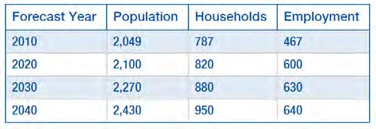
The second chart reflects what share of the Twin Cities Metropolitan Area’s forecasted affordable housing needs for 2030 are allocated to the community of Lexington. Regulations require that the City guide land development to meet minimum residential land densities sufficient to create opportunities for the development of affordable housing options.
The Metropolitan Council offers two options for communities with affordable housing needs allocations:
• Option 1: Guide sufficient land at minimum residential densities of 8 units/acre to support your community’s total allocation of affordable housing need for 2021 – 2030. This option may be best for communities that find it difficult to support densities of 12 units/acre (per Option 2), or prefer simplicity over flexibility in their density minimums.
• Option 2: Guide sufficient land at minimum residential densities of:
• 12 units/acre to address your community’s
allocation of affordable housing need at <50% AMI. This combines your community’s allocation at <30% AMI and 31-50% AMI.
• 6 units/acre to address your community’s allocation of affordable housing need at 51-80% AMI.
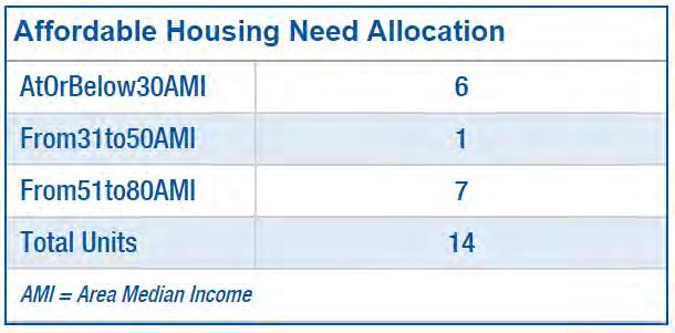
The best option for the community of Lexington, as a mostly developed City with a ‘Suburban’ community designation, is Option 1. The community will continue to see infill development at higher densities than currently exist because of its location in the metropolitan area, interstate and highway access, nearby regional transportation facilities, and affordability levels in relation to Anoka County as a whole.
There are very few undeveloped areas of Lexington and underdeveloped opportunities that may or may not play out. Currently, the undeveloped or underdeveloped areas where the City is guiding residential growth are either future High Density Residential (max 20 units/acre).
In 2018 the City approved two high density residential redevelopment projects, The Ephesians at Lexington and the Landings at Lexington. These two projects have added a total of 225 rental apartment housing units to the community on roughly 7.34 acres; a overall density of about 30 units/acre. These projects and another proposed development allow for the City to easily meet the 8 units/acre minimum of Option 1 and reach their 2040 growth forecasts.
The table below shows potential resources and housing tools available to the City of Lexington and its residents for the cities housing needs. The city will consider the following on a case-by-case basis. There are very few undeveloped areas of Lexington and underdeveloped opportunities that may or may not play out. The community is landlocked and will not be expanding its boundaries. The City will consider engaging in housing related organizations and partnerships.
Housing
Need
Home Rehabilitation Loan Program
Maintenance of Existing Housing Needs
Foreclosure Prevention
Assist income eligible homeowners in financing home maintenance exterior and interior projects, or energy efficiency improvement projects. The City will work to provide information on potential resources to the best of its ability.
The City will consider partnering with Anoka County Community Action Program to assist homeowners in foreclosure prevention with Post Purchase Counseling.
Anoka County, Minnesota Housing
Anoka County Community Action Program
Rental License and Inspection Program
Home StretchPre-Purchase
It is unlikely the City will develop a rental license and inspection program. But the will provided resources for residence on an as needed basis.
The City will provide residents with information on Anoka County Community Action Program offers Home-Buyer counseling and helps low to moderate income individuals or first time home buyers with workshops for approval assistance
Anoka County Community Action Program
Step-Up Loan Program
Preservation of Existing Affordable Housing
Local Housing Incentives Account (LHIA)
The City will work to provide information on potential resources like the Step-Up Loan Program. Assist qualified non-firsttime home buyers with financing a home purchase or refinancing an owned home through a dedicated loan program.
The City will consider support for proposals to preserve, renovate, or maintain affordable housing for households below 80% AMI
Minnesota Housing
Metropolitan Council
Preservation of Existing Affordable Housing
Tax Abatement
Preservation of Manufactured Housing
Incentive post LHITC preservation
Consolidated RFP
The City will maybe consider tax abatement for developments including rental units suitable for large families.
The City will consider support for the preservation of manufactured housing.
Metropolitan Council
HOME Program
The city will consider support for this method of affordable housing preservation. It is important that there is assistance in keeping affordable housing in Lexington when this has phased out.
This application provides funders the flexibility to assemble creative finance packages that best fit certain projects during the review and section process. The City will consider this for new housing funding.
The City will consider support for HOME funding applications to provide gap financing for new units affordable to owner or renter households at or below 60% AMI
Metropolitan Council
Anoka County CDA
Planned Unit Developments (PUDs)
Low Income Housing Tax Credit (LIHTC)
Development of New High Density
Residential Development
Living Communities Demonstration Account (LCDA)
Living Housing Incentives Account
Site Assembly
The City is already considering planned unit developments to meet overall community land use, affordable housing, and density goals that may otherwise not be permitted through regular zoning requirements.
The City supports continued preservation of LIHTC financed affordable housing in the City and LIHTC financing to develop affordable rental housing for households at or below 60% AMI
The City will consider LCDA grant for development proposals that help connect housing, jobs, retail, transit and provide affordable housing.
The City will consider support for development proposals that provide affordable housing for households below 80% AMI.
The City will most likely not consider using site assembly for construction of new affordable housing as the City has no more developable land.
Super RFP It is unlikely the City will consider supporting an application to RFP programs for the construction of new affordable housing.
MN Housing Anoka County CDA
Metropolitan Council
Metropolitan Council
Landbank of the Twin Cities
• Protect environmental systems from unnecessary impacts of future growth and redevelopment activities.
• Maintain and enhance the natural amenities of the City for future generations to enjoy.
• Protect the limited water resources of the City to promote aesthetic qualities, natural habitat areas and ground water recharge.
• Maintain and enhance the stormwater drainage system in the City and improve the quality of storm water runoff.
• Enforce all local and state regulations for activities occurring in naturally or environmentally sensitive areas.
• Restrict or prohibit development on wetlands and other natural features that serve important environmental functions.
• Enforce development standards consistent with soil suitability, slopes, ground water tables and aquifer sensitivity.
• Enforce development standards consistent with the Wetland Conservation Act.
• Require that new stormwater ponds meet the applicable design standards of the National Urban Runoff Program (NURP).
• Enforce erosion and sedimentation control standards consistent with the MPCA’s “best management practices”.
• Participate with neighboring communities and Rice Creek Watershed District in educating residents on the proper use and concentrations of lawn fertilizers to improve water quality.
• Evaluate cost effective options to modify existing ponds to enhance water quality.

The City of Lexington owns and operates a sanitary sewer collection system and is part of the Twin Cities Metropolitan Wastewater Treatment System. Sanitary Sewage is collected through a network of 4-inch house pipes and 8-inch City-owned sewer mains. There are five “lift stations” in the City, which transport wastewater in areas where sewer mains cannot flow by the force of gravity. These stations are located at Restwood Road and Pascal Avenue; Flowerfield Road and Syndicate Avenue; Lovell Road and Hamline Avenue; Edgewood Road and Hamline Avenue; and on Jackson Avenue 500 feet south of Restwood Road. Wastewater is ultimately directed through Circle Pines to the Pig’s Eye Wastewater Treatment Plant. The Pig’s Eye Wastewater Treatment Plant is operated by Metropolitan Council Environmental Services (MCES).
The City of Lexington is fully developed. Any expansion of the sewer system infrastructure will be limited to individual parcels. Anticipated increases in the sanitary sewer flow will occur from an increase in the number of new households and businesses in the community as a result of infill development and redevelopment. The City estimates that approximately 3,053 residences and businesses are served by the sanitary sewer system. The table below from the MCES illustrates that new growth through 2040 is expected to continue to utilize the municipal shared sewer system.
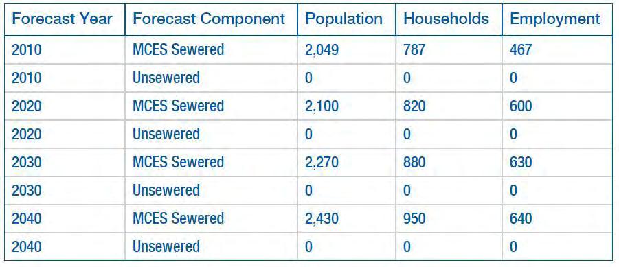
The City of Lexington sanitary sewer system includes 9.1 miles of gravity sewer, 180 manholes, 5 lift stations, and 0.5 miles of forcemain. The existing sanitary sewer system is shown on page 6-5. There are no individual sewage treatment systems within Lexington.
The system collects and conveys the City’s wastewater to Metropolitan Council Environmental Services (MCES) Meter 206. From there, the wastewater flows through the MCES regional system to the MCES Metropolitan Wastewater Treatment Plant (WWTP) located southeast of St. Paul on the Mississippi River. There are no intercommunity sewer connections. The Metropolitan WWTP has a capacity of 251 MGD, provides advanced secondary treatment with chlorination/dechlorination, and discharges treated effluent to the Mississippi River. There are no public or private community treatment systems within the City of Lexington. All properties within the City are served by the public collection system described above. The City of Lexington does not currently have any proposed improvements in the future.
The City of Lexington consists of 5 lift stations that are summarized below.
The total per capita wastewater flow was calculated from MCES flow meter data from 2014-2019 and from populations interpolated based on the Metropolitan Council 2015 System Statement Forecasts for the City. The average total per capita wastewater flow from 2015-2019 was 53 gallons per capita per day.

The community forecasts for the City of Lexington are provided above on page 6-3. The entire City is sewered and served by MCES Meter M206. All projected growth will be served by the same MCES facilities.
The City’s existing land use designations were used to estimate existing wastewater flows. These flows were then calibrated to equal the average community-wide metered flow from 2014-2018. Future flows were estimated based on areas within the City that are expected to develop or redevelop and the wastewater flow assumptions in the table below. Standard MCES peak hourly flow factors for sanitary sewer design were applied to calculate future peak hourly flows.
The proposed peak hourly flow and residual capacities in the City’s lift stations are listed below. All lift stations are projected to have adequate capacity through the year 2040.
Inflow and Infiltration (I/I) refers to water entering the sanitary sewer system from unintended sources. The water is typically clear, that is, not requiring treatment at the same level as wastewater. Inflow is runoff from rain events that drains directly into the sanitary sewer from such sources as storm sewer cross connections, foundation drains, sump pumps and open manholes. It generally appears as a dramatic spike in the sewer flow during and immediately after rain or a snow melt event and is a short duration. Infiltration refers to groundwater that enters the sewer system through open pipe joints, leaking manhole walls, and cracked or broken pipe. This is also highlighted in rain and snow melt events, but the rise in flow is delayed and flow rates can remain elevated for longer periods. The existing sources of I/I in the city are manhole covers and broken pipes. Typically these problems are fixed whenever street reconstruction projects take place and the pipes are televised every three years. There are 180 manholes and 9.1 miles of sewer pipe throughout the City.
The efficiency of the sanitary sewer system can be diminished if outside sources of water are permitted to enter the sanitary sewer network, and if left unchecked can be costly for communities for a variety of reasons ranging from unnecessary chemical treatment or capacity issues of the system. MCES establishes I/I goals for each community that discharges wastewater to the regional collection system. These goals are based on average flows, adjustments to community growth and I/I mitigation peaking factors.
Removing I/I from the sanitary sewer system requires a continuing program of replacement, inspections, maintenance, and repairs. The sanitary sewer system is no different than other infrastructure types. As with streets, every year the condition of the sewer system degrades. Cracks form, joints leak, and infiltration increases. If the existing system is left alone, it will only continue to deteriorate and become worse. The reduction strategies consist of televising all pipes every three years to determine necessary repairs and fix all deficiencies found to further eliminate I/I from the area. The City will also perform open manhole inspections.
Reduction of I/I also includes eliminating clear water discharges to the sanitary sewer system from properties served by Lexington’s municipal utilities. Lexington’s adopted City Code prohibits the discharge of clear water to the municipal sanitary sewer system as identified in Chapter 3, Section 3.30, Subdivision 5 - Types of Wastes Prohibited A, 10) Roof water, ground water, or any other natural precipitation. Lexington’s adopted City code also requires and allows for the disconnection of prohibited connections in Chapter 3, Section 3.04, Subdivision 3 and Subdivision 5. The full code is available on the City’s website, http://www.ci.lexington.mn.us/page/govt_code_book.
The City of Lexington sanitary sewer system includes 9.1 miles of gravity sewer, 180 manholes, 5 lift stations, and 0.5 miles of forcemain. The existing sanitary sewer system is shown on page 6-5. There are no individual sewage treatment systems within Lexington. The system collects and conveys the City’s wastewater to Metropolitan Council Environmental Services (MCES) Meter 206. Approximately 48% of the housing in the City was constructed before 1970. The only evaluation of the pre-1970 era housing as been televising of the lateral connection to the main.
The amount of clear water flow generated within the City was estimated by calculating the average annual I/I rates, equal to the average wastewater flow minus the base wastewater flow, using data from 2014-2018. The average flow, both annual and monthly, was calculated from MCES meter data. The base flow was approximated as the minimum daily flow within each year. The City’s metered flow is calculated using data from one meter: M206, the data presented below should be considered qualitative in nature, rather than an exact quantification of I/I within Lexington. There are no private sewer systems in the City of Lexington.
The City completes regular street and utility improvement projects, typically every other year. These projects include pipe replacement, manhole replacement, casting adjustments, chimney seals, lining, and televising. The sanitary sewer costs for the projects completed in the last ten years are listed in the table below. The City invests approximately $25,000 dollars each year in sanitary sewer improvements to the sewer fund, which will assist in a long-term reduction of I/I. The City has performed yearly street improvements the last 5 years, that have contributed to I/I reduction in Lexington.
With the televising completed during the street and utility improvement projects, the City is able to view the condition of the private service lateral connections to the public sewer mains and identify any issues. The City will explore additional activities for I/I reduction from private sources, such as sump pump inspections, smoke testing, and service lateral televising.
It is important to consider the cost effectiveness of I/I reduction programs. Effectiveness in reducing I/I rates has varied in the past. Lexington does not have a significant I/I problem and past efforts have helped reduced the amount of I/I in the sewer systems. But it is also common for there to be very little actual reduction in I/I flow. It is difficult to say that all of the potential I/I sources could not be immediately identified and rehabilitated. The I/I defects that are rehabilitated will reduce treatment costs, but additional previously-unidentified sources may become active, suggesting that the removal was not completely effective.
Infiltration, as opposed to inflow, is difficult to remove because the groundwater can enter any crack in manholes, sewer pipes, joints, and service lines. When a crack is repaired, the water may enter through another one further upstream. Each repair makes it more difficult for water to enter, but it is not possible to eliminate all infiltration. If nothing is done in terms of maintenance and repair, pipes and manholes will continue to deteriorate, increasing the amount of groundwater entering the system. Maintenance is important regardless because, I/I certainly will not increase as quickly as it would if nothing had been done.
Therefore, while a definitive answer to the question of how much I/I will be removed from the sewer system cannot be answered, the cost effectiveness of the annual maintenance, televising, enforcement of city code and manhole inspections. The maintenance program is needed as much for future I/I prevention as it is for current I/I reduction. No programs for I/I reduction will ever eliminate all of the clear water from the sanitary sewer system.
Capital Improvements
Lexington is landlocked and fully built out. Therefore the primary sanitary sewer improvements consist of maintaining the existing infrastructure. As mentioned previously throughout this chapter, the City will continue to televise sanitary sewer pipes every three years.
There are limited water resources in the City of Lexington. There are no surface waters, shoreland designations, floodplains, protected waters or protected wetlands. There are some scattered wetland areas, which serve as drainage basins in the City. Judicial Ditch #1 drains the largest wetland area near Lexington Park to the southwest into Blaine and ultimately to Rice Creek. The northerly and easterly portions of the City drain to the east to Golden Lake in Circle Pines. Lexington is located wholly within the Rice Creek Watershed District. As a fully developed community, stormwater drainage systems are generally in place. Land disturbances activities are generally limited to redevelopment projects and road reconstruction projects. As Lexington continues to mature, the focus on water resources will be to monitor, maintain and modify existing stormwater control mechanisms and to improve the water quality of runoff.
There is one stream and a watershed management organization of Rice Creek within the City’s boundaries. The city is also completely within the Rice Creek Watershed District. Each of these natural features contributes to the aesthetics of the community and provides recreational opportunities and/ or function as natural stormwater management basins.
Each lake, wetland and stream plays an integral role in the City’s water resource management by serving as storage basins for stormwater during storm events and providing natural filtration for stormwater runoff. Due to the relatively small amount of surface water resources, the City of Lexington is not in
a FEMA 100 year floodplain. This downsizes the potential or the risk for flooding due to overflow of a lake or river, but it may increase the risk for flooding with heavy rainfall. In large storms, Lexington has less natural stormwater management basins.
The Rice Creek watershed district, that spans about 180 square miles, is present throughout Lexington. The district has special protections, and many efforts to maintain the watershed are implemented throughout the district. There are currently no projects with the watershed taking place in or around Lexington.
The City will continue to work with the Rice Creek Watershed District to protect groundwater supplies. The City will continue to enforce Chapter 13, Storm Water Management Regulations. Chapter 13, in conjunction with the City’s zoning and subdivision regulations, establishes land use regulations, restrictions, and guidelines to protect groundwater resources within the boundaries of the Rice Creek Watershed District.
Lexington has its own stormwater management regulations located in Chapter 13 of the City Code. The purpose of the code is to promote, conserve and enhance the natural resources through minimizing pollution. The code also aims to protects natural resources from adverse effects occasioned by poorly sited development or incompatible activities through the following actions:
• Regulating land disturbing or development activities that would have an adverse and potentially irreversible impact on water quality and unique and fragile environmentally sensitive land.
• Minimizing conflicts and encouraging compatibility between land disturbing and development activities and water quality and environmentally sensitive lands; and
• Requiring detailed review standards and procedures for land disturbing or development activities proposed for such areas, thereby achieving a balance between growth and development and protection of water quality and natural areas.
Additionally, the City of Lexington’s Local Watershed Management Plan is included as Appendix B of the 2040 Comprehensive Plan.


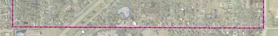


The City of Lexington owns and operates a municipal water system. The City also has twelve interconnection points with the City of Blaine and one interconnection with the City of Circle Pines. The City operates one water tower, which is located in Lexington Memorial Park and has a capacity of 100,000 gallons. The City also operates one well, which is also located in Lexington Memorial Park. The well is drilled to 309 feet deep and draws water from a sand and gravel geologic formation (quaternary buried artesian aquifer). The Minnesota Department of Health has determined that the geologic sensitivity of the well’s aquifer is low and that the well is not vulnerable to discharge of contaminants at land surface.
The Metropolitan Land Planning Act requires all communities in the metropolitan area that have a municipal water supply system to prepare a water supply plan. The City of Lexington is a member of the Anoka County Municipal Wellhead Protection Group (ACMWPG). Lexington, along with other members of ACMWPG, is cooperating with the Minnesota Department of Health to prepare municipal wellhead protection plans that meet state requirements. The City has developed and maintains a separate Water Supply Plan document that is located in the City’s Wellhead Protection Plan.
This plan includes, but is not limited to, the following information:
1. Water Supply Description and Evaluation
• Per capita water use over past ten years
• Identification of large volume water customers
• Seasonal and peak water demand analysis
• Description of treatment and storage facilities
• Description of water source, production capacity, and geology
• Description of plans for modification of system
• Conclusions regarding future demand and supply
2. Emergency Planning Information
• Identification of emergency triggers
• Evaluation of demand reduction measures during emergencies
• Identification of alternative sources of water
• Wellhead protection plan
3. Water Conservation Plan
The City recognizes that water conservation efforts are needed to reduce overall, longterm demand for water in order to protect the municipal water supply system. If wisely implemented, appropriate water conservation methods should not substantially impact the user and yet should provide for a reasonable supply of water during periods of water shortages. The water conservation program will also serve a state and regional need in conserving groundwater and surface water resources. It is expected that each of the components of the entire city water supply system will utilize conservation components.
It is the policy of the City of Lexington that the costs of its water system will be assessed in relationship to the benefits received from the use of the water system. The water system conservation strategy of the City is to promote the sensible use of water, to reduce the demand for water, and adequately provide a supply of water for emergency situations.
Short-term water conservation measures are discussed in the next section of the Plan titled Emergency Planning. Long term and more specific measures of water conservation programs are discussed below and include metering, water audits, leak detection and repair, conservation orientated water rates, regulation, education and information programs, retrofitting programs and pressure reduction. The water conservation goal over the next ten years is to reduce water demand by 10% on a year-round basis and to reduce seasonal demand by 15% through these programs.

The purpose of a metering program is to gather information for use, billing, water loss, and to determine potential problem areas. Chapter Three of the City Code requires the installation of a meter before water is withdrawn from the municipal water supply system. Further, the City installs and maintains the meter.
The City of Lexington has had a metering program since 1966 and all water customers are metered except for outside public activities such as street cleaning, fire fighting, rink flooding, etc. The City currently reads its entire customer’s meters quarterly and bills accordingly based on these readings. The City does not have any existing water meter calibration or inspection programs in effect. However, if a customer believes that a meter is inaccurate, the City tests the meter. If the meter overruns by more than 3%, the City pays the cost for the test and refunds the overcharges to the customer. If the meter overrun is less that 3%, the customer pays for the test and any undercharges.
The City does not have a formal water audit program to determine system water leaks and repair. Metering provides the City the ability to detect water leaks by comparing the volume of water consumed by individual customers with the volume of water that is drawn from the wells and circulated through the water system. The difference of the two is unaccounted water use. The American Water Works Association considers a 10% unaccounted water use acceptable. Because of the sharing of water supply with Blaine and present record keeping activities, the unaccounted water use figure is unknown. The City is in the processing of developing a new water accounting system that will be able to track water use and production on a regular basis. Additionally, this system will allow the City to determine the amount of unaccounted water loss that will be beneficial in determining the direction of future conservation programs.
Occasional water main breakage is one of the factors that the City uses in determining the need for pipe replacement. On a general basis, water main replacement, if needed, occurs when street widening or reconstruction projects are programmed. The City is currently devising a strategy to guide the Public Works Department when there is water main break that affects the City’s water supply and distribution system.
Chapter Three of the City Code allows the City to prohibit or restrict water use whenever the City determines that there is a water emergency. Further, the ordinance states that “it is unlawful for any water consumer to cause or permit water to be used in violation of such determination after public announcement thereof has been made through the news media specifically indicating the restrictions thereof.” Violation to the ordinance is a misdemeanor.
The Energy Policy Act of 1992 stipulates water efficiencies for almost all household water using fixtures, such as including toilets, shower heads, and faucets, manufactured after January 1994. Federal and state plumbing codes have changed so that all new homes and retrofits to existing homes are required to comply with the new water efficiency requirements. Lexington has adopted the State Building Code that mandates energy efficient fixtures. Additionally, the City has implemented a voluntary program that provides an incentive for customers to replace older and more inefficient water fixtures, such as toilets and shower faucets, with newer and more efficient ones.
Further, the City is studying a program that provides the customer with a rebate or credit towards their water use account when they upgrade their fixtures. This type of program is more effective in older communities, such as
Lexington, where a higher percentage of older and inefficient fixtures may be installed. The City is also considering replacing the water fixtures in all public buildings with low-flow, high efficient ones.
The rate program that a city utilizes for water consumption can impact water conservation efforts. An increasing block rate structure discourages water use because a consumer is charged at an increasing schedule for increments of water used. A decreasing block rate has the opposite effect since a customer is charged less for the more water that is used.
Lexington currently utilizes a decreasing flat rate structure with a minimum charge. The quarterly water price is $14.50 for the first 10,000 gallons and $.75 per 1,000 gallons. It is advisable that a uniform or increasing water charge rate be established for the water system to eliminate an incentive for customers to use more water than needed. It is recommended that a financial study be conducted to determine the impact of a uniform rate structure upon the utility fund before this method is adopted to ensure that it is within the philosophy and legal parameters of the water enterprise fund.
A decrease of system supply pressure reduces the flow rate (gallons per minute) to each customer, therefore reducing the overall consumption rate. The Ten States Standard recommends that normal operating pressure be approximately 60 psi and not less than 35 psi. The City fire flow tests for the last 29 years have ranged between 65 to 68 psi at 1290 gpm.
The City of Lexington will provide information to water customers that includes AWWA consumer facts and other appropriate material that will describe the importance of water conservation
and monitoring as well as provide information on how customers can conserve water. These efforts will increase customer awareness of the individual and community benefits of conservation and inform them of rates and programs associated with conservation.
It is the policy of the City of Lexington to provide a reliable and adequate supply of water for the health and safety of its citizens. It is also the policy of the City of Lexington that water supply quality will meet or exceed standards of the Federal Safe Drinking Water Act (SDWA) and the Minnesota Department of Health; and to protect the water supply source through the Minnesota Wellhead Protection Program.
Water supply protection is an essential part of emergency planning. With the limited storage supply at the wells, it is critical that the City protects existing pumping capacity. The City conducts annual inspections of wells and pumps. Repair parts are kept on hand in order to adequately service the units in an emergency. The City of Lexington has never had a contamination problem with its water supply system. Water quality reports indicate that the City’s water supply quality level is well above those standards set by the Federal Safe Drinking Water Act (SDWA) and the Minnesota Department of Health.
The likely natural hazards that could disrupt the Lexington water supply and distribution system include tornadoes, severe storms, flooding, drought, and water-borne diseases. Humancaused disasters could include the release of hazardous materials into the supply or the system, structural fires, a major construction or transportation accident, or vandalism.
The City does not have its own Emergency Operations Plan. However, Anoka County has developed an Emergency Operations Plan to manage events if any one of the above mentioned disasters should occur. Although there is not a specific chapter that is centered upon the effects of hazards on the water supply and system components, several items are included in the plan that applies to water. Lexington is covered by this plan for any of the aforementioned emergencies. During such periods of limited water supply the public supplier is required to allocate water on the priorities established in Minnesota Statutes 103G.261. Long term preventative programs and measures will aid the City in reducing the risk of emergency situations.
The following section documents current city emergency procedures, reviews potential issues to be considered in an emergency situation, and concludes with a list of recommendations for water utility related items.
The water supplier is the City of Lexington. The City offices are located at 9180 Lexington Avenue, Lexington, Minnesota 55014. The Water Superintendents are Jim Fischer and Travis Schmid and the person responsible for utility billing is Tina Northcutt (763-7842792).
The ground water source for service to the City is glacial drift. Descriptive data for the public well is listed below.
Identification: Well No. 1
Status: Permanent
DNR Appropriation Number: 660584
Unique Number: 208996
Date Installed: 1966
Pump Capacity (gpm): 1,000
Pump Type: Deep well turbine
Casing Diameter (in): 12” inner liner / 24”outer liner
Casing Depth (ft): 275’
Total Well Depth (ft): 306’
Water Source: Drift
Static Water Level (ft): 47
Specific Capacity (gpm/ft): 1,000
A list of all available sources of water that can be used to augment or replace existing sources must be included in the emergency response procedures. The following includes existing alternative water supply sources and suggestions that should be considered as potential alternative sources.
The City of Lexington and the adjacent Cities of Blaine and Circle Pines have existing interconnection points between their water supply systems. The interconnections between Lexington and the Cities of Blaine and Circle Pines are mentioned earlier is this plan. The Blaine interconnections are established not only to supply water to the customers of Lexington during periods agreed upon by each city, but also to augment each other during emergency periods such as fires, contamination and water-main breaks.
The Circle Pines interconnection point was established to connect the two systems during emergency situations. The use of this interconnection, with the exception of system testing, has never been required.
The Lexington water supply system is interconnected with Blaine’s water supply system on a regular and daily basis and linked with the City of Circle Pines’ water supply system for emergency situations. Blaine and Circle Pines have the ability to supply water to the Lexington distribution system if water cannot be supplied by the Lexington well.
In the event that the City of Lexington water supply system, including the interconnections become inoperable or unusable for potable water use, an alternate supply must be found in quantities sufficient to meet essential domestic needs only. The most viable choices would include water from outside the community trucked in by tanker, small commercial Point of Use (POU) water treatment units, and commercial bottled water for drinking needs. In the ultimate emergency situation, the Department of Public Safety - Emergency Management Division would be contacted for community disaster assistance. It is likely that at this stage, the National Guard would either supply water by truck or provide potable water treatment plants.
The State has established priorities (Minnesota Statutes 103G.261) associated with water distribution during emergency situations. These priorities are:
First: Domestic water supply and use for power production that meets contingency requirements excluding industrial and commercial uses.
Second: Water uses involving consumption of less than 10,000 gallons per day.
Third: Agricultural irrigation and processing of agricultural products.
Fourth: Power production in excess of the use
provided for in the contingency plan under the first priority.
Fifth: Uses other than agricultural irrigation and processing, and power production, involving more than 10,000 gallons per day.
Sixth: Non-essential uses: lawn sprinkling, golf course and park irrigation, vehicle washing and other non-essential water uses as defined by Minnesota Statutes 103G.291.
Most of the City of Lexington’s water supply use is considered first priority. However, during the summer, peak water usage may occur due to the sixth priority water use, such as lawn watering and car washing. The non-essential water uses represent the best potential for reductions in short-term demand. Reductions in water use can be accomplished through limiting or banning vehicle washing and sprinkling.
In the event that a short-term demand reduction is necessary, the City of Lexington staff and City Council will discuss potential reduction measures that are best suited for the situation. The following list describes some of these measures:
Voluntary Reduction: The City should inform their water customers that there is a water shortage, and request that each customer voluntarily reduce their water consumption.
Sprinkling Ban: The City shall carry out instructions regarding limited water in associated with the City Code (Chapter 3, Section 3.20, Subd. 6).
Water Allocation Restrictions: The various water use priorities noted earlier in this section should be implemented according to the severity and length of the emergency condition.
Long Term Demand Reduction Procedures
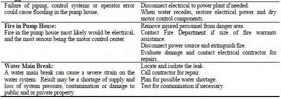
The City of Lexington will develop procedures based on Minnesota Statutes 103G.261, which establishes priority user groups during periods of limited water supply or in emergency situations. The allocations are prioritized with high priority first. Domestic water use is defined by Minnesota Rules 6115.0630, Subp. 9 as the use of water for general household purposes for human needs such as cooking, cleaning, drinking, washing, and waste disposal, and uses for on-farm livestock watering excluding commercial livestock operations which use more than 10,000 gallons per day or one million gallons per year.
It is necessary to determine the conditions that constitute a water emergency and the degree to which the City must respond. This is defined as “trigger” conditions. The trigger conditions are specific conditions of such items as ground water levels, water demand, storage capacity, and precipitation. The City has established responses to the indicated triggers that will be implemented immediately. The table to the right on the following page outlines the conditions and the City responses.
The City will conduct an annual review of the water system in order to determine the operational and maintenance needs of the current and or following year. This review should be conducted in early spring when winter moisture levels are available and seasonal forecasts have been determined. The review should include an examination of growth issues to closely identify the expanding water use needs of the City.
The Minnesota Department of Health has developed a ranking program to phase public water supply systems into the wellhead protection program. Part 1 has been completed at this time. The City of Lexington will complete Part II . The ranking program is based on the number and vulnerability of wells in a system and the population served. Lexington has been assigned a Tier 5 classification, meaning that its wells are not particularly susceptible to contamination. The City’s ranking was originally established at 1,071 out of 1,586 community and non-transient, non-community water systems in Minnesota. However, because of the construction of new wells and systems in other cities, the City’s ranking has moved to 1,036.
Lexington completed its Wellhead protection plan and will be updating that approved Wellhead Plan - through ten-year an extension of the current plan. Lexington and other communities have established a new joint powers organization (the Anoka County Municipal Wellhead Protection Group) to implement common elements of their wellhead plans in a coordinated and efficient manner.
The City expects to continue its cooperative efforts with the Anoka County Municipal Wellhead Protection Group and the Department of Health in completing all components of its wellhead protection program.
The City maintains records of well water levels and withdrawals. These records include daily log books on the wells and pumps, draw down and pumping levels on a monthly basis, and records of major repairs, replacement parts and updating of equipment. These records are kept to accurately monitor certain aspects of water use in the City.
• Create and maintain convenient park, open space and recreational opportunities for all residents, particularly for youth and the elderly.
• Create and maintain safe and convenient bicycle and pedestrian access to Lexington Park and nearby parks, open space, and trails.
Policies
• Support cooperative park and recreation programming with adjacent communities, the Centennial School District, and community service organizations.
• Jointly plan park and trail improvements with neighboring communities, Anoka County, and the Metropolitan Council.
Residents of the City of Lexington have access to recreational and open space resources both within the City and within the immediate area. The City plans to maintain and enhance Lexington Memorial Park for the future enjoyment of community residents, explore new park resources, and create trails when opportunities arise. The existing “Tot Park” is located adjacent to vacant land in the Central Business District. The City may wish to negotiate with the owners of the adjacent vacant property when these owners are ready to develop this land. It may become appropriate to do one of the following:
• Trade land with owners for better park/playground land somewhere else south of Lake Drive.
• Incorporate land into development in exchange for new open space/ playground within development.
Bicycle Transportation Network (RBTN)
of Lexington, Anoka County
The City is within close proximity to regional park facilities and trails. The Rice Creek Chain of Lakes Regional Park is located in the adjacent communities of Circle Pines and Lino Lakes. There is an existing regional trail, constructed by Anoka County along Lexington Avenue. The trail is connected to the Rice Creek Regional Trail.
The City has identified potential trail corridors within its City limits. These trails emphasize
connection between parts of the community rather than recreation. Areas include Lexington Memorial Park, higher density residential areas, and along commercial areas. Trails may become possible as a result of requirements for development and redevelopment, reconstruction of roadways, and expenditures of park and recreation funds. The Bicycling & Walking Plan in Chapter 4 outlines the City of Lexington’s plans for connecting parts of the community for pedestrians and bicyclists.
The City of Lexington is committed to the reasonable expansion of the City’s trail system to serve the residential and commercial areas of the City. The City has identified key corridors where the creation of sidewalks or trails would encourage non-vehicular transit or provide greater safety for bicyclists and pedestrians. The City will emphasize establishing sidewalks or trails within the commercial area with links to adjacent, higher density residential areas and Lexington Memorial Park.
Regional Bicycle Transportation Network (RBTN)
of Lexington, Anoka County
Potential trail areas are described below and indicated on the map on the following page:
(Parks Policy Plan)
• Along either side of much of Lake Drive, to connect with the Anoka County Regional Trail.
• Along Griggs Avenue in the central business district; connecting with multi- family buildings on the south and the Paul Revere Co-op Manufactured Park on the north.
(Alignments
• Along Hamline Avenue, possibly in cooperation with the City of Blaine.
• Along the north side of the Service Commercial area on Lake Drive, possibly associated with redevelopment of this area, to connect residential areas to the north with the Park and central business district.
The City of Lexington does not currently have any plans for the expansion of existing or creation of new parks but has some small improvements planned as shown in the chart below. The community has very little undeveloped area and is well served by existing community and regional recreation facilities. The City will continue to maintain and improve Memorial Park and Tot Park for the enjoyment of residents and visitors.
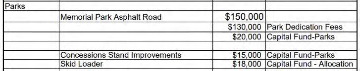
Describes the City’s capacity to respond, adapt and thrive under changing conditions and covers the areas infrastructure & environment, energy infrastructure & environment, healthy communities, and economy & society.
• Mitigate the potential negative impacts of climate change on the community.
• Promote education and awareness regarding hazards and risks in the community.
• Protect and develop access to direct sunlight for solar energy systems
• Promote land use and development patterns that support achieving Minnesota’s adopted greenhouse gas emissions goals.
• Support the inclusions of additional storm water management capacities to account for changing rainfall patterns.
• When forewarning is possible the City will strive to keep citizens apprised of the situation and possible outcomes during flooding, snow storms, and other naturally occurring hazards.
• The City will collaborate with local agencies and organizations to inform the community about disaster preparedness, especially including evacuation procedures in flood-prone areas and the location of public shelters.
• The City encourages private disaster preparedness, including resilient building practices and materials, establishment of disaster response, recovery plans by families and businesses, and maintenance of emergency kits and supplies as recommended by the Federal Emergency Management Agency (FEMA).
• The City encourages and will implement programs to support participation in the National Flood Insurance Program (NFIP) and hazard proofing of residences and businesses.
• The City will commit to the safe development of public facilities, and will evaluate the feasibility of re-siting and upgrading facilities to mitigate potential hazard.
• The City will plan for the effective delivery of emergency services and basic human needs in the event of a worst case scenarios, such as catastrophic flooding, wind damage from tornados, or large snowfall events.
• The City recognizes the potential for a disaster causing impacts beyond the City’s capacity to respond, and will maintain procedures to request timely assistance from neighboring communities and County and State government.
• Encourage residential solar development that maintains community character.
• Encourage investment in electric grid infrastructure and solar development that makes electric service more reliable and resilient to weather-related disruptions.
Climate change has the potential to have major impacts on urban infrastructure and environmental assets. Increased precipitation may require additional on-site capacity to manage storm water, and offsite infiltration and storage to free capacity on storm water conveyance systems. Community forests will help mitigate urban heat island effect. Multi-modal transportation networks will reduce greenhouse gas emissions from mobile sources and diversify travel options for local residents. Integrated electric distribution grids will enable full use of local energy efficiency and renewable energy systems. Natural resource design standards will make natural systems and eco-systems more resilient to development.
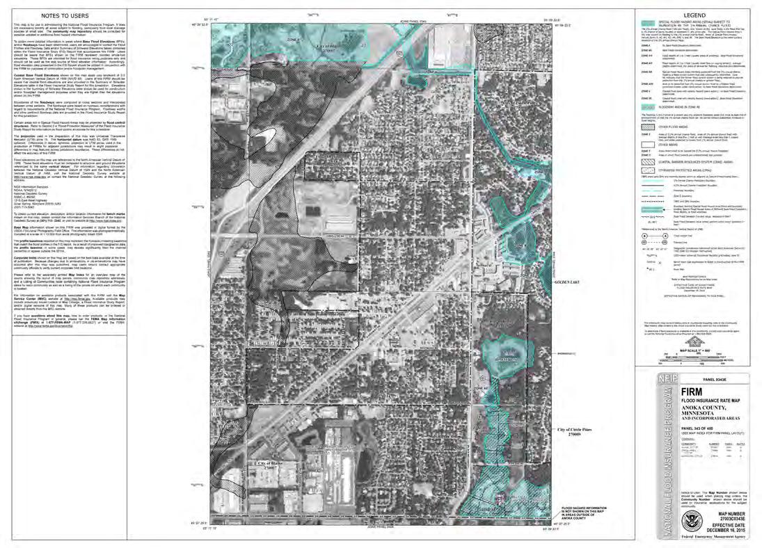
The City of Lexington recognizes the importance of protecting access for solar collectors from potential interference by adjacent structures and vegetation. Decisions regarding development will be made on the basis of not precluding the possible future development and use of solar energy systems.
Provisions within the City’s Code establish the regulatory basis for this protection. These controls primarily include solar orientation, structure separation and height restrictions.

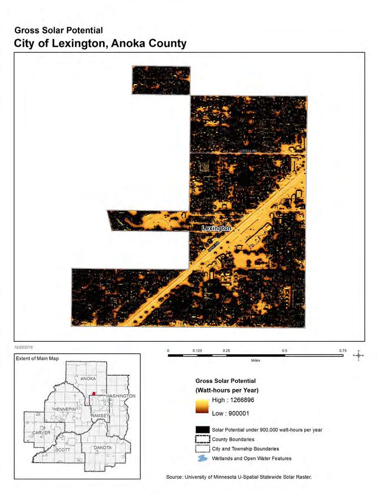
The gross solar potential and gross solar rooftop potential are expressed in megawatt hours per year (Mwh/yr), and these estimates are based on the solar map for the City of Lexington. These values represent gross totals; in other words, they are not intended to demonstrate the amount of solar likely to develop within the City. Instead, the calculations estimate the total potential resource before removing areas unsuitable for solar development or factors related to solar energy efficiency. The gross solar generation potential and the gross solar rooftop generation potential for City are estimates of how much electricity could be generated using existing technology and assumptions on the efficiency of conversion. The conversion efficiency of 10% is based on benchmarking analyses for converting the Solar Suitability Map data to actual production, and solar industry standards used for site level solar assessment. -Metropolitan Council
• Maintain a strong and stable commercial core.
• Create a commercial area that benefits the residents of Lexington.
• Support the growth of existing community businesses and employers as well as new businesses.
• Prioritize commercial uses that enhance services and provide economic opportunities to the citizens of Lexington.
• Evaluate and prioritize the use of TIF, CDBG and other programs that provide assistance for rehabilitation and the enhancement of commercial areas.
• Explore the costs and benefits of establishing an economic development or housing redevelopment authority (EDA/HRA).
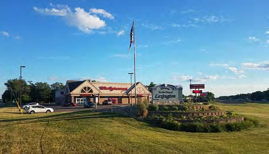
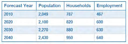
Employment within the City of Lexington is estimated to grow to 640 jobs by 2040, an increase of 173 jobs. It is anticipated that most of these will be related to increased retail and service sector jobs in existing commercial areas or redevelopment areas along the major thoroughfares. These positions could be filled by residents or by regional workers who have easy access to the area via the transit route along Lake Drive.
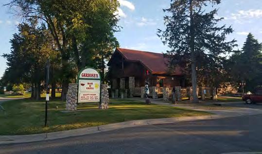
The economy plays a central role in maintaining the vitality and quality of life within Lexington. A healthy economy creates good paying jobs, providing economic opportunities to all citizens. The economy also supports the tax base, providing for schools, public safety, fire protection, parks, roads and many other facilities and services.
The purpose of the Economic Competitiveness element is to present goals, objectives, and strategies that support and encourage a strong, vibrant economy. While this section focuses on economic competitiveness topics, it is important to recognize that the entire plan can be considered as an economic development tool.
The following infographics, from ESRI Business Analyst, shed some further light on current economic conditions in the City of Lexington. According to 2017 economic estimates the community has low unemployment, a majority of workers are white-collar, and 88% of the population has at least a high-school education.
According to ESRI, there are an estimated 89 businesses within the City and 753 full or part-time employees living in the City. With an estimated population of 2,054 this means the employee to residential population ratio is 37/100. 21.8% of the households in Lexington earn between $50K and $75K per year, which is slightly more than the same group for Anoka County as a whole.
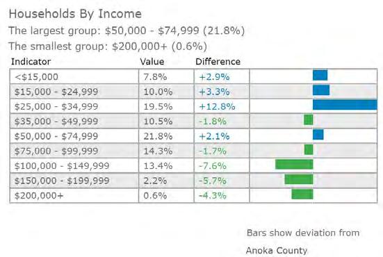

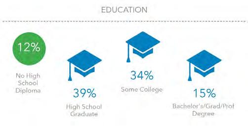

Source: 2017 ESRI Business Analyst
The subject of redevelopment is also discussed in Chapter 3: Land Use but it is important to reiterate that as a nearly completely developed suburban community, that is surrounded on all sides by incorporated cities, Lexington will need to look towards infill development and redevelopment to facilitate new businesses growth within the community. In order to plan for and assist economic development the City has prioritized two areas that provided the best opportunities for commercial infill and redevelopment, including possible assistance and involvement from the City. These are:
1. Any vacant properties in the Central Business District area on the south side of Lake Drive
2. Within the Commercial Redevelopment Districts on north side of Lake Drive
In either of these areas the City may elect to assist with the redevelopment process, using tools such as tax increment financing. Additionally, the City will consider assisting existing businesses within the community in expanding their economic footprint as well with similar resources offered to new business development.


As a community within the Metropolitan Urban Service Area the City of Lexington is required to identify employment locations and provide a measurement of intensity of planned land use. This Comprehensive Plan’s 2040 Future Land Use Map and associated forecast are located in Chapter 3 and detail the locations within the City guided for commercial use. The net acreage for commercial land by planning period in the Employment-Bearing Land Use Intensity table below shows the Lexington’s projected Employment-Bearing Land Use Intensity. Using the Metropolitan Council’s guidance on how to provide measurements of intensity of employment, it is estimated that the City has guided enough land towards employment bearing uses through 2020, 2030, and 2040 to support the estimated number of jobs forecasted by the Metropolitan Council.
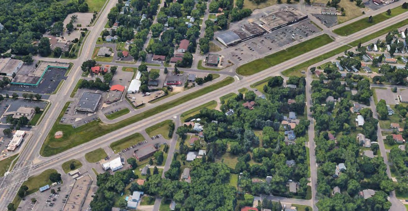
Utilizing ESRI’s Business Analyst we can see that the City of Lexington has a strong relationship to the regional market. A quick analysis of surplus and leakage across industry groups shows that Food & Beverage Stores, Auto Parts, Accessories & Tire Stores, Health & Personal Care Stores, General Merchandise Stores, Other Miscellaneous Store Retailers, Food and Drinking Places, and Restaurants/ Other Eating Places are abundant and have a surplus of sales based on the local population.
Basically, surplus areas means these industry groups are pulling sales revenues from outside the community. The other industry groups showing leakages mean that people from Lexington are spending their money outside the City for these goods and services. Given the geographic location within a complex regional marketplace and size of the community this is to be expected and not of huge concern. However, the areas of leakage do show opportunities for new business growth within the community.
The chart below graphically summarize leakage and surplus. A more detailed analysis is found on page 9-6.
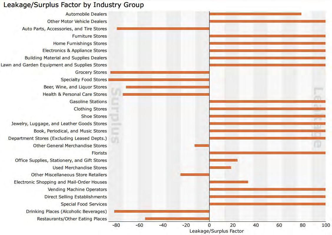

(2736836)
(retail
estimates the
by consumers at
establishments. Supply and demand estimates are in current dollars. The Leakage/Surplus Factor presents a snapshot of retail opportunity. This is a measure of the relationship between supply and demand that ranges from +100 (total leakage) to -100 (total surplus). A positive value represents 'leakage' of retail opportunity outside the trade area. A negative value represents a surplus of retail sales, a market where customers are drawn in from outside the trade area. The Retail Gap represents the difference between Retail Potential and Retail Sales. Esri uses the North American Industry Classification System (NAICS) to classify businesses by their primary type of economic activity. Retail establishments are classified into 27 industry groups in the Retail Trade sector, as well as four industry groups within the Food Services & Drinking Establishments subsector. For more information on the Retail MarketPlace data, please click the link below to view the Methodology Statement. http://www.esri.com/library/whitepapers/pdfs/esri-data-retail-marketplace.pdf
Source: Esri and Infogroup. Retail MarketPlace 2017. Copyright 2017 Infogroup, Inc. All rights reserved. August 15, 2017
The implementation of the Comprehensive Plan does not end with adoption. The City’s official controls, such as the zoning ordinance and subdivision regulations, will ensure day to day monitoring and enforcement of the plan. The regulatory provisions of these ordinances, as revised, will provide a means of managing development and redevelopment in the City in a manner consistent with the Comprehensive Plan. The City’s Capital Improvements Program will enable needed improvements identified in the plan to be programmed and implemented in a timely and cost effective manner.
The Comprehensive Plan is primarily a policy document. This document will provide direction for detailed studies and plans that are necessary for the implementation of the Comprehensive Plan, but would provide more specific “vision” for its implementation. These may include, but not necessarily limited, to the following:
• Central Business District Improvement Plan
• Commercial Redevelopment District Improvement Plan
• Park, Recreation Facility, and Trail Plan
• Community Services and Facilities Plan
• Travel Demand Management/ Transit Improvement Plan
As part of the planning process, the City will evaluate its land use controls and consider amendments to existing ordinances that eliminate inconsistencies with the Comprehensive Plan, enhance performance standards, protect public and private investments, conform to mandatory State and Federal regulations and make it an understandable document.
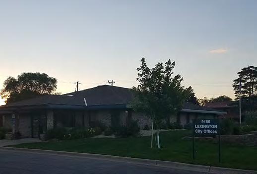
The plan identifies a number of specific changes to the ordinances that need to be considered by the City. Some of these changes include:
• Adding or amending provisions to continually implement the policies and strategies in the Water Resources Protection Plan.
• Periodic reviews of the commercial district provisions to promote development, ensure appropriate use and regulation, and prevent land use or environmental incompatibility.
• Possible revisions to the zoning map to make the zoning of property consistent with the policies and provisions of this plan.
• Possible amendments to the City’s subdivision regulations to better protect natural resources and amenities and provide for appropriate land dedication and funding for improvement of the City’s park and/or trail system
• Evaluate the feasibility of establishing housing and economic development initiatives at the City level or contracting with the County HRA for similar services.
The City of Lexington has been proactive in its zoning efforts to ensure fluidity with future development. The future land use plan is in coordination with the existing zoning map. And little changes will have to be made with the adoption of the comprehensive plan.


The Comprehensive Plan is intended to be general and flexible; however, formal amendments to the Plan will be required when land use elements or growth policies are revised. Periodically, the City should undertake a formal review of the plan to determine if amendments are needed to address changing factors or events in the community. While a plan amendment can be initiated at any time, the City should carefully consider the implications of the proposed changes before their adoption. All amendments to the plan must be submitted to the Metropolitan Council, Anoka County, and affected local jurisdictions for review prior to implementation. When considering amendments to this plan, the City will use the following procedures:
• Landowners, land developers, the Planning Commission or the City Council may initiate amendments.
• The Planning Commission will direct staff or a planning consultant to prepare a thorough analysis of the proposed amendment.
• Staff or the planning consultant will present to the Planning Commission a report analyzing the proposed changes, including their findings and recommendations regarding the proposed plan amendment.
• A formal public hearing will be held on the proposed amendment.
• Following the public hearing, the Planning Commission will make a recommendation to the City Council.
• The City Council will receive the recommendation from the Planning Commission and make a final decision on whether to adopt the amendment.
• Certain amendments may require referral to the Metropolitan Council, Anoka County and other affected jurisdictions before local adoption.

The City annually updates a five-year Capital Improvements Plan (CIP), which identifies major capital expenditures consistent with this Plan. The program focus’ on public and private investments in infrastructure, park and trail development expenditures, infrastructure repair and replacement, building maintenance and repair, equipment purchases and other planned capital expenditures. Like the Comprehensive Plan, the capital improvements planning process in ongoing and subject to modification, as appropriate.
Administration and implementation of the Comprehensive Plan and related supportive ordinances are equally as important as the development of the plan itself. Only through the proper coordination of the Comprehensive Plan with the City’s related development tools can the City fulfill its development and redevelopment vision and goals.
The Comprehensive Plan recognizes Lexington as a growing community, primarily through infill and redevelopment and will have little or no opportunities for greenfield development because the community is surrounded by incorporated communities.. The plan recommendations emphasize the need for regulating future infill and redevelopment in a manner that protects Lexington’s natural environment, preserves its character, and limits community expenditures on municipal infrastructure. Under these circumstances, concerns have been expressed with regard to expanding future public expenditures. In response to this issue, the City will continue to implement the following strategies:
• Continue the City’s proactive public facilities maintenance programs to avoid significant disrepair or breakdown.
• Maintain a five year Capital Improvement Plan that identifies needed public capital improvements, assigns costs and schedules implementation based on project priority and funding availability.
• Pursue beneficial intergovernmental cooperation for sharing public services and facilities, to avoid duplication and economize on City investments.
• Promote the maintenance, modernization
and expansion of local land uses to preserve and expand the City’s tax base and revenues.
• Pursue available county, state and federal grants and aids as appropriate to facilitate community improvements and programs.
• Utilize cost effective financing programs when authorized to encourage growth and development projects.
Through good communication with the public and responsiveness to residents’ needs, the City administration has been cited as a community strength. High quality resident service will continue to be the standard for City operations in the future.
The City continues to take a proactive approach to insure a high level of community services in a fiscally responsible manner. These efforts include:
• Regular scheduled inspections of streets, utilities, parks and facilities to identify areas of disrepair, or facility replacement to insure that City maintenance or capital improvement funds are properly planned and utilized.
• Utilize available new technologies to assist in delivery of services in an efficient and cost effective manner.
• Maintain good communication with City residents and businesses through direct contact, open meetings, television, newsletters, media releases, City website, and project bulletins.
• Periodically utilize community surveys to solicit resident perceptions, issues, or comments on community concerns and/or operations.
• Continue to work with the Rice Creek Watershed District to protect groundwater supplies. The City will continue to enforce Chapter 13, Storm Water Management Regulations. Chapter 13, in conjunction with the City’s zoning and subdivision regulations, establishes land use regulations, restrictions, and guidelines to protect groundwater resources within the boundaries of the Rice Creek Watershed District.
In an effort to reach Lexington’s transportation goals the City supports implementing the following policies related to transportation:
• Coordinate transportation planning and system improvements with the Anoka County and neighboring jurisdictions.
• Maintain development standards that promote safe and efficient access to arterial roadways.
• Assist or provide comment to area transit providers in planning the expansion or adjustment of transit services in Lexington.
In an effort to reach Lexington’s parks and trail development goals the City supports implementing the following policies:
• Support cooperative park and recreation programming with adjacent communities, the Centennial School District, and community service organizations.
• Jointly plan park and trail improvements with neighboring communities, Anoka County, and the Metropolitan Council.
In an effort to reach Lexington’s resilience development goals the City supports implementing the following policies:
• Promote land use and development patterns that support achieving Minnesota’s adopted greenhouse gas emissions goals.
• Support the inclusions of additional storm water management capacities to account for changing rainfall patterns.
• When forewarning is possible the City will strive to keep citizens apprised of the situation and possible outcomes during flooding, snow storms, and other naturally occurring hazards.
• The City will collaborate with local agencies and organizations to inform the community about disaster preparedness, especially including evacuation procedures in floodprone areas and the location of public shelters.
• The City encourages private disaster preparedness, including resilient building practices and materials, establishment of disaster response, recovery plans by families and businesses, and maintenance of emergency kits and supplies as recommended by the Federal Emergency Management Agency (FEMA).
• The City encourages and will implement programs to support participation in the National Flood Insurance Program (NFIP) and hazard proofing of residences and businesses.
• The City will commit to the safe development of public facilities, and will evaluate the feasibility of re-siting and upgrading facilities to mitigate potential hazard.
• The City will plan for the effective delivery of emergency services and basic human needs in the event of a worst case scenarios, such as catastrophic flooding, wind damage from tornados, or large snowfall events.
• The City recognizes the potential for a disaster causing impacts beyond the City’s capacity to respond, and will maintain procedures to request timely assistance from neighboring communities and County and State government.
• Encourage residential solar development that maintains community character
• Encourage investment in electric grid infrastructure and solar development that makes electric service more reliable and resilient to weather-related disruptions.
The City of Lexington support the following polices with the intent of reaching it’s goals for economic competitiveness:
• Prioritize commercial uses that enhance services and provide economic opportunities to the citizens of Lexington.
• Evaluate and prioritize the use of TIF, CDBG and other programs that provide assistance for rehabilitation and the enhancement of commercial areas.
• Explore the costs and benefits of establishing an economic development or housing redevelopment authority (EDA/HRA).
In an effort to attain Lexington’s future land use goals the City supports implementation of the following policies related to future land use planning:
• Identify and target specific areas of the community that are appropriate for new housing and commercial opportunities, including infill and redevelopment.
• Require vegetative or other type of screening, when appropriate, to mitigate negative impacts on uses in adjacent land use districts.
• Require landscaping along all public rightsof-ways for all commercial uses.
• Maintain sign regulations compatible with the goal of developing a cohesive and aesthetically pleasing commercial area.
• Prioritize and assist development in the City’s commercial areas.
• Investigate public improvements to improve safe pedestrian access within and between neighborhoods and commercial areas.
In an effort to reach Lexington’s water resources goals the City supports implementing the following policies:
• Enforce all local and state regulations for activities occurring in naturally or environmentally sensitive areas.
• Restrict or prohibit development on wetlands and other natural features that serve important environmental functions.
• Enforce development standards consistent with soil suitability, slopes, ground water tables and aquifer sensitivity.
• Enforce development standards consistent with the Wetland Conservation Act.
• Require that new stormwater ponds meet the
applicable design standards of the National Urban Runoff Program {NURP).
• Enforce erosion and sedimentation control standards consistent with the MPCA’s “best management practices”.
• Participate with neighboring communities and Rice Creek Watershed District in educating residents on the proper use and concentrations of lawn fertilizers to improve water quality.
• Evaluate cost effective options to modify existing ponds to enhance water quality.
It is the policy of the City of Lexington to:
• Update and amend a five-year capital improvement program based upon community priorities.
• Actively support the formation and operation of homeowner associations, commercial business associations and crime prevention block clubs.
• Appoint ad hoc citizen advisory bodies to implement aspects of the Comprehensive Plan and evaluate ongoing needs of the City.
• Communicate with residents through various media, including the City’s newsletter and cable access.
• Explore participation in new joint service agreements as well as the expansion of existing joint service agreements with adjacent communities and service organizations.
• Analyze and scrutinize police reports to evaluate changes in criminal statistics and predict community needs.
• Continue working on the redevelopment of the Lovell property.
The City of Lexington shares boundaries with the adjoining communities of Circle Pines and Blaine. When considering any public improvements along shared boundaries, the City will cooperate with the affected adjoining community in planning and implementing the improvement project to avoid duplication, economize on available funding, and to promote a uniform improvement design.
Ensuring that all properties have equal access to sunlight is a priority not only for potential solar energy systems, but for the protection of property and aesthetic values as well. Solar access protection is provided for by the uniform implementation of lot and building performance standards adopted as part of the Lexington’s City Code. Requirements such as minimum lot size, maximum building height, and yard setback standards are implemented for the purpose of creating separation between structures and allowing equal sunlight access such that a property is not in the shadow of an adjacent building.
The City of Lexington will meet its existing and future housing needs, as outlined in section 5.3 of Chapter 5, by working to achieve the goals laid out in section 5.1 of Chapter 5 of this plan.
In an effort to implement its housing goals, the City of Lexington supports the following “Housing Principals”:
• Balanced housing supply, with housing available for people at all income levels.
• Equal access by all racial and ethnic groups in the purchase, sale, rental and location of housing within the community.
• Housing choices for people in all stages of the “life-cycle”.
• A community of well-maintained housing and neighborhoods, including both ownership and rental housing.
• Housing development that respects the natural environment.
• A range of services and facilities to assist City residents with housing and economic needs.
• Identify linkages between housing and employment opportunities.
Overall, maintaining a variety of housing options, affordability, and quality are important needs for housing growth in Lexington. The City will utilize its City Code, Land Development Regulations and the funding tools listed below to meet these needs and reach its goals. The City will also maintain their ability to refer residents and potential residents to any applicable housing programs available to them as well as adopt and maintain a Fair Housing Policy.
The Metropolitan Council offers two options for communities with affordable housing needs allocations:
• Option 1: Guide sufficient land at minimum residential densities of 8 units/ acre to support your community’s total allocation of affordable housing need for 2021 – 2030. This option may be best for communities that find it difficult to support densities of 12 units/acre (per Option 2), or prefer simplicity over flexibility in their density minimums.
• Option 2: Guide sufficient land at minimum residential densities of:
• 12 units/acre to address your community’s allocation of affordable housing need at <50% AMI. This combines your community’s allocation at <30% AMI and 31-50% AMI.
• 6 units/acre to address your community’s allocation of affordable housing need at 51-80% AMI.
The best option for the community of Lexington, as a mostly developed City with a ‘Suburban’ community designation, is Option 1. The community will continue to see infill development at higher densities than currently exist because of its location in the metropolitan area, interstate and highway access, nearby regional transportation facilities, and affordability levels in relation to Anoka County as a whole.
1
Annual SWPPP Assessment & Annual Reporting
City staff will conduct an annual SWPPP assessment in preparation of each annual report. Proposed SWPPP modifications are subject to Part II.G of the MS4 permit. The final annual report will be posted on the City’s website. City staff will submit the annual report to the MPCA prior to June 30th for the previous calendar year.
2 Online Availability of the Stormwater Pollution Prevent Plan (SWPPP) Program Document
The City will make the SWPPP and each year’s annual report available on the Water Resources webpage within 12 months from the date the MS4 permit coverage is extended to the City.
3 Update Stormwater Management Regulation Ordinance The City will update their ordinance to be consistent with NPDES Permit regulations. As well as continue to enforce the regulation. This will be completed in the timeframe allowed by MN State statute.
4 Identify possible corrective actions and solutions for the city’s eventual drainage into the impaired waters of Rice Creek, Golden Lake and the Mississippi River.
5 Continue to monitor ARJD 1 Branch 2 to ensure that the existing flow rate is maintained or reduced.
Total Cost
The table below shows potential resources and housing tools available to the City of Lexington and its residents for the cities housing needs. The city will consider the following on a case-by-case basis. There are very few undeveloped areas of Lexington and underdeveloped opportunities that may or may not play out. The community is landlocked and will not be expanding its boundaries.
Housing
Home Rehabilitation Loan Program
Maintenance of Existing Housing Needs
Foreclosure Prevention
Assist income eligible homeowners in financing home maintenance exterior and interior projects, or energy efficiency improvement projects. The City will work to provide information on potential resources to the best of its ability.
The City will consider partnering with Anoka County Community Action Program to assist homeowners in foreclosure prevention with Post Purchase Counseling.
Anoka County, Minnesota Housing
Anoka County Community Action Program
Rental License and Inspection Program
Home StretchPre-Purchase
It is unlikely the City will develop a rental license and inspection program. But the will provided resources for residence on an as needed basis.
The City will provide residents with information on Anoka County Community Action Program offers Home-Buyer counseling and helps low to moderate income individuals or first time home buyers with workshops for approval assistance
Anoka County Community Action Program
Step-Up Loan Program
The City will work to provide information on potential resources like the Step-Up Loan Program. Assist qualified non-first-time home buyers with financing a home purchase or refinancing an owned home through a dedicated loan program.
Minnesota Housing Preservation
The City will consider support for proposals to preserve, renovate, or maintain affordable housing for households below 80% AMI
Metropolitan Council
Preservation of Existing Affordable Housing
Tax Abatement
Preservation of Manufactured Housing
Incentive post LHITC preservation
Consolidated RFP
The City will maybe consider tax abatement for developments including rental units suitable for large families.
The City will consider support for the preservation of manufactured housing.
The city will consider support for this method of affordable housing preservation. It is important that there is assistance in keeping affordable housing in Lexington when this has phased out.
This application provides funders the flexibility to assemble creative finance packages that best fit certain projects during the review and section process. The City will consider this for new housing funding.
Metropolitan Council
Development of New High Density Residential Development
HOME Program
Planned Unit Developments (PUDs)
Low Income Housing Tax Credit (LIHTC)
Living Communities Demonstration Account (LCDA)
Living Housing Incentives Account
Site Assembly
The City will consider support for HOME funding applications to provide gap financing for new units affordable to owner or renter households at or below 60% AMI
The City is already considering planned unit developments to meet overall community land use, affordable housing, and density goals that may otherwise not be permitted through regular zoning requirements.
The City currently supports LIHTC financing to develop affordable rental housing for households at or below 60% AMI
The City will consider LCDA grant for development proposals that help connect housing, jobs, retail, transit and provide affordable housing.
The City will consider support for development proposals that provide affordable housing for households below 80% AMI.
The City will most likely not consider using site assembly for construction of new affordable housing as the City has no more developable land.
Metropolitan Council
Anoka County CDA
Super RFP
It is unlikely the City will consider supporting an application to RFP programs for the construction of new affordable housing.
MN Housing
Metropolitan Council
Metropolitan Council
Landbank of the Twin Cities
There are very few undeveloped areas of Lexington and underdeveloped opportunities that may or may not play out. The community is landlocked and will not be expanding its boundaries. These projected land uses will allow for the City to easily meet the 8 units/acre minimum of Option 1 as well as meet both its affordable housing needs allocation and overall need for 14 additional households by 2040. The City will consider utilizing the following tools to support highdensity rental housing development:
Housing Bond Issuance - Minnesota State Statute allows HRA’s to issue housing bonds to provide affordable housing, or the acquisition of accumulated equity for low income preservation.
CDBG - Department of Housing and Urban Development provides Community Development Block Grants (CDBG) funds to communities with over 45,000 residents for the use of providing and maintaining affordable housing. Anoka County HRA administers these CDBG funds for the City of Lexington.
Tax-Increment Financing - Cities may create a housing district to create a tax increment financing district. The TIF bonds issued on this district are to be used to support to construction of affordable housing and property taxes received above the original tax value from the development are utilized to finance these bonds. The city should determine if the level of affordable housing and affordability would provide a public benefit the use of TIF.
Tax Abatement - Cities may issue bonds to be used to support the construction of affordable housing, using a portion of the property tax received (tax abatement) from the development to finance these bonds. This removes the property from paying taxes for the services need for this property. The city does not anticipate using Tax Abatement to meet any housing goals at present.
Metropolitan Council
Section 8 Rental Assistance
Minnesota Housing Finance Agency (MHFA)
Minnesota Mortgage Program
Homeownership Assistance Fund
Purchase Plus Program
Minnesota Urban and Rural Homesteading Program
Partnership for Affordable Housing
Rental Assistance for Family Stabilization (RAFS)
Energy Cost Homeownership Program (ECHO)
Anoka County
Fair Housing Implementation
First Time Homebuyer Program - Home Stretch
Pre- Purchase
HOME Investment Partnerships Program
Housing Referral Assistance
Continuum of Care
Shelter Plus Care
Anoka County Community Action Program
ACCAP provides a variety of programs for low to moderate income individuals and families, including pre-purchase education, confidential financial counseling, down payment assistance, post purchase follow-up, reverse mortgage counseling, foreclosure prevention, housing maintenance assistance, various service areas.
Additional tools that are available to meet the housing needs of the of the Minneapolis-St. Paul Metropolitan Region are listed on the Metropolitan Council’s Housing Tools guide available here: https://metrocouncil.org/ handbook/files/resources/fact-sheet/housing/ recognized-tools-and-resources.aspx
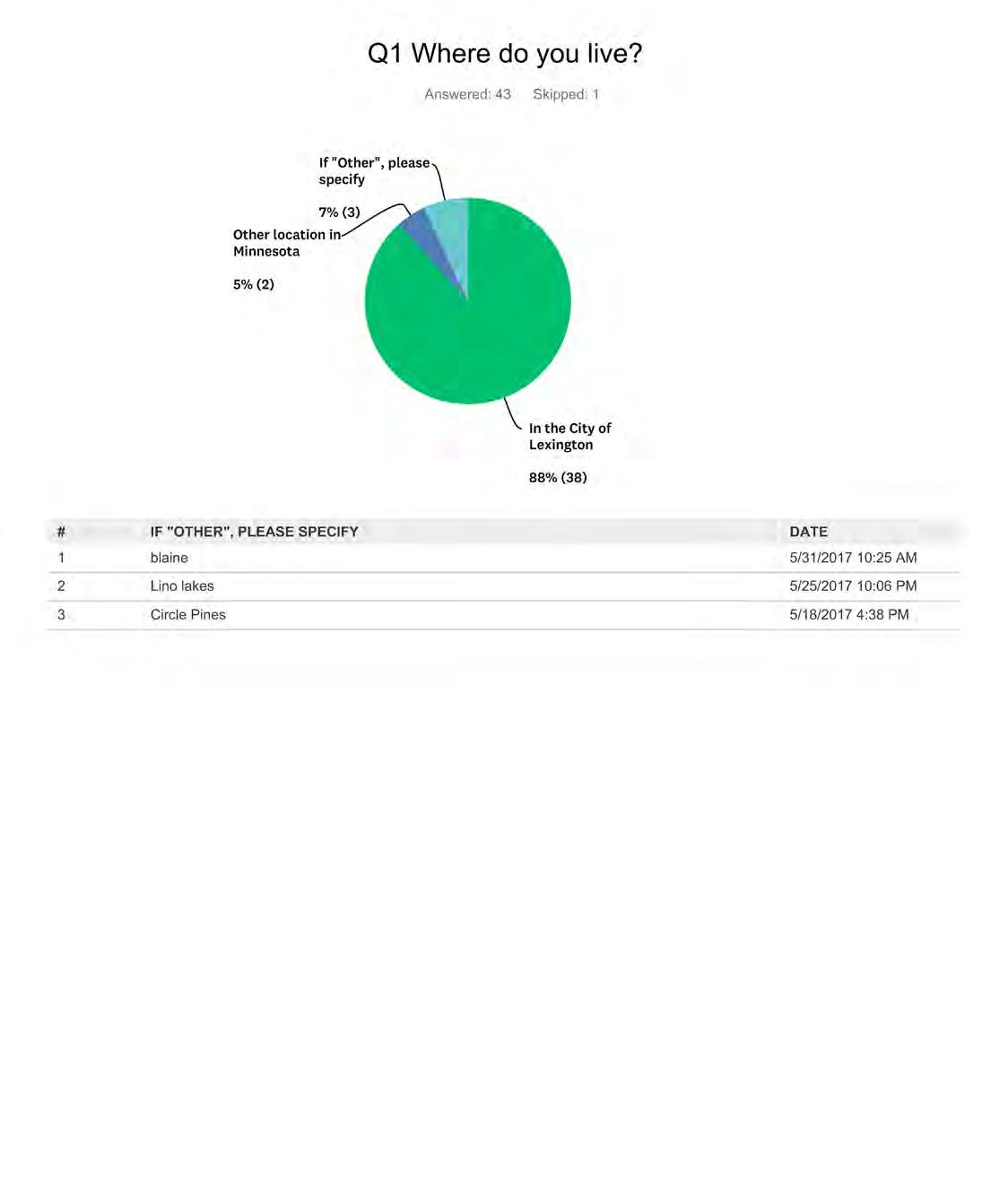
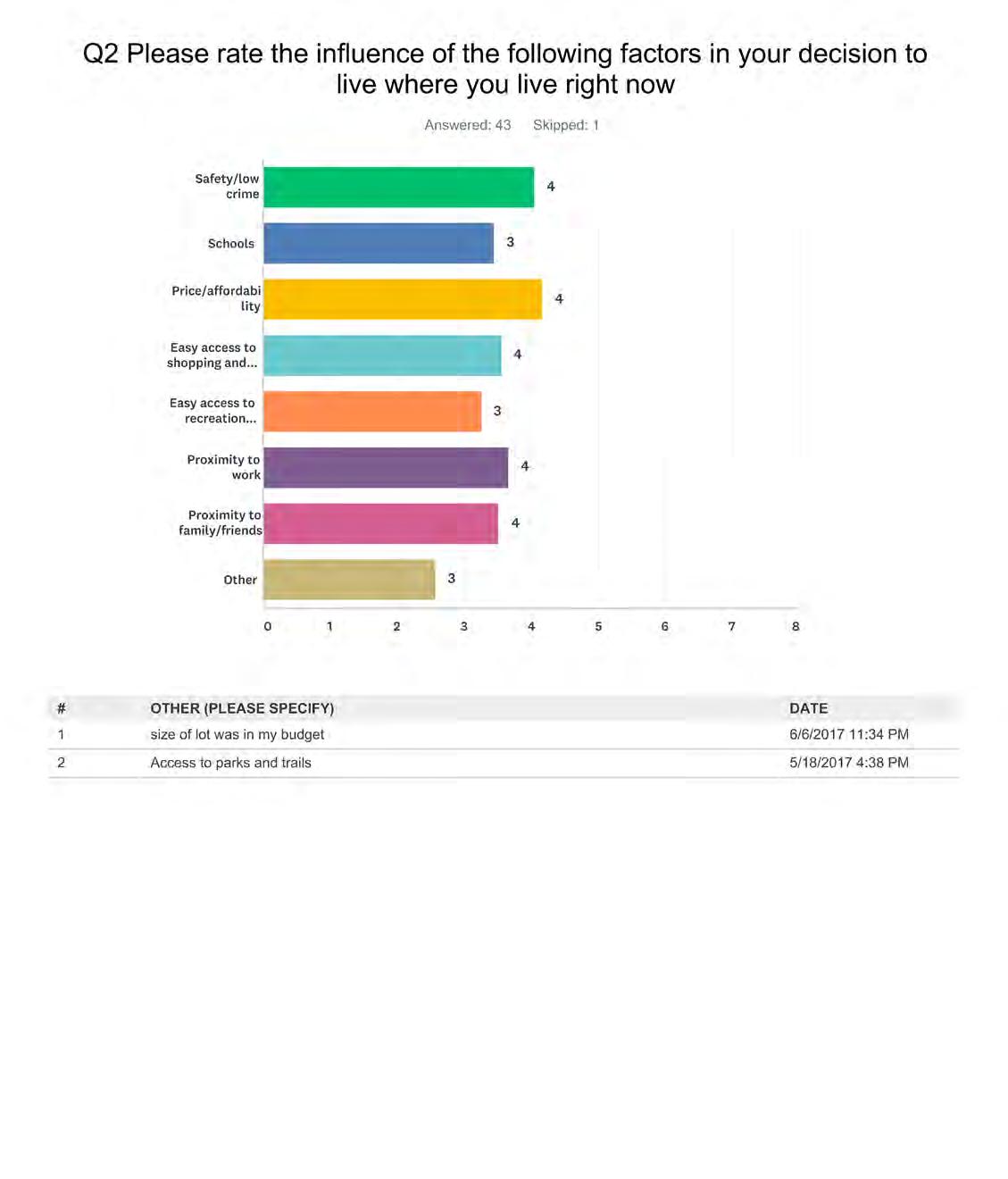
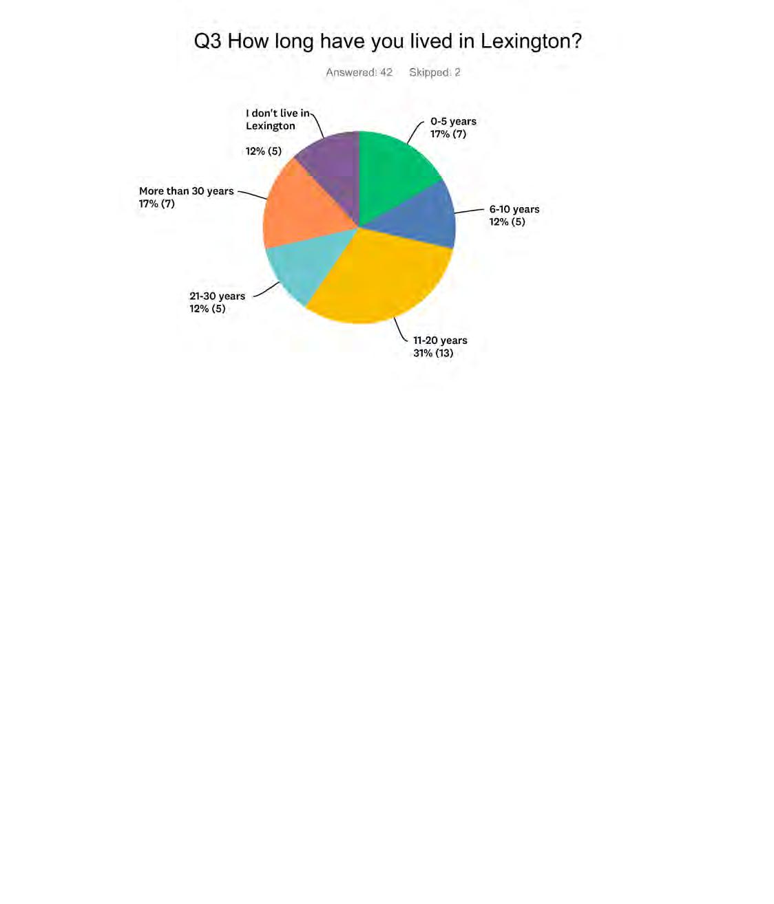
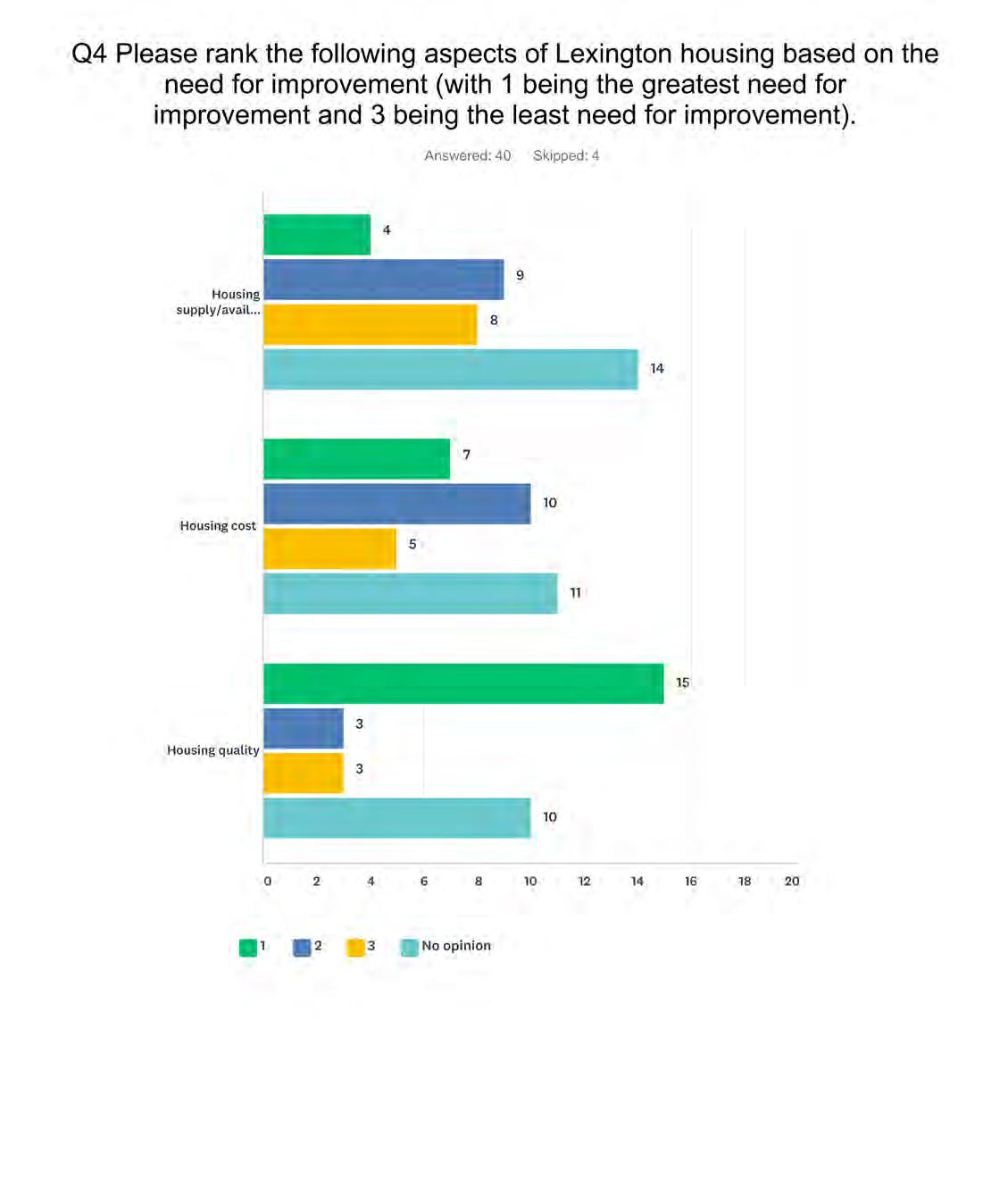
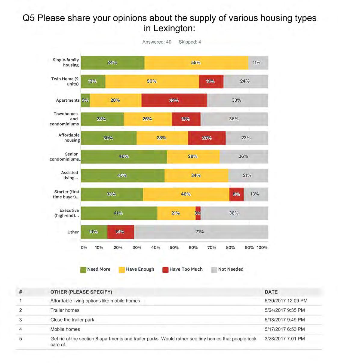
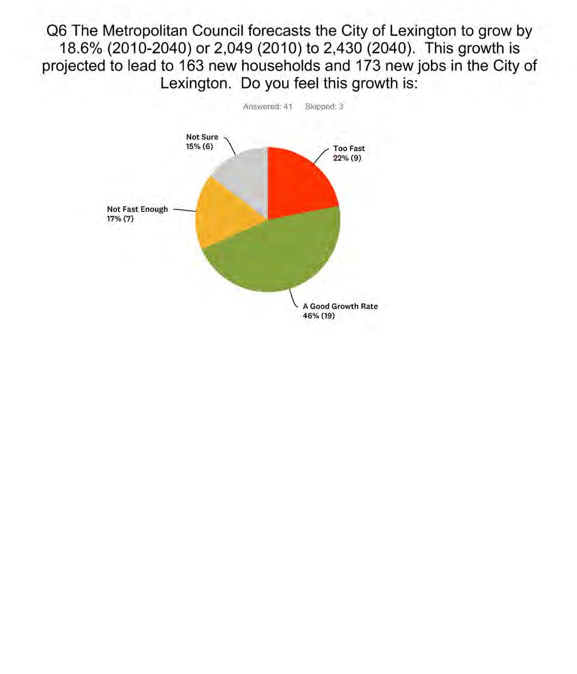
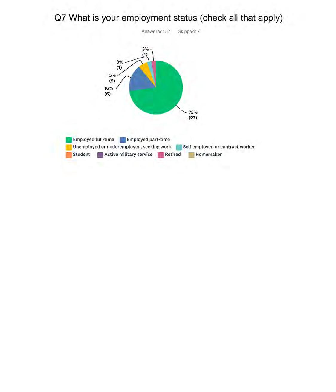
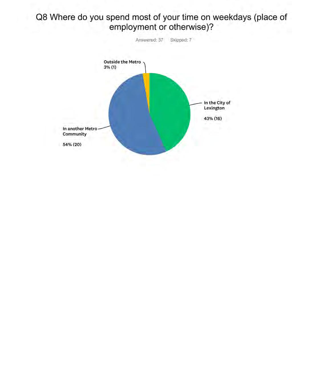
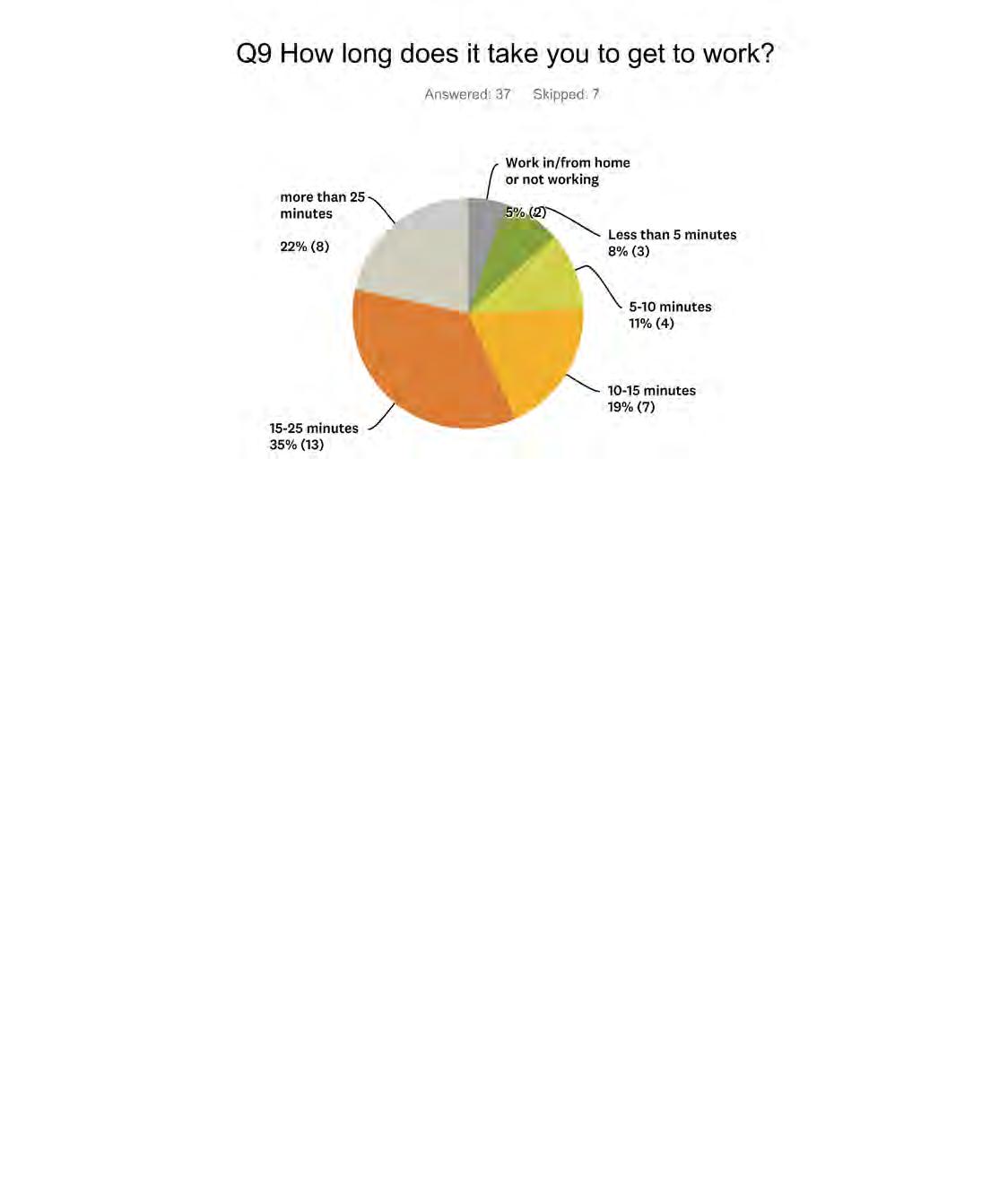
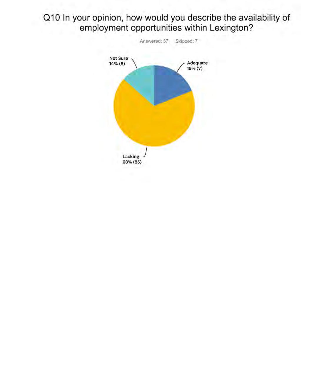
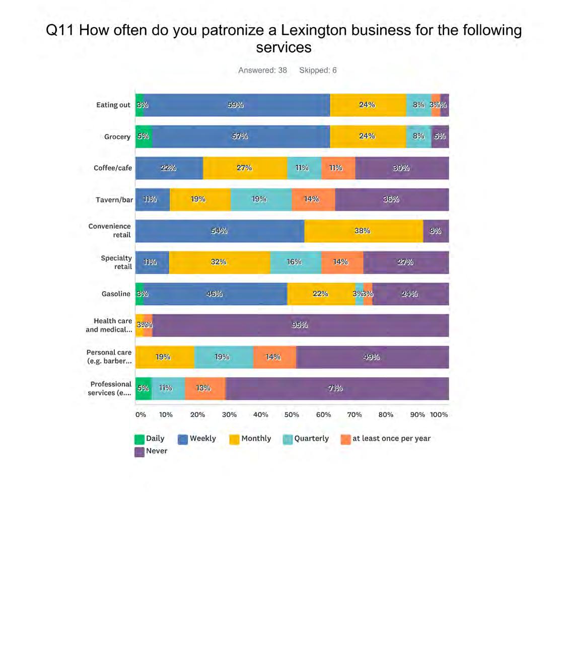
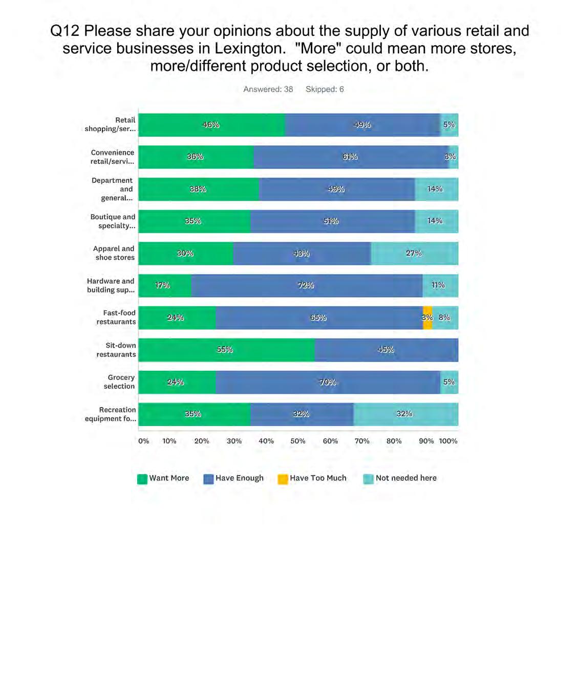
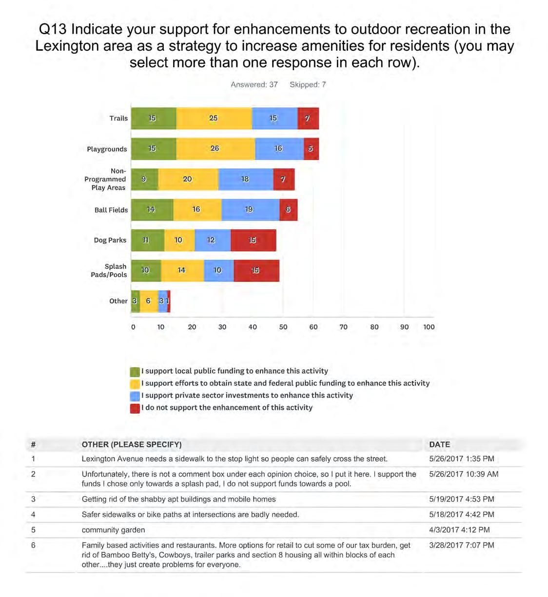
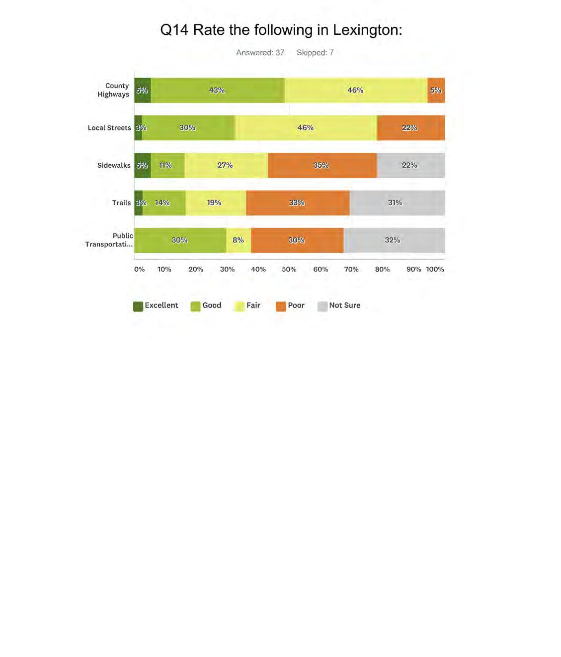

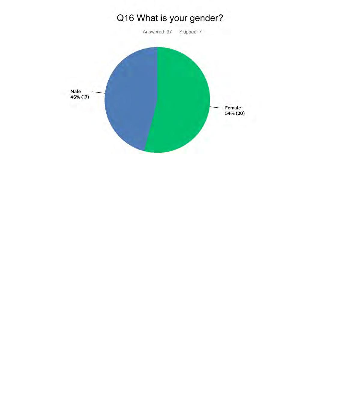
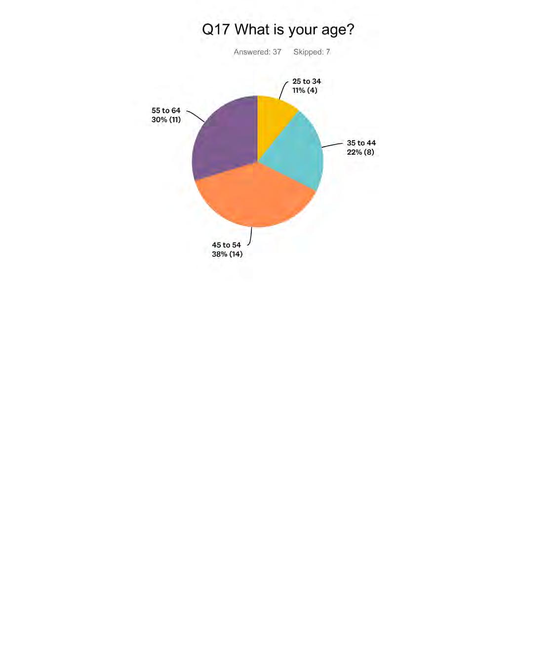

Lexington, MN


The City of Lexington Local Water Management Plan has been prepared in accordance with Minnesota Statutes 103.b, the Minnesota Rules Chapter 8410 and the Rice Creek Watershed District’s Watershed Management Plan .
The plan is subdivided into four sections as listed:
1. Executive Summary
2. Goals & Policies
3. General Standards
4. Maps
The City of Lexington lies completely within the Rice Creek watershed district. As such the City will rely primarily on the Rice Creek Watershed District (RCWD) for municipal review and compliance of stormwater management requirements. This district has water resource regulations which continue to apply within the city limits. The City provides public wastewater facilities and services to residents. Currently there are roughly 2100 residents with anticipated growth to reach roughly 2400 residents by 2040. The collector system is mostly serviced by gravity mains, and there are limited force mains in the City. A map of the sanitary sewer system has been provided for reference.
The City has a relatively small amount of surface water resources and thus is not in a FEMA 100 year floodplain boundary, however one public drainage ditch Anoka-Ramsey Judicial Ditch 1 is present within the City as well as a few wetlands. The RCWD is the drainage authority in the City and the local government unit for the Wetland Conservation Act. Because of the limited amount of surface water Lexington has less natural stormwater management basins, which is an occasional issue for localized drainage issues during large rain events. Currently there are no projects with the watershed taking place in or around Lexington. A map of the storm sewer system has been provided for reference.
The City inspects all storm water management facilities during construction, during the first year of operation. According to the City’s Stormwater Pollution Prevention Plan the City conducts annual inspections of structural stormwater BMP’s to determine structural integrity, proper function and maintenance needs. They also inspect a minimum of 20% of ponds and outfalls each year on a rotating basis. Any person subject to an NPDES storm water discharge permit shall comply with all provisions of such permit. Where re-use of stormwater is implemented, volumes captured shall be given equal credit toward the volume reduction requirement by the City.
Water pumped from a site shall be treated by the appropriate control devices. Erosion and sedimentation control devices and techniques shall be consistent with the MPCA’s Minnesota Stormwater Manual. The City also completes bi-annual street sweeping (100% of the streets) to prevent sediment and debris from entering the storm sewer system. The City will continue to address any non-stormwater discharges that are found to be a significant contributor of pollutants to the MS4.
The City will continue to implement a public education program to help educate residents about the impacts of stormwater discharges on water bodies and steps the public can take to reduce pollutants in stormwater runoff. The city will continue to assess existing and potential water resource problem areas in accordance with MN Rules 8410, but currently does not have any key conservation areas and has not identified any problem areas within city limits. The city does drain to impaired water bodies such as Rice Creek and Golden Lake.
1. Continue to partner with the Rice Creek Watershed District on their goals and policies.
2. Make sure all data collected by the District is available for all citizens and streamline the flow of permit related information, and conserve staff resources by improving the efficiency in the distribution.
3. Utilize the Rice Creek Watershed District (RCWD) website to provide access and distribution of data and information.
4. Use implementation processes and funding mechanisms consistent with the anticipated benefits received.
5. Minimize the potential damage to public and private infrastructure, private property, the land and other important water related natural resources caused by excess runoff and flooding.
6. Recognize the potential uncertainty associated with managing water resources and understand the implications of emerging issues including climate change, the use of monitoring data, and the interpretation of scientific and technical data, in the decision-making process.
7. Capitalize on opportunities to enhance water quality, reduce runoff volume and flood damages, and enhance ecological resources by using open space and greenways in the city.
8. Continue to incorporate ground water considerations into the decision making process with mindfulness of the interconnectedness of water and water dependent natural resources for development and redevelopment opportunities.
1. Provide data in a manner which maximizes use by the public, share and distribute data and information in the most efficient manner possible, and minimize the duplication of data collection through cooperative data collection efforts and information sharing on the city website.
2. Encourage landowners to improve water quality, reduce runoff volume, and enhance ecological systems through the use of cost-share programs.
3. Continue to partner with RCWD for management of wetlands and establish wetland management goals to improve ecological condition.
4. Continue to manage with RCWD public drainage systems and provide a functional level of service to benefited lands, while following local, state and federal laws and programs.
5. When describing the maintenance, repair, improvement and general management of public and private drainage systems use consistent language as previous documents internally and externally with the RCWD and other entities.
6. Achieve a better understanding of local surface and ground water dynamics and interactions in the City of Lexington.
Lexington provides public wastewater facilities or services to its residents. The system serves all recorded population, households, and lots located in Lexington. This is shown in the cities existing land use, as it is landlocked there future land use will be very similar. More detailed information and land use maps can be found in chapter 3 of the comprehensive plan. The systems service 787 households.
The City estimates that approximately 2,100 residences and businesses are served by the Sewage Treatment System. The table below from the Metropolitan Council illustrates that new growth through 2040 is expected to continue to utilize the municipal shared sewer system.
Source: Metropolitan Council
The map on the following page shows the entire Sanitary Sewer System for Lexington. It shows the various locations for manholes, force mains, gravity mains, pipe castings, lift stations, and the city limits of Lexington. Most of Lexington is serviced by gravity mains, and there are limited force mains in the City. For geological features of Lexington please refer to the RWCD Watershed Managment Plan or the Anoka County Geological Atlas.

The entire City of Lexington is within the boundaries of the Rice Creek Watershed District (RCWD). Additionally, an open channel public drainage ditch, Anoka-Ramsey Judicial Ditch 1 Branch 2 is present in the City of Lexington. Natural surface water features in the RCWD and the City of Lexington contribute greatly to the aesthetics of the community and/or function as natural drainage basins.
The City’s surface waters are integral to the City’s water resource management by serving as storage basins for stormwater during storm events and providing natural filtration for stormwater runoff. The City of Lexington does not contain any FEMA 100 year floodplain zones, Due to the relatively small amount of surface water resources. The surface waters in the City eventually drain to Golden Lake, Rice Creek, and the Mississippi River. The minimal surface waters downsizes the potential and the risk for flooding due to overflow of a lake or river, but localized flooding with heavy rainfall and large storms, still occurs as Lexington has few natural stormwater management basins.
The Rice Creek Watershed District is approximately 185 square miles. The District has water resource regulations and many efforts to maintain that their management goals and policies are implemented throughout the district. The District has water resources regulations and goals and policies that it implements throughout the District to conserve and restore water resources for the beneficial use of current and future generations.

All storm water management facilities shall be designed to minimize the need for maintenance, to provide access for maintenance purposes and to be structurally sound. All storm water management facilities shall have a plan of operation and maintenance that assures continued effective removal of pollutants. The director of public works, or designated representative, shall inspect all storm water management facilities during construction, during the first year of operation, and every year for structural stormwater BMPs to determine structural integrity, proper function, and maintenance needs. The inspection records will be kept on file at the public works department for a period of 6 years. It shall be the responsibility of the applicant to obtain any necessary easements or other property interests to allow access to the storm water management facilities for inspection and maintenance purposes.
The city of Lexington will primarily rely on the RCWD for municipal review and compliance with stormwater management requirements. However, certain provisions are kept for unique situations. Included in these are industrial activities and situations where access is limited.
Any person subject to an NPDES stormwater discharge permit shall comply with all provisions of such permit. Proof of compliance with the permit may be required in a form acceptable to the city prior to the allowing of discharges to the storm sewer system. Any person responsible for a facility that has stormwater discharges associated, and who is or may be the source of an illicit discharge, may be required to implement, at the person’s expense, additional structural and nonstructural BMPs to prevent the further discharge of pollutants to the storm sewer system. These BMPs shall be part of a stormwater pollution prevention plan as necessary for compliance with requirements of the NPDES permit.
If the city has been refused access to any part of the premises from which stormwater is discharged, and is able to demonstrate probable cause to believe that there may be a violation of this section or that there is a need to inspect and/or sample as part of a routine inspection and sampling program designed to verify compliance with this chapter or any order issued hereunder, or to protect the overall public health, safety, and welfare of the community, then the city may seek an administrative search warrant from any court of competent jurisdiction.
The City’s post-construction control ordinance is the City’s method for managing stormwater associated with development and re-development projects. Where re-use of stormwater is implemented, such as use with an irrigation system, the volume captured and reused shall be considered volume capacity towards volume reduction requirements by the City within the same resource of concern. All re-use measures must be fully documented in the post-construction stormwater management program maintained by the City. If the permittee receives payment from the owner and/or operator of a construction activity for mitigation purposes in lieu of the owner or operator of that construction activity meeting the conditions for post-construction stormwater management. The permittee shall apply any such payment received to a public stormwater project. The permittee must identify priority areas within the various watersheds of its jurisdiction where mitigation projects could occur. If the owner of a construction activity cannot meet the TSS and TP requirements because of site limitations, they may either perform a mitigation project or make an in- lieu-of payment to the City to apply to a mitigation project at a later time.
The City of Lexington has no regulated areas.
The City of Lexington has no key conservation areas as the City limits are 100% developed and the City is landlocked.
The City’s CIP does not include any projects that would impact the regional systems. All Capital Improvement Programs relating to regional systems would be limited and primarily focused on maintenance efforts on an as required basis with no major expansions anticipated. The city reviews the CIP annually. 2019’s CIP is shown below; Category Cost Funding Source
Administration
Fire
Street
Parks
Transfers
Liquor
Storm Sewer
Sewer
Water
$86,000
$50,000
$186,000
$5,000
$25,000
$40,000
$0
$3,500
$3,500
Capital Fund and Franchise Fees
Gambling Proceeds 10% Funds
Capital Fund and Fund Reserves
Capital Fund and Park Dedication Fees
Reduce Debt Levy to 2017 Street Improvement
Liquor Fund
Storm Sewer Fund
Sewer Fund
Water Capital Expenditure
Please refer to the end of this document for the cities Local Watershed Management Plan located on page 22-23.
The City of Lexington is compliant with the NPDES requirements for MS4 permittees. The City of Lexington’s Stormwater Pollution Prevention Plan is a resource stating rules and regulations, some of the proceeding sections of this plan are summaries of the SWPPP. The City of Lexington has a categorical Waste Load Allocation (WLA) for the Golden Lake TMDL. The City has helped address this WLA by installing raingardens in the City. The City will work with RCWD and adjacent communities to continue addressing the Golden Lake TMDL requirements. The City is also included in the Upper Mississippi River Bacteria TMDL, and will help address this by implementing a pet waste ordinance or policy.
Water pumped from the site shall be treated by temporary sedimentation basins, grit chambers, sand filters, up flow chambers, hydro-cyclones, swirl concentrators or other appropriate controls as appropriate. Water may not be discharged in a manner that causes erosion or flooding of the site or receiving channels or a wetland. Erosion and sedimentation control devices and techniques shall be consistent with the MPCA’s “MN Stormwater Manual” as amended. For sites with less than ten acres disturbed at one time, silt fences, straw bales, or equivalent control measures shall be placed along all side slope and down slope sides of the site. If a channel or area of concentrated runoff passes through the site, silt fences shall be placed along the channel edges to reduce sediment reaching the channel. The use of silt fences, straw bales, or equivalent control measures must include a maintenance and inspection schedule. Below is a link. The existing ordinance needs some updates that will be completed as shown in the CIP. This will occur within the required Minnesota State Statute timeframe. http://www.ci.lexington.mn.us/page/open/648/0/CHAPTER%2013%20-%20STORM%20WATER%20MANAGEMENT%20REGULATIONS.pdf
Street sweeping: The City currently uses a City owned mechanical street sweeper to remove sediment and debris from the road surface within the jurisdiction and minimize the amount received by the storm sewer system. The City plans to continue to use the current system of street and parking lot sweeping which involves training, storage, disposal, and sweeping schedules. Lexington completes biannual street sweeping (100% of the streets).
Snow plowing: The City holds an annual snowplow meeting.
Salt: Inspect all exposed stockpile, storage and material handling areas at least annually. The City uses a salt/sand mixture. This stockpile is always completely disposed of by the end of each winter season. The City does not store salt mixtures over the summer. The city has goals to document the amount of salt and sand applied to roadways, create a sensible salt program, and evaluate alternative deicing products, equipment, or procedures.
The City will continue to evaluate whether any of the following categories of non-stormwater discharges or flows are significant contributors of pollutants to our MS4: water line flushing, landscape irrigation, diverted stream flows, rising ground waters, uncontaminated ground water infiltration, uncontaminated pumped ground water, discharges from potable water sources, foundation drains, air conditioning condensation, irrigation water, springs, water from crawl space pumps, footing drains, lawn watering, individual residential car washing, flows from riparian habitats and wetlands, dechlorinated swimming pool discharges, street wash water, and discharges or flows from fire fighting activities. For any nonstormwater discharges or flows which the City finds to be a significant contributor of pollutants to the MS4 the City will develop an action plan to evaluate and address the impact the discharge is having on stormwater quality.
City Code Chapter 13, Section 13.30 Sub-division 13 states “All Stormwater management facilities shall be designed to minimize the need of maintenance, to provide access for maintenance purposes and to be structurally sound. All Stormwater management facilities shall have a plan of operation and maintenance that assures continued effective removal of pollutants carried in Stormwater runoff. The director of public works, or designated representative, shall inspect all Stormwater management facilities during construction, during the first year of operation, and at least once every year thereafter. The inspection records will be kept on file at the public works department for a period of 6 years. It shall be the responsibility of the applicant to obtain any necessary easements or other property interests to allow access to the storm water management facilities for inspection and maintenance purposes.”
The City will continue to implement a public education program to distribute educational materials to the community or conduct equivalent outreach activities about the impacts of Stormwater discharges on water bodies and the steps that the public can take to reduce pollutants in Stormwater runoff.
• Publish Stormwater issues, recycling information and Education Program information articles in the Quarterly Newsletter. (ongoing)
• Distribute Educational Materials on Cable Television Broadcast Channel 16
• Broadcast weekly issues on Stormwater management on Cable Television Channel 16 continually throughout to educate our residents. (ongoing)
• Continue 30-day public notice for the annual public meeting and continued on an annual interval. (ongoing - annual)
• Solicit Public Input and opinion on the Adequacy of the SWPPP
• Continue to provide a copy of the SWPPP at City Hall for viewing prior to the annual Public Meeting and other times upon request. (ongoing - annual)
• BMP categories to be implemented
• Measurable goals and time frames
• Online Availability of Stormwater Pollution Prevention Program Document
• Provide an electronic document of Stormwater Pollution Prevention Program document online, to allow anytime, easier access to these documents annually. (ongoing - annual)
The City is required to assess existing or potential water resource problems regulated by MN Rules 8410. Currently within the city limits the City of Lexington has not identified problem areas such as floodplain increases or stormwater capacity limitations. There are no conflicts between infiltration requirements and wellhead protection. Citizens have identified a few issues such as drainage issues during heavy rains, old sewer and water infrastructure, and water run-off from the industrial park. Lexington is a regulated community for stormwater but is not a local floodplain administrator for FEMA. The city does drain to Golden Lake, Rice Creek and the Mississippi River, which is a problem. The city will evaluate corrective issues to help ensure they are limiting their effect on these impaired waters. The Rice Creek Watershed District, district wide modeling has identified an existing point of discharge from Lexington to Blaine and is shown in the following table with the flow points. Through our existing goals and policies we will continue to work with the RCWD to ensure there is no increase in flow-age.
Normally, the City of Lexington will initiate and proposed amendment to the City’s Local Water Management Plan and can do so at any time. The process will require the City of Lexington to acknowledge a needed amendment. Amendments can be required to comply with amendments to the Local Water Management Plan requirements, to comply with modifications in State Statues, to comply with revisions in the State Rules, to correct errors in the present plan, or to meet changing needs within the City of Lexington. The Local Watershed Management Plan must be updated every 10 years as part of the Comprehensive Plan update processes.
Any amendment will need to be considered by the City of Lexington. Upon consideration of the City Council, any amendment will need to follow the adopted submittal and review process described in the section titled Submittal and Review.
The Minnesota Rules Chapter 8410, Minnesota Statues 103.b and the RCWD Watershed Plan outline the submittal and review process of the Local Water Management Plan (LWMP). Lexington must consider and approve forwarding the LWMP, or any amendment, to the Rice Creek Watershed District (RCWD) for approval. The RCWD is allowed 60 days to review the Local Plans. Within the 60 days, the RCWD can approve, deny or request an extension from Lexington. If the RCWD fails to approve or deny the Plan within the 60 days and Lexington does not approve an extension, the LWMP is deemed approved.
Lexington must also forward a copy of the LWMP to Anoka County and to the Metropolitan Council for review at the same time the LWMP is submitted to the RCWD. Anoka County and the Metropolitan Council have 45 days to review and submit comments to RCWD. Neither the County nor the Metropolitan Council has the authority to deny the LWMP.
Once the RCWD has approved the LWMP or amendment, either by action or the failure to act within the prescribed period, the City of Lexington must adopt the LWMP or amendment within 120 days. The implementation of any regulatory controls required by the plan, or amendment to the plan, must be implemented within 180 days of the approval by the RCWD.

Karst Features (DNR)
Source: Metropolitan Council
Surface water type (regional screening by Met Council)
Disconnected from the regional groundwater system
Recharges aquifers
Receives and discharges groundwater
Supported by upwelling groundwater
Trout Streams (DNR)
County Boundaries
City and Township Boundaries
NCompass Street Centerlines
Other Open Water Features
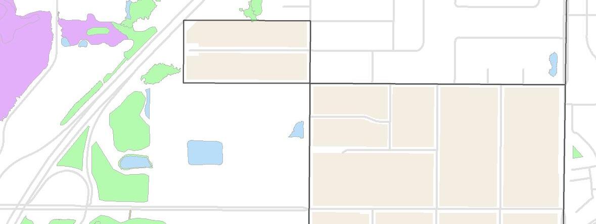


The existing land use map represents the existing environment of the City’s land use. The majority of Lexington is residential. For further in depth information on the land use categories please refer to Chapter 3 of the city’s comprehensive plan.
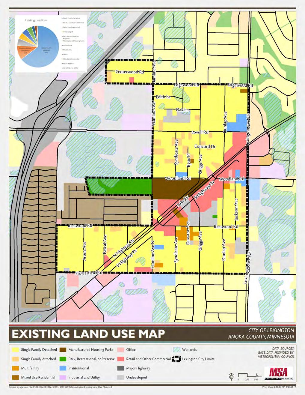
The future land use map represents the desired environment of the City’s future land use. The majority of Lexington is residential. In the next 10 years there is potential for more commercial development. For further in depth information on the land use categories please refer to Chapter 3 of the city’s comprehensive plan.


1 Annual SWPPP Assessment & Annual Reporting
City staff will conduct an annual SWPPP assessment in preparation of each annual report. Proposed SWPPP modifications are subject to Part II.G of the MS4 permit. The final annual report will be posted on the City’s website. City staff will submit the annual report to the MPCA prior to June 30th for the previous calendar year.
2 Online Availability of the Stormwater Pollution Prevent Plan (SWPPP) Program Document
The City will make the SWPPP and each year’s annual report available on the Water Resources webpage within 12 months from the date the MS4 permit coverage is extended to the City.
3 Update Stormwater Management Regulation Ordinance
The City will update their ordinance to be consistent with NPDES Permit regulations. As well as continue to enforce the regulation. This will be completed in the timeframe allowed by MN State statute.
4
Identify possible corrective actions and solutions for the city’s eventual drainage into the impaired waters of Rice Creek, Golden Lake and the Mississippi River.
5 Continue to monitor ARJD 1 Branch 2 to ensure that the existing flow rate is maintained or reduced.
Total Cost

REGULAR PLANNING COMMISSION MEETING
July 9, 2019 - 7:00 P.M.
9180 Lexington Avenue, Lexington, MN
A. Roll Call: Vice Chairperson Vanderbloomer, Commissioners Bautch, Koch, Murphy, and Thorson
Chairperson Vanderbloomer called to order the Public Hearing on July 9, 2019 at 7:00 p.m. Commissioners Present: John Bautch, Michelle Koch and Gloria Murphy. Excused Absence: Ron Thorson. Also present: John Hughes, City Councilmember; Bill Petracek, City Administrator; Kurt Glaser, City Attorney; Chris Janson and Claire Michelson, MSA Consultants.
Public Hearing the purpose of the Public Hearing is to take comments on the draft 2040 Comprehensive Plan
Chris Janson, Planner for MSA Consultants, provided an overview of the final draft of the 2040 Comprehensive Plan and the approval process.
Vanderbloomer asked if the website solicited any comments from citizens on the plan. Janson stated that the website didn’t generate any comments, although there were comments made by Anoka County on the plan.
Discussion ensued about the full approval process for the plan that Janson discussed with the Commission.
No citizens were present to provide comments on the 2040 Comprehensive Plan
Bautch made a motion to adjourn the Public Hearing at 7:08 p.m. Murphy seconded the motion. Motion carried 5-0.
REGULAR PLANNING COMMISSION MEETING
July 9, 2019 - 7:00 P.M.
9180 Lexington Avenue, Lexington, MN
3. CALL TO ORDER
B. Roll Call: Chairperson VanderBloomer, Commissioners Bautch, Thorson, Koch and Murphy
Chairperson Vanderbloomer called to order the Regular Planning Commission meeting on July 9, 2019 at 7:08 p.m. Commissioners Present: John Bautch, Michelle Koch and Gloria Murphy. Excused Absence: Ron Thorson. Also present: John Hughes, City Councilmember; Bill Petracek, City Administrator; Kurt Glaser, City Attorney; Chris Janson and Claire Michelson, MSA Consultants.
4. CITIZENS FORUM
No citizens were present to discuss items not on the agenda
5. APPROVAL OF AGENDA WITH CHANGES AND CORRECTIONS
Bautch made a motion to approve the agenda as typewritten. Koch seconded the motion. Motion carried 5-0.
6. LETTERS AND COMMUNICATION
A. Building Permits for June 2019
Some discussion on permits issued to Landings of Lexington
7. APPROVAL OF PLANNING COMMISSION MINUTES
A. June 11, 2019
Murphy made a motion to approve the June 11, 2019 minutes. Koch seconded the motion. Motion carried 5-0.
8. DISCUSSION ITEM:
A. Recommendation to City Council to approve 2040 Comprehensive Plan
Bautch made a motion to recommend to the City Council the approval of the 2040 Comprehensive Plan. Koch seconded the motion. Motion carried 5-0.
B. Discuss Proposed Ordinance Changes – Outdoor Storage
Attorney Glaser provided an overview of the proposed changes to the outdoor storage ordinance. Glaser stated that he has arranged the proposed regulations in a manner that all the provisions will be located in two locations in the ordinance book, as opposed to several locations, as it currently exists. Discussion ensued.
Petracek stated he believed Glaser is on the right track simplifying the regulations for ease of enforcement by having them placed in chart format in the zoning regulations. Discussion ensued.
Vanderbloomer recommended tabling this item so that the Planning Commission can have more time to review the regulations for further discussion at the next meeting. The consensus was to table the items for further review.
No action was taken.
Vanderbloomer asked to table this
A. June 6, 2019
B. June 20, 2019
Some discussion was had on the Citizens Forum at the June 20th meeting regarding organized waste hauling.
No input from the Planning Commission
11. ADJOURNMENT
Bautch made a motion to adjourn at 8:07 p.m. Koch seconded the motion. Motion carried 5-0.
JULY 18, 2019 – 7:00 P.M.
9180 LEXINGTON AVENUE
1. CALL TO ORDER: – Mayor Kurth
A. Roll Call - Council Members: DeVries, Harris, Hughes and Murphy
Mayor Kurth called to order the Regular City Council meeting for the City of Lexington at 7:00 pm of July 18, 2019. Councilmember’s present: Devries, Harris, Hughes, and Murphy. Also Present: Bill Petracek, City Administrator; Kurt Glaser, City Attorney; Chris Galiov, Finance Director; Chris Janson and Claire Michaelson, MSA Consultants.
2. CITIZENS FORUM
No citizens were present to discuss items not on the agenda
3. APPROVAL OF AGENDA WITH CHANGES AND CORRECTIONS
Councilmember Hughes made a motion to approve the agenda as amended. Councilmember Murphy seconded the motion. Motion carried 5-0.
4. LETTERS AND COMMUNICATIONS:
A. City Report – June 2019
B. North Metro TV – June 2019 Update
C. Planning & Zoning meeting minutes – July 9, 2019
D. Centennial Lakes Police Department Media Reports
6-19- through 7-9-2019
No discussion on Letters and Communications
5. CONSENT ITEMS:
A. Recommendation to Approve Council Minutes: Council Meeting – July 11, 2019 will be presented at the August 1, 2019 for approval
B. Recommendation to Approve Claims and Bills:
Check #’s 13620 through 13621
Check #’s 45097 through 45149
Check #’s 12709 through 12723
Councilmember Murphy made a motion to approve the consent agenda items. Councilmember Devries seconded the motion. Motion carried 5-0
A. Recommendation to approve Resolution NO. 19-15 A Resolution Approving the 2040 Comprehensive Plan and Authorizing Its Submittal To the Metropolitan Council For Review
Chris Janson, MSA Consultants, provided an overview of the final draft of the Lexington 2040 Comprehensive Plan. He discussed the process of submitting the final draft to the Metropolitan Council for their 30-day review of the plan and then the Council would approve the final plan following the Met Council’s review and changes. Discussion ensued.
Councilmember Hughes made a motion to approve Resolution NO. 19-15 A Resolution Approving the 2040 Comprehensive Plan and Authorizing Its Submittal To the Metropolitan Council For Review. Councilmember Devries seconded the motion. Motion carried 5-0.
Mayor Kurth thanked Vice Mayor Hughes for filling in for him at the last meeting.
8. ADMINISTRATOR INPUT
Petracek stated he would be taking the first week in August off. Discussion ensued.
9. ADJOURNMENT
Councilmember Devries made motion to adjourn the meeting at 7:06 p.m. Councilmember Harris seconded the motion. Motion carried 5-0.