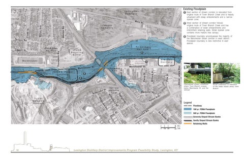
Existing Floodplain
Lexington Cemeter y
1 East section of stream corridor is relocated from
Calvar y Cemeter y
Henton Rd.
C ly d e S t.
Wil ton Av e.
Main
original route of Town Branch Creek and is heavily urbanized with steep embankments and a narrow riparian zone. St.
2 West section of stream corridor follows
original route of Town Branch Creek and has a combination of wider embankments and intermittent retaining walls. Wider riparian zone contains more mature tree canopy. 3 Floodplain boundary encompasses the majority of
the Manchester Street corridor in west district. Floodplain boundary is less restrictive in east district. LFUCG Recycling Center
3
3 2
er
Manchester St.
Speig le Heights Pa r k
gl St
Legend
St
on
Floodway
.
St .
St
. Ve
r
i sa
lle
s
Rd
.
100 yr. FEMA Floodplain D
e
R
0’
10
Scrub understory is indicative of the steep slopes along Town Branch
e.
.
n
us
so
e
rt
rg
Av ey l l Va
ei
be
Fe
Ja
ne
Channelized stream conditions where Town Branch crosses below Manchester St. and the railroad
Edmond St.
Sp
Ro
And
St. son
Oliver Lewis Way
Pyr amid Pa r k
Pine St.
r S t.
Will ard St.
M a n c h e s te
James E. Pepper Distiller y
Vulcan Materials Company
W.M. Tar r Distiller y
1
Per ry St.
War ehouses
RJ Cor man Rail Yar d
Driscoll St.
T hompson Rd. Par k
L ig g e tt S t.
Thompson Rd.
Te x a c o R d.
500 yr. FEMA Floodplain oo
de
S Severely Sloped Stream Banks S
Gently Sloped Stream Banks Retaining Walls
t.
100’ 200’
400’ north
Lexington Distillery District Improvements Program Feasibility Study, Lexington, KY