
STRATEGIC PLAN


Acknowledgements
Gregg County and MHS Planning & Design, LLC would like to thank the following leaders and volunteers for their input in the development of this plan. A special thanks to the residents & public administration of Gregg County for their participation and input, Longview Fire Department for their vital assistance during the river tour, and the Sabine Rivier Authority for their financial support during the planning process.
Gregg County:
Judge Bill Stoudt – County Judge
Ray Bostick – County Commissioner, Precinct 2
Sabine River Authority
Travis Williams – Assistant General Manager
Troy Henry – Upper Basin Regional Manager
Don Iles - Middle Basin Regional Manager
Local City Leadership:
Rolin McPhee – City Manager, City of Longview
Josh Selleck – City Manager, City of Kilgore
Charlie Smith – Interim City Manager, City of Gladewater
Johnny Sammons - Mayor, City of Lakeport
Walter Ward - Mayor, City of Easton
Steering Committee:
Ray Bostick - Gregg County Commissioner, Precinct 2
Shawn Hara - Community Relations Director, City of Longview
Seth Pyle - Former Parks Director, City of Longview
Josh Selleck - City Manager, City of Kilgore
Don Iles - Middle Basin Regional Manager, Sabine River Authority
Gregg County Paddling Trail Strategic Plan
Gregg County Contact:
Judge Bill Stoudt 101 E Methvin Street
Longview, TX 75601 Office: 903-236-8420
MHS Planning & Design Team:
Hunter Rush, Senior Planner & Partner
John Waltz, Planner
Zach Clark, Planner
Jonathan Povoski, Graphic Designer 212 W 9th Street Tyler, TX 75703 Office: 903-597-6606
Project Contact: Shawn Hara 300 W Cotton Street
Longview, TX 75601 Office: 903-237-2733
MSA Professional Services Contact:
Raine Gardner, PE 1702 Pankratz Street Madison, WI 53704 Office: 608-242-7779
Executive Summary
Gregg County, through funding from the Sabine River Authority (SRA), partnered with MHS Planning & Design (MHS) in 2023 to perform an analysis of the County’s approximately 50 miles of the Sabine River’s stream bank and provide recommendations for future access points, amenities, and programming in the paddling trail strategic plan. The Executive Summary is intended to briefly explain the process that was utilized to develop the plan, which includes understanding and inventorying the existing river conditions and encouraging dialogue to determine the needs of the communities surrounding the river within Gregg County. The analyzed information was used to create a list of recommendations and an implementation schedule, which is a flexible guide that outlines the steps needed to expand existing river access sites and develop new areas over time. Investing in infrastructure and amenities should be a priority for the County because ramps, facilities, and open spaces enhance user quality of experience and programming. This will encourage economic development and additional investment in the river and surrounding communities.
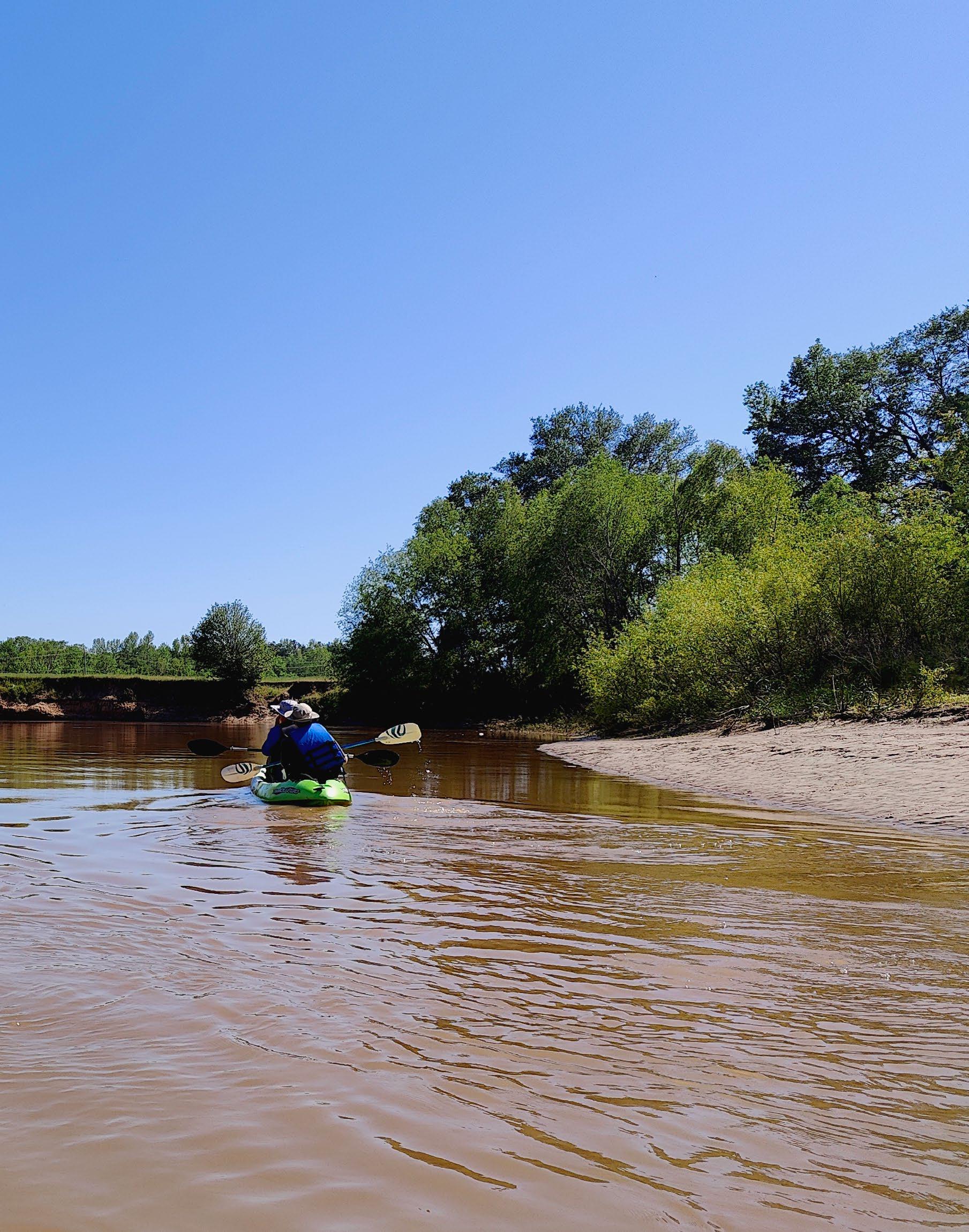
To understand the desires of the river’s userbase and Municipal and County Staff, a Steering Committee was developed to assist with the plan. MHS strategically partnered with MSA Professional Services (MSA) to assist with planning, as they are specialists in water-based planning and design. Together, the team conducted several different forms of engagement with the general public and stakeholders to ensure the community had the opportunity to voice their opinions regarding the existing and the future river developments. To capture the existing conditions of this portion of the Sabine River, the team conducted numerous site visits, observing conditions from the land as well as from the river via a boat, courtesy of the Longview Fire Department Water Rescue Team.
During the planning process, it became apparent from strong citizen input that the community was in significant need of enhanced accessibility to the Sabine River; the lack of accessibility was primarily due to steep topography and the overall lack of publicly owned land along the riverbank. The Steering Committee, County Staff, City Staff, and consultants developed comprehensive recommendations, including schematic designs, estimated construction allowances, and a feasible timeline for implementing the proposed improvements. It is recommended to acquire properties around five bridge crossings for new sites and expand existing sites, improve existing facilities with additional parking and amenities, and utilize wayfinding signage, branding, an education campaign, and programming to enhance the safety and marketability the river. These action items will help Gregg County in effectively addressing the accessibility needs identified in the plan, ensuring the community benefits from the improvements.


Chapter 1 - About the Area
The Sabine River is one of 15 major river basins in the State of Texas, and while it has one of the smallest basin areas, it has the second largest average flow of water per year, partly due to the Toledo Bend reservoir. The Sabine River is a key feature for East Texas, serving as a vital water resource, a source of leisure and recreation, and a segment of the eastern state boundary. The crescent river drains space approximately 10,000 square miles of watershed, meandering in every direction as it flows between cities and towns for approximately 360 miles with a 48-mile width. It also encompasses three major reservoirs: Lake Tawakoni, Lake Fork, and Toledo Bend.
The Sabine is a natural river with a series of quiet pools and several small riffles. Seasonal flow through nearly flat terrain results in long periods of little to no velocity. Weather situations cause water levels to dramatically rise and fall upwards of 20 feet. There are man-made structures including bridges, crossing pipelines, and weirs that must be heeded while traversing.
The Sabine River watershed boasts a rich and varied ecosystem with a wide diversity of flora and fauna. A range of wildlife species can be found in this region, including alligator gar, bald eagles, blue herons, catfish, deer, ducks, hogs, kingfishers, white-tailed deer, osprey, otters, sand bass, and turkey. The presence of the Hardwood Bottomland forests throughout East Texas creates a densely forested environment. Within these forests, commonly found trees include ash, elm, oak, and pine trees. The flora and fauna contribute to the ecological balance and natural beauty of the area.
The area of study for this segment of the Sabine River watershed is located within the Gulf Coastal Prairies subregion of the Gulf Coastal Plains region in Texas. This region spans from the Louisiana border to the Rio Grande Valley. The subregion is known for having soil rich in clay, sand, and silt, and trees typically consist of Elm, Oak, Pine, Sugarberry, and Yaupon. The land is typically low sloping and contains numerous waterways. The waterways have played a significant role in the formation of local development, with the water being used for agriculture, civil, industry, and transportation needs. The Sabine River is the primary source of drinking water for the cities of Longview, Kilgore, and White Oak. These cities have raw water pump stations located on the river, and the weirs are able to be crossed over when the water height is at normal levels.
THIS PORTION OF THE RIVER IS NOT HEAVILY USED FOR RECREATION WHEN COMPARED TO OTHER RIVERS IN TEXAS. HOWEVER, LOCAL CITIZENS WANT TO RECTIFY THIS.
The Sabine River is managed by the Sabine River Authority, a multi-state official agency whose mission is to control, store, preserve, and distribute the waters of the Sabine River and its tributary system for useful purposes. One of the uses of the river is for recreational activities - opportunities for fishing, kayaking, and boating. Other sections of the Sabine River have been developed as official Texas Parks & Wildlife Inland Paddling Trails, which is awarded to exceptional paddling trails and helps promote and inform other paddlers of Staterecommended trails. This specific portion of the Sabine River is not designated as a TPWD paddling trail, and it is not as heavily used for recreational purposes compared to other rivers in Texas. Through comprehensive studies conducted by MHS, the number of users utilizing the Sabine River for recreation has been negatively affected by the lack of public river access. The citizens and administration of Gregg County desire to enhance this useful purpose of the river, and the proposed improvements outlined in this plan will help the County attain the designation of a Texas Paddling Trail for this segment of the river and improve access for all.


Chapter 2 – Inventory & Public Input
MHS and MSA conducted an extensive study on the Sabine River throughout this planning process. To capture the existing conditions of this portion of the Sabine River, the field team conducted numerous site visits, observing conditions from the land as well as from the river via a boat, courtesy of the Longview Fire Department Water Rescue Team. In addition to the site visits, two public meetings were held, and four focus groups were conducted. The site visits as well as the public and focus group meetings provided the County and Consulting Team with an overall inventory and site analysis of current uses and desired uses of the Sabine River.
SITE INVENTORY
During the site visits, staff observed the river and land conditions and geotagged points of interest surrounding the river; the process of geo-tagging involves taking photos with precise coordinates and managing the data with ESRI's Geographic Information Science (GIS) software. The points of interest were then categorized and used to educate stakeholders during the public engagement and to determine the recommendations on where access points to the Sabine River could be reasonably and cost-efficiently added. The following section details the inventory and findings.
The banks along the river are heavily wooded with hardwoods and pine trees. Tree canopies stretch over the water and eroded banks showcase complex root systems, aged concrete and metal structures, and occasionally sandy shores. The area of study is incredibly winding, running approximately 50 miles within a 25-mile Euclidean span (as the crow flies). As it carves deep into the soil, the buildup of sediment has created several oxbow lakes overtime.
Traversing the river is easy at normal water elevation, as it has a slow current and minimal narrow points. However, access to and out of the river is difficult. Steep banks of rock, silt, and clay line the majority of the river, and flatter areas are usually in remote regions a considerable distance from any public road. Additionally, when the river is at a low elevation, the water intake areas in the channel become impassable, and users must portage along the banks to cross.
The environment along the Sabine River has a diverse composition of soil types. The predominant soils in this region comprise of Estes Clay, Latch Mollville, Cuthbert Fine Sandy Loam, and Mattex Loam. Each of these soil types possess unique characteristics that influence the ecological dynamics and potential land use in the area such as water retention, nutrient content,
Mattex Loam
soil is found in floodplains within the Western Coastal Plains ecoregion, and are formed by the compaction of sand, silt, and clay. They exhibit low runoff and low permeability and are subject to frequent or prolonged flooding.
Cuthbert Fine Sandy Loam
soil is formed from the compaction of sandstone and shale and typically is characterized by having a red, grey, or brown color. This soil is typically found on steep sloping land, primarily between 8 to 25 percent slopes, but can range between 5 to 40 percent slopes. It features high drainage, poor to moderately poor permeability, and medium runoff for slopes from 5 to 20 percent and high runoff for slopes greater than 20 percent.
Latch Mollville soil forms from the compaction of sand and clay and is typically located on slightly sloped land. It displays a greyish-brown color, offers moderate drainage and permeability, and exhibits low runoff.

Estes Clay soil is commonly found in floodplains and results from the compaction and mixture of acidic clay and loamy alluvium. It exhibits a brownish color, has moderately poor drainage, and experiences high runoff.
and overall fertility. Understanding the composition of these soils is crucial for land management, development, and ecological conservation. For example, while clay has high porosity, its permeability is slow, resulting in soil that retains a significant amount of water and drains slowly. This characteristic can pose difficulties in traversing the riverbanks. Additionally, the tacky surface of clay makes it a challenging surface for construction purposes. River water quality is also affected by the various mixtures of runoff generated by the river soil, severe erosion, and the impact of any additional impervious surfaces. Impervious surfaces not only increase the volume of runoff but also the variety of chemicals that are not native to the area. The combination of fluctuating river elevations, chemical runoff, and lack of vegetative root systems lead to severe shoreline erosion. The soil types have been given careful consideration throughout the development of the plan to account for their unique characteristics and potential implications.
The Sabine River, located in a region specializing in the oil sector, boasts several noteworthy points of interest that allude to its own historic involvement in the industry. Just beyond the entrance of the Highway 42 access point are a cluster of oil derricks along the river. They tower over the surrounding woods at 100 feet in height and bring a unique charm to the area. Pumpjacks can be occasionally spotted through the underbrush, and remnants of train infrastructure like steel rails and concrete footings cling to the shore. Although some of these structures appear to be unused and in disrepair, they stand as public reminders of East Texas’s economic and cultural connections with the oil industry.

BRIDGES
Several TxDOT and county bridges span over the river, including Highway 271 (Gladewater), Highway 31, Highway 42, Interstate 20, FM 2087, Highway 149 (Lakeport).

EXISTING (PUBLIC AND PRIVATE) RAMPS
The large majority of land abutting the river is privately owned, with only a couple of public properties having steep boat ramps. The water tour revealed a handful of small, private ramps shrouded from aerial views by the thick tree canopy.

TREE & DEBRIS WITHIN THE RIVER
The open waters are occasionally interrupted by fallen trees and concrete debris. Segments of shoreline are dotted with garbage, exposed pipes, and looming oil derricks which are in poor condition.

OIL LINES / PIPES
Oil lines are numerous, interweaving both overhead and under the Sabine River, some segments rusted out or lacking structural support. There were several uncapped and presumably abandoned pipes that protrude from the riverbank.

UTILITY LINES
High voltage electric transmission lines owned by SWEPCO and local Co-ops stretch across the width of the river, crossing the study area approximately 10 times.


Gregg County
Rusk County


Oil
CULTURAL INVENTORY
TOTAL POPULATION: 124,860
MEDIAN AGE: 38
DIVERSITY INDEX: 73
MEDIAN HOUSEHOLD INCOME: $59,798
MEDIAN DISPOSABLE INCOME: $51,737
Gregg County sits as the 37th most populous county out of 254 in the State and is one of the highest populated counties in East Texas. A community with a large population creates a wide demand for recreational activities. According to the 2020 Census, there are 124,239 residents within Gregg County. This number grew by approximately 2,500 people from the 2010 Census. There are 9 cities that make up Gregg County; these cities along with their 2020 population are: Clarksville City (778), East Mountain (899), Easton (499), Gladewater (6,134), Kilgore (13,376), Lakeport (976), Longview (81,638), Warren City (320), and White Oak (6,301). The remainder of the population lives in unincorporated land within the county. The community typically participates in the following recreational activities: baseball, bowling, fishing, and hunting. (ESRI Tapestry, 2022) Since the majority of land adjacent to the Sabine River is owned by private landowners, it restricts the number of people who can utilize the Sabine River for recreational purposes, thus public access is limited.
Growth of Cities Near Sabine River
NATIONAL RECREATION TRENDS
OutdoorIndustry publishes an annual report that tracks the trends in recreational activities throughout the United States. According to the 2021 report, kayaking was one of only 12 recreational activities in the country that saw an increase in the number of participants between 2020 and 2021estimated at an all-time high of 13,351,000 people. This is an increase of 6% in participants over the past five years. This growth trend is expected to continue, as the number of participants who kayak has increased every year since the study was initially conducted in 2007. While freshwater fishing may not have seen an increase in participants from 2020 to 2021, the 5-year average has increased 1.5%. In 2021, the estimated number of participants that fish in freshwater reached 40,853,000. Recreational fishing was the third overall most popular outdoor recreation activity in the country from 2015 to 2021.
FOCUS GROUP & PUBLIC INPUT
Community input is a vital component to any public plan, and Gregg County recognized the importance of hearing from the public. To ensure a comprehensive understanding of the community’s needs and aspirations, the City of Longview, in partnership with MHS and MSA, organized a series of meetings spanning over two days at the Maude Cobb Convention Center in the City of Longview. The meetings were advertised through social media, local newspapers, and televised news coverage.
The public meetings served as a platform for a wide range of stakeholders to voice their opinions and contribute to the decision-making process. Attendees included community leaders, adjacent landowners, fishers, kayakers, business owners, and individuals that do not directly use the river. Over the three-day period, nearly fifty members of the community were involved and provided their feedback in the public meetings. The planning team facilitated a group discussion with an informational presentation and list of questions. Afterwards, staff met with individuals in breakout groups and provided comment forms for citizens to fill out at their own pace.
In addition to the public input meetings, MHS and MSA met with key stakeholders including community leaders, private business owners, emergency responders, and county and municipal staff. These discussions followed a similar format to the public input but included specific questions tailored to each group. The input and discussions served as the foundation for the subsequent steps in the planning process. This process enabled MHS and MSA to develop a well-rounded plan that addressed the community’s concerns while incorporating innovative ideas for improvement. After meeting with groups and citizens, there were many needs that were determined concerning community paddling access. The following chapter describes these needs.


Chapter 3 – Needs Analysis
The needs analysis is based on comments received from the general public, citizen survey, special interest groups, steering committee, emergency responders, staff, and the consultant’s professional opinion. This needs analysis is the basis for the remainder for the Paddling Trail Strategic Plan, and the needs will influence and determine the key areas of focus, recommendations, and implementation process. Through a SWOT analysis, county and city staff and residents can identify the strengths, weaknesses, opportunities, and threats (SWOT) of the Sabine River. Public input was compiled and organized with these themes, as summarized below:
SWOT ANALYSIS
STRENGTHS
• The river provides a water resource to several communities.
• Strong project support from local users and communities.
• Various fish and wildlife are prevalent.
WEAKNESSES
• Severe bank erosion, poor water quality/clarity.
• Log jams, while infrequent, require strenuous clearing efforts.
• Lack of safe general and ADA-compliant access and poor marketing hamper public awareness.
• Old, exposed oil equipment could cause damage to recreational gear.
• Wildlife could pose a threat to users.
• High banks limit emergency access and increase development costs.
• Large amounts of private land along the river.
OPPORTUNITIES
• Increase recreation and public wellness access.
• Untapped tourism draw to the area.
• Increase public awareness of the region’s history.
• Become an approved Texas Paddling Trail by Texas Parks & Wildlife.
THREATS
• Increase of trespassing on private property.
• Increased river maintenance of debris clearing.
• Public’s perception/awareness (fear, disdain) harms branding.
• Public’s lack of knowledge of river rules decreases safety.
Throughout the stakeholder and public engagement process, access and awareness were the most mentioned topics. Gregg County residents were excited about the possibility to use a natural amenity that is closer to home than other paddling destinations where people are traveling out of state to utilize. Some citizens expressed desire for amenities such as seating, signage, bathrooms, lighting, and shade structures to be added to the access sites. Local businesses and economic development organizations saw the untapped commercial potential and social benefit created by investing in the river and marketing it to the region. Current users hailed the river as a “best kept secret” and noted the varied wildlife and fishing opportunities.
CURRENT USERS HAIL THE RIVER AS A “BEST KEPT SECRET” AND NOTE THE VARIED WILDLIFE AND FISHING OPPORTUNITIES.
Safety concerns were voiced by the various groups, including: exposed and unprotected oil equipment during low water periods, faster currents and tree entanglement during flood events, untraversable/eroded high banks, and concern of the general public’s lack of knowledge during motorized boat interactions. Private landowners along the river were hesitant to support encouraging more users out of concern of increased trespassing and property damage incidents. The public and stakeholders agreed that educating river users on legal conduct and safety procedures should be a high priority.
A portion of the discussed topics and suggestions are recognized to be desires but are determined to not be crucial needs at this time. Additionally, some items such as insect repellent dispensers and fish cleaning stations are not recommended at this time due to the high maintenance costs and lack of allocated resources. However, based on the consulting firms' projects in similar communities, these items should be considered to be included at a later date once higher priorities (such as land acquisition) are accomplished. The following chapters elaborate on the key areas of focus and recommendations derived from the needs analysis.
Chapter 4 – Key Areas of Focus & Recommendations
KEY AREAS OF FOCUS
The key areas of focus are listed below, and all themes are important and needed throughout the region. The list is formed based on the public input received from the citizen survey, focus group meetings, recommendations from the steering committee, federal, state, and local guidelines, and the professional consultant’s opinion. The list is intended to be a thematic guide for development of river amenities over the next ten years.
RECOMMENDATIONS
The following recommendations expand on the previous needs analysis and list of key areas of focus. These recommendations are based on the citizen survey, focus group meetings, discussions with the steering committee, and the consultants’ professional opinion. To ensure that the Sabine River can cater to the recreational needs of the area, it is encouraged that the following recommendations be executed over the coming decade and beyond. The following actions should be implemented to ensure the Sabine River meets the recreational needs of the region. The valuable insights shared by Gregg County and the municipalities have contributed significantly to understanding the community's needs, ensuring that these recommendations will benefit the region in the future.
A key element included with the Recommendations is a schematic layout of identified access points along the Sabine River. These locations are recommended to be developed first because there is suitable public land, nearby roads, and distance between points. Other locations should be considered in the future to further improve user access and shorten distance between points. The County should evaluate and change the locations of improvement if necessary or take advantage of any unforeseen opportunities that may arise as long as it fits the priorities of this plan. The schematic layouts can be viewed at the end of this chapter.
ESTABLISH COMMITTEE FOR FUTURE RIVER MANAGEMENT.
The strategic planning process generated a significant amount of positive public engagement and discussions with various entities. The continued communication and collaboration of public agencies and interested parties and the creation of a committee to oversee future planning, investment, and safety management would provide excellent structure and guidance to the implementation of the plan. The committee could also pursue environmental studies focusing on water quality and erosion protection.
CONTINUE LOCAL PARTNERSHIPS.
Work with community and county tourism agencies, economic development corporations, and chamber of commerce organizations to develop ways to further spread the information about this section of the Sabine River. Work with local businesses interested in developing boat rentals, paddle share programs, and/or gear/food to assist river users on their trips. Work with local schools to consider the opportunities to tie outdoor classroom learning with students and teachers that focus on the nature of the river and that highlight recreation.
IMPROVE EXISTING PUBLIC ACCESS POINTS.
Existing public access points are located in the City of Gladewater and the City of Lakeport. Land acquisition costs will not be needed for these sites, so they are the most logical for initial funding and enhancement. Recommended enhancements include safe ADA and inclusive access separate from motorized boat launches for safety and quick turnover. Artistic renditions of these improvements can be found at the end of this chapter.

During low water periods like droughts, the weirs at the water intake stations for Longview and Kilgore are exposed. These sites should be inspected and equipped for safe portage.
ACQUIRE LAND OR PURSUE EASEMENTS AT OTHER ACCESS POINTS FOR EMERGENCY RESPONSE AND GENERAL USE.
Several existing access points and locations for additional access points were identified during the inventory and data analysis. The majority of access points could be utilized by emergency responders for quicker rescues and tree clearing, while other access points would by used by outfitters and the general public to reduce the paddling segments and broaden the user base to multiple skill levels of paddlers. The City of Easton expressed interest in having a kayak launch area and campsite. The Recommendations Map (pg. 32) identifies other areas outside of the five locations to further research.
Over the course of the planning process, it has become apparent that land acquisition will be imperative to increase access, especially at sites with limited ROW. The cost of land acquisition may vary based on the presence of existing infrastructure. For example, access at Highway 42 may be achieved by either acquiring the site with existing infrastructure or acquiring an undeveloped site; there is not enough area to develop access within the existing ROW. Both sites are viable options for increased public access to the river, so the following formulas should be compared:
Option 1: Developed Site Project Cost = potentially higher market value of the land + improvements + little-to-no time allocation.
Option 2: Undeveloped Site Project Cost = potentially lower market value of the land + engineering + permitting + surveys + new infrastructure (kayak launch, parking, lighting) + greater time allocation.
Based on this comparison, it is recommended to purchase a property with existing infrastructure in most situations (depending on the market value of the land). A detailed review of the properties around each access site with limited ROW will be needed to determine the most viable options.
Land acquisition is also recommended at sites with existing boat access. The site analysis for Gladewater and Lakeport revealed a need for additional parking along with the proposed kayak launch. The Gladewater and Lakeport sites each utilize approximately 1.5 acres, and it is recommended for an access site to be a minimum of four (4) acres. This minimum acreage is recommended so as to have sufficient developable space for potential future expansion of parking and/or recreational amenities in a typically steep topography around the river.
DEVELOP EDUCATION CAMPAIGN FOR SAFETY AND CONDUCT.
To address safety concerns, stigma, and unawareness about the Sabine River, it is vital to run an education campaign that utilizes interpretative and wayfinding signage, online platforms, and various other media. Information such as Texas public water laws, boating laws, river courtesy (“pack in, pack out”), conduct during emergencies, awareness of dangerous river conditions and hunting seasons, and the history of the area should be easily accessible prior to and during a river experience.
DEVELOP BRAND & MARKETING MATERIALS.
A strong brand should be developed for the paddling trail to increase economic development opportunities and support an education campaign. Branding can be utilized for placemaking, which would uniquely personalize this segment of the river as an asset of the county and its citizens. Consider a special logo for the river that ties in other sections that are already established. Printed maps can be made available to market the corridor at various businesses, communities, and restaurants.
DEVELOP WAYFINDING SYSTEM.
Consider a location system - such as a mileage signage system - so users can identify their location on the river. Other sign types can be used to brand adjacent parks, open spaces, and downtown districts to connect these communities to the river.
DEVELOP PROGRAMMING.
Plan and host various events surrounding and celebrating the river. Events can consist of festivities that highlight the river’s rich history, natural beauty, and recreational opportunities. To promote the public’s safety when using the river, organized events held by the local emergency services demonstrating the use of safety devices, diving and river rescues, and the equipment they use when on the river will promote general public knowledge of water safety. These events can be tied with other festivals highlighting the river. Other considerations can underscore the river’s need for revitalization of cleaning up debris and garbage to restore the natural area.
ACHIEVE TEXAS PARKS & WILDLIFE DEPARTMENT (TPWD)
PADDLING TRAIL DESIGNATION.
TPWD's paddling trail program promotes sustainable economic development and builds public support for conservation of waterways and wildlife. The desired trail characteristics include having public access between four- and twelve-mile segments, presence of natural or historical attractions, adequate water quality, river flows or water depth, population centers within 100 miles, local partners to maintain put-in/take-outs, canoe and kayak rentals from local sources, designated parking, and Texas Paddling Trails marker signage and kiosks.
FUTURE CONSIDERATIONS.
The research and planning process revealed the following items that are recommended for future investigation and consideration to enhance the user experience along the river:
• Additional access points - other identified locations that would further reduce distance between access points. Adjacent creeks could provide access points close to population centers.
• Adoption program - facilitate public-private-partnerships (PPPs) or management agreements with non-profits or social organizations to maintain river segments or access points.
• Canoe and kayak rental system - a rental system using an online payment process and storage lockers at the access points that would require minimal staffing.
• Hiking trail system - pedestrian trails that run parallel to the river.
• Mobile app - the development of an app or website for community engagement, education, and real-time river conditions (ex. navigation, warning notifications, elevations, velocities, weather, and historical information).
• 'Park and paddle' bike routes - the addition of improved bike routes between river access points,

SCHEMATIC LAYOUTS
The following schematic layouts display improvements that are possible at both proposed and existing sites. Additions to the sites could include redeveloped or enhanced boat ramps, kayak launches, parking, lighting and picnic amenities. Quality in design, looped drive aisles and lighting could improve vehicle circulation and safety of the area. It is important to note that each site is schematic and detailed design, engineering and permitting will be required prior to construction.

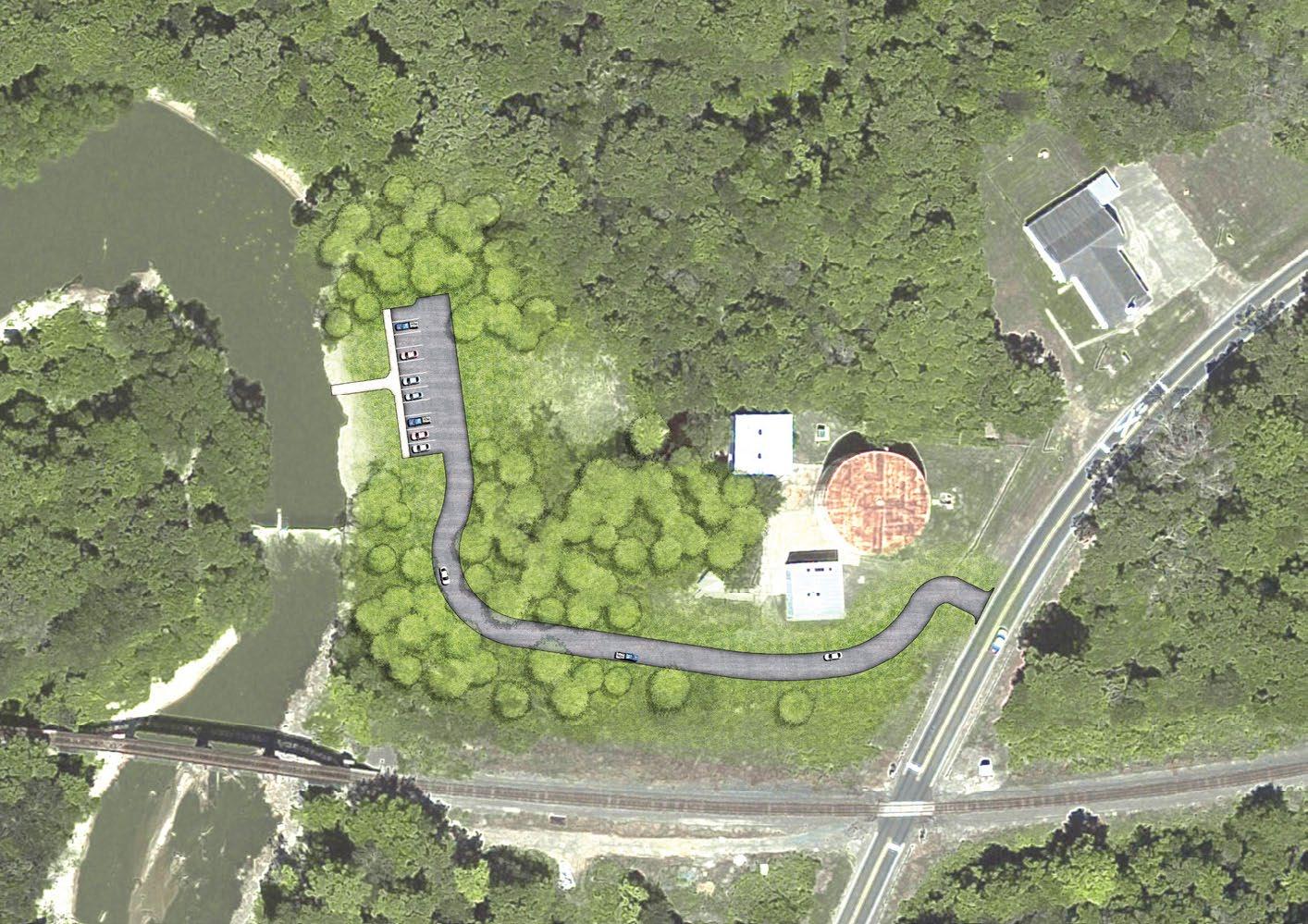
GLADEWATER BOAT LAUNCH & KAYAK LAUNCH
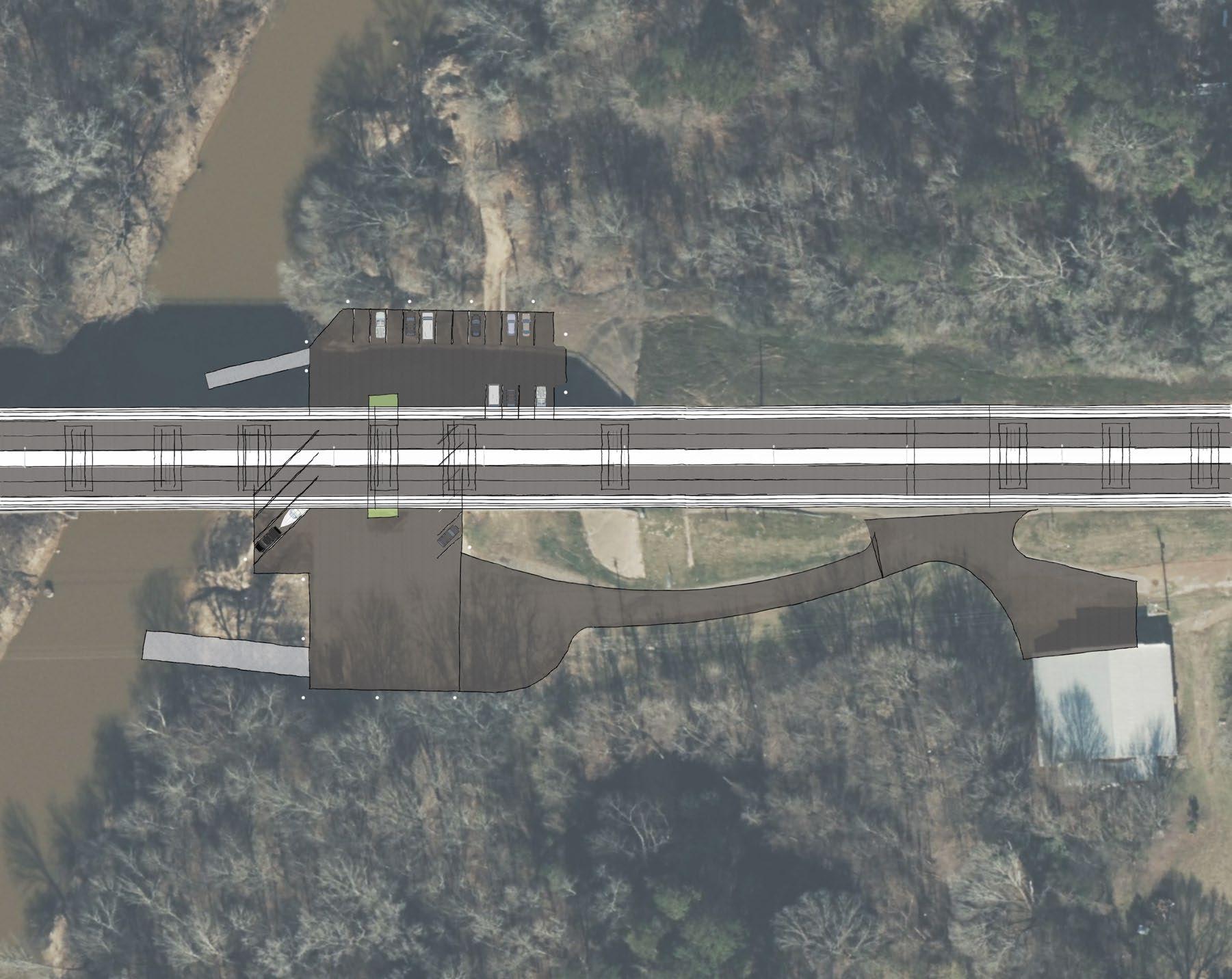
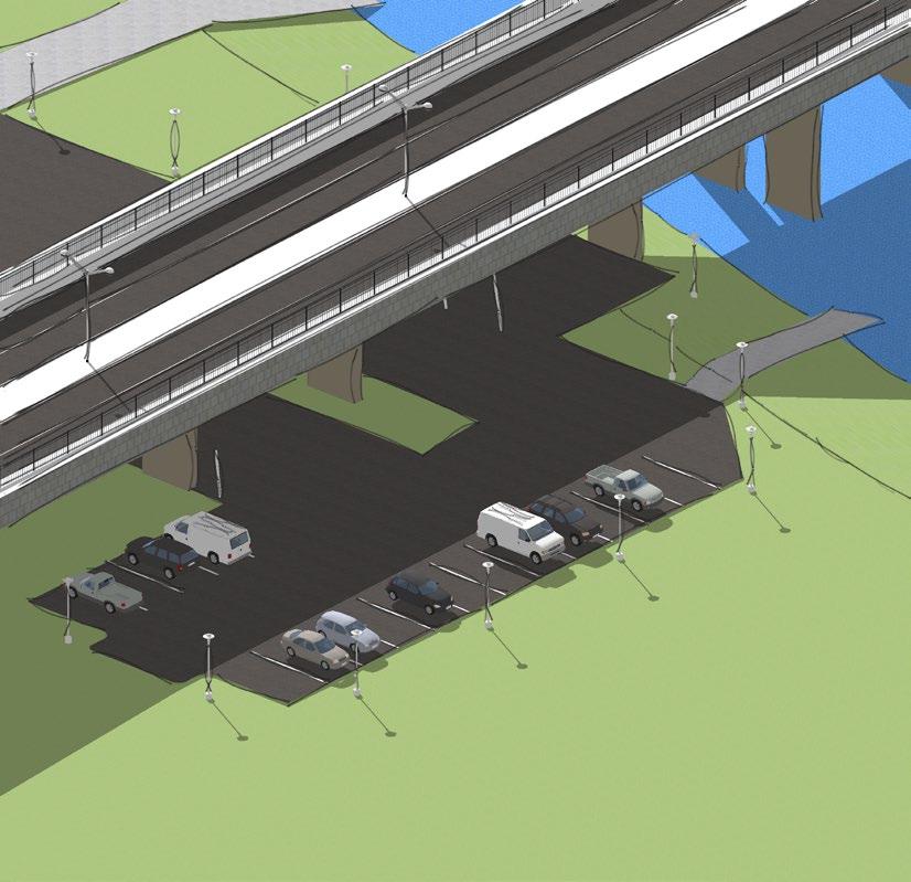

FM 2087 KAYAK LAUNCH


FM 2087
LAKEPORT BOAT LAUNCH & KAYAK LAUNCH


KILGORE WATER INTAKE KAYAK LAUNCH
Kayak Launch
Parking
Drive Aisle
Exisiting Kilgore Raw Water Pump Station
OLDKILGOREHWY


Chapter 5 - Implementation
The following implementation schedule presents action items that are based on the needs analysis, key areas of focus, and recommendations found in previous chapters. The purpose of the implementation schedule is to provide a framework to assist with future river planning in the County. The implementation schedule is intended to be a flexible guide for the development of access, land acquisition and amenities over the next 10 years and into the future. The main goal is to achieve access points to the river and expand and develop those sites over time in phases. The County should evaluate and change the order of implementation if necessary or take advantage of any unforeseen opportunities that may arise as long as it fits the priorities of this plan. Phased projects can and should be combined when funding is available.
Cost projections are depicted as construction allowances and are included for each project, aiding the County and its partners in budgeting for the future. A construction allowance refers to an amount of money within a construction contract to cover the cost of certain items or materials that have not been precisely determined at the time of preliminary planning. This allowance is often included to accommodate potential changes, variations, or unforeseen circumstances that may arise. These allowances are intended for budgetary purposes but will vary at the time of design. If necessary, specific line items can be built in phases without constructing the entire scope of the project, with emphasis on creating more access to the accessible sites. Phasing highcost projects is common; however, it is imperative to ensure a high-quality Phase I project is implemented to boost confidence in the overall project by both the financiers and the end users.
It is important to note that there is currently no detailed design or engineering construction documents and no boundary surveys, topography surveys, or environmental surveys for the proposed projects.
Various sources of funding at the local, state, and federal levels are available for the development of new access points and the revitalization of existing sites along the Sabine River. It is important to note that not every funding source will apply to every project, and multiple funding sources may be utilized for a project contingent on its scope and magnitude. Further details on additional funding sources can be found on page 45 of this plan.
The strategies have been assigned a time frame for implementation. It is recommended the county evaluate their progress to ensure they are completing projects in a timely manner. If the county progresses more quickly or slowly than anticipated, adjustments can be made to the time frames accordingly. In the event of unexpected opportunities, it is advisable for the county to consider modifying the implementation schedule to capitalize on such opportunities. The time frames are outlined as follows:
Ongoing Goals: can be completed through existing programs, construction, or as the need arises.
Short-Term Goals: 1 - 3 years.
Mid-Term Goals: 4 - 7 years.
Long-Term Goals: 8 - 10 years.
ONGOING GOALS
Coordinate or develop partnership for easement agreement with private landowners that have existing access ramps
Explore partnerships with local groups such as:
- Sabine River Authority
- East Texas Salt Water
- Komatsu
- Municipalities
- Rusk County
- Paddle & Bike Rental Companies
- Set up a committee to guide management and plan future improvements
Pursue Texas Parks and Wildlife (TPWD) Grants
- Create advisory committee to determine priority order of capital projects for grant revolving funds
- Identify and develop a grant application
$0 - $50,000
$0 - $50,000
SHORT-TERM GOALS
Develop public access to Kilgore Water Intake site (TPWD Grant Opportunity)
- Develop strategic plan for fundraising
- Identify and develop a grant application
- Identify and hire a design & engineering firm to develop construction documents
- Identify and hire a contractor for construction
Phase 1
- Canoe / kayak launch
- Signage
- Improve entry driveway (concrete or asphalt)
- Parking (gravel, asphalt, concrete)
Phase 2 - Lighting
- Pavilions / shade structure
- Information kiosk
Develop public access at FM 2087 site (TPWD Grant Opportunity)
- Develop strategic plan for fundraising
- Identify and develop a grant application
- Identify and hire a design & engineering firm to develop construction documents
- Identify and hire a contractor for construction
Phase 1
- Canoe / kayak launch
- Signage
- Improve entry driveway (concrete or asphalt)
- Parking (gravel, asphalt, concrete)
Phase 2 - Lighting
- Pavilions / shade structure
- Information kiosk
-
- $50,000
$650,000 $150,000$250,000 $0 - $50,000 $50,000$150,000
SHORT-TERM GOALS
Develop public access at Highway 42 site (TPWD Grant Opportunity)
- Consider strategic partnership or land acquisition through purchase or donation for the enhancement or development of a public use facility at or near the Highway 42 bridge.
NOTE: Securing this site will provide a central access point between Gladewater and Lakeport.
- Develop strategic plan for fundraising
- Identify and develop a grant application
- Identify and hire a design & engineering firm to develop construction documents
- Identify and hire a contractor for construction
Phase 1
- Canoe / kayak launch
- Signage
- Parking (gravel, asphalt, concrete)
Phase 2
- Lighting
- Pavilions / shade structure
- Information kiosk
Coordinate with Texas Parks and Wildlife Department to establish a Paddling Trail Designation.
Develop brand & placemaking for river
- Develop logo package
- Develop trail section names
Develop education campaign
- Texas Public Water laws, Boating laws
- ‘Purple Paint’ law (trespassing rules)
- Camping rules
- ‘Pack in pack out’ (river courtesy)
- Safety procedures (log jams, flooding events, hunting seasons)
Market Value
$0 - $50,000 $50,000$150,000 $450,000$550,000 $150,000$250,000 $0 - $50,000
Minimal Cost
$0 - $50,000
$0 - $50,000
MID-TERM GOALS
Improve public access at Lakeport site (TPWD Grant Opportunity)
- Develop strategic plan for fundraising
- Identify and develop a grant application
- Identify and hire a design & engineering firm to develop construction documents
- Identify and hire a contractor for construction
Phase 1
- Canoe / kayak launch
- Signage
- Additional overflow parking (gravel)
Phase 2 - Lighting - Pavilions / shade structure
- Information kiosk
$0 - $50,000
$400,000$500,000 $150,000$250,000 $0 - $50,000 $50,000$150,000
MID-TERM GOALS
Improve public access at Gladewater site (TPWD Grant Opportunity)
- Develop strategic plan for fundraising
- Identify and develop a grant application
- Identify and hire a design & engineering firm to develop construction documents
- Identify and hire a contractor for construction
Phase 1
- Canoe / kayak launch
- Signage
- Additional overflow parking (gravel)
Phase 2
- Lighting
- Pavilions / shade structure
- Information kiosk
Inspect weirs at Longview and Kilgore water intake areas & improve as needed
Develop a maintenance plan with local agencies
Develop wayfinding signage
- Make interpretive signs (historical, environmental, etc.)
- Mile markers and color-coated bridge crossings (for emergency responders)
- Warning signs at water intake areas
- Overall paddle trail map that can be downloadable for users
- $50,000
$50,000$150,000
$150,000$250,000 $0 - $50,000
$350,000$500,000
- $50,000
$0 - $50,000
LONG-TERM GOALS
Develop public park at Gladewater site
- Identify and develop a grant application
- Identify and hire a design & engineering firm to develop construction documents
- Identify and hire a contractor for construction
Recommend Gregg County & Rusk County partnership with the City of Easton (TPWD Grant Opportunity)
- Develop a trailhead at this location to function as a transition point to future extensions of the paddling trail
- Consider developing a campsite area
$550,000$650,000 $300,000$500,000 $0 - $50,000 $50,000$150,000 $600,000$700,000
*The projected costs above are allowances based on minimal information (no detailed design, engineering, or surveying has been performed).


Chapter 6 – Funding
Gregg County and each municipality have a variety of funding opportunities available that can assist with the funding of the proposed projects in this plan. The funding opportunities have been divided into two categories: locally generated funds and state and federal funds. There may be additional funding available which is not listed within this plan and can be identified through the Finance Department, a financial advisor, financial database, or a general web search.
LOCALLY GENERATED FUNDS
GENERAL FUND
A pay-as-you-go approach that uses city funds for smaller projects such as repairs and replacements at existing park facilities.
GENERAL OBLIGATION BONDS (GO BONDS)
These bonds are issued by a city following an election in which the voters authorize their issuance for specific stated purposes, as well as the necessary tax increases to support them. These bonds pledge the property or ad valorem taxing power of a city. GO bonds are debt instruments used by municipalities to raise funds for large-scale and capital improvement projects.
CERTIFICATES OF OBLIGATION (CO)
These certificates have the same basic effect of GO bonds except they do not require an election to authorize their sale and use (unless a referendum is petitioned). These certificates are issued on the authorization of City Councils. Repayment is based on the property and sales taxing power of each city, utility system revenues, or a combination of the two. CO debt can be used for construction and/or restoration of structures; purchase of materials and supplies; purchase of equipment, machinery, buildings and land; and professional services (architects, engineers, etc.).
TYPE A/TYPE B ECONOMIC DEVELOPMENT SALES TAX (EDS)
The State of Texas authorizes local governments to impose a sales tax (known as Type A and Type B) for economic development and quality of life. Proceeds accumulate in a sales tax fund. State law lists the possible uses of the fund. Type B offers all the industrial development options of Type A in addition to job training facilities, parks, tourist facilities, and sports venues, but it is subject to more administrative restrictions. Both Type A and Type B structures are present in Gregg County.
PRIVATE OR CORPORATE DONATIONS
Donations from foundations, corporations, and/or private individuals are often used to acquire and develop parks. The County should constantly identify and pursue opportunities to receive such funding for parks. One avenue for receiving donations is through the use of the Texas Parks & Recreation Foundation. This foundation has been developed to help all communities in the State of Texas to maximize the benefits of donations of land, property, and money.
STATE & FEDERAL FUNDING
SABINE RIVER AUTHORITY GRANTS
SRA-TX's Community Assistance Program (CAP) provides competitive grants that will complement or leverage water project funds for eligible entities within the Sabine River Basin. Most grants awarded are up to $10,000; however, some "shovel-ready" infrastructure or other projects may be considered for more.
TPWD BOATING ACCESS GRANTS
These grants provide 75% matching fund grant assistance to construct new, or renovate existing, public boat ramps that provide public access to public waters for recreational boating. The State Boating Access Program receives funding from the Federal Aid in Sport Fish Restoration Act. Local government sponsors must make an application, provide the land, provide access to the proposed boat ramp, supply 25% of the development costs, and accept operation and maintenance responsibilities for a minimum 25-year period. This grant is funded in two phases: Design and Construction. The ceiling for planning and construction documents is $200,000, and the construction grant is capped at $1,000,000.
TPWD LOCAL PARKS NON URBAN OUTDOOR RECREATION GRANTS
These grants are intended for communities with a population of less than 500,000 and can be used for the acquisition of parkland, park development or for the renovation of existing parks and open spaces. This grant is a 50% matching grant with a ceiling of $750,000.
TPWD COMMUNITY OUTDOOR OUTREACH PROGRAM (CO-OP)
These grants are primarily used to assist non-profits and local governments for recreational programming geared toward underserved populations. The intent of the funds are to introduce the importance of environmental education and conservation and provide TPWD mission oriented outdoor recreational activities. This grant is a TPWD Sponsored grant with a minimum
funding requirement of $5,000 and a ceiling of $50,000.
TPWD RECREATIONAL TRAILS GRANTS
These grants are intended for both motorized and non-motorized recreational trail projects; including new trail construction, existing trail improvements, acquisition of trail corridors, trailheads and/or amenities. This grant is federally funded by the Federal Highway Administration and administered by TPWD. This grant is 80 / 20 grant with up to 80% of the project being funded through TPWD with a ceiling of $300,000 for non-motorized trails and no ceiling for motorized trails.
TX RESTORE ACT
The RESTORE Act dedicates 80% of any civil and administrative penalties paid under the Clean Water Act by responsible parties in connection with the Deepwater Horizon oil spill to the Gulf Coast Ecosystem Trust Fund for ecosystem restoration, economic recovery, and tourism promotion in the Gulf Coast Region.
TXDOT TRANSPORTATION ALTERNATIVES SET-ASIDE (TA) PROGRAM
TxDOT administers TA funds for locally sponsored bicycle and pedestrian infrastructure projects in communities less than 200,000. In large, urbanized areas with populations over 200,000, TA funds are distributed directly to Metropolitan Planning Organizations (MPO) to administer according to their needs. MPOs and TxDOT are responsible for selecting projects independent of one another.
LAND & WATER CONSERVATION FUND (LWCF) GRANTS
These funds are federally funded and administered through TPWD through the Texas Recreation Park Account. Note: If a city applies for an Outdoor Grant, Small Community Grant or Indoor Recreation Grant, TPWD may choose to fund a successful project directly through LWCF with no additional or separate application.
NATIONAL PARK SERVICE (NPS) PROGRAMS
These funds are primarily used for parks and recreational opportunities and consist of LWCF & Urban Park and Recreation Recovery Act (UPARR) dollars. The United States Congress appropriates funds to each State.
ADDITIONAL GRANT OPPORTUNITIES
There are numerous grant opportunities through both public and private institutions. Grants.gov is an electronic platform for a comprehensive list of government grant opportunities.
GREGG COUNTY PADDLING TRAIL STRATEGIC PLAN
