City of Mount Vernon Zoning Ordinance

Appendix A of the City of Mount Vernon’s Code of Ordinances
Effective April 14, 2025
1-1 SHORT TITLE
1-2 AUTHORITY
1-3 EFFECTIVE DATE
1-4 TRANSITIONAL PROVISIONS
1-5 APPLICABILITY
1-6 INTERPRETATION AND PURPOSES
1-7 SCOPE
1-8 USAGE OF TERMS
1-9 VIOLATIONS
1-10 ESTABLISHMENT OF DISTRICT
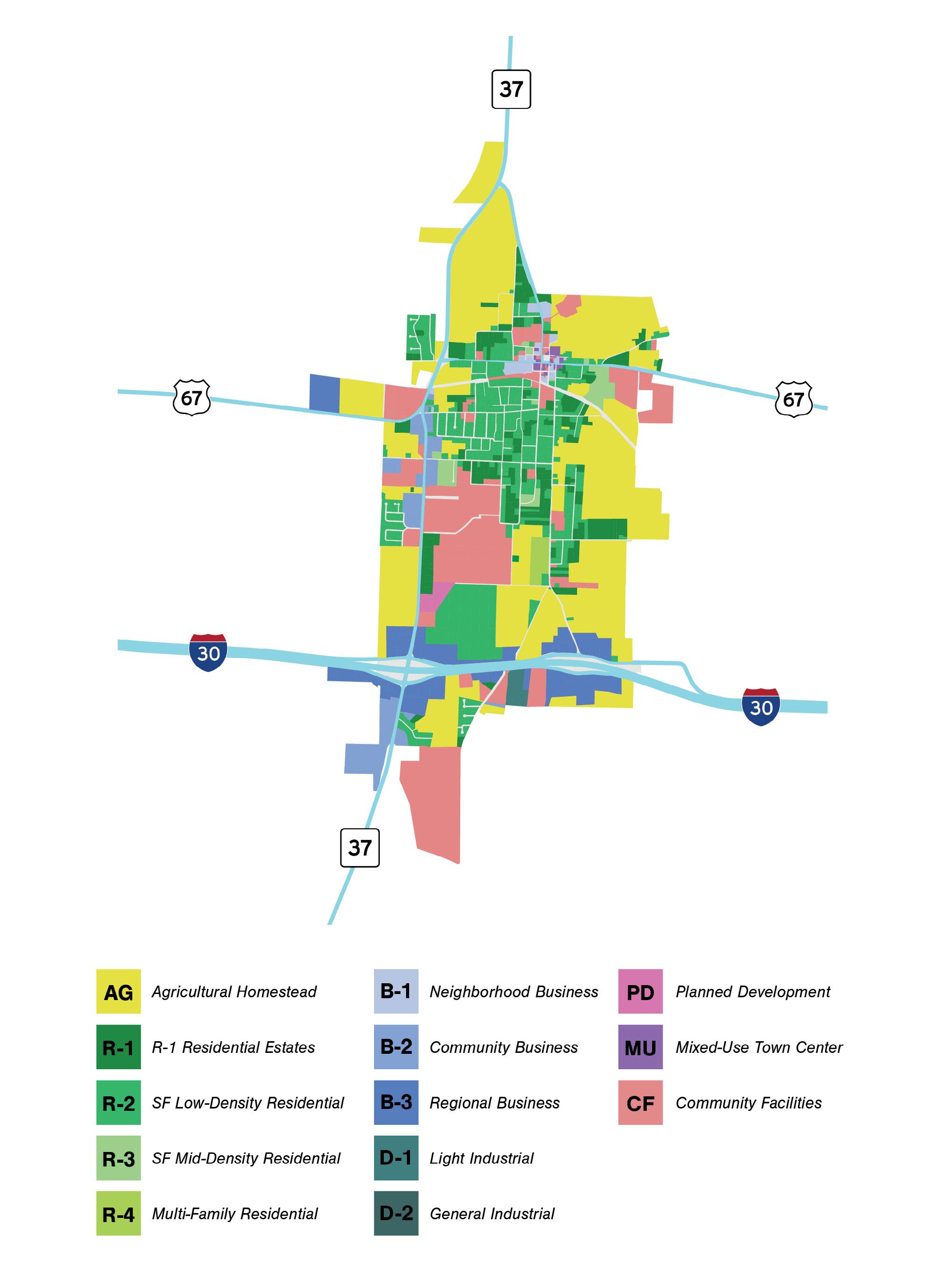
1-11 OFFICIAL ZONING MAP
1-12 DETERMINATION OF BOUNDARIES
1-13 “AG” AS TEMPORARY ZONING CLASS FOR NEWLY ANNEXED PROPERTY
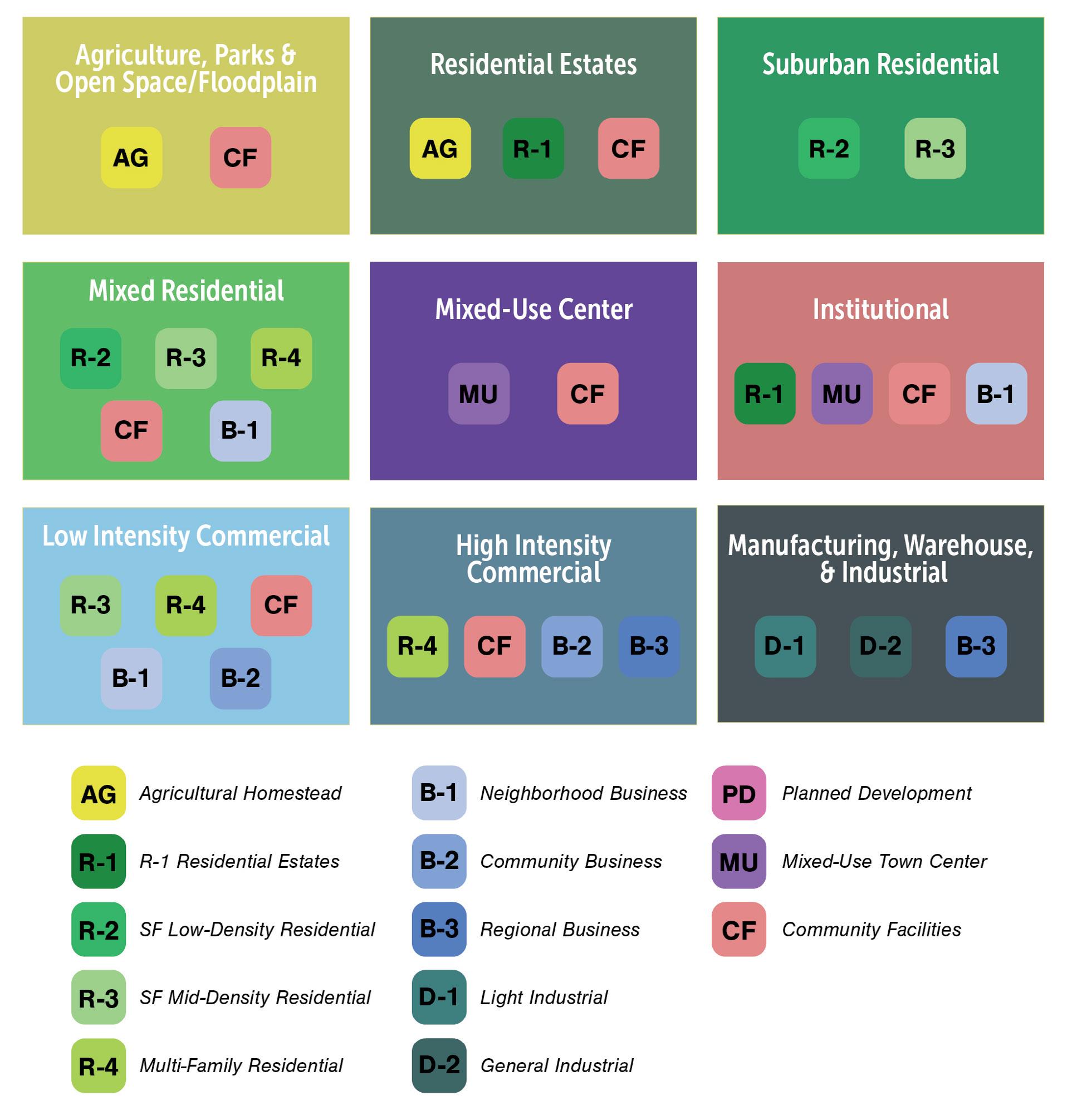
1-14 DESCRIPTION OF ZONING DISTRICTS
1-15 UNIFORM HEIGHT AND REGULATIONS
1-16 USE TABLE
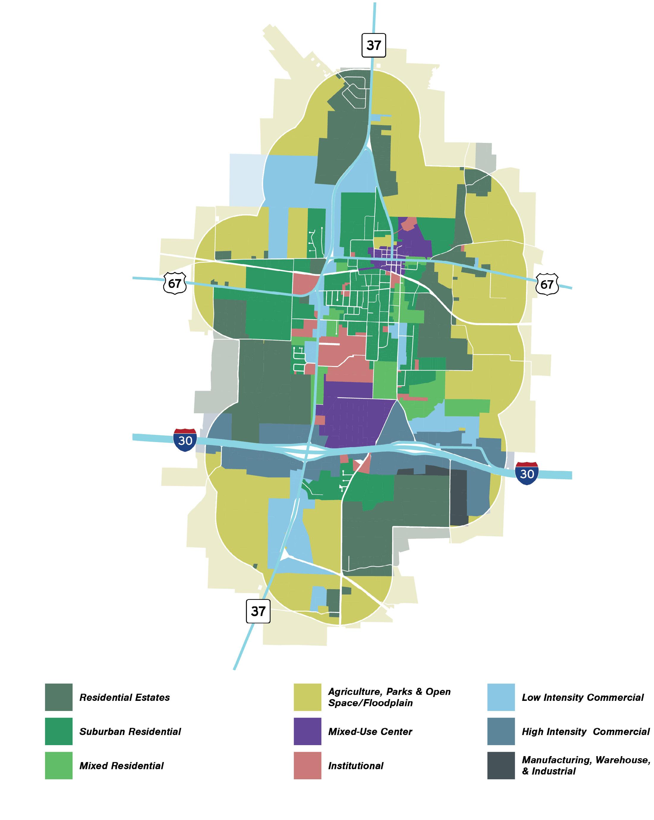
1-17 FUTURE LAND USE MAP
1-18 ZONING MAP
I - Purpose & Introduction
SECTION 1-1 SHORT TITLE
This ordinance shall be known and may be cited as the “Zoning Ordinance of the City of Mount Vernon, Texas.”
SEC. 1-2 AUTHORITY
These regulations are adopted pursuant to the authority granted by the U.S. Constitution, the Texas Constitution, and the laws of the State of Texas, specifically Chapter 211 and Chapter 212 of the Texas Local Government Code (TLGC).
SEC. 1-3 EFFECTIVE DATE
The effective date of this ordinance, adopted as Ordinance Number 2025-03, is April 14, 2025.
SEC. 1-4 TRANSITIONAL PROVISIONS
A. Applications submitted before the effective date. Complete applications for approval required under these regulations that are pending before the effective date specified in Section 1-3 must be reviewed and approved in accordance with the subdivision regulations in effect immediately before the effective date specified in Section 1-3. Incomplete applications submitted before the effective date specified in Section 1-3 will not be reviewed until they are complete. Once complete, the application must be reviewed and approved in accordance with the regulations in effect at the time that the application is deemed complete.
B. Permit issued before the effective date. Any building, structure or other activity for which a building permit was issued before the effective date specified in Section 1-3 may be completed in conformance with the issued building permit and other applicable permits and conditions, even if such building, structure or activity does not fully comply with provisions of these regulations. If the permitted construction or activity is not commenced or becomes dormant within the time allowed under the original permit or any extension granted, then the building, structure or other activity is subject to compliance with these regulations.
C. Previous violations. The adoption of these regulations does not affect or prevent any pending or future prosecution of, or action to abate, a violation of the previous subdivision regulations that occurred before the effective date specified in Section 1-3.
SEC. 1-5 APPLICABILITY
The provisions of the Zoning Ordinance apply to all public and private use and development of properties within the corporate limits and extraterritorial jurisdiction of the City of Mount Vernon, to the maximum extent allowed by state or federal law, and except as expressly stated in the Zoning Ordinance.
SEC. 1-6 INTERPRETATION AND PURPOSES
In their interpretation and application, the provisions of this ordinance shall be held to be the minimum requirements adopted for the promotion of the public health, safety, and welfare. The zoning regulations and districts as herein established, have been made in accordance with a comprehensive plan, for the purpose of promoting health, safety, morals and the general welfare of the town; they have been designed, among other things
A. to lessen congestion on streets;
B. to secure safety from fire, panic and other dangers;
C. to promote health and the general welfare;
D. to provide adequate light and air;
E. to prevent the overcrowding of land;
F. to avoid undue concentration of population;
G. to facilitate the adequate provision of transportation, water, sewage, schools, parks, and other public requirements; and
H. to conserve the value of property and encourage the most appropriate use of land through the town.
SEC. 1-7 SCOPE
A. It is not intended by this ordinance to repeal, abrogate, annul or in any way impair or interfere with existing provisions of other laws or ordinances, except as the same may be specifically repealed by the terms of this ordinance, or with private restrictions placed upon property by conveyance, deed, easement, or other private agreement. Where this ordinance imposes a greater restriction upon land, buildings or structures than is imposed or required by other laws, ordinances, covenants or agreements, the provisions of this ordinance shall govern.
B. If the provisions of this Zoning Ordinance are inconsistent with state or federal law or other city regulations, the more restrictive provision governs, to the extent allowed by law. The more restrictive provision is the one that imposes more stringent controls.
C. Land may not be used for any purpose other than what is allowed by the provisions of the Zoning Ordinance.
D. A building or structure may not be erected, located, moved, reconstructed, extended, or structurally altered except as allowed by the Zoning Ordinance.
E. Buildings, structures, and land may be used and occupied only in compliance with the Zoning Ordinance.
F. All lots created or modified must comply with the Zoning Ordinance.
SEC. 1-8 USAGE OF TERMS
The following terms contained in the Zoning Ordinance are defined as follows:
A. The words “must,” “will,” “shall” and “may not” are mandatory.
B. The word “may” is permissive, not mandatory or required.
C. The word “person” includes a firm, association, organization, partnership, limited liability company, trust, or corporation, as well as an individual.
SEC. 1-9 VIOLATIONS
Unless otherwise expressly allowed by the Zoning Ordinance or state law, any violation of a provision contained in the Zoning Ordinance is subject to the remedies and penalties provided for in the Zoning Ordinance. A violation includes, but is not limited to, the following actions:
A. To use land, buildings or structures in any way that is not consistent with the requirements of the Zoning Ordinance;
B. To erect or modify a building or structure in any way not consistent with the requirements of the Zoning Ordinance;
C. To install or use a sign in any way not consistent with the requirements of the Zoning Ordinance;
D. To engage in the use of a building, structure or land, the use or installation of a sign, or any other activity requiring one or more permits or approvals under the Zoning Ordinance without obtaining the permits or approvals;
E. To engage in the use of land, a building(s), a structure(s), or to use or install a sign, or any other activity approved by a permit granted under this Zoning Ordinance or under previous standards of the City in any way inconsistent with or in violation of the requirements of the permit or approval;
F. To knowingly and willfully obscure, obstruct, or destroy any notice required to be posted under the Zoning Ordinance;
G. To violate any lawful order issued by an authorized public official or to continue any violation after receiving a notice of a violation;
H. Provide fraudulent information to obtain an approval or permit under this Zoning Ordinance; or
I. Failure to install or maintain required landscaping and screening material.
SEC. 1-10 ESTABLISHMENT OF DISTRICT
In order to regulate and restrict the location of trades and industries and the locations of buildings erected, reconstructed, altered or enlarged for specified uses, to regulate and limit the height and bulk of buildings hereafter erected, reconstructed, altered or enlarged, to regulate and determine the area of yards and other open spaces and to regulate and limit the density of population, the municipality is hereby divided into the zoning districts described in Article XI.
SEC. 1-11 OFFICIAL ZONING MAP
A. The districts aforesaid, and the boundaries of such districts, shall be as shown upon the map attached hereto and made a part of this ordinance, said map being designated “Official Zoning Map,” and said map and all notations, references, and other information shown thereon shall be a part of this ordinance the same as if all such matters and information were fully described herein.
B. The original of said map shall bear even date with the passing of this ordinance; shall be signed by the Mayor and attested by the City Secretary, under the seal of the City, and shall be kept in the office of the City Secretary in the City Hall. In order to provide and maintain a current-to-date and accurate map of all zoning district boundaries, the City shall maintain electronic mapping files or other similar Geographic Information System (GIS) files of the Official Zoning District Map with all approved zoning amendments
C. In case of any question involving a district designation within the City, the updated copy of the Official Zoning District Map on file in the office of the Chief Building Official is presumed correct, and the person challenging the accuracy of that copy has the burden of presenting the Official Zoning Map, together with the ordinances amending the Map, to prove the inaccuracy of the updated copy.
D. Reproductions for informational purposes may be made of the Official or Current Zoning District Map.
SEC. 1-12 DETERMINATION OF BOUNDARIES
The district boundary lines shown on the zoning district map are usually along streets, alleys property lines or extensions thereof. In determining the location of zoning district boundaries on the map accompanying and made a part of this ordinance and where uncertainty exists as to the boundaries of districts as shown on the official zoning map, the following rules shall apply:
A. Where boundaries are shown to follow the centerlines of rights-of-ways lines of streets or alleys, as they exist at the time of adoption of this ordinance, shall be the zoning boundary; or
B. Where boundaries are shown on unsubdivided property, the location shall be determined by scale shown on the map unless dimensions are given on the map.
C. Boundaries indicated as approximately following platted lot lines shall be construed as following such lot lines so as to eliminate a zoning division on any platted lot.
D. Boundaries indicated as approximately following the city limits shall be construed as following the city limits.
E. Boundaries indicated as following the centerlines of streams or rivers or the shoreline of lakes or ponds shall be construed as following such centerlines or shorelines as the case may be.
F. Boundaries indicated as parallel to or extensions of features indicated above or as delineated in whatever manner shall be so construed. Distances not specifically indicated on the zoning District Map shall be determined by the scale of the map.
G. Whenever any street, alley, or any other public way is vacated by official action of the City Council, or whenever such area is franchised for building purposes; the zoning district line adjoining each side of such street, alley, or other public way shall be automatically extended
to the centerline of such vacated street, alley or way and all area so involved shall then and henceforth be subject to all regulations of extended districts.
H. Where physical features of the ground are at variance with information shown on the official Zoning district map or when there arises a question as to how or whether a parcel of property is zoned and such question cannot be resolved by the application of Subsection A through G above, the property shall be considered as classified in the “AG”, Agricultural District, temporarily in the same manner as provided for newly annexed territory, and the issuance of a Building Permit and the determination of permanent zoning shall be in accordance with the provisions provided in Section 1-13 for temporarily zoned areas.
SEC. 1-13 “AG” AS TEMPORARY ZONING CLASS FOR NEWLY ANNEXED PROPERTY
All territory hereinafter annexed to the City of Mount Vernon shall be temporarily classified as “AG” Agricultural District, until permanent zoning is established by the City Council of the City of Mount Vernon. The Planning and Zoning Commission shall study any property with regard to current or proposed use when considering annexation of land into the city limits. The procedure for establishing permanent zoning on annexed territory shall conform to the procedure established by law for the adoption of original zoning regulations.
A. In an area being considered for annexation, the City Council and Planning and Zoning Commission may hold public hearings on annexation and permanent zoning simultaneously, and the City Council may approve the permanent zoning of a newly annexed area at the time of final action or annexation.
B. In an area temporarily classified as “AG” Agricultural District:
1. No person shall erect, construct, or proceed or continue with the erection or construction of any building or structure or cause the same to be done in any newly annexed territory to the City of Mount Vernon without first applying for and obtaining a Building Permit or Certificate of Occupancy from the Building Official.
2. No permit for construction of a building or use of land shall be issued by the Building Official other than a permit which will allow the construction of a building permitted in the “AG” Agricultural district, unless and until such territory has been classified in a zoning district other than the “AG” Agricultural District, by the City Council in the manner prescribed by law.
3. No parcel of land under single ownership or other legal form of ownership may be divided, traversed, bisected or sectioned by one or more zoning district boundaries. All parcels of land within the city shall reside in a single zoning district. Conflicts, where found, may be the subject of rezoning to permit corrections to the Zoning District Map.
SEC. 1-14 DESCRIPTION OF ZONING DISTRICTS
A. Working Area Zones
The working area zones consist of those districts in which the primary purpose is the establishment and operation of activities of a commercial or industrial nature. Uses are grouped
in terms of their operating characteristics, their functional relationship to one another, and the extent of their service to the neighborhood, the city or the region. Commercial districts provide for offices, personal service establishments, retail sales, intensive business uses and wholesale sales activity. Manufacturing and industrial districts are designed for a wide variety of uses including storage, processing, fabrications, manufacturing, repairing or distribution of products. Regulations insure the grouping of compatible uses with particular attention to building bulk, user demand, transportation needs, and requirements for public services and utilities. Where appropriate, special safeguards are imposed to protect adjacent property in non-compatible zones.
B. Living Area Zones
The living area zones consist of residential districts accommodating housing of various types. District regulations are designed to stabilize and protect the essential characteristics of the districts, to promote and encourage a suitable environment for family life consistent with the density limitations of the zone, and to permit those uses which are necessary to the functioning of a residential community. Density of family units is limited by means of minimum area requirements per dwelling unit. Other regulations provide for yard and open space, limitations on building bulk, and for separation between detached buildings.
C. Special Purpose Zones
The special purpose zones are designed to recognize the unique requirements of urban life and community development. The objective of these zones is to provide a convenient mechanism for dealing with the problems of urban growth in a manner that recognizes the needs of the community while respecting the rights of individuals.
SEC. 1-15 UNIFORM HEIGHT AND REGULATIONS
The regulations set forth in the following table are established as minimum and maximum tolerance limits to regulate the development of land, the provision of open space, the density of dwelling units and the height of buildings and other structures in each of the districts listed. Where required for specific uses or development special height and area regulations found elsewhere and in each zoning district shall also apply.
DU = Dwelling Unit
NR = No requirement
NA = Not Applicable
RE = Next to residential property
* For interior townhomes
a = Applies only to residential uses in this zone
b = Determined by the developer and subject to approval by the planning and zoning commission and city council as part of the site development plan.
c = Unless providing on-street parking
Below is a reference table that summarizes the uses listed in the Ordinance. Uses below are generalized. Consult Section 3.1 as certain conditions and standards may apply. If there are any conflicts between this table and the uses listed in Section 3.1, the latter will control.
X = By Right
C = Conditional T = Temporary P = With PD Site Plan
Assisted living facility, shelter care home
detached accessory [1 per DU]
Dwellings, attached live/work
Dwellings, multiple-family
Dwellings, single-family detached
Park (short-term & long-term)
Park (short-term)
Below is a reference table that summarizes the uses listed in the Ordinance. Uses below are generalized. Consult Section 3.1 as certain conditions and standards may apply. If there are any conflicts between this table and the uses listed in Section 3.1, the latter will control.
X = By Right
C = Conditional
T = Temporary
P = With PD Site Plan
Public parks & recreational use
Public safety facilities [police, fire, EMS]
Public works yard & garage
Public-owned utiIity buildings
Public-owned utiIity structures
School, higher education institutions
K-12, public/ private
Below is a reference table that summarizes the uses listed in the Ordinance. Uses below are generalized. Consult Section 3.1 as certain conditions and standards may apply. If there are any conflicts between this table and the uses listed in Section 3.1, the latter will control.
X = By Right
C = Conditional
T = Temporary
P = With PD Site Plan
Agriculture - Equestrian stables, private
Agriculture - farm, orchard or nursery
Agriculture - feed/ seed store
Agriculture - poultry facilities
Agriculture - ranching
Agriculture - small farming
shop (with outdoor display)
- car wash
- convenience/gasoline station
Automobile - maintenance/service establishment, major
Automobile - maintenance/service establishment, minor (oil)
Automobile - towing & temporary storage
and financial institution
Below is a reference table that summarizes the uses listed in the Ordinance. Uses below are generalized. Consult Section 3.1 as certain conditions and standards may apply. If there are any conflicts between this table and the uses listed in Section 3.1, the latter will control.
X = By Right
C = Conditional
T = Temporary
P = With PD Site Plan
Bars, lounges, tavern, or nightclubs (associated with a restaurant)
Bed-and-breakfast homestay
Bed-and-breakfast inn
Bicycle shop X
Boats and other recreational vehicle sales, rentals, or service (large consumer goods)
Book store
Boutique [sqft or employee count]
Brewpub & winery
Bus or truck maintenance facility
Bus, truck, and manufactured home sales or leasing
Camera, Photography Store
Cleaning Plant (Commercial)
Clothing/apparel repair shop
Clothing/Apparel Store, large
Club or lodge
Collection Agency
Commercial recreation facilities
Confectionery shop (retail)
Data processing service
Day care facility, commercial
SEC. 1-16 USE TABLE
Below is a reference table that summarizes the uses listed in the Ordinance. Uses below are generalized. Consult Section 3.1 as certain conditions and standards may apply. If there are any conflicts between this table and the uses listed in Section 3.1, the latter will control.
X = By Right
C = Conditional T = Temporary
P = With PD Site Plan
Below is a reference table that summarizes the uses listed in the Ordinance. Uses below are generalized. Consult Section 3.1 as certain conditions and standards may apply. If there are any conflicts between this table and the uses listed in Section 3.1, the latter will control.
X = By Right
C = Conditional
T = Temporary
P = With PD Site Plan
Institutions, rehabilitation and training center
office
Internet/mail order distribution centers
Jewelry store
Key/locksmith shop
Landscape nurseries and garden supply establishments
Lawn & garden shop (no outdoor display)
Lawn & garden shop (w/ outdoor display)
Lawn & garden equipment sales & service store
Meat/seafood market (no processing)
Medical appliance store
Motel
Multiple family residential with ground floor retail, restaurant, or office use(s)
Multi-unit commercial development
store
Offices - medical, dental, optical
Offices - professional & administrative, small
Offices - professional & administrative,
SEC. 1-16 USE TABLE
Below is a reference table that summarizes the uses listed in the Ordinance. Uses below are generalized. Consult Section 3.1 as certain conditions and standards may apply. If there are any conflicts between this table and the uses listed in Section 3.1, the latter will control.
X = By Right
C = Conditional T = Temporary
P = With PD Site Plan
Below is a reference table that summarizes the uses listed in the Ordinance. Uses below are generalized. Consult Section 3.1 as certain conditions and standards may apply. If there are any conflicts between this table and the uses listed in Section 3.1, the latter will control.
X = By Right
C = Conditional
T = Temporary
P = With PD Site Plan
Restaurants, large
>2,000 sq. ft., no drive-through
Restaurants, large
>2,000 sq. ft., with or w/o drive-through
Restaurants, small
≤2,000 sq. ft., with drive-through
Retail commercial use, small ≤ 6,000 sqft X
Retail commercial use, large > 6,000 sqft X
Retail showroom ≤ 10,000 sqft
Self-service laundry facility
Sewing machine sales & service
Sexually oriented businesses
Skilled nursing home/ rehabilitation
Small scale specialty food and non-alcoholic beverage production and sale
Small-box discount store
Storage Units
Strip retail center
Studio (broadcasting/ recording)
Subdivision advertising sign
Swimming pool sales/ supplies
Tattoo parlor and body art establishment
Below is a reference table that summarizes the uses listed in the Ordinance. Uses below are generalized. Consult Section 3.1 as certain conditions and standards may apply. If there are any conflicts between this table and the uses listed in Section 3.1, the latter will control.
X = By Right
C = Conditional
T = Temporary
P = With PD Site Plan
sales, new and used (large consumer goods)
Veterinary clinic (no outdoor pens)
Veterinary clinic (w/ or w/o outdoor pens)
ceramic and concrete masonry products manufacturing
Contractor yard, plumbing, heating, building, electrical, demolition
salvage and wrecking operations
Industrial metal and waste rags, glass, paper salvage
Lumberyards (milling of timber)
Below is a reference table that summarizes the uses listed in the Ordinance. Uses below are generalized. Consult Section 3.1 as certain conditions and standards may apply. If there are any conflicts between this table and the uses listed in Section 3.1, the latter will control.
X = By Right
C = Conditional
T = Temporary
P = With PD Site Plan
Battery Storage Power Station
Railroad yards and terminal uses
Recycling center, composting facilities
Salvage yard, junkyard
Sand and gravel processing and storage
Stockpiling of sand, gravel, or other aggregate
Stone/monument works
Tractors and large farm equipment sales and service
Trucking operations center, freight services
Lumber/building materials sales yard
Cold storage plants, including frozen food lockers
THIS PAGE IS INTENTIONALLY BLANK
2-1 CLASSIFICATION OF NEW AND UNLISTED USES
2-2 AGRICULTURAL HOMESTEADS (AG) DISTRICT
2-3 RESIDENTIAL ESTATES (R-1) DISTRICT
2-4 LOW-DENSITY RESIDENTIAL (R-2) DISTRICT
2-5 MID-DENSITY RESIDENTIAL (R-3) DISTRICT
2-6 MULTIFAMILY RESIDENTIAL (R-4) DISTRICT
2-7 NEIGHBORHOOD BUSINESS (B-1) DISTRICT
2-8 COMMUNITY BUSINESS (B-2) DISTRICT
2-9 REGIONAL BUSINESS (B-3) DISTRICT
2-10 LIGHT INDUSTRIAL (D-1) DISTRICT
2-11 GENERAL INDUSTRIAL (D-2) DISTRICT
2-12 COMMUNITY FACILITIES (CF) DISTRICT
2-13 MIXED-USE TOWN CENTER (MU-TC) DISTRICT
2-14 PLANNED DEVELOPMENT (PD) DISTRICT
2-15 NEIGHBORHOOD CONSERVATION OVERLAY (NCO) DISTRICT
II - Zoning Districts
SEC. 2-1 CLASSIFICATION OF NEW AND UNLISTED USES
It is recognized that new types of land use will develop and forms of land use not anticipated may seek to locate in the City of Mount Vernon. In order to provide for such changes and contingencies, a determination as to the appropriate classification of any new or unlisted form of land use shall be made as follows:
A. The Building Official may refer the question concerning any new or unlisted use to the City Planning and Zoning Commission requesting an interpretation as to the zoning classification into which such use should be place. The referral of the use interpretation question shall be accompanied by a statement of facts listing the nature of the use and whether it involves dwelling activity, sales, processing, type of product, storage and amount and nature thereof, enclosed or open storage, anticipated employment, transportation requirements, the amount of noise, odor, fumes, dust, toxic material and vibration likely to be generated and the general requirements for public utilities such as water and sanitary sewer.
B. The City Planning and Zoning commission shall consider the nature and described performance of the proposed use and its compatibility with the uses permitted in the various districts and determine the zoning district or districts within which such use should be permitted.
C. The City Planning and Zoning commission shall transmit its findings and recommendations to the City Council as to the classification proposed for any new or unlisted use. The City Council shall by ordinance approve the recommendation of the commission or make such determination concerning the classification of such use as is determined appropriate.
THIS PAGE IS INTENTIONALLY BLANK
Agricultural Homesteads (AG) District
A. INTENT
The AG Agricultural Homesteads District is designed to permit sparsely settled residential development in combination with traditional farming activities. Character dimensions encourage wide, rural lots with ample road frontage at a 2-acre minimum area.
B. PRINCIPAL PERMITTED USES
i. Dwellings, detached accessory [1 per DU]
ii. Dwellings, attached live/work
iii. Dwellings, single-family detached
iv. Church, rectory, or other places of worship
v. Public parks & recreational use
vi. Public safety facilities [police, fire, EMS]
vii. School, higher education institutions
viii. School, K-12, public/private
ix. Zoo
x. Telephone exchanges/static transformer tower
xi. Agriculture - Equestrian stables, commercial ; Farm, orchard or nursery; feed/seed store; poultry facilities; ranching; small farming
xii. Bed-and-breakfast homestay
xiii. Subdivision advertising sign
C. CONDITIONAL USES
i. Transient Housing/Rooming house/ Boarding house
ii. R.V. Park (short-term & long-term)
iii. R.V. Park (short-term)
iv. Concerts, fairs, festival grounds
v. Orphanage
vi. Agriculture - Equestrian stables, private
vii. Home occupation
Agricultural Homesteads (AG) District
E. DEVELOPMENT STANDARDS
Lot Size
Minimum
Setbacks


Residential Estates (R-1) District
A. INTENT
The R-1 Residential Estates District is primarily intended to accommodate development of detached, single-family housing on minimum one acre lots. Character dimensions encourage narrower, rural lots with moderate road frontage at a 1-acre minimum area.
B. PRINCIPAL PERMITTED USES
i. Dwellings, attached live/work
ii. Dwellings, single-family detached
iii. Church, rectory, or other places of worship
iv. Public parks & recreational use
v. School, K-12, public/private
vi. Day care facility, residential
vii. Subdivision advertising sign
C. CONDITIONAL USES
i. Bed-and-breakfast homestay
ii. Bed-and-breakfast inn
iii. Home occupation
Residential Estates (R-1) District
E. DEVELOPMENT
Setbacks

Low-Density Residential (R-2) District
A. INTENT
The R-2 Low-Density Residential District is designed to permit low density residential development, both attached and detached. Character dimensions encourage four to six sites per acre for single-family homes and large lots for duplexes, garden homes, and townhomes.
B. PRINCIPAL PERMITTED USES
i. Dwellings, attached live/work
ii. Dwellings, single-family detached
iii. Dwellings, garden home
iv. Church, rectory, or other places of worship
v. Public parks & recreational use
vi. School, K-12, public/private
C. CONDITIONAL USES
i. Dwellings, townhome
ii. Dwellings, duplex
Low-Density Residential (R-2) District
E. DEVELOPMENT STANDARDS
Lot Size
Setbacks
Mid-Density Residential (R-3) District
A. INTENT
The R-3 Mid-Density Residential District is distinguished by moderately intensive detached and attached single-family homesites. Character dimensions encourage compact, shallow depth lots for duplexes, triplexes, quadplexes, garden homes, and townhomes.
B. PRINCIPAL PERMITTED USES
i. Assisted living facility, shelter care home
ii. Dwellings, townhome
iii. Dwellings, duplex
iv. Dwellings, triplex
v. Dwellings, quadplex
vi. Dwellings, garden home
vii. Personal care home
viii. Church, rectory, or other places of worship
ix. Public parks & recreational use
x. School, K-12, public/private
xi. Bed-and-breakfast homestay
xii. Bed-and-breakfast inn
xiii. Day care facility, commercial
xiv. Day care facility, residential
xv. Subdivision advertising sign
C. CONDITIONAL USES
Mid-Density Residential (R-3) District
E. DEVELOPMENT STANDARDS

Multifamily Residential (R-4) District
A. INTENT
The R-4 Multifamily Residential District is designed to permit multifamily apartments and compactly developed detached single-family homesites. Character dimensions encourage small lots that contain sufficient area to provide open space for multifamily & single-family housing.
B. PRINCIPAL PERMITTED USES
i. Assisted living facility, shelter care home
ii. Dwellings, multiple-family
iii. Dwellings, townhome
iv. Dwellings, triplex
v. Dwellings, quadplex
vi. Personal care home
vii. Church, rectory, or other places of worship
viii. Public parks & recreational use
ix. School, K-12, public/private
x. Bank and financial institution
xi. Bed-and-breakfast homestay
xii. Bed-and-breakfast inn
xiii. Club or lodge
xiv. Day care facility, commercial
xv. Day care facility, residential
xvi. Health club, fitness gym
xvii. Real estate development tract or field office
xviii. Skilled nursing home/rehabilitation
xix. Subdivision advertising sign
C. CONDITIONAL USES
i. Transient Housing/Rooming house/ Boarding house
ii. R.V. Park (short-term & long-term)
iii. R.V. Park (short-term)
iv. Home occupation
Multifamily Residential (R-4) District
E. DEVELOPMENT STANDARDS
Lot Size
Minimum lot area: First 3,500 sqft + Additional 1,500 sqft
Minimum lot width: No Requirement
Minimum lot road frontage: 50 ft
Setbacks
Minimum front yard setback:
Minimum side yard setback: 5 - 15

Floor Area
Minimum floor area per one-family dwelling: 3,000 sqft
Neighborhood Business (B-1) District
A. INTENT
The B-1 Neighborhood Business district is primarily intended for commercial development and professional services and act as a transition zone between the main street district and residential areas. Areas zoned B-1 district are intended to serve the nearby neighborhoods and must be restricted to commercial and office activities, predominantly conducted indoors, with limited or no outdoor display or storage of merchandise.
B. PRINCIPAL PERMITTED USES
i. Church, rectory, or other places of worship
ii. Museums
iii. Nursing, rest or convalescent home
iv. Post office
v. Public parks & recreational use
vi. Telephone exchanges/static transformer station
vii. Antique shop (no outdoor display)
viii. Arts and crafts supply store
ix. Bank and financial institution
x. Bed-and-breakfast homestay
xi. Bed-and-breakfast inn
xii. Bicycle shop
xiii. Book store
xiv. Boutique
xv. Camera, photography store
xvi. Club or lodge
xvii. Confectionery shop (retail)
xviii. Day care facility, residential
xix. Fine arts studio
xx. Florist
xxi. Grocery store, ≤ 10,000 sqft
xxii. Insurance office
xxiii. Jewelry store
xxiv. Multiple family residential with ground floor retail, restaurant, office use(s)
xxv. Offices - professional & administrative, small
xxvi. Print shop
xxvii. Real estate development tract or field office
xxviii. Restaurant, small ≤2,000 sqft, no drive-through
xxix. Retail commercial use, >6,000 sqft
xxx. Tutoring Center
C. CONDITIONAL USES
i. Personal care home
ii. Brewpub & winery
iii. Clothing/apparel repair shop
iv. Daycare facility, commercial
v. Key/locksmith shop
vi. Lawn & garden shop (no outdoor display)
vii. Music store
viii. Outdoor vending machine
ix. Pet grooming (no overnight stay)
x. Private park
xi. Sewing machine sales & service
xii. Skilled nursing home/rehabilitation
xiii. Studio (broadcasting/recording)
xiv. Veterinary clinic (no outdoor pens)
xv. Temporary Use - Outdoor display
Neighborhood Business (B-1) District
E. DEVELOPMENT STANDARDS
Lot Size
Minimum lot area: NA
Minimum lot width: NA
Minimum lot road frontage:
Setbacks
Minimum front yard setback: 20 Ft
Minimum rear yard setback: 5 ft, RE 20 ft Minimum side yard setback: 10 ft, RE 20 ft
Bulk Controls


No Parking in the Front First: 10 ft*
RE = If the lot abuts a residential zone. NA = Not Applicable.
* = Unless providing on-street parking.


Community Business (B-2) District
A. INTENT
The B-2 Community Business district is a restricted business district comprised of businesses, professional service establishments, and retail stores that serve the daily shopping needs of the entire City area by being located adjacent to the state highway system. The regulations of this district are designed to permit the uses listed while protecting adjacent residential development by requiring the provision of pedestrian-scale amenities.
B. PRINCIPAL PERMITTED USES
i. Bus station
ii. Church, rectory, or other places of worship
iii. Medical care facility, small
iv. Museums
v. Nursing, rest or convalescent home
vi. Post office
vii. Public parks & recreational use
viii. School, higher education institutions
ix. School, K-12, public/private
x. Telephone exchanges/static transformer station
xi. Agriculture - feed/seed store
xii. Animal boarding, kennels, shelter
xiii. Answering service office
xiv. Antique shop (no outdoor display)
xv. Antique shop (with outdoor display)
xvi. Arts and crafts supply store
xvii. Automobile - car wash
xviii. Automobile - convenience/gas station
xix. Automobile - maintenance/service establishment, minor (oil)
xx. Bank and financial institution
xxi. Bar, lounge, tavern, or nightclub (associated with a restaurant)
xxii. Bed-and-breakfast inn
xxiii. Bicycle shop
xxiv. Boats and other recreational vehicle sales, rentals, or service (large consumer goods)
xxv. Book store
xxvi. Boutique
xxvii. Brewpub & winery
xxviii. Camera, photography store
xxix. Clothing/apparel repair shop
xxx. Clothing/apparel store, large
xxxi. Club or lodge
xxxii. Confectionery shop (retail)
xxxiii. Data processing service
xxxiv. Day care facility, commercial
xxxv. Day care facility, residential
xxxvi. Department store
xxxvii. Employment agency
xxxviii. Fine arts studio
xxxix. Funeral home, mortuary
xl. Grocery store, ≤10,000 sqft
xli. Grocery store, >10,000 sqft
xlii. Hardware store
xliii. Health club, fitness gym
xliv. Hotel
xlv. Insurance office
xlvi. Jewelry Store
xlvii. Key/locksmith shop
xlviii. Lawn & garden shop (no outdoor display)
xlix. Lawn & garden shop (w/ outdoor display)
Community Business (B-2) District
B. PRINCIPAL PERMITTED USES, CONT.
l. Meat/seafood market (no processing)
li. Medical appliance store
lii. Multiple family residential with ground floor retail, restaurant, office use(s)
liii. Multi-unit commercial development
liv. Music store
lv. Offices - medical, dental, optical
lvi. Offices - professional & administrative, small
lvii. Offices - professional & administrative, large
lviii. Pet grooming (no overnight stay)
lix. Pet shop (no outdoor pens)
lx. Pharmacy & related sales
lxi. Photocopy/fax service facility
lxii. Print shop
lxiii. Protection service office
lxiv. Radio or television studio
lxv. Real estate development tract or field office
lxvi. Research-and-development labs and facilities
lxvii. Restaurant, small ≤2,000 sqft, no drive-through
lxviii. Restaurant, large >2,000 sqft, no drive-through
lxix. Retail commercial use, small ≤6,000 sqft
lxx. Retail commercial use, large >6,000 sqft
lxxi. Sewing machine sales & services
lxxii. Skilled nursing home/rehabilitation
lxxiii. Small scale specialty food and nonalcoholic beverage production and sale
lxxiv. Storage units
lxxv. Strip retail center
lxxvi. Studio (broadcasting/recording)
lxxvii. Theater/cinema
lxxviii. Tutoring center
lxxix. Utility company office
lxxx. Veterinary clinic (no outdoor pens)
Theater/cinema
lxxxi. Tutoring center
C. CONDITIONAL USES
i. R.V. Park (short-term & long-term)
ii. R.V. Park (short-term)
iii. Antique shop (with outdoor display)
iv. Automobile - auto supply (w/o install)
v. Collection agency
vi. Commercial recreation facilities
vii. Firearm sales establishment
viii. Flea market (indoor only)
ix. Food truck park, minor
x. Furniture/appliance sales & service
xi. Outdoor vending machine
xii. Pet shop (outdoor pens)
xiii. Private park
xiv. Restaurants, large >2,000 sq. ft., with or w/o drive through service
xv. Restaurants, small ≤2,000 sq. ft., with drive-through service
xvi. Small-box discount store
xvii. Veterinary clinic (outdoor pens)
xviii. Wholesale sales
xix. Tractors and large farm equipment sales and service

Community Business (B-2) District
E. DEVELOPMENT STANDARDS
Lot Size
Minimum lot area:
Minimum lot width:
Minimum lot road frontage:
Setbacks
Minimum front yard setback: 20 ft
Minimum rear yard setback: 5 ft, RE 20 ft Minimum side yard setback: 10 ft, RE 20 ft Bulk Controls
Parking in the Front First:
RE = If the lot abuts a residential zone. NA = Not Applicable.
Community Business (B-2) District
THIS PAGE IS INTENTIONALLY BLANK
Regional Business (B-3) District
A. INTENT
The B-3 Regional Business district is primarily intended for heavier commercial development that serves the citywide and regional market area. This district is located adjacent to the major thoroughfare Interstate-30.
B. PRINCIPAL PERMITTED USES
i. Bus operations center
ii. Bus station
iii. Church, rectory, or other places of worship
iv. Hospital
v. Museums
vi. Nursing, rest or convalescent home
vii. Post office
viii. Private & co-op utility buildings & structure
ix. Public parks & recreational use
x. Public safety facilities
xi. School, higher education institutions
xii. School, K-12, public/private
xiii. Telephone exchanges/static transformer station
xiv. Telephone exchanges/static transformer tower
xv. Agriculture - Equestrian stables, private
xvi. Agriculture - feed/seed store
xvii. Agriculture - poultry facilities
xviii. Animal boarding, kennels, shelter
xix. Automobile - car wash
xx. Automobile - convenience/gas station
xxi. Automobile - maintenance/service establishment, major
xxii. Automobile - maintenance/service establishment, minor
xxiii. Automobile - towing & temporary storage
xxiv. Bank and financial institution
xxv. Bar, lounge, tavern, or nightclub (not associated with a restaurant)
xxvi. Bar, lounge, tavern, or nightclub (associated with a restaurant)
xxvii. Boats and other recreational vehicle sales, rentals, or service (large consumer goods)
xxviii. Brewpub & winery
xxix. Bus, truck, and manufactured home sales or leasing
xxx. Commercial recreation facilities
xxxi. Environmental monitoring station
xxxii. Fine arts studio
xxxiii. Firearm sales establishment
xxxiv. Funeral home, mortuary
xxxv. Golf course
xxxvi. Grain and feed milling
xxxvii. Grocery stores, > 10,000 sqft
xxxviii. Hardware store
xxxix. Hotel
xl. Institution, rehabilitation, and training center
xli. Internet/mail order distribution center
xlii. Lawn & garden equipment sales & service store
xliii. Multi-unit commercial development
Regional Business (B-3) District
B. PRINCIPAL PERMITTED USES, CONT.
xliv. Offices - medical, dental, optical
xlv. Outdoor storage
xlvi. Parking lots or structures
xlvii. Pawn shop
xlviii. Pet shop (no outdoor pens)
xlix. Pet shop (w/ outdoor pens)
l. Private park
li. Radio or television studio
lii. Research-and-development labs and facilities
liii. Restaurant, small ≤2,000 sqft, no drive-through
liv. Restaurant, large >2,000 sqft, no drive-through
lv. Restaurant, large >2,000 sqft, with or w/o drive-through
lvi. Retail commercial use, small ≤6,000 sqft
lvii. Retail commercial use, large >6,000 sqft
lviii. Retail showroom
lix. Small scale specialty food and nonalcoholic beverage production and sale
lx. Storage units
lxi. Studio (broadcasting/recording)
lxii. Swimming pool sales/supplies
lxiii. Theater/cinema
lxiv. Vehicle sales, new and used
lxv. Veterinary clinic (w/ or w/o outdoor pens)
lxvi. Contractor yard, plumbing, heating, building, electrical, demolition
lxvii. Food processing, small
lxviii. Industrial use, light
lxix. Large area distribution or transit warehouse
lxx. Large consumer goods sales
lxxi. Warehouse
lxxii. Lumber/building materials sales yard
lxxiii. Cold storage plants, including frozen food lockers
C. CONDITIONAL USES
i. R.V. Park (short-term & long-term)
ii. R.V. Park (short-term)
iii. Medical care facility, small
iv. Bus or truck maintenance facility
v. Cleaning plant (commercial)
vi. Restaurants, small ≤2,000 sq. ft., with drive-through service
vii. Wholesale sales
viii. Recycling center, composting facilities
ix. Stockpiling of sand, gravel, or other aggregate
x. Stone/monument works
xi. Tractors and large farm equipment sales and service
xii. Lithium refinery
Regional Business (B-3) District
E. DEVELOPMENT STANDARDS
Lot Size
Minimum lot area: 10,000 sqft
Minimum lot width: NR
Minimum lot road frontage: NR
Setbacks
Minimum front yard setback: 30 ft
Minimum rear yard setback: 5 ft, RE 20 ft
Minimum side yard setback: 10 ft, RE 20 ft
Bulk Controls
Maximum building height: 30 ft
Maximum Lot Coverage: 70%
No Parking in the Front First: 20 ft
RE = If the lot abuts a residential zone. NA = Not Applicable.


Regional Business (B-3) District
THIS PAGE IS INTENTIONALLY BLANK
Light Industrial (D-1) District
A. INTENT
The D-1 Light Industrial district is primarily intended to provide for the location and development of low impact industries and supporting commercial and public uses, which generate relatively low levels of noise, smoke, odor, dust, or intense light. These industrial and manufacturing uses may require sufficient access to air, rail, or street transportation routes.
B. PRINICIPAL PERMITTED USES
i. Bus operations center
ii. Bus station
iii. Church, rectory, or other places of worship
iv. Hospital
v. Museum
vi. Nursing, rest or convalescent home
vii. Post office
viii. Private & co-op utility buildings & structures
ix. Public parks & recreational use
x. Public safety facilities
xi. Public works yard & garage
xii. School, higher education institutions
xiii. Telephone exchanges/static transformer station
xiv. Telephone exchanges/static transformer tower
xv. Zoo
xvi. Automobile - maintenance/service establishment, major
xvii. Automobile - towing & temporary storage
xviii. Bars, lounges, tavern, or nightclubs (associated with a restaurant)
xix. Brewpub & winery
xx. Bus or truck maintenance facility
xxi. Cleaning Plant (Commercial)
xxii. Helistop or aircraft landing area
xxiii. Internet/mail order distribution centers
xxiv. Wholesale sales
xxv. Contractor yard, plumbing, heating, building, electrical, demolition
xxvi. Food processing, small
xxvii. Industrial use, light
xxviii. Large area distribution or transit warehouse
xxix. Large consumer goods sales
xxx. Industrial metal and waste rags, glass, paper salvage
xxxi. Recycling center, composting facilities
xxxii. Stockpiling of sand, gravel, or other aggregate
xxxiii. Stone/monument works
xxxiv. Tractors and large farm equipment sales and service
xxxv. Warehouse
xxxvi. Lumber/building materials sales yard
xxxvii. Cold storage plants, including frozen food lockers
xxxviii. Internet/mail order distribution centers
C. CONDITIONAL USES
i. R.V. Park (short-term & long-term)
ii. R.V. Park (short-term)
iii. Medical care facilites, small
Light Industrial (D-1) District
C. CONDITIONAL USES, CONT.
iv. Museums
v. Orphanage
vi. Automobile - car wash
vii. Brick, ceramic and concrete masonry products manufacturing
viii. Concrete batching plant
ix. Contractor yard, plumbing, heating, building, electrical, demolition
x. Food processing, large
xi. Lumberyards (milling of timber)
xii. RaiIroad yards and terminal uses
xiii. Salvage yard, junkyard
xiv. Trucking operations center, freight services
xv. Lithium extraction site
xvi. Lithium refinery
Light Industrial (D-1) District
E. DEVELOPMENT STANDARDS
Lot Size
Minimum lot area: First 3,500 sqft + Addtitional 1,500 sqft
Minimum lot width: No Requirement
Minimum lot road frontage: 50 ft
Setbacks
Minimum front yard setback: 25 ft
Minimum rear yard setback: 20 ft
Minimum side yard setback: 5 - 15 ft
Bulk Controls
Maximum building height: 40 ft
Maxmimum Lot Coverage: 70% No Parking in the Front First: 25 ft
RE = If the lot abuts a residential zone. NA = Not Applicable.
Light Industrial (D-1) District
THIS PAGE IS INTENTIONALLY BLANK
General Industrial (D-2) District
A. INTENT
The D-2 General Industrial district is primarily intended to provide for location and development of medium and heavy impact industries and supporting commercial and public uses, which may generate noise, odor, smoke, dust, or intense light. These industrial and manufacturing uses must provide access to air, rail, or street transportation routes. Provision may also be made for outdoor operations and storage.
B. PRINICIPAL PERMITTED USES
i. Church, rectory, or other places of worship
ii. Concerts, fairs, festival grounds
iii. Public works yard & garage
iv. Telephone exchanges/static transformer tower
v. Zoo
vi. Agriculture - Equestrian stables, commercial
vii. Agriculture - feed/seed store
viii. Agriculture - ranching
ix. Agriculture - small farming
x. Automobile - maintenance/service establishment, major
xi. Animal boarding, kennels, shelter
xii. Bed-and-breakfast homestay
xiii. Club or lodge
xiv. Golf course
xv. Grain and feed milling
xvi. Helistop or aircraft landing area
xvii. Landscape nurseries and garden supply establishments
xviii. Radio or television studio
xix. Small scale specialty food and nonalcoholic beverage production and sale
xx. Brick, ceramic and concrete masonry products manufacturing
xxi. Concrete batching plant
xxii. Contractor yard, plumbing, heating, building, electrical, demolition
xxiii. Food processing, small
xxiv. Food processing, large
xxv. Fuel oil distributors
xxvi. Industrial use, heavy
xxvii. Industrial use, light
xxviii. Large area distribution or transit warehouse
xxix. Large consumer goods sales
xxx. Automobile salvage and wrecking operations
xxxi. Industrial metal and waste rags, glass, paper salvage
xxxii. Lumberyards (milling of timber)
xxxiii. Railroad yards and terminal uses
xxxiv. Recycling center, composting facilities
xxxv. Salvage yard, junkyard
xxxvi. Sand and gravel processing and storage
xxxvii. Stockpiling of sand, gravel, or other aggregate
xxxviii. Stone/monument works
xxxix. Tractors and large farm equipment sales and service
xl. Trucking operations center, freight services
xli. Warehouse
xlii. Lumber/building materials sales yard
xliii. Cold storage plants, including frozen food lockers
General Industrial (D-2) District
B. PRINCIPAL PERMITTED USES, CONT.
xliv. Lithium extraction site
xlv. Lithium refinery
C. CONDITIONAL USES
i. Agriculture - Equestrian stables, private
ii. Agriculture - farm, orchard or nursery
iii. Agriculture - poultry facilities
iv. Automobile - car wash
v. Brewpub & winery
vi. Home occupation
vii. Lawn & garden equipment sales & service store
viii. Meat/seafood market (no processing)
ix. Private park
x. Skilled nursing home/rehabilitation
General Industrial (D-2) District
E. DEVELOPMENT STANDARDS
Minimum
Minimum
Minimum lot road frontage: 50 ft
Setbacks
Minimum front yard setback: 30 ft
Minimum rear yard setback: 10 ft, RE 50 ft


Minimum side yard setback: 10 ft, RE 50 ft Bulk Controls
Maximum building height: 100 ft
Maxmimum Lot Coverage: NR No Parking in the Front First: 10 ft, RE 50 ft RE = If the lot abuts a residential zone. NA = Not Applicable.

General Industrial (D-2) District
THIS PAGE IS INTENTIONALLY BLANK
Community Facilities (CF) District
A. INTENT
The CF Community Facilities district is primarily intended to provide for the location and development of publicly owned property and facilities and supporting services to sustain a high quality of life. These civic uses, especially emergency services, may require sufficient access to air, rail, or street transportation routes. There are no lot regulations for this land use.
B. PRINICIPAL PERMITTED USES
i. Bus operations center
ii. Bus station
iii. Cemetery
iv. Church, rectory, or other places of worship
v. Concerts, fairs, festival grounds
vi. Conference, convention center
vii. Cultural facility and library
viii. Hospital
ix. Medical care facility, small
x. Muncipal office building
xi. Museum
xii. Nursing, rest or convalescent home
xiii. Post office
xiv. Private & co-op utility buildinsg & structure
xv. Public parks & recreational use
xvi. Public safety facilities
xvii. Public works yard & garage
xviii. Public-owned utility buildings
xix. Public-owned utility structures
xx. School, higher education institutions
xxi. School, K-12, public/private
xxii. Telephone exchanges/static
transformer station
xxiii. Telephone exchanges/static transformer tower
xxiv. Zoo
xxv. Animal boarding, kennels, shelter
xxvi. Commercial recreation facilities
xxvii. Farmers Market
xxviii. Golf course
xxix. Helistop or aircraft landing area
xxx. Private park
xxxi. Tutoring center
C. CONDITIONAL USES
i. Cremation facilities
ii. Orphanage
Community Facilities (CF) District
THIS PAGE IS INTENTIONALLY BLANK
Mixed-Use Town Center (MU-TC) District
A. INTENT
The Mixed-Use Town Center District (MU-TC) is established for dense land use intended for office and professional uses, for neighborhood-oriented retail and personal service uses, for high density residential uses, and for civic and open space uses. This area is intended to include a wide variety of building types that are placed and designed consistent with the regulations in this district to foster a vibrant pedestrian area. Attached buildings form a continuous street wall, and there is substantial pedestrian activity. Adaptive reuse of existing structures is encouraged.
The MU-TC district is intended for use in the vicinity of The Square and other central business districts, major job centers, and concentrations of multi-family housing. Buildings in this district should be compatible and on a similar scale with residential uses and adjacent property. There are currently two types of buildings in this district – single-story shopfront and mixed-use, multi-story building – though there are provisions for three additional types – row houses, apartments, and open spaces. Each building type has different prescribed forms (lot size, area, height); building coverage on the lot is high.
Parking is provided at grade level and in parking structures. Parking is provided on-street, in private lots, and on public property. Off-street surface parking is located predominantly to the rear and, in limited cases, to the side of buildings. There are places to park and lock bicycles and there are comfortable pedestrian places to walk and rest.
B. PRINICIPAL PERMITTED USES
i. Church, rectory, or other places of worship
ii. Cultural facility and library
iii. Muncipal office building
iv. Museum
v. Post office
vi. Public parks & recreational use
vii. Public safety facilities
viii. Agriculture - feed/seed store
ix. Arts and crafts supply store
x. Bank and financial institution
xi. Bicycle shop
xii. Book store
xiii. Boutique
xiv. Brewpub & winery
xv. Camera, photography store
xvi. Clothing/apparel repair shop
xvii. Club or lodge
xviii. Confectionery shop
xix. Day care facility, commercial
xx. Day care facility, residential
xxi. Farmers Market
xxii. Fine arts studio
xxiii. Florist
xxiv. Grocery stores, ≤ 10,000 sqft
xxv. Health and fitness club
xxvi. Hotel
xxvii. Insurance office
xxviii. Jewelry store
xxix. Key/locksmith shop
xxx. Lawn & garden shop (no outdoor display)
xxxi. Meat and seafood market (no processing)
xxxii. Multiple family residential with ground flood retail, restaurant, and office use(s)
xxxiii. Multi-unit commercial
Mixed-Use Town Center (MU-TC) District
B. PRINCIPAL PERMITTED USES, CONT.
develpoment
xxxiv. Music store
xxxv. Offices - medical, dental, optical
xxxvi. Offices - professional & administrative, small
xxxvii. Parking lots or structures
xxxviii. Pet grooming (no outdoor pets)
xxxix. Pet shop (no outdoor pens)
xl. Print shop
xli. Restaurant, small ≤2,000 sq. ft., no drive-through
xlii. Retail commercial use, small ≤ 6,000 sqft
xliii. Small scale specialty food and nonalcoholic beverage production and sale
xliv. Theater, cinema
xlv. Tutoring center
xlvi. Multi-unit commercial develpoment
xlvii. Music store
C. CONDITIONAL USES
i. Bus station
ii. Concerts, fairs, festival grounds
iii. School, higher education institutions
iv. School, K-12, public/private
v. Answering service office
vi. Antique shop (no outdoor display)
vii. Bar, lounge, tavern (not associated with a restaurant)
viii. Bar, lounge, tavern (associated with a restaurant)
ix. Bed-and-breakfast homestay
x. Bed-and-breakfast inn
xi. Data processing service
xii. Department store
xiii. Firearm sales establishment
xiv. Food truck park, major
C. CONDITIONAL USES, CONT.
xv. Food truck park, minor
xvi. Hardware store
xvii. Lawn & garden shop (w/ outdoor display)
xviii. Medical appliance store
xix. Offices - professional & administrative, large
xx. Pharmacy & related sales
xxi. Photocopy/fax service facility
xxii. Private park
xxiii. Research-and-development labs and facilities
xxiv. Restaurants, large >2,000 sq. ft., no drive-through
xxv. Self-service laundry facility
xxvi. Studio (broadcasting/recording)
Mixed-Use Town Center (MU-TC) District
E. DEVELOPMENT STANDARDS BY BUILDING TYPE
1. Mixed-Use, Multi-Story Building
This building type is designed to feature ground-floor commercial spaces with residential or office uses on the upper levels. Large windows on the ground floor create an inviting and visible streetscape, allowing pedestrians to engage with the interior activity. These spaces are ideal for merchandise displays and showcasing dynamic activities such as art-related businesses, beauty services, fitness centers, and dining. Primary entrances are prominently positioned, facing the street, and located at or near the adjacent sidewalk within a designated build-to zone.
Lot Size
• Minimum lot area: 5,000 sqft
• Minimum lot width: 20 ft
• Maximum lot coverage: 90%
Setbacks
• Alley street (min.): 5 ft
• Rear lot line (no alley/future alley): 5ft/25ft
• Interior side: 0 ft
• Parking (min.): 10 ft
Build-to Zone (BTZ) 0-10 ft
Building Height
• Stories (min./max.) 2/5
• Total height (max.) 70 ft
• Ground story height (min.) 14 ft
• Bulk plane adj. to Res. Zone 1:1 above 40 ft
Transparency
• Ground story (min./max.) 70%/90%
• Upper stories (min./max.) 30%/50%
• Blank wall area (max. length) 30 ft
Street facing entrance is required.
Mixed-Use Town Center (MU-TC) District
E. DEVELOPMENT STANDARDS BY BUILDING TYPE
2. Single-Story Shopfront
This building type allows for single-story retail or restaurant buildings as a Conditional Use. The primary objective of the MU-TC is to encourage the development of structures ranging from two to five stories. However, this typology provides an opportunity for singlestory buildings, with or without mezzanines, that showcase exceptional architecture or unique, highly desirable features not commonly found in other retail or restaurant buildings within the district.
Lot Size
• Minimum lot area: 2,000 sqft
• Minimum lot width: 20 ft
• Maximum lot coverage: 90%
Setbacks
• Alley street (min.): 5 ft
• Rear lot line (no alley/future alley): 5ft/25 ft
• Interior side: 0 ft
• Parking (min.): 30 ft
Build-to Zone (BTZ) 0-10 ft
Building Height
• Stories (min./max.)
NA
• Total height (min./max.) 18/30 ft
• Ground story height (min.) 14 ft
• Bulk plane adj. to Res. Zone 1:1 above 40 ft
Transparency
• Ground story (min./max.) 70%/90%
• Upper stories (min./max.) 30%/50%
• Blank wall area (max. length) 30 ft
Street facing entrance is required.
Mixed-Use Town Center (MU-TC) District
E. DEVELOPMENT STANDARDS BY BUILDING TYPE
3. Apartment
This building type consists of a single structure containing three or more dwelling units with shared internal walls. Entrances are prominently positioned and face the street. Individual units may be fully or partially stacked above or below one another within the building.
Lot Size
• Minimum lot area: 8,000 sqft
• Minimum lot width: 50 ft
• Maximum lot coverage: 85%
Setbacks
• Alley street (min.): 5 ft
• Rear lot line (no alley/future alley): 5ft/25ft
• Interior side: 0 ft
• Parking (min.): 10 ft
Build-to Zone (BTZ) 0-10 ft
Building Height
• Stories (min/max) 2/5
• Total height (max) 70 ft
• Ground story height (min.) NA
• Bulk plane adj. to Res. Zone 1:1 above 40 ft
Transparency
• Ground story (min./max.) 35%
• Upper stories (min./max.) 20%
• Blank wall area (max. length) visible from street 30 ft
Max. building length along any street: 250 ft
Street facing entrance is required.
Mixed-Use Town Center (MU-TC) District
E. DEVELOPMENT STANDARDS BY BUILDING TYPE
4. Row House
This building type comprises three or more connected structures, each sharing a common side wall. Each structure can accommodate up to two primary dwelling units, which may be arranged in a vertical stack. Every unit features its own external entrance facing the street.
Lot Size
• Minimum lot area: 1,200 sqft
• Minimum lot width: 20 ft
• Minimum interior lot width 16 ft
• Maximum lot coverage: 90%
Setbacks
• Alley street (min.): 5 ft
• Rear lot line (no alley/future alley): 5ft/25 ft
• Interior side: 0 ft
• Parking (min.): 30 ft
• Interior side abutting non-res/res: 0 ft/10 ft
Build-to Zone (BTZ) 5-15 ft
Building Height
• Stories (min/max) 2/5
• Total height (min/max) 70 ft
• Ground story height (min.) NA
• Bulk plane adj. to Res. Zone 1:1 above 40 ft
Transparency
• Ground story (min./max.) 15%
• Upper stories (min./max.) 15%
• Blank wall area (max. length) 30 ft
Max. building cluster length along any street: 250 ft
Street facing entrance is required.
Mixed-Use Town Center (MU-TC) District
E. DEVELOPMENT STANDARDS BY BUILDING TYPE
5. Civic
This building type is designed to house community, religious, or public functions that serve the surrounding area. Civic buildings are often located adjacent to or within civic spaces, acting as visual landmarks by being positioned at key focal points, such as the end of a street.
Lot Size
• Minimum lot area: 5,000 sqft
• Minimum lot width: 40 ft
• Maximum lot coverage: 85%
Setbacks
• Alley street (min.): 10 ft
• Rear lot line: 10 ft
• Interior side: 0 ft
• Parking (min.): 10 ft
Build-to Zone (BTZ) 0-10 ft
Building Height
• Stories (max.) 5
• Total height (max.) 70 ft
• Ground story height (min.) NA
• Bulk plane adj. to Res. Zone 1:1 above 40 ft
Street facing entrance is required.
Mixed-Use Town Center (MU-TC) District
E. DEVELOPMENT STANDARDS BY BUILDING TYPE
6. Open Lot
An open lot provides space for temporary or permanent open areas, including preserved natural spaces, parks, parking lots, and similar uses. Small, single-story structures may be permitted, provided they comply with lot coverage limits and serve as an accessory to the primary open space use.
Lot Size
• Minimum lot area: 2,000 sqft
• Minimum lot width: 20 ft
• Maximum lot coverage: 10%
Setbacks
• Alley street (min.): 10 ft
• Rear lot line: 10 ft
• Interior side: 0 ft
• Parking (min.): 10 ft
Building Height
• Stories (min/max) NA
• Total height (min/max) 20 ft
Mixed-Use Town Center (MU-TC) District
F. SPECIAL DISTRICT REQUIREMENTS
1. Building entrances may be recessed up to 5 ft from the façade. 35% of total frontage shall be within the Build-to Zone. Forecourts (recessed areas up to 25 ft) may be permitted by the P&Z Commission.
2. Paved Areas: All areas located between the building and the street shall be paved for pedestrians unless specific landscaped areas within the paved sections are approved by the City.
3. Interior Side Setbacks – None required
4. Ground Floor windows and doors:
i. Integral Design: All storefronts shall have doorways, windows, and signage that are integrally designed.
ii. Transparency: Each storefront shall have transparent or lightly tinted areas, equal to the specified minimum and maximum percentages by building type. These required window areas shall be either windows that allow views into retail space, dining areas, office work areas, lobbies, pedestrian entrances, merchandise display windows or other windows consistent with encouraging an active pedestrian environment along the storefront.
iii. Entry: At least one functioning doorway shall be provided for every Streetfacing storefront, with the primary entrance on the street. One doorway shall be provided for every 75 feet in horizontal building length facing the street.
5. Balconies
i. Balconies may be added to facades with the following conditions:
ii. Balconies shall not extend more than six feet from the building face.
iii. Materials shall be compatible with the building and be integrally designed.
iv. Balconies shall not extend into a public right-of-way without special approval of the City Administrator.
6. Lighting
i. Street Lighting
a. Pedestrian-scaled lighting shall provide a minimum of one foot candle of light between the building face and the curb.
b. Street lights are required with any new development or redevelopment and must be of the type identified by the City.
ii. Contained illumination: Site lighting shall be of a design and height and shall be located so as to illuminate only the lot.
iii. Flashing, traveling, animated or intermittent lighting: Such lighting is not permitted, whether of a permanent or temporary nature, outside the building, or inside the building where it could be seen from the public way.
7. Landscaping
i. Generally: Sites should include landscaping as an integral part of site design.
ii. Mechanical Equipment: Mechanical equipment, including, but not limited to, HVAC equipment, electrical transformers, air compressors, pumps, exterior water heaters, water softeners, private garbage cans (not including public sidewalk waste bins) and storage tanks may not be stored at ground level facing a street and, if provided in the rear yard, must be screened from public
Mixed-Use Town Center (MU-TC) District
view. Rooftop mechanical equipment must be screened from public view, using materials that are complementary to the overall building design.
iii. Clear vision: Trees shall not be placed closer than thirty feet (30’) from intersections, nor be placed in the clear vision triangle.
iv. Irrigation: Irrigation systems must be installed at the time of development. Drip irrigation is strongly encouraged.
8. Parking lots: Parking lots adjacent to public or private streets shall be screened by one or a combination of the following: hedge row, brick, stone or similar masonry knee wall, and/or ornamental metal fencing, with the design intent of screening an area 2.5 feet high adjacent to parking lots. In addition, perimeter landscape strips along streets shall have one canopy tree planted for every thirty (30) feet of open frontage.
9. Open Space Standards: Public spaces are meant to provide a means for social interaction. There are two general classifications of public spaces in the Mainstreet district: those that are part of a development and those that are to be developed by the City. Generally:
i. Location: Public open spaces should be practically located so that the public is aware of their location
ii. Function: All open spaces should be functional and purposeful, yet flexible to provide for a variety of uses.
10. Storefront Vacancy
i. For the purpose of this section, a “storefront vacancy” in the Mainstreet District is defined as a vacant commercial ground floor (street level) space in any otherwise occupied or unoccupied building.
ii. Vacant storefronts shall be properly secured to prevent trespassing during the period of vacancy.
iii. The exterior façade of vacant storefronts shall be maintained by the property owner at the same level of quality as surrounding occupied storefronts and buildings.
11. Liner Building & “Live/Work Unit”
i. Residential shall be a principal permitted use on the ground floor if the first thirty (30) feet or more of ground floor building depth facing a Primary Street is used for one or more of the permitted or conditional uses otherwise allowed by 2.13.B & C. Such nonresidential use(s) shall extend the full width of the ground floor building frontage. When used as described above, the non-residential use on the ground floor is considered a liner use.
ii. In order to be occupied as a “live/work unit” the remainder of the building must be continuously operated as an on-going commercial/retail operation. Failure to continuously operate the building as an on-going commercial/retail operation for a period of one (1) year shall result in an automatic revocation of the “live/work unit” certificate of occupancy.
iii. All “live/work units” shall contain a minimum of 450 livable square feet.
iv. Only one (1) “live/work unit” shall be allowed per building.
v. Each “live/work unit” shall be subject to an annual inspection and must
Mixed-Use Town Center (MU-TC) District
receive a residential certificate of occupancy for each year.
vi. All residential use parking shall be in the back of the building. There shall be no boat, trailer, camper, or recreational vehicle parking on the property.
vii. There shall be no dedicated front entryway from the building directly into the “live/work unit.” Each “live/work unit” shall provide for at least one (1) dedicated exit way that is not by and through the commercial/retail space.
viii. Each “live/work unit” shall be separated from the commercial/retail space by a fire wall meeting all applicable City codes.
ix. Each “live/work unit” shall meet and remain in compliance with all applicable City and State codes.
Mixed-Use Town Center (MU-TC) District
THIS PAGE IS INTENTIONALLY BLANK
Planned Development (PD) District
A. PURPOSE OF DISTRICT
The PD Planned Development District is designed to encourage a greater flexibility and the opportunity for a higher standard of land development than is permitted under conventional regulations. As such it makes feasible the application of planning concepts dealing with planned unit development of residential areas, planned shopping centers, and planned industrial parks. Improvements in a PD District are subject to conformance with a site plan approved by Council after public hearing thereon. Paved Areas: All areas located between the building and the street shall be paved for pedestrians unless specific landscaped areas within the paved sections are approved by the City.
B. EFFECTS OF PD CLASSIFICATION
Property may be classified under the PD Planned Development District zone either in combination with another zoning district and so designated by the letters PD affixed to the code letters of the base district, or as a single zoning district. When the PD designation is affixed to another base district, development may proceed in accordance with the provisions of this section. When property carries only the PD designation it shall be considered to be classified in a “holding zone” pending (1) presentation by land owner or owners of specific development proposals consistent with the adopted City Plan, and (2) determination of public action on facilities and services needed to serve the proposed development. Under this circumstance no development may proceed until an accompanying base district classification is established by map amendment to this ordinance.
C. DESIGN STANDARDS
1. Minimum site area. PDs shall contain the minimum acreage of two continguous acres.
2. Maximum density. Set in the approved plan, but not more than:
i. Single-family residential, detached structures: Six units per acre.
ii. Two-family residential duplex structures: Six structures (12 units) per acre.
iii. Other uses set in the approved plan.
4. Minimum lot area. Subject to density standards, there is no minimum area requirements for lots.
5. Structure height. Set in approved plan but not exceeding 50 feet.
D. MINIMUM YARD SETBACKS
Lots located on the perimeter of the planned unit development district shall adhere to the setback requirements of the zoning district of directly abutting properties unless a lesser setback is approved in the master site plan. All other required yards may be varied in accord with specific development plans provided that adequate spacing is provided to meet fire protection and public safety requirements. Public streets dedicated as integral elements of the development plan. shall not be considered as creating new external property lines.
Planned Development (PD) District
E. DRAINAGE PLAN
RESERVED.
F. CIRCULATION
Adequate facilities for the safe and convenient circulation of pedestrian and vehicular traffic, including walks, driveways, off-street parking areas, off-street loading areas, and landscaped separation spaces between pedestrian and vehicular ways.
G. STREET DESIGN
Deviations in street typical sections may be considered during the approval process, provided that safe and convenient circulation standards are maintained and that a civil engineer licensed in the State of Texas shall certify on the plans that said roads are constructed for safe vehicular traffic at a speed of not less than 15 miles per hour.
H. OPEN SPACE/PARKS
Common open space/parks will be set in the approved plan, and shall be at least ten percent of the approved residential lot area or ten percent of other approved site areas. The Board of Aldermen may, at its discretion, approve a decrease in the amount of required open space/ parks when the plan includes unique design features or amenities that achieve an especially attractive and desirable development, such as, but not limited to, terraces, sculptures, water features, or preservation and enhancement of unusual natural features.
I. COMMON AREAS AND FACILITIES
Adequate provision shall be made for a community association or other legal entity with direct responsibility to, and control by, the property owners involved to provide for the operation and maintenance of all common areas and facilities, including private streets and sidewalks, which are a part of the planned unit development district.
1. A planned district may be established only on a tract that is in single ownership or under unified control.
2. All parking, loading areas, and walks within a planned district must be paved with hard surface material meeting applicable city specifications.
3. Any part of the project area not used for buildings or other structures, or for parking, loading, or access ways, must be landscaped with grass, trees, shrubs, and pedestrian walks in compliance with the city landscape ordinance.
4. A planned district must be located in a way that acceptable access to major thoroughfares and those thoroughfares must be adequate to carry the additional traffic generated by the uses in the planned development.
J. SITE PLAN APPROVAL REQUIRED
A site plan approved by the City Council shall be a prerequisite to issuance of building permits and certificates of occupancy for any property in the district other than those which are entitled to same by reason of other provisions of this ordinance.
1. Information to be shown: The site plant shall show all pertinent information as necessary to accompany an application for building permit and such other information pertinent to the site and surrounding area as the Council may require under its Rules
Planned Development (PD) District
J. SITE PLAN APPROVAL (CONT.)
of Procedure, including a schedule of proposed improvements both on-site and offsite.
2. Public Hearings Required: A request for site plan approval shall follow the same review and hearing procedure as a proposal for zoning district change. A site plan approval request may be heard concurrent with or subsequent to a zoning change request, but not before.
3. Modification of Site Plan: The Council may recommend and require such modification of a site plan as will permit the proposed project to be in harmony with the existing and anticipated development of surrounding areas.
4. Amendments: All site plans approved hereunder may be amended pursuant to the same procedure and subject to the same limitations and requirements by which such plans were originally approved.
K. SITE PLAN STANDARDS
Every application for approval of a site plan under the terms of this district shall contain sufficient information delineating the characteristics of the site, changes in those characteristics as may be proposed by the developer, how the development will relate to public services and facilities, and what protection features are included to insure that the development will be compatible with existing and allowable development on adjacent property. The site plan shall show at least the following items of information.
1. The land area included within the site, the land area of all abutting sites and the zoning classification thereof, all public and private rights-of-way and easements bounding and intersecting the site and the abutting sites which are proposed to be continued, created, relocated and/or abandoned;
K. SITE PLAN STANDARDS (CONT.)
2. The proposed finished grade of the site, shown to contour intervals of not to exceed two feet ;
3. A description of the proposed site and the boundaries thereof;
4. The location of each existing and each proposed structure on the site, the use or uses to be contained therein, the number of stories, gross floor area, and the location of entrances and exists to buildings;
5. The location of all outside facilities for waste disposal;
6. The location and width of all curb cuts and driving lanes;
7. The dimensions and capacities of parking areas and loading areas, and the character and location of illumination facilities for same;
8. All pedestrian walks, malls and open areas for use by tenants or the public;
9. The location and height of all walls, fences and screen planting;
10. The location, size, height and orientation of all signs other than signs flat on building facades;
11. The types of surfacing, such as paving, turfing or gravel, to be used at the various locations;
12. The location of fire hydrants.
L. ADMINISTRATIVE ACTION
On approval of the site plan all necessary permits or certificates authorized thereby may be issued. Subsequent to such approval, minor changes may be authorized by the Zoning Official when such minor changes will not cause any of the following circumstances to occur:
1. A change in the character of the development;
2. An increase in the ratio of the gross floor areas in structures to the area of any lot;
3. An increase in the intensity of use;
4. A reduction in the originally-approved separations between buildings;
Planned Development (PD) District
L. ADMINISTRATIVE ACTION (CONT.)
5. An increase in the problems of circulation, safety, and utilities;
6. An increase in the external effects on adjacent property;
7. A reduction in the originally-approved setbacks from property lines;
8. An increase in ground coverage by structures;
9. A reduction in the ratio of off-street parking and loading space to gross floor area in structures;
10. A change in the subject, size, lighting, flashing, animation or orientation of originally-approved signs.
Neighborhood Conservation Overlay (NDO) District
A. PURPOSE OF DISTRICT
The Neighborhood Conservation Overlay (NDO) District is intended to recognize and promote the preservation, perpetuation of value, and enhancement of distinctive neighborhoods within the City of Mount Vernon which provide a sense of place and contribute to the overall character and identity of the City.
A. Maintain desirable and unique neighborhood character by protecting and strengthening distinctive and recognized neighborhood identity and charm;
B. Promote reinvestment in the neighborhood by fostering stable property values and enhancing the economic viability of the neighborhood and the City of Mount Vernon in general;
C. Preserve the mature cultural character of the neighborhood;
D. Encourage and strengthen civic pride;
E. Foster the harmonious, orderly, and efficient growth, development, and redevelopment of the City of Mount Vernon.
B. GENERAL PROVISIONS (CONT.)
by regulations applied by base zoning and historic overlay zone (if applicable), as well as general regulations applied by this zoning ordinance.
A. Properties and structures within the NDO District which are not in compliance with zoning standards applied upon the approval date shall maintain their conformity status. However, properties and structures within the district shall not increase the degree of nonconformity from the increase or relocation of a building’s footprint within the identified setback designated by the base zone.
B. Properties and structures shall abide
THIS PAGE IS INTENTIONALLY BLANK
3-1 ATTACHED SINGLE-FAMILY RESIDENCES
3-2 TEMPORARY USES
3-3 GAS STATIONS
3-4 RECREATIONAL VEHICLE PARK
3-5 RETAIL SHOWROOM
3-6 ACCESSORY USES AND BUILDINGS
3-7 OUTDOOR DISPLAY OF LARGE CONSUMER GOODS
3-8 TEMPORARY OUTDOOR RETAIL SALES
3-9 PERSONAL WIRELESS SERVICE FACILITIES
III - Use Standards
SEC. 3-1 ATTACHED SINGLE-FAMILY RESIDENCES
A. There may be up to six attached single-family residences in one continuous row or group.
B. No dwelling unit may be constructed above another unit.
C. All attached single-family residences or accessory structures within a contiguous group must be at least 15 feet from any portion of an attached single-family residence or accessory structure of another single-family residence group.
D. Each lot or parcel of land that is used for attached single-family residences must provide 15 percent useable open space per unit.
SEC. 3-2 TEMPORARY USES
A. Description - A use established for a fixed period of time with the intent to discontinue such use upon the expiration of the time period. A prospective use, intended for limited duration, which may be located in a zoning district not permitting such a use as of right, but does not constitute continuity of a nonconforming use or building.
B. Temporary Use Permit - The public works department may issue a temporary use permit (TUP) for the following uses, provided that the temporary use complies with regulations of this code governing area, parking, sanitation requirements, etc., for the district in which it is to be conducted and does not constitute a nuisance for adjacent properties. Refer to the residential and nonresidential use tables in sections Article XII for other permitted temporary uses.
C. Uses
1. Tents
i. All tents must comply with Fire Department Regulations.
ii. Within all Office, Commercial, and Industrial districts; not to exceed a cumulative total of 30 days per lot per calendar year.
iii. Seasonal tents used for nurseries, tree lots, or similar type uses, may be approved up to 90 days (maximum of two permits per calendar year per lot) at the discretion of the city administration.
2. Temporary outdoor sales on properties zoned B-1, B-2, MU-TC, D-1, D-2, and all nonresidentially used property therein and in non-residential Planned developments may be permitted by the city enforcement officer for a period not to exceed 30 days upon the application and granting of a temporary use permit.
3. All Other Attention Gathering Devices
i. Any other attention gathering devices within all zoning districts; location and duration shall be at the discretion of the city administration.
SEC. 3-3 GAS STATIONS
A. That pump islands are located a minimum of 15 feet from any public right-of-way.
B. That island canopy overhangs are located at least 10 feet from any public right-of-way, have a minimum height of 12 feet and supportive posts of such canopies are located at
least 15 feet from any public right-of-way.
C. Gas stations may be used for the storage of rental trucks or trailers, if paved parking is provided for the trucks and trailers, and these rental vehicles do not occupy required offstreet parking spaces.
D. Areas used for outdoor storage or display must be maintained so that excessive dust, fumes or odors will not be produced by continued use.
E. Areas devoted to required parking spaces, loading areas, vehicle maneuvering, public sidewalks, or street right-of-way may not be used for display or sales.
F. Outdoor storage of equipment, materials, and merchandise for sale on the service station premises is permitted. Outdoor storage of equipment, materials, or merchandise not actively offered for sale or use must be surrounded by an opaque screen which restricts their view from the public.
G. In all districts in which service stations are permitted, a permanent opaque screening fence, wall, or landscaped buffer must be provided along any side or rear property line which abuts property zoned for residential purposes. The opaque screening fence must be a minimum height of six feet, measured from finished grade to the top of the screen. All fences and buffer areas must be maintained in a safe and orderly condition.
SEC. 3-4 RECREATIONAL VEHICLE PARK
A. The site must be located at a minimum of 1,500 ft from a gas station or travel center, measured at the nearest point of property boundary from said land use.
B. Parking, loading and unloading berths shall be paved with a dust proof or hard surface.
SEC. 3-5 RETAIL SHOWROOM
A. Any structures must have a GFA greater than 10,000 sqft.
SEC. 3-6 ACCESSORY USES AND BUILDINGS
A. Construction Buildings and Security Fences: Nothing herein shall prohibit the placement of temporary portable buildings providing office space, sanitary facilities or storage of supplies or materials, or the erection of security fences on the site and during the period of any construction project. However, no manufacturing operation shall be conducted within a temporary or portable building when the project of such operation is to be transported off the site for use in construction at another location.
B. Construction of any accessory building or structure may begin only after construction of the principal structure on the lot has begun.
C. An accessory building or structure may be used only after the principal structure on a lot is completed and occupied.
D. The square footage of an accessory building or structure may not exceed 50 percent of the square footage of the principal structure.
E. Accessory buildings or structures must not occupy more than 30 percent of the required rear yard and must not be nearer than five feet from any side or rear lot line, except that when a garage is entered from an alley, it must not be located closer than five feet to the rear alley line.
F. Accessory buildings or structure must not exceed 16 feet in height.
G. No accessory building may project beyond a required side yard setback line along any street.
H. Swimming pools or spas shall not be located in the established front yard and shall have a minimum setback of five feet from all property lines.
I. Mechanical Equipment: Air conditioning and similar mechanical equipment shall not be mounted in minimum yard spaces. Equipment shall be so placed as to direct motor and fan noise away from the nearest property line.
SEC. 3-7 OUTDOOR DISPLAY OF LARGE CONSUMER GOODS
Where Large Consumer Goods sales are permitted, the display of large consumer goods such automobiles, boats, pools, motorcycles, and the like are permitted as an accessory use, subject to the following standards:
A. Goods visible by the public shall be kept in good repair and shall be presented in an orderly manner.
B. The surface upon which the goods are stored or displayed must be dust-free and maintained in good repair.
C. Goods shall not encroach on any required parking for the site and shall not be permitted within 10 feet of any street-facing yard.
SEC. 3-8 TEMPORARY OUTDOOR RETAIL SALES
When temporary outdoor retail sales are permitted, the following conditions apply:
A. Storage of goods in or sale of goods from vehicles or trailer(s) on the site is prohibited, except for a farmers market where the City has approved locations. A temporary caretaker’s trailer may be permitted by the Zoning Administrator.
B. Outdoor display and the surrounding premises shall be maintained in an orderly manner, free of litter and other debris. Display of goods for sale shall be no more than eight (8) feet in height. Outdoor displays shall not obstruct required access to buildings or parking spaces on the site or to adjoining property;
C. Sufficient off-street parking shall be provided and shall be located to the rear or the side of the temporary outdoor use, but not in front. On-site parking may be provided on a dustfree, pervious surface area;
D. Tents and other display structures are permitted, providing they meet the conditions of this section and are subject to approval by the Zoning Administrator. Such structures shall be similar in appearance or consistent with the appearance of the principal structure on the parcel.
E. Outdoor temporary retail sales shall be accessory to a principal use on the same parcel.
F. Signs on the premises of a temporary use shall meet the same standards as for similar uses permitted in the district.
SEC. 3-9 PERSONAL WIRELESS SERVICE FACILITIES
A. Policy statement. The purpose and intent of this section is to accommodate the wireless telecommunications needs of residents and businesses while protecting the public health, safety and general welfare of the community. The Board of Aldermen finds that these regulations are necessary in order to:
1. facilitate the provision of personal wireless services to the residents and businesses of the city;
2. minimize adverse visual effects of towers through careful design and siting standards;
3. encourage the providers of personal wireless services to use concealment technology;
4. encourage and maximize the use of existing towers, buildings and other structures to accommodate new personal wireless service facilities in order to reduce the number of towers needed to serve the community; and
5. provide standards for the siting of personal wireless service facilities.
Accordingly, the Board of Aldermen finds that the promulgation of this section is warranted and necessary:
6. To regulate the siting of personal wireless service facilities within the city in order to promote the health, safety, and general welfare of the public;
7. To establish appropriate locations and provide site development standards for personal wireless service facilities;
8. To ensure that personal wireless service facilities are sited within the city in such a manner as to prevent the unnecessary proliferation and concentration of such facilities;
9. To manage the location of towers and antennas in the city;
10. To protect residential areas and other land uses from potential adverse visual impacts of towers and antennas through proper design, height limitations, and setbacks;
11. To minimize visual impacts of towers and antennas through careful siting, landscaping, screening, innovative camouflaging techniques, and concealment technology;
12. To accommodate the growing need for personal wireless service;
13. To avoid potential damage to adjacent properties through engineering and proper siting of antenna support structures; and
14. To promote and encourage shared use and co-location on existing towers, buildings and other structures as a desirable option rather than the construction of additional freestanding towers.
B. Maintenance and future facilities.
1. Routine maintenance shall be permitted on antennas and towers. New construction by a provider at a particular site (including adding or replacing existing antennas), which significantly affects the aesthetic appearance or structural makeup of the facility, shall make the provider’s new personal wireless service facilities subject to the requirements of this section.
2. In addition to the above, all other new personal wireless service facilities after the date of passage of the ordinance [from which this section derives], including, without limitation, antennas and towers, shall comply with this section.
3. Co-location. To minimize potential adverse visual impacts associated with towers, colocation of antennas or other facilities is generally preferred over the construction of new towers. Providers are encouraged, by the opportunity for an accelerated process, to collocate antennas or other facilities onto existing towers or structures.
Any personal wireless service facility to be located in the MU-TC district or any PD district must be either a co-location or on an alternative tower structure.
C. Criteria for towers and antennas.
1. All towers and antennas must meet or exceed current standards and regulations of the FAA, the FCC and any other agency of the federal or state government with the authority to regulate towers and antennas. If such standards and regulations are changed, then the owners of the towers and antennas governed by this section shall bring such towers and antennas into compliance with such revised standards and regulations in accordance with the compliance deadlines and requirements of such standards and regulations.
2. All facilities and structures shall be constructed and maintained in compliance with all applicable local and state construction, building and safety codes.
3. Towers shall be constructed to meet the Electronic Industries Association (“EIA”) Standards, which may be amended from time to time. Further, any improvements or additions to existing towers shall require submission of site plans sealed and verified by a professional engineer licensed by the State of Texas which demonstrate compliance with the EIA standards and industry practices in effect at the time of said improvement or addition. Said plans shall be submitted and reviewed at the time a permit is requested. All towers shall be fitted with anticlimbing devices, as approved by the manufacturers.
4. Towers shall not be artificially lighted unless specifically required by the FAA or other governmental safety regulations. Where aviation warning marking is required by the FAA, a lighting system in conformance with federal regulations shall be installed. Any lighting system installed shall be shielded to the greatest extent possible so as to minimize any negative impact of such lighting on adjacent properties and not to create a nuisance for surrounding property owners.
5. Antennas and supporting electrical and mechanical equipment installed on existing structures other than a tower must be of a neutral color that is similar to, or closely compatible with, the color of the supporting structure, in order to minimize the visual obtrusiveness of the antennas and supporting equipment.
6. All equipment enclosures, buildings, and related structures installed at a personal
wireless service facility site shall, to the extent practicable, be landscaped and screened from view and use materials, colors, textures, camouflaging and architectural treatment, designed to blend the personal wireless service facility with the surrounding natural setting and built environment. Equipment enclosures to facilitate co-location shall not exceed 12 feet in height and 360 square feet in size.
7. Each personal wireless service facility shall contain year-round landscaping and/ or berming. This landscaping shall be planted around the outside of the security fencing in order to create an opaque screen of at least six feet high which visually blocks the area within the fence from surrounding properties and roadways. All landscaping shall be maintained. Existing mature tree growth and natural land forms on the site shall be preserved to the extent feasible; provided, however, that vegetation that causes interference with the antennas or inhibits access to the personal wireless service facility may be trimmed.
8. Each personal wireless service facility shall be maintained free of debris, both organic and inorganic. No storage of materials shall be allowed outside of equipment enclosures. The owner or operator of the site will keep animals off of the site.
9. Each ground mounted personal wireless service facility, shall be enclosed with a gated chain link fence or masonry wall, of not less than six feet in height from finished grade. Gates shall be kept locked at all times when personnel are not actually at the facility.
10. No commercial or advertising signs, banners, or similar materials shall be permitted on personal wireless service facilities or at the sites. Each personal wireless service facility shall prominently display on the access gate a small sign, no larger than two square feet in size, listing the tower owner’s name, address, and emergency phone number. “No trespassing” signs and signs required by the FCC shall not be subject to the two square foot size restriction.
11. If the personal wireless service facility is not fully automated, adequate parking shall be required for maintenance workers. If the site is automated, arrangements for adequate off-street parking shall be made and documentation thereof provided to the city.
D. Tower setbacks. Towers must be located a minimum distance equal to 100 percent of the tower height from other property lines, as measured from the center of the base of the tower to its nearest property line. For leased properties, the distance shall be measured from the center of the base of the tower to the boundary of the parent tract.
E. Proximity to existing towers. The following proximity requirements shall apply to all new towers:
1. A monopole tower less than 120 feet in height shall not be constructed within 1,000 feet of an existing tower, as measured from the center of the base of the proposed tower to the center of the base of the existing tower.
2. A monopole tower that is 120 feet or greater in height shall not be constructed within 1,500 feet of an existing tower, as measured from the center of the base of the proposed tower to the center of the base of the existing tower.
3. A guyed or lattice tower shall not be constructed within 2,500 feet of an existing
guyed or lattice tower, as measured from the center of the base of the proposed tower to the center of the base of the existing tower.
4. A guyed or lattice tower shall not be constructed within 1,500 feet of an existing monopole tower that is 120 feet or greater in height, as measured from the center of the base of the proposed tower to the center of the base of the existing tower.
5. A guyed or lattice tower shall not be constructed within 1,000 feet of an existing monopole tower less than 120 feet in height, as measured from the center of the base of the proposed tower to the center of the base of the existing tower.
F. Other standards for personal wireless service facilities.
1. Personal wireless service facilities, such as antennas and related equipment, placed on or attached to the roof or side of a building, or to another structure such as a water tower, shall comply with the following:
i. The antennas and related equipment shall be located and designed to minimize visual impacts.
ii. Antennas and related equipment on the side of the building shall be flush mounted or have a maximum of three feet of clearance from the side of a building, and closely match the enclosure or building.
iii. Antennas and related equipment on a rooftop shall be flush mounted or have a maximum of 20 feet of clearance from expanded rooftop mechanical
iv. enclosures, with the enclosures and antennas and related equipment designed to be consistent with the architectural treatment and color of the building.
v. Antennas and related equipment shall be enclosed with screening that is consistent with the architectural treatment and color of the building.
vi. Antennas and related equipment shall be appropriately camouflaged or painted or otherwise treated to minimize their visibility using concealment technology.
2. The owner and operator of any personal wireless service facilities shall assure that the antenna and related equipment complies at all times with the then current applicable EIA and FCC standards, or other federal standards, whichever standard is more stringent.
3. Any equipment building or cabinet located on the roof of a building and all other related structures shall not occupy more than 25 percent of the roof area and shall be appropriately screened from view.
G. Use permits.
1. Any personal wireless service facility shall require a use permit from the city. A request for co-location on an existing tower or structure shall be authorized by the Zoning Administrator as a principal permitted use. A request for a new Tower may be authorized by the Board of Aldermen upon recommendation from the Planning and Zoning Commission.
2. An applicant for a use permit for: (i) personal wireless service facilities directly related to the operation of the Franklin County Airport and located at the Franklin County Airport, or (ii) personal wireless service facilities owned by or
leased for the operations of the city, county, state or federal government or public schools, when located on governmental or school properties and used primarily for the operation of those governmental entities or schools, or (iii) personal wireless service facilities located on any city property or public right-of-way (provided the applicant has furnished all information reasonably requested by the city and an agreement authorizing such personal wireless service facilities has been approved by the city and provided that the facility must not in any way impair the public health, safety or welfare in the reasonable judgment of the city), shall provide the following:
i. A completed application form.
ii. A site plan drawn to scale showing the property lines of the parent tract and the distance of the proposed facilities from those property lines.
iii. Elevation drawings depicting the typical design of the proposed structures, including equipment height, type and dimensions, including guy wires and anchors.
iv. A list of the names and mailing addresses from the Franklin County Assessor’s Office of all property owners located within a 300-foot radius of the property lines as measured from the parent tract. The city will make a reasonable effort to notify all of the property owners on said list regarding the meeting of the Planning and Zoning Commission referred to in subsection (J) [herein] prior to said meeting by regular mail. Actual notice is not required.
v. If a tower, a certification from a licensed professional engineer in Texas stating that the proposed facility is designed to withstand winds in accordance with EIA and other applicable standards and the tower will accommodate the number of and weight of the antennas that can be colocated thereon.
vi. Documentation reflecting that no existing towers or structures are located anywhere within the applicant’s search ring which will meet the applicant’s engineering, technical and structural requirements.
vii. Other documentation reasonably required by the city which relates to the request for a use permit.
3. An applicant for a use permit for all other personal wireless service facilities shall provide the following:
i. A completed application form.
ii. A filing fee of $500.00 unless the amount is modified by the Board of Aldermen.
iii. Site plans. A site plan drawn to scale by a state licensed land surveyor or civil engineer showing:
a. Property lines of the parent tract and the distance of the proposed facilities from those property lines;
b. Existing structures on the parent tract;
c. Adjacent roadway rights-of-way;
d. Tower facilities and equipment enclosure locations specific to the permit request;
e. Tower facilities and equipment height, type and dimensions, including guy wires and anchors;
f. Proposed parking area, access easements and fencing.
g. Elevation drawings depicting the typical design of proposed structures;
h. Landscape plan showing the locations of existing and proposed landscaping and a chart with the following information: plant symbol, botanical name, common name, quantity and size;
i. Other documentation reasonably required by the city which relates to the request for a use permit.
iv. Legal description of the parent tract.
v. A list of the names and mailing addresses from the Franklin County Assessor’s Office of all property owners located within a 300-foot radius of the property lines as measured from the entire tract. The city will make a reasonable effort to notify all of the property owners listed regarding the meeting of the Planning and Zoning Commission referred to above prior to said meeting by regular mail. Actual notice is not required. In the case of a leased site, the radius shall be measured from the property lines of the parent tract.
vi. Identification of owners of all facilities, antennas and other equipment to be located at the site. Emergency contact names, numbers and email addresses shall be provided to the City at the time of Application and shall be kept up-to-date by the owner / operator.
vii. Copy of the proposed FAA application, if required, and any FAA notices requiring lighting or marking of the tower, if applicable.
viii. If a tower, a certification from a licensed professional engineer in Texas stating that the proposed facility is designed to withstand winds in accordance with EIA and other applicable standards and the tower will accommodate the number of and weight of the antennas that can be colocated thereon.
ix. Signed statement by the tower owner stating that the tower will be available for co-location, at a reasonable market rate, by other users. If the fees, costs, or contractual provisions required by the owner in order to co-locate on an existing tower or structure or to adapt an existing tower or structure for colocation exceed 110 percent of market value for similar colocations in the area, as established by a qualified expert in the area, then the costs exceeding new tower construction are presumed to be unreasonable.
x. Documentation reflecting that no existing towers or structures are located anywhere within the applicant’s search ring which will meet the applicant’s engineering, technical and structural requirements.
xi. Copy of any environmental assessment prepared for the FCC for the proposed site.
xii. Photo simulations of the proposed facility from adjacent properties and public rights-of-way a distance of 100 feet therefrom.
xiii. A current map and aerial view showing the location of the proposed
facility, and the applicant should demonstrate how the proposed site fits into its overall network within the city. The applicant shall also demonstrate that the height specified is the minimum height necessary for the facilities, as applicable, or if the height specified is greater than the minimum height in order to accommodate co-location.
xiv. If the site is contiguous to residentially zoned property, then an engineering study shall be provided by the applicant showing why alternative locations outside of and not adjacent to residential areas are not acceptable.
xv. The applicant will submit a letter of credit, performance bond, or other security acceptable to the city to cover the costs of removal of the personal wireless service facilities.
xvi. Other documentation reasonably required by the city which relates to the request for a use permit.
4. The Zoning Administrator shall consider the application for the use permit for colocation or replacement of transmission equipment. In these instances, Conditional Use approval is not required.
5. For new towers or structures or instances where the Zoning Administrator finds that proposed co-location or replacement of equipment to substantially change the physical dimensions of a tower or base equipment, the Planning and Zoning Commission shall consider the application for the use permit at a public hearing at a regular or special scheduled meeting. Notice of the public hearing shall be advertised in a local paper of general circulation three times with the first publication notice running at least ten days prior to the public hearing date. The Planning and Zoning Commission shall make a recommendation to the Board of Aldermen, which recommendation shall be in the form of an approval, an approval subject to conditions, or a denial. The application shall then be presented to the Board of Aldermen for consideration during a regularly scheduled meeting. Following the decision by the Board of Aldermen, the Zoning Administrator shall provide written notice to the applicant within 30 days setting forth the decision of the Board of Aldermen. In granting a use permit, the Board of Aldermen may impose conditions as deemed necessary to minimize any adverse effects of the proposed facility on adjoining properties.
H. Third party review. In certain instances when the technical data provided by an applicant is such that the city could benefit in its interpretation and understanding by the retention of a third party expert, then there may be a need for expert review by a third party of the technical data submitted by the personal wireless services provider along with the development of such other data as may be necessary to evaluate the application. The city may require such technical review to be paid for by the applicant for the personal wireless service facilities. The selection of the third-party expert shall be by mutual agreement between the applicant and the city, such agreement not to be unreasonably withheld by either party. The third-party expert shall have recognized training and qualifications in the field of radio frequency engineering. The expert review is intended to be a site-specific review of the personal wireless service facilities and other matters as described herein.
In particular, but without limitation, the expert may provide a recommendation on the height of the proposed facilities. Such a review should address matters including, but not limited to, the accuracy and completeness of the provider’s technical data, whether the analysis techniques and methodologies are legitimate, the validity of the conclusions and any specific technical issues raised by the Board of Aldermen, Planning and Zoning Commission or city staff.
I. Variance.
1. If the applicant is unable to meet any of the requirements of this section, then the applicant may request a variance from the Board of Aldermen. A request for a variance from the requirements of this section may be authorized by the Board of Aldermen after receiving a recommendation from the Planning and Zoning Commission.
2. After providing all of the items required by this ordinance, an applicant for a variance shall also provide the following to the Planning and Zoning Commission:
i. A completed variance request form.
ii. A supplemental filing fee of $250.00.
iii. Other documentation reasonably required by the city which relates to the request for a variance.
3. The Planning and Zoning Commission shall consider the request for a variance at a public hearing at a regular or special scheduled meeting. Notice of the public hearing shall be advertised in a local paper of general circulation three times with the first publication notice running at least ten days prior to the public hearing date. The Planning and Zoning Commission shall make a recommendation to the Board of Aldermen, which recommendation shall be in the form of an approval, an approval subject to conditions, or a denial. The request for a variance shall then be presented to the Board of Aldermen for consideration during a regularly scheduled meeting. Following the decision by the Board of Aldermen the Zoning Administrator shall provide written notice to the applicant within 30 days setting forth the decision of the Board of Aldermen.
4. The Planning and Zoning Commission may recommend a variance, and the Board of Aldermen may grant a variance upon a showing that:
i. Compliance with the requirements of this section would impose an undue, demonstrative hardship on the applicant or provider, as applicable, as distinguished from a mere inconvenience; and
ii. The purpose of the variance is not based exclusively upon a desire to serve the convenience or profit of the applicant or provider, as applicable, or other interested party(ies); and
iii. The granting of the variance will not be detrimental to the public safety or welfare in the area in which the property is located.
5. The Planning and Zoning Commission may consider the variance request and a request for a use permit during the same meeting. At such meeting, the variance request will be considered first.
6. The Board of Aldermen may consider the variance request and a request for a use permit during the same meeting. At such meeting, the variance request will be considered first.
J. Approvals. All approvals of personal wireless service facilities shall be limited to the specific request, as stated in the application. Any approval granted under this section will expire within one (1) year from the approval date, unless a permit has been issued and construction of the facility has begun.
K. Denial. Any decision by the city to deny an applicant’s request to place, construct, or modify personal wireless service facilities shall be in writing and supported by substantial evidence contained in a written record.
L. Judicial procedures. Any person adversely affected by any final action or failure to act by the city on any matter governed by this section (with the exception of matters pertaining to the environmental effects of radio frequency emissions) may, within 30 days after such action or failure to act, commence an action in any court of competent jurisdiction.
M. Discontinuing use. Any personal wireless service facilities that are not operated for a continuous period of 180 days in a 12-month period shall be considered abandoned and the owner thereof shall so notify the city. The owner of such personal wireless service facilities shall remove the same within 60 days of receipt of notice of abandonment from the Zoning Administrator and the site shall be restored and revegetated to blend in with the surrounding environment. If such personal wireless service facilities are not removed and the site is not restored and revegetated within said time period, the Zoning Administrator may have such personal wireless service facilities removed and the site restored at the owner’s expense. If there are two or more users of a single tower or alternative tower structure, then this provision shall not become effective until all users cease using the tower or alternative tower structure.
N. Violation. In the event of any violation of any terms of this section, the Zoning Administrator shall notify the owner or lessee of the personal wireless service facility in writing by certified mail. If after 30 days from the receipt of the notification letter, the owner or lessee has not come into compliance with this section, the Zoning Administrator shall submit to the Board of Aldermen proper evidence of the violation. Upon finding a violation, the Board of Aldermen may revoke the applicable permit, invoke other remedies that may be contained herein or elsewhere in this Code, and pursue any other remedy that is available at law (for example, damages) or in equity (for example, injunctive relief or specific performance).
4-1 AUTHORIZED SPECIAL EXCEPTIONS
4-2 OFF-STREET PARKING AND LOADING
4-3 SPECIAL DEVELOPMENT CONTROLS
4-4 LIGHTING
4-5 DRIVE-THROUGH LANES
4-6 SIGHT DISTANCES
4-7 LANDSCAPING
4-8 BUFFERYARDS
4-9 PERFORMANCE STANDARDS
IV - Site Standards
SECTION 4-1 AUTHORIZED SPECIAL EXCEPTIONS
A. The height regulations prescribed herein shall not apply to television or radio towers, television antennas, church spires, belfries, storage tanks, water and fire towers, stage towers or scenery lofts, cooling towers, chimneys, elevator and air conditioning penthouses and skylights.
B. Where a lot or tract is used for educational, institutional, hotel, commercial, industrial or multi-family purposes, more than one main building may be located upon the lot or tract, but only when such buildings conform to all open space requirements for the district in which the lot or tract is located.
C. Setbacks
1. The front yards heretofore established in the Historic Overlay District shall be adjusted in the following cases:
i. Where forty percent (40%) or more of the frontage on the same side of street between two intersecting streets is presently developed or may hereafter be developed with buildings that have, with a variation of five feet (5’) or less, a front yard greater or lesser in depth than here required, new buildings shall not be erected closer to the street than the average front yard so established by the existing buildings.
ii. Interior lots having a frontage on two streets shall provide the required front yard on both streets.
2. The front yards heretofore established in RE, R-1, R-2, R-3, R-4 and MU-TC districts shall be reduced to 10 feet if:
i. parking is provided through a rear loaded alley; ii. no required parking is accessed from the street; and iii. the building does not encroach on a 15-foot sight visibility triangle.
3. Where a lot of record at the time of the passage of this Ordinance has a width of less than fifty feet (50’), the side yard on each side of a building may be reduced to a width of not less than ten percent (10%) of the width of the lot, but in no instance, shall it be less than five feet (5’).
4. A porte cochere, carport, or canopy may project into a required side yard provided every part of such porte cochere, carport, or canopy is unenclosed except for necessary structural supports and not less than five feet (5’) from any side lot line.
SEC. 4-2 OFF-STREET PARKING AND LOADING
A. General Requirements
1. Responsibility. The duty to provide and maintain off-street parking and loading space shall be the joint and several responsibility of the owner and occupants of the land on which is established any use for which off-street parking or loading space is herein required.
2. Parking for Existing Uses
i. It is the intent of these regulations to preserve and retain existing off-street
parking and loading spaces in at least the minimum amounts as would be required if the existing use or structure has been established or erected in full compliance with the provisions herein.
ii. No certificate of occupancy shall be issued, no use shall be established or changed, and no structure shall be erected, enlarged or reconstructed unless the off-street parking and loading spaces are provided in the minimum amounts and maintained in the manner specified; provided, however:
a. For the enlargement of a structure or for the expansion of a use of structure or land there shall be required only the number of off-street parking and loading spaces as would be required if such enlargement or expansion were a separate new structure or use; and
b. For a change in the use of a structure or land the number of additional off-street parking and loading spaces required shall be equal to the number required for the new use, according to the schedule below, less the number of spaces which would have been required for the previous use if it had been established in conformance with this Section. In no case shall the total number of spaces required to be furnished exceed the minimum number required for the new use.
3. Measurement
i. When units or measurements result in requirements of a fractional space any fraction up to one-half (1/2) shall be disregarded and fractions of more than one-half (1/2) shall require one (1) space.
ii. Loading space shall not be considered to supply required off-street parking space, nor shall required off-street parking spaces supply required offstreet loading spaces.
B. Parking and loading area development standards
The off-street parking or loading facilities required for the uses mentioned in this ordinance, and other similar uses, shall be on the same lot or parcel of land as the structure they are intended to serve, or on a lot or parcel of land abutting the structure they are intended to serve.
1. Improvements
i. Open parking, loading and unloading berths shall be paved with a dust proof or hard surface except that parking areas not more than six (6) spaces serving dwelling units may be surfaced with compacted gravel or crushed stone.
ii. Unless curbing is provided, parking and loading spaces shall be provided with wheel guards or bumper guards so located that no part of the parked vehicles shall extend beyond the parking space or across a property line.
iii. Any light used to illuminate or identify a parking or loading area shall be placed so as to reflect the light away from the adjacent dwellings, and so as not to interfere with traffic control.
iv. A parking or loading area designed for more than six (6) spaces or berths shall be screened so that occupants of nearby dwelling units shall not be disturbed unreasonably, either by day or by night, by vehicular
movements. A solid wall of wood or masonry not less than four (4) feet in height shall constitute minimum screening. Said wall shall be maintained in a neat and orderly condition and shall be of a neutral color. Except for necessary driveways, said wall shall screen the vehicle area along those exposures where the vehicle area adjoins or is across a street or alley from property in a Living Area Zone. Provided, however, no screen wall shall be required for a parking area which is at least seventy (70) feet from the lot line of affected property in a Living Area Zone.
2. Non-Parking Uses. The parking area shall be used for passenger vehicles only, and in no case shall be used for sales, repair work, storage, dismantling or servicing of any vehicles, equipment, materials, or supplies.
3. Locations Prohibited. On any lot in any residential zone or on any lot used for a dwelling, off-street parking or loading spaces shall not be permitted in the minimum front yard. Yards along front and side streets shall be landscaped and maintained in a manner comparable to the area around the principal use.
4. Space Standards
i. A space ten (10) feet by twenty (20) feet of floor or lot area with unobstructed access to a public street shall be deemed to be a parking space for one (1) vehicle: such space when provided for other than a dwelling unit shall not be required to be greater than nine (9) feet in width. ii. Unless otherwise specified, a space twelve (12) feet by forty (40) feet of floor or lot area with a clear height of fourteen (14) feet, and with unobstructed access to a public street or alley shall be deemed to be loading space for one vehicle.
C. Off-street parking requirements. In all zoning districts there shall be provided for each allowable use, off-street parking space in accordance with the following requirements.
1. Basis for Determination. The following classes of uses shall be deemed to include and apply to all uses. Whenever a property or structure is designed, intended or arranged for more than one class of use the total number of parking spaces required shall be the sum of the requirements of the various classes of uses computed separately. If for any reason the classification of any use is not readily determinable hereunder, the classification of the use shall be fixed by the Zoning Official with the advice of the Council.
2. Joint Use Parking Facilities. A management entity for any combination of facilities which are located on one or more properties and which are owned or controlled as a unit may apply to the Council for a special exception for Joint Use Parking Facilities. Such Joint Use Parking Facilities may provide a total amount of parking less than the sum of parking spaces which would be furnished by each facility individually. The application shall state how the individual uses are expected to generate a lesser parking demand, or demand at alternating periods, such as for a church and office building. If the uses are all of a commercial nature, the parking furnished shall be not less than 5.5 spaces for each 1,000 feet of gross established area.
4. In no instance shall front yard parking and drives cover more than 50 percent of the front yard area.
5. Classes of Uses; Number of Parking Spaces Required. The minimum number of off-street parking spaces required shall be as follows:
# / CLASS USE
All areas for subsidiary uses not listed above or in other parts of this Section (such as restaurants, office, etc.), shall be calculated in with the minimum specified for those individual uses Public
1 Church, rectory, or other place of worship:
In cases where seating is not provided, 1 space/4 persons allowed by capacity, as determined by Fire Chief
2 Museum, library, cultural facility: 10 spaces + 1 space/300 sqft
3 Conference, convention center: 3 spaces/1000 sqft
4 Places of public assembly not listed: 6.7 spaces/1000 sqft GFA of exhibit + office + ancillary space
5 School, elementary (grades K-6):
6 School, secondary or middle (grades 7-8):
in auditorium or gym
in auditorium or gym
7 School, high school (grades 9-12): 0.3/student 0.3/seat in auditorium or gym
8 School, college or university: 11 spaces/classroom, lab or teaching room
9 Hospital: 4.1 spaces/bed, to provide parking for all staff, patients, & visitors
10 Park & open Space - All uses As determined by Administrator
11 Utilities - all uses As determined by Administrator
12 Sanitarium or similar institution: 1 space/6 beds, + 1 space/2 employees at maximum (i.e., peak) shift and full occupancy
Bank, savings and loan, or similar institution:
spaces/1,000 sqft GFA + 3 stacking spaces/drive-through window or ATM
Car wash (full service)
spaces/1,000 sqft
space/150 sqft GFA in addition to the required stacking spaces
33 Car wash (self-serve): 1 space/washing bay or stall in addition to the washing areas/ stalls themselves and required stacking spaces
34 Commercial amusement (indoor): 1 space/150 sqft GFA, or as follows:
35 a - Racquetball, handball, indoor/outdoor tennis courts 3 spaces/court
36 b - Gymnasium, health club, skating rinks, martial arts schools, weight lifting/exercise aeras, and indoor jogging/running tracks 4 spaces/1,000 sqft of GFA
37 c - Swimming pool 1 space/100 sf of gross water surface and deck area
38 d - Motion picture theaters (which do not include live performances) 1 space/4 seats
39 e - Amusement Center 1 space/1,000 sqft
40 Commercial amusement (outdoor): 10 spaces + 1 space/500 sqft over 5,000 sqft of building and recreational area
41 Convenience store (with gasoline pumps): 4.6 spaces/1,000 sqft GFA # / Category Use Proposed Requirement
42 Dance/aerobics studio or skating rink without fixed seats: 6.4 spaces/1,000 sqft GFA
43 Day nursery, day care center: 3 spaces/10 pupils
44 Furniture or appliance store, hardware store, wholesale establishments, clothing or shoe repair or service: 1.1 spaces/1,000 sqft GFA
45 Gasoline station: 0.9 spaces (away from the pumps)/fueling position, to provide parking for all customers & employees
46 Golf course: 6 spaces/hole + 4 spaces/court
# / CLASS USE
47 Golf driving range: 1 space/driving tee
48 Hotel: 1 space/guest room + 1 space/ employee on largest shift + parking for any accessory uses
49 Lodge or fraternal organization: 3.3 spaces/ 1,000 sqft GFA
50 Machinery or heavy equipment sales: 2 spaces/1,000 sqft GFA
51 Manufactured/mobile home or manufactured/mobile home park:
Medical:
ALT.REQ. (WHICHEVER IS GREATER)
2 spaces/manufactured/mobile home unit, + visitor/supplemental parking + additional spaces as required herein for accessory uses
52 a - Chiropractic or dental office: 1 space/200 sqft GFA. Facilities over 20,000 sqft shall use the parking standards set forth for hospitals.
53 b - Veterinarian clinic: 3.3 spaces/ 1,000 sqft GFA
54 All other uses 4 spaces/1,000 sqft GFA
55 Mortuary or funeral home: 1 space/4 seats in main parlor 1 space/4 persons of maximum occupancy allowed by Fire Chief
56 Motor-vehicle sales and new or used car lots: 3 spaces / 1 repair bay 4 spaces/1,000 sqft GFA
57 Office (administrative or professional): 3.3 spaces/1,000 sqft GFA
58 Outdoor display: 3.3 spaces/1,000 sqft GFA
59 Restaurant (dine in), private club, night club, cafe or similar recreation or amusement establishment: 1 space/100 sqft of Useable Floor Area 1 space/3 patron seats + 1 space/ employee on largest shift
60 Restaurant (take out) 1 space/200 sqft
61 Retail or personal service establishment 1 space/200 sqft GFA in addition to any required stacking spaces for drive-through facilities.
# / CLASS USE
62 Rooming or boarding house: 1 space/3 bedrooms + 1 additional space/resident manager
ALT.REQ. (WHICHEVER IS GREATER)
63 Telemarketing, call center, or similar use 12 spaces/1,000 sqft GFA 1 space/employee
64 Theater, indoor or outdoor (live performances), sports arena, stadium, gymnasium or auditorium (except school auditorium):
1 space/3 seats or bench seating spaces
64 Truck stop/travel center: 1 truck parking space/10,000 sqft site area, + 1 vehicle parking space/200 sqft of retail/service building area + 1 space/100 sqft of restaurant/ café floor area (if provided) Industrial
65 Industrial (light) uses: 1 space/employee + 1 space/ company vehicle operating from premises 2.3 spaces/1000 sqft GFA
66 Small-Scale Storage: 1 space/2 employees 1 space/250 sqft GFA
67 Warehouse or wholesale type uses: 3.3 spaces/1,000 sqft GFA for office area + 1 space/employee on largest shift for indoor storage area
68 Mini-warehouse: 4 spaces/establishment + 1 space/10,000 sqft of storage area
69 Manufacturing, processing or repairing: 1 space/2 employees 1 space/1,000 sqft GFA
70 Lumber yard/home improvement center: 1 space/400 sqft of display area + 1 space/1,000 sqft of warehouse
D. Off-street loading requirements. In all zoning districts there shall be provided in connection for each allowable use, off-street loading facilities in accordance with the following requirements.
1. General Standards. At least the following amounts of off-street loading space shall be provided, plus an area or means adequate for ingress and egress. The number of spaces required, except as modified hereafter, shall be not less than the following which shall be deemed to include and apply to all structures:
E. Site access. New and modified roads and driveways shall meet the driveway and access management standards of the road agency that has jurisdiction over the intersecting public roadway and meet the following:
1. General Standards
i. All buildings shall be located on a site abutting a public or private street.
ii. Unless otherwise approved by the City Engineer, all buildings must take vehicular access from within the site or from a shared driveway with a recorded cross-access easement.
iii. All nonresidential sites abutting an arterial street are strongly encouraged to provide a shared cross-access easement with a minimum paving width of 22 feet when abutting another mixed use or nonresidential property. Typically, the cross-access easement shall be in the rear yard, but may be in a front or exterior side yard if approved by the City Engineer.
iv. No vehicle or obstacle may block driveways intended for use as a fire lane or for cross-access.
2. Access to Arterial Streets
i. Direct driveway access from any lot to an existing or proposed arterial street shall meet the standards of the appropriate road agency.
ii. Sites may be subdivided so as to provide access onto a frontage road.
iii. Approval of driveway access between a site and the arterial at an interval less than those specified may be granted only by review and recommendation of the City Engineer.
3. Driveways for All Residential Districts
i. Width of Driveways. Driveways shall meet the width requirements of the affected agency with jurisdiction on the public roadway.
ii. Location of Driveways
a. Non-alley loaded driveways may be no closer than 30 feet from any other driveway (near edge of throat to near edge of throat).
b. Unless otherwise approved or required by the City Engineer, non-alley loaded residential driveways may intersect a street no closer than 30 feet from the intersection of two street right-of-way lines and no closer than 50 feet from the intersection of an arterial street.
4. Driveways for All Commercial and Industrial Districts
i. Mixed-Use Town Center District. When an improved alley is provided, all vehicular access shall take place from the alley unless otherwise approved by the City Engineer. Access may be taken from the side street on corner lots.
ii. Width of Driveways - Driveways shall meet the width requirements of the affected agency with jurisdiction on the public roadway.
iii. Location of Driveways
a. The number of permitted driveways shall be as specified in the accompanying table.
Number of Driveways in Commercial & Industrial Districts
b. Driveways shall be separated by a distance specified by the agency with jurisdiction over the roadway.
c. Unless otherwise approved or required by the City Engineer, the permitted driveway for a corner lot shall connect to the street with the lower roadway classification.
d. Unless otherwise approved or required by the City Engineer, non-alley loaded driveways may intersect a street no closer than 50 feet from the intersection of two street right-of-way lines and no closer than 100 feet from the intersection of an arterial street.
e. Driveways shall be contained entirely within the property frontage or as part of a joint access easement with an adjacent platted property.
5. Cross-Access Parking Reduction
i. Property owners who reserve cross-access easements to be paved when abutting lots are developed, will receive an incentive of a parking reduction of 20% or two spaces, whichever is greater, for each cross-access easement.
ii. Parking spaces eliminated as a result of future paving of cross-access easements will not be required to be replaced. OR
iii. One Cross access is required between adjacent non-residential properties so that each property can share the use of the driveway(s) on the adjacent
property. Each non-residential property is required to construct the crossaccess drive on its property and to connect it to any adjacent existing driveway/cross-access drive or extend to the location where a future connection is anticipated.
F. Shared parking. Shared parking represents an arrangement in which two or more nonresidential uses with different peak parking periods (hours of operation) use the same off-street parking spaces to meet their off-street parking requirements
1. Authorization and Criteria
i. The City Administration is authorized to approve an alternative compliance parking plan allowing shared parking arrangements for nonresidential uses with different hours of operation.
ii. The City Administration may permit up to 100 percent of the parking required for one use to be supplied by the off-street parking spaces provided for another use if the City Administration determines that the various activities will have peak parking demands at different periods of the day or week.
iii. In order to approve an alternative compliance parking plan for shared parking, the City Administration must find, based on competent evidence provided by the applicant, that there is no substantial conflict in the principal operating hours of the uses for which the sharing of parking is proposed.
iv. A request for approval of a shared parking arrangement must be accompanied by such information determined by the City Administration as necessary to evaluate the peak parking demand characteristics or difference in hours and/or days of operation, including, but not limited to, a description of the uses, the space occupied by each use, and their operational characteristics, a site plan, nearest transit stop, and a parking study prepared by a licensed professional traffic engineer or equivalent qualified professional which justifies the reduction in parking requested.
2. Location of Shared Parking Facility. A use for which an application is being made for shared parking is proposed must be located within 1,000 feet walking distance of the shared parking, measured from the entrance of the use to the nearest parking space within the shared parking lot.
3. Agreement. An agreement providing for the shared use of parking areas, executed by the parties involved, must be filed with the City Administration, in a form approved by the City Attorney and recorded at the Franklin County Land Records office by the applicant. Shared parking privileges will continue in effect only as long as the agreement, binding on all parties, remains in force. Agreements must guarantee long-term availability of the parking, commensurate with the use served by the parking.
4. Shared Parking at Schools and Places of Worship. A facility or use located within 1,000 feet of the property line of a school or place of worship (measured by a straight line from the nearest points), may use the parking lot of such use to provide a maximum of 25 percent of its required off-street parking provided the operating schedules of the facility and the school or place of worship do not conflict.
G. Recreational vehicle parking and storing
1. Only one large recreational vehicle, which is defined as a self-propelled vehicle or other vehicle designed to be towed on public streets and which exceeds 22 feet in length, may be stored per lot.
2. All large recreational vehicles parked or stored in a residentially zoned district must meet the following requirements.
3. A large recreational vehicle:
i. may not be stored on required off-street parking.
ii. may not extend over a public easement or right-of-way.
iii. may not be used for housekeeping, living, or sleeping quarters.
iv. must be maintained in an operable condition.
v. must be secured with wheel stops or maintained so as not to present a safety problem to the neighborhoods in which the vehicle is parked.
vi. must be stored on an improved driveway or improved parking surface such as concrete, asphalt, paving stones, or brick. Gravel or crushed rock may be used in the side and rear yards, but not in the front yard. The parking surface must be continuous from a driveway or accessible from a rear alley.
vii. must be stored behind the rear building line of the principal building.
viii. Recreational vehicles stored in the side yard or rear yard behind the front building line must be screened from view from adjacent lots and side streets.
4. All large recreational vehicles parked in residential areas must have a valid federal or state license and registration if required.
5. On a residential lot, all self-propelled vehicles not defined as a large recreational vehicle must be parked on an improved surface.
H. Commercial vehicle parking in residential areas
1. Commercial vehicles larger than 22 feet in length, 7.5 feet in height, and weighing more than 4 tons (8,000 lbs.) may not be parked overnight in any residential district on public streets, private driveway, or other improved surface. (Ord. No. 0-2017-69; 8/23/17)
2. The following exceptions apply to the parking of commercial vehicles that exceed the maximum permissible size described in subsection a:
i. Vehicles temporarily parked on or in front of a residential lot while loading, unloading, or rendering a service.
ii. If the principal use of the lot is other than residential (such as a church or office) and the vehicle is directly related to that use.
iii. Vehicles that are temporarily parked, weekdays between 9:00 a.m. and 3:00 p.m., off the street and on premises owned or occupied by the driver of the vehicle.
iv. Properly licensed and plated vehicles designed or used for accommodating the needs of disabled occupants of the site, which exceed the height limitations.
v. Trailers otherwise restricted by this section may be parked or stored on a site when housed within a garage.
3. This section should not be construed as to prevent the temporary parking of emergency vehicles, delivery trucks, moving vans, and similar vehicles used for delivery of goods and services nor the parking of commercial vehicles at an active job site or staging area.
I. Credit for on-street spaces
1. On-street parking spaces located immediately abutting the subject parcel, lying entirely within the extension of the side lot lines into the roadway and not within any required clear sight distance, may be counted toward meeting these parking requirements. The on-street parking credit shall not exceed 20% of regular parking.
2. In the MU-TC district, a property owner may install, at the property owner’s cost, on-street parallel parking into the public right-of way to satisfy up to 50% of the required number of parking spaces. The City retains all rights to activities within the right-of-way.
SEC. 4-3 SPECIAL DEVELOPMENT CONTROLS
The regulations and development controls of the various district shall be modified by and be subject to the following provisions and limitations.
A. Lot Requirements
1. Lot Required: Every building hereafter erected shall be located on a lot as herein defined, and in no case shall there be more than one main building on one lot, except as herein provided.
2. Multiple Structures on Lot: In any district, more than one structure for a permitted Principal use other than a dwelling, may be erected on a single lot, provided that yard and other requirements of this ordinance shall be met for each structure as though it were on an individual lot.
3. Deficient Lot Area: Where a lot has less area than herein required and was of record and in separate ownership at the time of the passage of this ordinance, said lot may be occupied by a dwelling for not more than one family.
4. Frontage on Street: Every building hereafter erected or moved shall be on a lot adjacent to a public street, or with access to an improved private street, and all structures shall be so located on lots as to provide safe and convenient access for servicing, fire protection, and required off-street parking.
B. Height Limitations
1. General Exceptions: The height regulations contained in the District Regulations do not apply to spires, belfries, cupolas, antennas, water tanks, ventilators, chimneys, or other appurtenances usually required to be placed above the roof level and not intended for human occupancy.
2. Visibility at Intersections: On a corner lot in any Residential District, nothing shall be erected, placed, planted, or allowed to grow in such a manner as materially to impede vision between a height of two and one-half (2 1/2) and ten (10) feet above the centerline grades of the intersecting streets in the area bounded by the street lines of such corner lots and a line joining points along said street lines fifty (SO) feet from the point of the intersection.
C. Yard Provisions
1. Depth of Front Yard: Depth of front yards shall be measured at right angles to a straight line joining the foremost points of the side lot lines. The foremost point of the side lot line, in the case of rounded property corners at street intersections, shall be assumed to be the point at which the side and front lot lines would have met without such rounding. Front and rear front yard lines shall be parallel.
2. Front Yard on Through Lots: Unless the prevailing front yard pattern on adjoining lots indicates otherwise, front yards shall be provided on all frontages of through lots. Where he finds that one of the front yards that would normally be required on a through lot is not in keeping with the prevailing yard pattern, the Zoning Official shall waive the requirement for the normal front yard and substitute therefore a special yard requirement which shall not exceed the average of the yards provided on adjacent lots.
3. Width of Side Yard: Side Yard width shall be measured in such a manner than the yard established is a strip of the minimum width required by district regulations with its inner edge parallel with the side lot line.
4. Depth of Rear Yard: Rear Yard depth shall be measured in such a manner that the yard established is a strip of the minimum width required by district regulations with its inner edge parallel with the rear lot line.
5. Corner Lots with Three or More Frontages: On corner lots with more than two (2) frontages, the Zoning Official shall determine the front yard requirements subject to the following limitations:
6. At least one front yard shall be provided having the full depth required generally in the district;
7. No other front yard on such lot shall have less than half the full depth required generally.
8. Reversed Frontage Lots: A front yard of the required depth shall be provided on either frontage of a reversed frontage lot, and a second front yard of half the depth required generally for front yards in the district shall be provided on the other frontage.
9. Yards for Accessory Buildings: No accessory buildings shall be erected in any required yard, and no separate accessory buildings shall be erected within five (5) feet of any other building on said lot.
10. Special Yards: In those cases in which the above general rules do not apply the Zoning Official shall require a yard with minimum dimensions as generally equivalent to a side yard or a rear yard in the district, determining which shall apply by the relation of the portion of the lot on which the yard is to be located to the adjoining lot or lots with due regard to the orientation and location of structures and buildable areas thereon.
11. Other Yard Uses: Fences, walls, poles, posts, and other customary yard accessories, ornaments, furniture, and roof overhangs not exceeding 36 inches, may be permitted in any yard subject to height limitations and requirements limiting obstruction of visibility.
SEC. 4-4 LIGHTING
A. Intent. It is the intent of this section to regulate outdoor lighting in a manner that establishes appropriate minimum levels of illumination, prevents unnecessary glare, reduces spill-over onto adjacent properties and reduces unnecessary transmission of light into the night sky. This section is not intended to eliminate the need for an applicant to seek out professional assistance to determine appropriate lighting for the use and design proposed.
B. Approved lighting plan. Whenever the installation or modification of outdoor lighting is part of a development that requires site plan approval, the approving body shall review and approve all proposed lighting as part of its site plan approval process.
1. A lighting plan submitted for review shall contain the following:
i. A site plan showing the location of all existing and proposed buildings, landscaping, streets, drives, parking areas and exterior lighting fixtures.
ii. Specifications for all proposed and existing lighting fixtures including photometric data, fixture height, mounting and design, glare control devices, type and color rendition of lamps, and hours of operation. A photometric plan illustrating the levels of illumination at ground level shall account for all light sources that impact the subject site, including spillover illumination from neighboring properties.
iii. Relevant building elevation drawings showing all fixtures, the portions of the walls to be illuminated, luminance levels of walls and the aiming points of any remote fixtures.
2. A proposed lighting plan shall be reviewed based upon the following considerations:
i. Whether the lighting is designed to minimize glare;
ii. Whether light will be directed beyond the boundaries of the area to be illuminated or onto adjacent properties or streets;
iii. Whether the lighting will cause negative impacts on residential districts and uses;
iv. Whether the plan will achieve appropriate levels of illumination for the use proposed; and
v. Whether the lighting is in harmony with the character of the surrounding area and the illumination levels of neighboring properties; and
vi. Whether the lighting is in keeping with the city’s goal of prohibiting unnecessary illumination of the night sky.
C. Required conditions. When site plan approval is required for the installation or modification of exterior lighting, the following conditions shall apply:
1. Light fixtures shall not be mounted in excess of the maximum height limitation of the district in which they are located. For lighting in residential districts and for uses adjacent to residential districts or uses, light fixtures shall not be mounted in excess of twenty-five (25) feet above grade. Fixture height shall be measured from the grade of the illuminated surface to the bottom of the fixture.
2. Electrical service to light fixtures shall be placed underground.
3. No flashing light shall be permitted.
4. Glare control shall be accomplished primarily through the proper selection and application of lighting equipment. Only after those means have been exhausted shall landscaping, fencing and similar screening methods be considered acceptable means for reducing glare.
5. Outdoor lighting shall be designed to achieve uniform illumination levels. The ratio of the average light level of the surface being lit to the lowest light of the surface being lit, measured in foot-candles, shall not exceed 4:1.
6. The use of true color rendering lamps such as metal halide is preferred over high and low pressure sodium lamps.
7. Only necessary lighting for security purposes and limited operations shall be permitted after a site’s hours of operation.
8. Lighting for security purposes shall be directed only onto the area to be secured.
i. All fixtures shall be located, shielded and aimed so that light is not cast toward adjacent properties or streets or unnecessarily transmitted into the night sky.
ii. Fixtures mounted on the building and designed to illuminate the facade are preferred.
9. Parking lot lighting shall be designed to provide the minimum illumination necessary to ensure adequate vision and comfort in parking areas. Full cut-off fixtures shall be used to prevent glare and direct illumination away from adjacent properties and streets. Designs that result in even levels of illumination across a parking area are preferred.
10. The illumination of gasoline service stations and convenience stores shall be the minimum level necessary to facilitate such uses. Excessive lighting for the purposes of attraction and advertising shall not be permitted.
i. Areas away from gasoline pump islands that are used for parking and vehicle storage shall be illuminated in accordance with the parking area requirements of this section.
ii. Light fixtures mounted on canopies shall be recessed or flush with the bottom of the canopy. Where a dropdown fixture is used, the lens shall be flush with (i.e., no more than one inch beyond) the casing so that light is directed down and not sideways. All canopy lighting shall be shielded to provide a cut-off angle of eighty-five (85) degrees. Fixtures shall not be mounted on the top or sides of canopies.
iii. The illumination of canopy sides is prohibited.
11. Where a site abuts a residential district or use, the following special conditions shall apply:
i. The height of light fixtures shall not exceed twenty-five (25) feet.
ii. All fixtures shall have a cut-off angle of ninety (90) degrees or less.
iii. No direct light source shall be visible at the property line (adjacent to residential) at ground level.
iv. Maximum illumination at the property line shall not exceed one footcandle.
12. The city may choose to waive or alter cutoff requirements of this section when
appropriate historic or decorative fixtures are proposed (e.g., use of decorative uplighting to illuminate the underside of a canopy or columns on a facade, where a canopy or roof projection restricts the projection of the light into the night sky).
D. Maintenance. All installed and approved light fixtures shall be kept in good repair. This includes, but is not limited to, replacing nonworking bulbs, repairing broken or malfunctioning fixtures and similar activities. Failure to maintain fixtures shall be deemed a violation of this chapter and violators shall be subject to the penalty provisions contained in Article VII.
E. Exemptions. The following uses shall be exempt from the provisions of this section:
1. Roadway and airport lighting required by the appropriate public agency for health, safety and welfare purposes;
2. Construction lighting approved by the building department as part of a building permit;
3. Flag lighting, provided that the illumination is the minimum level necessary, and that the light source is aimed and shielded to direct light only onto the intended target and to prevent glare for motorists and pedestrians;
4. Emergency lighting approved by the city, provided the lighting is discontinued upon the abatement of the emergency necessitating said lighting; and
5. Other temporary lighting determined to be reasonable and appropriate by the Zoning Administrator.
SEC. 4-5 DRIVE-THROUGH LANES
These regulations are intended to ensure that an adequate amount of space is allocated for on-site maneuvering and circulation, that vehicles in a queue for service do not impede traffic on abutting streets, and that stacking lanes will not have nuisance impacts on nearby residential uses.
A. Applicability
1. A drive-through facility/lane is any lane, aisle, drive or path in which vehicles are directed expressly for the purposes of receiving or dispensing persons, goods or services without the driver leaving the vehicle.
2. The regulations of this section apply to all uses that include drive-through facilities and to all portions of a development that comprise the drive-through facility.
3. The regulations apply to new developments, the addition of drive-through facilities to existing developments, and the relocation of existing drive-through facilities.
4. Any use in any district that has drive-through lanes and windows must provide sufficient space on site for vehicles to queue while customers is being served, placing an order, or waiting to place an order or to receive service.
B. Drive-Through Facility Design Standards
1. Drive-through lanes shall be separate from the circulation roads and lanes necessary for ingress to and egress from the property.
2. Drive-through lanes and stacking spaces shall be setback from all property lines a distance equivalent to the minimum setback for parking lots in the respective zoning district.
3. Drive-through lanes shall not use any space that is necessary for adequate access to parking spaces.
4. Drive-through lanes shall allow unobstructed travel for vehicles to pass those waiting to be served by one of the following:
i. Provide a bypass lane adjacent to the drive-through lane, or
ii. Provide for at least one one-way bailout or escape lane between the order board and the pickup window for those needing to leave the drive-through lane. It shall be designed for reasonable and safe travel, as determined by the approving body.
5. Drive-through lanes shall have a minimum width of nine (9) feet.
6. Drive-through lanes shall have a minimum centerline turning radius of twentyfive (25) feet.
7. Drive-through lanes shall be striped, marked or otherwise distinctly delineated.
8. Drive-through lanes shall have a minimum length of twenty (20) feet per vehicle.
9. Drive-through lanes shall have a minimum stacking space in accordance with the standards in the table that follows:
Use Served by Drive-Through Lane
Restaurant (fast food with indoor seating and drive-through)
Restaurant (fast food drive-through only)
Financial institution
Car wash (coin/hand-held wand stall)
Car wash (fixed location, when accessory to a gas station)
Car wash (tunnel)
Dry cleaners
Convenience market/drug store
Other uses
Minimum Stacking Requirements
Four (4) in advance of window and four (4) in advance of ordering board
Eight (8) vehicles
Three (3) vehicles, inclusive of the vehicle at the window
Three (3) vehicles in advance of the washing bay and storage for one and one-half (1.5) vehicles beyond the washing bay for drying.
Five (5) vehicles in advance of the washing bay and storage for one and one-half (1.5) vehicles beyond the washing bay for driving.
Stacking spaces equal in number to five (5) times the capacity of the audio wash. Maximum capacity of the auto wash shall be determined by dividing the length in feet of each wash line by twenty (20)
Three (3) vehicles inclusive of the vehicle at the window
Three (3) vehicles inclusive of the vehicle at the window
For uses not listed, the planning commission shall make a determination of the minimum required stacking at the time of site plan review, based upon review of information submitted by the applicant, city staff, and consultants
SEC. 4-6 SIGHT DISTANCES
A. The line of sight safety triangle at either side of an accessway intersecting with a public street shall not be less than 35 feet in length along the accessway and public street rightof-way.
B. The line of sight safety triangle at the junction of two public streets shall not be less than 25 feet along each public street right-of-way.
C. A line of sight safety triangle must be essentially clear of obstructions between the heights of 30 inches above and eight feet above grade to allow for vehicular visibility. Additional clear area may be required by the City Engineer to ensure proper sight distance on higher speed roadways.
SEC. 4-7 LANDSCAPING
A. Intent. The intent of the landscaping requirements set forth in this subsection are as follows:
1. The provisions of this subsection shall be interpreted toward the preservation of the natural aesthetic qualities of the city, and to enhance the beautification and quality of life in the city. The focus of this subsection is on retaining and enhancing the quality of our environment with street trees, screening of objectionable views and the implementation of a minimum standard landscaping for commercial properties.
2. Aid in stabilizing the environment’s ecological balance by contributing to the processes of air movement, air purification, oxygen regeneration, groundwater recharge and stormwater runoff control, while, at the same time, aiding in the abatement of noise, glare, heat and dust.
3. Provide visual buffering between land uses of differing character and off-street parking.
4. Protect the public health, safety and general welfare.
5. Safeguard and enhance property values, and protect public and private investments.
6. Encourage innovation and quality in landscape and architectural design.
B. Applicability
1. Unless specifically exempted below or provided for elsewhere in this Ordinance, all existing and proposed development other than single family residential homes shall provide landscaping in accordance with this section. No certificate of occupancy shall be issued until these standards have been met.
2. Buildings and uses lawfully existing as of the effective date of this zoning code may be renovated or repaired without providing additional landscaping, provided there is no increase in gross floor area or change in use of existing floor area, or the addition of accessory buildings or structures.
3. Where a building or use existed as of the effective date of this zoning code, see Article VII, to determine landscape ordinance compliance requirements.
C. Landscape installation.
1. Minimum installation size. At the time of installation, approved landscape trees shall comply with the minimum size required in the tree schedules under section 20-55 hereto.
2. Maintenance. The landscape plan shall set forth the proposed maintenance system for the proposed plan. Xeriscape landscaping is encouraged to comply with the sustainability goals of the City of Mount Vernon, Texas.
3. Traffic visibility. Landscaping shall not be erected so as to obstruct traffic visibility. Trees and shrubs shall be located on private property and not on a street rightof-way. With the exception of street trees approved by appropriate municipal or state highway department authorities, landscaping within ten (10) feet of a curb line shall not exceed thirty (30) inches in height. Trees (existing or to be installed) shall be pruned so that branches are at least seven (7) feet above the curb and do not obstruct visibility.
4. Completion. All approved landscaping must be in place prior to the issuance of a certificate of occupancy; provided however, the city environmental officer may defer installation for a period of no more than six (6) months after issuance of a certificate of occupancy based on seasonal planting consideration and with written assurance from the developer or property owner stating a specific date by which landscaping will be installed. If the application has been referred to the city landmark commission, that commission shall have the same authority to defer installation under this subsection (E). Installation may be further deferred by appropriate authority in drought conditions.
D. Landscape plan required.
1. Submission. A landscape plan shall be submitted with the site plan showing the location, name, and quantity of landscaping materials and other landscape features proposed, as well as showing the location of buildings, parking areas, drives, fences, walls, alleys and adjacent streets. The landscape plan shall be drawn to scale and shall be legible. The plan shall show buffering, screening, tree preservation, and any proposed tree removal and tree replacement related to the landscaping.
2. The landscape plan should provide for protection of trees within parking areas to buffer stormwater runoff; with tree islands encouraged in cooperation with planned development.
3. Review and approval. Landscape plans shall be reviewed and approved by the Environmental Officer for the City of Mount Vernon coordinating the review with the city landmark commission. Administrative decisions may be made by the city environmental officer. In the event of any question, or a decision adverse to the applicant, or at the option of the applicant, the application shall be submitted to the Landmark Commission of the City of Mount Vernon. The commission’s decision may be appealed to the City of Mount Vernon as provided for appeals of decisions of the landmark commission under Ordinance 2009-03, the Landmark Preservation Planning Ordinance of the City of Mount Vernon. The time frame for action shall be the same as for the determination of applications for a certificate of appropriateness involving construction and renovation work.
E. Landscaping standards.
1. For all districts, except for the MU-TC, a minimum of five percent of the total property shall consist of landscaping on the front half of the property.
2. All portions of properties which are not used for buildings, structures, offstreet parking and loading areas, sidewalks or similar purposes shall be suitably landscaped and permanently maintained, as approved by the Planning & Zoning Commission as part of the site plan, so as to minimize erosion and stormwater runoff and harmoniously blend such uses with the residential character of the city as a whole.
3. Landscaping shall consist of a combination of not less than three organic materials such as lawn grasses, ground covers, shrubs, and trees, as well as durable inorganic material, such as brick, stone and rocks. Not less than 70 percent of the area required to be landscaped by this subsection shall be landscaped with living materials. Decorative inorganic materials shall be allowed, but shall meet all spatial requirements for monument signs in Sec. 5.11.3. with a maximum depth (thickness) of three feet. In satisfying the landscaping requirements of this subsection, the use of high quality, hardy and drought-tolerant plant materials is recommended and encouraged.
4. Street Trees. Street trees shall be required along all streets at the rate of one canopy tree per single family residential lot or one canopy tree for every 40 linear feet (spaced a maximum of 50 feet apart). Street trees are prohibited in the right-ofway, unless approved by the building official.
5. Landscaping for Stormwater Areas. Stormwater ponds and other man-made water features shall be planted with native wetland plants for a minimum of 50 percent of the length of the shoreline.
6. Credit for tree preservation. Credit for preserving a protected size tree, as defined in the tree schedules, shall be given by counting each protected tree saved as two (2) trees for the purpose of fulfilling the calculated landscape tree requirement, or by reducing the required landscape area by five hundred (500) square feet for each tree preserved. This section does not permit tree removal but does allow flexibility in installation and maintenance of proposed parking areas. For protected trees removed in new development, the tree schedules of Section 20-55 still apply to require placement of the small caliper replacement trees on outer boundaries or acceptable areas of a proposed landscape plan. Failure to participate in replacement planting shall subject a developer to all fees and penalties established in this article.
F. Off-street Parking Landscaping. Parking areas located within seventy (70) feet of an adjacent property or public street right-of-way and consisting of more than twenty (20) parking spaces shall be separated into areas no greater than one hundred fifty (150) spaces by the following perimeter landscaping and island plantings:
1. Perimeter Landscaping. When adjacent to a street, perimeter landscaping shall be a minimum of five feet wide, landscaped with shrubs installed at a rate of one for every fifteen (15) sqft of landscaped area. Selected shrubs shall not exceed a mature or maintained height of three feet. In the Mu-TC district, a decorative masonry screenwall thirty (30) inches in height located along a three-foot planting
strip shall be substituted for the shrubs unless the approving body finds shrubs to be more appropriate for the site.
2. Interior Islands
i. An interior landscaped island shall be provided for every twenty (20) spaces. Each island shall contain a minimum of one hundred eighty (180) sqft with a minimum width of eight (8) feet inside the curb and include a minimum of one (1) canopy tree.
ii. Interior islands shall be distributed throughout the parking area, with no parking space located more than one hundred (100) feet from a planting island.
iii. Interior islands may be consolidated or intervals may be expanded in order to preserve existing trees where approved by the Zoning Administrator or approving body.
3. End Islands. All rows of spaces adjacent to an aisle shall terminate in a concrete curbed landscaped island. Each island shall conform to the specifications described for interior islands above.
4. Median Islands
i. A median island with a minimum width of eight (8) feet inside the curb shall be sited between every six single parking rows and along primary internal and external access drives.
ii. Each median island shall be planted at the rate of one canopy tree for every forty (40) linear feet (spaced a maximum of fifty (50) feet apart).
iii. Median intervals may be expanded in order to preserve existing trees, where approved by the Zoning Administrator.
G. Requirement for residential uses.
1. Single-family residences and duplexes. In new developments, single-family residences and duplexes shall provide permanent turf grass and/or groundcover established in all yards; a minimum of one (1) large canopy shade tree, or two (2) small canopy shade trees or evergreen trees, or three (3) ornamental trees in the front yard of each dwelling unit.
2. Multifamily residential. Landscaping for multifamily uses shall be in accordance with the requirements set out above for nonresidential uses.
H. Maintenance. All landscaping shall be maintained in a neat and orderly manner at all times:
1. Mowing, edging, pruning, fertilizing, watering, and weeding shall occur on a regular basis appropriate to the season;
2. Trash, litter, and weeds shall be removed regularly;
3. Trees and plants shall be kept in a healthy growing condition;
4. Dead plant material shall be replaced in a timely manner. Plants shall not exceed permitted heights or be permitted to grow in restricted areas. Watering requirements shall be adjusted to conform to any city limitations on water use in drought conditions.
SEC. 4-8 BUFFERYARDS
A. General Requirements
1. The bufferyard is included in the overall calculation of the percentage of required landscaping on a lot.
2. All open space within a buffer yard must be planted with grass, or vegetative ground cover.
3. A buffer yard may provide additional plantings in excess of the minimum requirements.
4. A buffer yard may be interrupted in order to provide access (pedestrian or vehicular) to adjacent parcels.
5. This subsection does not apply to any lot on which there is no development.
6. A required buffer is not a setback. A required buffer is determined exclusive of any required setback; however, the required buffer may be located wholly or partially within a required setback.
7. No principal building on the subject site may be located closer than ten (10) feet to a required buffer.
8. One purpose of a buffer is to interrupt sight lines from adjacent properties. If the grade of the site, or other condition, prevents the buffer from accomplishing this purpose, then the minimum requirements may be modified by the approving body.
9. Water, sanitary sewer, electrical, telephone, natural gas, cable, storm drainage, or other service lines may be located within buffers.
10. Required trees and shrubs must be installed a minimum of five feet away from any flow line of a swale.
11. The parking of vehicles is prohibited in a required buffer.
12. Buffer width is calculated on the average width of the buffer per 100 feet or portion of buffer. The minimum width of the buffer at any one point shall not be less than one-half the required width of the buffer.
13. Design variations may be permitted by the approving body.
14. Permitted uses within the rear buffer yard. No active recreation area, storage of materials, parking, or structures, except for necessary boxes and equipment, shall be located within the rear buffer yard. The buffer yard may be included in the required building setback.
District AG, R-1, R-2 R-2D, R-3, R-4
B-1, MU-TC B-2, B-3 D-1, D-2
R-1, R-2
B. Bufferyard Types
1. “Type A” Bufferyard
i. Applicability: A “Type-A” bufferyard is required along the lot boundary line of any lot in a B-1 or MU-TC district that abuts a AG, R-1 or R-2 single-family residential use and/or district.
ii. Type A Bufferyard Composition - A “Type A” buffer yard must consist of one of the following:
a. A 10-foot-wide planting area with an average of one tree of 6” DBH or larger at maturity per 60 linear feet and one shrub of any type (as identified in the landscape list) per 60 feet; or
b. A 7.5-foot-wide planting area with an average of two trees of 6” DBH or larger at maturity and two shrubs of any type per 60 linear feet; or
c. A 5-foot-wide planting area with an average of one medium or large evergreen tree of 6” DBH or larger at a maturity for each 60 linear feet of buffer yard spaced no more than 45 feet apart to provide additional screening above a required solid six-foot screening wall constructed of brick, stone, reinforced concrete, or other similar two-sided masonry materials. Wood (redwood, cedar, or other preservative pressure treated wood) may be used as long as a continuous masonry wall (one foot height minimum) on a concrete footer is installed. The wooden panels must be separated by masonry columns spaced no further apart than 20 feet.
2. “Type B” Bufferyard
i. Applicability: A “Type-B” bufferyard is required along the lot boundary line of any lot in a B-2, B-3 use or R-2, R-3, or R-4 multifamily use that abuts an existing R-1 or R-2 single-family residential use and/or district.
ii. Type B Bufferyard Composition - A Type B bufferyard must consist of one of the following:
a. A 20-foot-wide planting area with an average of one tree of 6” DBH or larger at maturity per 60 linear feet spaced no more than 35 feet apart; or
b. A 15-foot-wide planting area with an average of one tree of 6” DBH or larger at maturity and one shrub per 45 linear feet; or
c. A 10-foot-wide planting area with an average of two trees of 6” DBH or larger at maturity and two shrubs per 45 linear feet.
d. A 10-foot-wide planning area with an average of one medium or large evergreen tree of 6” DBH or larger at maturity for each 60 linear feet of buffer yard, spaced no more than 35 feet apart to provide additional screening above a required solid six-foot screening wall constructed of brick, stone, reinforced concrete, or other similar two-sided masonry materials. Wood (redwood, cedar, or other preservative pressure treated wood), may be used as long as a continuous masonry wall (one foot height minimum) on a concrete footer is installed. The wooden panels must be separated by masonry columns spaced no further apart
than 20 feet.
3. “Type C” Bufferyard
i. Applicability: A “Type-C” bufferyard is required along the lot boundary line of any lot in any industrial district that abuts an R-1, R-2, R-3, or R-4 residential district.
ii. Type C Bufferyard Composition: A “Type C” buffer yard must consist of one of the following options:
a. A 10-foot-wide planting area with an average of two evergreen trees of 6” DBH or larger at maturity for each 50 linear feet of buffer yard, spaced no more than 45 feet apart to provide additional screening above a required solid six-foot screening wall constructed of brick, stone, reinforced concrete, wood, or other similar two-sided masonry materials; or
b. A 30-foot-wide planting area with a berm at least three feet tall and minimum 4:1 side slope, with an average of four shrubs at the top of the berm per 50 linear feet; or
c. A 50-foot-wide buffer area with tree canopy equal to at least one tree per 60 linear feet.
4. Exceptions
i. No fence or wall is required if an existing fence or wall on abutting residential property meets the requirements of this section.
ii. If the grade of the site, or other topographic condition, prevents the buffer from accomplishing its purpose , the minimum requirements may be modified by the Zoning Administrator.
5. Maintenance.
i. General requirements. Required screening and buffering elements shall be maintained in a neat, orderly, and sound manner at all times. If the original development plan represented construction or erection of walls or fences, then such walls and fences shall be in an upright position with all panels, slats, pickets, or other parts in place and firmly attached. Replacement of broken or missing parts shall occur on a prompt and regular basis. Landscape elements shall be maintained in the same manner required for landscaping in general.
ii. Private maintenance required. All screening and buffering located on private property and on adjacent rights-of-way or easements shall be maintained by the property owner. Where subdivision screening walls and/or landscaping are located in individual lots, the property owner shall be responsible for maintenance of the improvements in a manner consistent with the original installation requirements.
SEC. 4-9 PERFORMANCE STANDARDS
A. Standards established
In any district no land shall be used in any manner other than in compliance with the performance standards herein set forth. Where appropriate all other applicable local, State
and Federal regulations shall apply to the characteristics of the use.
1. Fire and explosion hazards. All activities involving, and all storage of, inflammable and explosive materials shall be provided at any point with adequate safety devices against the hazard of fire and explosion and adequate fire-fighting and fire suppression equipment and devices standard in the industry. Burning of waste materials in open fire is prohibited at any point.
2. Radioactivity or electric disturbance. No activities shall be permitted which emit dangerous radioactivity at any point, not exceeding quantities established as safe by the U.S. Bureau of Standards, when measured at the property line. Additionally, no activities shall be permitted which emit dangerous electrical or electronic disturbance adversely affecting the operation at any point of any equipment other than that of the creator of such disturbance.
3. Noise. At the points of measurement specified in Sub 9-2, the maximum sound pressure level radiated in each standard octave band by any use or facility (other than transportation facilities or temporary construction work) shall not exceed the values for octave bands lying within the several frequency limits given in Table II after applying the correction as shown in Table III. The sound pressure level shall be measured with a Sound Level Meter and associated Octave Band Analyzer conforming to standards prescribed by the American Standards Association. (American Standard Sound Level Meters for measurement of noise and other sounds, Z 24, 3-1944 American Standards Association, Inc., New York, N. Y., and American Standard Specification for an Octave-Band Filter Set for the analysis of Noise and Other Sounds, 224-10-1953, or latest approved revision thereof, American Standards Association, Inc., New York, N. Y. shall be used).
4. Vibration. No vibration shall be permitted which is discernible without instruments at the points of measurement specified in Section 9-2.
5. Smoke. No emission shall be permitted at any point, from any chimney or otherwise, of visible grey smoke of a shade equal to or darker than No. 2 on the Power’s Micro-Ringlemann Chart or the standard Ringlemann Chart as issued by the United States Bureau of Mines, except that visible grey smoke of a shade equal to No. 3 on said chart may be emitted for 4 minutes in any 30 minutes.
6. Odors. No emission shall be permitted or odorous gases or other odorous matter in such quantities as is readily detectable when diluted in the ratio of one volume of odorous air to four volumes of clean air at the points of measurement specified in Section 9-2 or at the point of greatest concentration. Any process which may involve the creation or emission of any odor shall be provided with a secondary safeguard system, so that control will be maintained if the primary safeguard system should fail. There is hereby established as a guide in-determining such quantities of offensive odors in Table II I, “Odor Thresholds”, in Chapter 5, “Air Pollution Abatement Manual”, copyright 1951 by Manufacturing Chemists’ Association, Inc., Washington, D. C. and said manual and/or table as subsequently amended.
7. Fly Ash, Dust, Fumes, Vapors, Gases, and other forms of Air Pollution. No emission shall be permitted which can cause any damage to health, to animals, vegetation, or other forms of property, or which can cause any excessive soiling,
at any point. No emission shall be permitted in excess of the standards specified in Table I, Chapter 5, “Industrial Hygiene Standards, Maximum Allowable Concentrations”, of the “Air Pollution Abatement Manual”, copyright 1951 by Manufacturing Chemists’ Association, Inc., Washington, o.c. and said manual and/or table as subsequently amended. In no event shall any emission, from any chimney or otherwise, of any solid or liquid particles in concentrations exceed 0.3 grains per cubic foot of the conveying case of any point. For measurement of the amount of particles in gases resulting from combustion, standard correction shall be applied to a stack temperature of 500 degrees Fahrenheit and fifty (50) percent excess air.
8. Glare. No direct or sky-reflected glare whether from floodlights or from high temperature processes, such as combustion or welding or otherwise, shall be visible at the points of measurement specified in Section 9-2. This restriction shall not apply to signs otherwise permitted by the provisions of this ordinance. Lighting shall be shielded or recessed so that direct glare and reflections are confined to the maximum extent feasible within the boundaries of the site, and shall be directed downward and away from adjoining properties and public rightsof-way. No lighting on private property shall produce an illumination level greater than one footcandle on any adjacent property within a residential zoning district.
9. Liquid or Solid Wastes. No discharge at any point into any public sewer, private sewage disposal system, or stream, or into the ground, except in accord with standards approved by the State Department of Health or standards equivalent to those approved by such department, for similar uses, of any materials of such nature or temperature as can contaminate any water supply, interfere with bacterial processes in sewage treatment, or otherwise cause the emission of dangerous or offensive elements.
10. No garbage, sewage, filth, refuse, waste, trash, debris, or rubbish, including cans, bottles, waste paper, cartons, boxes, and crates, or other offensive or obnoxious matter shall be piled, placed, stored, or dumped on any land within the City until the operator has obtained a permit from all regulating agencies. All uses in every zoning district shall place waste materials in an appropriate covered container and properly dispose of same in accordance with State Law and City Ordinances. Nothing contained herein shall prevent the reasonable use of fertilizers, manures, and similar materials for the improvement of land utilized for agricultural purposes where such use does not constitute a public or private health hazard.
B. Enforcement
1. Measuring Violations. In order to determine if actual violations are involved, certain measurements are necessary for the enforcement of performance standards herein set forth pertaining to noise, vibration, odors, and glare. These measurements are as follows:
i. Twenty-five (25) feet from the source of origin or at the closest lot line in any district except an industrial district.
ii. In an industrial district five hundred (500) feet from the source of origin or at the closest District boundary, or anywhere within an adjacent district
other than an industrial district.
2. Administrative Responsibilities
i. The Zoning Official shall have the power to refuse a Building Permit when insufficient information is provided to determine the likelihood and compliance with these performance standards.
ii. Information to be supplied the Zoning Official shall include the proposed feature of development, with all details pertaining to the proposed processes and products and all necessary specifications to judge the proposed measurers against the emission of dangerous and objectionable elements as herein elaborated. Fees for any required special reports shall be included in the application.
iii. Qualified expert consultants may be employed for analysis, if in the opinion of the Zoning Official the proposed uses may cause dangerous or objectionable emissions. These reports shall be presented in due process and without delay with a copy for the applicant.
3. Council Responsibility
i. Within thirty (30) days of receipt of application, or in case of a required expert consultant report, within a reasonable and mutually agreed upon period, the application shall be reviewed by the Council, after which the Building Permit shall be issued, refused, or granted subject to modification of plans.
ii. In case of alleged violations, of performance standards, the Zoning Official shall investigate and report to the Council on any deviations from the performance standards. The Council shall analyze the report with the help of qualified experts, and after public hearing shall determine whether or not a violation exists. Costs for a qualified expert shall be paid for by a violator if a violation is established, otherwise by the City.
5-1 INTENT
5-2 INTERPRETATION
5-3 RECOURSE
5-4 SIGN PERMITS AND FEES
5-5 EXEMPT SIGNS
5-6 GENERAL REQUIREMENTS
5-7 SIGN TYPES PERMITTED - GENERAL
5-8 PROHIBITED SIGNS
5-9 SIGNS THAT REQUIRE A SPECIAL PERMIT OR APPROVAL
5-10 MIXED-USE TOWN CENTER (DOWNTOWN HISTORIC DISTRICT)
5-11 STREET NAME SIGNS
5-12 REGULATORY SIGNAGE
5-13 STANDARD STREET SIGN POLE AND FIXTURES
5-14 DECORATIVE SIGN POLE AND FIXTURES
5-15 SIGN MAINTENANCE AND REMOVAL
5-16 NON-CONFORMING SIGNS
V - Sign Regulations
Other than as herein after provided, no building nor structure shall be erected, nor structurally altered, nor shall any building, structure, or land be used for any purposes other than that permitted in the district in which the same is located.
SECTION 5-1 INTENT
These regulations establish rules and standards for the construction, location, maintenance and removal of privately-owned signs. Directional, emergency, or traffic-related signs owned by city, parish, state or federal government agencies or signs owned or used by the City are not regulated by this chapter.
The execution of these regulations recognizes that the purpose of this chapter is to protect the dual interest of the public health, safety and welfare and to ensure the maintenance of an attractive physical environment while satisfying the needs of sign users for adequate identification, communication, and advertising.
In order that such purposes can be achieved, the following objectives shall be applied for this chapter and any future additions, deletions and amendments:
A. General. Ensure that signs are located, designed, constructed, installed and maintained in a way that protects life, health, morals, property and the public welfare
B. Public Safety. Protect public safety by prohibiting signs that are structurally unsafe or poorly maintained; that cause unsafe traffic conditions through distraction of motorists, confusion with traffic signs, or hindrance of vision; and that impede safe movement of pedestrians or safe ingress and egress from buildings or sites
C. Protect Aesthetic Quality of Districts and Neighborhoods. Prevent blight and protect aesthetic qualities by preventing visual clutter and protecting views; preventing intrusion of commercial messages into non-commercial areas; and eliminating signs and sign structures on unused commercial properties. Also, to avoid glare, light trespass, and skyglow through selection of fixture type and location, lighting technology, and control of light levels;
D. Free Speech. Ensure that the constitutionally guaranteed right of free speech is protected and to allow signs as a means of communication;
E. Reduce Conflict. Reduce conflict among signs and light and between public and private information systems
F. Business Identification. Allow for adequate and effective signage for business identification and other commercial speech, non-commercial speech, and dissemination of public information, including but not limited to, public safety information and notification as may be required by law.
G. Foster Economic Development. Ensure that signs are located in a manner that does not cause visual clutter, blight, and distraction, but rather promotes identification and communication necessary for sustaining and expanding economic development in the City.
H. Recognize Unique Areas. Acknowledge the unique character of certain districts, e.g., the Mixed-Use Town Center District, and establish special time, place and manner regulations that reflect the unique aesthetic, historical, and/or cultural characteristics of these areas.
SEC. 5-2 INTERPRETATION
The provisions of this article shall be the minimum requirements necessary to meet the purpose and intent of this article. The building official of the city is appointed as the sign code officer for all matters of the interpretation of the article.
(Ord. No. 2020-04, 3-9-20)
SEC. 5-3 RECOURSE
A. Any parties aggrieved by the decisions of the building official may file an appeal with the city council. Parties may request a variance from the city council, the fee for requesting a variance is two hundred fifty dollars ($250.00).
B. Authority. The building official is responsible for the provisions of this chapter and his/ her designees shall be authorized to inspect all signs or parts of signs and to issue sign violation citations. For the purpose of sign inspections, the building official or his/her designees may enter at any reasonable time upon the premises where any permitted sign is located. Neither the building official nor the city shall be liable for any damages or for any failure to enforce any of the provisions of this chapter.
C. Nature of Sign Violations. All sign violations shall be considered civil infractions, and no criminal penalty shall attach for their commission, except where a police officer has actually observed a criminal violation being committed.
(Ord. No. 2020-04, 3-9-20)
SEC. 5-4 SIGN PERMITS AND FEES
A. Permit Procedure
1. Approval Required. The building official shall review all plans for the construction or alteration of a sign that the building official determines will require a permit. Signs that do not require a permit, do not require review.
2. The building official shall consider and deny, approve, or approve with conditions, all sign applications for which an application is made and a review fee is paid. The building official may initiate a review by the Zoning Commission.
3. The approving body may impose restrictions on the size, placement and appearance of signs in addition to those requirements set forth by this ordinance but not allow the alteration or construction of any sign which would violate the requirements of this ordinance.
4. No person shall construct, erect, move, enlarge, illuminate or change any sign regulated by this article, except in accordance with the provisions of this article. Repainting or changing the message of the sign shall not be considered as an alteration. The basic permit fee shall be ten dollars ($10.00) per one thousand dollars’ value of the sign with a thirty-dollar-minimum permit fee. If the business or said property falls within the historical district, a letter of permission from the landmark commission will need to be filed with the permit application. The letter
will need to be specific as to what agreement was reached for said sign.
5. Billboards shall be two hundred dollars ($200.00) per side or face, with a onehundred dollar ($100.00) per year renewal fee. The renewal fee also applies to existing billboards.
6. Sign permit applications shall be made on such forms as the building official may require. A sketch or drawing of each sign showing the size of the sign and the message to be displays shall be minimum information to be filed with the permit application. Additional information may be required as needed such as engineers drawing with seal when special conditions exist.
7. Applications for billboards shall have engineered drawings with a design of seventy (70) miles per hour minimum with load requirements or to meet the current requirement according to the International Building Code for this area.
8. The provisions for the latest adopted version of the International Building Code and National Electric Code shall apply for inspections and administrative matters.
9. A master sign plan shall be filed with the building official for all sites occupied by more than one tenant. After filing and approval of the sign plan, all tenant signs shall meet the requirements of the plan. The following information shall be provided with the sign plan:
i. Colors
ii. Letter/graphic style
iii. Location of each sign
iv. Materials used
v. Maximum dimensions and proportion.
10. All plans shall address the removal of all previously installed signage and repairs to mounting surfaces impacted by previous mountings. If it appears that the proposed sign is in compliance with all plans approved by the appropriate body, and all requirements of this section, then a sign permit shall be issued by the Building Official.
B. Fees. Every applicant shall pay to the Treasurer of the City a fee for each sign permit before being granted a permit as established by resolution of the Board of Aldermen. In the event a sign is erected prior to receiving the permit, the sign permit fee shall be double that indicated in the schedule.
C. Duration. All rights and privileges acquired under the provisions of this section or any amendments thereto, are mere licenses and may be revoked upon the violation of any of the conditions contained herein. If the work authorized under a sign permit has not been completed within 6 months after date of issuance, the permit shall become null and void.
SEC. 5-5 EXEMPT SIGNS
The following signs are exempt from regulation under this article, except as noted:
A. Signs not exceeding four (4) square feet normally associated with residential use, such as mailboxes, addresses, and warning or traffic signs on private property.
B. Signs erected by governmental body or public utility.
C. Signs on currently licensed vehicles that are not primarily used as signs.
D. Signs for real estate brokers indication that a property is for sale. Such signs shall be limited to four (4) square feet in residential zoning, sixteen (16) square feet in local retail zoning, and thirty-two (32) square feet in commercial and industrial zoning. Such signs shall observe the setback requirements established in the zoning ordinance. In addition, such signs in residential zoning shall be setback a minimum of five (5) feet from any property line, nor shall they be in the sight triangle at intersections.
E. Signs erected in connection with political campaigns. Such sign are limited to sixteen (16) square feet, may not be placed in the sight triangle at intersections, and must be removed within three (3) days following the election.
F. Signs regulated by state agencies that supersede local regulations.
G. Individual letters placed on a building façade or window.
H. Signs or other displays used in conjunction with holidays, festivals or grand openings may be placed two (2) weeks before and shall be removed within ten (10) days after the conclusion of said holiday, etc.
SEC. 5-6 GENERAL REQUIREMENTS
A. All signs shall meet the requirements of the city building code.
B. No person or business firm, acting either as principal or agent, shall erect or install any sign or sign structure until a permit for such work has been issued by the building official to a contractor or the owner or occupant of the premises where the work is to be done, except as otherwise provided in this chapter.
C. Signs with changeable copy may be changed by the owner, occupant or their assigns, provided the sign has been approved and constructed in accordance with this chapter and the building code.
D. No sign, sign structure or sign support shall project over any internal side or rear property line. Projection over a front or exterior side lot line shall only be as permitted in this Ordinance.
E. No sign, sign structure or sign support shall project over the roof of any building, nor obstruct or obscure any building windows or significant architectural elements.
F. All businesses, institutions, and residences shall be identified by a street address sign or number which shall be clearly visible from the street.
G. Signs shall meet requirements for sight distances as described in Section 5.10.
H. Substitution. Any sign that can be displayed under the provisions of this ordinance may contain a non-commercial message.
I. Illumination:
1. All illuminated sign shall require an electrical permit and shall be U.L. approved and constructed in accordance with the latest adopted version of the National Electric Code, and any other applicable codes and ordinances.
2. Exterior Lighting. Exterior lighting may be provided from an external light source attached to or near the sign and directed only to the face of the sign. Sign light sources shall be shielded in order to prevent visible glare to passing motorists
and unnecessary spillover to the night sky, and they shall not be directed so as to trespass or encroach in or upon neighboring properties.
3. All electrical connections to freestanding signs shall be in conduit and underground.
4. Box Panel Signs. In the R-1, R-2, R-3, R-4, B-1, & MU-TC districts, box panel signs are not permitted. In all other districts, including, B-2 & B-3 districts, box panel signs with internal lighting may be permitted. If the sign panel has a dark background and light lettering, a 10 square foot bonus may be added to the maximum sign area. All illumination shall be steady and stationary in source and intensity, except as otherwise permitted.
5. All neon installed through inside or outside walls shall be installed with p.k housings and secondary and primary wiring in conduit. No double back neon will be allowed with the exception of border neon and hanging window signs as explained in section 17.5-33.
6. Lighted individual neon channel letters shall be wired with p.k. housing and all secondary and primary wiring will be in conduit. Exception: channel letters installed on a raceway will have all wiring concealed in the raceway and glass housing used for electrodes. No double-back neon will be allowed.
7. External Illumination. In the MU-TC, B-1, and all residential districts, all sign illumination shall be external, provided, however, that back-lit halo lighting of individual letters shall be permitted and as otherwise provided herein.
J. Structural and fire resistance requirements.
1. All signs shall be U.L. approved and be in compliance with the applicable sections of the latest adopted version of the International building Code and Fire Prevention Code.
2. No double-back neon shall be allowed. Exception: border neon and hanging neon window signs are allowed with approved electrode covers and no exposed wires.
SEC. 5-7 SIGN TYPES PERMITTED - GENERAL
See tables for sign types and requirements for signs A-D, and as continued below:
A. Symbols: Symbols which are designed as an integral part of the building structure, and symbols and signs which are not visible or readable from the public street shall not be limited by the sign regulations of the zoning district.
B. Traffic Control Conflicts: No sign permitted under this ordinance shall be erected, placed or allowed to remain wherein such sign creates confusion, impairs hearing or vision, or otherwise distracts the automotive driver using any public street. Specifically prohibited is high intensity bar bulb lighting, signs which distract from visibility or traffic signs or signals by reason of color or manner of operation, and signs or equipment which produce noises simulating sirens, bells, or whistles.
C. Residential Area Nuisance: No sign or lighting permitted under this ordinance shall be authorized wherein such sign or lighting directly exposes and subjects nearby residential property to high intensity lighting or to noise,
D. Real Estate Sales Sign: Temporary signs announcing the sale or rental of the real estate
on which placed shall be permitted in any district and may be placed in any yard. Such sign shall not exceed four (4) square feet in area and shall be removed within one week following the close of the sale or lease.
E. Awnings, canopies, and marquee signs.
1. Shall be in compliance with the applicable provisions in the latest adopted version of the International Building Code.
2. Awnings and canopies used as signs may not use over seventy (70) percent of lineal footage. Awnings that are backlit shall be U.L. approved.
F. Electronic message signs. The following regulations apply to Electronic Message Signs:
1. Such signs shall be permitted in the B-2, B-3, D-1, and D-2 and districts as a portion of a wall sign, monument sign, or pole sign, in locations where pole signs are allowed as provided in the table in Section 5.11.3 above.
2. The sign must meet the requirements of Section 5.11.3. (see tables above).
3. The sign must be a minimum of one hundred (100) feet from a residentially zoned district.
4. All portions of the message displayed must have a minimum duration consistent with the State of Texas Department of Transportation & Development requirements/policy, or 8 seconds, whichever is greater. All portions of the message displayed must be static, and no portion may flash, scroll, twirl, change color, and fade in or out, or in any manner imitate movement. The change from one message to the next message shall be instantaneous.
5. Audio speakers or any form of pyrotechnics are prohibited.
6. The sign must not exceed a maximum luminance of 1,000 nits (candelas per square meter) during daylight hour and a maximum luminance of 200 nits as measured from within six inches of the sign panel’s face at maximum, whitecolor brightness for the time period between one half-hour before sunset and one halfhour after sunrise, which shall be accomplished by use of an automatic dimmer control.
7. If an electronic message sign malfunctions, fails, or ceases to operate in its usual or normal programmed manner, causing motion, movement, flashing or any similar effects then the sign owner must immediately stop the display within 24 hours.
8. The electronic display portion of the sign shall not exceed fifty percent (50%) of the total sign area.
9. A minimum of the upper twenty percent (20%) of the sign shall not include an electronic display component.
G. Temporary Pedestrian or A-Frame Signs:
1. A-Frame Signs shall be permitted in the following districts: B-1 and MU-TC
2. The area of the A-frame sign shall not exceed six (6) square feet per side or a total of 12 sq ft total.
3. One (1) such sign shall be permitted per customer entrance or per on-site business, whichever is less.
4. The sign height of the sign structure shall be no greater than four (4) feet and the width shall be no greater than three (3) feet.
5. The sign shall not be illuminated in any manner.
6. The sign shall be located a minimum of four (4) feet from the back of street curb
and it shall not be located in a manner as to interfere with vehicular or pedestrian traffic flow or visibility.
7. The sign is permitted only during operating business hours or from the hours of 6:00am to 10:00pm, whichever is less, and must be stored inside when the establishment is not open to the general public.
8. A-Frame signs shall be spaced a minimum of 20 feet apart.
9. The sign must be professionally constructed of weather-proof, durable material, and kept in good repair.
10. The sign shall have a black or silver/gray frame. Changeable message panels shall be either professionally printed or white changeable letters shall be used on a black or dark color background. A ”blackboard-style” message area, similar to those used for daily restaurant specials, may all be used for all or a portion of the sign area.
11. The signs shall not be illuminated, nor shall they contain moving parts, or have balloons, windsocks, pinwheels, streamers, pennants, or similar adornment attached to them.
H. Digital Billboards.
1. All digital billboards are prohibited. Existing billboards at the time of the adoption of this ordinance are rendered non-conforming.
I. Projecting Signs. Projecting signs are for the primary benefit of pedestrians and are encouraged to be decorative in design. Such signs shall only be permitted under the following provisions:
1. Projecting signs shall only be permitted in the B-1, B-2, B-3, and MU-TC districts.
2. Projecting signs shall be placed on the sign band, when provided, unless a wall sign prohibits placement there.
3. Projecting signs shall be a minimum of 8 feet above ground level, shall be placed no closer that 20 feet from another projecting sign (measured center of sign to center of sign), shall be no taller than 4 feet above the bottom edge of the projecting sign, shall be no greater than 16 square feet in area, and shall project no farther than 4.5 feet from the façade.
4. Projecting signs shall be placed no closer than 10 feet to the horizontal edge of the storefront façade associated with the subject establishment provided; however, that this subsection shall not apply to the corner portion of a corner building.
5. Projecting signs shall have a maximum depth (thickness) of 2 feet; however, up to 33 percent of the sign may be up to 4 feet thick in order to provide for creative sign design.
6. Support structures for projecting signs shall be constructed of a material and color to match the sign and complement the building.
J. Neon Signs
1. Neon signs shall only be permitted in the MU-TC district.
2. Neon signs shall be a minimum of 8 feet above ground level, shall be placed no closer than 20 feet from another neon sign (measured center of sign to center of sign), shall be no taller than 4 feet above the bottom edge of the neon sign, shall be no greater than 16 square feet in area, and shall project no farther than 4.5 feet
from the façade.
3. Neon signs shall have a maximum depth (thickness) of 2 feet.
4. Support structures for neon signs shall be constructed of a material and color to match the sign and complement the building.
5. A neon sign must have a static display and no portion of the sign may move, flash, scroll, blink, oscillate, twirl, change color, change intensity, fade in or out, or in any manner imitate movement.
6. Prior to the issuance of a sign permit, a neon sign must be approved by the Mayor as being harmonious with the character of the MU-TC and stated goals of the City.
K. Special event signs in non-residential Districts.
1. A temporary special event or community service sign may be erected in a nonresidential district for a period not to exceed 2 weeks. Only 1 special event sign may be placed on a lot and a permit can only be granted once every 6 months. A special event sign shall be a portable sign, freestanding sign, or banner sign (affixed to a wall) and shall be no greater than 36 square feet in area and no taller than 6 feet. The sign may be illuminated and may also be electronic, but it shall be subject to the electronic sign regulations in Section 5.11.3.A. except that the entire sign face may be electronic. Electrical permits are required if illuminated. A temporary sign permit is required.
2. Special event signs shall have an appearance in keeping with permanent signs in the City. In the case of non-electronic signs, they shall be professionally prepared and supported by wood or metal posts or similar support frames that are black, dark, or an otherwise solid neutral color. In the case of a portable electronic message signs, they shall be encased in a black, dark, or otherwise solid neutral color frame with matching dark base.
3. Signs on a chassis are prohibited unless the wheels and chassis are fully screened by skirting that is black, dark, or an otherwise solid neutral color that matches or complements the color of the frame and is professionally fabricated.
L. Directory Signs. One directory sign no larger than 8 sq ft may be permitted per building at the principal building entrance. Each occupant shall be permitted an identification panel up to 1 square foot on a building directory sign. Such signs may be externally illuminated as provided in Section 5.11.2.I
M. Rear Entry Signs. When a business has a rear entrance, a wall or projecting sign not exceeding 12 square feet in area is permitted at the rear entrance.
N. Plaque signs. One historic marker or building identification sign no greater than 2 sq ft may be affixed to a building at the ground floor level.
O. Painted/stencil letters no higher than eight inches may be applied in one row to windows in non-residential districts and do not count toward total window sign area. Painted/ stencil letters up to eight inches in height may also be applied to the vertical drip of an awning, not exceeding 80 percent of the width of the awning.
P. Parking of Vehicles Displaying Signs. Mobile billboards are prohibited per Section 5.11.4.G. Commercial vehicles and trucks: i) displaying signs that are typically found on said vehicles, and ii) that have a primary function of carrying goods or people, not
advertising, may be permitted to park on the site of the principal use provided parking shall be in a rear or interior side yard.
Q. Non-Street Facing Signs. Additional wall signs may be permitted on non-street facing building frontages, provided that the total area of all such signs on each non-street facing frontage is a maximum of one (1) sqft per lineal foot of building frontage. In the Core districts, such signs shall not exceed forty (40) sqft.
SEC. 5-8 PROHIBITED SIGNS
The following signs are prohibited except as provided for elsewhere in this article:
A. Portable, unattached or movable signs.
B. Balloon over one (1) foot in diameter, blimps, propellers and other types of signs that move due to the action of the wind.
C. Searchlights. Exception: on the day of a grand opening.
D. Signs that appear to have movement due to flashing or moving lights or other similar display methods are limited to flashing intervals of no more than five (5) seconds, except with the approval of the city council. Exception: Signs that display the time and temperature or the weather conditions.
E. Signs which move or contain visible moving parts.
F. Signs which contain statements, words, or pictures of an obscene character.
G. Any sign that blocks the view of motorists or that is in the established sight triangle at intersections.
H. Any sign that shines light into houses in a residential area.
I. Any sign on public property or in the public right-of-way. Such signs shall be impounded and disposed of by the building official.
J. Signs in the right-of-way, on utility poles, or within ten (10) feet of overhead electrical power transmission lines, on traffic sign poles.
K. Signs attached to living vegetation.
L. Home occupation signs in a residential area.
M. Off-premises signs except as otherwise noted in this article.
N. Damaged signs which are unsafe, unsecured, disfigured, or broken.
O. Signs which resemble any official traffic sign or bear the words “stop,” “go,” “slow,” “caution,” “danger,” “warning” or similar words.
P. Signs which, by reason of their size, location, movement, content, coloring or manner of illumination, may be confused with or construed as a traffic control sign, signal or the light of an emergency or road equipment vehicle.
Q. Signs which hide from view any traffic or street sign or signal or similar device.
R. Signs which emit sound, odor or visible matter which serves as a distraction to persons within the public right-of-way.
S. Mobile billboards
T. Inflatable signs
U. Roof signs, or signs that project or extend over the roof line of a building.
V. Festoons
W. Mirrors. No mirror device shall be used as part of a sign.
X. Obsolete or Abandoned Signs
Y. Pennants
Z. Signs containing strobe lights
AA. Snipe Signs
AB. Skid mounted signs
AC. Portable arrow signs
AD. Trailer signs
SEC. 5-9 SIGNS THAT REQUIRE A SPECIAL PERMIT OR APPROVAL
A. Any odd, different, unusual or spectacular signs not specifically covered by this article shall be referred to the city council for special approval. Including but not limited to: murals, rooftop signs, etc.
(Ord. No. 2020-04, 3-9-20)
B. Billboards shall be permitted along Interstate Highway 30, U.S. Highway 67 and State Highway 37 only, and only if in accordance with the provisions of this section.
1. Spacing of billboards shall be a minimum of two thousand (2,000) feet apart on the same side of the roadways and only in B-2 & B-3 zoning.
2. The maximum overall height is forty-two and one-half (42½) feet, excluding cutouts extending above the rectangular border, measured from the highest point of the sign to the grade level of the roadway from which the sign is to be viewed.
3. The maximum area for an off-premises billboard is six hundred seventy-two (672) square feet, excluding cutouts, uprights, trip and apron with a maximum length of sixty (60) feet and a maximum height of twenty-five (25) feet.
4. Electrical service for billboards shall be underground.
5. Billboards shall be setback a minimum of twenty-five (25) feet from any property line to any part of the billboard.
6. 1-30 billboards shall not be placed within three hundred (300) feet of residential property. U.S. 67 and State Highway 37 billboards shall not be allowed within nine hundred (900) feet of residential property.
7. Billboards shall be one hundred (100) feet from any other freestanding signs.
8. No billboards shall be placed within one thousand (1,000) feet of any school, church, hospital, retirement home, cemetery, historic district, government building, nor within one thousand five hundred (1,500) feet of any park.
(Ord. No. 2020-04, 3-9-20)
SEC. 5-10 MIXED-USE TOWN CENTER (DOWNTOWN HISTORIC DISTRICT)
A. Signage in the historic commercial district should be compatible with the design of the building. Often, signs are hectic or cluttered and contain too much information. Signs are often too large and inappropriately located on the building. Existing signs within the historic commercial district are grand-fathered. New signs shall comply with these design guidelines and with all applicable signage ordinances of the city and the state.
1. Message: Simple and minimal wording can be easily read. Use a balanced layout and design. The sign copy should cover no more than forty (40) to fifty (50) percent of the overall sign area. Letter style and color should be chosen for the abilities to be read and seen. The sign should act as a reference without overstating the message.
2. Size, type, and location: Most of the storefronts have an obvious location for the sign. The sign frieze is typically located above the transom and below the second-floor window. When utilizing the sign frieze, it is important to respect the frieze borders. Signs shouldn’t cover windows or other architectural features. Old and obsolete signs should be removed to reduce visual clutter. The landmark commission shall allow options for placement of signs to the end of accommodating property owners within the historic commercial district.
i. Signs shall not obscure or compete with architectural details of the building.
ii. Window signs shall be limited to thirty (30) percent coverage of the total glass area.
iii. Size shall not exceed one and one-half (1.5) square feet for every one-foot of façade width.
iv. Projecting signs shall provide a minimum clearance of eight (8) feet between the sidewalk surface and the bottom of the sign and shall be no more than fifteen (15) square feet in size with a maximum sign height of five (5) feet. Projection signs shall not project beyond one-half (½) of the sidewalk width. The minimum distance allowed from curb shall not be closer than two and one-half (2½) feet.
v. Freestanding signs shall not exceed six (6) square feet of surface per side, shall not exceed five (5) feet in height or three (3) feet in width and shall not impede pedestrian or wheelchair traffic.
vi. Hanging signs shall provide a minimum of eight (8) feet clearance between the sidewalk surface and the bottom of the sign; however, a hanging sign mounted under a canopy shall provide a minimum clearance of seven (7) feet. When installed under a canopy, the sign shall not exceed fifty (50) percent of the canopy’s width.
vii. Hanging signs or blade signs may not exceed eight (8) square feet in size.
viii. Permanent signs of plastic construction should not be used in the historic commercial district.
ix. Sandwich boards shall not exceed twelve (12) square feet of surface per side, shall not exceed four (4) feet in height or three (3) feet in width and shall not impede pedestrian or wheelchair traffic.
x. Billboards are prohibited.
xi. Wall murals may be painted on blank building walls subject to the granting of a certificate of appropriateness by the landmark commission.
xii. Handmade or nonprofessional signs are not allowed.
xiii. Neglected or abandoned signs must be removed.
xiv. Inflatable signs and balloons are not allowed except when used to designate a temporary event. In those instances, they may be used two (2) days before the event and must be removed within twenty-four (24) hours at the close of the event.
xv. Flashing, fluttering, undulating swinging, rotating, or otherwise moving signs are prohibited.
xvi. Brand name advertisement signs are not permitted in the front windows or doors of businesses.
B. Sign lighting:
1. An indirect source of light is recommended.
2. Flashing signs or electronic signs shall not be used.
3. Internal illumination and backlighted sign will be considered on a case by case basis subject to the approval of the historic preservation officer.
4. Exterior neon or other tubular lighting is not allowed.
5. Small interior neon open/closed signs are permitted provided that all electrical supply cords, conduit, and electrical transformers are hidden from view through the window. Open/closed signs should be placed in the corner of a window or door.
C. Color: Color schemes should be simple while complementing building colors. The color selected should relate to the colors that are present in the building facade or in the surrounding environment. Limit the number of colors used in any one (1) sign. Contrast is an important influence on a sign’s legibility. Light letters on a dark background are most legible.
D. Quality and design: Overall quality and design should reflect taste and marketing ability. Homemade or poorly fabricated signs are detrimental to the marketing image.
(Ord. No. 2020-04, 3-9-20)
SEC. 5-11 STREET NAME SIGNS
A. Street name signs shall be installed at all intersections of public streets, private streets, and public ways in accordance with the City’s Standard Details, Technical Specifications and requirements.
B. Street name blades shall be nine inch (9”) tall aluminum.
C. The street name shall be left justified, with block numbers located in the upper right-hand and upper left-hand corners. Abbreviated street designations shall be located in the lower right-hand corner. Where applicable, the abbreviation for the street direction (N, S, E and W) shall be at the upper left – hand corner.
D. The lettering of the street name shall be Federal Highway Series B or Series C (manufacturer is to determine best series to use based on length of blade and length of
name), six inches (6”) tall and upper/lower case. Letters of abbreviated street designations shall be three inches (3”) tall upper/lower case (i.e., Ln, Pkwy, Dr, Ct, etc.). Block numbers and abbreviation for direction shall be 3” tall.
E. A street name shall be limited to sixteen (16) characters, not including the street designation. A street name shall either consist of one word no longer than sixteen (16) letters or two words separated by one space where the two words have no more than fifteen (15) letters combined.
F. Sign sheeting shall be high intensity. The background shall be green and the legend shall be white.
G. For a street with only one cul-de-sac end, a standard W 14-2a “No Outlet” shall be mounted over the street name blade. In the case of a street with two cul-de-sac ends, two standard W 14-2a “No Outlet” signs shall be mounted over the street name blade in the appropriate directions.
H. Owners, developers, and/or contractors should contact the City of Mount Vernon at 903537- 2252 to obtain block number information. Block numbers are required on all street name blades, even if no homes or buildings front onto the street.
SEC. 5-12 REGULATORY SIGNAGE
Regulatory signs should be used only where justified by engineering judgment. All signage plans shall be reviewed and approved by the City of Mount Vernon and be designed in accordance with the principles described in the current Texas Manual on Uniform Traffic Control Devices (TMUTCD).
All street and regulatory signage shall be installed, inspected, and approved prior to final acceptance of the project. This inspection typically takes place as part of the City’s final walkthrough. Any sign related issue/issues will be noted on the projects final punch list.
A. A detailed street and regulatory signage plan are to be submitted to the City of Mount Vernon. All signs shall be shown in the engineering plans for review and approval. The signage plan shall be shown on a separate signage & pavement marking layout sheet or as a part of the plan & profile sheet. The plan shall identify the specific sign designation, size, and location for each sign. Sign standards shall also be included in the engineering plans.
B. All signage installed shall comply with the current “Texas Manual on Uniform Traffic Control Devices” and the “Standard Highway Sign Designs for Texas.” The sign layout drawings shall show the color and dimensions of all sign face legend components including background color, legend color, borders, symbols, letter size and style.
C. The developer shall be responsible for furnishing and installing all regulatory signage, warning signage and street name signage along with all necessary sign mounts in accordance with the approved engineering plans. A sample production sign shall be submitted to the Traffic Signs & Pavement Markings Supervisor for review and approval. The sample sign must be submitted at least 10 days prior to the scheduled installation date.
SEC. 5-13 STANDARD STREET SIGN POLE AND FIXTURES
A. Standard Street Signpost – shall be 12’ long - minimum (2-3/8”) galvanized steel round post with a minimum of 60 mil wall thickness.
B. Standard Post Installation Depth – signpost shall be installed into solid ground to a minimum depth of 24-inches and anchored with a minimum of 60lbs of concrete.
C. Standard Post Bracket – shall be (18”) cast aluminum round post bracket street sign mount for bottom street blade.
D. Standard Top Crossing Bracket – shall be (12”) cast aluminum top crossing street sign bracket mount for top street blade.
E. Standard Mounting Bracket Assemblies – shall be (2-2/8”) diameter aluminum round post interlocking bracket x 2 per pole.
SEC. 5-14 DECORATIVE SIGN POLE AND FIXTURES
A. The City of Mount Vernon will allow the installation of decorative signs and posts or other non-standard items by Developers/Homeowners Associations on a caseby-case basis provided that their installation does not result in an adverse impact to the public safety and that there is no cost to the City for installation or maintenance. Residential developer requesting such installations will be required to give the recorded documentation of an incorporated Homeowner’s Association (HOA) to the City. The City of Mount Vernon maintains only standard street and regulatory signs/post installed on public streets within its designated right-of-way. The City of Mount Vernon does not maintain decorative sign poles and fixtures installed by developers or HOA.
B. If the developer elects to install non-standard decorative signs, sign poles and fixtures, the designated HOA must enter into a maintenance agreement with the City covering the hold harmless provisions. These provisions shall be noted on the approved final plat for the subdivision. The platted maintenance provisions will serve as the agreement and applies to all non-standard decorative signs, poles/post, hardware, or any other attachments. The City of Mount Vernon has no maintenance or other responsibility for these items. The ownership and maintenance of all such signs, poles and fixtures become the maintenance responsibility of the designated HOA.
C. Decorative Sign Pole/Fixture Submittals: A detail of the decorative sign poles, pole fixtures and base mounting shall be included with the submittal of the civil engineering construction plans. The submittal shall also include a street/site plan indicating the location and identification of all proposed signage and post to scale.
SEC. 5-15 SIGN MAINTENANCE AND REMOVAL
A. All signs and all components thereof shall be kept in a good state of repair.
B. If a business, service, or other enterprise shall cease activity for a period of over one hundred eighty (180) days, any signs at said location shall be deemed to be abandoned, and the sign owner; or lessee, or the property, shall remove said sign identifying or
advertising said business or activity, or any product sold thereby, within thirty (30) days of such abandonment. Removal shall mean to remove the face of the sign, paint over the message of the sign in a neat manner, or to otherwise remove in a satisfactory and safe manner, the advertising or other message contained by said sign.
C. A written notice to alter or remove a sign shall be given by the building official by certified mail, return receipt requested, to the owner, lessee or person responsible for the sign. If such order is not complied with within ten (10) working days from the receipt of the letter, the building official shall initiate proceedings to have the sign removed at said person’s expense.
D. Every new and existing sign of any type may be inspected by the building official or his representative at such intervals as may be required by the building official. Nonconformance shall be corrected in accordance with the provisions of the written notice.
(Ord. No. 2020-04, 3-9-20)
SEC. 5-16 NON-CONFORMING SIGNS
Subject to the following restrictions, nonconforming signs that were otherwise lawful at the time of this article may be continued until they are required to be removed under the provisions of this article:
A. No person may increase the extent of nonconformity of a nonconforming sign.
B. A nonconforming sign may not be removed or replaced in any manner except to bring it into complete conformity with this article.
C. Nonconforming signs severely damaged or destroyed by storms or tornadoes may not be replaced.
D. Nonconforming signs damaged by non-storm events may be repaired as long as the cost of the repairs does not exceed fifty (50) percent of the value of the sign.
E. Signs considered to be nonconforming under the previous article shall still be considered to be nonconforming under the provisions of this article.
F. Existing nonconforming signs may be replaced on the existing pole but shall not be any larger in size than the previous sign.
G. All types of portable signs are prohibited, except as provided for herein.
(Ord. No. 2020-04, 3-9-20)
THIS PAGE IS INTENTIONALLY BLANK
6-1 GENERAL RULES
6-2 ADMINISTRATIVE
6-3 LOTS, YARDS, AND LAND
6-4 BUILDINGS, STRUCTURES, AND USES
6-5 SIGNS
VI - Definitions
SECTION 6-1 GENERAL RULES
For the purpose of this ordinance certain terms and words are defined in the following sections. Words used in the present tense include the future; words in the singular number include the plural, and words in the plural number include the singular. The work “shall” is mandatory, and not directory. The Word “structure”, includes the word “building.” The words “used” or “occupied” include the words “intended,” “designed,” or “arranged to be used or occupied.” The word “lot” includes the words “plot,” “parcel” or “tract” as used in their common meaning. Words not defined herein shall have the common meanings ascribed to them by usage unless other means are clear from their context of use.
SECTION 6-2 ADMINISTRATIVE
A. Council: The City Council of the City of Mount Vernon.
B. Development Controls: All or any part of those regulations that establish minimum yards, set-backs, or open space; limit height, area or location of buildings or other structures; or regulate the placement or operation of facilities or equipment.
C. Interpretation: A determination of the meaning of zoning regulations or their application, or a determination of the location of zoning district boundaries,· expressed as the City Council ruling which becomes a permanent guide in the enforcement of the Zoning Ordinance.
D. Non-Conforming Lot: A parcel, site or tract of land which does not meet the minimum lot regulations for the district in which it is located, which lot was legally created prior to the effective date of the applicable zoning regulations.
E. Non-Conforming Structure: A building, wall, fence, tower, sign, or other similarly created object which does not meet the type, size, height or location limitations of the district in which it is located, which structure was legally existing prior to the effective date of the applicable zoning regulations.
F. Non-Conforming Use: A use of land or structure which is not authorized in the district in which such use or activity is conducted, which use was legally existing or in operation under other laws of the State or codes of the City of Mount Vernon prior to the effective date of the applicable zoning regulations.
G. Special Exception: A privileged use of development of property which would not be appropriate generally or without restriction throughout the zoning district but which, if controlled as to ·number, size, location, or relation to the neighborhood would promote the public health, safety, welfare, morals, order, comfort, convenience, appearance, prosperity, or general welfare of the community.
H. Variance: A privileged relaxation of the Development Controls provisions of this Ordinance where, owing to conditions peculiar to the property and not the result of the actions of the applicant, a literal enforcement of the Ordinance would result in unnecessary and undue hardship and would prevent the substantial enjoyment of property rights as shared by nearby properties which conform to the Development Controls.
I. Zoning Official: The person designated to administer and enforce the regulations of this Ordinance.
SECTION 6-3 LOTS, YARDS, AND LAND
A. Alley: A public right-of-way which affords only a secondary means of access to abutting property.
B. Buildable Area: The portion of a lot remaining after required yards have been provided.
C. Frontage: All the property abutting on one side of the street between two intersecting streets, measured along the street line.
D. Lot: A parcel of land surveyed or apportioned for sale or other purposes, as shown on a plat of a recorded subdivision of which it is a part, or any tract of land the use of which is controlled or managed by any person or group of persons under a unified and specific plan.
E. Lot Coverage: The percentage of the total area of the lot, excluding streets,. alleys and dedicated drainage ways, covered by all buildings located thereon.
F. Lot Depth: The distance between the mid-points of straight lines connecting the foremost points of the side lot lines in front and the rearmost points of the side lot lines in the rear.
G. Lot Frontage: The front of a lot shall be constructed to be the portion nearest the street. For the purpose of determining yard requirements on corner lots and through lots, all sides of a lot adjacent to streets shall be considered frontage, from which yards shall be provided as indicated under “Yards” in this section.
H. Lot of Record: A lot which is part of a subdivision recorded in the office of the County Clerk, or a lot or parcel described by metes and bounds, the description of which has been so recorded.
I. Lot Types: The designation of lots according to the diagram in Figure 1 illustrating corner lots, interior lots, reversed frontage lots and through lots.
J. Lot Width: The distance between the straight lines connecting front and rear lot lines at each side of the lot, measured across the rear of the minimum front yard, provided however, that width between side lot lines at their foremost points (where they intersect with the street line} shall not be less than 60 percent of the required lot width except in the case of lots on the turning circle of cul-de-sac, where the 60 percent requirement shall not apply.
K. Street: A public or private right-of-way which affords principal means of access to abutting property.
L. Yard: A required open space other than a court unoccupied and unobstructed by any structure or portion of a structure beginning 30 inches above the general ground level of the graded lot. Yard measurements shall be made as shown in Figure 1.
M. Yard, Front: A yard extending between side lot lines across the front of a lot adjoining a public street.
N. Yard, Rear: A yard extending across the rear of the lot between inner side yard lines. In the case of through lots and corner lots, there will be no rear yards, but only front and side yards.
O. Yard, Side: A yard extending from the rear line of the required front yard to the rear lot line, or in the absence of any clearly defined rear lot line to the point on the lot furthest from the intersection of· the lot line involved with the public street. In the case of through
lots, side yards shall extend from the rear lines of front yards required.
P. Yard, Special: A yard behind any required yard adjacent to a public street, required to perform the same functions as a side or rear yard, but adjacent to a lot line so placed or oriented that neither the term “side yard” nor the term “rear yard” clearly applies.
Q. “C” = Corner Lot: A lot located at the intersect ion of two or more streets. A lot abutting on a curved street or streets shall be considered a corner lot if straight lines drawn from the foremost points of the side lot lines to the foremost point of the lot meet at an interior angle of less than 135 degrees.
R. “I” = Interior Lot: A lot other than a corner lot having only one frontage on a street.
S. “K” = Key Lot: A interior lot so situated that it fronts onto the side street of an adjoining corner lot and so that the side line of the key lot is the rear line of the corner lot which abuts the same street.
T. “R” = Reverse Frontage Lot: A corner lot in which its frontage is on a street whose alignment is generally parallel to the side lines of the lots that constitute the predominant lot pattern in the block.
U. “T” = Through Lot: An interior lot with frontage on more than one street: a through lot fronting on two generally parallel streets may be referred to as a “double frontage” lot.
Figure 1 LOT TYPES
SEC. 6-4 BUILDINGS, STRUCTURES, AND USES
A. Accessory Use: Any use of building or premises which exists in conjunction with and which is customarily incidental to a permitted principal use.
B. Boarding House: A building other than a hotel, occupied as a single housekeeping unit, where lodging or meals are provided for five or more persons for compensation, pursuant to previous arrangements, but not for the public or transients.
C. Building: A structure having a roof supported by columns or walls for the housing or enclosure of persons, animals or chattels.
D. Building, Accessory: A subordinate building located on the same lot as a principal building, the activity of which is clearly integral with or incidental to the permitted use of the principal building.
E. Building, Height of: The vertical distance measured from the curb level:
1. to the highest point of the roof surface, if a flat roof,
2. to the deck line of a mansard roof; or
3. to the mean height level between eaves and ridge for a gable, hip or gambrel roof; provided, however, that where buildings are set back from the street right-of-way line, the height of the building may be measured from the average elevation of the finished grade along the front of the building.
F. Clinic: Offices for one or more physicians, surgeons, or dentists engaged in treating the sick or injured, but not including rooms for the abiding of patients.
G. Community Center: A place or facility dedicated to social or recreational activities, serving the city or a neighborhood thereof and owned and operated by the city, or by a none-profit organization dedicated to promoting the health, safety, morals or general welfare of the city.
H. Day Care Center: An agency at which four or more children, under age sixteen and not related to the proprietor, are left for care a part of the twenty-four hours of the day.
I. Drive In Restaurant or Refreshment Stand: Any place or premises used for sale, dispensing, or serving of food, refreshments, or beverages in automobiles, including those establishments where customers may serve themselves and may eat or drink the food, refreshments, or beverages on the premises.
J. Dwelling Unit: One or more rooms connected together but structurally divided from all other rooms in the same structure and constituting a separate, independent housekeeping unit for permanent residential occupancy by one family, with all necessary facilities contained therein for sleeping, eating, cooking and sanitation.
K. Dwelling, Detached: A building containing a dwelling unit and not connected to any other building containing a dwelling unit.
L. Dwelling, Attached: A separate building containing only one dwelling unit which building is connected to, but is structurally independent of any other building.
M. Dwelling, Single Family: A detached residential building, not including a mobile home, which contains not more than one dwelling unit.
N. Dwelling, Duplex: A detached residential building containing two dwelling units.
O. Dwelling, Triplex: A detached residential building containing three dwelling units.
P. Dwelling, Multi-Family: A residential building containing five or more dwelling units, with the number of families in residence not exceeding the number of dwelling units provided.
Q. Dwelling, Mobile Home: A detached residential dwelling unit designed for transportation after fabrication on streets or highways on its own wheels or on flatbed or other trailers, which arrives at the site where it is to be occupied, complete and ready for occupancy other than for minor and incidental unpacking and assembly operations, location on jacks or other temporary or permanent foundations, connections to utilities, and which meets the requirements of American Standards Association Code Provision A-l19.1--1963, American Standard for Installation in Mobile Homes of Electrical, Heating and Plumbing Systems, or Mobile Homes Manufacturers Association “Mobile Home Standards for Plumbing, Heating and Electrical Systems” or any state administered code insuring equal or better plumbing, heating or electrical installations.
R. Family: One or more persons occupying a single dwelling unit, provided that unless all members are related by blood or marriage, such family shall contain not over six persons, but further provided that domestic caretakers employed on the premises may be housed on the premises without being counted as a family or families.
S. Floor Area Ratio: A numerical value obtained by dividing (1) the sum of the gross horizontal areas of all floors of a building, including interior balconies and messanines, measured to the exterior faces of walls, by (2) the total area of the lot, excluding streets, alleys and dedicated drainage ways.
T. Floor Space Per Dwelling Unit: The ‘total number of square feet of habitable floor space contained within a dwelling unit exclusive of porches, breezeways, carports, garages and storage areas not directly accessible from within the dwelling unit.
U. Garage, Private: A building for parking only of motor vehicles belonging to the occupant of the same premises.
V. Garage, Public: A building other than a private of parking garage used for the care of repair of self-propelled vehicles or where such vehicles are kept for remuneration, hire or sale.
W. Garage, Parking: A building or portion thereof, other than a private garage, used exclusively for parking or storage of self-propelled vehicles, but with no other services provided except facilities for washing.
X. Gross Leasable Area: The total floor area of a building which is designed for tenant occupancy and exclusive use, including basements and messanines, and measured to center lines of joint partitions and to outside of exterior walls, but the term does not include designed office space, auditorium or theater space within such building.
Y. Hobby Studio: An accessory activity area used by the occupants of the premises purely for personal enjoyment, amusement, recreation or cultivation of artistic talents.
Z. Home Occupation: An activity or occupation which is contained wholly within the dwelling unit and is customarily incidental to the use of a dwelling, and which a) uses only equipment or furniture normally found in the home; and b) is conducted and engaged in only by members of the family residing in the dwelling; and c) requires no keeping of stock in trade or commodity to be sold upon the premises; and d) does not
include a barber of beauty shop, or a barber school or beauty culture school.
AA. Hotel: One or more buildings containing individual living or sleeping units specially designed as temporary quarters for transient guests, including provisions for meals and personal services; “hotel” includes a tourist hotel, a motor hotel, and a motel, but does not include an apartment hotel.
AB. Hotel, Apartment: A multi-family dwelling which furnishes for the use of its tenants, services ordinarily furnished by hotels, but the privileges of which are not primarily available to the public.
AC. Junk: The term “junk” is defined to mean and shall include scrap iron, scrap tin, scrap brass, scrap copper, scrap lead or scrap zinc and all other scrap metals and their alloys, and bones, rags, used cloth, used rubber, used rope, used tinfoil, used bottles, old cotton, or used machinery, used tools, used appliances, used fixtures, used utensils, used boxes or crates, used pipe or pipe fittings, used automobiles or airplane tires and other manufactured goods that are so worn, deteriorated or obsolete as to make them unusable in their existing condition: subject to being dismantled for junk.
AD. Kennel: Any lot or premises on which four or more clogs, cats, or other domestic animals, at least four months of age, are housed or accepted for boarding, trimming, grooming or bathing for which remuneration is received.
AE. Kindergarten: A school for children of pre-elementary school age in which constructive endeavors, object lessons and helpful games are prominent features of the curriculum.
AF. Mobile Home Park: An area designated, arranged, or used for the parking or storing of one or more mobile homes which are occupied or intended for occupancy as semipermanent living quarters by individuals or families.
AG. Parking Space, Off-Street: An area adequate for parking an automobile with room for opening doors on both sides, together with maneuvering room and with properly related access to a public street or alley.
AH. Private Club or Lodge: An association of persons meeting regularly for their mutual benefit or for the promotion of some common purpose, supported jointly through payment of membership clues, all members having the right to vote on policies and business.
AI. Caretakers’ Quarters: A dwelling unit located on the same lot or grounds as the main building, and used by caretakers employed on the premises and not rented or otherwise used as a separate domicile, and serviced through the same utility meters or connections as the principal use of which accessory.
AJ. Stable, Private: A building designed for the keeping of horses, or mules owned by the occupants of the premises and not kept for remuneration, hire or sale.
AK. Stable, Riding: A building designed for the keeping of horses or mules used for pleasure riding or driving, for boarding or for hire, including a riding track.
AL. Structure: Anything constructed or erected, the use of which requires location on the ground or that it be attached to something having a location on the ground.
AM. Structural Alterations: Any change in the supporting members of a building, such as bearing walls, columns, beams or girders, or any substantial change in the roof or in the
exterior walls.
AN. Travel Trailer: A vehicular, portable structure built on a chassis designed to be used as a temporary living facility for travel and recreational purposes, having a body width not exceeding eight feet, but not having all sanitary facilities within the trailer.
SEC. 6-5 SIGNS
A. Sign means any words, numbers, figures, presentations, designs, objects, trademarks, inflatable, announcements, pennants, emblems, banners, pictures or other symbols or similar devices which attract attention or make known such things as an individual, firm, profession, business, event, commodity or service and which are visible outdoors at the property line or any right-of-way lines, and shall include any structure designed to be used for such display. For the purpose of removal, such term shall also include sign supports. A sign shall not include any of the above that is customarily affixed to a person or clothing that is being actively worn by a person. The following definitions are related to the regulation of signs in this ordinance. Directional Sign: Any sign, except those authorized by law, which is designed and erected solely for the purpose of vehicular or pedestrian traffic control and placed on the property to which or on which the public is directed.
B. Business Identification Sign: Any sign identifying by name or symbol, the operation of a business and/or the merchandise or service available on the premises on which the sign is placed.
C. Center Identification Sign: Any sign designating a shopping center or industrial district by name or symbol only.
D. Facility Identification Sign: Any sign identifying by name or symbol the health or medical service, institutional, public or quasi-public complex, facility or installation situated on the premises on which the sign is placed.
E. Subdivision Identification Sign: A permanent sign identifying a subdivision by name or symbol only and erected on private property at an entrance to a subdivision at location shown on a recorded subdivision plat and of a design approved by Council.
F. Abandoned sign means any sign which for a period of at least 30 days or longer no longer correctly directs or exhorts any person or advertises a bona fide business lessor, owner, product, service or activity.
G. Advertising vehicle or trailer sign means any vehicle or trailer which, as its basic purpose, has the advertisement of products or the direction of people to a business or activity, whether such business or activity is located on or off the premises.
H. Animated sign means a sign that has any visible moving part, flashing or osculating lights, visible mechanical movement of any description, or other apparent visible movement achieved by any means that move, change, flash, osculate or visibly alters in appearance in a manner that is not permitted by these regulations.
I. Area of sign shall be calculated by measuring the area of all sign elements circumscribed by a rectangle or circle, as follows:
J. For a wall sign comprised of individual letters, figures or elements on a wall or similar
surface of the building or structure, the area and dimensions of the sign shall encompass a rectangle or a combination of rectangles that form, or approximate, the perimeter of all elements in the display, the frame, and any applied background that is not part of the architecture of the building.
K. For a freestanding sign, the sign area shall include the sign frame, if any, but shall not include:
L. A pole or other structural support unless such pole or structural support is internally illuminated or otherwise so designed to constitute a display device, or a part of a display device, and
M. Architectural features that are either part of the building or part of a freestanding structure, and not an integral part of the sign, and which may consist of landscaping, a decorative sign base or structural forms complementing the site in general.
N. Ascenders means the portion of a lowercase letter that rises above the main body of the letter as found in the letters b, d, f, h, k, l, and t.
O. Auxiliary sign means any sign indicating general information, such as pricing, trade stamps, credit cards, official notices or services required by law, trade associations and signs giving directions to offices, restrooms, exits and like facilities.
P. Awning sign– see Canopy sign
Q. Banner sign means a temporary lightweight sign that is attached or imprinted on a flexible surface the deforms under light pressure and that is typically constructed of nondurable materials, including, but not limited to, cardboard, cloth, and/or plastic.
R. Billboard means a panel for the display of advertising and messages that is independent from any building or other structure, and it is greater than 300 sqft in size.
S. Canopy sign means any sign that is painted on, applied or attached to or hung from a marquee, mansard, awning, canopy or other structure projecting from and supported by the building and extending beyond the building wall.
T. Changeable copy means a sign that is designed so that its characters, letters, illustrations or other content can be changed, altered or rearranged without physically altering the permanent physical face or surface of the sign. This includes manual, electrical, electronic, or other variable message signs.
U. Community service sign means any sign or banner which solicits support for or advertises a nonprofit community use, public use or social institution. Such signs may include, but shall not be limited to, seasonal holidays, school activities, charitable programs or religious activities.
V. Damaged sign means any sign which has become deteriorated or dilapidated so as to require more than minimal reconditioning to restore it to an average, normal, safe state of repair.
W. Descenders means the portion of a lowercase letter that falls below the baseline as found in the letters g, j, p, q, and y.
X. Digital billboard means a billboard that uses electronic technology that is capable of displaying changeable or intermittent images, such as by turning on or off various lighting elements. The term includes any illuminated sign on which such illumination is not kept
stationary or constant in intensity and color at all times when such sign is in use, or which changes the visual image more than one time per 24-hour period. The term includes display technology such as LED (light emitting diode) or digital displays which can vary in color or intensity, or any system that is functionally equivalent even if the message is static. The term also includes any display, or device, which changes the static message or copy on the sign, in slide show fashion, by electronic means.
Y. Directory sign means small scale, pedestrian-oriented wall signs that are used for multitenant buildings to provide a directory of tenant locations within the building. They may also serve as the address sign for the property.
Z. Electronic Message Sign means a sign with a fixed or changeable display or message composed of a series of lights that may be changed through electronic means.
AA. Extensions mean any cut-out or fixture attached to or superimposed upon a sign, or any object that extends beyond the face of the sign.
AB. External illumination means an artificial light, located away from the sign, which lights the sign, the source of which may or may not be visible to persons viewing the sign from any street, sidewalk, or adjacent property
AC. Flashing sign—see Animated sign
AD. Freestanding sign means any sign permanently affixed to the ground and not to a building, and which is not used for off-premises advertising.
AE. Frontage (for sign purposes) - means that side of a building that faces a street.
AF. Governmental sign means any sign indicating public works projects, public services or other programs or activities conducted or required by any governmental subdivision.
AG. Ground sign - see Monument sign
AH. Illumination or Illuminated means a source of any artificial or reflected light, either directly from a source of light incorporated in, or indirectly from an artificial source, so shielded that no direct illumination from it is visible elsewhere than on and in the immediate vicinity of the street graphic.
AI. Internal illumination means a light source that is concealed or contained within the sign and becomes visible through a translucent surface. Signs incorporating neon lighting shall not be considered internal illumination for the purposes of this ordinance.
AJ. Interstate Highway 30 Corridor means all that area zoned as a Business or Industrial District and lying within 150 feet from the center line of the Interstate Highway 30 service roads as constructed or as projected.
AK. Luminance means the brightness of a surface as seen from a particular angle of view, which is measured in candelas per sq. meter, also referred to as “nits”. One (1) nit is equal to one (1) candela per sq. meter.
AL. Marquee sign means any sign painted on or attached to or supported by a marquee.
AM. Mural means a picture on an exterior surface of a structure. A mural is a sign only if it is related by language, logo, or pictorial depiction to the advertisement of any product or service or the identification of any business.
AN. Mobile billboard means an on- or off-premise advertising sign attached to a vehicle or
trailer that is used for the primary purpose of advertising and that moves with pedestrian or vehicular traffic or is parked at specific locations. A vehicle which advertises the company of its primary use is not considered a mobile billboard.
AO. Monument sign means a two-sided sign attached to a permanent foundation or decorative base and not attached or dependent on support from any building, pole, posts or similar uprights. Monument signs include ground signs.
AP. Moving sign means a sign, sign-related structure or other device with one or more moving parts that are used to attract attention to a sign or place.
AQ. Nonconforming sign means a sign which met all legal requirements at the time of construction but became “nonconforming” as a result of subsequent changes to the sign regulations and/or amendments thereto; a prohibited sign is not a “nonconforming” sign.
AR. Off-premises sign means any sign not strictly related to goods, activities or services rendered on the premises where the sign is located or affixed.
AS. On-premises sign means a sign limited to advertising the name and goods or services rendered on the premises where the sign is located or affixed.
AT. Pennant means any cloth, plastic, metal or similar material suspended from one end to hang down, with a written message or advertisement, and any similar materials cut into strips and attached by strings, wire or ropes and suspended in such a manner as to attract attention by waving and/or fluttering from natural wind currents.
AU. Pedestrian sign means a sign near street or sidewalk level, oriented and scaled to the pedestrian rather than the motorist. Such signs shall be self-supporting, as with an A-frame type sign, and not be permanently installed.
AV. Permitted site means the location of a sign that has received a permit from the city inspection office.
AW. Pole sign means a permanent sign that is mounted on a freestanding pole or other support, eight feet or more from the ground surface to the bottom of the sign, that is placed on, or anchored in, the ground and that is independent from any building or other structure, and that is less than or equal to 300 sq ft in size.
AX. Portable sign means any sign not permanently affixed to the ground or a building, and which is designed to permit removal and reuse or relocation without any disassembly.
AY. Projecting sign means a sign that extends beyond the building wall, where the horizontal sign face is not parallel to the building wall.
AZ. Realty sign means a temporary sign used to advertise a real estate development site or that real estate is for sale, rent or lease, and which is located upon the premises advertised.
BA. Roof sign means any sign which is affixed to a building roof.
BB. Sign band means an integral part of the storefront design that architecturally defines the top of the ground floor, or the location on the building’s facade between the building entrance and the bottom of the second floor windows, or, for a one-story building, the eave line.
BC. Sign face means that part of the sign where copy and display matter is or could be located.
BD. Sign height means the vertical distance between the grade of the public street to which the sign is oriented to the highest point of the sign.
BE. Sign setback means the horizontal distance between a sign and the property lot line as measured from that part of the sign, including its extremities and supports, nearest to any point on an imaginary vertical plane projecting from the property lot line.
BF. Snipe sign means anything that is attached to trees, wires or to other objects that has a message appearing on it that does not apply to the present use of the premises or structure upon which the sign is located and is not otherwise permitted by this Ordinance.
BG. Static billboard means a billboard which displays a single visual image that does not change more frequently than once per 24-hour period and does not include LED or functionally electronic equivalent technology.
BH. Temporary sign means a sign intended to display either commercial or non-commercial messages of a transitory or temporary nature. Portable signs or any sign not permanently embedded in the ground, or not permanently affixed to a building or sign structure that is permanently embedded in the ground, are considered temporary signs.
BI. Wall sign means any sign affixed flat against and parallel to a building wall, including window areas.
BJ. Window sign means any interior sign, other than product or decorative display, affixed to business windows and/or doors, or within three feet of the windows and/or doors, including vinyl letters eight or more inches in height.
THIS PAGE IS INTENTIONALLY BLANK
7-1 CERTIFICATE OF OCCUPANCY
7-2 SITE PLAN REVIEW
7-3 CONDITIONAL USES
7-4 NON-CONFORMING LOTS AND USES
SEC. 7-1 CERTIFICATE OF OCCUPANCY
In order to ensure that all new construction and the use of all existing and new structures and the use of land shall comply with the terms of this ordinance, a Certificate of Occupancy shall be required in accordance with the rules below.
A. Application for Certificate of Occupancy
1. An application for a Certificate of Occupancy shall be filed in the office of the Zoning Official on forms provided by the Zoning Official. Upon approval a Certificate of Occupancy shall be issued stating that the building or proposed use of a building or premises complies with all the building and health laws and with the provisions of the Zoning Official. A permanent record of all such certificates shall be kept on file in the office of the Zoning Official, and copies shall be furnished, on request, to any person having proprietary or tenancy interest in the building affected.
2. No vacant land shall be occupied or used, except for agricultural purposes, and no building hereafter erected, reconstructed, altered, or enlarged, shall be occupied or used until a certificate of occupancy shall have been issued by the Zoning Official stating that the building or proposed use of the building or premises complies with the building and health laws and with the provisions of the Zoning Ordinance.
3. Certificate for non-conforming uses, lots, and structures. A Certificate of Occupancy shall not be required but may be applied for and shall be issued for non-conforming uses, lots, or structures. However, in the event of any subsequent application for building permit or of any change in occupancy the Zoning Official may require other evidence that the nonconforming use, lot, or structure legally existed prior to the effective elate such property became subject to the terms of this ordinance.
4. Certificate for existing non-conforming uses. A Certificate of Occupancy shall not be required but may be applied for and shall be issued for any existing use of land or structures which conform to the requirements of this ordinance.
5. Certificate and building permit. A Certificate of Occupancy shall be applied for coincident with the application for Building Permit; it shall be issued within ten (10) days after the erect ion or structural alteration of such building has been completed in conformity with the provisions hereof.
SEC. 7-2 SITE PLAN REVIEW.
B. Statement of Purpose. This Section is intended to establish procedures and standards for the review of Site Plan applications as here in prescribed. This Section is further intended to insure a thorough evaluation of a site and the potential impacts on public health, safety and welfare in relationship to the City Master Plan, drainage, utilities, natural resources, traffic patterns, adjacent parcels, landscaping and signs. The site plan review standards and procedures provide an opportunity for the City Administrator and Planning and Zoning Commission to review a proposed use in terms of site preparation and grading,
building footprint, parking supply and design, service areas, easements, access points, vehicular and pedestrian traffic flow, landscape design, relationship to adjacent uses, adequacy of utilities, stormwater management, placement of signs and lighting fixtures, preservation of significant natural features and aesthetics. This Section is also intended to assist the City in ensuring that buildings, structures, and uses are in conformity with the provisions of this zoning ordinance, other ordinances of the City, and state or county or federal statutes.
C. Uses Requiring Site Plan Review. Site Plan Review shall be required for the following (see also Article IV Section 4-1, Exceptions):
1. Development of vacant property;
2. Any change of use in land or building to a different occupancy or type or to a more intensive use, as determined by the City Administrator, that may involve substantial change in such features as parking, traffic flow, structural amenities, hours of operation, public services, effluent discharge, drainage provisions or that may entail substantial alteration of an important physical aspect of the site;
3. Prior to the issuance of any Conditional Land Use Permit;
4. Any building containing three or more dwelling units;
5. Remodeling or altering an existing structure that increases the building footprint or increases the interior or leaseable floor area by ten percent (10%) in any twentyfour (24) month period;
6. A change is made from a non-conforming use to a conforming use;
7. Where the costs of remodeling and/or additions exceed fifty percent (50%) of the appraised value of the existing building(s) and said existing building(s) never previously received site plan approval;
8. Establishment of any new use requiring a new structure or requiring an offstreet parking lot or other significant improvement as determined by the City Administrator;
9. Where site plan review is otherwise required by this or other ordinances of the City.
D. Exceptions. Site Plan review is not required for the following:
1. Construction, reconstruction, erection or expansion of a single-family or twofamily dwelling on a single lot or parcel;
2. Placement of a manufactured home within an approved mobile home/ manufactured housing park;
3. Construction of permitted farm buildings or structures;
4. Permitted accessory buildings and structures accessory to a single family or twofamily dwelling in any zoning district;
5. Family day care homes, foster family homes and foster family group homes in any zoning district;
6. Adult foster care family homes;
7. Construction solely on the building interior that does not increase usable floor area or parking and loading requirements; and,
8. Construction or erection of signs, retaining walls, fences, buffer walls, refuse storage stations, sidewalks, antennae, lights, poles, cooling/heating or other
mechanical equipment, when located on a building or structure which conforms to the standards of this Ordinance.
E. Site Plan Review Procedures
1. The site plan review process follows a two-step process including preliminary plan review and final site plan review. Once a final site plan has been approved, an applicant may proceed with the construction review and approval process.
2. Optional Conceptual Plan Review. The applicant may request review of a Conceptual Plan by the City Administrator and/or the Planning Commission prior to submittal of a complete Preliminary Site Plan. The City Administrator may in his or her discretion present the proposed Conceptual Plan to the Planning Commission for its review and comment and a public hearing, but with no vote by the Commission. The purpose of a Conceptual Plan is to permit the applicant to obtain comments on the potential location of buildings, points of egress and ingress to the site, and an indication of other likely improvements necessary to facilitate the preparation of the preliminary site plan and any other matter relevant to the proposed development. Generally, the submittal should include the building footprint, general parking lot layout, location of driveways, conceptual grading, conceptual landscaping and similar items.
3. The direction and comment given to an applicant during a Conceptual Plan Review is non-binding and shall be void after six (6) months from the time such is given, but no vote or other action will be taken by the Commission.
4. Application. Any person with legal interest or a representative in a lot or parcel may apply for review of a site plan by filing completed application forms and copies of required site plan contents with the City Administrator.
5. Initial Staff Review of Preliminary Site Plan. The City Administrator shall review the application and preliminary site plan submittal to determine if the preliminary site plan application is complete. If the Administrator determines that the applications and exhibits are inadequate, the Administrator shall advise the applicant in writing of the revisions needed to comply with the requirements of this Section and the Administrative Rules.
6. Submittal to City Departments and Consultants. Once a preliminary site plan submittal is found to be complete, the Department shall submit a copy to the following:
i. City Staff and Consultants. A complete application shall be submitted for review by City Staff and Consultants. Any written comments shall be forwarded with the application to the Planning and Zoning Commission. The applicant shall receive a copy of all reviews.
ii. Department of Public Works. A complete application will be forwarded to the Department of Public Works for a utilities capacity review, as follows:
a. The Department of Public Works shall determine whether or not there is water and sewer capacity for the proposed project.
b. If the Department of Public Works determines that capacity is available for the proposed project, it shall send a memorandum stating such availability to the City Administrator.
c. If the Department of Public Works determines that capacity is not
available for the proposed project, the applicant may request that the project be placed on the agenda of the Board of Aldermen for an infrastructure review.
d. The Board of Aldermen shall make a final determination of capacity. If the Board of Aldermen finds that there is not adequate utility capacity, the applicant must revise the project to conform with available capacity or terminate the site plan review process.
7. Preliminary Site Plan Review
i. Preliminary site plans are valid for one (1) year from the date of approval. One extension of up to six (6) months may be granted by the Approving Authority.
ii. For all uses requiring non-administrative site plan review, the approving body for preliminary site plan review shall be as follows:
a. All principal permitted uses: City Administrator.
b. The City Administrator may, at his/her discretion, administratively approve or forward to the Zoning Commission conditional use applications for Multi-Unit Commercial developments on tracts of three (3) or more acres in the MU-TC or PD districts.
c. All conditional uses: Planning and Zoning Commission
iii. The Planning and Zoning Commission shall review the preliminary site plan for compliance with the standards of this ordinance and other appropriate ordinances and statutes, and take one of the following actions:
a. Table action and request that the applicant revise the site plan or provide additional documentation or information; or
b. Approve the site plan, by a majority vote upon finding that applicable ordinance standards are met and the impact upon surrounding areas and City Master Plan is considered negligible; or
c. Approve the site plan with conditions which the Planning and Zoning Commission determines are reasonable and necessary to achieve conformance with applicable ordinances and laws with such conditions listed on the motion and noted on the site plan; or
d. Make a recommendation to the Board of Aldermen for all PUD’s; or
e. Deny the site plan upon a determination the site plan does not meet the standards, spirit and intent of this zoning ordinance and other appropriate ordinances and statutes. The applicant must then revise the plans and resubmit the revised site plan if she/he is still interested in pursuing the project.
8. Final Site Plan Approval. The City Administrator and the City Departments shall review the final site plan application and submittal to determine if the application is complete. Approval of the final site plan shall be under the activity of the City Administrator unless the Planning and Zoning Commission (or Board of Aldermen for PUDs) requests a plan be brought back for final approval.
i. For final site plans is submitted to the Planning and Zoning Commission, the approving body shall take one of the following actions:
a. Table action and request the applicant revise the site plan or provide
additional documentation or information; or
b. Approve the site plan upon finding that applicable ordinance standards are met and the impact upon surrounding areas and Master Plan is considered negligible; or
c. Approve the site plan with conditions which the approving body determines are reasonable and necessary to achieve conformance with applicable ordinances and laws with such conditions listed on the motion and noted on the site plan; or
d. Deny the site plan upon a determination the site plan does not meet the standards, spirit and intent of this zoning ordinance and other appropriate ordinances and statutes.
9. Implementation and conditions of final site plan approval.
i. The City Administrator shall provide the applicant with a signed and dated copy of the approved final site plan, specifying any conditions of approval. One (1) copy shall be filed with the City Administrator to ensure compliance. Where a final site plan is approved with conditions, the conditions shall be listed in the motion and noted on the site plan, with the signature of the City Administrator. The applicant shall submit a revised site plan to the City Administrator within 6 months of conditional approval being granted that incorporates the conditions imposed by the approving body prior to the issuance of any building permits.
ii. The revised site plan must be in compliance with any Zoning Ordinance amendments or adoptions that had been enacted between the time of conditional approval and the submission of the revised site plan.
iii. The City Administrator shall have the authority to sign the site plan as the final approved site plan upon determination that the conditions and requirements have been met.
10. Issuance of building permits.
i. Upon approval of a final site plan, the City Administrator will notify the Building Department in writing that they may proceed with review and approval of Building Permit and Construction Drawing Applications.
ii. If the Planning and Zoning Commission deny a change or amendment to a site plan, any building permits issued pursuant to, or conditioned on that change or amendment to a site plan, shall be revoked until such time as the requirements for approval of the site plan by the approving body have been met.
11. Site inspection. The City Administrator and/or the Building Department may make periodic investigations of developments with approved site plans. Noncompliance with required conditions shall allow the City Administrator and/or the Building Department to take necessary enforcement actions.
F. Required Information
1. Site plan review is intended to ensure that a use does not result in a nuisance and that it is safe, harmonious, and compatible with the environment, the neighborhood, and the existing nearby land uses. Site plans are a required part of applications for certain property improvements within the City of Mount Vernon,
including conditional uses. Some factors to be considered in the site plan review process include:
i. Zoning restrictions at the time of the proposal;
ii. The Mount Vernon Land Use Plan 2024-2034
iii. Compatibility with neighborhood in use and appearance;
iv. Effect of development on public services, including power, water, wastewater, and storm water systems;
v. Effect of development on traffic, safety, and the provision of emergency services;
vi. Environmental impact of the proposed development;
vii. Visual impact of the proposed development.
2. Minimum site plan requirements. Site plans shall include at least the following:
i. Name and address of the owner of record of the property, the applicant, and the name of the person preparing the site plan;
ii. A legal description or survey of the property;
iii. Date, north arrow; and a scale no smaller than one inch = 100 feet;
iv. Property lines with dimensions and total acreage or square footage of the site;
v. Front, side and rear yard setbacks;
vi. Location, exterior dimensions, square footage, height, and orientation, of the proposed structures;
vii. Intended uses of the proposed structures;
viii. Location and dimensions of existing structures, including setback distances from property lines and the distances between structures;
ix. Location and dimensions of existing and proposed driveways;
x. Location and description of fencing, walls and other screening;
xi. Landscape plan;
xii. Location, amount and type of proposed lighting;
xiii. Location of existing or proposed streets within or abutting the property;
xiv. Location, grade, description, and dimensions of all existing and proposed paved surfaces, including parking and loading areas.
3. Additional site plan requirements. Applicants are required to consult with planning and zoning staff as to additional details which may be required before submittal. Depending upon location, size, or complexity of the proposed development or use, additional information may be required, including, but not limited to the following:
i. Description of operational elements, including hours of operation, potential odor generation, and noise control;
ii. Building design characteristics, including use of materials, height, and finished grade lines. The applicant may be required to include illustrated examples of proposed building elevations, exterior building materials, and exterior surface colors;
iii. Existing and proposed easements, servitudes and dedications;
iv. Location and size of existing and proposed utilities, which may include water, fire hydrants, sanitary sewer, storm sewer, electrical, and other
utilities;
v. Location of any special flood hazard areas (flood zones), streams, bodies of water or wetlands within or adjacent to the site;
vi. A drainage plan, in conformance with requirements of Chapter 24 of the Code of Ordinances;
vii. Traffic circulation, parking and sidewalk plan;
viii. Location of open and/or public space;
ix. Plans and proposed methods of erosion control for the development;
x. Location of all existing and proposed outdoor trash collection areas, and methods of screening these areas;
xi. Location and type of all existing and proposed signs; signs are also subject to requirements of Article V, Signs.
xii. Contours of the existing and proposed ground surface at specified intervals, not to exceed five feet;
xiii. Location and specifications for any existing or proposed above ground or below ground storage facilities for any chemical, salts, flammable materials or hazardous materials;
xiv. Site plans may be required to be signed and sealed by a certified surveyor or professional of record.
G. Standards for Reviewing Site Plans. The standards for a Site Plan Review shall be pursuant to this Zoning Ordinance, the Building Code, the Planning and Zoning Commission’s regulations, other City Ordinances, County Regulations, and Federal and State statutes.
1. Building relationships. Buildings and structures will meet or exceed setback standards, height and other dimensional standards, and be placed to preserve environmentally sensitive areas. Maximum building and lot coverage (impervious surface ratios) are consistent with the district standards. Any accessory buildings or structures (garages, decks, fences, etc.), will meet the standards of this ordinance.
2. Impact on surrounding land uses and zoning. The proposed site plan will be harmonious with, and not harmful, injurious, or unreasonably objectionable to, existing and planned future uses in the immediate area. The proposed development will be coordinated with improvements serving the subject property and with the other developments in the vicinity. Required screening and landscaping is provided.
3. Views and building elevations. Placement and height of buildings, structures and parking shall preserve existing views of lakes, woodlands and other significant visual resources to the greatest extent reasonable. Proposed architecture shall complement the character of the surrounding area.
4. Preservation of wetlands. Regulated wetlands are preserved or modified in an acceptable manner.
5. Floodplain Standards. Any uses proposed in a 100-year floodplain will meet federal, state and local standards.
6. Stormwater management and soil erosion control. The development will not substantially reduce the natural retention storage capacity of any watercourse, thereby increasing potential for flooding. Provisions have been made to
accommodate stormwater, which complements the natural drainage patterns and wetlands, prevents erosion and the formation of dust. On-site storage or sedimentation ponds may be required to reduce or filter stormwater runoff. Stormwater runoff on paved areas will be collected at intervals, but will not obstruct the flow of vehicular or pedestrian traffic, create standing water or cause unnecessary erosion of soil or other material.
7. Preservation of topography. The site plan demonstrates judicious efforts to preserve the integrity of the land, existing topography and natural drainage patterns. Grading or filling will not destroy the character of the property or the surrounding area and will not adversely affect the adjacent or neighboring properties.
8. Greenbelts, landscaping and screening. Greenbelts required along public street frontage and required trees within parking lots are provided. The amount, type and minimum size of landscaping meets ordinance standards and are properly labeled and identified in a plant list. Trees and shrubs native to Louisiana should be used where appropriate.
9. Traffic impacts and mitigation. Traffic impacts are addressed in the Impact Study, if required. Improvements such as turn lanes, deceleration lanes or a traffic signal are planned, where warranted.
10. Access and circulation. Proposed driveways meet design and spacing standards of the ordinance. Streets and parking lots are designed to promote safe, convenient, uncongested and well defined vehicular and pedestrian circulation. Access to the site is designed to minimize conflicts between vehicles and pedestrians, and with traffic using adjacent streets and driveways. Shared access or service/frontage drives are used where appropriate.
11. Emergency vehicle access. Adequate access will be provided for emergency vehicles to the site and all buildings or groups of buildings, and has been approved by the Fire Department. Secondary access may be required by the City upon recommendation by the Fire Department, Public Works Director and/or City Administrator.
12. Parking and Loading Spaces. The number and dimensions of off-street parking and loading/ unloading spaces, the design and setbacks of parking and loading areas and the number of barrier free spaces, meets the standards of this ordinance.
13. Waste receptacles. Waste receptacles (dumpsters, compactors and individual recycle stations) meet the standards of this ordinance.
14. Site lighting. Site lighting fixtures are designed to direct lighting within the site. The height and intensity of fixtures meets the standards of this ordinance.
15. Signs. Proposed signs meet the standards of this ordinance and are generally complementary with surrounding signs and traffic operations.
16. Storage of potentially hazardous materials or waste. Information has been provided to help insure compliance with regulations pertaining to hazardous waste storage and handling to minimize adverse effects on adjacent properties, the lakes, wetlands, and drinking water. Uses utilizing, storing or handling hazardous material have provided, where required, secondary containment facilities and provide documentation of compliance with state and federal regulations, as
required.
17. Utilities. The development provides adequate sanitary sewer, either through on -site septic systems, connections to public or publicly approved sewer facilities, or by providing separate sewer facilities. New utility distribution lines will be placed underground wherever feasible. The proposed utilities have been approved by the Public Works Director.
18. Conditional Uses. If the proposed project involves one or more Conditional Land Uses, any site related standards of Article 4 are met.
19. Phasing. Any phases of development are in logical sequence so that any phase will not depend upon a subsequent phase for adequate access, public utility services, drainage, or erosion control.
20. Agency Coordination. The applicant has demonstrated the site plan meets the standards of other government agencies, where applicable
H. Validity of Approved Final Site Plan.
1. Approval of the final site plan is valid for a period of twelve (12) months. If actual physical construction of a substantial nature of the improvements included in the approved site plan has not commenced and proceeded meaningfully toward completion during that period, and if a written request for extension of the approval has not been submitted by the applicant, the approval of the preliminary or final site plan shall be deemed null and void.
2. Upon written application, filed prior to the termination of the twelve (12) month review period, the approving body may authorize a single extension of the time limit for approval of a final site plan for a further period of not more than one (1) year. Such extension shall only be granted based on written evidence from the applicant that construction of the project has been delayed by factors beyond the reasonable control of the applicant and that construction of the project is likely to proceed within the extension period.
SEC. 7-3 CONDITIONAL USES
Conditional Uses. Conditional uses require approval of a conditional use permit through the following process:
A. Site plan review. Conditional uses require site plan review, as set forth in Section 7.2.
B. Process. Conditional uses require an initial meeting with city zoning staff to determine the completeness of the application and the type of approval necessary.
1. Planning and Zoning Commission approval. If staff determines that the application should proceed to the Planning and Zoning Commission for a public hearing and a review of the proposed use, the following apply: If the use includes the extension of any utility service by the city beyond its corporate limits, the applicant shall submit evidence that a copy of the conditional use permit application was provided to the Administrator of the Franklin County Commissioners Court, and any comments by the administrator regarding such application.
2. Standards for Approval
i. The proposed conditional land use shall be of such location, size and character that it will be in harmony with the appropriate and orderly development of the surrounding neighborhood and/or vicinity and applicable regulations of the zoning district in which it is to be located.
ii. The proposed use shall be a nature that will make vehicular and pedestrian traffic no more hazardous than is normal for the district involved, taking into consideration vehicular turning movements in relation to routes of traffic flow, proximity and relationship to intersections, adequacy of sight distances, location and access of off-street parking and provisions for pedestrian traffic, with particular attention to minimizing child- vehicle interfacing.
iii. The proposed use shall be designed as to the location, size, intensity, site payout and periods of operation of any such proposed use to eliminate any possible nuisance emanating therefrom which might be noxious to the occupants of any other nearby permitted uses, whether by reason of dust, noise, fumes, vibration, smoke or lights.
iv. The proposed use shall be such that the proposed location and height of buildings or structures and location, nature and height of walls, fences and landscaping will not interfere with or discourage the appropriate development and use of adjacent land and buildings or unreasonably affect their value.
v. The proposed use shall relate harmoniously with the physical and economic aspects of adjacent land uses as regards prevailing shopping habits, convenience of access by prospective patrons, continuity of development, and need for particular services and facilities in specific areas of the City.
vi. The proposed use is appropriate at the proposed location.
vii. The proposed use is so designed, located, planned and to be operated that the public health, safety and welfare will be protected.
viii. The proposed use shall not cause substantial injury to the value of other property in the neighborhood in which it is to be located and will not be detrimental to existing and/or other permitted land uses in the zoning district.
3. If the Planning and Zoning Commission approves, conditionally approves or denies the application, the Planning and Zoning Commission shall forward its action to the City Administrator. PD Approvals must go before the Board of Aldermen for final action.
C. Amendments to conditional use permit.
1. Minor amendments. The City Administrator may administratively authorize minor amendments to an approved conditional use when such amendments appear necessary in light of technical or engineering considerations. Such amendments shall be consistent with the intent of this ordinance and the approved conditional use and shall be the minimum necessary to overcome the particular difficulty. Minor amendments may include the following:
i. Change of ownership or name of proprietor, while maintaining the same or
similar use.
ii. Minor change of landscaping elements.
iii. Minor changes to lighting, signs, or screening.
iv. Minor relocation of buildings, lot lines and/or easements.
v. Minor parking changes.
vi. Minor relocation of internal access and circulation.
vii. Minor grade alterations to the satisfaction of city engineering requirements.
viii. Minor relocation of points of access which will improve traffic circulation on adjacent public streets as determined by city engineering requirements.
2. Major amendments. Any amendments not classified as minor amendments, or which in the opinion of the City Administrator constitute major amendments, or which in the discretion of the City Administrator require consideration by the planning commission, shall be subject to the permit application process.
D. Expiration of conditional use permit. Construction, in accordance with the approved conditional use permit, shall commence within one year of the date of issuance of said permit. Failure to commence construction within that period shall automatically render the conditional use permit null and void. Prior to the expiration of a conditional use, a one-year extension may be granted by the planning commission. After the conditional use expires, no building permit or certificate of occupancy may be issued for that use until a new conditional use application has been reviewed and approved in accord with the criteria and procedures outlined in this section. A conditional use permit authorizes only the particular use for which it was issued as shown on the approved site plan and permit. A conditional use permit shall automatically expire and become null and void if such authorized use shall, for any reason, be discontinued for a period of one year.
E. Expansion of Approved Conditional Uses. The city zoning staff may administratively approve the proposed use if the following conditions met:
1. The proposed conditional land use shall be of such location, size and character that it will be in harmony with the appropriate and orderly development of the surrounding neighborhood and/or vicinity and applicable regulations of the zoning district in which it is to be located.
2. The proposed use shall be of a nature that will make vehicular and pedestrian traffic no more hazardous than is normal for the district involved.
3. The proposed use shall be designed as to the location, size, intensity, site layout and periods of operation of any such proposed use to eliminate any possible nuisance emanating therefrom which might be noxious to the occupants of any other nearby permitted uses, whether by reason of dust, noise, fumes, vibration, smoke or lights.
4. The proposed use shall relate harmoniously with the physical and economic aspects of adjacent land uses.
F. Appeals of Conditional Use Permit. Any person aggrieved by the decision of the Planning and Zoning Commission in granting or denial of a conditional use permit shall have the right to appeal the decision to the Board of Aldermen.
1. The appeal shall be filed with the Clerk within five business days of the final decision by the Planning and Zoning Commission. The appeal shall state the aggrieved parties’ grounds for appeal.
2. The filing of an appeal of a decision of the Planning and Zoning Commission concerning a conditional use permit shall act to stay any building permit issued for improvements on the property, which is the subject of the appeal.
3. On hearing such appeal, the Board of Aldermen shall review the record before the Planning and Zoning Commission and shall determine whether or not there was support on the record for the original decision. The appellant shall not have the right to present new evidence.
4. An appeal of a Board of Aldermen decision concerning a conditional use permit shall be to a court of jurisdiction.
SEC. 7-4 NON-CONFORMING LOTS AND USES
G. Purpose. The general public and the Council are to take note that non-conformities in the use and development of land and buildings are to be avoided, or eliminated where now existing, wherever and whenever possible, except when necessary to preserve property rights established prior to the date this ordinance became effective as to the property in question, and when necessary to promote the general welfare and to protect the character of surrounding property, It shall be the responsibility of the Council to achieve this goal. As necessary, the Council shall from time to time on its own motion or upon cause presented by interested property owners inquire into the existence, continuation or maintenance of any non-conforming use within the City.
H. Non-conforming lots
1. Continuance of Non-Conforming Lots . Subject to all limitations herein set forth, any non-conforming lot may continue without change in boundaries and may be utilized or developed provided that the uses and development are otherwise authorized by this ordinance. No new structure shall be placed thereon except in conformity with the applicable Development Controls of the zoning district in which the lot is located.
2. Discontinuance of Non-Conforming Lots. Any lot which is made conforming by combining with other lots for purpose of sale or development, or by subdividing or resubdividing, thereafter shall be recognized as a conforming lot and shall comply in full with the provisions of this ordinance.
I. Non-conforming structures
1. Limitation on Regulations. No structure, otherwise in accordance with the provisions of this ordinance or an amendment hereto, shall be rendered or be deemed a non-conforming structure solely for a failure to comply with the provisions of this ordinance, or an amendment hereto, relating to Signs, Off-Street Parking Regulations or Off-Street Loading Regulations.
2. Continuance of Non-Conforming Structures. Subject to all limitations herein set forth any non-conforming structure may be occupied and operated and maintained in a state of good repair, but no non-conforming structure shall be enlarged or extended unless the enlargement or extension can be, and is, made in compliance with all of the provisions of this ordinance established for structures in the district in which the non-conforming structure is located.
3. Accidental Damage to Building. If a building occupied by non-conforming uses is destroyed by fire or the elements, it may not be reconstructed or rebuild except to conform with provisions of this ordinance. In the case of partial destruction by fire or other causes, not exceeding fifty (50) percent of its value, the Zoning Official may issue a permit for reconstruction. If greater than fifty (50) percent and less than total, the Council may grant a permit for repair but for no enlargement or refurbishing of the building.
4. Obsolescence of Structure. The right to operate and maintain any non-conforming structure shall terminate and shall cease to exist whenever the non-conforming structure becomes obsolete or sub-standard under any applicable ordinance of the Town and the cost of placing such structure in lawful compliance with the applicable ordinance exceeds fifty (50) percent of the replacement cost of such structure on the date that the Zoning Official determines that such structure is obsolete or sub-standard.
5. Determination of Replacement Cost. In determining the replacement cost of any non-conforming structure there shall not be included therein the cost of land or any factors other than the non-conforming structure itself.
6. Prior Permits. Nothing herein shall require any change in the plans, construction or designated use of a building for which a legal building permit has been heretofore issued, provided such construction shall have been started and shall be diligently prosecuted to completion within six (6) months following the elate of issuance of such permit.
7. Repairs and Alterations. Repairs and alterations may be made to a nonconforming building or structure; provided, however, no structural alterations shall be made except those required by law or ordinance, unless the building is changed to a conforming use; and provided that no additional dwelling units shall be added where the non-conforming use results from there being more dwelling units on the lot than is permissible in the district in which the building is located. The Council may grant as a special exception, an application to extend or enlarge a building occupied by a non-conforming use on the lot occupied by such building provided such grant does not prevent the return of such property to a conforming use.
J. Non-conforming uses
1. Continuance of Non-Conforming Use. Any non-conforming use may be continued in operation on the same land area and on the same floor area in a structure which were occupied by the non-conforming use on the effective date of this ordinance or on the effective date of any amendment by which the use became non-conforming, but such land area or floor area shall not be increased, except that such limitation shall not apply to farming uses.
2. Registration of Non-Conforming Use. It shall be the right of the joint tenants and owners of a nonconforming use to register same by securing a Certificate of Occupancy as provided in section 7-1.
3. Changing a Non-Conforming Use
i. To a Conforming Use: Any non-conforming use may be changed to a use conforming with the regulations herein established for the district in
which the non-conforming use is located; provided, however, that a nonconforming use so changed shall not thereafter be changed back to a nonconforming use.
ii. To Another Non-Conforming Use: The following, and no other, nonconforming uses may be changed to another non-conforming use; provided, however, that a non-conforming use changed to another nonconforming use as hereinafter provided, shall not thereafter be changed back to the former non-conforming use.
a. A non-conforming use which is permitted as a Principal Use in a given Residential District may be changed to any other Principal Use which is also permitted in said given Residential District.
b. A non-conforming use which is permitted as a Principal Use in only one or more of the Business or Industrial Districts and which is more restricted in terms of the listing of Principal Uses than the particular Business or Industrial District in which the non-conforming use is a Principal Use, may be changed to any use which is a Principal Use in any one of’ the Business Districts which is more restricted.
K. Expenses and fees
1. Expenses incurred in the enforcement and administration of this ordinance are necessary to improve the environmental quality and to help achieve orderly development of the community. In order that such expenses shall be borne primarily by those persons causing administrative action to be taken under the terms of this ordinance, the Council shall adopt a schedule of fees commensurate with the costs incurred in such action.
2. The fee schedule shall apply to and a collection procedure shall be provided for applications for building permits and for certificates of occupancy and zoning compliance, for applications and appeals to the City Council, for applications for zoning change, and for other matters pertaining to this ordinance. A copy of the schedule shall accompany each copy of this ordinance which is distributed to the public. No application or appeal which is subject to the fee schedule shall be reviewed or processed until all required fees have been paid in full. Changes in the fee schedule shall not become, effective until adopted by Council.
L. Enforcement and penalties. Any person, firm or corporation who violates, disobeys, omits, neglects, or refuses to comply with, or who resists the enforcement of any of the provisions of this ordinance, shall be fined not less than $5.00 nor more than $200.00 for each offense. Each clay that a violation is permitted to exist shall constitute a separate offense.
M. Severability clause. If any section, provision, or part thereof in this Ordinance shall be adjudged invalid or unconstitutional by a court of competent jurisdiction, such adjudication shall not affect the validity of the Ordinance as a whole or any section, provision or part thereof not adjudged invalid or unconstitutional.
N. Publication and effective date. This Ordinance shall take effect from and after its passage and publication as provided for by law.
8-1 DECLARATION OF POLICY
8-2 AUTHORITY TO AMEND ORDINANCE
8-3 PROCEDURE
VIII - Changes & Amendments
SEC. 8-1 DECLARATION OF POLICY
The Council declares the enactment of this ordinance governing the use and development of land, buildings and structures as a measure necessary to the orderly development of the community and to the carrying out of the adopted City Plan. Therefore, no change shall be made in these regulations or in the boundaries of the zoning districts except
A. To correct a manifest error in the regulations or map, or
B. To recognize changed or changing conditions in a particular locality, or
C. To recognize changes in technology, the style of living, or manner of doing business.
Every proposal to amend this ordinance shall be considered in light of the above declaration of policy and by the purposes enumerated in the preamble to this ordinance.
SEC. 8-2 AUTHORITY TO AMEND ORDINANCE
The Council may from time to time after receiving a final report thereon by City Administrator and after public hearings required by law, amend, supplement or change the regulations herein provided or the boundaries of the zoning districts. Any amendment, supplement or change may be ordered for consideration by the Council, be initiated by the City Administrator, or be requested by proposal of affected persons.
SEC. 8-3 PROCEDURE
A. Proposal Required. Every proposal to amend, supplement or change the regulations of this ordinance or the boundaries of the zoning districts shall be prepared in the form and manner prescribed by and be deposited with the City Administrator. The Council shall schedule a public hearing on the proposed change as provided below.
B. Public Hearing and Notice. The Council shall hold at least one public hearing prior to making changes to this ordinance. Written notice of all public hearings on proposed changes in district boundaries shall be sent to all owners of property, or to the person rendering the same for town taxes, affected by such proposed changes of classification, and to all owners of property, or to the person rendering the same for city taxes, located within two hundred (200) feet of any property affected thereby, within not less than ten (10) days before such hearing is held. Such notice may be served using the last known address as listed on the city tax roll and depositing the notice, postage paid, in the United States Mail. Notice of hearings on proposed changes in zoning regulations shall be accomplished by one publication not less than fifteen (15) days prior thereto in the official paper of the Town.
C. Council Hearing and Notice. The Council may from time to time amend, supplement, or change by ordinance the boundaries of the districts or the regulations herein established. A public hearing on such amendment, supplement, or change shall be held by the Council. Notice of Council hearing shall be given by publication one time in the official
paper of the City, stating the time and place of such hearing, which time shall not be earlier than fifteen (15) days from the date of publication. In making its determination, the Council shall consider the following factors:
1. Whether the uses permitted by the proposed change would be appropriate in the area concerned;
2. Whether adequate public school facilities and other public services exist or can be provided to serve the needs of additional residences likely to be constructed as a result of such change, and the consequences of such change;
3. Whether the proposed change is in accord with any existing or proposed plans for providing public water supply and sanitary sewers to the area;
4. The amount of vacant land currently classified for similar development in the vicinity and elsewhere in the city, and any special circumstances which may make a substantial part of such vacant land unavailable for development;
5. The recent rate at which land is being developed in the proposed zoning district, particularly in the vicinity of the proposed change;
6. How other areas designated for similar development will be, or are likely to be, affected if the proposed amendment is approved, and whether such designation for other areas should be modified also.
D. Negative Recommendations; Written Protest. An amendment, supplement, or change shall not become effective except by favorable vote of three-fourths of all members of the Council
1. If written protest is filled by owners of 20 percent of the area of land:
2. Within the site of the proposed change, or
3. Within 200 feet of all boundaries of the site.
Protests signed by property owners may be filled prior to or at the public hearing conducted by the Council.