OCEAN SCIENCES Geoquip Marine has successfully completed a highly challenging offshore windfarm geotechnical investigation in harsh environmental conditions off the coast of Japan. Geoquip and strategic partner Fukada operated the highly capable Poseidon 1 for the project for Influx Offshore Wind Power HD. Poseidon 1 is a DP2 vessel with a twin tower derrick permanently installed over a central moonpool. The presence of rock below mudline made standard push sampling and CPT testing techniques impractical to complete the boreholes. As a result, Geoquip Marine chose to utilise a wireline core barrel to recover rock cores and progress boreholes. Geoquip was able to perform coring in rock utilising the standard API drill string because the Geoquip system enables the use of wireline core barrels without the need to recover the drill string. “The fact that sampling, CPT testing and coring was able to be completed with a single drill string when changing mode from sampling and CPT testing to coring meant that the process was completed very rapidly and highly efficiently,”
CORE BARREL TECHNOLOGY FOR CHALLENGING WIND POWER SITE INVESTIGATION
A new laboratory testing facility will offer fast and accurate analysis of all types of geotechnical data. Offshore geotechnical engineering and drilling company, Geoquip Marine has unveiled an in-house onshore testing laboratory in Bristol, UK that includes eight separate laboratory areas. The analyses undertaken include sample logging, classification/index testing, consolidation, shear, triaxial and effective stress testing. “This is a highly significant development for our company following a sustained period of remarkable growth,” commented Geoquip Marine chief executive, Stewart Higginson. “Up to now we have been working with external partners for our onshore laboratory testing and there is no secret in the market that the shortage of suitable providers was becoming ever more of a problem as demand has increased.” By providing this laboratory, Geoquip Marine aims to present
Geotechnical data analysis lab
“Given the challenging conditions experienced throughout the duration of the work, the time saved by not having to recover the drill string to perform coring, improved safety by reducing the risk exposure of the drill crew whilst allowing operations to be completed in shorter weather windows, which contributed to the contract being completed with no safety concerns whatsoever,” he concluded.
explained Project Manager Torran Purchase. “Utilising the wireline core barrel in these circumstances provided us with really excellent recoveries – whilst allowing us to change back to sampling and
customers with a comprehensive end-to-end service, worldwide. Higginson added: “Our objective was to be able to provide our clients with the accurate and reliable data possible, delivered to meet their project timelines, and I’m delighted that we have succeeded in that.”
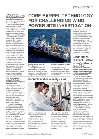
8 Poseidon 1 was used for this project
CPT testing if necessary. Ultimately it provided excellent quality rock cores in very difficult conditions with less than one per cent downtime.
Geoquip Marine provides the offshore renewables, nearshore civil infrastructure, scientific research, gas hydrates, offshore mineral exploration, and offshore oil & gas markets with accurate profiles and conditions of the sub-seabed, from the shoreline to depths of 3,500m.
For the latest news and analysis go to www.maritimejournal.com/news101
Lidar buoys will fact find for energy islands Floating wind lidar measurements will be taken for what will be the world’s first offshore artificial energy island, which is being constructed for the Danish Government. Fugro will install and operate four SEAWATCH wind lidar buoys at two locations, Energioe Nordsoen and Energioe Baltic, that will act as hubs connecting several offshore wind farms. From October, these buoys will record continuous wind measurements for a minimum of 1 year to support wind-resource mapping for the two islands, and the engineering and design of the future wind farms. Fugro is already performing geophysical surveys for the Energy Island project under a separate contract to provide Energinet with a reliable derisked site interpretation. The SEAWATCH wind lidar buoy can record wind measurements up to 250m above sea level, and wave measurements and current profiles down to the seabed. The buoy also acts as a multipurpose platform for additional metocean sensors and, on this project, will be fitted with sensors to capture Geo-data on environmental impact parameters, including bat monitoring.
JANUARY 2022 | 39


