ARCH672-UD732_Lithium Urbanities_Out of Sight out of Mind_IliyaMela
From time immemorial, rural areas have served as the backbone of human civilization and urban development. All industrial revolutions were initiated and sustained by the resources extracted from these hinterlands. While the stories of extractive cultures in these areas are documented in archives, museums, and other places, these narratives remain incomplete as they tell little about critical topics such as pollution, unjust labor practices, displacement, and the varying impact of mining and extraction on poverty and prosperity.
“Out of Sight, Out of Mind” creates a travel itinerary that explores Nevada’s cultural landscape, shedding light on the subject of extractivism and the rural hinterlands that power our urban aspirations, including the just energy transition. Taking advantage of Nevada’s large tourist inflow and scenic roads, the itinerary stretches along the 95 highway from the city of Las Vegas to Reno, cutting through the region’s historic towns and active mining sites to critically tell the story of the landscapes sustaining urban America as we approach yet another energy regime.
Rural-Urban America Relationship
Hey dude, have you ever wondered were all them raw materials we produce go to?
I
don’t know , one thing i know is we are not the benefactors
From time immemorial, rural areas have served as the backbone of human civilization and urban development. All industrial revolutions were initiated and sustained by the resources extracted from these hinterlands
Just place an order!
The Case of Nevada San Francisco
Rural Nevada
Not for me
This is the case of the state of Nevada, where raw materials(mainly borate of lime) from places like Esmeralda County, were transported to Salt Lake City
Via the connecting railroads. The extraction of these materials played a significant role in the development and expansion of San Francisco, such as using vessels as raw materials for the city’s harborside expansion. The results of these activities are the thousands of ghost towns, abandoned mines and facilities that have now become part of Nevada’s cultural landscape.
what has
Nevada’s
hinterlands gotten in return?
200,000 Holes
Experts estimate that there are nearly 200,000 abandoned mines in Nevada from historical mining activity, about 50,000 of which may exhibit safety hazards to the public.
Production of Minerals in Nevada 1987-Present
Present Extraction in Nevada
Brownfield Indian Land Petitioned
Can anyone see us from high up there
In the midst of the global aspiration for a clean energy transition and the desire of the Biden administration to be self-sufficient in the production of lithium ion batteries and the manufacturing of electric vehicles, Nevada is confronted once again with another regime of extractivism. The discovery of lithium in Silverpeak, Nevada and the successful operation of America’s first brine lithium mine has called for more mineral exploration, thanks to the advancement in technology.
such a lovely view from up there, i wonder if anything exist down there............
what is that hole in the ground, it’s so hugggge!!!
Nevada’s Cultures of Extraction
While the stories of extractive cultures in these areas are documented in archives, museums, and other places, these narratives remain incomplete as they tell little about critical topics such as pollution, unjust labor practices, displacement, and the varying impact of mining and extraction on poverty and prosperity.
Taking advantage of Nevada’s large tourist inflow and scenic roads, the itinerary stretches along the 95 highway from the city of Las Vegas to Reno, cutting through the region’s historic towns and active mining sites to critically tell the story of the landscapes sustaining urban America as we approach yet another energy regime
Speculative Scenic Routes
The itinerary contends with the importance of circulating these less known stories and facts across the silver state’s cultures of extraction as we yet approach another energy regime with the hope to prompt us to do differently this time.
Highway 50 is the lonliest highway in the U.S connecting San Francisco and Sacramento to Delta
number of important mining sites alongside it.
Reno-Carson to Las Vegas: Reno to Las Vegas highway has the highest
Lonliest Highway in the U.S: 80 Interstate runs from San francisco to salt lake city
Scenic Routes
Las Vegas
Trip starts with a visit to Rhyolite,
from
With its five-star resorts, world-class restaurants, stellar shopping, unrivaled entertainment, and 24/7 pulse—from classic Downtown Las Vegas to the famous Las Vegas Strip and beyond—this one-of-a-kind city owns the throne as the world’s premier tourist destination.
Beatty
Las Vegas.
Speculative Scenic Routes
Las Vegas
Rhyolite, Beatty
Speculative Itinerary
Yerington
Hawthorne
Mina
RNO International Airport
Anaconda Mines
Tonopah Muesum
Tonopah
Silverpeak Brine
Lithium mine
Goldfield, Mine
Las Vegas
Rhyolite, Beatty
Rhyolite, Beatty
Beatty: Rhyolite
Status: Ghost Town
Elevation: 3,819 Feet (1,164 meters) County: View Nye County Mines
Date Settled: 1905
Current Population: None
Peak Population: Up to 10,000
Commodity: Gold, Silver
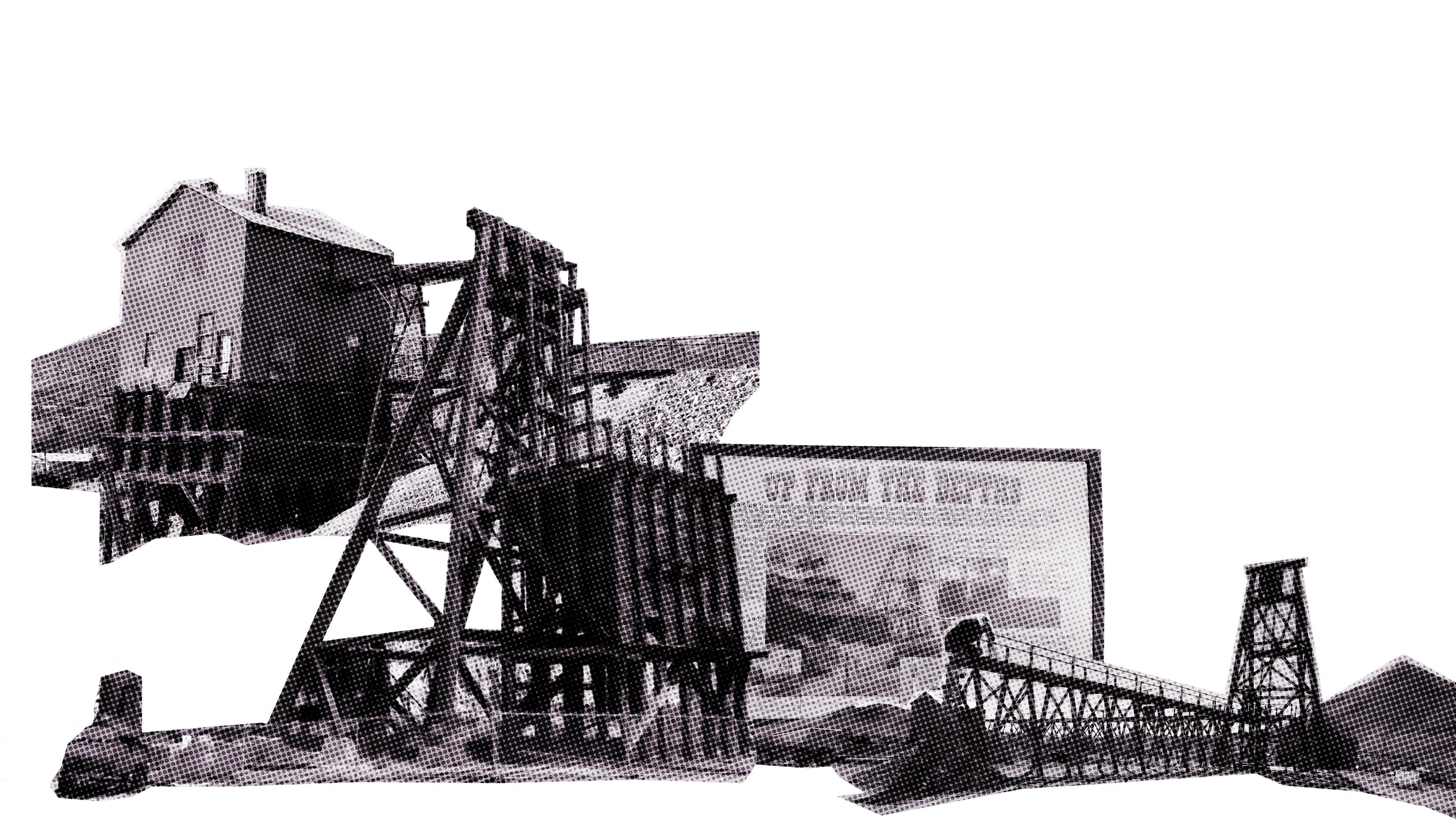
The story of Rhyolite begins in 1904 with two guys named Frank “Shorty” Harris and Ernest. L. Cross. While prospecting in the area, they found gold in the Bullfrog Hills, named for their green-spotted rocks. Thousands of people began streaming into the area. At its peak, Rhyolite really seemed to have it all. It was a bustling town of over 5,000 inhabitants with train lines, newspapers, hotels, schools, hospitals, an opera, saloons, churches and even a red-light district. It even became one of the first towns in the area to have electricity.
Sadly, the financial panic of 1907 was the beginning of the end for Rhyolite. Over the next few years mines began closing and banks and businesses began to fail. In 1919 there were only 24 people left in the town and by 1924 it’s last resident had died.
The Porter Brothers’ Store was very popular. In 1906, it was the go-to destination for Christmas shopping which was due in part to its impressive displays that rivaled those of the department stores in major cities. The store was the largest employer of people in Rhyolite, aside from those working in the mines.
Unfortunately, even the popular the store was not immune to the the downturn that would decimate Rhyolite’s businesses; closed in 1910. Hiram, however, would stay in Rhyolite for the next nine years, serving as the town’s postmaster until the post office closed on September 15, 1919.
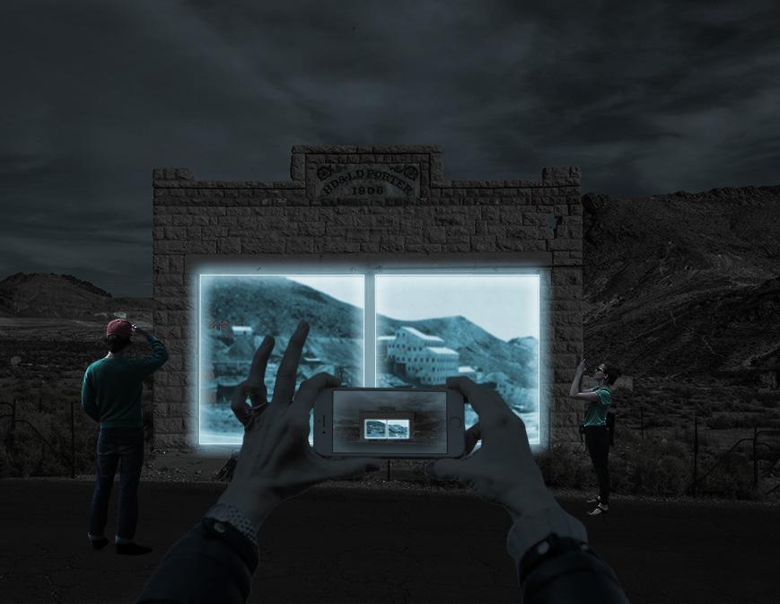
Porter Brothers Store: Approach View
Through projection screens powered by a long lithium ion battery, the intervention brings to life the history of this town which has been lost in the sands of time. The projected archival documents pay homage to the labor and contribution of the once inhabitants of Rhyolite and their contribution to privileges we now enjoy.
By making use of the town’s ruins of the once grocery store in combination with recent technology, the project challenges the notion that the old belongs to the past and the new to present.
THE ITENARY SAYS THE LAST GREAT BOOM CAMP.....
Las Vegas
Rhyolite
Golfield
GoldField!
SAYS IT IS GREAT WESTERN CAMP.....
i wonder what happened to the miners and residents of rhyolite.....
do you think they ever got the chance to recover from their loss?
Goldfield
Las Vegas
Rhyolite
Golfield
Goldfield: Historical Context
Status: Near Ghost Town
Elevation: 5,689 Feet (1,734 meters)
County: View Esmeralda County Mines
Date Settled: 1902
Current Population: Around 250
Peak Population: Around 20,000
Commodity: Gold
After a significant gold discovery in 1904, Goldfield grew to be the wealthiest and largest city in Nevada, boasting three newspapers, five banks, a mining stock exchange, and what was most likely the longest bar in the country— boxing promoter Tex Rickard’s Northern Saloon, which required 80 bartenders to handle its clientele.
However, despite its mighty reign, like all boomtowns, Goldfield soon enough went bust. Most of its mines were in severe decline by 1910, as was its population, which dwindled down to about 1,500 as fortune seekers set their sights on the next opportunities elsewhere. Then came a flash flood in 1913, followed by a devastating fire in 1923. Today, fewer than 300 people call the sprawling town home.
Today, with advancement in technology and innovation, abandoned mines in goldfields are being re-mined and explorations for new prospects are ongoing. The question is whether goldfields stand a chance of sustainable growth this time around? Upon this realization, the visitor is left wondering why young international professionals are employed to do the work that the locals can be trained to do. Regardless of the miners compensation and their benefits, their life in goldfield is not void of challenges, one of which is they are far from home and can’t have their loved ones move around with them The other is that they are far away from civilization and basic necessities such as health care and clean water.
The advancement in technology and innovation, abandoned mines in goldfield are being re-mined and while explorations for new prospects are ongoing. The question is those goldfields stand a chance of sustainable growth this time around?
Las Vegas
Rhyolite
Golfield
Silverpeak
silverpeak? i’ve never heard of it. is it a town or a city?
omg this landscapes are so wild, look at wild the horses roaming freely
Silverpeak: Historical Context
Status: Active Town
Elevation: 4,321 Feet (1,317 meters)
County: View Esmeralda County Mines
Date Settled: 1864
Current Population: Around 100
Peak Population: na
Commodity: Silver, gold, lithium
Silver Peak is one of the oldest mining areas in Nevada, discovered in 1863; The ups and downs of the mining industry resulted in a fluctuation in the population as well. In 1948 a fire burned the town of Silver Peak. After that there was little activity until 1966, when the Foote Mineral Company started its lithium extracting operations in nearby Clayton Valley.
The ups and downs of the mining industry resulted in a fluctuation in the population as well. In 1948 a fire burned the town of Silver Peak. After that there was little activity until 1966, when the Foote Mineral Company started its lithium extracting operations in nearby Clayton Valley.
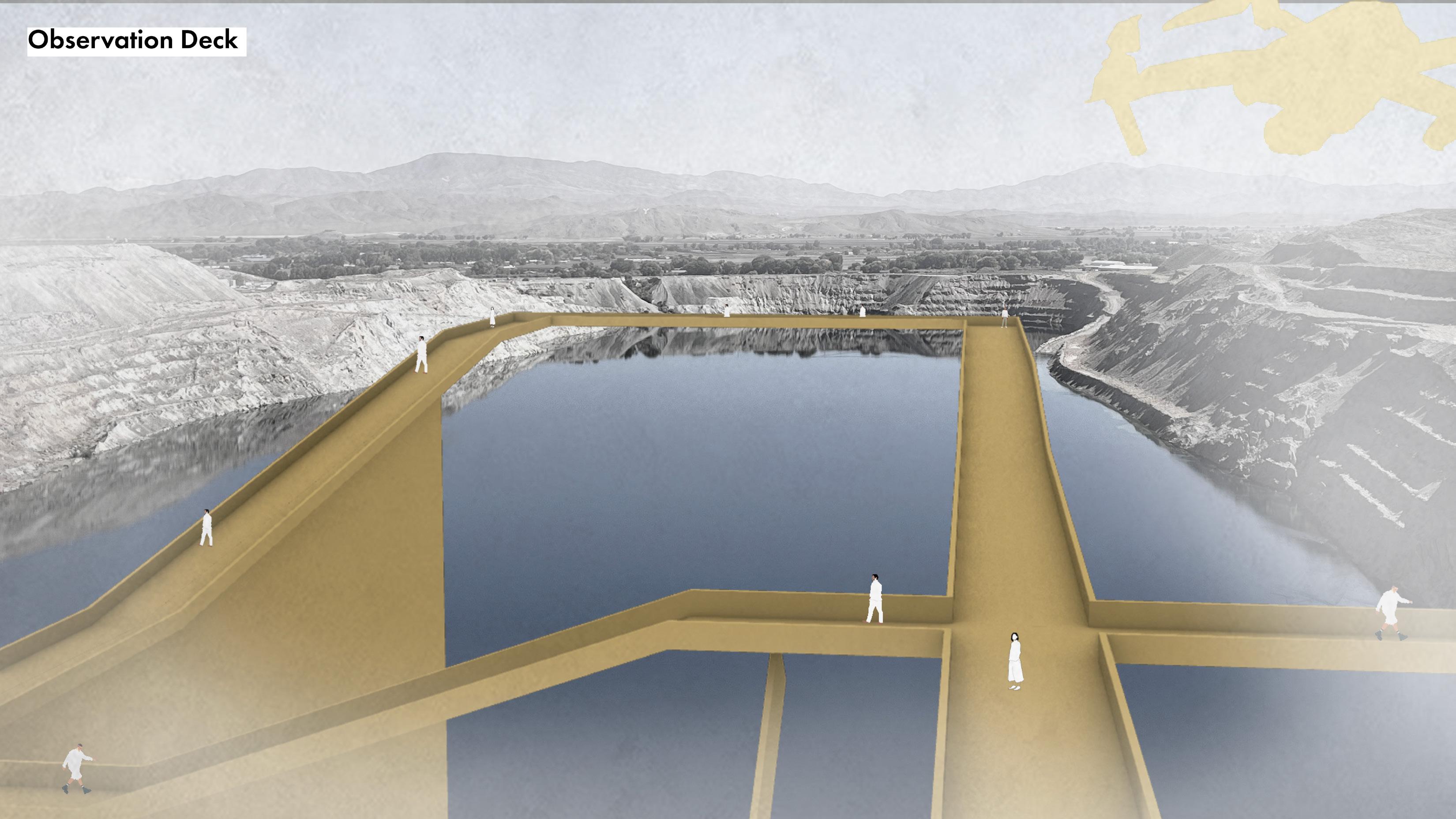
From exploration, mining to post mining, the character of the mining site changes to reflect the activities happening (or not happening). One generation’s trash becomes another generation’s artifact, and soft dusty tailings gradually become hazards.
A view of the lithium brine mine from the observation deck situated on a heap of tailing that has now become part of the landscape makes the visitor ask the question, how clean is the clean energy transition? A sharp contrast between the built and the semiarid landscapes of Nevada raises the question, can we eat our cake and have it, or do we just roll the dice and hope for the best?
Through the use of technology, the visitor is not confronted with a monument as an intervention but with interventions that situates silverpeak in a mix of the scenery of the past and a cyber futuristic context. This is a metaphorical interpretation of the small mining town that has been caught in limbo between the past, present and future
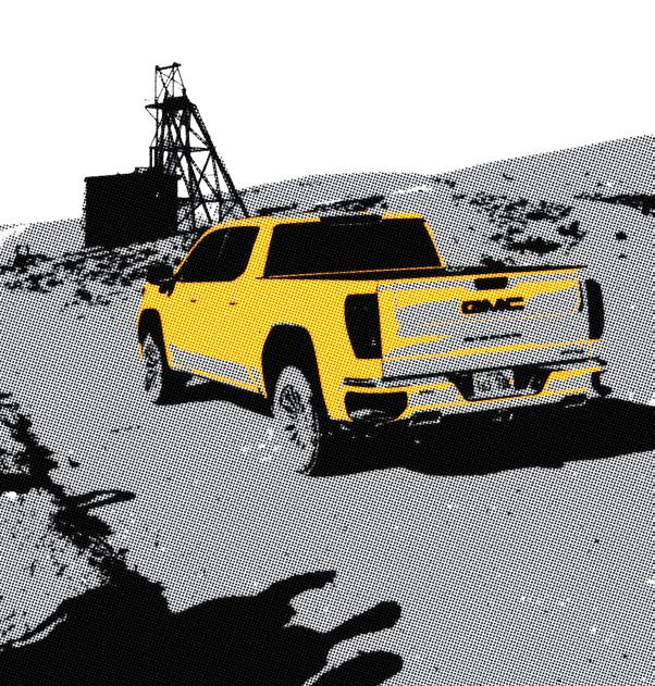
Refurbished corvet used as a displayed as an artifact and information
next stop,
what do think of the exhibition at silverpeak?
the government need to consider the effect of mineral extraction in places like silverpeak in green energy transition
Silverpeak
tonopah
the silverpeak?
i love... what they did with the relics but the stories got me thinking of how unfair the urban america has been to places like these.
effect extraction in the
i just hope that the rush for lithium at silverpeak will not bring people and development only to leave them high and dry.
Tonopah: Historical Context
Status: Active Town
Elevation: 6,030 Feet (1,838 meters)
County: Nye County Mines
Date Settled: 1900
Current Population: Around 2,500
Peak Population: Up to 10,000
The Tonopah Historic Mining Park is located on some of the original claims staked by Jim & Belle Butler in 1900 (when Tonopah first came into being). In 1901, those claims were sold to the Tonopah Mining Company. The Tonopah Mining Company worked these claims until 1930, and then leased them until 1948 when they were permanently shut down; the Company went bankrupt soon after. In 1968, the claims were owned by Howard Hughes and the Hughes Tool Company, and after passing through several hands ended up being owned by the Town of Tonopah in 1993. Today the mining park offers several trails and an in-depth look at some of Tonopah’s earliest and most profitable mines
Commodity: Silver, gold
At Tonopah, the visitor visits the Tonopah Historic Mining Museum but this time around is confronted with a different narrative or at the least, one that completes the entire story. This story is told by self experience. The visitor is taken underground into the tight meandering holes to have a first hand experience of the kind of working conditions the early miners were exposed to ad the show the extent to damage that was done to the earth to extract some of those raw materials.
These underground mines have claimed the lives of over 8 dozen men, and the question of if their families were compensated is still unanswered. At this very moment in time, we continue to lack the regulations in place. To ensure that minors are not confronting a necessary risk.
Yerington: Ananconda mInes
Las Vegas
Rhyolite
Golfield
Silverpeak
Tonopah
Mina
Hawthorne
Yerington
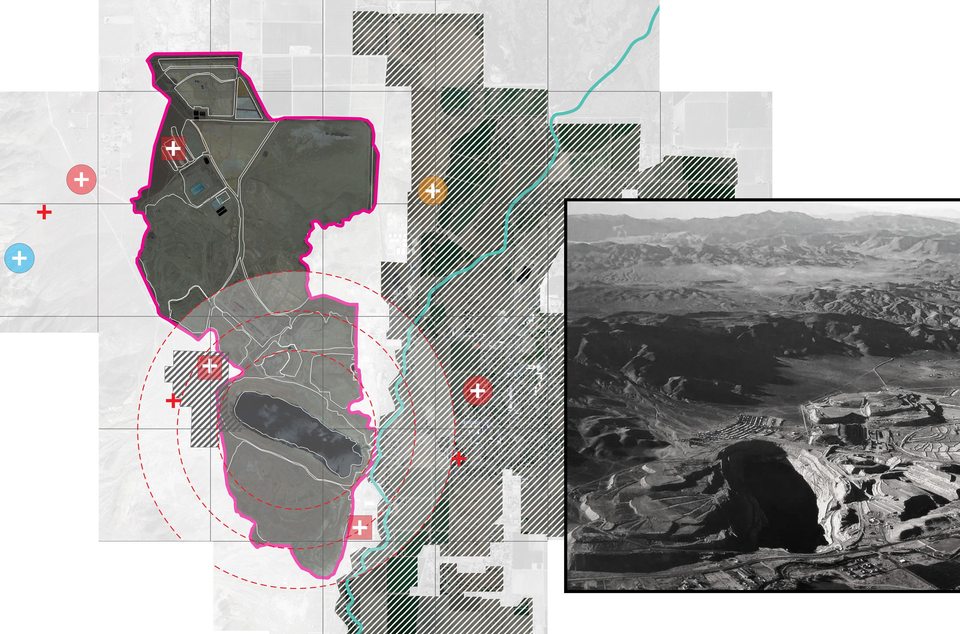
Yerington: Anaconda Mines
Air/health
lined evaporation
Unlined Evaporation ponds
Unlined Finger Evaporation ponds
pumpback evaporation ponds
Wabuska drain
Sulfide tailings
Oxide tailings Process solution recycling ponds
Phase III 4x heap leach pad
Weed heights
Process area
Arimetco plant site
w-23 waste rock area
Phase II heap leach pad
phase IV slot heap leach pad
Yerington pit
pit pake
South west Rock area
Yerington
City of Yerington
Walker River
The historic Anaconda Copper Mine Site (Site) is an abandoned open pit copper mine and processing facility, located in Lyon County’s Mason Valley, in western Nevada. The majority of copper mining, milling and processing at the Site occurred between 1953 and 1978, and secondary milling and processing of ores occurred between 1978 and 2000.
Today, the Nevada Division of Environmental Protection (NDEP) is overseeing site investigations, clean up, and closure actions that are protective of human health and the environment. The goal of this webpage is to enhance the public’s understanding of the current and planned activities at the Site.
Yerington
Aerial view of the abandoned Anaconda Copper Mine near Yerington. (Nevada Department of Conservation and Natural Resources)
Here the visitor is confronted with the sublime beauty of this present water that happens to be the most polluted in the entire region. Preventing all the agricultural production. In this metropolitan area. To be irrigated with the very water that is collected here. By suspending the visitor over this water I present them with the depth of how much extraction took place in this artificial waterbody
The visitor can only suspend over the water body but cannot touch it because after operations the company left all this pollution behind that now is taking all this many millions and all this many years to clean. And jet you. The visitor cannot touch this water.
Tahoe Reno Industrial Centre
On the way to which are are
Las Vegas
Rhyolite
Golfield
Silverpeak
Tonopah
Yerington
Hawthorne
Mina
Carson
Virginia City
to Reno the visitor passes through the tahoe reno industrial center that houses over 150 companies, most of are dependent on extractive resources to operate
The narratives of Nevada’s cultures are documented in archives, museums, and various locations. Although these stories are preserved and accessible to today’s visitors, their incompleteness is evident. One significant aspect of this incompleteness lies in the limited information available on critical topics such as pollution, abusive labor practices, displacement, the socioeconomic impact of mining and extraction (including both poverty and prosperity). Out of sight out of mind addresses the significance of disseminating these lesser-known stories and facts, encouraging a reevaluation of our actions and choices based on the lessons they offer.