Transportation & The Street Network
15, 2023
June
1
Michael B., Mannini P., Marcus C., & Jonathan P..


Overall PLOS Grading: D
Overall PLOS Grading: D
Existing Sidewalk Network


Existing Trails

Existing Multi-Use Pathways


Overall BLOS Grading: D
Overall BLOS Grading: D


“How far can I go from my front door?”
“How far can I go with transfers?”

Multiple Bus Routes to Bronte GO, & Transfers to Midtown Oakville from Bronte/Dundas


“Where do the nearest regional rapid transit lines go?”


High Densities near Dundas make it a transit-supportive corridor
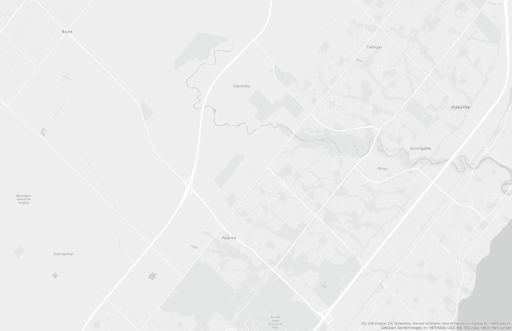
Easy vehicular access to regional areas beyond Oakville
Hospital provides easy access to healthcare services for all modes of transit
Easy regional transit access to the south, relatively frequent service along Dundas
Large sidewalks can act as multi-use paths for pedestrians and cyclists
Quick trip to Bronte GO on the Lakeshore West Line, with the highest train frequencies on the network.
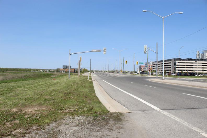
No pedestrian infrastructure on Bronte Road; Pedestrians are rerouted onto Old Bronte Road
No transit access to frequent GO Buses at Bronte Rd. Park& Ride.
Infrequent transit connections to the south during the weekends
No cycling infrastructure on Bronte and William Halton Pkwy
Wide lanes and high traffic volumes make Dundas uncomfortable for pedestrians
Improve cycling infrastructure to better connect the hospital to the rest of the cycling network
Lots of planned transit to support high-density mixed-use developments
Opportunity to turn Hospital District into future transit hub by creating more routes or increasing frequency to support increase in demand
Improve pedestrian infrastructure along William Halton Pkwy to facilitate walkability in future developments
Increased alternate modes of transit could reduce demand for cars along major arterials, reducing congestion
Bottlenecking of the road can lead to traffic congestion
Influx of activity could increase traffic, making streets noisier, busier, and less safe for all transit modes
Lack of adequate transit in place today has/will make the area car dependent.
Unprotected bike lanes make cycle infrastructure dangerous and undesirable
Burlington Downtown – Connecting Business and leisure by the Lake. Burlington Downtown iCal. (2023, May 26). Retrieved on 2023/06/15 from: https://burlingtondowntown.ca/
City of Oakville. (2018). 2018 Switching Gears Transportation Master Plan. Retrieved on 2023/06/15 from: https://www.oakville.ca/transportation-roads/transportation-roads-studies-and-plans/transportation-master-plan/transportation-master-plan/
City of Oakville. (2019). Map 4 - 2019 Traffic Volumes. Oakville. chrome-extension://efaidnbmnnnibpcajpcglclefindmkaj/https://www.oakville.ca/getmedia/b008e2a6-2e51-4968-9930-83a81eac7f64/traffic-volumes-map.pdf
City of Ottawa. (2015). Multi-Modal Level of Service (MMLOS) Guidelines. chrome-extension://efaidnbmnnnibpcajpcglclefindmkaj/https://pub-ottawa.escribemeetings.com/filestream.ashx?documentid=61403
CensusMapper. (2023). Population Density [Interactive Map]. CensusMapper.com.https://censusmapper.ca/#14/43.4388/-79.7567
Dennis, A. (2016). GO transit bus services. Wikipedia. https://en.wikipedia.org/wiki/GO_Transit_bus_services#/media/File:GO_Transit_SuperLo_Enviro500_8308.jpg
Downtown Hamilton Bia. Hamilton Halton Brant. (2023, April 28). Retrieved on 2023/06/15 from: https://theheartofontario.com/operator/downtown-hamilton-bia/
Downtown Milton Business Improvement Area. (2023, March 14). Retrieved on 2023/06/15 from: https://downtownmilton.com/
Doyle, E., & Wu, L. (2023, February 3). The best things to do in Mississauga in 2023. Time Out Canada. Retrieved on 2023/06/15 from: https://www.timeout.com/canada/things-to-do/best-things-to-do-in-mississauga
Government of Ontario (2019). Size and location of urban growth centres in the Greater Golden Horseshoe: Size and location of urban growth centres in the Greater Golden Horseshoe. ontario.ca. Retrieved on 2023/06/15 from: https://www.ontario.ca/ document/size-and-location-urban-growth-centres-greater-golden-horseshoe/size-and-location-urban-growth-centres-greater-golden-horseshoe
Google. (2023). [Google Map of 2070 Halton Region]. Retrieved June 14, 2023, from https://goo.gl/maps/CeCJmU3p5TM7rAVZ8
Google. (2023). [Google Map of Hospital Gate]. Retrieved June 14, 2023, from https://goo.gl/maps/iHNNFdT3MgAziiME6
Google. (2023). [Google Map of Halton Regional Road]. Retrieved June 14, 2023, from https://goo.gl/maps/XknE7SFwL3tRLie38
GTA-Homes (2022, October 26).Etobicoke Centre Growth Plan: Government plans: Retrieved on 2023/06/15 from: https://www.gta-homes.com/real-estate-info/etobicoke-centre-growth-plan/ Fast facts Downtown Markham. (2018, November 14). Retrieved on 2023/06/15 from: https://downtownmarkham.ca/about/fast-facts/ Metrolinx. (n.d.). Dundas BRT. Metrolinx. Retrieved on 2023/06/15 from: https://www.metrolinx.com/en/projects-and-programs/dundas-brt
Metrolinx (2018). Regional transportation plan. Metrolinx. https://www.metrolinx.com/en/projects-and-programs/regional-transportation-plan
Metrolinx (2018) GO Expansion Full Business Case. p. xvi, 26-27) Retrieved 23/06/15 from: /https://assets.metrolinx.com/image/upload/v1667497052/Images/Metrolinx/GO_Expansion_FBC.pdf
MTO (n.d). 407 Transitway - Brant Street to Winston Churchill Boulevard. Retrieved on 2023/06/15 from: https://407transitway.com/brantToHurontario/ Oakville Transit Administration. (n.d.). Oakville Transit. Oakville transit. https://www.oakville.ca/transportation-roads/oakville-transit/ Oakville Transit. (2022). Schedules and Maps - All Routes. https://www.oakvilletransit.ca/schedules-and-maps.html
Prepare For Canada. (2023, May 9). What to know about living in Richmond Hill, Ontario. Prepare For Canada. Retrieved on 2023/06/15 from: https://www.prepareforcanada.com/choosing-a-city/living-in-richmond-hill-ontario/ Region of Halton. (2011). Halton master plan. Halton. Retrieved on 2023/06/15 from: https://www.halton.ca/For-Residents/Roads-Construction/Infrastructure-Master-Plans/Transportation-Master-Plan-to-2031-The-Road-to-C#:~:text=Scope%3A,walking)%20to%20the%20year%202031
Remington Group (2018, November 14). Fast facts Downtown Markham. Retrieved on 2023/06/15 from: https://downtownmarkham.ca/about/fast-facts/ Town of Oakville. (n.d.). Town of Oakville Open Data Portal. https://portal-exploreoakville.opendata.arcgis.com/
Town of Oakville. (2020). Transit Presto Routes. Uwaterloo.maps.arcgis.com. Retrieved on 2023/06/15 from: https://uwaterloo.maps.arcgis.com/home/item.html?id=457f8a0f90c44c07a3b43c7315343506#overview Urban Strategies. (n.d.). Midtown Oakville. Retrieved on 2023/06/15 from: https://www.urbanstrategies.com/project/midtown-oakville/
Vagen, A (2017, August). Downtown toronto. Wikipedia. Wikimedia Foundation. Retrieved on 2023/06/15 from: https://en.wikipedia.org/wiki/Downtown_Toronto
Assignment I: Site Research and Analysis
PLAN 313/647 Community Design Studio
SITE RESEARCH - KNOWLEDGE
Data sources Comments
Primary data collected from site visits and in-situ observations and documentation, and interviews among others
Secondary data sources (e.g., planning documents, historic & contemporary maps, reports, peer-reviewed publications, grey literature... etc.)
Total Grade for data collection
Grade 6%
SITE ANALYSIS
Criterion Comments
Transects
Exploded Axonometrics
GIS
Sketch Map
Combinations of the above
Total Grade for site analysis

CONCLUDING DIAGRAM
Criterion Comments
Suitability Analysis
SWOT
Constraints – Opportunities
Grade 10%
Grade 4%

