landscapeinstitute.org Summer 2023 £15.00 Making it home: Creating a hospitable landscape
Product Range: Heavy-Heavy, beamsize: 14 x 21 cm


Wood option: FSC® Recycled 100% Hardwood


Twin option: Lava Grey (recyclate)

STREETLIFE BV enquiriesUK@streetlife.com I www.streetlife.com I t. +44 (0) 20 30 20 1509 I FSC® license number: C105477 Drifter Bench with USB Charger Lava Grey (recyclate) TWIN Extraordinary for Landscape Architects Rough&Ready Curved Bench
Thames Barrier Park Royal Docks in London (UK) by Mott MacDonald
Heavy-Heavy Loungers
Project:
Product:
Mobile Green Isle Oval movable & modular seating elements Love Tub CorTen
PUBLISHER
Darkhorse Design Ltd
T (0)20 7323 1931
darkhorsedesign.co.uk
tim@darkhorsedesign.co.uk
EDITORIAL ADVISORY PANEL
Saira Ali, Team Leader, Landscape, Design and Conservation, City of Bradford Metropolitan District Council
Stella Bland, Head of Communications, LDA Design
Marc Tomes CMLI, Director, Allen Scott
Landscape Architecture


Sandeep Menon, Landscape Architect and University tutor, Manchester Metropolitan University
Peter Sheard CMLI, Landscape Architect
Jaideep Warya CMLI, Landscape Architect, Allies and Morrison
Jenifer White CMLI, National Landscape Adviser, Historic England
LANDSCAPE INSTITUTE
Editor: Paul Lincoln
paul.lincoln@landscapeinstitute.org
Copy Editor: Jill White
Proof Reader: Johanna Robinson

Immediate Past President: Jane Findlay PPLI
CMLI
CEO: Sue Morgan
Head of Marketing, Communications and Events: Neelam Sheemar
Landscapeinstitute.org
@talklandscape landscapeinstitute landscapeinstituteUK

Creating the hospitable landscape
Landscape architects are ideally placed to create a welcoming environment for everyone, from tourist, refugee and visitor to pedestrian or cyclist. The welcome may be developed through signage systems, cartography, planting, or a hard landscape with materials that carefully offer a route and a navigation through the city. The creation of maps and signpost schemes, like Legible London and Legible Bristol, are interesting examples that offer a form of welfare, an embrace of the visitor that says, you are welcome in this place.

and a student-led consultation in Hackney, East London.
The research section highlights thermal comfort as an essential area of landscape expertise and demonstrates how co-design has become an essential area of expertise across all of the built environment professions. And finally, LI chief executive Sue Morgan examines the ground we stand on to ask how much of it provides a truly hospitable landscape.
Paul Lincoln Editor
Print or online?
Landscape is available to members both online and in print. If you want to receive a print version, please register your interest online at: my.landscapeinstitute.org
Landscape is printed on paper sourced from EMAS (Environmental Management and Audit Scheme) certified manufacturers to ensure responsible printing.
The views expressed in this journal are those of the contributors and advertisers and not necessarily those of the Landscape Institute, Darkhorse or the Editorial Advisory Panel. While every effort has been made to check the accuracy and validity of the information given in this publication, neither the Institute nor the Publisher accept any responsibility for the subsequent use of this information, for any errors or omissions that it may contain, or for any misunderstandings arising from it.
Landscape is the official journal of the Landscape Institute, ISSN: 1742–2914

© 2022 Landscape Institute. Landscape is published four times a year by Darkhorse Design.


This edition of Landscape considers what it means to create a hospitable environment. Considering a childhood experience of learning to cycle in North London and a UNESCOsupported child-friendly landscape in Ilford, we also showcase the way in which the early work on Legible Bristol and Legible London schemes has further evolved from New York to Toronto, Brick Lane and Bankside. We explore plans for dramatic improvements in Newhaven and celebrate the unsettling life of the City of London bollard.
Our interview with the creators of Elephant Springs traces the development of a landscape made from porphyry stone as it is carved and tested and then transported from its quarry to create a childfriendly environment in Elephant Park. Our book extract explores how skateboarding has improved the hospitality of Malmö, and our university briefings update on an innovative collaboration in Bangladesh
WELCOME
landscapeinstitute.org Making it home: Creating a hospitable landscape Cover is based on a photograph of the Legible London map. Credit TfL.
3


Contents 4 Signage makes a world of difference to an urban stroll 6 Signs of life A new park seeks to become iconic draw 34 Elephant Springs Eternal Examining making and design 39 The Experience Book Creating an inclusive environment through wayfinding 29 Newhaven’s Wayfinding Masterplan When it comes to history, bollards have a clear role to play The hospitable bollard 24 FEATURES A rich heritage inspires a child-friendly public realm Ilford through the lens 19


Sue Morgan selects some of her most hospitable landscapes 61 The Ground We Stand On 64 CAMPUS: Learn from anywhere LI LIFE RESEARCH 46 Skills Development Report Launch of an online hub UNIVERSITY BRIEFING 42 Gramer Haor Helping a village to grow sustainably RESEARCH RESEARCH 52 The Value of Co-design The ‘Towards Spatial Justice’ Research Project 57 Thermal comfort Ensuring liveability by developing heat resilience UNIVERSITY BRIEFING Showcasing work on the Nightingale Estate 48 University of East London 5
Signs of life
Signs can make the world of difference to an urban stroll. Designed to point, indicate and control – sometimes they also offer comfort and support.

FEATURE
No 1. ©
1. Model Traffic Area
British Pathé Ltd
6
1.
1 Model Traffic Area, London https://lordshiprec. org.uk/what-to-seedo/model-traffic-area/ https://museummum. com/2018/05/17/ local-london-mta/
Jill White

We are always looking for signs. From judging the clouds to see if the weather is on the change, eyeing the colour of the smoke emanating from the Vatican at conclave, to looking for that road-signed turn-off we’re supposed to be taking, or checking if that’s a disabled toilet over there. We’re looking for messages and reassurance, an acknowledgement that this place has us in mind, that it’s designed to be used by people like you and me, or that it’s safe. Although we bridle at over-zealous instruction signs and hate feeling corralled, having the ‘rules’ set out in our environments is often what makes it work. Funnily enough, those double-yellow lines are there for a reason.
We’ve been keen on signs for a long time, from cave art to traditional travelling cultures which recorded important hunting and subsistence locations through graphics, song and story. Romans invented milestones and from the 16th century parishes had responsibility for signposts in their areas. When cars came along from the 1890s onwards, the first warning and danger signs appeared for steep hills and bends, as vehicles then had much more entertaining braking and clutch capabilities. Before the advent of mass-production of relatively cheap vehicles, road signage was largely a local matter, and the result was a variety of styles and forms sometimes understood clearly only by locals. In the late 1950s, the government commissioned designers Jock Kinneir and Margaret Calvert to sort out the mess and to come up with a coherent style which was later applied across the UK and became the international template that we know today. It even has its own fonts designed by Calvert – ‘Transport’ and ‘Motorway’ – chosen
after rival fonts were exhaustively tested by aircraft pilots sitting on a platform in the middle of an airfield, working out what could be seen at what distance and travelling speed. It was Calvert who previously came up with the black type on yellow background approach (for Gatwick Airport), which is still widely recognised as the best, especially by the visually impaired. The mix of lower-case and capital letters enables them to be read faster than just using all capitals. The three shapes employed are codified as triangles for warnings, circles for giving orders and squares for supplying information. All of our suite of signs for pedestrians, horse riders, cyclists and vehicles now complies with the Kinneir-Calvert system.

Of course, not all signs are visual and on a flat surface. We take clues about how we are likely to experience the environment in the form of sound, touch and smell, too. The reassuring bleep of the controlled crossing that helps us navigate a busy road; the warning reversing alarm of the local authority dustcart; the passenger announcements on public transport – they’re all given as a form of sign to
help us get around and function in the world safely. Other more subliminal signs are displayed by features of landscape schemes: planting that allows enough visibility for vulnerable groups to feel safer; benches which have proper back and armrest support for disabled or elderly users, inviting a rest; also the use of scented plants for the visually impaired. These, too, are signs which make for a friendly landscape, one that says, ‘Yes, we’ve thought about you and we hope we’ve designed it so you’ll like it enough to visit again.’ Of course, there’s a place for warning signs such as ‘Danger’ and ‘Offenders will be towed’ (also designed for our wellbeing), but it isn’t always about the rules. How do we learn about all of this signage, overt and otherwise? As a child, I learned how traffic lights worked, what road signs meant and how to behave as a cyclist at the Lordship Recreation Ground in Haringey, North London. Apparently, the world’s first, opening in 1938,¹ to this day it still has some of the same layout. Learning the rules can be made fun and the Model Traffic Area also allowed me to feel that here was
FEATURE 7
something designed for me and so I was welcome there.
Later in life as a landscape architect designing a play area in a local park, I came upon this feeling again when children told me that the first thing they do when they go into a new area or park is to look for the brightly coloured stuff and then they know it’s for them – a sign that it’s the space where they’ve been thought about and so feel welcome. I was thinking how fed up they must be with the same old coloured equipment, but they were interpreting it as a navigation sign. Of course, they also enjoyed the more natural non-coloured play facilities, too.
What are we doing today to help people navigate or to signal a welcome? And how has this changed in recent years? Legible London was set up particularly to help pedestrians find their way around the capital more easily. The project was originally the brainchild of Pat Brown of Central London Partnership around 1999. It was promoted by a number of London boroughs together with Transport for
London and has now been taken up across the capital. It was given a boost by the London Olympics. TfL worked with boroughs, businesses and disability groups to create an easy-touse wayfinding system of routes and signage that was also linked to transport hubs and underground station exits. Although this was achieved using a suite of recommended sign styles, information ‘pillars’ and other physical devices, it also tackled street clutter by streamlining multiple signs and getting them out of the way (or easily locatable) for visually impaired pedestrians. Information maps installed on the street use the ‘heads-up’ approach, orientated to the users’ direction of travel rather than the usual north/south. The overarching concept, according to Pat Brown, was that ‘the city should put a sublime arm around you and say welcome’. The pedestrian would not necessarily know why they were being aided. It was a physical manifestation of the city helping people find their destination,
allowing them to feel confident to get lost, safe in the knowledge that they would end up in the right place.
Wherever possible, routes guided people to Tube stations from where most other hubs and stations were walkable, encouraging them to explore and access more areas on foot by building confidence in a ‘five-minute walk’ (or 400m) ideal journey model. The wayfaring map system was also designed to help users understand if there will be dropped kerbs and pedestrian crossings along the way –important for those with buggies, disability scooters and wheelchairs. Early consultation demonstrated that fewer strategically placed signs were just as effective as more numerous badly placed ones. Signage with existing provision, such as on bus stops, was adopted, as was positioning some road signage at a lower level where pedestrians could see it far more easily. The aim of the Legible London project is to roll out its consistent and easily recognisable signage across as many areas of
 2.
2.
2 Regulations for road signage www.gov.uk/ government/ collections/trafficsigns-signals-androad-markings FEATURE 8
2. Legible London map design © TfL
The wayfaring map system was also designed to help users understand if there will be dropped kerbs and pedestrian crossings along the way –important for those with buggies, disability scooters and wheelchairs.
London as possible. Other global cities, such as New York (see Case Study below) are also creating more legible and consistent approaches to helping people navigate around.

How important is consistency in approach? Road signage and some pedestrian signs are regulated by the Traffic Signs Regulations and General Directions 20162 which provide sizes, font size, minimum clearances over carriageways, footways, shared routes and bridleways. However, a surprisingly large variety of deviations from the standard approaches to design in this field can be seen. There have been a number of zebra crossings installed which employ a range of different colours. I have also seen a good deal of ‘artistic’ use of independent metal studs meant for use as tactile paving. They are sometimes also employed as a non-slip device: tactile surfaces are intended to be an essential safety feature which advise pedestrians who need them on the location of safe crossings.3
back to those local variations in signage that caused all the problems in the past.
And where are we heading now, in this brave new world of technological solutions? Has it allowed us to free ourselves from the mostly visual signage of the past and allowed us to consider other forms of messaging? Why can’t our immediate environment simply tell us what’s going on? With the Talking Lamppost project (a Playable City initiative)4 everything from street furniture to post boxes and cranes becomes interactive, with pedestrians able to trigger a talking response from inanimate objects which can tell them everything from how they’re feeling (yes, really) to inviting dialogue via text messaging about what local area improvements they’d like to see.
3 Guidance on tactile paving surfaces www.gov.uk/ government/ publications/inclusivemobility-using-tactilepaving-surfaces
4 Talking Lamppost project https://www. playablecity.com/ projects/
https://www. mediacityuk. co.uk/newsroom/ talking-lamppostsbecome-a-reality-atmediacityuk/
5 RNIB REACT Talking Sign System
https://react-access. com/
https://www. sightadvicefaq.org. uk/independentliving/transport-travel/ react-talking-sign
https://www. chroniclelive.co.uk/ news/north-eastnews/talking-lampposts-help-blindpeople-1449652
Invented in Japan in 1965, the range of warning surfaces also includes corduroy paving, which has rounded bars in the surface to provide warning of hazard, such as top or bottom of stairs, a ramp, level crossing and so forth. Is it acceptable to play with set standards that some sections of the community vitally need to navigate their way in the world? Do we really find it acceptable for a blind person arriving in a new town to have to wonder what the hell is going on with an artful arrangement of random size studs conveying who-knowswhat, instead of what they need and rely on? Is it right that a visually impaired person is bewildered by whether the art on the road is a right of way zebra crossing, or just a bit of fun or a political statement? There is a boundary somewhere between frivolity and the preservation of safety and life.
Getting this wrong can have serious consequences and I do know blind people who have had major accidents, such as falling onto train lines, because the wrong tactile signage had been used. There is a danger that we could just be going
It’s not just major cities in countries like Japan, USA, Canada and the Netherlands which are having all the fun. Talking Lampposts has also been rolled out in Bristol, Nottingham and MediaCity UK in Salford. Users scan a QR code on a given object and this will prompt an interactive ‘conversation’ via text, with answers to questions in real time. This talking signage also provides users with local information and interpretation about the location. Fun though it may be, this is not an exercise in levity, but also has a serious intent to garner opinion and to help with future development.
The talking signage phenomenon is also being taken to a new level and becoming a permanent wayfinding and information system for people with visual impairment. In Newcastle, for example, the RNIB (Royal National Institute for the Blind) REACT (React Audio Triggering System) Talking Sign System5 has been installed to provide spoken information via speakers attached to lampposts and other features. Users carry an electronic keyfob or use a phone app which triggers the speaker at distances up to 8m away and it provides all kinds of information, from routing and wayfinding to transport times and location details. This has been installed in many transport locations around the UK and the variety of possible uses is clearly enormous and should not
FEATURE
4.
© TfL
3. Legible London wayfinder with map
9
3.
necessarily be restricted to owners of smartphones. Other ‘triggering’
caring about them and wanting to meet their needs.
The next time you’re considering how to impart information to users of any space, instead of just showing them, perhaps consider actually ‘speaking’ to people directly about what they need to know, too. Think
also about other senses such as touch to impart information and understanding. It’s a sign you care about them.
Reference to village names


Village names are already embedded in London’s bus system.

others they are caring for to study maps and timetables in tiny print. It could also feel more relevant and friendly if a local accent or dialect is used in the delivery.
It doesn’t have to be an important countrywide signage scheme that makes a landscape more friendly and hospitable. Little project touches, such as the 3D sign6 made for visually impaired visitors to a walking labyrinth in Seaton, Devon, go a long way to making people feel the environment is
Building better knowledge
We all know from our usual modes of transport that we use our own mental get about. Drivers navigate London by landmarks and, from this, develop an advanced) vocabulary of favoured routes. Tube travellers see London as a collection points, lines and intersections. When cyclists plan their journeys, they think safety, effort and environment.
To create effective support for pedestrians developing their mental maps we
FEATURE
Jill White is a writer and landscape
6.
5. Legible London, A wayfinding study, ‘London’s Villages’ © Central London Partnership
6. South Island, New Zealand © Graham Macey
simplify London in a way that is useful for walkers. London has plenty of memorable
London’s ‘villages’ London has a wealth and named areas, clusters of neighbourhoods distinctive localities. can form a code connect their knowledge.
Changing the culture
10
5.
Darkhorse Design
Founded in 2005, Darkhorse Design is a full service communications agency and content publisher specialising in the built and natural environment.
St Helens Council
The Dream site in St Helens was one of seven chosen from over 1,400 publicly nominated locations for the Channel 4 series The Big Art Project. Working alongside artist Jaume Plensa and local focus groups, Darkhorse created a visual wayfinding system including striking black-and-white imagery to reflect a dream-like state. The site was reimagined to create a sense of local ownership and place with planet positive fabrication of signs using locally reclaimed and repurposed material where possible. Digital aspects include on-site signage with downloadable audio guides, plus augmented reality which is used on-site to show the original mine shafts; visitors can look through their camera phones and watch as the mine shafts appear, transporting the viewer back in time to the working Sutton Manor Colliery.
United Utilities
A wayfinding and interpretation system was required across thousands of acres of regularly used United Utilities land with supporting communications collateral to encourage safe and responsible enjoyment of the countryside. Highlighted points of interest on the maps are brought alive by accessible 3D illustrations that attract attention to the key destination points, and a colour coded system is applied to walks for different audiences. Innovative and sustainable cost-effective signage, sympathetic to their individual surroundings and usage, were plotted across the sites providing local information as well as public safety and awareness messages. Joint venture project between Darkhorse and Sundog Creative.


Bury Council
The Irwell Sculpture Trail, which spans over 33 miles, is the UK’s longest public art trail. It features over 70 artworks by local, national and international artists in rural and urban settings. Its aim is to connect various aspects of the Irwell Valley, its people, its heritage, its parks and countryside using artworks in the environment. We developed a brand strategy following extensive research in both local communities and the tourism marketplace. This cultural project required the delivery of a family of accessible signage to work across a range of locations with varying environmental considerations covering demographically different user requirements. On-site digital interpretation is available with a website providing interactive and downloadable maps, QR codes, mobile apps, on-site audio guides, and sustainably printed seasonal visitor guides.
CASE STUDIES
The overarching concept of Legible London was that ‘the city should put a sublime arm around you and say welcome’. This legacy has led to many developments in signage and mapmaking designed to welcome the visitor. This selection of case studies illustrates current approaches.
1.
2.
3.
1. Dream at St Helens
2. Thirlmere
11
3. The Lookout at Clifton Country Park
Steer
An infrastructure and transport consultancy. The core areas that define the practice are place, identity and movement.
Toronto Natural Environment Trails
Toronto’s forested ravines and natural trails are well-loved and heavily used. As trail usage increases, so do the pressures on these areas, alongside user expectations for wayfinding. In response, the City of Toronto engaged Steer to develop a custom information system specifically suited for the needs of its trails and its users on foot and bike. The system combines wayfinding, interpretation, trail rules/etiquette, and emergency safety instructions into a simple, durable, and cost-effective system of panels mounted to timber posts.
See Paddington
The canal side around Paddington Basin suffers from a lack of visibility, coherence and sense of place. The Paddington Partnership commissioned Steer and Jedco to address these issues. The outcome was See Paddington – a coordinated package of interventions in the form of perforated steel panels that graphically integrate locally inspired stories and public art derived from Paddington’s heritage, community and nature to create a narrative trail linking key gateways with the canal between Bishop’s Bridge Road and South Wharf Road.

STUDY
CASE
4. Trail head and fingerpost © Steer
5. Interpretive panels and painted mural © Steer
4.
12
5.
CASE STUDY
Toronto 360
Toronto’s TO360 wayfinding strategy supports walking as the connecting mode that enables multi-modal transportation in the city. TO360 provides information for pedestrians, cyclists, transit users and motorists through unified signage and mapping. Steer has supported the City of Toronto since 2011 in the preparation and delivery of the system. After successful evaluation of the 2015 Financial District pilot, the project is now being rolled out citywide by the City of Toronto and its project partners including BikeShare, TTC and Metrolinx.

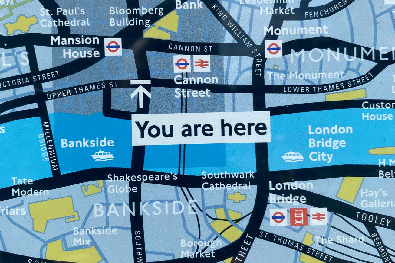
Bankside

Southwark Council and TfL launched a competition to address pedestrian conditions on Lavington Street as part of Bankside Urban Forest. In response, Steer designed a new modular product that enabled widening of the narrow footways to allow more space for people on foot, with buggies or in wheelchairs and accommodate a cycle contraflow. This innovative product demonstrates how streets can be rapidly reconfigured to respond to changing pressures, accommodate increased footfall and support safe movement around construction sites or roadworks.
 6. TO360 Fingerpost © Steer
7. TO360 Map sign © City of Toronto 8. Bankside Boardwalk © Better Bankside
6.
7.
6. TO360 Fingerpost © Steer
7. TO360 Map sign © City of Toronto 8. Bankside Boardwalk © Better Bankside
6.
7.
13
8.
City-ID
Information and wayfinding solutions to integrate people, movement and places.

WalkNYC
WalkNYC was designed to help the 8.5mn residents and 50mn visitors a year to walk, bike and use public transit by providing new types of information and a standardised system of parts. It provides an intuitive, legible and extendible information system with an elegant family of products, robust design standards and a confident visual identity, all inspired by New York City and its iconic Subway system.
The project continues to expand above ground and below with the renovation of NYC Subway system as part of the New York City Transit Enhanced Station Initiative.

CASE STUDY
9. Presentation boards © City-ID
10. Product family © City-ID
9.
14
10.


CASE STUDY 11. New York Wayfinding © City-ID 12. Printed maps © City-ID 11. 12. 15
Interconnect Birmingham
Interconnect Birmingham is a partnership and framework initiated in 2006 by Marketing Birmingham (now West Midlands Growth Company) within which infrastructure and design for Birmingham’s city centre streetscape is being evolved and improved, with a focus on people, their journey, interaction and activity. Interconnect delivers an integrated pedestrian wayfinding and transport information system through an innovative research-led approach, focused on improving experiences for residents and visitors of the West Midlands. The mapping and products were updated across the city centre in readiness for the 2022 Commonwealth Games.


CASE STUDY
13. Wayfinding system © City-ID
14. Bus stop wayfinding system © City-ID
13.
16
14.


17 CASE STUDY
15, 16, 17 & 18. City wayfinding system and map detail © City-ID
15.
17.
18.
16.
GreenBlue


Time


For further information on our versatile products visit woodblocx-landscaping.com or telephone 0800 389 1420 Sustainable timber solutions for the built environment with limitless design potential The world’s #1 modular timber system Street Furniture | Raised Planters | Free Design Service LIJ Advert 2023.indd 1 23/3/2023 7:54 pm Provides amenity and biodiversity Creating healthier urban spaces in harmony with nature T: +44 (0)1580 830 800 E: enquiries@greenblue.com W: greenblue.com #MakeAChange Green Blue Smart Space Air RootSpace HydroPlanterReLuminate AQ Planter
Urban’s unique suite of products act as the interface between nature and the built environment.
to
change. 18
make a
Ilford through the lens
A rich photographic heritage has inspired the design of a child-friendly public realm built on the site of the former Ilford factory.
 1.
1.
FEATURE
1. Packaging paper in 1894
19
© Courtesy of Michael Talbert ‘photomemorabilia.co.uk’
With an emphasis on child-friendly design, the newest urban quarter in Ilford and one of Redbridge’s largest regeneration schemes was given a resolution to grant planning just before Christmas. Connecting the area’s rich industrial heritage with a relatable and hospitable landscape for children provided a unique placemaking opportunity.
Harnessing the abundance of opportunity that the £18.8 billion Crossrail project is bringing to Ilford, this Telford Homes scheme features 837 new homes and 447 student accommodation bedrooms with 3,500m²+ of commercial floor space, and almost 7,000m² of new public realm. With the potential to set a precedent for future development in the area, this development will mark a significant change of use and improve permeability in central Ilford.
As one of only a few UNICEF child-friendly boroughs in the country, Redbridge Council advised Telford
Homes on a specialised engagement strategy. Chapel Place was named as the pilot scheme within the council’s Child-Friendly Action Plan, and Telford have therefore taken as many opportunities as possible (to date) to put youth engagement at the heart of this strategy. While child-centred design was a key element – with youth ambassadors influencing the design from the outset, framing the engagement process was the industrytransforming innovation that has characterised Ilford’s past.
Celebrating the heritage of Ilford, the design narrative focuses on the former Ilford Ltd (previously Britannia Works Factory) – a photographic plate factory – on which the development is planned. Founded by Alfred Harman in 1883, Ilford Ltd developed innovative photographic technologies including glass photographic plate production, the silver emulsion to create photosensitivity, and film and cameras which transformed the photography industry at the time.
Our design for public realm at Chapel Place was inspired by the innovative technologies that succeeded in putting Ilford on the world map. Concept design sketches were developed, refined and folded into this design narrative. Two concepts based on the fluidity
of silver emulsion and photographic plate geometries were used within the site to help create two distinct areas. The photographic plate concept was applied to an urban linear space which would function as a retail and commercial corridor, while the more curved silver inspired spaces would be more suitable for a central green space (named Britannia Gardens – reflecting a former green space in the factory grounds) that would form the heart of the development.
To strengthen the link with the heritage of Ilford Ltd, its branding and packaging colour schemes of sands, buffs and greys were used to inspire the hard and soft material palette. Intended to reinforce distinct character areas in the site, these paving designs and colours created a natural navigation through the site. Similarly, planting and furniture designs utilised the bright colours of the packaging labels through flower and seed head colours and powder coated accents to the metal work of the furniture.
Enshrined across Redbridge policy is a commitment to children’s rights at the heart of every council decision. With 25% of Redbridge’s half a million residents aged 0–15, achieving UNICEF UK Child Friendly Community status for Redbridge was a key manifesto pledge for the
2. Innovations of Britannia Works factory


© Courtesy of ‘Silver by the Ton: A History of Ilford Limited 1879-1979’
3. Innovations of Britannia Works factory

© Courtesy of ‘Silver by the Ton: A History of Ilford Limited 1879-1979’
4. Innovations of Britannia Works factory

© Courtesy of ‘Silver by the Ton: A History of Ilford Limited 1879-1979’
With the potential to set a precedent for future development in the area, this transit-oriented development will mark a significant change of use and improve permeability in central Ilford.
 Pierre Chin-Dickey and James Blower
2.
3.
Pierre Chin-Dickey and James Blower
2.
3.
FEATURE
4.
20
current administration. Redbridge’s Child Friendly Action Plan provides a UNICEF-aligned programme to put children’s educational development at the centre of public space design. Ensuring that key design priorities on Chapel Place were linked to the UNICEF child rights principles was important for framing the public realm and landscape strategy. UNICEF Child-Friendly Cities Initiatives1 explore ways of elevating community voices, needs, priorities and rights of children, allowing them to form an integral part of public policies, programmes and
decisions. The initiative’s practical toolkit based on the seven Principles of the UN Convention on the Rights of the Child were used by designers to ensure that at no point in the design process were children an afterthought. Divided into general principles (Life, Survival and Development; NonDiscrimination; and Participation) and human-rights principles (Dignity; Interdependence and Indivisibility; Transparency and Accountability), they ensure a quality of care and provision in children’s lived experience.
For this scheme, we partnered
with UP Projects to empower young people to shape the narrative through both public art and infrastructure. Using the photographic heritage of Ilford Ltd as a lens to frame engagement, workshops included meeting local Ilford artist Andrew Brown to look at Ilford Ltd’s heritage items and explore photographic techniques.
This strategy provided an opportunity for an emerging neighbourhood to connect with communities both old and new as the project started to take shape. It allows


FEATURE
5.
6.
5. Proposed Britannia Gardens’ allocated open space
© Image courtesy of Rockhunter 6. Proposed Britannia Gardens’ allocated open space
21
© Image courtesy of Rockhunter
art and creative practice to sit at the heart of this development and gives people the chance to develop what and how this cultural offer might shape and deliver tangible social value to both young people and adults.

This philosophy remained at the heart of the strategy and design of Chapel Place. Structuring engagement sessions with activities for young people to participate in led to helpful design responses that the design team could incorporate, such as space promoting digital arts innovation and a community hub to access digital art
technology.

Seeing how photography could inspire young people, Ilford’s photographic heritage played a key part in devising Chapel Place’s play strategy, with the design of individual features inspired by different photographic key principles: perspective, light, texture and colour. These features include a silver-themed climbing feature; picture frame-inspired play features; brightly coloured play items representing the packaging materials; and iridescent objects that play tricks on the eye by shifting

with light and shadow. Similarly, it was determined that any public art should, as well as reinforcing historical narratives, be functional and used for play or seating.
While these principles framed the design approach, implementation of child-friendly design has to be relevant to the context. Harnessing the lived experience of Redbridge Youth Ambassadors through engagement gave children an opportunity to shape placemaking strategies and ‘places’ where they feel connected. The crux of the challenge with Chapel Place was to make the powerful heritage relevant to the modern youth perspective, in so connecting the past with the future.
As placemaking specialists, creating successful public realm can create a multitude of challenges and
FEATURE
https:// childfriendlycities.org/
1
7.
8.
7. Ilford Community workshop activities
© Copyright Up Projects Consultation Curator and run by local artist Andrew Brown.
Photo by Bronwyn Jones.
8. Photographic plate production concept sketch
9. Camera aperture concept sketch © Courtesy of Michael Talbert ‘photomemorabilia.co.uk’
10. Packaging paper in 1894 © Courtesy of Michael Talbert ‘photomemorabilia.co.uk’
9.
22
10.
While Chapel Place is inspired by the past, the engagement with local young people has shaped a relevant design for the future.

overlooking young people can limit success. Young people demonstrate energy and dynamism that should be nurtured and catered for. While Chapel Place is inspired by the past, the engagement with local young people has shaped a relevant design for the future. As Chapel Place has already been given a resolution to grant
planning, moving forward into the next stages of design, its future success hinges on ensuring these young voices are heard.
Client: Telford Homes and Sainsbury’s Team: HTA Architects (Lead Consultant), UP Projects (Public Art and Consultation), Mayer Brown (Transport), Ramboll (Engineers)
12

FEATURE
Pierre Chin-Dickey CMLI, CLARB, LEED A.P. is a landscape architect and Design Director at Macfarlane + Associates
James Blower MA – Urban Designer and Sustainability Lead at Macfarlane + Associates
11. Aspirational townscape sketch depicting the development and changing Ilford context
© Image courtesy of HTA Design
12. Proposed Chapel Way Winston Way Gateway
© Image courtesy of Rockhunter
23
11.
They’re back!
Two popular sandstones have returned to our Commercial sandstone range.
Both sandstones are as strong as they are beautiful, meaning they can be deployed in heavily trafficked areas and withstand the test of time. This strength, combined with the size of the quarried blocks also means they capable of creating even the largest bespoke furniture items.
Visit: marshalls.co.uk/commercial
to start designing with Marshalls sandstone


SANDER RED
Choice and versatility from the Marshalls sandstone range


BROWNRIDGE
BRACKENDALE

THORNLAKE
Laurel Bank: Hawks View:
a former best-seller, with beautiful, smooth creamy tones.


a stunning dual-colour available in 4 finishes.

 Blasted FlamedClear blastBush hammered & brushed
New New
Blasted
The hospitable bollard
Ross
Bollards: you can’t sit on them; they don’t help with litter and they bar your way. Some even carry self-important branding telling you who’s in charge. In many situations, bollards can be positively hostile: hard lines of metal, clearly intended to prevent movement.

So, compared to other pieces of street furniture, can bollards be described as ‘hospitable’?
The City of London is a good place to contemplate this question. With a long history of installing ‘posts’ in its streets, today the City is a bollard hotspot. Wherever you stand in the

1. A Culture Mile bollard All images © Cathy Ross
When it comes to contributing to a city’s history, bollards have a clear role to play, acting as reminders of an ever-present past.
1.
FEATURE 26
Cathy
3.
Square Mile, you will probably spot a bollard or two. All types and sizes are here from modern, impact-tested, steel cylinders to ancient cast-iron boundary posts marking parish land. By far the most distinctive designs are the two bollards associated with the Corporation of the City of London, the Square Mile’s governing body. What’s now termed ‘the D3 type’ first appeared in the 1820s, when it was a ‘flat post’. More showy is ‘the C3 type’, formerly known as a ‘guard post’, and dating from the 1860s. With its black-and-red livery, octagonal body, lemon squeezer top and star collar, the C3 is a slightly pompous presence. The basic design has been much tweaked over the years. Variations on the theme include the thin, dainty B5 which arrived in the 1980s to fill the holes in the ground left by parking meters; and a modern streamlined, high-security C3 whose heritage exterior hides an
inner core of crash-proof steel.
These hard-core C3s are the latest addition to the City’s bollard population and they arrived along with growing anxiety about terrorism. Over the last 20 years or so, bollards have become ‘hostile vehicle mitigation’ measures in ever-increasing numbers. The new arrivals no longer carry the coat of arms of the City of London, so have a more forbiddingly anonymous look. Standing in long lines around significant buildings, these are the grey squirrels of the bollard population: invasive displacers, now the dominant species.
So, are City-branded bollards hostile or hospitable? Despite the association with terrorism, I’d come down on the side of hospitable – with the proviso that bollards elsewhere may have different stories to tell. Here, however, I’d suggest that what makes bollards hospitable is their potential


to be playful. Maybe it’s something about their scale and appearance, but City bollards do seem to have a rather silly side. They can easily be given a personality by placing a hat on their head; and the tendency of odd singletons to move around the City, popping up in the pavements or disappearing, seemingly at random, gives them a kind of agency. This playfulness encourages interaction. Stray hats aren’t the only things that bollards attract. City bollards bear all sorts of gifts – scarfs, gloves, the inevitable drink cans. Their hospitable qualities extend to hosting stickers: a few summers ago, many City bollards evidently joined Extinction Rebellion. On its website, the World Bollard Association underlines the ability of bollards to add imagination and humour to the public realm. In the City, the Corporation requires its public realm to have a certain gravitas (‘safe,
Over the last 20 years or so, bollards have become ‘hostile vehicle mitigation’ measures in ever-increasing numbers.
FEATURE
2.
2. The D3 bollard
The hard core revealed
3.
27
high quality and inclusive’), which mitigates against the wacky end of playfulness. However, the one aspect of bollards that seems to be tweakable is colour. Bollards in Leadenhall Market are painted in rich shades of plum, while those in the City of London Cemetery are green. In 2016, the City promoted its ‘Culture Mile’ strategy by wrapping some bollards in a colourful vinyl sleeve designed by Richard Wolfstrom. Does the future promise more colour for official City bollards? Given that the Corporation regularly repaints its bollards to freshen them up, this is at least a possibility. On the seafront at Margate is a rogue Corporation bollard, a seaside day tripper painted a rather stylish bright yellow. Apart from playfulness, the oldfashioned design of the C3 may also add a hospitable note. As the City’s new office blocks become bulkier, taller and more hard-edged in mood, so the faintly ridiculous 1860s items

at ground level acquire a new allure, indeed a new softness.
To 1960s modernists, fauxVictorian street furniture was shamefully backward-facing. Today’s planners seem to hold more nuanced ideas about the contribution historic character makes to a sense of place. And bollards have a clear role to play here. Small reminders of the everpresent past, they perhaps also add some sense of reassurance about the future for people who brush past daily – residents, workers and visitors alike.
‘The City bollard is an indisputable symbol of the City of London,’ said the Corporation’s Annual Report in 2005. Nearly 20 years later the City has changed, as has the detail and role of the bollard. But they remain familiar and, to my mind, friendly parts of this particular urban landscape.
Bollardology: observing the City of London, by Cathy Ross. Quickfry Books, 2022. ISBN 978-1-39992123-7. £12.99. Available from the Guildhall Art Gallery shop and online.
As the City’s new office blocks become bulkier, taller and more hardedged in mood, so the faintly ridiculous 1860s items at ground level acquire a new allure, indeed a new softness.
 Cathy Ross is a historian and author
4.
Cathy Ross is a historian and author
4.
28
4. Hostile bollards? © Cathy Ross
Newhaven’s Wayfinding and Signage Spatial Masterplan
Newhaven has a commitment to creating an inclusive environment by ensuring that all aspects of an area’s wayfinding and signage are carefully investigated and planned.

Newhaven is a small East Sussex port town with a population of 13,000 people lying at the mouth of the River Ouse. The local authority, Lewes District Council, received funding of just over £5mn from Government’s Future High Streets Fund (FHSF) and Newhaven Town Deal funding to ‘re-connect the
Town’. The FHSF ‘Re-imagining Newhaven’ prospectus provides a foundation of baseline information, analysis and overarching themes to help deliver some big ideas and aspirations for the town.
The prospectus acknowledges Newhaven’s poor public realm and the fact that there’s little sense of arrival

FEATURE
1. Cover page of final report © Credit Lewes District Council
Marc Tomes in conjunction with Lewes District Council
29
1.
when entering the town from transport interchanges, and by the severance caused by the river, railway corridor, industrial estates and existing road network. The ring road known locally as ‘The Collar’ is a particular issue, effectively cutting off the town centre from its surroundings. Like many towns, a past emphasis on traffic planning and engineering has led to the dominance of cars, an infrastructure that does not lend itself to pedestrian or cyclist movements and a town centre that ‘turns its back’ on its surroundings.
Over time, notions of civic pride have eroded along with the quality of public realm, further diminishing the sense of place and amenity value. The furnishings and materials are repaired and added to in an ad hoc manner, leading to increased clutter and visual discontinuity.
One of the threads emerging from the prospectus is to improve wayfinding and access across Newhaven, to reconnect the town
centre and the high street with key residential and business areas, increasing footfall and dwell time, while reducing traffic and improving air quality. Key to achieving this aim is to create clearer, more legible and engaging routes that simultaneously promote local identity and enhance public realm.

Lisa Rawlinson is Head of Regeneration at Lewes District Council. ‘The desire was to install new signage at key access points and gateways to the high street including from the railway station and through to riverside walks,’ she says. ‘This required a strategic approach to working out where to put this and what this might look like to help create something that reflected Newhaven’s unique characteristics.’
Lewes District Council engaged landscape architects, Allen Scott, to prepare a Wayfinding & Signage Spatial Masterplan for Newhaven, to deliver a pilot scheme for new visitor trails along the river, and to spark
interest in Newhaven’s heritage.
‘As landscape architects, we wanted the spatial masterplan to be a comprehensive approach to wayfinding and signage for the whole town, taking a holistic and spatial view of movement and inclusive access and to use it to deliver some of the emerging ideas for the town,’ says Marc Tomes, Allen Scott’s Director.’ Ultimately, the Spatial Masterplan needed to improve people’s experience, making the town easy, safe, convenient and attractive for people to find their way around and to spend more time there.’
Following contextual analysis, the project team undertook consultation with a number of key stakeholders including East Sussex County Council, Newhaven Enterprise Zone and Newhaven Town Council. This framed a structured methodology based around four steps involving research and site visits, targeted workshops and presentations and initial conceptual illustrations of potential outcomes.
2. Reconnecting the town centre by improving connections to the high street © Allen Scott.
The project highlighted to us all that wayfinding isn’t just about signs. It’s about how people experience a place or a journey.
FEATURE
2.
30
The ethos behind the Spatial Masterplan went far beyond considering replacement signage. It resulted in helping to set the scene for vital and necessary improvements to the public realm across Newhaven.
The content of the masterplan covered town-wide wayfinding principles, locations for wayfinding and signage improvements and better visual language and potential materials. Using these principles, the team then defined specific improvements in key locations across the town and prepared an action plan.

Says Rawlinson, ‘The project highlighted to us all that wayfinding isn’t just about signs. It’s about how people experience a place or a journey.’
Combining these concepts demonstrated that the experience of a ‘place’ involves a number of factors, including the physical environment of the public realm and the elements and activities within it. Together these provide both intuitive and informative navigation, leading to a better sense of that place. This leads to connections that are more positive between people, places and each other, encouraging active and healthy lifestyles and reducing air pollution through a reduction in car use.
‘The ethos behind the Spatial Masterplan went far beyond considering replacement signage. It resulted in helping to set the scene for vital and necessary improvements to the public realm across Newhaven,’ says Rawlinson.

‘We kept coming back to the town’s distinct character, a juxtaposition of marine, coastline, countryside and industry within such a small geographic area, and our desire to reflect and respect this in our design response,’ says Tomes. ‘We felt it was important to ensure the essence of Newhaven, its history and evolution, for better or for worse, was not lost to homogeneity but that emerging projects and actions followed principles to preserve the character while enhancing the amenity
of the local community and visitors alike. The pragmatic starting point, though, was that the current quality of the public realm and amenity spaces is poor with tired infrastructure in need of investment.’

Before embarking on the action plan, the team sought to gain a deeper understanding of how people currently make their way through the town and to what extent these could be rationalised and improved. Primarily through personal observations, available visitor data, footfall data and consultation, Allen Scott analysed the various visual cues and physical elements such as public realm furnishings materials, signage, public art, vegetation, buildings and infrastructure that impart the current ‘sense of place’ and amenity value to help unpick the challenges and inform potential solutions. In Newhaven’s favour is its geography, topography, river, coast and proximity to the South Downs National Park, which all help with intuitive orientation. Long views towards the town centre and the river from the east, west and south and panoramic views from Castle Hill and the fort provide a valuable sense of where you are within the wider landscape. The town centre and high street currently suffers from severance to the river, the coast, the South Downs National Park and to its residents. The analysis reinforced outcomes and recommendations from previous studies to improve the
navigation and connectivity for all abilities and all ages. This included enabling ease of movement and connections for people who are visually impaired.
Applying best-practice principles to this analysis with more specific principles for Newhaven provided two overarching directions, better arrival and destinations and better routes and pause points. Derived from the research and discussions, the team then applied four themes to assist
FEATURE
4.
3. Newhaven railway station, one of the key gateways into Newhaven
© Allen Scott
4. Contextual analysis included spatially mapping baseline information
© Allen Scott
5. Opportunities identified include improved gateways, routes and places to stop across Newhaven
© Allen Scott
3.
31
5.
in formulating specific projects and actions. These were: re-imagining the sense of arrival into Newhaven; reconnecting the town centre; reestablishing relationships between land, river and sea; and repurposing under-utilised spaces. Best practice principles include wayfinding that’s inclusive, relatable, simple and legible. Newhaven’s town-wide principles include wayfinding that is well-placed and integrated, consistent and coordinated, and in the context of the Towns Fund and FHSF improved wayfinding could also act as a catalyst for further enhancements and positive change.
Under these themes, 33 projects
were identified and organised, each one located and described with a number illustrated and expanded upon. Importantly, the Spatial Masterplan included a series of recommended actions to help deliver it. These include strategic and aspirational improvements such as major enhancements to the Transport Interchange Hub (ferry, train, bus interchange) through to quick wins of decluttering and rationalising signage and furnishings. There are also recommended overarching actions and projects such as gathering coherent content about Newhaven, its past and present, and formatting this in a way so it is easy
to use for future information boards, website information and public realm enhancements. Grouping the actions into the four themes enabled the team to demonstrate how specific issues can be resolved through physical improvements, although many proposals also deliver multiple themes and benefits. Priority ‘early win’ pilot schemes were identified that would deliver the objectives set for the project as well as objectives set within the Town Investment Plan. Working with Newhaven Historical Society, a heritage interpretation trail has been created along the River Ouse. The new bespoke information boards reflect the visual language and materials palette of Newhaven. They also include QR codes linked to further information about Newhaven and its heritage.
Says Rawlinson: ‘The Spatial Masterplan includes several ambitious “Big Idea” projects aimed at addressing issues that go far beyond just wayfinding.’
Prioritising projects for the longer term is challenging without further planning, design and engagement with stakeholders. To assist with this, the report included an assessment toolkit to help council officers and their partners prioritise projects based on success criteria.
The Spatial Masterplan sets out an ambitious and holistic way to deliver improved wayfinding across Newhaven over time. Some

The Spatial Masterplan includes several ambitious ‘Big Idea’ projects aimed to address issues that go far beyond just wayfinding.

FEATURE
6.
6. Conceptual ideas for a family and a hierarchy of bespoke signage © Allen Scott
32
7. Principles, overarching directions and themes for application help deliver a reconnected Newhaven © Allen Scott
projects will take far longer to deliver than others, but the more complex projects are broken down into a series of smaller manageable projects to simplify staged delivery.
It was not the purpose of the project or the report to propose a complete ‘materials and furniture palette’ for Newhaven. However, in the interest of steering a consistent

and coherent approach to future public realm improvements and wayfinding interventions, the Spatial Masterplan report included the principles applicable to material specification.

The report also insists that integrated sustainable approaches to design, specification, implementation, ongoing management and maintenance are part of the solutions,
actions and interventions. This includes sustainably sourced products and materials, environmentally sensitive designed solutions that provide benefits to biodiversity and climate action, integration of appropriate vegetation to help with air quality control and reduce the heat-island effect, potential for sustainable drainage solutions such as rain gardens, swales and permeable paving and information and interpretation that explains climate change and the biodiversity crisis.
Newhaven’s Wayfinding and Signage Spatial Masterplan was adopted by Lewes District Council and signed off by the Town Deal board in 2022. An initial pilot scheme is due to be implemented this summer.
Marc Tomes is Director of Allen Scott and a High Street Task Force Expert. He has more than 20 years’ experience working within the landscape and environment sector in the UK, Australia and New Zealand
FEATURE
8.
9.
8. Conceptual ideas for improving one of the key gateways by applying the Spatial Masterplan principles, direction and themes
© Allen Scott
33
9. Conceptual illustration of a ‘Pause point’, applying Newhaven’s family of signage and materials © Allen Scott
Elephant Springs Eternal
A £4 billion redevelopment programme has seen radical change in South London. It’s hoped that a new two-acre park will prove an iconic draw for generations to come.

34
1.
We looked at how we could create biodiversity in any residential areas, as well as the park itself.
Alice Charles

In South London, at the heart of one of the capital’s busiest routes, sits a ‘little oasis’, Elephant Springs. Opened last summer, the distinctive ‘pocket park’ has proved a draw for hundreds of people across the city. Elephant Springs is part of Elephant Park, a mixed-use development by Lendlease and Southwark Council, which when completed will offer 3,000 new homes, 50 new retail spaces, a library, heritage centre and nursery. There are also plans for a new office building and an NHS community health hub. The development is scheduled for completion in 2026 with a bold ambition of achieving net-zero operation by this time.
Elephant Park itself is intended as a ‘community space’, with rain gardens and walkways, and forms part of a £2.5bn plan by Southwark Council and Lendlease to boost the local economy.

Nearly 15% of people who live in the borough are estimated to earn less than the living wage and Southwark has the sixth-highest rate of child poverty out of all local authorities in the UK.
Zena Wigram is Head of Marketing at Gillespies in Clerkenwell, London. The project has been ‘a long time coming,’ she says. Previously, the company had completed a number of major projects in Southwark, including a public park for the apartment and

workspace complex Bankside Yards, a landscape courtyard for the office development The Forge, as well as ITV headquarters and the park at the apartment complex, the Biscuit Factory in Bermondsey.
For the Elephant Park development, Gillespies was retained by Lendlease back in 2014 to devise a masterplan, covering 28 acres, including a new two-acre park. ‘It’s a big footprint,’ she says. ‘We looked at how we could create biodiversity
FEATURE
3.
1. Porphyry quarry Albiano, Nr Trento, Italy
© Hardscape
2. Mel Chantrey among the Porphyry in Italy
© Hardscape
3. Elephant Spring complete © Hardscape
2.
35
There was also a story about play and what we could provide.
in any residential areas, as well as the park itself. There was also a story about play and what we could provide.’
After the pandemic hit, this idea of including a ‘playscape’ for local children became central to the project’s development, and Gillespies describes Elephant Springs as ‘a rocky water-world of fountains, waterfalls and sandy beaches created from 300 tonnes of Italian porphyry stone. Elephant Springs is … a tactile space designed to delight, challenge and excite children and adults alike.’


During the pandemic, how we use public spaces came under sharp focus and the company undertook a lot of research, looking at how water and sand could be used in the Elephant Springs project, which sits at the heart of one of London’s busiest routes, providing a respite from the heavy traffic.
Neil Matthew is Senior Associate at Gillespies but when the project began nearly ten years ago, he was Senior Landscape Architect and has seen his career progress as the project reached completion. ‘I was leading the team, public consultations and client meetings,’ he says. ‘It was a very collaborative process.’
When the project started, a steering group was formed called the Park Action Group (PAG) made up of local residents and professionals who met regularly and acted as a ‘sounding board’ throughout the design process. They were found by posting notices up on the site. ‘It was important to have resident input as the park was next to existing properties,’ says Matthew. The company was charged with developing a focal point for
Elephant Park, which was delivered in two phases, protecting the site’s existing mature trees and adding new ones to provide a canopy, as well
as a wildflower meadow to act as a ‘welcome’ to the area.
Trying to complete the project during lockdown required a change in their way of working. Says Matthew, ‘Obviously, we worked remotely most of the time. But we all know each other well and that made things easier. It was easy just to pick up the phone, and a lot of site visits were conducted virtually via video calls.’
For the park’s water feature, the company worked with artist Mel Chantrey from the Fountain Workshop. Chantrey had previously worked with Gillespies on a larger water feature project in Woolwich, London, called the Royal Arsenal Riverside Waterfront in 2016. Chantrey also designed the
Trying to complete the project during lockdown required a change in their way of working. Says Matthew, ‘Obviously, we worked remotely most of the time. But we all know each other well and that made things easier.
FEATURE
4.
4. Porphyry in Albiano quarry, Italy, selected for the project © Hardscape 5. Watercolour drawing © Hardscape
5.
36
waterscape for the Diana Princess of Wales memorial playground in Kensington Gardens. ‘He was the natural choice,’ says Matthew. ‘He’s a great collaborator.’

For Chantrey, whose background is in fine art, Elephant Springs was a real labour of love. ‘I grew up in the Pennines, wandering about springs and streams, and that became the narrative that informed this project,’ he says. Chantrey learned that there had previously been a watercourse
on the site and had the idea of creating a water feature. ‘The water would emerge from the ground into a tumbling watercourse, ending in a kind of delta, and the course would change colour as it ran through. I had everything hidden, even the drains, so that it looks natural.’


Having previously travelled to a quarry in northern Italy for the project in Woolwich, Chantrey was introduced by Hardscape to the colour and finish of porphyry stone, selected


for its durability and beauty. ‘I don’t use computers,’ he admits and so produced hundreds of drawings, which in the end proved invaluable. He also spent 18 months making precise Plasticine models to scale in Gillespies’ offices. ‘I knew exactly how it would work,’ he says. ‘And I wanted it to be inclusive so you can get wheelchairs in there, you can play with jets. But it’s not just for children, it’s also for adults.’
A presentation to Lendlease went well and Chantrey’s models, drawings
Plasticine model of mound 1 and 2. Mel Chantrey
3D model by Hardscape rendered to show colour variation.
Mound 1 nearly complete. Test layout in Italy. Hardscape
Mound 2 laid out in Italy complete.
FEATURE
Hand watercolour impression and vision. Mel Chantrey
Planning the project
Design view to the north. Lendlease Porphyry paving with jointing material test colour. Mel Chantrey
Paving between mounds and beginning of laying on the project site. Mel Chantry
Elephant Springs porphyry design in construction. Lendlease
37
Water feature paving and porphyry blocks being laid with 5M ‘bridge stone’ (in one piece) in the background. Lendlease
and equipment were shipped to Italy, but just as the project was about to go ahead, the pandemic hit – with the Italian village where the family-owned quarry was located in the epicentre of the outbreak.
Weeks passed and it was eventually decided to work remotely. Cameras were mounted overlooking the quarry yard with round-theclock access so that Chantrey could see what he was doing. ‘I worked every day, from 7am to 6pm, from September to December. It had to be done by Christmas before the snow came,’ he says.
The process was long and involved. For every stone to be used, three or four had to be selected. Says Chantrey, ‘Porphyry is a volcanic rock; a slab can be half a metre thick. I was looking for colour – it was like doing a jigsaw puzzle long distance. In the end, 70% of the product was built in Italy. It sounds crazy, all the odds were stacked against us, but it worked like a dream.’
Chantrey is full of praise for the Italian family that helped bring the vision to life. ‘These guys are artisans,’ he says. ‘It was an incredible working relationship. They ended up adopting me.’
Lendlease had originally intended for the work to be recreated in a field in Kent before being transported to site but having lost several weeks due to the lockdown, the stones were shipped straight to the site itself.
Again, it was necessary to work remotely with cameras set up on site and Chantrey ended up giving the engineers and construction crew a half-day ‘creative induction’, featuring his many drawings and models.
‘People went the extra mile,’ he says. ‘It was a crazy bit of work but so much care has been lavished on this thing –the workmen really upped their game.’
Mathew Haslam, director of Hardscape, has known Mel Chantrey for more than 20 years and had a 30year relationship with Gillespies, since the company first formed. He was involved in early discussions about the project. ‘Mel built an amazing model,’ he says. ‘The digital world doesn’t bring a project to life in the same way. People may sneer at anything old-time, but I think they [Lendlease] fell in love with the Plasticine model.’
But the project was not without its issues. ‘Because of Covid, there was real uncertainty about how it was all going to turnout. It was difficult to predict,’ he says. ‘Porphyry is granitic. It comes out of the ground in sheets, not in blocks. With a digital model, you couldn’t predict the stone height or dictate water flow. It required a leap of faith – and a real team effort with construction team P.J. Careys Ltd.’ Lifesize models were created in the quarry, which required each slab to be numbered and a GPS coordinate assigned, so that each piece could then be reconstructed in London.
An independent risk-benefit
analysis was carried out by the Royal Society for the Prevention of Accidents (RoSPA) on site when the project was 80% completed, and then another assessment was conducted just prior to the park opening in June 2021. In the interim, the company undertook ‘slight changes’, which in the end won the company an award. Mathew is very positive about this process. ‘It’s always good to be recognised,’ he says. ‘It was a feast of innovation.’
Would he undertake such a project again? ‘Oh yeah,’ he replies without hesitation. ‘In Mel, we had someone who wants to reinvent Hadrian’s Wall, the Italians were proud of their material and Lendlease didn’t waver from their vision. It was a real human endeavour. The best projects are a real challenge and produce the best result.’
Meanwhile, when lockdown finally lifted, and Chantrey could travel from his home in Manchester, he visited Elephant Springs and spent some time speaking to the people who had come to enjoy the space. He is delighted with the outcome.

‘The opening was fantastic,’ he says. ‘You’re not sure how things are going to work until the public are there. I saw people on the Tube coming with buckets and spades, and the sound was terrific. For me, it’s a real success. People have come back together, a new community is forming. During the day, I saw families with children playing, people having lunch, and I talked to people in the evening. It wasn’t originally meant to be a playground; it was a “peoplescape”, but it also accommodates the people who had been displaced from Heygate Estate [demolished ten years previously]. The park provides the glue, putting a community back together.
‘It doesn’t look like a playground, it’s a lyrical, romantic landscape – at night the lighting is beautiful. It could have been an abject failure but it worked. It was extraordinary.’
©
People have come back together, a new community is forming.
FEATURE 7.
Alice Charles is a London-based journalist.
38
7. Design view to the south
Lendlease
The Experience Book: For Designers, Thinkers & Makers
The Experience Book examines the design and making of experiences that define the spaces where we live, work and play. Landscape showcases two projects.
On Paradise City
The idea behind The Experience
Book is a simple one. With the evolution of humans as a cultural and technological species, we have become increasingly adept at putting our ideas into the world. At the same time, the word ‘experience’ has been used to sell everything from theories on a new economical era to toothbrushes to holidays to whole cities. A guide to and source of examples of the designed experience, the book is an attempt to (re)anchor ‘experience’ as being fundamental to what it means to design, for better and for worse.
Skaters worldwide have brilliantly subverted the privatisation of public space. This repurposing of what the artist Nils Norman calls the ‘vernacular of terror’ is taken to its wonderfully logical endpoint in Malmö, Sweden. It’s not perfect, but it’s a prototype for how we might go about designing our public spaces from grassroots up and in the interests of all.
On Kids with hammers
Health and safety has become the designer-in-chief of what it means to be socially responsible. This is especially true of how we treat our children, who must suffer our fear for their health and their safety. The
Land and other similarly risk-tolerant adventure playgrounds are a fightback in the name of today’s children, who are being denied the very things – the freedom to experiment, to be hurt, to fail, to test their bodies – that were the making of their parents and grandparents.
PARADISE CITY
A vernacular of inclusiveness: how a city reinvented itself as a skateboarding mecca
Modern concepts of ‘public’ and ‘space’ are easily read (if we take the time to look) in the design of our public realms, whether controlled by public or private bodies or both. The escalation of defensive or hygiene programmes

FEATURE
Adam Scott and Dave Waddell
©
Creative commons licence
1. Skatepark, Malmö, Sweden
Maria Eklind
1.
39
and hardware – mosquito alarms, anti-homeless spikes, pay-per-minute benches, pavement sprinklers, and so on – is the ‘vernacular of terror’ that the artist Nils Norman says is exercised against those we consider not us: the ‘destitute’ and the ‘anti-social’.

It’s not like this everywhere, however, and especially not in the Swedish city of Malmö. Unusually for a long-winter destination, Malmö is a skateboarding mecca, the design of the city’s skate-friendly public realm the result of a long partnership between the not-for-profit skaters’ association Bryggeriet and the municipal authorities. It wasn’t always this way – Malmö’s council was once much the same as city councils the world over, either shepherding skating into acceptable spaces or demonising it as a public nuisance. However, unable to ignore the association’s reactivation of spaces otherwise left to rack and ruin, it donated the site of a decommissioned brewery, and in doing so changed the fortunes of a city that had never fully got over the collapse of its shipbuilding industry.
The details of the role the association and skating in general played in the regeneration of Malmö are a story for another time. Suffice it to say, it has evolved considerably. At the beginning, it was all about what the city could do for skating; today, it is all about what skating can do for
the city. The result: a vernacular of inclusiveness, designed by the once excluded.
KIDS WITH HAMMERS
The world’s greatest playground and the department of health and safety is not invited.
The Land is a small and fenced-off piece of land in a housing estate in north Wales. You could be forgiven for mistaking it for an illegal dump. Tyres and pallets lie scattered across the site. A small stream is full of junk. A large piece of green tubing hangs from a tree. Makeshift seating and the remains of fires betray signs of human activity. It’s what you’d hope your local authority would classify as a health
and safety hazard, and certainly not anywhere you’d bring the kids.
Only, it’s not a hazard; it is exactly where many of the estate’s children play, and everything you see is actually meant to be here. That’s because The Land is an adventure playground, ‘a space’, as it says on its welcome sign, ‘full of possibilities’, and which – in the hands of a band of ever-present and yet unobtrusive playworkers –is wholeheartedly devoted to the business of risky play, including lighting fires, climbing high, hammering nails, and sawing through anything except each other. It’s hardly a new concept, but still an almighty breath of fresh air in an age of stranger fear, hover parenting and internet pervasiveness.
The Land is one of a growing number of such playgrounds, all of which are descended in one way or another from Copenhagen’s wartime ‘junk playgrounds’. Just as the Danish landscape architect Carl Theodor Sørensen was inspired by the creativity of children’s play on bombsites, so it is continually informed by its organisers’ observation of the children it serves. It’s a place of possibility, directed by children for children. Take the kids: it’s wonderfully dangerous.
The Experience Book: For Designers, Thinkers & Makers is published by Black Dog Press.

The Land is one of a growing number of such playgrounds, all of which are descended in one way or another from Copenhagen’s wartime ‘junk playgrounds’.


FEATURE
2.
3.
4.
40
2, 3, 4 Children playing on the Land © Land Plasmadoc


A 100% FSC Manufacturer www.factoryfurniture.co.uk design+ make+ collaborate
A new podcast from Landscape and Open City. Available on: Listen to Talking Landscape 41
Photo - Macgregor Smith Quay Loungers in FSC Redwood and galvanised steel
Gramer Haor –helping a village to grow sustainably

Two years ago, Landscape showcased the collaboration between Birmingham City University and Shahjalal University of Science and Technology. The Prince’s Foundation which supported the project and the academics involved provide an update.

Background
The Gramer Haor Co.Lab was initiated during the summer of 2019 to explore


ways to support sustainable growth of the village of Kazir Gaon in Bangladesh. Kazir Gaon was experiencing rapid growth and expansion, which was occurring in haphazard, unsustainable ways. To tackle these issues, an international partnership was formed between Eccles Ng, Course Director for BA (Hons) Landscape Architecture and BA (Hons) Landscape Architecture with Urban Design at Birmingham City University (BCU), Kawshik Saha,
Associate Professor, Department of Architecture at Shahjalal University of Science and Technology (SUST), and Abubokkar Siddiki, a British Bangladeshi architect. The support of The Prince’s Foundation and use of its Rapid Planning Toolkit (RPT) were integral to the Co.Lab studio. The RPT is a four-step process designed to guide a multidisciplinary approach in the inclusive planning and design of rapidly growing cities and towns.
Following the success of the process, the local government informally agreed to allocate approximately 2.5 acres of land to develop a community hub, which would provide facilities for Kazir Gaon residents.
1. Group photo following the community workshop in January 2022 © Naimul Islam
UNIVERSITY BRIEFING
Eccles Ng, Abubokkar Siddiki and Victoria Hobday
1. 42
1
The Co.Lab continues to be an important opportunity to apply the RPT in Bangladesh and for students and stakeholders to learn through their involvement in a live project.
Project evolution
Given the nature of the location and culture, the RPT activities were adapted to suit Kazir Gaon’s village setting. This bottom-up approach and engagement with villagers and local stakeholders helped build trust with the panchayat (village council) and villagers, which ensured their permission to pursue the project in their village. The initial intention was for the students to work together in Kazir Gaon to develop a collaborative plan for sustainable growth.
Season One – January 2021
With the BCU team not able to travel because of the pandemic, the first cohort of Gramer Haor Co.Lab from SUST made visits to Kazir Gaon, toured the village and met with villagers in small groups to gather information and data. The first cohort worked on the masterplan of the village, including the bazaar, Bhumin (social housing area) and the old village. Their brief was to look at how the village can grow sustainably. The vision emerged through conversations with students,
villagers, and local government with the intention to become a pilot project for other rural villages.
Season Two – January 2022
The next workshop was carried out with the villagers and various stakeholders in the old primary school. The event was organised by SUST staff and students, with virtual participation by staff and students from BCU. The workshop was supported with remote participation from The Prince’s Foundation and funded by the Commonwealth Association of Planners (CAP).
In line with the RPT methodology and objectives, the workshop developed a vision or ‘charter’ for the village, created a rapid growth plan, while also identifying key areas for development required over the next 20 years. Around 60 villagers attended, of whom 18 were women, and included

a special guest, Shelim Choudhary, Chairman of Uppozila Sub-District. The charter was then signed by the villagers. Various mini-workshops followed, which were carried out by SUST students and staff, in which villagers expressed their wish for a community hub or mixed-use development that would incorporate: a health centre; educational and training facilities for men, women and children; a library with access to computers and IT services; landscape/ accessible public realm.
Following the success of the process, the local government informally agreed to allocate approximately 2.5 acres of land to develop a community hub, which would provide facilities for Kazir Gaon residents.

Season Three – January 2023 (current)
Following the previous years’ work, the Co.Lab was delighted to receive the West Midlands National Park International Project Award 2022. The current students are curating an exhibition to showcase previous students’ work and the value and outcomes of effective community engagement in the village. Exhibitions are taking place at the Building Centre in London and at SUST campus in Sylhet, Bangladesh.
In addition to promoting the students’ work, the RPT and the international partnership between the two universities, it is hoped that the exhibitions will help to unlock funding for implementation, including demarcation and protection of development sites, access and blue and green environmental corridors through tree planting as has been successfully adopted in other applications of the RPT, building a health centre and improving basic infrastructure.
The exhibitions will sit within the broader context of the climate emergency, highlighted by recent catastrophic flooding in the region, as well as the UN Sustainable Development Goals (SDGs) and the Declaration on Sustainable Urbanisation across the Commonwealth.1
2. Signing charter at community workshop January 2022
© Kawshik Saha
3. Kazir bazaar at night
© Abu Siddiki
UNIVERSITY BRIEFING
https:// commonwealth sustainablecities.org/ wp-content/uploads/ 2021/01/220627 -CHOGM-2022Announcement.pdf
2.
43
3.
Learning for all
The experience of the Co.Lab continues to offer rich learning for everyone involved:
‘It has planted a seed in the minds of the villagers of Kazir Gaon, of the importance of the environment we live in and the role we as individuals have in shaping it. This is the first time many villagers feel like they have a voice, especially many women. During the community engagement in January 2022 at Kazir Gaon village, we asked a lady for her opinions on how to improve her village. She said it was the first time anyone asked her this. I feel we have empowered some of the villagers to speak their mind.’
 Abubokkar Siddiki
‘Learning through a real case scenario really helps students to close the gap between practice and theory. Gramer Haor Co.Lab responds to the UK Professional Standards Framework 2023 as it contributes to the wide variety of local and global contexts in which higher education operates, and the diverse practices and roles that contribute to high-quality learning. The mode of teaching encourages a
wide range of transferable skills for both students and staff, as well as understanding the SDGs through the international interdisciplinary project.’
Eccles Ng
‘The Gramer Co.Lab is an excellent opportunity for SUST students to show their commitment to community and context. One of our key teaching philosophies is to enhance students’ capacity to plan and design in a critical ecological context. The village of Kazir Gaon turned into a living laboratory to study the complex relationship between ecology and society. On top of that, the cross-cultural learning experience of Co.Lab allowed students to confront their cultural and geographical boundaries.’
Kawshik Saha
‘I learned the realistic viewpoint for the future. I am becoming aware of self, opportunities, choices and consequences. I learnt three important things here: evaluation, involvement and implementation. I think these three things will help me for my career and also in my life.’
Sadia Afrin, SUST student
‘I underestimated how hard it is to manage people – you have to manage other people’s time, resources effectively, make sure people are still excited, boost morale and take responsibility for critical feedback. This could potentially feed into my future managerial skills.’
Harry Braid, BCU student
Next steps
Gramer Haor Co.Lab started a dialogue between local stakeholders from all walks of life who came together for the first time to discuss the future of their village. As a result of conversations around sustainable planning, architecture and landscape architecture, the people of Kazir Gaon have started to think about the basic infrastructure, education and healthcare required for the village to grow sustainably. While they may not have the resources to implement this, they are very supportive of the Gramer Haor project and feel more empowered to take responsibility for their village and implement the changes needed.
One of our key teaching philosophies is to enhance students’ capacity to plan and design in a critical ecological context.
UNIVERSITY BRIEFING
4.
4. Community Engagement Workshop January 2022 © Saita Cha
44
5. Vendor Zaid selling fried eggs in Kazir Gaon © Abu Siddiki
Observations on how the plan was achieved, and development land secured
At the inception of the project, the village panchayat had to be convinced to allow the university team to come into the village. While there was resistance at the first, once they understood that the project was a collaboration between SUST and BCU with the objective of supporting the village to grow sustainably, they agreed.
The initial site visit was conducted by the Season One cohort of students and staff from SUST. This was the first time that a group from any university had visited the village, and people were understandably curious about the reason for their visits. As the students toured the village and spoke with villagers and stakeholders, this heightened curiosity. Once the academic staff explained that it was an international collaboration between SUST and BCU, supported by The Prince’s Foundation, the villagers started to trust that it was a legitimate project.
There were informal conversations about land which could potentially be available for the benefit of the villagers. However, this did not fit with local government plans. When the villagers learnt of this, they convened the panchayat and persuaded the local government to change its plans and retain the land for community use. This journey continues to empower the villagers to have a voice and take ownership of their environment. This facilitated the workshops which in turn shaped the ‘charter’ that local people and organisations signed up to.
Observations from The Prince’s Foundation
The Prince’s Foundation focuses on building sustainable communities, livelihoods and capacity through collaborative, people-centred approaches. In line with this, the RPT is designed to help city mayors, professionals and civil society partners create simple, robust and easyto-implement framework plans in response to rapid urban growth and the climate emergency.
The RPT was originally designed for urban areas under growth pressures, so the fact that it has been applied in Kazir Gaon village shows its adaptability to local circumstances. The Gramer Haor Co.Lab is an inspiring model of international, cross-cultural collaboration, which offers the opportunity for learning more than just technical skills for all participants. The experience in Kazir Gaon shows the potential of the RPT to facilitate wide-ranging transformation, while empowering local stakeholders to take responsibility for the future of their areas.
We are encouraged by the commitment of the Co.Lab partners to supporting the village of Kazir Gaon to identify a more sustainable development trajectory using the RPT, and we value the opportunity this has also provided to refine the RPT methodology as a result of the invaluable lessons that have emerged. Working closely with the Bangladesh Institute of Planners, the universities and other partners, we look forward to the replication and scaling of the Co.Lab model to other villages and urban centres in Bangladesh, and to supporting the delivery of more sustainable outcomes.
Observations from the Commonwealth Association of Planners
The Commonwealth Association of Planners exists to advance professional planning through advocacy, capacity building, promoting good practices and knowledge sharing in the development of sustainable human settlements. To this end, we support the RPT’s emphasis on the need for robust planning to mitigate the
impacts of rapid urbanisation and the climate emergency, through building resilient and informed communities. It reinforces the role of planning in managing and directing growth in a sustainable way, through collaboration with other built environment professionals, city leaders and community stakeholders.
CAP continues to support the Gramer Haor Co.Lab in Kazir Gaon and we are pleased to have made critical connections between the Co.Lab team and the Bangladesh Institute of Planners, to facilitate support for a wider rollout of the RPT methodology on the ground.

An exhibition on the project is currently at the Building Centre, London until 1 July 2023.
https://www.buildingcentre.co.uk/ whats_on/exhibitions/gramer-haorplanning-a-village-to-grow-sustainably
Abubokkar Siddiki is a British Bangladeshi architect and chair of the RIBA Southeast London Architects Group (RIBA SELAG) in the UK, visiting lecturer for MA International Planning and Sustainable Development and BA Designing Cities at University of Westminster, visiting lecturer at Birmingham City University and a Partner of Gramer Haor Co.Lab.
Eccles Ng CMLI is Course Director of the BA (Hons) Landscape Architecture and BA (Hons) Landscape Architecture with Urban Design courses at Birmingham City University, a supervisor of Pathway to Chartership, and a partner of Gramer Haor Co.Lab.
Victoria Hobday is a Senior Programme Manager (International) at The Prince’s Foundation in London, a Chartered Member of the Royal Town Planning Institute and a Professional Member of the Trinidad and Tobago Society of Planners.
UNIVERSITY BRIEFING
45
5.
Climate change adaptation hindered by skills shortage
Skills for Greener Places – the LI’s review of the UK’s landscape workforce was published last year. This important publication has now been matched with a hub offering members detailed insights into the data.

It found that:
The UK’s plans for climate change adaptation and nature recovery are being held back by a major skills shortage, according to the latest research by the Landscape Institute. Its report, Skills for Greener Places, is the result of an industry-wide assessment of skills and workforce issues within the landscape sector.
The research undertaken by Metro Dynamics was the result of a national partnership between UK government agencies and industry, led by the Landscape Institute, and in partnership with the British Association of Landscape Industries (BALI), Historic England, Historic Environment Scotland, Locri Recruitment, Natural England, Natural Resources Wales, NatureScot and the Northern Ireland Department for Communities.
The UK has a major green skills gap inhibiting its ability to deliver on plans for local climate adaptation and nature recovery.
– The landscape businesses that contributed to the survey are being forced to turn down contracts for creating greener places, with over 50% of businesses in the sector reporting a hard-to-fill vacancy.
Biodiversity and nature recovery is driving increasingly high demand for landscape skills.
Skills gaps exist across all parts of the UK but are particularly acute in the public sector and outside of large cities, exacerbating regional inequalities.
– The workforce is older and whiter than average in the UK, and an ageing workforce could potentially lead to worse skills shortages in the medium term.
–
–
–
RESEARCH
1. Skills for Greener Places © Landscape Institute
46
1. Paul Lincoln
2-5
– The survey indicates that the landscape sector is worth £24.6bn to the economy in Gross Value Added (GVA) terms and is growing faster than the wider economy average (18% compared to 10% since 2010).
Sue Morgan, Chief Executive of the Landscape Institute, said: ‘Previous green skills research has focused mainly on heavy industry and new technology. This report looks closer to home: at how we make the places where people live greener. This is vital, not only for halting climate change, but also for adapting to its impacts, which we’re already feeling. The UK has set the right goals; now we need to look at how we can achieve them.’
Previous green skills research has focused mainly on heavy industry and new technology. This report looks closer to home: at how we make the places where people live greener.
Jill Bullen Hulse, Lead Specialist Adviser for Natural Resources Wales, said: ‘The Landscape Skills and Workforce Research is welcome. It will equip us with the evidence and insight we need to create landscapes that are fit for the future. This improved understanding is essential for both our own profession and to support collaboration on these important national challenges.’
The report reveals a high demand for greener cities, which are not only much nicer, healthier places to live, but also help protect the population from the effects of climate change. Existing skills shortages, however, are presenting challenges on the supply side and preventing this demand from being met.
Wayne Grills, Chief Executive of the British Association of Landscape Industries, said: ‘This sector is on the frontlines when it comes to delivering solutions to international environmental challenges. Whether it’s understanding skills shortages, barriers to innovation, public sector crunch points, or other market failures which hold back the landscape industry, this research makes a case for renewed focus on landscape by national policymakers.’
To review all data from the survey and report, please visit the special online hub: https://dashboard. landscapeinstitute.org/


 2.
3.
4.
5.
2.
3.
4.
5.
RESEARCH
Images
are taken from the Landscape Skills dashboard © Landscape Institute
47
Nightingale Estate – Designing for sustainable communities

The University of East London design studio for the autumn term this year involved a collaboration with the London Borough of Hackney and the people who live there... addressing issues of isolation and loneliness on the estate.
The University of East London, based in London’s Docklands, runs three Landscape Institute accredited postgraduate courses in Landscape Architecture – a one-year Post Graduate Diploma, a one-year MA, for students with an undergraduate degree in Landscape Architecture, and a twoyear MA Conversion, for students new to the subject.

UEL’s ethos and approach is rooted in preparing students for professional life. As a careers-focused university, we pride ourselves on our links with industry, providing students with the professional knowledge, skills and attributes required to work as a landscape architect in practice. Students experience live sites as part of their project work, and undertake work experience with landscape practices, enabling them to apply professional skills to their university projects.
Our design studio for the autumn term this year involved a collaboration with the London Borough of Hackney and the people who live there. Residents had asked the council for help in developing the landscape of Napoleon Road, which lies on the edge of the Nightingale Estate, just north of Hackney Downs Park. Community Engagement and Projects Officer at Hackney Council, Alice McCreadie, contacted Clare Penny to ask if UEL students could help come up with ideas for the spaces along Napoleon Road. Alice talked about the issues of isolation and loneliness on the estate, with many elderly residents having no outside spaces to sit and meet people, and with some residents she met having not seen another person since her last visit to them. This is a huge social challenge, and one that can be addressed through the work of landscape architects. Providing welcoming spaces for people can encourage them to interact with others they might not normally see, building
strong community connections. To develop designs that meet the needs of local people, Hackney Council sent out a questionnaire to residents, asking for their views, and students were given the opportunity to meet residents and members of a local gardening club to find out what their hopes were for the spaces along Napoleon Road. Students then worked
48 UNIVERSITY BRIEFING
1. A hand-stitched section of Napoleon Road, created by student Ruth Ferguson © Clare Penny
2. Group collage of urban flora, made from leaves collated on site © Clare Penny
2.
1.
Clare Penny
in groups to undertake site survey and analysis, focusing upon the sense of place and social and physical history of the Nightingale Estate.
Students met with residents again before beginning the design stage of the project, and then worked individually to develop a design package for Napoleon Road, including an illustrative masterplan, detailed
design layout and planting strategy. Students were encouraged to develop both permanent and ‘meanwhile’ uses for the street, so that residents had the chance to construct some smaller elements themselves, without the need to source external funding.
In February, students presented their ideas to Napoleon Road residents and other local people at the
Nightingale Estate Community Centre. Residents were incredibly grateful for the hard work students had put into their proposals and now plan to use the ideas to construct some of the ‘meanwhile’ elements themselves, while also seeking funding to implement the permanent elements of the proposals.
Sustainable Communities Project: description of project by student Ruth Ferguson

Napoleon Road is on the ‘edge’ of the Nightingale Estate and faces a railway cutting. It’s also on the edge of the regeneration proposal of Nightingale Estate by Townsend Landscape Architects, while left out of the more dramatic changes to this housing area. The road connects to Hackney Downs Park and had previously been used as a rat-run. Recent vehicle control measures have reduced this problem, but the area remains dominated by parking.
Napoleon Road has a lot of potential for improvement and has many mature trees. The railway is a
bat corridor and Site of Importance for Nature Conservation (SINC). The site also lies on the edge of proposals made in the Hackney Green Infrastructure Strategy. Two local primary schools lie within 100m of the road, as well as several more schools and nurseries within a kilometre. A gardening club has been started, with residents and local people undertaking guerrilla gardening to improve their local area.
I was interested in the wideranging notion of ‘stitching in’ Napoleon Road to the surrounding area, so that it wasn’t a forgotten
valuable insight into how people who lived on the estate during different periods of time had seen it change and develop through the years. Gaining these multigenerational and diverse accounts was integral to the design.
Ultimately, my design was centred around the idea of building strong community foundations

edge. It could literally be stitched into the Hackney Green Infrastructure Strategy and the regeneration of the Estate. I took rubbings of the leaves on the street and stitched these into a patchwork blanket section of Napoleon Road, in which I used silver embroidery thread on lightweight cotton and linen to create a section of the road and railway cutting. I added layers of history by stitching on photos from the past, including the tower blocks that were demolished in the 1990s, the pirate radio stations and bicycle clubs, as well as adding current photos.
through gardening. Many of the residents had expressed an interest in growing their own food. In addition to this, there’s already a keen gardening group established on the estate. My design was inspired by this and is represented through the recurring shape of seeds at different stages of life cycle as a key motif.
Amelia Bouquet, PG Diploma student
I really enjoyed researching the rich, layered history of the Nightingale Estate, which formed an important part of our design process. Speaking with residents gave us
UNIVERSITY BRIEFING
49
Visualisation of proposed garden area by Amelia Bouquet © Amelia Bouquet
Ruth Ferguson, 2nd year MA Conversion student


As a second year MA student, I found this project on the Nightingale Estate, Hackney, both challenging and inspiring. It was very much rooted in the reality of the isolation felt by many residents, but with the potential to make changes that
could reconnect people with each other and with nature. The concept of my design proposal was to create ‘Living Streets’ – which could create opportunities for people to connect and rest, to improve their mental and physical health, to feel a sense of community and connect to nature. The streets would also become more alive with pollinators and birds as a result of improved biodiversity, as well as become more resilient to flash floods and extreme heat in the face of a changing climate.

Looking at the history of the area, I became interested in the ‘lost river’ of Hackney Brook in the nearby park Hackney Downs, which was covered up underground in the 19th century for sanitation (the source of the brook is still visible in the ponds at Clissold Park, Hackney). I wanted to create a street that offered opportunities to meander, as the river did, and offer a source of life through a series of design interventions such as SuDS planting, informal play, new trees, reduced traffic, community kitchen
estate for some of their work.
After conducting a desktop survey, I was very excited to meet the residents the following week. Their commitment to improving the estate really inspired me. I spoke with the Garden Club, who gave us a lot of information and ideas about what they wanted to achieve on Napoleon Road. Plants, birds, pollinators and biodiversity came to mind as the best theme for them.
gardens, cycle parking and nature trails. These could all be replicated throughout Hackney after successful implementation on Napoleon Road. Ultimately, a ‘living street’ is an opportunity for people to rest, connect and feel alive.
Khaled Hadi, 2nd year MA Conversion student


When I started digging deep into the Nightingale Estate, I discovered that it is rich in history, such as pirate radio stations in the early 1990s, and that it was a location for the BBC television show, Top Gear, which used the


What surprised me, too, was that Hackney Council’s policies have a strong emphasis on pollinators and biodiversity, and encourage developers to use meadows instead of grass. This served as the foundation for my project, which I called the Nightingale Bee Walk.
I designed my project to create a space for people and bees to live side by side and show how we can share our city with a range of different species. My thoughts turned to the educational system, as the surrounding area has more than

six schools and nurseries that could benefit from the design, allowing children to go on local trips to learn more about bees.
The challenges we face as humans around the world are increasing, with climate change destroying thousands of homes for birds and insects and affecting human lifestyles, from temperature changes to food crisis. As a landscape student, I’ve always viewed cities as a shared space between humans and all other living species, where we complement one another in the biological life cycle. Concept
UNIVERSITY BRIEFING
“It is all too easy to forget that streets are not just there to get people from A to B. In reality, streets have many other functions. They form vital components of residential areas and greatly affect the overall quality of life for local people.” C. Concept Using the curves of the Lost River of Hackney Brook as a thread that runs through this proposal, the 'Living Streets' Design Concept will bring streets and communities back to life. As the hidden river was once the source of life, so the street can become a place that is alive with plants, wildlife, and human interaction. Design interventions such as SUDS planting, informal play, new trees, reduced traffic, community kitchen gardens, cycle parking and nature trails, can all be replicated throughout Hackney after successful implementation on Napoleon Road. The lost River (Hackney Brook) represents the lost connection city dwellers have to the nature that exists beneath our feet, and a nature trail (by local artists) is placed along the street but also along the new green link that connects Hackney Downs to Clissold Park. This creates a circular Green Link route, including more SINCs and Green Estates left out of the orignal Hackney Green Infrastructure Strategy. The route meanders like a river from Hackney Downs to Clissold Park (although not following the original river route). In this way it gives people also the chance to meander, to stop, to look, listen, and connect to both nature and each other. After a long period of isolation, people need to come together again as a community in the streets where they live; a shared space for all. “I like the planting the neighbours have been doing” “More greenery needed” “I like to let [my] daughter play outside”
Pedestrian Prioritised shared space New Tree Planting SUDS / Rain Gardens Biodiversity net gain Informal Play Rest & Connect Community Kitchen Garden Cycle Parking Nature Trail One of the most striking things about Napoleon Road was the number and variety of trees, and how the light filtered through them. The shape of these leaves can be source of design inspiration for nature trails along the street. Leaf shape Concept visual for Ruth’s Living Streets idea. © Ruth Ferguson Tree identification using leaves gathered on site. © Ruth Ferguson Khaled’s Nightingale Bee Walk concept, inspired by London Borough of Hackney’s biodiversity and climate emergency policies. © Khaled Hadi 50
Living Streets
Having the opportunity to speak directly to those we were designing for was essential for creating a meaningful space, which would really benefit the community.
Flying around AutoCAD or Revit, it’s easy to get caught up in a world of imagined realities. After hours of offsetting, edge surfing and purging, I often forget that what we do has


very real material impacts on the everyday lives of people. Although it is, of course, important to have a strong concept and cohesive story to bring a design together, this project reminded me that simple things are as important as lofty narratives.
So many of the residents reported feeling lonely and isolated, because of old age or having a limited support network of family and friends. And for a number of elderly residents – particularly since the pandemic – a short lap of the estate or a trip to pick up a pension is all the time outside they get. Even this is too much for some, with no seats to break a journey and with pavements cluttered by superfluous bollards and orphaned gateposts. The number of residents struggling with a poor quality of life and lack of social connections was sobering.
It is not an exaggeration to say that a well-considered, yet simple, redesign of streets like Napoleon Road can completely transform

therefore, should accommodate a wide range of needs. Having the opportunity to speak directly to those we were designing for was essential for creating a meaningful space, which would really benefit the community it was designed for, while also helping to forge a stronger sense of identity for the place.

My design incorporated temporary ‘DIY’ elements, which could later be adapted to more permanent uses, allowing residents of the estate and wider community to take control of this space and directly engage with their landscape.


lives. Small changes, like places to sit and interact with others, or to sit quietly alone, surrounded by greenery, would have a huge positive impact. Better signage, more bins, measures to reduce traffic, more places to park bikes, community growing space – these are all basic things that residents would like. But although the street feels forgotten and disconnected, it’s inspiring to see community groups taking matters into their own hands.
Lucy Williams, 1st year MA Conversion student


The community engagement element to the project was a really inspiring way of approaching the design. Outdoor spaces, particularly streets like this one, are experienced by a large number of people and,

maintenance, and other areas where residents and local people can plant the things they would like to see along the road. Residents and locals are encouraged to take ownership over their space through the planting. During the community consultation, many suggested the desire for space to grow their own food. This has already been started by the gardening club and to be enhanced through the masterplan. Others suggested that with combination of plants which require more care and others which can be left alone to grow wild. The choice of planting has also been informed by sun analysis of Napoleon Road, which indicated that the north of the Site had more access to sunlight, whereas the remaining southern areas were shady areas and would require suitable planting. Weeds A line of ‘weeds’ have been selected to run through the heart of the Site and is the principle planting character of the landscape along Napoleon Road, responding to the theme of rebellion. These plants typically grow where they are not wanted and in competition with cultivated Herbal dispensary This area would be designated for plants which have medicinal uses. Historically, these plants have been used in different ways and by different cultures and form part of counterculture which constitutes form of rebellion. They are to be grown in pollution free soil to Communal kitchen garden The kitchen garden would be located to the north of the Site, visible from Kenninghall Road, busy thoroughfare and buying produce thereby offering monetary savings. The space would also allow residents to take ownership of the space and grow what they would like to see along Napoleon Road.Residents are encouraged to bring plants which are representative of their native cultures, which might not otherwise be found in local supermarkets. Additional planters can be assembled and dissembled depending on amount of use, changing overtime. oleracea Chamomile, chamomilla Malva neglecta Hypericum year. Turf will be laid initially, however residents will be encouraged to add to the mix of species by creating seed bombs small balls of compacted compost with mixture of wild flowers seeds embedded within them. Common Knapweed, Centaurea nigra Red Clover, pratense spicant Chestnut, hippocastanum Callaloo Amaranthus Sukuma wiki Courgettes Sweetcorn Zea mays White Dead-Nettle Dandilion Taraxacum officinale new habitats. The planting will include fruit trees which can be picked by the local community throughout the year, without need for maintenance, as well trees with strong, open branches which are good for climbing, encouraging adventurous play and activities, as well as direct engagement with nature. Planting Strategy 1:500 at A2 N Shepherd’s Purse, Capsella bursa-pastoris Chicory, Chicory intybus Cornflower, Buddleja Hemp, Eupatorium cannabinum Mind-your-ownGreen alkanet, Pentaglottis Hard paving Some ‘mat-forming’ species are to grow between paving slabs along the hardscaped portion of the Site, adding visual interest and mature look to the landscape. This design intervention would respond to the theme of rebellion as these plants, sometimes seen as unwanted species, would rupture the formal appearance of the paving. support the biodiversity along the railway, a SINC and bat corridor, and define the edge of road. These planting beds would provide visual barrier to the passing trains which would lead to more tranquil space and encourage people to spend more time along Napoleon Road. Some species have been chosen which are commonly classed as ‘weeds’, and others like the chestnut tree, allow for games and crafts. capillaris 4 2 3 S m Vision Example Species Historically, Napoleon Road and the wider Nightingale Estate has had rebellious spirit, from its Pirate Radio stations to, more recently, the community’s involvement Gorilla Gardening. This now lacking and existing plans for the Site are uninspired by this character and history. and nature to inhabit new system of living and to push against the conventionally urban ubiquity of the Estate. Rebellious Community Spirit A Rebellious Community G orilla Gardening appropriate food. allows communities control over the way F ood Sovereignty An area comprised multiple habitat types. can be formed creating or maintaining biodiversity. M osaic Habitat W R O pen source T emporality INDEX UNIVERSITY BRIEFING
Joe White, 2nd year MA Conversion student
Clare Penny MA CMLI FHEA is Course Leader for Landscape Architecture at the University of East London
Joe’s design for Napoleon Road.
© Joe White
Lucy’s concept of Rebellion reflected the community of the Nightingale Estate and their strength to overcome challenges. © Lucy Williams
51
Lucy’s Planting Strategy built upon the concept of Rebellion, proposing planting that would inhabit every crack and crevice of her design for Napoleon Road. © Lucy Williams
The Value of Co-design in the Public Realm

Reporting from the ‘Towards Spatial Justice’ Research Project


In the UK, the spaces in between buildings – public realm, parks, squares, highways – are critical sites where public and private interests are negotiated and where challenges to ‘spatial justice’ can be addressed. In this instance, spatial justice is a term used to describe the intersection of health, diversity and climate injustice.
For the design and delivery of some of these spaces, especially those located in neighbourhoods that lack access to open space, there are opportunities to adopt collaborative co-design approaches and processes to empower a more diverse group of agents to be at the table and part of design teams, to shape strategic decisions and participate in design and construction stages, which in turn strengthens existing and nurtures new communities.
In the context of a wider societal reckoning with the climate emergency, the Black Lives Matter movement and the pandemic, the ‘Towards Spatial Justice’ research
that has been undertaken by members of DSDHA argues that co-design can help address the entrenched lifestyles and inequities in the built environment and advance change towards spatial justice. As a methodology, codesign can embed an intersectional lens to address the multiple crises in health, race, climate and others in design, reinforcing their mutuality: regenerative design is most effective with community stewardship; deep-rooted petroleum-fueled habits are inextricable from mobility injustice; the city cannot nurture its inhabitants’ health without addressing socio-economic inequities.
RESEARCH
Tom Greenall and Jane Wong
1.
52
1. Testing co-design ideas on site at White Horse Square © DSDHA
© DSDHA
Demystifying the process
Myth #1 Community engagement is a one-off event
In the UK, the Statement of Community Involvement (SCI) is required for major developments where significant public interests are at stake. Too often, the SCI is treated as a box-ticking exercise where the notion of ‘community’ is not interrogated, or assumptions are made with little consideration to the complexity of its makeup, multiple motivations and lived experiences. Without careful planning, community engagement can be biased towards loud voices, property owners, those with more comfortable incomes and those who already navigate the built environment confidently, both physically and digitally. Establishing a co-design approach at the beginning of site research and strategic planning can, on one hand, produce a more nuanced understanding of different groups and demographics that constitute the ‘community’ as a basis for engagement and collaboration, and crucially, on the other hand, nurture new forms of community that can safeguard the legacy of projects through engagement and dialogue.
Currently, in the absence of statutory checks on the SCI, there is little incentive for developers to be held accountable to the community, to rigorously track, test and implement ideas, or to maintain dialogue with

those engaged after planning permission has been secured. When contributions are consistently disregarded, ‘consultation fatigue’ may take hold, a term that is at times used to justify low turnouts and lack of interest. Community engagement can certainly empower certain communities when the process is built upon trust, mutual exchange and accountability, but equally can foster a sense of false agency if not conducted with care. As designers, who at times act as a mediator between public and private interests, it is important to acknowledge at which rung of Sherry Arnstein’s ‘Ladder of Participation’1

we are operating in different projects. While often having little to no influence over land ownership, forms of politics, governance or resource distribution, we could be sensitive to ethical issues and champion best practices, especially in early stages (RIBA Stage 0–1), where community input will likely make substantial impact on the course and outcome of the project.
Myth #2 An accessible space equals an inclusive space
In recent years, there has been significant development in guidance for and application of inclusive design – defined by the Design Council as ‘making places everyone can use’ – from the creation of the Built Environment Access Panel (BEAP) at the LLDC to the suite of GLA Good Growth by Design guidance, including ‘Safety in Public Space’. Designing towards spatial justice aims to go further than just following inclusive design codes, by including people in the process of design, acknowledging gender, ableist and other privileges in design teams, prioritising the diversity of lived experience and collectively challenging what is ‘normal’. One of our research collaborators, Mei-Yee Man Oram, Access and Inclusion Lead at Arup, has posed co-design as a means to identity gaps of engagement for inclusive design, and blind spots in existing design codes,
1 https://
citizenshandbook.org/ arnsteinsladder.html
2.
3.
2. White Horse Square, a programmable landscape that offers contemplative spaces for locals and playful areas co-designed with young people, while safely structuring the movement of crowds on event days
RESEARCH 53
3. Co-design workshops led by Project Lead Dr Julia King and Akil Scafe-Smith of LSE Cities with young people hired and paid to participate in the design of the final part of White Horse Square © DSDHA
some of which are predicated on standardised dimensions based on the average white male, or outdated mobility equipment, the dimensions of which have evolved over time.2 While inclusive design aims to create an accessible playing field, such spaces may still feel intimidating for some.
Reflecting on this issue’s theme ‘the hospitable landscape’, we can perhaps understand hospitality as a process of giving time to the subjective experience of space, alongside objective means of measurement, through which users can find a sense of welcome, belonging and ownership. The value of co-design lies both in its outcome and in its process where multiple injustices – mobility, race, health, climate and others – can be addressed. Co-design and inclusive design can be mutually beneficial and produce results that are more inclusive by the nature of collaborative design.
Myth #3 People can’t co-design
In the realm of design and construction, it is often said that each project could only occupy two areas of the Time-Cost-Quality tripartite. Each of these – insufficient project programme, funding constraints and aesthetic concerns – are often seen as obstacles in implementing co-design principles or processes in projects. On top of these is an inherent distrust that non-professionals can contribute knowledge and value to the design process. At the heart of these challenges and assumptions is that co-design is rarely considered at the outset when strategic decisions are made with regards to the definition of roles and responsibilities. We have discussed at length with our collaborators the extent to which different team structures can facilitate co-design, for example integrating local members on the design team, or conversely, appointing an impartial facilitator to design and client teams. The role designations may differ from project to project, but the clarity of the designation is critical as it sets out what each party will bring to the table, how they will communicate, and where they potentially overlap. Connected to this is the importance of paying for participants’ time in
4. DSDHA participating in the construction of a cordwood shed at Paper Garden, a codesign project led by Global Generation and Yes Make © DSDHA

5. Co-design workshops led by Project Lead Dr Julia King and Akil Scafe-Smith of LSE Cities with young people hired and paid to participate in the design of the final part of White Horse Square © JULIA KING

6. Co-design workshops led by Project Lead Dr Julia King and Akil Scafe-Smith of LSE Cities with young people hired and paid to participate in the design of the final part of White Horse Square © DSDHA

RESEARCH
4.
5.
6.
54
2 M. Man Oram (interview as part of the ‘Towards Spatial Justice’ research, 25 April 2022).
co-design processes. Too often, it is assumed that participants at an engagement event are there in a voluntary capacity. This immediately establishes an inequitable relationship between ‘professional’ and ‘local, and excludes those who cannot afford to donate their time for free. Developers will often argue that to pay a member of the community for their time risks being seen as bribery for supporting the application. This simply exposes the mindset that the purpose of co-design is to achieve planning permission rather than to create a scheme that addresses the needs of the local community.
Compounding this problem further is the fact that co-design practitioners face a significant challenge to be paid reasonably for their time and effort, and frequently facilitate co-design processes on either a pro-bono basis, or through working at a loss in order to invest in capacity-building work and apprenticeships in their embedded communities. While everyone can draw from their personal experiences in the built environment, capacity-building is especially useful in equipping participants with skills to communicate design ideas, tools to take ownership of or initiate projects, and knowledge to understand and navigate the local development context beyond the timescales of a specific project, empowering them to participate in the shaping their neighbourhoods. Capacity-building does not preclude knowledge exchange. In fact, good co-design approaches always recognise that
learning can be mutual, despite the power dynamics between participants, designers, local authorities, funders and developers.

Negotiated Space
What does this look like on the ground? White Horse Square in Wembley, London, is a public space that is used by a wide variety of people and experiences extreme fluctuations of foot traffic – residential amenity by day, passage for 12,000 people by night on event days. DSDHA designed a phased scheme which provides integrated solutions to wayfinding and crowd control through the introduction of two large sculptural red trusses and generous planting zones, which provide an urban oasis for surrounding residents. The first green space – a flowering perennial garden with generous seating – has already been delivered, while the second – a ‘playable landscape’ – is being designed in collaboration with local young people – facilitated by Julia King and Akil Scafe-Smith (London School of Economics Cities) and supported by Quintain, the developers of Wembley Park.
Brent is one of the UK’s most diverse neighbourhoods with a significant young population. On the back of the wealth of knowledge and trust built across different initiatives – Seen and Heard, the Brent Youth Parliament, the Blueprint Collective and the London Borough of Culture it was critical for the co-design process to build upon the existing relationships, aspirations and findings from earlier engagement and dialogue. The codesign team consisted of five locals between the ages of 15 and 18 who were hired and paid to participate in the design of the final part of White Horse Square. The process involved strategic briefing to cover scope and constraints of the project, precedent studies of public spaces around the world, mapping and visioning, and design development with DSDHA. These processes were supported by online and physical workshops, including a workshop on ‘public space’ where Julia provided an engaging seminar on the contradictions and possibilities of the design and
management of public spaces in the UK context. Participants, who knew the area intimately, articulated their experiences of different public spaces in Brent and nuanced observations about how certain behaviours were encouraged or deterred. Equipped with an understanding of the covert or more explicit tensions between use and management and the needs of different user groups, the participants shared their desires and aspirations for White Horse Square, from which key themes – ‘shelter’, ‘escape’, ‘play’ and ‘multipurpose’ – were identified for the entire design team within a wider aspiration to create ‘judgementfree space’. The articulation of this aspiration by the young people created a prism through which design decisions could be tested – from the layout and the scale of the space, down to the colours of the furniture. The designs that emerged from these collective conversations were then tested on-site via a series of temporary enactments and taping exercises that played with dimensions and orientation, which identified different opportunities for conviviality and intimacy. The dialogue and findings from workshops and site visits fed back into the detailed design of the space, where DSDHA translated and synthesised into a coherent scheme.
The scheme is due to be completed later in 2023, but in the meantime, we hope that the co-design process has transformed the way participants and their social networks see and experience Wembley, as it has for us, that they feel a sense a belonging to a space that they have helped shape, and that they are empowered to both critique and enjoy the spaces that they inhabit.
Tom Greenall is an architect, director at London-based practice DSDHA, and tutor at the Royal College of Art. Jane Wong is an architect at DSDHA and tutor at the Bartlett School of Architecture.
In 2021 Greenall and Wong won funding from the RIBA Research Fund for their research ‘Towards Spatial Justice: A guide for achieving meaningful participation in co-design processes’
RESEARCH
7.
55
7. DSDHA participating in the construction of a cordwood shed at Paper Garden, a codesign project led by Global Generation and Yes Make © DSDHA
LANDSCAPE INSTITUTE AWARDS 2023

30 YEARS OF CELEBRATING PEOPLE, PLACE AND NATURE.
Friday 3 November: Awards Ceremony
The Brewery
52 Chiswell Street, London, EC1Y 4SD
#LIAwards2023

56
1 Booth R Hottest day of 2022 saw 638 more deaths than normal in England. The Guardian Jan 20 2023 https://www. theguardian.com/ uk-news/2023/ jan/20/hottest-day-of2022-saw-638-moredeaths-than-normalin-england

2 AndersonMahendran R, Xu R, Li S and Guo Y Interpersonal violence associated with hot weather. The Lancet 2021, 5(9)

3 Spanjar G, van Zandbrink L, Bartlett
D and Kluck J The Cool Towns Measurement Protocol Amsterdam University of Applied Sciences Centre of Expertise Urban Technology. 2020, (Faculty of Technology) ISBN: 9789492644213. Available online: https://www. cooltowns.eu/ protocol/

Thermal comfort and its significance for landscape practice
There is a clear role for landscape architects to ensure the liveability of cities is maintained even during extremely hot weather by considering thermal comfort and developing city-scale heat resilience strategies.

Here in northern Europe, much as we enjoy sunshine and look forward to warm summer weather, particularly in the dreary months of late winter, it can become too much of a good thing. June 2022 saw some of the hottest temperatures ever recorded in the UK.
On the hottest day, 17 June 2022, there were 638 excess deaths attributed to heat in England.1 The effect of heatwaves on health and wellbeing has been well documented, particularly among vulnerable groups such as the young, the old and those with existing health conditions. The debilitating effect of lack of sleep on hot nights has an influence on productivity, as well as the ability to learn, and can affect safety for those using machinery, including driving cars, although these effects are difficult to quantify. The association of hot weather with change in behaviour is evident from the term ‘hot headed’,
and the Heat Hypothesis, reviewed by Anderson,2 predicates that hot weather leads to an increase in violent crime. This association is attracting renewed attention as heatwaves become more frequent and intense (Mahendran et al 2021), but of wider importance is the effect on everyday activities in a city and the need for urgent action for this environment to remain welcoming, even with high climatic temperatures. Hot weather can result in a significant drop in the number of visitors to city centres as they are exposed to heat stress there3 (Spanjar et al 2022), so less money is spent on non-essential purchases. Staying
RESEARCH
Debbie Bartlett and Gideon Spanjar
1. Urban Heat Island illustration of the rush-hour TCL scenario in Southend, showing the pilot site on London Road © Amsterdam University of Applied Sciences
57
1.
indoors in poorly insulated homes is often uncomfortable and this may force people to go to cooler areas such as parks, the countryside or coast. Public transport may become a less attractive option, particularly when waiting areas such as bus stops or station platforms are open and lack shade. This can cause increased car use.4
Cycling is a more sustainable transport option but, like other forms of physical activity, this is sensitive to warm conditions.5 Walking in the sun can also become unpleasant in hot weather, although there may be no alternative for those needing to travel to work, school or for daily shopping. Extreme weather events, including heatwaves, are predicted to become more frequent, more intense, and longer lasting, with local authorities increasingly aware of the need for urgent action. A recent Nature paper highlighted this, suggesting not only that specific policies to deal with extreme temperature were required,
but that heat officers should be appointed to ensure the safety of vulnerable groups and individuals.6
What does this mean for landscape professionals?
There is a clear role for landscape architects to ensure the liveability of cities is maintained even during extremely hot weather by considering thermal comfort and developing city-scale heat resilience strategies. This requires systemic change, going beyond evaluating the cooling potential of existing green infrastructure, but considering how cool spaces can be distributed more equitably, providing benefit where it is most needed. Total green cover positively influences the urban heat island effect – the greener the city, the cooler it is – but deprived neighbourhoods frequently have less green space than more affluent ones, so cooling capacity is inadequate where people have least resources. It is at the street level that strategically placed small-scale interventions can

improve the microclimate, providing cool areas to keep important amenities accessible during hot days.
The Cool Towns project
Funded by the European INTERREG 2 Seas programme, this four-year project involved local and regional authorities from the UK, Belgium, France and the Netherlands which were looking for spatial adaptation options to increase urban heat resilience. These were assisted by researchers from the University of Greenwich and Amsterdam University of Applied Sciences, as well as companies specialising in climate mitigation, to find the most effective cooling options for different types of public open space.
Places that had a high intensity of use were a priority, as were those where particularly vulnerable people might experience discomfort and possible health risk, during hot weather. The academic partners developed a standardised Thermal
4 Pazdan, S (2020). The Impact of Weather on Bicycle Risk Exposure. Archives of Transport, 56(4), 89105. doi:10.5604/01. 3001.0014.5629
5 Böcker, L and Thorsson, S Integrated Weather Effects on Cycling Shares, Frequencies, and Durations in Rotterdam, the Netherlands. Weather, Climate, and Society. 2014, 468-481. 6. Ladd K, Meerow S, Hondula D M, Turner V K, & Arnott J C Deploy Heat Officers, Policies and Metrics. Nature. 2021, 598(7879):29-31.
6 Ladd K, Meerow S, Hondula D M, Turner V K, & Arnott J C Deploy heat officers, policies and metrics. 2021 Nature 598(7879):29-31. doi: 10.1038/d41586-02102677-2.
RESEARCH
2. 58
2. Cool Towns Intervention Catalogue
The comparative analysis is the first overview of the current heat resilience state of cities in Northwest Europe.
Comfort Assessment (TCA) to identify where in partner towns or cities would be most likely to become unbearable hot during summer days. The Physiologically Equivalent Temperature (or PET) index was used as this is the most appropriate standard measurement system to identify and express the thermal comfort experienced in outdoor spaces.
Urban Heat Atlas
The Atlas started with identifying the impact of heat in the Cool Town’s project partner’s cities. The Urban Heat Atlas contains a collection of heat maps developed for these urban areas to set priorities for action and raise awareness of the potential for heat stress and where this was most likely to be experienced. The maps were developed by modelling the effect of different meteorological scenarios, combined with social and environmental indicators, to enable priorities for intervention in partner cities to be set. For instance, users of market squares and other open central

locations are frequently exposed to direct solar radiation, but their multiple functions and/or heritage status can hinder mitigation attempts. This can be addressed by transforming nearby parking areas into green oases to provide relief by creating cool spots.
The heat maps for coastal cities (Southend and Ostend) show that visitors are, on hot days, exposed to extreme conditions even before they reach the beach. Walking routes from parking areas and transport hubs to the sea can be cooled by creating green promenades and nearby parks, such as the Westcliff Parade in Southend, and these may offer cool alternatives on hot days when staying at the beach for long periods is uncomfortable.
The Urban Heat Atlas is the result of four years of research and contains heat-related maps of urban areas, covering more than 40,000 hectares in ten municipalities in England, Belgium, the Netherlands and France. The maps demonstrate how to conduct a Thermal Comfort Assessment (TCA) systematically to
identify heat vulnerabilities in cities to enable decision-makers to set priorities for action. The comparative analysis is the first overview of the current heat resilience state of cities in Northwest Europe.7
Effective Cooling Solutions
The local authority partners in the Cool Towns project8 carried out pilot projects – from tree planting to installing water features and green walls – so that effectiveness in heatstress mitigation and improved thermal comfort for users could be measured. Trees deliver many well-established, benefits and can also reduce the temperature experienced by between 4 and 20°C PET, although this depends on the leaf area, which provides shade, as well as ambient weather conditions that affect evaporation. Main routes for cycling and walking can be transformed into cool corridors by planting rows of trees, and this can secure the accessibility of important areas in the city. There are, however, some disadvantages to consider as
7 Downloadable from https://research.hva. nl /en/publications/ the-urban-heatatlas-a-standardisedassessment-formapping-heat-v.
8 See https://www. cooltowns.eu/ site for a list of the 14 partners.
RESEARCH
3. The Urban Heat Atlas
59
3.
trees require careful management, especially during establishment, and can incur additional costs, such as watering, pruning and autumn leaf clearance. Long-term investment in tree planting and management to increase canopy cover is the most effective way to make cities more heat resilient. Shade sails are an effective alternative for immediate effect, such as can be required for play areas or narrow streets where planting trees is not possible, and can reduce PET by 9–15°C. Water features have little effect on PET, with reductions of 0–6°C experienced only by those close to them. However, contact with the water cools immediately and this works particularly effectively for children. Green walls are increasingly popular, but PET reduction is again only noticeable when really close to them – although they insulate buildings so can increase thermal comfort for those inside.

The results of all the measurements carried out by the partners have been collated in the Cool Towns Intervention Catalogue, the third in a series of documents produced by the project. This enables the costs and benefits of different options to be compared and considered in site-specific contexts, so the most appropriate can be selected.9 The Intervention Catalogue has been designed as a resource for decisionmakers, urban planners, landscape architects, environmental consultants, elected members and anyone considering how to mitigate heat stress and increase thermal comfort in urban areas. Technical information on the effectiveness of the full array of intervention types, from trees to water features, shading sails to green walls, is provided for their heat-stress mitigation properties, expressed in PET. These factsheets will help in making an informed, evidence-based
choice so that the most appropriate intervention for the specific spatial situation can be identified.10
While the Urban Heat Atlas and the Intervention Catalogue are of general interest, all the outputs of the Cool Towns project can be seen on the website, www.cooltowns.eu/. These include a roadmap outlining the approach, from start to finish, to producing a heat-resilient city strategy, as well as all the elements in the decision support toolkit.
Debbie Bartlett is a landscape architect and ecologist, and Professor of Environmental Conservation at the University of Greenwich
Gideon Spanjar is a senior researcher at Amsterdam University of Applied Sciences and Professor at Aeres University of Applied Sciences.
Long-term investment in tree planting and management to increase canopy cover is the most effective way to make cities more heat resilient.
9 Spanjar et al 2022 10Downloadable from https://www. cooltowns.eu/app/ uploads/2023/05/ Cool-TownsInterventionCatalogue.pdf

RESEARCH
4. For the Intervention Catalogue: a photograph of a row of silver lime trees lining a pedestrian path in Breda, and a thermal photograph of the same measurement © Municipality of Breda
60
4.
The Ground We Stand On
The power of a hospitable landscape

Landscape Institute CEO Sue Morgan selects some of her most hospitable landscapes and some which offer an essential historical perspective.
Sue Morgan

Sometimes all we need is a sign or a map, sometimes a building or landmark; sometimes the landscape needs to help us memorialise past trauma and at other times, the job of the landscape is to embrace the citizen, treating us with warmth, respect and serendipity. Here is a selection of images that illustrate recent experience of past projects of hospitable landscapes in the widest sense of that word.
MANCHESTER Kampus


Last year the LI’s people, place and nature campaign spent a significant time in Manchester. In terms of newly created landscape, the Kampus project on the banks of the Canal, in the centre of the city, offered an inspiring way of creating a comfortable destination. The design from Exterior Architecture creates new communal spaces within lush greenery. The landscape architect tested growing ferns in their own garden to ensure this resilience.
Mayfield Park is Manchester’s first city centre park in nearly 100 years which uses as its inspiration the existing state of post-industrial deterioration with planting having taken over the site. Studio Egret West interpreted this state through the retention of existing structures and through their material choices, detailing and approach to planting design. Water management is fundamental to the design, with the de-culverting of the River Medlock resulting in softened edges forming a ‘wildscape area’ that can accommodate flood water should the river burst its banks. See the last edition of Landscape for details.
Manchester meanwhile/ temporary place markers
Wall adornment and public sculptures (concrete cows in Milton Keynes for example) can support our navigation. These are recent examples from Manchester’s Northern Quarter.
 Mayfield
1. Kampus, Canal Street
© Sue Morgan
2, 3, 5. Manchester Northern Quarter
© Sue Morgan
1.
3.
2.
Mayfield
1. Kampus, Canal Street
© Sue Morgan
2, 3, 5. Manchester Northern Quarter
© Sue Morgan
1.
3.
2.
61
4.
The Ground We Stand On
LONDON London – Wandle Valley Regional Park


I was responsible for leading the development of the Wandle Valley Regional Park Trust. It comprised a linear park following the route of the Wandle River through the boroughs of Croydon, Sutton, Merton and Wandsworth. A significant project for the Trust was the development of key gateways and wayfinding along the Wandle Trail. This resulted in a series of wayfinding projects, which included consistent materials to distinguish the trail, signage and key gateway markers.
BERLIN
Berlin has a number of memorials to the Holocaust. More than 70,000 Stolpersteine or ‘stumbling stones’ have been installed, replacing cobbles and making them the world’s largest decentralised monument to the Holocaust. Each commemorates a victim outside of their former home, a level of almost shocking intimacy that contrasts with the larger-scale memorials with which visitors to Berlin will be familiar.

Equally in need of memorialisation is the site of the Berlin Wall. The time that has now passed since its removal is now longer than the period during which it was dividing Berlin. These images are a powerful way of evoking a past that is fast fading from memory.


8.
9.
10.
5.
8.
9.
7.
10.
11.
6.
5, 6. Wandle Valley Trail, Wandle Valley Regional Park
© Sue Morgan
7. Berlin Wall © Sue Morgan
Maurepark, Prenslauerberg
Wall Park © Sue Morgan
Stolpersteine ‘stumbling stones’ © Sue Morgan
Maurepark, Prenslauerberg Wall Park © Sue Morgan
62
10. Pasaje Independence Cafe © Sue Morgan
The Ground We Stand On
PORTUGAL Porto
Praça de Lisboa, Porto, Portugal
Praça de Lisboa is a park that complements an outdoor shopping centre at Passeio dos Clérigos, overlooking the historic Torre dos Clérigos. The old Mercado do Anjo was housed in the square and was considered, crowded, unhygienic and unsafe, even during the day.


It is an astonishing achievement, more than a roof garden, it creates intimacy and an embrace that is truly hospitable.
The scale and shape of the building is humane and the commitment to green infrastructure, impressive.
Lisbon and Porto
The distinctive paving in Lisbon and Porto are used through the city to support navigation for newcomers. The white-and-black paving can be found on all the main thoroughfares to support tourists and newcomers to the cities. Easy to follow and a joy to experience.

 Sue Morgan is CEO of the Landscape Institute.
12. Lisbon
© Sue Morgan
13. Porto
© Sue Morgan
14. Lisbon
© Sue Morgan
15. Porto
© Sue Morgan
16. Porto © Sue Morgan
12.
14.
16.
15.
Sue Morgan is CEO of the Landscape Institute.
12. Lisbon
© Sue Morgan
13. Porto
© Sue Morgan
14. Lisbon
© Sue Morgan
15. Porto
© Sue Morgan
16. Porto © Sue Morgan
12.
14.
16.
15.
63
13.
A
BETWEEN HISTORIC ENGLAND, GREEN FLAG AND THE LANDSCAPE INSTITUTE
HISTORIC ENGLAND
Jenifer White
Historic Parks and Green Spaces

A three-part webinar series now available to download on LI Campus
We know our green and blue infrastructure network is key to the long-term liveability of our towns and cities. The Landscape Institute, with others, has been campaigning about the importance of green spaces and their multiple benefits for over 15 years and we were extremely delighted to see that at the end of January, Natural England unveiled the new Green Infrastructure Framework (GIF). Designed to deliver the government’s 25-year Environment Plan commitment and to support the National Planning Policy Framework, the GIF has been developed in collaboration with government departments and a 70-strong advisory group, made up of universities, representatives from the active travel
sector and environmental experts, to develop the framework which has been tested by local planning authorities and developers. The GIF offers a suite of green infrastructure mapping tools and guidance on principles, standards, design and strategy.
As well as the exciting opportunities ahead for landscape professionals to create much needed new green spaces and features, we also need to look after our existing public parks and open spaces to ensure they are accessible, beautiful and enjoyable places, nature-rich, working effectively to help us adapt to climate change and connected into the wider network of green infrastructure.
These historic public parks and other green spaces like cemeteries, urban commons and heaths are usually our biggest green infrastructure assets.
The good news is that there is a host of good practice experience to draw on and innovation underway. Over the past 25 years, the National Lottery has
invested more than £950mn in public parks and other green spaces. Over 900 parks across the UK have been transformed and these parks are enjoyed by 37m people every year.
In step with the Green Flag Award criteria, a well-managed historic public park is:
– A welcoming, well-cared-for place that invites and draws people to it;
– An environment where everyone feels safe, secure and is encouraged to enjoy healthy activities;
– A location which is well-maintained and clean;
– Somewhere that has environmental sustainability and climate change at the core of its management;
– Has its heritage, character and biodiversity actively conserved and enhanced;
– One which meets the needs of its community and the public are involved in making decisions;
COLLABORATION
1. Brockwell Park. C18th veteran oak trees illustrate the location of pre-park field boundaries © LUC
64
1.
dramatically enhanced the biodiversity of the water bodies

© LUC
– Is a park which has benefits that are shared and celebrated by all;


– Features a park management plan which is used to guide day-to-day decisions and looks ahead to the future. Collaborating with Historic England and the Green Flag Award, the Landscape Institute’s three webinars introduce the importance of historic public parks and green spaces and their role in urban communities, now and into the future. The award-winning registered practices, HTA Design and LUC, joined forces to share insights into their public park projects with additional advice from the National Lottery Heritage Fund and the Midlands Parks Forum.

Understanding the historical development of parks and their creators’ aspirations to improve towns and cities for their inhabitants and welfare helps us to decide how to look after these special assets. The 19th-century parks in the industrialised landscapes of cities like Manchester were designed as ‘lungs’ and the popular name for these new parks, ‘People’s Park’, reflects the zeal to improve the futures of working classes through better environments as well as education and healthcare. These pioneering design ideas were soon adopted around the globe. In many towns and cities, we have inherited public parks that have been loved and used
by communities for many generations and the best landscape designs have proved to have long-lasting appeal and adaptability, with new facilities and features integrated over time. The International Federation of Landscape Architects (IFLA) and the International Council on Monuments and Sites (ICOMOS)’s 2017 declaration on historic public parks recognises these urban parks as ‘an essential and inalienable part of the traditions and plans of many towns and settlements’ and the need to safeguard them.
One of the first public parks added to our own Register of Parks and Gardens of Special Historic Interest in England in 1986 was Birkenhead Park, now bidding to be added to the UK World Heritage Site Tentative List as one of the first ever public parks in the world and the model for many others. The Registers and inventories for Scotland, Wales and Northern Ireland also celebrate our public park heritage. The most recent additions to the Register in England in 2020 were post-war designs such as Campbell Park, Milton Keynes, which
2. Brockwell Park. Removal of silt from one of the lakes, work which has
3. Brockwell Park. Eight years later the reedbeds are well established
© LUC
HISTORIC ENGLAND is the public body that helps people care for, enjoy and celebrate England’s spectacular historic environment.
www.historicengland.org.uk
GREEN FLAG AWARD, run by Keep Britain Tidy, is the benchmark scheme raising the standard of public parks and green spaces. https://greenflagaward.org/
2.
65
3.
4. Brockwell Park. Swan nesting close to a pedestrian path through the park

© LUC
5. Brockwell Park. View into City of London which is 5 miles north of Brockwell Park, with the unmown summer meadow in the foreground.

© LUC
6. Stanmer Park, Brighton. Entrance to the newly restored walled garden, the work was funded by the NLHF, Brighton & Hove City Council & Plumpton College ©

was opened in 1984.
The Register aims to tell the story of landscape design by capturing a representative range of the best examples that illustrate design ideas and designers. On the eve of the 40th anniversary of the Register, this year there are 1,700 entries in total for all landscape design types: urban, rural, institutional and remembrance. The public parks and urban green spaces on the Register are very special and there are more to be considered. The Register continues to grow with sites from the 1990s now eligible for assessment. For example, it is likely that the 2012 Queen Elizabeth Olympic Park will be added at some point. In addition, there are thousands more
parks of regional and local importance. Indeed, every public park has a history. Researching the history of a park will also reveal the role of the community, many of whom helped fundraise for their new parks. The story of a park is also the story of its people and place. Exploring this heritage can be a great way to get people involved, whether or not they have a long association with the area or they have recently moved. After all, in time they are all adding and enriching the history of the park, too. Community engagement is at the heart of every National Lottery Heritage Fund (NLHF) project. In their own words, ‘celebrating community heritage can help people come together, feel pride in where they
live and save stories and traditions’. In the webinars, we look at how the projects can connect with local people and the challenges of outreaching to non-park users and long-term involvement of people in their own parks. We also look at the role of the many other players that make these multidisciplinary projects successful, from the local authority teams as clients and stewards of these historic parks to consultants and public bodies like Historic England and the Environment Agency, and most importantly the public park professionals. We discuss the value of sharing and learning, with the Midlands Park Forum as an example. Within the framework of their historic design, public parks have evolved
5.
6.
LUC
A COLLABORATION
66
4.
BETWEEN HISTORIC ENGLAND, GREEN FLAG AND THE LANDSCAPE INSTITUTE
and updated over time to meet their community’s needs, such as new cafés, toilets and playgrounds. We should now be thinking about the role of our existing green spaces into the future. The historic public parks have an important role in providing access to green space, health and wellbeing, community cohesion, climate change resilience and nature recovery. The NLHF, National Trust and Department of Levelling Up, Housing and Communities’ Future Parks Accelerator project offers ten tips:
– Know your green estate
– Be ambitious for environmental justice
– Ensure green space is central to local community life

– Put health at the heart of green spaces strategies and plans
– Grown your own urban network
– Makes parks and green spaces a
popular cause
– Be socially entrepreneurial
– Promote green space as valuable natural infrastructure
– Develop new sources of investment
– Nurture your green team and ‘wider family’
Watch these webinars and think about how your next historic public park project can pick up these tips and ensure we pass on our heritage in good shape and share our public park culture with future generations.
Key Green Infrastructure references: Landscape Institute (2013) Green Infrastructure An integrated approach to land use. Position Statement. https://landscapewpstorage01.blob.core. windows.net/www-landscapeinstituteorg/2016/03/Green-Infrastructure_an-
integrated-approach-to-land-use.pdf
Natural England (2023) Green Infrastructure Framework. https:// designatedsites.naturalengland.org.uk/ GreenInfrastructure/Home.aspx:
– Green Infrastructure Principles: the what and how of good green infrastructure.
– Green Infrastructure Standards: guidance on national standards for green infrastructure quantity and quality.
– Green Infrastructure Maps: mapped environmental, socio-economic datasets to support the standards.
– Green Infrastructure Planning and Design Guide: practical, evidencebased advice on how to design good quality green infrastructure.

– Green Infrastructure Process Journeys: guides on how to apply all the products in the Green Infrastructure Framework.
Have a look at Landscape past issues on historic parks:
Parks and heritage: https://issuu.com/ landscape-institute/docs/landscape_ journal_2013_1_spring
Post-war designed landscapes: https://issuu.com/landscape-institute/ docs/12421_landscape_issue_1-2021_ v8a_issuu/32
How do I find out whether a public park or historic green space or features are important?
England – National Heritage List https:// historicengland.org.uk/listing/the-list Scotland – https://www. historicenvironment.scot/adviceand-support/listing-scheduling-and-
8.
7. The Water Gardens – Flower Garden
© Nick Harrison 8. Stanmer Park, Brighton. Former glasshouses have be converted into a shop/ market operated by Plumpton College, and selling local produce and plants © LUC
67
7.
A COLLABORATION BETWEEN HISTORIC ENGLAND, GREEN FLAG AND THE LANDSCAPE INSTITUTE
designations/
Wales – https://cadw.gov.wales/ Northern Ireland – https://www. communities-ni.gov.uk/landing-pages/ historic-environment
Other research resources: National Archives www.a2a.org.uk
Historic Environment Records Heritage Gateway (England) – https://www. heritagegateway.org.uk/Gateway/CHR/
Online georeferenced historic Ordnance Survey maps and satellite imagery for the whole of the UK –National Library of Scotland https://maps. nls.uk/os/index.html
The Gardens Trust’s research and recording training resources https:// thegardenstrust.org/conservation/vs-hub/ cgt-guidance/research-and-recording-2/

How can I find out more about historic and cultural significance?
ICOMOS (2017) ICOMOS – IFLA document on historic urban public parks https://www.icomos.org/images/ DOCUMENTS/Charters/GA2017_63-2_HistoricUrbanPublicParks_EN_ adopted-15122017.pdf
Historic England (2018) Urban Landscapes. Register of Parks and Gardens Selection Guide https:// historicengland.org.uk/images-books/ publications/drpgsg-urban-landscapes/
Historic England (2017) Conservation Principles. Policies and Guidance https://historicengland.org.uk/advice/ constructive-conservation/conservationprinciples
Where can I find good practice guidance and innovation projects?
National Lottery Heritage Fund (NLHF) offers good practice guidance on a range of topics, including conservation management planning, management and maintenance plans, inclusion, wellbeing and volunteers https://www.heritagefund.
org.uk/funding/good-practice-guidance
The NLHF’s web page https://www. heritagefund.org.uk/our-work/landscapesparks-nature/public-parks-urbangreen-spaces links to their innovative programmes ‘Rethinking Parks’ and ‘Future Parks Accelerator’ Green Flag Award resources hub https://greenflagaward.org/resources-hub/ Midlands Parks Forum https://midlandsparksforum.co.uk
Special thanks to all the speakers for these webinars, especially HTA Design and LUC, NLHF, Midlands Park Forum, and LI’s Events Assistant, Oliver Ryan, for managing the webinar programme.
Jenifer White, National Landscape Adviser, Historic England
9. Stanmer Park, Brighton. Horticultural training operated by Plumpton College within the restored C18th walled garden © LUC
9.
68
JUPITER PLAY Key Trends 23: The Future of Play Now on LI Campus
A year ago, we delivered the Key Trends 22: The Future of Play webinar for the Landscape Institute. Since then, we’ve been on a journey of learning, trying things for the first time, and challenging
ourselves and our customers. We look back at those Key Trends outlined at the beginning of 2022 to discuss whether they have materialised and how they have influenced our projects that year.
Then we focus on the Future of Play in 2023, first looking at the current built environment and considering areas of improvement, before looking at the trends that will influence the landscape of play, and finally showing how we can

design with the future in mind through an outcome-led process.
Learning outcomes for this webinar include:
– Identifying areas of improvement in the current design of play spaces and the wider built environment;
– Discovering the five key trends of 2023;
– Examining how can we design with the future in mind.
ADVERTORIAL
69
9.
GREENBLUE URBAN
Addressing urban tree planting perceptions and changing behaviours
Now on LI Campus
We are all fully aware that planting trees in urban areas can provide a range of benefits, including improving air and water quality, reducing the urban heat island effect, and providing habitat for wildlife. However, changing people’s perceptions and behaviours around urban tree planting can be challenging. There are many ways in which we can all collaborate:
1. Educate the public to ensure an understanding of the benefits of urban tree planting or how to properly care for trees, through workshops, seminars, and social media campaigns.
2. Partner with local organisations including schools, community groups, and non-profits, to spread the word and provide opportunities for volunteers to get involved in planting and caring for trees.
3. Build partnerships with local businesses: such as nurseries, landscaping companies, and tree care services, to provide a network of support.
However, as Landscape Designers our key role is to design attractive green spaces with plenty of shade, seating, and amenities that encourage people to spend time outdoors and appreciate the benefits of urban tree planting.
As our built environment continues to adapt to climate change so does the pressure on quality, long-lasting green infrastructure with minimal impact.
GreenBlue’s most recent webinar (18 April) discusses industry perceptions and behaviours relating to urban tree planting due to design and construction constraints, addressing how these gateways can be challenged and overcome – guided by facts and enabled by efficient, knowledgeable engineering.

Highlighting a range of planting methodologies and analysing evidencebased case studies, GreenBlue’s approach to new schemes is collaborative, so we were delighted to be joined by Kieran
Linale – Senior Landscape Architect –Exterior Architecture to discuss some hard-hitting topics that many industry professionals may shy away from, including:
– What is the perception of using plastic below ground to enable future green infrastructure?
– Has the quality of soil used previously changed the outcome of your desired schemes?
– What is the view on Value Engineering as a designer?
These are just some of the insights discussed during this webinar.
With audience engagement promoted throughout, there follows a Q&A to further understand industry perceptions and further provide proven data to justify a change of behaviour.
This session will help with any pre-existing knowledge gaps and provide tried, tested and proven solutions that enable improvements to land, air and water, supporting the circular economy and awarded the ‘Made in Britain’ stamp of approval.
ADVERTORIAL
10. 70
VECTORWORKS Digital Workflows in Four Landscape Design Phases Now on LI Campus
With a continuous development of tools and workflows, this webinar focuses on some of the new features and their
benefits in digital workflow. Showcasing a standard commercial landscape project within an urban environment, the aim is to break down the complexity and look at the effective ways to deliver four design phases in a landscape project.

Following the LI Digital Plan of Works and LI RIBA Overlay, the webinar’s content covers hardscape areas and their interaction with the site model, existing
tree import, Laubwerk tree objects, hedgerows, graphic legend and/or data tags and the points at which they are used within the pre-design, concept, design development and technical design stages. The aim is to help optimise in-house workflows and to make quick, cost-effective design decisions that have sustainability in mind.
SECTION TITLE
71
11.
A Sign of the
throughout the piece.
Project: 'Unto the Sea’, River Walkway, New Union Wharf, Isle of Dogs, London

Client: The Hill Group

Commissioned by: L&Q Group
Artist: Nicky Hirst
Public Art Consultant: Jeni Walwin
and Plaque manufactured and fabricated by: IP Surfaces Ltd
-
at New Union Wharf,
of Dogs, London. Thames Enhance Surfaces and Transform Spaces by collaborating with our sister company: telephone: 0333 344 1691 or visit ipsurfaces.co.uk. hardscape.co.uk.
an artistic and representative ‘sign of the times’ featured
Isle
The 170m Thames concrete wall at the New Union Wharf site reveals sandblasted (onsite) lettering of the last stanza of the poem, 'The Glories of Our Thames' written by English poet William Cox Bennett (1820 - 1895), with the word RESILIENCE picked out in lichen-coloured yellow
Artwork
Photography courtesy of: Nicky Hirst
