

City Plan 2030 Written Statement
Foreword
Edinburgh continues to be a successful and growing city. With that we need homes, jobs and the renewal of places, infrastructure and services to make sure new and existing neighbourhoods have the right developments in the right places. We need to do this in a way which reflects the history, heritage and character of the city and minimises impact on the natural setting of the city.
City Plan 2030 will reinforce and promote new ways to intertwine sustainability into the fabric of Edinburgh, from upgrading and promoting the use of new environmentally friendly building technologies to combat the climate crisis, to continue to attract responsible investment and development balanced with the need to support our local communities, and increase the provision of afordable homes to meet the needs of our residents and tackle inequality in our city.
This plan has been developed in the context of other Council plans, with broad engagement and consultation with our communities and businesses. It has been rigorously scrutinised at its Examination stage and by Scottish Ministers. It translates national policy to address Edinburgh’s needs, requiring more afordable housing from private developments, seeking renewal of city areas with housing as a priority on brownfeld sites and seeking housing provision alongside new commercial developments to build neighbourhoods that support essential services, including even better public transport links.
Emerging from that scrutiny with those objectives City Plan 2030 give a clear basis for planning decisions and investment choices and we will work with all parties to deliver its aims for all.
Councillor James Dalgleish
Convener for Planning Committee

This is the City Plan 2030
City Plan 2030 sets out policies and proposals to guide development. The plan is supported by the following documents:
• The Proposals Map -This shows the policies and proposals on an Ordnance Survey map of Edinburgh.
• The Action Programme sets out actions to deliver the Plan.
• The Report of Conformity explains how engagement informed the Plan.
• The Habitats Regulations Appraisal assesses the Plan’s impact on internationally important bird habitats.
• The Transport Technical Note and Transport Appraisal identifes transport actions to support the Plan.
• The Education Appraisal identifes new and expanded schools to support the Plan.
• The Integrated Impact Assessment checks what impact the Plan will have on people.
• The Environmental Report assesses the impact of the Plan and explains the selection of new housing sites.
• The Housing Technical Note sets out the assumptions on need and demand for homes and housing land availability which inform the Plan.
• See the documents at www.edinburgh.gov.uk/cityplan2030
How to use this plan
Part 1 - Introduction
This sets out what City Plan does and how the plan works with national and council strategies.
Part 2 - Strategy
This sets out the City Plan 2030 strategy including the Spatial Strategy.
Part 3 - Policies
This sets out the policies which the Council will use to ensure that development will deliver the strategy. Planning applications will be assessed against relevant policies.
Part 4 - Proposals
This sets out the proposals to deliver the strategy and policies.
Part 5 - Technical Appendices
This sets out the appendices to the plan as evidence for its strategy, proposals and policies.
Proposals Map
This shows the policies and proposals on an Ordnance Survey map of Edinburgh.
The Action Programme
This sets out actions to deliver the Plan.


Part one Introduction
Part one - Introduction
1.1 With a great quality of life, a beautiful green environment, good connectivity, world recognised natural, cultural, and built heritage, and an innovative entrepreneurial economy, Edinburgh is one of the best cities in the world in which to live, work and study. However, Edinburgh, like other cities, is feeling the impacts of climate change, there are poverty and health inequalities in our communities, there is a demand for new homes and rising housing costs, and in some areas, trafc congestion and poor air quality.
1.2 We are committed to change. The City Vision 2050 for Edinburgh is working towards a city that is fair, pioneering, welcoming and thriving – a city that belongs to all of us, and where we all belong.
1.3 We want our city to lead the way in responding to climate change and the social inequalities felt by our residents. We have set a target for the city to be net zero by 2030. We have approved a programme to transform our City Centre and have approved our City Mobility Plan, to radically change how we move around our city. We are consulting on a proposed Low Emissions Zone for the city centre.
1.4 We are committed to eliminating poverty, ensuring residents have enough money to live on, have access to work, learning and training opportunities and have a good place to live. We are committed to building 20,000 afordable and low-cost homes over the period to 2027.
1.5 To meet our objectives, the future growth of our city must meet our ambitions to be a climate ready city where new homes are built to the highest emissions quality standards in resilient, connected neighbourhoods, in the right locations, with the right infrastructure. We need to support our businesses and promote an inclusive wellbeing economy. To help do this, City Plan 2030 sets out how we develop our city sustainably over the next ten years.
1.6 City Plan 2030 is our Local Development Plan for Edinburgh for the period 20242034. A Local Development Plan protects places of value, sets out locations for new homes and businesses, and ensures essentials for a good quality of life are in place - such as public transport, active travel, schools, healthcare and green space.
1.7 The plan sets out policies and proposals relating to the development and use of land in the Edinburgh area, and where new infrastructure and community facilities are required. The plan sets out where development should happen and where it should not. The policies in the plan will be used to determine future planning applications to meet our outcomes.


Part two City Plan 2030 Strategy
Part two - City Plan 2030 Strategy
2.1
City Plan 2030 is ambitious. We want the future growth of our city to be sustainable and net-zero. The City Plan 2030 strategy sets out how we will deliver a place-based approach to future growth. City Plan 2030 Aims
2.2 City Plan aims to ensure that the planning of housing, employment and services addresses the need for net-zero development, resilience to climate change, quality places and green spaces, delivery of community infrastructure and job opportunities where people live and embeds a 20-minute neighbourhood principle at the heart of all places in Edinburgh. The Plan will meet these aims through:
1. Delivering a network of 20-minute neighbourhoods and embedding a ‘place-based’ approach to the creation of high quality, high density, mixeduse and walkable communities, linked by better active travel and public transport infrastructure, green and blue networks and bringing community services closer to homes.
2. Directing new development to, and maximising the use of, brownfeld land rather than greenfeld land, improving and re-imaging Edinburgh’s neighbourhoods, rebuilding the city from within and delivering new communities in Edinburgh Waterfront, West Edinburgh and on other major development sites across the city.
3. Setting out Place Policies, Development Principles and preparing Place Briefs to guide development and to integrate new services and supporting Local Place Plans to help create sustainable communities.
4. Requiring all new buildings to be net-zero in their operational emissions through their fabric, design and the use of low and zero-carbon generating technologies and to be more resilient to climate change. City Plan supports
the delivery of heat networks and energy infrastructure development, including in mixed-tenure and heritage building settings, to help Edinburgh transition to net-zero.
5. Implementing environment policies to deal with climate change mitigation and adaptation, protect our beautiful green setting, increase biodiversity, physical and mental wellbeing, reduce flooding and other climate impacts, and improve air quality.
6. Delivering land to meet Edinburgh’s housing needs over the next decade and securing a minimum 35% afordable housing contribution from new developments in Edinburgh.
7. Protecting the availability of housing and protecting residential amenity and ensuring any uses in residential areas are appropriate.
8. Adopting an ‘infrastructure frst’ approach, directing new development to where there is existing infrastructure. Where required to support new development, the Plan requires new and expanded community infrastructure including schools, healthcare, sustainable transport, energy, and waste to support our spatial strategy.
9. Where new infrastructure is required, we will take a consultative approach with communities to address future healthcare and education requirements alongside rising school rolls and the requirements of the Edinburgh Local Development Plan 2016.
10. Deliver Edinburgh’s key economic land use needs, including supporting the city centre, Edinburgh Waterfront, West Edinburgh, the Edinburgh BioQuarter, local centres, retail and leisure, and deliver land for modern business space, including as part of housing-led mixed-use development, and through policies which support businesses to thrive.
The City Plan Spatial Strategy
2.3 City Plan’s spatial strategy (Map 1 and Map 2) sets out how growth in Edinburgh will be delivered sustainably over the next 10 years.

Map 2 – Spatial Strategy (technical)
How does the City Plan strategy work with national, regional and council strategies?
2.4 In preparing City Plan 2030, we have taken account of the following key policy frameworks and council programmes. City Plan must also take account of the relevant provisions of Planning Circulars and Planning Advice Notes (PANs).
2.8 National Planning Framework 4 (NPF4) became part of the statutory development plan in February 2023. It is the national spatial strategy for Scotland and sets national policies. There are 6 overarching spatial principles:
• Just transition
• Conserving and recycling assets
2.5 The Planning (Scotland) Act 2019 sets out that the purpose of planning is to manage the development and use of land in the long-term public interest, including development which contributes to sustainable development, or achieves the national outcomes.
2.6 National outcomes are set out in the National Performance Framework so that everyone in Scotland works together to help achieve them. These focus on eleven joined up areas ranging from enhancing children’s life chances to tackling poverty and hunger. They cover the need to plan to make communities pleasant places to live, that homes and other buildings are excellently and innovatively designed and have a commitment to sustainable planning and transport and in all of this recognise the needs of older people. The economy must be environmentally sustainable, be inclusive and beneft all people and communities and protect natural and built heritage.
2.7 The Climate Change (Scotland) Act 2009 Act, as amended by the Climate Change (Emissions Reduction Targets) (Scotland) Act 2019, sets targets of 75% reduction in emissions by 2030 and net-zero emissions by 2045. The Climate Change Plan 2018-2032: Securing a Green Recovery on a Path to Net Zero and Climate Ready Scotland: Second Scottish Climate Change Adaptation Programme 2019-2024 set out key steps for achieving a reduction in greenhouse gas emissions across Scotland. The Heat in Buildings Strategy sets out more specifc detail on the role of buildings in achieving net zero. The contribution of City Plan to greenhouse gas reduction is also considered in the context of the Council’s commitment to net-zero by 2030.
• Local living
• Compact urban growth
• Rebalanced development
• Rural revitalisation
These principles support the planning and delivery of:
• sustainable places
• liveable places
• productive places
2.9 Priorities for the Central region, which includes Glasgow, Edinburgh, Stirling, Dundee and Perth city regions are identifed. A coherent strategy focused on climate change and responding to the challenges of the pandemic will drive forward change to tackle inequalities and build a new, greener, future for this area. By guiding Regional Spatial Strategies and Local Development Plans, the strategy aims to:
• Provide net zero energy solutions including extended heat networks and improved energy efciency, together with urban greening and improved low carbon transport.
• Pioneer low carbon, resilient urban living by rolling out networks of 20 minute neighbourhoods, future proofng city and town centres accelerating
urban greening, investing in net zero homes, and managing development
2.13 National Transport Strategy 2 sets out a new approach to how we move around on the edge of settlements.
• Target economic investment and build community wealth to overcome disadvantage and support a greener wellbeing economy.
2.10 Key economic sectors to be supported in the city region include fnancial services, life sciences and universities, food and drink, tourism and energy related development.
2.11 National developments are identifed to support the spatial strategy of NPF4.
The following are relevant to Edinburgh:
• Edinburgh Waterfront
• Central Scotland Green Network
• Urban Mass/Rapid Transport Networks
• Urban Sustainable, Blue and Green Surface Water Management Solutions
• Circular Economy Materials Management Facilities
• National Walking, Cycling and Wheeling Network
• Digital Fibre Network
• High Speed Rail
• Strategic Renewable Electricity Generation and Transmission Infrastructure
2.12 The Programme for Government aims to create new, good and green jobs, promote lifelong health and wellbeing and promoting equality and the opportunity for young people to grasp their potential. It sets out that it will work with local government to take forward ambitions for 20-minute neighbourhoods as a further step in work on the links between planning and public health held up as an example throughout the UK and globally and support Local Place Plans as set out in the Planning (Scotland) Act 2019.
the country and its settlements. This puts sustainable modes of movement at the heart of the transport hierarchy with walking, cycling and wheeling at the top and private car use at the bottom. The Strategic Transport Projects Review 2 follows this hierarchy. In its second stage it supports investment in sustainable public transport in Edinburgh as well as active travel.
2.14 The National Marine Plan published in 2015 provides the overarching policy framework for marine spatial planning and the sustainable development of inshore and ofshore waters around Scotland. It sets out a vision for clean, healthy, safe, productive and diverse seas, managed to meet the long-term needs of nature and people. The Plan promotes an ecosystem approach, putting the marine environment at the heart of the planning process to promote ecosystem health, resilience to human induced change and the ability to support sustainable development and use. A Regional Marine Plan will be developed by a statutory Regional Marine Planning Partnership, implementing national policies at a regional level, taking account of local circumstances and issues.
2.15 The Infrastructure Investment Plan for Scotland 2021-2022 to 2025-2026 sets out the Scottish Government’s infrastructure investment programme focused on delivering good outcomes for the people of Scotland and transitioning to net zero, driving inclusive economic growth and building resilient and sustainable places.
2.16 The national context is therefore a policy direction of net zero carbon and increasing requirements for sustainable development whilst providing for prosperity and wellbeing. This reflects the increasing weight of evidence on climate change and the need to act quickly to address it by building communities that support a mix of uses and sustainable public transport with the 20-minute neighbourhood approach.
Regional context and change
2.17 The proposed plan was prepared in the context of a planning system which comprised of strategic development plans and local development plans. Following the adoption of NPF4 in February 2023, the Strategic Development Plan for Edinburgh and South East Scotland, June 2013 ceased to be part of the development plan. The Planning (Scotland) Act 2019 introduced the concept of Regional Spatial Strategies. These are non-statutory documents which provide a spatial representation of the key regional land use issues requiring to be addressed across the region. They do not form part of the development plan. Their purpose is to guide the development of the National Planning Framework and local development plans.
2.18 An interim Regional Spatial Strategy for Edinburgh and South East Scotland City Region, approved by SESplan, the City Region Deal Directors and the constituent SESplan authorities, was submitted to Scottish Government for consideration as part of the engagement process for NPF4.
2.19 The interim Regional Spatial Strategy is based on the Strategic Development Plan 2 spatial principles, City Region Deal projects, the latest Local Development Plan from each SESplan authority and recognition of the need for cross boundary sustainable transport initiatives and infrastructure to address long-standing connectivity and capacity issues which are too heavily dependent on private car usage.
2.20 The collaborative working with the Scottish Government and the context of the National Transport Strategy 2 and the Strategic Transport Projects Review 2 underpin the opportunities for progress to be made to support better connectivity and access to jobs across the region whilst also supporting transition to net carbon zero movement.
2.21 City Plan 2030, together with the Council’s approved City Mobility Plan and related strategies will be major influences on the delivery of sustainable transport modes alongside national and regionally focused projects. So too will be progress in delivering committed City Region Deal funding for West Edinburgh Transport Appraisal (Refresh 2016) and West Edinburgh Transport Improvement Programme projects to address cross boundary transport issues in the West of Edinburgh.
Planning policy drivers
2.22 At an Edinburgh level, City Plan has taken account of the Council’s three main areas for change – becoming a sustainable and net zero city, ending poverty by 2030, and delivering wellbeing and equalities.
Becoming a sustainable and net zero city
2.23 Addressing climate change is at the heart of City Plan 2030. Edinburgh must become more resilient and adaptive to future climate shocks including managing the environmental impacts of climate change, particularly from more extreme weather events, sea level rise, flood risk and erosion, particularly from more extreme weather events, sea level rise, flood risk and erosion. The city must also be part of a green recovery by being proactive in reversing biodiversity loss and maximising the wider benefts of nature through improving greenspaces and food growing opportunities as well as the accessibility of these spaces to enhance physical and mental wellbeing. The draf 2030 Climate Strategy is leading the actions for change across Edinburgh by identifying what actions the city needs to take to improve resilience as well as achieve a reduction in greenhouse gas emissions by 2030.
2.24 It is important for the city to play its part in reducing emissions and sequester carbon where possible to help meet targets set by the Climate Change (Emissions Reduction Targets) (Scotland) Act 2019 for Scotland to achieve a 75% reduction in all greenhouse gas emissions by 2030 and net zero by 2045. City Plan aims to help deliver the Council’s commitment to net-zero by 2030. The strategy and policies set out in City Plan 2030 are designed to design in climate resilience and biodiversity enhancement to deliver a ‘climate ready city’.
2.25 The City Mobility Plan and our City Centre Transformation Strategy aim to change the future way we move around our city and our city centre. Proposals for Edinburgh’s Low Emission Zone for the City Centre are being progressed and will be an important part of the drive of improving air quality. Together with City Plan 2030, our City Mobility Plan will widen travel choice and reinforce the national sustainable travel hierarchy that promotes walking, wheeling, cycling, public transport and car sharing in preference to single occupancy car use. This will enable us to meet our target for a reduction in car kilometres by 20% and for people to travel with zero emissions by net zero transport infrastructure.
2.26 The Vision for Water Management in the City of Edinburgh sets out key principles of how the city should manage its water environment, considering the increasing severity and complexity of challenges facing Edinburgh arising from the Climate Emergency. Work is ongoing with Edinburgh’s Nature Network and the Green Blue Network project, with these showing the beneft of the City of Edinburgh and its new development being served by a coordinated network multifunctional green blue infrastructure.
2.27 Edinburgh’s Open Space Strategy reviews the distribution, quality, types and accessibility of Edinburgh’s open space and play areas as well as identifying opportunities to improve provision and access to these. The Edinburgh Biodiversity Action Plan raises awareness of the city’s biodiversity and the opportunities for positive actions to protect and enhance this. These reflect national objectives set out in the Scottish Forestry Strategy 2019-2029, Scottish Biodiversity Strategy and 2017-2027 Pollinator Strategy.
Vision
for Water Management in the City of Edinburgh


Ending Poverty by 2030
2.28 Edinburgh has a great quality of life for many, but it is also a city of inequalities. There are still almost 80,000 Edinburgh residents living on incomes below the UK poverty threshold. The fnal report of the Edinburgh Poverty Commission was published in 2020 and set out 51 actions to end poverty in Edinburgh. The City Housing Strategy sets our priorities for delivering housing and related services across all tenures and types of housing, supported by key delivery plans including the Council’s Housing Revenue Account (HRA) and the Strategic Housing Investment Plan (SHIP).
2.29 As part of a place-based approach, the strategy proposals and polices set out within City Plan 2030 will help achieve the actions, including delivering land to build afordable homes in mixed income neighbourhoods, with a minimum of 35% secured through new developments in Edinburgh.
Wellbeing and Equalities
2.30 Improving wellbeing and health outcomes is a vital part of ensuring sustainable communities, particularly in ensuring equality of these outcomes for diferent groups and spatially across the city. The Improvement Service and Public Health Scotland’s document ‘Place and wellbeing: integrating land use planning and public health in Scotland’ places emphasis on the role of Local Development Plans working in partnership with public health practitioners. The strategy proposals and polices set out within City Plan 2030 take a place-based approach to deliver greater equality in health, wellbeing and sustainability outcomes through the delivery of 20-minute neighbourhoods.
City Plan 2030 Outcomes
2.31 To help deliver the spatial strategy aims and national, regional and local policy drivers, City Plan 2030 has four outcomes, around which our strategy, proposals and policies are set out. These are:
A sustainable city which supports everyone’s physical and mental wellbeing
By 2030, we want Edinburgh to be...
A sustainable city which supports everyone’s physical and mental wellbeing
A city where you don’t need to own a car to move around
A city which everyone lives in a home they can aford
A city where everyone shares in its economic success
2.32 Edinburgh needs to be resilient, adaptable and address the impacts of climate change, contributing to the delivery of a net zero city by 2030. We also want Edinburgh to be a sustainable and healthy city which protects and enhances its natural, historical and community assets.
2.33 Maintaining and enhancing Edinburgh’s built and natural environment is a vital part of ensuring land use planning plays its part in improving the physical and mental wellbeing of residents. City Plan recognises the importance of this in the emphasis on creating a high-quality environment as well as recognising that land use planning must play a role in both climate change adaptation and delivering sustainable communities.
2.34 City Plan aims to ensure that everyone has access to a range of amenities in their area through the promotion of 20-minute neighbourhoods with a range of housing types and other buildings that are adaptable and can meet the changing needs of communities and individuals.
2.35 A Rapid Scoping Assessment Report of Edinburgh Local Development Plan scenarios undertaken by Public Health Scotland and involving City of Edinburgh Council played a signifcant role in how the City Plan has considered and embedded the 20-minute neighbourhoods into its strategy. In particular this work has underlined the importance of City Plan to reduce private car use and promote active and public transport to ensure the viability of 20-minute neighbourhoods and the sustainability of local amenities and communities.
2.36 Whilst City Plan supports the sustainable growth of the city, delivering new afordable homes, spaces for business and supporting infrastructure, City Plan’s policies to mitigate against the impacts of climate change and protect and enhance the built and natural environment are an integral and important part of the overall strategy.
2.37 New development, through its design and contribution to place-making, should enhance not detract from the city’s overall character and quality of environment and should help mitigate against, and adapt to, the impacts of climate change. Good design can help achieve a wide range of social, economic and environmental goals, creating places that are successful and sustainable. The design of a place, its density and mix of uses can defne how people live, how much energy they use, how efcient transport systems are and whether businesses succeed.
2.38 The Place Policies in City Plan set out key design requirements to guide the development of new housing sites and other major development opportunities. Additionally, some development sites require Place Briefs to precede the planning application process to provide comprehensive stakeholder engagement and set out design principles to inform the development of proposals at an early stage.
2.39 All planning applications involving the construction or change of use of one or more buildings, must be accompanied by a Sustainability Statement. Where required by the plan or where appropriate, master plans should be prepared by developers as part of the planning application process to demonstrate how their proposals meet the LDP’s design and place-making objectives and any sitespecifc requirements. Master plans should also provide information on the mix of uses, how a development relates to and connects with the surrounding area and, where relevant, proposals on an adjacent site and development phasing.
The built environment
2.40 Edinburgh’s built environment contributes to its distinctive character, local appeal and world-wide reputation. The city lies between the internationally important habitat of the Firth of Forth and the dramatic backdrop of the Pentland Hills Regional Park to the south and, to the east and west the city is bounded by the landscapes of rural west Edinburgh and East Lothian.
2.41 Edinburgh’s topography and landscape have influenced its built form. Edinburgh’s medieval, once walled Old Town and the Neo-Classical New Town is one of the best in Europe. This is in addition to the city’s medieval villages, historic estates, ports and harbours. These unique qualities are recognised in the designation of two world heritage sites and ffy conservation areas that comprise architecturally signifcant neighbourhoods and villages, together with many individual listed buildings. These interact with the city’s open hills and wooded river valleys and coastline, to create a unique and diverse townscape.
World Heritage Sites
2.42 Two of Edinburgh’s most widely acclaimed assets are its World Heritage Sites; places of outstanding universal value, recognised under the terms of the 1972 UNESCO Convention concerning the Protection of the World Cultural and Natural Heritage. The ‘Old and New Towns of Edinburgh’ became a World Heritage Site in 1995, and the ‘Forth Bridge’ became a World Heritage Site in 2015. UNESCO requires every World Heritage Site to have a management plan which says how the Outstanding Universal Value (OUV) of the Site will be protected. OUV is the collection of attributes which make the area special and give Edinburgh’s World Heritage Sites their international importance.


2.43 The City of Edinburgh Council, Historic Environment Scotland and Edinburgh World Heritage Trust, are partners in the management of the Old and New Towns of Edinburgh World Heritage Site. Fife Council, the City of Edinburgh Council, VisitScotland, Network Rail and Transport Scotland are partners within The Forth Bridge Forum in the management of the Forth Bridge World Heritage Site. Together the World Heritage Site Management Plans provide a link between the international requirements of World Heritage, the planning process and the wider management issues involved in protecting complex Sites in Edinburgh. The Management Plans inform separate Action Plans and may be a material consideration for decisions on planning matters.
Listed buildings
2.44 Listed buildings are buildings of special architectural or historic interest. Edinburgh has the greatest concentration of listed buildings in Scotlandaround 5,000 listed items comprising 31,500 individual buildings. 75% of buildings in the World Heritage Site are listed.
2.45 Listed buildings have statutory protection, which means that listed building consent is required for the demolition of a listed building, or its alteration or extension in any manner which would afect its character. Some proposals may also require planning permission. Development plan policies have a role to play in helping to protect listed buildings, their setting and features of special interest.
Conservation areas
2.46 Across Edinburgh there are ffy designated conservation areas. These are areas of special architectural or historic interest, the character or appearance of which should be conserved or enhanced. A quarter of Edinburgh’s urban area lies within a conservation area. Each conservation area has its own unique character and appearance that is identifed in a character appraisal. The underlying principle behind the designation of the conservation areas is to maintain the variety of character that illustrates the history of Edinburgh. An ongoing review of conservation areas will consider amendments to boundaries, opportunities for enhancement, and the designation of new conservation areas.
2.47 In conservation areas, conservation area consent is required for demolition of buildings. Additionally planning consent may be required for some developments, such as window alterations to a house or flat, which elsewhere in the city would not generally require a specifc grant of planning permission. This additional level of control helps to ensure that small scale incremental changes do not damage the character of the conservation areas. The Proposals Map and Appendix A show which parts of the city are covered by conservation areas.


Inventory of gardens and designed landscapes
2.48 The National Inventory of Gardens and Designed Landscapes is compiled by Historic Environment Scotland and includes 21 sites in Edinburgh. The Inventory sites are identifed on the Proposals Map and the Council is required to consult Historic Environment Scotland on proposals afecting these. The Council will protect Inventory sites and consider whether restoration or improvement of historic landscape features can be achieved through development proposals.
Archaeology
2.49 Edinburgh has a wealth of archaeological resources covering over 10,000 years, from buildings to buried remains and marine wrecks, dating from early prehistory to the 20th century. This archaeological resource is fnite and nonrenewable. It contains unique information about how the city’s historic and natural environment developed over time. In addition to providing a valuable insight into the past, archaeological remains also contribute to a sense of place and bring leisure, wellbeing and tourism benefts. Care must be taken to ensure that these are not needlessly destroyed by development.
2.50 The Council maintains a Historic Environment Record (HER) of known designated and non-designated archaeological remains which in 2021 contains 63 nationally important scheduled monuments protected by the Ancient Monuments and Archaeological Areas Act 1979. There may also be many potentially important archaeological remains which have not yet been discovered.
2.51 These are therefore not included in national or local records. NPF4 Policy 7 Historic assets and places sets out the Government’s approach to protecting and enhancing historic environment assets and places and the weight to be given to archaeological considerations when assessing against the benefts of development. Detailed advice is provided in Planning Advice Note 2/2011 Planning and Archaeology. Any works directly afecting a designated Scheduled Monument require Scheduled Monument Consent (SMC) which is obtained from Historic Environment Scotland. Advice on the SMC process and requirements should be sought at an early stage from Historic Environment Scotland.
The natural environment
2.52 Edinburgh’s open spaces and landscape features contribute to the structure and identity of the city, enhance the quality of life of residents and the city’s appeal as a place for tourism and investment. The city’s natural environment also supports a diversity of habitats, flora and fauna.
Green belt
2.53 Edinburgh’s green belt plays an important role in directing the planned growth of the city and supporting regeneration. The Edinburgh Green Belt extends beyond the City of Edinburgh Council area, into East Lothian and Midlothian. Its purpose is to:
• direct planned growth to the most appropriate locations and support regeneration
• protect and enhance the quality, character, landscape setting and identity of the city and neighbouring towns
• protect and give access to open space within and around the city and neighbouring towns.
• support the benefts of the Edinburgh Green Blue Network.
2.54 City Plan defnes green belt boundaries to meet these purposes, ensuring that growth requirements can be accommodated. The boundaries of the green belt shown on the Proposals Map are largely unchanged from previous local plans, with no new areas of green belt proposed for development in City Plan over those already set out in the Edinburgh Local Development Plan 2016, though amendment may need to be made if the Scottish Ministers grant planning permission in principle for the proposed development at Land East of Milburn Tower.
2.55 To ensure the Edinburgh Green Belt continues to meet its objectives in terms of directing planned growth, protecting landscape setting, providing access to open space and supporting the benefts of the Edinburgh Green Blue Network, City Plan 2030 controls the types of development that will be allowed in the green belt. The Plan also promotes opportunities to enhance the appearance of the green belt and to increase countryside access.

Countryside
2.56 In addition to the green belt, Edinburgh has many areas designated as Countryside which fulfl many of the same objectives as the green belt and where City Plan 2030 controls the types of development that will be allowed. The boundaries of the countryside shown on the Proposals Map are largely unchanged from previous local plans, however some areas have been altered for the following reasons:
• A strip of land along the eastern side of the M90 has been brought into the Countryside to take it up the western edge of the built edge of the HSG 1 in Edinburgh's LDP (2016)
• Several strips of land have been added and removed from the Countryside at the southern edge of Kirkliston to reflect the actual built edge of properties at Masson Close, Swine Burn and King Edwards Way
• At the western edge of Ratho, a strip of land has been taken into the settlement boundary to align with the area of residential properties and associated streets and reflect the actual extent of residential development granted planning permission in application 13/02527/FUL
• An area of land to the south-west of Newbridge (north of the M8) has been brought within the urban area as an extension to the settlement’s Business and Industry Area
• Enhancing the quality of places to improve wellbeing, health, social activity and interaction
• Providing attractive, welcoming active travel routes and giving natural setting to these to promote walking and cycling
2.58 Map 6 shows Edinburgh’s Strategic Green Blue Network, with this highlighting the key features and corridors in this network. There are many further features that exist at a local scale that are not shown in this map which nonetheless play a signifcant role in cumulatively and individually contributing to Edinburgh’s green and blue network. City Plan provides a framework to ensure all new projects and developments protect this network as well as create linkages to it and enhance it. New policy ‘Env 6 - Green Blue Infrastructure’ is key to this, however many other new and updated policies have also been designed to support Env 6 and to deliver on these aims. City Plan also identifes many green blue network proposals to link up and expand the city’s green blue network. This will help to reverse the decline in biodiversity and adapt the city to climate change, for example through improved water management. It will also result in mitigation in the form of more active travel and more sequestration of carbon by new planting. The enhancement of Edinburgh’s green blue network will help play a role in the wider Central Scotland Green Network (CSGN) which a national development identifed in National Planning Framework 4.
2.57 Edinburgh’s existing green blue infrastructure, such as its greenspaces and watercourses, are signifcant assets to the city that contribute to its overall green blue network. City Plan recognises the multifunctional value of green blue infrastructure in providing a wide range of multiple benefts such as:
• Having positive efects for biodiversity
• Sustainably managing surface water and reduce flood risk
• Capturing carbon emissions and improving air, water and soil quality
• Lowering energy consumption in buildings and regulate urban heating
2.59 Other projects and strategies will also play an important role in expanding and enhancing the city’s green blue network. The Council’s Open Space Strategy will ensure a coordinated and consistent approach to meeting Edinburgh’s open space needs and protecting and developing the city’s network of open spaces. The Strategy sets standards for the provision of diferent types of open space and identifes where these standards are not currently met. The Strategy, together with 12 accompanying action plans, identifes opportunities to improve the quantity and quality of open space provision in Edinburgh. Work has also commenced on the Edinburgh’s Climate Change Risk Assessment which will help identify areas that are most in need of additions to green blue network to improve resilience to climate change.
Green blue network

Landscape
2.60 The Council’s Landscape Character Assessment sets out how Edinburgh’s landscape character may be conserved, enhanced or restructured as appropriate so how planning can help meet the objectives of national landscape policy and the commitments of the European Landscape Convention and Scotland’s Landscape Charter.
2.61 Special Landscape Areas (SLAs) are designated to protect locally important landscapes from development which would harm their character and appearance. 22 SLAs are identifed on the Proposals Map due to their distinctive characteristics and qualities, which contribute to the city’s unique setting and sense of place. These include examples of Edinburgh’s coastal margin, hills, valleys and designed landscapes, which are described in the ‘Statements of Importance’ prepared for each SLA.
2.62 Outwith the SLAs, a range of design and environmental policies and guidance highlight the value and potential of all landscapes as a setting for the city and buildings, as open spaces for recreation, biodiversity and well-being. City Plan recognises that development can bring benefts through conserving and enhancing landscape character and important topographical features and creating future landscapes of quality and character in the provision of new green infrastructure.
Trees and woodland
2.63 Trees and woodland make an important contribution to the character and quality of the urban area and countryside providing biodiversity, landscape, water attenuation and cultural benefts including mental health benefts. Specifc legislation protects trees in conservation areas and those covered by a Tree Preservation Order.
2.64 The Edinburgh and Lothians Forestry and Woodland Strategy provides a longterm vision for woodland creation and management to increase woodland cover and create better links. Opportunities will be taken to deliver the Strategy through greenspace proposals and management of the woodland resource throughout the city.
2.65 Edinburgh has the ambition to become a ‘Million Tree City’ by 2030, with approximately 730,000 urban trees at present and a further 270,000 needed to reach the target. City Plan 2030 will play an important role in achieving this target by encouraging new tree planting as well as protecting existing trees.
Biodiversity
2.66 The Edinburgh Biodiversity Action Plan sets out how planning can meet the objectives of national policy on biodiversity and fulfl the commitments of the Biodiversity Duty and the Scottish Geodiversity Charter.
2.67 Planning decisions must comply with environmental legislation on international and national protected sites and species. In addition, Local Nature Reserves and Local Nature Conservation Sites are identifed to protect and provide places to experience biodiversity and geodiversity at the local level and are shown on the proposals map. The plan includes policies relating to a range of biodiversity designations.
2.68 City Plan policies, supplementary planning guidance and the Edinburgh Biodiversity Action Plan also recognise the value and potential for biodiversity outwith designated areas and sets out key principles for connecting and enhancing biodiversity through habitat creation and restoration.
2.69 The planning process should play its part in ensuring development achieves the principles of conservation, connection and enhancement. This is important to secure positive efects for biodiversity in line with the principles set out in the National Planning Framework 4 position statement to ensure that Edinburgh plays its role in addressing the global challenge of the ecological emergency which recognises the signifcant international loss of biodiversity.
Water
2.70 The water environment is a key natural resource which requires stringent protection from the potentially harmful efects of new development, both on ecological quality and in adding to flood risk. Within the urban area, some built, and some unbuilt areas have experienced flooding in extreme weather conditions.
2.71 The Council, with Scottish Water and SEPA, has a responsibility to reduce overall flood risk and have jointly produced the Water Management Vision to ensure a sustainable approach to water management across the city.
2.72 The Council has completed a flood protection scheme for the Braid Burn and has completed two areas for the Water of Leith. It has also identifed unbuilt areas of land which fulfl an important flood function, and which should be allowed to flood to protect other, built-up areas from floodwater. These are shown on the Proposals Map as areas of importance for flood management.
2.73 A flood map published by the Scottish Environment Protection Agency shows some areas on Edinburgh’s waterfront potentially at medium to high risk of coastal flooding, considering climate change. City Plan 2030 does not prevent development in such locations but will require all proposals to take a precautionary approach to locating development and designing layouts to consider and address any potential risk of flooding.
2.74 City Plan has had regard to current and ongoing work undertaken by Glasgow University and NatureScot which considers a range of coastal processes and predicted change. It has also had regard to related work on Strategic Flood Risk Assessment being undertaken by City of Edinburgh Council, Scottish Water, Dynamic Coast and SEPA.
2.75 A Strategic Flood Risk Assessment (SFRA) was undertaken to inform and support the development of the City Plan and its spatial strategy. The SFRA considered many potential development sites considered for inclusion in the City Plan and assessed their level of risk for development by holistically considering their risk from diferent forms of flooding, such as Coastal, Fluvial and Pluvial, as well as factoring in other related considerations such as erosion.
2.76 This provided a cumulative assessment of risk that then informed site selection for City Plan, as well as if some sites may be able to be included subject to limits on their extent of developable area. The SFRA also identifed additional constraints and opportunities for these sites which has been used to inform the development principles of certain sites within this plan.
Air quality and noise
2.77 The planning system should ensure that development does not lead to harmful increases in air pollution, particularly in Air Quality Management Areas (AQMAs), or lead to the creation of further AQMAs in the city. These are areas where air quality standards are not being met, and for which remedial measures should therefore be taken.
2.78 There are fve AQMAs in Edinburgh – areas which include the city centre, a section of St John’s Road in Corstorphine, Great Junction Street in Leith, Glasgow Road (A8) at Ratho Station and two in Leith around Great Junction Street and Salamander Street. Poor air quality in fve of these locations is largely due to nitrogen dioxide pollution from trafc emissions. The sixth AQMA at Salamander Street adjacent to Leith Docks has been most recently declared for breaches in particulate matter (PM10) standards originating from a mixture of industrial sources and trafc. The Council has prepared action plans setting out measures to improve air quality within these areas. The Council monitors air quality in other locations and may need to declare further AQMAs.
2.79 In partnership with SEPA and Transport Scotland, the Council is progressing proposals for Low Emissions Zones (LEZ) in Edinburgh. As with AQMAs, City Plan shall support these LEZ proposals, including by working alongside other relevant strategies such as the City Mobility Plan and City Centre Transformation and the Council’s Air Quality Action Plans.
2.80 To achieve this, City Plan seeks to improve air quality in the city, reducing emissions by promoting a brownfeld approach, 20-minute neighbourhoods, a modal shif away from private car travel, supporting zero carbon energy schemes, and by increasing the city’s capacity for air purifcation through its green infrastructure proposals. This includes guiding new development to locations already close to local amenities that future occupiers and users of the developments can walk and cycle to. Some new developments will also be required to provide new local amenities to reduce private car travel.
2.81 Furthermore, City Plan contains many proposals for new and enhanced active travel and public transport routes to serve new and existing development, including a revised safeguard for future tram lines. City Plan establishes the principle of maximum parking limits for new developments as well as the need for these new developments to incorporate measures to promote active travel and shared mobility to reduce car ownership.
2.82 Finally, City Plan has policies which protect amenity and ensure noise levels are acceptable for future and existing residents alike, with this sitting alongside the Edinburgh Agglomeration: Noise Action Plan in recognising and addressing the importance of noise as an issue in afecting wellbeing and quality of life in Edinburgh.
A city in which everyone lives in a home which they can aford
2.83 We want our homes to be accessible, afordable, well designed and energy efcient with the right homes in the right places supported by local facilities. The City Plan spatial strategy prioritises new homes on brownfeld land and redevelopment of existing areas.
2.84 Edinburgh needs more homes to meet housing need and support economic growth. City Plan identifes how much housing should be delivered in the plan period to meet the housing need. The housing policies, along with the other policies of City Plan aim to provide the required housing in mixed use sustainable communities.
2.85 Development will only be supported where it can be demonstrated there is infrastructure capacity to absorb the additional impact of new development or that it can be delivered at the appropriate time. This includes schools, primary healthcare, transport and greenspace.
2.86 Design should be at the heart of any new housing development. A mix of housing is promoted to meet the needs of all households. Place Policies, development principles, and Appendix D identify the key requirements of housing allocations. Higher density development is promoted subject to ensuring new development has a positive impact on the urban design of its location. Higher density development makes efcient use of land, helps maintain viability of services and encourages efective provision of public transport.
2.87 The greatest need is for afordable housing. Afordable housing in Edinburgh is delivered directly through the Council’s afordable housing programme and a requirement for market housing developments to deliver a proportion of their units for afordable housing. City Plan aims to increase the amount new homes that are afordable and requires that market sites provide 35% of their units to deliver afordable housing in mixed-use sustainable communities.
2.88 Purpose-built student accommodation, retail, leisure, hotels and other commercial developments are ofen being built at the expense of creating strong, sustainable communities. To make best use of the limited space in our city and meet our housing need in sustainable mixed-use communities, proposals for commercial developments of a certain size, including student accommodation, should also deliver new housing. There is strong potential for
commercial centres, stand-alone supermarkets and other retail sites, to include housing as part of any future redevelopment and City Plan provides support for this.
2.89 Edinburgh has experienced a steep rise in the number of properties being used for short-term letting, impacting on the availability of homes for traditional housing need. The plan aims to balance the quality of life of our residents with the demands of visitors to the city.
2.90 There is a large student population in Edinburgh and the higher and further education institutions contribute signifcantly to Edinburgh’s success as a city. City Plan supports the provision of purpose-built student accommodation ensuring that student housing is delivered at the right scale and in the right locations, helping to create sustainable communities and looking afer students’ wellbeing.
2.91 NPF4 now introduces an expectation on local development plans to set a local housing land requirement (LHLR) which is expected to exceed the 10-year minimum all tenure housing land requirement (MATHLR). This is set out in Annexe E of NPF4 where the MATHLR for Edinburgh is 36,750. This includes a flexibility allowance of 25% but does not diferentiate the need for market and afordable housing.
2.92 Evidence from HNDA2 (2015) and the more recent HNDA3 (2022) shows a continuing strong need for afordable housing. However, it is recognised that there are limits to the delivery of afordable housing based on capacity and resources. The council Business Plan 2017-2022 sets out a commitment to develop a programme to deliver at least 10,000 social and afordable homes over the following fve years, with a plan to build 20,000 by 2027. The number of afordable homes in this plan has been set at a level which meets the council’s commitment and acknowledges that afordable housing will continue to be delivered beyond 2027. The Council will take an active role to deliver afordable housing, forming partnerships with public and private sector landowners and developers, and the use of compulsory purchase powers where necessary. The Strategic Housing Investment Plan sets out our approach to investment in afordable housing and the plan supports the City Housing Strategy, delivery strategies and the Council’s land acquisition strategy. The Housing Technical Note accompanying City Plan provides further details.

2.93 In addition, demand remains strong for market housing in Edinburgh. The existing land supply identifed in the Housing Land Audit and Completions Programme 2022 provides a starting point to meet the housing land requirement as a whole. It includes allocations carried over from the Edinburgh Local Development Plan 2016, subsequent applications and consents. Furthermore, the spatial strategy of this plan identifes other sites with recognised housing potential. There is a focus on delivering mixed use sustainable communities and reusing existing land within the city.
2.94 However, the rate at which housing sites are developed is constrained by a variety of factors. It is acknowledged that the spatial strategy may require higher levels of intervention given the council relies on a number of sites with current occupiers and sometimes multiple owners. Furthermore, new housing-led development focussed on former strategic employment sites requires major infrastructure investment. For these reasons it is acknowledged that not all the sites identifed for housing-led mixed use development may come forward in the plan period.
2.95 Some sites with particular constraints are identifed only as opportunities at this stage (Table 15). For those sites it will be for the subsequent delivery programme and next local development plan to look in more detail at the feasibility and timescale for delivery along with any associated infrastructure requirements. Given past experience and strong demand there is some reasonable prospect of at least a proportion of these sites coming forward to contribute to the supply of housing.
2.96 Table 2 identifes those sites from the existing land supply and other new sites which are relied upon as part of the deliverable land supply. Even so, a number of these are subject to current constraints. These sites will also be tracked through the delivery programme and the council will advance any necessary actions, working with other parties, to secure timeous delivery.
2.97 Overall, in accounting for the identifed opportunity sites in Table 15 and the housing land supply in Table 2, a generous supply of land for housing is identifed to meet the MATHLR. Early preparation of a new local development plan, to take account of NPF4 and its approach to housing and infrastructure delivery, is anticipated. In the meantime, the important role for the delivery programme is recognised.
City Plan Housing Land Requirement and Housing Land Supply
Anticipated land supply:
• Legacy Sites
• Other Sites in in Housing Land Audit and Completions Programme 2022
• New proposed sites* (Table 2)
• Constrained opportunity sites (Table 15)
*excludes parts of sites included in the Housing Land Audit and Completions Programme 2022.
A city where you don’t need to own a car to move around
2.98 City Plan 2030 will realise the lifelong health benefts of walking, wheeling and cycling by creating streets and public spaces for people over cars and improving and expanding sustainable public transport. City Plan 2030 aligns with and assists in the delivery of the City Mobility Plan’s commitment to make Edinburgh a city that welcomes everyone, where the streets are for people not cars, and with accessible and pleasant places to safely walk, wheel and cycle around. City Plan 2030 promotes an infrastructure-frst approach to community development, directing development to where there is existing infrastructure.
2.99 City Plan’s spatial strategy directs growth to brownfeld sites within the urban area or in strategic expansion areas where there is good public transport, including tram. We have reflected and embedded the travel and investment hierarchies as set out in the Infrastructure Investment Plan and National Transport Strategy 2 within the appraisal and assessment of potential development options to inform the spatial strategy from the outset. Where new infrastructure is required, we will link with community infrastructure plans and follow the transport hierarchy to encourage place-based investment in local infrastructure to work alongside planned future housing led mixed-use developments.
2.100 To addresses the climate emergency, City Plan aims to reduce transport emissions and avoids adding to congestion by managing travel demand and promoting public transport. We are committed to the reduction of trafc and trafc-borne air pollution.
2.101 The plan sets out Edinburgh’s mass transit network, including proposed new public transport actions, including from the City Mobility Plan and the Edinburgh Sustainable Strategic Transport Strategy. The strategy is supported by the Scottish Government’s National Transport Strategy and the emerging case for Strategic Transport Projects Review 2 which supports investment in sustainable public transport.
Transport Appraisal
2.102 The Plan’s Transport Appraisal sets out the infrastructure actions required to deliver the growth within the plan. The plan’s policies focus on creating 20-minute neighbourhoods, delivering active travel connections and promoting shared transport, reducing the need for car journeys. We want development to be of a density that supports a mix of uses and better serves walking, wheeling, cycling and public transport, making these our frst choice over travel by private car.
2.103 Our recent experience of changing travel patterns as a result of Covid-19, highlights the importance of making local shopping trips, having access to local amenities and being able to exercise close to home in local greenspaces. Our policies are designed to create a 20-minute city where access to key services for daily life are available within walking distance, reducing unnecessary journeys.
2.104 City Plan 2030 is planning for a city in which you don’t need to own a car to move around. Our policies aim to reduce the need to travel and promote the shif from private car use to sustainable travel modes.
2.105 Scottish Government intends to achieve its commitment to a 20% reduction in the distance travelled by car by 2030. The City Mobility Plan sets out the mode share targets for the city to meet the national reduction in car kilometres. All development must work towards meeting these targets to achieve the required reduction in car trips and see emissions reduce and air quality improve. To help achieve the sustainable mode share targets and deliver in line with the sustainable transport hierarchy, we want to see all development:
• Prioritising walking and wheeling and cycling
• Demonstrating high public transport accessibility
• Restricting private car parking
• Encouraging shared transport through mobility hubs

2.106 Development must take all opportunities to enhance the walking, wheeling and cycling access to local services, ensuring routes are safe, direct and pleasant (including making necessary connections to make safe routes to schools in line with school travel plans, as appropriate) and connections are made wherever possible to the wider network of protected cycleways.
2.107 The Plan assists in this by:
• Setting out key active travel proposals, helping to develop and expand a city-wide network of protected cycleways
• Identifying routes and connections in development principles
• identifying where public transport provision could be improved and extended, including strategic infrastructure like the tramline from Granton to BioQuarter, new public transport routes to support growth in West Edinburgh and better connecting the city with orbital bus routes
• Enabling delivery through the plan’s Action Programme, and policies on Community Infrastructure and Developer Contributions in conjunction with the City Mobility Plan.
Education Appraisal
2.108 An education appraisal has been prepared by the Council’s Learning Estates Service to inform the impact of City Plan housing development on the city’s education infrastructure and to ensure that the Council can fulfl its statutory obligation to provide adequate and efcient provision of school education.
2.109 The requirement for additional education infrastructure is assessed on a cumulative basis with other known proposed developments, including existing housing sites from previous plans. The requirement for additional education infrastructure is assessed by identifying the spare capacity in the existing learning estate to accommodate peak projected rolls.
2.110 Pupil generation from new housing developments is then added to the baseline projection to assess whether there is capacity in the existing estate or if additional education infrastructure is necessary to support housing growth. The assessment uses a ‘pupil generation’ rate that were updated following an examination of actual pupil numbers over a 14-year period.
2.111 The education appraisal demonstrates that the education infrastructure attributable to development in City Plan meets the test of circular 3/2012: Planning Obligations and Good Neighbour Agreements. The required education proposals are set out in Part 4 Table 11 and cost estimates are set out in the Action Programme. An informal consultation process will take place prior to any formal consultations that are required which result from these proposals.
Healthcare Appraisal
2.112 A primary health care appraisal has been prepared by the Edinburgh Health and Social Care Partnership. Its purpose is to identify the impacts of the proposed development sites on existing primary care provision within Edinburgh. The appraisal identifes that primary care provision is already at capacity in many parts of the city at present and is struggling to meet additional new population demand.
2.113 The preliminary high-level assessment reviews the impacts of development by locality assessing current provision and that proposed from CP2030 actions. It identifes a requirement for a mixture of new GP practices and re-provision of existing practices with increased capacity in new accommodation. The infrastructure requirements will be discussed with GPs in due course and the details of the infrastructure solutions are likely to evolve over time, however, the details will be set out in Part 4, Table 12 and reviewed through the Action Programme.
Resources and services
2.114 City Plan has a role in supporting development which meets needs vital to modern life. These include the use of natural resources such as energy and materials, and the provision of network services such as water supply, drainage and telecommunications.
2.115 City Plan requires new buildings to be net-zero in terms of operational greenhouse gas emissions, supports existing buildings to be more efcient and supports new low and zero carbon energy generation developments. These requirements help to ensure City Plan is ambitious in doing what it can to contribute to the journey toward net-zero and support the objectives of the Heat in Buildings Strategy.
Sustainable Energy
2.116 Most of the onshore capacity for meeting national targets for both emissions reduction and renewable energy will come from large-scale developments such as wind farms. These are not appropriate for location in Edinburgh’s urban area or surrounding countryside, much of which is green belt and/or in proximity to Edinburgh Airport. City Plan instead supports low and zero carbon energy generation, including solar panels, combined heat and power, district heating, air and ground source heat pumps, and energy-from-waste.
Waste
2.117 Scotland’s national waste strategy, the Zero Waste Plan, is based on a waste hierarchy. This means that waste should be prevented, reused, recycled or recovered, and that the landflling of waste is the last resort.
2.118 The waste hierarchy is being implemented through the Waste (Scotland) Regulations 2012. These will lead to a signifcant increase in the number and range of waste management facilities needed in order to collect, sort and treat all waste (municipal, commercial and industrial) which would otherwise have gone to landfll.
2.119 To maximise potential to retain the energy and emissions values within materials already in the economy NPF4 identifes Circular Economy Materials Management Facilities as a national development. The main types of installation that will be needed are composting and anaerobic digestion facilities; transfer stations; materials recycling facilities; and plants for mechanical, biological and thermal treatment. There will also be opportunities to capture heat and power generated through the waste recovery process. Some developments may include a combination of the above processes. A network of waste processing facilities is needed to deliver zero waste objectives.
2.120 City of Edinburgh Council operates 4 licensed Waste Management sites:
• Sighthill Community Recycling Centre at Bankhead Avenue
• Old Dalkeith Road Community Recycling Centre
• Seafeld Community Recycling Centre at Fillyside Road.
• Braehead Quarry Civic Amenity Site
2.121 The food processing and energy recovery facility at Millerhill has been provided by a partnership between Midlothian and the City of Edinburgh Councils and deals mainly with household waste. Two enhanced waste transfer stations have been developed at Bankhead and Seafeld. These will link with the facility at Millerhill. The three existing Household Waste Recycling Centres will remain. The provision of household waste recycling centres will be kept under review as the city grows. The Zero Waste Plan identifes the total operational capacity for waste management at both national and regional level.
2.122 Edinburgh’s household waste is only a quarter of total waste produced in the city, so more new facilities will be needed in the city region. The location of these facilities will depend mainly on the procurement of services from private waste management operators. However, the European Waste Framework Directive establishes the proximity principle. This aims to limit the environmental impact of transporting waste by ensuring all waste is managed as near as possible to its place of production.
2.123 Proximity can be relative – currently some waste types must be transported elsewhere because the material recovery processes do not take place in Scotland. Edinburgh, as a concentration of homes, places and businesses, generates a signifcant amount of waste and so, where possible, should make some provision to deal with its own waste. Accordingly, this plan supports existing and new waste management facilities at operational quarries, safeguarded sites and at Seafeld Industrial Estate (EW1d).
2.124 The plan also:
• safeguards extraction of economically viable mineral deposits
• ensures that new development is adequately served by water supplies and drainage
• supports expansion of modern telecommunications, including the introduction of public wireless connectivity in public areas.

A city where everyone shares in its economic success
2.125 Edinburgh is a strong and resilient city, successful in creating jobs and attracting investment. The Council’s economic strategy seeks sustainable growth through investment in jobs – focussing on development and regeneration, inward investment, support for businesses and helping unemployed people into work or learning. A successful Edinburgh economy will have wider implications across the city region and for Scotland as a whole. City Plan has a key role in helping to deliver this strategy.
2.126 The strength of Edinburgh’s economy is based on a range of key sectors, for example tourism, fnancial services, life sciences and higher education. Edinburgh also has a wide range of cultural, arts and sports venues which bring economic benefts as well as enhancing the wellbeing of residents and visitors. City Plan supports existing businesses, continues to promote previously identifed economic proposals and highlights new investment opportunities. There are many economic development opportunities across the city, available to accommodate businesses of varying types and sizes. These include areas of economic importance, strategic ofce locations in the city centre, Leith and Edinburgh Park, and industrial estates such as Newbridge.
2.127 The plan identifes 1,675 hectares of land with potential for employment purposes as part of a mixed-use housing or business-led approach across a range of sites and locations as shown on the Proposals Map. 144.5 hectares of vacant employment land is available for business and industrial uses including a new allocation of 40.3 hectares at Newbridge within the Business and Industry Area.
2.128 The plan needs to deliver key land use needs, including local centres, retail and leisure, sites for businesses, new and expanded community infrastructure including schools, health care, and to support sustainable transport, energy, and waste. To do this, City Plan 2030 will:
• support development where there is contribution to good growth for Edinburgh including community and social enterprises, start-ups, culture, innovation and learning, and the low carbon sector
• provide land for all types of businesses – big and small – whether they are ofce based or require industrial units, or as part of mixed-use development
• protect our city centre, and network of town, local centres and commercial centres which provide an important network of local retail, leisure and community services for residents.
Retailing
2.129 Shopping and leisure uses are major providers of jobs in Edinburgh, and have strong links with other economic activities, particularly tourism. Town, local and other centres have an important role in providing shopping, entertainment, places to eat and drink and local services in accessible locations. In Edinburgh, shopping and leisure uses are mainly provided in the following network of centres distributed across the city.
• City Centre: The retail core of the city centre is the largest shopping centre in the Edinburgh City Region with a wide range of shops and other entertainment, leisure and cultural uses and excellent public transport services
• Town Centres: The other eight town centres serve as a focal point for their local communities providing a diverse mix of shopping facilities and other commercial and community services. Each of the town centres is characterised by traditional shop units under tenements located on main roads with good bus services. There is potential for a new town centre in West Edinburgh in connection with new development as set out in Part 4, Table 14.
• Commercial Centres: Seven shopping malls and retail parks of varying size and character. The individual characteristics of each centre and their potential future role, which includes mixed uses at certain centres, are set out in Part 4, Table 14
• Local Centres: There are 63 local centres located across the city and some new centres are proposed in connection with new development as set out in Part 4, Table 14. These contribute to the quality of life and sense of identity of neighbourhoods by providing local shops and other services within walking distance. Sizes vary from larger local centres such as Wester Hailes, Easter Road and Davidson’s Mains to smaller parades of shops in the villages of Currie and Queensferry


2.130 City Plan, in line with National Planning Framework 4, continues to support the existing network of city, town and local centres. These are important focal points for people who live and work in Edinburgh, providing shopping, leisure and community facilities in locations which can be easily accessed by walking, wheeling and cycling or public transport and helping to contribute towards 20-minute neighbourhoods. It also recognises the valuable role of commercial centres as popular destinations for shopping and leisure activities.
2.131 Part of the evidence base for City Plan is a Commercial Needs Study. The study involved the preparation of 4 reports covering various sectors of the economy including a retail and leisure paper. The key fndings of the report were as follows:
• household expenditure only recently recovered to levels seen before the 2008 global fnancial crisis
• Edinburgh is currently well endowed with supermarkets and discount food stores. Scope for additional convenience retail floorspace will mostly result in the form of trade diversion from existing stores
• comparison good expenditure is expected to grow; however, online sales are also forecast to increase. As a result, there is not expected to be scope for additional comparison retail expenditure much before 2023.
2.132 The city centre is seen at the best location capable of attracting the additional comparison retail expenditure into Edinburgh and therefore is where the provision of additional retail floorspace should be focused. Conversely it highlights that expansion of floorspace in the commercial centres would risk deflecting trade away from the city centre to its detriment.
2.133 Prioritising and protecting the role of the city centre remains a key objective of the LDP, particularly considering the impact on retail and tourism by Covid-19. Although it is not clear what the medium to long term implications of Covid-19 will be on the city and town centres it is important that the Council continues to strengthen the position of the city to maintain its shopping role within the region and to attract more investment.
2.134 The new Edinburgh St James brings major benefts to the city centre providing additional retailing floorspace and a more vibrant mix of uses. The more flexible application of retail policy by allowing uses other than shops in ground floor units in the retail core aims to improve the overall shopping experience in the city centre. Supplementary guidance provides advice on how this change of policy is applied.
2.135 The retail policies continue to direct new development to existing centres, as these centres are the most accessible and help provide a focal point for residents.
2.136 The factors afecting retail spending and provision will be kept under review, particularly as Edinburgh is a growing city, and where appropriate the Council’s guidance will be updated to respond to changing retail trends.


Part three Policies
Part three - Policies
3.1 City Plan’s policies play a key role in delivering the plan’s strategy. Planning applications will be assessed against the following polices to meet the aims of the plan. All relevant polices will be considered in assessing each application. Part 3 of the plan is set out in fve sections:
• Place-based Policies
• Environment and Design Policies
• Housing Policies
• Infrastructure and Transport Policies
• Economy Policies
3.2 Policies are ofen expressed positively, in terms of what kinds of development will be permitted or encouraged. Where a policy states that certain types of development will be permitted it should also be understood that failure to meet other relevant policies of the plan, may provide grounds for refusal of planning permission. The Edinburgh Design Guidance provides illustrative guidance on putting the principles of the policies into practice. This Council guidance will be reviewed and updated in light of these policies.
Place-based policies
3.3 This section of the plan covers the areas listed below and as further detailed in Table 2. A number of place-based policies include sites that have a key role in delivering the plan’s strategy with a focus on utilising land within the city. Some sites are relied on as deliverable in the plan period. For others there is less certainty given they are currently occupied by employment and other uses with no current indication or timescale for re-development. These are identifed as opportunity sites with the prefx OPP. They are not included in Table 2 but listed separately as constrained sites in Table 15. Some may present a future opportunity to deliver housing-led, mixed-use and necessary infrastructure. In some cases, it may be that the Council can fnd mechanisms, working with others, to enable delivery.
Central Edinburgh
• Place 1 - City Centre and Waverley Valley
• Place 2 - Fountainbridge
• Place 3 - Astley Ainsley
North and East Edinburgh
• Place 4 - Edinburgh Waterfront
• Place 5 - Royal Victoria Hospital
• Place 6 - Crewe Road South
• Place 7 – Stead's Place
• Place 8 - Jane Street
• Place 9 - West Bowling Green Street
• Place 10 - Newhaven Road 1
• Place 11 - Newhaven Road 2
• Place 12 - Bangor Road
• Place 13 - South Fort Street
• Place 14 - Stewartfeld
• Place 15 - Seafeld
West Edinburgh
• Place 16 - West Edinburgh
• Place 17 - Edinburgh Airport
• Place 18 - RBS Gogarburn
• Place 19 - Edinburgh Park/South Gyle
• Place 20 - Royal Highland Centre
• Place 21 - Riccarton University Campus and Business Park
• Place 22 - Maybury
• Place 23 - Builyeon Road, South Queensferry
South West Edinburgh
• Place 24 - Curriemuirend
• Place 25 - Gorgie Road East
• Place 26 - Stevenson Road (A)
• Place 27 - Broomhouse Terrace
• Place 28 - Murrayburn Road
• Place 29 - Dumbryden Drive
• Place 30 - Redford Barracks
South East Edinburgh
• Place 31 - Edinburgh BioQuarter
• Place 32 - Newcraighall
• Place 33 - Brunstane
• Place 34 - Liberton Hospital/Ellen’s Glen Road
• Place 35 - Moredunvale Road
• Place 36 – Edmonstone
Central Edinburgh
Edinburgh City Centre
3.4 Edinburgh’s city centre is the vibrant hub of the city region – it’s the regional shopping centre and an important tourist destination with a wide range of entertainment and cultural attractions. It has excellent public transport connections and provides employment for over 80,000 people.
3.5 Edinburgh city centre’s stunning setting and iconic architecture is celebrated internationally. It incorporates Scotland’s only urban World Heritage Site and many listed buildings and important green spaces. The city centre is also an area where people live, with a wide range of housing types and styles contributing to its character.
3.6 The plan aims to ensure that development in the city centre achieves the right balance between several competing priorities – from realising its economic potential, to protecting its built and natural heritage, from promoting its role as a capital city to making it an attractive place to live.
3.7 Through City Centre Transformation (CCT) streets and public spaces in the Old and New Towns of Edinburgh World Heritage Site will become more peoplefriendly and inclusive places, where walking, wheeling, cycling and public transport use are prioritised. Aligned with the City Mobility Plan, CCT will enhance quality of life for residents and create places that support the local economy and cultural life, working towards creating a largely trafc free city centre and net-zero Edinburgh by 2030.
3.8 To achieve these outcomes, the allocation of street space will be rebalanced, removing some trafc lanes and parking, whilst enabling local access for residents, disabled parking and servicing for businesses.
3.9 CCT’s delivery plan includes:
• a network of vehicle free streets in the Old Town and wider pedestrian priority zone
• improved access for all, through measures such as dropped kerbs, widened footways, improved surfacing and disabled parking
• the redesign of George Street and the First New Town’s public realm
• strategic cycle links to and through the city centre, including the City Centre West-East Link, Meadows to George Street and Lothian Road boulevard project
• improved public transport journey times and interchange, making it easier to switch between rail, bus, tram, taxi, bike and walking routes, and
• restricting loading and servicing by time of day and vehicle size and promoting ‘last-mile delivery’ by cargo bikes and low or zero emissions vehicles.
3.10 Further change will be guided by the emerging Princes Street and Waverley Valley Strategy, including:
• the Waverley Station Master Plan to deliver increased rail passenger capacity,
• renewal of the Ross Bandstand and other facilities in West Princes Street Gardens, and
• opportunities to enhance the retail, leisure, community, tourist, entertainment and cultural experience on Princes Street.
Place 1 Edinburgh City Centre Policy
Planning permission will be granted for development which lies within the area of the city centre as defned on the Proposals Map which retains and enhances its character, attractiveness, vitality and accessibility and contributes to its role as a strategic business and regional shopping centre and Edinburgh’s role as a capital city.
The requirements in principle will be for:
a. comprehensively designed proposals which maximise the potential of the site in accordance with any relevant development principles, development brief and/or other guidance
b. a use or a mix of uses including residential appropriate to the location of the site, its accessibility characteristics and the character of the surrounding area
c. at street level, ground floor uses must maintain city centre diversity, especially retail vitality on important shopping frontages, generating footfall. Where practicable, major mixed-use developments should provide ofces, particularly on upper floors, and
d. the creation of new civic spaces and trafc-free pedestrian routes where achievable.
3.11 This policy guides development in the city centre to ensure proposals provide an appropriate mix of uses and are of a high quality of design taking account of the characteristics of the historic environment. Given the demand for ofce space in the city centre and the importance of ofce jobs to the economy, the policy requires ofce provision to be included in major mixed-use development proposals wherever possible. Housing as part of mixed-use development will be encouraged on appropriate sites to help meet housing need and create strong, sustainable communities.
Princes Street and Waverley Valley
3.12 Through the emerging Princes Street and Waverley Valley Strategy, City Plan will ensure residents, workers and visitors continue to experience a vibrant city centre by establishing the right mix of land uses, including:
a. guiding regeneration through new place briefs for Princes Street
b. establishing a placemaking vision and design code for Princes Street’s public realm - complementing the renewal of George Street and Rose Street, and
c. by managing change and improving access within the outstanding urban landscape of the Waverley Valley, including the protection and enhancement of the city centre’s green heart of Princes Street Gardens.

Map 12 – Edinburgh City Centre
Place 2 Fountainbridge
Planning permission will be granted for development within the boundary of Fountainbridge as defned on the Proposal Map provided it accords with the Fountainbridge Development Principles, and the approved or subsequently approved master plan.
3.13 Located in the southwest of the city centre, just beyond the World Heritage Site, Fountainbridge includes the Edinburgh terminus of the Union Canal at Edinburgh Quay. Comprehensive mixed-use redevelopment of the land previously occupied by the Fountainbridge Brewery animated by its canal side setting is underway.
Fountainbridge Development Principles
a. create a layout which integrates with adjoining neighbourhoods in Dalry, Tollcross and Viewforth,
b. improve north-south linkages, provide a strong pedestrian/cycle link to Haymarket that reduces the barrier efect of the West Approach Road
c. create new public spaces and streetscape consistent with the approved Fountainbridge Public Realm Strategy
d. proposals should explore potential for expansion of water space and should provide attractive frontages to the canal, safeguarding its nature conservation
e. Proposals should also take the opportunity, where appropriate, to enhance the use, physical appearance and condition of the canal, where this would be of beneft to development,
f. contribute to the improvement of Dalry Community Park (Proposal BGN 43),
g. protect and enhance key townscape views, and
h. Provide or contribute towards education, and healthcare infrastructure and community facilities.

Place 3 Astley Ainslie
Planning permission will be granted for development within the boundary of Astley Ainslie as defned on the Proposal Map provided it accords with a Place Brief, Astley Ainslie Development Principles and a subsequent master plan.
3.14 The Council will prepare a Place Brief for the site. The Place Brief will establish high level principles to inform future master planning and design processes. Local communities and key stakeholders will be consulted through the development of the Place Brief. Once approved the Place Brief will become non-statutory planning guidance. Proposals for any part of this site in advance of an approved Place Brief will be considered as premature in line with Policy Env 2. Proposals will also be assessed against the Astley Ainslie Development Principles and other relevant local plan policies, for example on matters such as design, accessibility, landscaping and biodiversity.
Map 13 Fountainbridge
Astley Ainslie Development Principles
The requirements in principle will be:
a. A housing-led mixed-use development, in line with the density requirements in Part 4, Table 2, which respects the mature landscape setting of the site, whilst also creating a sustainable place, and retaining its special character, through the provision of new connections, open spaces and other community infrastructure
b Determination of the location, scope and scale of development through a thorough assessment of the landscape and heritage assets on the site. The whole site is covered by a TPO
c. A development design which is consistent with the conservation area character appraisal addressing the special character and appearance of the area, including its setting. The design should also preserve/enhance the listed buildings –and their setting- within and adjacent to the site
d. Preservation in situ of the sites of the 16th/17th century St Rogues Chapel and associated plague settlement and graveyard, with architectural fragments from the demolition of Trinity Church retained and conserved
e. That new outdoor play facilities needed on site to ensure all new homes in the development are adequately served by a play facility in line with the requirements of the Council's Open Space Strategy. The new outdoor play facilities are to be integrated into the site layout in a well overlooked and accessible location with a welcoming setting. These new facilities shall provide for a range of users, including those with disabilities
f. Daylight covered sections of the Jordan Burn, with any new development also set back at least 15m from the top of the bank to the Burn
g. Layout which addresses numerous overland flows/sewers at capacity in the area. Diverting flows into green spaces should be considered for both sides of the Jordan Burn, reducing restriction and enabling development. The creation of ‘blue corridors’ should follow the natural flow paths are encouraged to convey water into the Jordan Burn
h. Provision of several pedestrian/cycle routes through the site linking to Canaan Lane, Cluny Place, South Oswald Road, Grange Loan to the east of the site and at Whitehouse Loan
i. Provide or contribute towards education, and healthcare infrastructure and community facilities. Provide or contribute towards the following active travel infrastructure connections in the vicinity:
a. Active travel link and crossing: Cannan Lane to Grange Loan
b. New active travel infrastructure: Newbattle Terrace/Grange Loan
c. New Active Travel route and crossing: Oswald Road to Cluny Gardens/ Charterhall Road junction
d. Provide a mobility hub
e. Contribute towards Public Transport Improvements: Morningside Road/ Cluny Gardens
North and East Edinburgh
Edinburgh Waterfront
3.15 Edinburgh Waterfront is an opportunity for mixed-use regeneration on the largest scale and has started to help meet the city’s growth needs, particularly for new housing. Its strategic importance is recognised in NPF4 which identifes the area as a national development. The Edinburgh Waterfront extends from Leith to Granton and is identifed in part in Place Policy 4 and the Proposals Map, however, other developments in the area from Leith to Granton may have signifcance for the National Development and these will require to be identifed on a case by case basis. The long-term strategy aims to transform the waterfront into one of the city’s landmark features, attract high quality developments which will contribute towards economic prosperity in the city region, create distinctive high-density urban quarters and build exemplar sustainable communities with a reduction in the influence of the car in design and layout, support regeneration in adjoining areas and provide an incentive for the construction of the tram. This plan continues to support the regeneration of Granton Waterfront and part of Leith Waterfront for housing and other uses.
Place 4 Edinburgh Waterfront
Planning permission will be granted for development which will contribute towards the creation of new urban quarters at Leith Waterfront and Granton Waterfront (specifcally EW 1 a - c and EW 2 a -d on the Proposals Map).
The requirements in principle will be for:
a. comprehensively designed proposals which maximise the development potential of the area
b. the provision of a series of mixed-use sustainable neighbourhoods that connect to the waterfront, with each other and with nearby neighbourhoods
c. proposals for a mix of house types, sizes and afordability
d. the provision of open space in order to meet the needs of the local community, create local identity and a sense of place
e. the provision of local retail facilities and leisure and tourism attractions, including water related recreation in and around retained harbours
f. provide or contribute towards education, and healthcare infrastructure and community facilities
g. transport measures agreed with the Council, including a contribution to the proposed tram network and other necessary public transport improvements, the eastwards extension of Ocean Drive and the provision of a network of paths for pedestrians and cyclists, including an east-west path that will form part of the city-wide coastal promenade (safeguarded routes for these are shown on the Proposals Map)
h. in Seafeld and Leith’s northern and eastern docks (EW 1d and e), planning permission will be granted for industrial and port-related development and compatible uses provided it complies with other relevant policies in this plan. Development should accord with the Leith Waterfront or Granton Waterfront Development Principles.
3.16 The purpose of this policy is to ensure the regeneration of Edinburgh’s Waterfront comes forward in a planned manner within the context of a long-term vision. It sets out key development principles to guide housing led regeneration on large parts of the site, with more detailed guidance provided in the relevant development principles.
3.17 The policy also recognises that some parts of the waterfront will remain in business and industrial uses.
Leith Western Harbour (EW 1a)
3.18 Housing-led mixed-use development with an approved master plan.
Leith Western Harbour Development Principles

Proposals will be expected to:
a. complete the approved street layout and perimeter block urban form
b. provide a wide range of dwelling types within the context of a high-density development
c. meet the Council’s Large Greenspace Standard by delivering the Western Harbour Central Park (Proposal GBN44/GS2)
d. deliver school provision as specifed in the Action Programme
e. create a publicly accessible waterside path around the perimeter of the area, connecting east and west
f. design new housing to mitigate any signifcant adverse impacts on residential amenity from existing or new general industrial development, and
g. carry out a flood risk assessment to inform the design and layout of development proposals.
Central Leith Waterfront (EW1b)
3.19 Area of commercial and housing-led mixed-use development sites in various ownerships. At the present time, Forth Ports Ltd has decided to retain land at the Britannia Quay and south of Edinburgh Dock in port related uses and as part of the Low Carbon/Renewables East Enterprise Area. However, the development principles remain applicable.

Western Harbour
Map 14 – Leith Western Harbour
MAP 15 - Central Leith waterfront
Central Leith Waterfront Development Principles
Proposals will be expected to:
a. locate any major ofce development within the strategic business centre identifed on the Proposals Map
b. create a publicly accessible waterside path connecting east and west
c. help meet the Council’s open space standards through delivery of major improvements or creation of of-site spaces
d. design new housing to mitigate any signifcant adverse impacts on residential amenity from existing or new general industrial development, and
e. carry out a flood risk assessment to inform the design and layout of development proposals.
East of Salamander Place (EW 1c)
3.20 Housing-led mixed-use development on sites in various ownerships. Housing shown in the Salamander Place Development Brief (2007) is under construction. There is now also an opportunity for housing to the east of the Leith Links Seaward Extension (Proposal BGN 45). This land was identifed for industry in the previous local plan and the development brief but is no longer needed due to the increase in industrial land elsewhere in Leith Waterfront.
East of Salamander Place Development Principles
Proposals should provide for:
a. (west) the key streets and frontages set out in the approved development brief and identifed in the above diagram
b. implementation of the park extension
c. streetscape improvements along Salamander Street
d. the design of new housing to mitigate any signifcant adverse impacts on residential amenity
e. from existing or new general industrial development, and
f. a flood risk assessment shall be carried out in order to inform the design and layout of development proposals.

Northern and Eastern Docks (EW 1e and EW 1d)
3.21 Area of general industrial, storage and business development and port-related
uses. Identifed in this plan as an Area of Economic Importance. Identifed nationally as an Enterprise Area, which has implications for tax and a speedier development management process. There is potential for new deep-water berth(s) outside the current port lock gates. In order to provide a flexible context for renewable industry-related developments, this LDP does not set detailed layout or design principles.
Map 16 - East of Salamander Place
Northern and Eastern Docks Development Principles
Proposals should take account of the following:
a. within the Northern and Eastern Docks (EW 1e), proposals will be assessed to ensure there are no adverse impacts on the nature conservation interests of the Firth of Forth Special Protection Area or other relevant European sites; Policy Env 21 will apply
b. the character and sense of place in The Shore is important to the tourism potential of Leith. Views from The Shore will be a factor in considering proposals for new larger buildings
c. the Seafeld Industrial Estate (EW 1d) is the subject of a waste management / combined heat and power safeguard (see Policy Inf 18)
d. existing pedestrian footpaths at Marine Esplanade and Albert Road have the potential to form part of a coastal cycle route and be extended to Salamander Street and Leith Links. These routes avoid the secure port area, which is no longer expected to be available as a section of the wider Edinburgh Promenade. Review the flood risk assessment that has already been provided for this site
e. ensuring all homes are adequately served by play facilities and have access to open space in line with the Council’s Open Space Strategy, and
f. Flood Risk Assessment(s) will be required and should inform the development and layout.
3.22 Proposals for development must be accompanied by an expert appraisal to inform a project-level Habitats Regulations Appraisal (HRA). This may require a study of qualifying species behaviour in the afected area of the SPA and the Outer Firth of Forth and St Andrews Bay Complex SPA, which is likely to involve survey over at least one overwintering season. Pre-application discussion with NatureScot regarding preparation of the assessment is recommended. Account shall also be taken of the HRA of this Proposed Plan including measures potentially required to address disturbance both during and afer construction.
3.23 The Council as ‘Competent Authority’ will carry out the HRA. If it is concluded that the proposal is likely to have a signifcant efect, the Council must then undertake an Appropriate Assessment of the implications of the development for the conservation interests for which the area has been designated. Development which could harm an internationally important site will only be approved in exceptional circumstances.

- Northern and Eastern Docks
3.24 The approved Granton Development Framework aims to create a new vibrant, healthy and sustainable coastal quarter on Edinburgh’s Waterfront. It sets out a vision and principles for the entire framework area and provides an urban design framework and design guidelines for the potentially developable, former industrial land in the centre and east of the site. The land at Granton Harbour is subject to its own master plan.

3.25 Granton Waterfront is situated adjacent to the Firth of Forth SPA and the Outer Firth of Forth and St Andrews Bay Complex SPA, Maps 18 and 19 identifes the site. The site is supported by a Granton Waterfront Development Framework and Appropriate Assessment. The Appropriate Assessment identifed disturbance, and collision risk/barriers to movement, as potential impacts on the qualifying interest of the Firth of Forth SPA.
3.26 However, appropriate mitigation measures were identifed, which will be relevant to all future development to ensure there will be no adverse efect on the site integrity of the Firth of Forth SPA and the Outer Firth of Forth and St Andrews Bay Complex SPA. On this basis, there is no requirement for further assessment in relation to Granton Waterfront developments. However, incombination efects should be revisited as individual applications come forward.
Mitigation Measures:
• The preparation of a Construction Environment Management Plan (CEMP), which sets out commitments to: adherence to best practice in relation to pollution prevention; a Surface Water Management Plan; a Waste Management Plan; the appointment of an Environmental Clerk of Works (ECoW) to provide advice and support during construction stages.
• A Lighting Strategy that demonstrates attempts to limit unnecessary light spill, particularly onto the adjacent European Sites.
• Avoidance of works in sensitive areas during the winter period, where possible.
• Where works during the winter cannot be avoided, a general ban on piling activities and a ‘slow start’ approach to noise generating activities during the winter months.
• Prior to consent, developers will be required to agree the full scope of the ECoW (environmental clerk of works) role with the Planning Authority and in consultation with NatureScot.


Map 18 - Granton
Coastal Granton
Forthquarter Park (character area includes public and private open space)
Waterfront Development Framework (2020) showing indicative locations.
Map 19 - Granton
Coastal Granton
3.27 This land is identifed for the development of a coastal park along the waterfront. Development in this area should promote small scale, leisure-based businesses (Class 1A, 3, 4); leisure-based activity that enhances active travel opportunities; and the potential for water-based transport.
Coastal Granton Development Principles
a. A new coastal park is to be developed along the waterfront north of West Shore Road stretching from the east to the existing open space in the west, incorporating flood prevention measures and a path network
b. The Gypsy Brae open space to the west is to be retained and enhanced
c. New active travel routes are to be provided through the area, linking West Shore Road to the existing route along the waterfront and connecting to pedestrian/cycle routes in the wider development area
d. Provide or contribute towards education, and healthcare infrastructure and community facilities
e. Some small pavilion buildings and a larger focal building could be accommodated within the coastal park to provide places to meet, eat and enjoy activities
f. A landscaped flood defence system should be provided to protect West Shore Road and West Harbour Road from coastal flooding and wave carry over
g. Sensitive ecological areas are to be protected and diverse habitats created, and
h. Carry out a flood risk assessment(s) to inform the design and layout of development proposals
ForthQuarter Park
3.28 ForthQuarter Park is an existing park which is to be extended through the Granton development area to incorporate other assets and features – including the gas holder, the quarry, the walled garden and connecting to the waterfront. Cultural and community uses are promoted within the listed Granton gas holder and Granton Castle Walled Garden.
3.29 There is the potential to accommodate some small-scale kiosks for retail/ refreshments within the parks and public realm; and outdoor nursery and educational learning is encouraged within the green space - particularly Forthquarter Park.
ForthQuarter Park Development Principles
a. This area contains a number of category A and B listed buildings. Appropriate re-use of the B listed Granton gas holder and Granton Castle Walled Garden should be a priority of the development. The area also includes the A listed Caroline Park House, a private house of historic signifcance including Royston House. The setting must be preserved. The design of the development should seek to understand, preserve and enhance the special architectural character and historic interest of the listed buildings and structures including their setting
b. Active travel routes are to be provided through the area as indicated in the Granton Development Framework and Proposals Section.
Harbour Road
3.30 Harbour Road should be developed into a new, dense urban street with a mixture of homes and small-scale businesses. The streetscape and travel opportunities through this area should ensure that visitors and residents can readily travel to and from the area, preferably using low-carbon transport methods. Uses in the area should incorporate small-medium scale class 1A, 3 and 4 businesses, residential flatted development with active ground floors: and creative and light industrial workshops / workspace.
Harbour Road Development Principles
a. Development should incorporate low carbon strategies,
b. Appropriate re-use of the B and C listed buildings including the Former Customs House, Granton Square and the Granton Lighthouse, should be a priority of the development. The design of the development should seek to understand, preserve and enhance the special architectural character and historic interest of the listed buildings and structures including their setting,
c. A route for a tramline along West Harbour Road and Waterfront Avenue is to be safeguarded with stops at the junction between the roads and Granton Square,
d. Several active travel routes are to be provided through the site including a link from West Granton Road through Kingsburgh Crescent to West Shore Road and connections from that route to West Harbour Road,
e. West Granton Road and Granton Square should be upgraded to be pedestrian and cycle friendly and provide segregated cycle routes where possible,
f. All routes should be lined by active frontages,
g. The development should incorporate a variety of heights, massing and density as indicated in the development framework,
h. Key SUDS infrastructure is to be provided within this area and incorporated within landscaped green corridors,
i. Some areas with potential for green roofs are identifed as part of surface water attenuation measures,
j. Carry out a flood risk assessment(s) to inform the design and layout of development proposals.
The Link
3.31 This quarter is home to a number of key cultural organisations and developing projects including the National Museums Scotland site, National Galleries of Scotland proposed ‘The Art Works’ facility, existing Madelvic House and Madelvic Car Factory. It ofers opportunities for creative and cultural workspace combined with residential flatted development. Gap sites should be in-flled to create density, active frontages and activity within this area, with small to medium scale class 1A,3 and 4 businesses located on key corners and streets. A separate Place Brief has been produced to guide the future development of the National Collections Facility site within this area.
The Link Development Principles
a. Appropriate re-use of the B listed Madelvic Car Factory and C listed Madelvic House should be a priority of the development. The design of the development should seek to understand, preserve and enhance the special architectural character and historic interest of the listed buildings and structures including their setting,
b. A route for a tramline along Waterfront Avenue is to be safeguarded with a stop by the National Collections Facility site,
c. Several active travel routes are to be provided through the site including a link from West Granton Road to Forthquarter Park and connections from West Granton Road to the waterfront,
d. All routes should be lined by active frontages,
e. Existing greenspaces in the area are to be preserved. A new cultural plaza is to be created along the Diagonal and a new greenspace connecting West Granton Road and Granton Park Avenue,
f. Key SUDS infrastructure is to be provided within this area and incorporated within landscaped green corridors,
g. Some areas with potential for green roofs and areas of open retention are identifed as part of surface water attenuation measures.
h. Carry out a flood risk assessment(s) to inform the design and layout of development proposals.
Waterfront Broadway
3.32 Waterfront Broadway should be developed as a gateway into Granton that activates and reinforces routes between the city centre and the waterfront. New and existing development such as Edinburgh College, the proposed Construction Skills Centre, and the refurbished Station Building should be integrated to create an innovative commercial area where enterprise, skills and innovation can thrive. The area is particularly suited to mixed use developments, including small to medium scale Class 1A, 3 and 4 businesses, creative and light industrial workshops/workspace and incorporating residential flatted development on upper storeys.
Waterfront Broadway Development Principles
a. Existing gap sites should be in-flled, and boundaries should be reinforced to better defne the street network; the pedestrianised diagonal route; and eastwest routes linking Forthquarter Park and the new cultural Link character area,
b. Appropriate re-use of the B listed Station building (including activation of area to the front) and C listed Gasworks Gatehouse should be a priority of the development. The design of the development should seek to understand, preserve and enhance the special architectural character and historic interest of the listed buildings and structures including their setting,
c. New routes should be provided through the area including connections from Granton Park Avenue to Waterfront Broadway and West Granton Road to Granton Park Avenue (connecting to Waterfront Avenue if possible). Important active travel and vehicular connections are set out in the development framework,
d. A route for a tramline connecting Waterfront Avenue to Waterfront Broadway is to be safeguarded with a stop by Waterfront Broadway,
e. All key routes, greenspaces and green corridors are to be lined by active frontages,
f. The development should incorporate a variety of heights, massing and density as indicated in the development framework,
g. Key SUDS infrastructure is to be provided within this area and incorporated within landscaped green corridors along the Diagonal and Waterfront Broadway.
h. Carry out a flood risk assessment(s) to inform the design and layout of development proposals.
Upper Granton
3.33 Upper Granton should be developed as a series of active and pedestrianfocused streets which open up views and provide access to Forthquarter Park, the city centre and the waterfront. Some key local services should be located within this area including a new school, health centre and a potential library. These services should create a new neighbourhood centre which over-looks Forthquarter Park and connects with new community playing felds.
Upper Granton Development Principles
a. Development should be urban in character and form with active ground floor uses overlooking the park and a strong block structure. There is the potential for housing above key services and an intergenerational approach to development,
b. The B listed Craigroyston House and Granton Gas holder sit adjacent to this area. The design of the development should seek to fully understand and preserve and/or enhance the setting of these listed buildings,
c. New active travel and vehicular routes should be provided through the area as set out in the development framework, forming a network of pedestrian friendly streets between Waterfront Broadway and West Shore Road, connecting to existing and proposed routes in adjacent areas and providing good links to Forthquarter Park,
d. All key routes, greenspaces and green corridors are to be lined by active frontages.
e. An east-west public transport route is to be provided through this area between Waterfront Broadway and West Shore Road,
f. Development in this area should include dense housing between 3-5 storeys high and incorporate a mix of house types as indicated in the development framework,
g. Views across the area to the gas holder, Forthquarter Park and West Shore should be exploited,
h. Key SUDS infrastructure is to be provided within this area and incorporated within landscaped green corridors established as part of the new pedestrian focussed street network - creating strong green/blue links,
i. A large part of this area has been identifed as having potential for green roofs and areas of open retention as part of surface water attenuation measures,
j. Carry out a flood risk assessment(s) to inform the design and layout of development proposals.
West Shore
3.34 West Shore spans from the green open space at Gypsy Brae in the west to West Harbour Road in the east. It faces the coastal park and a new boulevard along West Shore Road to the north and Upper Granton/The Link to the south. The area slopes steeply down towards the waterfront.
West Shore Development Principles
a. Uses in this area will be predominantly residential flatted development but should incorporate small-medium scale class 1A, 3 and 4 businesses on the ground floors along West Shore Road and at key corners/routes,
b. A strong and active frontage is to be created onto the new boulevard at West Shore Road.
c. The existing terraced topography should be maximised to capitalise on views, form clear pedestrian routes and open to the waterfront,
d. The B listed Granton gas holder and Granton Castle Walled Garden sit adjacent to this area. The design of the development should seek to fully understand and preserve and/or enhance the setting of these listed structures,
e. Development should respond to the steeply sloping terraced topography by integrating stepped development. Strong perimeter and points blocks should be created that capitalise on views to and from the waterfront. Opportunities to integrate lanes and mews development should be considered,
f. A series of strong north-south pedestrian-focused routes should open the site up to the waterfront, and a green/blue link should be created from the gas holder at Waterfront Broadway,
g. A new boulevard is to be created along West Shore Road with transport links and active travel routes,
h. All key routes, greenspaces and green corridors are to be lined by active frontages.
i. The development should incorporate a variety of heights, massing and density as indicated in the development framework,
j. Key SUDS infrastructure is to be provided within this area and incorporated within landscaped green corridors established as part of the new pedestrian focussed street network - creating strong green/blue links,
k. A couple of areas along West Shore Road have been identifed as having potential for green roofs and areas of open retention as part of surface water attenuation measures.
Granton Harbour
3.35 Housing-led mixed-use development on land in a range of ownerships. Some housing development has been completed in accordance with an approved master plan.
Granton Harbour Development Principles
Proposals will be expected to:
a. complete the approved street layout and perimeter block urban form
b. provide a housing mix that is appropriate to the site in terms of place-making and would maximise completions within this urban regeneration proposal within the plan period
c. meet the convenience shopping needs of new and future residents by implementing the proposed Local Centre (Part 4, Table 14)
d. complete the relevant section of the waterside Edinburgh Promenade
e. provide for retained and improved mooring facilities and boat storage and retain Middle Pier as a ‘working pier’
f. include tourism and waterfront-related leisure and entertainment uses, and,
g. provide a strategic flood risk assessment.

Place 5 Royal Victoria Hospital
Planning permission will be granted for development within the boundary of Royal Victoria Hospital, as defned on the Proposals Map, provided it accords with the Royal Victoria Hospital Development Principles.
3.36 Proposal to provide housing-led mixed use on this former hospital site. The site contains two listed buildings (the East Lodge and Hospital Administration building) and designated open space lining the southern boundary. The entire site is covered by a Tree Preservation Order. It lies within the view cones of Protected City Views.
Royal Victoria Hospital Development Principles
Proposals will be expected to:
a. Deliver a housing-led mixed-use development in line with the density requirements in Part 4, Table 2.
b. Incorporate small-scale retail (no larger than 250 sqm) and class 1A/3 uses, proportionate to the needs of future residents, as an integral part of the design,
c. Improve the setting of the listed buildings using analysis of historic garden and landscape structure to inform design and layout of open space, movement routes and public realm,
d. Make iterative use of topographic and view analysis (including views within the site) to inform height and massing, and to integrate development into the setting of the listed buildings and the wider context,
e. Demonstrate pedestrian priority throughout, providing limited private car parking, all on-street,
f. Line all new routes and open space with active frontages that promote pedestrian movement between inside and out and enable good passive surveillance at ground floor level,
g. Provide new active travel infrastructure: Active Travel Route: Royal Victoria Hospital to Roseburn Path via Quiet Route 20 and New active travel crossing: Craigleith Road at Orchard Drive,
h. Retain and enhance designated open space as public greenspace. Use selective tree thinning and minor adjustments to boundary walls to improve visual and physical connections to and through the site,
i. Ensure design and layout of streets and spaces incorporate key views towards listed buildings and surviving historic features (landscape and built form). Design active travel links to incorporate green blue infrastructure, including tree-planting,
j. Retain mature trees and stone walls. Consider appropriate re-use of nondesignated heritage asset (stable block) in north west corner of the site,
k. Integrate site history interpretation into public realm design,
l. Integrate new outdoor play facilities into the site layout in a well overlooked and accessible location with a welcoming setting that rovide for a range of users, including those with disabilities (see Proposal BGN 36)
m. Take contemporary surface management proposals in this sewer catchment area into account in designing the site layout and corresponding surface water management plan, particularly in relation to ongoing work lead by the Edinburgh and Lothians Strategic Drainage Partnership,
n. Provide or contribute towards education, and healthcare infrastructure and community facilities.
Place 6 Crewe Road South
Planning permission will be granted for development within the boundary of Crewe Road South. As defned on the Proposals Map provided it accords with the Crewe Road South Development Principles.
3.37 Proposal to provide housing-led mixed-use on a site which currently comprises a mix of commercial uses and substantial greenspace. The site is adjacent to the Inverleith Conservation Area and there are listed buildings and structures adjacent to the site as part of Fettes College and at Avenue Villas. The site lies within the view cones of Protected City Views. It contains two electricity substations. The site is assessed as constrained as explained in paragraph 3.3.
Crewe Road South Development principles
Proposals will be expected to:
a. Deliver a housing-led mixed-use development in line with the density requirement in Part 4 Table 15 in the event that the existing use constraint is resolved,
b. Respect green landscape setting of Inverleith Conservation Area, in particular dominance of landscaped open space and its relationship with built form. Retain and enhance greenspace on northern and eastern boundaries within a new structure of tree/woodland planting and blue-green infrastructure. Reinforce existing green network between Comely Bank Cemetery and Inverleith Park and enable potential for new allotment space,
c. Incorporate existing mature trees and other signifcant vegetation into site layout,
d. Create a strong urban form, including ground floor commercial uses, at the corner of Crewe Road South and Comely Bank Road equivalent in scale to a 4-storey tenement,
e. Make provision for a potential new Annexe to Flora Stevenson Primary School (0.8ha),
f. Create a permeable network of streets and paths that increase active travel links to facilities such as Western General Hospital, Inverleith Park and public transport stops,
g. Line all new routes and open space with active frontages that promote pedestrian movement between inside and out and good passive surveillance at ground floor level,
h. Provide active travel infrastructure: New active travel route: Crewe Road South from Orchard Brae Roundabout to Crewe Toll; link from Victoria Hospital site to Carrington Road (Quiet Route 20) ensuring safe crossing of Crewe Road South and new Active Travel link: along Fettes Avenue from Comely Bank to Carrington Road,
i. Incorporate a mobility hub in a prominent location with high footfall and good passive surveillance. Provide direct links for active travel between this hub and public transport stops. As a minimum, the hub should incorporate bike/e-bike cycle hire point (19 docks approx. 14.5m x 2m) and car share opportunities,
j. Demonstrate pedestrian priority throughout, providing no or very limited private car parking apart from accessible parking spaces and vehicular access for servicing and deliveries,
k. Make iterative use of Townscape and Visual Impact Assessment to identify footprint, height and massing of built form, respecting existing townscape, landscape and conservation area setting and surrounding residential character (predominantly 2-3 storey villas, townhouses and tenements),
l. Adjust height and create new openings in stone wall lining Crewe Road South to provide an active frontage and improve visual and physical connections to and through the site.
m. Address potential requirement to re-locate gas infrastructure (District Governor, gas main) in north western corner.
n. Incorporate a new open river channel that maximises riparian habitat and reduces overall flood risk from the culvert to the north of the site by diverting the stretch of the existing culverted watercourse that is north of the site from Crewe Road South (at the North West corner of this site) up to the junction of Carrington Road at its junction with Fettes Avenue (at the North East corner of this site). The diverted watercourse shall be routed to run inside the northern boundary of the site as shown the site brief diagram. As part of this, the developer shall upgrade any remaining length of culvert between where the open watercourse enters the culvert under Crewe Road South, and the new open river channel within the site. The developer shall coordinate with Scottish Water, SEPA and City of Edinburgh Council regarding the planning, design and delivery of this diversion (see proposal BGN20), and,
o. Take contemporary surface management proposals in this sewer catchment into account in designing the site layout and corresponding surface water management plan, particularly in relation to ongoing work lead by the Edinburgh and Lothians Strategic Drainage Partnership.
1 site reference conservation area street pedestrian access (indicative)
indicative primary school annexe (0.8ha)
listed building greenspace (indicative) pedestrian link vehicular access continuous frontage
improved setting to listed building heritage asset green blue infrastructure new public park new active travel link tree planting potential vehicular access
alternative access for emergency vehicles
indicative position of new Mobility Hub
Place 7 Stead's Place
Planning permission will be granted for development within the boundary of Stead’s Place, as defned on the Proposals Map, provided it accords with the Stead’s Place Development Principles.
3.38 Proposal to provide housing-led mixed-use. The site is partially within the Leith Conservation Area and comprises a mix of retail units on the Leith Walk frontage and industrial buildings to the west. There are a number of listed buildings adjacent to the site. The site includes one non-designated heritage asset (twostorey sandstone building) fronting onto Leith Walk.
Stead’s Place Development Principles
Proposals will be expected to:
a. Deliver a housing-led mixed- use development in line with the density requirements in Part 4, Table 2.
b. Re–provide appropriately sited new flexible, ground floor, class 4 uses as an integral part of the design. Retain and re-use the two-storey sandstone building (106-154 Leith Walk) that currently contains commercial and retail units.
c. Create a new pend through this frontage to improve permeability for active travel as part of connection from Leith Walk to West Bowling Green Street,
d. Improve existing active travel route between Leith Walk and Pilrig Park, incorporating green blue infrastructure. Defne this route with active frontages that promote pedestrian movement between inside and out and enable good passive surveillance at ground floor level,
e. Vary height, mass and housing typology in response to diverse edge conditions that include the sandstone building, the railway embankment, open space, and a range of residential heights (predominantly 4-5 storeys). Use townscape, roofscape and view analysis to inform scale and massing,
f. Demonstrate pedestrian priority throughout, providing accessible parking only (no private car parking) and vehicular access for servicing and deliveries,
g. Use site design, layout and landscaping, including green blue infrastructure, to connect to and reinforce surrounding green networks and natural habitats, including Pilrig Park,
h. Improve the landscape character and usability of existing greenspace bordering Pilrig Park,
i. Enable future use of surviving railway embankment as a green corridor that is fully-accessible from its western edge,
j. Provide access strip on either side of existing combined sewer crossing the north-west section of the site.
k. Provide or contribute towards education, and healthcare infrastructure and community facilities.

BANGORROAE
Place 8 Jane Street
Planning permission will be granted for development within the boundary of Jane Street, as defned on the Proposals Map, provided it accords with the Jane Street Development Principles.
3.39 Proposal to provide housing-led mixed use on site primarily in industrial use.
The site is adjacent to the Leith Conservation Area. There are several listed buildings and one non-designated heritage asset (church) adjacent to the site. The site includes surviving arched sections of the former railway and embankment. Within the site there is a medium pressure gas pipe, multiple drainage and water assets, two electricity substations and high voltage cables. The site is assessed as constrained as explained in paragraph 3.3.
Jane Street Development Principles
Proposals will be expected to:
a. Deliver a housing-led mixed-use development in line with the density requirement in Part 4 Table 15 in the event that the existing use constraint is resolved.
b. Re–provide appropriately sited new flexible, ground floor, class 4 uses(e.g. high density, small business space) as an integral part of the design, including below residential. Individual units should be no larger than 500 sqm with a weighting towards units no larger than 200 sqm.
c. Make provision for a new Primary School (1.2ha) and Nursery (0.3ha).
d. Locate family housing with private open space near existing residential streets.
e. Create a permeable network of streets and spaces including new routes for active travel between Great Junction Street and Pilrig Park and secure the connection from Leith Walk to West Bowling Green Street (via Tenant Street) including new safe crossing of Bonnington Road. Line all new movement routes and open space with active frontages that promote pedestrian movement and passive surveillance between inside and out at ground floor level.
f. Demonstrate pedestrian priority throughout, providing accessible parking only (no private car parking) and vehicular access for servicing and deliveries.
g. Vary height, mass and housing typology in response to diverse edge conditions that include built heritage, the railway embankment and a range of residential heights (2-5 storeys). Use townscape, protected and local view analysis to inform scale and massing.
h. Integrate key views into the site layout (e.g. local views to railway arches, Arthur’s Seat).
i. Retain existing mature trees, stone walls and stone setts. Consider appropriate re-use of locally important built form including surviving railway arches and older industrial units.
j. Provide new greenspace and green blue infrastructure, including tree-lined streets that connect to and enhance surrounding green networks, including Pilrig Park. Enable future use of surviving railway embankment as a green corridor, and,
k. Have regard for Water of Leith flood extent, which may require further consideration as part of planning application.
Bonnington Cluster
3.40 All proposals in this cluster will be expected to provide sections of, or links to, the new active travel routes: - Bonnington link East-West from Great Junction Street to Powderhall and Leith Walk to West Bowling Green Street, and public transport improvements to services along Bonnington Road.
FERRYROADNE
Place 9 West Bowling Green Street
Planning permission will be granted for development within the boundary of West Bowling Green Street, as defned on the Proposals Map, provided it accords with the West Bowling Green Street Development Principles.
3.41 Proposal for housing and commercial space on a site currently occupied by single storey industrial units. The site is adjacent to Leith Conservation Area and abuts the Water of Leith Green Corridor. The site is assessed as constrained as explained in paragraph 3.3.
West Bowling Green Street Development Principles
Proposals will be expected to:
a. Deliver a housing-led mixed-use development in line with the density requirement in Part 4 Table 15 in the event that the existing use constraint is resolved.
b. Re-provide appropriately sited new flexible, ground floor, class 4 uses as an integral part of the design, including below residential. Individual units should be no larger than 500 sqm with a weighting towards units no larger than 200 sqm.
c. Incorporate small-scale retail (no larger than 250 sqm) and class2/3 uses, proportionate to the needs of future residents.
d. Use townscape, protected and local view analysis to inform scale and massing and to integrate development with the setting of the Conservation Area, the Water of Leith, and surrounding residential built form (4-6 storeys).
e. Use site design, layout and landscaping, including green blue infrastructure, to connect to and enhance surrounding green corridors and natural habitats. Retain mature and shrubs on the periphery of the site.
f. Form convenient connections to adjacent core paths, pedestrian and cycle routes, integrating necessary changes in level.
g. Demonstrate pedestrian priority throughout, providing no or very limited private car parking apart from accessible parking spaces and vehicular access for servicing and deliveries.
h. Line streets, paths and open space with active frontages that promote pedestrian movement between inside and out and enable good passive surveillance at ground floor level.
i. Take South Fort Street building line from adjacent block (22-10 South Fort St), equalling or increasing pavement width.
j. Maintain a 20m bufer zone between the top of the bank to the Water of Leith and built form,Use bufer to create natural space for resilience and overland flow, beneft biodiversity and create an attractive river edge. This space can also be used for recreation and amenity.
k. Provide access strip on either side of combined sewer near southern boundary.
l. Provide or contribute towards education, and healthcare infrastructure and community facilities.
Place 10 Newhaven Road 1
Planning permission will be granted for development within the boundary of Newhaven Road 1, as defned on the Proposals Map, provided it accords with the Newhaven Road Development Principles.
3.42 Proposal for housing and commercial space on the site of a former distillery and flour mill currently occupied by industrial and storage units. The site abuts a core path and the Water of Leith Green Corridor and lies within the viewcones of Protected City Views. The site is assessed as constrained as explained in paragraph 3.3.
Newhaven Road 1 Development Principles
Proposals will be expected to:
a. Deliver a housing-led mixed-use development in line with the density requirement in Part 4 Table 15 in the event that the existing use constraint is resolved.
b. Re-provide appropriately sited new flexible, ground floor, class 4 uses(e.g. high density, small business space) as an integral part of the design, including below residential. Individual units should be no larger than 500 sqm with a weighting towards units no larger than 200 sqm.
c. Form new connection for active travel between the consented cycle route (east of site boundary) and the existing footbridge on Water of Leith walkway, integrating any necessary changes in level.
d. Provide section of the new active travel route: Bonnington link East-West from Great Junction Street to Powderhall along southern frontage.
e. Make iterative use of townscape, protected and local view analysis to inform scale and massing, and to integrate development with the river setting and surrounding housing (predominantly 4-6 storeys).
f. Maintain a 20m bufer zone between the top of the bank to the Water of Leith and built form. Use bufer to create natural space for resilience and overland
flow beneft biodiversity and create an attractive river edge. This space can be also be used for recreation and amenity.
g. Demonstrate pedestrian priority throughout, providing no or very limited private car parking apart from accessible parking spaces and vehicular access for servicing and deliveries.
h. Line streets and public open space with active frontages that promote pedestrian movement between inside and out and enable good passive surveillance at ground floor level.
i. Use site design, layout and landscaping, including green-blue infrastructure, to promote biodiversity and strengthen existing green corridors and natural habitats. Retain mature trees and shrubs on the periphery of the site.
i. Retain surviving historic fabric, e.g. stone walls, from former uses (distillery, flour mill).
k. Provide access strip on either side of combined sewer near northern boundary.
l. Provide or contribute towards education, and healthcare infrastructure and community facilities.
Place 11 Newhaven Road 2
Planning permission will be granted for development within the boundary of Newhaven Road 2, as defned on the Proposals Map, provided it accords with the Newhaven Road 2 Development Principles.
3.43 Proposal to provide housing-led mixed use on the site of a former chemical works currently occupied by ofce accommodation and industrial units. The site includes one listed building fronting onto Newhaven Road. It lies within the viewcones of Protected City Views.
Newhaven Road 2 Development Principles
Proposals will be expected to:
a. Deliver a housing-led mixed-use development in line with the density requirements in Part 4, Table 2.
b. Re-provide appropriately sited new flexible, ground floor, class 4 uses(e.g. high density, small business space) as an integral part of the design, including below residential. Individual units should be no larger than 500 sqm with a weighting towards units no larger than 200 sqm.
c. Incorporate small-scale retail (no larger than 250 sqm) and class2/3 uses, proportionate to the needs of future residents.
d. Provide appropriate new use for listed buildings at 36-40 Newhaven Road. Promote retention of non-designated heritage assets associated with former chemical works.
e. Create a permeable network of streets and paths reinforcing key routes for active travel, in particular connections to nearby core paths. Line all routes and open space with active frontages that promote pedestrian movement between inside and out and good passive surveillance at ground floor level.
f. Provide section of the new active travel route: Bonnington link East-West from Great Junction Street to Powderhall through site and continuing along Newhaven Road and safe crossing.
g. Vary height, mass and housing typology in response to diverse edge conditions that include built heritage and a range of residential heights (2 to 6 storeys). Use townscape, protected and local and view analysis to inform scale and massing.
h. Demonstrate pedestrian priority throughout, providing no or very limited private car parking apart from accessible parking spaces and vehicular access for servicing and deliveries.
i. Provide new greenspace and green blue infrastructure, including tree-lined movement routes.
j. Provide or contribute towards education, and healthcare infrastructure and community facilities.
Place 12 Bangor Road
Planning permission will be granted for development within the boundary of Bangor Road, as defned on the Proposals Map, provided it accords with the Bangor Road Development Principles.
3.44 Proposal to provide housing-led mixed-use on land occupied by two redundant listed buildings and low-density commercial properties. The site is adjacent to and partially within the Leith Conservation Area. The site is assessed as constrained as explained in paragraph 3.3.
Bangor Road Development Principles
Proposals will be expected to:
a. Deliver a housing-led mixed-use development in line with the density requirement in Part 4 Table 15 in the event that the existing use constraint is resolved.
b. Re-provide appropriately sited new flexible, ground floor, class 4 uses(e.g. high density, small business space) as an integral part of the design, including below residential. Individual units should be no larger than 500 sqm with a weighting towards units no larger than 200 sqm.
c. Incorporate small-scale retail (no larger than 250 sqm) and class2/3 uses, proportionate to the needs of future residents.
d. Provide appropriate new use for listed buildings at 26 Bonnington Road and 13 Bangor Road. Retain stone setts and stone walls.
e. Vary height, mass and housing typology in response to diverse edge conditions that include built heritage and a range of residential heights (2 to 5 storeys). Use townscape and view analysis to inform scale and massing.
f. Demonstrate pedestrian priority throughout, providing no or very limited private car parking apart from accessible parking spaces and vehicular access for servicing and deliveries.
g. Re-open lane to Great Junction Street as an active travel route and provide new active travel link and crossing: Great Junction Street to Cables Wynd
h. Provide section of new active travel link: Leith Walk to West Bowling Green Street.
i. Provide new greenspace and green blue infrastructure, including tree-lined movement routes.
j. Adjust building line on west side of Bonnington Road to widen pavement.
k. Provide access strip on either side of existing water main. Address potential requirement to re-locate existing gas infrastructure (District Governor, gas main) at south corner.
l. Provide or contribute towards education, and healthcare infrastructure and community facilities.
Place 13 South Fort Street
Planning permission will be granted for development within the boundary of South Fort Street, as defned on the Proposals Map, will be granted provided it accords with the South Fort Street Development Principles.
3.45 Proposal to provide housing-led mixed-use on land currently occupied by a mix of large-scale industrial sheds, buildings and yards. The site is within the view cones of Protected City Views. The site is assessed as constrained as explained in paragraph 3.3.
South Fort Street Development Principles
Proposals will be expected to:
a. Deliver a housing-led mixed-use development in line with the density requirement in Part 4 Table 15 in the event that the existing use constraint is resolved.
b. Re-provide appropriately sited new flexible, ground floor, class 4 uses(e.g. high density, small business space) as an integral part of the design, including below residential.
c. Incorporate small-scale retail (no larger than 250 sqm) and class 1A/3 uses, proportionate to the needs of future residents, as an integral part of the design.
d. Respect prevailing height of surrounding residential built form, predominantly 3 and 4 storey tenements, using townscape, protected and local view analysis to inform scale and massing.
e. Integrate key views into the layout of streets and spaces (e.g. Water of Leith, Calton Hill, Arthur’s Seat, Edinburgh Castle, Pentland Hills).
f. Demonstrate pedestrian priority throughout, providing no or very limited private car parking apart from accessible parking spaces and vehicular access for servicing and deliveries.
g. Line streets, paths and public open space with active frontages that promote pedestrian movement between inside and out and enable good passive surveillance at ground floor level.
h. Provide safe crossing of West Bowling Green Street to connect to Water of Leith walkway with national cycle route 75.
i. Integrate necessary changes in level between active travel routes and Water of Leith walkway.
j. Maintain a 20m bufer zone between the top of the bank to the Water of Leith and built form. Use bufer to create natural space for resilience and overland flow, beneft biodiversity and create an attractive river edge. This space can be also be used for recreation and amenity.Integrate blue green infrastructure into design of greenspace and movement routes, linking to existing green corridors north and south of the site. Retain mature trees and shrubs.
k. Retain historic streetscape features, including stone setts and lamp standards. Preserve in-situ archaeological remains associated with Bonnington House.
l. Improve public realm on South Fort Street at interface with Water of Leith walkway.
m. Provide access strip for combined sewer that extends into the site.
n. Provide or contribute towards education, and healthcare infrastructure and community facilities.
Place 14 Stewartfeld
Planning permission will be granted for development within the boundary of Stewartfeld, as defned on the Proposals Map, provided it accords with the Stewartfeld Development Principles.
3.46 Proposal to provide housing and commercial space on a site currently occupied by single storey industrial and commercial units. There are a number of listed buildings adjacent to the northern and western boundaries. The site lies within the view cones of Protected City Views. The site is assessed as constrained as explained in paragraph 3.3.
Stewartfeld Development Principles
Proposals will be expected to:
a. Deliver a housing-led mixed-use development in line with the density requirement in Part 4 Table 15 in the event that the existing use constraint is resolved.
b. Re-provide appropriately sited new flexible, ground floor, class 4 uses (e.g. high density, small business space) as an integral part of the design, including below residential. Individual units should be no larger than 500 sqm with a weighting towards units no larger than 200 sqm.
c. Integrate key views into the layout of streets and spaces, such as local views to Whinny Hill,
d. Vary height, mass and housing typology in response to diverse edge conditions that include built heritage, level changes and a range of building heights (1-5 storeys). Use townscape and view analysis to inform scale and massing.
e. Form new routes for active travel including new link between Redbraes Place and Ladehead. Provide new section of new active travel route: Bonnington link East-West from Great Junction Street to Powderhall, including safe crossing of Newhaven Road. Line all new routes and public open space with active frontages that promote pedestrian movement between inside and out and good passive surveillance at ground floor level.
f. Demonstrate pedestrian priority throughout, providing no or very limited private car parking apart from accessible parking spaces and vehicular access for servicing and deliveries.
g. Provide new greenspace and green blue infrastructure, including tree-lined streets that connect to existing green networks, including towards the Water of Leith,
h. Provide access strip on either side of existing water main.
i. Deliver a SUDS solution to serve both the site and surrounding area in line with Proposal BGN10.
j. Provide or contribute towards education, and healthcare infrastructure and community facilities.
Place 15 Seafeld
Planning permission will be granted for development within the boundary of Seafeld, as defned on the Proposal Map, provided it accords with a Place Brief, a flood risk and coastal erosion appraisal, the Seafeld Site Development Principles and an approved master plan.
3.47 The Council will prepare a Place Brief for the site. The Place Brief will establish high level principles to inform future master planning and design processes. The Place Brief must consider the implications of flood risk and erosion in the area and be informed by a flood risk and coastal erosion appraisal which develops options which can be supported by the Council. The implications of flooding and coastal erosion should be used to inform the development of this site. Development at Seafeld should provide or contribute towards education, and healthcare infrastructure and community facilities. The site is assessed as constrained as explained in paragraph 3.3.
3.48 Local communities and key stakeholders will be consulted through the development of the Place Brief. Once approved the Place Brief will become nonstatutory planning guidance. Proposals for any part of this site in advance of an approved Place Brief will be considered as premature in line with Policy Env 2. Proposals will also be assessed against the Seafeld Development Principles and other relevant local plan policies, for example on matters such as design, accessibility, landscaping and biodiversity.
3.49 Development at Seafeld Industrial Estate must not have an adverse efect on qualifying interests of the Firth of Forth Special Protection Area (SPA) and the Outer Firth of Forth and St Andrews Bay Complex SPA.
Seafeld Development Principles
The requirements in principle will be:
a. A housing –led mixed use urban extension with a sense of community that can connect with neighbouring areas and the wider city.
b. Appropriate mass, scale, height and layout of new development, having regard to views to it from the Firth of Forth
c. Ensure all homes are adequately served by play facilities and have access to open space in line with the Council’s Open Space Strategy and proposal BGN57
d. Deliver a SUDS solution to serve both the site and surrounding area in line with Proposal BGN9
e. Provision of sustainable travel infrastructure, including where possible use of existing rail infrastructure:
a. Mobility Hub
b. Edinburgh Promenade upgrade and safe connections and safe crossing of Seafeld Road East
c. New active travel route: City Centre along Portobello Road/London Road.
d. New active travel route: Along Seafeld Road and connection to Craigentinny Avenue via Fillyside
e. New active travel route: Along Seafeld Road and Portobello High Street
f. Active travel connections through Harry Lauder Junction
g. New public transport route: Seafeld Road to Leith
h. Provide or contribute towards education, and healthcare infrastructure and community facilities.
3.50 The site is situated adjacent to the Firth of Forth SPA and the Outer Firth of Forth and St Andrews Bay Complex SPA, bounded by a promenade. Development of Seafeld may cause acoustic and visual (including lighting) disturbance to waders feeding and roosting within 150 metres of the site, particularly during construction but also once new development is occupied/operational and human activity, including vehicular movement, increase. However, it should be noted that this area of the SPA is readily accessible and does currently experience large volumes of pedestrians and dog walkers. The factors identifed apply only in the winter months, when the wading and roosting birds are present.
3.51 Pollution is a potential cause of harm most likely during construction. This could have a direct impact upon the qualifying interest, through ingestion or fouling or, more likely, an indirect impact by modifying the habitat – either temporarily -including intertidal sediment quality. Disturbance and the efects of pollution could signifcantly alter the SPA populations as a viable component of the Firth of Forth SPA or alter their disturbance within the site. Both of these scenarios run contrary to the conservation objectives of the SPA.
3.52 Mitigation measures applied or taken into account. Acoustic disturbance during the construction phase of the development can be avoided by preventing work during the overwintering period, between September and April (inclusive). It may be acceptable however to mitigate any noise disturbance, if necessary, through:
• noise attenuation (including screening) or restrictions which prevent noise exceeding thresholds above which qualifying species are disturbed,
• phasing plans or agreed programmes of work which prevent activities likely to cause a noise disturbance such as piling from occurring during the overwintering period, or for example, working during high tides at springs between sunrise and sunset during that period.
3.53 To prevent pollution events, there should be standard adherence to pollution control measures e.g. SEPA Guidance Note 7.
3.54 The mitigation measures noted above would ensure development of the Seafeld Industrial Estate would not have a signifcant efect upon the Firth of Forth SPA and the Outer Firth of Forth and St Andrews Bay Complex SPA; the structure or the functioning of the qualifying features (species) populations or the habitats that they support.
West Edinburgh
3.55 West Edinburgh focuses on land along the A8 corridor and tram route and intermodal connections at Edinburgh Gateway. This includes a number of existing major uses such as the Airport, Royal Highland Showground, Edinburgh Park and Gyle and Hermiston Gait shopping centres.
3.56 National planning policy identifed the potential of this area for nationally important economic development through the delivery of an International Business Gateway. Given changes in the business and ofce market both pre and post Covid-19 it is now considered appropriate to defne a number of the parameters of development within this area as they inform a revised vision for West Edinburgh.
3.57 City Plan continues to support economic development opportunities within West Edinburgh whilst introducing a balanced mix of uses that promote healthy, sustainable lifestyles and a strong sense of place through the 20-minute neighbourhood principle. Therefore, a range of new opportunities for housing development are being brought forward in City Plan with a focus on housingled, high density, mixed-use development. Infrastructure requirements detailed here are assessed through the technical notes accompanying the Plan.
3.58 The vision is for West Edinburgh to become a vibrant, high density, mixed-use extension to the city with a focus on place making, sustainability, connectivity, biodiversity and a strong landscape framework.
3.59 Place policies 16-23 set out development principles for sites across the wider West Edinburgh area. Place 16 provides principles for the area identifed in Maps 24 and 25. These principles will inform the current Council led West Edinburgh Placemaking Framework for this area. That process will also be of relevance to neighbouring Place 17 (Edinburgh Airport) and Place 20 (Royal Highland Centre).
3.60 The West Edinburgh Placemaking Framework will also consider strategic connectivity with West Craigs/Maybury and East of Millburn Tower as well as links, including through the blue green network, with the Gyle Centre and Edinburgh Park, RBS Gogarburn, Ratho Village, Ratho Station, Newbridge and Kirkliston. The connectivity of Place 16 with areas to the north and east is critical.
3.61 Development of Place 16 is to be designed in accordance with the West Edinburgh Development Principles. These set the context for the detail to be included in the West Edinburgh Placemaking Framework.
Place 16 West Edinburgh
Planning permission will be granted for development which will contribute towards the creation of new urban quarters in West Edinburgh (including H59, OPP60, H61, H62 and H63 on the Proposals Map), and is in accordance with the West Edinburgh Development Principles. An approved West Edinburgh Placemaking Framework will include a phasing plan to further detail these principles along with the mechanisms for delivery and an infrastructure frst approach. The Council will coordinate a collaborative, multidisciplinary master planned approach to development across these sites.
3.62 Proposals will be assessed against the West Edinburgh Development Principles and other relevant local plan policies, for example on matters such as design, accessibility, landscaping, biodiversity and relationship with neighbouring uses and designations in conjunction with submitted visual, landscape and environmental appraisals.
3.63 The West Edinburgh Placemaking Framework will be prepared, to support the future development of Edinburgh towards net-zero through a housing led mixeduse development based on 20-minute neighbourhood principles. It will set the framework for the following:
• The West Edinburgh Vision
• Delivering Net Zero
• Landscape, Biodiversity, the Green Blue Network and the Airport
• Strategic Open Space, Play and Recreation
• Strategic Connections, Access and Movement, Parking with emphasis on active travel and public transport
• Living Well Locally: Delivering 20- Minute Neighbourhoods
• Creating a Distinctive Place
• Infrastructure First, Delivery and Phasing
3.64 It will generally indicate how and when strategic infrastructure is to be delivered. The details of the actions (set out in part 4 of the plan) regarding timing, updates to costs or funding and how and by whom they will delivered, will be further detailed in updates to the Plan’s delivery programme. Phasing plans and individual masterplans submitted at application stage should generally align with the Council’s approved Framework. In particular these should demonstrate how connections between individual landholdings are to be delivered as well as essential infrastructure like schools, healthcare facilities, open space, play, recreational facilities and green blue infrastructure.
Infrastructure Delivery
3.65 Policy Inf 3 and Inf 4 are relevant in requiring cumulative and cross boundary transport impacts to be addressed. Development should only progress subject to sufcient infrastructure already being available or where it is demonstrated that it can be delivered as part of a phased approach to site delivery. Further assessment of individual and cumulative impacts may be required to further understand the necessary mitigation.
Transport Assessment
3.66 A cumulative Transport Contributions Zone will be applied to some proposals as identifed in Part 4, Table 8 of this plan (unless indicated to be delivered directly through development). This is to address the area wide transport interventions as identifed through the Transport Appraisal and the outcomes of WETA/WETIP in support of the measures being delivered as part of City Deal. These zones will be identifed in the Supplementary Planning Guidance to be prepared to support Policy Inf 3. The Council’s preferred method of infrastructure delivery will be through direct delivery by developers. It is expected that detailed transport assessments will be submitted in support of development proposals. These should include modelling of cumulative efect of increased trafc flows on the trunk and local road networks (taking into account all known proposed development and any potential cross- boundary impacts).
Education and Community Facilities Appraisal
3.67 A secondary school and associated community facilities (including healthcare, public library, recreation and leisure facilities) shall be required at an early stage of the delivery of H63. This will also ensure early delivery for Place Policy 16 as a whole. This school shall have an initial capacity of 1200 pupils but it shall be designed and built from the outset so it can be expanded to accommodate up to 1800 pupils. The land required for this high school is to be transferred to the Council in full within a prescribed timescale. This timescale will be informed by the West Edinburgh Placemaking Framework with further details to be addressed through the delivery programme and in progressing to the next stage in the planning process.
3.68 For primary schools, Place 16 is estimated to require 9 streams of nondenominational primary school and nursery provision and 2 streams of RC primary and nursery provision). It is also known that H61 and H63 will each need to contain primary schools from an early stage due to the size and location of these development sites. Land required for these two primary schools must also be transferred to the council in full within a prescribed timescale. Beyond this some flexibility is required prior to fnalising the confguration of early years and primary school provision across Place Policy 16. Again the details of this will be informed by the West Edinburgh Placemaking Framework, the delivery programme and in progressing to the next stage in the planning process.
3.693.69 Where on site provision is not feasible contributions are required to deliver education provision to support the level of development outlined within West Edinburgh. Contributions will be applied through a cumulative contributions zone drawing on the conclusions of the Council’s Education Appraisal. The siting of schools adjacent to large, strategic areas of open space is important to ensure the proximity of areas for sport and recreation, play facilities and natural spaces.
3.70 The West Edinburgh Placemaking Framework shall set out further information on all of this as well as on the overall delivery and phasing of education infrastructure.
Summary of education infrastructure at Place 16 (West Edinburgh), Place 22 (Maybury), Cammo (HSG20) and East of Milburn Tower (H96)
Sites
Place Policy 22 (Maybury)
ELDP 2016 HSG 20 (Cammo)
East of Milburn Tower (H96)
Emp 6 IBG;
H61 Crosswinds;
H62 Land adj. to Edinburgh Gateway;
H63 Edinburgh 205;
H59 Land at Turnhouse Road (SAICA); and OPP 60 Turnhouse Road.
Healthcare
Assessment
Infrastructure required (and proposal ref. no. as per Table 11)
Development of 1 x 21 Class Primary School committed and fully built by October 2024 (EWE 3)
(EWE 10)
9 x streams of Primary School provision and associated nurseries across the Place Policy 16 area. This shall include Primary Schools on both H61 and H63 (EWE 4/5)
3.71 Contributions are required to deliver healthcare provision to support the level of development outlined within West Edinburgh. Contributions will be applied through a cumulative contributions zone drawing on the conclusions of the Council’s Healthcare Appraisal. The actions set out in Table 12 are to be addressed through Policy Inf 3.
West Edinburgh Development Principles
The requirements in principle will be:
a. A collaborative, multi-disciplinary, master plan led approach to creating a high density, mixed-use, urban extension to the city, compact in form with a sense of place and community attractive to residents, workers and visitors. As a result, West Edinburgh will embody many of the principles that help the City progress toward net-zero. The collaborative approach will include statutory consultees as key stakeholders. As part of this process the West Edinburgh Landscape Framework and West Edinburgh Strategic Design Framework will be reviewed,
b. A mix of uses focused around the tram stops, with a particular focus within the land known as Edinburgh 205 (H63) as a town centre development with civic space, community facilities and commercial and leisure uses as the focal point of a new 20-minute neighbourhood,
c. Development which takes account of the West Edinburgh Landscape Framework as appropriate and considers how the site connects into the wider, strategic green network at West Edinburgh in creating a landscape structure and green network as a setting for development which incorporates north - south and east-west corridors and views, linked blue/green spaces and water management and ecosystem services,
d. Design which takes account of detailed contextual appraisal and analysis, agreed with the Council, that considers potential impact of development on key views, surrounding landscape, listed buildings and other designated heritage assets and the landscape setting of the city, including topographical features and typical woodland cover,
e. Design which aligns streets and spaces to capture and accentuate potential key views to important landmarks such as the Pentland Hills, Arthur’s Seat, the Forth Bridges and Edinburgh Airport air trafc control tower, as well as to new landmarks of the development,
f. Design which develops options to address how development in the south of the area should take account of transport and trafc improvements on the A8 to defne how development should address that route,
g. A legible hierarchy of streets, routes and spaces designed for convenient, safe movement of pedestrians, cyclists, and public transport that connects all parts of the brief area,
h. Led by contemporary design to reinforce the image of Edinburgh as a modern, prosperous city and integrate positive characteristics of the city’s historic townscape, roofscape and spatial character to create a sense of place,
i. An iterative process with the use of TVIA, sunlight and daylight analysis to ensure building height and mass responds well to site context, topography and micro-climate and provides future residents with high levels of residential amenity,
j. The West Edinburgh Placemaking Framework will consider the feasibility and detail of a green network spur from the Gogar Burn east of Castle Gogar including the alignment, extent, nature and width of this corridor. Further assessment will also address the potential for a re-routed Gogar Burn channel (as set out in Table 1 through Proposal BGN49). An alternative option may include improvement along the existing route of the burn. This should be retained in any event for water management purposes.
k. Where operationally acceptable, to integrate the tram line with the urban character and civic space of the town centre and local centre and with the tram line to the south of the space so that buildings are set back to allow for sunlight. Where it is not operationally acceptable to integrate the tram in this way, access and crossing points should be clear and designed for ease of active travel. Tram line operational boundary treatments should be designed as an integral part of the urban and landscape framework. Crossings will be signalised for safety,
l. To address and connect across land ownerships and to the wider city –physically, visually and socially, including with urban frontages to site edges where appropriate and with active travel and public transport infrastructure which enables movement around the area and to the city. Active travel and public transport connectivity between the sites and to the north shall be established through the master plan and phasing work and public transport options for orbital bus routes to north and south will be delivered either through improvements to public transport priority at the Gogar and Maybury roundabouts or through public transport access to the north,


Map 25 West Edinburgh housing sites
m. The relevant Table 8 and 9 transport proposals are shown indicatively on the Proposals Map and in diagrammatic form in Map 24. Proposals for road access, layout and linkages which follow the principles of WETA will be confrmed through the West Edinburgh Placemaking Framework. These include:
• the east-west Gogar linkages and Main Street;
• a north-south access through Crosswinds potentially following the railway line and associated options for a secondary access to the airport;
• options for a public transport only easterly link using either the existing bridge or a new bridge across the railway;
• the potential for local access from the south of the area to the A8 in conjunction with transport and trafc improvements on the A8; and
• further consideration of the hierarchy of routes for vehicle access, public transport and active travel.
n. Internal connectivity for active travel and public transport modes, including relationship with the Ingliston Park & Ride site and how that site might be relocated or redesigned for the better overall place making of the area. Master plan and phasing work should develop a design, parking strategy and parking standards approach to minimise need for private car use and private vehicle ownership. This and other demand management measures are an important element of relevant local, regional and national policies and will be critical in promoting sustainable travel behaviour in West Edinburgh area,
o. Reflect the area’s identifcation as an Area of Economic Importance (Table 13) and as a Strategic Business Centre. That master plan and phasing work will establish how a mix of uses, including vertical mix, is distributed across the area. The mix will include but not be limited to retail, professional services, food and drink, ofce and light industrial, industrial in appropriate locations away from residential use, assembly and leisure and community facilities/ hubs as well as high and medium density residential with mixed tenure development as required by other plan policies,
p. To use a public realm strategy to achieve an integrated design approach to the delivery of high-quality streets and public spaces to provide identity, and a public art strategy to complement this,
q. For a sustainable place with increased biodiversity and a net-zero carbon target and adapted to climate change,
r. To provide or contribute towards education, and healthcare infrastructure and community facilities,
s. A flood risk assessment is required and should inform the development and design/layout of the site, as shall a strategic assessment of surface water management with a view to setting out a coordinated, strategic approach to surface water management for the whole site,
t. The development shall provide new outdoor play facilities as necessary to ensure all homes in the site are adequately served play facilities in line with the Play Access Standard set out in the Open Space Strategy (OSS). The new outdoor play facilities shall be integrated into the site layout in well overlooked and accessible location(s) with a welcoming setting. These new facilities shall provide for a range of users, including those with disabilities. The site shall also ensure all homes are adequately served by play facilities in line with the standards for diferent sizes of open space set out in the OSS,
a. Provide or contribute towards the following transport infrastructure:
b. New active travel routes as detailed in Table 8.
u. Within the sites delivery of high-quality, direct walking and cycling routes, segregated from trafc and without at-grade crossings of major roads where possible, between the developments and as a minimum to the airport (as a major employment site), the Gyle, Edinburgh Park, Corstorphine, and onward links to Edinburgh City Centre. Provide well connected routes to the tram stops and Edinburgh Gateway Station, including one or more active travel links that cross the rail line.
v. To support delivery and integration of active travel infrastructure emerging from the West Edinburgh Transport Improvement Programme study, including as part of junction improvements works at Gogar and Maybury, long-distance segregated of-road routes, as part of the bus priority measures, and the Newbridge to Dalmeny route upgrade,
w To segregate active travel routes developed alongside Gogar Link Road and Eastfeld Road,
x. Mobility hubs: provide a number of mobility hubs close to tram/bus stops and high footfall, master planning and phasing work will identify optimum locations,
Enhanced bus provision:
y. North Orbital to connect new residential and high employment areas of West Edinburgh with key areas of development along the waterfront from Granton, Newhaven through to Seafeld,
z. South Orbital route to connect West Edinburgh with new areas of development to the South East of Edinburgh at the BioQuarter via a number of key residential localities. To support delivery of the bus priority and interchange recommendations that emerge from the on-going West Edinburgh Transport Improvement Programme study (improve bus priority between the area served by the current A8 between Maybury and Broxburn),
aa. For potential public transport connection to the east over the railway (also see development principle m);
bb. For improved Public Transport Interchange: Train/tram/bus/active travel opportunity on the A8, The Gyle and Edinburgh Gateway Station to integrate radial and orbital bus routes with longer distance coaches, train and tram services.
Place 17 Edinburgh Airport
The development and enhancement of Edinburgh Airport will be supported within the airport boundary to be defned in the West Edinburgh Placemaking Framework. Proposals for ancillary services and facilities will only be permitted where it can be demonstrated that these have direct functional and locational links with the airport and are compatible with its operational requirements.
All development proposals within the airport boundary that are not permitted development must accord with the West Edinburgh Development Principles where
applicable and other relevant local development plan policies. They should also align, where appropriate, with the West Edinburgh Placemaking Framework. Supporting information will be required to demonstrate how proposals will contribute to meeting the infrastructure requirements identifed for West Edinburgh.
Land to the north of the existing airport boundary is safeguarded to provide a main parallel runway, if required in the future, to meet air passenger growth forecasts subject to a full assessment at that time. In the meantime, the area is retained within the green belt (policy Env 18). Proposals which would prejudice the long-term expansion of Edinburgh Airport will not be supported.
3.72 The purpose of this policy is to guide proposals at Edinburgh Airport. The policy covers proposals for airport and related uses that require planning permission (some airport proposals are ‘permitted development’). Compliance with the West Edinburgh Placemaking Framework and other relevant policies will ensure airport proposals are acceptable in terms of scale and location, accessibility by public transport, on foot and by bike and acceptable in terms of managing trafc and environmental impacts.
3.73 The connectivity of this site to the identifed West Edinburgh area to the south and development to the north and east is important. Where development requires planning permission, it should be designed to respond appropriately to the West Edinburgh Development Principles and the West Edinburgh Placemaking Framework.
Place 18 RBS Gogarburn
Ofce and ancillary development will be supported within the boundary shown on the Proposals Map provided proposals are compatible with the existing function of the site, are acceptable in terms of impact on green belt objectives and accord with other relevant local development plan policies.
3.74 This policy supports the future development of this site for economic development purposes, in recognition of its importance to Edinburgh’s economy and fnancial sector. Proposals will also be assessed against other relevant local plan policies, for example on matters such as design, accessibility, landscaping, biodiversity and green belt.
Place 19 Edinburgh Park/South Gyle
Planning permission will be granted for development within the boundary of Edinburgh Park/South Gyle as defned on the Proposal Map, for development which maintains the strategic employment role of the area and introduces a wider mix of uses.
The requirements in principle will be for:
a. comprehensively designed proposals which maximise the development potential of the area
b. development for ofce and other business uses as part of mixed-use proposals,
c. housing as a component of business-led mixed-use proposals,
d. provision of, or contribution towards education infrastructure, healthcare and community facilities,
e. the creation of a new commercial hub adjacent to Edinburgh Park Station,
f. additional leisure and community uses at Gyle shopping centre,
g. an extension of the existing green space corridor (known as the Lochans) space, and,
h. improved pedestrian and cycle links through the site and to provide strong, safe connections with services and facilities in the surrounding area including the potential to create a strategic pedestrian/cycle route linking Wester Hailes, Broomhouse and Sighthill to Edinburgh Gateway Station, as part of the wider West Edinburgh Active Travel Network (WEL)
i. Adoptable roads to be brought up to standard and an Internal CPZ, integrated parking/trafc management.
j. Enhance cycle parking at Edinburgh Park Station
k. Contribute towards the package of West Edinburgh transport improvements that provide active travel and public transport connections in the vicinity, including the Orbital Bus Route
l. Bus infrastructure - provide new facilities on internal road, including provision for Orbital Bus Route as otherwise shown in this Plan
m. Development should accord with the Edinburgh Park/South Gyle Development Principles.
3.75 This policy aims to promote a better mix of uses in Edinburgh Park/South Gyle and still retain its important role as a strategic business location. The vision is to change the character of the Edinburgh Park/South Gyle area over time from a business dominated environment with limited evening and weekend activity to a thriving mixed use and well-integrated part of the city.
3.76 Proposals should help contribute towards realising the long-term vision for Edinburgh Park/ South Gyle.
Edinburgh Park/South Gyle Development Principles
a. Where possible, proposals should incorporate new cycle and pedestrian links through the site and consider how these connect to other uses and routes across the Edinburgh Park and South Gyle area.
b. a flood risk assessment shall be carried out in order to inform the design and layout of development proposals. Consideration should be given to any culverted watercourses within the site and pluvial flooding.
Housing-led mixed redevelopment
Mixed use redevelopment (short/long term)
Business led redevelopment (short/long term)
Mixed use area, business, residential and ancillary uses and commercial hub.
Business led redevelopment
Business area
New
Tree lines movement corridor
Primary pedestrian/cycle route
Secondary pedestrian/cycle route
Enhanced pedestrian/cycle route
Heavy/light rail interchange
Tram halt
Potential vehicular access
Building line


Map 26 – Edinburgh Park / Gyle Centre City of Edinburgh
Bankhead Drive
Area EP 1 - development opportunities in this area include undeveloped land and the potential to reconfgure existing surface car parks to accommodate new buildings.
a. proposals should incorporate a mix of business and residential uses and ancillary uses. The creation of a commercial hub adjacent to Edinburgh Park station is supported.
b. development should work with and extend the existing grid layout to ensure a cohesive townscape framework and deliver sustainable movement through the site.
c. the continuation of the existing north to south greenspace corridor and creation of new pedestrian and cycle links through the site are essential requirements. Create a strategic pedestrian/cycle route linking Wester Hailes, Broomhouse and Sighthill to Edinburgh Gateway Station.
Area EP 2 is now complete.
Area EP 3-5 - redevelopment opportunity on vacant land and adjacent sites currently occupied by vacant ofce buildings.
a. proposals should incorporate a mix of business and residential uses and create an element of active commercial frontage onto South Gyle Broadway.
b. a mixed-use development provides the opportunity to create new pedestrian and cycle routes through the site.
c. in EP 3 and EP 4, commercial and mixed-use proposals will be supported. Where practicable, development should provide increased permeability, create a direct relationship with South Gyle Broadway and improve the pedestrian and cycling environment along South Gyle Crescent.
d. EP5 should remain in predominantly business and industrial use. Where opportunities arise, consideration should be given to improving accessibility for pedestrians and cyclists.
Gyle Centre
a. any expansion of the Gyle shopping centre to meet the needs of the expanding population in West Edinburgh should provide an active frontage to South Gyle Broadway, contribute to the green network and provide good pedestrian connections to the tram stop and wider area.
b. the opportunity exists to create of a new green space incorporating the tram halt and a north south pedestrian cycle route, framed by additional development to help the centre contribute to the long-term vision for the area.
c. A master plan should be produced for the whole commercial centre before any proposals could be considered for individual parts of the commercial centre where these would propose any new residential development.
d. Housing development should provide, or contribution towards education infrastructure, healthcare and community facilities.
Place 20 Royal Highland Centre
The development and enhancement of the Royal Highland Centre (RHC) will be supported within the boundary defned on the Proposals Map, provided proposals generally align with the approved West Edinburgh Placemaking Framework. Ancillary uses will only be permitted where it can be demonstrated that these are linked to the primary activities of the RHC.
3.77 All development proposals within the RHC boundary must accord with other City Plan policies. The West Edinburgh Development Principles should be applied where appropriate and further guidance is provided in the West Edinburgh Placemaking Framework.
3.78 The site of the Royal Highland Centre may be required for airport uses in the long term to meet air passenger growth forecasts. Therefore, development which would prejudice the long-term expansion of Edinburgh Airport will not be supported, except where it is compatible with the current use of the site by the Royal Highland Centre, in the context of this policy. Land at Norton Park as shown on the Proposals Map is safeguarded for the future relocation of the RHC and its development as Scotland’s National Showground. Within this area, green belt policy will apply (policy Env 18). Proposals which would prejudice the future development of the Norton Park site for showground purposes will not be permitted.
This policy guides proposals for the further development and enhancement of the Royal Highland Centre on land to the north of the A8. The policy also safeguards the site for the long-term expansion of Edinburgh Airport, and in turn safeguards land at Norton Park to the south of the A8 for the long-term relocation of the RHC.
3.79 Further planning guidance on the long-term expansion of Edinburgh Airport is set out within the Edinburgh Airport Master plan. The Norton Park site will remain in the green belt until required for the relocation of the RHC. Compliance with the WESDF and other relevant local plan policies will ensure RHC proposals are acceptable in terms of scale and location, accessibility by public transport, pedestrians and cyclists, trafc generation and car parking, landscaping, sustainable building, drainage and flood management, habitat protection and enhancement, place-making and design and impact on setting and views, including wider townscape impacts.
Place 21 Riccarton University Campus and Business Park
Development for the following purposes will be supported within the boundary of Riccarton University Campus and Business Park, provided proposals accord with the approved, or subsequently approved, master plan and other relevant local development plan policies:
• Academic teaching and research.
• Uses ancillary to the University, including student residential accommodation and sport and recreational facilities.
• Business uses, including the research and development of products and processes, where a functional linkage with the University’s academic activities can be demonstrated.
3.80 This policy supports the future development of Heriot-Watt University and expansion of the adjacent business park for research and development and other business uses which have strong links to the University’s academic activities. Proposals will also be assessed against other relevant local plan policies, for example on matters such as design, accessibility, landscaping, biodiversity and relationship with the green belt. This policy also supports the development of the National Performance Centre for Sport and directly related development.
Place 22 Maybury
Planning permission will be granted for development within the boundary of Maybury as defned on the Proposals Map will be granted provided it accords with the Maybury and Development Principles and the approved, or subsequently approved, master plan.
3.81 This housing site was allocated for development and removed from the green belt in the Edinburgh Local Development Plan (2016). Comprehensive master planning and phasing of development will be required drawing upon placemaking and street design principles to create distinctive and sustainable urban communities at the gateway to the City.
Maybury Development Principles
a. Development should start in the eastern part of the site forming an extension of the existing built up area.
b. Pedestrian/cycle bridge must be provided linking site with Edinburgh Gateway Station and providing onward connections to the Gyle and Edinburgh Park to the south and IBG to the west.
c. New 30 m wide green network link is to be provided from new pedestrian/ cycle bridge through the Maybury site to connect via Cammo Walk and Cammo Estate park to the north. This will provide a new, strategic, north-south green network link to the west of the City. No vehicular access should be taken through the green corridor.
d. Opportunity to change the character of Turnhouse Road through street design providing avenue trees, verges and incorporating existing stone walls. New residential development should be positioned to address Turnhouse Road. A new reduced speed limit will be required.
e. The entirety of Craigs Road should be widened on the southern edge to facilitate all vehicle movements.
f. Opportunity for higher density development within 400 metres of pedestrian/ cycle bridge.
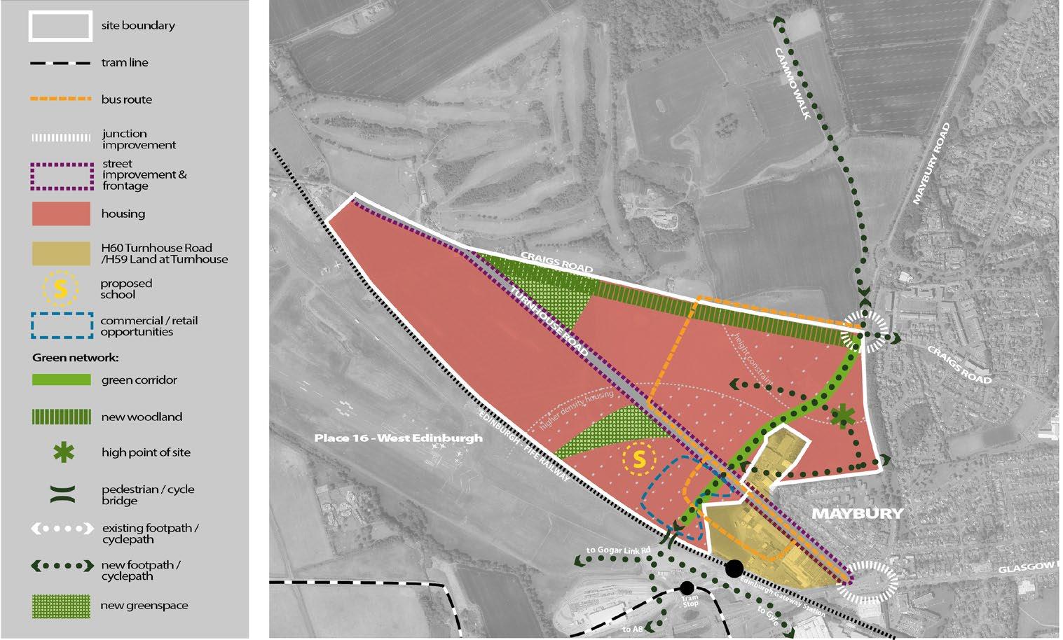
g. Site layout must allow bus route to be formed linking Craigs Road with Turnhouse Road.
h. Development must respect the ridgeline of Craigs Road and elevated slopes within the site
i. Opportunity to create a community focal point providing local services in an accessible location close to new pedestrian/cycle bridge. This should include a new primary school, civic space and units suitable for local shopping (maximum 800 (gross) sq.m.) and healthcare facilities.
j. Provision of new woodland and grassland habitat (30m depth) to create a strong green belt boundary adjoining Craigs Road along the northern edge of the site.
k. Provision of two new large greenspaces to meet the two-hectare green space standard as required by the Open Space Strategy. There is potential to create local green space on the high point of the site next to Maybury Road.
l. Proposals should enable co-ordination with long term redevelopment opportunity of existing industrial/employment sites for high quality mixed use development incorporating pedestrian, cycle and public transport safeguards.
m. Address the transport infrastructure mitigation requirements at Maybury junction, Barnton junction and Craigs Road junction and support delivery of the bus priority and interchange recommendations that emerge from the on-going West Edinburgh Transport Improvement Programme study.
n. Provision of new 21 class primary school.
o. Address appropriate and safe access from Turnhouse Road and Craigs Road.
p. Proposals should address a new footway/cycleway along the south-west side of Turnhouse Road and upgrading of bus infrastructure on Turnhouse Road.
q. Address any identifed impacts on the safe operation of the local road network.
r. Provision of new bus infrastructure on internal roads and Maybury Road.
s. High quality pedestrian and cycle routes within the site.
t. Further investigation/consultation is required to determine the nature of any flood risk on the site and whether further assessment and mitigation measures are required.
u. Provide or contribute towards healthcare infrastructure and community facilities.
Place 23 Builyeon Road
Planning permission will be granted for development within the boundary of Builyeon Road as defned on the Proposals Map provided it accords with the Builyeon Road Development Principles and the approved, or subsequently approved, master plan.
3.82 This housing site was allocated for development and removed from the green belt in the Edinburgh Local Development Plan (2016).
Builyeon Road Development Principles
a. address the education mitigation measures: New Buileyon Road (ND) Primary School and extension to Queensferry High School, St Margaret's RC Primary School and St Augustines (RC) High School, and transport mitigation measures including bus improvement works and active travel connections to the high street, high school and Dalmeny rail station. Including safe crossing for walking/wheeling and cycling and active travel infrastructure at Echline Junction, on Ferrymuir Road and Lover’s Lane.
b. vehicular access to be taken from Builyeon Road (A904).
c. a substantial landscaped bufer, with additional tree planting, should be provided along the southern boundary of the site with the new approach road, as shown on the diagram. The landscaped bufer should be of sufcient width to sofen the visual impact of development on the site from the new approach road, provide a robust green belt boundary and mitigate noise impact. Additional tree planting should constitute native woodland species and have regard to any ecological mitigation measures specifed as part of the replacement crossing and oil pipeline.
d. the landscaped bufer should integrate with that provided within the western part of South Scotstoun (ELDP 2016 HSG 33), with an opportunity to incorporate a footpath/cycleway, including a bridge over the existing A90 carriageway (which is being retained as a public transport link only to the existing Forth Road Bridge) to the retail and housing area to the east of the site.
e. Opportunity to change the character of Builyeon Road (A904), through street design, including new development frontage with the road where this is possible, upgrading or providing of new bus stops or shelters, roadside footpaths and trafc calming (including reducing the speed limit through trafc regulation orders).
f. new pedestrian/cycle routes (taking into account the Queensferry Crossing as appropriate) should be provided, particularly forming north-south path connections by linking new pedestrian/cycle routes to the existing network north of the A904, thus allowing the new housing to integrate fully with the existing urban area including the town centre to the north of the site. The use of avenue tree planting and retention/re-use of the existing stone wall is encouraged.
g. the residential amenity of existing housing should be taken into account in the design of all new pedestrian/cycle routes and links.
h. landscape efects of any noise attenuation measures to be considered in terms of site design and appearance.
i. opportunity for commercial and community uses within the site, possibly in the north west and north east parts of the site where they could also form part of the frontage to the main road. There is also a possible redevelopment opportunity with respect to existing commercial uses to the north of the site (which could be incorporated into the development on the site) and with respect to the redundant northbound carriageway to the east of the site.
j. provision of new local greenspace in accordance with standards set out in the Open Space Strategy.
k. Provide or contribute towards healthcare infrastructure and community facilities, and,
l. Investigate existence of culvert in the area which would allow connection of surface water flows from the site into the watercourse.

Stoney˜ats
Map 28 – Builyeon Road
South West Edinburgh
Place 24 Curriemuirend
Planning permission will be granted for development within the boundary of Curriemuriend as defned on the Proposals Map, provided it accords with a Place Brief, the Curriemuirend Development Principles and a subsequently approved master plan.
3.83 This housing site was allocated for development in the Edinburgh Local Development Plan (2016). Proposal to provide housing and allotments on land at Curriemuirend Park and to improve the quality of the existing green space at Clovenstone Drive (BGN 50).
3.84 The Council will prepare a Place Brief for the site. The Place Brief will establish high level principles to inform future master planning and design processes. Local communities and key stakeholders will be consulted through the development of the Place Brief. Once approved the Place Brief will become non-statutory planning guidance. Proposals for any part of this site in advance of an approved Place Brief will be considered as premature in line with Policy Env 2. Proposals will also be assessed against the Curriemuirend Development Principles, a Place Brief and other relevant local plan policies, for example on matters such as design, accessibility, open space landscaping and biodiversity.
Curriemuirend Development Principles
a. a comprehensive approach to both sites is required, to ensure the allotments and green space improvements are delivered
b. development should take account of density/development policies to minimise the footprint and maximise green space
c. development should create an active street frontage along Wester Hailes Road
d. opportunity to create links to the wider green network
e. proposals should provide better pedestrian and cycle access to both the allotments and Clovenstone Drive park
f. opportunity to reduce the width of Wester Hailes Road to create a more attractive, safe environment for pedestrians
g. Provide or contribute towards education, and healthcare infrastructure and community facilities, and,
h. Investigate existence of culvert in the area which would allow connection of surface water flows from the site into the watercourse.
Place 25 Gorgie Road East
Planning permission will be granted for development within the boundary of Gorgie Road East, as defned on the Proposals Map, provided it accords with the Gorgie Road East Development Principles.
3.85 Proposal to provide housing-led mixed use on a site comprised of former industrial buildings and vacant land. To the south, the site is bounded by public open space. The site contains three electricity substations. The site is assessed as constrained as explained in paragraph 3.3.
Gorgie Road East Development Principles:
Proposals will be expected to:
a. Deliver a housing-led mixed-use development in line with the density requirement in Part 4 Table 15 in the event that the existing use constraint is resolved.
b. Re-provide appropriately sited new flexible, ground floor, class 4 uses(e.g. high density, small business space) as an integral part of the design, including below residential. Individual units should be no larger than 500 sqm with a weighting towards units no larger than 200 sqm.
c. Incorporate small-scale retail (no larger than 250 sqm) and class 1A/3 uses, proportionate to the needs of future residents.
d. Vary height, mass and housing typology in response to diverse edge conditions that include Gorgie Road, existing greenspace, and residential accommodation ranging from 2-5 storeys. Use townscape and view analysis to inform scale and massing.
e. Demonstrate pedestrian priority throughout, providing limited private car parking, all on-street.
f. Create new tree-lined street linking Gorgie Road to Slateford Green-Hutchison Crossway to form part of new, direct route between Stevenson Road and the greenspace and provide link to Hutchison Road.
g. Contribute towards bus priority on A71 and connections to the Orbital Bus Route.
h. Locate and design new greenspace and green blue infrastructure to link to existing green networks and natural habitats. Retain existing mature trees and improve all boundary treatments (See proposal BGN 19)
i. Investigate options to de-culvert the natural water pipe that crosses the site. If retained, provide access strip on either side of this pipe. Provide access strips on either sides of mains water and combined sewer pipes that also cross the site.
j. Provide or contribute towards education, and healthcare infrastructure and community facilities. Have regard for Water of Leith flood extent, which may cause surface water flooding and should be considered as part of the application.
Place 26 Stevenson Road (A)
Planning permission will be granted for development within the boundary of Stevenson Road (A), as defned on the Proposals Map, provided it accords with the Stevenson Road (A) Development Principles.
3.86 Proposal to provide housing-led mixed use on a site that currently comprises a mix of industrial and commercial buildings. The site fronts onto Stevenson Road and Gorgie Road, with housing on either side. The site is assessed as constrained as explained in paragraph 3.3.
Stevenson Road (A) Development Principles
Proposals will be expected to:
a. Deliver a housing-led mixed-use development in line with the density requirement in Part 4 Table 15 in the event that the existing use constraint is resolved.
b. Re-provide appropriately sited new flexible, ground floor, class 4 uses(e.g. high density, small business space) as an integral part of the design, including below residential. Individual units should be no larger than 500 sqm with a weighting towards units no larger than 200 sqm.
c. Incorporate small-scale retail (no larger than 250 sqm) and class2/3 uses, proportionate to the needs of future residents.
d. Vary height, massing and housing typology to complement the mixed pattern of surrounding development, which ranges from 2 - 5 storeys. Use townscape, protected and local view analysis to inform scale and massing.
e. Demonstrate pedestrian priority throughout, providing limited private car parking, all on-street.

1 site reference
existing greenspace
new greenspace
listed building
principal street
secondary street (indicative)
new active travel link
continuous frontage park frontage tree planting
BALGREENG
f. Create new tree-lined street linking Stevenson Road to Gorgie Road to form part of new, direct link to existing greenspace (Slateford Green-Hutchison Crossway).
g. Line all streets, routes and public open space with active frontages that promote pedestrian movement between inside and out and enable good passive surveillance at ground floor level.
h. Retain mature trees and enhance landscape bufer and boundary treatment between site and Westfeld Court to form link to wider green network. As far as possible, integrate historic brick/stone walls into site layout.
i. Provide access strip on either side of existing combined sewer.
j. Provide or contribute towards education, and healthcare infrastructure and community facilities.
Place 27 Broomhouse Terrace
Planning permission will be granted for development within the boundary of Broomhouse Terrace, as defned on the Proposals Map, provided it accords with the Broomhouse Terrace Development Principles.
3.87 Proposal to provide housing-led mixed use on a site currently occupied by nondesignated heritage assets (government buildings) that played an important post-war function. To the north of the site is the Edinburgh Tram line and a tram stop. The site contains three electricity substations.
Broomhouse Terrace Development Principles
Proposals will be expected to:
a. Deliver a housing-led mixed-use development in line with the density requirements in Part 4, Table 2.
b. Create a record of any heritage asset identifed for demolition.
c. Re-provide appropriately sited new flexible, ground floor, class 4 uses (e.g. high density, small business space) as an integral part of the design, including below residential. Individual units should be no larger than 500 sqm with a weighting towards units no larger than 200 sqm.
d. Incorporate a mobility hub in a prominent location with high footfall and good passive surveillance. Provide direct links for active travel between this hub and the nearby Tram stop. As a minimum, the hub should incorporate bike/e-bike cycle hire point (19 docks approx. 14.5m x 2m) and car-share opportunities.
e. Create active travel links through the site forming safe, convenient connections from surrounding streets to the Tram stop, bus stops, paths and open space.
f. Provide new active travel infrastructure: new link and crossing of Broomhouse Row to Saughton tram stop; upgrade of crossing at Broomhouse Road to open space; and new active travel route: North-South connections at parallel Saughton Road.
g. Demonstrate pedestrian priority throughout, providing limited private car parking, all on-street.
h. Vary scale and housing typology in response to a diverse range of edge conditions (2-storey terraces, 4-storey flatted blocks). Position tallest frontages on Broomhouse Drive and Saughton Road. Use townscape and view analysis to inform scale and massing.
i. Retain and enhance existing landscape structure and tree-planting at site perimeter, with selective thinning to form new pedestrian links into the site. Improve boundary treatment.
j. Use site layout and green blue infrastructure to strengthen existing green networks and natural habitats.
k. Provide or contribute towards education, and healthcare infrastructure and community facilities.
Place 28 Murrayburn Road
Planning permission will be granted for development within the boundary of Murrayburn Road, as defned on the Proposals Map, provided it accords with the Murrayburn Road Development Principles.
3.88 Proposal to provide housing-led mixed use on the site of Hailes Park Industrial Estate. Hailes Quarry Park bounds the site on the south and east. The site sits within the viewcone of Protected City Views. The site is assessed as constrained as explained in paragraph 3.3.
Murrayburn Road Development Principles
Proposals will be expected to:
a. Deliver a housing-led mixed-use development in line with the density requirement in Part 4 Table 15 in the event that the existing use constraint is resolved.
b. Provide Class 5 industrial space that complements Hailes Park Industrial Estate, including a 2,500 sqm (gross) industrial estate made up of small units (circa 100-500 sqm).
c. Incorporate small-scale retail (no larger than 250 sqm) and Class 1A/3 uses, proportionate to the needs of future residents, an integral part of the site layout.
d. Vary height, mass and housing typology in response to a diverse range of edge conditions that include Murrayburn Road, existing greenspace, and residential accommodation ranging from 2 – 4 storeys. Use protected and local view analysis (including townscape and park views) to inform scale and massing.
e. Integrate key views into the site layout (Corstorphine Hill, Pentland Hills).
f. Demonstrate pedestrian priority throughout, providing limited private car parking, all on-street.
g. Form new active travel links between the park and surrounding paths and
streets incorporating green blue infrastructure. Line all new streets, paths and open space with active frontages that promote pedestrian movement between inside and out and good passive surveillance at ground floor level.
h. Provide new active travel route and junction upgrade: Union Canal to Calder Road.
i. Locate and design new greenspace and green blue infrastructure to link to existing green networks and habitats.
j. Design landscape edge and planting abutting Hailes Park to complement and integrate with park setting. Retain and enhance existing mature trees and planting on frontages to Murrayburn Road and Dumbryden Drive. Improve all boundary treatments.
k. Prepare flood mitigation strategy based on holistic assessment of flood risk to all parts of the site, including risk from nearby culverted Murray Burn.
l. Investigate Murray Burn culvert location/condition/capacity to see how/if development should account for this and incorporate it into the layout.
m. Provide or contribute towards education, and healthcare infrastructure and community facilities.
Place 29 Dumbryden Drive
Planning permission will be granted for development within the boundary of Dumbryden Drive, as defned on the Proposals Map, provided it accords with the Dumbryden Drive Development Principles.
3.89 Proposal to provide housing-led mixed use on the site of Dumbryden Industrial Estate. The site is adjacent to Hailes Quarry Park and the Union Canal. The site is assessed as constrained as explained in paragraph 3.3.
Dumbryden Drive Development Principles
Proposals will be expected to:
a. Deliver a housing-led mixed-use development in line with the density requirement in Part 4 Table 15 in the event that the existing use constraint is resolved.
b. Re-provide appropriately sited new flexible, ground floor, class 4 uses (e.g. high density, small business space) as an integral part of the design, including below residential.
c. Incorporate appropriately sited small-scale retail (no larger than 250 sqm) and class 1A/3 uses, proportionate to the needs of future residents, as an integral part of the design.
d. Improve pedestrian permeability from surrounding paths and streets to the park and canal.
e. Respect prevailing height of surrounding residential built form, predominantly 4 storey flatted blocks. Use townscape and local view analysis including park and canal views, to inform scale and massing.
f. Demonstrate pedestrian priority throughout, providing limited private car parking, all on-street.
g. Use site layout and green blue infrastructure to connect to and enhance surrounding green networks and natural habitats.
h. Prioritise retention of stone walls, mature trees and vegetation. Use selective thinning to improve permeability, open up views and provide passive surveillance to movement routes.
i. Provide or contribute towards education, and healthcare infrastructure and community facilities.
Place 30 Redford Barracks
Planning permission will be granted for development within the boundary of Redford Barracks site as defned on the Proposal Map, provided it accords with a Place Brief, Redford Barracks Site Development Principles and a subsequent master plan.
3.90 The Council will prepare a Place Brief for the site. The Place Brief will establish high level principles to inform future master planning and design processes. Local communities and key stakeholders will be consulted through the development of the Place Brief. Once approved the Place Brief will become nonstatutory planning guidance. Proposals for any part of this site in advance of an approved Place Brief will be considered as premature in line with Policy Env
2. Proposals will also be assessed against the Redford Barracks Development Principles, a Place Brief and other relevant local plan policies, for example on matters such as design, accessibility, landscaping and biodiversity.
Redford Barracks Development Principles
The requirements in principle will be:
a. A housing-led mixed–use development which draws the surrounding communities together, through the provision of new connections, open spaces and other community infrastructure.
b. A development which respects the heritage of the site. New uses for all listed buildings -and their settings- within and adjacent to the site must be an integral part of future development proposals. Any new buildings should have a positive relationship with existing listed buildings in terms of height.
c. Active travel routes provided through the site to connect with and contribute towards the provision of the following active travel infrastructure:
a. New active travel route: Redford Barracks to City Centre
b. New active travel route: Colinton Road to Colinton Village
c. New active travel connections: Water of Leith (NCR75 Colinton Dell) to Colinton Mains Drive
site reference
existing green space / infrastructure
listed building
potential location for colony housing
new active travel link
pedestrian link core path
principal street
secondary street (indicative)
vehicular access
continuous frontage
frontage with potential for side street access
park frontage
d. New active travel connection: Union canal ramp access.
e. Active travel link: connection to supermarket and Colinton Primary School and Oxgangs Road North/Colinton Mains Drive.
d. Contributions towards Public Transport Improvement: South Orbital Bus Route connections (Redford Barracks to Gilmerton and Sighthill to Redford Road/ Oxgangs)
e. Provision of a mobility hub.
f. Retention of existing streets which are lined by the stables blocks plus other key routes through the site. The frontages to many of these streets needs to be improved to make them more attractive.
g. Provision of appropriate frontages to Colinton Road, Oxgangs Road North and the rear of surrounding uses. The existing parade grounds should be kept free from development. Any new development around the parade grounds must provide active frontages onto these spaces.
h. Retention and enhancement of Redford recreation park to the southeast of the site and provision of a new community park (See proposal BGN 27) and play space in line with criterion (m) below.
i. Maximisation of the views of the Pentland Hills, Craiglockhart Hill, and landmark buildings.
j. Retention of the war memorial although relocation to an alternative location could be agreed.
k. Interpretation of the site’s military history within the new development.
l. Removal of the security fence around the site.
m. New outdoor play facilities to be integrated into the site layout in a well overlooked and accessible location with a welcoming setting. These new facilities shall provide for a range of users, including those with disabilities. See proposal BGN 27
n. Provide or contribute towards education, and healthcare infrastructure and community facilities, and,
o. A flood risk assessment is required and should inform the development and design/layout of the site, including taking opportunities to address surface water flooding and historic interactions between the Braid Burn and Water of Leith.
South East Edinburgh
Place 31 Edinburgh BioQuarter
Planning permission will be granted for development within the boundary of Edinburgh BioQuarter as defned on the Proposals Map, provided it accords with the BioQuarter Development Principles and the approved, or subsequently approved, master plan.
3.91 Proposals will be assessed against the BioQuarter Development Principles and other relevant local plan policies, for example on matters such as design, accessibility, landscaping, biodiversity and relationship with the neighbouring green belt and the Southeast Wedge Parkland Green Space Proposal BGN46.
3.92 A BioQuarter master plan will be prepared to support the future development of the Edinburgh BioQuarter for a development focused on Life Sciences research and directly related commercial developments. This co-location of uses helps the development and city on its journey toward net-zero.
Edinburgh BioQuarter Development Principles
The requirements in principle will be:
a. A high density, urban extension, compact in form with a sense of community attractive to workers, visitors and residents.
b. A mix of uses focused around the BioQuarter’s role as a life sciences quarter, including potentially around 2500 residential units in the longer term, community facilities, commercial and leisure to encourage evening and weekend activity.
c. Development which respects the site’s location within the wider landscape setting of the city – the extent of development and building heights managed to protect the landscape character and the visual connectivity of the Craigmillar and Edmonstone ridges.
d. Address and connect with neighbours and the wider city – physically, visually and socially, including with urban frontages to the site edges, including to Old Dalkeith Road
e. A sustainable place with increased biodiversity and a net zero carbon target and adapted to climate change.
f. Provide or contribute towards the following transport infrastructure:
a. New active travel route: Connection to the Wisp from East of BioQuarter.
b. New active travel route: A7 north-south - BioQuarter to City Centre and Midlothian.
c. Mobility hub
d. Enhanced bus provision including the Orbital bus route
g. Provide or contribute towards education infrastructure as indicated in Table 11, healthcare infrastructure as indicated in Table 12, and other community facilities,
h. Ensure all homes are adequately served by play facilities and have access to open space in line with the Council’s Open Space Strategy (see BGN 51), and
i. A flood risk assessment is required and should inform the development and design/layout of the site,
Place 32 Newcraighall
Planning permission will be granted for development within the boundary of Newcraighall as defned on the Proposals Map, provided it accords with the Newcraighall and Brunstane Development Principles and the approved, or subsequently approved, master plan.
Newcraighall Development Principles
3.93 This housing site was allocated for development and removed from the green belt in the Edinburgh Local Development Plan (2016). These sites provide the opportunity for new housing together with new and improved school and local facilities on the eastern side of the Council area.
Newcraighall East
a. new woodland should be provided along the southern boundary of the site as shown on the diagram.
b. the fnalised site capacity, design and layout should be informed by an adequate flood risk assessment.
c. site layout should enable a bus route to be formed north-south through the site. It is intended that this connects to QMUC across land allocated for development in East Lothian. A bus gate at the site boundary should prevent general vehicular access through this route.
d. layout should create pedestrian and cycleway connections through the site.
e. a new green corridor should be created along the course of the power lines running through the site, extending grassland habitat with the opportunity for connections outwith the Council area. This greenspace should be fronted by new development in order to improve community safety and aid place-making.
f. Layout should make provision for an extension of Newcraighall Primary School’s grounds.
g. opportunity for retail/commercial units as part of street frontage to Whitehill Street / Newcraighall Road
h. Provide or contribute towards education, and healthcare infrastructure and community facilities.
Place 33 Brunstane
Planning permission will be granted for development within the boundary of Brunstane as defned on the Proposals Map, provided it accords with the Newcraighall and Brunstane Development Principles and the approved, or subsequently approved, master plan.
3.94 This housing site was allocated for development and removed from the green belt in the Edinburgh Local Development Plan (2016). These sites provide the opportunity for new housing together with new and improved school and local facilities on the eastern side of the Council area.
Brunstane Development Principles
a. address the education impacts by providing a new 18 class Primary School and 128 place early learning centre transport assessments should identify any appropriate commensurate mitigation which may be required with respect to the A1/Newcraighall Road junction and to the junctions on the A199, taking into account any cumulative impact with trafc from other development sites. Particular attention should be given to the proposed new junction on Milton Road East, and the management of additional trafc generation onto Milton Road East and Newcraighall Road including associated improvements to pedestrian cycle crossing facilities.
b. the site layout should allow for the proposed new bus route to be formed linking Milton Road East with Newcraighall Road. Appropriate consultation with service providers should take place in order to identify the bus service improvements which can be undertaken in the plan period, taking into account access, routes and frequency of service, and including the proposed new bus route. Proposals should provide for an appropriate upgrading of existing bus stops and an increase in cycle parking facilities at Brunstane and Newcraighall stations.
c. vehicular access should be taken from Milton Road East and Newcraighall Road, forming a new vehicular crossing over the East Coast railway line. The potential for a new pedestrian/cycle bridge within the eastern part of the site should be investigated, together with an investigation as to whether or not a second vehicular crossing of the East Coast railway line should be provided in the interests of safety, as identifed within the transport appraisal. Any
crossings of the East Coast railway line should be on bridges over the railway line, and not at grade.
d. no vehicular access to be taken from Gilberstoun area
e. opportunity to enhance existing core and other paths along the boundaries of the site, and in particular the Brunstane Burn Core Path (John Muir Way) on the northern boundary of the site including pedestrian crossing where vehicular access meets the path. New multi-user path links should be formed to the Innocent Railway Core Path, Brunstane Burn Core Path and the disused railway line to the north of Newcraighall, with path connections also to housing at Gilberstoun, Newcraighall and Brunstane railway station.
f. the impact on the setting of Brunstane House should be minimised through the appropriate design and layout of housing on the site, including the provision of sufcient open space and landscaping to the north and east as shown on the diagram. The extent of the open space is indicative only and the exact area will depend on the design and layout of housing on the site. Sufcient open space should also be similarly provided in order to retain an open setting for the two scheduled monuments of Brunstane Moated Site and Brunstane Enclosure, also meeting a large greenspace defciency to the south west of the site.
g. a landscape framework should be provided to the boundary of Newhailes House garden and designed landscape inventory site, with a bufer as shown on the diagram (again indicative and depending on the design and layout of housing on the site) and detailed siting and design of dwellings should respect views to Arthur’s Seat from the grounds of Newhailes House.
h. management proposals should have regard to the above stated historic environment assets. Historic Environment Scotland should be consulted on these matters when development proposals are being prepared.
i. establish statutory safeguards to overhead powerlines to the north and south of the site. Design principles should seek to integrate overhead powerlines with site layout. To the south, allotment provision should compliment consented allotments at Newcraighall North. To the north, powerline way leave should be designed to provide for semi natural greenspace and habitat connectivity with informal recreation.
j. expand grassland habitat (under pylons) and provide woodland connectivity across the site
k. Streets and open spaces should be designed to beneft from views to the coast to the north, Arthur’s Seat to the west and Pentland Hills to the southwest.
l. opportunity to create a community focal point including a new primary school and local centre.
m. proposals for housing (including the fnalised site capacity, design and layout), the school, and any other uses provided on the site, should be informed by an adequate flood risk assessment.
n. Enhanced sustainable urban drainage will be required as appropriate to address current/future water quality pressures and to ensure no detrimental impacts to the recently designated bathing waters at Fishers Row.
o. proposals should fully address any necessary site remediation in relation to mining legacy constraints, and should take account of any need for prior extraction of minerals.
p. Provide or contribute towards healthcare infrastructure and community facilities.

Map 32 Newcraighall / Brunstane
Place 34 Liberton Hospital/Ellen’s Glen Road
Planning permission will be granted for development within the boundary of Liberton Hospital/Ellen’s Glen Road site as defned on the Proposal Map, provided it accords with Liberton Hospital/Ellen’s Glen Road Development Principles and a subsequent master plan.
3.95 The Ellen’s Glen Road part of the site was identifed in the Edinburgh Local Development Plan (2016) as a housing site with the adjacent Liberton Hospital site identifed for other development opportunities. These two sites are combined in this Plan and identifed for potential housing use. Proposals will be assessed against the Liberton Hospital/Ellen’s Glen Road Development Principles and other relevant local plan policies, for example on matters such as design, accessibility, landscaping and biodiversity.
Liberton Hospital/ Ellen’s Glen Road Development Principles
The requirements in principle will be:
a. A housing development which respects the landscape setting of the site whilst also creating a sustainable place that can retain its special character. This can be achieved through the provision of new connections and open spaces.
b. A mix of house types (including family housing) provided on the site with an active residential frontage facing onto Ellen’s Glen Road.
c. Direct vehicular access from Lasswade Road with additional vehicular access from Ellen’s Glen Road and Malbet Wynd.
d. New development set back at least 15m from the top of the bank to the Stenhouse Burn. The bufer around the Stenhouse Burn should be used to create natural space for resilience and overland flow. This area can be used as a space for recreation and amenity
e. A development design which fully understands and preserve and/or enhances the setting of all listed buildings adjacent to the site.
f. Retention or re-use of Liberton Hospital buildings within any new development.
g. Provision of new local greenspace to meet the Council’s Greenspace Standard. Any new greenspace and planting should form green network links between Lasswade Road and the nature conservation site along Ellen’s Glen Road and Malbet Wynd.
h. New outdoor play facilities to be integrated into the site layout in a well overlooked and accessible location with a welcoming setting. These new facilities shall provide for a range of users, including those with disabilities. See proposal BGN34
i. Provide or contribute towards education, and healthcare infrastructure and community facilities.
j. Provision of pedestrian paths and cycle routes on land near to the Stenhouse Burn to compensate for the narrow footway on Ellen’s Glen Road, and routes through the site south to Lasswade Road and from Malbet Wynd through the site to connect via Ellen’s Glen Road to the Burdiehouse Burn Valley Park Core Path.
k. Provide or contribute towards the following active transport infrastructure:
a. New active travel Route: Liberton Hospital to City Centre
b. Active travel link: connections through site to Malbet Wynd - Liberton Community Campus
c. Active Travel link: connection to Gilmerton Road and A7
MALBETWYND

site boundary
housing
street improvement and frontage
vehicular access
Green network:
new footpath / cyclepath
existing footpath / cyclepath
ELLEN
LASSWADEROAD
Map 33 Liberton Hospital / Ellen’s Glen Road
l. Contribute towards Public Transport Improvements: service improvements from Liberton Hospital to City Centre, and the South Orbital bus route
m. A flood risk assessment is required and should inform the development and design/layout of the site, and,
n. Consideration should be given to providing flood storage between Carbee Dell and Dunlaw Wynd.
Place 35 Moredunvale Road
Planning permission will be granted for development within the boundary of Moredunvale Road site as defned on the Proposal Map, provided it accords with a Place Brief, the Moredunvale Road Development Principles and a subsequent master plan.
3.96 This housing site was allocated for development in the Edinburgh Local Development Plan (2016). Proposal for housing development and open space improvements to provide new housing on approximately half of the site and improve the quality of the remaining open space.
3.97 The Council will prepare a Place Brief for the site. The Place Brief will establish high level principles to inform future master planning and design processes. Local communities and key stakeholders will be consulted through the development of the Place Brief. Once approved the Place Brief will become nonstatutory planning guidance. Proposals for any part of this site in advance of an approved Place Brief will be considered as premature in line with Policy Env 2. Proposals will also be assessed against the Moredunvale Road Development Principles, a Place Brief and other relevant local plan policies, for example on matters such as design, accessibility, landscaping and biodiversity.
Moredunvale Development Principles
a. Address the education infrastructure at Craigour Primary School.
b. The fnalised site capacity, design and layout should be informed by an adequate flood risk assessment
c. land around the high rise flats to be kept as green space.
d. opportunity to provide play space, allotments and growing spaces as green space improvements.
e. opportunity to create links to the wider green network
f. proposals should provide better pedestrian and cycle access between the site and the surrounding area.
g. remediation work may be required to develop the site due to the history of coal and limestone mining.
h. Provide or contribute towards education, and healthcare infrastructure and community facilities.
i. A flood risk assessment is required and should inform the development and design/layout of the site, and,
j. The upstream flow pathways should be considered for attenuation and formalised conveyance of existing overland flows. These formalised channels (swales) should be used to convey stormwater from the site and potentially able to discharge into a culvert/watercourse.
Place 36 Edmonstone
Planning permission will be granted for development within the boundary of Edmonstone site as defned on the Proposals Map, provided it accords with the Edmonstone Development Principles and a subsequent master plan.
3.98 This housing site was allocated for development and removed from the green belt in the Edinburgh Local Development Plan (2016).
Edmonstone Development Principles
a. Create a development layout that retains and enhances any elements of historic landscape structure
b. Incorporate sizeable areas of open space and parkland and retain views and open aspects to the south and east
c. Ensure the visual separation from Danderhall through sensitive design and screen planting
d. Integrate a network of footpaths, cycleways and open space to be part of the wider green network
e. Ensure appropriate grouting and mine entry treatment works are carried out prior to commencement of development
f. Achieve additional boundary planting along both road boundaries
g. Address required local road and footway improvements and mitigation measures:
a. Trafc signals at the Wisp/Old Dalkeith Road
b. Speed limit restrictions on the Wisp
c. contribution towards active travel infrastructure on the A7 north-southBioQuarter to City Centre and Midlothian.
h. Secure any required archaeological works.
i. Provide or contribute towards education, and healthcare infrastructure and community facilities.
Environment and Design Policies
Env 1 Design Quality and Context
Planning permission will be supported by this policy where it is demonstrated that the proposal will create or contribute towards a vibrant, successful place. Design should be based on an overall design concept that draws upon positive characteristics of the surrounding area. Planning permission will not be granted for poor quality or inappropriate design or for proposals that would be damaging to the character or appearance of the area around it, particularly where this has a special importance.
Env 2 Co-ordinated Development
Development proposals will be supported in principle if they can demonstrate that:
a. they would not compromise the efective development of adjacent land, or
b. they would accord with the comprehensive development and regeneration of a wider area provided for in a master plan, place brief, site brief, and/or development principles approved by the Council.
3.99 The Council encourages a comprehensive approach to redevelopment and regeneration wherever possible, and the preparation of development frameworks, master plans, development briefs or place briefs to identify the full design potential for creating successful places. Piecemeal development is less likely to lead to the creation of well-defned and cohesive networks of streets and spaces. In some cases, it may be necessary for the Council to use its powers of compulsory purchase to assemble a site for development and enable a satisfactory outcome to be achieved.
Env 3 Development Design – Incorporating and Enhancing Existing and Potential Features
Planning permission will be granted for development where it is demonstrated that the proposals have been informed by a detailed analysis and understanding of the site. Proposals should explain how those characteristics and features of the site that are deemed worthy of retention would be incorporated and/or enhanced.
3.100 The incorporation of existing features including built structures, archaeology, trees and woodland, landscape character, views, biodiversity, open space and water enhance a development’s sense of place and contribution to the wider habitat. Including, enhancing and expanding these features are important for improving the city wide green and blue network, which should be a critical, early drive in guiding how and where features such as open space and SUDS are positioned and designed as part of developments to ensure good linkage to this wider network.
3.101 Proposals shall have positive efects for biodiversity in line with policy 37 Designing in Biodiversity and the water environment in accordance with policy 36 Designing for surface water.
Env 4 Development Design – Impact on Setting
Planning permission will be granted for development where it is demonstrated that it will have a positive impact on its surroundings, including the design quality and character of the wider townscape and landscape, green blue networks, and impact on existing views, having regard to:
a. height, form and roofscape pattern
b. scale and proportions, including the spaces between buildings
c. position of buildings and other features on and around the site
d. materials and detailing
3.102 Where the surrounding development is fragmented or of poor quality, development proposals should help repair the urban fabric, establish model forms of development and generate coherence and distinctiveness – a sense of place. The siting and design of development should also be guided by views within the wider landscape and an understanding of local landscape character, including important topographical features, for example prominent ridges, valleys and patterns of vegetation. Further details about context, placemaking and design are set out in the Edinburgh Design Guidance.
Env 5 Alterations, Extensions and Domestic Outbuildings
Planning permission will be granted for alterations, extensions and domestic outbuildings which:
a. in their design and form, choice of materials and positioning are compatible with the character of the existing building
b. will not result in an unreasonable loss of privacy or natural light to neighbouring properties
c. will not be detrimental to neighbourhood amenity and character
For extensions and outbuildings, it is additionally required that proposals:
d. retain and provide green/blue infrastructure including trees, biodiverse vegetation and habitat
e. sustainably handle rainfall, by incorporating measures such as rain gardens and green/blue roofs to of-set development on permeable ground.
3.103 Every change to a building, street or space has the potential to enrich or, if poorly designed, impoverish a part of the public realm. The impact of a proposal on the appearance and character of the existing building and street scene generally must be satisfactory and there should be no unreasonable loss of amenity and privacy for immediate neighbours.
3.104 Edinburgh’s gardens make a signifcant contribution to the City’s green and blue network by providing biodiverse habitat and spaces that contribute to sustainable water management.
3.105 Roofscapes should similarly be treated as an opportunity to improve the green and blue network as they have the potential to provide the same biodiversity and water management benefts as gardens. This is especially important if garden space is being lost to development, although all proposals should seek to achieve a net enhancement to the City’s green and blue network through sustainable use of gardens and roofscapes. This small level of change at the scale of an individual property can make a large diference to the City’s overall green and blue network given the large number of existing properties across the City.
3.106 The Council’s Guidance for Householders shall set out further information on the requirements set out in this policy, including in relation to the application of criteria d and e regarding green and blue infrastructure.
Env 6 Green Blue Infrastructure
Development proposals will be supported where they can demonstrate, in proportion to their scale and nature, that they will protect, enhance and link to the city’s green/ blue network through the following steps:
a. incorporating and enhancing existing green and blue features such as biodiverse vegetation and de-culverting watercourses on the site,
b. providing new green blue infrastructure on-site which is linked within the site through careful consideration of site layout, and
c. linking new green and blue infrastructure to the city wide green blue network using components such as parks, woodland, street trees and blue/green roofs and walls.
3.107 To ensure the above principles are followed, proposals must consider and embed green and blue infrastructure at all stages of the proposal's evolution, including prior to design and layout of buildings. Natural flow paths of water must be identifed at the visioning stage and inform design. The interaction of green blue infrastructure with wider infrastructure types to maximise placeled social, economic and environmental benefts will be at the heart of best practice in future ftting design. Designs should follow the principles in the Edinburgh Design Guidance and associated appendices and Green and Blue Network Guidance and guidance from Edinburgh’s Biodiversity Action Plan,
Edinburgh Adaptation Plan, NatureScot “Delivering Scotland’s Ambition to Secure Positive Efects for Biodiversity 2020”, SEPA and other appropriate agencies. Comprehensive integration of green blue infrastructure should be evident in proposals but, for larger proposals, planning applications should also demonstrate developments are accompanied by appropriate accreditation such as ‘Building with Nature’ or similar.
3.108 Where it is demonstrated that fully delivering green blue infrastructure on-site is not possible, then the Council may require proportionate contributions toward the delivery of additions and/or improvements to the green and blue network of-site.
Sustainable developments
3.109 Env 7 - Sustainable Developments sets out the circumstances where additional information is needed to support diferent types of proposal. Env 8 - New Sustainable Buildings sets out the standards that must be met for developments containing new buildings.
Policy Env 7 Sustainable Developments
All detailed proposals involving the construction, redevelopment or change of use of one or more buildings* must incorporate all reasonably practicable measures to address the climate emergency and contribute to sustainable living, with this being demonstrated through a Sustainability Statement which addresses the following:
a. how the proposal integrates measures to both mitigate and futureproof the building against the efects of the climate emergency, particularly with regard to the increased frequency and severity of extreme temperature and storm/ rainfall/flooding events as well as sea level rise and erosion, and
b. how the proposal encourages all forms of active travel (including complying with Edinburgh’s Street Guidance and associated Factsheets) and shall be accessible by those of all ages and levels of mobility, including those with disabilities.
In addition to the above, the Sustainability Statement must also address the matters set out below:
For developments involving new buildings the statement shall set out how the development has been designed to be of long-life construction and to allow future adaptation for diferent uses as well as utilising construction materials that have low or negative embodied greenhouse gas emissions and are local and/or sustainably sourced and/or recycled and capable of re-use at the end of a building’s lifecycle as far as reasonably practicable
For change of use proposals, the statement must address how the proposal has considered and integrated measures to increase resilience to future climate change and minimise greenhouse gas emissions such as built fabric efciency improvement and Low and Zero Carbon Generating Technology.
For proposals involving the replacement of existing buildings* the proposals should be accompanied by a carbon assessment setting out the ‘whole-life’ carbon footprint of the proposed development compared to the option of re-using the existing building to accommodate the proposed use**. Where this comparative assessment fails to show an overall lower carbon footprint then it must be set out why the developer considers the proposal justifed.
3.110 Sustainability statements should set out all potential measures and, where they have not been incorporated into the development, the reasons why it has been concluded that it is not reasonably practicable to do so. Further advice, including how to access the council’s Sustainability Statement Form, is set out in the Edinburgh Design Guidance.
* The term building in this context does not include domestic outbuildings which are addressed by ‘Policy Env 5 - Alterations, Extensions and Domestic Outbuildings’
** Carbon assessment’ is the commonly given name to this type of assessment however such assessment should also account for other GHG emissions as well as C02. A statement detailing the comparative footprint of a redevelopment compared to re-using an existing building should have regard to the following:
a. Embodied GHG within the existing building
b. The total embodied GHG of the new construction
c. Comparison of operational emissions over the lifetime of existing and proposed buildings, including factoring in the efect of practicable measures to improve the efciency of existing buildings
d. Expected lifespan of the existing and proposed buildings as well as if these buildings and their construction materials shall be capable of future re-use
Env 8 New Sustainable Buildings
In order to make sure new buildings are: i) sustainable and play their part in addressing the climate emergency; and ii) exceed the current carbon dioxide emissions target with at least half of this target met through the use of low and zero generating technologies; proposals for new buildings * will be supported where it has been demonstrated that:
a. all reasonably practicable measures, predominantly through ultra-high fabric energy efciency, have been taken to achieve a net zero level of operational greenhouse gas emissions**
b. where appropriate, green roofs have been provided where new roofs are of a pitch capable of supporting these and that these roofs provide wildlife habitat and water attenuation.
c. provision is made for facilities for the separate collection of dry recyclable waste and food waste.
The ability to achieve the above should be evidenced, where applicable, through the submission of a Sustainability Statement as required through Policy Env 7. Thereafer the above will be ensured by attaching a relevant condition to all planning permissions to which this policy applies.
* Not including domestic outbuildings which are addressed by ‘Policy Env 5 -Alterations, Extensions and Domestic Outbuildings’
** Operational emissions in the context of this policy refers to the use of heating, hot water, lighting, ventilation and cooling systems.
3.111 This policy applies to all development involving one or more new buildings, with criterion (a) specifcally applying only in cases where a Building Warrant is required for the development. The purpose of this policy is to help reduce greenhouse gas emissions, ensure development is resilient to the impacts of climate change, reduce resource use and moderate the impact of development on the environment.
3.112 All new development requires to embed ultra-high fabric energy efciency into its design and construction, with the optimal approach being for it to be built to Passivhaus standards. To ensure that new development can meet or exceed the net zero requirement, the incorporation of low and zero carbon generating technologies into the new development is also supported.
3.113 The circumstances in which green roofs shall be required will be addressed in a dedicated section in the Edinburgh Design Guidance and associated appendices. This will address where considerations such as the built heritage may mean green roofs are considered inappropriate.
3.114 This guidance will also set out how developments can be designed so that solar panels can be provided in conjunction with green roofs as well as the appropriate construction of specifcation for the roofs. Maintenance of green roofs is an important issue and all proposals incorporating green roofs must be supported by a maintenance plan in line with Policy Env 27 and the requirements of Edinburgh Design Guidance and associated appendices.
The Historic Environment
3.115 The Planning (Listed Buildings and Conservation Areas) (Scotland) Act 1997 is a statutory consideration in the assessment of applications and requires that special regard be given to preserving listed buildings and their setting as well as the preservation and enhancement of the character or appearance of Conservation Areas.
Env 9 World Heritage Sites
Development which would harm the qualities of World Heritage Sites and which justifed the inscription of the Old and New Towns of Edinburgh and/or the Forth Bridge as World Heritage Sites (i.e. their Outstanding Universal Value) or would have a detrimental impact upon their setting, will not be permitted.
3.116 This policy requires development to respect and protect the Outstanding Universal Value of each World Heritage Site and its settings. The Statement of Outstanding Universal Value for World Heritage Sites provides the summary for why a Site is considered to be of international importance and should be used to establish a baseline for assessing development.
3.117 This policy also requires the protection of key characteristics of buildings and their setting. Setting may include sites in the immediate vicinity and viewpoints identifed in the key views study as well as other views to and from important buildings and landscape features throughout the city.
3.118 The Management Plans for the Forth Bridge and the Old and New Towns of Edinburgh World Heritage Site should be referred to for further supporting information; as should Historic Environment Scotland Managing Change Guidance on World Heritage.
Env 10 Listed Buildings - Demolition
Proposals for the total or substantial demolition of a listed building will not be permitted unless it can be clearly demonstrated and justifed that:
a. the building is no longer of special architectural and/or historic interest, or
b. the building is incapable of meaningful repair, or
c. the demolition of the building is essential to delivering signifcant benefts to economic growth or the wider community, or,
d. It is not economically viable to retain the listed building and it is demonstrated all reasonable eforts have been made to do this*
3.119 Demolishing a listed building will only be permitted in exceptional circumstances. The Planning (Listed Buildings and Conservation Areas) (Scotland) Act 1997 is a statutory and primary consideration in the assessment of applications and requires that special regard be given to preserving listed buildings and their settings.
* There is a strong presumption in favour of retaining listed buildings with full consideration of the diferent approaches and options for reuse, adaptation and extension required before considering the case for demolition. Applications to demolish listed buildings will be refused unless their loss has been fully considered and justifed. Historic Scotland’s ‘Managing Change in the Historic Environment: Use and Adaptation of Listed Buildings’ and ‘Demolition of Listed Buildings’ provides more detailed advice on how reuse of a listed building can be achieved including proactive marketing measures and what signifcant benefts may make a demolition essential to the wider community or economic growth.
Env 11 Listed Buildings -Setting
Development within the curtilage of a listed building, or afecting its townscape or landscape setting, will be permitted only if not detrimental to the architectural character, appearance or historic interest of the building, or to its setting.
3.120 The setting of listed buildings is defned and detailed further by Historic Environment Scotland in its guidance titled ‘Managing Change in the Historic Environment: Setting’. Where development is proposed it is important to:
a. identify the historic assets including their signifcance that might be afected,
b. defne the setting of each historic asset, and
c. assess the impact of any new development on this
3.121 Setting can be important to the way in which historic structures or places are understood, appreciated and experienced. It can ofen be integral to a historic asset’s cultural signifcance and needs to be taken into full account when considering the impact of development proposals.
3.122 Setting ofen extends beyond the property curtilage of an individual historic asset into a broader townscape, historic or natural landscape. If proposed development is likely to afect the setting of a key historic asset, an objective written assessment taking into account the signifcance of the asset; its setting and the steps taken to avoid or mitigate detrimental impacts is required to inform the decision-making process.
3.123 The Planning (Listed Buildings and Conservation Areas)(Scotland) Act 1997 is a statutory consideration in the assessment of applications and requires that special regard be given to preserving listed buildings and their setting.
Env 12 Listed Buildings and structures – Alterations and Extensions
Proposals to alter or extend a listed building will be permitted where:
a. there will be no harm to the special interest of the building and its features,
b. there will be no damage or loss of important historic fabric, and
c. any additions are of a high-quality design that are appropriate to the character of the building.
3.124 In determining applications for planning permission or listed building consent, the Council is required to have special regard to the desirability of preserving the listed building, its setting or any features of special architectural or historic interest that it possesses. Applications for the substantial alteration and/or extension of a listed building must be fully considered and justifed with an accompanying supporting information. This must justify the impact on the listed building and be tailored to the situation and specifc to each case.
3.125 Decisions about listed buildings should always focus on the qualities that make them important - their special interest. Identifying what is important about a listed building is essential for understanding how to preserve its special
interest. The qualities of a listed building that contribute to its special interest and signifcance will vary considerably.
3.126 All listed buildings will include the physical evidence of the past preserved in their fabric, and some elements of their fabric may make a signifcant contribution to the building’s historic and archaeological interest. They will also all have a certain architectural style which can be ‘read’ and understood – this might reflect local, national, or even international movements. Some types of buildings are rarer than others, and some buildings will have survived with fewer changes – which will mean they are closer to their original design, structure and appearance.
3.127 The Planning (Listed Buildings and Conservation Areas)(Scotland) Act 1997 is a statutory consideration in the assessment of applications and requires that special regard be given to preserving listed buildings and their setting. The City of Edinburgh Council’s guidance on ‘Listed Buildings and Conservation Areas’ as well as applicable Historic Environment Scotland’s guidance ‘Managing Change in the Historic Environment’ on ‘Extensions’ and ‘External Fixtures’ provides further information that can assist with interpreting this policy.
Env 13 Conservation Areas – Demolition of Buildings
Proposals for the demolition of an unlisted building within a conservation area which makes a positive contribution to the special character or appearance of the conservation area, either in itself or as part of a group, will only be permitted in exceptional circumstances*. In such cases it must be demonstrated that all options to retain the building have been fully explored and proven to be unable to provide a viable solution that allows the retention of the building.
Proposals for the demolition of any building within a conservation area, whether listed or not, will not normally be permitted unless a detailed planning application is approved for a replacement building which preserves the special character and appearance of the conservation area or, if acceptable, for the landscaping of the site.
3.128 In deciding whether conservation area consent should be granted, account should be taken of the importance of the building to the special characteristics or appearance of any part of the conservation area, and of proposals for the future of the cleared site.
3.129 If the building is considered to be of any architectural, historical or archaeological value, either in itself or as part of a group, a positive attempt should always be made to achieve its retention, restoration and sympathetic conversion to some other compatible use before proposals to demolish are investigated.
*In some cases, demolition may be considered appropriate, for example, if the building is of little townscape value or of no historic or archaeological signifcance; if its structural condition rules out its retention at reasonable cost, or if its form makes its re-use extremely difcult. Conservation Area Consent may be subject to conditions or a legal agreement to link demolition works to the new proposals for the site.
Env 14 Conservation Areas - Development
Development within a conservation area, afecting its setting or impacting views of the area and from within it will be supported by this policy where it:
a. preserves or enhances the special character or appearance of the conservation area and is consistent with the relevant conservation area character appraisal
b. preserves trees, hedges, boundary walls, railings, paving and other features within the public realm which contribute positively to the special character or appearance of the conservation area, and
c. demonstrates high standards of design and utilises materials appropriate to the historic environment.
3.130 Planning applications should be submitted in a sufciently detailed form with supporting information for the efect of the development proposal on the character and appearance of the area to be assessed.
3.131 Where a Design Statement is required for a proposal in a conservation area this statement should include reference to the relevant conservation area Character Appraisal and Council’s ‘Edinburgh Design Guidance and associated appendices’, guidance on Conservation Areas and Listed Buildings and Historic Environment Scotland’s relevant ‘Managing Change in the Historic Environment’ guidance series. The design statement should show how an assessment of the
conservation area and consideration of these documents have informed the proposed design.
3.132 The Planning (Listed Buildings and Conservation Areas) (Scotland) Act 1997 is a statutory consideration in the assessment of applications and requires that special regard be given to the preservation and enhancement of the character or appearance of Conservation Areas'.
Env 15 Historic Gardens and Designed Landscapes
Development will only be permitted where there is no detrimental impact on the character of a site recorded in the Inventory of Gardens and Designed Landscapes as well as non-designated sites. There must be no adverse efects upon their setting or upon component features which contribute to their value. Elsewhere, adverse efects on historic landscape character and features should be avoided wherever possible, and always be minimised. Restoration and enhancement of these historic landscapes is actively encouraged.
3.133 This policy aims to protect Historic Gardens and Designed Landscapes (shown on the Proposals Map) as well as non-designated sites and other historic landscape features elsewhere across the Council area. An understanding of how the landscape has evolved can help inform a development proposal. A historical landscape appraisal may be requested from applicants to allow full assessment of the implications of development and identify if and where development may be possible, as well as restoration and enhancement opportunities for these historic landscapes.
Archaeology
3.134 The objective of policies Env 16 and Env 17 is to protect and enhance Edinburgh’s historic environment and archaeological remains, where possible by preservation in situ and in an appropriate setting. When preservation in situ is not possible, recording and/or excavation followed by analysis, reporting and publication of the results will be required. In some cases, depending on the nature of the remains and character of the site, the Council may require provision for interpretation and also public access and engagement as part of the proposed development.
3.135 Developers should seek early advice from the Council’s Archaeologist for sites where historic remains are known or thought likely to exist. Where a development may afect a scheduled monument or its setting, early contact should also be made with Historic Environment Scotland.
Env 16 Protection of Important Archaeological remains and the historic environment
Development will not be permitted which would:
a. adversely afect a scheduled monument, or other nationally important archaeological remains, or the integrity of their setting
b. damage or destroy non-designated archaeological remains which the Council considers should be preserved in situ.
Env 17 Development of Sites of Archaeological Signifcance
Proposals will be supported by this policy on sites of known or suspected archaeological signifcance if it can be demonstrated that either:
a. no signifcant archaeological or historic features are likely to be afected by the development, or
b. any signifcant archaeological or historic features will be preserved in situ and, if necessary, in an appropriate setting with provision for public access and interpretation, or
c. the benefts of allowing the proposed development outweigh the importance of preserving the remains in situ. The applicant will then be required to make provision for appropriate archaeological mitigation (for example historic building recording, environmental sampling, excavation, conservation, recording, and analysis, and publication of the results) before development starts, all to be in accordance with a programme of works agreed with the Council which should include provision for public beneft including public engagement.
3.136 Assessment against the above criteria will be based on information derived from either a Desk-Based Assessment, Historic Building Assessment and, if requested by the Council, an archaeological evaluation and survey, forming part of an Environmental Impact Assessment, Heritage Statement and Historic Impact Assessment, or a Design and Access Statement.
The existing Natural Environment and Open Space
Env 18 Development in the Green Belt and Countryside
Within the Green Belt and Countryside shown on the Proposals Map, development must meet one of the following criteria and not detract from the rural environment or landscape of the surrounding area in terms of its quality, characteristics and views.
a. For the purposes of agriculture, woodland and forestry, horticulture or countryside recreation, or where a countryside location is essential and provided any buildings, structures or hard standing areas are of a scale and quality of design appropriate to the use.
b. For the change of use of an existing building, provided the building is of architectural merit or a valuable element in the landscape and is worthy of retention. Buildings should be of domestic scale, substantially intact and structurally capable of conversion.
c. For development relating to an existing use or building(s) such as an extension to a site or building, ancillary development or intensifcation of the use*, provided the proposal is appropriate in type in terms of the existing use, of an appropriate scale, of high-quality design and acceptable in terms of trafc impact.
d. For the replacement of an existing building with a new building in the same use provided:
• the existing building is not listed or of architectural / historic merit,
• the existing building is of poor-quality design and structural condition,
• the existing building is of domestic scale, has a lawful use and is not a temporary structure, and
• the new building is of a similar or smaller size to the existing one, lies within the curtilage of the existing building and is of high design quality.
In the green belt, the above criteria will apply in the specifc context of maintaining the purposes and objectives of the green belt as set out in paragraphs 2.53 to 2.55 of the plan.
3.137 It is necessary to control the type and scale of development in the green belt to enable it to fulfl the purposes and objectives of including land within a green belt, as set out in paragraphs 2.53 to 2.55 in Part 2. This policy sets out the circumstances in which development in the green belt can be supported and should be read in conjunction with NPF4 Policy 8 Green belts.
3.138 In Edinburgh, Countryside areas i.e. land outwith existing settlements, which are not designated green belt are considered to be of equivalent environmental importance. For this reason, it is appropriate to apply the same level of protection to both green belt and Countryside areas. Proposals for development within a Countryside Policy Area will also be assessed in the context of NPF4 Policy 17 Rural homes and Policy 29 Rural development.
3.139 The key test for all proposals in the green belt and Countryside areas will be to ensure that the development does not detract from the landscape and/or rural environment of the area in terms of quality, characteristics and views. The Council’s guidance ‘Development in the Countryside and Green Belt’ provides more detailed advice.
* New dwellings, not associated with countryside use, are not a form of development that can be justifed on the basis of intensifcation, nor being ancillary or incidental to an existing use.
Env 19 Special Landscape Areas
Planning permission will not be granted for development which would have a signifcant adverse impact on the special character or qualities of the Special Landscape Areas shown on the Proposals Map.
3.140 This policy aims to protect Edinburgh’s unique and diverse landscape which contributes to the city’s distinctive character and scenic value. Special Landscape Areas (SLA) are local designations, which safeguard and enhance the character and quality of valued landscapes across the Council area.
3.141 A Statement of Importance has been prepared for each SLA and can be viewed on the Council’s website. This sets out the essential qualities and characteristics of the area and the potential for enhancement. The Statements of Importance should be used to guide development proposals in SLAs and will be a material consideration in assessing planning applications. A landscape and visual impact assessment is likely to be needed in support of proposals afecting a SLA.
Env 20 Protection of Trees and Woodlands
There is a presumption against development that risks having a damaging impact on any tree, groups of trees or woodland unless the Council accepts this is necessary for good arboricultural reasons and also accounting for the value of the tree(s) in terms of amenity, health benefts, biodiversity, townscape and landscape character, cultural signifcance or climate change adaptation and mitigation.
Any proposal which may adversely afect tree(s) will require a tree survey that is accepted as competent by the Council. If the Council considers there may be adverse impacts on trees of value then the proposal must be supported by a competent Tree Protection and Mitigation Plan (including tree survey). Where permission is granted and there would be loss of trees, replacement planting of appropriate species and numbers will be required to ofset the loss to amenity.
3.142 A Tree Protection and Management Plan required under this policy should demonstrate how it has informed the proposal itself so that both permanent buildings and services as well as temporary construction structures are sited so
as to minimise adverse impacts on existing and future trees. The Protection and Mitigation Plan should include temporary earth works and any site preparation as well as full details of compensatory planting proportionate to the value of trees lost in each of the above respects. Where applicable, root protection areas, canopy extents should be established, with details submitted of protective barriers to be erected prior to any work commencing.
3.143 This policy applies to all trees, including those outwith a tree protection order or conservation area. This policy recognises the important contribution made by trees to character, biodiversity, amenity and green/blue networks. In assessing proposals afecting trees, the Council will consider their value, taking into account their status such as Tree Preservation Order, heritage tree, Ancient Woodland and Millennium Woodland. This will be considered alongside information from tree surveys, the green blue network report, current Scottish Government guidance (presently contained in its Policy on Control of Woodland Removal) and the UK Forest Standard. Where necessary to protect trees, the Council will use its powers to make and enforce Tree Preservation Orders.
3.144 Existing trees retained as part of proposals will contribute towards the minimum level of tree planting required under policy Env 27. The Edinburgh Design Guidance and associated appendices and appropriate British Standards are also applicable, as shall the Forest and Woodland Strategy once these are adopted during the lifetime of this Plan.
Policy Env 21 Protection of Biodiversity
All proposals should safeguard habitat features of biodiversity value* and priority species. This includes sites and species identifed in the Edinburgh Biodiversity Action Plan (EBAP) and Green Blue Network section of the Edinburgh Design Guidance.
Development that adversely afects sites designated for nature conservation or protected species will not be permitted except:
a. For European designated sites where: there are no alternative solutions, and there are imperative reasons of overriding public interest**; and compensatory measures are provided to protect the overall coherence of the European network. In these circumstances, Scottish Ministers must be notifed.
b. For Sites of Special Scientifc Interest, where: the integrity and objectives of the designation will not be compromised; or any signifcant adverse efects are clearly outweighed by social, environmental or economic benefts of national importance.
c. For Local Nature Conservation Sites and Local Nature Reserves where adverse efects are adequately mitigated; that public access is maintained, and that the integrity of the site’s distinctive qualities are protected in the long term.
d. For European Protected species (EPS)***, where: the works accord with relevant legislation and all the relevant licensing tests are passed.
e. For other specifc species protected by legislation then reference should be made to the EBAP and UK legislation for the relevant species and considerations to be taken account of.
3.145 In addition to safeguarding existing features, proposals must also create enhancement in terms of biodiversity value, which should be demonstrated by complying with policy Env 37 (Designing in positive efects for Biodiversity) and the mitigation hierarchy in that policy as well as according with The Edinburgh Design Guidance.
3.146 Where a proposal may afect an internationally protected site, the Council will carry out a Habitats Regulation Appraisal. If it considers the proposal is likely to have a signifcant efect, the Council must then undertake an appropriate assessment that considers the implications of the development for the conservation interests for which the area has been designated. Applicants must provide information to inform the appropriate assessment. Development that would have an adverse efect on site integrity for any of these internationally important areas will only be approved in exceptional circumstances and where imperative reasons of overriding public interest can be demonstrated.
3.147 Sites of Special Scientifc Interest (SSSIs) are areas of land (including land covered by water) which are considered by NatureScot to be of special interest by reason of their natural features, i.e. their flora, fauna or geological or geomorphological features.
3.148 Local Nature Conservation sites and Local Nature Reserves ofen provide connectivity between internationally and nationally important sites and contribute to green networks.
3.149 The impact on the habitat and species adjacent to protected sites, including watercourses and water bodies, is also relevant in the context of this policy.
* Features to be safeguarded and enhanced include but are not limited to woodlands, hedgerows, lochs, ponds, watercourses, wetlands, priority grassland habitats, wildlife corridors, geological features and areas that provide a food source for pollinators/invertebrates and insects.
** For European protected sites then reasons of overriding public interest include those of a social and economic nature. European sites within the City of Edinburgh are the Firth of Forth, Forth Islands (part), and Imperial Dock Lock Special Protection Areas.
*** European Protected Species (EPS) are covered by the Habitats Regulations. EPS found in the Edinburgh area are bats, otters, and great crested newts. The EU Habitats Directive defnes ‘favourable conservation status’ as the distribution and population of the species being at least the same as when the Directive came into force in 1994. If the presence of an EPS or other protected species is suspected, appropriate survey work must be carried out to enable the Council to assess the likely impact of development on the species.
Env 22 Pentlands Hills Regional Park
Development which supports the aims of the Pentlands Hills Regional Park will be supported by this policy provided it has no unacceptable impact on the landscape character and special qualities of the Park, including views to and from the Park.
The aims of the Pentland Hills Regional Park noted above are:
a. To retain the essential character of the hills as a place for the peaceful enjoyment of the countryside.
b. Caring for the hills so that the landscape and the habitat is protected and enhanced.
c. Within this caring framework to encourage responsible public enjoyment of the hills.
d. Co-ordination of these aims so that they co-exist with farming and other land uses within the Pentland Hills Regional Park.
3.150 This policy aims to ensure that proposals for outdoor recreation activities, whilst likely to be supported in principle, do not detract from the special rural character of the Regional Park.
Env 23 Open Space Protection
Proposals involving the loss of open space will not be permitted unless it is demonstrated that:
a. there will be no signifcant impact on the quality or character of the local environment,
b. the loss of open space should not cause any existing homes to stop being within the appropriate walking distance of Local or Large standard open space*
c. the loss would not be detrimental to the wider green and blue network (including its continuity, visual amenity, water management function or biodiversity value); and either:
d. there will be a local beneft, proportionate to the scale of the development, in allowing the development in terms of either alternative equivalent provision being made or improving an existing public park or open space, or
e. the development would be for a community purpose** and have an overriding beneft to the local community and public that outweighs the loss of open space.
3.151 This policy protects all open spaces designated in this plan or which otherwise: contribute to the amenity of their surroundings and the city; and/or provide or are capable of providing for the recreational needs of residents and visitors; and/or are part of the city’s landscape and townscape character; and/or part of its biodiversity and the green/blue network. These spaces may be either public or privately owned.
3.152 To accord with criterion d), proposals for alternative provision or improvements to open space should normally address an identifed action in the Open Space
Strategy and/or a proposal in City Plan. Proposals must comply with greenspace proposals in this plan in addition, even if they comply with this policy.
* Local Standard spaces are 500 square metres, or larger and Large Standard Spaces are 2 hectares or larger. Local and Large standard spaces which are protected under this policy are only those which are publicly accessible. The maximum appropriate walking distances between homes and open spaces are 400m for Local Standard spaces and 800m for Large Standard spaces. Edinburgh’s Open Space Strategy (OSS) maps the areas of Edinburgh that are adequately served by both forms of open space.
** An example of community purpose providing an overriding beneft in this context may be a new school or medical facility.
Env 24 Protection of Outdoor Sports Facilities
In addition to the requirements of Policy Env 22, the loss of some or all of an outdoor sports facility (including playing felds) will be permitted only where one of the following circumstances applies:
a. The proposed development is ancillary to the principal use of the site as outdoor sports facilities
b. The proposed development involves a minor part of outdoor sports facilities and would not adversely afect the use or potential of the remainder for sport and training
c. An alternative outdoor sports facility is to be provided of at least equivalent value in terms of sports it allows to be played and is accessible in no less of a convenient location, or where existing provision is to be signifcantly improved to compensate for the loss*
d. The Council is satisfed that there is a clear excess of the relevant sports facilities to meet current and anticipated future demand in the area, and the site can be developed without detriment to the overall quality of provision.
3.153 Outdoor sports facility provision must be considered as a city-wide resource and in terms of its contribution to local needs.
* An example of this may be where development is allowed where it enables other pitches serving the local community are to be upgraded and equipped with allweather playing surfaces. The Open Space Strategy identifes the locations where such investment is to be concentrated in multi-pitch venues.
Sustainable Placemaking
Env 25 Layout Design
Proposals will be supported by this policy (so far as applicable to the scale and nature of development proposed) where:
a. a comprehensive and integrated approach has been taken to the retention, design, layout and orientation of buildings, streets, footpaths, cycle paths, public and private open spaces, services, plant equipment, and green/blue networks (including SUDS features, landscape and tree planting, biodiversity connectivity and habitat),
b. new streets and active travel routes within developments are direct and connected with adjoining networks wherever possible to ensure ease of access to local centres and public transport,
c. the layout will encourage walking/wheeling and cycling to reduce emissions and address the climate emergency, cater for the requirements of public transport if required and incorporate design features which encourage slower driving, actively reduce the space and priority given over to private vehicles, and minimise potential conflict between pedestrians, cyclists and motorised trafc,
d. car and cycle parking areas and pedestrian and cycle paths are overlooked by surrounding properties,
e. safe and convenient access and movement in and around the development will be promoted, having regard especially to the needs of people with limited mobility or special needs,
f. attractive public open spaces, focal points, SUDS features, biodiversity habitat, play and education opportunities are provided and connected with the appropriate features and green blue network in the surrounding area, and
g. it is designed to create and retain attractive public views of the site as well as through the development and from it.
3.154 The layout of development should enhance community safety and urban vitality and provide direct and convenient connections on foot/wheel and by cycle. Where new road space is required as an integral and necessary part of new development, layouts should prioritise walking/wheeling and cycling, and not encourage greater car use or cause or add to congestion in the surrounding area.
Env 26 Housing Density
Sites identifed to deliver housing in this Plan should provide density and numbers in line with the range set out for the relevant site in Part 4, Table 2 and Table 15.
On other sites where the principle of housing is acceptable, development must achieve an appropriate density having regard to:
a. the characteristics of the site and those of the surrounding townscape, where this positively contributes to the character of the area
b. the need to create an attractive residential environment and safeguard living conditions within the development
c. the accessibility of the site to public transport, in particular recognising the role of transport corridors
d. the need to encourage and support the provision of local facilities necessary to high quality walkable neighbourhoods.
3.155 The aim of this policy is to promote an appropriate density of development, taking account of site characteristics and location. There are many benefts of higher density development – it makes efcient use of land, helps maintain the vitality and viability of local services and encourages the efective provision of public transport. Where appropriate, increasing density and building
heights can also enhance an area’s character and lead to better placemaking, particularly where there is limited historic character and where visual focal points may enhance otherwise featureless townscapes.
Env 27 Public Realm, New Planting and Landscape Design
Planning permission will be supported by this policy where all external spaces, and features have had their design and position considered as a fundamental part of the scheme as a whole, and it has been demonstrated that:
a. the design and the materials to be used are appropriate for their intended purpose, to the use and character of the area generally, especially where this has a special interest or importance,
b. the diferent elements of paving, landscaping, street furniture and other features are coordinated to avoid a sense of clutter, and in larger schemes design and provision will be coordinated over diferent phases of a development,
c. a tree canopy coverage of appropriate species shall be achieved in line with Council guidance, as well as hedge, shrub and wildflower planting to provide a setting for buildings, boundaries and road sides and create a robust landscape structure,
d. a satisfactory scheme of maintenance will be put in place to ensure longterm viability, and
e. in appropriate locations, where open space/public realm is created or enhanced by new development, public art or interpretation displays should be provided as an integral part of the design.
3.156 This policy applies to all development with new public and semi-private external space. High-quality, well-designed public spaces are crucial elements of the urban environment and in making successful places. The Council encourages the preparation of public realm strategies to coordinate design and provide information on future maintenance in other major development schemes.
3.157 In terms of landscaping and maintenance arrangements, details of these should be submitted at the application stage so they can be considered as a central part of the proposal alongside the built form and overall layout. These schemes shall cover landscape, including both existing and new tree planting during and afer construction. It is expected that, if acceptable, compliance with these landscape plans and maintenance arrangements shall be secured by condition.
3.158 The retention and planting of trees as well as other planting has many benefts, including to sequester carbon as well as assisting with climate change adaptation through urban heat regulation and reducing surface water run-of from sites.
3.159 Consideration should be given to positioning of planting and buildings as well as the species used to avoid detrimental efects of overshadowing.
3.160 Designs should follow the principles in the Edinburgh Design Guidance and associated appendices (including in respect of the Green and Blue Network) and guidance from Edinburgh Biodiversity Action Plan, Forest and Woodland Strategy, NatureScot, SEPA, Construction Industry Research and Information Association guidance and guidance from other appropriate agencies.
Env 28 Urban Edge Development
Planning permission will only be granted for development on sites at the green belt boundary where it:
a. conserves and enhances the landscape setting and special character of the city,
b. promotes access to the surrounding countryside if appropriate,
c. includes landscape and environmental improvements that strengthen the green belt boundary and contribute to multi-functional green and blue networks by improving active travel links, enhancing biodiversity and surface water management.
3.161 This policy applies to all new development situated at the edge of the urban area. A clear demarcation between town and country is important to the defensibility of the green belt boundary and its objectives.
Env 29 Waterside Development
Development on sites on the coastal edge or adjoining a watercourse, including the union canal, will only be supported where the proposals:
a. provide an attractive frontage to the adjacent water’s edge and have had regard for character of the existing local area,
b. where appropriate maintains, provides or improves public access to and along the water’s edge,
c. design in climate change resilience and adaptation, including through maintaining and enhancing the green and blue network, particularly the water environment and its nature conservation and landscape interest (including its margins and river valley) including incorporating a bufer zone* along the water’s edge,
d. if appropriate promotes the recreational use of the water.
* The width of the bufer zone noted in criterion c) should be proportionate to the nature and size of the adjacent water environment. Further details are set out in the Green Blue Network section of the Edinburgh Design Guidance. Bufer zones should provide space for habitat creation as well as allowing fluvial and coastal processes to occur, including accounting for climate change and erosion. This bufer zone should be clear of new or existing development unless needed for flood defence or of historic merit.
Env 30 Building Heights
Development which rises above the building height prevailing generally in the surrounding area will only be supported by this policy where each of the following criteria are met:
a. a development is to be created that enhances the skyline and surrounding townscape and is justifed by the proposed use,
b. the scale of the building is appropriate in its context, and
c. there would be no adverse impact on important views of landmark buildings, the historic skyline, landscape features in the urban area or the landscape setting of the city, including the Firth of Forth.
3.162 Proposals for development that would be conspicuous in views of the city will be subject to special scrutiny. This is necessary to protect some of the city’s most striking visual characteristics: the local, intermediate and distant views available from many vantage points within the city and beyond, of landmark buildings, the city’s historic skyline, the diversity of roof forms and heights, undeveloped hillsides within the urban area and the hills, open countryside and the Firth of Forth which create a unique landscape setting for the city.
3.163 In addition, the height of new buildings may need to be suppressed where necessary so that the city’s topography and valley features continue to be reflected in roofscapes. This policy will play an important role in protecting the setting of the World Heritage Sites as well as conservation areas and listed buildings.
3.164 A study undertaken for the Council identifes key public viewpoints and is used in assessing proposals for high buildings on the World Heritage Site and its setting. Further advice is provided in Edinburgh Design Guidance. Notwithstanding this, there will be a requirement for additional supporting information on a case-by-case basis where appropriate to consider a proposal’s impact, for example in the form of Visual and Townscape Appraisals, TVIA, LVIA and for verifed views and photomontages.
3.165 In relation to impact on local character and views, the relationship with views from ground level around the proposed development shall be of key importance.
Open space in new development
3.166 This section contains two policies on open space. All developments containing housing must be considered against Env 32 Useable Communal and Private open space in Housing Development. Non-residential development (including student accommodation and specialist housing) must be considered against Env 31 Useable Open Space in non-residential Development. Developments should also be aware of the need to meet requirements set out in the Open Space Strategy relating to standards of access to play facilities and diferent categories of open space.
3.167 The Development Principles in the Place Policies and Appendix D generally do not illustrate the extent or location of open space which needs to be provided. In some instances, the plans accompanying the principles show certain areas where it is important to provide open space, but this is not necessarily exhaustive of the full open space requirement for the site. In summary, developments must still comply with this policy and will be required to accommodate open space in line with the policies below. This will typically mean open space will need to be incorporated within areas indicated for development in the site diagrams in sites covered by Place Policies.
Env 31 Useable Open Space in New Development*
All proposals containing new- build development (except householder development and housing proposals covered by policy Env 5 above) shall include the provision of good quality, attractive, useable and where appropriate publicly accessible open space that forms at least 20% of the total site area.
Wherever possible, this provision shall take the form of extensions and/or improvements to the green and blue network.**
* This policy ensures that development proposals (other than private and afordable housing development) include appropriate open space provision. This includes specialist housing built for occupation by groups such as students or the elderly. The supporting text for Env 32 also sets out an explanation of how open space should be provided as well as what type of space should be counted as open space, with this addressed further in the Edinburgh Design Guidance and associated appendices.
** A proposal which does not meet the full requirements of this policy on-site may be supported if appropriate provision or fnancial contribution is made to implement an action which improves park/open space/green network provision in the area (or access to these), with this normally needing to be an identifed action in this Plan and/or Open Space Strategy
Env 32 Useable Communal Open Space and Private Gardens in Housing Development
Housing development will be supported by this policy where it provides good quality, useable open space and/or private gardens as applicable to meet the needs of future residents in line with the requirements below:
In developments containing flats where communal provision will be necessary, this will be based on a standard of 10 square metres per flat (excluding any units which are to be provided with adequate* private gardens). A minimum of 20% of total site area should be useable open space and/or private gardens. Where development cannot meet the criteria above, a contribution towards the open space and/or green blue network will be negotiated*.
For housing developments with private gardens, a contribution towards the open space and/or green network will be negotiated if appropriate, having regard to the scale of development proposed and the opportunities of the site and surrounding area.
3.168 This policy applies to all private and afordable housing developments, including mixed use developments containing housing of these types. It also includes build-to-rent accommodation. This policy does not apply to open space in student or other specialist accommodation which is addressed by Env 31.
3.169 To be considered good quality, all communal open spaces should provide useable amenity space that is accessible to everyone. They must also be multifunctional in their form, character and function. Multifunctional spaces should, at a minimum, have biodiverse habitat, receive acceptable daylight and sunlight, contribute to sustainable surface water management and provide an attractive place to rest and play. How developments enhance, extend and connect into existing green blue networks should be a key factor in establishing where and how open space is provided in a site’s layout.
3.170 The Council expects housing development to meet these open space requirements in full within the site and plans/information to be submitted to demonstrate sufcient useable space has been provided in line with the defnition set out above and in the Edinburgh Design Guidance. Exceptions will only be considered if there are good reasons, for example for a conversion proposal with insufcient potential open space within the site.
3.171 A proposal which does not meet the full requirements of this policy on-site may be supported if appropriate provision or fnancial contribution is made to implement an action which improves park/open space and/or green network in the area (or access to these), with this normally needing to be an identifed action in this Plan and/or Open Space Strategy identifed action in this Plan.
* Edinburgh Design Guidance and associated appendices shall also set out what is expected in further detail for private gardens and private open space, including what nature of space can be counted towards open space provision (such as if/ when roof garden may contribute towards amenity space provision)
Env 33 Amenity
Development will be supported by this policy where it is demonstrated that the amenity of future occupiers of the development and occupiers of neighbouring developments are not adversely afected by ensuring acceptable levels of amenity, particularly in relation to odour, space standards, noise, daylight, sunlight, privacy or immediate outlook.
3.172 This policy protects the amenity of neighbouring and occupiers of proposed buildings as well as public and private amenity spaces. The Edinburgh Design Guidance and associated appendices provides further information on how to ensure proposals provide acceptable levels of amenity for new occupiers and neighbouring developments, including in relation to amenity spaces. Where a proposal may cause some existing or future occupiers to sufer inadequate amenity then further information may be required as necessary to assess whether the proposal complies with this policy and guidance noted above, for example such as daylight/sunlight assessments.
Env 34 Pollution and Air, Water and Soil Quality
Development will not be supported that would be subject to and/or have a signifcant adverse efects for health, amenity and the environment (including air, soil and water quality as well as ground stability, erosion and noise) unless any detrimental impacts are adequately addressed by design and layout (or by mitigation only if a design/layout solution is not possible) and that these measures are appropriate for the development and site context.
3.173 In applying the policy above there is a particular presumption against development that would increase the risk of major accidents and in this respect, the Council shall have particular regard the proximity of locations such as Hazardous Substances Consent Sites. A health impact, air quality, and/or noise impact assessment may also be required to support a proposal.
3.174 Pollution can arise from many sources and activities including trafc and transport, domestic heating, industrial processes, agriculture, waste disposal and landfll. Air, soil and water quality can all be afected and harmed by some forms of development and land can present a potential pollution or safety threat if it has been contaminated or destabilised by previous activities. Air, noise and light pollution as well as odour can also be a source of harm to health and amenity.
3.175 The efect of a proposal on future residents, workers and visitors within a development is relevant as well as the efect on neighbouring areas and populations. Appropriate siting of buildings and uses on site as well as retaining and providing green/blue infrastructure within developments should be the frst options explored to address the adverse efects noted in this policy. Further details can be found in the Edinburgh Design Guidance and associated appendices.
3.176 The potential risk and signifcance of pollution will be considered when assessing planning applications, in consultation where necessary with relevant agencies, such as Scottish Environment Protection Agency and the Health and Safety Executive. Proposals will be assessed to ensure development does not adversely afect Low Emissions Zones or air quality in identifed Air Quality Management Areas (AQMAs) or, by cumulative impacts, lead to the creation of further AQMAs in the city.
Env 35 Reducing Flood Risk
Planning permission will not be granted for development that would:
a. increase a flood risk (pluvial, fluvial, coastal or sewer flooding) elsewhere or within the site itself, including by failing to allow for the efect of future climate change or where the layout of the development does not adopt the *precautionary principle*
b. impede the flow of flood water or deprive a river system of flood water storage within the areas shown on the Proposals Map as areas of importance for flood management
c. be prejudicial to existing or planned flood defence systems.
d. fail to allow sufcient space to incorporate and enhance existing features into the proposal’s design which would add to the blue network, for example deculverting and re-meandering rivers.
Proposals should not discharge surface water into the public sewer system to ensure they do not worsen sewer flooding. In exceptional circumstances, where no other option can be achieved, agreement for discharge into a public sewer must be agreed by Scottish Water and not increase flood risk, including from unsanitary foul waste from combined sewers.
3.177 All development, including that which meets this policy, must also follow the principles in Edinburgh Design Guidance and associated appendices and meets the Flooding regulations. Identifed areas of importance for flood management are identifed on the Proposals Map. It is essential to maintain strict control over development in these areas. As a frst principle, development in areas at flood risk will be avoided. Development proposals at risk of flooding or in a flood risk area will only be supported in the circumstances described in criterion a) of Policy 22 of NPF4. Development proposals which create, expand or enhance opportunities for natural flood risk management will be supported. Planning permission may need to be refused where proposals are unable to demonstrate that flood risk could be avoided or, where it cannot be avoided, managed using natural flood risk management techniques.
3.178 The Climate Emergency is increasing and exacerbating flood risk from a wide range of causes, particularly through rises in sea level and increasing the frequency and severity of extreme rainfall events which cause flood risk from coastal, fluvial and surface water flood risk (including an exceedance of sewer network capacity causing water to back-up on streets). Proposals should account for contemporary predictions of climate change in addressing the policy requirements above.
3.179 Culverting of watercourses can exacerbate flood risk and have a detrimental efect on biodiversity. Any further culverting across the city will be opposed, and the removal of existing culverts will be sought when possible (see criterion d above), including where culverts adjoin development sites on neighbouring land. New development can add to flood risk if it leads to an increase in surface water runof. It is also at risk from water flowing over land during heavy rainfall. Env 36 – Designing for Surface Water requires that these risks should be avoided by the use of sustainable drainage techniques (SUDs) and careful design of land levels to create additional storage on site.
Env 36 Designing for Surface Water
Detailed applications involving the construction of one or more buildings* and the redevelopment of existing sites will be supported by this policy where:
a. They are accompanied by a Surface Water Management Plan which has considered design exceedance scenarios,
b. The development creates an attractive, biodiverse sustainable drainage system* that manages the frst 5mm of rainwater on-site at a plot level wherever possible as well as ensuring all water is stored and flows above ground avoiding pumping of water,
c. The design is adaptable and resilient to climate change and considers overland flow paths, maximises permeable surfaces, avoids pinch points and potential blockages to collection points in the system, and stores water on site to the level stated in the Council’s flood regulations and maximising long-term* storage where appropriate,
d. The design provides a drainage system that is safe, reliable and efective over the design life of the development and long-term maintenance has been considered and agreed between the developer and each party responsible for management of the system, and
e. They would remove existing surface water drainage pipes from the site and/ or adjacent to the site, unless it can be demonstrated that this would be unviable.
Stand-alone proposals for SuDS development described in this policy will also be supported.
3.180 In addition to the policy requirements above, developments should comply with the Council’s Surface Water Management Plan guidance. They should also account for contemporary predictions of climate change in addressing the policy requirements above. In order to fulfl the requirements of criterion (e) above then developers should collaborate with Scottish Water and the City of Edinburgh Council to fully explore and, wherever possible, replace existing surface water pipework (both on site and adjacent) by using SuDS onsite instead. Surface water in the combined sewer network can increase the risk of impacts on the water environment and/or sewer flooding as a consequence of more intense rainfall.
3.181 Water can be stored above ground in basins, ponds or in features such as blue roofs. Development must avoid the use of underground tanks and maximise evapotranspiration to reduce both volume and rate at which water enters rivers and drainage systems. Further detail on how the above principles should be achieved as part of developments is set out in the Edinburgh Design Guidance and associated appendices as well as the Council’s ‘Vision for Water Management for the City of Edinburgh’.
* not including domestic out-buildings which are addressed by ‘Policy Env 5Alterations, Extensions and Domestic Outbuildings’
Env 37 Designing-in Positive Efects for Biodiversity
Proposals must have a positive efect upon biodiversity, proportionate to the nature and scale of development, by following the sequential approach set out in criteria a to d below:
a. Avoid impact wherever possible by identifying existing species, spaces and features of biodiversity on-site and including these within new developments
b. Where impact cannot be avoided this efect must be minimised, for example by prioritising the retention of most of the important areas for ecological networks
c. Any remaining adverse impacts must be wholly mitigated by new biodiversity measures
d. Additional improvements must then be included to tilt the balance of impact from neutral to an overall positive efect for biodiversity, for example through incorporating measures to improve the conservation status of notable species.
Consideration of biodiversity should include, but is not limited to, soils, habitat networks and environmental quality within and linking to a site.
3.182 All development proposals should seek to include features such as swif bricks and hedgehog highways. Biodiversity corridors are a particularly valuable ecological asset because they preserve habitats and allow the movement of species across the city. The extent of enhancement will be proportional to the scale of the development rather than the size of the site. For example, this may mean taller developments may require green walls in addition to green roofs. Further information on what levels and types of positive efect will be required at diferent scales of development and in diferent habitat types/areas shall be set out in the Edinburgh Design Guidance and associated appendices.
3.183 Where any defciency in on-site provision exists, this will only be accepted where it is demonstrated that this cannot be achieved on the site and where a fnancial contribution is made to of-site delivery of green blue infrastructure in the local area, with this normally relating to improvements identifed in this Plan, Action Programme, Open Space Strategy and/or Forestry and Woodland Strategy. This is in line with fnancial contributions framework set out in Inf 3 Infrastructure Delivery and Developer Contributions.
3.184 Further details on features that have positive efects on biodiversity can be found in Chartered Institute for Ecology and Environmental Management (CIEEM) Biodiversity Net Gain Principles and “Developing with Nature guidance, published by NatureScot.”
3.185 In exceptional circumstances, it may be accepted that certain measures may not be appropriate to incorporate into a particular proposal, for example where this involves the conversion of a listed building on a site otherwise lacking in space. In all circumstances however it should be ensured that all opportunities to embed measures to provide improvements to biodiversity have been explored. Stand-alone proposals for green and blue infrastructure will also be supported where it accords with this policy.
Env 38 - Shopfronts
Planning permission will be granted for alterations to shopfronts which are improvements on existing and relate sensitively and harmoniously to the building as a whole. Particular care will be taken over proposals for the installation of illuminated advertising panels and projecting signs, blinds, canopies, security grills and shutters to avoid harm to the visual amenity of shopping streets or the character of historic environments.
3.186 Shopfront design, shop designs and shopfront advertising play an important role in the visual environment of the city. Important traditional or original features on older buildings, such as stall risers, fascias and structural framing of entrances and shop windows, should be retained and incorporated into the design. In conservation areas and on listed buildings, design and materials used will be expected to be of a high standard, and not damaging to existing fabric of buildings or wider character. Detailed advice on shopfronts is provided in Council guidance.
Housing Policies
Hou 1 Housing Development
For housing proposals (Table 2) and Opportunity sites (Table 15) as shown on the Proposals Map, development should accord with the Place-based policies and development principles set out in Place 1 to Place 36 and Appendix D. This supply is augmented by the established land supply (as audited in 2022) in order to meet the housing land requirement.
In addition to these sites proposals for housing will be supported:
a. on other sites within the urban area, provided proposals are compatible with other policies in the plan and,
b. as part of redevelopment proposals in a commercial centre subject to retention of its function as a commercial centre and a Place Brief or master plan of the overall site area in accordance with plan policies.
3.187 Place Policies and Development Principles (and technical requirements in Appendix D) set out the key elements to be delivered on allocated housing sites. Where no place policy or development principles are provided, proposals for housing development should meet with the requirements of the Housing Density policy Env 26, provide any required community facilities as set out in Inf 1 and any other infrastructure requirements in accordance with Inf 3.
3.188 To maximise the opportunity to meet afordable housing need through the Afordable Housing Policy Hou 2 and provide opportunities for provision of afordable housing directly, the development of housing on sites, not allocated for other uses, within the urban area is strongly encouraged. Policy Econ 2 sets out a requirement to provide housing as part of commercial development. The Council will work with public sector partners to deliver land in the urban area for afordable housing. On sites in private ownership the Council will, where necessary, intervene to ensure that land comes forward utilising compulsory purchase powers if required.
3.189 Commercial centres provide important focal points for people who live and work in Edinburgh, providing shopping, leisure and community facilities in locations which can be easily accessed by walking, cycling or public transport. The role of commercial centres in providing shopping and leisure facilities is supported in Policy Re 6. Through redevelopment, housing could complement existing retail floorspace and utilise available land to create sustainable mixed-use communities within the urban area.
Hou 2 Afordable Housing
Developments including conversions, consisting of 12 or more units should normally provide afordable housing amounting to 35% of the total number of units proposed. The provision should normally be on site. Tenure should be consistent with local housing need. Application of this policy will be informed by the detail to be set out in associated guidance.
3.190 Given the scale of afordable need housing developments should support the delivery of new afordable homes as far as possible. Afordable housing is defned as housing that is available for rent or sale to meet the needs of people who cannot aford to buy or rent the housing generally available on the open market. There is a range of approved afordable housing tenures. The highest housing need in the city is for homes delivered for social rent. Early engagement with a Registered Social Landlord should be undertaken when designing a scheme. Further information about how this policy will be applied will be set out in council guidance. This guidance will set out the following: where limited exceptions may apply; the need for an open book approach; the approach to tenure mix; the application of subsidy; and other detailed matters of delivery. This policy will be applied to all developments of 12 or more residential units. It does not apply to student accommodation.
Hou 3 Mixed Communities
Proposals for housing will be permitted if it is demonstrated that:
a. they address local housing priorities by meeting identifed gaps in provision,
b. development provides an appropriate range of housing of diferent types and sizes,
c. developments of 12 or more units provide a minimum of 20% of units suitable for larger families and,
d. the range of housing provided is well integrated through the entire development scheme
3.191 A mix of housing types and sizes provides potential for multi-generational communities. The mix should respond to the difering needs of residents, including families, older people and disabled people. Citywide objectives, including the Council’s housing strategy, should inform the provision of housing to meet identifed needs, in particular, accessible, adaptable and wheelchair housing. The mix of size of dwellings should provide for the needs of larger families. This includes larger units of three or more bedrooms, with access to private garden ground from ground or frst floor level.
3.192 An inclusive approach to design of market and afordable housing should be taken to ensure homes are accessible to as wide a range of people as possible and provide adaptability for occupants to meet changing needs. Guidance is provided in the Edinburgh Design Guidance. This supports the Scottish Government’s Housing for Varying Needs Standards which set out good practice on the design of housing to achieve flexibility and suitability for people of all abilities and is the standard which applies to all Registered Social Landlord (RSL) development. To support diverse and well-integrated neighbourhoods, afordable homes should reflect the range of dwelling types and sizes provided across the development as a whole and be tenure blind.
3.193 The Private Rented Sector is a key provider of homes throughout the city. Purpose built accommodation for rent (BTR) ofers professionally managed homes under single ownership with shared facilities that can be delivered rapidly and provide afordable housing. BTR developments are considered as a strand of mainstream housing and proposals should meet with the afordable housing policy and fulfl
placemaking principles. Guidance on size and type of housing is provided in the Edinburgh Design Guidance.
Hou 4 Conversion to Housing
Planning permission will be granted for the change of use of existing buildings in non-residential use to housing, provided:
a. a satisfactory residential environment can be achieved,
b. housing would be compatible with nearby uses,
c. appropriate open space, amenity and car and cycle parking standards are met and,
d. the change of use is acceptable having regard to other policies in this plan including those that seek to safeguard or provide for other uses
3.194 Conversion of existing buildings can make a contribution to housing provision. It can help to create the high-density mixed-use environments which are supported by this plan. Policy Re 4 presumes against the conversion of shop units to residential use, and safeguards these for shopping and small business use. However, conversion to residential use could be supported where the shop unit has been vacant for a signifcant period of time and been actively marketed, where there is a local need and demand for a range of housing types and for town centre living.
Hou 5 Student Accommodation
Planning permission will be granted for purpose-built student accommodation where:
a. there is good access by public transport and active travel routes to further and higher education institutions,
b. it provides suitable amenity to students, including open space,
c. no more than 10% studio flats are provided and,
d. there will be no adverse impact on the established character of the area
3.195 Purpose built student accommodation makes a valuable contribution to housing Edinburgh’s many students. Ensuring it is delivered at the right scale and in the right locations is required to balance this with the needs of the existing community and the need for residential dwellings. It is particularly important that the design of purpose-built student accommodation should create safe and pleasant places for occupants, residents and the wider community, create a mix of uses avoiding a single land use and ensure adaptability.
3.196 Larger sites provide an opportunity to balance the mix of land uses and to contribute to delivery of housing. A mix of student accommodation and housing is required on all sites greater than 0.25Ha. Where compatible and appropriate within the site context, at least 50% of the site is provided for housing. The afordable housing policy of 35% will apply. This will not apply in self-contained campus locations. Council Guidance sets out further details.
3.197 To avoid additional pressures on existing local amenities and open space there is a need for purpose-built student accommodation to provide students with high quality living and adequate on-site amenity spaces and communal facilities. Student accommodation is expected to be designed to provide equivalent amenity required for housing. This includes daylight and sunlight, open space, internal space standards and noise. Standards are provided in Council guidance.
3.198 Studio flats can lead to social isolation and in high concentration do not foster healthy student communities. Cluster flat arrangements allow the opportunity for students to interact and improve wellbeing. This policy seeks to provide flexibility for future conversion to other residential uses studio can pose issues for conversion.
3.199 This policy applies to all types of student accommodation developments, including new build, change of use and conversion.
Hou 6 Inappropriate Uses in Residential Areas
Developments, including change of use, which would have a materially detrimental efect on the living conditions of nearby residents, will not be permitted.
3.200 The intention of the policy is to preclude the introduction or intensifcation of non-residential uses incompatible with predominantly residential areas and
prevent any deterioration in living conditions in more mixed-use areas, which nevertheless have important residential functions. This policy will be used to assess proposals for short-term lets and for the conversion of a house or flat to a House in Multiple Occupation (i.e. for fve or more people). Further advice is set out in Council guidance.
3.201 The retention of existing dwellings is important as a means of meeting housing need. Over the last decade, Edinburgh has witnessed a signifcant increase in the use of residential properties for short-term lets, reducing the number of homes available. In some areas, this has resulted in the dilution of the resident population. Over and above that, any change of use of residential properties to commercial uses can have a detrimental impact on the amenity of residents, particularly where there is a high density of people occupying one building with communal areas.
3.202 In 2022 the Edinburgh Council area was designated as a short-term let control area. This means that any change of use from a dwelling to a short-term let since the designation of the control area is deemed to be a material change of use requiring planning permission. If any change of use from a dwelling to a short-term let took place before the designation of the control area and the change was material and has not become lawful by passage of time, retrospective planning permission will be required for the use to continue.
Hou 7 Sites for Gypsy/Travellers and Travelling Showpeople
The development of a site for caravans for Gypsy/Travellers and Travelling Showpeople will be permitted provided:
a. it has been demonstrated that a site is needed in the location proposed,
b. the site would not detract from the character and appearance of the area,
c. the site would not detract from the amenity currently enjoyed by residents in the area,
d. the site can be adequately screened and secured and provided with essential services and,
e. it has been demonstrated that the site will be properly managed
Infrastructure and Transport Policies
3.203 The policies in this chapter support the City Mobility Plan’s ambition to shif car trips to more sustainable modes, in line with sustainable transport hierarchy. By meeting the criteria in these policies, support is given to development (or its mitigation) that is people focussed and reduces the reliance on private car use and helps the Council to meet its mode share targets as set out in the Council’s City Mobility Plan technical note. These may be reviewed over time reflecting changes in mobility infrastructure and the monitoring of their success.
3.204 The intention of the following policy is to ensure that new housing development is directed to where residents can access a range of key services within a reasonable distance. This supports local living and the 20-minute neighbourhood concept.
Inf 1 Access to Community Facilities
Housing development will be supported which addresses local living and 20-minute neighbourhoods. Applicants should demonstrate this through the submission of a suitable assessment. Where this is not demonstrated, proposals will only be considered where these services can be delivered relative to the scale of development and managed as an integral component of a mixed-use development.
Wherever possible, delivery of new community facilities should be as part of multiservice hubs that brings community services together, increasing opportunities for linked trips where the long-term sustainability of the facilities is prioritised. Proposals for new schools provide the opportunity to consider the integration of community service provision.
3.205 Facilities such as schools/lifelong learning, green spaces, community gardens, allotments, sport and recreation, local doctor and dental surgeries, local shops, community halls and shared work/meet spaces, public toilets and water fountains, are necessary to foster community life, support health and wellbeing and reduce the need to travel for everyday services and should be protected.
Inf 2 Loss of Community Facilities
Development involving the loss of a valued community facility will not be permitted, unless appropriate alternative provision:
a. already exists within a reasonable distance of people’s homes as determined by the 20-minute neighbourhood concept.
b. the service can be provided within another, existing facility or as part of a new multi-service hub or,
c. where the service is to be provided in a diferent way, for example, as part of the Council’s strategic approach to service delivery but maintaining or improving the accessibility by the community.
3.206 The Council will seek to retain facilities of proven value, if threatened by redevelopment proposals without prospect of suitable alternative provision.
Inf 3 Infrastructure Delivery and Developer Contributions
Development will be supported where there is sufcient infrastructure capacity already being available or can be delivered at the appropriate time or where the development can deliver the infrastructure necessary to mitigate any negative impacts. This should be secured by legal agreement. Where, by the nature of the infrastructure, it cannot be delivered by the developer directly, developer contributions will be sought.
Proposals will be required to deliver or contribute to the following infrastructure provision where relevant and necessary to mitigate* any negative impact (either on an individual or cumulative basis) and to ensure the proposal can meet the Council’s sustainable transport targets (mode share targets) and where commensurate to the scale of the proposed development:
a. transport proposals and safeguards from Part 4, tables 3-10 and/ or interventions identifed in transport assessments and/or transport consultations in accordance with Policy Inf 4 Provision of Transport Infrastructure,
b. education provision including new schools, early years nursery proposals, school extensions to accommodate additional classrooms, and associated requirements to support the additional pupil numbers such as dining and gym facilities, taking into account opportunities to co-locate community services from Part 4, table 11,
c. primary healthcare infrastructure capacity – proposals to provide floorspace for the provision of new facilities or to extend existing facilities including those identifed in Part 4, Table 12
d. greenblue network actions, including Part 4, Table 1 and public realm where identifed for the town centres or projects delivering the Council’s City Centre Transformation and,
e. infrastructure of a regional scale where identifed as part of a national or regional spatial strategy or as a Regional Spatial Priority as set out in NPF4.
Where necessary to mitigate cumulative impacts, contribution zones will apply. These will demonstrate the direct relationship between development, either individually or cumulatively, and the need for that infrastructure. For strategic infrastructure projects of regional signifcance, the Council will continue to work with partners across the region for an approach to funding.*
3.207 Wherever possible it is the Council’s preference that infrastructure is directly delivered by developers, secured through condition or legal agreement. In most cases this will be possible where the land is in the control of the developer or the Council.
3.208 Where the requirement for an of-site proposal arises from the cumulative impacts of more than one development, a contribution zone will apply for the funding of that proposal to mitigate the impacts. This will be secured through legal agreement. Wherever possible it is the Council’s preference that cumulative interventions are delivered directly by development (with the exception of education infrastructure). Other circumstances where a contribution zone is
needed include but are not limited to circumstances where:
• the proposal is not reasonably deliverable directly by a developer secured by condition or legal agreement (for example on third party land).
• it is necessary to calculate the proportional impact of the new development relative to other City Plan sites and/or wider existing community need.
3.209 Tables 3 –12 indicate relevant infrastructure proposals including those with existing and/or committed external funding (such as through the City Deal)* and where contribution zones may apply. Proportionate contributions will be sought to address:
• cumulative impacts of more than one development with a combined intervention to mitigate and address infrastructure needs;
• cumulative impacts of development where any existing community need would require a consequent and proportionate contribution from the Council or others in order to achieve the combined intervention; and
• infrastructure to be delivered directly by development secured by condition or legal agreement.
*Proportionate contributions based on scale and impact of development may still apply.
3.210 Developer contributions must be proportionate and attributable to the impacts of the development. Supplementary Guidance on infrastructure delivery and developer contributions will:
• defne the detail of the intervention/mitigation;
• defne the extent of the contribution zones and reasoning for its basis (likely to be specifc to the type of intervention and based on distance thresholds);
• state which City Plan sites/place based policies are included in the zone, the expected housing output numbers and where relevant how this relates to other committed housing proposals;
• demonstrate the direct relationship between development, either individually or cumulatively, and the need for that infrastructure;
• explain the evidence justifying the intervention/mitigation based on the relevant appraisals;
• set out the detailed calculation and indexation from the date of calculation of proportionate contributions within a contribution zone;
• provide the proportional costs based on estimated delivery costs, generally on a per unit basis;
• detail the expected cost of delivering the proposal, timing, other funding information, how and by whom they will be delivered; and
• detail the date at which the cost of each piece of infrastructure has been calculated and that indexation will apply from that date to when contributions are made.
3.211 The Supplementary Guidance on infrastructure delivery and developer contributions will provide further detail of the likely costs and method of calculation of developer contributions for the infrastructure detailed in Part 4, Tables 3-12.
3.212 Other details on the delivery of the actions (proposals in Tables 3-12) regarding timing, updates to costs or funding, how and by whom they will be delivered, will be provided in updates to the Plan’s action programme and subsequent delivery programme.
Inf 4 Provision of Transport Infrastructure
Development proposals relating to housing or other development sites which would generate a signifcant amount of trips, shall demonstrate through an appropriate transport assessment or statement and through mitigation (including development layout, form, design and other measures) that:
a. local, city-wide and cross-boundary individual and cumulative transport impacts identifed in the City Plan Transport Appraisal modelling and analysis can be timeously addressed where this is relevant and necessary for the proposal and,
b. the required transport infrastructure, as set out in Part 4 Tables 3-10, place policies/ development principles or forthcoming guidance in place briefs/master plans has been addressed where relevant to the proposal.
3.213 This policy requires that proposals carry out further assessment at the planning application stage to further inform any local impacts. This should take into account the impact of any windfall sites. Cross - boundary impacts may need to be considered for any unallocated proposals near or at the local authority boundary. A similar approach would be expected for the assessment of the impact of any new allocations or windfall proposals in adjacent local authority areas. A proportionate approach to the scope of the assessment will be applied at the application stage.
3.214 The approach to the delivery of the required transport infrastructure is set out in Policy Inf 3 Infrastructure Delivery and Developer Contributions and and will be further detailed within Supplementary Guidance.
Inf 5 Location of Major Travel Generating Development
Proposals for major development* which would generate signifcant travel demand will not be supported where there is a reliance on private car use. Such uses will only be permitted on suitable sites with very good accessibility by sustainable transport. Proposals must demonstrate their suitability using the following evidence:
a. the accessibility levels of the site by sustainable modes other than the car using existing or planned** sustainable transport and,
b. impact of any travel demand generated by the new development on the existing road and public transport networks.
3.215 The location and design of the proposed scheme should demonstrate it follows the sustainable transport hierarchy with priority given to walking, wheeling, cycling and public transport. Measures to mitigate any adverse efects on networks should be through increasing the use and accessibility by modes other than private car, contributing towards meeting the City’s mode share targets. Travel plans are a tool that encourages behaviour change of future users and residents to more sustainable travel choices and are expected to play a role in achieving mode share targets and should be encouraged in major developments.
* applies to any retail, ofce, leisure, housing or mixed-use development that is likely to be a signifcant trip generating use.
** identifed in Part 4 or other committed sustainable transport projects at the local, regional or national level.
Inf 6 Cycle Parking
Proposals for residential development will be supported where:
a. residents’ cycle parking is securely and conveniently provided within buildings,
b. secure external visitor cycle parking and storage is located close to building entrances and,
c. the provision meets or exceeds the standards set out in Council guidance and is designed in accordance with the current Council guidance.
All other development (ofces and other employment uses, retail, leisure and entertainment) must provide a range of cycle parking and storage options for both employees/future users and visitors, reflecting the expected length of stay, and be designed in accordance with the standards set out in Council guidance. Ancillary facilities, including shower/changing and space for cycle maintenance equipment and e-bike charging must be provided.
Major housing and mixed-use developments should consider the integration of cycle hire docking stations into the layout taking into account secure by design principles and explore the potential for cycle hire to form part of wider hub for shared mobility services and public transport.
3.216 The appropriate provision, ease of access to and security of high-quality cycle parking facilities is important to encourage greater levels of cycling and to help meet the Council’s mode share target for active travel and should always be closer to development entrances than any car parking spaces that may be provided.
Inf 7 Private Car Parking
Development will be supported where private car use is not needed. This policy encourages private car parking free or low car parking developments. Within the Council’s Low Emission Zone private car parking (other than accessible spaces) will not be permitted. The appropriate level of provision will be determined by the following factors:
a. sustainable transport accessibility levels*, including committed public transport and active travel infrastructure or located in a central area,
b. if development is on the edge of the Council’s Low Emission Zone,
c. parking controls on neighbouring streets to mitigate any potential overspill parking,
d. the proposed use assumes no or low car ownership and use by potential occupiers, for example purpose-built sheltered housing or student accommodation,
e. availability of shared mobility services to make it more convenient for residents not to own a car, for example the city’s car club and cycle hire schemes,
f. for major new developments, and where identifed in a Place Policy or Development Principles, shared mobility services should be provided and be conveniently located close together and near to public transport stops, potentially in a ‘mobility hub’ with additional services, located with good natural surveillance,
g. any car parking spaces that would have smart electric vehicle charging provision,
h. no additional space for car parking can be accommodated within the curtilage of a dwelling by careful design of gardens, driveways and integral garages,
i. whether, in the case of non-residential developments, the applicant has demonstrated through a travel plan that practical measures can be undertaken to signifcantly reduce the use of private cars to travel to and from the site and,
j. meets standards for accessible parking.
* Following a methodology to determine a location’s public transport accessibility and walkability ratio that will be set out in planning guidance.
3.217 Determining the appropriate level of parking must be informed by location, access to public transport and other controls and incentives that can be put in place. Private car parking free developments (with car parking provision for disabled users only) will be supported in accessible central locations, including within and on the edge of the Low Emission Zone or elsewhere where highdensity developments are supported. Excessive parking levels in less central locations cannot be justifed. The Council will continue to manage residents parking permits in new development.
3.218 Meeting our targets for shifing car use to sustainable travel modes must guide our approach to controlling the demand for car parking. Restricting car parking spaces available on-site, controlling on-street parking in surrounding streets, encouraging use of sustainable and public transport and providing alternatives to car ownership through the provision of shared mobility services are all needed to meet the mode share targets set for reducing private car use and creating places for people.
3.219 Measures that support people to not need to own a private car, such as shared car hire schemes and mobility hubs ofering a range of shared sustainable travel modes at the local/neighbourhood level, are required to support lower car parking provision and will be supported in appropriate locations. Where shared mobility services are necessary to mitigate the impact of development, but is not practical to deliver on site, contributions to of-site delivery will be sought. Where Place Briefs are to be developed, there is the opportunity to identify an appropriate location for a mobility hub, tailored to the needs of the area, in consultation with communities.
Inf 8 Design of Car Parking
Where parking provision within a development site is required or considered to be acceptable, it will be supported where it meets the following criteria:
a. car parking should wherever practical be provided in on-street vehicle bays to avoid creating single large surface car parks at the expense of public spaces, private open space and active frontages
b. car parking at basement level within a building may be acceptable, if appropriate to the scale of development
c. the layout strategy for car parking should always prioritise safe and direct walking and wheeling access and routes, conveniently locate disabled parking, and integrate with drop-of points or mobility hubs
d. on larger developments a range of parking solutions should be explored that use land efciently, for example communal car park garages, creating pedestrian friendly places with less car dominance
e. integration of structural planting, including tree planting, to minimise visual and environmental impact of any on-street or surface car parks and,
f. space should be provided for small-scale community recycling facilities in the car parking area in appropriate development, such as large retail developments.
3.220 This policy sets out important design considerations for car parking provision including environmental quality, pedestrian safety and security. Poorly located or designed car parking can detract from the visual appearance and vitality of the surrounding area. Parking that separates a building frontage from the road can be an added discouragement to public transport use and walking/wheeling.
3.221 A high standard of design for surface car parking will be sought, with landscaping to sofen its visual impact, and in larger car parks the provision of marked walkways for ease of pedestrian movement and safety. New of-street car parking provides an opportunity to expand the city’s network of small recycling points to complement larger community recycling centres.
Inf 9 City Centre Public Parking
Proposals for new of-street car parking within the city centre and the Low Emission Zone will not be supported.
3.222 The city centre is highly accessible by a range of sustainable transport modes and we want to manage the trafc that enters the city centre. The City Centre Transformation project aims to create a walkable city centre prioritising movement on foot, wheeling, by bike and by public transport.
Inf 10 Cycle and Footpath Network
Development proposals must design for and deliver direct connections to adjacent segregated active travel infrastructure and/or the of-road cycle and footpath network. Development proposals should address improvements to safe walking routes to local schools, including those identifed in school travel plans, where relevant. Development will not be supported which would:
a. prevent the implementation of proposed cycle paths and pedestrian/wheeling routes shown on the Proposals Map and Part 4, safeguarded routes identifed in this plan, other routes identifed in the Council’s Active Travel Action Plan, or other routes identifed through Place Policies and Development Principles or Place Briefs following community consultation,
b. prejudice the continuity of the core path network or of-road network generally,
c. obstruct or adversely afect a public right of way or other route with access rights unless satisfactory provision is made for its replacement,
d. prejudice the possible incorporation of an abandoned railway alignment into the of-road path network and,
e. prevent the implementation or connectivity of proposals identifed in an approved Regional Transport Strategy.
3.223 Increasing trips made by walking, wheeling and cycling is central to the Sustainable Transport Hierarchy and the Council’s targets for walking and cycling. Creating a well-connected cycle and footpath network is important to meet those targets, and all the proposals in the Proposals Map make crucial links to support safe connections and increase the of-road network or connections to segregated on road cycle lanes.
3.224 Development layout will be expected to deliver routes within their boundary and layouts will coordinate and connect with any proposed routes and links in their vicinity. This policy also ensures that development proposals do not obstruct or damage existing cycle paths and footpaths and other routes with access rights and do not prejudice the future implementation of potential additions or improvements to of-road routes across the city and the Active Travel Action Plan network.
Inf 11 Public Transport Proposals and Safeguards
Development will not be supported which would prejudice the implementation of the public transport proposals and safeguards listed in Part 4 and shown indicatively on the Proposals Map or that will come forward as part of the Edinburgh Strategic Sustainable Transport Study, Regional Transport Strategy and Strategic Transport Projects Review 2
3.225 This policy is to ensure that development proposals take account of committed and potential public transport proposals. These are required to reduce reliance on travel by private car and help meet climate change targets and the Council’s targets for public transport.
3.226 The Edinburgh Strategic Sustainable Transport Study (ESSTS) remit is to examine strategic transport corridors within, and potentially beyond, Edinburgh to assess whether, and how, the development of transit-led solutions could deliver against stated transport objectives and support wider policy outcomes such as sustainable economic growth, reducing carbon emissions, promoting equity and supporting healthier lifestyles. Phase 2 of the study continues to build a strategic business case for two mass rapid transit routes for the city.
Inf 12 Park and Ride
Development proposals for park and ride facilities will be supported on sites closely related to public transport corridors and railway stations provided that:
a. visual impacts can be mitigated through careful design and landscaping
b. they integrate with wider pedestrian routes and connection made to any segregated cycle travel routes, and include secure cycle parking and storage
c. they support the co-location of shared mobility services and ancillary facilities at park and ride sites and,
d. they provide electric vehicle charging facilities (in line with the Council’s EV charging hub strategy).
3.227 This policy sets out criteria for assessing new proposals for park and ride sites that add to those already serving commuters and residents of Edinburgh. Options for a new park and ride in West Lothian are being developed as part of the West Edinburgh Transport Improvement Programme with improved bus and active travel connections.
Inf 13 Road Network Infrastructure
Development is not supported where it would prejudice proposed new transport infrastructure and junction improvements listed in Part 4 and shown indicatively on the Proposals Map.
3.228 Additional capacity on the road network for private car use is not supported. This policy relates to new access roads to connect new parts of the city to the existing road network, as well as supporting upgrades to junctions that can prioritise active and sustainable transport.
Inf 14 Rail Freight
Development will not be supported which would prejudice the retention of viable freight transfer facilities at Seafeld and Portobello.
3.229 There are rail freight transfer facilities at Seafeld (Leith Waterfront) and Portobello. The re-designation of Leith Docks for industrial purposes assumes that a rail-sea freight transfer capability will be retained. Keeping a reduced general freight rail head to the east in Seafeld will complement the safeguard for a waste management facility in that location (see Policy Inf 18). It is also prudent to retain the rail freight capability at Portobello.
Inf 15 Edinburgh Airport Public Safety Zones
Development will not be permitted within the Airport Public Safety Zones, as defned on the Proposals Map. This includes new or replacement houses, mobile homes, caravan sites or other residential buildings. Depending on the circumstances of individual proposals, the following types of development may be permitted as an exception to this general policy:
a. extensions and changes of use, and/or
b. new or replacement development which would be associated with a low density of people living, working or congregating.
In assessing applications, the Council will take account of the detailed guidance and assessment criteria in Circular 8/2002: Control of Development in Public Safety Zones.
3.230 Public Safety Zones are identifed at either end of Edinburgh Airport’s main runway. In these zones, special development restrictions apply to control the number of people on the ground at risk of death or injury in the event of an aircraf accident on take-of or landing.
Resources and services
Inf 16 Sustainable Energy and Heat Networks
Development of low and zero carbon energy schemes including small-scale wind turbine generators, solar panels, ground and air source heat pumps, water source heat and power, heat and/or power networks where energy comes from a renewable/ low carbon source, and energy storage schemes that help support low and zero carbon energy schemes will be supported provided the proposals:
a. do not cause signifcant harm to the local environment, including natural heritage interests and the character and appearance of listed buildings and conservation areas and,
b. will not unacceptably afect the amenity of neighbouring and future occupiers or users of open space by reason of, for example, noise emission or visual dominance.
All new developments located within or adjacent to an area containing a heat network that is accepting new connections should connect to that network. If the development site falls partially or wholly within, or adjacent to, a planned heat network, statutory heat network zone and/or a prospective heat network zone as identifed in the Council’s most recently published Local Heat Energy Efciency Strategy (LHEES), then development proposals within or adjacent to such an area will only be supported where they are designed and constructed to allow for cost-efective connection to a future heat network at a later date.
If connection to an existing or future network is not possible then all development must instead (a) employ a heat network with no adverse impact on air quality; and/or (b) employ zero direct emission heating solutions for individual buildings.
Planning proposals should include details (insofar as they are available) of how heat networks and heat generation equipment will be incorporated into developments, with this being sited in such a way as to minimise detrimental visual impact wherever possible.
Any developments that are not heated through heat networks must demonstrate they are future proofed to allow future connections to heat networks to be made and all buildings to be readily able to be connected to a heat network when one becomes available. In particular it must be shown that the development will not prevent access to corridors and areas that may be needed to allow pipework to be laid at a future date for this purpose.
All proposals must take account of the City of Edinburgh Council’s most recently published Local Heat and Energy Efciency Strategy, the Scottish Government’s Heat in Buildings Strategy and the Scottish Government’s Heat Networks Delivery Plan.
3.231 This policy is intended to support developments of appropriately sited and designed freestanding wind turbines. All wind turbine proposals will be assessed for their individual and cumulative efect on the landscape and biodiversity, taking account of other turbines proposals approved or proposed in the surrounding area. Given the importance of protecting the landscape setting of the city, it is unlikely that wind turbines located in the green belt will accord with Policy Inf 16 and Policy Env 18.
3.232 Proposals to ft micro-generation equipment onto existing buildings will be assessed using the above policy and non-statutory Guidance for Householders.
3.233 The Council will review and update guidance over the lifetime of this Plan regarding heat mapping and consideration of the potential to establish district heating and/or cooling networks and associated opportunities for heat storage and energy centres - as well as regarding how implementation of such initiatives could best be supported. The council intends to prepare planning guidance that provides more detail on Inf 16 and heat decarbonisation.
Inf 17 Safeguarding of Existing Waste Management Facilities
Development in the area immediately surrounding an existing or safeguarded waste management facility (as identifed on the Proposals Map) will only be allowed if it is demonstrated that there will be no adverse implications for the approved waste handling operations.
Inf 18 Provision of New Waste Management Facilities
Planning permission for new waste management facilities will be granted:
a. on the existing sites safeguarded through Policy Inf 17
b. on land designated ‘Business and Industry’ on the Proposals Map
c. on other suitable sites within the urban area provided there will be no signifcant adverse impact on residential amenity or the environment
d. on operational or former quarries including those identifed through Policy Inf 20, provided the waste management operation would not sterilise the identifed mineral extraction potential.
Seafeld Industrial Estate is designated EW 1d on the Proposals Map for a waste management facility incorporating thermal treatment with energy recovery. Other development proposals at Seafeld will only be permitted if they do not adversely afect this waste management option.
Any developments including waste facilities should make provision for the local reuse of heat energy and be supported by a Heat and Power Plan detailing how this has been achieved**
** in line with the Thermal Treatment of Waste Guidelines 2014. Where potential uses for such heat are frmly identifed, the necessary connections should either be implemented or safeguarded. Such proposals will be assessed for their impact on air quality using Policy Env 34. Heat generation from biomass is not supported given adverse impacts on air quality.
Inf 19 Waste Disposal Sites
New landfll or land raise sites will not be supported. An exception may be made where it is demonstrated that there will be signifcant environmental benefts and no dis-benefts and the proposal will address an identifed shortfall in landfll capacity established at the national or regional level.
3.234 Policy Inf 17 continues the safeguarding of the existing three Household Waste Recycling Centres (Craigmillar, Seafeld, Sighthill) and two enhanced waste transfer stations at Bankhead and Seafeld. It also safeguards two existing waste management sites at Braehead Quarry, of Craigs Road, (one Council owned, currently not in use, and another private facility) where there is sufcient separation from the new housing proposed in this Plan. The policy also applies to development proposals in the immediate vicinity of the safeguarded sites and is intended to ensure that such development does not introduce conflict between uses, for example in terms of noise or air quality.
3.235 Policy Inf 18 supports the principle of new facilities at those sites. Modern waste management facilities are highly controlled and can be similar in impact to general or light industrial processes. Many waste management facilities would be appropriate in locations designated for industrial or storage and distribution uses. Accordingly, Policy Inf 18 continues to support new facilities in industrial areas and introduces the scope for low impact waste management uses on suitable sites elsewhere in the urban area.
3.236 Land at Seafeld Ind (identifed as EW 1d) has unique locational advantages: it is sufciently remote from housing areas; it has the beneft of rail access; and it has an outlet in nearby regeneration and potentially industrial uses for energy recovered afer thermal treatment. Accordingly, its potential as a location for energy from waste and combined heat and power uses should be retained in any development proposals.
3.237 Policy Inf 18 identifes quarries as opportunities to locate new waste management facilities which comply with the minerals policy below. This could be done by establishing such facilities on a temporary basis or by siting and designing them in a way which does not sterilise the mineral resource or signifcantly constrain quarrying operations.
3.238 This Plan does not identify opportunities for the disposal of residual municipal waste or other forms of waste to landfll sites. It similarly opposes (through Policy Inf 19) land raise operations unless there will be demonstrable benefts to the appearance of the environment and no harmful impacts and the need for additional relevant landfll capacity in the Plan area has been established at the national or regional level.
Inf 20 Minerals
Planning permission will be granted for development to extract minerals from the quarries identifed on the Proposals Map: Hillwood, Bonnington Mains, Ravelrig and Craigiehill Quarry. Development which would prevent or signifcantly constrain the potential to extract minerals from these sites with economically viable mineral deposits will not be allowed.
3.239 It is important to protect economically viable mineral deposits from sterilisation by permanent development. The only mineral resource within the area likely to be economically viable in the Plan period is hard rock. There are three operational quarries in the Council area - Hillwood (dormant), Bonnington Mains and Ravelrig. The above policy is intended to protect that resource, and to ensure that new development does not introduce conflict which would prejudice mineral operations.
3.240 The Plan area also includes deposits of coal in the west and southeast and small areas of peat in the southwest. Proposals for their extraction will be assessed for their environmental and trafc impact using other policies in this Plan. An additional consideration, when assessing proposals afecting peat, is its role as a carbon sink.
Inf 21 Telecommunications
Telecommunications development will be supported provided:
a. the visual impact of the proposed development has been minimised through careful siting, design and, where appropriate, landscaping,
b. it has been demonstrated that all practicable options and alternative sites have been considered, including the possibility of using existing masts, structures and buildings and/or site sharing and
c. the proposal would not harm the built or natural heritage of the city.
3.241 The provision of new telecommunications infrastructure is essential to economic competitiveness. The telecommunications industry must be enabled to expand and diversify, but this must be undertaken sensitively and imaginatively, and with minimum environmental impact. Telecommunications equipment such as antennas, mobile phone masts and base stations can have a signifcant visual impact in both urban and rural areas. Telecommunications operators are therefore required to demonstrate that all practicable options to minimise impact have been explored, and the best solution identifed.
3.242 There will be a limited number of locations, including city landmarks such as Arthur’s Seat and Salisbury Crags, where the impact of an installation cannot be satisfactorily minimised, and where it will therefore be unacceptable in principle. In other locations, individual proposals may be acceptable but where there is a concentration of these uses, consideration will be given to the cumulative visual impact. Conditions will be imposed on any consent, requiring the removal of any mast or apparatus and the reinstatement of a site to its former condition when it becomes redundant.
3.243 Edinburgh is one of ten UK cities to receive early delivery of high-speed broadband and large areas of wireless connectivity in public areas. The latter will require installation of new equipment, some of which may require planning permission or conservation area / listed building consent. These will be assessed using the above policy if appropriate and a separate non-statutory guideline on telecommunications.
Inf 22 Water Supply and Foul Waste Water
Planning permission will not be granted where there is an inadequate water supply or foul waste water sewerage available to meet the demands of the development and necessary improvements cannot be provided.
3.244 Scottish Water has replaced the main storage and treatment facilities in Edinburgh, at Fairmilehead and Alnwickhill, with a new facility at Glencorse in Midlothian. Further, smaller scale, enhancements of the water supply and sewerage network may be needed to serve new development. For larger developments this will be identifed and delivered as described in Policy Inf 3. Management of surface water has its own requirements separate to water supply and foul waste water and these are addressed by Policy Env 36 (Designing for Surface Water).
Economy Policies
Econ 1 Supporting Inclusive Growth, Innovation and Culture
Proposals for development associated with social enterprises, business start-ups, university linked education, research and innovation, and culture will be supported in principle, where they meet relevant LDP policies and are associated with one of the following:
a. Addressing poverty and inequality
b. Edinburgh city centre transformation
c. Edinburgh’s cultural festivals and events throughout the city
d. Edinburgh’s universities and colleges
e. Life science research
3.245 The Council’s Economy Strategy sets out steps and actions needed to enable good growth for Edinburgh’s economy. The strategy is built around two priorities of inclusion and innovation, and on an approach to delivery centred on strong collaboration between key institutions, such as the universities and colleges, Edinburgh Chamber of Commerce etc. The strategy sets out eight steps to achieve this, but in particular to tackle barriers such poverty and inequality, to build on the success of the city’s world leading culture and tourism sectors and enhance the city’s position as the UK’s most entrepreneurial city.
3.246 This policy seeks to support development proposals that help to address the need for inclusive growth, innovation and culture. Social enterprise proposals will be expected to be associated with measures to improve social and mental wellbeing. Proposals relating to culture will be expected to be associated with relevant matters such as Scottish arts, history, music etc. Developers will have to demonstrate that proposals are not just associated with the fve key criterion but meet other relevant LDP policies such as heritage and environmental policies.
Econ 2 Commercial Development
Proposals for commercial uses within the urban area on sites 0.25ha or larger, should where compatible and appropriate within the site context, provide at least 50% of the site for housing.
3.247 This policy supports the approach of the plan to create sustainable communities, maximise opportunities for housing and avoid large mono use developments. It applies to development for commercial uses including student housing, retail, leisure, hotels and other commercial developments where they are compatible with residential use. This policy does not apply to sites allocated for housing or designated by this plan for a specifc use.
Econ 3 Ofce Development
High quality ofce developments will be permitted:
a. in the city centre as identifed on the Proposals Map
b. in the other strategic business centres identifed on the Proposals Map at Edinburgh Park/South Gyle, West Edinburgh and Leith, preferably as part of business led mixed use proposals
c. in town or local centres as identifed in Part 4, table 14 and on the Proposals Map (where of an appropriate scale)
d. in commercial centres as identifed in Part 4, table 14 and on the Proposals Map (where of an appropriate scale)
e. Where it is demonstrated that sites in locations a-d above are unavailable or unsuitable, other accessible mixed-use locations may be considered where:
i. in proximity to public transport nodes, compatible with the accessibility of the location by public transport and active travel, and with the character of the local environment and
ii. for any development exceeding 2,500 square metres an assessment of impact has been prepared which demonstrates that the impact on existing town centres is acceptable.
3.248 Within strategic business centres, proposals should include ofce development as a signifcant element of any mixed-use development reflecting their importance as major ofce locations. This policy supports a range of suitable locations for ofce development in recognition of the important role of the fnancial sector and other ofce-based businesses in providing jobs and contributing to economic growth.
3.249 The city centre remains a prime location for ofce development, due to proximity to other ofce, service and transport hubs. There has been a number of new developments in the last decade which have provided additional ofce space in the city centre including the Edinburgh St James, Caltongate, Haymarket, Fountainbridge and the Exchange District.
3.250 To meet continuing demand for ofce space in the city centre, major redevelopment opportunities should include ofce provision, and where possible large, flexible floor-plates as part of the overall mix of uses. A development brief may be prepared when a redevelopment opportunity arises to ensure proposals incorporate an appropriate mix of uses to support economic growth and the important shopping and leisure role of the city centre.
3.251 The plan identifes three other strategic business centres at Edinburgh Park/ South Gyle, West Edinburgh and Leith. Each is diferent in character, but all are in accessible locations providing readily available opportunities for ofce development. In order to create an attractive place in which to invest, work and visit, proposals should incorporate a mix of uses.
3.252 To meet economic growth and accessibility objectives in the context of the climate emergency, the plan applies a flexible approach to ofce proposals in other accessible mixed-use locations across the city. Such proposals will be supported provided the scale of development is appropriate in terms of accessibility by public transport and the character of the area.
Econ 4 Business and Industry Areas
Planning permission will be permitted for business, industrial or storage development on sites identifed on the Proposals Map as part of a ‘Business and Industry Area’. Development, including change of use, which results in the loss of business, industrial or storage floorspace or potential will not be permitted in these areas.
3.253 This policy aims to retain a range of employment sites across the city where new and existing businesses can operate, expand or relocate. It applies to land at Leith Docks, large industrial areas such as Sighthill and Newbridge and other smaller estates dispersed across the city.
Econ 5 Employment Sites and Premises
Planning permission will be supported for the development for employment purposes of business and industrial sites or premises in the urban area.
Proposals to redevelop employment sites or premises in the urban area for uses other than business, industry or storage will be permitted provided:
a. the introduction of non-employment uses will not prejudice or inhibit the activities of any nearby employment use,
b. the proposal will contribute to the regeneration and improvement of the wider area where relevant, and,
c. the proposal forms part of a mixed-use development and includes floorspace designed to provide for a range of business and commercial users, including existing uses and their associated operational requirements where appropriate in the context of the site and the urban environment.
3.254 This policy applies to sites or premises in the urban area currently or last in use for employment purposes not covered by Place Policies 16-21, 31 and Econ 4. It provides support for such sites to be redeveloped for mixed use development including housing in order to contribute towards meeting the city’s housing requirements.
3.255 Small businesses contribute signifcantly towards the economy of the city by providing jobs and services. The policy aims to help meet the needs of small businesses and the city’s residents by ensuring that full consideration is given in the design and layout of developments to the retention and inclusion of small business/commercial units within mixed-use developments which is a policy approach consistent with the strategy of City Plan 2030. Where small business/ commercial units are not included within redevelopment proposals applicants should provide clear justifcation for their exclusion and demonstrate why it would be appropriate in the circumstances of the site. Supplementary Planning Guidance will be used to inform development principles further.
3.256 Redevelopment proposals on all employment sites, regardless of size, need to take account of the impact on the activities of neighbouring businesses and in the context of criterion b) any other regeneration or redevelopment proposals, for the wider area.
Econ 6 Hotel Development
Hotel development will be permitted:
a. in the city centre where developments may be required to form part of mixeduse schemes, if necessary to maintain city centre diversity and vitality, especially retail vitality, on important shopping frontages
b. within the boundaries of Edinburgh Airport, the Royal Highland Centre and West Edinburgh.
c. in defned town, local and commercial centres
d. in locations within the urban area with good public transport access to the city centre.
3.257 Tourism is the third biggest source of employment in Edinburgh, providing jobs for over 31,000 people. Maintaining and developing this key sector in the city’s economy relies upon sufcient provision of high-quality tourist accommodation. The Council commissioned consultants to prepare a visitor accommodation needs report as part of the Edinburgh Commercial Needs Study to inform the preparation of the plan. The study identifed there has been strong growth in hotel supply over the last 10-15 years particularly in the budget hotel sector.
Even with the growth in supply, the hotel market has performed very well with growth in occupancy.
3.258 However, as a result of the impact of Covid-19 and the reduction in visitors particularly those passing through Edinburgh Airport there has been an impact on tourism and hospitality. It is unclear at this time what the long-term implications will be. Assuming the sector overcomes its challenges in the short term, as identifed in the study, there is scope for further growth in the visitor accommodation sector over the lifetime of City Plan 2030.
3.259 Therefore, this policy continues to reflect the importance of hotels to generating economic beneft from growth in tourism and is satisfying the main sources of demand for accommodation. The city centre continues to be the preferred location for most visitors, but accessible locations with good public transport accessibility within the urban area including defned centres also ofer opportunities for further new hotel development.
Econ 7 Goods Distribution Hubs
Proposals for city wide goods distribution hubs will be supported provided they meet the following:
a. the proposal is on a site within the urban area, or the proposal is on a site already identifed as an established business and industry area or the site is already an existing employment use, and
b. the proposal will not have an unacceptable detrimental impact on adjacent uses,
c. the proposal site is or can be made easily accessible by sustainable transport modes including committed active travel routes,
d. the proposal demonstrates that it will reduce vehicle movements and associated emissions of heavy good vehicles within the city, and
e. the proposal will contribute towards achieving the City Mobility Plan objectives relating to freight and goods vehicles.
Proposals for smaller sub-city scale neighbourhood goods distribution hubs will be
supported provided they meet the following:
f. the proposal is within the urban area,
g. the proposal will not have an unacceptable impact on residential amenity,
h. the proposal site is or can be made easily accessible by sustainable transport modes including active travel routes,
i. the proposal demonstrates that it will reduce vehicle movements and emissions of heavy good vehicles within the city,
j. the proposal will contribute towards achieving the City Mobility Plan objectives relating to freight and good vehicles, and
k. it is demonstrated that the proposal for a sub-city scale distribution hubs is designed to function in coordination with city wide distribution hubs.
3.260 This policy supports the introduction of freight distribution hubs to rationalise and facilitate a more sustainable approach to the delivery of goods in Edinburgh. The Council’s City Mobility Plan seeks to rationalise, coordinate and integrate freight and goods vehicles and deliveries in the city, including edge of town goods consolidation centres, micro distribution centres within the city, and click and collect hubs in communities. This approach will support walking and cycling based deliveries and restrict access and emissions standards to particular vehicle types bringing benefcial efects such as reduced congestion and emissions. Applications, through evidence submitted in transport appraisals, must demonstrate that the proposal will help to reduce heavy freight vehicle trips, and in turn deliver a corresponding reduction in associated emissions.
Re 1 Town Centres First Policy
Planning permission will be permitted for retail and other uses which attract a signifcant amount of people including commercial leisure use, community and cultural facilities and where appropriate libraries, education and healthcare facilities in the following order of preference:
• Town centres (including city and local centres)
• Edge of town centre
• Other commercial centres as identifed in the plan
• Out of centre locations that are or can be made easily accessible by a range of sustainable transport modes.
Where a retail or leisure development with a gross floorspace over 2,500sq.m. or occasionally for smaller proposals, if proposed outwith a town centre and contrary to the development plan, a retail impact analysis will be required sufcient to demonstrate that there is no signifcant adverse efect on the vitality and viability of existing town centres. Town and local centres within adjoining council areas will also be considered when assessing retail impact if they fall within the intended catchment area of the proposal.
3.261 In line with national and strategic planning policy, the retail policies apply a sequential approach to the identifcation of preferred locations for new retail development. They provide policy guidance to assist the assessment of proposals for retail development at diferent locations throughout the plan area
- the City Centre Retail Core, town centres, commercial centres, local centres and out-of centre locations (Part 4, Table 14).
Re 2 City Centre Retail Core
Planning permission for retail development in the city centre retail core will be permitted having regard to the following considerations:
a. whether the proposal will provide high quality, commercially attractive units to a high standard of design that will strengthen the role of Edinburgh as a regional shopping centre, safeguard historic character and improve the appearance of the city centre,
b. whether the proposal will reinforce the retail vitality of the shopping streets in the retail core,
c. whether the proposal has paid special attention to upper floors if not to be used for retail purposes, and how these may be put to, or brought into, benefcial use which will enhance city centre character,
d. whether the proposal will help to create a safe and attractive pedestrian environment, safeguard historic character and improve the appearance of the city centre including the public realm.
Planning permission will be permitted for retail development on sites which adjoin or can form an efective extension to the city centre retail core if it is clear that no suitable sites are available within the city centre retail core, and subject to considerations a) to d) above.
3.262 This policy supports proposals for additional retailing floorspace in or adjacent to the city centre retail core. It recognises that the success of this regional shopping centre depends not just on the quantity and quality of shopping facilities but also the appearance of the shopping environment taking account of its historic character and ease of movement, by pedestrians in particular.
3.263 A number of non-statutory planning documents have been prepared to guide development proposals in the city centre retail core and will be a material consideration in the determination of planning applications. These identify key issues which retail development proposals should address, for example encouraging a mix of uses on upper floors, promoting evening activity, providing flexible retail floorplates and enhancing public realm.
3.264 Edinburgh’s City Centre Transformation programme will create a people-focused capital city centre, which improves community, economic and cultural life. The experience of George Street, Princes Street, Rose Street and the perpendicular streets of Castle Street, Frederick Street and Hanover Street will be improved: as places to spend time, shop, enjoy leisure and to get around by walking, wheeling, cycling and public transport with enhanced links to Princes Street Gardens. Alongside Supplementary Guidance on change of use within the city centre retail core, the Princes Street and Waverley Valley Strategy will provide further guidance on redevelopment opportunities on Princes Street and the design of its public realm.
Re 3 Town Centres
Planning permission will be permitted for retail development within a town centre, where it has been demonstrated that:
a. there will be no signifcant adverse efects on the vitality and viability of the city centre retail core or any other town centre,
b. the proposal is for a development that will be integrated satisfactorily into the centre and will help to maintain a compact centre,
c. the proposal is compatible, in terms of scale and type, with the character and function of the centre,
d. the proposal will reinforce the retail vitality and improve the appearance, including public realm, or
e. it can form an efective extension to the centre by promoting linked trips with safe and easy access to the town centre, where it is clear the proposal will help to improve the accessibility of the centre for all transport modes.
Planning permission will be granted for retail development on sites which adjoin the boundary of a town centre or can form an efective extension to the centre, and if it is clear that no suitable sites are available within the town centre itself, and subject to considerations a) to e) above.
3.265 This policy applies to the following eight town centres – Corstorphine, Gorgie/ Dalry, Leith/Leith Walk, Morningside/Bruntsfeld, Nicolson Street/Clerk Street, Portobello, Stockbridge and Tollcross. The boundaries of each centre are shown on the Proposals Map.
3.266 This policy supports proposals for retail development in or adjacent to Edinburgh’s eight town centres in recognition of their important role in providing shopping and services in locations well served by public transport. Development opportunities are seldom available within town centres, especially to meet the requirements of larger stores, and are more likely to arise on edge of town centre sites. Edge of centre development should beneft rather than compete with the town centre. Such proposals will need to demonstrate how the development integrates with the existing centre in terms of appearance and pedestrian connections.
Re 4 Alternative Use of Shop Units in the City Centre and Town Centres
In the City Centre Retail Core and town centres, change of use of a shop unit to a nonshop use will only be permitted if it can be demonstrated that:
a. The change would not undermine the retailing function of the centre, and
b. The proposal is for an appropriate commercial, community or business use, which would complement the character of the centre and would not be detrimental to its vitality and viability.
The Council’s city centre and town centre planning guidance will be used to assess whether the change of use would undermine the retail function of the centre. These guidelines have been prepared following detailed analysis of each centre and set out detailed advice tailored to identify the appropriate balance of uses within each centre to maintain their vitality, viability and deliver good placemaking.
3.267 This plan aims to protect the important retailing function of defned centres but recognises the benefts of a wide range of complementary service, leisure and other community uses. The right mix of shopping and other uses will vary in the diferent centres and in the case of the city and town centres, in diferent parts of the centre. The policy applies to ground floor units only or basement/frst floor units that are directly accessed from the pavement.
3.268 Within the City Centre Retail Core, a strong, high quality retail ofer is a key aspect of sustaining and enhancing the city centre and policies are required to ensure that shopping continues to be the predominant use. However, in order to achieve a diverse, thriving and welcoming city, a more flexible approach to complementary uses that support the main shopping function and encourage use into the evening is supported. Supplementary guidance has been prepared to guide the mix of uses in diferent parts of the City Centre Retail Core and set out criteria for assessing proposals for uses other than shops.
3.269 Each of the town centres in Edinburgh is diferent in terms of the current mix of uses and how well it is meeting the needs of those who live, work and shop in the surrounding area. In order to take account of these diferences, this plan takes a tailored approach for each town centre. Separate supplementary guidance has been produced to guide change of use applications in each of the eight town centres. The supplementary guidance, where relevant, will be reviewed to take account of changing retail trends and alterations to their boundaries in the CP2030.
3.270 The policy aims to avoid areas of ‘dead frontage’ and reduced pedestrian flow which would detract from the character and vitality of the centre by requiring that a certain proportion of units in each centre to be in shop use.
Re 5 Local Centres
Planning permission for retail development in or on the edge of a local centre will be permitted provided the proposal:
a. can be satisfactorily integrated into the centre,
b. is compatible, in terms of scale and type, with the character and function of the centre,
c. makes a positive contribution to the shopping environment and appearance of the centre,
d. would not have a signifcant adverse impact on the city centre retail core or any town or local centre, and
e. is easily accessible by public transport, foot and cycle.
Proposals for non-retail development in a local centre or on edge of a local centre which would have a detrimental impact on the function of the centre will not be permitted.
The change of use of a shop unit in a local centre to a non-shop use will be permitted provided:
f. The change of use would not result in half the units in the centre being in nonshop use, and
g. The proposal is for an appropriate commercial, community or business use, which would complement the character of the centre and would not be detrimental to its vitality and viability.
3.271 This policy applies to the local centres listed in Table 14 and in Appendix B the boundaries of which are shown on the Proposals Map.
3.272 The policy supports new retailing development of an appropriate scale and type in local centres and protects local centres from development which would threaten their future existence or undermine their role. ‘Edge of local centre’ will only apply to sites physically adjoining the existing boundary of the centre. This policy also protects the network of existing local centres as this helps contribute towards delivering a 20-minute city.
3.273 The policy applies a flexible approach to change of use applications in local centres provided the use will be benefcial to the local community such as providing services, hot food or entertainment facilities. In local centres, former shop units may also be suitable for business use, providing a benefcial use for vacant properties and opportunities for small start-up businesses and job creation close to where people live.
Re 6 Commercial Centres
Proposals for retail floorspace requiring permission in a Commercial Centre (see Table 14 and Proposals Map) will not be supported unless it can be demonstrated that:
a. the proposal will address a quantitative or qualitative defciency within its catchment area, and will be restricted to a scale which makes good this defciency,
b. all potential town centre and edge of town centre options (including the city centre retail core) have been thoroughly assessed and can be discounted as unsuitable or unavailable,
c. the proposal will not have signifcant adverse individual or cumulative impacts on any other town, local or commercial centre and, in particular, will not impact adversely on the strategy and objectives for enhancing the vitality and retail attractiveness of the city centre retail core, and
d. the scale, format and type of development proposed is compatible with the centre and the proposal will assist in making the centre more accessible by public transport, walking and cycling, contribute to less car travel, and will improve the appearance and environment of the centre.
3.274 Policy Re 6 covers the seven commercial centres in Edinburgh – Cameron Toll, Craigleith, Hermiston Gait, Meadowbank, Newcraighall/The Jewel (which includes Fort Kinnaird retail park and an Asda superstore) Ocean Terminal and The Gyle. The purpose of this policy is to indicate the circumstances in which retail floorspace in a commercial centre will be supported.
3.275 The plan supports and values the role of the commercial centres in providing shopping and leisure facilities. However, with the slow recovery in household expenditure which has only recently returned to its 2008 pre-fnancial crisis level, and the trend to more online shopping, there is not expected to be any signifcant gap in comparison floorspace provision in the frst half of the LDP period to justify expansion of any of the commercial centres.
3.276 Although there may be scope for expanded comparison floorspace in the second half of the LDP period, the recommendation from the Council’s commissioned Commercial Needs Study is that the city centre is best placed to attract additional expenditure and that if the commercial centres were expanded there would be a higher risk of deflecting trade away from the city centre to its detriment. However, there may also be opportunities to improve the quality of shopping and leisure facilities, through changes to layout of the centre and unit sizes.
3.277 In addition, Policy Econ 3 also supports high quality ofce development within commercial centres and through redevelopment, housing and associated uses could complement existing retail floorspace and utilise available land to create sustainable mixed-use communities within the urban area, minimising travel needs and strengthening viability of centres and units. Policy Hou 1 supports this approach.
3.278 The efect of this policy is to complement policies Re 2 and Re 3 by directing any new retail development to the city or town centres in the frst instance. This approach will help support the role of the city centre and town centres and promote investor confdence in these locations.
Re 7 Out-of-Centre Development
Proposals for retail development in an out-of-centre location will only be permitted provided it has been demonstrated that:
a. the proposal will address a quantitative or qualitative defciency or will meet the needs of a growing residential or working population across its catchment area,
b. all potential sites, either within or on the edge of an identifed centre (see Part 4, Table 14 ), have been assessed and can be discounted as unsuitable or unavailable,
c. the proposal will not have a signifcant adverse efect, either individually or cumulatively with other developments, on the vitality and viability of any existing centre,
d. the site is or can be made easily accessible by a range of sustainable transport modes and will reduce the length and overall number of shopping trips made by car.
3.279 New retail development should be of an appropriate scale and in locations which can be easily accessed on foot or cycle contributing towards delivering a walkable city and by public transport as well as by car and preferably in
close proximity to other local services and community facilities to allow linked trips. This is why existing and proposed centres are the preferred locations for new retail development. Policy Re 7 will be used to assess proposals for retail development in out-of-centre locations.
3.280 This policy recognises that in exceptional circumstances, there may be retail proposals of an appropriate type and proportionate scale that can justify an out of centre location. Criterion (a) of the policy sets out four mutually exclusive scenarios for proposals and it is expected that a proposal conforming with one scenario would be unlikely to meet another. Examples would include proposals where it can be demonstrated that there is a quantitative defciency across a clearly defned catchment area. Catchment areas should be reasonable in terms of their defned boundaries and should not appear to deliberately exclude existing stores to manufacture a defciency. Proposals to meet a qualitative defciency should take account of provision within the whole catchment area and not just part of it. Proposals seeking to meet the additional needs of a growing population should demonstrate that they are specifcally meeting their needs and not the needs of existing population. Proposals for non-local provision, for example a free-standing retail unit which would trade over a much wider area and encourage car-borne shopping, would not be acceptable in terms of this policy.
3.281 There are benefts in providing small scale, convenience stores (up to 250sq.m. gross floorspace) in locations easily accessible on foot or by cycle. These will complement the role of the identifed centres and therefore for such proposals it is not necessary to demonstrate that there is no site suitable and available in or adjacent to an identifed centre (criterion b) in Policy Re 7. The other requirements of Policy Re 7 do need to be satisfed. This will allow, for example, large scale housing proposals to include local shopping facilities to serve new residents. This will also help meet create more sustainable communities, one of the overall objectives of the plan.
Re 8 Alternative Use of Shop Units in Other Locations
Outwith defned centres, planning applications for the change of use of a shop unit will be determined having regard to the following:
a. where the unit is located within a speciality shopping street (defned on the Proposals Map and in Appendix B), whether the proposal would be to the detriment of its special shopping character,
b. where the unit is located within a predominantly commercial area, whether the proposal would be compatible with the character of the area,
c. whether the proposal would result in the loss of premises suitable for small business use,
d. whether there is a clear justifcation to retain the unit in shop use to meet local needs, and
e. where residential use is proposed, whether the development meets the requirements of Hou 4 Conversion to Housing.
3.282 The purpose of this policy is to guide proposals for change of use involving shop units not located within defned centres. Independent and specialist retailers may be found in secondary locations throughout the city. But their concentration in some streets in the Old Town and on the fringes of the City Centre has given these a distinctive shopping character and interest worthy of protection. The defned speciality shopping streets are Cockburn Street; High Street (parts) Lawnmarket and Canongate; Victoria Street and West Bow, Grassmarket; Jefrey Street and St Mary’s Street; Staford Street, William Street and Alva Street in the New Town. More detailed information on the frontages to which Policy Re 8 applies is provided in Appendix B.
3.283 In parts of the city, mainly the City Centre and Leith, there are concentrations of commercial uses including retail, food and drink, and entertainment uses which, although not fulflling the role of a local centre, do make a positive contribution to the vibrancy of the city. Proposals incompatible with the commercial character of such areas will be resisted.
3.284 Single convenience shops and parades of small shops play an important role in providing the 20-minute city, meeting neighbourhood shopping needs and creating a sense of community, particularly in areas not well served by the network of shopping centres. It may be necessary to resist the loss of shop units to ensure local needs, particularly for people without access to car, are met.
3.285 The Council’s Guidance for Businesses provides advice on relevant design and amenity considerations for the conversion of shop units to residential use.
Re 9 Entertainment, Leisure and café/restaurant Developments –
Preferred locations
Planning permission will be permitted for high quality, well designed arts, café/ restaurant, leisure and entertainment facilities and visitor attractions in the City Centre, at Leith and Granton Waterfront, in a town centre, and local centres provided:
a. the proposal can be integrated satisfactorily into its surroundings with attractive frontages to a high quality of design that safeguards existing character,
b. the proposal is compatible with surrounding uses and will not lead to a signifcant increase in noise, disturbance and on-street activity at unsocial hours to the detriment of living conditions for nearby residents, and
c. the development will be easily accessible by public transport, foot and cycle.
3.286 Policies Re 9 and Re 10 apply a sequential approach to the location of entertainment and leisure uses such as cinemas, theatres, restaurants, night clubs, ten pin bowling, bingo halls and sof play centres. These policies will also be applied to proposals for visitor attractions supporting Edinburgh’s role as a major tourist destination and cultural centre of international importance.
3.287 The preferred locations for entertainment and leisure development in accord with the sequential approach are the City Centre (as shown on the Proposals Map), the eight town centres, as part of mixed-use regeneration proposals at Leith Waterfront and Granton Waterfront and local centres.
3.288 The purpose of this policy is to identify the preferred locations for entertainment and leisure development and to ensure that such proposals make a positive contribution in terms of the type of use and quality of design, are in accessible locations and do not introduce unacceptable noise and late-night disturbance.
3.289 The City Centre has a mixed-use character and provides a wide range of leisure uses, arts and cultural establishments and pubs and restaurants. Whilst recognising the importance of such uses to the local and national economy, the policy takes account of potential impact on the environment and local residents.
3.290 Entertainment and leisure uses will be a key component of the major regeneration proposals at Leith Waterfront and Granton Waterfront and are also appropriate in town centres and local centres, contributing to the diversity and vitality.
Re 10 Entertainment, Leisure and Café/Restaurant Developments – Other Locations
Planning permission will be granted for entertainment, leisure and café/restaurant developments in commercial centres and other locations in the urban area provided:
a. all potential City Centre, town centre, and local centre options have been thoroughly assessed and can be discounted as unsuitable or unavailable,
b. the site is or will be made easily accessible by a choice of sustainable transport and not lead to an unacceptable increase in trafc locally,
c. the proposal can be integrated satisfactorily into its surroundings with attractive frontages to a high quality of design that safeguards existing character, and
d. the proposal is compatible with surrounding uses and will not lead to a signifcant increase in noise, disturbance and on-street activity at unsocial hours to the detriment of living conditions for nearby residents.
3.291 This policy sets out criteria for assessing proposals for entertainment and leisure developments in other locations, such as commercial centres, and elsewhere in the urban area. Key considerations include accessibility by sustainable transport modes, design quality and impact on the character of the area and local residents.
Re 11 Food and Drink Establishments
The change of use of a shop unit or other premises to a licensed or unlicensed restaurant, cafe, pub, or shop selling hot food for consumption of the premises (hot food take-away) will not be permitted:
a. if likely to lead to an unacceptable increase in noise, disturbance, on-street activity or anti-social behaviour to the detriment of the living conditions or health and wellbeing of nearby residents, or
b. in an area where there is considered to be an excessive concentration of such uses to the detriment of the living conditions or health and wellbeing of nearby residents.
3.292 The provision of food and drink establishments in areas where people live is a recognisable component of urban living. However, such uses can cause a number of problems for local residents. Particular care will be taken to prevent an excessive concentration of hot food shops, pubs and bars in areas of mixeduse but essentially residential character. The Council’s Guidance for Businesses identifes sensitive areas in this regard namely Tollcross, Grassmarket, Nicolson/Clerk Street and Broughton Place/Picardy Place and their environs.

Part four Proposals
Part four - Proposals
Table 1 - Environment Proposals
Ref Name Type
BGN1 Inch Nursery and Park Park Improvement
BGN2 Leith Links Park Improvement
BGN3 Inverleith Park and Depot Park Improvement
BGN4 Clerwood
BGN5 Gypsy Brae
Allotments/ food growing areas
Allotments / food growing areas
BGN6 Fernieside
BGN7 Little France
Allotments/ food growing areas
Allotments/ food growing areas
Description
Park Improvement Plan of entire park to be produced which will involve public engagement and additional details regarding costings, business plan and implementation plan to be completed by multi-discipline consultant team from July 2021 - January 2022. This Plan's outputs will include proposals for Inch Nursery, the CEC Depot, Inch House, and boundaries to better connect it within the 20-minute neighbourhood.
Park Improvement Plan of entire park to be produced which will involve public engagement and 10-year implementation plan; currently, in process of selecting a landscape architect consultant from the Framework to directly award as well as appoint a project manager to lead on community stakeholder engagement.
Park Improvement Plan of entire park to be produced and 10-year implementation plan; currently, in process of selecting a landscape architect consultant from the Framework to directly award as well as appoint a project manager to lead on community stakeholder engagement.
New allotments and/or food growing areas to be created at Corstorphine Hill. The new allotments/food growing areas are to cover an area of approximately 0.24 hectares .
New allotments and/or food growing areas to be created at West Shore Road. The new allotments/food growing areas are to cover an area of approximately 1.36 hectares.
New allotments and/or food growing areas to be created at Fernieside Drive. The new allotments/food growing areas are to cover an area of approximately 0.2 hectares.
New allotments and/or food growing areas to be created at Castlewood Avenue. The new allotments/food growing areas are to cover an area of approximately 0.7 hectares.
The site shall include SuDS that manages all surface water within the site. In addition, the developer shall discuss with City of Edinburgh Council and Scottish Water the additional role the SuDS can serve to reduce surface water flood risk in the area (including from overland flows and/or watercourses and/or surface water sewers). This role, along with the location and design of the SuDS, will also be informed by hydrological modelling undertaken prior to detailed site design and submission of any planning application so as to be used to inform site layout.
Any SuDS must be multifunctional as have positive efects of biodiversity and also ensure that any SuDS basin is accessible for recreation (in particular being unenclosed) so that it can make up the site’s minimum open space requirement under Policy 31 and/ or Policy 32.
The site shall include SuDS that manages all surface water within the site. In addition, the developer shall discuss with City of Edinburgh Council and Scottish Water the additional role the SuDS can serve to reduce surface water flood risk in the area (including from overland flows and/or watercourses and/or surface water sewers). This role, along with the location and design of the SuDS, will also be informed by hydrological modelling undertaken prior to detailed site design and submission of any planning application so as to be used to inform site layout.
Any SuDS must be multifunctional as have positive efects of biodiversity and also ensure that any SuDS basin is accessible for recreation (in particular being unenclosed) so that it can make up the site’s minimum open space requirement under Policy 31 and/ or Policy32.
BGN9 Seafeld Strategic SuDS
BGN10 Stewartfeld Strategic SuDS
BGN11 St Clair St Strategic SuDS
BGN12 Norton Park Strategic SuDS
The site shall include SuDS that manages all surface water within the site. In addition, the developer shall discuss with City of Edinburgh Council and Scottish Water the additional role the SuDS can serve to reduce surface water flood risk in the area (including from overland flows and/or watercourses and/or surface water sewers). This role, along with the location and design of the SuDS, will also be informed by hydrological modelling undertaken prior to detailed site design and submission of any planning application so as to be used to inform site layout.
Any SuDS must be multifunctional as have positive efects of biodiversity and also ensure that any SuDS basin is accessible for recreation (in particular being unenclosed) so that it can make up the site’s minimum open space requirement under Policy 31 and/ or Policy 32.
BGN13 North Fort Street Strategic SuDS
The site shall include SuDS that manages all surface water within the site. In addition, the developer shall discuss with City of Edinburgh Council and Scottish Water the additional role the SuDS can serve to reduce surface water flood risk in the area (including from overland flows and/or watercourses and/or surface water sewers). This role, along with the location and design of the SuDS, will also be informed by hydrological modelling undertaken prior to detailed site design and submission of any planning application so as to be used to inform site layout.
Any SuDS must be multifunctional as have positive efects of biodiversity and also ensure that any SuDS basin is accessible for recreation (in particular being unenclosed) so that it can make up the site’s minimum open space requirement under Policy 31 and/ or Policy 32.
BGN14 Roseburn Street Strategic SuDS
The site shall include SuDS that manages all surface water within the site. In addition, the developer shall discuss with City of Edinburgh Council and Scottish Water the additional role the SuDS can serve to reduce surface water flood risk in the area (including from overland flows and/or watercourses and/or surface water sewers). This role, along with the location and design of the SuDS, will also be informed by hydrological modelling undertaken prior to detailed site design and submission of any planning application so as to be used to inform site layout.
Any SuDS must be multifunctional as have positive efects of biodiversity and also ensure that any SuDS basin is accessible for recreation (in particular being unenclosed) so that it can make up the site’s minimum open space requirement under Policy 31 and/ or Policy 32.
BGN16 Broomhouse Terrace On-site green and blue infrastructure
Retain and enhance existing landscape structure and tree-planting at site perimeter, with selective thinning to form new pedestrian links into the site. Improve boundary treatment and use site layout and green blue infrastructure to strengthen existing green networks and natural habitats.
BGN17 Murraryburn Road On-site green and blue infrastructure
Retain and enhance existing mature trees and planting on frontages to Murrayburn Road and Dumbryden Drive. Improve boundary treatment.
Locate and design new greenspace and green blue infrastructure to link to existing green networks and natural habitats. Design landscape edge and planting abutting Hailes Park to complement and integrate with park setting. Investigate Murray Burn culvert location/condition/capacity to see how and if development should daylight this and incorporate this.
Ref Name Type
BGN18 Stevenson Road (A)
On-site green and blue infrastructure
BGN19 Gorgie Road (east) Green and blue infrastructure
BGN20 Crewe Road South Green and blue infrastructure
Description
Create new tree-lined street linking Stevenson Road to Gorgie Road to form part of new, direct link to existing greenspace (Slateford Green-Hutchison Crossway). Retain mature trees and enhance landscape bufer and boundary treatment between site and Westfeld Court to form link to wider green network.
Retain existing mature trees and improve all boundary treatments. Create new tree-lined street linking Gorgie Road to Slateford Green-Hutchison Crossway to form part of new, direct route between Stevenson Road and the greenspace. Locate and design new greenspace and green blue infrastructure to link to existing green networks and natural habitats. Investigate options to de-culvert the natural water pipe that crosses the site. If retained, provide access strip on either side of this pipe. Provide access strips on either sides of combined sewer pipe and mains water pipe that also cross the site.
Retain and enhance greenspace on northern and eastern boundaries within a new structure of tree/woodland planting and bluegreen infrastructure. Reinforce existing green network between Comely Bank Cemetery and Inverleith Park and enable potential for new allotment space. Respect green landscape setting of Inverleith Conservation Area, in particular dominance of landscaped open space and its relationship with built form.
The development shall incorporate a new open river channel that maximises riparian habitat and reduces overall flood risk from the culvert to the north of the site by diverting the stretch of the existing culverted watercourse that is north of the site from Crewe Road South (at the North West corner of this site) up to the junction of Carrington Road at its junction with Fettes Avenue (at the North East corner of this site). The diverted watercourse shall be routed to run inside the northern boundary of the site as shown the site brief diagram. As part of this, the developer shall upgrade any remaining length of culvert between where the open watercourse enters the culvert under Crewe Road South, and the start of the open river channel within the site. The developer shall coordinate with Scottish Water, SEPA and City of Edinburgh Council regarding the planning, design and delivery of this diversion.
The site design and corresponding surface water management plan shall be cognisant of contemporary surface management proposals in this sewer catchment area, particularly in relation to ongoing work led by the Edinburgh and Lothians Strategic Drainage Partnership.
BGN21 South Fort Street Green and blue infrastructure
Maintain a 20m bufer zone between the top of the bank to the Water of Leith and new built form, designing landform and planting to reduce flood risk, beneft biodiversity and create an attractive river edge. Integrate blue green infrastructure into design of greenspace and movement routes and link to existing green corridors north and south of the site. Retain mature trees and shrubs.
Ref Name Type
BGN22
Royal Victoria Hospital Green and blue infrastructure
BGN23 Astley Ainsley Hospital
BGN24 Granton Waterfront Coastal Park
Green blue infrastructure and play facilities
Proposed coastal park and landscaped coastal flood defence
BGN25 Granton Waterfront West Shore Road Proposed landscaped coastal flood defence
Description
Retain and enhance designated open space lining southern boundary as public open space. Ensure design and layout of streets and spaces incorporate surviving historic features (landscape and built form) and key views towards listed buildings.
Design greenspace and active travel links to incorporate green blue infrastructure (including tree-planting).
Line all new routes and open space with active frontages that promote pedestrian movement between inside and out and good passive surveillance at ground floor level.
Retain mature trees and stone walls. Use selective thinning and sensitive adjustment to boundary walls to strengthen visual and physical connections between the site and its surroundings.
The site design and corresponding surface water management plan shall be cognisant of contemporary surface management proposals in this sewer catchment area, particularly in relation to ongoing work led by the Edinburgh and Lothians Strategic Drainage Partnership.
Protect and respect the mature landscape setting of the site and retain its special character, including its green and open space as well as its many high quality trees. The whole site is covered by a TPO.
Daylight covered sections of the Jordan Burn, with any new development also set back at least 15m from the top of the bank to the Burn.
Layout must addresses numerous overland flows/sewers at capacity in the area. Diverting flows into green spaces should be considered for both sites of the Jordan Burn, reducing restriction and enabling development. The creation of ‘blue corridors’ following the natural flow paths are encouraged to convey water into the Jordan Burn.
New outdoor play facilities needed on site to ensure all new homes in the development are adequately served by a play facilities in line with the requirements of the Council's Open Space Strategy. The new outdoor play facilities to be integrated into the site layout in a well overlooked and accessible location with a welcoming setting. These new facilities shall provide for a range of users, including those with disabilities.
Create 11ha coastal park by making use of partly brownfeld land. A key role of the coastal park is managing the impacts of climate change in relation to flood risk and water management along the coast of the Forth. There is also an opportunity to strongly
centre the benefts of new, high quality and accessible green space to a community’s health and wellbeing, and to deliver a wider destination resource that has benefts at a city wide or city-region level.
Creation of landscaped greenspace that will also assist with the management of the impacts of climate change in relation to flood risk and water management.
Ref Name Type
BGN26 Cramond Road
Large standard, publicly accessible open space of good quality to be created
BGN27 Redford Barracks
New play facilities and open space to be provided
BGN28 Lanark Road
BGN29 Craiglockhart Avenue
New play facilities to be provided
New play facilities to be provided
BGN30 Eastfeld New play facilities to be provided
BGN31 Land at Ferrymuir
BGN32 Murrayburn Gate
New play facilities to be provided
New play facilities to be provided
Description
This site currently comprises open space however it has scope for signifcant improvement to provide greater amenity for the surrounding area. This is especially important as the surrounding area is inadequately served by Large Standard open space in line standards set out in the Open Space Strategy. As a result, this site should deliver a minimum of a Large Standard (i.e. 2 hectare area) good quality open space which is publicly accessible.
The development shall provide new outdoor play facilities as necessary to ensure all homes in the site are adequately served with play facilities in line with the Play Access Standard set out in the Open Space Strategy (OSS). The new outdoor play facilities to be integrated into the site layout in a well overlooked and accessible location with a welcoming setting. These new facilities shall provide for a range of users, including those with disabilities. The site shall also ensure all homes are adequately served by open space in line with the standards for diferent sizes of open space set out in the OSS. See proposal H85.
New outdoor play facilities needed on site to ensure all new homes in the development are adequately served by a play facilities in line with the requirements of the Council's Open Space Strategy. The new outdoor play facilities to be integrated into the site layout in a well overlooked and accessible location with a welcoming setting. These new facilities shall provide for a range of users, including those with disabilities. See proposal H75.
New outdoor play facilities needed on site to ensure all new homes in the development are adequately served by a play facilities in line with the requirements of the Council's Open Space Strategy. The new outdoor play facilities to be integrated into the site layout in a well overlooked and accessible location with a welcoming setting. These new facilities shall provide for a range of users, including those with disabilities. See proposal OPP74.
New outdoor play facilities needed on site to ensure all new homes in the development are adequately served by a play facilities in line with the requirements of the Council's Open Space Strategy. The new outdoor play facilities to be integrated into the site layout in a well overlooked and accessible location with a welcoming setting. These new facilities shall provide for a range of users, including those with disabilities. See proposal OPP58.
New outdoor play facilities needed on site to ensure all new homes in the development are adequately served by a play facilities in line with the requirements of the Council's Open Space Strategy. The new outdoor play facilities to be integrated into the site layout in a well overlooked and accessible location with a welcoming setting. These new facilities shall provide for a range of users, including those with disabilities. See proposal OPP64.
New outdoor play facilities needed on site to ensure all new homes in the development are adequately served by a play facilities in line with the requirements of the Council's Open Space Strategy. The new outdoor play facilities to be integrated into the site layout in a well overlooked and accessible location with a welcoming setting. These new facilities shall provide for a range of users, including those with disabilities. See proposal H82.
Ref Name Type
BGN33 Clovenstone House
BGN34
New play facilities to be provided
Liberton Hospital/ Ellen’s Glen Road
BGN35 Roseburn Public Park
New play facilities to be provided
Upgrade existing play facilities to excellent standard
BGN36 Royal Victoria Hospital
BGN37 Orchard Brae Avenue
New play facilities to be provided
New play facilities to be provided
BGN38 Duddingston Park South
BGN39 London Road (B)
New play facilities to be provided
New play facilities to be provided
Description
New outdoor play facilities needed on site to ensure all new homes in the development are adequately served by a play facilities in line with the requirements of the Council's Open Space Strategy. The new outdoor play facilities to be integrated into the site layout in a well overlooked and accessible location with a welcoming setting. These new facilities shall provide for a range of users, including those with disabilities. See proposal H83.
New outdoor play facilities needed on site to ensure all new homes in the development are adequately served by a play facilities in line with the requirements of the Council's Open Space Strategy. The new outdoor play facilities to be integrated into the site layout in a well overlooked and accessible location with a welcoming setting. These new facilities shall provide for a range of users, including those with disabilities. See proposal H91/Place 34.
Upgrade play facilities at PY141: Roseburn Public Park to excellent standard as necessary to ensure that site OPP5: Roseburn Street meets the Play Access Standard and is adequately served by a suitable standard of play facilities space within walking distance. This is necessary in this instance as the site is not within such a walking distance at present and there is insufcient space on site to provide a suitable quality play space.
New outdoor play facilities needed on site to ensure all new homes in the development are adequately served by a play facilities in line with the requirements of the Council's Open Space Strategy. The new outdoor play facilities to be integrated into the site layout in a well overlooked and accessible location with a welcoming setting. These new facilities shall provide for a range of users, including those with disabilities. See proposal H31.
New outdoor play facilities needed on site to ensure all new homes in the development are adequately served by a play facilities in line with the requirements of the Council's Open Space Strategy. The new outdoor play facilities to be integrated into the site layout in a well overlooked and accessible location with a welcoming setting. These new facilities shall provide for a range of users, including those with disabilities. See proposal OPP33.
New outdoor play facilities needed on site to ensure all new homes in the development are adequately served by a play facilities in line with the requirements of the Council's Open Space Strategy. The new outdoor play facilities to be integrated into the site layout in a well overlooked and accessible location with a welcoming setting. These new facilities shall provide for a range of users, including those with disabilities. See proposal H87.
New outdoor play facilities needed on site to ensure all new homes in the development are adequately served by a play facilities in line with the requirements of the Council's Open Space Strategy. The new outdoor play facilities to be integrated into the site layout in a well overlooked and accessible location with a welcoming setting. These new facilities shall provide for a range of users, including those with disabilities. See proposal OPP25.
Ref Name Type
BGN40 Morrisons at Gilmerton Road
New play facilities to be provided
BGN41 Gilmerton Dykes Street
BGN42 Balgreen Park
New play facilities to be provided
Upgrade existing play facilities to excellent standard
BGN43 Dalry Community Park
Enhance and extend existing 1.1ha local park and associated green blue infrastructure
BGN44 Leith Western Harbour Central ParkWestern Harbour EW1a
New 4.4 ha public parkland and associated green blue infrastructure
Description
New outdoor play facilities needed on site to ensure all new homes in the development are adequately served by a play facilities in line with the requirements of the Council's Open Space Strategy. The new outdoor play facilities to be integrated into the site layout in a well overlooked and accessible location with a welcoming setting. These new facilities shall provide for a range of users, including those with disabilities. See proposal H90.
New outdoor play facilities needed on site to ensure all new homes in the development are adequately served by a play facilities in line with the requirements of the Council's Open Space Strategy. The new outdoor play facilities to be integrated into the site layout in a well overlooked and accessible location with a welcoming setting. These new facilities shall provide for a range of users, including those with disabilities. See proposal H92.
Upgrade play facilities at PY135: Balgreen Park to excellent standard as necessary to ensure that sites H69: Corstorphine Road (A) and H70: Corstorphine Road (B) meet the Play Access Standard and are adequately served by a suitable standard of play facilities space within walking distance. This is necessary in this instance as these sites are not within such a walking distance at present and there is insufcient space on either site to provide a suitable quality play space. H69: Corstorphine Road (A) shall contribute 66% of this cost and H70: Corstorphine Road (B) shall contribute 34%.
Enhance and extend existing 1.1ha local park.
Associated with Fountainbridge redevelopment where open space provision cannot be met onsite.
Improve and extend multi-functional park space including hard landscaping, new layout and new equipment to children’s play area, replacement of existing sport pitch with MUGA pitch, street furniture and improved access points from Dalry Road, the supermarket car park and Telfer Subway.
Linked to Roseburn to Union Canal Cycleway development (see transport action).
Park currently maintained by the Council. Maintenance of improved aspects and any extensions may need to be developer funded and negotiated with the Council.
New 4.4 ha public parkland.
To include formal and informal recreation facilities and community spaces.
To be developed as part of Western Harbour site in accordance with development LDP principles. Park would be maintained by Western Harbour developers.
Public land status to be secured.
Ref Name Type
BGN45 Leith Links Seaward Extension Linear extension to Leith Links
Linear extension to Leith Links providing new allotments and open space alongside links to wider path network. Approximately 0.8ha including small park and allotments.
Associated with housing-led redevelopment of Salamander Place.
Allotments to be transferred to CEC on completion.
Open space to be maintained by developers.
Public land status to be secured.
The following actions have secured funding and on target for delivery by summer 2022:
• 1900m new path network across the site.
• Arboretum tree trail planting of approx 30 specimen trees.
• Boundary improvements with 300m double row native hedging.
• Reflective orchard site feature for amenity including edible hedge, orchard trees, hard landscaping features, signage, internal pathworks with links to Edinburgh Royal Infrmary via new Edin University and BioQuarter funded spur path link.
BGN46 South East Wedge Parkland (Little France Park) Improvements to Little France Park
Future opportunities subject to additional funding: Wetland scrape and enhancement of current saturated ground and habitat improvement potential in low south slope, unmanaged SuDS associated with BioQuarter and Flood Alleviation Basin. Included in management plan and future desire to better manage wetland areas for habitat. Potential funding via Green Action Trust/Scottish Government funds if found to be a suitable project for allocation. Enquiry via Thriving Greenspace Teams in P&G. Funding not yet secured but future priority for 2021/2022.
Springfeld Wedge enquiry with planning team to determine future costs/potential for acquisition and integration into parkland. Broad concepts and estimations of development costs to be provided. If the land were to be purchased approx 10Ha incorporated into the existing parkland the acquisition would have the potential to:
• Improve active travel routes to the Wisp and beyond linking communities and neighbouring local authorities (Midlothian / Shawfair).
• Improve local pedestrian and cycling access for through routes linking East and South Edinburgh.
• Invest in greenspace for communities in an area that has received signifcant housing development in recent years.
• Further protect and extend valuable habitats and greenspaces.
BGN47 Niddrie Burn
Restoration of Niddrie Burn and formation of footpath
Re-alignment and restoration of 1,800 linear metres of burn, landscaping, habitat creation, footpath along burn edge and bridge construction.
Ref
Name Type
BGN48 West Edinburgh green network
Extending and embedding the green network into developments at West Edinburgh (Place 16)
BGN49 Gogar Burn Restoration of Gogar Burn
BGN50 Clovenstone Drive and Curriemuirend Open space, playspace and green blue infrastructure
BGN51 Edinburgh BioQuarter Play facilities and open space
BGN52 Edinburgh 205 Play facilities and open space
Description
Development which takes account of the West Edinburgh Landscape Framework as appropriate and considers how the site connects into the wider, strategic green network at West Edinburgh in creating a landscape structure and green network as a setting for development which incorporates north-south and east-west corridors and views, linked blue/green spaces and water management and ecosystem services.
BGN49 is shown on the proposals map but the details, including any bufer zone, are to be confrmed through the West Edinburgh Placemaking Framework process. Irrespective of any re-routing of the main Gogar Burn water-course, the existing section of the burn to the south of the airport is expected to still be utilised as a drainage outlet as part of a sustainable surface water drainage system. The potential for diversion (restoration) of the Gogar Burn shall be safeguarded. Proposals for the related provision of a green corridor are set out in development principle j. of Place Policy 16. Further detailed option appraisal will be required to inform the West Edinburgh Placemaking Framework and delivery process recognising the need to address flood risk, improvements to water quality and enhanced biodiversity in a holistic way. Consultation with SEPA will be important in this respect.
Two connected development sites.
New 4ha greenspace to be developed at Clovenstone Drive including playspace and football pitch. The greenspace will replace some of the open space at Curriemuirend.
Maintenance / Access - CEC, Curriemuirend Developer.
Curriemuirend to be developed for housing with provision for allotments and improvements to open space and woodland edge. Active travel routes to connect through both sites.
The development shall provide new outdoor play facilities as necessary to ensure all homes in the site are adequately served by play facilities in line with the Play Access Standard set out in the Open Space Strategy (OSS). The new outdoor play facilities shall be integrated into the site layout in well overlooked and accessible location(s) with a welcoming setting. These new facilities shall provide for a range of users, including those with disabilities. All homes in the development should be adequately served by either existing or new open space as necessary to meet the standards for diferent sizes of open space set out in the OSS. See proposal H86.
The development shall provide new outdoor play facilities as necessary to ensure all homes in the site are adequately served by play facilities in line with the Play Access Standard set out in the Open Space Strategy (OSS). The new outdoor play facilities shall be integrated into the site layout in well overlooked and accessible location(s) with a welcoming setting. These new facilities shall provide for a range of users, including those with disabilities. All homes in the development should be adequately served by either existing or new open space as necessary to meet the standards for diferent sizes of open space set out in the OSS. See proposal H63.
Ref Name Type
BGN53 Turnhouse Road Play facilities and open space
BGN54 Turnhouse Road (SAICA) Play facilities and open space
BGN55 Crosswinds Play facilities and open space
BGN56 Land adjacent to Edinburgh Gateway Play facilities and open space
BGN57 Seafeld Play facilities and open space
Description
The development shall provide new outdoor play facilities as necessary to ensure all homes in the site are adequately served by play facilities in line with the Play Access Standard set out in the Open Space Strategy (OSS). The new outdoor play facilities shall be integrated into the site layout in well overlooked and accessible location(s) with a welcoming setting. These new facilities shall provide for a range of users, including those with disabilities. All homes in the development should be adequately served by either existing or new open space as necessary to meet the standards for diferent sizes of open space set out in the OSS. See proposal H59.
The development shall provide new outdoor play facilities as necessary to ensure all homes in the site are adequately served by play facilities in line with the Play Access Standard set out in the Open Space Strategy (OSS). The new outdoor play facilities shall be integrated into the site layout in well overlooked and accessible location(s) with a welcoming setting. These new facilities shall provide for a range of users, including those with disabilities. All homes in the development should be adequately served by either existing or new open space as necessary to meet the standards for diferent sizes of open space set out in the OSS. See proposal OPP60.
The development shall provide new outdoor play facilities as necessary to ensure all homes in the site are adequately served by play facilities in line with the Play Access Standard set out in the Open Space Strategy (OSS). The new outdoor play facilities shall be integrated into the site layout in well overlooked and accessible location(s) with a welcoming setting. These new facilities shall provide for a range of users, including those with disabilities. All homes in the development should be adequately served by either existing or new open space as necessary to meet the standards for diferent sizes of open space set out in the OSS. See proposal H61.
The development shall provide new outdoor play facilities as necessary to ensure all homes in the site are adequately served by play facilities in line with the Play Access Standard set out in the Open Space Strategy (OSS). The new outdoor play facilities shall be integrated into the site layout in well overlooked and accessible location(s) with a welcoming setting. These new facilities shall provide for a range of users, including those with disabilities. All homes in the development should be adequately served by either existing or new open space as necessary to meet the standards for diferent sizes of open space set out in the OSS. See proposal H62.
The development shall provide new outdoor play facilities as necessary to ensure all homes in the site are adequately served by play facilities in line with the Play Access Standard set out in the Open Space Strategy (OSS). The new outdoor play facilities shall be integrated into the site layout in well overlooked and accessible location(s) with a welcoming setting. These new facilities shall provide for a range of users, including those with disabilities. All homes in the development should be adequately served by either existing or new open space as necessary to meet the standards for diferent sizes of open space set out in the OSS. See proposal OPP55.
Edinburgh
CC3 Fountainbridge 1,139* Existing ELDP 2016 proposal. Part of site has planning consent and is currently under development. Development should accord with Fountainbridge Development Principles set out at Place 2.
New Housing Proposals
H3 Chalmers Street (Eye Pavilion) 68 Development should accord with Development Principles set out in Appendix D.
H4 Dalry Road 45 Development should accord with Development Principles set out in Appendix D.
H7 Murieston Lane 69 Development should accord with Development Principles set out in Appendix D.
H8 Astley Ainslie Hospital 500
H9 Falcon Road West 11
The Council will prepare a Place Brief for the site which will establish high level principles to inform future master planning and design processes. Once approved the Place Brief will become non-statutory planning guidance. Proposals for any part of this site in advance of an approved Place Brief will be considered as premature in line with Policy Env 2. Proposals will also be assessed against the Astley Ainslie Development Principles set out at Place 3. Development should accord with Development Principles set out in Appendix D.
H10 Watertoun Road 49 Development should accord with Development Principles set out in Appendix D.
H11 Watson Crescent Lane 8 Development should accord with Development Principles set out in Appendix D.
H12 Temple Park Crescent 46 Development should accord with Development Principles set out in Appendix D.
H15 St Leonard's Street (car park) 24 Development should accord with Development Principles set out in Appendix D.
H16 Fettes Row 349 Development should accord with Development Principles set out in Appendix D.
H17 Eyre Place 69 Development should accord with Development Principles set out in Appendix D.
H18 Royston Terrace 28 Development should accord with Development Principles set out in Appendix D.
H19 Broughton Road (Powderhall) 262 Development should accord with Development Principles set out in Appendix D.
H27 Willowbrae Road 24 Development should accord with Development Principles set out in Appendix D.
H28 Cowan’s Close 55 Development should accord with Development Principles set out in Appendix D.
North of Edinburgh
Existing ELDP 2016 Housing Proposals
EW 2a Forth Quarter 1,223*
Existing ELDP 2016 proposal. Development underway with homes already built along with ofces, superstore and a new park. Development should accord with the Edinburgh Waterfront Development Principles set out in Place 4.
EW 2b Central Development Area 1,149*
Existing ELDP 2016 proposal. Part of site developed. Development should accord with the Edinburgh Waterfront Development Principles set out in Place 4.
EW 2c Granton Harbour 1,546*
Existing ELDP 2016 proposal. Housing-led mixed-use development. Some housing development has been completed in accordance with an approved master plan. Development should accord with the Edinburgh Waterfront Development Principles set out in Place 4.
EW 2d North Shore 988*
Existing ELDP 2016 proposal. Development should accord with the Waterfront Development Principles set out in Place 4.
New Housing Proposals
H29 Silverlea 120 Development should accord with Development Principles set out in Appendix D.
H30 Ferry Road 14 Development should accord with Development Principles set out in Appendix D.
H31 Royal Victoria Hospital 360
H34 Orchard Brae 124 East of Edinburgh
Former hospital site proposed for housing-led mixed-use development. Proposals should accord with the Royal Victoria Hospital Development Principles set out in Place 5. Development should accord with Development Principles set out in Appendix D.
Existing ELDP 2016 Housing Proposals
EW1A Leith Waterfront (Western Harbour) 2,091*
Existing ELDP 2016 proposal. Development should accord with the Edinburgh Waterfront Development Principles set out in Place 4.
EW 1B Central Leith Waterfront 2,138* Existing ELDP 2016 proposal. Development should accord with the Edinburgh Waterfront Development Principles set out in Place 4.
EW 1C Leith Waterfront (Salamander Place) 757*
Existing ELDP 2016 proposal. Development should accord with the Edinburgh Waterfront Development Principles set out in Place 4.
New Housing Proposals
H35 Salamander Place 113 Development should accord with Development Principles set out in Appendix D.
H36 North Fort Street 8 Development should accord with Development Principles set out in Appendix D.
H39 Pitt Street 103 Development should accord with Development Principles set out in Appendix D.
Jane Street/ Stead's Place
H40 Stead’s Place 148 Development should accord with the Stead's Place Development Principles set out in Place 7. A density range of 100-175 dwellings per hectare should be achieved.
H42 Leith Walk /Manderston Street 235
Bonnington
Development should accord with Development Principles set out in Appendix D.
H45 Newhaven Road 2 193 Development should accord with the Newhaven Road 2 Development Principles set out in Place 11. A density range of 100175 dwellings per hectare should be achieved.
H52 Iona Street 80 Development should accord with Development Principles set out in Appendix D.
West of Edinburgh
Existing ELDP 2016 Housing Proposals
DEL 4 Edinburgh Park/South Gyle 1,737*
Existing ELDP 2016 proposal. Development should accord with the Edinburgh Park/South Gyle Development Principles set out in Place 19.
HSG 1 Springfeld 176*
Existing ELDP 2016 proposal. The site lies on the western edge of the town between existing housing at Springfeld and the line of the replacement Forth Crossing.
HSG 5 Hillwood Road 124*
HSG 7 Edinburgh Zoo 80*
Existing ELDP 2016 proposal. Environmental concerns such as the proximity of the site to nearby sources of noise, including aircraf noise must be addressed through a comprehensive master plan for the site and proposals should accord with the West Edinburgh Strategic Design Framework. The fnalised site capacity, design and layout should be informed by an adequate flood risk assessment. Investigate existence of culvert in the area which would allow connection of surface water flows from the site into the watercourse.
Existing ELDP 2016 proposal. Land on the western edge of the zoo which is no longer required for zoo purposes. Opportunity for high quality housing development within a mature landscape setting. A flood risk assessment is required and should inform the development and design/layout of the site,
HSG 19 Maybury 2,085* Existing ELDP 2016 proposal. Proposal for housing-led development on land to the north and south of Turnhouse Road. Development should accord with the Maybury Development Principles set out in Place 22.
HSG 32 Buileyon Road 840*
Existing ELDP 2016 proposal. Proposal for housing-led development on land to the south of Builyeon Road. Development should accord with the Builyeon Road Development Principles set out in Place 23.
New Housing Proposals
H59 Land at Turnhouse Road (SAICA) 1,000 Development should accord with West Edinburgh Development Principles set out in Place 16.
H61 Crosswinds 2,500 Development should accord with West Edinburgh Development Principles set out in Place 16
H62 Land adjacent to Edinburgh Gateway 250 Development should accord with West Edinburgh Development Principles set out in Place 16.
H63 Edinburgh 205 7,000 Development should accord with West Edinburgh Development Principles set out in Place 16.
H65 Old Liston Road 104 Development should accord with Development Principles set out in Appendix D.
H69 Corstorphine Road (A) 16 Development should accord with Development Principles set out in Appendix D.
H70 Corstorphine Road (B) 8 Development should accord with Development Principles set out in Appendix D.
HSG 31 Curriemuirend 188*
Existing ELDP 2016 proposal. Proposal for housing and allotments with opportunity to improve the quality of green space at Clovenstone Drive. Proposals must accord with the Curriemuirend Development Principles set out in Place 24 and a Place Brief.
New Housing Proposals
H73 Gorgie Road (Caledonian Packaging) 138 Development should accord with Development Principles set out in Appendix D.
H75 Lanark Road 80 Development should accord with Development Principles set out in Appendix D.
H76 Peatville Gardens 10 Development should accord with Development Principles set out in Appendix D.
West Edinburgh
South West of Edinburgh
Existing ELDP 2016 Housing Proposals
H79 Broomhouse Terrace 320
Wester Hailes
Proposal for Housing-led mixed-use development. Development should accord with the Broomhouse Terrace Development Principles set out at Place 27. A density range of 60-100 dwellings per hectare should be achieved.
H82 Murrayburn Gate 135 Development should accord with Development Principles set out in Appendix D.
H83 Clovenstone House 97 Development should accord with Development Principles set out in Appendix D.
H84 Calder Estate 28 Development should accord with Development Principles set out in Appendix D.
H85 Redford Barracks 800
HSG 15 Greendykes Road 145*
The Council will prepare a Place Brief for the site which will establish high level principles to inform future master planning and design processes. Once approved the Place Brief will become non-statutory planning guidance. Proposals for any part of this site in advance of an approved Place Brief will be considered as premature in line with Env 2. Proposals will also be assessed against the Redford Barracks Development Principles set out in Place 30.
South
East
of Edinburgh
Existing ELDP 2016 Housing Proposals
Existing ELDP 2016 proposal. Current site of Castlebrae High School expected to become available on completion of replacement High School. Development should accord with the Craigmillar Urban Design Framework.
Existing ELDP 2016 proposal. A vacant site within an established residential area. Its redevelopment forms part of the wider regeneration of Craigmillar. Planning permission granted on part of the site. The fnalised site capacity, design and layout should be informed by an adequate flood risk assessment.
Existing ELDP 2016 proposal. The fnalised site capacity, design and layout should be informed by an adequate flood risk assessment.
Existing ELDP 2016 proposal. Planning permission was granted for housing on the majority of the site in 2012. This site is larger with a higher estimated capacity. Development should accord with the Newcraighall Development Principles set out in Place 3.
Existing ELDP 2016 proposal for housing-led development on land to the south of Brunstane Burn and north of Newcraighall Road. Development should accord with the Brunstane Development Principles set out in Place 33.
Existing ELDP 2016 proposal for housing development and open space improvements. Development should accord with Moredunvale Development Principles set out in Place 35 and a Place Brief. A Flood Risk Assessment is needed for this site and should inform the development and layout of the site.
Reference
Comments
HSG 40 SE Wedge SouthEdmonstone 696* Existing ELDP 2016 proposal. Development should accord with the Edmonstone Development Principles set out in Place 36.
New Housing Proposals
H86 Edinburgh BioQuarter 2,500
H87 Duddingston Park South 24
A master plan will be prepared for the Edinburgh BioQuarter to support the future development of a net-zero mixed-use development with a net-zero emissions target. Development should accord with the Development Principles set out at Place 31 Edinburgh BioQuarter.
Development should accord with Development Principles set out in Appendix D.
H88 Moredun Park Loan 32 Development should accord with Development Principles set out in Appendix D.
H90 Morrisons at Gilmerton Road 32 Development should accord with Development Principles set out in Appendix D.
H91 Liberton Hospital/Ellen’s Glen Road 360
H92 Gilmerton Dykes Street 24
Site of Liberton Hospital combined with existing ELDP 2016 proposal HSG 28. Proposals should accord with the Liberton Hospital/Ellen’s Glen Road Development Principles set out in Place 34.
Development should accord with Development Principles set out in Appendix D.
H93 Rae's Crescent 32 Development should accord with Development Principles set out in Appendix D.
H94 Old Dalkeith Road 24 Development should accord with Development Principles set out in Appendix D.
H96 East of Millburn Tower 1,350 Development should accord with the Development Principles set out in Appendix D.
*remaining homes to be built calculated from 2021 Housing Land Audit
Infrastructure proposals
Mobility Proposals and Safeguards
Table 3 - Active Travel Strategic Projects and Safeguards
These include some safeguarded routes that are longer distance active travel routes, sometimes more leisure in nature, that do not necessarily have a direct relationship with the plan’s development sites. It also includes projects that are programmed as part of the Active Travel Investment Programme, and within scope of the City Centre Transformation package of public realm and pedestrian priority projects. It also includes proposals that serve a cluster of development sites.
Reference
ATSR1 Edinburgh Waterfront Promenade
ATSR2 Roseburn to Union Canal route/ green network16)
ATSR3 Pentlands to Portobello Walking and Cycling Route
Description
Form a continuous walkway/cycleway extending for almost 17km from Joppa in the east to Cramond in the west.
Upgrade and extend the cycle/footpath and green network from Roseburn to the Union Canal including new bridges over Dalry Road and West and East Coast Mainline railways. To be delivered in phases.
First section – from Dalry Community Park with new bridge over Dalry Road and West Coast Mainline.
Further enhance the Dalry Community Park to ensure cycle/pedestrian links are well integrated into the park layout. Scope to help meet greenspace needs of relevant developments.
Later section new bridge over East Coast Mainline.
Long distance walking and cycling route mainly via of-road or on quiet roads.
ATSR4 River Almond Valley Walkway Strategic of-road route from Cramond to Kirkliston.
ATSR5 Lochend to Powderhall
ATSR6 West Edinburgh Link
ATSR7 Meadows to George Street
ATSR8 City Centre West-East Link
ATSR9 Lothian Road
Of-road route connection - potential to connect North Edinburgh Paths, Bonnington with Lochend and London Road to Portobello active travel proposals.
New walking, cycling and public spaces in East Craigs, South Gyle, Bankhead, Sighthill and Wester Hailes linking with Edinburgh Park/the Gyle.
Part of Edinburgh City Centre Transformation
Part of Edinburgh City Centre Transformation - to prioritise sustainable and active travel in the city and improve the public realm.
Part of Edinburgh City Centre Transformation - to prioritise sustainable and active travel in the city and improve the public realm.
Reference Title
ATSR10 Waverley Valley Bridge Link
ATSR11 Currie to Heriot-Watt
Description
Part of Edinburgh City Centre Transformation - to prioritise sustainable and active travel in the city and improve the public realm.
Active travel safeguard connecting Currie settlement with safe, segregated route to university campus.
ATSR12 A71 South Livingston to West Edinburgh Part of WETIP/Sustrans strategic route.
ATSR13
Bonnington Link East-West Great Junction Street to Powderhall Bonnington cluster related to development.
ATSR14 Leith Walk to West Bowling Green Street
ATSR15
Foot of Leith Walk to Ocean Terminal
ATSR16 Lanark Road/Slateford Road
Bonnington cluster related to development.
Phase 1 of Leith Connections providing better connections to new protected cycle lanes on Leith Walk, planned as part of Trams to Newhaven project, the north Edinburgh path network, the Water of Leith path and Quiet Route 10.
Segregated route along main arterial road, related to development.
Table 4 - Active Travel Proposals Relating to Development Sites
Active travel routes and connections to existing active travel infrastructure that are required to make development proposals acceptable in terms of mitigating transport impact.
Reference
ATPR1 Place 15 - Seafeld New Active Travel Route: Along Seafeld Road and Portobello High Street.
ATPR2 Place 15 - Seafeld New Active Travel Route: Along Seafeld Road and connection to Craigentinny Avenue via Fillyside.
ATPR3 Place 15 - Seafeld New active travel route: City Centre along Portobello Road/London Road.
ATPR4 Place 15 - Seafeld Active Travel connections: Harry Lauder Junction.
ATPR5 Place 15 - Seafeld Active Travel Route: Seafeld Road to Edinburgh Promenade - safe crossing.
ATPR6 Place 15 - Seafeld Mobility Hub: Seafeld.
ATPR7 Place 3 - Astley Ainslie Active travel link and crossing: Cannan Lane to Grange Loan.
ATPR8 Place 3 - Astley Ainslie New Active Travel route and crossing: Oswald Road to Cluny Gardens/Charterhall Road junction.
ATPR9 Place 3 - Astley Ainslie New active travel infrastructure: Newbattle Terrace/Grange Loan.
ATPR10 Place 3 - Astley Ainslie Mobility Hub: Astley Ainslie.
ATPR11 Place 30 - Redford Barracks New Active Travel connections: Water of Leith (NCR75 Colinton Dell) to Colinton Mains Drive.
ATPR12 Place 30 - Redford Barracks New Active Travel Route: Colinton Road to Colinton Village.
ATPR13 Place 30 - Redford Barracks New Active Travel Route: Redford Barracks to City Centre.
ATPR14 Place 30 - Redford Barracks New active travel connection: Union canal ramp access.
ATPR15 Place 30 - Redford Barracks Mobility Hub: Redford Barracks
ATPR15 Place 30 - Redford Barracks Active travel link: connection to supermarket and Colinton Primary School and Oxgangs Road North/Colinton Mains Drive.
ATPR16 Place 5 - Royal Victoria Hospital New Active Travel Route: Royal Victoria Hospital to Roseburn Path via Quiet Route 20.
ATPR17 Place 5 - Royal Victoria Hospital New Active Travel Route and crossing: from Victoria Hospital site to Carrington Road (Quiet Route 20).
ATPR18 Place 5 - Royal Victoria Hospital New active travel crossing: Craigleith Road at Orchard Drive.
ATPR19 Place 6 - Crewe Road South New Active Travel link: along Fettes Avenue from Comely Bank to Carrington Road.
ATPR20 Place 6 - Crewe Road South New Active Travel Route: Crewe Road South from Orchard Brae Roundabout to Crewe Toll.
ATPR21 Place 6 - Crewe Road South Mobility hub: Fettes Avenue.
ATPR22 Place 34 - Liberton Hospital/ Ellen’s Glen Road New Active Travel Route: Liberton Hospital to City Centre.
ATPR23 Place 34 - Liberton Hospital/ Ellen’s Glen Road Active travel link: connections through site to Malbet Wynd - Liberton Community Campus.
ATPR24 Place 34 - Liberton Hospital/ Ellen’s Glen Road Active Travel link: connection to Gilmerton Road and A7.
ATPR25 Place 31 - Edinburgh BioQuarter New Active Travel route: Connection to the Wisp from East of BioQuarter.
ATPR26 Place 31 - Edinburgh BioQuarter New Active Travel route: A7 north-south - BioQuarter to City Centre and Midlothian.
ATPR27 Place 31 - Edinburgh BioQuarter Mobility Hub: BioQuarter.
ATPR28 Place 25 - Gorgie Road East
ATPR29 Place 28 -Murrayburn Road
New Active Travel Link: Stevenson Road to open space at Hutchison Crossway and path west of Slateford Green, allowing connection to Hutchison Road.
New Active Travel route and junction upgrade: Union Canal to Calder Road.
ATPR 30 Place 28 - Broomhouse Terrace New Active Travel link and crossing: Saughton tram stop to Broomhouse Row.
ATPR31 Place 28 - Broomhouse Terrace New active travel crossing: Broomhouse Road.
ATPR32 Place 28 - Broomhouse Terrace New Active Travel route: North-South connections at parallel Saughton Road including crossing point.
ATPR33 Place 28 - Broomhouse Terrace Mobility hub: Broomhouse Terrace.
ATPR34 Bonnington cluster New active travel route: Bonnington link East-West from Great Junction Street to Powderhall.
ATPR34 (details) Place 10 - Newhaven Road 1 New active travel route: Bonnington link East-West from Great Junction Street to Powderhall (section).
ATPR34 (details) Place 11 - Newhaven Road 2 New active travel route: Bonnington link East-West from Great Junction Street to Powderhall (section).
ATPR34 (details) Place 14 -Stewartfeld New active travel route: Bonnington link East-West from Great Junction Street to Powderhall (section).
ATPR35 Bonnington cluster New active travel route and crossing: Leith Walk to West Bowling Green Street.
ATPR35 (details) Place 12 - Bangor Road New active travel route: Leith Walk to West Bowling Green Street.
ATPR35 (details) Place 8 - Jane Street New active travel route: Leith Walk to West Bowling Green Street (section).
ATPR36 Place 12 - Bangor Road New active travel link and crossing: Great Junction Street to Cables Wynd.
ATPR37 Place 13 - South Fort Street New active travel connections: safe crossing of West Bowling Green Street.
ATPR38 Place 7 - Stead's Place New active travel route: Leith Walk to Pilrig Park.
ATPR39 Place 8 - Jane Street New active travel route: Great Junction Steet to Pilrig Park.
ATPR40 Bonnington cluster Mobility Hub.
ATPR41
Place 4 – Edinburgh Waterfront (Granton Framework) Promenade link to Granton Harbour
ATPR42
ATPR43
Place 4 – Edinburgh Waterfront (Granton Framework) West Granton Road - Key Street Interface 8
Place 4 – Edinburgh Waterfront (Granton Framework) Marine Drive / West Shore Road - Key Street Interface 7 (Forth Quarter Park to Promenade)
ATPR44 Place 4 – Edinburgh Waterfront (Granton Framework) Key Street Interface 1 - West Shore Road Key Street Interface 2 - West Harbour Road
ATPR45
ATPR46
Place 4 – Edinburgh Waterfront (Granton Framework) East West Primary Route (Waterfront Park/Broadway/Avenue)
Place 4 – Edinburgh Waterfront (Granton Framework) West Granton Road / Saltire Street / West Shore Road Route
ATPR47
ATPR48
Place 4 – Edinburgh Waterfront (Granton Framework) Waterfront Broadway Key Street Interface 3
Place 4 – Edinburgh Waterfront (Granton Framework) Key Street Interface 4 – The Diagonal
ATPR 49 East of Milburn Tower North South active travel route along Gogar Station Road
ATPR50 -51
Place 4 - Edinburgh Waterfront (Granton Framework) Mobility Hubs – Granton and Granton Square
Table 5 - Active Travel Safeguards – Local Connections
A range of potential connections to the local active travel network that are safeguarded for when the opportunity arises to make the connection either through development or as part of the Council’s Active Travel Action Plan.
Reference
ATSG1 Blackhall path westwards extension to Cramond Road South
ATSG2 Couper Street - Citadel Place
ATSG3 Craigentinny - Leith Links at Craigentinny Ave North
ATSG4 Craigentinny - Leith Links cycle link
ATSG5 Edinburgh Park to Gogar Burn
ATSG6 Fort Kinnard - Queen Margaret University
ATSG7 Gillberstoun link
ATSG8 Inglis Green cycle link, new Water of Leith Bridge
ATSG9 Liberton Road – Robert Burns Drive link path
Title
ATSG10 / ATSR2 Link along railway viaduct -Gorgie/Dalry Community Park - Roseburn Path
ATSG11 Lochend Butterfly cycle link with new bridge
ATSG12 / ATSR5 Lochend - Powderhall
ATSG13 McLeod Street/Westfeld Road
ATSG14 Morningside - Union Canal link
ATSG15 Morrison Crescent - Dalry Road
ATSG16 North Meggetland -Shandon link
ATSG17 Of road alternative NCNR 75 at Newmills, Balerno
ATSG18 Pitlochry Place - Lochend Butterfly
ATSG19 Quiet Route Link via Liberton Tower
ATSG20 Quiet Route link to Blackford Glen Road
ATSG21 Round the Forth cycle route at Joppa
ATSG22 Salamander Cycle Link
ATSG23 To King's Buildings and Mayfeld Road
ATSG24 West Approach Road -Westfeld Road cycle link
ATSG25 Wisp - Fort Kinnard link
ATSG26 Ramped access from Canal to Yeoman Place
ATSG27 Waterfront Avenue to Granton Rail path link
Public Transport
Table 6 - Orbital Bus Route and Improved Bus Connections
The Orbital Bus Route, North and South sections are proposals for new or upgraded bus services to connect the plan’s development proposals in the north of the city to West Edinburgh, and the plan’s development proposals in the south-east and south-west with West Edinburgh. This is required to address transport impacts of new development. Other bus service proposals to mitigate the impact of development.
PT2 Seafeld Road to Leith (southside of Leith Links)
PT3 Bonnington Road
PT4 West Edinburgh A8 Corridor
PT5 East of Milburn Tower
PT6 North South Orbital bus connection - Bankhead - Edinburgh Park to Maybury Road
PT7 South Orbital Bus Route - Sighthill to Redford Road/Oxgangs
PT8 South Orbital Bus Route - Redford Barracks to Gilmerton
PT 16 BioQuarter to City Centre
PT 17 Liberton Hospital to City Centre and West
Table 7 - Tram Route Proposal and Option Safeguards
Safeguards options for the extension of the tram network connecting Granton and the South East. The Edinburgh Strategic Sustainable Transport Study Phase 2 shows alignment options for the Granton to City Centre extension and the South East Corridor options, being taken forward to a Strategic Business Case. Route of existing and under-construction line is also shown in the Proposals Map.
TR1 Safeguard A1: West Granton Access Road from Ferry Road to Caroline Park.
Safeguard option B1b: ties in with the existing tram line at Roseburn and then follows the Roseburn Path from the A8 to Ferry Road, west of Crewe Toll.
Safeguard option B2: ties in with the existing tram line at Shandwick Place at the west end of Princes Street and assumes an onstreet route following Queensferry Road, Orchard Brae and Crewe Road South.
Safeguard C1 route leaves the existing tramline at Princes Street/South St David Street and continue east along Princes Street to North Bridge. It would then follow North and South Bridge connecting into Nicholson Square.
Safeguard option C3: create operational loop connecting Newhaven route and South East corridors via Leith Street.
D: Nicolson Square to BioQuarter.
Table 8 - West Edinburgh Transport Improvements
This table comprises the list of necessary transport proposals to support the development envisaged for Place 16 West Edinburgh as set out in the development principles. Additionally, it includes measures identifed in the WETA (West Edinburgh Transport Appraisal) Refresh 2016 and West Edinburgh Transport Improvement Programme (WETIP) which are likely to be funded by the Edinburgh and South East Scotland City Region Deal (ESES CRD) and City of Edinburgh Council (CEC)*.
Some proposals will be expected to be delivered in kind as part of the development. Whereas some proposals will be delivered by the Council with developer contributions taken on a cumulative basis.
Further details with regards to timings, updates to costs or funding, how and by whom they will be delivered shall be set out in the delivery programme as well as through the West Edinburgh Placemaking Framework.
A8 Gogar Roundabout – 4 Lane Northern Circulatory Improvement Carriageway widening on western side of roundabout to accommodate extra lane. Required to facilitate more direct access into West Edinburgh sites and the Gogar Link Road. Mainly for improved road trafc (separate West Edinburgh trafc from other city trafc) but with some beneftto public transport.
WE4 Bus Lane under Gogar Roundabout
WE6 Maybury Road Approach to Maybury Junction - bus priority measure.
Make permanent the bus priority lane. Public Transport Likely to be funded by CityDeal/ Council monies and delivered under WETIP.
Additional capacity to help bus movement and necessary intervention to unlock development west of Maybury
Potentially superseded by Maybury Junction upgrade and Maybury Road feasibility study, and measure outcome to be considered as part of the strategic appraisal of the Orbital Bus route as part of the Bus Partnership Fund.
Cumulative contribution zone.
WE1
Improved crossings at Turnhouse Road and Maybury Road for designated cycle path
This active travel crossing point is being progressed as part of the redesign of Maybury Junction (R6)
WE2 A8 Eastbound Bus Lane from Dumbbells to Maybury Junction
WE3
WE5 Gogar to Maybury additional eastbound trafc lane
Proposal
WE7 A8 North active travel infrastructure ('missing link')
WE8
New active travel only bridge to north of Edinburgh Gateway station to tie in to West Craigs
WE9
WE10
WE11
Active travel route linking active travel bridge to cycle network northwards to Cammo/Barnton
Active travel route west of Maybury to city and West Edinburgh Links
Active travel route alignment on the north side of A8 with additional provision of a connection to East of Milburn Tower development utilising the RBS Gogarburn bridge towards Gogar Station Road
New active travel route north of the A8 between Eastfeld Road and Gogar roundabout following close to the carriageway but separate to the roadside. Active Travel
To be delivered by Place 22 Maybury. Active Travel
To be delivered by Place 22 Maybury and other housing sites. Active Travel
Directly delivered by development layout and/or delivery secured by condition or legal agreement.
Directly delivered by development, delivery secured in signed legal agreement.
Directly delivered by development, delivery secured in approved drawings/condition.
Connections from sites west of Maybury to the West Edinburgh Link active travel project. Active Travel Cumulative contribution zone.
This is an external connection to ensure West Edinburgh sites are seamlessly connected to other sites and active travel routes to the south, in particular East of Milburn tower.
WE 12 would allow bus route services in West Edinburgh to connect directly with housing in West Craigs and lead to Maybury Road avoiding Gogar Roundabout and Maybury Junction.
Active Travel
To be delivered by development secured by condition or legal agreement.
WE12
WE13
New bus/active travel only connection bridge to north of Edinburgh Gateway station and West Craigs Development, tying into Maybury Road around Craigs Road.
It is acknowledged that the land required to construct a new connection bridge over the railway line would impact upon a site within HSG19 (Maybury). The new connection bridge is only one option currently being consulted on in the draf WEPF.
The other option is a road connection through Airport land to Turnhouse Road to permit the utilisation of existing railway bridge on Turnhouse Road tying into the West Craigs Development leading to Maybury Road.
Public Transport
Depending on which option is progressed, either a cumulative contribution zone will be required or it could be substantially delivered by development secured by condition or legal agreement.
Bus and active travel link across City Bypass, south of the A8 to connect East of Milburn Tower development with Edinburgh Park and improve links with public transport
Requires development layout of East of Milburn Tower to accommodate this potential link. Active travel element is being considered n WETIP. See ATSG5.
Active Travel/ Public Transport
To be delivered by development secured by condition or legal agreement.
Proposal
WE14 Upgraded bus interchange facility at Ingliston P+R
Potentially to be superseded by bus interchange improvements at Edinburgh Gateway. (See intervention WE15 below Enhanced interchange at Edinburgh Gateway).
WE15
WE16
Enhanced interchange at Edinburgh Gateway to connect active travel and bus services with tram and rail of Myreton Drive. Additional bus stops created on Gogar Roundabout slips.
Improved northern and southern orbital bus routes from Maybury (via Maybury Road and Edinburgh Park respectively)
WE17 Bus Priority South West Edinburgh
WE18
WE19
Segregated public transport route - North connecting West Edinburgh sites through the Main Street
Segregated public transport route - West alignment - using safeguarded tram line
WE20
Bus service subsidies will beneft all sites and bus services routed through West Edinburgh (see bus facilitating proposals: WE12, WE18, WE26, WE28).
Improved bus priority linking South West Edinburgh with the Gyle, IBG and airport (including pedestrian / cycle facilities where appropriate).
Transit corridor to the north of A8 serving IBG and tying into Gogar Link Road/Gogar and Eastfeld Road. This would be developed as part of the Main Street.
Ofline bus corridor to the south of the A8, crossing to the west of Eastfeld Road without interfering with A8 trafc and connecting into Eastfeld Road north of Ingliston Park and Ride.
Segregated public transport route South - Harvest Road Bus route, utilising Harvest Road as a bypass of Newbridge Roundabout.
WE21 Segregated public transport route SouthNewbridge
Ofline public transport route to the south, potentially exiting the A89 in the vicinity of Newbridge, west of B800 though other alignments would be possible.
Public Transport
Cumulative contribution zone to establish proportionate contributions.
Delivery could be directly through development secured by condition or legal agreement.
Cumulative contribution zone to establish proportionate contributions.
Public Transport
Delivery could be directly through development secured by condition or legal agreement
Public Transport Cumulative contribution zone.
Public Transport and Active Travel Cumulative contribution zone.
Public Transport
To be directly delivered by development layout secured by condition.
Public Transport
Cumulative contribution zone for proportionate cost calculations.
Public Transport
Cumulative contribution zone for proportionate cost calculations.
Public Transport
Cumulative contribution zone for proportionate cost calculations.
WE22
WE23
Dumbbells Roundabout Improvement - capacity and AT
Dumbbells westbound of slip
Eastfeld Road - integration of segregation cycle connection from A8 along Eastfeld Road into Airport
A8 dumbbells (R3) includes active travel improvements: high quality (cycle by design) standard active travel route ofline to the north of A8, linking Eastfeld Road and the dumbbells; and dumbbells westbound of-slip.
Part of dumbbells junction (R3).
High quality, Cycling by Design standard, active travel route ofline to the north of A8, linking to Eastfeld Road dumbbells.
Roads
WE24
Roads
Active Travel
Dualling of Eastfeld Road Phase 1 - northern section Eastfeld Road to Airport (R3). Roads
Cumulative contribution zone for proportionate cost calculations.
WE25
Dualling of Eastfeld Road Phase 2- southern section Eastfeld Road (from dumbbells) (R3). Roads
WE26 Main Street - Development Link Road
Main Street with bus route serving the development sites. Roads
WE27 Gogar Link Road Segregated cycle route Part of Gogar Link Road (R4).
Active Travel
Cumulative contribution zone to establish proportionate contributions.
Delivery could be directly through development secured by condition or legal agreement.
Cumulative contribution zone to establish proportionate contributions.
Delivery could be directly through development secured by condition or legal agreement.
Cumulative contribution zone to establish proportionate contributions.
Delivery could be directly through development secured by condition or legal agreement.
Cumulative contribution zone to establish proportionate contributions.
Delivery could be directly through development secured by condition or legal agreement.
Cumulative contribution zone to establish proportionate contributions.
Delivery could be directly through development secured by condition or legal agreement.
WE28
WE29
Gogar Link Road Part 1 Dual Carriageway - to accommodate bus priority measures (segregated bus lane)
Part of Gogar Link Road (R4).
Roads
Gogar Link Road Part 2 Single Carriageway - single carriageway option
WE30 New Tram Stop
WE31
Ratho Station and A8 along Station Road - improved active travel access and Glasgow Road / Ratho Station - improved crossing.
WE32 Improved Station Road/A8 bridge access for cyclists.
Part of Gogar Link Road (R4).
The foundations and adjacent tram crossings are already in place as the construction of the line anticipated future additional patronage within the framework area. The completion of this stop along with the frst phase of development on H63 West Town will be a requirement of development. The new tram stop must be fully operational before the occupation of the frst homes within H63.
Wider intervention for active travel. Part of the WETIP package being appraised.
Potential for at-grade replacement on Station Road. Part of the WETIP package being appraised.
WE33 Station Road to Newbridge Interchange bus lane To be appraised as part of WETIP.
Roads
Cumulative contribution zone to establish proportionate contributions.
Delivery could be directly through development secured by condition or legal agreement.
Cumulative contribution zone to establish proportionate contributions.
Delivery could be directly through development secured by condition or legal agreement.
Cumulative contribution zone to establish proportionate contributions.
Public Transport
Delivery could be directly through development secured by condition or legal agreement.
Active Travel
Likely to be funded by CityDeal Council monies and delivered under WETIP
Active Travel
Cumulative contribution zone to establish proportionate contributions.
Public Transport
Likely to be funded by CityDeal Council monies and delivered under WETIP
WE34
Improvements to gravel path (old railway line) from A8/M9 interchange north to Kirkliston (incl. lighting)
Part of the WETIP package being appraised. Required to provide improved active travel connections to proposed high schools in West Edinburgh and Kirkliston.
Active Travel
Cumulative contribution zone to establish proportionate contributions.
WE35 Active travel priority enhancements at key junctions on A89 approaching Newbridge
WE36 Broxburn to Newbridge Roundabout bus lane
WE37 Kilpunt Park and Ride
WE38 Intelligent trafc signal interventions at Newbridge/ Gogar/Maybury junctions.
Part of the WETIP package being appraised. Active travel
Broxburn to Newbridge public transport interventions (part of WETIP package being appraised).
Being appraised within WETIP project. Final project scope to be determined.
Public Transport
Likely to be funded by CityDeal Council monies and delivered under WETIP
Likely to be funded by CityDeal Council monies and delivered under WETIP
Public Transport
Intelligent trafc signal interventions at roundabout at Gogar (R5). Roads
WE 39 Mobility Hub
Indicative locations - Main Street near tram stop
WE 40 Mobility Hub
Indicative location - near proposed High School.
Cumulative contribution zone to establish proportionate contributions.
Cumulative contribution zone to establish proportionate contributions.
Cumulative contribution zone to establish proportionate contributions.
Delivery could be directly through development secured by condition or legal agreement.
Cumulative contribution zone to establish proportionate contributions.
Delivery could be directly through development secured by condition or legal agreement.
* WETA 2016 was a collaborative study from NPF3 that looked at the whole of West Edinburgh and recommended a package of strategic transport improvements costing a total of £108m. This included both developer and public lead schemes.
The ESES CRD was signed in 2017. £20m of ESES CRD funding was provided by Transport Scotland specifcally towards public transport improvements identifed under WETA 2016. CEC also provided £16m of funding, which was not specifcally tied to public transport improvements.
The strategic case for the West Edinburgh Transport Improvement Programme (WETIP), sifed through the WETA refresh 2016 options to identify a core package of measures which would be suitable for public funding and which is enabling an Outline Business Case to now be developed. Opportunities for additional funding are also being pursued.
The £36m in ESES CRD funding is for the appraisal and implementation of projects and not solely for the delivery of improvements.
Table 9 - Road Improvements and Safeguards
These proposals either required to enable development layouts to connect to the wider road network, or junction improvements to facilitate bus priority and active travel alongside anticipated additional trafc volume in areas of development growth. Sherifhall junction is a project led by Transport Scotland.
Gogar
New street connecting Ocean Drive to Salamander Street. Scope to create new development plots as part of delivery project.
Link between The Wisp and Newcraighall Road to enable bus priority and active travel infrastructure development along Niddrie Mains Road.
Dualling of Eastfeld Road and Dumbbells Roundabout improvements with segregated cycle infrastructure.
Road proposal required to support development in West Edinburgh. Largely single carriageway with some widening for bus priority.
Part of the WETA package of interventions to improve junction capacity and assisting bus movement.
Intelligent trafc signal interventions at
Grade separation of existing roundabout junction on city bypass including active travel provision and operational benefts for public transport.
R1 New Street in Leith Docks
R2 West of Fort Kinnaird Road to The Wisp
R3 Eastfeld Road and Dumbbells junction
R4 Gogar Link Road
R5
Roundabout to Maybury Junction additional eastbound lane
R6 Maybury Junction
Junction redesign to provide bus priority and improved provision for active travel. Also in WETIP.
R7 Craigs Road Junction
New signalised junction improved provision for bus and active travel.
R8 Barnton Junction
Increase efciency of signals.
R9 Newbridge Roundabout
Newbridge would seek to prioritise public transport.
R10 Sherifhall Junction
Table 10 - Public Transport – Other Safeguards
Safeguards to ensure development does not prejudice potential future improvements or re-use.
Reference Title
PTSG 1
PTSG 2
Future railway infrastructure improvements
Rail Halts at: Portobello, Piershill and Meadowbank
PTSG 3 South Suburban Halts
Further Details
Safeguards at Almond Chord and Abbeyhill required to ensure development does not prejudice future infrastructure improvements.
Required to ensure development does not prejudice future re-use of existing abandoned halts.
Required to ensure development does not prejudice future re-use of existing abandoned halts.
Table 11 - Education Infrastructure
EBJG1
EBJG2
EBJG3
EBJG4
Boroughmuir / James Gillespie’s Additional primary school capacity
43% of a new 14-class primary school (South Edinburgh)
Boroughmuir / James Gillespie’s Additional secondary school capacity 46 secondary pupils (Boroughmuir HS)
Boroughmuir / James Gillespie’s Additional secondary school capacity 91 secondary pupils (James Gillespie’s HS)
Boroughmuir / James Gillespie’s
ED1 ECA1 Castlebrae Additional primary school capacity New 14-class primary school (New Greendykes) A site with an area of 2.0 ha is required.
ED2 ECA2 Castlebrae Additional primary school capacity
ECA3
Castlebrae Additional RC primary school capacity
New 18-class primary school (Brunstane)
3 classrooms (St Francis RC PS)
ECA4 Castlebrae Additional secondary school capacity 575 secondary pupils (Castlebrae HS)
ED3 ECB1
ED4 ECB2
ECB3
ECB4
ECB4
ECB5
DLT1
Craigroyston / Broughton Additional primary school + ELC capacity
Craigroyston / Broughton Additional primary school capacity
Craigroyston / Broughton Additional primary school capacity
Craigroyston / Broughton Additional secondary school capacity
Craigroyston / Broughton Additional secondary school capacity
Early Level Annexe to provide additional primary and ELC places (Flora Stevenson PS)
New 18-class primary school (Granton Waterfront)
Catchment change afecting Stockbridge and Broughton Primary Schools.
154 secondary pupils (Craigroyston HS)
154 secondary pupils (Broughton HS)
Craigroyston / Broughton Additional RC primary school capacity 1 class (St David’s RC PS)
Drummond / Leith / Trinity
Additional primary school capacity
Catchment change afecting Abbeyhill and Leith Walk Primary Schools.
A site with an area of 2.0 ha has been allocated and design work is underway.
A site with an area of 0.8 ha is required and has been identifed in the Site Principles for Place 6 Crewe Road South. A safe walking route between the school and the annexe, and any improvements to existing transport infrastructure, will also have to be secured.
A site with an area of 2.0 ha is required.
A site with an area of 1.3 ha is required for ofsite playing felds with associated improvements to transport infrastructure to/from the school.
ED5 DLT2
DLT3
ED6 DLT4
DLT5
DLT6
Drummond / Leith / Trinity
Drummond / Leith / Trinity
Additional primary school capacity
New 14-class primary school (Bonnington – Jane Street)
Additional primary school capacity 4 classes (Broughton PS)
Drummond / Leith / Trinity Additional primary school capacity
Drummond / Leith / Trinity
Drummond / Leith / Trinity
DLT7
Drummond / Leith / Trinity
FH3 Firrhill
ED8 LG1
ED9 LG2
LG4
LG5
ELG6
/ Gracemount
/ Gracemount
/ Gracemount
/ Gracemount
/ Gracemount
EPB1 Portobello
EPB2
New 12-class primary school (Leith Waterfront)
Additional primary school capacity 6 classes (Craigentinny PS)
Additional primary school capacity
Additional secondary school capacity
New 17-class primary school (Victoria)
161 secondary pupils (Drummond HS)
461 secondary pupils (Leith Academy)
290 secondary pupils (Trinity Academy)
primary school capacity
6 classes and dining / assembly hall extension (Colinton PS)
secondary school capacity
secondary pupils (Firrhill HS)
ELC capacity
primary school capacity
primary school capacity
RC primary school capacity
secondary school capacity
secondary school capacity
primary school capacity
New 64 place ELC setting.
New 14-class primary school (BioQuarter/Edmonstone)
New 14-class primary school (Gilmerton Station Road)
classes (St Catherine’s RC PS)
secondary pupils (Gracemount HS)
secondary pupils (Liberton HS)
3 class extension of The Royal High Primary School
HS)
A site area of 1.4ha is required. Site location identifed in Place 8 - Jane Street with outdoor space potentially in Pilrig Park.
These classes could be added to the new primary school in the Jane Street / Bonnington / Pilrig area.
A site with an area of 1.3 ha is required. To be located outwith the operational port area.
The new primary school in the Jane Street/Bonnington /Pilrig area will feed into either Drummond HS, Leith Academy or Trinity Academy. Flexibility to use contributions to extend one or more of these schools to accommodate demand is required.
A site with an area of 2.3 ha is required.
A safe walking route between the school and the annexe, and any improvements to existing transport infrastructure, will also have to be secured.
site area of 2.0 ha is required.
EQF1 Queensferry
EQF2
EQF3 Queensferry
EQF4
ERC1
(Echline PS)
Road)
(Kirkliston PS)
(Queensferry HS)
(Holy Cross RC PS) It may be necessary to prioritise baptised RC pupils to reduce accommodation pressure, however this will increase rolls and accommodation pressure at nearby non-denominational schools. The Council will determine how to alleviate accommodation pressure at denominational (RC) primary and secondary schools by either extending denominational (RC) schools and/or nondenominational schools.
ERC2
ERC3
ERC4
ERC7
ERC8
1,684 places for secondary pupils (Craigmount HS’s catchment area)
A new secondary school and associated community facilities (including healthcare, public library, sports pitches and leisure and recreational facilities) is required at an initial stage of H63 to ensure education infrastructure is in place to serve this proposal and wider development in Place Policy 16. This school shall have an initial capacity of 1200 pupils, but shall be designed and built from the outset so it can be subsequently expanded to accommodate 1800 pupils. This shall require the timeous transfer to the council of the full extent of land needed to build the new school up to its capacity of 1800 pupils. All of the community facilities associated with the school shall be provided as part of the initial school. The West Edinburgh Placemaking Framework shall set out further information on the community facilities required in addition to the school, including what facilities such as natural space, open space, sport and play facilities are to be provided adjacent to the initial school prior to its operation.
9 x streams of Primary School provision and associated nurseries across the Place Policy 16 area. This shall include Primary Schools on both H61 and H63.
9 streams of non-denominational primary school and nursery provision is required to serve the Place Policy 16 area, with primary schools required on both H61 and H63 from an early stage. The West Edinburgh Placemaking Framework shall set out further information on the broader confguration of primary school provision for the Place 16 area, including the number, distribution and size of schools.
Table 12 - Healthcare Infrastructure
OPP5 Roseburn Street 152 Extensions to existing practices
H7 Murieston Lane 69
H16 Fettes Row 349
H17 Eyre Place 69
H18 Royston Terrace 28
OPP20 Broughton Market 41
H30 Ferry Road 14
H31 Royal Victoria Hospital 360
OPP32 Crewe Road South 256
OPP33 Orchard Brae Avenue 55
H34 Orchard Brae 124
H59 Land At Turnhouse (SAICA) 1000
OPP60 Turnhouse Road 200
H61 Crosswinds 2500
H62 Land Adjacent to Edinburgh Gateway 250
H63 Edinburgh 205 7000
H66 St Johns Road (A) 14
OPP67 St Johns Road (B) 72
OPP68 Kirks Loan 16
H69 Corstorphine Road (A) 16
H70 Corstorphine Road (B) 8
New practice required
Additional capacity needs to be created at Tollcross Health Centre.
A new medical practice will be required to accommodate the new population generated by these new developments. In addition, potential extension options may be required at the following practices: Annandale, Hopetoun, Stockbridge (relocation and expansion), Eyre, Green Practice (Stockbridge), Dr Thyne (Stockbridge).
New practice required
New practice required
A new medical practice will be required to accommodate the new population generated by these new developments. In addition, potential extension options may be required at the following practices: Bangholm, Blackhall, Crewe.
A new medical practice will be required to accommodate the new population generated by these new developments. In addition, potential extension options may be required at the following practices: Blackhall, Stockbridge (relocation and expansion).
A new medical practice will be required in west Edinburgh to accommodate the new population generated by these new developments. In addition, potential extension options may be required at the following practices: Parkgrove, East Craigs.
OPP64 Land at Ferrymuir 88 New practice required
H96 East of Millburn Tower 1350 New practice required
A new medical practice will be required in west Edinburgh to accommodate the new population generated by these new developments. In addition, potential extension options may be required at the following practices: Eastcraigs, Ladywell East, Ladywell West.
A new medical practice will be required in west Edinburgh to accommodate the new population generated by these new developments. In addition, potential extension options may be required at South Queensferry.
A new medical practice will be required in west Edinburgh to accommodate the new population generated by this new development.
North East Locality
H19 Broughton Road 262
OPP21 East London Street 41
OPP22 McDonald Road (B) 158
OPP23 McDonald Place 152
OPP24 Norton Park 69
H42 Leith Walk/Manderston Street 235
H52 Iona Street 80
OPP53 Albert Street 28
OPP54 St Clair Street 373
OPP25 London Road (B) 113
OPP26 Portobello Road 41
H27 Willowbrae Road 24
New practice required
New practice required
A new medical practice will be required to accommodate the new population generated by these new developments. In addition, potential extension options may be required at the following practices: Annadale, Hopetoun, Leith Mount, Links, Mill Lane, Restalrig, Victoria.
A new medical practice will be required to accommodate the new population generated by these new developments. In addition, potential extension options may be required at the following practices: Baronscourt, Brunton, Durham Road, Milton, Southfeld.
H36 North Fort Street 8
OPP37 Coburg Street 152
OPP38 Commercial Street 45
H39 Pitt Street 103
H40 Steads Place 148
OPP41 Jane Street 372
OPP43 West Bowling Street 83
H35 Salamander Place 113 New practice required
OPP44 Newhaven Road 1 90
H45 Newhaven Road 2 193
OPP46 Bangor Road 290
OPP47 South Fort Street 414
OPP48 Stewartfeld 207
OPP49 Corunna Place 24
OPP50 Bonnington Road 56
OPP51 Broughton Road 23
OPP56 Sir Harry Lauder Road 104
A new medical practice will be required to accommodate the new population generated by these new developments. In addition, potential extension options may be required at the following practices: Annandale, Hopetoun, Leith, Leith Mount, Mill Lane, Summerside, Victoria.
OPP55 Seafeld 800 New practice required
OPP57 Joppa Road 8
OPP58 Eastfeld 40
H87 Duddingston Park South 24
A new medical practice will be required to accommodate the new population generated by these new developments. In addition, potential extension options may be required at the following practices: Durham Road, Links, Milton, Mill Lane, Portobello, Restalrig, Southfeld, Victoria. Extensions may also be required as interim measures until such time as new practices are complete and in operation.
South East Locality
H3 Chalmers Street (Eye Pavilion) 68
H8 Astley Ainslie Hospital 500
H10 Watertoun Road 49
OPP13 Gillespie Crescent 166
OPP14 Ratclife Terrace 97
New practice required
A new medical practice will be required to accommodate the new population generated by these new developments. In addition, potential extension options may be required at the following practices: Meadows, Grange, Bruntsfeld, Hermitage, Morningside.
H11 Watson Crescent Lane 8 Extensions to existing practices Extensions may be required at the following practices: Springwell, Polworth, Gilmore, Leven.
H15 St Leonard’s Street 24 Extensions to existing practices Extensions may be required at the following practices: MacKenzie, St Leonards.
H28 Cowans Close 55
H86 Edinburgh Bioquarter 2500
New practice required A new medical practice will be required to accommodate the new population generated by this new development. Extensions may be required at the following practice: Gracemount
OPP95 Pefermill Road 16 Extensions to existing practices Extensions may be required at the following practices: Conan Doyle, Braefoot, Craigmillar
South West Locality
OPP1 Dundee Street 45
OPP2 Dundee Terrace 45
H12 Temple Park Crescent 46
H4 Dalry Road 45
Extensions to existing practices
Extensions to existing practices
H65 Old Liston Road 104 None
OPP72 West Gorgie Park 110
H73 Gorgie Park (Caledonian Packaging) 138
Extensions to existing practices
OPP74 Craiglockhart Avenue 24 None
H75 Lanark Road 80
H76 Peatville Gardens 10
OPP77 Gorgie Road (east) 469
OPP78 Stevenson Road 290
H79 Broomhouse Terrace 320
OPP80 Murrayburn Road 384
OPP81 Dumbryden Drive 124
H83 Clovenstone House 97
H84 Calder Estate 28
H85 Redford Barracks 800
Extensions to existing practices
Extensions may be required at the following practices: Polwarth, Springwell, Gilmore, Leven
Extensions may be required at the following practices: Polwarth, Springwell, Gilmore, Leven, Slateford.
Adequate capacity in place.
Extensions may be required at the following practices: Polwarth, Springwell, Gilmore, Leven, Slateford, Sighthill Red/Green
Adequate capacity in place
Extensions may be required at the following practices: Slateford, Springwell, Sighthill Green/Red
Extensions to existing practices
Extensions may be required at the following practices: Sighthill Green/Red, Wester Hailes, Whinpark, Slateford, Springwell.
Extensions to existing practices
Extensions may be required at the following practices: Firhill, Colinton, Craiglockhart
Note: The table sets out the healthcare requirements related to sites formally allocated in the City Plan 2030. Any other proposals coming forward for housing development would be required to meet the terms of Policy Inf3 Infrastructure and Developer Contributions.
Economy Proposals
Table 13 - Areas of Economic Importance
Area
Edinburgh BioQuarter
Riccarton
University Campus and Business Park
Edinburgh Airport
West Edinburgh
Purpose
The Edinburgh BioQuarter (EBQ) aims to become a top 10 global centre of excellence for life sciences ofering opportunities for academic, commercial and clinical research and development with health care, teaching facilities and appropriate support services and facilities focused on the Edinburgh Royal Infrmary. Development of the site will also incorporate housing development to support its delivery. Its development is being promoted by a partnership of the Council and Scottish Enterprise, University of Edinburgh and NHS Lothian.
The campus comprises Heriot-Watt University and the adjacent business park. A Master Plan was approved in January 2001. In 2013, it was identifed as the preferred location for a National Performance Centre for Sport. Its main purpose is academic teaching and research and business uses with a functional link to the University. There is currently 20 hectares of undeveloped land available within Riccarton Research Park.
The connectivity provided by Edinburgh Airport supports and enhances Scotland’s economy. The most recent Airport Master Plan was published by the owner in November 2016. The Master Plan sets out development intentions for airport and related uses up to 2025 and 2040 with more speculative proposals up to 2050.
National Planning Framework 4 (February 2023) refers to West Edinburgh as a place where a strategy is emerging which guides a wide range of uses to create a sustainable extension to the city, with the added beneft from associated improvements to the quality of place of existing communities.
West Edinburgh is a signifcant urban extension supporting economic development opportunities whilst introducing a balanced mix of uses that promote healthy, sustainable lifestyles and a strong sense of place through the 20-minute neighbourhood principle. Focus is placed on housing-led, high density, mixed-use development to come forward through a collaborative master plan process co-ordinated by the Council and with Key Agencies amongst the stakeholders. This will inform a series of phases of mixed-use developments with potential for some 7,000 homes and the commercial and community facilities required to support 20-minute neighbourhoods. Emphasis is placed on additional active travel and public transport infrastructure and services. The supporting uses will include signifcant opportunities for business.
The Development Principles will inform the West Edinburgh Placemaking Framework and the consideration of proposals for West Edinburgh through the development management process to secure an appropriate mix of uses, including employment.
The main purpose of the RHC site is for showground uses. Its owners, the Royal Highland and Agricultural Society of Scotland, intend to bring forward
Royal Highland Centre major proposals to expand and enhance facilities on their current site. A Master Plan has been prepared as part of a planning application. Proposals include a new exhibition hall, Centre for Excellence including retail facilities, Agribusiness and ofce uses, hotels, improved internal circulation and a new entrance boulevard onto Eastfeld Road. The RHC may need to relocate to the south of the A8 in the longer term to allow for airport expansion and a site is safeguarded accordingly.
The main purpose of the site is for ofce development in a high quality landscape setting. Part of the site remains undeveloped and provides the opportunity for additional ofce and ancillary development.
The main purpose of this area is for business and industry. The National Renewables Infrastructure Plan highlighted the potential of Leith Docks as a suitable location for the manufacturing and servicing of ‘wind turbines’ and other equipment to support the of-shore renewables industry. The Scottish Government is developing plans to establish green ports which will bring operators and business the benefts of a package of tax and customs incentives. This may provide an opportunity to develop a renewable energy hub at the docks.
RBS Gogarburn
Leith Docks
Table 14 - Network of Centres
City Centre
Edinburgh City Centre
Town Centres
Corstorphine
Morningside/Bruntsfeld
Gorgie / Dalry
Nicolson St/Clerk Street
Stockbridge Tollcross
Local Centres
Ashley Terrace
Boswell Parkway
Bryce Road, Currie
Chesser Avenue
Corslet Place
Crewe Road North (new)
Drylaw
Balgreen Road
Broughton Street
Buckstone Terrace
Colinton
Craiglockhart
Dalkeith Road
Drumbrae
Dundee Street East Craigs
Ferry Road (East)
Fountainbridge (Proposed new centre)
Gracemount
Jocks Lodge
Main Street, Balerno
Marchmont South
Moredun Park Road
Parkhead
Polwarth Gardens
Restalrig Road
Saughton Road North
Stenhouse Cross
Waterfront Broadway
West Granton Road (new)
Wester Hailes
Commercial Centres
Cameron Toll
Meadowbank
The Gyle
Ferry Road (West)
Gilmerton
Granton Waterfront (Proposed new centre)
Juniper Green
Main Street, Kirkliston
Mayfeld Road
Muirhouse/Pennywell
Pentland View Court, Currie
Queensferry (Centre)
Rodney Street
Scotstoun Grove, Queenferry
Viewforth
West Maitland Street
West Edinburgh (Proposed new centres)
Leith/Leith Walk
Portobello
West Edinburgh (Proposed new centre)
Blackhall
Brunstane (Proposed new centre)
Chesser
Comiston Road
Crew
Davidson Mains
Dundas Street
Easter Road
Forrest Road
Goldenacre
Hillhouse Road/Telford Road
Liberton Brae
Marchmont North
Milton Road West
Oxgangs Broadway
Piershill
Ratclife Terrace
Roseburn Terrace
Sighthill
Walter Scott Avenue
Western Corner
Whitehouse Road
Craigleith
Newcraighall/The Jewel
Hermiston Gait
Ocean Terminal
Commercial Centres
Centre Role and character
Cameron Toll
Enclosed shopping centre, built in 1984. 45 units. Includes superstore, discount food retailer, with petrol station, and drive through restaurant and cofee shops in car park. Located in South East Edinburgh on major transport intersection well served by bus.
Current Commitments and Future Role
Permission granted in 2020 for cinema and additional retail floorspace. This commercial centre may have scope to accommodate new housing to complement existing uses on site, however, this would need to be considered as part of a comprehensive proposal for the redevelopment of the whole commercial centre. A master plan would therefore need to be produced for the whole commercial centre and before any proposals could be considered for individual parts of the commercial centre where these would propose any new residential development. This would provide the opportunity to address the new safeguarded route of the tram line, and to improve and extend the Cameron Toll to BioQuarter segregated cycle route with links from Lady Road to Craigmillar Park and East Sufolk Park, and through the commercial centre.
Meadowbank
Retail park which opened in 1996. 20 Units. Mix of bulky goods, fashion, large stand-alone food store, petrol station and drive through restaurant.
Retail park which opened in 1995, originally with bulky goods focus with restriction on total floorspace. 10 shop units. Centre now includes large food store, and small food and drink units. Located in West Edinburgh next to city bypass and M8. Poor bus service and limited walking catchment. But site serves as a gateway to rail and tram stops.
Smaller urban retail park which opened in 1997. 10 units. Mix of homeware and clothing stores, supermarkets, leisure uses, drive through restaurants/cofee shops and local amenities. Located in high density residential area with good bus services.
Scope for future reconfguration or enhancement.
Retail floorspace is capped by conditions of consent. May be scope for future reconfguration or enhancement.
Permission granted in 2021 to allow change of use of a retail unit from comparison to convenience goods. Scope for future reconfguration or enhancement.
Newcraighall/
One of the largest out-of-centre retail facilities in the UK
The Jewel which opened in 1989. 71 units. Contains superstore, retail warehouses and variety of other retail operators. Also includes cinema and café/restaurants. Located on edge of urban area providing shopping facilities for the south east of the city and beyond. Regular bus services despite peripheral location and poor access to rail via Newcraighall station but walk in catchment limited.
Retail floorspace is capped by conditions of consent. May be scope for future
reconfguration or enhancement.
Craigleith
Hermiston Gait
Ocean Terminal
Enclosed shopping centre which opened in 2001. 87 units. Contains a range of high street retailing, including an anchor department store, restaurant/cafes and a multiplex cinema over three floors. Serves north Edinburgh and planned as part of the Waterfront regeneration. Well served by bus services and the tram in due course.
Enclosed shopping centre, built in 1993. 64 units. Provides broad range of shopping facilities including superstore, and café/foodcourt, to the west of the city, located on urban edge close to the city bypass and major business park. Well served by buses and next to tram route but rail lines and major roads act as barriers.
Located in Edinburgh Waterfront, an area where signifcant regeneration is still proposed. Any future increase in floorspace must reflect the scale and phasing of residential development. May be scope for future reconfguration or enhancement.
There is scope for future reconfguration or enhancement of this commercial centre. In particular the centre may have scope to accommodate new housing to complement existing uses on site however this would need to be considered as part of a comprehensive proposal for the redevelopment of the whole commercial centre. A master plan would therefore need be produced for the whole commercial centre and before any proposals could be considered for individual parts of the commercial centre where these would propose any new residential development. Development should provide or contribute towards education, and healthcare infrastructure and community facilities.
Gyle
Table 15 - Opportunity Sites
The following sites within the urban area are in use and assessed as constrained. However, they may present a future opportunity to deliver housing in accordance with the capacities and development principles set out below.
Reference Name Units Comments
Opportunity Sites
OPP1 Dundee Street 45 Development should accord with Development Principles set out in Appendix D.
OPP2 Dundee Terrace 45 Development should accord with Development Principles set out in Appendix D.
OPP5 Roseburn Street 152 Development should accord with Development Principles set out in Appendix D.
OPP13 Gillespie Crescent 166 Development should accord with Development Principles set out in Appendix D.
OPP14 Ratclife Terrace 97 Development should accord with Development Principles set out in Appendix D.
OPP20 Broughton Market 41 Development should accord with Development Principles set out in Appendix D.
OPP21 East London Street 41 Development should accord with Development Principles set out in Appendix D.
OPP22 McDonald Road (B) 158 Development should accord with Development Principles set out in Appendix D.
OPP23 McDonald Place 152 Development should accord with Development Principles set out in Appendix D.
OPP24 Norton Park 69 Development should accord with Development Principles set out in Appendix D.
OPP25 London Road 113 Development should accord with Development Principles set out in Appendix D.
OPP26 Portobello Road 41 Development should accord with Development Principles set out in Appendix D.
OPP32 Crewe Road South (Place 6) 256
OPP33 Orchard Brae Avenue 55
Proposal to provide housing-led mixed use development. Development should accord with the Crewe Road South Development Principles set out in Place 6. A density range of 60-100 dwellings per hectare should be achieved.
Development should accord with Development Principles set out in Appendix D.
OPP37 Coburg Street 152 Development should accord with Development Principles set out in Appendix D.
OPP38 Commercial Street 45 Development should accord with Development Principles set out in Appendix D.
OPP41 Jane Street (Place 8) 372
OPP43 West Bowling Green Street (Place 9) 83
Development should accord with the Jane Street Development Principles set out in Place 8. A density range of 100-175 dwellings per hectare should be achieved.
Development should accord with the West Bowling Green Street Development Principles set out in Place 9. A density range of 100-175 dwellings per hectare should be achieved.
OPP44 Newhaven Road 1 (Place 10) 90 Development should accord with the Newhaven Road 1 Development Principles set out in Place 10. A density range of 200-275 dwellings per hectare should be achieved.
OPP46 Bangor Road (Place 12) 290
OPP47 South Fort Street (Place 13) 414
OPP48 Stewartfeld (Place 14) 207
Development should accord with the Bangor Road Development Principles set out in Place 12. A density range of 100-175 dwellings per hectare should be achieved.
Development should accord with the South Fort Street Development Principles set out in Place 13. A density range of 100175 dwellings per hectare should be achieved.
Development should accord with the Stewartfeld Development Principles set out in Place 14. A density range of 100-175 dwellings per hectare should be achieved.
OPP49 Corunna Place 24 Development should accord with Development Principles set out in Appendix D.
OPP50 Bonnington Road 56 Development should accord with Development Principles set out in Appendix D.
OPP51 Broughton Road 23 Development should accord with Development Principles set out in Appendix D.
OPP53 Albert Street 28 Development should accord with Development Principles set out in Appendix D.
OPP54 St Clair Street 373 Development should accord with Development Principles set out in Appendix D.
OPP55 Seafeld (Place 15) 800
The Council will prepare a Place Brief for the site which will establish high level principles to inform future master planning and design processes. Once approved the Place Brief will become non-statutory planning guidance. Proposals for any part of this site in advance of an approved Place Brief will be considered as premature in line with Env 2. Proposals will also be assessed against the Seafeld Development Principles set out in Place 15.
OPP56 Sir Harry Lauder Road 104 Development should accord with Development Principles set out in Appendix D.
OPP57 Joppa Road 8 Development should accord with Development Principles set out in Appendix D.
OPP58 Eastfeld 40 Development should accord with Development Principles set out in Appendix D.
West Edinburgh
OPP60 Turnhouse Road 200 Development should accord with West Edinburgh Development Principles set out in Place 16.
OPP64 Land at Ferrymuir 88 Development should accord with Development Principles set out in Appendix D.
OPP66 St John's Road (A) 14 Development should accord with Development Principles set out in Appendix D.
OPP67 St John's Road (B) 72 Development should accord with Development Principles set out in Appendix D.
OPP68 Kirk Loan 16 Development should accord with Development Principles set out in Appendix D.
South West of Edinburgh
OPP72 West Gorgie Park 110 Development should accord with Development Principles set out in Appendix D.
OPP74 Craiglockhart Avenue 24 Development should accord with Development Principles set out in Appendix D.
OPP77 Gorgie Road (east) (Place 25) 469
OPP78 Stevenson Road (Place 26) 290
OPP80 Murrayburn Road (Place28) 384
OPP81 Dumbryden Drive (Place 29) 124
Proposal for Housing-led mixed-use development. Development should accord with the Gorgie Road East Development Principles set out in Place 25. A density range of 100-175 dwellings per hectare should be achieved.
Proposal for Housing-led mixed-use development. Development should accord with the Stevenson Road Development Principles Set out in Place 26. A density range of 100-175 dwellings per hectare should be achieved.
Proposal for Housing-led mixed-use development. Development should accord with the Murrayburn Road Development Principles set out in Place 28. A density range of 60-100 dwellings per hectare should be achieved.
Proposal for Housing-led mixed-use development. Development should accord with the Dumbryden Drive Development Principles set out in Place 29. A density range of 100-175 dwellings per hectare should be achieved.
OPP89 Moredun Park View 24 Development should accord with Development Principles set out in Appendix D.
OPP95 Pefermill Road 16 Development should accord with Development Principles set out in Appendix D.

Part fve Technical Appendices
A - Conservation Area Map

Table to follow
Appendix B – Shopping Centres
Local Centres
Ashley Terrace 30 - 36 Ashley Terrace, 37 - 50 Ashley Terrace
Balgreen Road 472 - 480 Gorgie Road, 191 - 229 Balgreen Road.
Blackhall 5 - 1 Craigcrook Place, 16 Marischal Place, 1 Craigcrook Terrace, 232 - 248 Queensferry Road
Boswall Parkway 2 - 14 Wardieburn Drive, 31 - 53 Boswall Parkway
Broughton Street 10 - 40 Broughton Street, 42 - 76 Broughton Street, 2 Picardy Place, 1 Forth Street, 2a Broughton Place, 1 - 9 East London Street, 1 - 7 Barony Street, 42 - 54 London Street, 19 - 45 Broughton Street, 49 - 87 Broughton Street, 91 - 115 Broughton Street
Bryce Road, Currie 120 - 124 Lanark Road West, 56, 60 - 62 Bryce Road
Buckstone Terrace 2 - 16 Buckstone Terrace
Chesser 536 - 560 Gorgie Road, 1 Chesser Avenue
Chesser Avenue 1 - 9 Hutchison Terrace, 1 – 9 Fruitmarket Place, 1 - 11 Newmarket Road
Colinton 2-8 Bridge Street, 7 - 23 Bridge Road, 10 - 64 Bridge Road
Comiston Road 2 - 34 Comiston Road, 1 - 19 Comiston Road, 6 - 22 Morningside Drive, 36 - 42 Comiston Road, 1 - 23 Morningside Drive
Corslet Place Currie 13 - 17 Bryce Road, 1 - 11 Corslet Place
Craiglockhart 2 - 4 Craiglockhart Road North, 116 - 142 Colinton Road
Craigmillar Dalkeith Road
1 - 2 Craigmillar Castle Road, 1 - 13 Niddrie Mains Road, 101 Niddrie Mains Road, 196 - 200 Pefermill Road, 3 - 9 Craigmillar Castle Road, 2 - 106 Niddrie Mains Road, 119 Niddrie Mains Road, 161 Duddingston Road West, 2-10 Harewood Drive 152 – 218 Dalkeith Road
Davidson Mains 36 - 38 Cramond Road South, 8 - 14 Main Street, 15 - 51 Main Street, 51 - 55 Quality Street, 44 - 80 Main Street, 61 - 89 Main Street
Drylaw 645 - 683 Ferry Road, 20 - 26; 28 - 40 Easter Drylaw Place
Drumbrae 24-42 Duart Crescent
Dundas Street 12 - 160 Dundas Street 3-23 Henderson Row
Dundee Street 137 - 183 Dundee Street
East Craigs 1-4 Bughtlin Market
Easter Road
Ferry Road (East)
1 - 107 Easter Road, 4 - 162 Easter Road, 1 Maryfeld - 10 Earlston Place (London Road), 3 - 28 East Norton Place (London Road), 1 - 21 Cadzow Place (London Road), 2-80 Montrose Terrace, 27-61 Montrose Terrace, 3 Lyne Street.
1 - 53 Ferry Road, 2 - 12 North Junction Street, 28 - 44 Ferry Road
Ferry Road (West) 109 - 147 Ferry Road, 120 - 142 (excluding 122) Ferry Road, 27 - 28 Summerside Place, 144 - 162 Ferry Road
Forrest Road 1 - 6 Greyfriars Place, 4 - 32 Forrest Road, 1 - 61 Forrest Road, 1 - 22 Teviot Place,
Gilmerton 1- 13 Drum Street, 8 - 38 Drum Street, 27 - 55 Drum Street, 2 Ferniehill Road
Goldenacre 1 Inverleith Gardens, 1 Goldenacre Terrace, 1 - 27 Montagu Terrace, 1 - 2 Bowhill Terrace, 58 - 66 Inverleith Row, 1a-1b Royston Terrace.
Gracemount 1 - 21 Gracemount Drive, 2 Gracemount Drive, 62 Captains Road
Hillhouse Road/Telford Road 2 - 14 Telford Road, 1 - 9 Telford Road, 12 - 34 Hillhouse Road, 2 - 4 Strachan Road
Jock’s Lodge 1 - 5 Wolseley Place, 1 - 18 Willowbrae Road, 1 - 7 Wolseley Terrace, 15 - 23 Jocks Lodge; 23a - 25 Jocks Lodge; 27, 29 Jocks Lodge; 35 Jocks Lodge
Juniper Green 574 - 606 Lanark Road, 534 - 546d Lanark Road, 553 - 565 Lanark Road, 529 - 539 Lanark Road
Liberton Brae 129-149 Liberton Brae
Main Street, Balerno 6 - 48 Main Street, 15 - 29 Main Street
Main Street Kirkliston 22 - 28, 66, 74 - 86 Main Street, 1 - 5 Station Road, 27 - 35 Main Street
Marchmont North 39 - 43 Warrender Park Road, 26 – 34 Warrender Park Road, 48 -60 Warrender Park Road 27a - 35 Marchmont Road, 22 - 30 Marchmont Crescent, 1530 Argyle Place, 2 - 8 Warrender Park Road, 22 - 38 Marchmont Road, 23 - 29 Marchmont Crescent, 26 - 28 Roseneath Place, 5 - 17 Roseneath Street 94 - 110 Marchmont Road, 123 - 129 Marchmont Road, 2 - 4 Spottiswoode Road, 20 - 21 Strathearn Road, 126 – 146 Marchmont Road, 1 - 5 Spottiswoode Road, 92 - 104 Marchmont Crescent, 2 - 10 Beaufort Road. 55-69 Mayfeld Road Marchmont South Mayfeld Road
Milton Road West 2 - 10 Milton Road West, 94 - 98 Duddingston Park
Moredun Park Road 70 - 92 Moredun Park Road, 101 - 117 Moredun Park Road
Muirhouse/Pennywell 39 - 47 Pennywell Road, 1 - 15 Pennywell Court, 49 - 63 Pennywell Road, 2 - 16 Pennywell Court
Oxgangs 1 - 18 Oxgangs Broadway 2 Oxgangs Bank, 343 Oxgangs Road North, 345 Oxgangs Road North, 4 Oxgangs Path
Parkhead 283 - 291 Calder Road, 8 - 10 Parkhead Gardens, 299 - 345 Calder Road
Pentland View Court, Currie 1 - 9 Pentland View Court
Piershill 4 - 42 Piersfeld Terrace, 89 Northfeld Broadway, 161 - 177 Piersfeld Terrace, 88 - 100 Northfeld Broadway
Polwarth Gardens 1 - 7 Polwarth Gardens, 2 - 14 Polwarth Crescent, 2 - 18 Polwarth Gardens, 34 - 44 Merchiston Avenue
Queensferry (Centre)
Ratclife Terrace
1 - 52, High Street, South Queensferry (odd and even), 2 - 6 Hopetoun Road (even), 15 & 19 West Terrace, 12 & 14A West Terrace, 23 - 45 Hopetoun Road (odd), 5 & 7 Mid Terrace, 1 Old Post Ofce Close (now part of Orocco Pier Hotel) 44 - 78 Ratclife Terrace, 27 - 63 Ratclife Terrace, 2 Fountainhall Road, 1 Grange Loan
Restalrig Road 133 - 165 Restalrig Road
Rodney Street 1 - 25 Rodney Street, 2 - 54 Rodney Street, 1-23 Canonmills, 30 Canonmills, 7-8 Huntly Street, 1-11 Howard Street, 2 Warriston Crescent, 1-27 Brandon Terrace, 1-11 Howard Street
Roseburn Terrace 1 - 59 Roseburn Terrace, 2 - 28 Roseburn Terrace,
Saughton Road North 73 - 89 Saughton Road North A - H 100 Saughton Road North
Scotstoun Grove, Queensferry 1 - 7, 9 Scotstoun Grove
Sighthill 483 - 501 Calder Road
Stenhouse Cross 1 - 12 Stenhouse Cross
Viewforth 1 - 12 St Peters Buildings, 119 - 139 Gilmore Place
Walter Scott Avenue 62 - 104 Walter Scott Avenue
Waterfront Broadway 3 Waterfront Broadway
West Maitland Street 1 - 14 West Maitland Street, 1 - 3 Grosvenor Street, 5 - 32 West Maitland Street
Western Corner 1 - 7 Western Corner, 127 - 31 Corstorphine Road, 113 - 125 Corstorphine Road, 50 - 84 Corstorphine Road
Whitehouse Road 185 - 199 Whitehouse Road
Wester Hailes 1 & 2 Westside Plaza 3 – 34 & 36 Wester Hailes Centre (odd and even)
Proposed New Local Centres
Fountainbridge
Granton Waterfront
Brunstane
Speciality Shopping Streets
Cockburn Street 11 - 71 Cockburn Street, 2 - 54 Cockburn Street
Grassmarket 1 - 9 Grassmarket, 8 - 98 Grassmarket, 1 - 13 Cowgatehead, 15 - 29 Grassmarket, 65 - 89 Grassmarket
High Street/ Lawnmarket/Canongate 94 - 112 Canongate, 154 - 172 Canongate, 246 - 278 Canongate, 1 - 137 High Street, 124 - 180 High Street, 351 - 381 High Street, 322 - 346 Lawnmarket, 97 - 145 Canongate, 175 - 223 Canongate, 259 - 299 Canongate, 2 - 60 High Street, 205 - 219 High Street, 435 - 521 Lawnmarket
Jefery Street/St Mary’s Street 1 - 37 Jefery Street, 2 - 68 St Mary’s Street, 2 - 16 Jefery Street
Victoria Street/West Bow 1- 9 Victoria Street, 80 - 118 West Bow, 8 - 46 Victoria Street, 87 - 105 West Bow
William Street/Staford Street/Alva Street
3 - 31 William Street, 2 - 26 William Street, 14 - 18 Staford Street, 34 - 36 Alva Street, 33 - 51 William Street, 28 - 38 William Street, 11 - 15 Staford Street
Newly Designated Local Centres
West Granton Road 201-211a West Granton Road, 114-152 West Granton Road, 154 West Granton Road, 160 West Granton Road, 162 West Granton Road 222-230 Crewe Road North, 242-242a Crewe Road North, 236-240 Crewe Road North, 141-143 Boswall Parkway, 210-218 Boswall Parkway. Crewe Road North
Bruntsfeld / Morningside
Corstorphine
2 Bruntsfeld Avenue, 103-219 Bruntsfeld Place, 7-23 Church Hill Place, 2 Colinton Road, 42 Forbes Road, 1A Maxwell Street, 1 Millar Crescent, 33-95 Morningside Road, 4-216 Morningside Road, 3 -5, 2 Viewforth, 78-226 Bruntsfeld Place, 1 Cannan Lane, 6-16 Church Hill Place, 1 Falcon Road West, 90 Lemington Terrace, 1-3 Merchiston Place, 145-265 Morningside Road, 302-426 Morningside Road.
5-9 Clermiston Road, 1-17 Glasgow Road, 2-4 Manse Road, 16-30 Meadow Place Road, 109-309 St John’s Road, 5-5A Featherhall Avenue 1-4, Gylemuir Road, 1-12 Ormiston Terrace, 38-160 St John’s Road, 3 Station Road.
2- 8 Alexander Drive, 6 – 8 Caledonian Road, 15 -191 Dalry Road, 87 – 345 Gorgie Road, 99 Gorgie Park Road, 1-3 Wardlaw Street, 4 Wardlaw Street, 1 Gorgie/Dalry Westfeld Road, 39 Westfeld Road, 4 Caledonian Place, 18 -128 Dalry Road, 92 – 306 Gorgie Road, 340 -390 Gorgie Road, 3,4 Orwell Place, 8 Orwell Terrace.
3A, 8-34 Albert Street, 1-31 Albert Place, 3-5 Bangour Road, 88, 97-117 Brunswick Street, 1 Buchannan Street, 170-174 Constitution Street, 1-10 Croall Place, 5-7 Dalmeny Street, 1-17 Duke Street, 1-201 Great Junction Street, 9-41 Haddington Place, 2 Henderson Street, 2-4 Leith Walk, 1-381 Leith Walk, Leith & Leith Walk 6 Middlefeld, 10 Montgomery Street, 3 Pirrie Street, 3 Balfour Street, 1-10 Brunswick Place, 88-96 Brunswick Street, 2-5 Crighton Place, 6 Dalmeny Street, 2-22 Duke Street, 1-75 Elm Row, 2-174 Great Junction Street, 1-5 Henderson Street, 4 Jane Street, 68-378 Leith Walk, 4 Manderston Street, 1 Montgomery Street, 2-42 Newkirkgate, 1-5a Shrubhill Walk.
1 Chambers Street, 5-85 Clerk Street, 18 Hope Park Terrace, 5-45 Newington Road, 2-88 Newington Road, 2-140 Nicolson Street, 3-11, 23, 24, 30, 31-33 Nicolson Street / Clerk Nicolson Square, 37 Marshall Street. Street 1-24 St Patrick Square, 1-67 South Bridge, 2-98 South Clerk Street, 6-8 Salisbury Place, 19-20 West Preston Street, 2-66 Clerk Street, 9 Hunter Square, 59-115 Newington Road, 1-129 Nicolson Street, 1-9 St Patrick Street, 78-108 South Bridge, 1-75 South Clerk Street, 21, 44 West Crosscauseway. Portobello 4-10 Bath Street, 49-51 Pipe Street, 1-29 and 26-332 Portobello High Street, 3-21 Brighton Place, 79-251 Portobello High Street
2 -10 Baker’s Place, 1-23 Comely Bank Road, 3-9 Dean Park Street, 1-6 Glanville Place, 6-68 Hamilton Place, 11-20 North West Circus Place, 1-77 Stockbridge Raeburn Place, 112- 132 Raeburn Place, 2&3 St Stephen Place, 2-78 St Stephen Street, 5-7 Baker’s Place, 2-36 Deanhaugh Street, 8 Gloucester Street, 9-11 Mary’s Place, 1-24, 25-36 North West Circus Place, 2-110 Raeburn Place, 7-63 St Stephen Street.
1-11 Earl Grey Street, 73 Fountainbridge, 2 Gillespie Crescent, 1-69 Home Street, 105-141 Lauriston Place, 1-43 Leven Street, 3, 4 Lochrin Place, 125Tollcross 165 Lothian Road, 2-48 Earl Grey Street, 48-50 East Fountainbridge, 1-10 Gillespie Place, 2-66 Home Street, 4 -52 Lochrin Buildings, 2-44 Leven Street, 118-144 Lothian Road.
1-3 Alva Street, 4-33 Castle St, 14-16, 24 Elder Street, 6a-36 Frederick Street, 29-109 George Street, 2-56 Hanover Street, 2-4 Hope Street, 5-37 Leith Street, 1-27 Multrees Walk, 34a North Castle Street, 10-147 Princes Street, 23-46 Queensferry Street 2-204 Rose Street, 31, 65-69, 87-89, 101-103 Rose Street North Lane, 71, 101, 127-129 Rose Street Lane South, 7-99 Shandwick Place, 1-13 South Charlotte Street, 8-20 South St Andrew Street, 1-2, 8 St Andrew Square, 1-111 St James Centre City Centre Retail Core 1-19 Waterloo Place, 3 Waverley Bridge, 16, 28-50 West Register Street, 12 Calton Road, 7 Charlotte Lane, 1 Elder Street Lane
3a-31 Frederick Street, 30-108 George Street, 3-55 Hanover Street, 27 James Craig Walk, 2 Melville Street,18 North Bridge
1a-3 Princes Street, 1-21 Queensferry Street, 12-13 Randolph Place, 3-167 Rose Street, 36-44, 52, 70-78, 90 Rose Street North Lane, 120-122, 146-150 Rose Street Lane South, 2-56 Shandwick Place, 3-19 South St Andrew Street, 7-21 South St David Street, 30-42 St Andrew Square, 3 Thistle Street South West Lane, 2-14 Waterloo Place, 1-9 Waverley Steps, 1, 5-9, 13-19 West Register Street.
Town Centres

Appendix D – Technical requirements for Housing Proposals
separate appendix
ACTIVE FRONTAGE Ground floor building frontage designed to allow people to see and walk inside and out.
AFFORDABLE HOUSING Housing that is for sale or rent, to meet the identifed needs of people who cannot aford to buy or rent housing generally available on the open market.
AIR QUALITY
MANAGEMENT AREAS
Designated parts of the city where the Council considers that air quality objectives are unlikely to be achieved.
BIODIVERSITY The variety of life on earth, both plant and animal species, commonplace and rare, and the habitats in which they are found.
BIODIVERSITY DUTY A duty placed upon every public sector body and ofce-holder to further the conservation of biodiversity in line with the Scottish Biodiversity Strategy. [Introduced by the Nature Conservation (Scotland) Act 2004].
BROWNFIELD Land which has previously been developed. The term includes vacant or derelict land, land occupied by redundant or unused building and developed land within the urban area where further intensifcation of use is considered acceptable.
BULKY GOODS Goods of such a size that they could not normally be transported by customers travelling by foot, cycle or bus and therefore need to be carried away by car or delivered to customers, and which require large areas to display them.
BUSINESS USE Class 4 of the Town and Country Planning (Use Classes) (Scotland) Order 1997 (as amended) which includes general ofce, light industry or research and development which can be carried out without detriment to the amenity of any residential area.
COMMERCIAL CENTRES Centres of strategic importance which have a more specifc focus on shopping or shopping/leisure uses and do not have the diverse mix of uses found in town centres.
COMMUNITY The term community includes individuals and groups, and can be based on location (for example people who live in, work in or use an area) or common interest (for example businesses, sports or heritage groups).
COMMUNITY FACILITIES A collective term used to describe buildings and/or land, and the uses to which they are put, that are required; of proven value, and foster a vibrant community. Examples of such buildings, land and uses include, but are not restricted to schools/lifelong learning; green spaces; community gardens; allotments; sport and recreation; local doctor and dental surgeries; local shops; community halls; shared work/meet spaces; public toilets; and water fountains.
CONSERVATION AREA An area designated under the Planning (Listed Buildings and Conservation Areas) (Scotland) Act 1997 as being of special architectural or historic interest, the character and interest of which it is desirable to preserve or enhance.
CORE PATHS Under the terms of the Land Reform (Scotland) Act 2003, the Council has prepared a plan for a system of ‘core paths’ to give people reasonable access throughout their area for walking, cycling, horse riding and to inland water.
COUNCIL GUIDANCE Guidance (other than that which is supplementary guidance), prepared, consulted on and approved by the Council on a range of planning matters. Council guidance will a material consideration in determining planning applications.
COUNTRYSIDE References to the “Countryside” (with a capital letter) relate specifcally to the “Countryside Policy Area” shown on the Proposals Map. References to “countryside” relate to open land in the rural area and may include both “green belt” and “Countryside Policy Area”.
COUNTRYSIDE RECREATION
DENSITY
DEVELOPMENT BRIEF
EASILY ACCESSIBLE
Passive or active outdoor recreational pursuits or land uses. This may involve very limited buildings, which do not, of themselves, disrupt the peace and tranquility of the countryside (or neighbouring urban area) or threaten the character and amenity of the landscape and its enjoyment by others.
The floorspace or number of dwellings in a development divided by its land area.
A document approved by the Council providing guidance on how a specifc site of signifcant size or sensitivity should be developed in line with the relevant planning and design policies. It will usually contain some indicative vision of future development form.
For a proposal to be easily accessible it requires to have a high level of:
Population accessibility, by being in an area that has a higher residential property density within a 1km distance, than the city average; and
Physically accessibility, via two or more non-car based transport modes, which in accordance with the sustainable transport hierarchy in descending order are:
Walking (i.e. 10 minute (800m) or less walk times);
Cycling (i.e.safe (preferably segregated) and efcient routes, connected to the ‘QuietRoutes’ network ; and
Public transport (i.e. a high public transport accessibility level (ptal) score)
EFFECTIVE HOUSING
LAND SUPPLY
Land identifed for housing which is free or expected to be free of development constraints in the period up to 2032 and will therefore be available for the construction of housing.
EMPLOYMENT USE Generally businesses, general industry or storage and distribution uses, each defned in the Town and Country Planning (Use Classes)(Scotland) Order 1997 (as amended).
EUROPEAN LANDSCAPE CONVENTION
A treaty which promotes the protection, management and planning of European landscapes and organises European co-operation on landscape issues.
GREEN BELT Land defned in adopted local plans or local development plans which protects and enhances the landscape setting and identity of Edinburgh and protects and gives access to open space around the city and smaller settlements.
GREENFIELD Land which has not previously been developed, or fully-restored formerly derelict land which has been brought back into active or benefcial use for agriculture, forestry, environmental purposes, or outdoor recreation.
GREEN BLUE INFRASTRUCTURE
This encompasses all forms of green and blue features in the built and natural environment which provide a range of benefts, including:
Having positive efects for biodiversity,
Sustainably managing surface water and reduce flood risk,
Capturing carbon emissions and improving air, water and soil quality,
Lowering energy consumption in buildings and regulate urban heating,
Enhancing the quality of places to improve wellbeing, health, social activity and interaction, and
Providing attractive, welcoming active travel routes and giving natural setting to these to promote walking and cycling.
There are a wide range of examples of green blue infrastructure however these can range from wholly natural features such as woodland and trees as well as include man-made features such as green roofs and detention basins. In all cases new green and blue infrastructure should seek to be multifunctional and seek to provide as many of the benefts as possible, such as those listed above.
GREEN BLUE NETWORK
The totality of green and blue features in an area, ofen combining to cumulatively provide a greater range of benefts to an area and its inhabitants. These benefts include positive efects for biodiversity, water management, recreation, mental and physical health, connectivity, carbon sequestration, air purifcation, heat and noise regulation, and creating an attractive setting for the spaces and buildings of the city.
GREENSPACE
HOUSING LAND AUDIT AND COMPLETIONS
PROGRAMME
IMMEDIATE OUTLOOK
INFRASTRUCTURE
LIFE SCIENCES
LISTED BUILDING
LOCAL NATURE RESERVES
LOCAL NATURE CONSERVATION SITES
LOCAL CENTRE
Any vegetated land or structure, water or geological feature in the urban area including playing felds, grassed areas, trees, woodlands and paths.
A monitoring tool used to assess the supply of land for housing and the delivery of new homes within the City of Edinburgh Council area. The HLACP records the amount of land available for house building, identifes any constraints afecting development and assesses the adequacy of the land supply.
The foreground of what can be seen from within a building. Does not include medium or long views from properties.
Physical networks which serve development such as roads, paths, street lighting, supplies of water, gas, electricity and waste water drainage and services for occupants of developments such as public transport measures, schools and healthcare.
The scientifc study of living things – plants, animals and humans.
A building identifed by Historic Scotland as being of special architectural or historical interest as set out in the Planning (Listed Buildings and Conservation Areas) (Scotland) Act 1997. Categorised A, B, C(s) to reflect their relative importance.
Area of nature conservation interest with value for education and informal enjoyment designated by a local authority under the National Parks and Access to the Countryside Act (1949) as amended.
Sites considered by the Council to be of local importance for wildlife or for their geological or geomorphological interest, usually following consultation with local voluntary nature conservation organisations, and therefore worthy of a measure of protection in this local plan.
For the purposes of this Plan a local centre is a shopping centre, usually of 10 units or greater, serving a local retail function. The local centres are listed in Table 6. In some instances, centres of less than 10 units have been included in order to provide a local centre within 15 minutes walk of residents where possible.
LOCAL TRANSPORT STRATEGY
LOW AND ZERO CARBON TECHNOLOGY (LZCT)
Document prepared by the Council setting outs its transport objectives and an implementation programme.
Equipment provided on-site or integrated into buildings and which use solely renewable sources, resulting in zero carbon dioxide emissions, or which include use of fossil fuels but with signifcantly lower carbon dioxide emissions overall, which may include combined heat and power (CHP) and/or a range of other methods.
LOW EMISSION ZONE Low Emission Zones (LEZs) in Scotland are mandated by The Scottish Government to reduce longstanding exceedances of legal air quality objectives (Nitrogen Dioxide, (NO2)) originating from urban road trafc. LEZ scheme defnes a zone in which vehicle emissions are managed and helps air quality improve by discouraging the most polluting vehicles from entering the area.
MAJOR OFFICE DEVELOPMENT
Proposals for ofce development exceeding 1,000 sq.m. gross floorspace, and those proposals of less than 1,000 sq.m., which could be linked to existing or proposed developments on adjacent sites, to create combined developments which together exceed 1,000 sq.m.
MASTER PLAN A detailed document that explains how a site or sites will be developed, usually prepared by or on behalf of the landowner, including a representation of the three-dimensional form of proposals and an implementation programme.
MATERIAL CONSIDERATION
MOBILITY HUB
MODE SHARE TARGET
MULTI SERVICE HUB
NATIONAL PLANNING FRAMEWORK (NPF)4
NATIONAL RENEWABLES
INFRASTRUCTURE PLAN (N-RIP)
Any consideration relevant to the use and development of land taken into account when determining a planning application.
A mobility hub is a local and accessible place which brings together diferent transport modes alongside associated facilities, services and information to encourage more sustainable travel. Can include a range of shared mobility services, click and collect and electric vehicle charging.
The percentage of journeys made by diferent types of transport.
Space from where multiple services can be delivered providing greater flexibility to provide greater flexibility to provide services where they are most needed.
National Planning Framework 4 (NPF4) - Scotland’s fourth National Planning Framework (NPF4) is part of the statutory development plan. It is a longterm plan looking to 2045 that guides spatial development, sets out national planning policies, designates national developments and highlights regional spatial priorities
A document prepared by Scottish Enterprise and Highlands and Islands Enterprise to assist the development of a globally competitive of-shore renewables industry in Scotland through the creation of infrastructure to support large scale manufacturing, assembly, deployment and operations, and maintenance of ofshore renewable energy devices.
Natura 2000 Sites selected by the European Commission for designation as Special Areas of Conservation (SACs) under the Habitats Directive or classifed as Special Protection Areas (SPAs) under the Wild Birds Directive are referred to collectively in the Regulations as European sites. The network of sites across the European Community is known as Natura 2000.
NET-ZERO
NON-SHOP USES
This is when any greenhouse gas emissions put into the atmosphere are balanced out by the greenhouse gases are removed from the atmosphere, so that the ‘net’ efect is zero emissions.
Non-shop uses refers to uses outwith those defned under Class 1A of The Town and Country Planning (Use Classes) (Scotland) Order 1997 (as amended 2023).
OPEN SPACE Includes ‘greenspace’ (see defnition) and ‘civic space’ consisting of squares, market places and other paved or hard landscaped areas with a civic function.
PLACEMAKING This is the process of creating better places, places that people enjoy being in. It is achieved through developers, public sector agencies and local communities working together.
PLACE BRIEF A place brief is a set of high-level principles established to shape the future development of a site and informed by outcomes from community engagement.
PLANNING ADVICE
NOTES (PAN)
A series of documents, produced by the Scottish Government, to provide advice and information on technical planning matters.
PLANNING CONDITIONS Conditions attached to a planning permission that are enforced through planning legislation.
PRECAUTIONARY PRINCIPLE
The precautionary principle requires that flood risk is considered from all sources, including coastal, water course (fluvial), surface water (pluvial), groundwater, reservoirs and drainage systems (sewers and culverts), taking account of the predicted efects of climate change.
PUBLIC ART Features of the public realm which are designed to provide more distinctive, vibrant, interesting and attractive places. Public art should be cognisant of its context; reflecting the identity of an area as well as complementing and diversifying the range of art in an area, for example to ensure children and adults alike can engage with the art and culture of their area. Such art may take many forms, including - but not limited to - sculptures, engravings, murals and written text.
PUBLIC REALM
PUBLIC TRANSPORT
NODE
RENEWABLE ENERGY
SCHEDULED ANCIENT MONUMENTS
SCOTLAND’S LANDSCAPE CHARTER
SCOTTISH
GEODIVERSITY CHARTER
SHOP UNIT
SITE OF SPECIAL SCIENTIFIC INTEREST (SSSI)
SOUTH-EAST WEDGE
SPECIAL LANDSCAPE AREAS
SPECIAL PROTECTION AREA (SPA)
STRATEGIC DEVELOPMENT PLAN
The parts of the city (whether publicly or privately owned) that are available for everyone to see and use without charge 24 hours a day, including streets, squares and parks.
A point of interchange on the public transport network.
Natural energy from sources which will never run out such as sunlight, wind, rain, tides, waves and geothermal heat.
Section 1 of the Ancient Monuments and Archaeological Areas Act, 1979 requires the Secretary of State for Scotland to maintain a schedule of monuments of national importance and to publish from time to time a list of such monuments (referred to as Scheduled Monuments). This responsibility passed to Scottish Ministers on 1 July 1999.
A voluntary charter which encourages action from all sectors of society to fulfl its vision that, within a generation, we can be proud of all our landscapes.
A voluntary charter which encourages signatories, including the City of Edinburgh Council, to raise awareness of geodiversity and integrate it into policy and decision-making.
Premises accessed directly from the street and designed primarily for shop use.
Areas of land or water that are of special interest by reason of their flora, fauna or geological or physiographical features. Designated by NatureScot under the provisions of the Wildlife and Countryside Act 1981 and in accordance with specifc guidelines to protect the special interest of the site from damage or deterioration.
The South-East Wedge refers to the area to the south of the existing built-up areas of Craigmillar and Niddrie, east of Little France, and north and east of Danderhall. It includes parts of the City of Edinburgh and Midlothian Council areas.
An area designated by a local authority in development plans as being of special landscape character requiring special protection against inappropriate forms of development.
An area of international importance for rare, threatened or migratory species of birds. Proposed developments must be considered against the risk to the ecological integrity of the site under the terms of EU Directive 79/409/EEC on the Conservation of Wild Birds (commonly known as the Birds Directive).
In Scotland’s four city regions, Strategic Development Plans provided a long-term vision, a spatial strategy and strategic policies. These ceased to have efect on 13 February 2023, and are no longer part of the development plan.
STRATEGIC GREEN BLUE NETWORK
A strategic green blue network has been mapped for Edinburgh showing key spaces, nodes and routes in Edinburgh’s Green Blue Network. This can be seen on Map 6. Features and areas that are not covered in this Strategic network can still be considered part of Edinburgh’s wider green blue network as the strategic network only focuses on certain key components whereas the overall network is much wider than this and can exist at all scales.
SUPPLEMENTARY GUIDANCE
SUSTAINABLE DEVELOPMENT
SUSTAINABLE URBAN DRAINAGE
Guidance prepared, consulted on and adopted by the Planning Authority to deal with further information or detail in respect of particular LDP issues. Supplementary guidance must be expressly identifed in the LDP and be submitted to Scottish Ministers. Once adopted, supplementary guidance forms part of the development plan.
Development that meets the needs of the present without compromising the ability of future generations to meet their own needs.
The aim of Sustainable Drainage Systems (SuDS) is to mimic natural drainage, encouraging infltration where appropriate and attenuating both hydraulic and pollutant impacts with minimal adverse impact on people and the environment. Keeping surface water out of the combined system in new development, and the removal of surface water from combined systems in areas being redeveloped, can free up capacity for the treatment of waste water, assist in the removal of development constraints and reduce the frequency of emergency overflows. SuDS should be designed to be multifunctional, with objectives being to reduce flood risk, improve water quality, provide biodiverse habitats and attractive amenity features within developments.
TENURE BLIND
Afordable housing that is indistinguishable from the general mix of other houses on a site in terms of style and layout, use of materials, architectural quality and detail.
TOWN CENTRE Centres that provide a diverse and sustainable mix of activities and land uses which create an identity that signals the function and wider role.
TOWNSCAPE
20-MINUTE NEIGHBOURHOOD
The urban equivalent of landscape; for example, the appearance of streets.
A 20-minute neighbourhood is about living well locally, giving residents the ability to meet most of their daily needs from within their own community by building on models of shared service delivery with public, private and voluntary sector partners. This could be by walking, cycling, taking public transport or using wheelchairs and other ‘wheels’ like scooters or prams.
TRANSPORT ASSESSMENT Transport Assessment concerns person trips, not car trips. It is a comprehensive assessment that should enable all the potential transport impacts of a proposed development or redevelopment to be fully understood. The objective should be to encourage sustainable travel in relation to the transport mode hierarchy. The assessment should be presented in clear language so that lay people can understand the implications.
TRANSPORT ASSESSMENT
(City Plan September 2021)
Carried out to inform the spatial strategy of the proposed plan to inform its ‘preferred approach’ and ‘reasonable alternatives’.
TRAVEL PLAN Tool for an organisation to manage its transport needs to encourage safe, healthy and sustainable travel options. It is site based, reflecting the diferent needs and problems of diferent locations. The principal objective of a plan is typically to minimise car use associated with a development.
TREE PRESERVATION ORDER (TPO) Made by a local authority under the Town and Country Planning (Scotland) Act 1997 to protect trees of importance for amenity.
URBAN AREA
URBAN DESIGN FRAMEWORK
VITALITY AND VIABILITY (OF TOWN CENTRES)
WASTE/WASTE MANAGEMENT
The built up parts of the Council area i.e. the city and smaller settlements. The urban area is shown on the Proposals Map as those parts of the Council area not covered by green belt or countryside policy area designations.
Urban design frameworks show how planning and design policies should be implemented, and what principles should be followed by developers and their designers. They may be used to co-ordinate more detailed master plans and are likely to be prepared for any area where the likelihood of signifcant change calls for co-ordinated action.
Vitality is a measure of how lively and busy a town centre is. Viability is a measure of its capacity to attract ongoing investment, for maintenance, improvement and adaptation to changing needs.
Includes any substance that constitutes a scrap material or an efluent or other unwanted surplus substance arising from the application of any process; and any substance or article that requires to be disposed of as being broken, worn out, contaminated or otherwise spoiled (but does not include explosives).
WETA The West Edinburgh Transport Appraisal. The Refresh - Final Report - December 2016 was one of the background reports that has informed the plan’s transport interventions and strategy.
WETIP West Edinburgh Transport Improvement Programme - May 2020. One of the background reports that has informed the plan’s transport interventions and strategy.
WHEELING Wheeling is defned as travel undertaken by wheelchair.
WINDFALL A site which becomes available for development during the plan period which was not anticipated when the plan was being prepared.
WORLD HERITAGE SITE
A cultural or natural site considered by UNESCO World Heritage Committee to be of ‘outstanding universal value’ and therefore one that needs to be preserved as part of the world heritage of humankind. The historic core of Edinburgh, essentially the Old and New Town, was inscribed in 1995. The Forth Bridge was inscribed in 2015.
