D. Jean Hutchinson, CGS VP Technical | vptech@cgs.ca
Andrea Lougheed, CGS Member | alougheed@bgcengineering.ca
Gholamreza (Reza) Saghaee, CGS Member | reza.saghaee@aecom.com
Andrew Drevininkas, CGS Member & Corporate Sponsor | andrew.drevininkas@ttc.ca
Subscription Rates:
CGS Members: Paper and electronic issues are included with membership. Electronic issues are available on the CGS member website. Non-CGS Members: Visit www.karma-link.ca/shop
Printed in Canada
Canadian Geotechnique is published by: Karma-Link Management Services Ltd. 2167 166 Street, Surrey, BC V3Z 0V6 info@karma-link.ca • www.karma-link.ca
CGS Membership: Contact admin@cgs.ca
Advertising: Contact Max Manuel at max@karma-link.ca
Submission of Feature Articles and News: Unsolicited feature articles and news items of interest to CGS members are encouraged
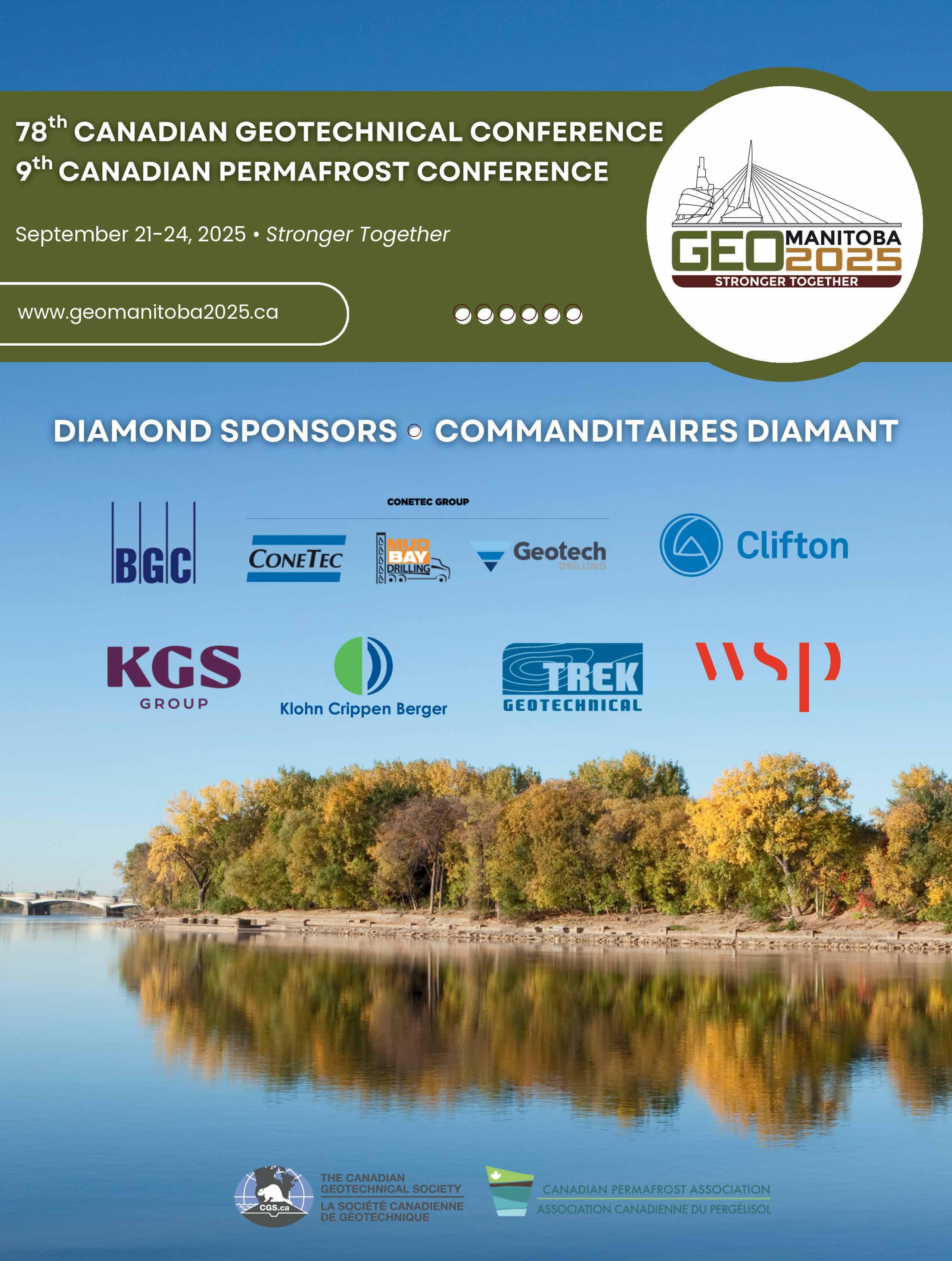
Mark your calendar for GeoManitoba 2025 coming up September 21-24. The 78th Canadian Geotechnical Conference (the longest running geotechnical conference in the world!) features the theme, ‘Stronger Together’, reflecting the ever-increasing need for collaboration between disciplines.
Lisa Reny, Publisher
Dear readers, You might have noticed that we have a new look and feel for the magazine this year. We are committed to continually improving the publication and this year was a big refresh of the layout and design – I hope you like it! We want to thank our advertisers that have supported us for the past five years and continue to do so. With close to 1,500 CGS members and individual subscribers, the reach of Canadian Geotechnique into the Canadian geotechnical community is wide. We would also like to recognize all the companies that currently support the CGS and our various initiatives. We realize that the support is provided at many levels (annual and specialty conferences, magazine ads, corporate sponsors,
local sections, student chapters, as well as various division and committee initiatives).
I would be remiss if I didn’t also mention the sponsors of the Canadian Foundation for Geotechnique who fund the travel costs of both the Spring and Fall CCLTs, and individual CGS members who donate annually which contributes to the Bozozuk and Becker scholarship funds; student awards, Colloquium & Colloquium Lecture Tour, and the YP ISSMGE travel award. Although they operate at arms length from the CGS, they support many CGS awards and initiatives available to CGS members. You can donate when renewing your CGS membership or go to their website (www.cfg-fcg.ca) and donate directly through Canada Helps.
Mark your calendar for GeoManitoba 2025 coming up September 21-24. The 78th Canadian Geotechnical Conference (the longest running geotechnical conference in the world!) features the theme, ‘Stronger Together’, reflecting the ever-increasing need for collaboration between disciplines. We are partnered with our friends from the Canadian Permafrost Association this year
and will also host a pre-conference workshop on Foundation Decarbonization and Re-use. The workshop will feature a keynote lecture from Dennis Becker, longtime CGS member, Past President, Legget award winner and as of last year, an Honorary Life member of the Society. His topic “Reuse of Foundations – Challenges, Successes and Lessons Learned” should not be missed. More information is on the conference website at www.geomanitoba2025.ca
As we look back on recent milestones, it is clear the landscape of geotechnical engineering is evolving, shaped by innovation and strengthened by community engagement. The CGS continues to foster collaboration and knowledge sharing among professionals, academics, and industry leaders, ensuring that geotechnical practice in Canada remains relevant.
Enjoy the summer!
Lisa and the Karma-Link Team
2025-2026
CGS EXECUTIVE COMMITTEE
COMITÉ EXÉCUTIF DE LA SCG
CRAIG LAKE PRESIDENT PRÉSIDENT president@cgs.ca
D. JEAN HUTCHINSON VP TECHNICAL V.-P. TECHNIQUE vptech@cgs.ca
DANIEL BERTRAND VP FINANCE V.-P. AUX FINANCES vpfinance@cgs.ca
MARIE-LIN BRÉARD LANOIX VP COMMUNICATIONS & MEMBER SERVICES V.-P. COMMUNICATIONS ET SERVICES AUX MEMBRES vpcomm@cgs.ca
JENNIFER DAY DIVISIONS & COMMITTEES REPRESENTATIVE REPRÉSENTANTE DES DIVISIONS ET COMITÉS divcomrep@cgs.ca
LILIANNE LANDRY-PARÉ SECTIONS REPRESENTATIVE REPRÉSENTANTE DES SECTIONS secrep@cgs.ca
CHELSEY YESNIK YOUNG PROFESSIONALS REPRESENTATIVE REPRÉSENTANTE DES JEUNES PROFESSIONNELS yprep@cgs.ca
Dear CGS members, I hope that this message finds you well and that you are able to enjoy some summer weather. For consultants, this can be a busy time of year with many larger projects coming to fruition. For those in academia, summer is a time to be more focused on research and hopefully enjoy good weather for field projects. Knowing how busy everyone is in their professional lives, the CGS appreciates the time and effort that each member puts into our society. Your work through our local sections, committees, or divisions, is much appreciated. If you are looking to get more involved, please contact the CGS to find out how. The Society provides an excellent platform to enhance your technical knowledge, expand your professional network, and develop leadership skills through volunteering.
For a listing of many of these CGS events, please explore our website at www.cgs.ca. You can also stay updated on CGS activities through our CGS E-News, Canadian Geotechnique – The CGS Magazine, and our LinkedIn and Instagram pages.
As this magazine reaches publication, there will be an increase in CGS activities in Manitoba. The 78th Annual CGS Conference and the 9th Canadian Permafrost Conference will be held from September 21-24 at the RBC Convention Centre in Winnipeg. The R.M. Hardy Keynote will be given by Ken Skaftfeld on the topic “Experience and lessons learned as a guide to geotechnical practice”. The CGS Colloquium will be given by Jennifer Day on the topic “The devil’s in the details: Impacts of geological complexities in rock engineering”. Suzanne Lacasse will be also providing a plenary lecture on the topic “Risk-informed decision-making provides necessary insight to help reduce risk”. In addition, Duane Froese will be giving the CPA MacKay Lecture. Also on the program is a full slate of short courses, workshops, and technical presentations. Full details on the conference can be found at www.geomanitoba2025.ca Beyond the technical experience offered by this conference, it is a great chance to catch up with old friends and make new ones. I want to thank Kent Bannister and his Local Organizing Committee for their tireless work on this conference. I have witnessed firsthand how much work they have done and how proud they will be to show you their wonderful city. I hope to see you there.
Another important event happening in Manitoba just prior to the annual conference
is the Canadian Geotechnical Society Young Professionals Conference (www.cgsypc2025.ca). This event has the tradition of occurring every three years and is a chance for our Young Professional members to attend field sites, listen to keynote lectures, and gain confidence in presenting their technical work in front of a friendly audience. As CGS President, I am looking forward to attending this conference and meeting many of our future CGS leaders. I attended the inaugural event back in 2004 and it is great to see this tradition continue after so many years.
Our upcoming CCLT speaker, in partnership with the Canadian Foundation for Geotechnique is Paul Dittrich of WSP. This event is one of many technical gatherings of our local sections, divisions, and committees. For a listing of many of these CGS events, please explore our website at www.cgs.ca You can also stay updated on CGS activities through our CGS E-News, Canadian Geotechnique – The CGS Magazine, and our LinkedIn and Instagram pages.
Please feel free to reach out to me anytime at president@cgs.ca with any questions. See you in Manitoba!
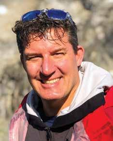
Lake 2025-26 CGS President
Craig
Craig Lake, 2025-2026 President of the Canadian Geotechnical Society
Chers membres de la SCG, J’espère que vous allez bien et que vous êtes en mesure de profiter de la saison estivale. Pour les consultant·e·s, cette période de l’année peut être particulièrement chargée en raison de l’aboutissement de nombreux projets importants. Même chose pour les universitaires : l’été est le moment idéal pour se concentrer davantage sur la recherche et profiter du beau temps (ce qu’on leur souhaite!) pour réaliser des projets sur le terrain. Sachant à quel point la vie professionnelle de chacun·e peut être occupée, la SCG apprécie le temps et les efforts que chaque membre consacre à notre société. Votre travail dans nos divisions, sections ou comités locaux ne passe pas inaperçu. Si vous souhaitez participer davantage à nos activités, veuillez communiquer avec la SCG et nous vous indiquerons comment vous pouvez nous aider. Notre société offre une excellente plateforme pour améliorer vos connaissances techniques, élargir votre réseau professionnel et développer vos compétences en leadership grâce au bénévolat.
Au moment de la publication de ce numéro du magazine, la SCG aura augmenté sensiblement ses activités au Manitoba.
Pour obtenir la liste de plusieurs de ces événements, veuillez consulter notre site Web à l’adresse https://cgs.ca/ index.php?lang=fr. Vous pouvez également vous tenir informé des activités de la SCG par l’intermédiaire de l’E-Info de la SCG, du magazine Géotechnique canadienne – Le périodique de la SCG, ainsi que de nos pages LinkedIn et Instagram.
La 78e conférence annuelle de la SCG et la 9e conférence canadienne sur le pergélisol auront lieu du 21 au 24 septembre au RBC Convention Centre, à Winnipeg. La conférence R.M. Hardy, qui sera présentée par Ken Skaftfeld, aura pour thème Experience and lessons learned as a guide to geotechnical practice (« Expériences et leçons apprises pour guider la pratique géotechnique »). Le Colloquium de la SCG, qui sera donné par Jennifer Day, portera sur le sujet suivant : The devil’s in the details: Impacts of geological complexities in rock engineering (« Impacts des complexités géologiques dans l’ingénierie des roches : tout est dans les détails »). Suzanne Lacasse présentera également une conférence plénière sur le thème Risk-informed decision-making provides necessary insight to help reduce risk (« Une prise de décision éclairée tenant compte des risques apporte l’éclairage nécessaire pour aider à les réduire »). De plus, Duane Froese prononcera la Conférence MacKay de l’Association canadienne du pergélisol (ACP). Le programme comprend également un éventail complet de cours intensifs, d’ateliers et de présentations techniques. Vous trouverez tous les renseignements sur la Conférence à l’adresse www.geomanitoba2025.ca/fr. Au- delà de l’expérience technique offerte, cette conférence est une excellente occasion de renouer avec de vieux amis, mais aussi de vous en faire de nouveaux. Je tiens à remercier Kent Bannister et son comité organisateur local qui ont travaillé sur cet événement. J’ai pu constater par moi-même le travail phénoménal que ces personnes ont accompli et la mesure dans laquelle elles seront fières de vous montrer leur merveilleuse ville. J’espère vous y voir!
La Conférence des jeunes professionnels de la SCG (www.cgsypc2025.ca) est un autre événement important qui se déroulera au Manitoba juste avant la conférence annuelle. Organisé traditionnellement tous les trois ans, cet événement constitue une occasion en or pour les jeunes professionnels membres de la SCG de se rendre sur le terrain, d’écouter des conférences d’honneur et de gagner en confiance en présentant leur travail technique devant un public qui leur est favorable. En tant que président de la SCG, j’ai hâte d’assister à cette conférence et de rencontrer bon nombre des futurs chef·fe·s de file de notre société. Après avoir eu le privilège d’assister à la première édition de cet événement en 2004, je suis heureux de voir cette tradition perdurer après tant d’années.
Dans le cadre de la Tournée de conférences transcanadienne (TCT) et en partenariat avec la Fondation canadienne de géotechnique, notre prochain conférencier sera Paul Dittrich de WSP. Cet événement s’ajoute aux nombreuses rencontres techniques de nos sections, divisions et comités locaux. Pour obtenir la liste de plusieurs de ces événements, veuillez consulter notre site Web à l’adresse https://cgs.ca/index.php?lang=fr. Vous pouvez également vous tenir informé des activités de la SCG par l’intermédiaire de l’E-Info de la SCG, du magazine Géotechnique canadienne –Le périodique de la SCG, ainsi que de nos pages LinkedIn et Instagram.
Si vous avez des questions, n’hésitez pas à me contacter à tout moment à president@cgs.ca. Au plaisir de se voir au Manitoba!
Craig Lake 2025-26 SCG PRÉSIDENT
Craig Lake, Président de la SCG 2025-2026
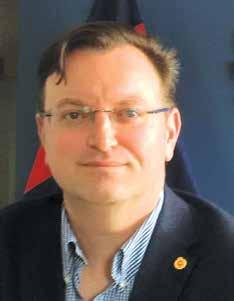
President-Elect Objectives: Nomination Statement of Dr. D. Jean Hutchinson
The Society has long been an exceptional organization, having such a significant impact on national, and playing a leading role in international, geotechnical practice and advancements, and I am very pleased to be able to continue to support and advance these missions.
It is my honour to accept the nomination as President-Elect of the Canadian Geotechnical Society. I am proud and motivated to continue to volunteer with my colleagues and friends for a world class organization that represents all facets of Geotechnical practice, and provides a strong and meaningful relationship with our International Learned Societies. I will serve the Society as President-elect during 2026, and for a two-year term as President commencing January 2027.
I have worked on behalf of the Society for many years, as documented in the notice of my nomination by Ian Moore in the last GeoNews. Since joining the CGS in 1987 and attending my first national conference in Winnipeg in 1989, to present my Master’s thesis project work, I have been honoured to be involved with the CGS in several roles. Before becoming VP Technical in 2025, I served for many years with the Canadian Foundation for Geotechnique – the arms length organization that raises funds to support numerous important CGS activities, including the CCLT, the Colloquium, the student awards and the Legget Medal. The CGS is important to me for many reasons, but key are the development and dissemination of best practice in all aspects of Geotechnical Engineering, and the support and promotion of early career colleagues and students. Working alongside the dedicated and insightful team of volunteers, who make the Society function so effectively, is inspiring and delightful.
There are two key objectives for my CGS Presidency.
To continue to support Young Professionals:
In collaboration with the YP Chair, and the Divisions and Committees, one of my highest priorities is to continue and promote CGS’s activities to encourage participation by YP members. As many have said, YP members are the future of our organization, and are well placed to help us navigate through the challenges and opportunities we are facing as a technical community, including thoughtful adoption of machine learning and AI, addressing impacts of a changing climate on our work and promoting an increasingly diverse work force. Throughout my career, as a professor at Queen’s and an early supporter of the CYGEG Conference series, I have worked to encourage YP participation in the profession. In recognition of the evolving interest of younger members of our profession in topics related to sustainability / stakeholder engagement / professional practice, I created a series of workshop in my courses at Queen’s to support this learning. Support for a more diverse group of YP is also increasingly tied with support for EDI, which is addressed in the next paragraph.
To promote and encourage involvement of diverse people in the profession: There is an increasing awareness of the benefits of employing and engaging with a diverse group of professionals. I applaud the ongoing work by the CGS Task Force to develop EDI policies and to encourage
opportunities, and will work alongside the conference organizing teams and the Sections and Divisions and Committees to encourage inclusivity and belonging for everyone. I will encourage discussion about the challenges encountered by diverse people in field based assignments, the barriers to promotion many diverse people encounter and developing a Code on Conduct. Excellent work has been done by a number of companies, universities and professional organizations to make Geotechnical Engineering more attractive to diverse people, leading to more representative and equitable work places. On the other hand, we hear about problematic work place cultures and biases leading to the “Leaky Pipeline”, causing smart, capable and well experienced women to leave the profession.
I look forward to discussions about how the Society can best support and serve our members, and encourage you to get in touch with me. My current email address is: vptech@cgs.ca
The Society has long been an exceptional organization, having such a significant impact on national, and playing a leading role in international, geotechnical practice and advancements, and I am very pleased to be able to continue to support and advance these missions.
D.
Jean Hutchinson
Professor Emerita, Queen’s University and Vice President, Innovative Geomechanics Inc.
Objectifs de la présidente désignée :
Déclaration de candidature de la Dre D. Jean Hutchinson
Depuis longtemps, la SCG a été une organisation exceptionnelle qui exerce un impact important à l’échelle nationale tout en jouant un rôle de premier plan dans la pratique et les progrès géotechniques internationaux. Je suis très heureuse de pouvoir continuer à soutenir et à faire progresser ces missions.
Je suis honorée d’accepter cette nomination au poste de présidente désignée de la Société canadienne de géotechnique (SCG). Je suis fière et motivée de continuer à faire du bénévolat avec mes collègues et amis pour une organisation de classe mondiale qui représente toutes les facettes de la pratique géotechnique tout en entretenant des relations solides et significatives avec nos sociétés savantes internationales. Je servirai la Société à titre de présidente désignée en 2026, ainsi qu’en tant que présidente pour un mandat de deux ans à compter de janvier 2027.
Je travaille pour la SCG depuis de nombreuses années, comme en témoigne l’annonce de ma nomination par Ian Moore dans le dernier numéro de GeoNews. Depuis mon arrivée à la SCG en 1987 et ma participation à ma première conférence nationale à Winnipeg en 1989 pour présenter mon projet de thèse de maîtrise, j’ai eu le privilège de prendre part aux activités de la SCG dans plusieurs rôles. Avant de devenir vice-présidente technique en 2025, j’ai été active pendant plusieurs années à la Fondation canadienne de géotechnique, un organisme indépendant qui recueille des fonds pour soutenir de nombreuses activités importantes de la SCG, notamment la Tournée de conférences transcanadienne (TCT), le Colloquium, les prix pour les étudiants et la Médaille Legget. La SCG est importante pour moi pour de nombreuses raisons. Parmi les principales, je mentionnerais le développement et la diffusion des pratiques exemplaires dans tous les aspects de la géotechnique, ainsi que le soutien et la promotion des collègues et des étudiants en début de carrière. Il est à la fois inspirant et plaisant de pouvoir travailler aux côtés d’une équipe dévouée et perspicace de bénévoles qui permettent à notre Société d’être aussi efficace.
Je me suis fixé deux grands objectifs pour mon mandat à la présidence de la SCG.
Continuer à soutenir les jeunes professionnels : En collaboration avec le directeur du Comité des jeunes professionnels (JP), les divisions et les comités, l’une de mes priorités absolues sera de poursuivre et de promouvoir les activités de la SCG afin d’encourager la participation des membres des JP. Comme beaucoup l’ont dit, les membres du Comité des JP sont l’avenir de notre organisation. Ils sont particulièrement bien placés pour nous aider à relever les défis et à saisir les occasions qui se présentent à nous en tant que communauté technique (p. ex. l’adoption réfléchie de l’apprentissage automatique et de l’intelligence artificielle [IA], la gestion des impacts des changements climatiques sur notre travail et la promotion d’une maind’œuvre toujours plus diversifiée). Tout au long de ma carrière, à titre de professeure à l’Université Queen’s et en tant que l’un des premiers soutiens de la série de conférences canadiennes des jeunes géotechniciens et géoscientifiques (CCJGG), j’ai encouragé la participation des JP à notre profession. Compte tenu de l’intérêt croissant des jeunes membres de notre profession pour les sujets liés à la durabilité, à l’engagement des intervenants et à la pratique professionnelle, j’ai créé une série d’ateliers dans mes cours à l’Université Queen’s pour soutenir cet apprentissage. Le soutien à un groupe plus diversifié de JP est également de plus en plus lié à l’appui apporté à l’équité, à la diversité et à l’inclusion (EDI) (voir le paragraphe suivant).
Promouvoir et encourager la diversité dans notre profession : On constate une sensibilisation croissante aux avantages d’employer un groupe diversifié de professionnels et d’interagir avec eux. Je
salue les efforts actuels du Groupe de travail de la SCG visant à élaborer des politiques d’EDI et à promouvoir les initiatives dans ce domaine. Je travaillerai aux côtés des équipes organisatrices de la conférence, des sections, des divisions et des comités pour favoriser l’inclusion et un sentiment d’appartenance pour tous. J’encouragerai la discussion sur les écueils auxquels se sont heurtés diverses personnes lors les affectations sur le terrain, les obstacles à la promotion qu’elles ont rencontrés et l’élaboration d’un Code de conduite. Un certain nombre d’entreprises, d’universités et d’organisations professionnelles ont fait un excellent travail pour que la géotechnique soit plus attrayante pour tous, de manière à rendre les milieux de travail plus représentatifs et équitables. Cela dit, nous entendons encore parler de cultures et de préjugés problématiques en milieu de travail. Ces stéréotypes mènent au « tuyau percé », une métaphore qui illustre le fait que des femmes intelligentes, compétentes et expérimentées en viennent à quitter la profession.
J’attends avec impatience les discussions sur la façon dont la Société peut soutenir et servir au mieux nos membres et vous encourage à communiquer avec moi. Mon adresse courriel actuelle est la suivante : vptech@cgs.ca
Depuis longtemps, la SCG a été une organisation exceptionnelle qui exerce un impact important à l’échelle nationale tout en jouant un rôle de premier plan dans la pratique et les progrès géotechniques internationaux. Je suis très heureuse de pouvoir continuer à soutenir et à faire progresser ces missions.
D. Jean Hutchinson
Professeure émérite, Université Queen’s et vice-présidente, Innovative Geomécanics Inc.
MESSAGE FROM THE CO-CHAIRS
Welcome to the CGS Young Professionals Conference 2025 {CGS YPC), where the next generation of geotechnical professionals come together to connect with peers and mentors, share ideas, and learn new things!
We both attended the last CGS YPC held in Banff, Alberta, in 2022, and we can speak from our experience that this conference truly made a positive impact on our professional development and expanded our geotechnical network. So much so that we are excited to be chairing the 2025 conference to bring this incredible experience to a new group of earlycareer professionals. These conferences would not be possible without the resounding support of our committed sponsors. Their support is invaluable in contributing to the incredible experiences the delegates will have at this conference.
The aim of the conference is to provide early-career professionals with an inviting atmosphere to network, learn, and gain experience presenting technical material to an audience of peers. In doing so, the intent is for delegates to come out of the experience with more confidence and some familiar faces prior to attending the national conference or other, similar large-scale conferences. The networking opportunities offered by the CGS YPC foster a more connected early-career professional community and a stronger geotechnical and geoscientific community as a whole.
The 2025 CGS YPC {8th iteration) will be oriented toward fulf illing these goals in the beautiful location of Wasagaming, Manitoba, at the Elkhorn Resort Spa & Conference Centre. It will take place from September 78 to 20, 2025, prior to the 78th CGS conference, GeoManitoba. Our fantastic Organizing Committee is thrilled to welcome you to Manitoba!
Warm regards,
Jack Park and Jenna Roadley Co-Chairs, CGS YPC 2025
Northeastern Ontario (Sudbury) Section
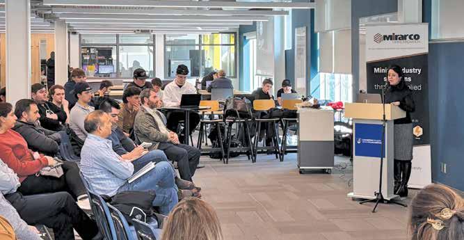
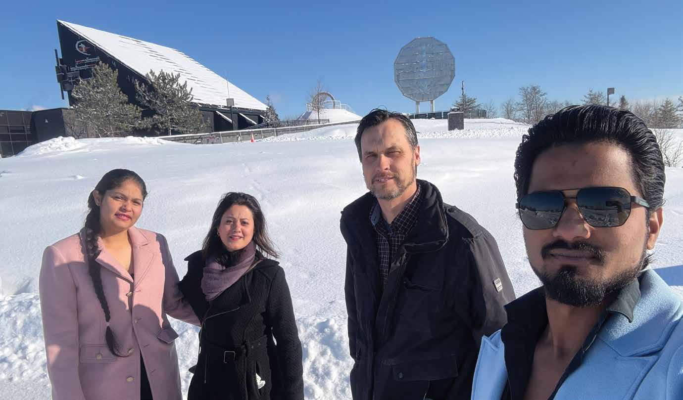
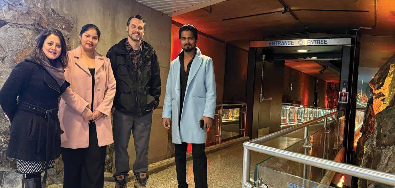
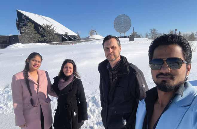
The Northeastern Ontario Section is also referred to as the Sudbury-North Bay Section to reflect the great collaboration between our two northern cities separated by 120 km. Pooneh Maghoul presented her 2023 Colloquium Role of Geotechnical Engineering in Human Settlement on the Moon and Beyond: Challenges and Opportunities, at Laurentian University (Sudbury) on January 23, and Ministry of Transportation, Ontario (North Bay) next day. Forty people attended at LU, 24 at MTO, with 100 online over the two days, including from other smaller sections across Canada. Select photographs of the events are provided below.
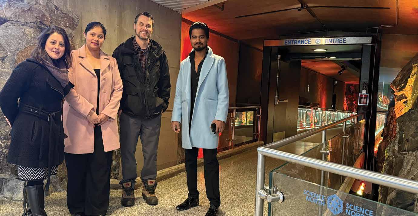
Immediately upon arrival to sunny Sudbury (150 mm snowfall the day before), Pooneh Maghoul asked to see Sudbury’s crater. We toured the entrance of Dynamic Earth / Big Nickel, as well as Science North entrance including the fault line that connects the smaller and larger snowflake buildings, as shown in the two photographs. During the tour, we discussed Sudbury was the astronaut practice ground in 1970’s due to the rocky landscape, which is now a much different landscape from the extensive regreening efforts (not visible due to all the snow!). Thankfully, Pooneh’s interest was peaked to return to Sudbury with her family in the spring or summer at full green.
Immediately following Pooneh’s LU presentation, a fortunate student was awarded a $300 scholarship in an “attendance draw”, similar to what LU has awarded for other recent out of town speakers. Also following the LU presentation, five section representatives met with Pooneh for dinner and in addition to the moon, there was discussion regarding opportunities to see our section grow and thrive in both Sudbury and North Bay and the rest of Northeast Ontario.
Enthusiasm and momentum for hosting this two-city monumental event was based on the very successful May 2024 CCLT by Ellen Rathje, the first time the CCLT was held in Sudbury, as summarized in the Fall 2024 issue of Canadian Geotechnique
Pooneh Maghoul’s presentation was very motivating for our section including a future potential Young Professional event, which may be combined with a couple of miniinterviews with “geo-legends” (25 years+ to retired), to continue growing the section and passing to the next geo-generation. Further, it is very encouraging to see our section membership growing and we hope to see
continued increase. One of the continued challenges for our smaller section to overcome is to see an increased number of active volunteers, which we anticipate to expand as membership grows.
Thank you to CGS and Canadian Foundation Geotechnique for support of this presentation with shared travel costs. Also thank you to LU, Mirarco, Goodman School of Mines, and the Ministry of Transportation, Ontario. And most especially thank you to Pooneh for taking time out of your busy schedule to present twice, and trust you made long-term networking connections!
Andre Bom and Hemant (Charlie) Walke
Pooneh Maghoul presenting the Colloquium in Sudbury
Visiting Sudbury’s Big Nickel before presentation
At the Science North Fault Line
Section du Nord-Est de l’Ontario (Sudbury)
La Section du Nord-Est de l’Ontario est aussi appelée « Section SudburyNorth Bay » pour refléter l’esprit de collaboration exceptionnel existant entre ces deux villes du Nord de l’Ontario distantes de seulement 120 kilomètres. Pooneh Maghoul a présenté sa conférence prononcée initialement à l’occasion du Colloquium 2023 intitulée Role of Geotechnical Engineering in Human Settlement on the Moon and Beyond : Challenges and Opportunities (« Rôle de la géotechnique dans l’établissement humain sur la Lune et au-delà : défis et possibilités »), à l’Université Laurentienne (Sudbury) le 23 janvier et au ministère des Transports de l’Ontario (North Bay) le lendemain. Quarante personnes ont assisté à la présentation à l’Université Laurentienne, 24 au ministère des Transports de l’Ontario, en plus de 100 participants en ligne au cours des deux jours, y compris d’autres sections de plus petite taille de partout au Canada. Vous trouverez ci-dessous des photographies de ces événements.
famille au printemps ou en été, lorsque la verdure aura pleinement repris ses droits.
Immédiatement après la conférence de M me Maghoul à l’Université Laurentienne, un étudiant a eu la chance de recevoir, dans le cadre du tirage d’un prix de présence, une bourse de 300 $ semblable à celles que l’établissement a déjà accordées lors des présentations récentes d’autres conférencier·ère·s de l’extérieur. À la suite de la présentation, cinq représentants de la section ont eu l’occasion de souper avec Mme Maghoul. En plus des conversations sur la lune, les convives ont discuté des possibilités de croissance et de développement de notre section, tant à Sudbury et à North Bay que dans le reste du Nord-Est ontarien.
Dès son arrivée dans la ville ensoleillée de Sudbury (la ville avait reçu 150 mm de neige la veille), Pooneh Maghoul a demandé à voir le cratère de Sudbury. Nous avons donc visité l’entrée des centres Terre dynamique, site du Big Nickel, et Science Nord, y compris la ligne de faille qui relie le grand et le petit bâtiment en forme de flocon de neige (voir les deux photographies). Pendant la visite, nous avons discuté de Sudbury qui a servi de terrain d’entraînement pour les astronautes dans les années 1970 en raison de son paysage rocailleux. Aujourd’hui, elle arbore un visage bien différent à la suite des efforts intensifs de reverdissement (des efforts qui, ce jour-là, sont passés inaperçus à cause de la neige!).
Heureusement, Mme Maghoul a manifesté son intention de revenir à Sudbury avec sa
L’immense succès rencontré par la Tournée de conférences transcanadienne (TCT) de mai 2024, qui mettait en vedette Ellen Rathje et se tenait pour la première fois à Sudbury, comme le rapportait le numéro d’automne 2024 de Géotechnique canadienne, nous a insufflé l’enthousiasme et le dynamisme nécessaires pour accueillir cet événement d’envergure dans nos deux villes.
La présentation de Pooneh Maghoul a fortement motivé notre section à organiser à l’avenir de telles activités, notamment un futur événement pour les jeunes professionnels. Un tel événement pourrait être combiné à des mini-entrevues avec des légendes de la géotechnique (ayant 25 ans d’expérience
ou plus, jusqu’à la retraite) pour continuer à développer la section et passer le flambeau à la prochaine « géogénération ». De plus, il est très encourageant de voir augmenter le nombre de membres de notre section. Nous espérons que cette hausse se poursuivra. L’un des défis permanents auxquels devra faire face notre petite section sera d’accroître le nombre de bénévoles actifs. Cela dit, nous pensons que ce nombre devrait augmenter à mesure que se renforceront nos effectifs.
Nous tenons à remercier la SCG et la Fondation canadienne de géotechnique d’avoir soutenu cette présentation en partageant les frais de déplacement. Nous remercions également l’Université Laurentienne, Mirarco, l’École des mines Goodman et le ministère des Transports de l’Ontario. Et surtout un grand merci à M me Maghoul qui, malgré un horaire chargé, a pris le temps de présenter sa conférence à deux reprises. Nous sommes certains que vous avez établi des liens durables en réseautant.
Andre Bom et Hemant (Charlie) Walke
Visite du Big Nickel de Sudbury avant la présentation
Pooneh Maghoul présente le Colloquium à Sudbury
À la faille du Science Nord
Geohazards Committee
September 29th to October 1st, 2025
W3e Atelier international sur les glissements de terrain dans les argiles sensibles
3rd International Workshop on Landslides in Sensitive Clays
Musée de la Civilisation, Quebec City, QC
e welcome you to the 3rd IWLSC 2025. The technical program will feature around 50 publications, mainly from Canada and Scandinavia, covering the latest advances in the field of landslides in sensitive clays. We are delighted to welcome three keynote speakers: Serge Leroueil (Université Laval), Jean-Sébastien L'Heureux (NGI) and Danielle Maltais (UQAC). A special session will focus on the results of a comparative stability assessment exercise. Delegates will also be offered the opportunity to hit the road to visit sites affected by problems associated with highly retrogressive landslides, as part of an optional technical tour.
The registration period is now open. An early bird rate is offered to those who register before August 1, 2025. For more information, please visit www.iwlsc2025.ca
Professional Practice
Seán Mac Eoin, Professional Practice Committee Past Chair
New Chairman of PPC
The PPC has a new Chairman: Storer Boone of Ground Rules Engineering Inc. assumed the role in January 2025 from Seán Mac Eoin of Tetra Tech Canada Inc., who had been Chairman since 2020.
GeoManitoba 2025 Special Sessions
Consistent with the PPC’s mandate to “highlight and educate CGS Members on Professional Practice issues facing Geoprofessionals”, the Committee is planning two Special Sessions to be presented at GeoManitoba 2025. The Committee expects to uphold its reputation for engaging, relevant, and useful sessions to look forward to.
Publication of Case Studies
The PPC has recognised the importance of published case studies to the practitioner and that the number of peer-reviewed case study papers published has significantly reduced in recent years. The PPC is working with members of the CGS Heritage Committee to make easily available to CGS members case studies from the Proceedings of CGS Annual Conferences. The PPC also encourages CGS members to identify suitable projects from their own experience and to prepare case study papers on these for publication. These will provide valuable “lessons learned” to all readers.
Relationship with the Geoprofessional Business Association (GBA)
The GBA and the CGS (through the PPC) have worked hard on building a strong, lasting relationship between the two organisations. Since the signing of a Memorandum of Understanding at GeoSaskatoon 2023, the GBA has contributed both to that conference and to GeoMontreal 2024. The GBA has also agreed to provide, free of charge to CGS members, one of their many curated case studies, normally only available to GBA members. A link to the case study will appear imminently in CGS e-News, and it is worth reading.
As part of our relationship with the GBA, they will be preparing a series of articles for a Special Section on Professional Practice in the Fall 2025 edition of Canadian Geotechnique These will be instructive and inspiring.
Young Professionals Committee
For the past two years, the CGS Young Professionals (YP) Committee has successfully hosted a nation-wide geotechnical Mentorship Program, which has paired experienced geotechnical engineers (10+ years of experience) with geotechnical engineers who are establishing themselves in the industry (less than 10 years of experience). We are happy to announce that the program has returned for its third year, and we are excited to announce 17 pairings. Each pair was eager to get started on their mentorship journey together. Although each yearly program ends in December, we hope to build long lasting mentorships and relationships amongst the pairs.
The YP Committee hosted a kickoff event in Spring, with CGS President, Craig Lake (Dalhousie University), as the featured guest speaker. A mid-year and year-end survey will be distributed to the pairs, to support further development of the program. Liam McCann, Adam Mickey and Sarah Jacob are leading the 2025 Mentorship Program.
We are also pleased to offer five exciting presentations for the 2025 calendar year, as part of the “Strong Foundations: Professional Development for Geotechnical Engineers” non-technical webinar series. The first webinar, hosted on March 13th, featured Harpreet Panesar (SoilRocks Consulting Inc.) presenting on the topic of ‘Engineers in Different Roles – Contractor vs Consultant vs Owner vs Entrepreneur’. The remaining four webinars will occur in May, July, September, and November, respectively.
The non-technical webinars aim to educate geotechnical engineers on topics surrounding soft-skills, business development, and many other aspects - while introducing them to new perspectives they may not have previously considered. There is no set guideline for what can and cannot be presented for the non-technical webinar, so we are happy to hear from the CGS community on topics they would like to see presented or topics they would like to present themselves. Please reach out to Liam McCann or Leonardo Paranhos for more information.
Stay tuned on our LinkedIn group for announcements on these upcoming
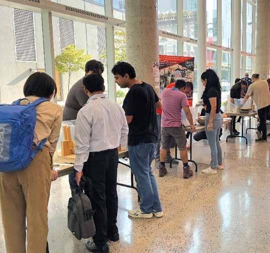
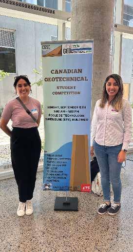
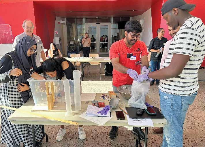
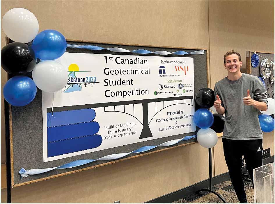
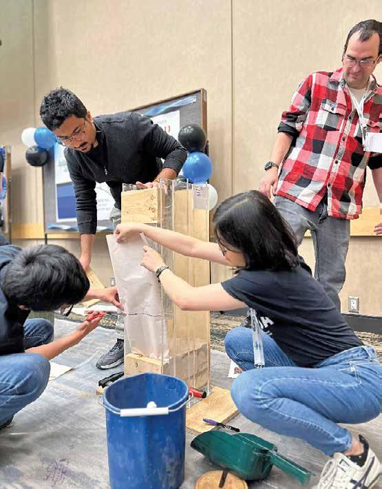
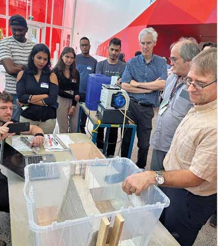
For the third consecutive year, the Canadian Geotechnical Student Competition (CGSC) is back, offering a thrilling hands-on challenge for students at GeoManitoba 2025! Join us on Wednesday afternoon, September 24, 2025, at the RBC Convention Centre, where student teams will put their engineering skills to the test.
presentations: https://www.linkedin.com/ groups/14132567. Recordings of these webinars are also available on our YouTube channel: https://www.youtube.com/@ cgsypcommittee
The Geotech 101 Webinar Series returns for 2025, which is a technical webinar series about the many specializations within geotechnical engineering with ‘101’ style content designed to broaden your understanding of the specialization, and potentially the career aspirations of YPs.
The 2025 calendar for this series is packed with talks from industry and academic experts, including Laifa Cao (WSP), Jim Oswell (Naviq), Lynden Penner (JDMA), and Masoud Manzari (Hatch) presenting on Retaining Walls, Soil-Pipe Interactions, Permafrost, and Soil Tunnelling - respectively.
To attend future webinars, keep your calendar open on the third Wednesday of each month and follow our LinkedIn page for announcements and reminders. You can also watch past technical webinars on our YouTube channel. Jade Kennan and Naveel Islam are organizing the technical webinar series and are actively seeking more speakers for 2025 and 2026.
For the third consecutive year, the Canadian Geotechnical Student Competition (CGSC) is back, offering a thrilling hands-on challenge for students at GeoManitoba 2025! Join us on Wednesday afternoon, September 24, 2025, at the RBC Convention Centre, where student teams will put their engineering skills to the test. Participants will design, construct, and evaluate a small-scale mechanically stabilized earth (MSE) retaining wall, showcasing their
expertise in engineering analysis, design, and construction. Teams should consist of approximately 4–5 students. While we encourage teams to sign up and register together, solo participants are also welcome –event organizers will do their best to match you with a team. The 3rd Annual CGSC is being planned by Liam Soufi (University of Manitoba), Steven Harms (RRC Polytech), and Patrick Machibroda
We also have an exciting update to our YP Committee, welcoming Ivanna Montani (Saskatchewan) as an Executive at Large!
Questions?
Mentorship Program: Adam (adam@am2geotech.com), Sarah Jacob (sjacob@bgcengineering.ca), Development Lead – Liam McCann (liam.mccann@atkinsrealis.com), Vice Chair – Zaran Patel (zarankumar.patel@stantec.com) or Chair & YP Rep – Chelsey Yesnik (yprep@cgs.ca)
Geotech 101 for Young Professionals: Knowledge & Impact Lead – Jade Kennan (jadewinona@gmail.com), Secretary and Fundraising Lead – Naveel Islam (cgs.yp.committee@gmail.com)
Strong Foundations Professional Development for Geotechnical Engineers: Liam McCann (liam.mccann@atkinsrealis.com), Leonardo Paranhos (leo.pbeng@gmail.com)
CGSC:
Communication Lead – Patrick Machibroda (patrick.machibroda@ucalgary.ca)
General: Chelsey Yesnik (yprep@cgs.ca)
Comité sur les géorisques
Du 29 septembre au 1er octobre 2025
V3e Atelier international sur les glissements de terrain dans les argiles sensibles
3rd International Workshop on Landslides in Sensitive Clays
Musée de la civilisation, Québec (Québec)
ous êtes cordialement invité à participer au 3e Atelier international sur les glissements de terrain dans les argiles sensibles (AIGTAS2025). Le programme technique comprendra environ 50 publications, principalement du Canada et de Scandinavie, couvrant les dernières avancées dans le domaine des glissements de terrain dans les argiles sensibles. Nous sommes ravis d’accueillir trois conférencier·ère·s : Serge Leroueil (Université Laval), Jean-Sébastien L’Heureux (NGI) et Danielle Maltais (UQAC). Une session spéciale sera consacrée aux résultats d’un exercice d’évaluation comparative de la stabilité. Les délégué·e·s auront également la possibilité de prendre la route pour explorer des sites touchés par des problèmes liés à des glissements de terrain fortement rétrogressifs, dans le cadre d’une visite technique facultative.
La période d’inscription est maintenant commencée. Un tarif de préinscription est offert aux personnes qui s’inscrivent avant le 1er août 2025. Pour de plus amples renseignements, veuillez consulter le site www.iwlsc2025.ca/fr
Comité sur les pratiques professionnelles
Seán Mac Eoin, président sortant du CPP
Nouveau président du CPP
Le CPP a un nouveau président : Storer Boone (Ground Rules Engineering Inc.) assume ce rôle depuis janvier 2025, après Seán Mac Eoin (Tetra Tech Canada Inc.) qui en était le président depuis 2020.
Sessions spéciales à GéoManitoba 2025
Conformément à son mandat qui consiste à « souligner aux membres de la SCG les enjeux relatifs aux pratiques professionnelles auxquels les professionnels en géotechnique font face et [à] les en informer », le CCP planifie deux séances spéciales qui seront présentées à GéoManitoba 2025. Fidèle à son habitude, le Comité prévoit organiser des sessions intéressantes, pertinentes et utiles.
Publication d’études de cas
Le CPP a reconnu que les études de cas étaient particulièrement importantes
pour le ou la praticien·ne, d’autant plus que le nombre de celles ayant fait l’objet d’une évaluation par des pairs et ayant été publiées a considérablement diminué ces dernières années. Le Comité travaille avec les membres du Comité sur le patrimoine de la SCG pour faciliter l’accès des membres aux études de cas tirées des comptesrendus des conférences annuelles de la SCG. De plus, le CPP encourage les membres de la SCG à repérer des projets appropriés à partir de leur propre expérience et à préparer des études de cas sur ces projets à des fins de publication. Il va sans dire que ces études de cas seront riches d’enseignements pour tous les lecteurs.
Relation avec la GeoProfessional Business Association (GBA)
La GBA et la SCG (par l’intermédiaire du CPP) n’ont ménagé aucun effort pour
établir une relation solide et durable entre les deux organisations. Depuis la signature d’un protocole d’entente à GéoSaskatoon 2023, la GBA a contribué à la fois à cette conférence et à GéoMontréal 2024. De plus, la GBA a accepté de fournir gratuitement aux membres de la SCG l’une de leurs nombreuses études de cas sélectionnées, lesquelles ne sont habituellement offertes qu’à ses membres. Un lien vers cette étude de cas, qui vaut la peine d’être lue, figurera prochainement dans l’ E-Info de la SCG
Dans le cadre de notre relation avec la GBA, elle préparera une série d’articles qui paraîtront dans une section spéciale sur les pratiques professionnelles du numéro d’automne 2025 de Géotechnique canadienne. Nul doute que ces articles seront à la fois instructifs et inspirants.
Comité des jeunes professionnels
Au cours des deux dernières années, le Comité des jeunes professionnels (JP) de la SCG a organisé avec succès un programme de mentorat géotechnique à l’échelle nationale. Ce programme a permis de jumeler des géotechnicien·ne·s expérimentés (plus de 10 ans d’expérience) à des géotechnicien·ne·s qui s’établissent dans l’industrie (moins de 10 ans d’expérience).
Nous sommes heureux d’annoncer que le programme, qui est de retour pour une troisième année, compte 17 jumelages. Tous les participant·e·s à ce programme étaient impatients d’amorcer leur mentorat. Bien que chaque programme annuel se termine en décembre, nous espérons qu’il permettra d’établir des mentorats et des relations durables entre les membres de chaque paire.
Au printemps, le Comité des JP a organisé un événement de lancement qui mettait en vedette le président de la SCG Craig Lake (Université Dalhousie) comme conférencier invité. Un sondage de mi-année et de fin d’année sera distribué aux paires mentor·ementoré·e, afin de soutenir le développement ultérieur du programme. Liam McCann, Adam Mickey et Sarah Jacob dirigent le Programme de mentorat 2025.
Nous sommes également ravis de proposer cinq présentations passionnantes pour l’année civile 2025, dans le cadre d’une série de webinaires non techniques intitulée Strong Foundations: Professional Development for Geotechnical Engineers non-technical webinar series (« Pour des fondations solides : perfectionnement professionnel pour les géotechniciens »). Le premier webinaire, organisé le 13 mars, mettait en vedette Harpreet Panesar (SoilRocks Consulting Inc.) qui a donné une présentation intitulée Engineers in Different Roles – Contractor vs Consultant vs Owner vs Entrepreneur (« Les ingénieurs dans différents rôles – Entrepreneur, consultant ou propriétaire »). Les quatre autres webinaires auront lieu en mai, juillet, septembre et novembre.
Les webinaires non techniques visent à former les géotechnicien·ne·s sur divers sujets (savoirêtre, développement des affaires et nombreux autres aspects), tout en leur présentant de nouvelles perspectives qu’ils et elles n’avaient peut-être pas envisagées auparavant. Il n’y a aucune ligne directrice en ce qui concerne les sujets qui peuvent ou non être abordés dans
le cadre d’un webinaire non technique. Par conséquent, nous serions heureux d’en savoir plus long sur les sujets que les membres de la SCG souhaiteraient entendre ou présenter euxmêmes. Pour de plus amples renseignements à ce sujet, veuillez communiquer avec Liam McCann ou Leonardo Paranhos
Pour être informé·e des annonces concernant les présentations à venir, consultez fréquemment notre groupe LinkedIn : https:// www.linkedin.com/groups/14132567. Les enregistrements de ces webinaires sont également publiés sur notre chaîne YouTube https://www.youtube.com/@cgsypcommittee
La série de webinaires Geotech 101 (Géotechnique 101) revient en 2025! Cette série de webinaires techniques, qui aborde les éléments de base de nombreuses spécialisations en géotechnique, vise à élargir la compréhension des jeunes professionnels et possiblement leurs aspirations professionnelles.
Le calendrier 2025 de cette série regorge de conférences données par des experts de l’industrie et du milieu universitaire, notamment Laifa Cao (WSP), Jim Oswell (Naviq), Lynden Penner (JDMA) et Masoud Manzari (Hatch), qui effectueront respectivement des présentations sur les murs de soutènement, les interactions pieux-sol, le pergélisol et la construction de tunnels.
Pour assister aux prochains webinaires, réservez dans votre agenda le troisième mercredi de chaque mois et suivez notre page LinkedIn pour être informé·e des annonces et des rappels. Vous pouvez également regarder les webinaires techniques précédents sur notre chaîne YouTube. Jade Kennan et Naveel Islam, qui organisent la série de webinaires techniques, recherchent activement un plus grand nombre de conférencier·ère·s pour 2025 et 2026.
Pour une troisième année consécutive, le Concours pour les étudiant·e·s canadiens en géotechnique (CECG) est de retour pour offrir un défi pratique passionnant aux étudiant·e·s à GéoManitoba 2025! Joignezvous à nous le mercredi 24 septembre 2025, en après-midi, au RBC Convention Centre, où des équipes étudiantes mettront à l’épreuve leurs compétences en ingénierie. Les participant·e·s concevront, construiront
et évalueront des murs de terre stabilisés mécaniquement à petite échelle, ce qui leur permettra de mettre en valeur leur expertise en analyse technique, en conception et en construction. Les équipes devraient être composées d’environ 4 à 5 étudiant·e·s. Bien que nous encouragions les équipes à s’inscrire en groupe, les participant·e·s individuels sont également les bienvenus (les organisateurs feront de leur mieux pour les jumeler à une équipe). Liam Soufi (Université du Manitoba), Steven Harms (CRR Polytech) et Patrick Machibroda planifient la 3e édition annuelle du CECG.
Par ailleurs, le Comité des JP est heureux d’accueillir dans ses rangs Ivanna Montani (Saskatchewan) en tant que membre à titre individuel.
Des questions? Programme de mentorat : Adam (adam@am2geotech.com), Sarah Jacob (sjacob@bgcengineering.ca), responsable du perfectionnement –Liam McCann (liam.mccann@atkinsrealis.com), vice-président – Zaran Patel (zarankumar.patel@stantec.com) ou présidente et représentante des JP –Chelsey Yesnik (yprep@cgs.ca)
Geotech 101 for Young Professionals (« Géotechnique 101 pour les jeunes professionnels ») : Responsable du perfectionnement du savoir et de l’influence –
Jade Kennan (jadewinona@gmail.com), secrétaire et responsable de la collecte de fonds – Naveel Islam (cgs.yp.committee@gmail.com)
Strong Foundations : Professional Development for Geotechnical Engineers (« Pour des fondations solides : perfectionnement professionnel pour les géotechniciens ») : Liam McCann (liam.mccann@atkinsrealis.com), Leonardo Paranhos (leo.pbeng@gmail.com)
CECG :
Responsable des communications –Patrick Machibroda (patrick.machibroda@ucalgary.ca)
Généralités : Chelsey Yesnik (yprep@cgs.ca)
In Memoriam
This column, published from time to time, acknowledges the passing of Canadian Geotechnical Society members and other prominent Canadian and international geotechnical professionals, and to recognize their contributions to the profession.
CGS Members, who are aware of the passing of such individuals and wish to bring it to the attention of the Canadian geotechnical community, are invited to send a notice of the passing to Managing Editor, Lisa Reny at lisa@karma-link.ca
The CGS Heritage Committee maintains the “Lives Lived” webpage in the Virtual Archives that contains memoirs of many past Canadian geotechnical professionals. See https://www. cgs.ca/virtual_archives_lives_lived.php
In the past few months, we have learned of the passing of Elmer Brooker (1931-2024) at the age of 93. Elmer was born in Edmonton
and attended the University of Alberta (UofA) for his bachelor’s and master’s engineering degrees and the University of Illinois for his PhD in geotechnical engineering. He taught at the UofA for a period of time before establishing his own engineering firm, Elmer Brooker & Associates, later named EBA Engineering Consultants, and now a part of Tetra Tech. Under Brooker’s leadership, EBA became a leading engineering firm with offices across western Canada and the territories, contributing to the development of the country and, through international projects, beyond. Brooker made lifelong friends and was a mentor to many through his career. A memoir for Elmer Brooker should be added to the “Lives Lived” website in the next few months.
A memoir for John Adams (1925-2022) has recently been added to the “Lives Lived” webpage. After graduating from the University of Toronto in 1949, John spent
more than 40 years with Ontario Hydro — rising to the position of Group Manager Civil Design, Architectural, Geotechnical and Hydraulic Engineering Departments. Among other contributions to the CGS, John was a founding member of the Toronto Soil Mechanics Group and served as CGS President in 1980 and 1981.
On the international front, Richard E. Goodman, Emeritus Professor of Engineering, University of California, Berkeley, recently passed away at the age of 90. Goodman was on the faculty at Berkeley from 1964 to 1994. During this period, he made seminal contributions to both engineering geology and rock mechanics. In his retirement, he researched and published the biography, Karl Terzaghi, the Engineer as an Artist (ASCE, 1999). See https:// geotechnical.berkeley.edu/news/sad-newsrichard-goodman-1935-2025 for more about Goodman’s life and contributions.
FROM THE CGS VAULTS
The following is a sampling of what was happening in the Canadian geotechnical community 10, 25, 50, and 75 years ago. If you know of possible items for future issues, please send them to info@karma-link.ca
IN 2015… 10 YEARS AGO
The J. Ross Mackay Symposium was held during GeoQuébec 2015, the 68th Canadian Geotechnical Conference held jointly with the 7th Canadian Permafrost Conference. The symposium was organized to honour the memory and life of J. Ross Mackay (1915-2014). Mackay was an internationally acclaimed geographer who focused his research on permafrost. His research combined three essential aspects: theory, design of simple and effective field instrumentation, and meticulous field observations. Mackay obtained his PhD from Université de Montréal in 1949 and joined The University of British Columbia (UBC) faculty the same year. He retired from UBC in 1981 as a Professor Emeritus but continued to teach and carry out research until shortly before he died at the age of 98. For his work in permafrost and applied geomorphology, he received many Canadian and international honours and distinctions including the Royal Society of Canada’s Willet G. Miller Medal (1975), being appointed an Officer of the Order of Canada (1981), and four honorary doctorates. In 1986, Mackay was awarded the inaugural Roger J.E. Brown Award from the CGS’s Cold Regions Geotechnology Division. The 2015 symposium was organized into four parts: “1. Reflections on the life and work of Professor Mackay; 2. Regional studies on permafrost in Canada; 3. Hydrologic effects in permafrost regions; and 4. Problems in geocryology.” All 19 of the symposium papers are available to CGS members in the proceedings of GeoQuébec 2015, available online at https://cgs.ca/login.php in the Members Section/Member Resources.
IN 2000… 25 YEARS AGO
In the late 1990s and early 2000s, Geotechnical News (forerunner of Canadian Geotechnique) published an annual listing of recently completed geotechnical PhD theses in North America. Among those listed in the June 2000 issue were the following names (universities) and “thesis titles”: Richard Brachman (University of Western Ontario –now Western University), “Mechanical performance of landfill leachate collection pipes”; Erik Eberhardt (University of Saskatchewan), “Brittle rock fracture and progressive damage in uniaxial compression”; Ian Fleming (Western University), “Biogeochemical processes and clogging of landfill leachate collection systems”; Murray Fredlund (University of Saskatchewan), “Role of unsaturated soil property functions in the practice of unsaturated soil mechanics”; Jocelyn Hayley (University of Alberta), “Behaviour of loose gassy sand and its susceptibility to liquefaction”; and Marco Quirion (Université de Sherbrooke), “Contribution to concrete work instrumentation: application of fibre optic sensors for internal strain measurements”. Where are they 25 years later? Currently, Richard is a professor at Queen’s University; Erik a professor at UBC; Ian a professor at University of Saskatchewan; Murray a Senior Strategic Geotechnical Advisory with Bentley Systems, a software development company; Jocelyn a professor at University of Calgary; and Marco a Senior Rock Mechanics Engineer with Hydro-Québec. What do these six geotechnical professionals have in common? They are all still active members and leaders in both the Canadian geotechnical community and the Canadian Geotechnical Society.
IN 1975… 50 YEARS AGO
What was going on the Canadian Geotechnical Society in 1975?
Cam Kenney (University of Toronto) was President. The CGS Executive Committee consisted of the President, Past-President, Vice-President, and Secretary, and several regional directors. The CGS was a quasi-independent “Constituent Society” of the Engineering Institute of Canada, which helped with administration. (There was no CGS Executive Director or national headquarters staff.) There were almost 600 CGS members, mostly men. Female members could be counted on one hand. In 1975, the Engineering Geology Division, the first CGS division, was formed under the leadership of Owen White (University of Waterloo). Local sections only existed in the larger urban centres. There were two CGS awards: the Robert Legget Award (now Medal) and the CGS Prize (now the R.M. Quigley Award) for the best paper published in the Canadian Geotechnical Journal in the previous year. They were awarded at the at the 28th Canadian Geotechnical Conference held in Montreal for which Raymond Yong (McGill University) chaired the local organizing committee. The 1975 Legget awardee was Carl Crawford (Director of the National Research Council’s Division of Building Research). The CGS Prize winners were Pierre La Rochelle , B. Trak, F. Tavenas , and M. Roy (Université Laval). The CGS News was a mimeographed and stapled three- to four-page document. It was edited and mailed to members several times a year by Bill Eden (Division of Building Research).
In 1950… 75 YEARS AGO
In 1950, Norman D. Lea (1923-2004) graduated with his master’s degree in soil mechanics from Harvard University, under the supervision of Arthur Casagrande . Lea had graduated as a civil engineer from the University of Toronto in 1945, then worked in construction for one year before joining the Soil Mechanics Division of the Foundation Company of Canada Ltd. He took a leave of absence from that organization to attend Harvard. On his return to the Foundation Company, he was appointed manager of its Soil Mechanics Division. At that time, the Foundation Company was only one of two organizations in Eastern Canada (the other being the federal Department of Public Works) that had the capabilities of drilling, soil sampling, and soil testing for site investigations. Lea recognized the value of science in soil mechanics, a topic that was just developing in Canada. He formed a strong team around him that combined the technical abilities of young postgraduate soil engineers with the experience of older, but less-schooled, construction engineers. In 1954, Geocon Ltd. – a wholly owned subsidiary of the Foundation Company – was formed to add engineering design capabilities to site investigation projects, and Lea was appointed general manager. In the late 1950s, Lea changed directions, and became a very successful transportation engineer, but continued to value soil mechanics (geotechnical engineering) in his many major transportation projects in Canada and internationally (see https://www.cgs.ca/virtual_archives_lives_lived.php for more information on Norman Lea).
Jorge Rodriguez
INTRODUCTION: SPECIAL SECTION ON GEOHAZARDS
Geotechnical Engineering encompasses many intricate subjects, and the focus of this special section is particularly critical. As dedicated Geotechnical Engineers, we relentlessly aim to enhance our mitigation strategies by leveraging invaluable resources of information taken from past inspection records, site investigation records, laboratory tests, instrument data, historical cases, personal experiences, and even anecdotal evidence.
Geohazards represent a complex challenge –they vary greatly in terms of size, intricacy, and the multitude of factors that could trigger movement or even failure. The consequences of these hazards can have significant impacts on the public, the environment, infrastructure, and businesses. While it is common practice to classify geohazards by their mode of failure,
a deep understanding of kinematics, trigger mechanisms, and material types is essential. This insight serves as a robust foundation for guiding effective mitigation responses when addressing these pressing issues. However, characterizing these diverse factors is no small feat; often, the necessary information is scarce or, at times, absent entirely. Therefore, it is essential that we identify methods to address these challenges to improve our response and ensure the safety and resilience of our communities.
This special section features six engaging articles that explore the history and evolution of Canadian conferences, present case studies on assessment and mitigation strategies for geohazards affecting highway infrastructure, study trigger factors related to complex landslides, and discuss the use
of remote sensing technologies, including Interferometric Synthetic Aperture Radar (InSAR) and Unmanned Aerial Vehicles (UAVs), for monitoring ground deformations.
THE ARTICLES
• Corey Froese presents a history and evolution of the Canadian conferences that have focused on various geohazards and risk management practices in Canada. This article presents the variety of topics covered in these conferences in relation to geohazards.
• Ahren Bichler and Matthew Tello present an article that discusses the evolution of rockfall mitigation systems, particularly focusing on the Minturn rockfall hybrid system, which combines features of catchment fences and attenuators.
Geohazards represent a complex challenge – they vary greatly in terms of size, intricacy, and the multitude of factors that could trigger movement or even failure.
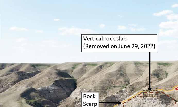
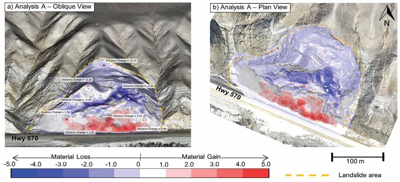
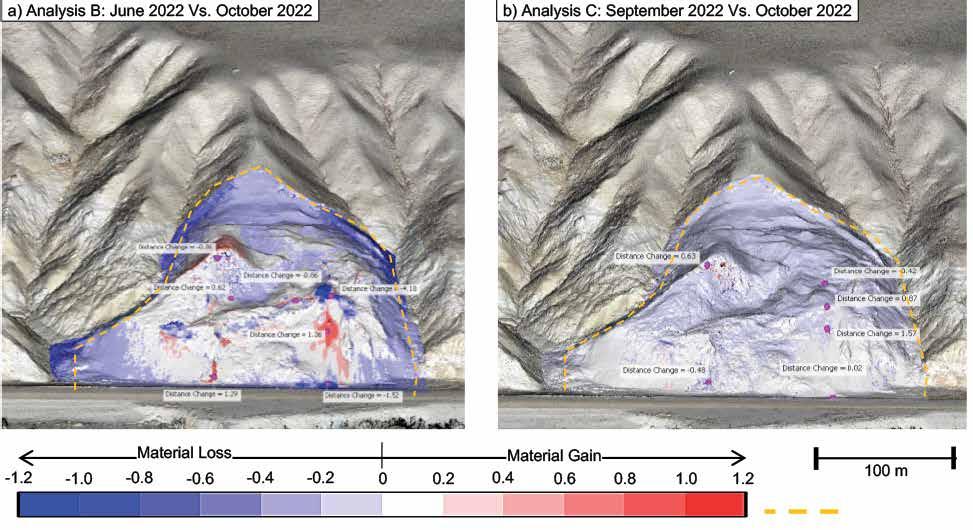
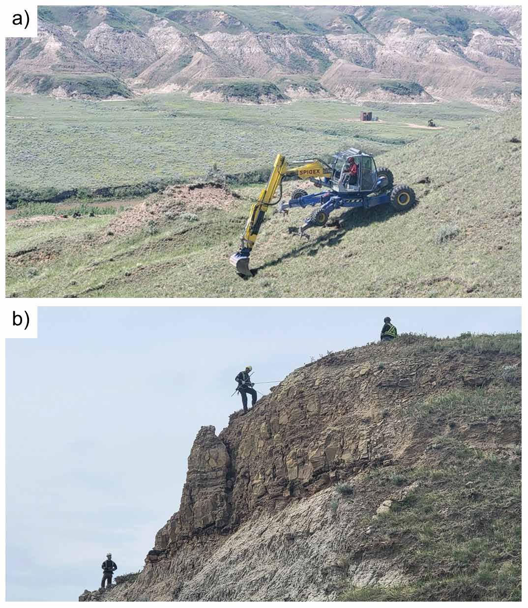
• My colleagues Chris Gräpel, Renato Macciotta, Kristen Tappenden, Tony Penney and I present an article that discusses the geotechnical challenges faced on Alberta’s Highway 570 due to a deep-seated landslide, detailing the assessment and mitigation measures taken.
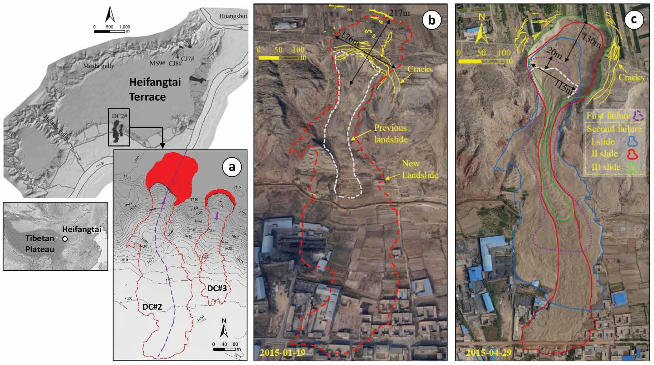
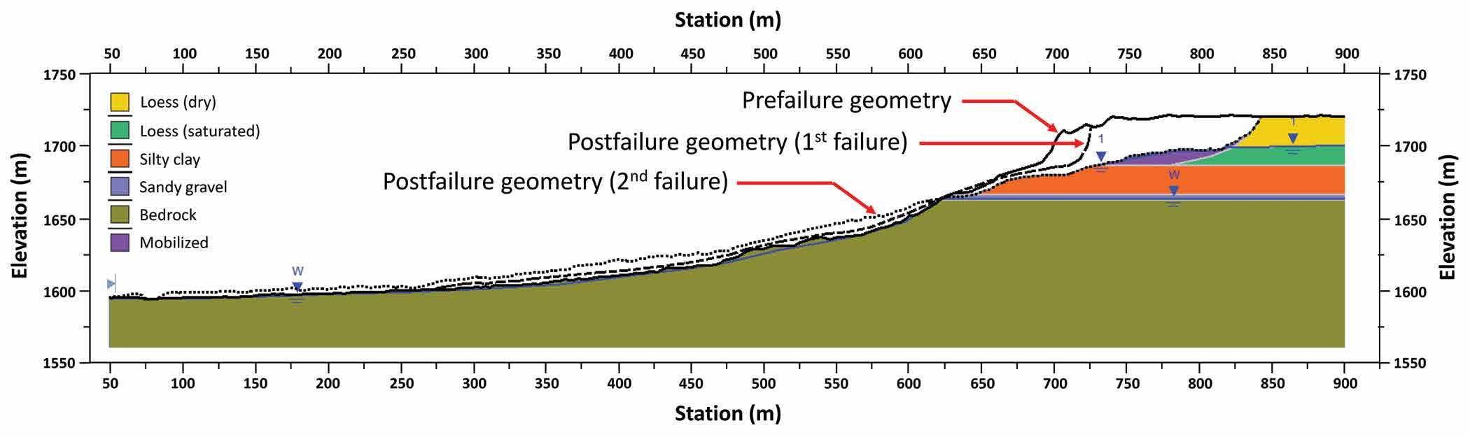
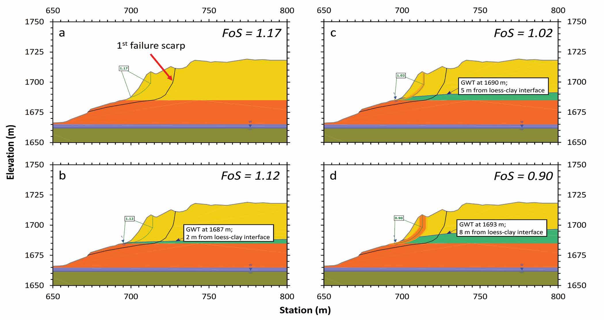
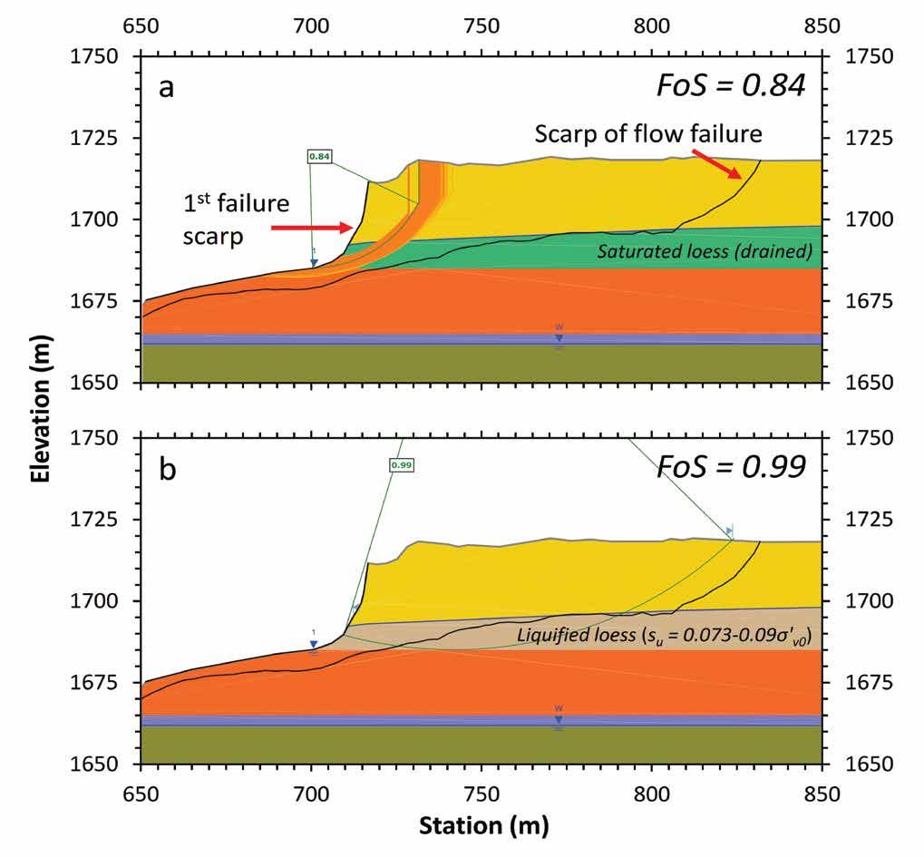
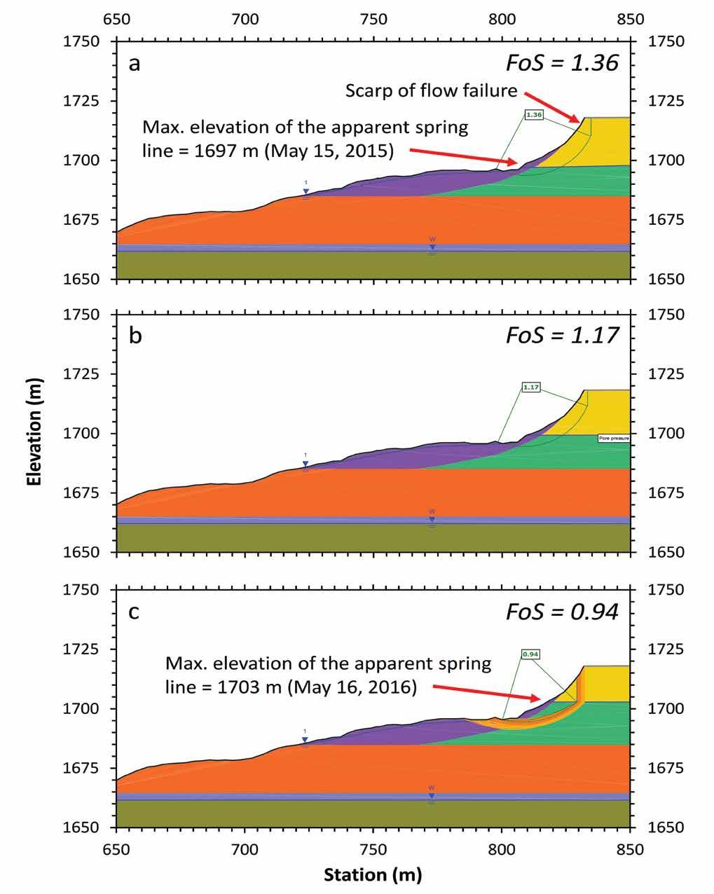
• Liming Zheng, Longde Jin, Andrew Fuggle, and Fangzhou Liu present an analysis of the triggering mechanism of a flowslide in loess that occurred in China on April 29, 2015. The study focuses on understanding the conditions leading to flow liquefaction and the subsequent failures.
• Sohrab Sharifi, Renato Macciotta, and Michael Hendry discuss the advancements and challenges of InSAR technology in geotechnical monitoring, emphasizing its potential for tracking
ground displacements with higher accuracy than traditional methods.
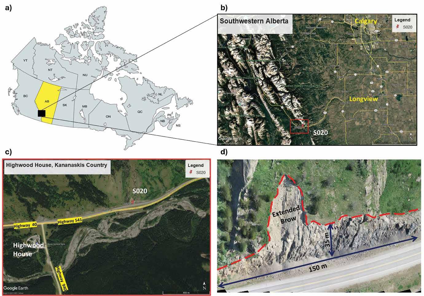
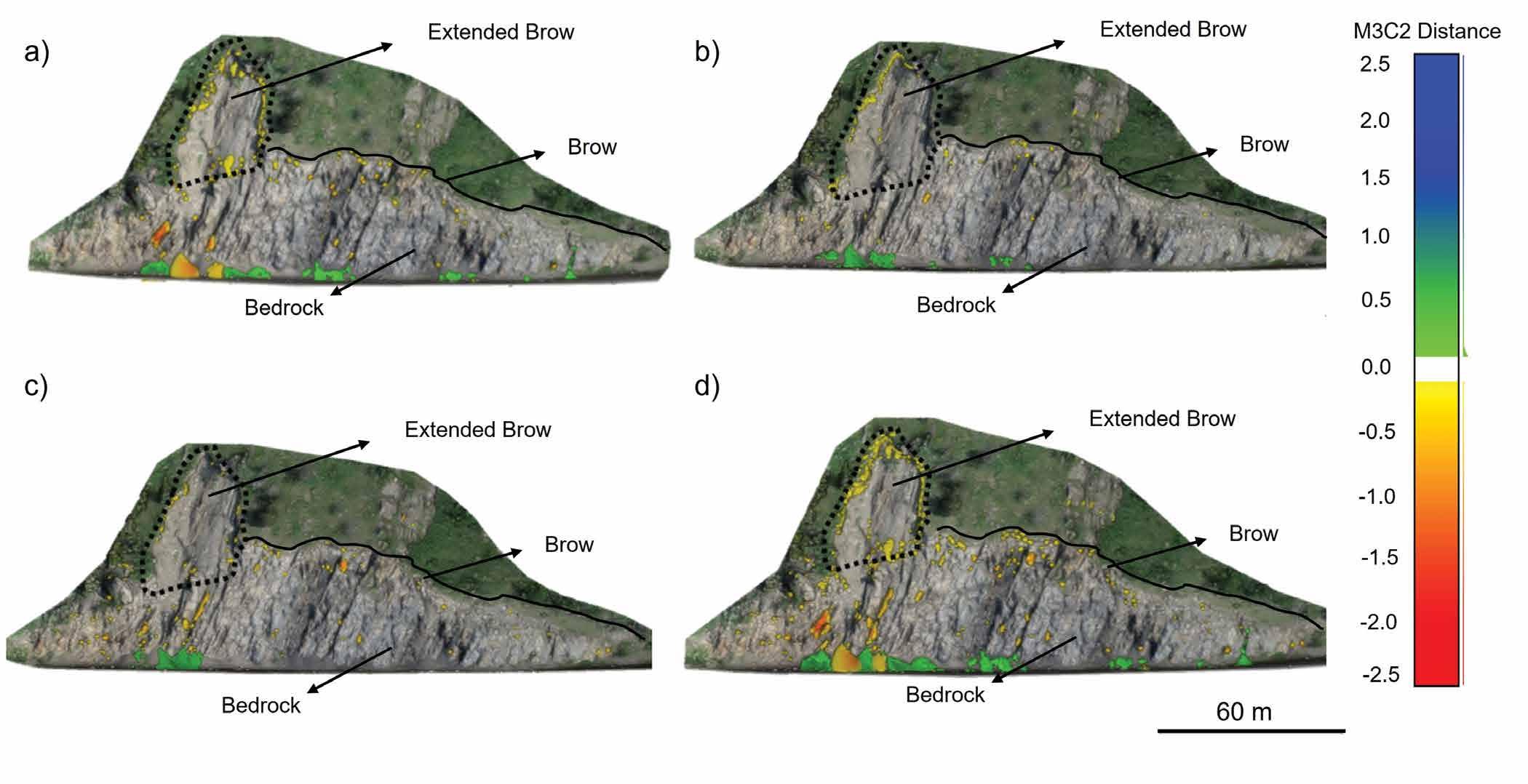
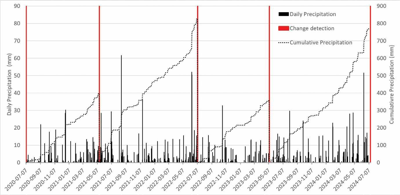
• Julian Solano, Renato Macciotta, Jorge Rodriguez, Chris Gräpel, and Kristen Tappenden also present an article discussing the implementation of remote sensing techniques using UAVs to monitor rockfall hazards along Highway 541 in Alberta.
ACKNOWLEDGEMENT
I want to thank all the authors and editors who took time out of their busy schedules to contribute to this special section and share their knowledge and expertise. I want to thank the Canadian Geotechnique team, including Dr. Nicholas Beier, Megan van Veen, and Lesia Beznaczuk. Special thanks go to Dr. Renato Macciotta for supporting this process.
Dr. Jorge Rodriguez is a geotechnical engineer with Klohn Crippen Berger in Edmonton. He holds a Ph.D. and M.Sc. in Geotechnical Engineering from the University of Alberta, as well as a B.Sc. in Civil Engineering from Colombia. His areas of expertise include slope stability design, rockfall hazard assessment and mitigation, and the use of innovative monitoring technologies like GNSS monitoring networks, low-cost UAVs, and Terrestrial-LiDAR.
33 YEARS AND COUNTING: THE CANADIAN CONFERENCE ON GEOTECHNIQUE AND NATURAL HAZARDS
As awareness of the impacts of hazards on populations and infrastructure continues to evolve, it is anticipated that the geohazards conference series will continue to add new thematic areas for discussion.
In 1992, the Vancouver Geotechnical Society (VGS) and the Canadian Geotechnical Society (CGS) hosted the First Canadian Symposium on Geotechnique and Natural Hazards as the theme for the annual VGS Symposium. This meeting was held May 6–9, 1992, and consisted of two days of singlesession presentations (Wednesday and Friday) — separated by a 1-day field trip (Thursday) — followed by a panel discussion on the Saturday morning. Although this event was entitled “the first”, denoting the beginning of a series, there were no further formal national gatherings of Canadian geohazards practitioners until 2000.
In 2000, to mark the closing of the International Decade of Natural Disaster Risk Reduction
(IDNDR), the Engineering Geology Division of the CGS, in conjunction with the Geological Survey of Canada and Emergency Preparedness Canada, organized the Canadian Workshop on Geotechnique and Natural Disasters. This workshop was held in Montreal, immediately following the 2000 Canadian Geotechnical Conference, and consisted of a single session of invited presentations from prominent Canadian geohazards practitioners. This event was not termed “the second” and there were no further discussions at the meeting regarding whether a “third” event should follow.
In 2001, the Engineering Geology Division of the CGS approached the Geotechnical Society of Edmonton with the concept of formally initiating the “series” of national geohazards
conferences by deliberately naming the conference as “the third” and agreeing on a host for the subsequent conference at the event. At this time, the concept for a two-day, single-session conference was set and the Third Canadian Conference on Geotechnique and Natural Hazards was hosted in Edmonton in June 2003.
Since then, this series has continued to thrive and is held every 3–5 years, alternating between eastern and western Canada at the following cadence:
• Quebec 2008
• Kelowna 2011
• Kingston 2014
• Canmore 2018
• Quebec 2022
Corey Froese
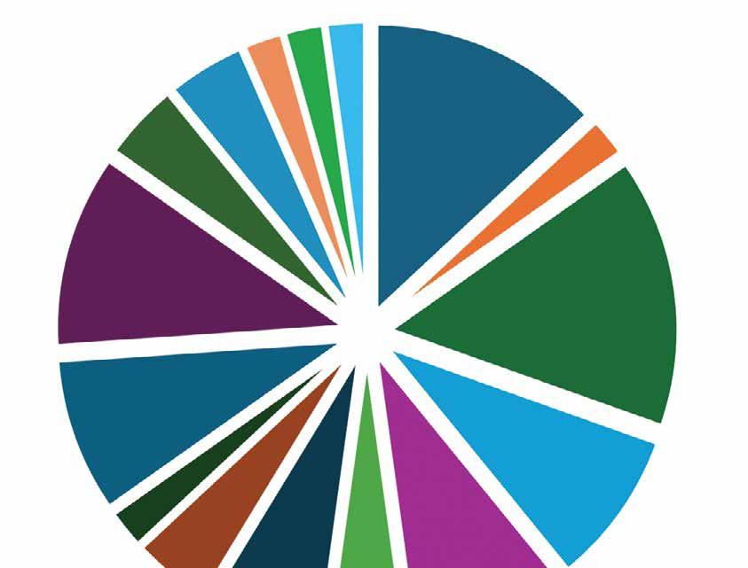
Although the series was organized by the Canadian Geotechnical Society, there has always been a targeted focus on engaging applied earth science professionals across Canada to discuss the current state of risk management for the wide range of hazards encountered in Canada. This is evident in the subjects of the keynote addresses shown below.
In addition, as new insights and techniques have continued to evolve through these 33 years, the key thematic areas for the conference presentations have continued to evolve. The table below provides a list of the topic areas discussed over the series.
As awareness of the impacts of hazards on populations and infrastructure continues to evolve, it is anticipated that the geohazards conference series will continue to add new thematic areas for discussion.
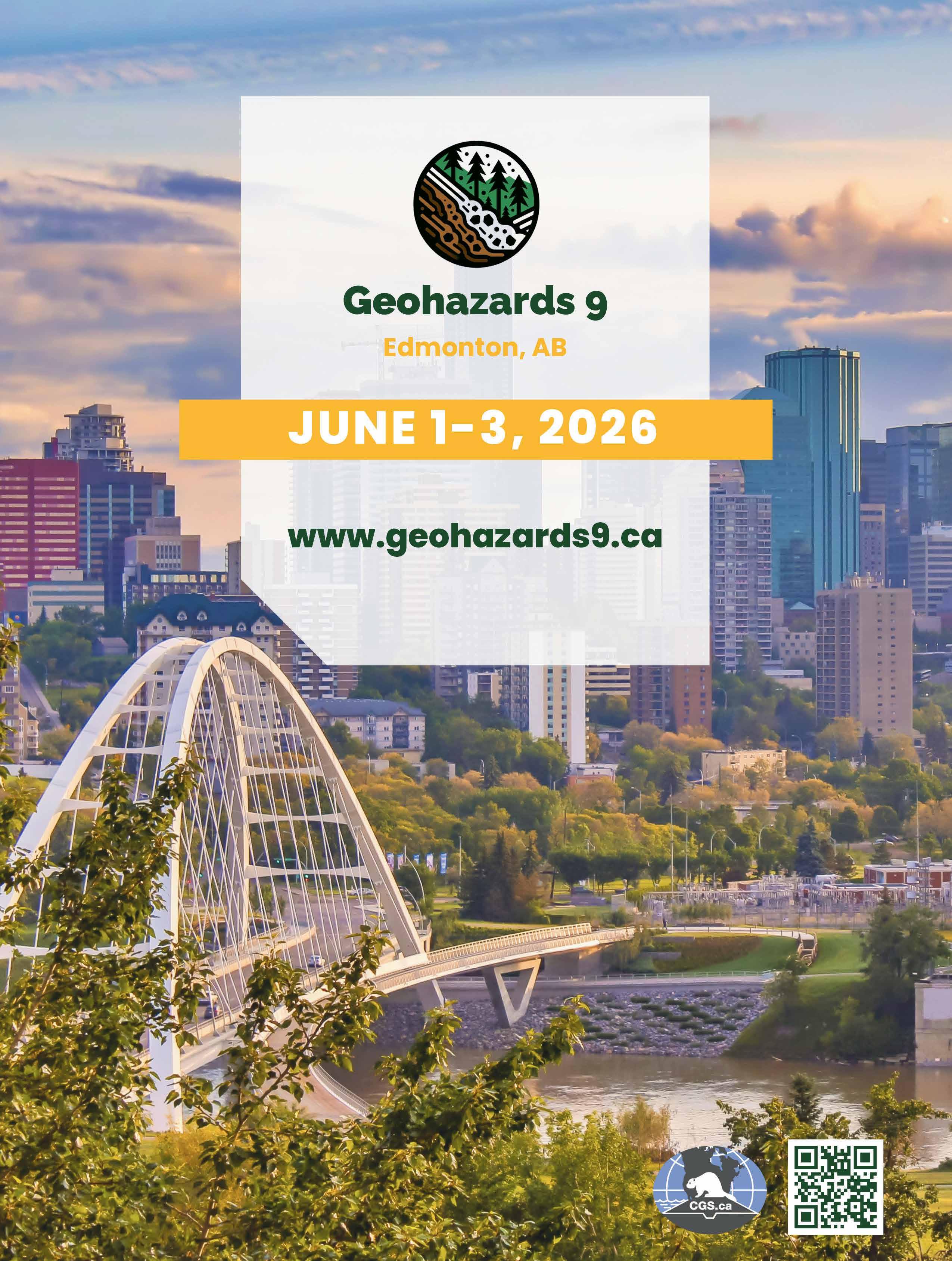
As a continuation of this series the Geohazards Committee of the CGS and the Geotechnical Society of Edmonton are pleased to announce that the 9th Canadian Conference will be held in Edmonton between June 1 and 3, 2026. It is expected that the meeting will continue with the tradition of bringing together a wide range of not only applied earth science professionals, but also those directly affected by hazards and their impacts. More details to come at wwwgeohazards9.ca
Corey Froese is the Principal Geological Engineer with Wavelength Advisory Services in Edmonton, Alberta, and has over 31 years of experience in
Risk Assessment, Policy, and Planning
Seismic Hazards
Volcanism
Risk Management Practice
Landslides
the field of geological hazard risk management and decision support across North American and Europe. Corey has been actively involved with the Canadian Geotechnical Society and Geotechnical Society of Edmonton for over 25 years in the capacity as GSE Student Member (1997/1998), Chair of the CGS’s Engineering Geology Division (1999–2002) and Landslide Committee (2008–2012), technical chair of the 2003 Geohazards Conference, Technical Chair of the 2008 CGS Conference, and Chair of the 2012 International Symposium on Landslides. Corey has also been honoured by the CGS with both the 2003 A.G. Stermac Award and the 2010 Canadian Geotechnical Colloquium. Corey will co-chair Geohazards 9 in Edmonton in June 2026.
Landslide Dams
Snow and Ice Hazards
Sensitive Clays
Tsunamis
Debris Flows and Steep Creek Hazards
Flooding Emerging Hazards
Techniques and Methods
Hazard Assessment and Inventories
Forestry and Alluvial Fans
Dams and Reservoirs
Mining
Induced Seismicity
Mitigation
Transportation
Climate Controls and Change
Modeling and Analysis
Coastal Areas
Linear Infrastructure
Multi-Hazard
Permafrost
Glacial Lake Outburst Floods
Rockfall
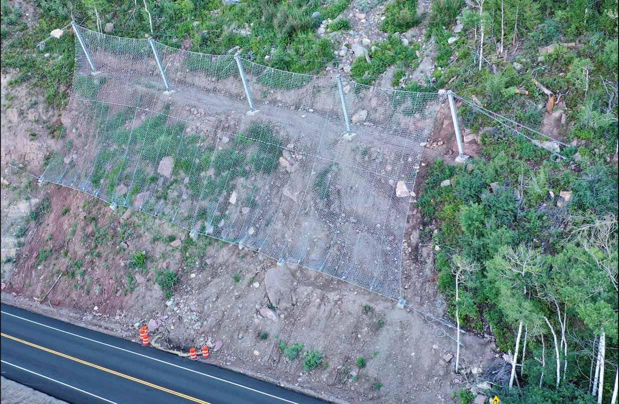
MINTURN ROCKFALL HYBRID SYSTEM: AN EVOLUTION OF AN ATTENUATOR
Bichler and Matthew Tello
BACKGROUND
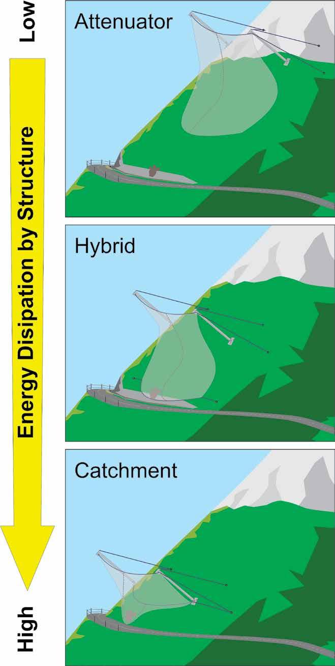
The generic term “rockfall fence” typically refers to several styles of structures made from steel cable nets that are supported by bearing ropes strung between lateral anchors and which are connected to steel posts. Rockfall fences are common tools for mitigating the effects of rockfall on elements at risk, such as buildings, roadways, railways, and utility corridors. There are three basic styles of fence: catchment fences, attenuators, and hybrids (Ortiz et al. 2022) (Figure 1).
The combination of a steep slope, close proximity to the highway, and limited catchment area made the Minturn site a good fit for this novel approach to a rockfall fence.
Catchment Fence
A rockfall catchment fence consists of an interception structure installed along a slope. The net forms a plane that is perpendicular to the falling direction of debris. The rockfall impact energy transfers through the net, ropes, and posts to anchor points whereby plastic deformation of the components (e.g. the nets and brake elements) dissipates energy and lowers the forces experienced at the anchors.
The total energy of the impact is stopped in the net at the location of the catchment fence.
Attenuator
An attenuator has a net supported only by upper bearing ropes whereby the net tail hangs past the foot of the post, either parallel to the slope or free-hanging. There are rarely any energy brake elements incorporated. Instead, falling debris is controlled through the weight, properties, and geometry of the net.
As there is no sealed lower boundary of the tail, debris is free to exit the system and the material is not caught, but rather controlled. Energy dissipation is highly variable and typically only a fraction of the initial impact energy (Bichler et al. 2022). Such systems require a secondary structure, whether that be a catchment ditch, fence, or sufficient run-out zone.
Hybrid System
A hybrid system has characteristics of both an attenuator and a catchment fence. The nets
are strung between posts supported by an upper and at least one lower bearing rope. The net can be parallel to the slope or vertical and extend past the post foot. Brake elements are often used to dissipate energy. Energy dissipation is designed to be significant, e.g., >70% (Bichler and Stelzer 2012). The debris continues through the system, interacting with the net and is caught by the lower bearing rope.
For hybrids, the total energy of the falling debris is dissipated by the system in combination with ground contact. The falling debris is caught at a position more favourable for cleanout.
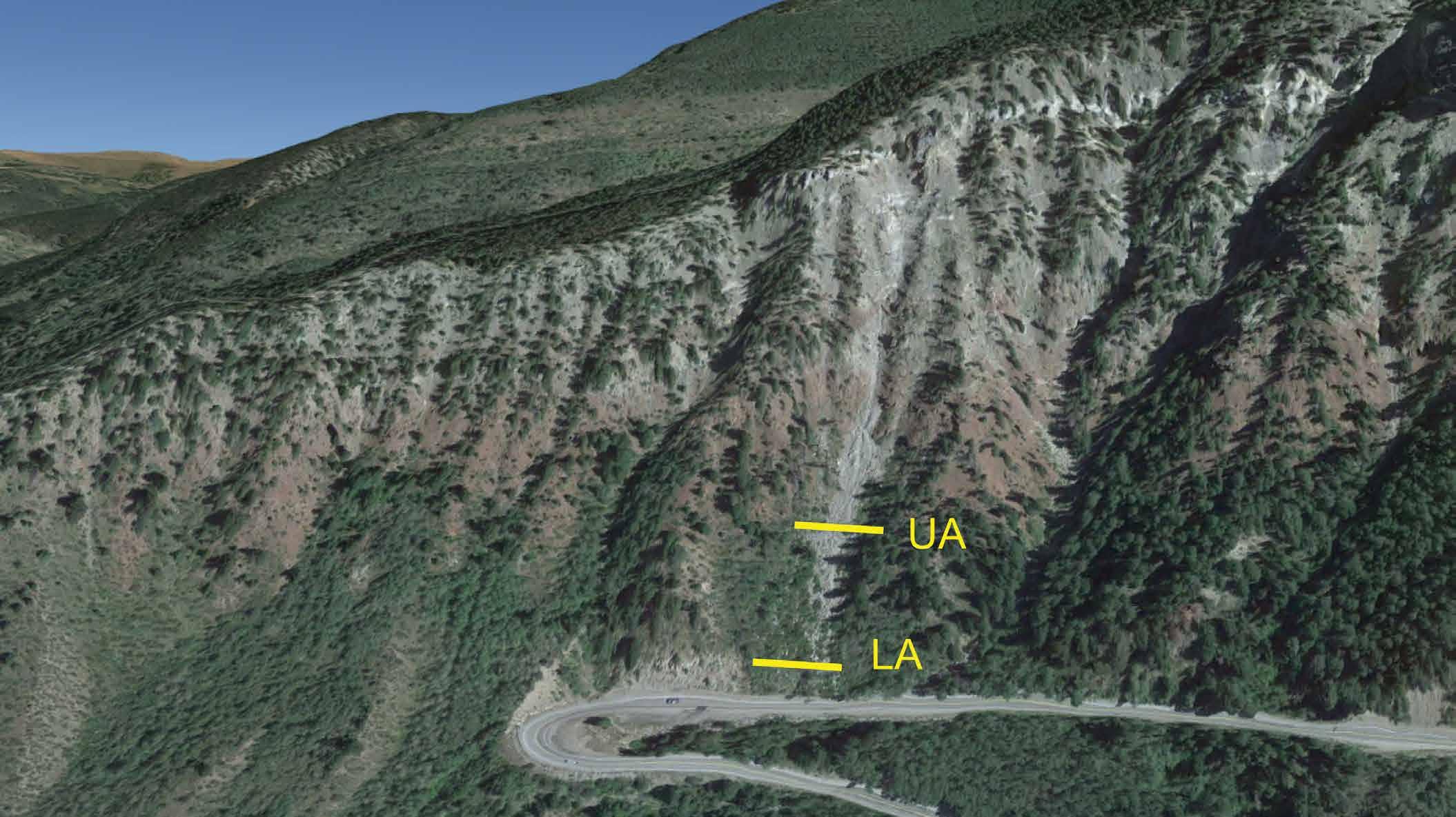
MINTURN SITE
The case study is located on US Highway 24 at Tennessee Pass, approximately 6 km south of Minturn, Colorado. The highway is considered a scenic route running between Minturn and Leadville, providing access to Pike and San Isabel National Forests and the Continental Divide Trail. The site is under the jurisdiction of the Colorado Department of Transportation (CDOT).
The slope above the highway has produced several massive rockfall events and has required continued maintenance, mitigation, and monitoring over the last decade and a half. The rockfall initiation zone is composed of interbedded sandstones, conglomerates, and shales and lies approximately 335 m above
Ahren
Figure 1. Schematic showing the differences and relative energy dissipation of three styles of rockfall fence (modified from Bichler and Stelzer 2012).
the roadway on a 60° slope. The slope can be divided into several hazard zones where the dominant mechanism for rockfall is freeze–thaw or heavy rainfall.
Two of the hazard zones have already failed or been mitigated and are now deemed low risk. What remains is a slowing-moving mass, as well as other loose blocks throughout the slope and along the ridgelines buttressing a chute. The chute is directly upslope of the highway, immediately adjacent to a hairpin turn, and is considered a high-risk area (Figure 2).
The CDOT Geohazards Program has since implemented several monitoring campaigns starting in 2015, which include the use of extensometers, LiDAR, photogrammetry, and change detection. The early-monitoring campaign captured several smaller rockfall displacements throughout the chute, two prominent debris slides (50 –100 m3) and 5–15 cm of displacement of the source area mass. The most recent change detection survey (2023) indicates that the source area rock mass is moving at approximately 5 cm/year.
Several historic events are noted at the site between 2000 and 2007, though little information is available regarding their size
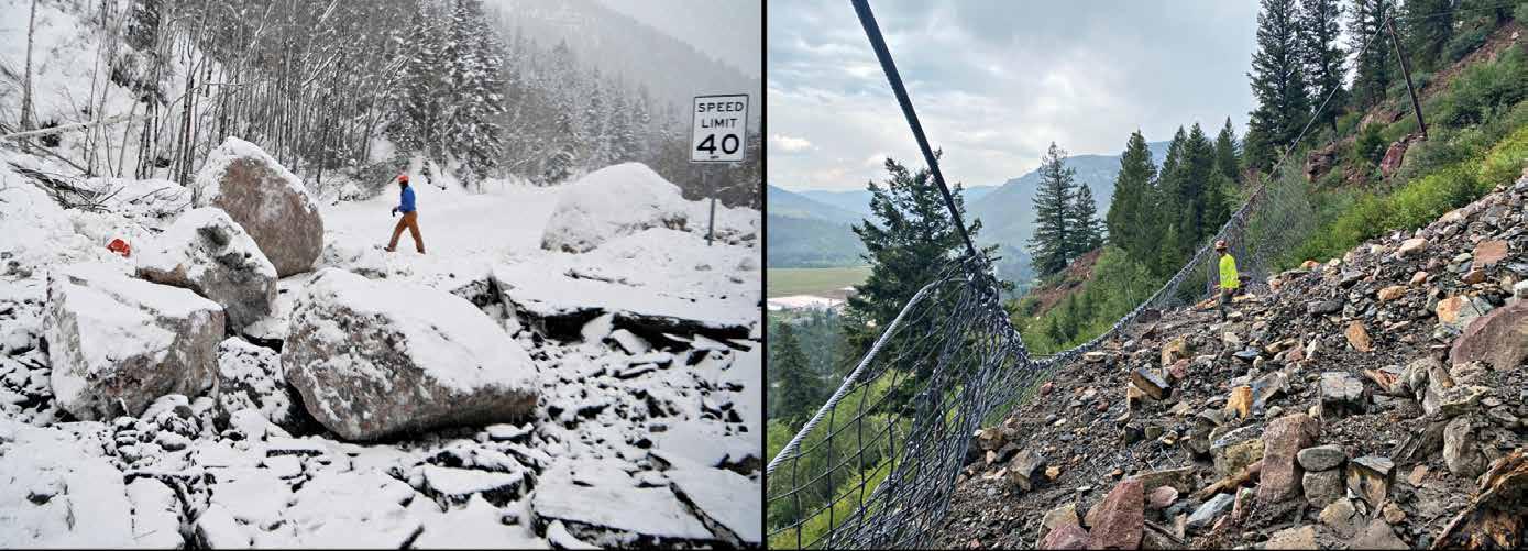
and extent. In January of 2009, a significant event occurred where an approximate 17 m3 block, as well as smaller debris, impacted the highway (Figure 3). Subsequently, in December 2014, a similar event occurred that damaged a couple of vehicles, luckily with no injuries, and damaged the highway, causing extended closures and requiring pavement repairs. Approximately $500,000-600,000 USD were spent on maintenance following the 2014 events.
The 2014 rockfall events, coupled with the monitoring campaign data, prompted the CODT Geohazards Program to implement mitigation at the site. The mitigation consisted of rockfall attenuators at two locations
(Figure 2). Both fences comprised ½" steel cable nets with a unit weight of approximately 6 kg/m2 supported by 1" diameter bearing ropes and 7.5 m posts. The cable nets extended 12 m below the upper bearing rope. Each system was approximately 50 m wide. Construction was carried out in March 2015 at a cost of approximately $460,000 USD.
Following the installation – in 2018, 2019, and 2021, debris flow and rockfall avalanche events impacted the upper attenuator with no maintenance carried out in between (Figure 3). Where typically, it is desired that the debris exit the tail of the system; in this case, the material was trapped beneath the tail and remained on the slope, filling the system.
Figure 3. Rockfall events from 2014 (left) impacting road and 2021 (right) that filled the upper attenuator.
SPECIAL SECTION: GEOHAZARDS
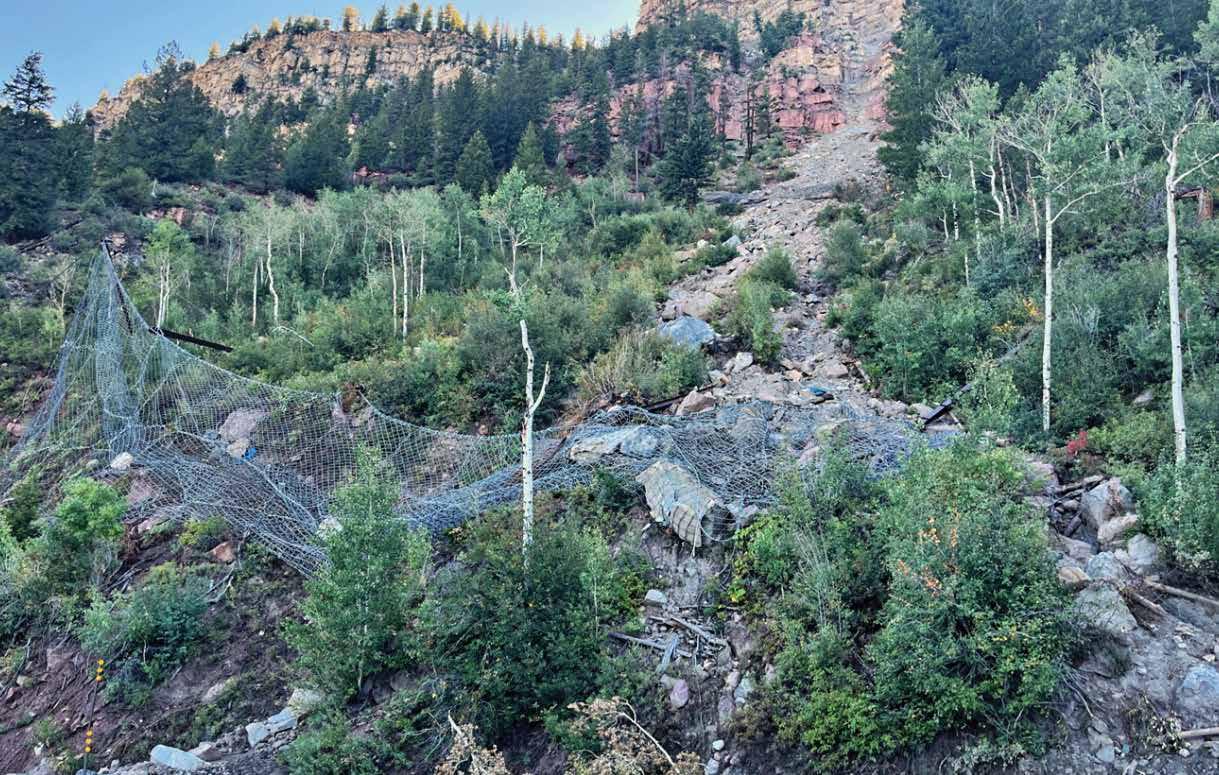
In August 2022, another major event occurred that completely destroyed both the upper and lower attenuators. Regarding the lower system, four of the five posts were dislodged or broken, and the net lay on the ground entangled with the debris (Figure 4). Debris from the event made it to the road but caused no damage. The attenuators were subsequently removed, and focused scaling was carried out for approximately $150,000 USD.
NEW MITIGATIONS
In 2023, a decision was made to replace the lower attenuator with a new style of system. The basis for the design was a full-scale tested 6000 kJ attenuator that was developed for the Kicking Horse Canyon Project, located in British Columbia. In the case of the CDOT project, the attenuator was adapted to function like a hybrid system with knowledge obtained from previous attenuator and hybrid testing.
KICKING HORSE CANYON SYSTEM TEST
The design of the highway improvements for the Kicking Horse Canyon Project involved using attenuators to help mitigate the effects of rockfall. In the tender process, it was stipulated that a system with a 6000 kJ capacity would be required. However, no such product was available on the market.
The attenuator was to have a Maximum Energy Level (MEL) capacity of 6000 kJ but should be tested for two impacts at a Service
Energy Level (SEL) of 3000 kJ. Furthermore, it must withstand 12 impacts of 1500 kJ without major repair. In response, Trumer Schutzbauten GmbH carried out testing on a newly designed system (TSA-6000-ZD) at test facilities in Austria and Germany (Bichler et al. 2022).
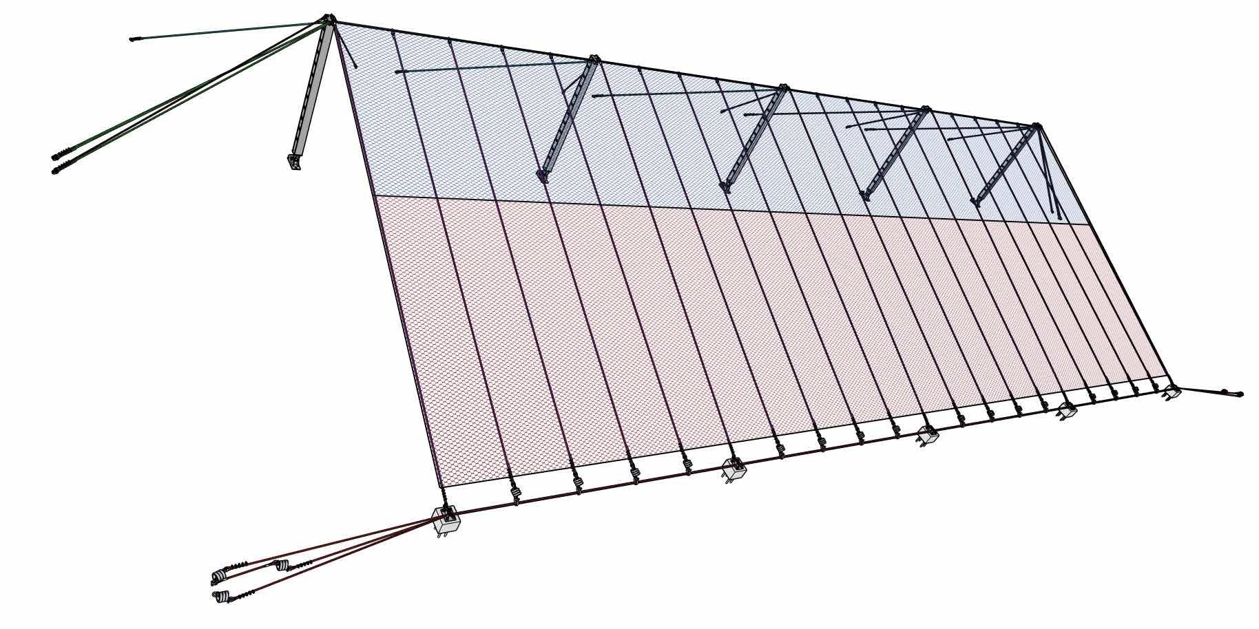
The attenuator consists of 6 m high posts with a double upper bearing rope of 24 mm steel wire rope. The head of the post is
supported by two 24 mm retaining ropes. None of the ropes have brake elements.
Two types of nets were hung from the bearing ropes. The upper 6 m (the impact zone) has an Omega-Net 10.5/180, which is a 10.5 mm steel cable net with a unit weight of 10.5 kg/m2. The lower 12 m tail section of the net consists of Omega-Net 9.0/185, which is a 9.0 mm steel cable net with a unit weight of 6.8 kg/m2. A secondary layer of high tensile
Figure 4. 2022 event that destroyed the lower attenuator.
Figure 5. Schematic showing the design of the modified attenuator.
mesh, Sigma 50/3.2 with a unit weight of 2.75 kg/m2, was applied.
The attenuator was ultimately tested with two impacts of more than 6500 kJ (thereby fulfilling both the MEL and SEL requirements) and 13 impacts with an average of approximately 2700 kJ.
CDOT HYBRID ADAPTATIONS
The TSA-6000-ZD was modified for this project to function like a hybrid system. These modifications were based on knowledge gained from previous testing. The goal was to provide a system that acts like an attenuator, but will stop large debris from reaching the road level since there is not a sufficient catchment area.
The primary difference is the incorporation of vertical ropes and lower bearing ropes that have brake elements to help dissipate energy (Figure 5).
Vertical ropes (24 mm diameter) between posts were installed approximately every 2.4 m. These ropes are attached to the static, upper bearing rope set, which consists of three 24 mm ropes. At its lower end, it is attached to a brake element, which is, in turn, attached to the bearing rope set (also three 24 mm ropes). In this way, all brake elements that typically require replacement after large events are located only at the lowest part of the system.
Vertical ropes from the post head are attached to hybrid base plates directly, using no brake elements, and are tensioned. This helps lift the nets away from the slope to reduce build up.
The lower bearing ropes are not attached to the nets directly. They are led from the brake elements at the lateral positions through detachable hybrid base plates and the brake elements of the vertical ropes. At Minturn, the hybrid base plates are elevated from the ground level to help promote the movement of small debris beneath the net while maintaining the catchment of larger debris.
The upper bearing ropes and retaining ropes are all static, meaning they do not have brake elements and so experience minimal elongation.
During an impact on an attenuator, the tail of the net is heaved vertically in an uncontrolled manner. The block is then deviated through the weight of the net along with frictional forces. In the case of this hybrid design, the displacement of the net is controlled by the expansion of the brake elements from the lower bearing rope set
and vertical ropes. The result is a much stronger deviation of the falling body, which redirects the block towards the slope.
A 50 m wide system with 7.5 m high posts was installed in the summer of 2024 (Figure 6). The project included significant scaling measures as well as the installation of the fence at a cost of approximately $800,000 USD, of which approximately $115,000 USD was for the superstructure. It is further planned to rebuild the upper attenuator using salvaged material from the damaged lower attenuator.
SUMMARY
The combination of a steep slope, close proximity to the highway, and limited catchment area made the Minturn site a good fit for this novel approach to a rockfall fence. At the time of writing, no impacts have yet been observed, but given the history of the site it will be bound to happen in the near future. Further testing of this style of system is planned, to help better understand how attenuators can be modified into hybrid systems to provide a higher level of safety while at the same time providing easier maintenance than traditional rockfall catchment fences.
REFERENCES
Bichler, A., and Stelzer, G. 2012. A Fresh Approach to the Hybrid/Attenuator Rockfall Fence. In International Symposium on Landslides 2012 Proceedings. Bichler, A., Stelzer, G., and Hamberger, M. 2022. Experiences with testing procedures for rockfall attenuators, In Geohazards 8 Proceedings
Ortiz, T., Polak, S., and Bichler, A. 2022. Rockfall attenuator systems 101 – current state of practice, applications and future needs. In Slope Stability 2022 Proceedings
Ahren Bichler, M.Sc., is the General Manager of Trumer Schutzbauten Americas Ltd. and is the past-president of the Association of Geohazard Professionals.
He is a Quaternary geologist who has worked with natural hazards for more than 20 years in Canada, the United States, South America, Australia, New Zealand, Germany, and Austria. He received a M. Sc. in Earth and Ocean Sciences from the University of Victoria.
Matthew Tello, M.S., P.G., E.I.T., is an Engineering Geologist for the Geohazards Program at the Colorado Department of Transportation (CDOT) in Denver, Colorado. His current practice focuses on improving highway safety by managing and mitigating geologic hazards across Colorado along transportation corridors. He received a B.S. in Geology from Western State Colorado University and a M.S. in Geological Engineering from Colorado School of Mines.
Figure 6. Completed installation of the hybrid system.
GEOTECHNICAL CHALLENGES ON ALBERTA’S TRANSPORTATION CORRIDORS: MITIGATION RESPONSE ON HIGHWAY 570 LANDSLIDE
Jorge Rodriguez, Chris Gräpel, Renato Macciotta, Kristen Tappenden, and Tony Penney
INTRODUCTION
Transportation corridors in Alberta pass through regions with varied geological features. In the East Central Plains, highway networks cross the badlands, a semi-arid area characterized by highly erodible slopes along the Red Deer River (RDR) valley. Alberta Transportation and Economic Corridors (TEC) has 13 active landslide sites that have historically impacted highway infrastructure due to weathering or landslide activity along the RDR valley (Government of Alberta 2023). Active landslides are inspected annually as part of TEC’s Geohazard Risk Management Program, to assess the risk posed to highway safety and efficiency, and to prioritize sites for maintenance interventions or capital repairs. On May 31, 2022, a site inspection tour conducted by Klohn Crippen Berger Ltd. (KCB) and TEC identified a deep-seated landslide on Highway 570:01, observing backscarps, ground cracks, and highly weathered rock blocks that were at risk of rockfall. As a new geohazard site with an unknown history, TEC retained KCB to undertake a site assessment that included collecting background information, historical aerial photos and LiDAR data, as well as conducting four UAV surveys to evaluate landslide activity, culminating in a rapid response to remove an unstable rock block above the highway.
HIGHWAY 570 LANDSLIDE
Highway 570 is a paved, two-lane highway near Drumheller in south-central Alberta. The highway was constructed over a former railway line, which was operational from 1911 to 1983 (FJHS 2022). Along an approximately 250 m length of highway, the height of the backslope rises 110 m above the roadway, while the active zone reaches a vertical height of 85 m, as shown in Figure 1. The slope angle varies at three sections: the backslope is angled at 29° from the toe to 35 m above the highway, the middle section is angled at 20° from 35 to 67 m above the highway, and from 67 to 85 m above the highway, the backslope
angle is 9°. Additionally, a 31 m rock scarp with a 52° angle is located on the west side of the backslope. The backslope is bounded by two gullies 20 m apart at the top and 264 m apart at the toe, with a slope angle of about 30° (see Figure 1).
A review of surficial geology maps indicates the presence of mainly colluvial deposits, which may encompass bedrock, till, glaciolacustrine, glaciofluvial, and eolian sediments, generally poorly sorted (Fenton et al. 2013). The bedrock stratigraphy is composed of horizontally bedded sandstone, siltstone, bentonite, mudstone, and coal seams (Prior et al. 2013). Weathering processes are linked to geology and the presence of dispersive soils that cause rill erosion, deep gullies, sinkholes, and runoff marks with tunnel erosion features. Intensified by precipitation, water seepage, ice, and snowmelt, these processes lead to differential rock disintegration. Failed material at the toe
of the backslope includes fine-grained soils in two talus fans, part of the slope bulging toward the highway indicative of deep-seated sliding, and cobble- to boulder-sized angular particles at various locations.
GROUND SURFACE INFORMATION
A review of historical aerial photos from Alberta Environment and Parks, spanning from 1950 (Figure 2a) to 2005 (Figure 2h), revealed a railway line that existed along the toe of the slope in 1950 (Figure 2a) and the construction of a highway that occurred between 1981 (Figure 2d) and 1986 (Figure 2e). The aerial photo scale does not allow for determining whether highway construction excavated the natural valley slope; however, slope deformation appears before the highway was built. The earliest evidence of cracking and deformation dates back to 1963 (Figure 2b), with multiple tension cracks noted in the 1975 photo (Figure 2c). A discussion with one of TEC’s
Figure 1. Panoramic view of the Hwy 570 landslide from June 2, 2022.
retired Maintenance Contract Inspectors revealed that the “pad” of fill on the south side of the highway was a former ridge used as borrow material to construct the railway embankment and highway. The railway made a double cut through the ridge, and fill borrowing reduced it to its current level south of the highway. The 1963 (Figure 2b) and 1975 (Figure 2c) photos show the development of tension cracks resulting from landslide displacement, suggesting that failed material from the backslope was removed and placed at the “pad” across the highway.
To assess the level of activity at the site, KCB acquired commercially available LiDAR data from October 28, 2007. This dataset was captured at an altitude of approximately 1820 m and featured a point spacing of 2.0 m, with horizontal accuracy of ±50 cm and vertical accuracy of ±30 cm. Generally, high-quality LiDAR survey data are more reliable, especially in densely vegetated areas, compared to UAV survey data. However, UAV surveys leveraging photogrammetry have emerged as a cost-effective and swift solution, suitable for challenging locations or regions with sparse vegetation. On June 2 and June 10, 2022, the project team performed UAV photogrammetry surveys to quickly assess the site’s activity level. This also provided an opportunity for all parties involved to visually examine deformations and critical regions on the predominantly unvegetated slope. Following the implementation of short-term mitigation efforts involving rock scaling, KCB conducted additional UAV surveys on September 15 and October 28, 2022.
The four UAV surveys used a DJI Mavic 2 Pro to capture oblique photographs of the ground surface, enhanced by ground control points (GCP) and scale references. The 2022 UAV surveys were conducted at altitudes ranging from 50 to 110 m above the landslide crest. The June 2 UAV survey originated from the highway, in contrast to the other three surveys, which were initiated from the upper plain. Each survey included approximately 1,000 photos with a Ground Sampling Distance of 2.4 to 3.1 cm/pixel. The digital photogrammetric reconstruction provides XYZ point cloud data of the site. The reconstruction for the September 15 and October 28 surveys was corrected with surveyed GCPs, while the June surveys referenced the September 15 survey. The average root-mean-square error for the GCP in northing, easting, and elevation coordinates ranged from 8 to 20 mm.
LANDSLIDE AND ROCKFALL HAZARD ASSESSMENT
A review of the data gathered for the site showed historic tension cracks high above
the slope’s brow, which suggested that the slope is failing due to deep-seated sliding, likely along a weak plane in the bedrock. While the exact depth of the failure plane is
Figure 3. Ground surface changes after 15 years, analysis “A”: (a) results shown in oblique view; (b) results shown in plan view.
SPECIAL SECTION: GEOHAZARDS
unknown, it was inferred to be near-horizontal, based on the cracking and displacement patterns observed at the slope’s crest and toe. Moreover, the absence of distress on the paved highway surface may indicate that the failure plane’s toe is either just below the highway level or slightly above it, concealed by talus. The differential weathering susceptibility of the slope materials has left some blocks of bedrock on the mid slope, posing a rockfall hazard to road users. Disaggregated material and rock blocks that had previously detached were noted in the ditch and across the highway during the initial inspection. Although the ditch captured most rockfall, the accumulated debris has filled much of the catchment ditch at the backslope’s toe, obstructing proper ditch drainage and causing water to pond.
During the initial assessment, change detection analyses of point cloud data from surveys were completed to evaluate the landslide’s activity. Three analyses were conducted:
• Analysis A: Comparison of the October 28, 2007, LiDAR point cloud with the October 28, 2022, UAV survey. Analysis “A” estimated the displacement over 15 years (see Figure 3). Results show minimal change in landslide extent; however, mid-slope areas indicate typical translational slide failure, with the upper section exhibiting a downslope displacement of approximately 3.0 m and the slope toe showing a bulging displacement of up to 4.0 m.
• Analysis B: Comparison of the June 10, 2022, UAV survey with the October 28, 2022, UAV survey to quantify changes after rock scaling activity (see Figure 4a). No significant displacements were noted in areas without rock scaling within a ±0.4 m change.
• Analysis C: Comparison of the September 15, 2022, UAV survey with the October 28, 2022, survey to assess short-term erosion and sliding over 43 days (see Figure 4b). Post-rock scaling analysis found no significant displacements across most of the landslide area, though small areas (less than 5 m²) with rock scaling continue to erode into the backslope.
The level of detection from the three analyses ranged from 0.1 to 0.4 m. Results showed significant noise at the active zone edges, including areas that were expected to be stable, as illustrated in Figure 4a. Two factors contributed to this noise in the June 2022 UAV survey results: lack of GCPs and the difficulty of filtering dense vegetation in the gullies.
Figure 4. Ground surface changes in 2022: (a) results from before rock scaling activities, analysis “B”; (b) results after rock scaling activities, analysis “C”.
Figure 5. Rock scaling work: (a) spider excavator accessing route through the east side gully; (b) rope-access crew on the rock slab on the east side.
RISK MITIGATION MEASURES
The initial assessment did not reveal recent overall movement; however, the presence of highly weathered rock blocks posed a safety concern for road users. Consequently, several mitigation measures were considered, including the installation of precast concrete barriers beside the highway, traffic warning signage, the removal of weathered rock blocks at the top of the slope, and cleaning the highway ditch to restore proper drainage. The rock block removal was accomplished using a “spider” excavator, which minimizes site disturbance compared to traditional equipment. This versatile excavator accessed the rock blocks by “walking down” the slope with its four extension legs. The site access path featured grades between 40% and 100%, which are too steep for conventional equipment, posing risks to site integrity and operator safety (see Figure 5a). Additionally, a rope-access crew trained in working on steep slopes assisted with the operations. Utilizing the spider excavator demonstrated the benefits of such adaptable equipment in difficult-to-access locations (see Figure 5b).
As part of ongoing risk management, the site has been added to TEC’s Geohazard Risk Management Program (GRMP) for recurring inspections on an annual basis or after significant precipitation events.
CONCLUSIONS
This project emphasizes the advantages of UAVs in quickly assessing geohazards with uncertain risks. While the Highway 570 landslide was first detected through an on-ground field inspection, UAV footage provided a fresh perspective on its extent and upper scarp. The aerial images revealed significantly weathered and fractured rock blocks at the summit of the backslope, posing a threat to highway safety. Nevertheless, reviewing historical ground deformation data was crucial to evaluate the landslide’s current condition and activity state. Additionally, employing UAVs for photogrammetric techniques proved to be an efficient and cost-effective means of gaining change-detection data. The precision of UAV surveys allowed for a quick quantification and localization of ground deformations both in the short term, within weeks, and over a long term of 15 years (when compared to historical LiDAR data). The UAV surveys also served as a quick method for assessing changes after rock scaling. Future UAV surveys will measure displacement magnitudes and
identify critical areas, thus aiding in activity assessment and enhancing risk management for highway safety. The mitigation process lasted just 29 days after identifying the hazard, encompassing response, setup, assessments, studies, permitting, contractor selection, and construction. Like UAVs, the spider excavator proved to be versatile equipment, facilitating access to challenging sites with minimal disruption.
ACKNOWLEDGEMENTS
This work was made possible by Alberta Transportation and Economic Corridors (TEC). The authors would like to acknowledge the support of the Highway Geohazard Research Program, a collaboration between the University of Alberta, KCB, and TEC, for providing additional resources and reviewing the work presented in this article. Also, the authors acknowledge the contribution of the rock scaling work by Emcon Services, the Prime Contractor; and sub-contractors BAT Construction Ltd., Spidex All Terrain Excavating Inc., and ATS Traffic.
REFERENCES
Fenton, M.M., Waters, E.J., Pawley, S.M., Atkinson, N., Utting, D.J., and Mckay, K. 2013. Surficial geology of Alberta. Alberta Energy Regulator, AER/AGS Map 601, scale 1:1 000 000.
Forth Junction Heritage Society (FJHS). 2022. Canadian Northern Railway in Central Alberta. Available at https://forthjunction.ca/ canadian-northern-railway.htm (accessed July 14, 2022).
Government of Alberta. 2023. Geotechnical and erosion control, landslide assessment, Reg-Central Region. Available at http://www. transportation.alberta.ca/PlanningTools/ GMS/Annual%20Landslides%20Assessments (accessed April 15, 2023).
Prior, G.J., Hathway, B., Glombick, P.M., Pană, D.I., Banks, C.J., Hay, D.C., et al. 2013: Bedrock geology of Alberta. Alberta Energy Regulator, AER/AGS Map 600, scale 1:1 000 000.
Jorge Rodriguez, P.Eng., is a geotechnical engineer with Klohn Crippen Berger in Edmonton. His areas of expertise include slope stability design, rockfall hazard assessment and mitigation, and the use of innovative monitoring technologies like GNSS monitoring networks, low-cost UAVs, and Terrestrial-LiDAR.
Chris Gräpel, M.Eng., P. Eng. is a Civil/ Geotechnical Engineer and Associate with Klohn Crippen Berger with 32 years of experience in dam engineering and geohazard engineering. His current practice area includes western and northern Canada, South America, and South Africa.
Renato Macciotta is an Associate Professor in the Department of Civil and Environmental Engineering at the University of Alberta. Renato has over 20 years of experience in geohazard management, including the investigation, monitoring, analysis, and remediation of natural and engineered slopes.
Kristen Tappenden ( kristen.tappenden@ gov.ab.ca ) is the Director of Geotechnical and Utilities Engineering at Alberta Transportation and Economic Corridors. Kristen has 20 years of progressive geotechnical engineering experience in the public, private, and academic sectors. In her role at TEC, Kristen leads a team providing expertise in the areas of geohazard risk and asset management, slope stability analyses and deep foundation design across a range of provincial infrastructure projects.
Tony Penney, P.Eng., is the Central Regional Administrator for Alberta Transportation and Economic Corridors.
BACK-ANALYZING THE TRIGGERING OF A FLOWSLIDE IN LOESS
Zheng, Longde Jin, Andrew Fuggle, and Fangzhou Liu
INTRODUCTION
Loess is typically a silt-sized soil, with a silt fraction of 70%–100%, that is bonded by various cementation agents, e.g., salt, water-film, carbonate, and clay. As a cemented soil, loess is problematic upon wetting as its metastable structure can transform rapidly from a cemented solid matrix to a fluidized material. The mechanism of loess flowslides has been ascribed to flow liquefaction, characterized by the sudden loss of strength with the development of large strains accompanied by increasing pore-water pressure under monotonic loading.
The Dangchuan (DC) #2 loess flowslide occurred on April 29, 2015, in the loess plateau of China, which provides an important case history to analyze the failure mechanism of flow failures in the Chinese loess. The main objective of this study is to analyze the triggering mechanism of the retrogressive DC#2 flowslide by back-calculating the shear strength and comparing it with the liquefied shear strength, s u(LIQ), at different failure stages with the factor of safety (FoS) of unity. This
analysis is needed for the quantitative understanding of the triggering of flowslides and can be applied to other intermediate soils.
LOESS FLOWSLIDES
The Heifangtai terrace is an arid loess terrace (area: ~12 km2) of the Yellow River in the loess plateau of China (see Figure 1); it consists of the Malan silty loess (thickness: 30–50 m), clay (3–20 m), and gravel (1–10 m) in sequence. The bedrock comprises sandstone with mudstone partings and the bedding plane dipping 135°<11°. The thickness of the exposed bedrock is greater than 70 m.
The field monitoring of the DC#2 flowslide indicated two failures occurred within 4 hours. The first failure appeared to be a more localized failure, and the second was a flowslide involving a much larger mass of material. The combined failures resulted in a retreat of the terrace surface for about 130 m with a runout distance of 789 m. The estimated total volume of the failure is 32.4×10⁴ m3. The ground markers placed behind
Liming
Figure 1. Study area and landslides along the margin of the Heifangtai terrace (HFT): (a) location and contour of the DC#2 and DC#3 flowslide (as of May 2016); (b) prefailure oblique aerial view of DC#2; and (c) post-failure oblique aerial view of the flowslide showing three sliding events for the retrogressive failure (after Qi et al 2018).
2. Simplified pre-failure geometry overlaying the approximate post-failure geometries of the first and flow failures of the DC#2 loess flowslide for stope stability back-analysis (location of the cross-section profile shown in Figure. 1a).
the scarp showed small cumulative displacements 3 months prior to the initial failure, which occurred around 7:50 a.m. on April 29, 2015, followed by a flow failure at 10:47 a.m. on the same day. No evident deformation was found between the first failure and at least 2 hours prior to the flow failure. The flow failure involved three individual sliding events within about 4 minutes. The first and second sliding events each resulted in about 60 m of slope retreat. The third sliding appears to be more localized and occurred on both flanks of the second sliding.
Agricultural irrigation was started on the terrace surface by pumping water from the adjacent Yellow River in 1968, covering an area of 7.5 km2 (exceeding 83% of the surface area), with annual water consumption of 6×10⁶ – 8×10⁶ m3. There is no prior knowledge of the groundwater status before irrigation. Xu et al. (2021) mapped the groundwater distribution in HFT in light of 26 electrical resistivity tomography (ERT) profiles; their results indicated that high localized GWT is associated with the crop type (i.e., irrigation cycles), affecting the failure mode. Localized high GWT with high surface discharge was found behind all reported flowslide sites in HFT.
BACK-ANALYSES
OF DC#2 FLOWSLIDE
SLIDE2 from Rocscience Inc. was used for the back-calculation. Spencer’s method is used for this study with circular slip surfaces. The simplified subsurface conditions and the approximate pre- and postfailure geometries of the DC#2 flowslide are shown in Figure 2.
At a depth of 20 m, the HFT loess sample has an initial void ratio range from 0.86 to 0.89 and a silt content (0.005–0.075 mm) of 87.9%, with a specific gravity of 2.69–2.71 and an in-situ water content of about 8%. The average liquid and plastic limits of the samples are, respectively, wL = 26.8% and wP = 17.5%, with a plastic index PI = 9.3, which is slightly above the A-line and classified as CL. With a saturated water content readily over 100% and wC/wL > 0.85, the HFT loess is susceptible based on the liquefaction criteria proposed by Bray and Sancio (2006). Strength parameters for soils are tested or estimated based on the general range of values for similar materials. Material parameters for the back-calculation are listed in Table 1.
The liquefied shear strength, s u(LIQ), is the shear strength mobilized at large strain by a saturated, contractive soil following the development of strain-softening response. The liquefied strength ratio is defined as the liquefied shear strength normalized by the pre-failure vertical
effective stress, i.e., s u(LIQ)/σ'v0. Olson and Stark (2002) evaluated 33 cases of liquefaction flow failures and indicated a linear relationship between su(LIQ) and the average pre-failure vertical stress σ'v0, typically ranging from s u(LIQ) = 0.03 to 0.12σ'v0. To investigate the triggering of flow liquefaction in the saturated base of the loess layer, a range of s u(LIQ)/σ'v0 is back-calculated to provide the computed critical slip surface matching the approximate post-failure geometry with FoS of unity. Results show the back-calculated strength ratio ranges from 0.073 to 0.090 for a FoS ranging from 0.95 to 1.05.
RESULTS AND INTERPRETATIONS
First Failure
The gradual deformation of the slope is analyzed in light of the responses of the FoS under drained conditions with an increasing phreatic surface using the pre-failure geometry, as shown in Figure 3. The FoS reaches unity when the phreatic surface at the same station of the first scarp crest reaches 1690 m-MSL, approximately 5 m above the bottom of the loess layer (Figure 3c). A further increase in the phreatic surface level will reduce the minimum FoS to 0.9, indicating that the first failure was likely triggered under drained conditions. The computed critical slip surface (FoS = 1) is located about 20 m ahead of the scarp of the first failure (Figure 3c), which may suggest the possibility of retrogressive behaviour in the first failure that was not documented in field observation.
Flow Liquefaction and Failure
The subsequent fl ow failure occurred about 4 hours after the fi rst failure, involving three consecutive sliding events within 4 minutes. It
Figure
Table 1. Characteristics of tested soils
is important to understand the FoS after the fi rst failure, especially at the location adjacent and at a distance behind the newly developed scarp. The critical slip surfaces are found immediately behind the scarp of the fi rst failure under drained conditions (Figure 4a). Although these slip surfaces cannot represent the failure surface associated with the liquefaction fl ow failure, it emphasizes that the slope was not at a stable state after the fi rst failure. Therefore, a subsequent failure is likely to occur.
The critical slip surface (FoS =1) is found to be close to the observed scarp of the flow failure when the liquefied shear strength of the saturated loess layer was employed under undrained conditions (Figure 4b). The computed slip surface suggests the development of flow liquefaction that is required to lead to an extended size of flow failure, as such a retrogressive and diffuse failure is unlikely to be achieved under drained conditions within only 3–4 hours. Hence, the active deformation after the first failure likely has served as the trigger for the subsequent flow failure, which also provides qualitative support to the development of the individual sliding events observed in the field. These results indicate the development of flow liquefaction in the DC#2 flowslide and provide a plausible explanation for the triggering of the flow liquefaction that adheres to the field observation.
Post-failure Slope Stability
It was noted that an evolution of the apparent spring line developed and expanded in the depletion zone after a year of failure. The maximum elevation of the line has increased from 1697 to 1703 m. Post-failure stability of the site due to the increasing phreatic surface is analyzed. The results show that the FoS is greater than unity immediately after the failure under drained conditions, indicating stabilization of the slopes. However, as the water table continues to rise
Figure 4. The FoS and critical slip surfaces of the flow failure: (a) critical slip surface computed under a drained condition immediately after the first failure and (b) critical slip surface of the fully softened loess under an undrained condition with a retreat of the scarp of approximately 120 m behind the first failure.
and saturates the bottom of the loess, FoS drops and is calculated to be below unity if the groundwater table is above Elevation 1703 m-MSL, as shown in Figure 5. Thus, with the continuous development of the hydraulic gradient or irrigation, similar flow slides could occur in the back of the scarp.
Figure 3. The continuous reduction of FoS with an increasing phreatic surface in the loess layer induced by irrigation.
The development of flow liquefaction in soils requires (1) the in-situ contractive state of the soil, (2) a sufficient degree of saturation, and (3) the stress path that leads to strain-softening.
CONCLUDING REMARKS
The development of flow liquefaction in soils requires (1) a sufficient degree of saturation, (2) the in-situ contractive state of the soil, and (3) the stress path that leads to strain-softening. Stability analysis using LEM shows the first failure of DC#2 loess flowslide occurred under drained conditions as a result of the gradual rise of the groundwater table in loess due to a prolonged irrigation program on the surface of HFT. The subsequent flow failure occurred under undrained conditions, as the back-calculated undrained strength indicates a significant reduction in strength in the saturated loess layer, and thus flow liquefaction may have developed within that region.
REFERENCES
Bray, J.D., and Sancio, R.B. 2006. Assessment of the liquefaction susceptibility of fine-grained soils. Journal of Geotechnical and Geoenvironmental Engineering, 132(9): 1165–1177.
Olson, S.M., and Stark, T.D. 2002. Liquefied strength ratio from liquefaction flow failure case histories. Canadian Geotechnical Journal, 39(3): 629–647. doi:10.1139/t02-001.
Qi, X., Xu, Q., and Liu, F. 2018. Analysis of retrogressive loess flowslides in Heifangtai, China. Engineering Geology, 236: 119–128. doi:10.1016/j. enggeo.2017.08.028.
Xu, Q., Zhao, K., Liu, F., Peng, D., and Chen, W. 2021. Effects of land use on groundwater recharge of a loess terrace under long-term irrigation. Science of the Total Environment, 751: 142340.
Liming Zheng, P.E. (liming4@ualberta.ca) is a Ph.D. student of Geotechnical Engineering at the University of Alberta. His research interest includes discrete element modeling, soil microstructure, and flow liquefaction.
Longde Jin, Ph.D., P.E. (longde.jin@wsp.com) is a Lead Consultant, Geotechnical engineer, Technical Principal at WSP USA Inc. in Atlanta, GA. His expertise includes geo-material characterization, liquefaction assessment, deformation modeling, and applying machine learning techniques in site characterization.
Andrew Fuggle, Ph.D., P.E. (andrew.fuggle@wsp.com) is Assistant Vice President and Senior Technical Principal of Geotechnical Engineering at WSP USA Inc. in Atlanta, GA. He specializes in applying geotechnical engineering principles to projects in the power, mining, waste, and manufacturing industries.
Fangzhou Albert Liu, Ph.D., PEng (fa6@ualberta.ca) is an Assistant Professor of Geotechnical Engineering at the University of Alberta. His expertise includes soil mechanics and tailings geomechanics, geohazards, numerical modelling, and remote sensing.
Figure 5. The postfailure FoS of the DC#2 flowslide under drained conditions with the apparent spring line increasing from 1697 to 1703 m.
OVERCOMING CHALLENGES WITH INSAR TO REALIZE ITS FULL POTENTIAL
Sohrab (Rob) Sharifi, Renato Macciotta, and Michael Hendry
INSAR, HESTIA OF MONITORING-VERSE
Ground movements are inevitable – whether planned, such as resource-friendly decisions, or unplanned, resulting from undetected weak materials during site investigations. Nevertheless, tracking these movements is crucial to ensure safe construction and operation. Maximizing spatial and temporal reading supports informed decision-making, enabling better navigation of potential challenges. While most traditional instruments measure displacements at a single geographical point, Synthetic Aperture Radar (SAR) offers a satellite-based alternative to enrich the spatial resolution of monitoring campaigns. It can capture a footprint larger than 1 km 2 at one burst with less sensitivity to cloud coverage and light availability than its counterparts.
SAR sensors illuminate Earth’s surface with microwaves and record the backscattered signals, which vary depending on the electromagnetic properties of ground targets. These readings include the amplitude and phase of the waves (Figure 1). The phase component, a proxy for wave travel time, is affected by ground movement. Interferometry — the comparison of phase data from different acquisitions — enables the calculation of displacement. However, Interferometric SAR (InSAR) analysis is complex, requiring corrections for satellite position disparities, Earth’s curvature, terrain, and atmospheric perturbation. Transforming the result of interferometry, called interferogram, into displacement maps involves advanced meteorological and signal-processing techniques and relies on sizable ancillary data such as digital elevation models and satellite orbit details (Figure 2). Despite its benefits, InSAR faces challenges in acquisition costs, data processing, and interpreting results due to the line-of-sight (LOS) nature of measurements.
Fortunately, recent and upcoming advancements are addressing these limitations, suggesting a forthcoming new era for InSAR adoption in geotechnical monitoring.
DATA, DATA, DATA
Strong microwave backscatter improves the accuracy of InSAR’s capacity to track the target movements. Urban areas, with abundant man-made structures, typically produce strong reflections. On the other hand, rural areas experience weaker backscatters, with the vegetation often being the source of concern. Selecting the right wavelength for monitoring needs ensures more wave energy reaches the ground surface. Common SAR wavelengths include X-band (~3 cm), C-band (~6 cm), and L-band (~24 cm). Longer wavelengths, like L-band, have a higher chance of bypassing foliage and avoiding volumetric dispersion in the canopy.
X-band sensors are often used in non-vegetated applications, such as security surveillance, to detect vessels. Among the remaining bands, the C-band strikes a balance between sensitivity to vegetation and displacement range, making it the most widely used. Examples include Canada’s RADARSAT missions and the European Space Agency’s Sentinel-1 satellites. However, for heavily vegetated regions like Western Canada, where average vegetation height can exceed 1 m and reach up to 25 m (Sothe et al. 2022a, 2022b), C-band results are often noisier and less reliable. Currently, the only operational L-band constellations are Japanese ALOS and Argentinian SAOCOM.
To address this, NASA and the Indian Space Agency plan to launch the NISAR mission in 2025. NISAR will provide freely available L-band SAR
Figure 1. SAR scene collection involves recording amplitude and phase
Figure 2. Interferometry process generating an interferogram
Radar technology has evolved significantly since the 1950s, when it was used to monitor large, fast-moving aircraft. Today, satellites orbiting 800 km above Earth's surface track soil and rock movements as small as 1 mm per year.
data, reducing the current $2000+ per scene cost of similar data. This development is expected to revolutionize geoscience industries by increasing accessibility for researchers and encouraging asset managers to integrate InSAR into regular monitoring practices.
THE HIDDEN WORK BEHIND INSAR ANALYSIS
High-precision InSAR analysis begins with co-registering scenes, particularly in areas experiencing millimetre-scale movements. Initial coarse registration, guided by satellite orbit data, is refined using crosscorrelation. Afterward, phase differences (Δфifg) can be calculated (Eq. 1), representing a combination of factors such as displacement (Δфdisp), topography (Δфtopo), earth curvature (Δфflat), atmospheric perturbations (Δфatm), random noise (Δфnoise), and wrapping effect (2kπ).
Topography, Earth’s curvature, and noise effects are typically minimized using digital elevation models, geoid model, and filters like Goldstein or multi-looking. Addressing atmospheric effects (Δфatm) and unwrapping phase discontinuities (2kπ) remain the most challenging aspects.
Finding an accurate k value in wrapping effect means estimating the difference in the number of wave revolutions between acquisitions. The 2π-modulo nature of observations means that a sudden discontinuity in the phase domain marks a peak or trough (Figure 3). However, the residual noise, large displacements, and rugged terrains cause significant challenges to reconstruct the absolute phase value.
In the early ages of InSAR, estimating the Δфatm was one of the reasons that the radar experts started to conduct a time-series analysis. Delineating atmospheric effects was done using a population of scenes on the premise that tropospheric effects vary slowly in space but
rapidly in time. A time-series analysis takes advantage of processing a stack of interferograms that is not generated using only consecutive acquisitions, but a certain number of succeeding acquisitions (typically between 3 and 8). This redundancy enables advanced statistical methods to manage atmospheric effects, temporal decorrelations, and unwrapping errors. Two sub-categories of time-series algorithms aim for different targets: persistent scatterers (coherent, point-like targets such as buildings) and distributed scatterers (weaker, broader targets like barren soil or rock outcrops). It soon became a universal understanding that time-series analysis is capable of yielding millimetric accuracy results as opposed to differential interferometry ranking on the centimetric order.
Commercial platforms, like GAMMA (https://www.gamma-rs.ch), SARscape (https://www.sarmap.ch), and SARproZ (https://eo59.com), offer end-to-end time-series InSAR analysis, but are costly and often feature black-box functions. Open-source alternatives, while more flexible, lack comprehensive capabilities. For example, MintPy (https://github.com/ insarlab/MintPy), PyRate (https://github.com/GeoscienceAustralia/PyRate), and MSBAS (https://insar.ca) usually require a stack of already unwrapped interferograms and those who can deliver this stack struggle with specific sensors, such as ISCE2 (https://github.com/isce-framework/isce2) with Canada’s RCM. The “awesome-sar” GitHub repository compiles popular relevant tools to support users in navigating these complexities (https:// github.com/RadarCODE/awesome-sar).
Recognizing these limitations, the Canadian Rail Research Laboratory at the University of Alberta developed the InSAR Facilitator of Alberta (iNFA) in 2023. iNFA 1.0 automated interferogram generation via ESA’s SNAP software (https://earth.esa.int/eogateway/tools/ snap), incorporated SNAPHU (https://web.stanford.edu/group/radar/ softwareandlinks/sw/snaphu) for one-stage unwrapping, and used MintPy for time-series analysis. Atmospheric effects were corrected using ERA5 weather data (https://www.ecmwf.int/en/forecasts/dataset/ ecmwf-reanalysis-v5) via PyAPS (https://github.com/insarlab/PyAPS). Feedback from national and international case studies informed the release of iNFA 2.0 in 2024, which introduced a two-stage unwrapping methodology (rewrapping and unwrapping an already unwrapped tiled scene), improved error mitigation (detailed in Yunjun et al. 2019), and MSBAS integration for mitigating the residual errors and extracting time-series trends unbiasedly. Future iterations of iNFA aim to leverage cloud computing and deep learning for faster, smarter, and large-scale monitoring solutions.
POST-PROCESSING FOR A 3D UNDERSTANDING
Once ∆фdisp is isolated (Eq. 1), it can be substituted into Eq. 2 to calculate the displacement:
dLOS = (λ/4π)Δфdisp [2]
where λ is the wavelength, corresponding to the sensor’s operation band, and dLOS is the displacement along the sensor’s LOS. This LOS
Fig. 3. An illustration of the wrapping concept in (a) 1-dimension (1D), and (b) 2-dimension (2D) wrapped interferogram which is (c) unwrapped
SPECIAL SECTION: GEOHAZARDS
nature of measurements complicates the interpretations of results (Figure 4). Firstly, the magnitude of displacement is reduced depending on the deviation of movements from LOS. The aspect and travel angle of movements are the next victims, overall resulting in counterintuitive displacement maps showing downsized, geometry-agnostic targets. Interpreting the kinematics and mechanism of geohazards using these maps could therefore be potentially difficult, especially at geomorphologically and geologically complicated sites.
Reconstructing true 3-dimensional displacements became a critical goal in the InSAR community. An approach using terrain geometry to back-calculate the true displacement soon became an obsession for researchers (Hu et al. 2014). The underpinning principle is that the ground geometry and displacements are in a symbiosis relationship where one can provide clues to another. The difference between the methods falling into this category is how the compatibility assumption is enforced between vertical, eastward, and northward components. We found that many studies have not clearly justified their method selection. Addressing this gap, our research examined the limitations and best-use scenarios for different methods. Interested readers are encouraged to refer to Sharifi et al. (2024) and Sharifi and Hendry (2023). Figure 5 is an example from Sharifi et al. (2024) featuring Ripley in Thompson River Valley, which slides sub-horizontally on a pre-sheared plastic clay seam with a residual friction angle of 9°–16°. Two decomposition methods — Surface Parallel Flow Method (SPFM) and Aspect Parallel Flow Method (APFM) — are compared here. The latter forces the vectors to be parallel to the 3D terrain while the APFM only forces the horizontal components to follow the valley’s fall line aspect angle. With in-depth mathematical investigations, we found that the residual errors in LOS velocities are manifested as geometrical distortions in the final decomposed vectors. As can be seen, SPFM vectors show a northward bias and APFM vectors’ travel angle appears to be exaggerated downward. In this study, two other methods are also studied and finally, a hybrid method for landslides in Western Canada is suggested so that each method is utilized for the greater strength it brings to the analysis.
While these studies elucidate the mathematical performance of existing famous decomposition methods, at the University of Alberta we are developing new terrain-based methods with strict (enforcing travel angle) and flexible (minimum error dual geometry) assumptions. Our vision is to integrate all these methods into iNFA, enabling a reliable and scalable displacement decomposition framework using multiple methods.
FINAL WORD
Radar technology has evolved significantly since the 1950s, when it was used to monitor large, fast-moving aircraft. Today, satellites orbiting 800 km above Earth’s surface track soil and rock movements as small as 1 mm per year. Upcoming satellite missions and advancements in processing tools promise a promising age for InSAR, unlocking unprecedented opportunities for regional-scale geotechnical monitoring of even the most remote sites from the comfort of an office.
ACKNOWLEDGEMENTS
The development of iNFA was made possible by the support of the (Canadian) Railway Ground Hazard Research program, a unique collaboration between the Natural Sciences and Engineering Research Council of Canada, Canadian National Railway, Canadian Pacific Railway, Transport Canada, University of Alberta, Queen’s University, University of Saskatchewan, and ÉTS. In addition, the roles of the following amazing
4. Notion of LOS measurement creates ambiguities in magnitude and geometry of movements
Figure 5. Map of total velocities and their unit vectors using (a) SPFM and (b) APFM; and histograms of (c) aspect angle, (d) travel angle and (e) velocity vectors magnitude (Sharifi et al. 2024)
individuals are acknowledged: David Huntley, Drew RotheramClarke, and Sergey Samsonov from Natural Resources Canada, and Yunjun Zhang from the Chinese Academy of Sciences.
REFERENCES
Hu, J., Li, Z.W., Ding, X.L., Zhu, J.J., Zhang, L., and Sun, Q. 2014. Resolving three-dimensional surface displacements from InSAR measurements: A review. Earth-Science Reviews, 133, 1–17.
Sharifi, S., and Hendry, M. 2023. An improved estimation of surficial velocities obtained by MT-TOPSAR interferometry: a case study of
Figure
Oldman River Dam, Alberta, Canada. Bulletin of Engineering Geology and the Environment, 82(12): 446.
Sharifi, S., Macciotta, R., Hendry, M., Rotheram-Clarke, D., and Huntley, D. 2024. Evaluating topography-based methods in 3D decomposition of InSAR 1D velocities obtained for translational landslides: Thompson River valley in Canada. Landslides, 21(2), 411–427.
Sothe, C., Gonsamo, A., Snider, J., Lourenço, R.B., Kurz, W.A. 2022a. Spatially continuous canopy height maps of forested ecosystems of Canada. 4TU.ResearchData. Dataset. Available at https://code. earthengine.google.com/?scriptPath=users%2Fsat-io%2Fawesomegee-catalog-examples%3Aagriculture-vegetation-forestry%2FCA-TREECANOPY-HEIGHT-GEDI
Sothe, C., Gonsamo, A., Lourenço, R.B., Kurz, W.A., Snider, J. 2022b. Spatially continuous mapping of forest canopy height in Canada by combining GEDI and ICESat-2 with PALSAR and Sentinel. Remote Sensing, 14(20): 5158.
Yunjun, Z., Fattahi, H., and Amelung, F. 2019. Small baseline InSAR time series analysis: Unwrapping error correction and noise reduction. Computers & Geosciences, 133: 104331.
Sohrab (Rob) Sharifi is a Research Associate at the University of Alberta who completed his PhD on novel methodologies for landslide risk mitigation under the supervision of Dr. Michael Hendry and Dr. Renato Macciotta. He is an expert in InSAR applications for geotechnical applications as well as other areas such as AI integration, soft computing, GNSS systems, LiDAR and sustainable engineering. He has contributed to more than 20 papers and as a reviewer for several esteemed international journals.
Sohrab Sharifi Michael Hendry Renato Macciotta
REMOTE SENSING TO QUANTIFY ROCKFALL HAZARD AND MAINTENANCE REQUIREMENTS ALONG A HIGHWAY IN ALBERTA
Julian Solano, Renato Macciotta, Jorge Rodriguez, Chris Gräpel, and Kristen Tappenden
INTRODUCTION
Recognizing the important role of geotechnical (earth) assets in the safe and efficient operation of highway networks, Alberta Transportation and Economic Corridors (TEC) is advancing the implementation of a Geotechnical Asset Management (GAM) framework, based on its existing Geohazard Risk Management Program (GRMP), to monitor natural and constructed earth works and to develop strategies for their management, maintenance, and rehabilitation (Tappenden and Skirrow 2020).
The use of remote monitoring techniques, such as drone-based photogrammetry,
enables accurate assessment of rock slope instabilities, facilitating safe, rapid, and efficient analysis of their behaviour. This capability supports more frequent monitoring, which in turn allows for the timely identification of potential instability sources, detection of terrain condition changes, assessment of triggering factors, and the integration of key information into geotechnical asset management programs (Rodríguez et al. 2020; Macciotta and Hendry 2021).
This article presents the results from a 4-year UAV-based remote sensing program that applied photogrammetry and change detection techniques at the S020 site (named
the Highwood House Rockfall Hazard site), located along a portion of Highway 541 in southwestern Alberta. Initial monitoring was conducted by Wollenberg-Barron et al. (2024) between 2020 and 2022, as part of TEC’s GRMP. From 2022 onward, the program has been continued by the authors of this article, incorporating data from 2023 and 2024.
SITE DESCRIPTION
Constructed in the 1970s, site S020 is a cut slope with an approximate inclination of 60°, a height of 35 m, and a length of 150 m, located on the north side of Highway 541:02, approximately 800 m east of the intersection of highways 40, 541, and 940, in the area known as Highwood House, within the Kananaskis Country region (approximately 130 km southwest of Calgary). The slope height varies along its extent, reaching approximately 50 m in its western sector, where an extensive erosion zone has developed at the crest (labeled as the “extended brow” in Figure 1).
Kananaskis Country is located along the eastern edge of the Canadian Rocky Mountains. Geologically, the region is defined by inactive thrust faults trending northwest to southeast. The site lies at the stratigraphic contact between the Kootenay Group and the Blairmore Formation, both from the Lower Cretaceous (Allan and Carr 1947).
From a surficial geology perspective, the site S020 area shows signs of past glacial activity, subsequently modified by ongoing colluvial and fluvial processes. The slopes are covered by poorly consolidated glacial deposits and a thin layer of angular rock fragments, ranging from gravel to boulder size (Jackson 1987; Allan and Carr 1947; Bidwell and Cruden 2010).
Figure 1. Location of the study area: (a) relative position within Canada and Alberta (source: https://www. mapchart.net); (b) regional view of site S020 in the Kananaskis Country region (Google Earth); (c) location of site S020 relative to the intersection of Highways 40, 940, and 541 in the Highwood House area (Google Earth); (d) detailed view of site S020.
MATERIALS AND METHODS
For this study, photogrammetric flights were conducted over site S020 using a DJI Phantom 4 drone, capturing oblique images at 30° from the horizontal with a manually piloted flight. The UAV is equipped with a 17 MP camera, a 1/2.3” CMOS sensor, an 82° field of view, a 44 mm focal length, and an aperture of f/3.3. Due to the limited accuracy of the internal GPS (±1.5 m), ground control points (GCPs) were used to ensure proper alignment and scaling.
The photographs captured by the drone were processed using the photogrammetry software ADAM Technologies (www.adamtech. com.au), which uses overlapping photos and photogrammetric principles to produce a digital surface model. The result is a dense point cloud that can be exported and refined using a point cloud processing software, such as CloudCompare (Girardeau-Montaut 2025).
Change detection analyses, consisting of a comparison between point clouds generated at different times, allow the identification of active instability zones and the quantification of the magnitude, frequency, and spatial distribution of rockfalls. In this study, the M3C2 method was employed, which is widely adopted due to its accuracy and robustness when comparing point clouds in complex geotechnical environments (DiFrancesco et al. 2020). The Limit of Detection (LoD)
of this methodology was estimated using two approaches: one based on twice the standard deviation of the measured change of the point clouds in stable areas (Macciotta and Hendry 2021) and another using the automated LoD95% calculation within the M3C2 algorithm, which accounts for surface roughness and registration error evaluated through cloud-to-cloud comparison (Lague et al. 2013).
RESULTS
The LoD, based on the previously described methodology, was estimated at 9 cm for the 2023 and 2024 analyses, and 13 cm for the 2020–2022 period. This indicates that surface changes as small as these values can be detected across the slope.
Several rockfall events with volumes between 6 and 7 m³ were recorded, including a maximum event of 22.5 m³, the largest documented at the site, as noted by Wollenberg-Barron et al. (2024). These occurrences highlight the ongoing erosional and geomorphological activity affecting the slope.
The multitemporal analysis conducted over the 4 year monitoring period reveals that the largest rockfall volumes are concentrated in the western portion of the slope (Figure 2). In this zone, structural discontinuities intersect the slope, creating blocks of varying sizes,
which are favourable to sliding along the inclined bedding planes. This process is intensified by the differential erosion of the lithological units that compose the Kootenay and Blairmore formations in the area. Softer materials (shales and coal seams) erode more rapidly, leading to the unconfined exposure of more resistant layers (sandstone, conglomerates), facilitating block detachment.
In addition, the Extended Brow (dashed area in Figure 2), located in the western portion of the slope, stands out due to its association with an actively expanding erosion zone, evidenced by the progressive upslope retreat of the cut slope boundary. This ongoing erosion has triggered material detachment, which accumulates at the base of the slope, forming several debris cones.
In the central and eastern portions of the slope, several highly friable and crushed coal seams have been identified. Although these have not generated large-volume events directly, they do contribute to the detachment of small blocks and the progressive accumulation of debris at the base of the slope with significant frequency. This ongoing process directly affects the drainage capacity of the roadside ditch and represents a cumulative operational risk for the highway. Table 1 summarizes the detached volumes recorded during each monitoring period,
Figure 2. Results of the change detection analysis: (a) 2020–2022; (b) 2022–2023; (c) 2023–2024; (d) 2020–2024.
SPECIAL SECTION: GEOHAZARDS
MONITORING PERIOD
categorized by the three slope zones defined in Figure 2.
According to Wollenberg-Barron et al. (2024), the negative value reported for material loss in the Extended Brow between 2020 and 2021 indicates that more material was retained within the same zone than was discharged downslope.
The detached material volumes were compared with daily and cumulative precipitation records obtained from weather stations near the study area (ACIS 2025), as shown in Figure 3.
The analysis reveals that rockfall volumes were higher during the 2021–2022 and 2023–2024 periods, coinciding with cumulative precipitation exceeding 800 mm between monitoring campaigns. In contrast, the 2020–2021 and 2022–2023 periods recorded lower rockfall volumes and fewer events, with cumulative precipitation closer to 400 mm. Although the monitoring intervals were not equal, periods with more rockfall events often experienced daily rainfall exceeding 20 mm, and in some cases reaching up to 60 mm. These observations indicate a quantifiable correlation between rockfall frequencies and precipitation, where both cumulative precipitation and daily precipitation would act as precursory factors and triggers. Further analysis is ongoing to leverage this correlation to predict years of higher rockfall hazard based on the expected annual precipitation.
Volume — cumulative frequency relationships were generated in the present study, with the objective of estimating the statistical behaviour of blocks that reach or have the potential to impact the roadway, as depicted in Figure 4. Over the 4 year monitoring period, the estimated frequency of rockfall events larger than 1 m³ in this zone was 3.5 events per year, with an average annual detached volume of approximately 62 m³. It is important to note that the
events
surface losses due to erosion detected in the “Extended Brow” zone were excluded from the analysis, as it was not possible to associate the rockfall activity with specific individual failure volumes/events.
This information not only allows for the characterization of volume distributions per event but also enables the inference of the probability of future high-magnitude events. Additionally, it provides valuable information
Figure 3. Daily and cumulative precipitation recorded between monitoring campaigns at site S020 during the 2020–2024 period.
Figure 4. Annualized cumulative frequency distributions of detached volumes at site S020.
Table 1. Estimated volume of detached material by zone and total number of recorded
for each monitoring period between 2020 and 2024.
to design the dimension and robustness of potential rockfall protection options.
CONCLUDING REMARKS
The integration of high-resolution, multitemporal data enabled a more objective assessment of slope performance, reinforcing the value of these tools within a Geotechnical Asset Management (GAM) framework. The methodology described in this article not only enhances the understanding of slope behaviour under varying climatic and structural conditions, but also enables transportation agencies to anticipate intervention needs, optimize resources, and reduce the risk of highway service disruptions.
ACKNOWLEDGMENTS
The authors would like to thank Klohn Crippen Berger (KCB) and Alberta Transportation and Economic Corridors (TEC) for the technical information provided. The support of the research team during field activities is also acknowledged, as well as the prior work of colleagues who kindly shared their data and expertise.
REFERENCES
Agriculture and Irrigation, Alberta Climate Information Service (ACIS). 2025. Data provided by Agriculture and Irrigation, Alberta Climate Information Service (ACIS). Available from https://acis.alberta.ca (accessed 20 Mar 2025).
Allan, J.A. and Carr, J.L. 1947. Geology of Highwood-Elbow Area, Alberta. Research Council of Alberta Report. Bidwell, A. and Cruden, D. 2010. Geohazard reviews of highway corridors through mountainous and foothills terrain, Southwestern Alberta. In Proceedings of the 63rd Canadian Geotechnical Conference, Calgary DiFrancesco, P.-M., Bonneau, D., and Hutchinson, D.J. 2020. The implications of M3C2 projection diameter on 3D semi-automated rockfall extraction from sequential terrestrial laser scanning point clouds. Remote Sensing, 12(11): 1885. Girardeau-Montaut, D. 2025. CloudCompare (Version 2.14 Alpha). Available at http:// cloudcompare.org (accessed 20 Mar 2025). Jackson, L.E. 1987. Terrain inventory of the Kananaskis Lakes map area, Alberta. Geological Survey of Canada, 86-12 Lague, D., Brodu, N., and Leroux, J. 2013. Accurate 3D comparison of complex topography with terrestrial laser scanner: Application to the Rangitikei canyon (N-Z). ISPRS Journal of Photogrammetry and Remote Sensing, 82: 10–26.
Macciotta, R. and Hendry, M.T. 2021. Remote sensing applications for landslide monitoring and investigation in Western Canada. Remote Sensing, 13(3): 366. Rodriguez, J., Macciotta, R., Hendry, M.T., Roustaei, M., Gräpel, C., and Skirrow, R. 2020. UAVs for monitoring, investigation, and mitigation design of a rock slope with multiple failure mechanisms – a case study. Landslides, 17(9): 2027–2040.
Tappenden, K.M. and Skirrow, R.K. 2020. Vision for geotechnical asset management at Alberta Transportation. In Proceedings of the 73rd Canadian Geotechnical Conference (GeoVirtual).
Wollenberg-Barron, T., Macciotta, R., Mirhadi, N., Gräpel, C., and Tappenden, K. 2024. Integrating change detection and slope assessment for enhanced rock slope asset management. Geotechnical and Geological Engineering, 42(8): 7063–7083.
Julian Solano (jsolano@ualberta.ca) graduated in Geological Engineering, with a focus on Geotechnics, from the Pedagogical and Technological University of Colombia. He is currently pursuing a Master of Science in Civil and Environmental Engineering at the University of Alberta. His research focuses on change detection and rockfall assessment, with the goal of enhancing Geotechnical Asset Management programs.
Renato Macciotta is an Associate Professor in the Department of Civil and Environmental Engineering at the University of Alberta. Renato has over 20 years of experience in geohazard management, including the investigation, monitoring, analysis, and remediation of natural and engineered slopes.
Jorge Rodriguez, P.Eng., is a geotechnical engineer with Klohn Crippen Berger in Edmonton. His areas of expertise include slope stability design, rockfall hazard assessment and mitigation, and the use of innovative monitoring technologies like GNSS monitoring networks, low-cost UAVs, and Terrestrial-LiDAR.
Chris Gräpel, M.Eng., P. Eng. is a Civil/ Geotechnical Engineer and Associate with Klohn Crippen Berger with 32 years of experience in dam engineering and geohazard engineering. His current practice area includes western and northern Canada, South America, and South Africa.
Kristen Tappenden (kristen.tappenden@gov. ab.ca) is the Director of Geotechnical and Utilities Engineering at Alberta Transportation and Economic Corridors. Kristen has 20 years of progressive geotechnical engineering experience in the public, private, and academic sectors. In her role at TEC, Kristen leads a team providing expertise in the areas of geohazard risk and asset management, slope stability analyses and deep foundation design across a range of provincial infrastructure projects.
HERITAGE
Valérie Fréchette, Heritage Editor
In past issues of Canadian Geotechnique, the Canadian Geotechnical Society’s Heritage Committee has written articles on CGS members who have been awarded Athlone Fellowships (Summer 2021) and who have been awarded the Order of Canada (Fall 2024). This article describes the 14 CGS members (past and present) who have been awarded a Royal Society of Canada Fellowship.
CGS Members and the Royal Society of Canada
What is the Royal Society of Canada?
The Royal Society of Canada (RSC) is Canada’s senior national society of distinguished scholars, humanists, scientists, and artists. It comprises the Academy of Arts and Humanities, the Academy of Social Sciences, the Academy of Science, and the College of New Scholars, Artists, and Scientists. The society operates bilingually, and in French is known as la Société royale du Canada (SRC).
The RSC’s mission is to “to serve Canada and Canadians by recognizing Canada’s leading intellectuals, scholars, researchers and artists and by mobilizing them in open discussion and debate, to advance knowledge, encourage integrated interdisciplinary understandings and address issues that are critical to Canada and Canadians.”
The RSC was founded in 1882, with the leadership of the Governor General of Canada John Campbell, Marquis of Lorne, and incorporated in 1883. One of rst RSC Fellows was Sandford Fleming, a Scottish Canadian engineer who was involved in locating and building both Canada’s Intercolonial Railway and the Canadian Paci c Railway. (Fleming also promoted the system of worldwide standard time and designed the rst Canadian postage stamp, among many other signi cant achievements.)
Since its founding, the structure of the society has evolved. Within the Academy of Science there are currently ve Divisions: Applied Sciences and Engineering; Earth, Ocean and
Atmospheric Sciences; Biological Sciences; Medical Sciences; and Mathematical and Physical Sciences.
Fellowships can be regularly elected Fellows, Specially Elected Fellows, International Fellows and Honorary Fellows. Each year, approximately 100 men and women, who have been nominated by their peers, are elected to the RSC Academies. Since the RSC’s incorporation, over 2600 individuals have been elected as Fellows.
In 2004, the RSC introduced an Institutional Membership to help develop its programs in conjunction with public and private institutions devoted to research. There are currently 61 Canadian institutions involved. In 2014, the society established the College of New Scholars, Artists and Scientists to recognize a high level of accomplishment by scholars who are within 15 years of having completed their post-doctoral or equivalent programme. Each year, 50 such scholars from those who have been nominated are elected and are members in the College for seven years.
CGS Heritage Committee
G. Geoffrey Meyerhof
1969 Nova Scotia Tech (Dalhousie), Halifax
Norbert Morgenstern 1975 University of Alberta, Edmonton
Lorne Gold
Branko Ladanyi
Raymond Yong
1979 Division of Building Research, NRC Canada
1979 École Polytechnique, Montréal
1987 McGill University, Montreal
John Clague 1998 Simon Fraser University, Burnaby
R. Kerry Rowe 2001 Queen's University, Kingston
Serge Leroueil 2004 Université Laval, Québec
Suzanne Lacasse 2005 Norwegian Geotechnical Institute, Oslo
A. Patrick Selvadurai
Richard Bathurst
McGill University, Montreal
Royal Military College, Kingston
Catherine Mulligan 2022 Concordia University, Montreal
Ian Moore 2022 Queen's University, Kingston
Mark Diederichs 2024 Queen's University, Kingston
In addition, the RSC has 21 medals and awards that recognize outstanding contributions in specific areas across multiple disciplines, however, there are no medals or awards specifically related to engineering or geotechnique.
CGS Members and the RSC
We have identified 14 CGS members (past and present) who have been elected as Fellows of the Royal Society of Canada. They are listed in the accompanying table, by the year of election, along with their institution in the year they were elected. If there are other CGS members who we have missed, please let the CGS Heritage Committee know.
The following paragraphs, ordered alphabetically, describe the Fellows accomplishments, as recorded by the RSC written in the year of election. (Note that the citations have been somewhat edited for this article.) Where applicable, the citations are followed by a brief synopsis of some of the Fellows’ involvement with the CGS.
“Dr. Richard Bathurst has made innovative and impactful contributions to the advancement and understanding of modern civil engineering geosynthetic reinforced earth retaining structures and slopes. His work demonstrates a multi-disciplinary approach to the design, analysis and sustainability of these structures. His many acclaimed contributions also include themes related to earthquake geotechnical engineering, probabilistic design, full-scale model earth structure testing, materials testing, soil-structure interaction, transparent surrogate granular soils and granular particle mechanics” (RSC 2017). Richard has served as CGS President
Table of CGS members who are RSC Fellows
The most recent RSC Fellow, Mark Diederichs with his wife Jean Hutchinson, 2024
(2013–2014), has been both a Cross Canada Lecturer and a R.M. Hardy Keynote Lecturer, and is a R.F. Legget Medalist.
“Dr. John Clague is internationally known for his fundamental contributions to Quaternary geology and widely recognized for his assessments of natural hazards. He has, in his comprehensive and integrated reviews of Late Quaternary history of the Canadian Cordillera, presented new insights into temporal patterns of sedimentation and erosion. His research on landslides and glacier-dammed lakes have provided lessons in hazard management. His studies of coastal crustal movements and analyses of fiord and lake fills have provided evidence of frequency of major earthquakes. Respected editor, lucid and prolific communicator, he shares his wisdom with fellow scientists and citizens” (RSC 1998). John is a joint CGS/Association of Environmental and Engineering Geologists Robert Schuster Medalist.
“Dr. Mark Diederichs is an expert in engineering geology, rock mechanics and rock engineering. He has been a strong advocate promoting the integration of geological principles, fundamental geomechanics and rock engineering application, thereby elevating the state of art and practice in deep mining, open pit mineral extraction, tunnelling and underground cavern construction for transportation, water transfer, hydroelectric generation, deep mine access, and research enabling safe deep underground storage of nuclear waste” (RSC 2024). Mark has served as the CGS Rock Mechanics Division Vice-Chair and has been a Cross Canada Lecturer.
“Dr. Lorne Gold has, since 1952, been in charge of snow and ice research at the National Research Council (Division of Building Research), during which time he and his colleagues have established an international reputation for high quality research. Though a physicist by training, he has worked mainly on engineering problems such as the bearing strength of freshwater ice, pressure of ice against structures, and the insulating effect of a snow cover. One of his chief contributions has been in the study of the failure of ice, in the course of which he has produced a series of papers which is at present definitive in this important field” (RSC 1979). Gold (1928–2018) was a Cross Canada Lecturer and a founding member of the CGS Heritage Committee.
“Dr. Suzanne Lacasse has made original contributions to the advancement of knowledge on offshore platforms in the North Sea under cyclic loading and has shown how theoretical and experimental information on cyclic behaviour of soils can be used in the
design of such platforms. Her original oft-cited contributions relate to behaviour of soft clays and sands, the effects of erosion on offshore platform foundations, design methods for offshore foundations under cyclic loading, and risk assessment in geotechnical analysis. She has also been a dynamic leader of the worldrenowned Norwegian Geotechnical Institute for the past 14 years” (RSC 2005). Suzanne has served as CGS President (2003–2004), has been a Cross Canada Lecturer, is both a Robert Schuster Medalist and a R.F. Legget Medalist, and a CGS Honorary Life Member. In 2024, Suzanne was awarded the ISSMGE Lifetime Achievement Medal.
“ Dr. Branko Ladanyi is Professor Emeritus at the Department of Civil, Geological and Mining Engineering of École Polytechnique where he has been involved in teaching and research for the last 30 years. He is well known for his work in permafrost engineering, rock mechanics and tunnelling. He has been in charge of the Northern Engineering Research and Documentation Centre of Ecole Polytechnique since 1972. Professor Ladanyi has co-authored a book on Frozen Ground Engineering, written chapters of several geotechnical books, and published over 200 papers on various topics of geotechnical engineering with a particular reference to foundations in frozen ground and ice” (RSC 1979). Ladanyi (1922–2022) was a Cross Canada Lecturer and a R.F. Legget Medalist.
“Dr. Serge Leroueil has made significant contributions to the understanding of soil behavior, particularly sensitive clays. Many of his ideas, incorporating the anisotropy, microstructure, and viscosity of natural soils and adapting the concepts of limit and critical states to the behavior of natural soils, form the basis of modern soil mechanics. This approach has had a major impact on the practice of geotechnics in Canada: it has provided a framework for studying the geotechnical characteristics of sensitive clays in eastern Canada and the behavior of these clays in problems of embankments on soft soils, stability of natural slopes and excavation slopes” (RSC 2004). Serge is a R.F. Legget Medalist.
“Dr. Geoffrey Meyerhof, Dean of Engineering at the Nova Scotia Technical College, is still an active research worker in soil mechanics and foundation design. Following experience at the British Building Research Station, he has worked in Canada for forty-five years and continued the production of notable papers on theoretical soil action and allied experimental subjects. Eminent as teacher and research leader, he is the author
of many outstanding papers in his special field that are amongst those most frequently quoted in international geotechnical literature” (RSC 1969). Meyerhof (1916–2003) served as the first CGS President (1972–1974), was a Cross-Canada Lecturer (twice), and a R.M Hardy Keynote Lecturer. The G. Geoffery Meyerhof Award of the CGS Soil Mechanics Division is named in his honour.
“Dr. Norbert Morgenstern is an applied earth scientist whose original work on landslides and slope stability has led to a technique known as the Morgenstern-Price method. His work on the prediction of foundation stability, and on the sampling and testing of permafrost, has been of the greatest importance to many major projects, including the McKenzie pipeline. He commands international respect as an advisor to consultants, government agencies and companies” (RSC 1975). Nordie has served as CGS President (1989–1990) and President of the International Society of Soil Mechanics and Geotechnical Engineering (1990–1994). He has been both a Cross Canada Lecturer and a R.M Hardy Keynote Lecturer and is a both a Robert Schuster Medalist and a R.F. Legget Medalist. In 2024, Nordie was awarded the ISSMGE Lifetime Achievement Medal.
“Dr. Ian Moore is the world leader in the analysis and design of buried structures used in municipal and highway applications. Using a powerful combination of numerical and physical modelling, he has advanced fundamental understanding of strength and other performance limits of metal, polymer and composite pipes used for drainage and water supply, in modelling of nonlinear
The first CGS-RSC Fellow, Geoff Meyerhof, 1969
soil-structure interaction, and in characterizing the stability of new, deteriorated, and repaired pipe structures” (RSC 2022). Ian has served as CGS President (2021–2022) and Editor of the Canadian Geotechnical Journal (2007–2018) and has been a Cross Canada Lecturer. He is a R.F. Legget Medalist and currently is the CGS Executive Director.
“Dr. Catherine Mulligan is an internationally recognized expert in the decontamination of water, soils, and sediments, and a pioneer of green remediation technologies. She is the founding Director of the Concordia Institute of Water, Energy and Sustainable Systems. Her fundamental and applied contributions to research and her service to the engineering profession have been recognized with numerous” (RSC 2022). Catherine has served as CGS Vice-President for two terms (2013–2016) and has been a Cross Canada Lecturer.
“Dr. Kerry Rowe has made sustained and original contributions to new scientific knowledge on the elasto-plastic finite element
analysis of soil stability, the theoretical, experimental and practical development of geosynthetics for the lining of landfills and other applications, and on the diffusive migration of contaminants through composite liner systems used in landfills. His research is complemented by outstanding contributions to engineering education and to his profession” (RSC 2001). Kerry has served as CGS President (2001–2002) and has been a Cross Canada Lecturer.
“ Dr. Patrick Selvadurai is a world authority in continuum geomechanics, theoretical, computational and experimental geomechanics, has profoundly influenced engineering modelling activities in nuclear waste management, soilstructure interaction, and northern and environmental geomechanics. He has published extensively in journals and coauthored Elastic Analysis of Soil-Foundation Interaction, Elasticity and Geomechanics and Plasticity and Geomechanics and authored Partial Differential Equations in
Mechanics Vols. 1 & 2” (RSC 2007). Selvadurai (1942–2023) was a CGS member.
“Dr. Raymond Yong has made outstanding contributions to many areas of geosciences and geotechnical engineering. Among many fields he covered in his numerous papers, he is probably the best known for his investigations of the nature of the bonds among clay particles. The original experimental methodology he used in that research, can serve as a model to be followed in all future studies. He has made very remarkable achievements in the last 25 years, is that of traction mechanics, with a particular emphasis on the trafficability of soils and snow for offroad vehicles. In 1976, he formed the McGill Geotechnical Research Centre" (RSC 1987). Raymond was Chair of the 28th Canadian Geotechnical Conference held in Montreal in 1975.
Acknowledgements
We acknowledge the RSC’s assistance in preparing this article.
Canadian Geotechnical Achievements
Réalisations Géotechniques Canadiennes Marquantes
In 2017, the Canadian Geotechnical Society asked members to submit suggestions of “Canadian Geotechnical Achievements”. These were profiled during GeoOttawa 2017. Over a number of issues, Canadian Geotechnique / Géotechnique canadienne has been presenting some of the achievements that were profiled. The two that follow were submitted by Steven Bean (Thurber Engineering) and by Mayana Kissiova (Golder Associates), Johnny Zhan (Barrick Gold Corporation), and Bruno Bussière (UQAT, Rouyn-Noranda).
En 2017, La Société canadienne de géotechnique a demandé à ses membres de soumettre des suggestions de réalisations géotechniques canadiennes marquantes. Ces réalisations ont été présentées à la conférence GeoOttawa 2017. Dans ce numéro et quelques autres, Géotechnique canadienne / Canadian Geotechnique publiera certaines de ces réalisations qui ont été sélectionnées pour être présentées. Étant donné que ce numéro comprend une section spéciale de la Section du Sud de l’Ontario, les deux réalisations qui suivent portent sur le Sud de l’Ontario. Les deux suivantes ont été soumises par Steven Bean (Thurber Engineering) et par Mayana Kissiova (Golder Associés), Johnny Zhan (Barrick Gold Corp.) et Bruno Bussière (UQAT, Rouyn-Noranda).
Glacier Skywalk: Geotechnical Investigation and Design
Geographical location
Jasper National Park, along Icefields Highway, approximately 60 km south of Jasper Alberta.
When it began or was completed Investigation and design began in 2011 and construction was completed in 2013.
Why a Canadian geotechnical achievement?
The Glacier Skywalk integrates a glass floor ‘skywalk experience’ with National Park wilderness experience, while protecting the stunning ecological environment. The unique structure is built into the limestone bedrock using weathering steel, glass and wood to mirror the natural environment.
The cantilevered, asymmetric structure has significant shear, compression and tension foundation loads which, combined with the desire to integrate the structure into the natural bedrock, presented significant geotechnical foundation support and slope stabilization challenges.
Integrating the structure into the natural slope resulted in high foundation loads close to the slope crest where zones of highly weathered limestone rock exist. Steel micropiles, tension anchors and rock bolts up to 15 m long were designed to resist foundation loads and to address slope stability. Cased micropiles were required to provide lateral support through the highly fractured zone at the north footing. Horizontal rock bolts were also installed to stabilize the highly fractured zone below the
Promenade Glacier Skywalk : Investigations et conception géotechniques
Localisation géographique
Parc National de Jasper, le long de la Promenade des Glaciers, à environ 60 km au sud de Jasper, Alberta.
Date du début ou de la fin du projet
Les investigations et la conception débutèrent en 2011, et la construction fut achevée en 2013.
Pourquoi est-ce une réalisation marquante?
La promenade Glacier Skywalk propose une expérience hors du commun. Il s’agit d’une passerelle avec un plancher en verre permettant un contact privilégié avec l’habitat naturel du parc national, tout en protégeant l'environnement unique du lieu. Cette remarquable structure, faite d’acier auto-protecteur, de verre et de bois, est parfaitement intégrée à l’environnement naturel tout en étant solidement fixée au massif rocheux calcaire.
La structure asymétrique en porte-à-faux engendre d’importantes contraintes de cisaillement, de compression et de traction. Ceci, conjugué au désir d'intégrer la structure au socle rocheux, a généré d’importants défis géotechniques pour la stabilisation des fondations et des pentes.
L’intégration de la structure, située dans la pente naturelle, a engendré des contraintes élevées en crête où se trouvent des zones de roche calcaire fortement altérées. Des micropieux en acier, des tirants d’ancrage et des boulons d’ancrage pouvant atteindre 15 m de long, ont été utilisés pour résister à ces contraintes et pour assurer la stabilité de la pente. Des micropieux encapsulés ont été nécessaires pour fournir un support latéral dans la zone fortement fracturée sous la base nord de la structure. Des boulons d’ancrage horizontaux ont également été installés pour stabiliser la zone fortement fracturée sous
footing. The rock bolts needed to be carefully oriented to avoid geometric conflicts with the micropiles and tension anchors – a challenge when drilling with equipment hanging over the slope suspended from ropes.
Glacier skywalk is owned and operated by Brewster Travel Canada.
Submitted by Steven Bean (Thurber Engineering)
la base. L’orientation des boulons devait être soigneusement définie afin d’éviter les conflits géométriques avec les micropieux et les tirants d’ancrage – tout un défi pour ces forages réalisés avec de l'équipement suspendu par des câbles au-dessus de la pente.
Brewster Travel Canada est propriétaire et exploite la promenade Glacier Skywalk.
Soumis par Steven Bean (Thurber Engineering)
Aerial view during construction showing large footings and steep rock slope. / Vue aérienne lors de la construction montrant les larges semelles et la pente rocheuse abrupte.
North footing during construction showing micropiles and extensive rock anchors. / Vue de la semelle nord lors de la construction ; on voit les micropieux et les nombreux ancrages au roc.
Completed structure with glass floor. / Passerelle achevée, avec son plancher de verre.
Les Terrains Aurifères (LTA)
Cover with Capillary Barrier Effects
(CCBE)
to Control Acid Mine Drainage
Geographical location
The Les Terrains Aurifères (LTA) mine site tailings impoundment, approximately 8 km southeast of Malartic, Abitibi, Québec.
When it began or was completed
The tailings impoundment cover was constructed in 1995 and 1996; monitoring has been ongoing since construction.
Why a Canadian geotechnical achievement?
The LTA tailings pond is approximately 60 ha in area and contains approximately 12 m of sulphidic (acid-generating) tailings placed over 5 m of non-acid-generating tailings. The reclamation work consisted mainly of constructing a multi-layered cover designed as a ‘cover with capillary barrier effects’ (CCBE).
The CCBE design was selected after extensive geochemical and hydro-geotechnical studies. The cover is 1.6 m thick and consists of 50 cm of sand (capillary break) placed on the reactive tailings, over 80 cm of non-acid-generating tailing (moisture-retaining layer, MRL), and more than 30 cm of sand and gravel (protection and drainage layer) on the surface. The design objective was to maintain a minimum degree of saturation of 85% in the MRL to effectively reduce the oxygen flux from the atmosphere to the acid-generating tailings. The CCBE has been monitored since construction. It has been functioning very well and its performance has exceeded the design criteria.
This was the first time a CCBE has been successfully used as an effective oxygen barrier on a large tailings impoundment; it was also the first time non-acid-generating tailings were used as a construction material (MRL) in a large-scale CCBE. Other innovative components of the project are described in the key references.
Barrick Gold Corporation is the mine site owner.
Submitted by
Mayana Kissiova (Golder Associates), Johnny Zhan (Barrick Gold Corporation), and Bruno Bussière (UQAT, Rouyn-Noranda).
Key References
Bussière B., Maqsoud, A., Aubertin, M., Martschuk, J., McMullen, J., and Julien, M. 2006. Performance of the oxygen limiting cover at the LTA site, Malartic, Québec. CIM Magazine, Vol 1, Paper 20. Maqsoud, A., Bussière, B., Aubertin, M., Chouteau, M., and Mbonimpa, M. 2011. Suction break to control slope-induced effects in covers used as gas barrier. Canadian Geotechnical Journal, 48: 53–71.
Les Terrains Aurifères (LTA)
Couverture à effets de barrière capillaire (CEBC) pour contrôler la génération de drainage miner acide
Localisation géographique
Le parc à résidus miniers Les Terrains Aurifères (LTA) se situe à 8 km au sud-est de Malartic, dans la région de l’Abitibi, au Québec.
Date du début ou de la fin du projet
Le recouvrement du parc à résidus miniers fut réalisé en 1995 et 1996 ; le suivi se poursuit depuis ce temps.
Pourquoi est-ce une réalisation marquante?
Le parc à résidus miniers LTA a une superficie de l’ordre de 60 hectares et contient environ 12 m de résidus miniers sulfureux (générateurs d’acide) placés au-dessus de 5 m de résidus non générateurs d’acide. Le travail de restauration consistait principalement à construire un recouvrement multicouche conçu comme une « couverture avec effets de barrière capillaires » (CCBE).
La configuration de la CCBE a été sélectionnée à la suite d’études géochimiques et hydro-géotechniques approfondies. Le recouvrement a une épaisseur de 1,6 m, et comprend (de bas en haut) 50 cm de sable (bris capillaire), plus de 80 cm de résidus non générateurs d’acide (couche de rétention d’eau), et plus de 30 cm de sable et de gravier (couche de protection et de drainage). L’objectif de la conception était de maintenir un degré de saturation supérieur à 85 % dans la couche de rétention d’eau afin de réduire efficacement le flux d’oxygène depuis l’atmosphère vers les résidus miniers générateurs d’acide. Le suivi de la CCBE est en cours depuis sa construction. La couverture fonctionne très bien et sa performance a même dépassé les critères de conception.
C’est la première fois qu’une CCBE a été utilisée avec succès comme barrière à l’oxygène sur un grand parc à résidus miniers. Il s’agissait également de la première fois que des résidus non générateurs d’acide étaient utilisés comme matériaux de construction (couche de rétention d’eau) dans un système multicouche de type CEBC à grande échelle. D’autres aspects innovants du projet sont décrits dans les références ci-contre.
La compagnie Barrick Gold est propriétaire du site minier.
Soumis par Mayana Kissiova (Golder Associés), Johnny Zhan (Barrick Gold Corp.) et Bruno Bussière (UQAT, Rouyn-Noranda)
Références
Bussière B., Maqsoud, A., Aubertin, M., Martschuk, J., McMullen, J., et Julien, M. 2006. Performance of the oxygen limiting cover at the LTA site, Malartic, Québec. CIM Magazine, vol 1, no. 20.
Maqsoud, A., Bussière, B., Aubertin, M., Chouteau, M., et Mbonimpa, M. 2011. Suction break to control slope-induced effects in covers used as gas barrier. Canadian Geotechnical Journal, 48: 53–71.
Side of the tailings impoundment after revegetation (2007). / Parc à résidus miniers après la restauration, avec un végétation contrôlée.
Aerial view of the LTA site before construction of the cover. / Vue aérienne du parc à résidus miniers LTA avant la construction du recouvrement.
Engineering Geology Without Borders: Dr. Paul Marinos And His Canadian Connection
Dr. Paul G. Marinos was a figure whose influence reached far beyond the borders of his native country of Greece. A renowned geologist and engineering geologist, he built a legacy rooted in excellence, mentorship, and international collaboration. Among his many professional relationships, his connection to Canada stands out. It was shaped through shared research, teaching, and a genuine commitment to advancing the fields of engineering geology and rock mechanics.
Dr. Marinos was a professor of engineering geology whose name became synonymous with the development and application of
practical geotechnical methods to complex geological problems. His work on hydropower dams in Greece brought him into collaboration with the late Victor Milligan of Golder Associates. Victor Milligan, a Canadian geotechnical luminary whose professional archives are housed at Queen’s University in Kingston, Ontario, partnered with Paul Marinos on several major infrastructure projects in Greece. Together, they tackled issues of slope stability, foundation design, and geological risk for some of the country’s most ambitious dam and tunnel projects. These projects, often involving flysch and other challenging rock masses, became case studies in how rigorous geology could inform safe, economical engineering design.
A pivotal contribution to international rock engineering came from Dr. Marinos’s work with Dr. Evert Hoek, a giant in Canadian rock mechanics and founder of Rocscience. Together, they refined and expanded the Geological Strength Index (GSI), a system now fundamental in the classification of rock masses for tunnelling and slope design. Dr. Marinos’s field experience in Greek rock formations, particularly in highly weathered and heterogeneous materials, gave the GSI depth, nuance, and applicability that resonated with practicing engineers around the world. Their collaboration marked a cornerstone in the development of practical tools for geotechnical engineers. These tools
Dr. Nicholas Vlachopoulos, Dr. Paul Marinos, Dr. Evert Hoek, Dr. Mark Diederichs, and Dr. Giovanni Grasselli at Victor Milligan’s celebration of life, 2009.
Nicholas Vlachopoulos
originated, in part, from distinctly Canadian and Hellenic perspectives.
The bridge between Greece and Canada was further reinforced through Dr. Marinos’s academic and research collaborations with Dr. Mark Diederichs of Queen’s University. These joint efforts included characterization of weak rock masses, field campaigns, and cross-institutional knowledge transfer. The partnership was not only technical, it was also deeply educational. Dr. Marinos was passionate about sharing real-world experience with students. His mentorship extended to Canadian graduate students through technical tours of Greek engineering works, many of which he had been involved in designing. One of those students was myself, and I had the great privilege of learning from him directly both in the classroom and on rugged hillsides overlooking large-scale underground geotechnical works.
My own collaboration with Dr. Marinos deepened further as we co-authored work on the Driskos Tunnel, part of the Egnatia Highway in northern Greece. This project exemplifi ed his ability to seamlessly balance theoretical engineering geology models with the practical requirements of optimized tunnel support. Our joint effort focused on integrating geotechnical risk with constructability, resulting in a tunnel design that responded to the complexities of fl ysch with innovative support strategies. Working alongside him, Dr Diederichs, and Dr. Vassilis Marinos on this publication and project remains one of the most formative professional experiences of my career. His clarity of vision, structured thinking, and deep respect for geology as both a science and a practical tool left an indelible mark on all involved.
Dr. Marinos’s was also the CGS Cross-Canada Lecturer in 2005. In 2010 he presented at the Kingston CGS Section, deviating northward to Canada as part of his year long US Richard H. Jahns Distinguished Lecturer Tour. His lecture captivated Canadian students and professionals alike, seamlessly blending theory with practical insight. It was a homecoming of sorts, a moment where his Canadian ties were strengthened and celebrated by the very community he had influenced for decades.
His generosity with time and knowledge, his humility, and his precision left a lasting impression on every student he encountered.
He not only taught us how to map, characterize, and classify rock, but also how to observe, think critically, and carry our profession forward with integrity.
Dr. Paul Marinos is no longer with us; he passed away in 2021. However, his legacy lives in the slopes we stabilize, the tunnels we drive through, and the generations of engineers he mentored. His connection to Canada, through Victor Milligan, Dr. Evert Hoek, Dr. Mark Diederichs, Queen’s University, the Royal Military College of Canada to the CGS and others is a testament to the power of collaboration across borders. For those of us who had the honour of learning from him, he was not only a scholar but a mentor, a guide, and a friend. He is sorely missed…
Dr. Nicholas Vlachopoulos is a professor of geotechnical/geological engineering at RMC and a consulting director with Geologos Inc. His expertise spans tunnelling, rock mechanics, and smart ground support systems. As an active member of CGS and IAEG, he contributes to advancing geotechnical practice through research, consulting, and international collaboration. He is Chair of CGS’s Engineering Geology and Geological Engineering Division.
Dr. Paul Marinos on-site with Graduate Students from RMC and Queen’s Universities.
Notes From the Canadian Geotechnical Journal
Andy Take
Reinstation of French abstracts (Résumé)
The Canadian Geotechnical Society / La Société canadienne de géotechnique (CGS/ SCG) is a proudly bilingual organization. The mission of our learned society is to initiate and pursue efforts leading to the technical competence and excellence of Canadian geotechnical engineering and related geoscience professionals. As a collective of society members, we work to achieve this mission in both official languages. Given that the CGS/SCG has chosen Canadian Geotechnical Journal (CGJ) as its principal medium of publication of geotechnical and geological engineering, rock mechanics, hydrogeological, cold regions geotechnical, and geoenvironmental papers, it is fitting that the journal publishes manuscripts written in either English or French. It is also important to ensure manuscripts are discoverable in both languages. The CGJ is happy to announce the reinstation of French abstracts (Résumé) in all papers published in CGJ. Working in collaboration with CGS/SCG, the Résumé workflow has been streamlined so that it may remain an essential feature of the journal. As of January 2025, authors of accepted papers are informed their abstract will be professionally translated into French and published alongside the published article (as was the case before 2023). Authors who are fluent in French and wish to provide their own translated abstract for their manuscript are encouraged to do so. On behalf of the journal, I am grateful to Michel Aubertin, Rob Kenyon, Craig Lake, Vincent Castonguay, Mario Ruel, and the other CGS/SCG members who have voiced their support for the reinstatement of the Résumé. I am also grateful to the journal’s publisher, Canadian
Science Publishing, who have responded by creating a streamlined solution to maintain the Résumé that permits the Journal to once again continue to reflect the proud bilingual identity of our society.
Move to Continuous Publication
In academic publishing, volume and issue publication is the traditional publication model in which articles are grouped into numbered volumes and issues. Born of an era of physical publication, this model now hinders timely dissemination as it introduces an unnecessary delay before online publication. In January 2025, the Canadian Geotechnical Journal (CGJ) moved from a volume and issue-based publication model to continuous publication, where articles are published in their final version as soon as they are ready, rather than in a monthly issue. This model favors CGJ’s high paper flow and has eliminated delays due to backlog.
Celebrating Case Studies Published in CGJ
CGJ has a proud history of publishing case studies of practical relevance to Canadian and international engineering practice. Unlike other competing international geotechnical scholarly journals, the CGJ both actively encourages the publication of case studies and provides a publication forum in which the permissible manuscript length is sufficiently large to capture the essential elements of these often complex cases (12,000 words and up to 20 figures or tables). In collaboration with the CGS/SCG’s Professional Practice Committee, we are building a Collection of impactful case studies previously published in the journal to celebrate past case study contributions in the journal and to encourage
the submission of new case studies. A journal collection contains peer-reviewed articles exploring a thematic topic. Articles within the collection can be drawn from all past and current journal issues and are presented on a landing page specific to the collection on the CGJ journal website. See the journal website for an example of a collection highlighting the contributions by women and their research teams to geotechnical engineering (https:// cdnsciencepub.com/topic/cgj-wgge).
Do you have a favourite case study that has been published in CGJ? Is there a case study that has particularly influenced your practice or your research? If so, please nominate this paper for inclusion into our collection by emailing the details of the CGJ paper to Brandi Shabaga, Journal Development Specialist for CGJ at brandi.shabaga@cdnsciencepub.com
Are you interested in submitting a new case study to the journal but are unsure of the requirements? Please feel free to get in touch with me via email (andy.take@queensu.ca) or feel free to discuss during the CGS/SCG’s annual conference.
Dr. Andy Take is a Professor of Geotechnical Engineering at Queen’s University. A CGS member for 20 years, he has been an Associate Editor for the Canadian Geotechnical Journal since 2012 and became Co-Editorin-Chief in 2024.
GEOMANITOBA 2025 WELCOMES BACK THE CANADIAN
GEOTECHNICAL STUDENT COMPETITION
The Canadian Geotechnical Student Competition (CGSC) is back for its third year and is headed to GeoManitoba 2025! Taking place on Wednesday afternoon, September 24, 2025, in the exhibitor hall of the RBC Convention Centre in Winnipeg, this handson challenge invites students across Canada to test their geotechnical know-how in a fun, fast-paced, and team-driven environment.
This year’s task? Design and construct a small-scale mechanically stabilized earth (MSE) retaining wall, then put it to the test under loading. Walls will be judged based on performance, construction quality, overall design, and teamwork. With over $1,000 in cash prizes up for grabs for 1st, 2nd, and 3rd place.
The third CGSC is organized through a strong partnership between Red River College Polytechnic and the University of Manitoba CGS MB Student Chapter, with leadership from Steven Harms and Liam Soufi, respectively.
This collaboration will bring together students from diverse academic backgrounds –whether studying to be a civil engineering technologist or pursuing an engineering degree – and creates a valuable space for learning, teamwork, and professional growth.
RRC Polytech’s Civil Engineering Technology program plays a key role in supporting the geotechnical sector in Manitoba, with many of its graduates contributing meaningfully to industry and consulting roles across the province.
The CGS MB Student Chapter helps bridge the gap between industry and academia by exposing students to real world projects undertaken by local firms/companies through the facilitation of guest presentations.
Originally launched at GeoSaskatoon 2023 as an MSE wall-building competition and reimagined at GeoMontreal 2024 as an
embankment dam challenge, the event has grown into a highlight of the CGS conference’s student programs. Each year brings a new challenge, drawing on core geotechnical concepts in a practical, team-oriented format.
Teams should consist of approximately 4-5 students, but solo participants are more than welcome - the organizers will do their best to match you with a team. An expert panel of senior professionals will judge the competition, and select the new champions!
Beyond the competition, this is an excellent chance to connect with students and professionals from across Canada. Connect with fellow emerging professionals and build lasting relationships that will grow with your career.
To register or find out more, contact: Communication Lead – Patrick Machibroda (patrick.machibroda@ucalgary.ca)