16 minute read
TRAFFIC AND TRANSPORT

from KCTT Company Profile 2020
by KCTT
this page is intentionally blank
project_ client_
Advertisement
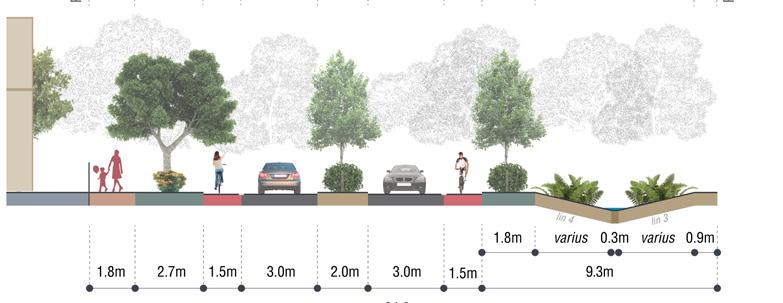
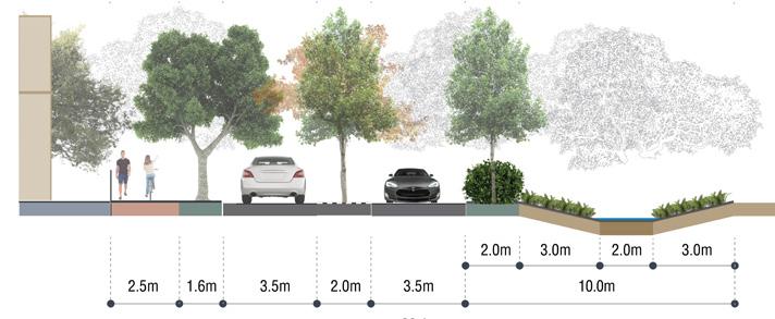
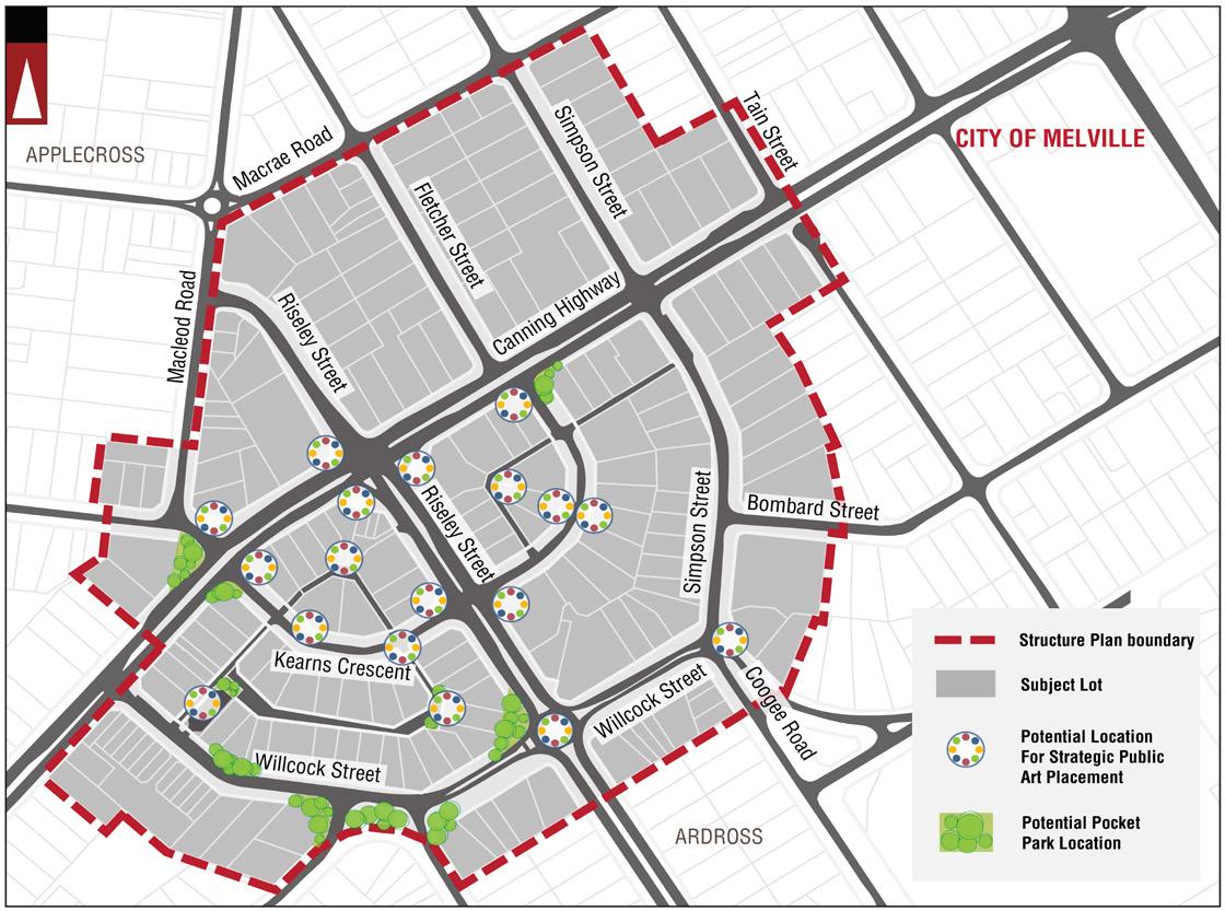
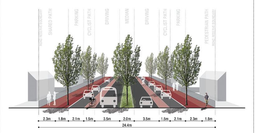
Riseley Street Activity Centre, Ardross
TPG / City of Melville
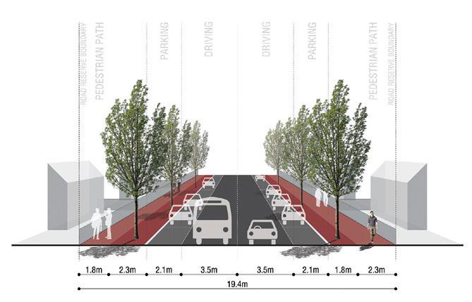
KCTT have provided traffic engineering and transport planning input in to Master Plan for reconfiguration of Riseley Street Activity Centre. This included road reserve remodelling, transport modelling, urban design guidelines and preliminary look into parking strategies.
In March 2015 City of Melville endorsed a Riseley Street Activity Centre Structure Plan that is to be used as an overarching guiding document in the process of the Centre Redevelopment. KCTT prepared the Master Plan document as a supplementary document that will guide redevelopment of the Riseley Street Activity Centre alongside the Structure Plan document.
Important components of this project are:
Streetscapes - as they provide a physical frame for the communication of the intended urban design. Streetscapes shape and stimulate the mental images generated of a place for all users and the shape the way users, (pedestrians, cyclists and motorists) interact with the space. Water Sensitive Urban Design (WSUD) - as they provide the dual benefit of improved streetscape aesthetics with improved water quality and use of finite resources such as water.

Project_ Client_
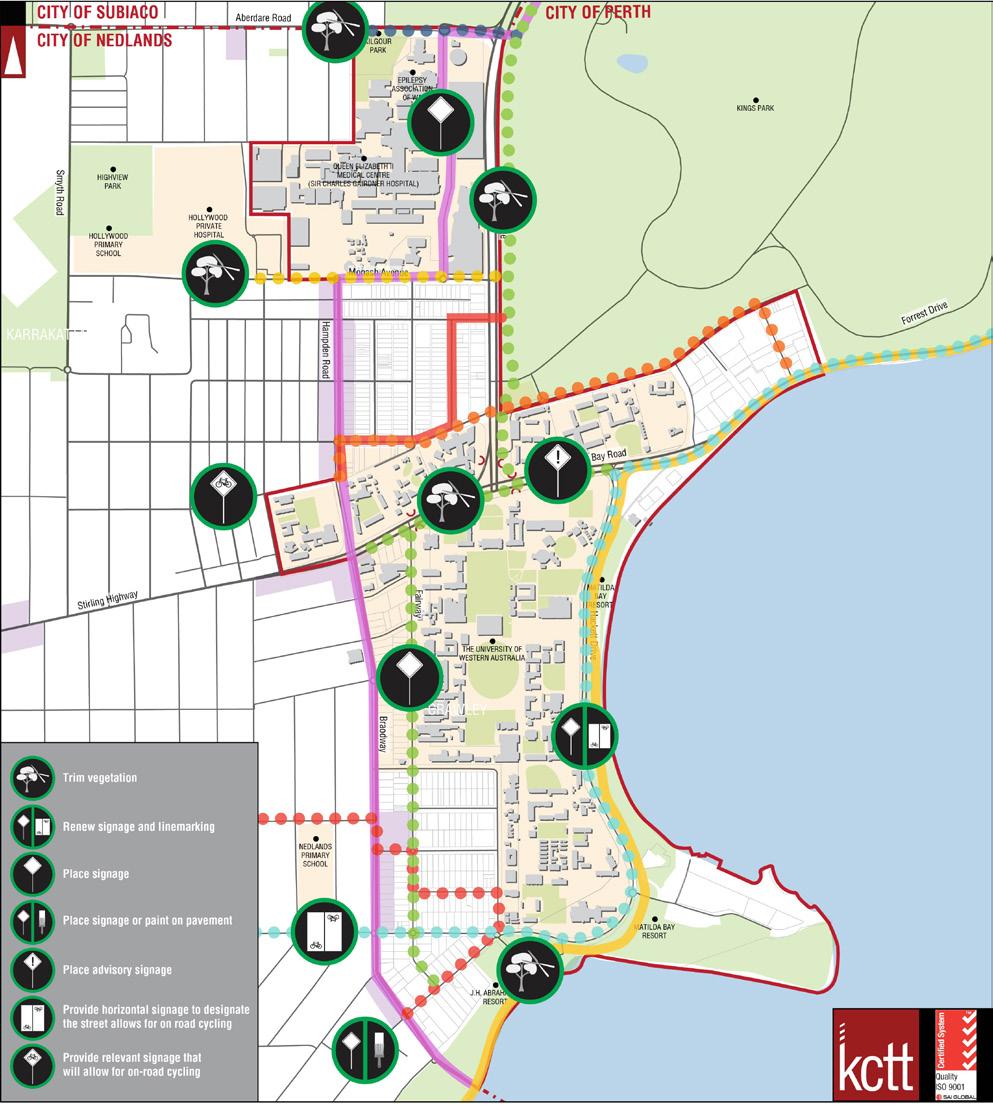
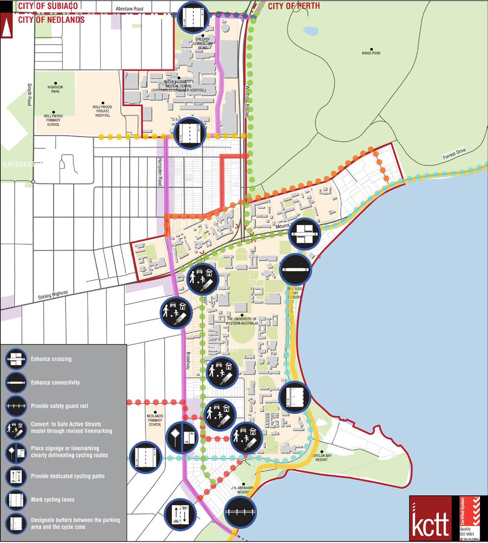
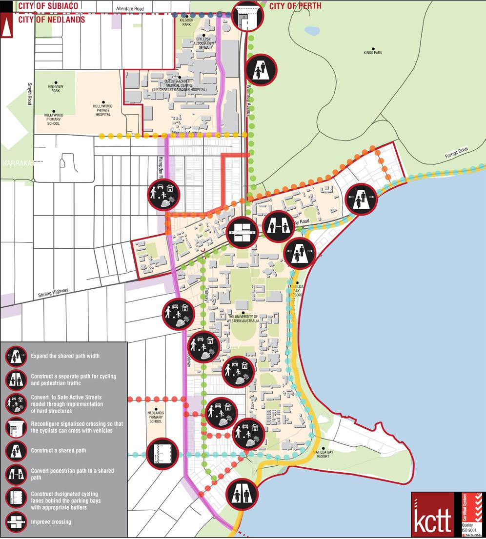
City of Perth Cycle Plan Implementation Program 2016-2021
City of Perth
KCTT have been commissioned by the City of Perth to conduct an assessment for possible cycling routes throughout Nedlands and Crawley.
The subject location includes University of Western Australia, the Queen Elizabeth II Medical Centre, Royal Perth Yacht Club and 1,348 residential properties. The land use pattern within the study area comprises of a traditional residential urban form with additional land uses such as a hospital and the University.

Most streets in the subject area of Crawley and Nedlands have relatively low traffic volumes given the adjoining land uses. The exceptions are Mounts Bay Road and Winthrop Avenue. KCTT have undertaken a saddle survey of selected routes in order to better understand the area and provide insight and commentary about the possibility of improvement. The analysis of the surveyed routes and the cost benefit analysis of the proposed improvements have been considered to derive an action plan focusing on short term improvement (quick wins), however taking into account medium and long term improvements.
Project_ Town of Port Hedland Heavy Vehicle Access Strategy Client_ Town of Port Hedland
KCTT were engaged by the Town of Port Hedland to update the heavy vehicle access strategy and concurrently prepare input for the local planning scheme to implement the revised strategy. The purpose of this document is to develop a heavy vehicle access strategy that will serve the Town of Port Hedland as the Town continues to grow and enhance its reputation as one of the key infrastructure hubs in Australia.
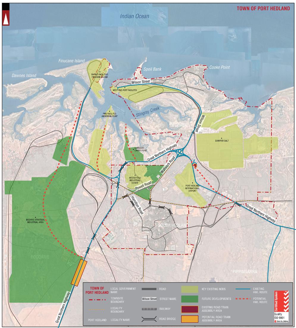
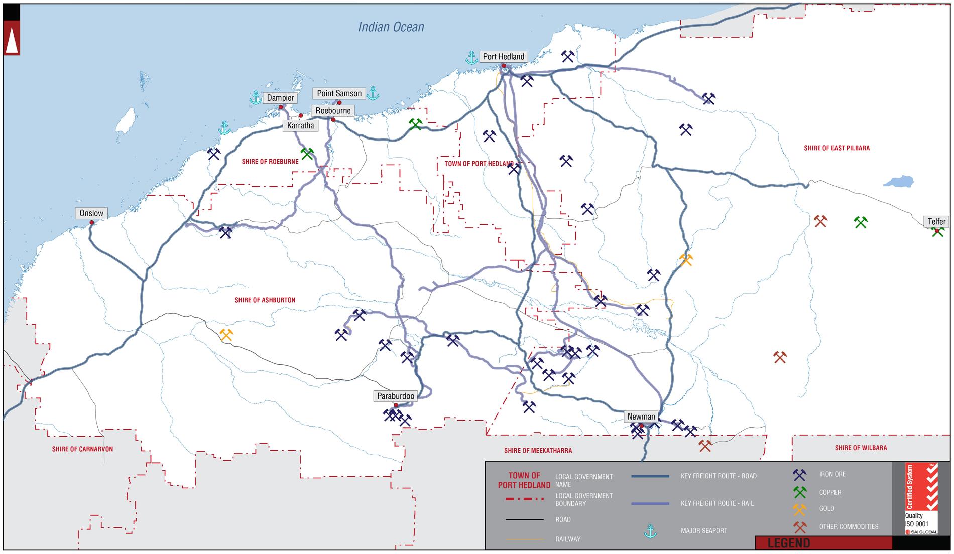
The document examines in detail the existing road network and highlights existing deficiencies in the network, in terms of accessibility with heavy vehicles and outlines areas where there are current safety and planning risks in the network and where there are issues with the sizing of infrastructure that limits access / egress by various heavy vehicle configurations. The future road network planning is also examined and the HVAS provides a gap analysis against any of the previously nominated deficiencies, offering priorities for construction of road infrastructure upgrades, new sections of road, road train assembly areas which strategically improve the performance and functionality of the network, requirements for Over Size Over Mass and RAV Network vehicles and reviewing each industrial area and its specific requirements within the Town of Port Hedland to present a holistic argument for the future infrastructure development within the Town. A thorough framework for the design, approvals and implementation phases associated with the suggested works scopes is collated in this document, offering guidance on the compliance documentation, the regulatory authority requirements of such major infrastructure works programs and clear descriptors on the future roles and responsibilities of each of the stakeholders in the process. Finally, a series of further recommended actions provides a concise summary of works that will provide benefit to the Town in the implementation of this Strategy.
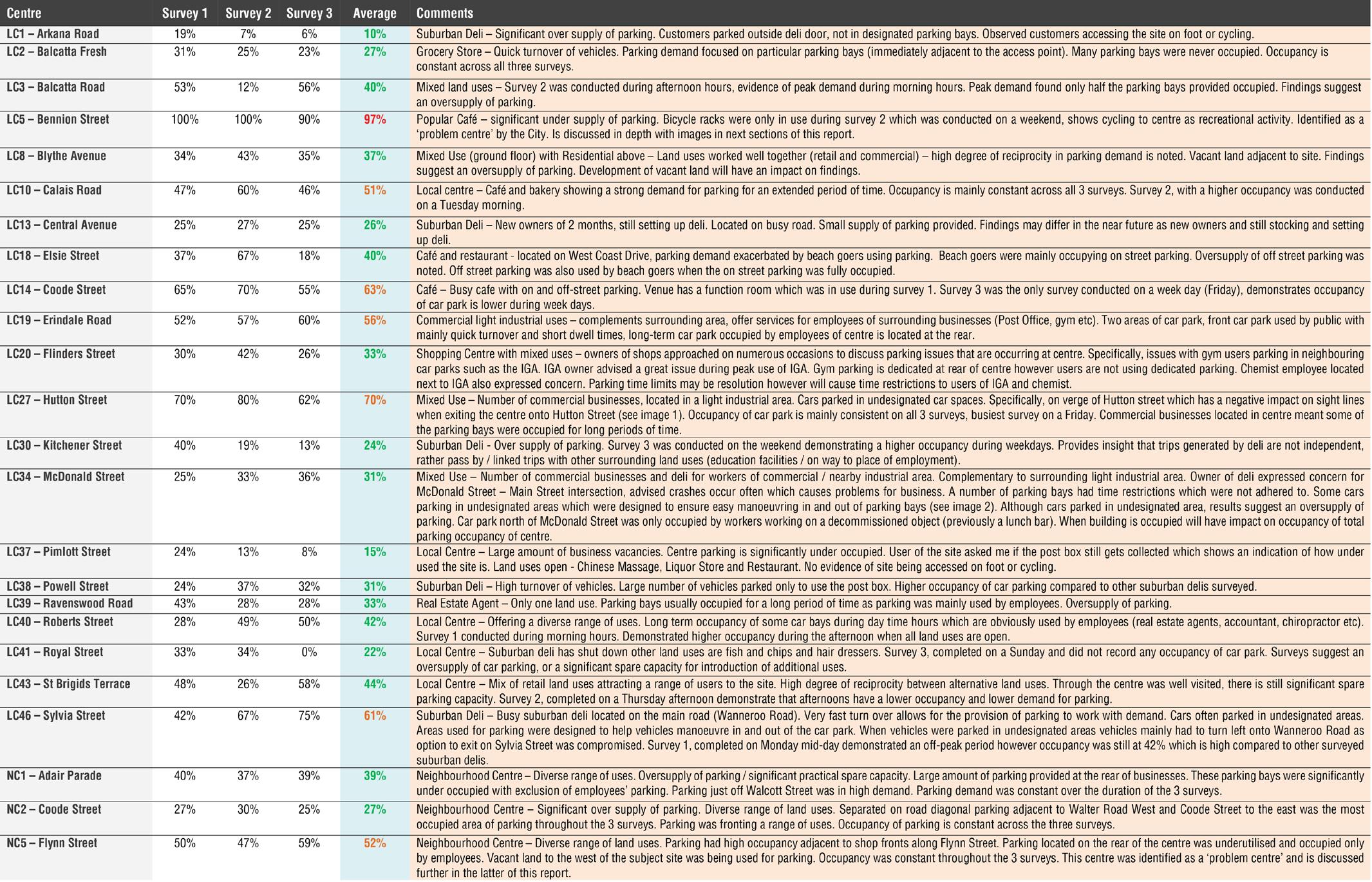
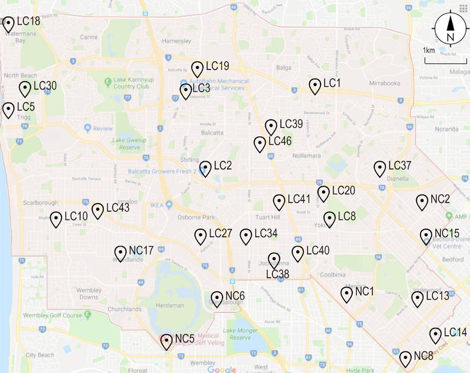
project_Parking Study of Local & Neighborhood Centres client_City of Stirling
KCTT was commissioned by the City of Stirling to conduct a number of car parking surveys at 28 Local and Neighborhood Centres. Each centre was surveyed three times to gather a reliable database which would inform the occupancy of parking at each centre. Prepared report outlines the methodology used to collect the data and the findings from each survey in the form of average occupancy across the three surveys and addresses observations made onsite that are relevant to the findings. An extensive desktop study was completed prior to conducting the surveys to ensure that the chosen day and time of the three surveys will capture the true parking demand. Additionally, excel spreadsheet with details of occupancy of each parking bay is provided.
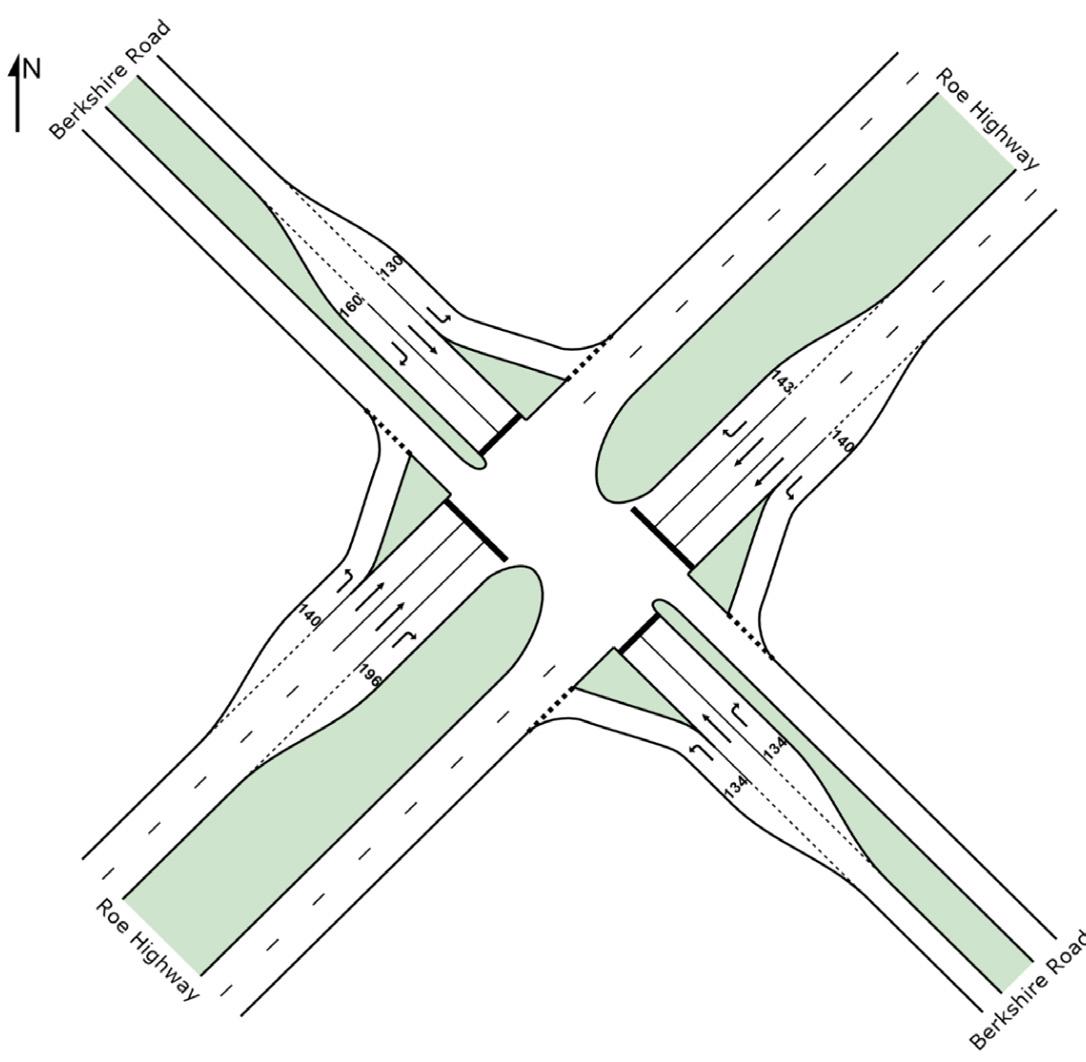
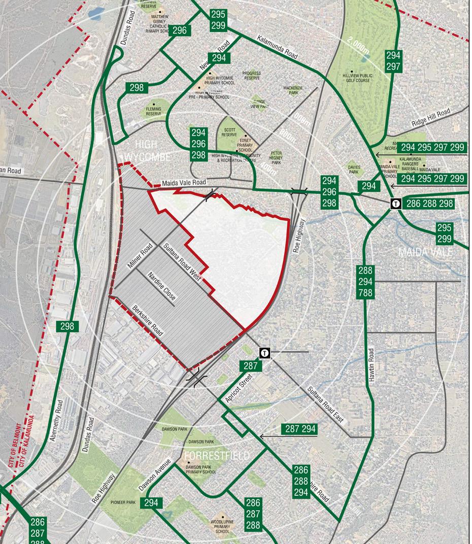

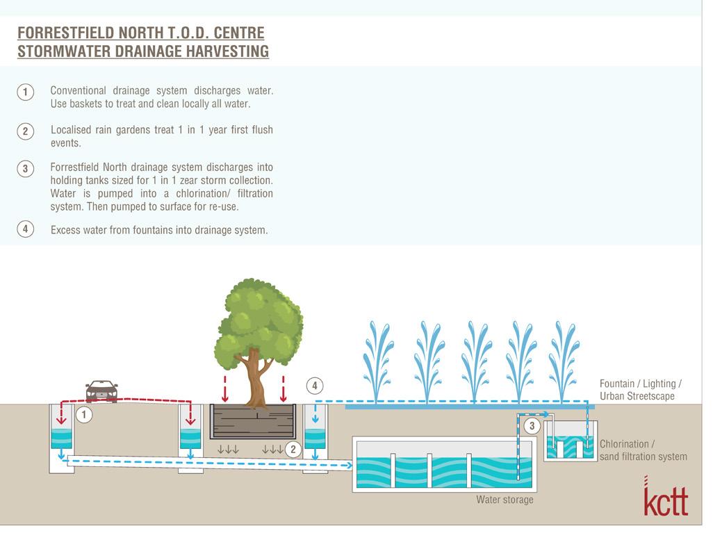
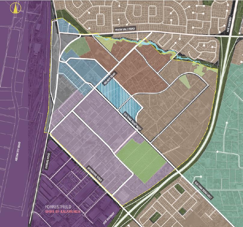
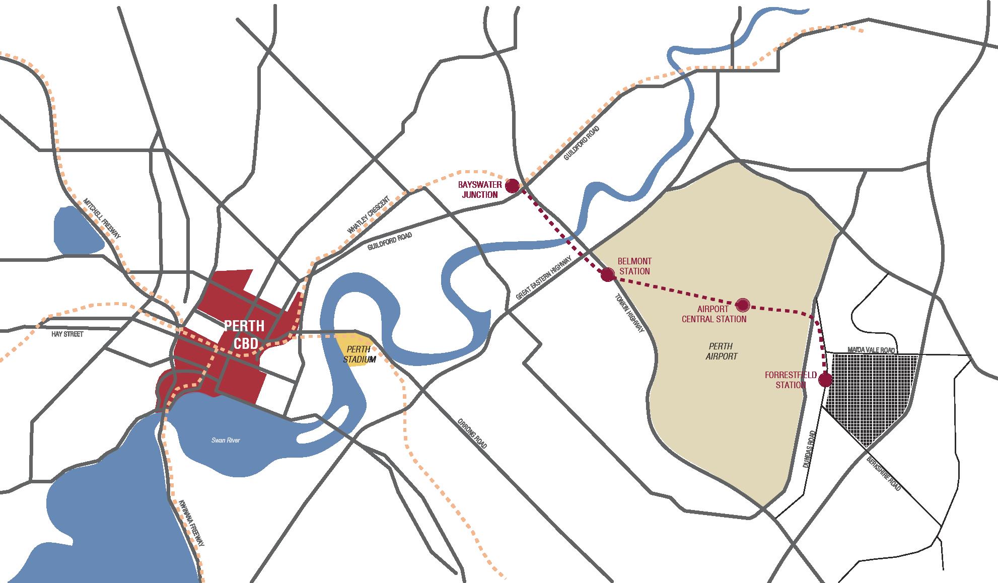
project_ Forrestfield North - District Structure Plan client_ Shire of Kalamunda KCTT have completed preliminary traffic and transport At this stage KCTT have examined several development scenarios and their potential impact on the surrounding network and reporting for the new proposed development in the the potential required upgrades such as:- Forrestfield North area. The new proposed development comprises of industrial, residential and mixed use • Configuration of carriageway for Berkshire Road (west), Milner Road, Sultana Road and Maida Vale Road (west). distributed over area larger than 180ha. It is envisaged • Realignment and assessment of traffic management measures for the intersection of Berkshire Road, Dundas Road as an organic extension of the proposed railway station and Milner Road; precinct. • Potential configuration of Maida Vale / Roe Highway interchange; Due to the high importance of the area, this project Road, etc. required extensive liaison with relevant authorities planning in the subject area (such as Gateway WA project KCTT have prepared a wider Paramics model for the area in order to examine the impact of the proposed development on major - upgrade of Tonkin Highway / Roe Highway interchange, road infrastructure such as: Roe Highway, Abernethy Road and Kalamunda Road. The intersections that were deemed critical upgrade of the intersection of Tonkin Highway / Abernethy were further modelled in SIDRA. Road; Expansion of Perth Airport and development of new business area adjacent to the subject DSP area; and the Further to this KCTT have examined the potential for utilisation of alternative transport modes. extension of railway). • Potential realignment and assessment of traffic management devices for the intersection of Dundas Road / Abernethy
Project_ Client_
Forrestfield North - Structure Plan Preparation
TPG + Place Match
KCTT have a significant experience on this project over the last several years. KCTT’s experience with both the traffic and civil engineering also provides us with a significant advantage over most our competitors – the integrated nature of our knowledge means that we inherently understand the infrastructure requirements due to traffic volumes and this will save time and money in the development of the modelling and Infrastructure Servicing Reports
KCTT have completed:
The traffic modelling for over 30,000 residential lots, plus many square kilometres of industrial, retail and commercial space in locations across the Perth metropolitan region, including in Dayton, Brabham, Forrestfield North, Forrestfield, Maida Vale, Wattle Grove, Cardup, Byford, Wungong and Baldivis. Infrastructure servicing strategies and conceptual civil design over landholdings which contain over 8,000 residential lots. Detailed design and contract administration for over 1,000 lots. These have either been constructed, are in construction, or are in design phase to be constructed.
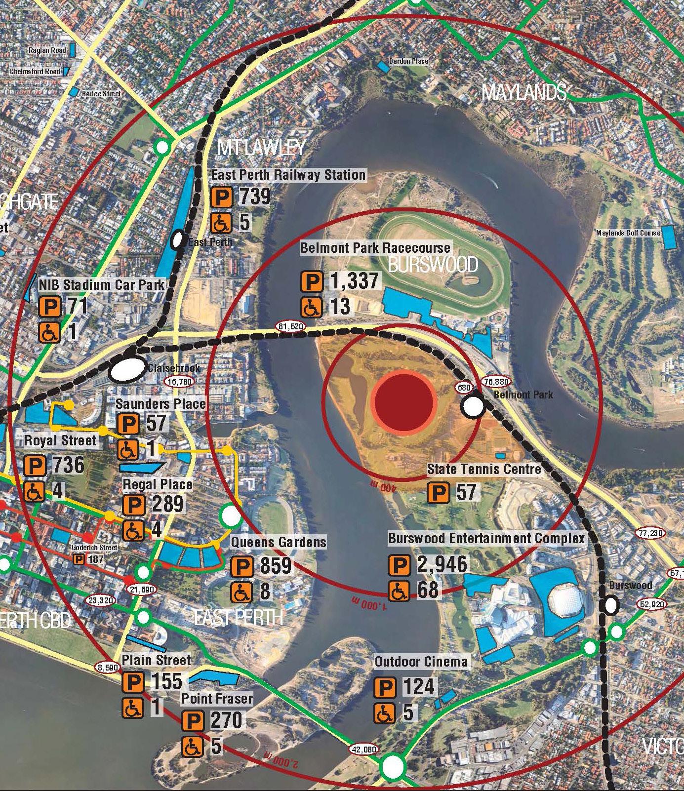
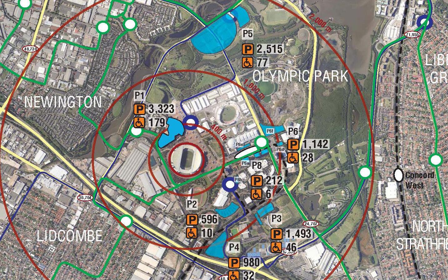
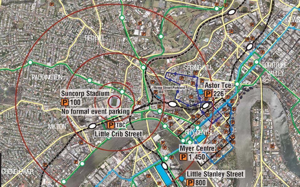
Project_ Stadium, Burswood Traffic Demand and Parking Study, New Perth Client_ West Australian Football Commission
KCTT have been engaged by West Australian Football Commission to provide an independent review of Stadium Taskforce’s findings regarding traffic demand management and requirements for parking.
The review included a detailed survey of preferred transport modes of patrons at Patersons (Domain) Stadium as well as comparison of the proposed stadium to other stadia around Australia.
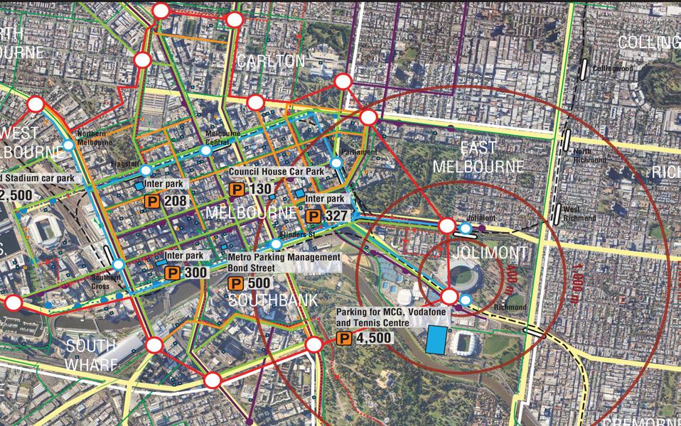

For this particular exercise we have chosen following stadia:- • ANZ Stadium in Sydney; • Suncorp Stadium in Brisbane; • Metricon Stadium in Gold Coast; • Etihad Stadium in Melbourne; • Melbourne Cricket Ground. A detailed comparative analysis was conducted for all listed stadia in terms of location in relation to CBD, surrounding road network and public transportation options, seating capacity and parking provided on the stadium and parking options in walking distance from each respective stadium.
Further to this, KCTT have undertaken a brief desktop research of Perth Railway Network in order to estimate the potential for upgrade and enhancement public transportation as a mode share in alll trips undertaken to and from the proposed Perth Stadium.
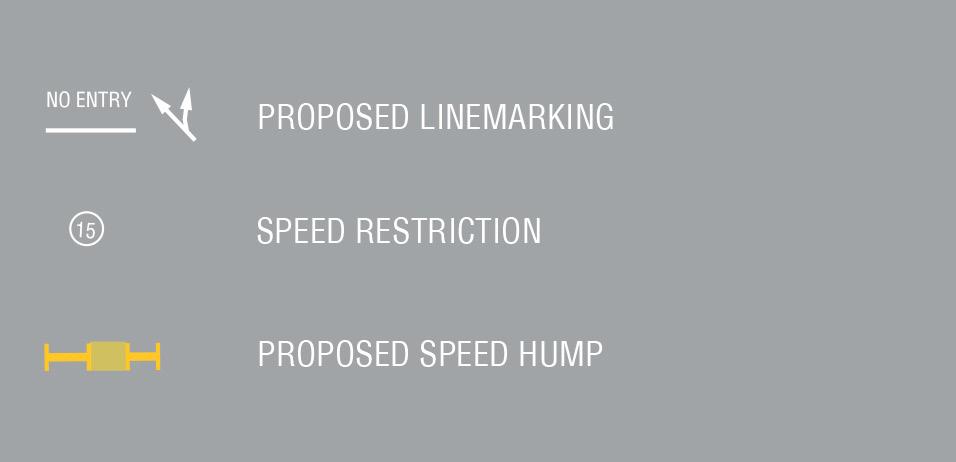
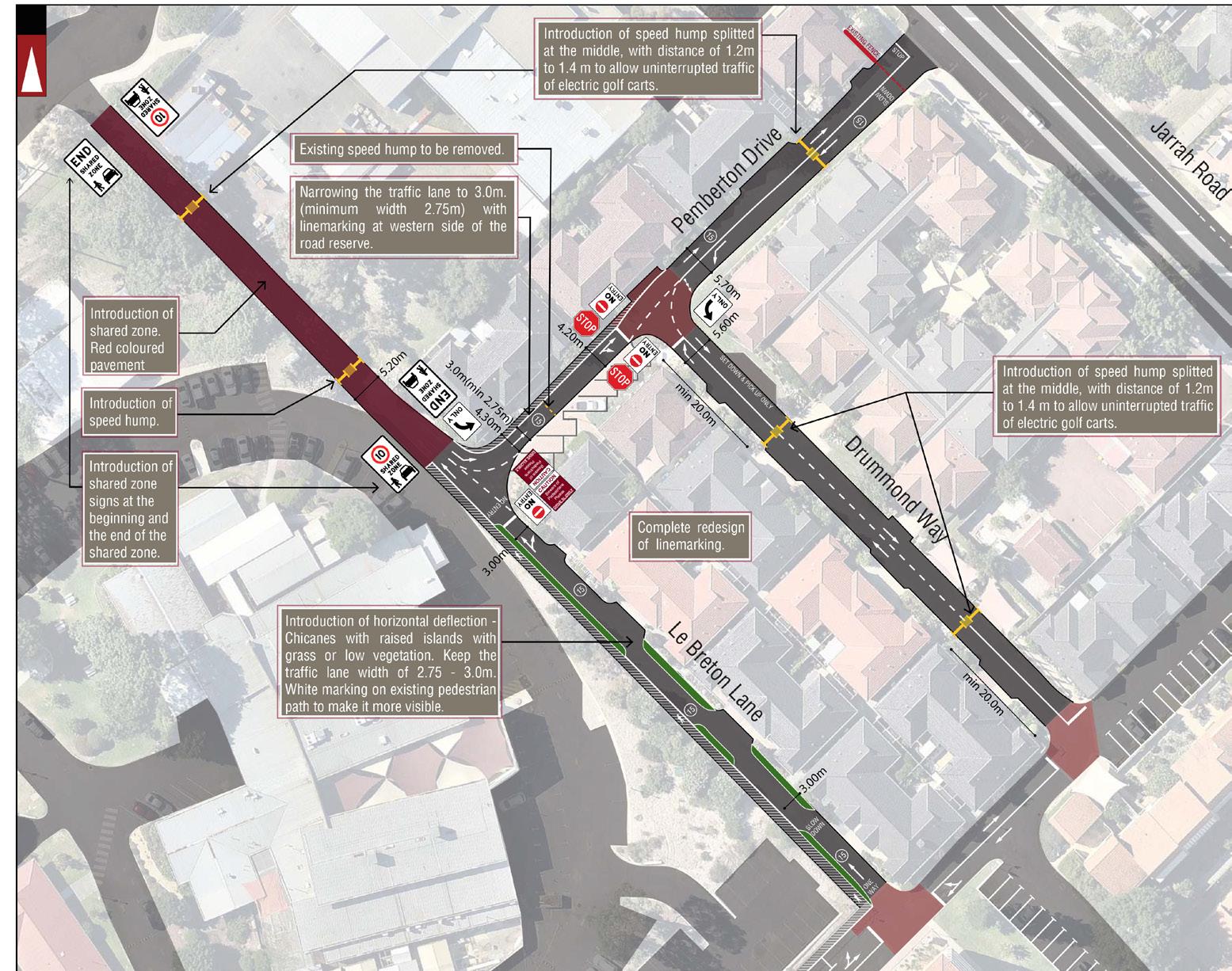
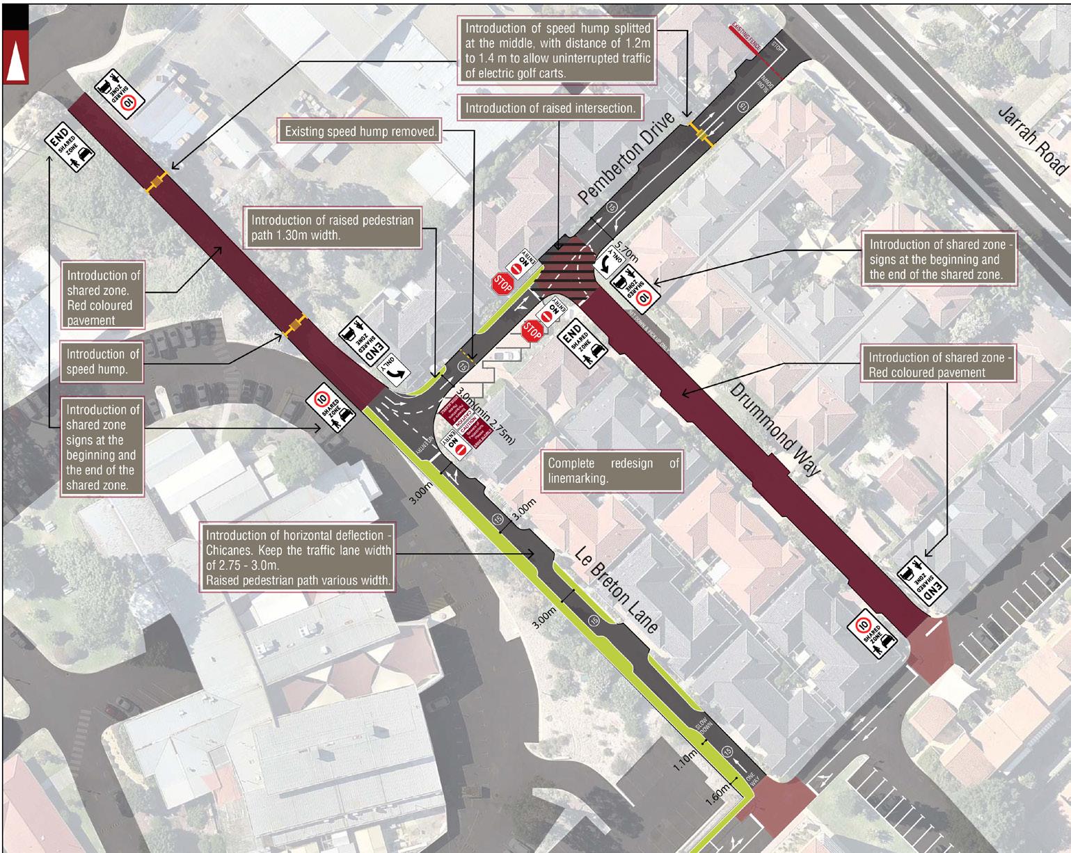
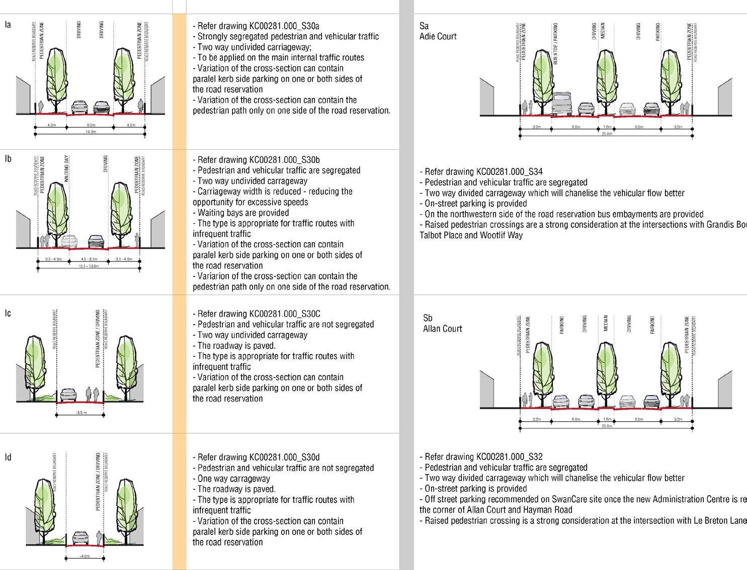
Project_ Localised Traffic Management Strategy –SwanCare Bentley Client_ SwanCare
KCTT have been engaged by Swan Care to provide an independent review existing traffic management arrangements for Le Breton Lane, Pemberton Drive and Drummond Lane and provide a maximum of three strategies for enhancement of traffic safety and discouragement of rat running, accompanying letter explained the propositions and provided a comparative analysis of the options.
Project_ Hilbert Precinct G Client_ ABN Group /Stockland Group / Creative Planning
KCTT were engaged to prepare a traffic impact study for the Hilbert development comprising of thirteen precincts. A more detailed analysis has been completed for the Hilbert Precinct G including the preparation of a Paramics model in order to examine the impact of the proposed development on surrounding road infrastructure. The intersections that were deemed critical were further modelled in SIDRA.
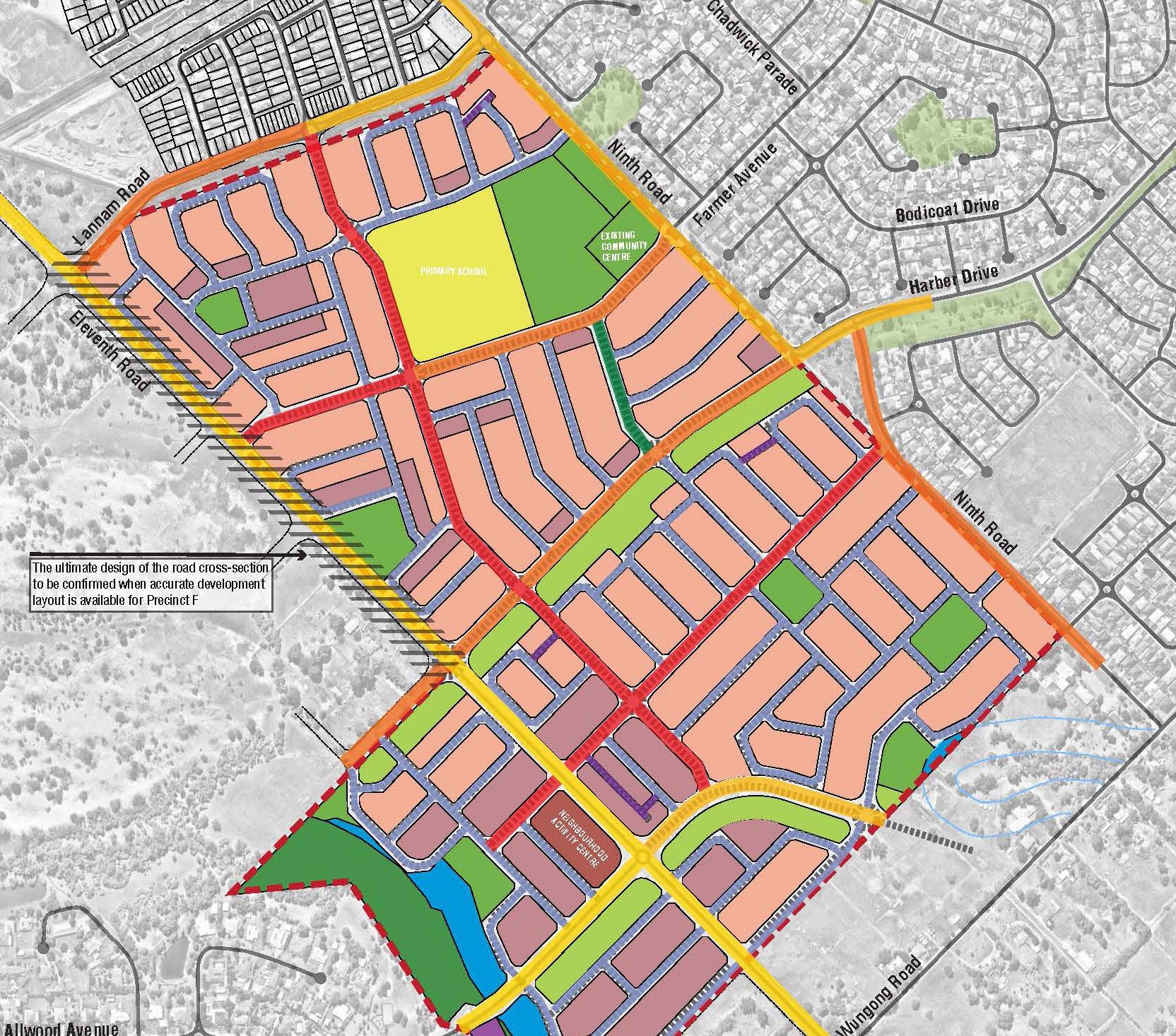
The Wungong Urban project is located in the suburbs of Hilbert and Haynes, just west of Armadale’s city centre and around 26km from Perth. Once complete, the 1,580 hectares of land is expected to accommodate over 16,000 homes with a projected population of around 40,000 people, surrounded by a stunning landscape of trees, waterways, and parklands.
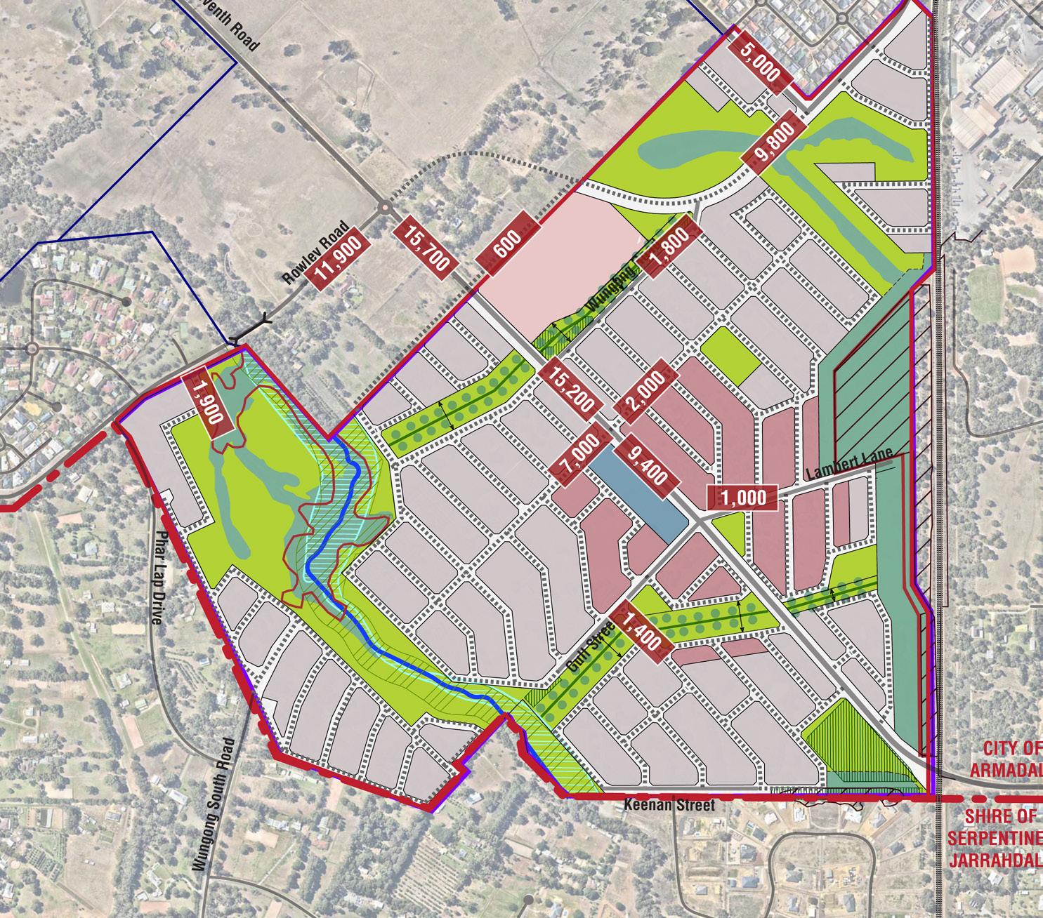
Project_ Hilbert Precinct H Client_ Exal Group Pty Ltd
KCTT were engaged to prepare a traffic impact study for the Hilbert development comprising of thirteen precincts. A more detailed analysis has been completed for the Hilbert Precinct H including the preparation of a Paramics model in order to examine the impact of the proposed development on surrounding road infrastructure. The intersections that were deemed critical were further modelled in SIDRA.
Wungong Precinct H is a part of the Wungong Urban Water Master Plan which incorporates 13 Precincts. The Structure Plan Area proposes 412 Urban Lots (160-360m2) and 1010 Suburban Lots (200-575m2), one primary school and a neighborhood centre.
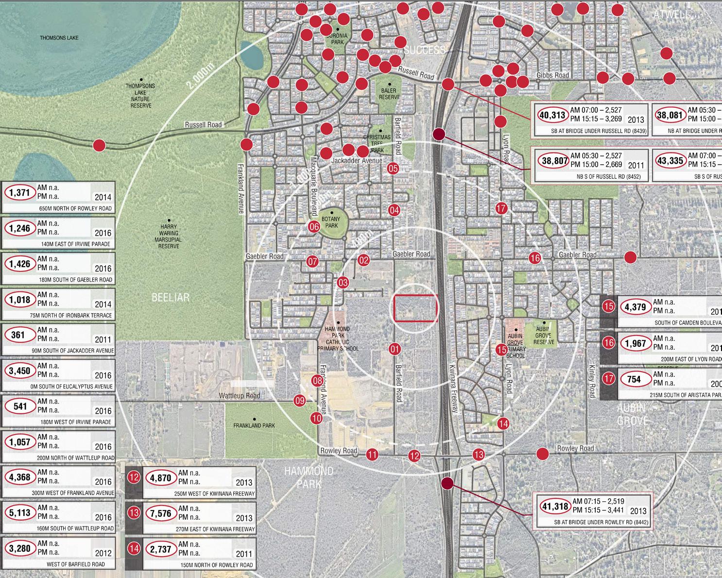
Project_ Barfield Road, Hammond Park Client_ Symbolise Holdings Pty Ltd
KCTT were engaged to prepare a Transport Impact Assessment and a civil engineering Infrastructure Servicing Report for the proposed residential development of 62 lots at Lot 29 Barfield Road, Hammond Park.
The Structure Plan proposes construction of multiple pedestrian paths and road links to cater for the pedestrian needs in the area. The proposed road network will be suitable for on-road cycling.
All the intersections are designed to have full unrestricted movement of vehicles to and from the Structure Plan Area. The intersections are priority controlled. This is suitable level of control for the anticipated traffic impact.
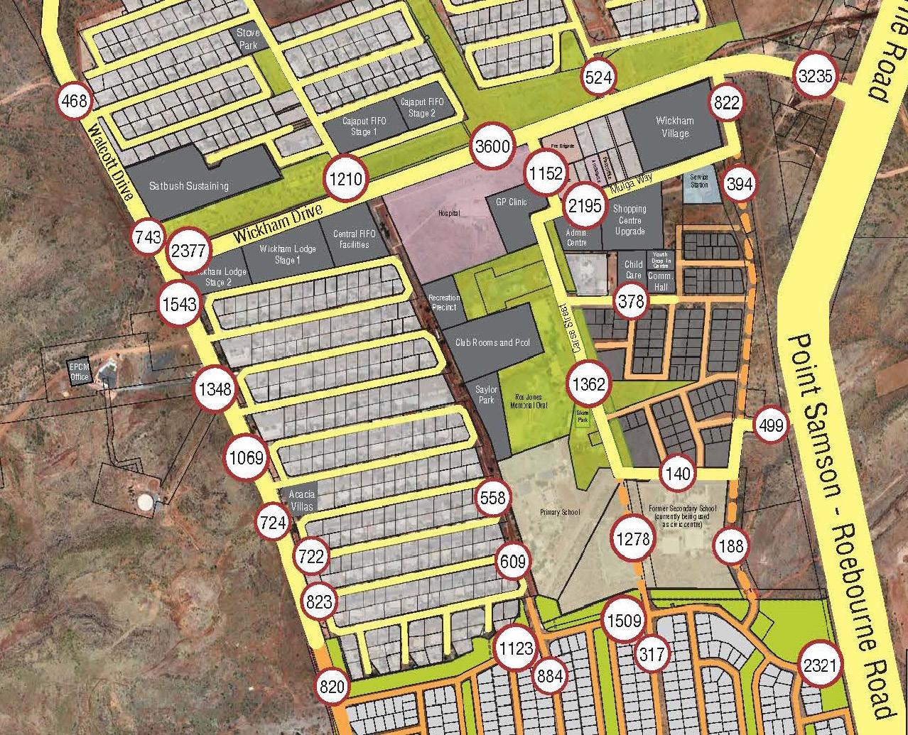
Project_ Wickham Accommodation Expansion Client_ Thinc Projects / RTIO
KCTT were engaged by Thinc Projects and Rio Tinto Iron Ore to prepare a traffic impact study for a group of projects titled “Wickham Accommodation Expansion”.
The proposed residential expansion included over 700 additional lots and over 500 additional units for short and long term stay. The proposed development would impose requirement for upgrading of the existing intersections with Point Samson to Roebourne Road.
A detailed traffic generation and parking requirements analysis was conducted. Attention was given to the pedestrian movement in particular due to the harsh climate conditions. Further to this, a formal road safety audit has been conducted at the intersection of Hakea Street and Point Samson to Roebourne Road in order to determine the exact extent of the required improvement.
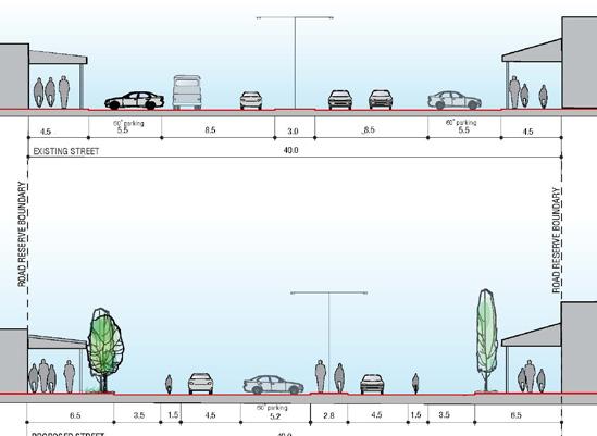
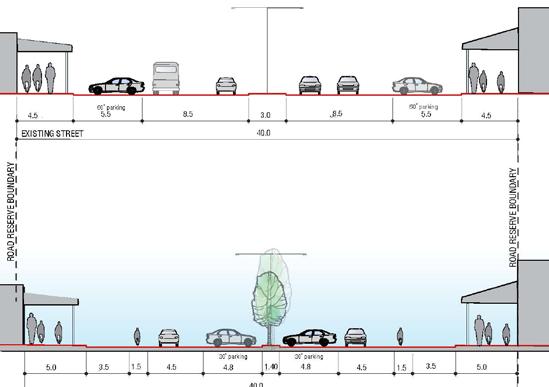
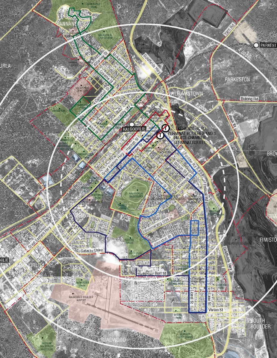
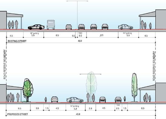
Project_Hannan Street Central Precinct
Client_ TPG / City of Kalgoorlie – Boulder
KCTT have been a part of the team in charge for developing a Master Plan for revitalisation of the iconic Hannan Street Precinct in Kalgoorlie. The main focus in this project was to examine the options for the best possible use of the wide road reservations.
Reconfiguring the road reservation required a particular concern for the specific climate requirements, general habits and preferences of residents / end users and the budget constrains. One of the main focal points was configuring the road reserve so that it is pedestrian and cycling friendly during hot summer months. Introduction of parklets and alfresco areas would allow for greater exposure and capacity for local businesses, with KCTT ensuring stormwater management requirements were met. Reconfiguration of some of the bus stops and particularly interface with St Barbara’s square was also examined.
project_ Doley Road LSP Byford
client_ ABN Group
KCTT have completed preliminary traffic and transport reporting for the new proposed development in the Doley Road LSP Byford. The land occupies an area of approximately 84.23 ha.
The development proposes to subdivide the Doley Road LSP, Byford into approximately 2,393 residential lots (887 lots with an assumed R25 yield, 764 lots with an assumed R40 yield and 742 lots with an assumed R60 yield), a Neighbourhood Centre, a Primary School and accompanying POS.
KCTT have developed a high-level Paramics Model suitable for use in Local Structure Plan submissions of this scale and size. The proposed roads were classified and sized to cater for the expected traffic volumes. Key intersections were analysed in more detail. Years 2026 and 2036 were taken as assessment years.

KCTT have been a part of the team appointed to examine options for facilitation of the expansion of lifestyle village Bentley Park. It’s favorable location has contributed to its popularity as a lifestyle village, and as such, its accommodation capacity is likely to double in next 20 years.
As a preliminary input into the Master Plan guidelines KCTT examined the implications of this expansion on the surrounding road network, options for developing parking ratios appropriate for the centrally located lifestyle village and methods of enhancement of pedestrian movement in an environment with high percentage of vulnerable users.
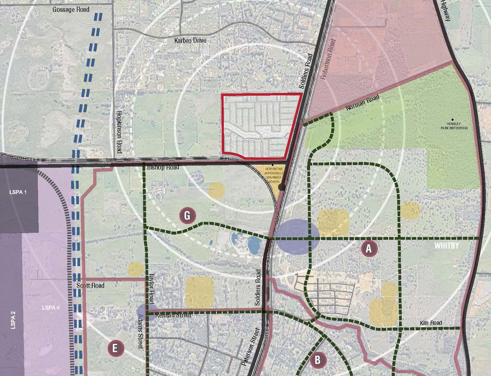
Project_ Lot 30 Soldiers Road, Cardup Client_ Land Group WA
KCTT have completed a Due Diligence, Infrastructure Servicing Report and Transport Impact Assessment for the Structure Plan Area comprising of a total of 898 residential lots ranging in size from 225m2 to 450m2.
Traffic flow has been distributed in accordance with Paramics modelling completed by KCTT. The analyzed traffic includes the existing road network traffic plus the expected traffic impact from the Mundijong-Whitby DSP, Cardup Business Park LSP, West Mundijong Industrial Area DSP and the expected traffic generated from the Structure Plan Area.
The proposed roads were classified and sized to cater for the expected traffic volumes. Key intersections were analyzed in more detail using SIDRA Intersection Analysis software. The year 2031 was taken for assessment. The intersections are expected to perform to a satisfying level.
Project_ Banksia Grove Traffic Model Client_ Banksia Grove Nominees
KCTT have completed a traffic model for the Banksia Grove development inclusive of all existing and all proposed development areas. Once fully developed, Banksia Grove will comprise of approximately 5,000 households, 2 primary schools, a high school and a district shopping center.
The purpose of this model was to update of the existing traffic assessment prepared 9 years ago at the very commencement of the project and to determine the most appropriate traffic management methods for several critical intersections.
KCTT have completed full modelling (in Paramics initially, in SIDRA examined details of the intersections) and have prepared an accompanying report detailing findings of the modelling process.
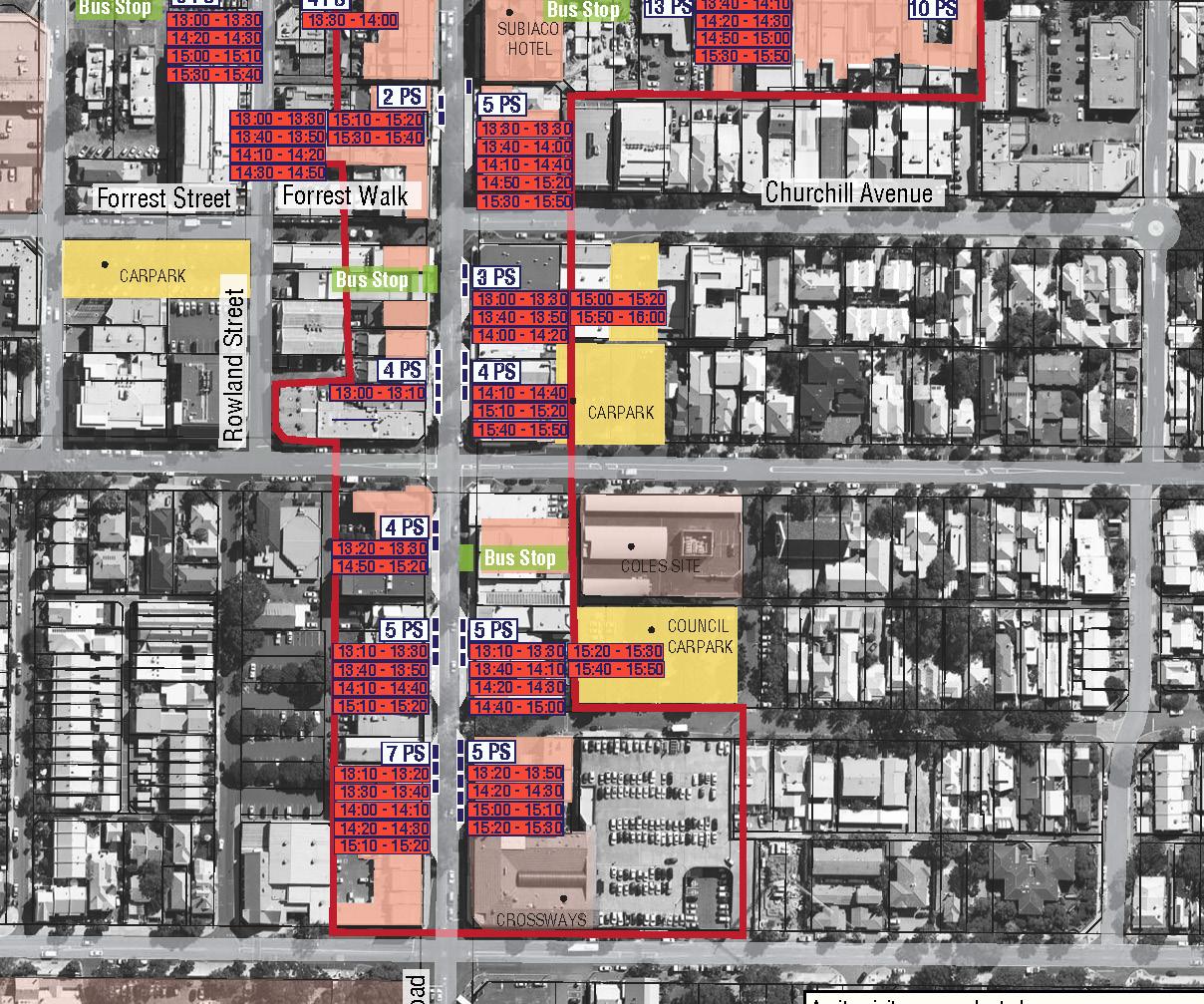
Project_ Subiaco TC Public Realm Design Client_ Blackwell and Associates / City of Subiaco
KCTT have completed a traffic input for a Master Plan for the revitalisation of Subiaco Town Centre.
The traffic analysis included detailed surveys of pedestrian movement and parking trends - by capturing real time user behavior in the urban structure. Findings of these were utilized to formulate recommendations and design guidelines for the project of revitalization.
The key intersections were modelled in SIDRA and all findings were summed in an accompanying report.
Project_ Client_
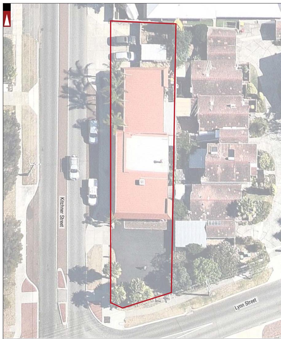
22 Altona Street, West Perth
Delstrat Homes
KCTT were engaged to prepare a Transport Impact Statement to assess the anticipated traffic impact of the proposed development located in 22 Altona Street, West Perth. The proposal suggests conversion of the existing commercial premises (located in a single storey unit) into an apartment complex consisting of 23 residential units.
Project_ client_
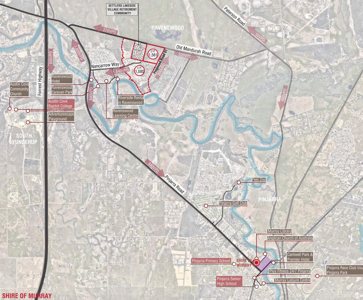
Lot 619 Old Mandurah Road,Ravenswood
Westcoast Engineering
KCTT were engaged to prepare a traffic engineering input into the proposed 225 lot subdivision on Lot 619 Old Mandurah Road Ravenswood