

Dan Oldford
ABS Harsh Environment Technology Centre

Jonathan Power National Research Council of Canada
Rob Brown, Kerri-Ann Ennis Marine Institute of Memorial University 6 Automatic Image Recognition Technology in the Service of Fisheries Management Monitoring and Control
Amos Barkai OLSPS 15 Collaborative Enhancement of Canadian and West African Partner Countries’ Technical Capacity for a Safe, Secure, and Sustainable Blue Economy
Debany Fonseca-Batista, Catalina Albury, Simone Le Gendre, Chukwuka Orji, Alberta Ama Sagoe, Christopher Milley, Kenneth Oguzie, Raffaella Gozzelino, Douglas Wallace DOTCAN 30 4-Dimensional Visual Delivery (4DVD) of Big Climate Data: A Web Tool that Enables Students to Visualize and Receive the Extended Reconstructed Sea Surface Temperature Data in Classrooms
Samuel S.P. Shen
San Diego State University
Javier Zambrano
Abdulalahi Mohamed General Motors
Thomas M. Smith, Boyin Huang NOAA 39 Sharing Technical Skills for the Blue Economy: An International Learning Experience
Marlene Power, Chris Batten Marine Institute of Memorial University
Matt Mulrennan
KOLOSSAL Chad Collett SubC Imaging
How Will you be Trained for your Next Ocean Career? Randy Billard Virtual Marine
Rope on Command: CCFI Brings Innovators, Regulators, and Harvesters Together to Help Make Industry More Sustainable Through Gear Enhancements
Keith Hutchings
Canadian Centre for Fisheries Innovation
Inside Out … Advances in ROV Autonomy Fuel Innovation in Offshore Energy Inspections
Riley Kooh, Deep Trekker Robotics
Reverberations … Digital Harbour: Diving Deeper into Data Collaboration
Tara Mooney, Kennedy Sittler, COVE
Homeward Bound … Why Mentoring is the Future of Ocean Technology

Lucija Prelovec, DeepSense
Parting Notes … Irish Sea Moss
Stephanie Flynn Norman

The Journal of Ocean Technology, Vol. 17, No. 4, 2022 i
ii Editorial Board iii On the Cover iv Publishing Schedule and Advertisements v Editor’s Note Essays 1 Improving Personal and Group Survival Equipment for Ships in Polar Waters
Contents 45
Expedition Launching to Study the Colossal Squid in Antarctica
52
57
64 Lodestar Katie
Spindrift 68
72
84
Peer-Reviewed Papers
Kirk, Jennifer Oteng, Malte Pedersen
Q&A with Emilio Notti
Trade Winds
88
90
92
Turnings
Perspective
94
96
96 72 42
PUBLISHER
Bill Carter
Tel. +001 (709) 778-0762 info@thejot.net
Dr. David Molyneux
ADMINISTRATION
Crystal-Lynn Gorman
Dr. Keith Alverson USA
Dr. Randy Billard Virtual Marine Canada
MANAGING EDITOR
Dawn Roche
Tel. +001 (709) 778-0763 info@thejot.net
TECHNICAL CO-EDITORS
Director, Ocean Engineering Research Centre Faculty of Engineering and Applied Science Memorial University of Newfoundland
WEBSITE AND DATABASE
Scott Bruce
Dr. Safak Nur Ertürk Bozkurtoglu Ocean Engineering Department Istanbul Technical University Turkey
Dr. Daniel F. Carlson Institute of Coastal Research Helmholtz-Zentrum Geesthacht Germany
Dr. Dimitrios Dalaklis World Maritime University Sweden
Randy Gillespie Windover Group Canada
Dr. Sebnem Helvacioglu
Dept. Naval Architecture and Marine Engineering Istanbul Technical University Turkey
A publication of
GRAPHIC DESIGN/SOCIAL MEDIA
Danielle Percy Tel. +001 (709) 778-0561 danielle.percy@mi.mun.ca
Dr. Katleen Robert Canada Research Chair, Ocean Mapping School of Ocean Technology Fisheries and Marine Institute
FINANCIAL ADMINISTRATION Michelle Whelan
EDITORIAL BOARD
S.M. Asif Hossain National Parliament Secretariat Bangladesh
Dr. John Jamieson Dept. Earth Sciences Memorial University Canada
Paula Keener Global Ocean Visions USA
Richard Kelly Centre for Applied Ocean Technology Marine Institute Canada Peter King University of Tasmania Australia
Dr. Sue Molloy Glas Ocean Engineering Canada
Dr. Kate Moran Ocean Networks Canada Canada
Kelly Moret Hampidjan Canada Ltd. Canada
Dr. Glenn Nolan Marine Institute Ireland
Dr. Emilio Notti Institute of Marine Sciences Italian National Research Council Italy
Nicolai von OppelnBronikowski Memorial University Canada
Dr. Malte Pedersen Aalborg University Denmark
Prof. Fiona Regan School of Chemical Sciences Dublin City University Ireland
Dr. Mike Smit School of Information Management Dalhousie University Canada
EDITORIAL ASSISTANCE
Paula Keener
Randy Gillespie
Dr. Timothy Sullivan
School of Biological, Earth, and Environmental Studies University College Cork Ireland
Dr. Jim Wyse Maridia Research Associates Canada
Jill Zande MATE Inspiration for Innovation USA
SPECIAL EDITORIAL ADVISORS
Catherine Lawton Dr. C.R. Barrett Library Fisheries and Marine Institute Canada
Louise White Queen Elizabeth II Library Memorial University of Newfoundland Canada
ii The Journal of Ocean Technology, Vol. 17, No. 4, 2022
Academic and Scientific Credentials
The Journal of Ocean Technology is a scholarly periodical with an extensive international editorial board comprising experts representing a broad range of scientific and technical disciplines. Editorial decisions for all reviews and papers are managed by Dr. David Molyneux, Memorial University of Newfoundland, and Dr. Katleen Robert, Fisheries and Marine Institute.
The Journal of Ocean Technology is indexed with Scopus, EBSCO, Elsevier, and Google Scholar. Such indexing allows us to further disseminate scholarly content to a larger market; helps authenticate the myriad of research activities taking place around the globe; and provides increased exposure to our authors and guest editors. All peerreviewed papers in the JOT are open access since Volume 1, Number 1, 2006. www.thejot.net
A Note on Copyright
The Journal of Ocean Technology, ISSN 1718-3200, is protected under Canadian Copyright Laws. Reproduction of any essay, article, paper or part thereof by any mechanical or electronic means without the express written permission of the JOT is strictly prohibited. Expressions of interest to reproduce any part of the JOT should be addressed in writing. Peer-reviewed papers appearing in the JOT and being referenced in another periodical or conference proceedings must be properly cited, including JOT volume, number and page(s).
On the
Cover
During August 2021, a team of biologists and oceanographers from Marine and Freshwater Research Institute (Iceland), Zoological Society of London (United Kingdom), and Greenland Institute of Natural Resources participated in a Eurofleets+ funded expedition BENCHMARK (Benthic Habitats in Denmark Strait) to map the seabed and identify vulnerable marine ecosystems in the Denmark Strait. This image was taken at 68° N and captures the ROV ÆGIR 6000 deployed from the Norwegian vessel G.O. Sars. During this dive, we saw deep gouges in the seabed at 900 m and huge boulders that were recently overturned, squashing their surviving megafaunal communities. www.zsl.org/blogs/science/ expedition-to-the-deep

The Journal of Ocean Technology, Vol. 17, No. 4, 2022 iii
EMMELINE BROAD
Publishing Schedule at a Glance
The JOT production team invites the submission of technical papers, essays, and short articles based on upcoming themes. Technical papers describe cutting edge research and present the results of new research in ocean technology, science or engineering, and are no more than 7,500 words in length. Student papers are welcome. All papers are subjected to a rigorous peer-review process. Essays present well-informed observations and conclusions, and identify key issues for the ocean community in a concise manner. They are written at a level that would be understandable by a nonspecialist. As essays are less formal than a technical paper, they do not include abstracts, listing of references, etc. Typical essay lengths are up to 3,000 words. Short articles are between 400 and 800 words and focus on how a technology works, evolution or advancement of a technology as well as viewpoint/commentary pieces. Submissions and inquiries should be forwarded to info@thejot.net.
Upcoming Themes

Journal of
c/o Marine Institute P.O. Box 4920 155 Ridge Road St. John's, NL A1C 5R3 Canada +001 (709) 778-0763 info@thejot.net www.thejot.net
iv The Journal of Ocean Technology, Vol. 17, No. 4, 2022
informed Each
provides
window
important issues and
Advertiser’s Index
Subscribe today!
Stay
issue of the JOT
a
into
corresponding innovation taking place in a range of ocean sectors – all in an easy-to-read format with full colour, high-resolution graphics and photography. CIOOS 28-29 Educational Passages IBC Marine Institute IFC, 77 Ocean Business 2023 56 OceansAdvance 83 SBG Systems 62
The
Ocean Technology
All themes are approached from a Blue Economy perspective. Spring Spring 2023 Energy from the ocean Summer 2023 Aquaculture Fall 2023 Vehicles Winter 2023 Smart ships @journaloceantechnology @jotnfld CONTACT US
Editor's Note

While it would be an exaggeration to suggest that ocean technology knows no bounds, it is accurate to say that this pan-disciplinary field is very difficult to circumscribe. The scope of this farranging industry includes everything from big data to autonomous container ships. At its most basic definition, ocean technology encompasses products and services that focus on the ocean. Editorial board member Randy Gillespie (and our former publisher) uses this statement to define ocean technology: “Technology” is the application of knowledge for the practical benefit of humanity – the bridge between “knowing” and “doing.” “Ocean technology” enables mankind to understand and utilize the ocean environment and resources efficiently, safely, sustainably, and profitably.
When we issued the call for content for this issue, we were pleasantly surprised by the vast array of topics submitted from around the globe. You can see the application of ocean technology in the content selected for this issue – starting with the front cover where we feature a remotely operated vehicle (ROV) being launched in the Denmark Strait as part of a benthic habitats project. From there, we move on to a series of essays outlining the innovations in various fields including the creation of ISO standards to improve personal safety in polar waters and the use of automatic recognition for fisheries management. We look at big climate data via a web tool that enables students to visualize and receive sea surface temperature data in their classrooms.
Read about a collaboration between Canada and West Africa to develop a safe, secure, and sustainable Blue Economy. Then follow up with an essay on an international ROV learning experience with engineering students and sea cadets in Barbados and students from the Marine Institute here in Newfoundland.
Dig further and you will discover an exciting expedition launching in December to study the colossal squid in Antarctica. An international team will attempt to find and film the largest invertebrate in the world in the deep sea for the first time. And what about training for an ocean career? How can that be done safely? There are high stakes associated with placing people and equipment in harsh environments. That is where virtual marine training is of great benefit. Learners can practice in simulated emergency events and challenging weather conditions – with no lives or equipment at risk.
As part of our mission, we want to highlight the people behind the research. These might be veteran researchers such as fishing gear and vessel technology expert Dr. Emilio Notti with the Italian
The Journal of Ocean Technology, Vol. 17, No. 4, 2022 v
RANDY GILLESPIE
Dawn Roche Managing Editor
Institute of Marine Biological Resources and Biotechnologies. Or they might be up-and-coming researchers such as master student Jennifer Oteng, who is completing her degree in applied ocean technology (ocean mapping); PhD candidate Katie Kirk, who leads tidal current projects with the U.S. National Oceanic and Atmospheric Administration; and PhD fellow Dr. Malte Pedersen, who focuses on image and video datasets for marine species using computer vision as well as developing new methods for tracking and identifying fish.
That is not all the ocean technology you will find in this issue. There are short articles focusing on The Launch – a portal to the ocean for the worldwide marine community; automation technology to plant seagrasses on a global scale; and a research and development centre providing small and medium sized businesses with access to specialized equipment, facilities, and expertise.
We look at how ROVs can monitor structural changes over time to ensure integrity, efficiency, and effectiveness; an advanced acoustic instrument capable of “seeing” the ocean in three dimensions; an aquatic research, data management, and partnership platform; and technology for open sea bathymetric surveys up to 100 m depth.
To wrap up this issue, the Digital Harbour initiative dives deep into data that digitally monitors Halifax Harbour in real time, and then we look at the importance of mentoring for the future of ocean technology. We close with a short piece on beachcombing for sea glass, shells, driftwood, and – in this case – Irish sea moss to create stunning pieces of jewelry.
As you will discover, this is a full issue on “ocean technology” that covers a wide range of topics, and this is just a glimpse into this pan-disciplinary field. Ocean technology truly is far reaching. We hope you will discover something new in this issue.
vi The Journal of Ocean Technology, Vol. 17, No. 4, 2022
Group Personal
Improving and Survival Equipment for Ships in Polar

Waters
by Dan Oldford, Jonathan Power, Robert Brown,
and Kerri-Ann Ennis
The Journal of Ocean Technology, Vol. 17, No. 4, 2022 1
ISTOCKPHOTO.COM/JARMO PIIRONEN
A Canadian team has created an International Organization for Standardization (ISO) standard that provides practical guidance for operators on how to improve survivability.
The entry into force of the International Maritime Organization’s (IMO) International Code for Ships Operating in Polar Waters (the Polar Code) was an important milestone for the shipping industry, but like much global regulation, it remains a work in progress. Many of the important aspects for polar operations are contained within non-mandatory parts of the Polar Code and provided as recommendations rather than requirements.
With maritime operators in polar waters strongly focused on the safety and sustainability of their operations, many stakeholders believe there is a need to turn some of these general recommendations into formal guidance and, in time, perhaps regulations too.
Operational assessment (OA) of a vessel sailing in polar waters centres on a hazard identification process that quantifies risks based on the known sailing area. This ensures that statutory requirements are met.
The OA and the Polar Water Operational Manual (PWOM) are intended to address all aspects of operations, including possible abandonment scenarios a vessel may encounter. The OA is generally based on a review of the intended route and season(s) of operation. With the operational “when and where” identified, the environmental hazards such as ice conditions and polar service temperature can be determined.
Following the review and assessment of the risks the vessel may encounter, risk control measures are developed when the risks are too high. This leads to operational limitations on the Polar Ship Certificate. Subsequent operational assessments serve to ensure that planned operations do not exceed the limitations and that procedures in the PWOM address the anticipated hazards.
The challenge for regulators and statutory bodies alike is to provide guidance that encourages operators to go beyond the lowest common denominator by providing flexible, best practice support for polar marine operations.
When faced with the complexity of polar operations and non-specific regulations, identifying the simplest solution is not always easy, especially for operators unfamiliar with sailing in polar waters. Taking overly complex or unproven options is rarely enough to provide the required risk tolerances that can protect the asset, environment, and crew/ passengers. This is particularly true for the survival equipment that ships carry in case of a casualty or evacuation.
The Polar Code only requires personal and group survival kits while the OA identifies a need for additional equipment to enable survival for the maximum expected time of rescue. The language used in the Polar Code around this topic could be seen as loose and weak. Under the Polar Code, the risk assessment by the ship owner or operator includes a decision to specify the number of kits required and equipment carried in them, but makes no mention of the quality or suitability of the equipment for survival in Polar Regions.
It is a problem recognized by polar practitioners and safety experts. To help solve it, in 2020 Transport Canada’s Nathalie Godin led a team comprising Jonathan Power of the National Research Council of Canada, Robert Brown and Kerri-Ann Ennis at the Marine Institute of Memorial University of Newfoundland and Labrador with input from the ABS Harsh Environment Technology Centre, also based at Memorial University.
The team set out to analyze how the Polar Code was being implemented in practice and create a feasible framework that could gain industry acceptance. This was done by developing practical and functional
2
The Journal of Ocean Technology, Vol. 17, No. 4, 2022
Figure 1: The team focused on the process of maximizing the chances of survival should a crew and/or passengers find themselves on the water in a lifeboat or life-raft or on ice/land.
requirements for equipment that improves the likelihood of surviving a maritime incident in the Arctic. ABS drafted the first iteration of the current ISO standard and helped to drive the project using the knowledge accumulated by supporting owners with ice operations, survey experience of ships in cold and ice environments, as well as Dan Oldford’s personal activities in cold northern climates.

The work was done under the auspices of the ISO, starting just as the COVID-19 pandemic began. Working remotely, the team was able to think through the process of maximizing
the chances of survival should a crew/ passengers find themselves on the water in a lifeboat or life-raft or on ice/land (Figure 1). This included design guidance to help crew understand what they might need to do to prepare for an incident.
One of the ways that the new standard aims to meet the goals is highlighting the importance of the survival microclimate. This is where sufficient ventilation is provided while ensuring the amount of heat loss from a stationary person is compensable (approximately 55 W∙m-2 to 65 W∙m-2) without
The Journal of Ocean Technology, Vol. 17, No. 4, 2022 3
ISTOCKPHOTO.COM/ALEXEY_SEAFARER
Figure 2: The team developed practical and functional requirements for equipment that improves the likelihood of surviving a maritime incident in the Arctic, including suitable protective clothing with sufficient insulation to compensate for heat loss.

excessive shivering. This can be achieved by ensuring that the person is wearing an adequate amount of protective clothing, providing insulation sufficient to achieve this level of compensable heat loss (Figure 2).
A systems approach can also be taken so that a suitable microclimate can be achieved by using a temporary shelter together with insulated clothing. Thus, the ambient air temperature inside the shelter would be greater than the external environment, reducing the amount of insulation survivors would need to wear, even when the only heat source being considered is the occupants of the shelter. The shelter can be in many different forms including the vessel’s lifeboats or life-rafts, provided they meet the shelter requirements.
This standard provides a new minimum requirement for personal and group survival kits, based on the team’s work to supplement
IMO requirements for lifesaving appliances. It also provides information on how to increase the chances of survival for all persons – crew, passengers, and other personnel – by reducing the duration of the search phase to minimize exposure time and increasing the ability of a person to self-rescue.
The new standard offers requirements for selection of appropriate survival equipment while following the Polar Code’s philosophy that additional survival equipment is only needed if the ship’s existing equipment is inadequate for the intended operation.
We hope and expect that the guidance will move rapidly through the industry acceptance phase, towards adoption into a future revision of the Polar Code. The fact that the guidance has been developed to an ISO standard should make that process more straightforward, further improving the safety of polar shipping. u
4 The Journal of Ocean Technology, Vol. 17, No. 4, 2022
ISTOCKPHOTO.COM/DZORIKTO
Dan Oldford is the principal engineer at the ABS Harsh Environment Technology Centre located within Memorial University in St. John’s, Newfoundland and Labrador, Canada. He grew up in a small mining town in western Labrador, where he enjoyed many outdoor activities from mountain biking, hiking, camping, snowmobiling, and snowboarding. Mr. Oldford has been working for ABS since 2003, with most of his experience as a senior surveyor in Canada. Surveying in Canada, including the North, he saw, first hand, many problems that ships, rigs, and their operators face in low temperature environments. One of his responsibilities was to ensure that these damages were rectified and the root cause removed to ensure the damage did not reoccur. In 2012, he joined the ABS Harsh Environment Technology Centre, where he is now involved in many projects that utilize his unique skillset and experiences. This includes managing projects to develop new guidance for winterization, further development of the ice class requirements, helping shipping companies comply with the Polar Code, and establishing critical scenarios for icebreaker design specifications.
Dr. Jonathan Power is a research council officer with the National Research Council of Canada (NRC). His primary area of research is in marine safety, focusing on human performance in extreme environments. In addition to his research activities, Dr. Power is a member of the NRC’s Research Ethics Board and various standards groups, including Canadian General Standards Board Helicopter Passenger Transportation and Immersion suit systems (CAN/CGSB 65.17-2012); the lead for the Canadian mirror committee for the Working Environments section of ISO/TC 67/SC8 “Arctic Operations”; and a member of the Canadian mirror committee for ISO/TC 8/SC1/WG 1 “Lifesaving Appliances and Arrangements.”


Dr. Rob Brown is a research scientist with the School of Maritime Studies, Marine Institute, Memorial University. He is a professional engineer (naval architecture) with a PhD in computing and mathematics from the University of Greenwich in London (understanding human behaviour during passenger ship evacuation). For almost 20 years, Dr. Brown’s research has focused on measurement and modelling of human behaviour and equipment performance for emergency situations at sea, in fires, and in the Arctic. He has spent thousands of hours conducting field experiments at sea and in the Arctic, and has contributed to the development of international regulations and standards. Dr. Brown is currently co-supervising four PhD and four master’s students.

Kerri-Ann Ennis has been a human factors researcher in marine safety with the Marine Institute’s School of Maritime Studies Research Unit since 2010 and holds a master of science in kinesiology from Memorial University of Newfoundland. Prior to joining the research unit, she was the human factors research coordinator with the Small Craft Simulation Project at Memorial University. Ms. Ennis also has practical small craft experience as a past employee of the Canadian Coast Guard-Inshore Rescue Boat Program and experience teaching water safety courses. She has research experience in the areas of maritime safety and survival, human thermal physiology, small craft simulation training, and helicopter underwater escape; and is currently pursuing a PhD at the Marine Institute.

The Journal of Ocean Technology, Vol. 17, No. 4, 2022 5


ISTOCKPHOTO.COM/VLADYSLAV SEVERYN
6 The Journal of Ocean Technology, Vol. 17, No. 4, 2022
by Amos Barkai


Technology, Vol. 17, No. 4, 2022 7
The Journal of Ocean
Background
Most of the world’s commercial fish stocks are heavily depleted and an estimated 70% of fish populations are biologically vulnerable and depleted to well below their maximum sustainable yield due to sustained overfishing. In addition, a large proportion of the commercial fisheries are mixed species fisheries. These fisheries tend to target a few economically important species. However, due to the indiscriminate nature of many fishing methods, there is a wide variety of bycatch species that are captured. In some fisheries there is a limit on the amount of bycatch that can be landed (choke species) and once this limit is reached fishing must stop altogether even if the legal quota of the target species is not yet reached. Bycatch of commercial fisheries worldwide is of great concern to fisheries’ managers, scientists, and environmental and conservation groups. Bycatch contributes to changing the structure of marine communities and ecosystems, leading to significant implications for marine populations and the overall health and sustainability of ecosystems. As a result, the impact of fishing on marine ecosystems may far exceed what can be estimated and assumed by only looking at and monitoring the landed catch of commercial species. Documented cases where other marine life are killed and sensitive ecosystems are destroyed due to rampant fishing – even (maybe mainly) by legally operating fishing vessels – should also be included. The public and scientific concerns regarding the adverse impact of commercial fishing on the marine ecosystem as a whole are probably well founded.
Management Approach
Until recently, the most widely used approach to control commercial fishing vessels was the intensification of fishing regulations and the use of vessel tracking devices such as Vessel Monitoring Systems (VMS) and Automatic Identification Systems (AIS). Fishing regulations mainly entail effort and catch quotas, closed seasons, closed areas, size limits, bycatch limitations (“choke”
species), gear limitations, mitigation devices (such as escape panels), reporting obligations, and many more complex and difficult to apply and enforce regulations. To ensure reliable and effective compliance, onboard observers were introduced to many fisheries around the world. These observers often manually record relevant data, using paper log sheets, during normal fishing operations on board the vessel. This data is later manually digitized and saved on computerized databases for further analysis. The process is tedious and prone to errors and often delays the analytical processes and the associated management actions by months or even years. In addition, the deployment of human onboard observers is very expensive, logistically complicated, and very difficult to manage.
Although, presently, there is greater awareness among scientists and fishery managers on the importance of collecting fishing data, there is still confusion about exactly what data is needed, and how to collect, store, and share it. It is common for skippers to record scientific data in one form for resource managers, another form for commercial purposes as well as to keep separate private fishing logbooks. As fishers become more involved in cooperative management or risk pools, this may create additional data requirements. This data is then transferred to different computer systems, often complex spreadsheets or, on some occasions, left in a paper format in large inaccessible books and files. This leads to a degradation in the quality of data due to the multi-stage process of transcription from handwritten logbook sheets to paper forms, and then to computer databases. As a result, considerable energy is wasted, and important opportunities are lost because of the uncertainty surrounding crucial data. For instance, there are typically many factors related to catch-per-uniteffort data, a key index of trends in resource abundance, which are not recorded; hence, this cannot be incorporated in statistical analyses. Frequently, the missing data is crucial for management decisions. Furthermore, for scientists, unreliable data leads to a poor basis
8 The Journal
of Ocean Technology, Vol. 17, No. 4, 2022
for stock assessment models and management programs. For industry, the lack of sound data significantly reduces its fishing efficiency, as past performance cannot be effectively studied. Consequently, poor management decisions are made based on unreliable analyses, often with substantial cost and risk to marine resources and the fishing industry.
To summarize, the main obstacles in the way of effective, informed, and financially viable approaches to the management of commercial fish resources include the following:
• Regulations are often confusing, contradictory, difficult to understand, difficult to apply, and unenforceable.
• Essential data is of poor quality or completely missing and often digested only a long time after it was collected.
• Onboard observers are very expensive, offer only a limited coverage, and are very difficult to manage.

• VMS/AIS technologies, while effective as vessel tracking devices, bring no other value to management.
• Business considerations are rarely incorporated into fisheries management, thinking which motivates fishers to try to evade management regulations.
• Ecological and environmental data and considerations also rarely find their way into the fisheries management process.
In recent years, two other technologies have emerged as potential solutions to the issues raised above. These are:
• Electronic Monitoring – often referred to as EM
• Electronic logbooks – often referred to as eLogs or ER (for Electronic Reporting)
Electronic Monitoring
EM refers to closed-circuit television (CCTV), similar to the ones found in many cities around the world, which are specifically adopted to withstand the harsh conditions of the marine environment and fish operations. These onboard CCTV cameras normally come with a control box that includes a GPS and sometimes a Satcom modem. The control box firmware has limited controlling functionalities, such as a tampering alarm and an activity manager that controls shooting resolution and shooting frequency based on the vessel activity so that high definition shooting will take place while the vessel is actively fishing (i.e., processing fish) to reduce the memory intake of the stored footage. The EM cameras can be wide-angle cameras focusing on a particular section of the vessel or omnidirectional cameras with 360° views (Figure 1). The cameras are normally placed on high structures on the vessel where there is a good view of the vessel deck (Figure 2). On larger vessels, cameras can also be installed in the vessels’ processing areas. The
The Journal of Ocean Technology, Vol. 17, No. 4, 2022 9
OLSPS
Figure 1: Onboard closed-circuit television (CCTV) camera placed at the higher structure of the vessel for electronic monitoring of the fishing activities.
digital footage taken by the EM cameras can be stored together with the vessel location/ date/time information on a removable storage device that may be placed in the camera control box or on a local onboard server that serves as controller for the number of cameras. In some cases, the onboard server also includes a user interface that allows users to watch the camera’s input in real time or to play back previously stored images. When the vessel is back in port, the stored images are transferred to a specialized unit that usually manually scrutinizes a portion of the recorded views in search of any infringement(s) in regulations.

Electronic Logbooks
eLogs are software applications that can be installed on and deployed from most laptops, tablets, or smartphones. eLogs allow users to fill out and send reports required by the fisheries compliance authorities and other permitted interested bodies. The reports are transmitted using Wi-Fi, GSM, or Satcom networks in different digital formats such as XML, Jason, CSV, HTML, PDF, and others. These reports can be sent to the recipient database, directly or via a proxy server, normally managed by the eLog provider. The main advantages of eLogs are that they replace
paper log sheets, the data entry process is timely (near real time), easier, more accurate, and – in most cases – completely paperless.
The OLSPS Integrated EM ER Solution (iEMR)
The Problem
While both ER and EM technologies have been found to be very effective in their mission, they still suffer from a number of significant shortcomings. EM technology is mainly hampered by the huge amount of video footage it produces, which makes the processing of its data very tedious and a labour-intensive process. Further, while video footage is good at providing a general overview of the onboard activities, it is not very useful as a tool for recording data details, such as catch size, amount of discard, etc. eLogs on the other hand, while capable of recording many data types with great detail, suffer from a possible lack of accountability since data is entered on the computer, leaving room for misreporting as lots of data must be entered manually and certain entry values cannot be verified.
While it is obvious that these two technologies can complement each other
10 The Journal of Ocean Technology, Vol. 17, No. 4, 2022
OLSPS
Figure 2: View of the vessel’s deck recorded by the electronic monitoring camera.
and address each other’s shortcomings, they have, from historic and commercial reasons, developed and evolved independently of each other, despite the overlap between some of the technologies on which they rely (for example, GPS and communication systems). OLSPS, the developer of the Olrac eLog system, decided to address the above issues by integrating its Olrac eLog system with commonly used EM systems.
Olrac is a sophisticated yet very simple to use eLog solution. The Olrac eLog was designed to be easy to customize for the needs of many different fisheries and the regulation regimes of many countries. Olrac is made of two core units: an Olrac vessel unit named Olrac Dynamic Data Logger (OlracDDL) (Figure 3) and a web-based fleet data management system named Olrac Dynamic Data Manager (OlracDDM), which can manage data from an entire fleet of vessels (Figure 4). The Olrac system can address the reporting requirements of the full range of commercial fishing vessels from very small boats to the largest factory vessels, and from small artisanal fleets to the level of a whole fishery or a national fleet. At present, the Olrac system is deployed in many fisheries and used daily by hundreds of vessels around the world.

Possible Solution – The Development of Integrated Electronic Monitoring and Reporting Technology for Fisheries in Portugal (EMREP) Project
The latest generation of marine surveillance cameras is very efficient and can produce and store hundreds of hours of high-quality video (or still) images on a single storage disk. This creates a new challenge: how can we utilize, inspect, analyze, and derive meaningful insights from this massive “pile” of imagery data. Manual inspection of thousands of hours of imagery data, most of which hold little or no value, can be expensive (labour intensive), tedious, uncomprehensive (normally only about 10% of the entire fishing trip footage is actually inspected), and inaccurate. As such, just like any other technology, the new EM based technologies can only be as good as its weakest feature – in this case, the need to inspect thousands of imagery frames.
In order to make the scanning of EM videos more practical and focused, OLSPS developed a conceptual integration model between eLogs and EM cameras, which it has named iEMR for Integrated Electronic Monitoring and Reporting. OLSPS’ rationale behind the iEMR thinking was the notion that the
The Journal of Ocean Technology, Vol. 17, No. 4, 2022 11
OLSPS
Figure 3: Olrac vessel unit named Olrac Dynamic Data Logger (OlracDDL) used for the recording and electronic reporting of fishing activities.
vessel’s eLog should act as the formal, legally bounded reporting tool while the EM should be used as a crude verification tool. In a way of example, one can compare this thinking to the submission of legally binding tax statements that can later be audited, randomly or if considered to be suspicious, by checking relevant invoices and bank transactions.
In 2019, together with the Portuguese University of Algarve and Imenco (a Norwegian manufacturer of marine CCTV), OLSPS initiated an iEMR project. A core


objective of this project was to develop and deploy an iEMR solution based on the Olrac eLog and the Imenco cameras. The project was named EMREP (The Development of Integrated Electronic Monitoring and Reporting (iEMR) Technology for Fisheries in Portugal). The EMREP project, which is nearing completion, received two years of funding from the European Economic Area and was formally launched in October 2020.
As a first step, OLSPS wrote an application programming interface that allowed images
12 The Journal of Ocean Technology, Vol. 17, No. 4, 2022
Figure 4: Web-based fleet data management system named Olrac Dynamic Data Manager (OlracDDM) that can manage data from an entire fleet of vessels.
OLSPS
OLSPS
recorded by the Imenco cameras to be viewed and stored on the OlracDDL dashboard (Figure 5). A second utility, developed by OLSPS, was an application that used the vessel date and time of activity as a common key that allows images taken by the Imenco cameras to be easily matched to data recorded and reported by the Olrac eLog. The ability to match recorded images to relevant eLog records meant that clear discrepancies between the reported data and actual visuals could be easily identified. Examples could be a significant under-reporting of catch, a misreporting of discard events, and/or a misreporting of marine life interactions.
While the integrated iEMR system described above made it simpler to search for reporting discrepancies, it still required a significant amount of manual scanning of video images in order to spot possible reporting discrepancies, as reported data often includes a summary of the activities and catch information over prolonged periods of time.

In order to address this shortcoming, OLSPS considered introducing artificial intelligence (AI) based technology to its iEMR prototype.
An obvious AI candidate was to leverage deep learning automatic image recognition technologies (AIRT). If successfully implemented, AIRT could potentially eliminate the need for a manual inspection of video footage. AIRT could be deployed on board vessels for real-time analysis and/or on shore servers for post-fishing inspection. Such technology may be able to provide a species-by-species catch estimation and identify events of interest (Figure 6). AIRT technologies could also assist less experienced analysts to identify similar looking species and provide better catch size estimations when counting or weighing all the fish caught is not practical. However, fisheries effective AIRT, which can support accurate species‐level identification in multispecies fisheries, may still be several years in the making as “messier” catch presentations to the camera requires a large amount of data to train the machine learning process. A typical trawl bag may require tens of thousands of images for meaningful species identification.
An alternative approach to AIRT could be to replace it with a supervised or semi-supervised machine learning approach where fish,
The Journal of Ocean Technology, Vol. 17, No. 4, 2022 13
Figure 5: Integration of the images recorded by the Imenco cameras with the Olrac Dynamic Data Logger (OlracDDL) dashboard.
OLSPS
objects, and events are labelled before being submitted to an image processing training model. While a supervised model would need far less images for the model to be trained, it still requires many labelled images in order for the recognition model to be effective and reliable. A typical trawl bag may require many thousands of images before a meaningful species identification would be possible. Unfortunately, at the moment, it is virtually impossible to obtain relevant labelled images from third party sources; and hiring dedicated people for the labelling and training tasks could be very expensive. OLSPS is exploring the option that AI-inexpert users of its Olrac software will be able to label the images using an integrated Microsoft visual object tagging tool utility. Once labelled, the images can be fed from the same interface into an incorporated convolutional neural network – which is a commonly used computational approach for image classification. OLSPS hopes that by using a supervised approach and by selflabelling the number of images needed for training, the validation process will be reduced significantly. This field is new and there are many associated challenges – specifically in the context of a very messy and highly dynamic vessel working environment. The proposed system, if successful, should allow the image libraries to be constructed dynamically during, or shortly after, the fishing operations.
OLSPS has developed, implemented, and is busy testing the pilot application described above. It is important to note that the long-term application of the technology will only come after a lengthy period of “learning” by the software as more and more labelled images are added to the training model. This “learning” period may require extensive supervision and manual inspection by technical people. u

Dr. Amos Barkai graduated in 1981 with a B.Sc. from Tel Aviv University. He obtained his PhD in marine biology at the University of Cape Town in 1987, focusing on the population dynamics and predator-prey interactions in benthic populations. His PhD work was published in Science Magazine, has been aired by the BBC, and is a regular feature in marine ecology textbooks. Dr. Barkai founded OLSPS in 1989 with Dr. Mike Bergh to provide support to the South African and international fishing industry. OLSPS specializes in the development and implementation of sophisticated quantitative and predictive analytic software tools in fisheries management and other commercial sectors. In 2012, OLSPS was awarded two prestigious IBM awards for its successful establishment of several complex and analytical software solutions. OLSPS developed the OLRAC eLog software, an advanced system for the electronic collection, transmission, and tracing of commercial fishing data, now installed on hundreds of fishing vessels and used by many fisheries around the world.

14 The Journal of Ocean Technology, Vol. 17, No. 4, 2022
OLSPS
Figure 6: Artificial intelligence (AI) based technology deployed to the iEMR prototype to provide a species-by-species catch estimation and identify events of interest.
Collaborative Enhancement of Canadian and West African Partner Countries’ Technical Capacity for a Safe, Secure, and Sustainable Blue Economy
by Debany Fonseca-Batista, Catalina Albury, Simone Le Gendre, Chukwuka Orji, Alberta Ama Sagoe, Christopher Milley, Kenneth Oguzie, Raffaella Gozzelino, and Douglas Wallace

The Journal of Ocean Technology, Vol. 17, No. 4, 2022 15
ISTOCKPHOTO.COM/EVA ALMQVIST
Introduction
The African continent is the second fastest growing region in the world in terms of gross domestic product (GDP), with half of the fastest growing African economies being West African nations (e.g., Ghana, Nigeria, and Côte d’Ivoire). The World Bank reported that coastal cities, ports, coastal agriculture, industries, and fisheries account for about 56% of West Africa’s GDP.
The African continent is also the only continent projected to have strong population growth over the remainder of this century, with its population expected to reach 4.3 billion by 2100 (see Figure 1), mostly in subSaharan Africa.

The continent’s population is already the youngest in the world, with a current median age of only 18.8. Population growth is being accompanied by extremely rapid urbanization and growth of large cities and megacities. West Africa has notably rapid urban population growth (4.5% in 2016) and will overtake North Africa by 2032 to become the continent’s most urbanized region. The accompanying increase in its working age population creates a window of opportunity, which if properly harnessed, can translate into improved livelihoods, higher growth, and yield a demographic dividend.
However, the ratio of dependents (young and older) to the working age population (the dependency ratio) determines whether a
dividend is realized, and this ratio has properly been decreasing, but slowly, in most subSaharan African countries for the past one to two decades. This creates the opportunity for a demographic dividend. Availability of jobs for youth and especially women will be key to its realization, yet most new jobs in African cities remain “informal” and low paying; this is particularly the case for women. The conditions for the dividend can be promoted by investments aimed at improving health, advancing gender equality and women’s empowerment, promotion of a revolution in education, and expansion of formal employment and a climate for entrepreneurship.
The continent’s demographics and enormous potential for economic growth present both opportunities and challenges for Canada, which continues to target much of its investment, trade partnerships as well as research and education partnerships on other continents. The major significance of the African continent’s economic potential for Canada was emphasized in the “Why Africa?” report of the Business Council of Canada, which recommended Canada should seize opportunities for business development and trade diversification in the continent and pointed out that “by neglecting its economic relationship with Africa, Canada is missing a significant opportunity to grow its trade.” In particular, the report recommended that Canadian companies should invest in local (African) representation and in training for existing talent, as well as partner with African
16 The Journal of Ocean Technology, Vol. 17, No. 4, 2022
Figure 1: Global population projections (adapted from United Nations World Population Prospects, 2019).
universities to connect with potential recruits (Figure 2). In addition, the recent launch of the African Continental Free Trade Area (AfCFTA), through the AfCFTA agreement, will offer Canadian businesses more access into the African market as the agreement is structured around a “single rule-book,” “one African market” for trade and investment.
As noted earlier, ocean-related economic activity is already important for West Africa’s GDP and the marine and coastal environments present many new opportunities for sustainable economic activity and trade. However, the ocean and coastal regions of West Africa are also under pressure from rapid coastal and industrial development, pollution, climate change, and damaging human activity including over-exploitation of marine resources by the Global North. The latter is exacerbated by illegal, unreported, and unregulated (IUU) fishing. These pressures present major challenges for coastal
communities, and the sustainable use of the resources of a shared Atlantic Ocean.
In the years following the United Nations Conference on Sustainable Development (2012 Rio Summit), a major increase in awareness of the ocean’s potential as a key driver of sustainable economic growth took place. Sustainable blue economies are those that promote economic growth while prioritizing social inclusion and the preservation of livelihoods and protecting the coastal and maritime natural resources. The concept of Blue Economy as a path to sustainable growth centred on an ocean-based economy was rapidly embraced by Small Islands Developing States (SIDS) since marine uses and activities commonly contribute significantly to their development and overall economies.
The Rio Summit was followed by the establishment of the Commonwealth Blue Charter (2021), which is a commitment

The Journal of Ocean Technology, Vol. 17, No. 4, 2022 17
Figure 2: Canada engagement with DOTCAN’s partner in Accra, Ghana, the Gulf of Guinea Maritime Institute (GoGMI), during the Blue Careers and Business EXPO hosted by GoGMI in collaboration with WISTA Ghana (November 9-10, 2021). Her Excellency Ms. Kati Csaba, Canadian Ambassador to Ghana at the time, posing with cadet students from the Regional Maritime University.
GOGMI
Figure 3: The Sustainable Blue Economy Conference, held in Nairobi, Kenya, on November 26 to 28, 2018, and co-hosted by the governments of Kenya, Canada, and Japan.

by Commonwealth countries to work collaboratively on fair, inclusive, and sustainable approaches to protect and manage the ocean while striving for economic development. The emphasis on the African continent was put on at the international Sustainable Blue Economy Conference, which took place in Nairobi in November 2018, and was co-hosted by the governments of Kenya, Canada, and Japan (Figure 3). At that massive conference, many governments, including several from West Africa, made major commitments towards unlocking the economic possibilities of their ocean basin, seas, lakes, rivers, and other water resources through investments that involve effective participation of all relevant people while protecting ecosystem resilience and the resources for present and future generations.
Notably, at Nairobi, Canada committed to lead the development of “Knowledge Hubs” to facilitate sharing of data and best practices, partnerships to address key challenges, capacity development including through skill and technology transfers, and to help build cooperation among stakeholders in marine affairs, in particular in ocean research and observations. Additional Canadian commitments included capacity development and technical assistance to SIDS, and a pledge by the Government of Canada and private sector to build a knowledge-based ocean economy.
Most recently, in 2021, the mandate letter to Minister Ng of Canada’s Ministry of International Trade, Export Promotion,
18 The
Journal of Ocean Technology, Vol. 17, No. 4, 2022
DOUGLAS WALLACE
Small Business, and Economic Development called explicitly for “Developing a strategy for economic cooperation across Africa, including support for the African Continental Free Trade Area, facilitation of increased infrastructure investment, and expansion of partnerships in research and innovation.” This mandate appears well matched to the Canadian commitments made in Nairobi.
Canada and West Africa – Common Interests, Challenges, and Opportunities
Canada and West African nations have strong and growing cultural and social ties through their membership of both the Commonwealth of Nations and La Francophonie. West African countries such as Nigeria are now a major and growing source of new immigrants to Canada. Notably, Canada and West African nations share dependence on the ocean for valuable marine living resources, transportation, and trade and must, collectively, face the reality of growing climate change-induced risks that have the potential to affect their inhabitants’ livelihoods and quality of life.
Emissions of greenhouse gases and associated climate change have significant multi-stressor effects on marine ecosystems off Canada and West African countries, including threats to fisheries and coastal communities, and the economies that depend on them. Similarly, sea level rise and increasing frequency of extreme weather events (e.g., storms, floods, droughts) threaten coastal communities worldwide, including both Canada and the rapidly developing coastal zone and coastal megacities of West Africa.
Climate change is particularly obvious in Canada, due to its northerly location, especially in its Arctic regions where warming has been particularly rapid, and impacts have included major changes in sea ice cover. Over the past half century, changes in climate have also resulted in sea level rising, shifting seasonal freshwater availability, and changing intensity and frequency of extreme weather events (e.g., heatwaves, drought,
floods). Additionally, because of Canada’s aging and increasingly urban population, its vulnerability to climate-induced changes is expected to become more challenging. However, many studies suggest that Africa is especially vulnerable to impacts of climate change. West Africa, in particular, is one of the world’s most vulnerable regions to climate variability and change. Increasing temperatures and shifting rainfall patterns are already affecting livelihoods, food security, and economic and governance stability. The frequency and intensity of droughts are expected to increase, accentuating the risk of water stress, particularly in dry seasons. While precipitation is expected to decrease in most parts, more frequent storms and extreme rainfall events could increase the risk of flooding which can create chaos, especially in coastal megacities. From Senegal to Nigeria, rising sea levels will affect densely populated coastal regions that are vulnerable to waterborne diseases, heavy rainfall, floods, and coastal erosion. Notably, Lagos and Abidjan are among the top 20 cities in the world that are threatened as a result of sea level rise and associated flooding.
Climate change is a global problem and high-income countries have been shown to have a greater degree of responsibility than previously thought, with the U.S., European Union, Russia, Japan, and Canada alone considered responsible for 85% of global carbon dioxide emissions since 1850 (the Global North as whole, i.e., U.S., Canada, Europe, Israel, Australia, New Zealand, and Japan, contributing to 92%). However, the emissions from developing countries have recently been increasing, and coupled with growing populations projected for the rest of this century, particularly on the African continent, this could have major impact on the global greenhouse gas emissions.
In terms of climate change mitigation, Canada and West African nations start from very different situations but their respective policies are not independent of each other’s policies.
The Journal of Ocean Technology, Vol. 17, No. 4, 2022 19
Per capita emissions of CO2 from West African nations are typically less than 1 metric ton per year whereas Canadian per capita emissions are about 20 times higher. Canada is now aggressively introducing policies and technologies in order to reach its commitment to net-zero emissions by 2050. However, when the much larger and growing population of the rapidly developing West African economies (around 400 million in the Economic Community of West African States – ECOWAS – alone) are considered, it becomes obvious that even a moderate increase of per capita emissions from West Africa (e.g., 1-2 tons per year) would cancel out the impact of attaining net-zero in Canada completely, in terms of overall climate benefits. There is, therefore, a very significant common interest in working cooperatively and internationally towards promotion of decarbonized economies based on advanced technologies. These are likely to include development of marine renewable energy as well as other forms of clean technology. This, in turn, implies a common need for a technically trained workforce.
Hence, addressing the climate challenge will require not only significant investments in mitigation approaches and technologies for use in northern countries such as Canada, but also in exchange of information with the objective of creating new knowledge, understanding, and technology appropriate and useful to developing regions.
Canada, bordered by three ocean basins and with the world’s longest coastline, has developed a close relationship to the ocean. This relationship has led to the development of a major ocean sector that contributes approximately $31.7 billion annually in gross domestic product and has supported a large expansion of marine research and technological capacities. Threats to the ocean and to climate are global and their negative impacts are also shared, due to the inherent connectivity between nations mediated by the shared atmosphere and ocean. Canada’s involvement in cross-Atlantic development
of ocean technical capacity is needed to address ocean protection on the one hand and greenhouse gas emissions and climate changeinduced challenges on the other. Therefore, it will be critical for it to meet its commitments and have a meaningful climate impact, and will result in mutual benefits.
As a direct outcome of Canada’s cosponsorship of the Nairobi conference and in recognition of the shared imperative and benefits of addressing sustainable Blue Economy development and climate change in a north-south cooperative context, the Development of Ocean Technical Capacity with African Nations (DOTCAN) Institute was established. DOTCAN is a not-for-profit organization with a mandate to “cultivate and enhance technical capacity, through partnerships, to advance safe, secure, and sustainable blue economies.” It aims to undertake mutually beneficial initiatives involving both Canadian and West African multisectoral expertise in ocean technology, maritime security, and business development to train and stimulate job creation for the next generation of ocean professionals.
Basis for DOTCAN
DOTCAN’s approach to tackling the challenges and opportunities identified above, and especially the promotion of a sustainable Blue Economy, is multifaceted. The initiative aims to establish partnerships between Canada and West Africa in order to collaboratively develop human technical capacity, as well as foster equity and gender equality, promote clean and emerging ocean-related technologies, and promote maritime security. DOTCAN’s view is that there can be no sustainable Blue Economy without maritime security.
Through integration of emerging clean and safe technologies, sustainable blue economies can contribute to increasing access to modern energy resources and improve food security, environmental health, and livelihoods. The energy sector is one of the identified strategic sectors for achieving the targets of the
Journal of Ocean Technology, Vol. 17, No. 4, 2022
20
The
sustainable development goals in the ECOWAS group of countries. For example, in Nigeria, renewable energy sources from the ocean are needed to sustain current demand considering population growth trends. Increased training and new technological capacity will be required to meet West Africa’s energy needs as is the case in Canada.
Equitable approaches will involve all members of the communities, leveraging partnerships fostered via non-colonial approaches, harnessing local research capacity and Indigenous knowledge. The current state of equity in the maritime sector in West Africa, as in Canada and many other regions worldwide, generally reflects its colonial past. In particular, the importance and value of Indigenous knowledge has often been overlooked by policy-makers and academics. However, the relevance of Indigenous perspectives in weather prediction, response measures, biodiversity protection, and climate change
adaptation have been pointed out by a growing number of African and Canadian scholars. Furthermore, the negative consequences of parachute science and the systemic exclusion of scientists from the African continent have been well documented.
Youth unemployment and inactivity rates (whereby individuals are not engaged in education, attached to the labour market, or in any training program) are significant in African coastal regions (Figure 4). Furthermore, in some coastal regions, not limited to Canada and West African nations, young women face extended periods without adequate employment, reinforcing traditional and outdated “gender roles” in ocean focused industries. Yet, the Blue Economy represents an ocean of opportunity to advance gender equality. Women make up most of the workforce in coastal and maritime tourism and fisheries, which are the main Blue Economy sectors. However, they are currently

The Journal of Ocean Technology, Vol. 17, No. 4, 2022 21
Figure 4: School visit at the Fazenda de Camarão de Cabo Verde in São Vicente Island, Cabo Verde – a blue-green community-based initiative and the first shrimp farm in the country.
FAZENDA DE CAMARÃO DE CABO VERDE
found predominantly in the lowest-paid, lowest-status, and least-protected jobs. For example, West African female seafarers face exclusion in their positions and express that they struggle to secure ship time placement compared to their male counterparts.
Investments in education, health care, and gender equality for youth and women are needed to continue to develop human capacity and meet the African continent’s development agenda. Quality employment and professional development opportunities are limited. Currently, most new jobs in African cities remain informal, noncontract, and low paying, particularly for African women. In response, the African Union declared 2018 to 2027 the “African Decade for Technical, Professional, and Entrepreneurial Training and Youth Employment.” Finally, as noted earlier, maritime safety and security are natural
prerequisites for any nation to achieve their sustainable Blue Economy goals; indeed, “there is no sustainable Blue Economy without maritime security” is a DOTCAN mantra. Many African nations, particularly in the West African subregion, face pressures from piracy, trafficking and IUU fishing that infringe on their ability to safely and sustainably manage their marine resources (Figure 5).

DOTCAN’s Vision and Mandate
DOTCAN’s mandate and activities are a response to the universal call to engage in shared stewardship of ocean resources. DOTCAN’s joined-up approach is bringing together individuals from business, academia, and government who can share ocean-relevant knowledge, skills, and resources to support collaborative and regional initiatives towards creating sustainable and equitable livelihoods. Through multi-sectoral networks, the two-way
22 The Journal of Ocean Technology, Vol. 17, No. 4, 2022
Figure 5: The Cabo Verde Coast Guard patrol vessel Guardião in Porto Grande port in Mindelo, São Vicente. The vessel is involved in collaboration with local and international ocean scientists to carry out monitoring in the territorial waters.
EDSON SILVA DELGADO
knowledge and cultural exchange between Canada and West African nations can provide unique opportunities to cultivate and enhance technical capacity and livelihoods through partnerships that advance safe, secure, and sustainable blue economies.
DOTCAN’s specific objectives include the establishment of:
1. A training program leading to a certificate and/or master in ocean technology and business. This training would convey both technical and business/entrepreneurship skills and be taught through a combination of classroom and online learning at several locations in West Africa as well as in Nova Scotia, Canada. The courses would be designed for students with relevant training in science and/or engineering.
2. A West African maritime security training program that would address technological, data analytics, and governance aspects of maritime domain awareness. This program would be aimed at specialists involved with maritime security including from coast guards and navies of the subregion.
3. One or more West African sustainable ocean technology business hubs (Oceantech Business Hub). Such firstof-their-kind Oceantech Business Hub(s) would promote West African start-ups and host offices for Canadian and other partner countries’ companies. A joined-up approach connecting business development and training is a key feature of the proposed framework. Oceantech Business Hub(s) would support mentoring, internships, and employment opportunities for trainees, in cooperation with companies and non-governmental organizations (NGOs) from Canada, West Africa, and others. The Hub(s) would also be a location for trade shows and would host overlapping annual summer schools for trainees from the training program, which would allow for participation of private sector partners involved in the trade shows.
At a more granular level, DOTCAN’s activities in Nova Scotia, Canada, and West African countries belonging to the ECOWAS regional economic union focus on enhancing education and training in technical, scientific, and entrepreneurship skills; getting private sector involvement in creating economic resilience through entrepreneurship; and creation of partnerships (academic, business, government) that support sharing of information and best practices, and expertise at the institutional level while maintaining close ties to communities and mobilizing grassroots initiatives.
At this time, DOTCAN’s flagship project WYTEC Blue tackles this issue headon. The acronym means Women & Youth Technical Capacity for the Blue Economy: Growing Technical Capacity amongst Women & Youth in Canada & West Africa for a Safe, Secure, and Sustainable Blue Economy. This three-year project, partially supported by Canada’s Department of Fisheries and Oceans, focuses on training for Blue Economy professionals in ocean technology, ocean business, and maritime security. The ultimate aim is to bring together Atlantic Canada’s emerging ocean entrepreneurial expertise and Africa’s demographic dividend to help build a shared Blue Economy based on trained people and technical knowledge to promote both sustainable livelihoods and a healthy ocean. The WYTEC Blue project (UN2021-002) has received the formal endorsement by the Executive Secretary of the Intergovernmental Oceanographic Commission of UNESCO as a project forming part of the UN Decade of Ocean Science for Sustainable Development 20212030. This endorsement is a recognition that the project will play a central role in supporting the Ocean Decade mission to catalyze transformative ocean science solutions for sustainable development, connecting people and the ocean, in order to achieve the Ocean Decade vision of “the science we need for the ocean we want.”
The Journal of Ocean Technology, Vol. 17, No. 4, 2022 23
Table 1A: Overview of DOTCAN initiatives (past, ongoing, and upcoming).
Overall DOTCAN is committed to broadening the reach of and participation to Blue Economy-related initiatives involving multisectoral collaborators from Canada and the ECOWAS group of countries. Thereby, in addition to WYTEC Blue, DOTCAN has been active in establishing networks of partners, and has helped to launch a number of smaller
projects and surveys that involve CanadaWest Africa cooperation. These activities are summarized in Table 1.

Conclusion
Undoubtedly, the effects of climate change and environmental degradation threaten ocean health and the livelihoods and health
24 The Journal of Ocean Technology, Vol. 17, No. 4, 2022
of coastal peoples. Such global challenges require solutions on an equivalent scale, with information exchange and equal opportunity as prerequisites. In response, DOTCAN envisions a network of researchers, industry members, government, and NGO representatives that extends beyond borders. The network should have hubs that allow established ocean professionals to effectively mentor youth, co-development initiatives that honour diverse perspectives and non-
colonial approach, and the creation of valuable opportunities that improve livelihoods and build more sustainable ocean futures. Any parties interested in partnership or collaboration should contact the corresponding author for additional information. u

The Journal of Ocean Technology, Vol. 17, No. 4, 2022 25
Table 1B: Overview of DOTCAN initiatives (ongoing and upcoming).
Dr. Debany Fonseca Batista is a research associate in the Department of Oceanography at Dalhousie University, the executive director and a founding board member at DOTCAN Institute, a notfor-profit organization incorporated in Halifax, Nova Scotia, Canada. He is committed to strengthening ocean-relevant collaborations with the West African subregion, where ocean sciences, technologies, and business ventures have a promising future. Originally from Guinea-Bissau and Cabo Verde, he is a marine scientist with several years of experience in ocean biogeochemical research. Dr. Fonseca Batista holds a PhD in marine biogeochemistry, a M.Sc. in oceanography, and a B.Sc. in molecular biology and biochemistry.
Catalina Albury, M.Sc., is an AfroCaribbean researcher interested in equity and inclusion in the marine sciences, with an emphasis on the Black diaspora. Having recently completed a M.Sc. in biology at Dalhousie University with a focus on marine microbial biogeochemistry, they act as DOTCAN’s project coordination assistant.

Simone Le Gendre is the board director of education, training, and outreach at DOTCAN. She has over a decade of experience in formal and informal STEM (science, technology, engineering, and mathematics) education, science communication, science centre management, community STEM programming, innovation capacity building and international project management. Throughout her career, she has been a passionate advocate for the participation of girls and women in STEM and has promoted science and technology for underrepresented groups. She believes that scientific and digital literacy are key components to building a knowledge-based and innovative economy.

Originally from Nigeria, Chukwuka Orji is a M.Sc. student at Dalhousie University whose research is focused on tracking and quantifying sources of eutrophication in Lagos lagoon – one of the most important coastal waters in Africa. His research interest is generally in using stable isotopes to track, monitor, and suggest management approaches for coastal water bodies and their preservation. He is also involved in DOTCAN as a research assistant in Nova Scotia, and liaison to research partners in Lagos.


Dr. Alberta Ama Sagoe is a maritime professional with over 15 years of experience in various maritime sectors and a PhD holder in integrated coastal zone management. She is a member of the board of directors at DOTCAN Institute and executive director at the Gulf of Guinea Maritime Institute, a non-profit think-tank dedicated to maritime research, capacity building, and advocacy in the areas of maritime safety, security, and Blue Economy development in Ghana and the Gulf of Guinea region at large. She champions community engagement where she creates multiple platforms for youth, particularly females, to participate in the Blue Economy development discourse in Ghana and the Sub-Region.

Christopher Milley is the president of NEXUS Coastal Resource Management, adjunct professor in the Marine Affairs Program at Dalhousie University, and member of the DOTCAN board of directors. Mr. Milley is a marine resource manager with over 35 years of experience in over a 100 local, regional, and international marine management projects in the Caribbean, Central America, and Canada. He has specialized in designing and implementing resource and environmental management policies and programs that promote sustainable community-based social and economic development. He has an intimate familiarity of human and environment-related issues of diverse coastal regions with a specific emphasis of the relationships between tradition, culture, and local environment. He is currently the research lead for a multi-year assessment of coastal restoration priorities in the Inuvialuit Settlement Region and manages multiple marine and environmental policy development projects in Canada and internationally.

26 The Journal of Ocean Technology,
Vol. 17, No. 4, 2022
Kenneth Oguzie is a board member of DOTCAN and CEO of Africa Canada Trade and Investment Venture, Nova Scotia, which focuses on promoting and facilitating trade and investment between Canada and Africa. He has more than a decade’s worth of experience working in international trade, policy, and equity diversity and inclusion across five countries on four continents. He volunteers on numerous boards in Canada and Africa.

Dr. Raffaella Gozzelino is the co-chair of DOTCAN; executive project coordinator for West Africa for the Parley Foundation for the Ocean; expert evaluator at the European Climate Infrastructure and Environment Executive Agency; and member of the board of directors of the International Society for the Study of Iron in Medicine and Biology. She is also group leader at NOVA Medical School, NOVA University of Lisbon, and member of the Reviewing Panel for Funding Attribution of 11 international granting agencies (European and other). Dr. Gozzelino is a consultant, invited lecturer, and editor of more than 10 and reviewer of more than 40 international scientific peer-reviewed journals.

Dr. Douglas Wallace is a Canada Excellence Research Chair (CERC) Laureate in ocean science and technology and Canada Research Chair (Tier 1) in ocean science and technology at Dalhousie University in Halifax, Canada. Dr. Wallace also serves as scientific director of the Marine Environmental Observation Prediction and Response Network (MEOPAR) and is co-chair of DOTCAN. He is a fellow of the Royal Society of Canada’s Academy of Science. Prior to his appointment at Dalhousie, Dr. Wallace was professor of marine chemistry at the Helmholtz Centre for Ocean Research Kiel (GEOMAR). He also spent more than a decade working at the Brookhaven National Laboratory in the United States; and has contributed to building a number of multidisciplinary research teams and programs in the U.S., Germany, Europe, West Africa, and Canada. This included working towards establishment of strong science cooperation between Germany and Cabo Verde where the importance and potential of African R&D became clear to him. His research interests focus on carbon cycle and air-sea exchange of gases.

The Journal of Ocean Technology, Vol. 17, No. 4, 2022 27


30 The Journal of Ocean Technology, Vol. 17, No. 4, 2022 ISTOCKPHOTO.COM/JIANDE WU
4-Dimensional Visual (4DVD) BIG Climate
Delivery of Data
 by Samuel S.P. Shen, Javier Zambrano, Abdulalahi Mohamed, Thomas M. Smith, and Boyin Huang
The Journal of Ocean Technology, Vol. 17, No. 4, 2022 31
A Web Tool that Enables Students to Visualize and Receive the Extended Reconstructed Sea Surface Temperature Data in Classrooms
4DVD stands for the 4-dimensional visual delivery system for climate data. It uses video game technologies and Amazon shopping philosophy to deliver climate data to users, particularly to students and teachers in classrooms. This essay uses the U.S. National Oceanic and Atmospheric Administration (NOAA) Extended Reconstructed Sea Surface Temperature (ERSST) dataset as an example to introduce the 4DVD system.
Introduction
If you were a NOAA data generator, would you be proud of yourself if your datasets were used by many high school students in classrooms? How wonderful would it be if an English teacher could use the climate data maps to show the hot temperatures in the 1930s over the Great Plains, U.S., when she teaches American literature on the “Dust Bowl”? Would it be an effective learning experience if the students and teacher in a history class can easily visualize the 10℃ below normal temperature map in December 1941 when the Nazi military advancement was stopped outside of Moscow, the former Soviet Union? Would it be nice if the science teacher and students in elementary schools can easily play with the sea surface temperature data and see the dramatic 7°C temperature difference between the eastern tropical Pacific, around 22°C near the coast of Peru, and the western tropical Pacific, around 30°C near the Solomon Islands, during a La Niña month, such as December 1998?
Most likely, you would say yes to all the above questions. Then, can we be serious about this mission of delivering climate data to classrooms? If we wish to implement the plan of delivering climate data to classrooms, what are the criteria of success?
Criteria for a System to Successfully Deliver Data to Classrooms
A few criteria are listed here for further discussions.
1. It has to be fun, almost as fun as a video game. 2. It has to be fast, so fast that a student
Journal of Ocean Technology, Vol. 17, No. 4, 2022
can get the digital data in an Excel sheet delivered instantly or within a few seconds.
3. It has to be easy, as easy as Amazon shopping, where a student can easily find what she wants, view the item in different ways, and place the order immediately.
4. It has to be useful, so that the data or maps can be beneficial in the learning of many subjects, ranging from English to history to science.
5. It has to bear the original scientific value for in-depth research and applications, such as using the NOAA ERSST to explore the eastern Pacific El Niño (EPEN) and the central Pacific El Niño (CPEN), an important El Niño feature pointed out by Professor Jin-Yi Yu of the University of California, Irvine, in 2007.
The 4DVD software technology can meet these criteria (Figure 1). 4DVD is named for 4-dimensional visual delivery of big climate data and provides possible answers to the questions at the beginning of this essay. 4DVD is a web tool that puts climate data at your fingertips and offers you instant access to global climate data, as reported by Environmental News Network on February 14, 2020.
4DVD has many colour schemes and numerous geographic features, such as rivers, lakes, coastal lines, land, and bathymetry. It is like a traditional toy globe that can be played by both school kids and grandmas. It puts climate data at your fingertips. If you can shop at Amazon, you can get climate data using 4DVD. It allows your instant download, or within a few seconds, of the data for an ERSST map or a time series of the ERSST data on a grid box. 4DVD can deliver data relevant to students and teachers in almost any class, whether humanity, or science, or engineering, such as using the NOAAGlobalTemp data for a history class or for an American literature class, as pointed out earlier. Being useful, 4DVD allows visualization and delivery of any data defined on 4-dimensional space-time
32
The
coordinates, written in the netCDF format. Thus, 4DVD can be used for any space-time data, not limited to climate data. Even just for climate data, 4DVD can be useful for in-depth scientific explorations, such as the aforementioned research on EPEN and CPEN.
In 2012 when Dr. Julien Pierret, as a PhD student in the San Diego State University (SDSU) Climate Informatics Lab (SCIL), started to develop the 4DVD system, he and SCIL director Samuel Shen already kept in mind the above features. During 2018-2020, the SCIL’s 4DVD team (including Isaiah Dorado, a computer science undergraduate student, and Snehal Ilawe, a graduate student in big data analytics) added more functions, such as the adjustable scale at the top right position of the 4DVD interface, statistics computing, histogram, and more to help with climate science research. In the last two years, the 4DVD team, championed by Jorge Caballero, another computer science student,
developed more functions and tested more datasets, such as ERSST V5. The 4DVD growth history demonstrates its upgradable advantages similar to those of Amazon shopping and most video games.
4DVD and ERSST can Help Students Learn Science, such as El Niño Features

The NOAA Climate Prediction Center has a product of cold and warm episodes based on the Nino 3.4 SST anomalies. 4DVD can easily display the cold and warm episodes with the ERSST data, instead of using the anomaly data. The following lists four examples:
• A La Niña scenario: December 1998 (the eastern tropical Pacific cold surface extends to the Niño 3.4 region) (Figure 2A);
• An El Niño scenario: December 1997 (an eastern Pacific El Niño) when the tropical Pacific warm surface extends all the way across the Pacific from Indonesia to Ecuador (Figure 2B);
The Journal of Ocean Technology, Vol. 17, No. 4, 2022 33
Figure 1: 4DVD displays the Extended Reconstructed Sea Surface Temperature data of December 1997 in the interval [-2, 30] °C on a globe.
• A neutral scenario: December 1993 (the eastern tropical Pacific cold does not reach the Niño 3.4 region) (Figure 2C); and
• Another El Niño scenario: December 2009 (a central Pacific El Niño) when the sea surface temperature (SST) over some grid boxes over the central Pacific region reached 30°C or 31°C, warmer than the usual temperature, which is normally around 28°C (Figure 2D).
Train Teachers to use 4DVD for Climate Data Visualization and Delivery
If you can surf the internet, you can use 4DVD. It is just that easy! Supported by the U.S. National Science Foundation, in the summer of 2021 Distinguished Professor Samuel Shen of the SDSU trained a group of science and mathematics teachers, ranging from elementary school to higher school levels in the San Diego county, to use 4DVD in their teaching (Figure 3). The training had two main goals: (i) pass the popular climate data to students and hope that these students can explore the full potential value of the data for a better world, and (ii) help students master some basic data science skills using the real data. The teachers learned how to find their interested datasets from www.4dvd.org, download the data, and use R programming language to plot and analyze the data themselves. R is a high-level computer language that is easy to learn and is a popular data science tool next to Python. The training used the R coding analysis and visualization in the book Climate Mathematics authored by Samuel Shen and Richard Somerville and published by Cambridge University Press in 2019.
To explore El Niño using the SST data over the Niño 3.4 region, a student can find the ERSST dataset from the Datasets menu, click a point at a grid box (00N, 1460W), and see a Time Series button. Click the Time Series button to see the SST time series from January 1854 to present. The student can also use the Computing button under the top left hamburger sign to calculate various kinds of
statistics, such as mean, variance, maximum, minimum, median, and other quantiles.
The student can use the Download Data button to instantly download the time series data and receive an Excel data sheet. She can do some calculations on the Excel sheet directly or use R to make further analysis. This function of 4DVD in connection with R is an effective way for students in high school or college to learn practical data science skills, which can improve their employment opportunities in today’s digital economy.
The Seasonal Data button in the time series window allows the student to display only the December SST time series (Figure 4), whose peaks indicate El Niño (e.g., 1997) and troughs La Niña (e.g., 1998).
The student can also use the Computing button under the top left hamburger sign to calculate the mean and standard deviations of each month (Figure 5). She can see that December has the largest standard deviation, while May the smallest.
Conclusion
4DVD is a convenient web tool that can dutifully deliver climate data to classrooms and help both students and teachers learn not only science but also humanity courses. This essay has presented several examples of ERSST data, while other climate data can be visualized and delivered in a similar way. The scale bar at the top right corner of a 4DVD map can be adjusted to show the climate anomalies, such as using the scale [27, 31] °C in Figure 2B to display an eastern Pacific El Niño.
Acknowledgments
We thank the 4DVD team in the San Diego State University Climate Informatics Lab for its general setup of the 4DVD software for our ERSST applications presented in this essay. Dr. Huai-Min Zhang of NOAA National Centers for Environmental Information tested 4DVD and provided valuable suggestions for the 4DVD improvements. u
Journal of Ocean Technology, Vol. 17, No. 4, 2022
34
The
(B)
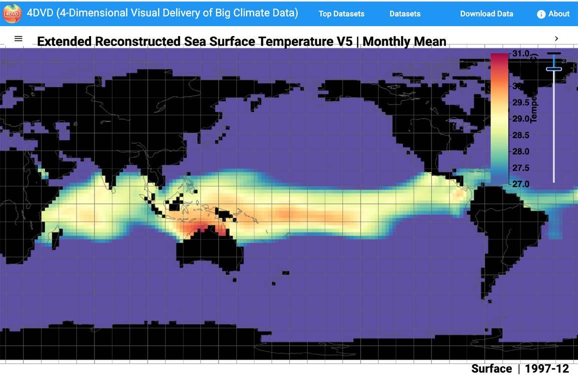

The Journal of Ocean Technology, Vol. 17, No. 4, 2022 35
Figure 2: (A) Sea surface temperature (SST) of December 1998 in the interval [22, 30] °C to show a La Niña scenario and a dramatic 7°C temperature difference between the eastern tropical Pacific and the western tropical Pacific.
SST of December 1997 in the interval [27, 31] °C to show an eastern Pacific El Niño.
(C) SST of December 1993 in the interval [22, 30] °C to show a neutral scenario.
(D) SST of December 2009 in the interval [27, 31] °C to show a central Pacific El Niño.


36 The Journal of Ocean Technology, Vol. 17, No. 4, 2022


The Journal of Ocean Technology, Vol. 17, No. 4, 2022 37
Figure 3: Samuel Shen training teachers to use 4DVD and R using real climate data.
Figure 4: December sea surface temperature (SST) time series of a grid box in the Niño 3.4 region from 1854 to present.
Dr. Samuel S.P. Shen is a distinguished professor of mathematics and statistics at San Diego State University, and visiting research mathematician at Scripps Institution of Oceanography, University of California, San Diego. His lab conducts research on climate mathematics, climate statistics, climate data science, and machine learning applications to climate science. Dr. Shen holds a B.Sc. in engineering mechanics, and MA and PhD in applied mathematics.
Javier Zambrano works as an environmental specialist. He holds a B.Sc. in environmental science from San Diego State University.

Dr. Thomas M. Smith is a physical scientist in NOAA/ NESDIS/STAR/Satellite Climate Studies Branch, co-located with CISESS/ESSIC at the University of Maryland. His work includes analyses of satellite and in-situ data and model output over different time scales. He has contributed to climate analyses, including temperature and precipitation that have been used to evaluate historical climate variations. He has a BA in mathematics, an MS in meteorology, and a PhD in oceanography.

Abdulalahi Mohamed holds a B.Sc. in applied arts and sciences, and computer science from San Diego State University. He is currently a software test engineer at General Motors.

Dr. Boyin Huang is a physical scientist in NOAA National Centers for Environmental Information. His work involves the dataset development of ERSST and NOAAGlobalTemp, the exploration of marine heatwaves, and applications of artificial intelligence/machine learning.


38 The Journal of Ocean Technology, Vol. 17, No. 4, 2022
Figure 5: Means and standard deviations of the 1854-2021 temporal sea surface temperature (SST) data of a grid box in the Niño 3.4 region.
An International Learning Experience
 by Marlene Power and Chris Batten
The Journal of Ocean Technology, Vol. 17, No. 4, 2022 39 MARLENE POWER
A key component of Marine Institute’s (MI) Internationalization Strategy is creating innovative globalized learning opportunities for MI students. A central mechanism supporting its students’ success in their academic journey is to better prepare them to succeed in a diverse and a more interconnected globalized work environment. Through Employment and Social Development Canada’s Global Skills Opportunity (GSO) funding, MI enhances students’ global competencies, both through virtual programming and through meaningful experiential immersion in the Blue Economy.
Introduction
In October 2022, eight students (Figure 1) from MI travelled to Barbados to discuss the deployment and use of ROVs with youth in Barbados. Engineering students from Barbados Community College and Sea Cadets attached to the Barbados Coast Guard had previously assembled ROV kits provided by MI by following instructional videos as the COVID-19 pandemic made travel impossible. This trip was an opportunity for MI students to discuss the assembly process and demonstrate the operation these ROVs in water, resulting in enhanced and transferrable skills for the

40 The Journal of Ocean Technology, Vol. 17, No. 4, 2022
Figure 1: Marine Institute students in Barbados learn about habitat restoration and share their knowledge of ROV usage for ocean resource management.
JAIMIE FEENER
engineering students and Sea Cadets and expanded knowledge on how ROVs can be used for different ocean-related projects, such as habitat restoration. In turn, MI students learned about climate change impacts and mitigation efforts in Barbados as well as new contexts for the use of ocean technology.
Prior to departure, the eight students attended a series of information sessions and completed an online course on global competencies developed by MI that included cross-cultural effectiveness, safety, health, logistics, career supports, and information specific to Barbados. Under this GSO program, students received faceto-face mentorship with staff and faculty members and reviewed potential career and professional development opportunities. They participated in meetings with stakeholders
and professionals within the Blue Economy, and learned to apply practical sectoral and technical skills in an international location.
On the Ground
During their time in Barbados, the students visited MI’s partner college – Barbados Community College (BCC) – to speak with its mechanical and electronic engineering students about ROV assembly and usage (Figure 2). Videos demonstrating ROV assembly were provided to BCC to assist with assembly of ROV kits, which MI provided in 2019 along with a smart board and a 3D printer.
The students also met with the Barbados Coast Guard where they assisted young Sea Cadets (secondary and post-secondary students) to deploy an ROV that they had assembled and provide guidance on required skills for

The Journal of Ocean Technology, Vol. 17, No. 4, 2022 41
Figure 2: Chris Batten from the Marine Institute speaks with Barbados Community College mechanical and electronic engineering students about ROV assembly and usage.
MARLENE POWER

42 The Journal of Ocean Technology, Vol. 17, No. 4, 2022
JAIMIE FEENER
Figure 3: Barbados Coast Guard Sea Cadets (secondary and post-secondary students) and Marine Institute students deploy an ROV assembled by the Sea Cadets with support from Barbados Community College.
ROV assembly and deployment (Figure 3). A number of tablets were presented to the Coast Guard to assist the Sea Cadets with further development of their technical skills.
Meetings were held at the Barbados Coastal Zone Management Unit to discuss the potential use of ROVs for coral reef protection and restoration; and with Dr. Shelly-Ann Cox of Blue Shell Productions to discuss the fisheries industry in Barbados, challenges faced by the industry, and the DigiFish project. This project uses digital
technologies and innovative data analytical methods to support the application of the ecosystem approach to fisheries in Barbados.
A visit was arranged to the Walkers Institute for Regenerative Research, Education, and Design; and tours were organized of Walkers Reserve, a rehabilitated quarry that has been regenerated to increase biodiversity and co-create self-sustaining systems, and of the Folkestone Marine Reserve, which was established in 1981 and is the only legislated marine protected area in Barbados.

The Journal of Ocean Technology, Vol. 17, No. 4, 2022 43
CHRIS BATTEN
Under this project, MI students were encouraged to consider the impacts of global issues such as climate change and how their career paths can contribute to Canada’s role in supporting climate resilience in a globally collaborative manner.


The Future MI will continue to work with BCC to build the competence of students at both institutions to utilize ROVs and ocean technology in general to promote international cooperation, the technical skills of youth, and advance occupations related to the Blue Economy and the diversification of employment and economy in the region (Figure 4). The long-term objective is to explore the use of ROVs for the rehabilitation of coral reef ecosystems, fragile ecological systems that include both hard and soft corals as well as sponges, starfish, crabs, squid, octopus, sea urchins, and reef fish and which are essential to the Caribbean region. Through this project, it is hoped that students will gain a better
understanding of reef rehabilitation initiatives by surveying new and existing sites and deploying reef balls – prefabricated, artificial reef structures used to create or restore marine habitat – using ROVs. u
Marlene Power is an international program officer with MI International. A certified project management professional, she is currently focused on the acquisition and management of partnerships, projects, and consultancies in the Caribbean and Latin America. Since joining MI International, she has supported business development, international mobility, and quality management initiatives, and has managed projects in Asia, Africa, and Europe. Ms. Power began her career in the humanitarian sector, having worked with Doctors Without Borders for three years in the Democratic Republic of Congo, with the United Nations High Commission for Refugees in Turkey, and as a consultant with Citizenship and Immigration Canada. She has also taught English as a second language in South Korea, Japan, and Quebec. She holds a bachelor of arts (honours) in political science from St. Francis Xavier University, a master of arts in political studies (international relations) from Queen’s University, and a master of philosophy in humanities from Memorial University. She is currently pursuing an interdisciplinary PhD in business, education, and political science at Memorial University.
Chris Batten is chair of the Remotely Operated Vehicles and Underwater Vehicles programs and a laboratory demonstrator/instructor with Marine Institute’s (MI) School of Ocean Technology. He has a diploma in electronics engineering technology (computers and IT) from the College of the North Atlantic, a bachelor of technology from MI, and a bachelor of education from Memorial University. His previous work experience includes various research and development projects through C-CORE’s centrifuge facility, Memorial University, and the Centre for Sustainable Aquatic Resources (CASD) at MI. The most notable projects are the biodegradable twine project conducted through CASD, vortex-induced vibration testing with Memorial University Engineering, and skewed rotor design at MI. Mr. Batten’s specialties include data acquisition, electronics and circuit board design and fabrication, computer-aided design and fabrication, 3D printing, CNC milling, computer networking, programming, and microcontrollers.

44 The Journal of Ocean Technology, Vol. 17, No. 4, 2022
Figure 4: Barbados Community College and Marine Institute students discuss aspects of their programs and their relevance to ocean initiatives.
MARLENE POWER
to the in
by Matthew Mulrennan and Chad Collett

The Journal of Ocean Technology, Vol. 17, No. 4, 2022 45
Expedition Launching Study Colossal Antarctica Squid ISTOCKPHOTO.COM/JOCREBBIN
An international expedition is heading to Antarctica in December 2022 in an attempt to find and film the largest invertebrate in the world in the deep sea for the first time. A collaborative effort is underway between a polar tourism vessel, underwater technologists, and marine biologists to repeatedly deploy deep-sea cameras into the Southern Ocean to try uncover the biological mysteries of the colossal squid. The goal is to find and study the colossal squid before 2025, the 100-year anniversary of the first discovery of the species.
An International Effort
The initiative is a joint effort between five organizations, each lending its expertise. KOLOSSAL, an American exploration and conservation non-profit, is joined by specialist travel operator, Chimu Adventures. The research will be conducted aboard the tourism vessel, Ocean Endeavour, which is operated by Intrepid Travel, the largest small-group adventure company in the world. Canadian ocean tech company, SubC
Imaging, is lending its technical expertise and equipment to the project. The team is rounded out by researchers from Memorial University’s Marine Institute, Canada’s most comprehensive centre for education, training, applied research, and industrial support for the ocean industries.
About the Colossal Squid
The colossal squid is the largest invertebrate in the world, and one of the largest ocean predators (Figure 1). It has the largest eye in the animal kingdom, about the size of a dinner plate. It could weigh as much as 750 kg or more, and the total length is ~10-12 metres. It is larger by weight than the better-known giant squid, Architeuthis, and believed to live primarily in the deep sea in the Southern Ocean. It has hooked tentacles and is in a genus by itself – Mesonychoteuthis. Little is known about the colossal squid’s basic biology, behaviour, unique use of bioluminescence, and conservation status. A summary paper of what is known about the colossal squid sums up the major gaps in understanding the world’s largest

46 The Journal of Ocean Technology, Vol. 17, No. 4, 2022
Figure 1: Colossal squid are the largest invertebrates in the world and weigh up to 750 kg with a total length of 10 to 12 metres.
A. REMESLO, 1981
invertebrate: “... its basic biology and ecology remain one of the ocean’s great mysteries.”
“The colossal squid is an oversized poster species for how little we know about the ocean,” said Matt Mulrennan, marine scientist, an organizer of the expedition and founder/CEO of non-profit KOLOSSAL.
Research Goals
Research will be conducted by graduate students at Memorial University’s Marine Institute. The goal is to document the colossal squid underwater in its natural habitat in the next three years (2025), before the 100-year anniversary of the first discovery of this species. In 1925, two arms of a colossal squid, Mesonychoteuthis hamiltoni, were found inside the stomach of a sperm whale. Since then, only a few whole specimens have been captured or viewed alive and never in the
colossal squid’s natural habitat, the deep sea between 500-2,500 metres.
The group will be surveying locations in the Antarctic Peninsula on board the tourism vessel Ocean Endeavour (Figure 2), operated by Intrepid Travel, to try to find and film a colossal squid. They hope to observe its behaviour and raise awareness about conservation priorities for the Southern Ocean. With this expedition, they seek to potentially answer some basic biological and ecological questions about the colossal squid: How large do they grow? What is their most preferred habitat and what depths do the adults live in? Do adult females spawn near the surface? How does it use its massive eye (offense or defense)? Is it attracted to lighted displays? How does it use its bioluminescent photophores around its eyes? Is it truly an ambush hunter or more active? Is it a pelagic

The Journal of Ocean Technology, Vol. 17, No. 4, 2022 47
Figure 2: The Ocean Endeavour is a polar expedition ship operated by Intrepid Travel.
INTREPID TRAVEL
species or does it spend time in fiords? What is its population size and conservation status?
“The colossal squid expedition is an unparalleled opportunity for our graduate research students to collaborate with an international team to expand our limited knowledge of this rarely seen species,” says Dr. Paul Brett, acting vice-president, of Memorial University (Marine Institute). “We are thrilled that our students will be able to lend their Canadian Arctic research experience and know-how in deploying similar innovative technology to this deep ocean exploration. Through knowledge generation, research, and industry collaboration, we are bringing our expertise to
the world to gain a better understanding of our global ocean ecosystems.”
Methods and Technologies
The colossal squid is believed to be a slowmoving ambush hunter, with a low metabolism and eating infrequently. It is thought to live only in the remote, deep sea of the Southern Ocean making it a difficult target species for research. To attract and observe it, the team will need to get very close to the squid with a suitable deep-sea camera system. The weather, wave, currents, and ice conditions of the Southern Ocean make submersibles, remotely operated vehicles, and autonomous underwater vehicles less reliable and possibly riskier for finding the colossal squid. Instead, researchers

48 The Journal of Ocean Technology, Vol. 17, No. 4, 2022
Figure 3: Researchers will use this modified version of SubC Imaging’s Tow Camera System to attract and observe the colossal squid.
SUBC IMAGING
will repeatedly deploy a tethered cable attached to a frame and deep-sea camera system made by SubC Imaging. They will use an oceanographic winch and a crane that is affixed to the vessel. The system will be deployed to a maximum of 500 metres depth by a small team of two to four researchers from a gangway door on the first floor of the Ocean Endeavour. They will employ a modified version of SubC Imaging’s Tow Camera System (Figure 3) along with a 4K Rayfin camera (Figure 4) and red and white LED lights.
“It’s wonderful that our technology will be used to attract and possibly capture footage of the elusive colossal squid, especially as we approach the 100-year anniversary of the first discovery of this species,” says Chad Collett, founder, CEO, and camera systems manager at SubC Imaging. “It’s this type of collaborative opportunity that breeds innovation and helps move forward ways to gather imaging for marine research.”

Conservation Goals
The mystery of the colossal squid is a prime example of how much we still can learn about
the ocean. With this expedition, the group also wants to inspire the public (Antarctic tourism guests and beyond) about the ~90% of the ocean largely unexplored.
“The expedition will launch our Antarctica expedition cruise, specially chartered by Chimu, with Australian mathematician and media personality Adam Spencer, so we’re thrilled that this trip will have such a strong element of citizen science for our travellers,” says Chad Carey, Chimu’s managing director. “On all our trips, wildlife is an integral part of the experience so the opportunity to learn more about creatures of the deep adds such a unique element to the journey. After visiting Antarctica, we find our guests become ambassadors and advocates for the planet so we’re thrilled to educate them about the elusive colossal squid.”
Talks about the expedition will be conducted to guests onboard the tourism vessels and a documentary is being developed that seeks to get people engaged in major decisions impacting the ocean. This includes passing the High Seas Treaty, expansion of Antarctic
The Journal of Ocean Technology, Vol. 17, No. 4, 2022 49
Figure 4: 4K video and high-resolution digital stills of the colossal squid will (hopefully) be captured using SubC Imaging’s Rayfin Coastal 500 m camera. SUBC IMAGING
marine reserves, and how individuals can make seafood decisions that impact far away nearly pristine ecosystems.
Multi-Year Initiative
The pilot investigation and first expedition to Antarctic waters will occur in December 2022. The group will return to Antarctica each year, partnering with university students. The team hopes to report back frequently on its findings. “It’s the largest invertebrate on our planet, with the world’s biggest eye, hooked tentacles, and likely glows in the dark; does it get any cooler than that?” continues Mulrennan. “Studying this species in this remote region is a truly challenging adventure. So let’s ‘get kraken’ on this exciting scientific expedition!” u
Matt Mulrennan is the founder and CEO of KOLOSSAL. He is a fellow of the Explorers Club, a marine scientist, technology enthusiast, and conservationist. For over 12+ years, he has worked in ocean exploration and conservation as a staff researcher at Scripps Institution of Oceanography, a marine scientist at ocean conservation group Oceana, director of the Ocean Initiative at the XPRIZE Foundation, and was the CEO of EnVest. Alongside KOLOSSAL, he works with ocean and climate investing funds. At the helm of KOLOSSAL, it became one of 20 candidate groups for the 2018 Pritzker Emerging Environmental Genius Prize. KOLOSSAL was the grand prize winner for the Con X Tech Prize for prototyping a deep-sea camera system. He has a master’s in marine biodiversity and conservation from Scripps Institution of Oceanography, and a bachelor’s in environmental studies from Miami University.


Cephalopoda in the diet of sperm whales of the southern hemisphere and their bearing on sperm whale biology
Sizing ocean giants: patterns of intraspecific size variation in marine megafauna
On Mesonychoteuthis, a new genus of oegopsid Cephalopoda
Alien vs. Predator: interactions between the colossal squid (Mesonychoteuthis hamiltoni) and the Antarctic toothfish (Dissostichus mawsoni)
Distribution and biology of the colossal squid, Mesonychoteuthis hamiltoni : New data from depredation in toothfish fisheries and sperm whale stomach contents
Biology and ecology of the world’s largest invertebrate, the colossal squid (Mesonychoteuthis hamiltoni : a short review)
Cephalopods of the world. An annotated and illustrated catalogue of species known to date Slow pace of life of the Antarctic colossal squid
Biogeography of Cephalopods in the Southern Ocean using habitat suitability prediction models
Journal of Ocean Technology, Vol. 17, No. 4, 2022
Chad Collett started out diving with the Canadian Navy, then worked at NRC-Institute for Ocean Technology, Oceaneering, and Welaptega Marine before founding SubC Imaging – a world leader in selling innovative underwater camera technologies. As a member of KOLOSSAL, Mr. Collett and the team at SubC became one of 20 candidate groups for the 2018 Pritzker Emerging Environmental Genius Prize. KOLOSSAL was the grand prize winner for the Con X Tech Prize for prototyping a deep-sea camera system.
50
The

Follow us @jotnfld Informative Cutting Edge Provocative Challenging Thought Provoking International thejot.net
by Randy Billard

52 The Journal of Ocean Technology, Vol. 17, No. 4, 2022
How will you be Trained for your Next Ocean Career?

The Journal of Ocean Technology, Vol. 17, No. 4, 2022 53 ISTOCKPHOTO.COM/THINKHUBSTUDIO
Lifeboat Coxswain: “Vessel 1, we have a visual on the man overboard (MOB). He is north of our position at approximately 200 feet.”
Standby Vessel: “Roger Lifeboat 1, MOB is north of your position at approximately 200 feet. Prepare to approach the MOB for recovery. Winds are 30 knots from the southwest and seas are 8 to 10 feet.”
Lifeboat Coxswain: “Roger, approaching MOB to attempt recovery. Winds are 30 knots from the southwest and seas are 8 to 10 feet.”
(4 minutes pass)
Lifeboat Coxswain: “Vessel 1, we have made two attempts to recover the MOB. On the first attempt, we could not get within reach of the MOB. On the second attempt, we hit the MOB. We are now moving clear to evaluate our next move.”
Simulator Instructor: “Alright Coxswain. Let’s stop the exercise and talk about what happened. No harm here, this was only a simulation.”
This dialogue was captured in a marine training scenario involving a lifeboat that would otherwise not be possible to perform without a simulator. The risks associated with placing people and equipment in harsh environments are too high. Simulations provide the only safe way to practice for plausible emergency events and challenging weather conditions. In this training example, it was possible for the coxswain to practice the pickup of a MOB in a moderate sea state and although a mistake was made there was no real harm to anyone in the exercise. The simulated scenario also allowed for the trainer to utilize an instructional approach to enable the operator to see the impact of their actions and to create a learning moment, again with no physical harm to any trainees (Figure 1).
If you are entering a career in the marine industry, or must complete training to
Journal of Ocean Technology, Vol. 17, No. 4, 2022
maintain your skills, chances are you will complete at least part of your training in a virtual environment. Digital technologies including simulations, virtual reality (VR), and augmented reality (AR) are commonly used in military, health care, and marine training. Ship simulators are used in several marine training facilities for navigation and operational training. Small boat simulators, including lifeboat and fast response boat trainers, are newer technologies that are being integrated with marine emergency response and search and rescue training programs. The use of virtual technologies is increasing due to several factors. The primary driver for using simulation in emergency response training is safety. Accidents have occurred during lifeboat training and maintenance exercises motivating operators and training schools to adopt simulators as a safer alternative. Simulators also provide much needed capacity and flexibility in training. Increased demands on marine operations have created a deficiency in the available workforce. The COVID-19 pandemic created a backlog in maritime training and has driven the adoption of digital technologies to facilitate access to training. The transformation to a digital workforce is also resulting in the acceptance of virtual trainers and a desire for flexible and customized training programs.
There are many advantages of using virtual environments in marine training. A key benefit is the ability to create learning environments that are representative of real operations. As an example, for emergency response training, site-specific virtual assets including specific offshore platforms, launch systems, and vessel controls can be modelled and realistic hazards (smoke and fire) and weather can be emulated. Operational specific procedures, names, and communications can be introduced in scenario scripts. These features create immersive scenarios that trainees can practice repeatedly to build muscle memory. Practicing in plausible events with realistic weather and equipment will improve trainee performance in a real event
54
The
as they are able to draw on past experiences. Virtual training is also customizable. Scenarios can range in difficulty and can be tailored as practice exercises to build competence in novice trainees or to challenge experienced operators in complex situations. Simulators and VR/AR trainers also provide a low cost and flexible way to train.
The rise of digital twins in the marine industry is in line with the increased use of virtual environments in training. Digital representations of physical operations, or twins, are used to capture information on processes and operations often using virtual models of assets to display and track key data. Digital twins can be created for offshore
platforms, marine vessels, and docking facilities and normally include detailed 3D models of the assets and sensor datasets. The 3D models can be used to generate virtual environments for workplace familiarization and site-specific training. Simulations and VR trainers can be integrated with digital twins and use site-specific models and environmental data to create operationspecific scenarios. AR simulators can use virtual models to extend workplace training and real-time skill transfer from experienced workers to novices. Simulations also create digital training records that can be integrated with digital twins. Data collected from virtual training environments can inform decision support systems and provide a real-time

The Journal of Ocean Technology, Vol. 17, No. 4, 2022 55
Figure 1: Simulated scenarios allow for the trainer to utilize an instructional approach to enable operators to see the impact of their actions and to create a learning moment – with no physical harm to the trainees.
VIRTUAL MARINE
assessment of operational readiness using human performance data collected in training programs. Machine learning and artificial intelligence algorithms can evaluate trainee readiness based on operational data from digital twins. Data from digital twins can be used to direct training, allow for customized curriculum, and can provide just-in-time training for forecasted events.
In summary, simulations and VR/AR technologies are increasing in use in marine training due to the benefits of using virtual environments and the continued industry digital transformation. If you will be completing a marine training course in the near future, there is a good chance you will be wearing a VR headset.


Dr. Randy Billard is president and CEO of Virtual Marine. Virtual Marine specializes in the development of state-of-the-art maritime safety training simulators, offering skillenhancing, hands-on, realistic, riskfree training. Science is incorporated into advanced training systems to produce

oceanbusiness.com


56 The Journal of Ocean Technology, Vol. 17, No. 4, 2022
u
G Meet 360+ world leading manufacturers and service providers G Discover the latest marine autonomous systems, survey tools and biological and chemical sensors G See equipment live with 180+ hours of free training & demonstrations G Navigate the year ahead and have your questions answered at the free conference REGISTER NOW FOR FREE Be at the forefront of ground-breaking innovation TRANSFORM YOUR BUSINESS 3 DAYS HUNDREDS OF SOLUTIONS In partnership with: Hosted by: National Oceanography Centre THE HANDS-ON OCEAN TECHNOLOGY EXHIBITION AND TRAINING FORUM OB23_A4 Ad half.indd 1 28/09/2022 11:40
unique and memorable learning experiences. www.virtualmarine.ca
by Keith Hutchings

The Journal of Ocean Technology, Vol. 17, No. 4, 2022 57
Harvesters
to Help Make Industry More Sustainable Through Gear Enhancements
CCFI Brings Innovators, Regulators, and
Together
DENNIS TRAINOR
Introduction
The North Atlantic right whale has been listed as endangered under the Canadian federal Species at Risk Act, with experts estimating there are less than 350 left. Primary threats to the species include entanglement in fishing gear, vessel strikes, climate change that is altering migratory patterns and feeding areas, and the impacts of ocean noise on the whale’s ability to communicate, find food, and navigate. Given the dire state of the population of the species, Fisheries and Oceans Canada (DFO) put a suite of fisheries measures and initiatives in place in the Atlantic Canada and Quebec regions to prevent entanglements. They include enhanced monitoring and reporting, requiring fishing activity to be altered when right whales are observed in a given area, requiring lost gear to be reported, retrieving ghost gear, and requiring all interactions with marine mammals to be reported. Looking to the future, DFO also committed to engaging fishing industry stakeholders on the development and implementation of “whale safe gear” (i.e., gear that would prevent the possibility of entanglements for right whales and other marine species). Traditional harvesting gear involves placing fishing gear at or close to the bottom of the ocean to harvest various species, often with rope extending to floatation devices on the surface so that gear can later be found and retrieved. It is these ropes that have been identified as posing significant entanglement threats, and priority has been placed on finding an alternative approach to harvesting.
With that goal in mind, DFO enlisted the help of the Canadian Centre for Fisheries Innovation (CCFI) in 2022, capitalizing on the institute’s 30-year history of partnering with diverse industry stakeholders to advance innovations that strengthen Canada’s seafood industry. Over the course of the year, CCFI has coordinated meaningful collaboration between innovators, researchers, harvesters, and regulatory officials with a view to augmenting current fishing equipment in ways that address concerns related to
entanglement, while keeping harvesting gear user friendly and dependable for harvesters and the industry. Work such as this is vital to Canada’s ability to demonstrate its investment and focus in maintaining sustainable fishery practices and protocols to satisfy the expectations and requirements of the nations to which it exports food products.
The author would like to take this opportunity to give recognition and thanks to the Centre for Sustainable Aquatic Resources (CSAR) at the Fisheries and Marine Institute of Memorial University for its participation in the project. CCFI has a strong history of engaging the foremost academic expertise in the world to advance important projects related to seafood innovation, and its partnership with CSAR on this project is another example of this.
A Collaborative Effort
With respect to augmenting current practices and equipment, CCFI’s primary partners have been Ashored Innovations and E-Sonar (Figure 1). Ashored Innovations is headquartered in Bedford, Nova Scotia, and is focused on sustainability-enabling technologies for the commercial fishing industry. The company was an ideal partner, as it had already developed different prototype “rope-less” fishing equipment that had been tested at sea, and the company now wanted to trial the equipment in the harsh and diverse marine environments found near Newfoundland and Labrador to make it more robust and adaptable to varying environmental conditions. E-Sonar, a St. John’s-based tech company focused on improving access to marine and subsea environmental data through advanced underwater acoustics technology, also brought invaluable knowledge to the project by applying its expertise in tandem with Ashored to produce a “Rope On Command” enhancement for harvesters. Essentially, the Ashored / E-Sonar prototype unit is connected to a trap or string of trap equipment that would be sent to the sea bottom to harvest in a fixed gear fishery. The prototype, called a MOBI (Modular
Journal of Ocean Technology, Vol. 17, No. 4, 2022
58 The
Figure 1: CCFI collaborated with Ashored Innovations and E-Sonar to trial rope-less fishing equipment, which includes advanced underwater acoustics technology, in the harsh and diverse marine environments found near Newfoundland and Labrador.

Ocean Based Instrument), contains coiled rope to serve as a surface line that connects with the harvester’s traps on the ocean floor until they return to the fishing ground to haul the gear. The equipment marks the location of the equipment, and when a harvester wishes to retrieve it, MOBIs are activated with an acoustic buoy release (with a passive backup timer,) and can be triggered to surface by an on-vessel MOBI Commander as the vessel arrives back in the area of visual proximity.
Working with CCFI, the companies engaged in sea trials off the coasts of Newfoundland and Labrador, with a view to determining what kinds of enhancements could be made to make the equipment even more robust, adaptable,
and user-friendly (Figure 2). Sea trials in these waters have proven valuable, not only because of the uniquely deep water fisheries conducted here, harsh currents, and hard seabeds that characterize the fishing areas, but also because CCFI arranged to have local harvesters conduct the sea trials personally so that all project participants could avail of their expertise and assessment of the pros and cons of the new equipment. In addition, CCFI arranged an information session with harvesters regarding the “Rope on Command” gear being trialled (Figure 3), and CCFI also plans to conduct demonstrations of other rope-less gear innovations that are currently in development in the U.S. and other parts of Canada to familiarize harvesters with the
The Journal of Ocean Technology, Vol. 17, No. 4, 2022 59
CCFI
Figure 2: During sea trials of the MOBI (Modular Ocean Based Instrument), the aim was to test for any needed enhancements to make the equipment even more robust, adaptable, and userfriendly.

Figure 3: CCFI arranged an information session with harvesters regarding the “Rope On Comand” gear.

60 The Journal of Ocean Technology, Vol. 17, No. 4, 2022
CCFI
CCFI
broad range of inventive activity currently taking place. Work will continue into 2023, with the current prototype already having undergone several iterative enhancements that have made it perform well in especially harsh and deep conditions.

In the fall of 2022, Edward Trippel of Integrated Resource Management within DFO and other DFO officials visited CCFI
(Figure 4) to discuss work to date, work ongoing in other jurisdictions, and the Ropeless Consortium Annual Meeting at the New Bedford Whaling Museum, which assembled experts, innovators, and regulators to share ideas and progress with respect to protecting the right whale through enhancements to harvesting gear. The work that continues to take place off the coast of Newfoundland and Labrador informed some of Mr. Trippel’s
The Journal of Ocean Technology, Vol. 17, No. 4, 2022 61
Figure 4: Members from Fisheries and Oceans Canada visit CCFI to discuss the MOBI and other rope-less projects.
CCFI
commentary when he spoke at the conference, and CCFI participated in the conference as well and followed up with attendees to gain greater insight on work taking place across North America. Working co-operatively, a broad and connected group is sharing information and resources in methods that can be expected to change the way harvesting activity takes place in the future so that it no longer poses any threat to the North Atlantic right whale and other marine life.
Looking Ahead


More news and developments can be expected to come in 2023 related to this important work, and CCFI will be well positioned and proud to help lead the discussion on next steps. As this technology continues to develop, CCFI is excited to engage with industry and continue to grow the knowledge base on rope-less gear and provide insight. As part of achieving greater engagement with stakeholders in its


research activities, CCFI will be officially launching online resources in the form of a new website and social media channels where developments about our work will be shared. We invite readers to follow us online, and learn more about the progress of this and many other exciting projects over the course of 2023. u


Keith Hutchings is the managing director of the Canadian Centre for Fisheries Innovation. He has been involved in large-scale management experience with extensive knowledge of inter-governmental affairs, innovation, business development, natural resource industries, and regulatory compliance. Prior to his leadership of CCFI, he served as a Cabinet Minister for the Government of Newfoundland and Labrador in multiple portfolios including fisheries and aquaculture, and prior to that, served in both the public and private sector leading change management in health and safety culture while working successfully with employers, unions, and industry associations.

62 The Journal of Ocean Technology, Vol. 17, No. 4, 2022

KATIE KIRK
OCEANOGRAPHER NOAA CENTER FOR OPERATIONAL OCEANOGRAPHIC PRODUCTS AND SERVICES PHD CANDIDATE
UNIVERSITY OF NEW HAMPSHIRE NEW HAMPSHIRE, U.S.
Katie Kirk leads tidal current survey projects in the National Current Observation Program on the Coastal and Estuarine Circulation Analysis Team with the U.S. National Oceanic and Atmospheric Administration (NOAA). The tidal current surveys involve deploying acoustic Doppler current profilers to collect observations of the current velocity at many stations throughout an estuary, harbour, or area along the coastal U.S. From these observations, the team runs a harmonic analysis in order to generate tidal current predictions at these locations.
In addition to her role with NOAA, Ms. Kirk is pursuing a PhD studying the high frequency variability about the mean tidal currents in narrow tidal inlets where there are areas of strong horizontal velocity shear. A small perturbation in the shear can lead to the mean currents becoming unstable, called shear instabilities. Her goal is to better understand

the physical dynamics that lead to the presence of shear instabilities of tidal currents that could ultimately lead to the meandering of the mean tidal current and the subsequent spin-off of nonlinear vorticities in the form of eddies. The presence of shear instabilities leads to the mixing of momentum across the inlet, which can impact the fate and transport of organic and inorganic matter and renewable energy initiatives that depend on estimates of the mean velocity. By learning more about the presence of shear instabilities in tidal inlets, greater insight can be gained regarding the consequential mixing of momentum processes and how this affects estuarine dynamics.
Ms. Kirk enjoys the fieldwork and collecting the observations on the water. It is a challenging process to ensure proper data collection based on the variable environmental conditions at each site given the equipment constraints and other vessel logistical hurdles. Her PhD work provides an opportunity to improve various skillsets and better understand the physical dynamics of coastal tidal current flow that she can apply in her role with NOAA.
https://tidesandcurrents.noaa.gov/ https://ccom.unh.edu/user/kkirk katherine.kirk@unh.edu
64 The Journal of Ocean Technology, Vol. 17, No. 4, 2022
ERIC BREUER, NOAA CO-OPS
JENNIFER OTENG
MASTER STUDENT, APPLIED OCEAN TECHNOLOGY (OCEAN MAPPING)
MARINE INSTITUTE MEMORIAL UNIVERSITY OF NEWFOUNDLAND AND LABRADOR ST. JOHN'S, N.L., CANADA
Jennifer Oteng always had a strong desire to participate in field data collection to learn the methods used to collect the information necessary to make ocean-related decisions. Being an ocean mapping student and taking a course in marine spatial planning and management further cemented that desire. When Ms. Oteng had the opportunity to participate in a research study during the summer of 2022, she jumped at the chance.
She boarded the MV Patrick and William to work on a marine conservation area project with the Marine Institute and Fisheries and Oceans Canada (DFO) and worked with seasoned ocean technology experts, who willingly explained the processes and the various research approaches used. This project is part of DFO’s Ocean Management Contribution program for marine conservation across Canada. In particular, the Northeast Newfoundland Slope, Hopedale Saddle, and Funk Island Deep marine refuges offshore Newfoundland and Labrador (N.L.) are the locations of interest in this region.
The project’s main objective is to gather information for long-term ecological monitoring using a variety of methods, including baited cameras, drop cameras, multibeam and fisheries echo sounders, collection of seawater samples for environmental DNA analysis to identify fish
and other aquatic species, and plankton nets to gather plankton samples. Given that the research areas are marine conservation areas –protecting coral habitats and acting as spawning grounds – having enough data to identify the specific species and coral locations will facilitate proper monitoring and assist in management decisions. This will help preserve and protect these areas by observing changes over time. The information gathered will be used as the starting point for additional years of data collection and will support graduate students’ studies aimed at maintaining and monitoring marine conservation areas offshore N.L.
For Ms. Oteng, the opportunity to participate in this research expedition meant gaining hands-on experience, undertaking novel tasks that were outside of her field of study, and giving her supplementary knowledge to what she learns in class.
https://www.4d-oceans.com/ joteng@wave.mi.mun.ca

The Journal of Ocean Technology, Vol. 17, No. 4, 2022 65
ADAM TEMPLETON
DR. MALTE PEDERSEN
PHD FELLOW
AALBORG UNIVERSITY, DENMARK PIONEER CENTER FOR AI, DENMARK
As a master’s student, Dr. Malte Pedersen was hired as an intern at a Norwegian research institution where he had the chance to work on an underwater range-gated time-of-flight camera. There he discovered how different underwater environments can be compared to their terrestrial counterparts and how much more difficult it is to capture high quality images and videos in underwater environments. This was the begining of Dr. Pedersen’s interest in marine analytics using computer vision.
Today, his research has two focuses: creating and evaluating image and video datasets suitable for developing and enhancing intelligent and automated solutions for detecting, classifying, and tracking marine species using computer vision; and developing new methods for tracking and identifying fish. Such automation allows marine scientists to conduct experiments such as behavioural analysis or counting the number of different species in an area in a non-lethal manner with minimal impact on the local ecosystem. For example, Dr. Pedersen worked with marine scientists who were trying to determine whether (and how often) individual sunfish visited particular areas in Bali. Rather than manually reviewing images from a database comprised of thousands of images and trying to recognize individuals based on spots and patterns on the sunfish, his automated solution – which is objective, reduces manual labour, and is scalable – was able to find a large portion of the matches.
To date, Dr. Pedersen has published the first bounding box annotated underwater dataset of marine species captured in European waters (The Brackish Dataset), which currently has more than 25,000 views and over 2,100 downloads from around the world. He has also published the first 3D zebrafish tracking dataset (3D-ZeF) for developing tracking algorithms for behavioural analysis of fish in controlled environments. https://vbn.aau.dk/en/persons/141158 www.aicentre.dk mape@create.aau.dk

LARS HORN 66 The Journal of Ocean Technology, Vol. 17, No. 4, 2022

Notti Dr. Emilio Q&A with
Mechanical engineering graduate with a master thesis on reducing energy demand in bottom trawlers. Involved in fishing gear and fishing vessel technology development and engineering. Experienced in energy performance evaluation and energy audit of commercial fishing vessels. Specialist in fishing gear design for bottom trawling and on engineering performance evaluations of fishing gear. Expert in design and development of propulsion system and deck machineries for working boats and fishing vessels. Skilled in assessing fishing activity impact on marine ecosystems with a focus on seabed impact of bottom trawls. Scientific responsibility in national and international research projects – in charge of technical and economic management of the project activities. Responsible for sea trial campaigns on board research and commercial vessels for technical and engineering testing of fishing gears and technological development of deck machineries. Member of the scientific committee of the Institute of Marine Biological Resources and Biotechnologies.

68 The Journal of Ocean Technology, Vol. 17, No. 4, 2022
Where were you born? Where is home today?
I was born in Ancona, Adriatic Coast of Italy. Today, I live in Falconara Marittima, 12 km north from Ancona.
What is your occupation?
I am a technologist at the Institute of Marine Biological Resources and Biotechnologies (IRBIM) of the Italian National Research Council.
Why did you choose this occupation?
During my studies in mechanical engineering, I was engaged as a research fellow in a European project dealing with theoretical feasibility of a hybrid propulsion system for trawlers. I was excited by the world of research and its potential. Moreover, as my faculty was not focused on naval architecture, this presented me with a great opportunity to expand my knowledge.
Where has your career taken you?
I started as an intern with some national and international research projects dealing with energy efficiency in fisheries and, since then, have had the opportunity to travel all around the world seeking new technologies and collecting information to contribute to the promotion of more fuel-saving fisheries in Europe.
If you had to choose another career, what would it be?
I would look for a career in a shipyard; since I was young, I have been captivated by ships and maritime technologies – thanks to my father, who was employed in Fincantieri, the most important shipyard in Italy.
What is your personal motto?
There are no problems, only opportunities.
What hobbies do you enjoy?
For a long time, I was a dog trainer for sea rescue. Travelling is also another great passion.
Where do you like to vacation?
My preferred vacation is one that combines great sightseeing with history, culture, and myths.
Who inspires you?
People who remain silent and let their actions and results speak for them.
What has been the highlight of your career so far? The highlight so far was coordinating two projects on very different topics. One was an international project dealing with energy efficiency of propulsion systems through an organic Rankin cycle heat recovery system tested on a bottom otter trawler in real conditions; it was very challenging and instructive dealing with such a complex operation in terms of technical specifications, technological creep, and scheduling and managing sea trials. The other was a local project dealing with energy efficiency and environmental impact reduction of fishing activity with a focus on the reduction of greenhouse gas emission in harbours, and the circular economy of marine plastic litter recovered by fishers during fishing activity. It was exciting to move from a high-level research project to a scaled project but important from the perspective of stakeholder involvement and technological transfer.
What do you like most about working in this field? When working on high-level research projects, they provide insight and knowledge from a scientific context to end users (the fishers), who can contribute to restoration of the marine environment, and also an opportunity to develop a more environmentally friendly approach.
What are some of the biggest challenges your job presents?
I think the biggest challenge is the bureaucracy that sometimes presents a barrier. As a public body, we must follow a tremendous number of rules and regulations that are not well suited for research activity. The distrust and resistance of fishers also present some obstacles.
What technological advancements have you witnessed?
The fisheries sector is mainly characterized by a general reluctance to technological innovation, so it is difficult to talk about relevant advancements. However, especially in the Mediterranean Sea, some new technologies and approaches have been recently implemented by fishers, such as adopting less impacting otterboards in demersal trawl fisheries or installing energy monitoring systems for more efficient conduction of the vessel. Also,
The Journal
Technology,
17, No. 4, 2022 69
of Ocean
Vol.
new systems for controlling fishing activity based on predictive models developed by researchers and aimed at enhancing the management of fisheries has been implemented by national authorities.

What does the future hold for this industry?
Research activity in environmental fields has a critical responsibility nowadays that requires scientists to not only make advances on the knowledge and find new methodologies and solutions, but also to communicate these
advancements with end users. It is no longer appropriate for a top-to-bottom approach – without consensus from the bottom levels, no relevant results can be achieved.
What new technologies would you like to see?
New technologies in the fishing sector would result in a decrease of harmful environmental impacts, especially with the reduction of greenhouse gases and unwanted catches through more efficient fishing gears. If we pay attention to the environment, we obtain many advantages: we
70 The Journal of Ocean Technology, Vol. 17, No. 4, 2022
guarantee a more sustainable activity, we create the opportunity to save money by lowering running costs, and we protect the resources for future generations. New technologies based on big data repositories can also contribute to the development of management tools that can be adopted by fishing cooperatives for enhancing the planning of fishing strategies. New communication plans can be developed that are more informative about fishing products (real-time information of fishing activity, RFID technologies that regularly collect information, etc.).
What advice do you have for those just starting their careers?
To those who want to participate in fisheries research, I suggest driving innovation despite the constraints and limits of the fishing sector; but, always remember to regard research activity and production of knowledge in such a way that end users will be in a position to make use of these advancements. Do not be afraid of technological creep – that will be the goal. Finally, research activity in environmental fields is not only for the sector and the scientist: it is for the planet.

The Journal of Ocean Technology, Vol. 17, No. 4, 2022 71
Trade Winds
The Launch: A Portal to the Ocean for the Global Marine Community
Fisheries and Marine Institute of Memorial University
The Launch is the Marine Institute’s (MI) hub of ocean innovation, discovery, and leadership, providing a collaborative and inclusive space for Canada’s ocean stakeholders and rights holders to operationalize the vital technology needed to support ocean health and economic prosperity from coast-to-coast-to-coast.
Located in Holyrood, N.L., with direct access to the Northwest Atlantic Ocean and one of the harshest marine environments in the world, The Launch is ideally located to mobilize Canadian and Arctic Ocean research – if it works here, it will work everywhere.
Strategically located at the most southerly point of the Labrador Current, The Launch is adjacent to some of the coldest, most pristine waters in the world, offering access to deep water, cold ocean research and development, almost year-round.
This facility … provides a vibrant, innovative centre for advancing technology development, training, and research for Memorial and N.L.

72 The Journal of Ocean Technology, Vol. 17, No. 4, 2022
Kelly Santos, Director, The Launch
MARINE
INSTITUTE

The Journal of Ocean Technology, Vol. 17, No. 4, 2022 73 DANIELLE PERCY
Designed to support a comprehensive approach to ocean research, The Launch provides access to vessels, technology, technical expertise, and collaborative partnerships – creating an ideal environment to further Canada’s Blue Economy Strategy and support opportunities presented by the UN Decade of Ocean Science.
Our
Strengths
Featuring extensive marine facilities, The Launch provides a safe, reliable, near-Arctic environment to support the technology development pipeline, train in the harshest conditions, and explore the next advancements in ocean research – in, on, and under the water.
• Centre for Applied Ocean Technology: The research and development arm of MI’s School of Ocean Technology, CTec supports projects that promote the adoption of technology in the ocean sector and provides users with technical expertise and extensive experience working in collaboration with other leading organizations and researchers in ocean technology and observation.
• Offshore Safety and Survival Centre: The OSSC offers a comprehensive range of safety and emergency response training
courses to the offshore petroleum, marine transportation, fishing, and land-based industries. Courses delivered at the centre are accredited or approved by national and international regulatory or other external approving agencies and a staff of more than 40 highly qualified and experienced instructors assures the quality of training delivery.
• SmartAtlantic: The Launch is home to SmartAtlantic, the largest applied ocean observation system in Canada, and data provider to the Canadian Integrated Ocean Observation System (CIOOS). SmartAtlantic’s open access platform provides vital ocean observing information in key areas of ocean research including fisheries and ocean management, climate change, and ocean safety.
• Holyrood Subsea Observatory: The Holyrood Subsea Observatory delivers realtime monitoring of the ocean and marine life in Conception Bay, N.L. A partnership between the Marine Institute and Ocean Networks Canada, the observatory provides a development, testing, and demonstration facility for subsea instrumentation intended for harsh environment operations and is

74 The Journal of Ocean Technology, Vol. 17, No. 4, 2022
DANIELLE PERCY
The Launch has so much to offer the global ocean community; it is blessed with perhaps the most advantageous location on the planet to study the Atlantic Ocean. It can support local, national, and international cooperation. But most importantly, it is blessed with a complement of people who are committed to the success of our institute, our university, our province, and our planet.
 Paul Brett, Acting Vice President, Memorial University (Marine Institute)
The Journal of Ocean Technology, Vol. 17, No. 4, 2022 75 MARINE INSTITUTE
expandable for a variety of research and monitoring needs.
• SmartBay Holyrood: The assets of SmartBay Holyrood collectively provide a completely calibrated, digitally connected living lab environment for cold ocean testing, validation, and demonstration that supports applied research and commercialization of new ocean and subsea technologies.
World Class Infrastructure
The Launch provides the Canadian ocean research community with the capability and capacity to capitalize on the dynamic and often scalable environment required to deliver leading-edge research in applied ocean science.
With collaborative and inclusive access to a comprehensive suite of ocean-focused resources for faculty, students, researchers, and private industry, The Launch provides a unique contribution to ocean science through a “onestop shop” for ocean exploration.
The Launch includes:
• 36,000 ft2 multi-purpose building
providing industry and academic spaces with laboratories, high-bay workshops, classrooms, conference, office, and collision spaces
• 6,000 ft2 facility for ocean safety training, ocean observation, and ocean management

• Sheltered access to the Atlantic Ocean via The Launch’s marginal wharf and finger pier in clean, year-round cold-water conditions of Holyrood Harbour
• A marine fleet with a variety of work vessels available for academic and R&D purposes
• An extensive suite of highly specialized technology to support a broad range of ocean R&D
• Access to the Marine Institute’s team of technical experts and extensive global network of academic and industry partners
For more information:
Kelley Santos, Director
The Launch
Fisheries and Marine Institute of Memorial University of Newfoundland St. John’s, N.L., Canada kelley.santos@mi.mun.ca 709-778-0636 www.thelaunch.mi.mun.ca
76 The Journal of Ocean Technology, Vol. 17, No. 4, 2022
MARINE INSTITUTE
ALUMNI MARINE INSTITUTE
CAREER SERVICES
events
services
discounts
• Resume/CV critique and evaluation • Mock interviews • Job search skills – personal branding, networking, job search resources • Resume referral services • Job postings • Access to career events • Special
• Reunions • Degree frames • Alumni and campus news • Group rates on insurance
• Alumni credit card • Retail
• University library access
Stay connected and up to date on new alumni services, events, latest news and how you can become involved. www.mi.mun.ca/alumni/reconnectwithmi alumni@mi.mun.ca 1 800 563 5799, ext. 0367 linkedin.com/edu/ FisheriesandMarineInstituteofMemorialUniversity youtube.com/marineinstitutepr facebook.com/ MarineInstituteAlumni twitter.com/ MarineInstitute instagram.com/marine.institute SERVICES
BENEFITS RECONNECT NOW!
AND
Trade Winds
Automation for Scaling Underwater Ecological Restoration
Reefgen
by Jon Pompa
About Reefgen is building automation technology to plant seagrasses on a global scale. Current rates of loss cannot be addressed by manual labour and the consequences of losing the ocean ecosystems supported by these organisms are dire. We started Reefgen in 2019 to build fleets of planters that will economically perform the outplanting portion

of underwater restorations. Today we can plant seagrasses with remotely operated vehicles and are working to increase autonomy of the systems to enable larger scale operations.
Business Case
With growing markets that allow monetization of restoration work through sale of credits for carbon capture or ecosystem services, there is
78 The Journal of Ocean Technology, Vol. 17, No. 4, 2022
REEFGEN
Reefgen builds fleets of seagrass planters that will economically outperform the outplanting portion of underwater restorations. A fleet of planters could plant 200,000 hectares and create a net annual sequestration of 2.5 megatons of CO2
Seagrasses are planted using remotely operated vehicles.

opportunity to fund restoration at large scale. To illustrate this, there is growing awareness of seagrasses’ CO2 sequestration potential. Current carbon market pricing, however, necessitates a drastic reduction of the cost of planting seagrass that can only be achieved by automation. Operational costs will be minimized through use of highly efficient, autonomous machines. We are also targeting planting methods that use low-cost materials. This process involves selecting plant life stages with the overall lowest production and maintenance costs. Depending on many project factors, these can be transplants, seedlings, or seeds. Accordingly, our systems are configurable to handle various forms and species of material.
Impact
Scaling this technology to the level of terrestrial agriculture will allow us to perform seagrass restoration and habitat creation at a scale that keeps pace with loss. We envision a world where the scope and efficiency of this work is analogous to that of rice planting performed in subtidal coastal zones around the world.
We have set a goal to replant the equivalent of 1% of the world’s existing seagrass, estimated at ~200,000 km2, per year. A fleet of our planters could plant 200,000 hectares, creating a net annual sequestration of 2.5 megatons of CO2. The planted area will continue to sequester carbon indefinitely, compounding this rate with each year of planting. The estimated available seagrass habitat worldwide is 4.32 million km2, representing over five gigatons of potential annual CO2 capture. Additionally, the carbon stock in soil under existing beds can be released into the atmosphere if the beds are lost. Prompt replanting of damaged seagrass is critical to avoid additional CO2 emissions.
In addition to the carbon capture potential, each hectare of seagrass planted is expected to support an average population of 55,000 more fish than the bare sediment equivalent area. This translates to hundreds of kilograms of fish biomass, contributing to food availability and broader ecosystem support.
Partnerships
To realize our goal of replanting the equivalent of 1% of the world’s total
The Journal of Ocean Technology, Vol. 17, No. 4, 2022 79
REEFGEN
existing seagrass annually, we partner with governments interested in their coastal ecosystem health and coastal community economies. By pairing our technological and operational capabilities with local expertise, we can plant native seagrasses that support fisheries, protect coasts, support coral reef health, and sequester CO2. The sale of carbon credits then funds further planting work.
Verification
To sell carbon sequestration, projects must provide a verifiable product that is guaranteed to have a long-lasting impact. In nature-based carbon sequestration, the critical metrics are additionality, leakage, and durability. Seagrass planting has a very strong position on the first two metrics and is potentially strong in the latter given good partners and site selection. Additionality in this context means that the sequestration of carbon dioxide by this planted seagrass would not have happened without the sale of carbon credits to support this work. We can safely say that the scale of seagrass restoration we envision will not be achieved through traditional funding methods. Most of the places where this work can happen do not have sufficient resources to fund such work locally. Leakage refers to the displacement of existing CO2 emitting activities from the project site to other locations. With coastal ocean work, there is no other land-use activity to displace. Providing support for local fisheries through habitat improvement can actually reduce emissions from fishing effort that would otherwise occur farther offshore. The big challenge for seagrass carbon sequestration verification is in durability. The permanence of the grass beds is subject to environmental and political changes. Reefgen is seeking to work with governments that can provide long-duration protection for project sites through coastal management and regulation. This includes not only marine protected area type controls on activity but also environmental protection programs dedicated to runoff control and water quality management. When these
conditions are in place, historical evidence shows that seagrass beds can persist for hundreds or thousands of years.
Reefgen planting technology has been developed with the support of the National Science Foundation, Neglected Climate Opportunities, Builders Initiative, and Schmidt Marine Technology Partners. We thank these organizations for their commitment to building high-impact solutions for ocean ecosystem health.
80 The Journal of Ocean Technology,
2022
Vol. 17, No. 4,
Jon Pompa is the CEO of Reefgen based in San Francisco, California, U.S. www.reefgen.io
Trade Winds
Advancing Ocean Innovation
SEATAC
Nova Scotia is home to over 500 ocean sector companies and has the largest number of ocean tech startups of any province in Canada. Most of these companies do not have in-house research departments but do require help designing, building, deploying, and testing their products to get to the next stage of development. That is where we come in.

Affiliated with Nova Scotia Community College (NSCC), SEATAC is an applied research and development centre that gives small- and medium-sized enterprises (SMEs) access to the College’s specialized equipment, facilities, and expertise. We work to fill the gap between proof-of-concept and market to help companies turn ideas into marketready products. SEATAC also provides technical and business services to help SMEs improve processes and plan for future product
development. Companies working with us retain all their intellectual property.
Located at the Centre for Ocean Ventures and Entrepreneurship (COVE) with harbourfront access and in the Design and Innovation Centre at NSCC Ivany Campus in Dartmouth, Nova Scotia, SEATAC’s engineers and ocean technicians are positioned to consider technical requirements while meeting business needs and market realities. Our research and development services include mechanical/electrical design-and-build with an emphasis on prototyping and advanced manufacturing support. We also do product testing, data analytics, and communication, and offer advanced coastal mapping services.
An example of an advanced manufacturing project we have completed was with Biome
The Journal of Ocean Technology, Vol. 17, No. 4, 2022 81
MEL HATTIE
Leaving SEATAC’s main office at the Centre for Ocean Venture and Entrepreneurship (COVE), our crew provided the small vessel and hands-on support needed to test the capabilities of a partner's new technology.
Renewables. The company wanted to apply the design of its PowerCone wind technology, which catches more air while reducing vibrations and noise, to an underwater turbine for tidal power. Collaborating with Biome Renewables’ engineers and product developers, NSCC researchers used the College’s Renishaw metal 3D printer to build two underwater turbine prototypes. The prototypes have been deployed in Ireland for ocean testing.

One of the benefits of working with us is that SEATAC is equipped to support bluetech companies through multiple stages of development – whether that be design, build, product testing, data analysis, or any combination of these steps. For example, our lead engineer designed and 3D printed a lowcost customized mounting shelf to go inside Aquaband-Marecomm’s new underwater acoustic communications system. The next step was to deploy and test the system. Our crew provided a small vessel and the hands-on support needed to test the capabilities of the technology.
Over the past few decades, NSCC has made significant investments in research facilities and equipment, such as a wave tank at the Nautical Institute (23 m x 18 m and 4 m deep), a metal 3D printer at Ivany Campus, and a topo-bathymetric lidar scanner used
to map coastal zones. In summer of 2023, SEATAC’s newest asset, a nine-metre oceanographic service vessel, will be available to companies that do not have a need to own a vessel and scientific equipment, but do have a need for on-water testing.
In addition to our many research and development services, SEATAC also provides business support. We work with clients to create technical reports and have provided consultation on proposal writing. We are in the process of developing an interactive marine workshop geared towards helping traditional marine industries move towards digitalization and another that will better equip researchers with mariner skills.
SEATAC supports SMEs through applied research and development services, business and technical support, and customized training. If you are a SME in ocean technology looking to scale-up manufacturing or develop a prototype or requiring on-water testing, contact us to start exploring our ocean solutions.
For more information: John Stratton, Director john.stratton@nscc.ca seatacsolutions.ca
82 The Journal of Ocean Technology, Vol. 17, No. 4, 2022
MEL HATTIE
SEATAC Project Coordinator, Neil Laamanen, working on a 3D metal printed prototype for use in the tidal sector.

Advances ROV in Autonomy Fuel Innovation Offshore in Energy
Inspections
by Riley Kooh
The adoption of robotics and imaging technology is becoming increasingly more common in the management of underwater assets, making submersible remotely operated vehicles (ROVs) crucial tools for inspections within the energy, infrastructure, and aquaculture industries. Using ROVs, operators can remotely monitor structural changes over time to ensure integrity, efficiency, and effectiveness.
In addition to gathering visual data on site, upcoming developments in autonomy, remote technologies, and progressive web applications will allow ROV pilots to remotely deploy and control the vehicle from anywhere in the world. Relying on case studies from aquaculture and energy, this article provides real life examples of ROV use to illustrate how these emerging technologies can greatly augment asset management for offshore, renewables, and aquaculture industries.
Offshore Wind
According to the 2018 World Energy Outlook Report, offshore wind can be expected to increase by an astounding 1,000% by 2040. Deep Trekker’s mission in the rapidly growing offshore energy industry is to
provide robotic solutions to streamline the inspections of offshore wind farms, as well as within the turbine blades for both onshore and offshore sites.
This article focuses on the subject of submerged inspections for offshore sites. Figure 1 is a map from 4C Offshore showing the location of over 1,000 of the world’s offshore wind farms. While this may be a relatively centralized concept in a current setting, rapid growth is estimated to raise these 341,000 reported offshore turbines to over 3,000,000 within the next two decades (Figure 2). This trend has already begun in China, with 16,900 new builds in 2021 alone. As construction ramps up and offshore wind takes a larger presence in providing global energy, ongoing inspections and maintenance will become vital to limit downtime and prevent energy shortages.
Pre- and post-construction inspections as well as ongoing surveillance for corrosion and signs of structural wear are how small anomalies can be caught early. This streamlines production efficiencies as well as prevents or limits cumulative maintenance. ROVs offer a cost effective solution for power producers to keep eyes on the submerged portions of their structures with no added hassles of complicated training programs or external contractors.
Sample Application: AROWIND Project
In February of 2022, Deep Trekker, alongside
84 The Journal of Ocean Technology, Vol. 17, No. 4, 2022
VOYIS and HydroSurv, were the recipients of a multimillion-dollar grant to fund the Autonomous Remote Offshore Wind Inspection, Navigation, and Deployment Project (AROWIND). The project scope will be to demonstrate a fully remote unmanned surface vehicle (USV) based inspection solution for offshore wind farms (Figure 3).

HydroSurv and Deep Trekker will collaboratively integrate the REVOLUTION ROV onto a USV, while developing a novel system that autonomously and reliably deploys the ROV once the survey site is reached. Remote control technologies will initially be employed for manual shoreside control, and vehicle autonomy will be slowly introduced using ultra-short baseline technology. The goal for autonomy is to remove any necessary human interaction and assist in the automation of survey trajectories. Remote autonomous inspection solutions can unlock the key to
keeping up with asset management during exponential industry growth.
Aquaculture
Aquaculture for food production has been steadily increasing worldwide. Over the past 30 years, we have experienced industry growth over 500% and expect this trend to continue (Figure 4). The majority of fish farming is currently done offshore in sheltered bays and sea lochs, with most of the operations occurring underwater. To keep pace with the growing demand for sustainable food production, the development of new sites, as well as new methods of streamlining daily operations will be necessary.
In an effort to provide portable, reliable, and easy-to-use inspection and light-underwater work solutions, Deep Trekker began providing ROVs to the aquaculture industry in 2010. Battery powered and lightweight underwater

The Journal of Ocean Technology, Vol. 17, No. 4, 2022 85
Figure 1: Global map of offshore wind turbines.
Figure 2: Graph showing exponential development of offshore wind installations.
DEEP TREKKER
GLOBAL WIND ENERGY COUNCIL
Figure 3: Rendition of project AROWIND concept.
drones provided farm workers with immediate eyes underwater to monitor net conditions, lift nets, perform minor repairs, sample water quality, and evaluate stock health. These benefits in itself have proven themselves as vital within offshore aquaculture; however, Deep Trekker is also seeking to break barriers in automation to improve these features even further.
Sample Application: Project Sentry
Project Sentry is a recent project aimed at designing a resident autonomous aquaculture cage inspection system. This system will have a ROV stationed in a garage ready to deploy to perform inspections and maintenance of nets to minimize the risk of collapse and fish escapes, and ensure fish health over time on fish farms. Working in collaboration with partner Visual Defence, Deep Trekker’s inspection system will utilize artificial intelligence (AI) and machine learning to reduce the burden of identifying defects on the human operators of the systems.
Figure 4: Global aquaculture growth over the past 30 years.

Advances in mechatronics will allow for seamless automatic netpen and environmental monitoring, reducing the workload for existing and future farm staff. Through the use of video, machine learning, and AI, resident ROVs will be able to identify where breaches of nets have occurred, as well as determine the position and volume of mortalities in the cage. If a breach or mortality is detected, the system will automatically record a photograph and/or short video clip, as well as log the position and depth of the issue for enhanced reporting.
Riley Kooh is the content manager at Deep Trekker Robotics; he joined the team in early 2022. This year, he has contributed over 30 new publications discussing the use of remote technologies within aquaculture, infrastructure, energy, defence, ocean science, and search and recovery. His works have been seen in Aquaculture Asia Pacific, International Water Power & Dam magazine, Submarine Telecoms Forum, International Aquafeed, and more.

86 The Journal of Ocean Technology, Vol. 17, No. 4, 2022
FOOD AND AGRICULTURE ORGANIZATION OF THE UNITED NATIONS
AROWIND PROJECT

Informative Cutting Edge Provocative Challenging Thought Provoking International thejot.net Follow us @jotnfld
Improved metocean forecasts
A new study has documented the first simultaneous observations of waves and currents in Norway’s Lofoten Maelstrom – one of the world’s strongest open-ocean tidal current systems. A unique dataset of simultaneous observations of waves and currents and observations of bubble depth were gathered using a Signature500 current profiler (ADCP) made by Nortek. This advanced acoustic instrument is capable of “seeing” the ocean in three dimensions. Using observations recorded with this advanced acoustic technology, the researchers estimated wave height and the speed and direction of the currents. They found wave breaking to be particularly vigorous when the waves travelled in the opposite direction to the currents. The observations also revealed a more unusual phenomenon – strong wave breaking when waves and currents travel in the same direction.
The observations, born out of a collaboration between the Norwegian Meteorological Institute, the Norwegian Coastal Agency, and Nortek AS, will help make fishing and seafaring in the area safer. The data can be fed into models that drive metocean forecasts. Seafarers and fishers can use these forecasts to plan their activities to avoid the most dangerous conditions.

88 The Journal of Ocean Technology, Vol. 17, No. 4, 2022
RAYMOND ENGMARK, NORTEK
what's new Turnings
OTN funding renewal
The Ocean Tracking Network (OTN) has been awarded a grant of $38.5 million from the Canada Foundation for Innovation (CFI) Major Science Initiatives Fund. OTN is a global aquatic research, data management, and partnership platform – collaborators around the world are using OTN’s global infrastructure and analytical tools to document the movements of more than 300 keystone and commercially and culturally valuable aquatic species in the context of changing ocean and freshwater environments. This continued investment from CFI allows OTN to maintain the core operations and activities that underpin the network’s mandate, including continuing to deliver on its world-class marine glider program, expanding

subsea robotics activities, and supporting the integration of satellite-derived animal movements data into the OTN Data Centre. OTN will also build further technical support and capacity for its marine glider program – the first and most expansive of its kind. Along with conducting general ocean monitoring and servicing equipment at sea, the program uses hydrophone-equipped gliders to detect the calls of critically endangered North Atlantic right (and other) whales and transmit the animals’ locations in near real-time to regulatory bodies and vessels in the region.
UAV-based solution for bathymetric surveying and marine construction
Aquamapper is developed in-house by TOPODRONE and contributes to a complete set of photogrammetry, LiDAR, and bathymetry surveying solutions. Mounting the aquamapper on a UAV provides a combination of high-speed efficiency (up to 14 km/h) and accuracy. Application areas include an open sea bathymetric survey up to 100 m depth, quantity survey and calculation of sediments, periodic maintenance survey of storage pools, and other uses. The key advantage is the ability to capture a riverbed with centimetres level accuracy with high speed in fully automatic mode and without using any boat. It enables users to work in hard to access and shallow water areas.

The Journal of Ocean Technology, Vol. 17, No. 4, 2022 89
TOPODRONE

90 The
Technology
Vol. 17, No.
2022
Journal of Ocean
,
4,
Perspective viewpoint
The Canadian Hydrographic Service (CHS - Ontario, Prairie, and Arctic Region) assigned four field staff to the Canadian Coast Guard Ship Des Groseilliers for the 2022-23 survey season in the High Arctic. The four team members included Dave Bazowsky (Hydrographer-In-Charge), Brandon Parsons (Senior Hydrographer/Data Processor), Jayne Dooley (Hydrographer/Data Processor), and Colin Brace (Student Hydrographer).
This photo captures the leading edge of the glacier in Croker Bay, Nunavut (taken September 29, 2022). Croker Bay is a sought-after destination for cruise ships in the North. In an effort to update the navigational products/nautical chart for this area, CHS collected high-resolution multibeam bathymetry using a Kongsberg EM712 sonar.

Vol.
The Journal of Ocean Technology,
17, No. 4, 2022 91
BRANDON PARSONS
DIGITAL HARBOUR
Diving Deeper into Data Collaboration
by Tara Mooney and Kennedy Sittler
We live in the Information Age. Beginning with the invention of the transistor in 1947, humanity’s ability to store, share, and access information has increased exponentially, transforming modern technology, economics, and life in turn. Rapid telecommunication connects individuals and groups across all parts of the globe, leading to the possibility for vast information processing. This allowed for the development of new inventions and technology, accelerating the creation of businesses and jobs within the global information and communications technology (ICT) sector. Importantly, our utilization of and reliance on information continue to grow – Innovation, Science, and Economic Development Canada reported that the ICT sector was responsible for 27.2% of GDP growth between 2015 and 2020.
Countless decisions, both routine and strategic, have been improved because of access to information. However, the decisions made can only be as good as the information that influences them. “Good” information satisfies several key characteristics:
• It is relevant, sufficiently accurate, and complete enough for its purpose.
• It comes from a reliable source and is accessible to its target audience.
Knowledge of the ocean, its health, and activities are crucial to the successful operation of naval, commercial, and research vessels, and in turn, to international security and economic stability. The trifecta of environmental, safety, and economic concerns is exacerbated in ports, where a high concentration of marine activities mandates sound decision-making while minimizing uncertainty. Connecting port users, of all
backgrounds, with good information in a timely fashion is of primary importance.
Across disciplines, ocean data collection is a robust activity. But importantly, data itself does not equate to information. While the collection of ocean data employs standardized practices to ensure reliability, there are significant barriers to this data being accessible to a wider audience. Ocean researchers typically act independently in collecting ad hoc data at a specific location and point in time to support their investigation. Companies lack incentive to share data due to the private nature of the industry and the lack of individual reward.
In practice, the creation of an all-domain situational awareness network using this data has myriad advantages:
• Improves safety and reduces accidents
• Improves the ability of vessels to reach their destinations efficiently, saving both lives and cost in the process
• New ocean technologies will be able to reach market faster as their impacts will be more closely understood, driving business and economic growth.
Most importantly, close monitoring of environmental factors and port health allows both public and private actors to make the most advantageous actions for port longevity for generations to come.
COVE’s Digital Harbour: Seabed to Space is a collaborative initiative that will digitally monitor the Halifax Harbour with an integrated system incorporating real-time data sources from stationary and mobile infrastructure located in the water, on land, in air, and via satellite. Halifax’s dense cluster of innovative ocean and aerospace companies paired with naval, commercial, research, and recreational activities that occur simultaneously in a constrained physical harbour space make it the optimal location for a project of this scope.
92 The Journal of Ocean Technology, Vol. 17, No. 4, 2022
Digital Harbour’s objective is to collect large longitudinal and spatial datasets of key metrics to inform the creation of e-solutions for a multitude of users in both the public and private sectors. COVE is actively working with critical players in government and industry to determine the most advantageous configuration of new and existing data collection infrastructure for this undertaking. The data collected from these diverse sources will be hosted on a centralized platform and allow Canadian companies to develop visualization and interpretation tools that will benefit naval, industry, and research-focused end-users by providing alldomain situational awareness, commercial development opportunities, and improved predictive-modelling techniques. Throughout this process, previously used data will be given new relevance in helping classify trends and changes over time. In all, Digital Harbour creates the foundation for our ocean data ecosystem to notably enrich data collaboration, access to information, data processing tools, and technology development in industry.
Digital Harbour is an evolution upon the Stella Maris, COVE’s multi-sensor seabed platform. The Stella Maris platform sits on
Reverberations then and now
the bed of the Halifax Harbour, 100 metres from COVE’s operational wharf. Resulting from the collaboration of over 30 international small and medium sized enterprises, the Stella Maris platform supports a variety of oceanographic devices and functions as an accessible, affordable marine instrumentation testbed for ocean technology companies to conduct product development, verification, and commercialization. The Stella Maris platform has been operational and used by companies since May 2021, providing real-time data access, and demonstrating the viability of a functional ocean data ecosystem.

Now more than ever, knowledge is power. If we want the power to maintain healthy, active, and secure ports, we must take the necessary steps to connect experienced port users with meaningful information.
Tara Mooney is a third-year student at Harvard College studying applied mathematics with a focus in statistics. She was an intern at COVE for the summer of 2022 and is deeply interested in the interdisciplinary benefits of data transparency. Kennedy Sittler is the marine technical specialist at COVE. She completed her studies at Dalhousie University with a B.Sc. in ocean science and Nova Scotia Community College with an advanced diploma in ocean technology.
The Journal of Ocean Technology, Vol. 17, No. 4, 2022 93
COVE
Why Mentoring is the Future Ocean of
Technology
by Lucija Prelovec
Earlier this year, Fisheries and Oceans Canada released an engagement report about Canada’s Blue Economy. The report found that the next generation of science, technology, engineering, and mathematics (STEM) talent needs to be fostered to continue the growth of the Blue Economy. Many youth (approximately 15 to 30 year olds) are unaware of the opportunities, especially within technology-based employment in the ocean sector. In addition to the lack of awareness around Blue Economy opportunities, youth have misperceptions about ocean-related careers and do not have clear career pathways to ocean sector jobs. Beyond an introduction, youth and young professionals need examples, such as mentors, to look up to and learn from so that they stay engaged in the field.
Canadian organizations across the country are working hard to remove the aforementioned barriers and engage youth in the ocean sector. Organizations such as Centre for Ocean Ventures and Entrepreneurship (COVE), Blue Future Pathways, ECOP Canada, Ocean Wise, DeepSense, and OceansAdvance: Oceans Career Immersion Program are introducing youth to blue careers, particularly those who would not have considered working in the sector in the past. For example, the Oceans Career Immersion Program starts with high school students and connects them with ocean professionals across their home province, Newfoundland and Labrador. DeepSense
creates internships in ocean tech companies for computer science and other post-secondary students in Atlantic Canada. Ocean Wise provides opportunities to youth (15-30 years old) across Canada to engage with the ocean.
These organizations, and more, are working hard to help youth enter the ocean sector more easily. The next hurdle is once youth begin their careers. Employers are finding retention difficult, especially in ocean tech, as the technology is moving quicker than companies can keep up. To ensure the ocean technology industry continues to grow and modernize, it is important to continue supporting youth as they enter the workforce and make career decisions.
Mentorship has been shown to be successful in helping mentees (the people being mentored) grow their professional networks, develop useful professional development skills, achieve their career goals, and improve overall sector retention. After 10 years in action, the Mentoring Physical Oceanography Women to Increase Retention (MPOWIR) program surveyed its participants and noticed significant improvements in participants’ careers. The program helped increase retention for those working in the oceanography field; more women were continuing their academic careers toward PhDs and postdoctorate positions; and there was an increase in employment in the field in which they were trained. Thanks to the success of the MPOWIR program, its creators suggested new oceanography mentorship programs for both minorities and a general audience. The benefits of mentoring are great for everyone.
Those benefits extend not only to youth, or mentees, but also to the mentors who already work in the ocean technology field. Mentors are six times more likely to be promoted, they show improvement in leadership skills and confidence, and have even reported being more fulfilled with their day-to-day work. To create a resilient, adaptable, inviting, and supportive
94 The Journal of Ocean Technology, Vol. 17, No. 4, 2022
sector, those working in ocean technology must be willing to act as mentors and make time for their mentees, to share their experience and expertise. There are a variety of ways in which workplace or career mentoring can be done, from group mentorship to one-on-one mentoring to rapid mentorship to even reverse mentoring. It is important you find the style and program that works best for your situation.
These mentorship programs target the ocean and STEM talent are already in place and looking for mentors:
• STEM Connector was developed specifically with Canadian university and college STEM students in mind. It is a free flash mentorship program connecting students and early career professionals with those working in STEM fields.

• Blue Future Pathways, led by Students on Ice, offers mentorship through its Internship Program for Canadian youth from 18-30 years old. They connect interns with professionals in industry,
Homeward Bound commentary
not-for-profit organizations, and educators working in the marine, freshwater, and wastewater sectors in Canada.
• OceanAdvance’s youth program Ocean Careers Immersion Program provides virtual mentoring for high school students in Newfoundland and Labrador by connecting them with ocean professionals. Mentorship can be either a full Classroom Connection or a four-week Team Mentorship.
• COVE’s mentorship program is part of its successful internship program. It connects its post-secondary interns with leading experts in the ocean industry for weekly meetings during their 16-week internship placement.
Invest in the future of ocean technology, become a mentor with any of the great programs mentioned above, and help prepare the next generation.
Lucija Prelovec is the communications coordinator for DeepSense and ShiftKey Labs. She has a background in marine and freshwater biology and specializes in science communication about the ocean.
The Journal of Ocean Technology, Vol. 17, No. 4, 2022 95
ISTOCKPHOTO.COM/FIZKES
Parting Notes
That feeling of absolute awe and respect, when standing at the shoreline, looking out over the Atlantic Ocean is truly a feeling like no other. The rhythmic dance between the rugged Newfoundland shoreline and the turbulent ocean waves creating beautifully tumbled sea glass, shells, and driftwood –it is all infinitely inspiring to us. We spend hours combing the shorelines of our stunning
beaches; it is what we love to do as a family. Carefully inspecting each piece, each “treasure,” as my daughter calls them. With every treasure found creating that spark of inspiration, and a willingness to preserve nature’s beauty so that it can be admired for years to come.
Facebook: Moonjelly Handcrafted Gifts Instagram: @moonjellyhandcraftedgifts Website: www.moonjellygifts.com

96 The Journal of Ocean Technology, Vol. 17, No. 4, 2022
Irish Sea Moss by Stephanie Flynn Norman


