PORTFOLIO Architecture JIAXIN LI
EDUCATION
SOUTHERN CALIFORNIA INSTITUTE OF ARCHITECTURE (SCI-ARC)
MASTER OF ARCHITECTURE
Sep 2019-Sep 2022
UNIVERSITY OF SOUTHERN CALIFORNIA
MASTER OF LANDSCAPE ARCHITECTURE
Sep 2017-Jul 2018
BEIJING UNIVERSITY OF TECHNOLOGY
BACHELOR OF LANDSCAPE ARCHITECTURE
Sep 2007-Jul 2011
EXPERIENCE
GRIFFIN ENRIGHT ARCHITECTS
ARCHITECTURAL DESIGNER
Nov 2022-May 2023
BEIJING TURENSCAPE URBAN PLANNING AND DESIGN COMPANY
LANDSCAPE ARCHITECTURAL DESIGNER
Apr 2013-Jan 2016
BEIJING ASDS ARCHITECTURE DESIGN COMPANY
LANDSCAPE ARCHITECTURAL DESIGNER
Jul 2011-Feb 2013
BEIJING YUANSHEN URBAN LANDSCAPE DESIGN COMPANY
INTERNSHIP
Apr 2010-Aug 2010
COMPUTING SKILLS
COMPUTER: PHYSICAL:
Autocad
Rhino
V-Ray
Google Sketchup
Unreal
Blender
Revit
Grasshopper
Adobe Photoshop
Adobe Illustrator
Adobe Indesign
Adobe After Effects
MS Office
Model making
Drawing
Sketch
Watercolor
Photography
HONORS AND AWARDS
MERIT GRADUATE THESIS AWARD IN RECOGNITION OF AN OUTSTANDING GRADUATE THESIS PROJECT.
SEP 2022
FIVE OF MY STUDIO PROJECTS WERE SELECTED TO BE EXHIBITED AT THE SCI-ARC SPRING SHOW
SEP 2019-SEP 2022
BEST NEW EMPLOYEE OF TURENSCAPE BEIJING
DEC 2013
AWARD OF TUREN BEST PROJECT - LANDSCAPE DESIGN OF INTERNATIONAL CULTURE AND HEALTH DEMONSTRATION AREA (CORE AREA) OF XIXIAN AIRPORT PROJECT.
DEC 2013
AWARD OF EXCELLENT GRADUATION PROJECTWHEAT FIELD ARCHITECTURE DESIGN “COLORLESS FOREST” AT BEIJING UNIVERSITY OF TECHNOLOGY.
JUN 2011
CHINESE (NATIVE), ENGLISH VIDEO EDITING, GAME SCENE DESIGN, ACCESSORY MAKING, MODEL MAKING, PHOTOGRAPHY, CARTOON DRAWING, TRAVELING, HIKING, ROCK CLIMBING
CONTENT PORTFOLIO JIAXIN LI CONTENT AMPHIBIOUS ARCHITECTURE 01 GRADUATE THESIS 2022 P.G O1 VITRA CAMPUS 02 2GA FALL 2020 P.G 13 CONTAINERS OF BIGNESS 03 2GA FALL 2020 P.G 23 NOT A MOUNTAIN 05 3GB SPRING 2022 P.G 45 URBAN BATHHOUSE 06 1GB SPRING 2020 P.G 53 A FIELD GUIDE TO THE CORRALITAS RED CAR TRAIL AND SURROUNDINGS 07 ARCH 541B: REDCAR STUDIO P.G 61 FIGURED GROUNDS AND GROUNDED FIGURES 04 3GA FALL 2021 P.G 35 REVITALIZATION OF MOUNTAIN 08 INDEPENDENT WORK P.G 67 DESIGNER
JIAXIN LI
LANGUAGES INTERESTS RESUME PORTFOLIO JIAXIN LI
AMPHIBIOUS ARCHITECTURE
We are a business dedicated to helping architects and designers showcase their work in the best way possible. Whether you're a recent graduate looking to break into the industry, or an experienced architect looking to update your portfolio, we've got you covered! We offer a range of stunning templates that are sure to impress potential clients and employers. In addition to these tem plates, we also offer custom portfolio creation services to ensure that your portfolio accurately reflects your unique style and experience.
O1 PAGE O2
AMPHIBIOUS ARCHITECTURE PORTFOLIO JIAXIN LI
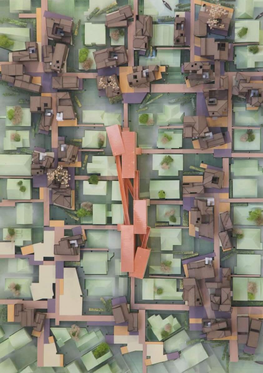
Graduate Thesis 2022 Design Advisor Mira Henry
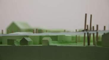
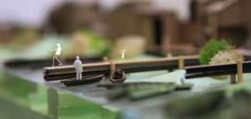
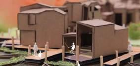
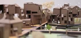
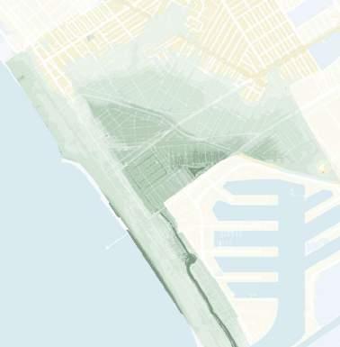
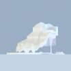
Glacial melting is raising the sea level and it’s projected that parts of coastal cities around the world will be underwater in the future. We’ll be looking at Venice, Los Angeles as the site for this project.
VENICE Vulnerability Assessment Results
This map of low-lying areas shows Southeast Venice to be the lowest area, shown in darker coloring. Next is a progression of inland flood potential from sea level rise over the next 100 years. I used this timeline for the planned construction of my site.

Assets:
Assets:
This area is prone to natural hazards such as large wave events, erosion, storms, and flooding. There have been two notable storms in the Venice area in the 1940s and 1980s.


Inland flood potential in Venice Canals and low-lying areas(Southeast Venice)


Non-storm tidal flooding potential 100-year storm coastal flooding(0cm)
+4.9
FT(20802150+)
Inland flood potential expands across Abbot Kinney Blvd&Oxford Triangele Coastal erosion &flooding threaten lifeguard HQ and Venice Rec. Center
Non-storm tidal flooding potential 100-year storm coastal flooding(0cm) Canals
FT(20402080)
Inland flood potential expands north across Venice Blvd into North Venice.
Assets:
Non-storm tidal flooding potential 100-year storm coastal flooding(0cm) Canals
+6.6
FT(20902150+)
Inland flood extends into Oakwood and Milwood communities Coastal flooding expands to inland area(for any storm).
AMPHIBIOUS ARCHITECTURE PORTFOLIO JIAXIN LI PAGE O3
Venice Pier 1939
El Nino 1983
Venice Flooding 1941
Flooding in Venice Beach(Fred Barthel) 1983
VENICE HISTORIC HAZARDS - 1940S
AMPHIBIOUS ARCHITECTURE PORTFOLIO JIAXIN LI PAGE O4
VENICE HISTORIC HAZARDS - 1940S
CURRENT SEA LEVEL +0.0 FT +1.6
Assets: ≤ 25 ≤20 ≤15 ≤10 ≤9 ≤8 ≤7 ≤6 ≤5 ≤4 ≤3 ≤2 Southeast Venice
Canals
VITRA CAMPUS
This project tries to respond to the studio brief of homogeneous and heterogeneous space by organizing the whole out of a set of slightly dissimilar parts.

O2 VITRA CAMPUS PORTFOLIO JIAXIN LI PAGE 14
2GA Fall 2020 Professor Russell Thomsen
The parts are distributed in a striated field on three levels. Almost like individual volumetric cells, they are initially arranged in flowing lines within a field of circulation. The striated fields act as a kind of homogenous space capable of holding difference. The result is kind of a long, striated building, with 3 layers that are connected and lengthened.


VITRA CAMPUS PORTFOLIO JIAXIN LI PAGE 15
VITRA CAMPUS PORTFOLIO JIAXIN LI PAGE 16
Here is the site plan of my project on the north-eastern corner of the site. It is adjacent to VitraHaus and parallel to Frank Gehry’s building. The site location both defines an edge and has a direct relationship to the VitraHaus.
SITE PLAN
THIRD FLOOR PLAN SECOND FLOOR PLAN
GROUND FLOOR PLAN
ELEVATION

Here is a cutaway chunk that starts to show how the interior relates to the exterior, void, and outdoor space. Some of the floors are set oblique to serve as ramps, while stairs and sectional voids try to bridge between the floors.


VITRA CAMPUS PORTFOLIO JIAXIN LI PAGE 17
SECTION VITRA CAMPUS PORTFOLIO JIAXIN LI PAGE 18
ENVIRONMENTAL DIAGRAM


VITRA CAMPUS PORTFOLIO JIAXIN LI PAGE 19 PERSPECTIVE VIEW PERSPECTIVE VIEW VITRA CAMPUS PORTFOLIO JIAXIN LI PAGE 20 PERSPECTIVE VIEW

CONTAINERS OF BIGNESS
2GB Spring 2021
Professor Zeina Koreitem CAMPUS OF NEW YORK UNIVERSITY
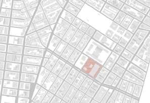
The project narrative imagines a merger between New York University and a contemporary College ofDesign and Art to create a standalone school and campus ‘mega-building’ situated within the historicurban NYU campus in the Greenwich Village neighborhood of Manhattan. This new College of Designand Art (CDA) program offers complexity, variation, friction, overlap, scalar difference and richness. Atapproximately half a million gross square feet of area, the program consists of twenty art and designoriented academic programs with shared support spaces including larger scale galleries, library and auditoria, as well as housing, administrative and support spaces.

O3 CONTAINERS OF BIGNESS PORTFOLIO JIAXIN LI PAGE 24
Diagram/West


CONTAINERS OF BIGNESS PORTFOLIO JIAXIN LI PAGE 25 500 Circulation/Bus Metro 21 M21 Bus Station Metro 1 Metro 55 Metro 20 Metro 1 Bus Station Metro 55 Bus Station Metro 20 Bus Station Metro 103 Bus Station Metro 8 Bus Station Metro 103 Metro 8 Metro 2 Circulation/Subway Line A,C,E A,C,E Subway Station Line B,D,F,M Line R,W,N,Q Metro 1,2,3 B,D,F,M Subway Station R,W,N,Q Subway Station 1,2,3 Subway Station 4,5,6 Subway Station Line 4,5,6 Circulation/Bike Protected Bicycle Lane with Access Point Potential Future Bicycle Routes Shared Lane Conventional Bicycle Lane W HOUSTON ST BLEECKER ST WOOSTER ST MERCER ST PRIVATE LEISURELY QUIET PUBLIC BUSY NOISY PUBLIC BUSY BUSY NOISY NOISY PUBLIC CONTAINERS OF BIGNESS PORTFOLIO JIAXIN LI PAGE 26
Houston Street Section & Plan 11-12.4 ft41-43 ft15.7-16.8 ft41-43 ft11-12.4 ft 119.7- 127.6 ft ACTIVE SIDEWALKS ACTIVE ROADWAY PLANTING STRIP ACTIVE ROADWAY ACTIVE SIDEWALKS SITE BUILDING SOHO 25 CONDOMINIUMS BUS STOP BUS STOP • Bus Stops • Walkable • Close to retail, restuarnts • Heavy traffic • No bike lane 17.8 ft 98.3 ft 17.8 ft27.2 ft 161.2 ft ACTIVE ROADWAY PLANTING AREA ACTIVE ROADWAY ACTIVE SIDEWALKS 505 LAGUARDIA Pl
Street Section & Plan • Parking lot • Walkable • Enter the site building directly • Address: 100 bleecher St • Year Built: 1967 • Building: Count2 Owner: NYU W HOUSTON ST BLEECKER ST WOOSTER ST MERCER ST ENTRANCE ENTRANCE ENTRANCE ENTRANCE ELEVATED WALKWAY
Diagram/Wooster


CONTAINERS OF BIGNESS PORTFOLIO JIAXIN LI PAGE 27 EXHIBIT SPACE DINING HALL & KITCHEN LECTURE HALL EDUCATIONAL SUPPORT ADMINSTRATIVE DEPARTMENTS GRADUATE DEPARTMENTS UNDERGRADUATE DEPARTMENTS RESIDENTIAL SWIMMING POOL GYM INFORMATIONAL DIAGRAMS OUTDOOR SPACE INFORMATIONAL DIAGRAMS CORES STUDYING INFORMATIONAL DIAGRAMS PROGRAM ROOF GREEN SPACE ELEVATED WALKWAY GROUND FLOOR GREEN SPACE CORES PLAN CONTAINERS OF BIGNESS PORTFOLIO JIAXIN LI PAGE 28 SITE PLAN AXONOMETRIC VIEW 0m5m10m


CONTAINERS OF BIGNESS PORTFOLIO JIAXIN LI PAGE 29 GROUND FLOOR PLAN SECOND FLOOR PLAN 0m5m 10m 0m5m 10m 0m5m 10m CONTAINERS OF BIGNESS PORTFOLIO JIAXIN LI PAGE 30 RESIDENTIAL FLOOR PLAN AUDITORIUM AND LIBRARY FLOOR PLAN 0m5m 10m


CONTAINERS OF BIGNESS PORTFOLIO JIAXIN LI PAGE 31
1
2 CONTAINERS OF BIGNESS PORTFOLIO JIAXIN LI PAGE 32
ELEVATION
ELEVATION
SECTION 1 SECTION 2

FIGURED GROUNDS AND GROUNDED

FIGURES
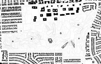
The Santa Monica Airport is on the top of an elongated hillside ridge and acts as a belvedere over the whole westside of LA, with views to the ocean, the mountains, Lax and beyond. Situated at the edge of Santa Monica this site has the capacity to reconnect currently dissociated areas of the West side of Los Angeles, uniting Santa Monica, West LA and Mar Vista. Formerly an edge condition of Santa Monica this site will become a new center of West Los Angeles. I used figure ground as a theoretical and geometric device to create a new Architecture of the City (Park), combining geometry, nature and fantasy to create a new urban paradigm that has the capacity to transform (the ecology of) our daily life
O4 FIGURED
AND
FIGURES PORTFOLIO JIAXIN LI PAGE 36
GROUNDS
GROUNDED
3GA Fall 2021 Professor Margaret Griffin A NEW URBAN PARK FOR WEST LA


PORTFOLIO JIAXIN LI PAGE 37
FIGURE-GROUND DIAGRAM I PATHS
FIGURE-GROUND DIAGRAM I BUILDINGS & STUCTURES
FIGURE-GROUND DIAGRAM I WATER FEATURE
FIGURE-GROUND DIAGRAM I HARD LANDSCAPE
TOPOGRAPHY DIAGRAM
PAGE 38
PORTFOLIO JIAXIN LI
SITE PLAN
FIGURED GROUNDS AND GROUNDED FIGURES
FIGURED GROUNDS AND GROUNDED FIGURES


PORTFOLIO JIAXIN LI PAGE 39
SECTION A-A'
SECTION B-B'
PAGE 40
SECTION C-C'
A A' B' B C C'
FIGURED GROUNDS AND GROUNDED FIGURES
PERSPECTIVE VIEWS

PORTFOLIO JIAXIN LI

NOT A MOUNTAIN
In this spirit the studio will survey and re-model iconic mountain peaks and re-insert them back into theworld through imagery. Of particular interest is the production of physical models that engage a range ofdigital and analog techniques. Through a strategy of extraction, from image to surface to substance, theaim is to raise awareness of and swerve our assumptions about nature and tectonic performances in searchof an aesthetic that exchanges the wonderful / auratic / superiority of the sublime for the wonderful /horrific / ulteriority of something adjacent.

NOT A MOUNTAIN PORTFOLIO JIAXIN LI PAGE 46 O5
3GB Spring 2022 Professor Ramiro Diaz-Granados
Nanga Parbat


Location: Gilgit-Baltistan, Pakistan
Elevation: 8,126m(26,660ft)
Prominence: 4,608m(15,118ft)
Isolation: 189km(117mi)


Age of Rock: 47 million years

Mountain Type: Folded mountaions
TIMELINE AERIALS FROM GOOGLE EARTH PRO
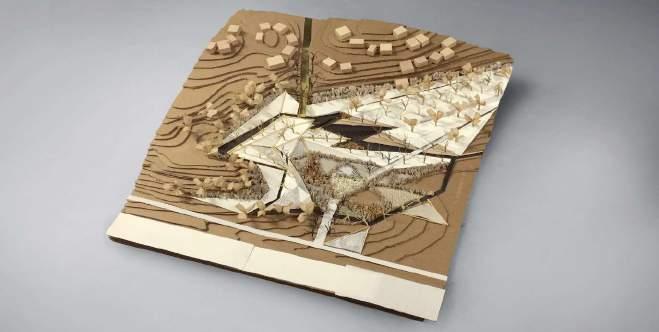
The project is a model. selected a mountain peak and convert its image data to a pair of models: miniature and dog-sized. From there worked through techniques of substantiating the surface through problems of thickness, performance, and structure then proceed to drawing-based techniques of hatching that will function as vector paths for scratching, gouging, and digging in the form of a cnc flip-milled model. This will serve as an armature for a sludge tectonics: using gravity to paint the model by systematically dripping liquids (paint, resin, latex, etc) into layers of accumulated mass and structure.


NOT A MOUNTAIN PORTFOLIO JIAXIN LI PAGE 47
201811 201609 201310 201812 201610 201311 201910 201611 201407 201012 200311 201002 200307 200609 198512
Heightmap from Atlas lugin for Photoshop Satellite Aerial from Goggle Map Customizer Perspective Views from Google
202009 202105 201709 201409 201106 NOT A MOUNTAIN PORTFOLIO JIAXIN LI PAGE 48
Prior to photography, painting was the primary means of depicting landscape (real and imagined) and capturing the majestic and atmospheric qualities of mountains,seas,forests,sky,flora, and fauna. In Landscape painting that include structures, buildings are often of the vernacular sort or monuments in ruin. I inserted drip model photographs into a selected landscape painting. Decisions about scale, location, orientation and simulated brushstroke techniques combine to produce an object that seems both alien and integral to the scene as mountain and structure.


NOT A MOUNTAIN PORTFOLIO JIAXIN LI PAGE 49
Prior to photography, painting was the primary means of Among the Sierra Nevada Mountains, California,1868, Albert Bierstadt
NOT A MOUNTAIN PORTFOLIO JIAXIN LI PAGE 50

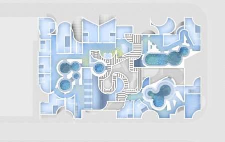
What originally inspired my design is the shape of puzzle pieces. With a few puzzle shapes, I gave them depth and dimension by constantly stretching and rearranging the pieces until the foundation was created. I used the same puzzle piece shapes to remove various spaces from the structure, using the original wall to create rooms, pools, domes, and arches.


URBAN BATHHOUSE PORTFOLIO JIAXIN LI PAGE 55
SITE PLAN
URBAN BATHHOUSE PORTFOLIO JIAXIN LI PAGE 56
AXONOMETRIC VIEW ELEVATION 2
ELEVATION 1


URBAN BATHHOUSE PORTFOLIO JIAXIN LI PAGE 57
FLOOR PLAN
FLOOR PLAN
FLOOR PLAN URBAN BATHHOUSE PORTFOLIO JIAXIN LI PAGE 58
2
1
GROUND
SECOND
THIRD
SECTION
SECTION

A FIELD GUIDE TO THE CORRALITAS
RED CAR TRAIL AND SURROUNDINGS
A field guide is a tool for interpreting features in a landscape. Field guides can be specific to vegetation, geology, architecture, or animals or insects. In this project, we will collaboratively develop a field guide to the Red Car landscape. You will work together to determine a size for the document, and a consistent “visual language” of line weights, colors, and hatching patterns.The following is a list of topics that must be covered in the field guide. Your section is responsible for dividing this work among all members, consider grouping work into particular “labs” based on skills and interest. However, this field guide is not just a collection of rote descriptions of each of these topics. It should have an angle, a position, an inclination, an editorial view which should be informed by your perceptions and studies, sketches and design iteration.

A FIELD GUIDE TO THE CORRALITAS RED CAR TRAIL AND SURROUNDINGS PORTFOLIO JIAXIN LI PAGE 62 O7
Arch 541B: Redcar Studio Professor Sarah Cowles


PORTFOLIO
PAGE 63
A FIELD GUIDE TO THE CORRALITAS RED CAR TRAIL AND SURROUNDINGS
JIAXIN LI
STUDY MODELS OF SCHEMES
A FIELD GUIDE TO THE CORRALITAS RED CAR TRAIL AND SURROUNDINGS
PAGE 64
PORTFOLIO JIAXIN LI
SITE PLAN
GLENDALE FWY

REVITALIZATION OF MOUNTAIN
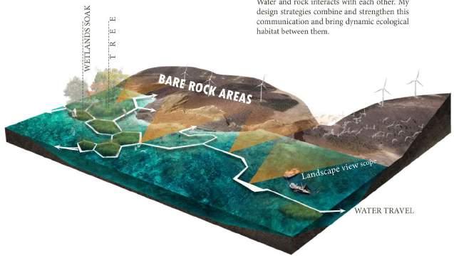
This is an independent work. Bare rock mountain locates near Binhai Road in the northwestern corner of the city of Wafangdian. Because of the requirement of building sea cucumber circle, mountains were transformed into bare rock and brackish water ponds landscape by mining and digging. I would like to show the restoration of the mountain, make good use of vertical space of the rock, transform the bare rock mountain into a demonstrative Vertical park. The main view façade will show the character of the rock by vertical sight view nodes. The secondary view façade will use vegetation restoration. Moreover, water will be used as part of the sight view as well as transport connections. Based on the formation of mining and digging process, various water ponds and tree islands will be created which has great contrast to mountain. In the end, the design will reach the goal of revitalization of mountain and water.

O8 REVITALIZATION OF MOUNTAIN PORTFOLIO JIAXIN LI PAGE 68
LANDSCAPE DESIGN OF TAIPING BAY BARE ROCK RESTORATION PARK Beijing Turenscape Urban planning and design company
SITE ANALYSIS


Bare rock areas will be viewed from three directions of the city, from the Taiping Lakes Business District viewing the greatest Visual impact.
VIEW FOR THE CITY
Red part in the plan diagram is the first view of bare rock surface for the Bay Park, which has significant influence on the whole design. Yellow part in the plan diagram is the secondary view of bare rock surface for the Bay Park.


In order to combine the visual effect of bare rock, strategy will focus on fixing red part in the plan diagram.


There are two issues of evaluating aesthetics value for the bare rock. In order to fulfill the aesthetics value of bare rock, there are two issues need to be designed.
• Mountain Outline
• Mountain High Ground

REVITALIZATION OF MOUNTAIN PORTFOLIO JIAXIN LI PAGE 69
China
Liaoning: Liaoning
Dalian Wafangdian Dalian: Wafangdian: Bare Rock Area:
Storage Reservoir Binhai Road
Bare Rock Area 4.65 Acre
1.Dangerous Pedestrain
VIEW FROM LANDSCAPE VIEW FROM TAIPING LAKE CBDVIEW FROM GULF PARK HILL
2 . Lacking of
3.Lacking of landscape
REVITALIZATION OF MOUNTAIN PORTFOLIO
LI PAGE 70
4.No Access to
JIAXIN
VISUAL EFFECTS ON THE CITY
View for the city of rock surface is the first issue for design.
SPECIFIC STRATEGY DIAGRAM

PLAN DIAGRAM ( FOR WATER USE )


Water and rock interacts with each other. My design strategies combine and strengthen this communication and bring dynamic ecological habitat between them.


REVITALIZATION OF MOUNTAIN PORTFOLIO JIAXIN LI PAGE 71
Dynamic transportation system formed by Peak trail,Rock plank road, Water front plank road, waterfront trail
Cliff Reuse Strategy
Net Hanging Spray Seed Strategy
TEN NIGNAH G SPRAY SE E D STRATE G Y CLIF F REUSE S T R YGETA IDEMMI A T E HABITAT REBUILD S GETART REVITALIZATION OF MOUNTAIN PORTFOLIO JIAXIN LI PAGE 72 SITE PLAN GOALS FUNCTIONAL ANALYSIS DIAGRAM TRAFFIC ANALYSIS DIAGRAM IMPROVE BIODIVERSITYIMPROVE WATER IMPROVE ADD ACCESS TO WALKING TRAIL RECREATION: CANOEING STIMULATE DEVELOPMENT MOUNTAIN SRUFACE
Immediate Habitat Rebuild Strategy


BEFORE AFTER


BEFORE AFTER
PORTFOLIO JIAXIN LI


 SLR in Southeast Venice