
3 minute read
VITRA CAMPUS

by Jiaxin Li
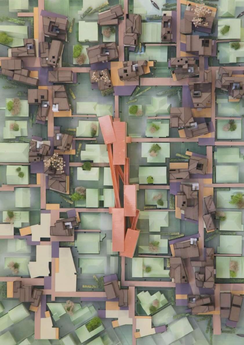
This project tries to respond to the studio brief of homogeneous and heterogeneous space by organizing the whole out of a set of slightly dissimilar parts.
The parts are distributed in a striated field on three levels. Almost like individual volumetric cells, they are initially arranged in flowing lines within a field of circulation. The striated fields act as a kind of homogenous space capable of holding difference. The result is kind of a long, striated building, with 3 layers that are connected and lengthened.
Advertisement


Elevation

Here is a cutaway chunk that starts to show how the interior relates to the exterior, void, and outdoor space. Some of the floors are set oblique to serve as ramps, while stairs and sectional voids try to bridge between the floors.


Containers Of Bigness
2GB Spring 2021
Professor Zeina Koreitem CAMPUS OF NEW YORK UNIVERSITY
The project narrative imagines a merger between New York University and a contemporary College ofDesign and Art to create a standalone school and campus ‘mega-building’ situated within the historicurban NYU campus in the Greenwich Village neighborhood of Manhattan. This new College of Designand Art (CDA) program offers complexity, variation, friction, overlap, scalar difference and richness. Atapproximately half a million gross square feet of area, the program consists of twenty art and designoriented academic programs with shared support spaces including larger scale galleries, library and auditoria, as well as housing, administrative and support spaces.

Diagram/West


Figured Grounds And Grounded

Figures
The Santa Monica Airport is on the top of an elongated hillside ridge and acts as a belvedere over the whole westside of LA, with views to the ocean, the mountains, Lax and beyond. Situated at the edge of Santa Monica this site has the capacity to reconnect currently dissociated areas of the West side of Los Angeles, uniting Santa Monica, West LA and Mar Vista. Formerly an edge condition of Santa Monica this site will become a new center of West Los Angeles. I used figure ground as a theoretical and geometric device to create a new Architecture of the City (Park), combining geometry, nature and fantasy to create a new urban paradigm that has the capacity to transform (the ecology of) our daily life


Perspective Views


Not A Mountain
In this spirit the studio will survey and re-model iconic mountain peaks and re-insert them back into theworld through imagery. Of particular interest is the production of physical models that engage a range ofdigital and analog techniques. Through a strategy of extraction, from image to surface to substance, theaim is to raise awareness of and swerve our assumptions about nature and tectonic performances in searchof an aesthetic that exchanges the wonderful / auratic / superiority of the sublime for the wonderful /horrific / ulteriority of something adjacent.

Nanga Parbat
Location: Gilgit-Baltistan, Pakistan
Elevation: 8,126m(26,660ft)
Prominence: 4,608m(15,118ft)
Isolation: 189km(117mi)
Age of Rock: 47 million years
Mountain Type: Folded mountaions
Timeline Aerials From Google Earth Pro
The project is a model. selected a mountain peak and convert its image data to a pair of models: miniature and dog-sized. From there worked through techniques of substantiating the surface through problems of thickness, performance, and structure then proceed to drawing-based techniques of hatching that will function as vector paths for scratching, gouging, and digging in the form of a cnc flip-milled model. This will serve as an armature for a sludge tectonics: using gravity to paint the model by systematically dripping liquids (paint, resin, latex, etc) into layers of accumulated mass and structure.

Prior to photography, painting was the primary means of depicting landscape (real and imagined) and capturing the majestic and atmospheric qualities of mountains,seas,forests,sky,flora, and fauna. In Landscape painting that include structures, buildings are often of the vernacular sort or monuments in ruin. I inserted drip model photographs into a selected landscape painting. Decisions about scale, location, orientation and simulated brushstroke techniques combine to produce an object that seems both alien and integral to the scene as mountain and structure.


What originally inspired my design is the shape of puzzle pieces. With a few puzzle shapes, I gave them depth and dimension by constantly stretching and rearranging the pieces until the foundation was created. I used the same puzzle piece shapes to remove various spaces from the structure, using the original wall to create rooms, pools, domes, and arches.


A Field Guide To The Corralitas
Red Car Trail And Surroundings
A field guide is a tool for interpreting features in a landscape. Field guides can be specific to vegetation, geology, architecture, or animals or insects. In this project, we will collaboratively develop a field guide to the Red Car landscape. You will work together to determine a size for the document, and a consistent “visual language” of line weights, colors, and hatching patterns.The following is a list of topics that must be covered in the field guide. Your section is responsible for dividing this work among all members, consider grouping work into particular “labs” based on skills and interest. However, this field guide is not just a collection of rote descriptions of each of these topics. It should have an angle, a position, an inclination, an editorial view which should be informed by your perceptions and studies, sketches and design iteration.


