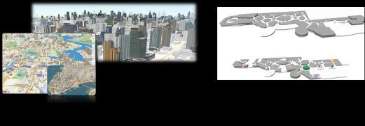
We provide Interactive Digital Map Platform


We provide Interactive Digital Map Platform

Interact with data and expand your digital spatial world

Part 1 Company Overview

Chapter
Part 2 Appendix
Chapter
1. MOGOS SCM 2. MOGOS FCM 3. MOGOS Interactive Digital Map Platform 1. About Company 2. Technology 3. Service Roadmap


Company
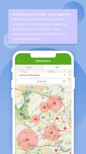
We have acquired innovative technologies that include monitoring interface, data analysis, and visualization to bring Geospatial AI in the diverse market.


FATOS consistently develops market-leading technologies to meet customers' needs with our MOGOS platform, a cloud-based interactive digital map platform that can create and distribute value-added services based on data.
Company Name
FATOS Co., Ltd.
#1009, Kolong Digital Tower Billant II, 31, Digital-ro 30gil, Seoul, Korea, 08390
CEO Dong Ho, Kim
Foundation 16th May 2016
Overseas corporation

• Singapore: MOGOS PTE. LTD.
6 Raffles Boulevard, Marina Square #03-308 Singapore 039594
• Thailand, Bangkok: MOGOS (Thailand) Co., Ltd.
928, Block 28, Building D, Soi Chulalongkorn 7, Wang Mai, Pathum Wan, Bangkok 10330
MOGOS platform offers unrivaled technologies such as maps that generate 3D maps, navigation, geofencing, realtime monitoring portal, data analysis, and spatial data visualization. This versatile service platform has been applied in various industries in Singapore, Thailand, Pakistan, etc. Community care [Singapore], Smart City [Thailand], and Digital Land Use system [Pakistan] have already passed beta service stages in 2022 and currently running official operation services till now. Platform
A flexible and scalable platform based on an interactive digital map where “geospatial data – general data – service content” interact.
“The best digital way, Cloud-based, Versatile Platform service provider”
Solution
“Problem-solving, Creating Data Value by Service-oriented Technology”
✓ Interlinking of 3D Outdoor map and Indoor map
✓ Interlinking of Objects, Events and Geospatial information
✓ Visualization of Congregated data on the map by mashup
✓ Real-time Analysis and Visualization of location data transition
Company
Overview
NAVER Line Investment attraction
Winner of Microsoft Startups
Truck
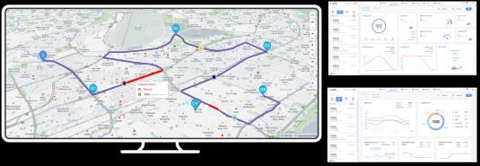
Intelligent Route Planning(RP) for Logistics
Nominated as
Bon

Angels
attraction
2019


Opened office in Singapore
Opened office in Bangkok, TH
MOGOS platform initiates first service
Accredited by Thailand BOI (Board of Investment)
World Bank’s Geospatial Response solution to confront habitat building in Pakistan


HQ
FATOS Co., Ltd. / founded 16th May 2016
•Core technology R&D
•Quality Control
•Business planning and operation
Thailand
MOGOS (Thailand) Co., Ltd. / founded 5th Aug 2022
•Business hub of Thailand and neighboring countries

•Web and Mobile service planning and development

•Platform service for [Smart City, Urban Development], [Social Development & Human Security Management]


Thailand
Singapore
Singapore
MOGOS PTE. LTD. / founded 13th Feb 2019
•Basecamp of APAC business


•Platform service for [Community Care Management]
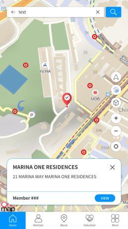
Map technology – search geospatial information and layer up various map data.
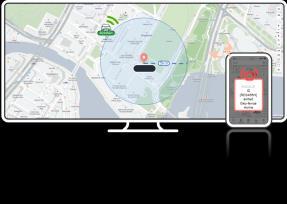
Geofencing technology – used in diverse fields such as location-based marketing, security, and telematics.
Realtime monitoring & analysis – support remote management, help informed decisions based on data.
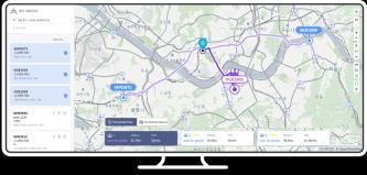
Intelligent Routing – improves mobility efficiency with optimal routes.
We aim for service-oriented platform technology that creates and distributes high value-added services.
▪ 3D Map
▪ Map Mashup*, which fuses spatial/non-spatial data
▪ Realtime Object Picking
▪ Setting virtual boundaries
▪ Location based services
▪ Notification for safety and security
▪ Realtime event/object tracking
▪ Pattern analysis based on moving trajectory
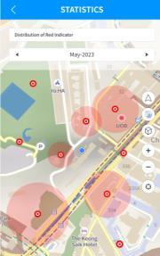
▪ Visualized map and statics data
Intelligent routing
▪ Optimal route planning for types of vehicle
▪ Multi-way/dynamic routing
▪ Predictive routing and simulation
▪ Pre-learning of routing
* Map Mashup: a service-oriented technology solution that combines spatial information, object properties and data to provide complex content in the form of application software or database.
MOGOS Platform, 1st Generation


GeoAI technology based MOGOS’ Interactive Digital Map Platform offers subscription of SaaS for easy adoption in diverse industries.
MOGOS Platform, 3rd Generation
Data driven service
MOGOS Platform, 2nd Generation
Realtime view interface

• 3D building maps
• Flexible transit between outdoor and indoor
Spatial technology
• Explore spatial information
• Software as a Service
• Data collection on the mobile Apps
• Data transit over the Cloud servers

• Realtime view and update
• Data analysis and visualization
• Providing service content using data (e.g. real-time calculation, digital work templates, virtual space, etc.)
• Customizable services for specific industries and business purposes


Technology components that completes interactive digital map platform
Interactive Digital Map 2D/3D Map, Indoor/Outdoor Map, Mash-up
Intelligent Routing Multiway points routing, Predictive routing
To the future markets that create and distribute high value-added services
Smart City Map
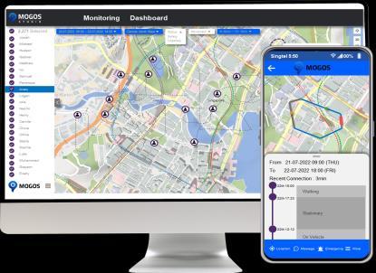
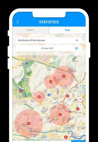
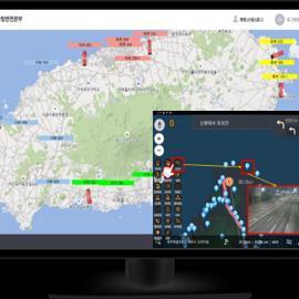
Realtime monitoring

User experienceoriented application service technology
Security, Safety monitoring
Smart Community Map
Object/Event tracking, Trajectory pattern analysis
Data Analysis Visualized spatial data, statistics data

Cloud based DB system architecture
Community Care
Family Care
✓ Established successful localization references in Singapore
Phase I
✓ IoT device-connected services
✓ Visualized behavior data on Map
Phase II
Advanced connected services

✓ Advanced Geo-AI services
✓ Bridging, Affiliated services
Phase III
Advanced + High-end
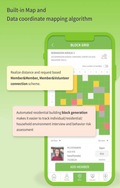
• Community Care Map
• Automated workflow solution


• Geo-connection and matching
• Real-time Geo-analytic data view on the map
• Connected Service Map
• IoT device-connected
• Caring features for dementia patient
• Behavior analysis and risk management
• Personalized Service Map
• Personalized care service recommendation
• Bridging care providers
• More data-driven services
1. MOGOS SCM
2. MOGOS FCM
3. MOGOS Interactive Digital Map Platform
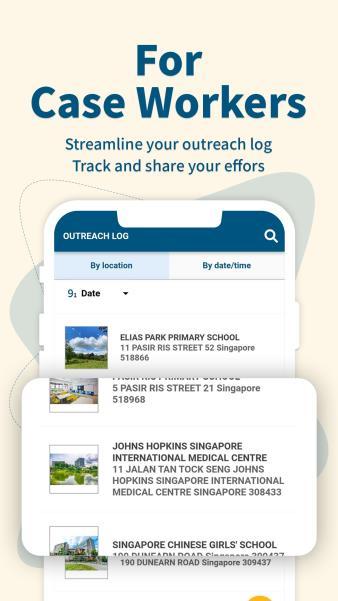
Cloud based SaaS (Software as a Service) for “Community Care”. Digitize outreach activities of Social Service Agencies and Community welfare service providers.
The “Community Care” is a leading welfare model that provides home-based care in residential spaces. It has recently been expanded along with the promotion of self directed service policies at community level.
Community Care Management solution for Social care professionals

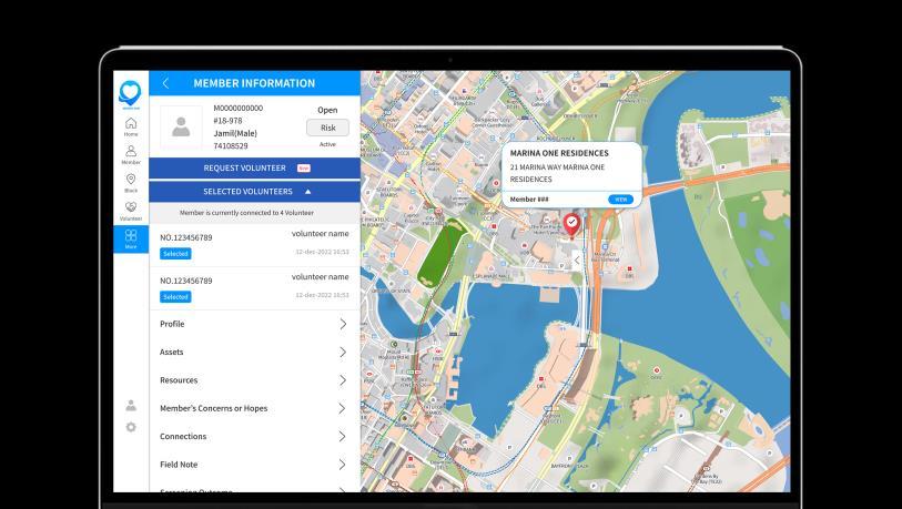
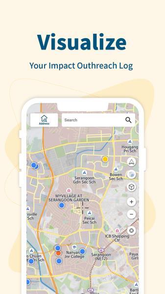
Community Map, cloud based software and workflow automation templates helps social care professionals to engage with members and spot community needs.

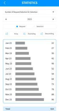
Admin management, Integrated content management, Statistics data matrix views, Report email send, Account control


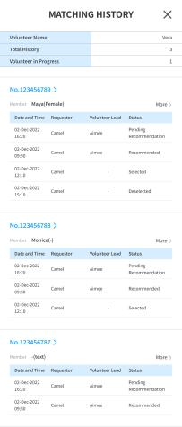
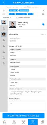
Member registration, Survey, Community connection, Volunteer matching
Admin
Volunteer recruit, Profile registration, Recommendation and match
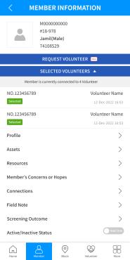
Field notes, data entry, member connection, volunteer matching
..
Volunteer Manager, Coordinator


Volunteer application submission


Community Map, cloud based software and workflow automation templates helps social care professionals to engage with members and spot community needs.

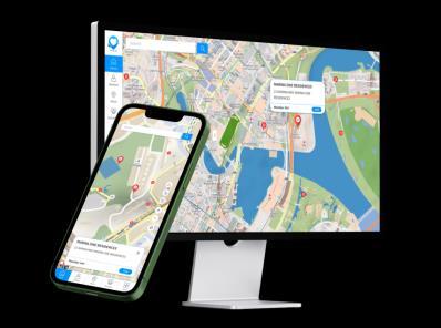
 Software as a Service (SaaS) interface
Mobile Apps powered by MOGOS Platform
Software as a Service (SaaS) interface
Mobile Apps powered by MOGOS Platform
Provides Geo-AI based features and digital conversion technology that gathers various aspects of data in one place, interlinks with spatial information, and analyzes data.

 OTW App powered by MOGOS SCM
Singapore Youth Care service management
Viriya App powered by MOGOS SCM
Singapore Community Care Management
MOGOS SCM brand platform service
Care Management Platform
OTW App powered by MOGOS SCM
Singapore Youth Care service management
Viriya App powered by MOGOS SCM
Singapore Community Care Management
MOGOS SCM brand platform service
Care Management Platform

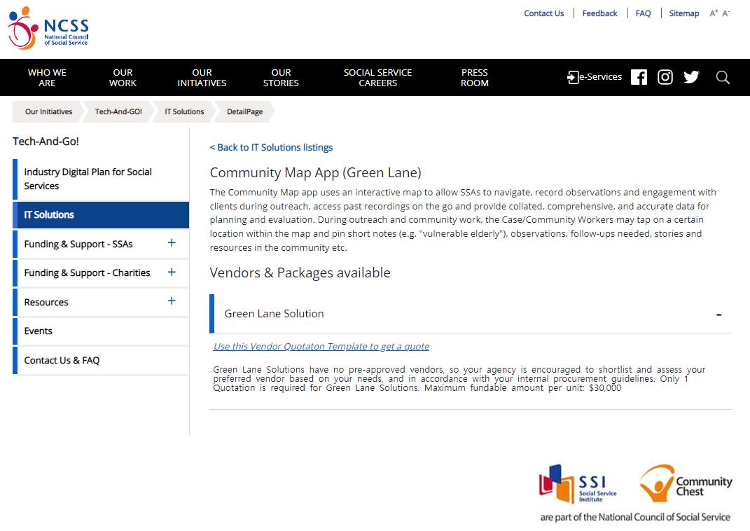
Partners 02 Singapore Green Lane IT Solution

Listed in Green Lane IT Solution of Singapore NCSS (National Council of Social Service) with ‘Could-based Interactive Community Map App’. Singapore Social Service Agency


Singapore is organizing various subsidizing programs and budgets at the government level in the social care service sector. Funding pool worth USD23 million, encouraging SSA (Social Care Agency) under Singapore NCSS to apply for digital transformation.
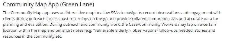
SSAs can receive consulting on solutions to digitally transform previous complex traditional work and adapt new digital systems and tools through proven IT vendors. Outreach workers especially need a Community Map solution to address the mission-critical challenges of using geospatial information to connect community members and identify high-risk res areas at community level.
MOGOS SCM platform has a solution that manages spatial and nonspatial data in real time by converging them. MOGOS SCM is running official service after sufficient beta service period in two SSAs. The solution is listed as a Green Lane IT solution certified by NCSS.

FATOS is the only Green Lane IT solution vendor that can provide Community Map while complying with the Singapore government's digital transformation policy.
NCSS가 인증하는 Green Lane IT Solution 으로 등재
Moving Forward: data driven family care services
With MOGOS’ Interactive Digital Map Platform encompassing Geo-AI, pipeline data in one place, mashup on the map , interlink and analyze.
Dementia patient care, community-level health care, and personalized behavior modification care management solution for Family and Community providers

Mapping dynamic information collected through wearable IoT devices with spatial information
Geo-AI by Intelligent spatial data analysis

Shape up wellbeing & health management and a social safety net.
With MOGOS’ Interactive Digital Map Platform encompassing Geo-AI, protect dementia patients, disabilities, vulnerable populations from missing or accidence.
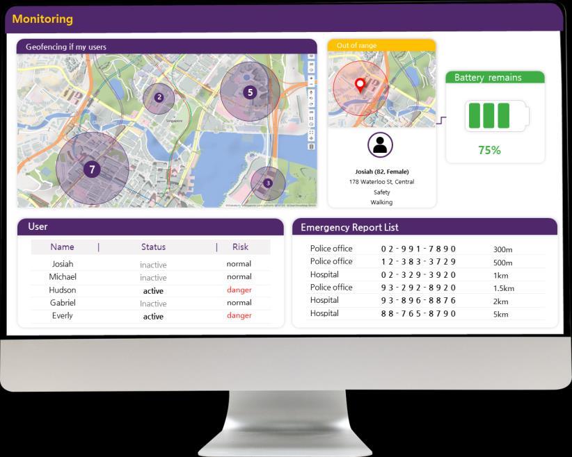
✓ data analysis services based on health data and behavior patterns.
✓ Mobile App Safeguard lets you connect with family and friends

✓ Mashup data with spatial information is displayed in a form of interactive and visualized map.
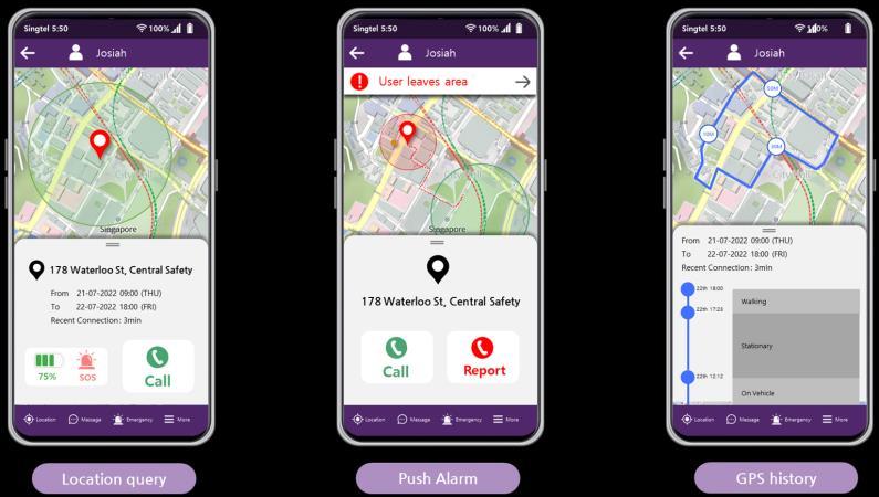 MOGOS FCM Users’ mobile App
Shape up wellbeing & health management and a social safety net.
With MOGOS’ Interactive Digital Map Platform encompassing Geo-AI, protect dementia patients, disabilities, vulnerable populations from missing or accidence.
Community 89
Dementia risk A
Recent 10 visits St. Mary's Clinic, view heart rate stability pattern >
Community 80
Dementia risk B

▪ Social demand articulation and customization with NGO partnerships, Malaysia
▪ Market diffusion by participating governmental Urban Planning & Smart City projects, Thailand
▪ Reference market with Green Lane entitled solution, Singapore
Insurers, Telco, Health centers, Family planning clinics, Nursing home and other types of providers
Nursing welfare community facility, disabled or vulnerable population
Thailand
Care service providers
Singapore
▪ Data mashup
▪ Risk assessment
▪ Statistical data reporting
Target market/users
Malaysia

▪ Location-based care service recommendation and matching
▪ Location-based group purchase
▪
Location-based risk management
▪
Real-time activity/loitering monitoring and pattern analysis
Technology/Service
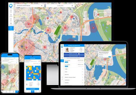
MOGOS Interactive Digital Map Platform
A flexible and scalable platform based on an interactive digital map where “geospatial data – general data – service content” interact.
Data


Engage users by dragging, overlaying, displaying statistics and other information in a visually formed map. It can comes with a variety of map styles and themes.
Unlike typical static map, users can input and click on data on the map.
This allows service content creators to create interfaces that grab users' attention and engage them more.
Unlike traditional (or ‘static’) maps, interactive maps can handle large data sets that can be updated in real time.
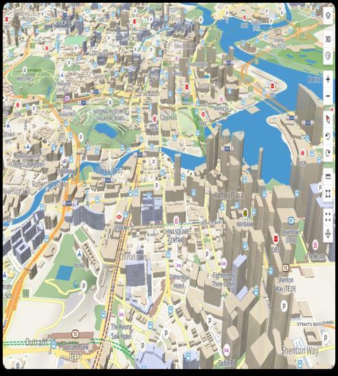
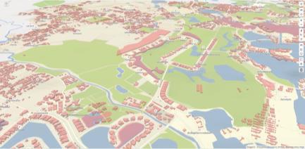
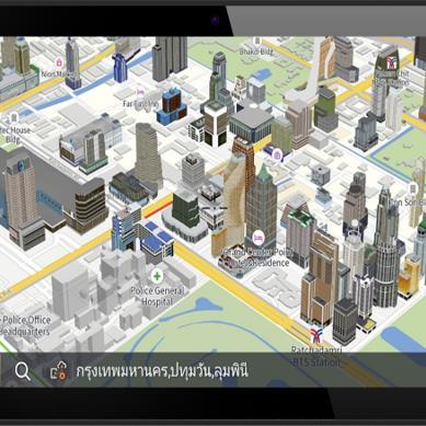
MOGOS Map

3D Map Indoor Map
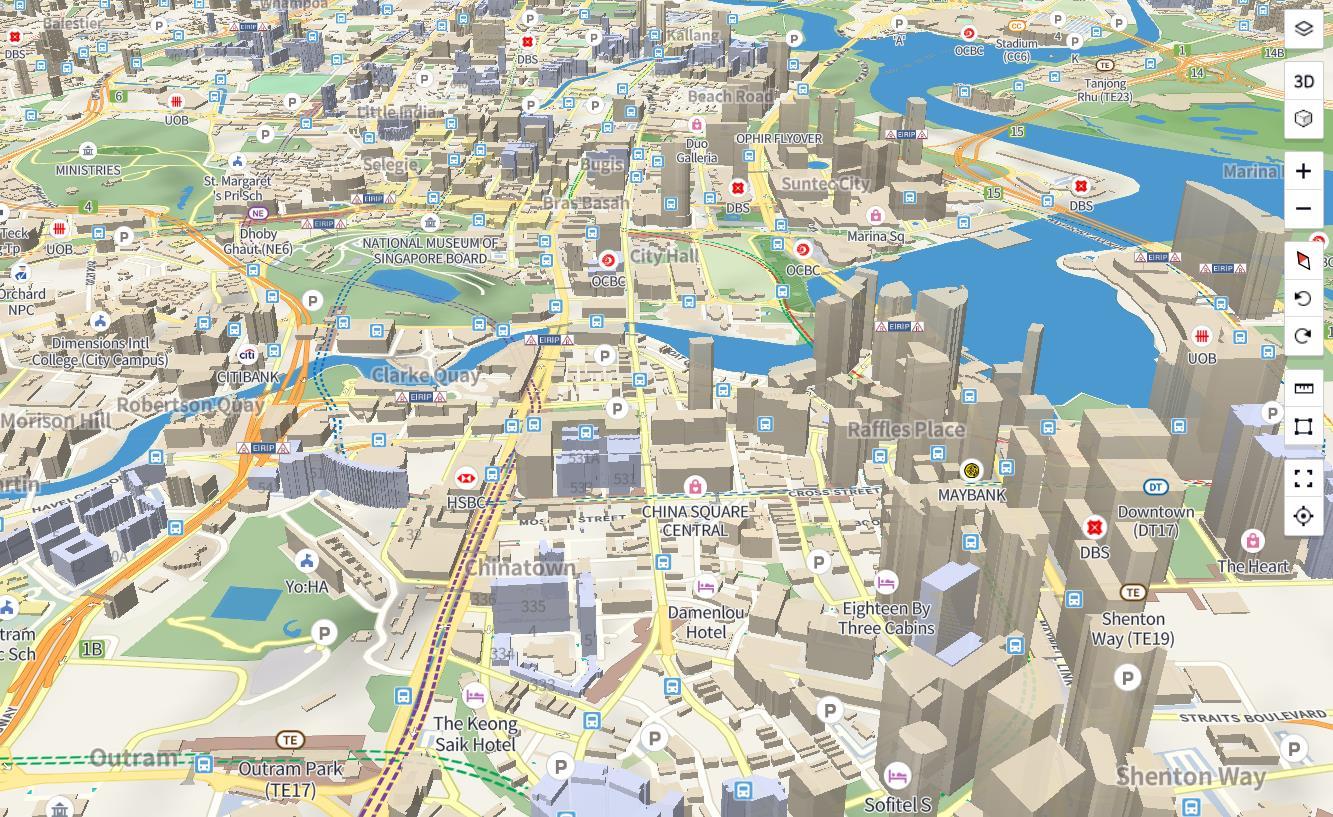
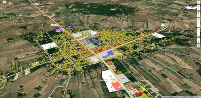
Lifelike high quality spatial data maps implementing digital twins in stunning speed

• Realistic digital twin map using 3D modeling data

• Inquiry of object properties and make connection with various services through real-time 2D/3D object picking

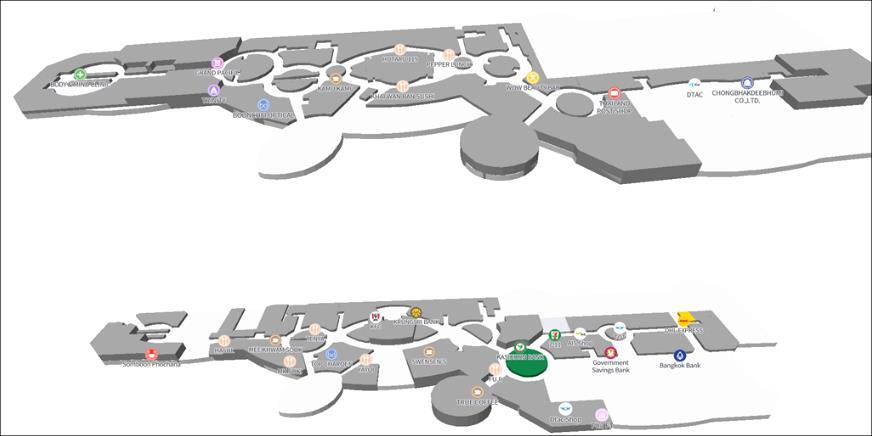
Indoor map that can implement various service contents such as route finding, store advertisement, and e-commerce

• Features include indoor routes/store search, coupon search.
• Current location search by Geo-AI.
Integrated geospatial information technology platform for identifying land use status and establishing basic taxation data in Thailand
Integrated geospatial information technology platform for digital cadastral map of Punjab, Pakistan


• Geo-Tech functions such as digital conversion, spatial/non-spatial data fusion, data visualization, and object picking.
• Digitized data collection and visualization of land parcel, ownership, tenancy to assist property registration and proof of ownership.
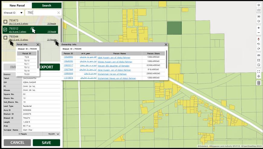
• This is being used in land information system construction for urban development in Thailand and Pakistan.
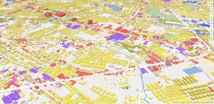
 Land use map
Tax map
Map Mashup
Parcel Survey Management
Land use map
Tax map
Map Mashup
Parcel Survey Management
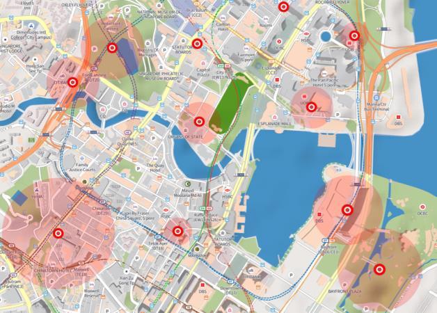
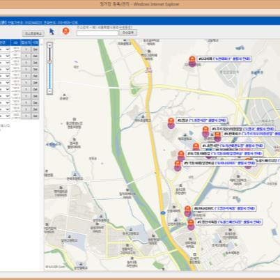
• GeoHash-based geofencing technology that notifies the MOGOS mobile/web app when an identified object enters or leaves the virtual boundary.


• Geofencing requires a lot of computation. MOGOS use advanced geohashes to accurately detect virtual fences and send instant notifications with compact computation.

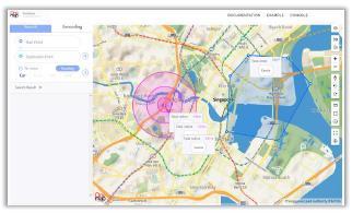
• This is being used for wide range of businesses, including smart city, fleet management, human safety.

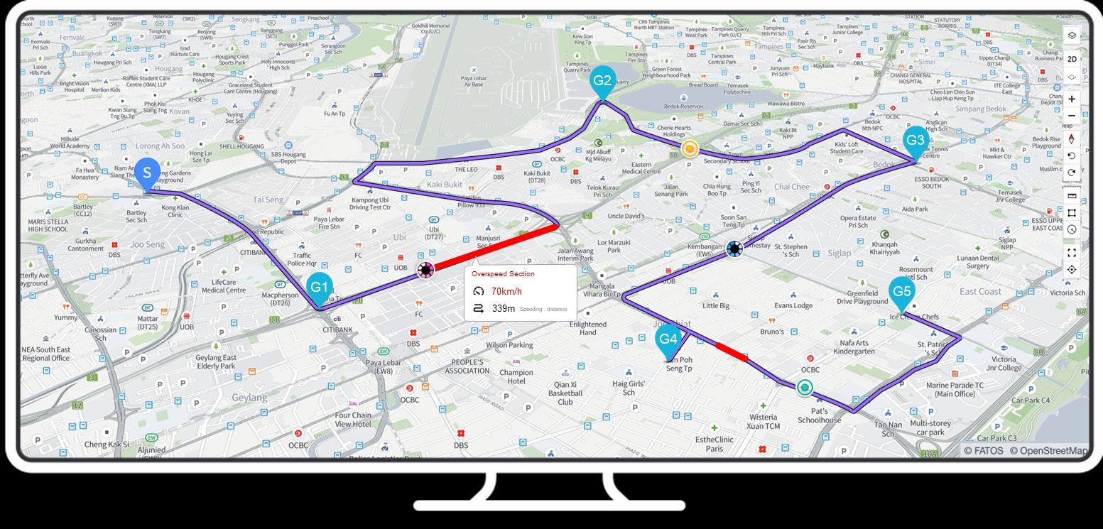
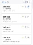


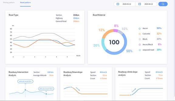
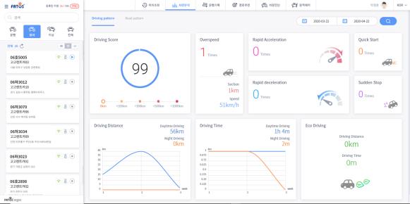
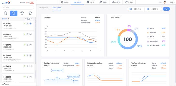
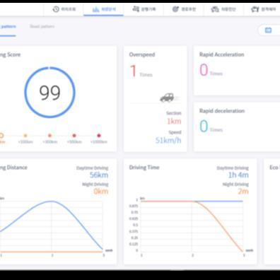
• Driving trajectory history overview, driving pattern analysis with accumulated data.
• Spatial information and various object data are acquired, stored, analyzed, visualized together with spatial information and lay it out on a map.
• Monitor various dynamic events, update statistical information in real time and visualize it in a dashboard.

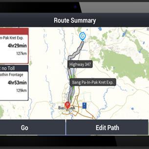
• Optimization nodes, simulate multiple paths, and calculate time spent based on various settings.
• Predict routes from a certain point of time and extract points that can be reached within the time limit.
• Choose a route out of pre-learned routes, dispatch drivers based on distance.
MOGOS Interactive Digital Map Platform
A flexible and scalable platform based on an interactive digital map where “geospatial data – general data – service content” interact.
What we make with Interactive Digital Map Platform
Outdoor/Indoor Navigation Routing Object data, Map layers, Spatial data mashup
Real-time location tracking Data analysis-based services

- MOGOS interactive Digital Map Platform -
The best Digital way, Cloud-based, Versatile Platform. Interact with your data, and expand your digital spatial world