International Research Journal of Engineering and Technology (IRJET)
e-ISSN: 2395-0056
Volume: 07 Issue: 12 | Dec 2020
p-ISSN: 2395-0072
www.irjet.net
Restoration Techniques Available for Satellite Image Sensing Applications – A Review Tamilselvi. K1, Prof. T. Thenmozhi2 1PG
scholar, Department of ECE, Government College of Engineering, Salem-11 2Assitant Professor, Government College of Engineering, Salem-11 ---------------------------------------------------------------------***----------------------------------------------------------------------
Abstract - Image restoration is important in the field of satellite image processing, weather forecasting and remote sensing,
where accurate details of the image are needed. Most of the satellite images are degraded by physical phenomenon such as relative motion of the object before captured by image capturing devices such as camera or due to atmospheric disturbances. To restore the original image from the degradation, various restoration techniques are available. This paper surveys various degradation models used for satellite images and presents the inferences from the survey, which helps the readers to choose specific restoration for specific degradation model, as each restoration technique will have its own advantages and disadvantages. Key Words: survey, satellite images, degradation, blur, noise, restoration, Non-Blind deconvolution, Blind deconvolution, inference table.
1. INTRODUCTION Satellite images plays vital role in various fields of life such as agriculture, fishery, remote sensing, weather forecasting and so on. It is important that the satellite image should be precise, in order to obtain various inferences in various fields. Satellite images are prone to various degradations due to the atmospheric disturbances and weather conditions, in order to overcome such effects; image restoration has become inseparable part. Image restoration may be further added by image enhancement to achieve better image clarity. Various restoration techniques are available for different degradation blurs and noises. The following sections will provide the details on the restoration techniques available in the literature and how could it be used effectively.
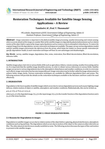
2. DEGRADATION Degradation is the loss in quality of satellite images which occurs due to various degradation process such as poor lighting, image defocus, relative motion of object or satellite, atmospheric and weather conditions. Mathematically, this can be written as, g (x, y) =f (x, y) *h (x, y) +n (x, y). where g (x, y) is the degraded image, f (x, y) is the input image, h (x, y) is the transfer function of the degradation function and n (x, y) is the noise function.
FIGURE 2.1 IMAGE DEGRADATION MODEL
2.1 Reasons for Degradation in images Degradation in satellite images occurs due to relative motion of the object before capturing, physical interferences, atmospheric conditions such as fog and haze. The degradation which occurs due to motion of the object or the camera is often referred to as Blur. The other physical interferences usually modelled as noise. The following section discusses the types of blur and motion in present in the satellite images.
Š 2020, IRJET
|
Impact Factor value: 7.529
|
ISO 9001:2008 Certified Journal
|
Page 259