International Research Journal of Engineering and Technology (IRJET)
e-ISSN: 2395-0056
Volume: 07 Issue: 10 | Oct 2020
p-ISSN: 2395-0072
www.irjet.net
Mapping of Aquifer For Ground Water Recharge In Shirala Taluka Dhanshree B.Shinde1, Prf.Dr.S.S.Kulkarni2 1M
Tech, Dept. of Civil Engineering, RIT, Maharashtra, India ²Director, KES Rajarambapu Institute of Technology, Maharashtra, India ---------------------------------------------------------------------***---------------------------------------------------------------------hollow spaces available deep underground which is a Abstract - Aquifer mapping is defined as a scientific process main source for groundwater. of a combination of geologic, geophysical, hydrologic and chemical field and laboratory analysis are applied to find the quantity, quality and sustainability of ground water in aquifers. Groundwater is the water that occurs below the surface of earth, where it occupies all or part of the void spaces in soils or geologic strata. The recharge and discharge of groundwater are control by aquifer characteristics and other factors such as soils, climate, land use, cropping pattern. The Identification of clusters of aquifers will help for preparation of aquifer management plans for sustainable groundwater management. This will help achieving drinking water security, improved irrigation facility and sustainability in water resources development in a rural area. The identification and evaluation aquifer involves GIS applications for demarcation of aquifer boundaries and division into smaller units, various software’s has been used for defining preliminary 3D disposition of aquifer systems.
An Aquifer is an underground layer of water-bearing permeable rock unconsolidated materials like sand silt and gravel etc. Groundwater can be extracted by tube well or dug well. The study of water in the aquifers and to characterize aquifers is called hydrogeology.
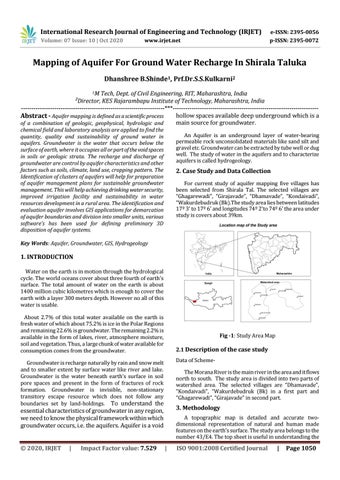
2. Case Study and Data Collection For current study of aquifer mapping five villages has been selected from Shirala Tal. The selected villages are “Ghagarewadi”, “Girajavade”, “Dhamavade”, “Kondaivadi”, “Wakurdebudruk (Bk).The study area lies between latitudes 17º 3’ to 17º 6’ and longitudes 74º 2’to 74º 6’ the area under study is covers about 39km.
Key Words: Aquifer, Groundwater, GIS, Hydrogeology
1. INTRODUCTION Water on the earth is in motion through the hydrological cycle. The world oceans cover about three fourth of earth’s surface. The total amount of water on the earth is about 1400 million cubic kilometres which is enough to cover the earth with a layer 300 meters depth. However no all of this water is usable. About 2.7% of this total water available on the earth is fresh water of which about 75.2% is ice in the Polar Regions and remaining 22.6% is groundwater. The remaining 2.2% is available in the form of lakes, river, atmosphere moisture, soil and vegetation. Thus, a large chunk of water available for consumption comes from the groundwater.
Fig -1: Study Area Map 2.1 Description of the case study Data of Scheme-
Groundwater is recharge naturally by rain and snow melt and to smaller extent by surface water like river and lake. Groundwater is the water beneath earth’s surface in soil pore spaces and present in the form of fractures of rock formation. Groundwater is invisible, non-stationary transitory escape resource which does not follow any boundaries set by land-holdings. To understand the
The Morana River is the main river in the area and it flows north to south. The study area is divided into two parts of watershed area. The selected villages are “Dhamavade”, “Kondaivadi”, “Wakurdebudruk (Bk) in a first part and “Ghagarewadi”, “Girajavade” in second part.
3. Methodology
essential characteristics of groundwater in any region, we need to know the physical framework within which groundwater occurs, i.e. the aquifers. Aquifer is a void © 2020, IRJET
|
Impact Factor value: 7.529
A topographic map is detailed and accurate twodimensional representation of natural and human made features on the earth’s surface. The study area belongs to the number 43/E4. The top sheet is useful in understanding the
|
ISO 9001:2008 Certified Journal
|
Page 1050