
International Research Journal of Engineering and Technology (IRJET) e-ISSN: 2395-0056
Volume: 11 Issue: 05 | May 2024 www.irjet.net
p-ISSN: 2395-0072
International Research Journal of Engineering and Technology (IRJET) e-ISSN: 2395-0056
Volume: 11 Issue: 05 | May 2024 www.irjet.net
p-ISSN: 2395-0072
Nitin Jain1 , Dr. Anjali S.Patil2
1Student, “Department of Architecture and Planning”, MITS Gwalior
2Assistant Professor, “Department of Architecture and Planning”, MITS Gwalior
Abstract - The world is currently dealing with periurbanism, a novel phenomenon. With the goal of obtaining free open areas for habitation, growth, and the establishment of new communities, there has beena progressive migrationof the urban population from the more developed regions to the less developed ones as a result of population growth and urban infrastructure improvements. Periurban spaces have emerged as a result of the large-scale urban population mobility. The periphery of metropolitan centers that warrant exploration are the periurban zones, as they lack a clear demarcation line. In order to manage the detrimental impacts that urban sprawling poses to the periurbanareas, a thorough understanding of the processes of urbanization is required. Urban sprawl is forming around the main urban centers in Ashoknagar city. To investigate the necessity of developing policies, a thorough analysis of the social, economic, and demographic makeup of the residents living on Ashoknagar periphery has been conducted. The paper's analytical strategy is predicated on an examination of the region's development and infrastructural challenges through the application of GIS mapping. The study's final conclusions address the concerns, challenges, and suggestions that are relevant to a planned and regulated development in Ashoknagar periurban areas.
Key Words: Peri urban Areas, Delineation, Urbanization, Planning, Development, etc.
1.INTRODUCTION
Duetotheexpansionofurbanactivity,peri-urbanareas the boundary between urban and rural regions are currentlyundergoingsignificantchanges.Howtheseareas turnintocontestedzonesisrevealedbythequickexpansion ofthenewlydevelopedenvironmentandtheapparentshift of the socioeconomic structure. It is acknowledged that outskirts offer substantial advantages for accommodating theagglomerationforeffectiveurbansystems.Asaresult, the inflow of immigrants is changing neighborhood life, traditionalculture,economicstructures,andpatternsofland usage.Thesedifficultiesareaddressedinthisresearch.This studyisfocusedonperiurbangrowth,urbanization,andthe advancement of urbanism on a theoretical level by concentratingontheinstanceofAshoknagar(M.P.),oneof smalltownsrapidlyexpandingurbanareas.Periurbanism hasbeentheresultoflimitedoptionsofdevelopmentwithin the existing urban boundaries which is the outcome of limiteddevelopmentpossibilitieswithinthecurrenturban limits.Inordertoaddresstheunplanned,unsystematic,and
significant effects of fast urbanization on the periphery of India's smart cities, a thorough investigation into the dynamicsofperiurbanizationinemergingnationslikeIndia isnecessary.ThisisespeciallytruegiventhatmostIndian metropolitancitiesareexperiencingthedynamiceffectsof peri urbanization, and that suitable strategies must be developed to integrate these periurban areas into the processofcitygrowthanddevelopmentinordertomakethe citieshabitable,sustainable,andproductive.
Itisobservedthatperiurbanareasaregenerallyenriched withsignificantecological,bio-diversity,landform,natural character, landscape and cultural/natural heritage values thatarerequiredtoberationallystudiedandplannedwith sensitivity (Simon, 2008). Evidences suggest that, appropriatemeasuresneedtobeevolvedtomaketheman integralpartofthecitygrowthanddevelopmentalprocess. Fromtheaboveliterature,itisclearthatunplannedgrowth inurbanareashasresultedinurbansprawlandthishasled toshiftingofpopulationawayfromurbannodalareastothe lessinfrastructuredandlessdevelopedperiurbanareas.
Thecomprehensionofperiurbandynamicsthroughchanges inlanduseandresearchintothecausesoftheunplanned, uncontrolled development in the city's periphery. The paper'sconclusionsareexpectedtoaidintheformulationof policies pertaining to urban development as well as a thorough framework for planning and development. Furthermore,thepaper'srecommendationswillaidinthe advancementoffuturestudyontheplanneddevelopmentof periurbanlandanditssustainableuseatthreelevels:city, municipalityorpanchayat,andbeneficiary.
2.1. Geographicalsetting
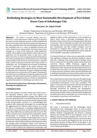
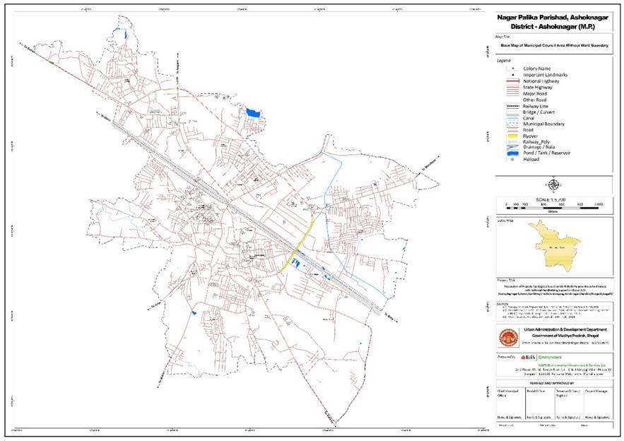
The study is concerned with the Ashoknagar Urban Development Area. Ashoknagar covers an area of about 4,673.94sqkm&situatedinthenortheasternportionofthe Madhya Pradesh. Geographically, the district is situated between the latitude 24.34 N and longitude 77.43 E. and falling in Survey of India toposheet nos 54 G, H & L. It is boundedintheNorthbyShivpuridistrictandeastbyUttar Pradesh, in the south by the Rajgarh & in the west by the Guna district (Census of India, 2011). In the figure 1, the boundariesofAshoknagardistrictaredefinedbytwoofthe rivers,SindhandtheBetwa.
International Research Journal of Engineering and Technology (IRJET) e-ISSN: 2395-0056
Volume: 11 Issue: 05 | May 2024 www.irjet.net p-ISSN: 2395-0072
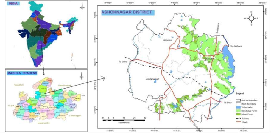
Figure 1: GeographicalsettingofAshoknagarDistrict, Source:PlanningAuthority,Ashoknagar
Ashoknagardistrictiscomprisedwith5tehsilsand4blocks. Thetotalvillagesaspercensus2011countsas907.District populationiscountedas845071(Aspercensus2011)with densityof147personspersq.km
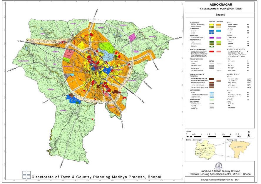
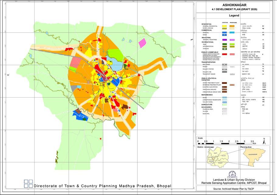
2.2. Landuseanddemographics
GENERALINFORMATION
i)Geographicalarea(sq.km)
ii)AdministrativeDivisions(Ason2013) NumberofTehsil/Blocks 05/04
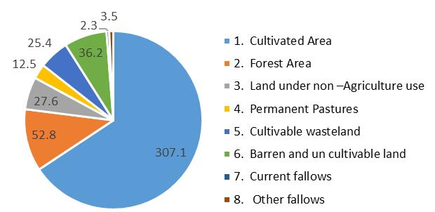
Figure 2: Land-useclassificationdataofAshoknagar
2.3. ClimaticConditions:RainfallandClimate
The climate of Ashoknagar district is composite which is characterizedfurtherbyahotsummerandgeneraldryness exceptduringthemonsoonseason.Theannualrainfallofthe districtmeasuresas927.1mm(TheCGWB,MinistryofJal Shakti,Govt.ofIndia).
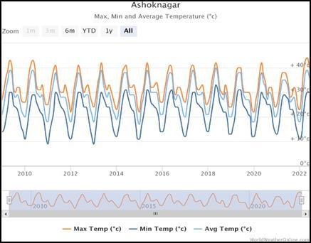
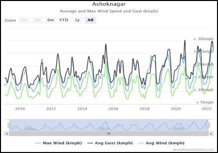
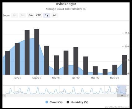
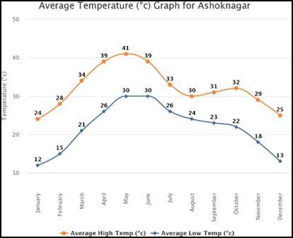
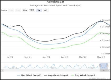
Figure 3:Climaticdata,Ashoknagar
As shown in graph, the typical maximum temperature is found in May, which is 41.3°C, while the minimum temperaturehasisfoundinJanuarymonth,whichis12°C. ThewindrosediagramshowsAshoknagardistrict'saverage annualwindspeedas8.1km/h.
Table 1: DemographicdataofAshoknagarDistrict, Source:(CensusofIndia,2011)
International Research Journal of Engineering and Technology (IRJET) e-ISSN: 2395-0056
Volume: 11 Issue: 05 | May 2024 www.irjet.net p-ISSN: 2395-0072
The paper strongly emphasizes defining the study area, concentrating on a specific location to accomplish its researchobjectives,andthoroughlyexaminingtheneedfor strategyformulationfortheseperiurbanareas.TheURDPFI Guidelines describe a set of parameters that must be considered (URDPFI, 2014). The population, population density, literacy rate, involvement rate in agriculture, and significant growth areas within our study area are all consideredwhiledefiningourstudyareas.
As discussed in the paper, the population, population density,literacyrate,agriculturalparticipationrateandthe important growth areas within our study area are being analyzedtozerodowntotheregionsthatwillbeusedfor studying and framing strategies for the planned developmentofperiurbanareas.
3.1 Populationdistributionanddensity:
The paper has analysed the population distribution and population density panchayat wise within the study area.
TotaldistrictpopulationofAshoknagarasperCensus2011 is 845071, in which Rural is 691387, male- 443837 and female–401234.Populationdensityincityisnearcitycore.
Themajoragriculturalactivitiesarebeingundertakeninthe southernandsouthwesternregionsofthestudyarea.The recommendationoftheresearchpapershouldbecarefulnot toaffecttheagriculturalactivitiesundertakeninourstudy area. The map defines the major growth zones within the fringearea.Theareasconsideredhasthefollowingoutput–
1. Highpopulationdistribution&density,
2. Highliteracyrateandlowagriculturalparticipation rate.
Taking into consideration of the above outputs, the most suitableareashasbeenobtained.Sincetheareashavebeen markedinascatteredmanner,acloseknitgroupedareahas beenconsideredasthestudyarea.
3.3
A study of spatial patterns of land use changes for the delineated region for the last decadal year has been conducted.Itisobservedthattherehasbeenanincreasein thecommercialandmixedlanduse.Further,residentialland use development has been dominant in expanding periurban areas. There has been a spontaneous conversion of vegetation and agricultural land into new urban developmentspaces.Asignificantchunkofdevelopmentis occurringwithinthedelineatedregiontowardsresidential development. Therefore, this is a significant attraction for people who want to invest in the area to buy or rent a property since investing within the urban nodes is very costly.AsexplainedbySimon&David,2008,WehrweinG., 1942, the Rural-Urban Fringe areas are “the transitional areas between designated urban areas and areas for agriculture.”Therefore,thesefringeareascanbeconsidered transitionzoneswhereonecanfindupcomingmixedlandusedevelopment.
International Research Journal of Engineering and Technology (IRJET) e-ISSN: 2395-0056
Volume: 11 Issue: 05 | May 2024 www.irjet.net p-ISSN: 2395-0072
3.4 Assessment of existing physical and social infrastructure:
An assessment has been done which shows the existing socialandphysicalinfrastructure(panchayatwise)forthe delineatedfringearea.Theseobservationsaresupportedby thedata’sobtainedfromtherespectivepanchayatsandthe municipality. The map clearly indicates that the physical infrastructurefacilitiesaresparselyavailableintheregion whereas, the social infrastructure facilities is in a satisfactorilypositionintermsofavailability.
Thestudyoflandusechangesandinfrastructureavailability in the delineated region provides us the following major findings:
A. Thegrowthofsettlementshasseenmainlyalongthe transit corridors, NH-46, SH-10 and also near the major growthcenters,BinaandGuna.
B. Thevillage'snaturalresourcebasehasbeenaffected as a result of the formation of the peri-urban interface as grazingareasandpondshavebeenpurchasedtosatisfythe needsofthecity.
C. Thefringecharacteristicsvaryfromonezonetothe other in terms of availability of infrastructure facilities, incomegeneration,densityandconnectivity.
D. The authorized and unauthorized constructions have gained momentum in fringe areas due to increase in demandoflandandhousing.
E. Themajorityofthepeopleareinvestingastheland valueislesserinthefringethaninthecitylimits.
F. Theagricultural landsintheperiurban areasare beingconvertedintourbanuseatagreaterextentduetothe highdemand.
Level Parameters Problems& issues Recommendatio ns
Affordabilit y and the availability ofland.
Citylevel
Lackof Affordable landinside citylimitand citycenter. Asaresult, preference towardsthe fringearea with expectation ofabetter and affordable optionfor housing.
Extremely high land cost along transport corridors
Panchayat slevel
Beneficiar ylevel
Systematic & planned developmen t
Asystematicperi urban developmentby legalizingthe procedureofland acquisition processtobe performedby Ashoknagar development authorities.
High speculation duetohigh landprice alongthe transport corridors whichneeds tobe controlled. Appropriate measuresfor conservationof theagricultural landandrural livelihood.
Violationof zoning regulations.
Lackof powerto regulate unauthorized development s
Clearand transparent guidelinestobe framedforruralurban components. Theremustbe appropriate regulatory structuretobring harmonyinland utilization.
Controlled developmen t Lackof propersocial andphysical infrastructur e.(school, park, hospital, road, network, drainage, water supply,etc.) Planning authoritiesshould look-intoatlocal andregionallevel.
Table 2: IssuesandRecommendations
International Research Journal of Engineering and Technology (IRJET) e-ISSN: 2395-0056
Volume: 11 Issue: 05 | May 2024 www.irjet.net p-ISSN: 2395-0072
Thisarticleattemptstoexaminetheissuesandproblemsof unplannedanduncontrolleddevelopmentintheurbanarea ofAshokNagar.Ithasbeenobservedthattheproportionof agriculturallandhasdecreasedinthelastdecade,whereas land cover has increased (CDP Ashoknagar 2030). The decrease in the proportion of agricultural land in the suburbsofurbannodesisaneffectofsemi-urbanization.The studyalsorevealstheunplanneddevelopmentinthefringe areasofthecity.
Therefore, rapid, unplanned, and dispersed urbanization threatens urban growth and infrastructure development (Kumar&Kumar,2014).Inordertocontrolthisunplanned spread, it is necessary to establish an urban regulatory system that ensures the use and management of the land, waterbodies,andnaturalenvironment.Activitiescarriedout by the state authorities and local bodies such as municipalities, panchayats, and beneficiaries of urban developmentshouldgetduegoodandvitalroles.Analysisof thestudyareatowardschangesinlandusepolicyinMadhya Pradesh is also examined as Ashok Nagar has undergone significant changes in land use, favoring major land acquisitions. Implementation of appropriate policies will helpcontrolunplanned,unregulated,andunderdeveloped peri-urbanareassurroundingtheAshokNagararea.
1. ComprehensiveDevelopmentPlanforAshoknagar DevelopmentPlanArea,2030.
2. DepartmentofEconomicandSocialAffairs,United Nations,https://www.un.org/development/desa/e n/
3. DistrictSurveyreportofAshoknagar,2020.
4. DistrictAgricultureContingencyPlan:Ashoknagar District,ISO9001:2008
5. Dutta, V., Land Use Dynamics and Peri-urban GrowthCharacteristics:ReflectionsonMasterPlan and Urban Suitability from a Sprawling North Indian City. Environment and Urbanization Asia, 2012,3(2):pp.277-301.
6. Kumar, Dr. Amit and Rai, Ambarish Kumar, Urbanization Process, Trend, Pattern and Its ConsequencesinIndia(December5,2014).
7. Ministry of Statistics and Programme Implementation,GovernmentofIndia,2011.
8. Patra,Suman&Sahoo,Satiprasad&Mishra,Pulak& Mahapatra, Subhash. (2018). Impacts of urbanization on land use /cover changes and its
probable implications on local climate and groundwaterlevel.JournalofUrbanManagement.
9. Population Enumeration Data, Census of India, 2011.
10. PryorRobinJ.,December1968,DefiningtheRuralUrbanFringe,ResearchGate,ArticleinSocialForces 47(2):202.
11. Ramachandran, R. "The Rural-Urban Fringe." Ramachandran,R.UrbanizationandUrbanSystem inIndia.OxfordUniversityPress,1989.297.
12. Simon, David, Urban Environments: Issues on the Peri-Urban Fringe (December, 23 2008). Annual Review of Environment and Resources, Vol. 33, November2008.
13. Singh Dinesh, Vyas Prof. (Dr.) Anjana, Planning Strategies for the Development of Peri-Urban Area:The Case of Indore Peri-urban Area, International Journal of Scientific & Engineering Research,Volume5,Issue7,July-2014,ISSN22295518,Pg27-32.
14. Stow D.A and D. Chen. Sensitivity and multitemporal NOAAAVHRR data on an urbanising region to land use/ land cover changes and misregistration.RemoteSensingofEnvironment,80,pg 297-307,2002.
15. UnitedNations,DepartmentofEconomicandSocial Affairs, Population Division. World Urbanization Prospects:The2014Revision.
16. Urban and Regional Development Plans Formulation and Implementation Guidelines, Chapter4,UrbanPlanningApproach,Page127-128.
17. Wehrwein George S., The Rural-Urban Fringe, EconomicGeography,JSTOR,Publishedby:Taylor& Francis,Ltd.Vol.18,No.3(Jul.,1942),pp.217-228.