
International Research Journal of Engineering and Technology (IRJET) e-ISSN: 2395-0056
Volume: 11 Issue: 05 | May 2024 www.irjet.net p-ISSN: 2395-0072

International Research Journal of Engineering and Technology (IRJET) e-ISSN: 2395-0056
Volume: 11 Issue: 05 | May 2024 www.irjet.net p-ISSN: 2395-0072
Naveen Gupta1 , Prof. Satyam Shukla2
1Student, “Department of Architecture and Planning”, MITS Gwalior
2Assistant Professor, “Department of Architecture and Planning”, MITS Gwalior
Abstract - The Bombay Town Planning Act of 1915 established this framework, which found increased use in Gujarati cities following a 1999 change to the GTPUD Act of 1976. Thecitiesmayacquirelandfromprivatelandownersfor public purposes, including utility, physical & social infrastructure, under the TPS, a land pooling and readjustment mechanism. The main goal of the TPS is to implement land pooling, after which the land will be readjusted to offer housing, commercial areas, and urban services, emphasizing all income groups, including the urban poor. TPS mechanism is primarily used for managing peripheralurbangrowthwhichrequiresthetransformationof agriculturallandtolandsuitableforurbanuse.Thisresearch brings out the measures or proposal from which Town Planningscheme/TownDevelopmentScheme/Landpooling/ Land Readjustment could use efficiently and effectively to managetheurbangrowthbyprovidingordeliveringserviced land on time.
Key Words: land pooling, Town Planning Act, urban services, urban development, planning land management, etc.
1.INTRODUCTION
Theaimofthestudyis“Toanalysestrategiesandmodelfor unplanned and haphazard growth of cities and their peripheralareasbyusingTownPlanningSchemetoachieve balancedgrowthdevelopment.
OBJECTIVES:-
a) TounderstandLanddevelopmenttools&Mechanism (EspeciallyLandreadjustment/LandPooling)Usedin India
b) ToUnderstandthevariousSchemes,Acts&Modelsof LandDevelopment.
c) To analyse efficiency & effectiveness of TPS/TDS in delivery of service Land Recommendation for better implementationofTPS/TDS
Scope and limitation includes, the concluded results and recommendationsofthestudymightcontributetoabetter understandingoftheuseoflandreadjustment.Theresearch is based on qualitative analysis. (Literature studies, discussionwithexperts,concernauthorities,stakeholders).
Basedonthe backgroundstudiesandinputsfromvarious stakeholder consultations indicators would be evolve in ordertoappraiseTownPlanningSchemesforthreestates (Gujarat,MadhyaPradeshandChhattisgarh) takenforthe study.Indicatorscouldbe:
1. Indicators for components like land distribution, opens spaces,infrastructuredevelopmentetc.
2.IndicatorsforImplementationandGovernance.
3.DoesTPschemeworksforthepublicdomainandforthe urbanpoor?
Analyzingthepresentscenariosandlearningfromthecase studies,theresearchaimstoconcludewith,doesanynew development model or application or method should be incorporated that to make the TP schemes better implementedwhichcouldresultinCity'surbanformmore livable. Land development and management needs to be efficientlyformulatedandeffectivelyimplemented.Hence, the land development and management in India requires greater emphasis on issues related to the efficient supply and servicing of land. The detailed methodology includes severalsurveysandfieldstudy.Atopographicalsurveymap is prepared for the area. This includes all the features availableonland.Thisneedstobedonediligentlysothatall landowners are recorded. A land ownership map is overlayed with the topographical survey map to create a basemap,andaboundaryoftheTPSisdelineated.
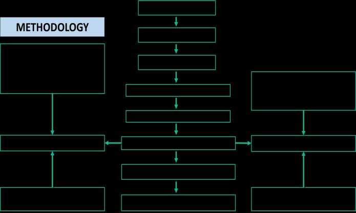
Fig -1:Methodologyofresearch
International Research Journal of Engineering and Technology (IRJET) e-ISSN: 2395-0056
Volume: 11 Issue: 05 | May 2024 www.irjet.net p-ISSN: 2395-0072
a) New Planned Cities
b) New Planned Cities
c) Special Townships
d) Town Planning Schemes
Two stages make up the groundwork of the entire TPS model. The development authority creates a statutory decadal development plan (DP) for the entire town in the firststage, whichshowsthe anticipatedareasofthecity's expansionintotheneighboringruralareas.Thesecondstage divides the growth area into several smaller regions. The Development Authority then gradually builds a Town PlanningScheme(TPS)forthesesmallerregions.Thecities ofGujarat makeconsiderableuse of these TPS. TheAUDA hasplayedavitalroleinitsimplementation.
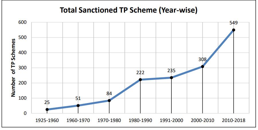
In1911,thecapitalrelocationwasformallyannounced,and British architect Edwin Lutyens was given the planning position SignificantriseinnumberofT.P.Schemesafterthe year1990; Pace ofurbanizationand timelyamendmentin legislation has paved the way for rise in the T. P. Schemes posttheyear2000;Total numberofT.P.Schemes – more than 1626 across the state at various stages; Land contributionhasbeenraisedfrom20%(pre1999)toupto 40%(post1999)showingasignificantriseinT.P.Schemes 95%ofPublicHousingProjectsbyUrbanLocalBodiesareon lands made available through Town Planning Schemes; Admissible components – geometrically regularly shaped plots, roads & circulation, EWS housing, schools, playgrounds, firefighting & other social infrastructure, gardens&urbangreen spaces,etc.
Landdevelopmentandmanagementmeansprocesstomake available the developed / serviced land to the people on time.Toeverincreasingpopulation,no.ofcitiesandmetros wouldbecomingtoaccommodatethem.Therewillbeneed of housing, commercial activities to generate economic activities, public amenities, opens spaces, good transport, infrastructure and basic services. Land development and managementisneededtoprovideallaboverequirementto caterthepopulation,toenhancetheirqualityoflife,togive them integrated options for public transport and lastly to givehousingtoSEWS/LIGsection. Hence, Land development and management needs to be efficientlyformulatedandeffectivelyimplemented.
Forlanddevelopmentthreestepsareinvolved:
a)
Assembly
Landassemblyisoftendonebyvariousmodesbyadopting variousmodelsundertheprovisionoflegalframework or withoutlegal framework. Landassemblyisalsoknown as "Formal Land Supply" which could be through public or private agencies. Usually formal land supply falls short as pertheneedorrequirementsofhousingwhichgivesriseto informallydevelopedarea(unauthorizedcoloniesorslums), lackinginbasicservicesandinfrastructure.Theonlypointof distinction1sthescaleofthedevelopment(Abuildingoran entirearea)
Land is developed by planning a basic layout where the uneven plots are given proper shape and access. Basic servicesandinfrastructureareprovidedlikeroads,opens spaces, water supply, sanitation, electrification of street lightsetc.Land required for commercial,Institutional and socialisbeencarvedout.
After the land development and servicing, the final plots whicharecarvedoutinpropershapeandaccessaregiven backtolandowners.
Insometheauthoritysaletheirplotsfromthelandreserved forsaletorecoverthecostoflayingdowntheinfrastructure. In that case they call for a lottery system, public auction, throughinvitingtenders,todisposetheirservicedplots.
Itisanadvanceacquisitionoflandandholdingitforfuture development.Thedevelopmentauthorityacquirestheland fromthelandownersundertheLandAcquisitionact18943 andgivesthemthecompensationinlieuoftheirlossesby surrenderingthelandtotheconcernedauthority.
International Research Journal of Engineering and Technology (IRJET) e-ISSN: 2395-0056
Volume: 11 Issue: 05 | May 2024 www.irjet.net p-ISSN: 2395-0072
“ThebasicconceptofaTPSchemeistopooltogetherallthe land (typically ranging from 100 to 200 hectares) under different ownerships and redistribute it in a properly reconstituted form after carving out the required land Transfer of development rights (TDR).” TDR is tool for transferring of development rights from places where developmentauthoritywouldliketodecongestorprevent overcrowding or preserve the environmentally sensitive area or to protect heritage area (called sending area) to places where they would like to see more development (calledreceivingarea).Itwasstartedin1950sinEuropeto developagriculturelandandIndiastartedinI980s.Thereare sixtypesofTDR- Road TDR;ReservationTDR; Slum TDR; HeritageTDR;DilapidatedbuildingsincentiveFSI;Schools, hospital and hotel incentive FSI TDR does not involve outright purchase of land hence it is very useful tool for publicsectorworks.
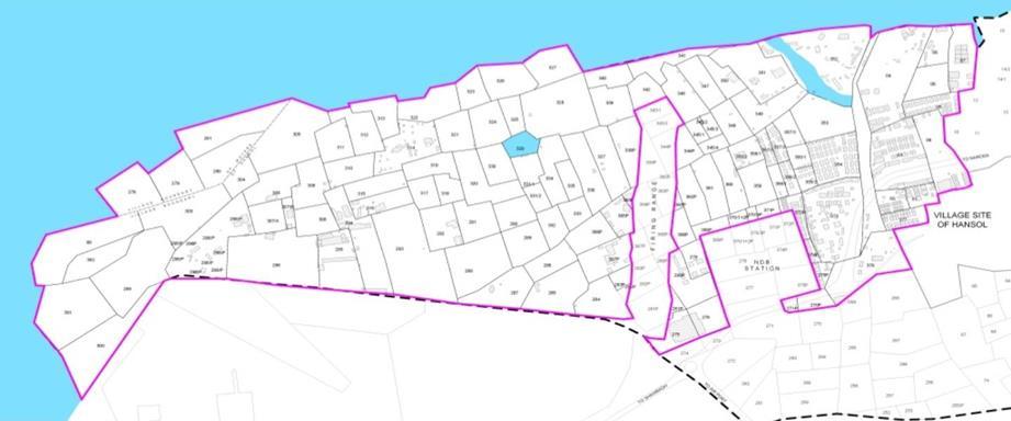
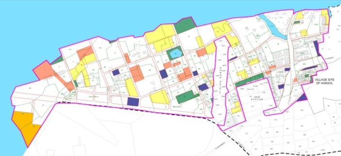
Hansol,AhmedabadhasbeentakenascasestudyofTPS.An areaisidentifiedwithpotentialdevelopment/urbanization andabout100 to 150Ha is takenup forproposing a T. P. Scheme.Totalstation-basedSurveyisperformedinentire area. Identification of plot boundaries, existing buildings, road alignment, natural resources. Topographical information – slopes of grounds, contours. Existing infrastructure of power supply, gas/fuel pipelines & forest/naturalreserveareas.Totalstation-basedSurveyis performedinentirearea.Identificationofplotboundaries, existing buildings, road alignment, natural resources. Topographical information – slopes of grounds, contours. Existinginfrastructureofpowersupply,gas/fuelpipelines& forest/natural reserve areas. Marking of Original Plot boundaries(OP).Bestsuitableroadalignmentisidentified andmarked.ReferencetotheDevelopmentPlanalignmentis made,ifanyproposedalready–takenupforinclusioninthe T.P.Scheme.Widthhierarchyforroadsisproposed.
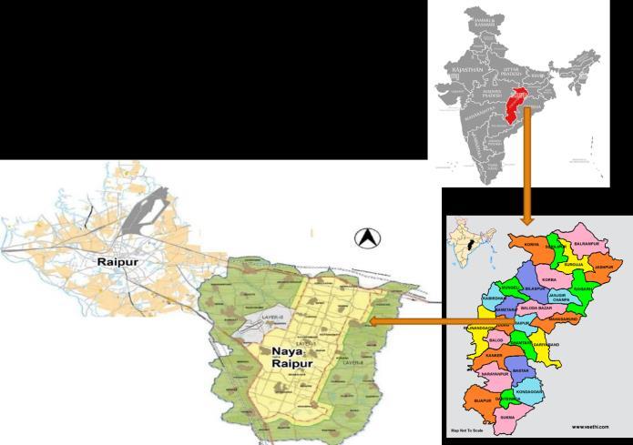
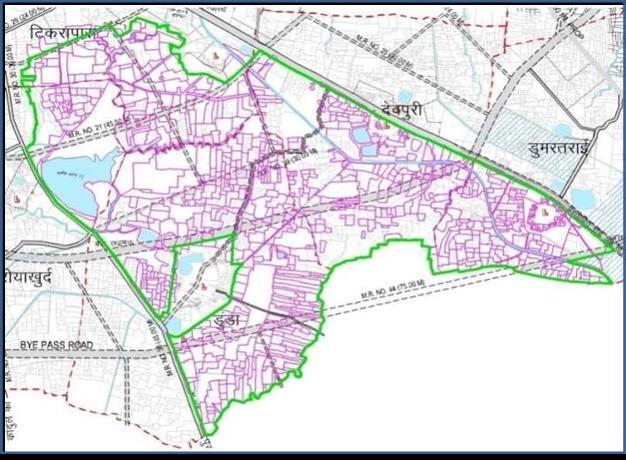
ThesiteareawaschosenforstudyasKamalVihar,Raipur (Chhattisgarh).Theschemeinvolvesreconstitutionofland whichisanacceptedmethodofurbandevelopment.
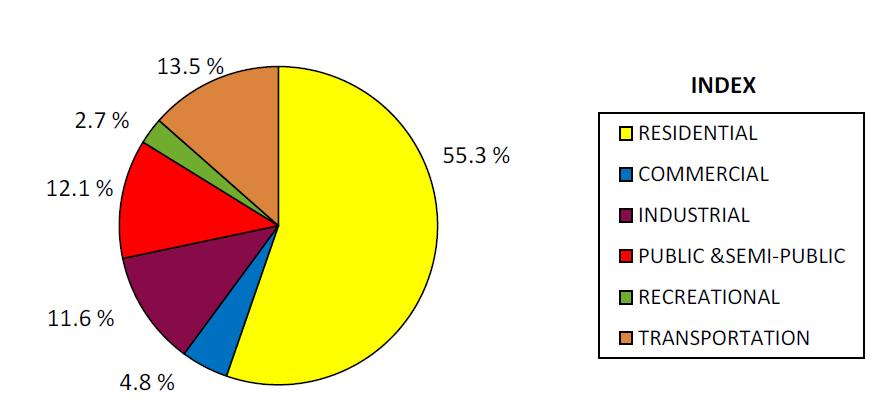
-6: Categorizationofurbanlanduse,RaipurCity, Census2011
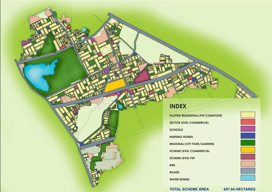
Table -1: SampleTableformat
ProjectName TownDevelopmentScheme-04KamalVihar
Location Raipur[CG.]
Cost 815.34crores
Area 647.84Ha.
Description Urbanplanningbasedonauniqueland poolingmodelandengineeringdesignofa stateofarturbaninfrastructure.
International Research Journal of Engineering and Technology (IRJET) e-ISSN: 2395-0056
Volume: 11 Issue: 05 | May 2024 www.irjet.net p-ISSN: 2395-0072
India is on a big move. Urbanization not only brings economic growth but also brings lot many problems like insufficientsupplyofservicedland,lackofbasicservicesand infrastructure which brings the haphazard development, sprawls,buildingupofslumsandalsodeterioratestheurban environment.Thestudybringsthedetailknowledgeofhow TPSusedinAhmedabad,IndoreandRaipur.Andtheprocess ofplanning,implementationmakesthebigdifferenceinthe overalldevelopmentofthecities.Thestudycouldgivethe visionthathowinmosteffectivemannerTPStoolcouldbe used to manage the urban issues, housing, lack of infrastructureetc.
ACKNOWLEDGEMENT (Optional)
TheauthorswishtoacknowledgeDrAnjalis.Patilma’amfor providingguidanceateverystepofthestudytobedone.
1. TheGujaratTownPlanningandUrbanDevelopment Act-1976.TheBombayTownPlanningAct-1954.
2. UrbanandRegionalDevelopmentPlansformulation and implementation (URDPFI), Ministry of Urban Development,GovernmentofIndia.
3. Ballaney, H.S. (2013), “Supply of Land for Development- Land Readjustment Experience in Gujarat, India- Urban Legal Case Studies. Ahmedabad”:UNHabitat.
4. Bansal, N. (2013), “DDA Land Pooling Policy”: KPMG.
5. Mahadevia,D.(2018)“TowardsamoreequalcityAhmedabad:TownPlanningSchemesforEquitable Development - Glass Half Full or Half Empty? Ahmedabad”: World Resources Report, WRI• UK Aid.
6. B.Patel,B.(2015),VariousUsesofLandPolingand Land Reconstitution in Gujarat, Ministry of Urban Development,NewDelhi.
7. [10]. V. Patel, V. (n.d.) Various Uses of the TPS mechanism,Ahmedabad.
8. Rawal,R.(2018)LegalFrameworkoftheGTP&UD Act, 1976 and Rules, Ahmedabad: Town Planning andValuationDepartment,GovernmentofGujarat.
9. Sharma, P. (n.d) “Statutory Provisions of Development Plan and Town Planning Scheme, Ahmedabad”: Town Planning and Valuation Department.
10. PatelN.K.(2019)“TownPlanningSchemeinIndia”: Journal of Institute of Town Planners, Indiavol:16/4.
11. Town Development Scheme as a Tool to Build Urban Infrastructure - Case Study: Kamal Vihar, Raipur,InternationalJournalofResearch(IJR)Vol1,Issue-5,June2014ISSN2348-6848
12. DubeyKK.UrbanLandUse–ACriticalReview.The IndianGeographical Society, Madras-5.1971Jan.March;XIIV(1&2):45-51.
13. Chandramauli,SinghSB.LandUseAssessmentand Management: A Case Study of Robertsganj Tehsil, Sonbhadra.NationalGeographicalJournalofIndia. 2012March;58(1):35-41.
14. KaushikSP,KaurV.UrbanLanduseAnalysisusing GISTechnique:ACaseStudyofKarnalCity.National
International Research Journal of Engineering and Technology (IRJET) e-ISSN: 2395-0056
Volume: 11 Issue: 05 | May 2024 www.irjet.net p-ISSN: 2395-0072
GeographicalJournalofIndia.2009June;55(2):3346.
15. SinghBN,SinghV.ChangesinLandusePatternin Chakia Block, Chandauli District. National GeographicalJournalofIndia.2009Dec.;55(4):3546.
16. MoHUPA (2007): National Urban Housing and HabitatPolicy2007.MinistryofHousingandUrban PovertyAlleviation,GOI,NewDelhi.
17. MoHUPA (2007): National Urban Housing and Habitat Policy, 2005, September 6, 2005. Source: muepa.nic.in/policies/duepa/DraftNHHP20059.pdf.
18. Shehana Rasheed, Saritha G Parambath. ‘Urban LandManagementandPlanning -IndianContext’. International Journal of Scientific & Engineering Research,Volume5,Issue7,July-2014.