Abstract - Understanding urbanization is based on a few important facts that demonstrate how populous expanding cities are. The area under investigation is influenced by the urban setting, which includes social, economic, and environmental issues. Uncontrolled expansion is a result of urbanization, which has caused residential, commercial, and industrial development outside the city's municipal boundaries. Due to this, settlements underwent a transition from being rural to urban, acquiring traits of both a village and a city. Being one of the most populous cities in MP, JabalpurCorporationisconstantlyunderpressuretodevelop, especially as the industrial and techno-centric fringe development in its periphery exhibits area. The study's objective is to evaluate the development plans for Jabalpur Panagar Urban Fringe area. and examine how different factors affect the rural-urban fringe area. Considering their requirements,significance,andindividualtraits,andcreating a proper planning strategy and proposal for the Jabalpur fringe areas methodical development.
Key Words: Equitable development, Policy and Planning, Satellite Town, Inclusive, The growth of urbanization
1.INTRODUCTION
Urbanization changes due to uncontrolled city expansion developed along industries, transport axes, people living alonghighwaysdevelopintoeasilybuiltupcolonies.Similar probleminIndiancitiestoo.
Asweapproachtheturnof the20th century,analystsare worried,whatshouldbedonetolimittherapidurbanization oflargecities.Manyexpertsagreethata newapproachto urbanplanningisnecessarybecausethedifficultiesfacedby the tremendous in comparison to earlier urban issues, urbanizationandriseinpopulationintheworld'sgreatest cities are substantially distinct. Utilization of present resourceskeepinginmindthefuturesocialneedsprevents depletion of resources. Natural cycles should not be tampered with to protect the environment. Land use and environmentallyresponsibleconstructionshouldbeplanned toraisethestandardofliving.
1.1 AIM
Thefocusofthestudyistoprepareaplanningstrategyto facilitatethedevelopmentoftheouterfringesareasofthe cityofJabalpur.

1.2 OBJECTIVE
Theobjectivesofthestudyare:
1.To understand the concept of urban fringe and its transformationduetourbanization.
2.Toanalysesthecharacterofdevelopmentoccurringonthe outerfringesofJabalpurCityandthevariablesinfluencingit.
3. To understand the causes of change in land use and to studytheedgepatternofthecityfringes.
4.Analyzingindicatorsgeneratedbysiteinvestigationand bestpractices
2. METHODOLOGY
Themethodologyofthestudy,whichwascarriedoutinfour phases, was derived from its objectives. For base map generation,italsousesthegeospatialtechnology,ArcGIS, which is an essential tool for geospatial data analysis. Primary and secondary surveys, questionnaires and field surveysareusedtocollectdataforthestudyinthefrontier region.Toanalyzethenatureofdevelopmentinthefringe area, a literature review, spatial analysis of area of land use/landcoverandbasicinfrastructurefacilitieswascarried out.Demographicinformationforthestudyisbasedonthe 2001, 2011 census and the study area was defined by extrapolating several criteria from various literature reviews.Afterreviewingtheinformationcollectedandtwo case studies of US perimeter development, for the study area,fromwhichsuggestionswerepreparedfortheplanned developmentofurbanoutskirtsforthestudyarea.
3. IMPORTANCE OF URBAN FRINGES
TheDemographicchangesthatmanycountriesarecurrently experiencingandwillexperienceinthecomingdecadesarea majorfactorintherisingrelevanceoftheurbanperiphery.
Long before urban expansion, the urban edge was a "temporaryzone."However,itisnolongeranticipatedthat thiscontinuousexpansionprocesswouldlastforverylong. Thislendstheurbanperipheryafarmorelastingcharacter and necessitates special consideration . The character of urban outskirts depends on the quantity of land that is availableinvariousnations.
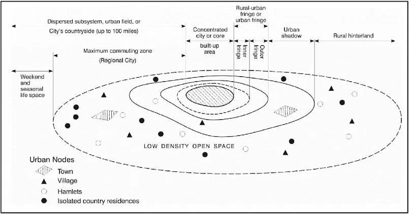
The concept of urban fringe and its transformation due to urbanization- A case of Jabalpur Fringe Area.
Countriesthatstruggletoabsorbanincreaseinpopulation do their best to relocate people to the outskirts of cities, whichhasasevereinfluenceontheenvironment.Therural urban periphery took on FOUR forms over time: i) Relationship to space ii) Social aspects iii) Physical componentsiv)Financialfactors.

3.1
ThepatternsofAareUrbansprawlaroundperipherycity expansionnearbymunicipalboundary.Thedevelopmentof thisfringeareaisunplannedmanner.Urbansprawlaround peripherydevelopmentleadstodecentralization
The patterns of B Growth along transportation axes are Peoplelivingalonghighwayseasilydevelopintothistypeof settlement. Most of the land use is mixed land use where thereareresidential,commercialandindustrialetc.
ThePatternsofCisSatellitedevelopmentnearbyparentcity linkagewitheachother.Thesearetheplaceswherepeople definitely live but employment is linked to big cities. The mainreasonforsettlementisbetterqualityoflife.
ThePatternsofDisSometimesthepopulationinbigcities increasesto a great extent. Toreducethe pressureon the main city, the government has planned a new city. high densityandwellplanned.
4. STUDY AREA-
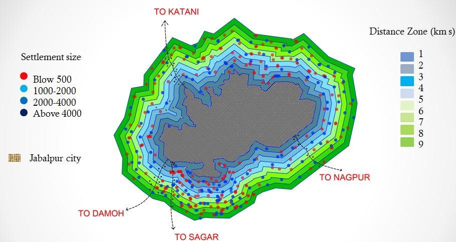
The studyarea is 9km rangearea taken fromoutsidethe municipal limits of Jabalpur city. Which is available
accordingtothe2011censusdata.Theouterfringeareais linkedtothecityandruralareas.Inwhichnodesarebeing formedatsomedistancewhichfollowdifferentpatterns.
Itincludescity,village,nodecolonyetc.Thisisunplanned developmentasthelanduseisbeingshownasagricultural landuseinthemasterplanbutthedevelopmentisofmixed type. inwhichthelackofinfrastructurecanbefelt,Dueto thelowercostoflandinthemarginalareaascomparedto thecity,peoplehaveseenmoreinterestinit.
4.1 UNDERSTANDING FRINGE AREA OF JABALPUR-

Asof2011Indiacensus,Jabalpurdistricthasapopulationof 24,63,289.Ruralpopulation10,23,255andurbanpopulation 14,40,034.Thepopulationofthecityareais10,55,525.Area 5211Sq.Km.Asperthe2011census,Thesocioeconomicand demographicstructureofacityisdirectlyaffectedbyurban development as it is undergoing significant changes. Urbanization has promoted residential, commercial and industrialdevelopmentbeyondthemunicipallimitsofthe city.Duetowhichuncontrolledgrowthistakingplace.This showsthattheeffectofpopulationhasspreadintherural areainthelastthreedecades.Thisalsoputsheavypressure on the fringe areas of the city. In 2010, the limits of the corporation were expanded by adding surrounding panchayats, 127 villages are included in the Jabalpur municipalitygeographicalareaandadministrativelyinthe municipalityward.
5. URBANIZATION TREND
Jabalpurislocatedat79°59'eastlongitudeand23°10'north latitudes.ThecityislocatedonNH-7betweenVaranasiand Nagpur in the 'Mahakaushal' region of Madhya Pradesh. Varanasi, and Bengaluru are all accessible by road from Jabalpur. It is connected to Prayagraj, Lucknow, through National Highway 30. It and Kanpur are connected by NationalHighway34. The130hectare(310acre)Jabalpur Airport (JLR), also known as Dumna Airport, is situated around 20 kilometers from the city's center. The city's
A prominent tourism hub is Jabalpur. A few of the wellknownJabalpurattractionsaretheShivStatueinKachnar City, the Balancing Rock next to the Madan Mahal Fort, Chausta-Yogini, Gwarighat, and Marble Rocks and dhuandhar in Bhedaghat. The well-known tiger reserves includingPenchNationalPark,BandhavgarhNationalPark, andKanhaNationalParkareeasilyaccessiblefromJabalpur. Thedistrict'snaturalresourcesserveastheprimarysource for a variety of different sectors, despite the fact that the ready-madegarmentindustryaccountsforasizableportion ofJabalpur'sproduction.
5.1 LAND USE
The area includes several mixed-use paddy and built-up areas.Theareaismostlyagricultural,residential,publicand semi-public uses This is 79% of the total land use due to increasinglandreclamationandurbanization,thedensityof waterbodiesandwetlandshasbecomeverylow.Farmers are under immense pressure as agricultural areas are rapidlybeingconvertedintomixed-use,denselypopulated residentialareas.Lessthan1.4%ofcomprisesopenspaces, parksandotherrecreationallanduses.Overaperiodof30 years,thearea'swetlandsdecreasedby58.75%,whilethe built-up area increased by 59%. Additionally, the city has lost17.82%ofitsgreenery. Inadramaticway,theexisting residentialunitswereconvertedintomixed-usecommercial andhousingfacilities
5.2 INFRASTRUCTURE
5.2.1 Water Supply and Sewerage System
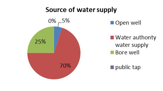

AsperURDPFInorms,thelevelofwatersupplyshouldbe 135LPCDoncethepipedwatersupplysystemandsewage systemareinstalledinthecity,whichwouldrequire156.6 MLD of water for the entire city based on the current population,KWAwatersuppliedtodifferentwards.Is.Most ofthewardsdependonbore wellsand othermethodsfor
watersupply.Thisappearstobeamajorproblem,asmany coastal homes do not have local storage tanks. Moreover, thereisgreaterrelianceonpublictapsthanprivatewater supply.
5.2.2 Solid Waste Management
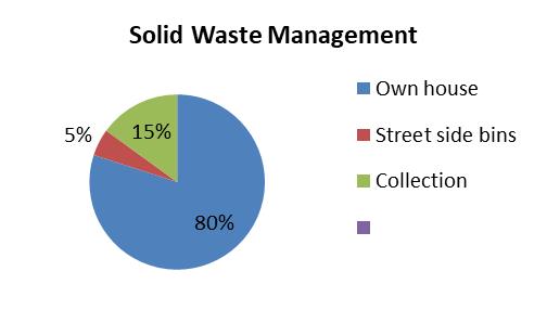
Currentissueswithsolidwastemanagementintheregion aresevere.IntheJabalpurCorporation,49%ofthewards have no rubbish collection. In these regions compared to other parts of the city, rubbish collection occurs less frequently.Ofthe8wardsintheresearchregion,haveno wastecollectionandhavewastepickupjustonceeverytwo weeks. There are no secondary collection stations or facilities for the collection or processing of e-waste in the area.Inwards,IMAGE(IndianMedicalAssociationbecomes EcoFriendly)collectsandmanagesbio-medicalwaste.
5.2.3 Education and Health
TheeducationalinstitutionsoftheurbanareaofJabalpurare famous.Therearemanyschoolsanduniversitiesinthearea, whichledtothedevelopmentofparksandlibraries.While the outskirts have inadequate health facilities, the area is fragmented due to the large number of educational institutions.
5.2.4 Parks and Open Spaces
Parks,openspacesandotherrecreationallanduseaccount forlessthan1%ofthetotalpercentageoflanduse.Spacefor recreationisfoundonlyinthecoreareasofthecity,while otherareasadjacenttotheoutskirtsofJabalpurlikeKhajri, Tilwaraareentirelyunderresidentialandagriculturalland use.Thereisalsoalackofcommunityparticipationinthe area.Communitybuildingandotheractivitiesforcommunity developmentarealsoabsent.
5.2.5 Special Economic Zones
New populations of students and migrant workers have movedinduetotechnologically-orienteddevelopmentand rapid growth of industrial parks such as the Khamaria Vehicle Factory, which constitute two special economic zones.Thishasaccommodatedthegrowthofeateries,banks, buildingsites,etc.alongthehighway.Presenceofhospital staffandeducationalinstitutionsatthemunicipallevel.
6. CONCLUSION
Thereisaneedtoimprovetheinfrastructurebothphysical and social in the entire research area. When it comes to physical infrastructure, the neighborhood lacks adequate water supply, proper sewage and proper solid waste management.TheoutskirtsofJabalpurdonothaveenough openspaces,parksandotherrecreationalfacilitiesforthe growing population. Another important issue of the local peopleisthelackofbusstations.Farmersareundermore stressasthearea'slandusecontinuestoshifttowardsbuiltupurbanuse.Thisisbecausetherearenolandusezoning regulationsintheresearcharea.Thehighlandvaluesofthe study area also preclude the possibility of additional industrialdevelopment,whichwouldhaveanimpactonthe localeconomy.
7. RECOMMENDATIONS
Threegoalsconservation,enhancement,anddevelopment are the starting point of the guidelines for marginal area development.Itneedstobedonetomakerecommendations forfourparameters:landuse,infrastructure,transportation, andeconomybasedonthestudypresentedabove.
Regulate residential developments in agricultural areastopreservelandusezoning.
Plan for appropriate public infrastructure to support the expected expansion, such as wastewater treatment facilities, storm water managementsystems,streetlighting,parks,trails, andotherrecreationalfacilities.
To promote community participation and development through community awareness programstocreateasenseofbelongingamongthe public.
REFERENCES
[1] Department of Architecture, TKM College of Engineering,Kollam,IndiaShilpaSureshJyear2020.
[2] Nazrin Banu, Shahab Fazal. (2016). Livelihood And Wellbeing In The Urban Fringe. Aligarh,India:Springer InternationalPublishingSwitzerland.
[3] [10] Neelmani Jaysawal, Sudeshna Saha. (2014). Urbanization In India: An Impact Assessment. International Journal Of Applied Sociology
[4] [11] Shah, J. (2015). Research Paper: Managing PeriUrbanExpansion.
[5] [12]ShahanazJaleel,JacobCherian.(2015,December). DefiningTheIdentityOfTechnocentricTransformations InAnUrbanEdge Creative Space (Cs),Pp.97-102.
Author Profile
RAHUL CHOURASIYA now doing M Plan at MITS College, Gwalior (2021-2023batch)

Guidename-Prof. JASPREETWALIA.

