APPRAISAL OF CONGESTION AND TACTICS TO COUNTER IT IN CENTRAL BUSINESS DISTRICT (CBD) OF A CITY: CASE STUDY- MAHARAJA BADA GWALIOR
3Professor, Department of Architecture & Planning, MITS, Gwalior ***

Abstract - In most places in the world, traffic congestion is an issue that has adverse implications. The central business districts (CBD) of many big and medium-sized cities in India, in particular, face the challenges of traffic congestion and suffer the consequences of this mobility issue, congestion is brought on by an assortment of factors, including increasing population density, rapid urbanization and motorization and most importantly, the simultaneous integration of administrative, socioeconomic, and commercial activities in the CBDs. This paper examines the state of traffic congestion in the Maharaja Bada area of the city of Gwalior, which is an important CBD of the city but currently experiencing severe congestion issues. In this regard, spot speed, active road width, and volume of every kind of vehicle on the major roads of the Maharaja Bada area during peak hours on weekdays have been evaluated using manual counting and video recording techniques. The Level of Service (LOS), Speed Performance Index (SPI), and Active Road Performance Index (ARPI) have all been used as indicators of the level of traffic congestion in the research area. The results of these indices concluded that all the major roads in the study area are facing the worst traffic congestion state. Specific recommendations are proposed for improving the current congestion state of the study area. Hopefully, the findings of the study will make a valuable contribution to the field of sustainable development.
Key Words: Congestion, Urbanization, Motorization, CentralBusinessDistrict,SustainableDevelopment
1.INTRODUCTION
Urban India is becoming more motorized than its urban population,most cities are seeing annual increases in automobile ownership of 15-20% according to reports of (The Ministry of Road Transport and Highway). Automobilesfulfillourneedformobilityhowever, itleads to traffic congestion in cities .Traffic congestion is characterized as a physical phenomenon where there is a shortage of available road space, which results in slower driving speeds, longer travel times, and more motor vehicle queuing [1] . According to Blanco [2] the lack of adequate transportation amenities, such as adequate
parking, road space, and traffic signals, leads to traffic congestion. One of themajorcause oftrafficcongestion is dueto lackofinfrastructurefornon-motorizedvehiclesin thecities,fastandslowmovingvehiclesfrequentlymingle onthesameroad,causingtrafficjamsinCBDs
Today many Indian cities are facing negative impacts traffic congestion butmostly these problems gets exaggerated in the central business districts (CBD) of the cities.ThroughouthistorytheCBDhasbeencharacterized by a number of land use changes that include industrial, residential, commercial, administration, and consumption [3]asaresultCBDofcitiesisfacingthiscongestionissues due to the nature and characteristics of these areas . MaharajaBadaisthemostimportantCBDofGwaliorithas acentrallylocated chowkwhichissurroundedbythriving bazaars.ItisoneofGwalior'sandMadhyaPradesh'smost prominent markets, Due to the importance of Maharaja bada it has to cater negative effects of urbanization and motorization every day which are problems like traffic congestion, parking issues, pollution in these area, these issues are exacerbated by factors like lack of traffic regulations,accessiblepublic transportationand planning forNon-MotorizedTransport(NMT),CBDareasofrapidly growing cities like Gwalior are congested all the time especially in peak hours of the day .Congestion relief and establishing an excellent transit infrastructure in CBD areas are two of the most critical challenges for any city's long-term economic success. The study aims to identify thecurrentcongestionscenario intheMaharajaBadaarea of Gwalior, and to propose strategies for sustaining this area from the negative effects of congestion, Main objectives of the research are i- To determine the level of congestion through indices on the major roads of the study area through several congestion indices ii-To identify factor responsible for traffic congestion in the study area. iii-To Identify strategies to tackle traffic congestion in study area. Several proposals are given at the end which can be used by government to shift the mobility planning towards more sustainable future of the area.
2. CITY OUTLINE
Gwalior is one of the counter magnet cities, located in MadhyaPradesh.Itis343kilometers(213miles)southof Delhi, 120 kilometers (75 miles) from Agra, and 414 kilometers (257 miles) from Bhopal the state capital (Google Maps) .Municipal Corporation covers an area of 372.22 sq. km. which is divided into 66 wards with populationof1600000approx(GwaliorDevelopmentPlan 2035,2021).
3. METHODS AND MATERIALS
1.1 Study Area
MaharajaBadaisthemostimportantCBDofGwalior.Itis one of Gwalior's and Madhya Pradesh's most prominent markets. Mainly 4 wards covers the maharaja bada area which are shown in Fig.1 and details of which is depicted inTable1 Thereareseveralimportantandlargemarkets in or near Maharaj Bada , including Sarafa Bazaar, Topi Bazaar, Subhash Market ,Nazarbagh Market, Gandhi Market, Daulatganj, and others. Aside from these large markets, there are a number of smaller markets in the MaharajBadaarea.
Maharaja Bada also has a historical importance for city Gwalior as many tourists visit jiwaji chowk as it is a magnificent grand squareis flanked by seven different historic buildings which are built in various architectural styles
1.1 Major Roads and Circulation


There are 5 primary roads that lead to the Jiwaji Chowk from which traffic can enter and exit. Traffic arrives from threeentrancepoints - DaulatGanj,Maharaja Bada Road, and Gandhi Market, and can exit from 2 routes which are MadhavganjroadandsarafabazarroadasdepictedinFig. 2.
There are 5 primary roads that lead to the Jiwaji Chowk
from which traffic can enter and exit. Traffic arrives from threeentrancepoints - DaulatGanj,Maharaja Bada Road, and Gandhi Market, and can exit from 2 routes which are MadhavganjroadandsarafabazarroadasdepictedinFig. 2.
1.2 Methodology
1.2.1 Data Collection
To evaluate the traffic congestion status of the Maharaja Bada, mainly three congestion indices were introduced namely Active Road Performance Index (ARPI), Level of Service (LOS), Speed Performance Index (SPI index) further to analyze these indices several surveys were conducted which involves the measurement of traffic volumeonallthemajorroadsofstudyarea,spotspeedof vehicles on roads and active road width These indices were analyzed to understand the intensity of congestion issues CBD is facing. It became apparent that NMT
transportandillegalhawkershaveasignificantimpacton the neighborhood. All of the surveys were carried out between April 2023 and July 2023 during the busiest hoursof the weekdays (6:00–7:00PM).Thesurveys were carriedoutusingmanualcountingandvideorecordingsto thesurvey'srequirements
3.2.2 Level of Service (LOS) and Passenger Car Unit (PCU)
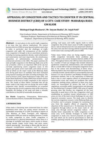
LOS provides a qualitative measurement of traffic on the roads. The type of facility, current traffic patterns, and other factors like heterogeneity of traffic, on-street parking, roadside commercial activities, pedestrian volumes influences level of service [4] . In this study, the Volume to Capacity ratio a tried-and-true and accurate approach for calculating Level of Service is used to determinetheLOSoftheRoadsandjunctions.[5]
PassengerCarUnit-AmetricknownasthePassengerCar Unit (PCU) is used in transportation engineering to measure the rate of vehicles moving along an urban road. A method of transportation's effect on traffic characteristics (such as headway, speed, and density) relative to a singlestandard passengercaris measured in passenger car units. It's also referred to as passenger car equivalent[5],valuesasperIRC-65areshowninTable3
The LOS can be determined by measurement of hourly traffic volume passing at a particular section of the road (v)andbyknowingthecapacityofvolumewhichcanpass (C), the ratio of volume and capacity is calculated .The scale intervals of the volume-to-capacity ratio, as given in Chart1,canbeusedtocalculatetheLOSofaroadway.

Each of the six service levels is identified and assigned a letterfromAtoF(Table2).Thebestoperatingconditions areindicatedbyLOSA,andtheworstoperatingconditions are indicated by LOS F. Thus with the help of LOS we can determine the quality of service road is providing for the traffictoflow.
3.2.3 Road Inventory and Active Road Performance Index (ARPI)
Road inventory survey is a thorough survey that can be used to profile the roads in the study area. Features like road/pavement widths, pavement types, encroachments, the presence of vendors/street furniture, bus stops, etc. can be studied and detailed [6] , the data was used to analyzetheActiveRoadPerformanceIndex(ARPI).
ARPI determines the active portion or percentage of the road width, the usable road width when occupied by illegal hawkers, on street parking or other it narrows the active width of the road and often leads to congestion Active road width decreases and influences traffic congestion. The active road percentage at the chosen traffic nodes was calculated using ARPI in the present research. The greater the ARPI number, the less road width is used by unlawful parking or other types of activity [7] .The active road performances for the major Maharaja Bada roads were defined in this study using ARPIandiscalculatedusingthefollowingformula-
Where,
RWbo-Roadwidthoccupiedbyinformalactivites,RWopRoadwidthoccupiedbyOn-streetPatking,RWrb-Road widthoccupiedbybuildings

3.2.4 Speed Survey and Speed Performance Index (SPI)
The speed performance index has been proposed by Beijing Traffic Management Bureau (BTMB) as an evaluation indication of the state of urban road traffic
basedonthosedata.Theindexvalue,whichrangesfrom0 to 100, represents the speed of the vehicle in relation to the maximum speed allowed. The two numbers (25, 50)

The purpose of the mid-block traffic count study wasto collect existing traffic volume on major roads. studies of thecurrenttrafficscenario,thetotalvehiclecount(TVC), PCU,PHF,andLOSofthemainroadsinthestudyareaare allexaminedinthissurvey'sdata.
are chosen by BTMB as the classification criteria for the state of urban road traffic. But in this study 3 thresholds value were taken ( 25,50,75,) for classification of urban road affic condition [8] The evaluation of Speed

Five locations were chosen (as shown in Fig. 3) along a few key routes in the maharaja bada area to perform the traffic count survey. The survey was conducted with the help of video recording and manual countingduring peak hours between 6:00 PM and 7:00 PM on usual weekdays from Monday through Wednesday, excluding public holidaysExcept for Madhavganj, all main highways have V/C ratios greater than 1, which indicates that there is a breakdown of flow on these routes (Table 3) and all the roads has PHF of more than 9 which implies that there wasnochangeinthevolumeoftrafficduringtheanalysis hour.
Performance Index will determine the quality of traffic movement along a route and the magnitude of delays along the same route. This enables the planners to make improvements. SPI index is calculated using the formulaDecrement in SPI index value represents high state of congestionontheroad asshowninTable4
4.1 Assessment of Traffic Congestion scenario through indices
4.1.1 Analysis of LOS and PCU through mid-block survey on major roads

Maharaja bada is considered as an importantcentral business districts of the city Gwalior, mostly all the roads hasLOSFduringpeakhours,whichisaverynegativesign forthe neighborhoodbecausethisbreakdownisto blame fortheworseningofthestudyareaascongestionnotonly affecting the area’s living environment but also causing significanteconomiclosses.Itisevidentthattheroadsare unabletohandlethislargeamountofPCUasshowninThe survey indicated that on the roads of the areatraffic congestionisunavoidable
The situation in peak hour is such that every vehicle follows the one in front of it, slowing down frequently as necessary.All the roads except Madhavganj generally has moredemandthancapacityTable5,thereforeitisevident thatthere is typically a capacity problem. The survey analysis shows that 2-wheelersare the most frequently used vehicles on all the major routes in Maharaja bada followed by auto rickshaws, and cars. Due to how convenient it is to park on the street and shop, there are an increasing number of 2-wheelers in the area, which leads to traffic gridlock and congestion. E-rickshaws and cars are also acontributor to the market area's traffic gridlockandjams.
The traffic volume count survey indicates the poor condition of the traffic in the study area The survey indicatedthatontheroadsoftheareatrafficcongestionis unavoidable.Thesituationinpeakhourissuchthatevery vehicle follows the one in front of it, slowing down frequently as necessary.All the roads except Madhavganj generally has more demand than capacity therefore it is evidentthatthereistypicallyacapacityproblem.
4.1.2 Speed Delay Index (SPI)
The speed survey was conducted on 21/06/2023 on Wednesday during peak hours (6:00-7:00) .As there was mixed traffic on road all the vehicles were taken in equal amount as a sample to evaluate average speed on the majorroads.Thespeedofthevehiclesweremeasuredby evaluating the time they were taking to cross 100m distance on the road by knowing the time of different vehiclesatmajorroadsSPIindexwasfurtherevaluated usingtheformulaasmentionedabove[8]
two-wheelersandcars,roadsideoccupiedbyvendors,and illegalIPThaltsontheroadside.
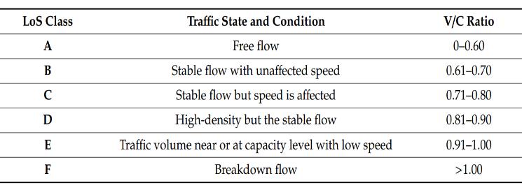
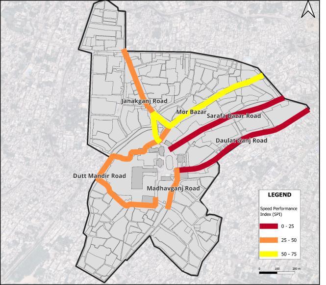
The level of service and speed delay survey of the roads are justified by the APRI index results. ARPI of all the majorroadsareshowninFig.5
The Daulatganj and Sarafa bazar road, with SPI scores below 25 as shown in Fig. 4, has the worst traffic conditions. Although the maximum permitted speed for these roads was 40 km/h, the average vehicle speed was observed to be between 7 and 9 km/h on theses roads, makingitpossibleustounderstandthelevelofcongestion on these roads because, according to the SPI index, these roadswillmeetthecriteriaforheavycongestion.Onlymor bazar road has a smooth flow as per the criteria of SPI index.
4.1.3-Active Road Performance Index (ARPI)
The survey analysis revealed that Daulatganj Road and SarafaBazaarRoadhavethelowestvaluesofARPI,which are between 30-40, this low percentage of ARPI was influenced by the presence of on-street illegally parked
4.2- Congestion-causing factors in the study area
4.2.1 Illegal Road Occupancy by Street Vendors and ParkedVehicles
It wasevident from ARPI Fig 5 that the active road width is reduced as a result of the presence of these illegally occupied informal businesses and parked vehicles, This encroachment of the road leads to severe levelof congestion in the area. Due to this illegalroad occupancy on both sides of the road as seen on thedaulatganj and sarafa bazar roadsin the region are experiencing considerable congestion; the detrimental impact of the encroachment was easily identifiable .Reduction ofthe active width of the roads effects vehicle speed and also reduces the Level of Service of the road, as seen in Fig. 4 and Table 5 respectively ,as shown in these analysis daulatganjandSarafabazarroadshaveLOSFandhavethe lowestaveragespeedofmovingvehicles.
4.22-InsufficientParkingSpaces
Due to lack of parking spaces in the study area, citizens have become adapted to parktheir vehicles on the street, which leads to traffic jams and congestion in the area, all the major roads of the study area are occupied by onstreet parking which causes congestion due to decrement of active road width as shown in Fig 5,It is therefore
necessary to provide structured and sufficient parking spaces in the area in order to increase the area's mobility andreducecongestionlevel.
4.2.3-Erraticexecutionoftherulesandregulations
Peopleintheareafrequentlyviolatetrafficlawsasaresult of the authority's failure to enforce strict laws in the maharaja bada. The failure of the traffic police and authority was clearly visible in the area through illegal business occupancy of spaces, illegal parking of vehicles on public streets, vehicles moving the wrong way. The combination of these variables is the main cause of the congestionintheMaharajaBadaarea.
4.2.4-IncrementinVehiclePopulation
OneofMadhyaPradesh'scitiesthatisexpandingquicklyis Gwalior. Increased economic activity, population growth, and urbanization allled to a rise in automobile activityin Gwalior.According to the study, all roads with the exceptionof MadhavganjRoad hadLOSF andhavevery highPCUvaluesasshowninTable5(withdaulatganjand sarafa more than 2000 PCU/hr) , which indicate a tendency towards increased vehicle traffic inGwalior. Thousands of new automobiles are introduced each year and as a result, Gwalior City encounters a variety of road vehicleswhich causes congestion. During peak hours, mostofMaharaja Bada'sroadshavespeedindexofbelow 50(Fig4).
5. DISCUSSION
Based on the results of these congestion indices (LOS,ARPI,SPI) it was evident that the major roads of maharaja bada especially Sarafabazar, Daulatganj and Janakganjroadsaresufferingfrommajornegativeimpacts of urbanization and motorization mix with the effects of CBD . It has been strongly emphasized that long term inclusiveplanning and some immediate law enforcement should be targeted to tackle the traffic congestion in the maharaja bada areaafter assessing the problems that currently exist in the areaand through the evaluation of congestion indices in the area. Inclusive planning in the study area is necessary to establish a thriving CBDs environment that relies on a sustainable, socioeconomic, anddynamicenvironmenttosupportthelocalcommunity atboththemicroandmacrolevels.
Thestudyfoundthattherearesignificanttrafficproblems in the Maharaja Bada area and its surrounding areas as a result of a number of factors, including an increase in the numberofvehicles,alackofinfrastructureforcyclistsand pedestrians, which forces people to share the road with vehiclesandcausedelaysandcongestion,alackofparking spaces due to which all the edges of the streets are occupied by on-street parked vehicles and most importantly lack of public transportation which is giving
rise to increasing count of IPT vehicles like e-rickshaws andautorickshaws,theseIPTsarecausingtrafficjamsby occupying road spaces and taking halt at every entry and exitoftheroadsandaswellasonthejiwajichowk.
6. RECOMMENDATIONS
Improving Multimodal connectivity in the area and Encouraging NMT modes for commute in the area-
An effective multi-modal strategy can be achieved through proper planning , since the research found thattheareaismostaffectedbytheparkingissue,itis vital to consider offering parking facilities outside peripheryofmaharajabadaareatoencouragedrivers toparkthereanduseanothermeansoftransportation to go to the business district the locations of these parking must be indentified near daulatganj, madhavganj,sarafabazarandjanakganjroad,achange ofmodefrompersonalvehicletoNMTmustbeensure throughthesetechniques–
I. Park and Walk – To achieve this strategy authority must focus on providing continuous, free from encroachment pedestrian infrastructure on the major roads of the area only after this Park and Walk scheme will be effective as people will than parktherevehiclesoutsidethemaharajabada area in the available parking and than continuetherevisittomarketbywalking
II. Park and Ride - A bike sharing system can be effectiveformaharajabadaarea.Thedocking stations must be installed at all parking spaces and should be placed with effective density not too far from each other throughout the Maharaja Bada area. This will encourage people to park their cars and commute via e-bikes or cycles in the area, which will reduce traffic and improve the environment.
However, before installing the docking stations,thereareafewthingsthatneedtobe considered anauthorities must establish an effective bicycle infrastructure across the market area; otherwise, this strategy may backfire and worsen the congestion in the areaascyclistswillbecompelledtoutilizethe sameroadsasothermixedtraffic [9].
Discourage utilization of private cars-
The first action that the local government should take is to reduce the number of vehicles entering the Maharaja Bada area. However, this is a challenging task because,the city's vehicle
populationisgrowingrapidly.Asaresult,thearea will continue to see an increase in the use of cars andmotorbikesinfuturealsoasindividualsfindit very convenient to commute from their own vehicles,whichinturnleadstotrafficcongestion. Instead of the idea of actually reducing the number of automobile trips,attempts should be made to reduceautomobile utilization to counter congestion.
Congestion Pricing- Britain is following this theory to reduce the congestion levels on there busy streets and was successful in reducing the congestion, Most people consider the London CongestionChargingprogrammetobesuccessful. The London Congestion Charging programme is largely regarded as successful [10] in this programme, the area is marked as a congestion charge zone in this programme, and people entering this area with their cars have to pay congestioncharges,forcing thecommuterstouse automobileslessfrequentlyinthearea,whichwill ultimately improve the level of service (LOS) and speedperformanceindex(SPI)oftheroads
Management of Off Street and On-Street parking in the study area-
Theresultsofthefieldstudyareabundantlyclear that parking is a major problem in the area because there is a demand for parking that is almostfourtimesgreaterthantheavailablespace. As a result, people park their cars on the roads, which leads to congestion and traffic jams in the area,thisparkingproblemisonlycapableofbeing solvedbyproperparkingmanagementplaninthe area. As maharaja bada is a very densely populated area, there are very just a handful of open spaces and unoccupied plots available, whichmakesitdifficulttobuildoff-streetparking, therefore, government-owned spaces is the only option left to facilitate the area with parking spacesasanexample,GSCDCiscurrentlybuilding one multistoriedparking spacethat will provide 465 ECS of parking in the area, but due to high demand of parking the construction of another spaceto relieve the pressure on the first in near future, moreparkingareasintheperipheryofthe bada must be identified so that park and ride scheme and park and walk scheme can be introducedinthearea.Off-streetparkingmustbe made available on roads for shop owners and commuters, but with a proper parking policy, onstreet parallel paid parking must be made accessibleonthemajorroadsinthearea,suchas Sarafabazar, Daulatganj, and Janakganj. This will reduce the utilization of vehicles by shop owners and commuters, and they will park their cars in
theoff-streetparkingspaces,reducingcongestion onstreets.
Management of Street Hawkers-
vending uses up valuable street space by obstructing the sidewalk and parking spaces and aggravating other drivers but completely evicting thesevendorsisnotatallagoodsolutionasitwill decreaselivabilityofthemarket forthisissuean inclusive design strategy must be adopted to facilitate these vendors ,proper planning is requiredformakingthebestuseofexistingspace through better space management or timesharing (eg: for an evening or Sunday market) ,vendors must given arranged spaces for selected time period this will also resolve conflicts betweenthesevendorsandbetweenvendorsand trafficpolice[11]
Strict law enforcement–
By effectively upholding norms and regulations and strictly enforcing traffic laws, traffic congestion can be reduced. If every traffic cop doestheirjob,maintainingtheregulationswillbe easy.
7. CONCLUSION
Duetothelandusepattern,ithasbeennotedthatparking issuesandtrafficcongestionarenoticeableintheMaharaj badabusiness areas. The capacity to generate motor vehiclesandpedestriantrafficissignificantlyhigh,parking spotsand other amenities are alsoin high demand due to commercialLanduseofthearea.Parkingissuesandtraffic congestionhavelaterresultedfromthecurrentsituation's disabilitytocopewiththedemand.Therecommendations have been made in light of the field survey's findings. Finally,theparkingandtrafficissuesintheMaharajaBada areawouldultimatelybecomea thingofthe pastifall the recommendations made earlier are effectively put into practice.
8. References
[1] A. Downie, "The World's Worst Traffic Jams," 2008 [Online].Available: <https://content.time.com/time/world/article/0,85 99,1733872,00.html>.
[2] Blancoetal.,"Hot,congested,crowdedanddiverse: Emergingresearchagendas inplanning," ELSEVIER, 2009.
[3] G. Rice, "Central Business District," ScienceDirect, 2009.
[4] K. V. K. R. Tom V. Mathew, Introduction toTransportationEngineering,2007.
[5] HCM,"HighwayCapacityManual,"1994.
[6] B.C. I.P. LTD.,"ROAD&STRUCTURE INVENTORY," [Online].Available: https://bpcipl.com/services/road-structureinventory/.
[7] V. T. Arasan and . R. Z. Koshy, "Methodology for ModelingHighlyHeterogeneousTrafficFlow," ASCE, 2005.
[8] F.He,X.Yan,Y.LiuandL.Ma,"ATrafficCongestion AssessmentMethodforUrbanRoad," ScienceDirect, 2016.
[9] S. B. Osoba, "Appraisal of Parking Problems and Traffic Management Measures in," Journal of Sustainable Development, 2012.
[10] R. L. Mackett, "Reducing Car Use in Urban Areas," ResearchGate, 2012.
[11] REPL,"StreetVendorsandurbanplanning,"[Online]. Available: https://www.repl.global/street-vendorsand-urban-planning/.