Pothole Detection Using ML and DL Algorithms
Mahesh Madhvi1 , Ruturaj Kondilkar2, Dhiraj Bhakare3 , Bhargavi Kaslikar 41,2,3Student, Final year B.Tech, Dept. of Electronics Engineering, K.J. Somaiya College Of Engineering, Mumbai, Maharashtra, India

4Professor, Electronics Department, K.J. Somaiya College of Engineering, Vidyavihar, Mumbai, Maharashtra, India ***
Abstract - Potholes are a persistent problem in transportation infrastructure, causing vehicle damage and hazards for drivers. Manual detection methods are timeconsuming and costly. Computer vision and machine learning offer potential solutions for automating pothole detection. These technologies can improve road maintenance and safety by accurately identifying potholes. This paper presents an integrated approach for pothole detection and classification using YOLOv7, SVM, and segmentation techniques. A user- friendly web application is developed using Streamlit for easy interaction. The YOLOv7 model accurately detects and classifies potholes based on annotated training datasets. Segmentation techniques refine pothole regions, enabling precise boundary extraction for accurate analysis. The SVM model is trained on labeled pothole images to classify different pothole types. The web applicationallows userstouploadimages,detect andclassify potholes, and visualize results. It aids road authorities and maintenance crews in identifying problematic areas and planningrepairs,contributingto saferroadconditions.
Keywords: Computer vision, machine learning, pothole detection YOLOv7, SVM, segmentation techniques, web application, Streamlit, pre-processing, object detection, classification
1. INTRODUCTION
Efficiently detecting and classifying potholes on roadways isvital forensuringroadsafetyand effective maintenance. This paper presents an integrated approach that utilizes the YOLOv7 object detection model for accurate pothole detection and classification. Additionally, a user-friendly webapplicationisdevelopedusingStreamlittoprovidean intuitive interface for interaction and result in visualization.
The detection process relies on the YOLOv7 model, which is trained on annotated datasets to precisely locate and classify potholes in road imagery. The model's robust object detection capabilities make it well-suited for identifyingpotholeswithhighaccuracy.
To enhance user experience and facilitate result visualization,awebapplicationisbuiltusing Streamlit.The application allows users to easily upload road images and applies the YOLOv7 model to detect and classify potholes. Thedetectedpotholesarethenpresentedtothe userinan
accessibleanduser-friendlyformat.
BycombiningtheYOLOv7objectdetectionmodelandthe Streamlit-based web application, ourintegratedapproach provides an efficient solution for accurate pothole detection and classification. This empowers road authoritiesandmaintenancecrewstoswiftlyidentifyand address potholes, ultimately contributing to safer road conditionsandmoreeffectivemaintenancepractices.
2. LITERATURE SURVEY
In a study conducted [1], various image pre-processing andsegmentation methods were explored toimprovethe accuracy of pothole detection. The study specifically implemented the difference between Gaussian-Filtering and clustering-based segmentation methods andcomparedtheirresults.Thefindings revealed thatthe K-Means clustering-based segmentation methodwasthe most efficient in terms of computing time, while edge detection-based segmentation was the most accurate.The study aimed to identify a superior method forpothole detection compared to traditional methods, and this objective was achieved by using performancemeasures to evaluate the different techniques reviewed. Their research paper [2] discussed a pothole detection model using computer vision and machinelearning. The study involved collecting road images fromBMC Mumbai and applying various computer visionoperationssuch as pre-processing, morphological operations, canny edge detection,anddecisiontreealgorithmstodetectpotholes. The proposed model aimed to identify potholes and report them to relevant authorities while utilizing machine learning techniques to enhance prediction accuracy.Despitetheavailabilityofsmarttechnologieslike IoT,machinelearning,andartificialintelligence,thereisa lack of effective techniques for detecting and preventing road anomalies such as potholes. The model also utilized GPUs to accelerate deep learning processes, albeit at the cost of significant power and energy consumption. Additionally, data from vibration and GPS sensors were utilized to evaluate road surface quality. By leveraging image processing techniques, the system successfully detected potholes from input images, enabling effective identificationofsuchroadhazards.
In their study [3], researchers aimed to develop a pothole detection method using a combination of pothole and normalroadimagedata.Thestudyinvolvedcollecting and preprocessing the data by resizing and rescaling the images. MobileNetV2 was utilized for feature extraction, anddimensionalityreductiontechniquessuchasPCA,LDA, and t-SNE were applied to reduce the feature dimensions. Five machine learning classification algorithms were employed to train the system, including Support Vector Machine (SVM), Logistic Regression, Random Forest, Elastic Net, and Decision Tree. The results were analyzed, and it was observed that Logistic Regression, Elastic Net, and SVM performed better than the other algorithms. A comparison of the top-performing algorithms concluded that Support Vector Machine (SVM) achieved the highest accuracy,reaching99%.
Intheirresearch[4],thefocuswasondetectingpotholesto prevent road accidents by utilizing a combination of hardware and software technologies. The researchers employed a Pi Camera for capturing images, benefiting from its high clarity and the ability to connect it to the Raspberry Pi for remote access. An interface was developedtofacilitateremoteaccesstothePiCamera. The system architecture involved taking input from the Pi Camera, sending it to the processing unit via a TCP server for networking, and utilizing a Neural Network Model for pothole detection. Once potholes were detected, the direction of an RC car would be modified accordingly. The study also employed Image Threshold segmentation for visualizing the potholes and Canny Edge Detection for detectingtheedgesoftheimages.Theimageswereinitially converted into grayscale and OpenCV libraries were utilizedforedgedetection.
In their study [5], researchers aimed to design and develop an Automatic Pothole Detection and Alert System that incorporates an ultrasonic sensor, accelerometer, stereo camera, and Global Positioning System (GPS) integrated with Raspberry Pi. The system's primary objectives were to detect potholes, alert riders, and create alocationdatabaseofexistingpotholes.Byenhancingrider awareness, the system has the potential to reduce accidents and vehicle maintenance costs. Experimental resultsdemonstrateda90percentaccuracyrateinpothole detection. The estimated cost of the system is approximately 8000 INR, and it can lead to a reduction of 35-50 percent in average vehicle maintenance expenses. The system is capable of promptly sending GPS location informationtothedatabaseandalertingthe riderwithin4 seconds. The database generated by the system is organized on a city- wise basis and has the potential for futureexpansiontocovertheentirenation.
Intheirstudy[6],researchersfocusedondevelopingan algorithmic approach for pothole detection that does not
rely on machinelearning. Unlike traditional methods that utilize simulated pothole models or footage from advantageousvantagepoints,thisstudyutilized animage library, a pothole model, and basic image processing techniques to detect potholes from within a vehicle. The algorithm aimed to identify various road features, including lane markings, road signs, and potholes, with the goal of enhancing road safety. The study aimed to improve pothole detection capabilities and make a contributiontooverallroadsafetyimprovement.
In the study conducted [7], the focus was on the effective managementofpotholesincomplexroadenvironmentsto ensure driver safety and smooth traffic flow. Traditional visual inspectionmethods forpotholedetectionarebeing replaced by automated approaches that utilize sensors and signal processing. The study categorizes these automated methods into vision-based, vibration-based, and3Dreconstruction-basedapproaches.Itcomparesthe strengths and weaknesses of each method and discusses the detection processes and technologies used in recent research. Additionally, the study outlines future plans for technology development to improve pothole detection and management. Overall, it provides a comprehensive overview of automated pothole detection methods and theirpotentialforfutureadvancements.
The studies mentioned here focused on various techniquesandmethodsforpotholedetectionusingimage processing, machine learning, and sensor-based approaches. The studies utilized different types of sensors, algorithms, and image-processing techniques to detect potholes, assess road conditions, and alert drivers of potential hazards. Some studies focused on identifying the most efficient and accurate segmentation methods, while others developed algorithms for pothole detection using machine learning techniques. The studies also discussed the potential benefits of automated pothole detection systems in terms of reducing accidents and vehicle maintenance costs. Overall, the studies provide a comprehensive overview of the current state of pothole detection technology and its potential for future advancements.
3. METHODOLOGY
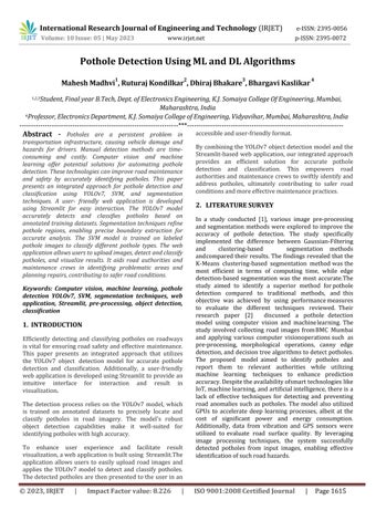
For a system that can find potholes in real-time, the suggested method looks for potholes with a customtrained YOLOv7 model, SVM machine learning algorithm, andimagesegmentation.Liketheothermodules,YOLOv7 gets information from the webcam or live camera and sends the pictures through the trained model. Each pictureis annotated after the dataset has been collected. Before giving it to deep learning models like the YOLO familytotraincustommodels,thelabeleddataissplitinto trainingandtestingdata.
Fig1:-ProposedSystem
We chose YOLOv7 as the main framework for our proposed solution because YOLOv7 is faster and more accurate than its earlier versions (YOLOv6, YOLOv5, etc.), pushing the state of art in object detection to new heights. The methodology is discussed in detail in the following sections.
3.1 Data Collection and Pre-processing
How well the models work and how reliable they are basedonthedatasetusedtotrainthem.Thedatasetmust have pictures of real potholes. So, the most recent pothole image dataset that is open to the public is used. This dataset has 700+ images with real-world effects like shadows, moving vehicles, and different lighting. The pictures in the dataset come from online sources, which means that they are noisy and of low quality. Data is cleaned to archive error-free data set. After cleaning the data set, all the images were annotated with the relevant labels.
3.2 Model Training and Testing
Training and Testing: The Machine Learning model is developed with YOLO v7 architecture, SVM machine learning algorithm, and segmentation algorithm. The TrainingandTestingratiois85:15
3.3 Pothole Detection Using Deep Learning Model
Deep convolution neural networks have shown that they candoalotofthingstofindobjects.Deeplearningletsyou train on several object recognition models, such as the region-based convolution neural network family and the YOLO family. But the R-CNN family is hard to compute, whichleadstolowdelay.Ontheotherhand,YOLOisbeing
looked at to help the R-CNN family with its speed problems.So,forthiscase,wefocusedonYOLOv7.
3.4 YOLOv7
YOLO, which stands for "you only look once," was first used by Redmonin in 2016. The YOLO architecture can find objects by using three key terms. It is important to understand these three tactics to fully understand why this model works so quickly and accurately compared to otherobjectidentificationalgorithms.TheYOLOapproach startswiththeimplementationoftheremainingblocks.In thefirststepofthearchitecturalplan,gridswere madein thespecificpictureusingtheremaining7×7blocks.these grids act as center points, and a different prediction is made for each grid based on what it shows. In a second way, the bounding boxes are made by taking each of a forecast's central points into account. Although the classification jobs are successful for each grid, it is more difficultto separate the bounding boxesfor eachforecast. The intersection of union (IOU) is the third and final approach. It is used to find the best bounding boxes for a givenobjectidentificationjob.
3.5 Pothole Detection using SVM
SupportVectorMachine(SVM)comesunderinsupervised machine learning method which can be used for both classification and regression problems. In this method, each piece of data is represented by a point in ndimensionalspace,wherenisthenumberoffeaturesand each feature's value is a coordinate. Then, classifying is done by finding the hyperplane that best separates the twoclasses.
3.6 Segmentation
Segmentation is used to highlight the specific part of any image in this we used to highlight the pothole area for better understanding. we used threshold segmentation in this Project first we have to convert the images into greyscale images for better observation we used the sigmoidandReluactivationinthismodelthereareatotal of 119 layers we used the Relu used in the background andthe sigmoid is used for the front end for flatten the output
4. RESULT AND DISCUSSION
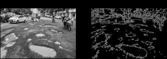
1. Edge Detection
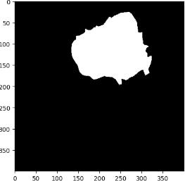
In this method, Figure 2 demonstrates the application of theCannyedgedetectionalgorithmtohighlighttheroad's edges for enhanced image analysis. Initially, the input image is converted into a grayscale representation. Subsequently,theCannyedgedetectionmethodisapplied to the grayscale image, effectively detecting and emphasizing the edges present in the road. The resulting
output image showcases the prominent edges, providing a clearervisualunderstandingforfurtheranalysis.
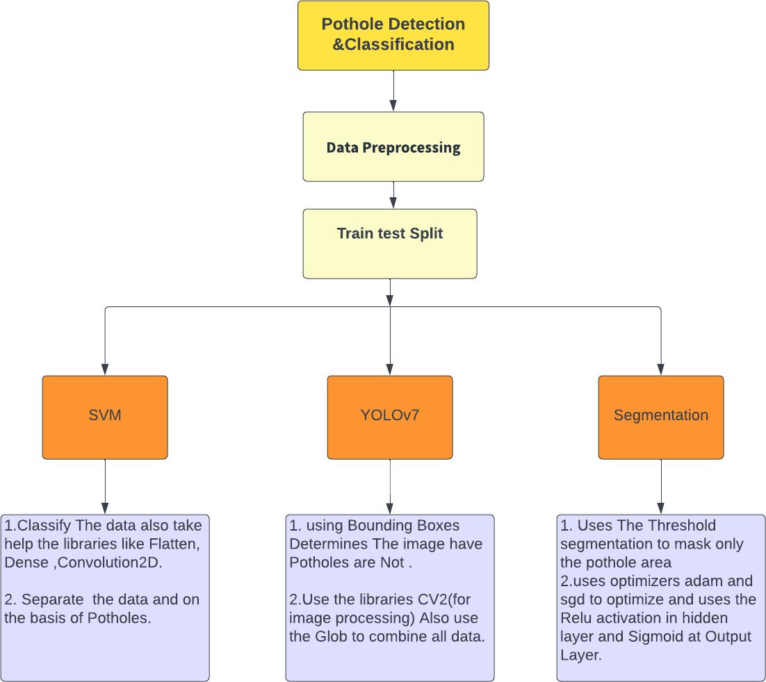
In this method, as shown in Figure 3, the threshold segmentation technique is employed to improve the visualization of the data and facilitate better analysis. The segmentation process is applied to the input images, resulting in a segmented output that highlights specific regionsofinterest.
In addition to segmentation, the method utilizes multiple layers, including convolutional layers, and employs activationfunctionssuchasReluasabackendandsigmoid asafrontend.Theoutputoftheselayersisthenflattenedto simplifytherepresentationoftheextractedfeatures.
Figure 4 visually represents the flattened output, showcasingthetransformeddatareadyforfurtheranalysis or utilization in subsequent stages of the method. By applying threshold segmentation, utilizing variouslayers, and employing specific activation functions, this method enhancesthevisualizationandanalysisof thedata.
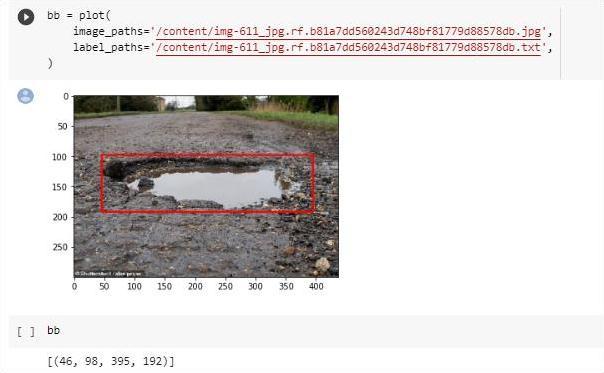
When applied to an image of a pothole, the YOLO (You Only Look Once) algorithm, as depicted in Figure 5, generates a bounding box that precisely indicates the location of the pothole within the image. This bounding boxacts as a visual representationofthepothole'sextent and position, enabling subsequent analysis and potential actionsbasedonitscoordinates.
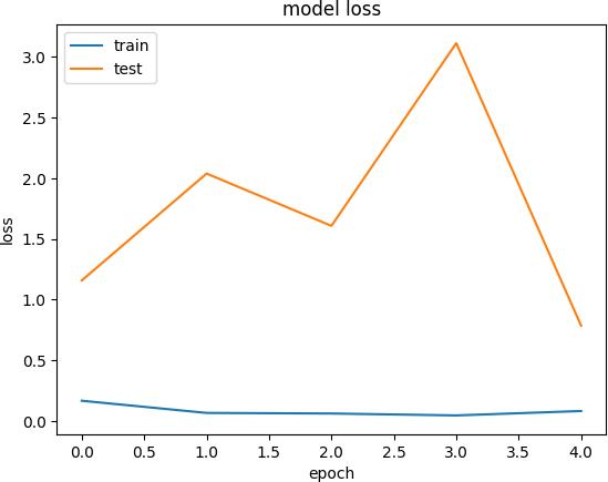
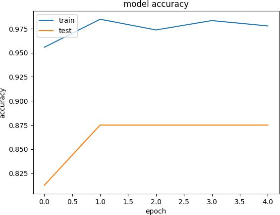
TheSVMgraphisspecificallydesignedtoclassifypotholes with great accuracy. Following 5 epochs of training, the model achieves an impressive training accuracy of 0.975, indicating that it correctly identifies potholes in the training data 97.5% of the time. During the binary test, whichassessesthemodel'sperformanceonnewdata,the SVMgraphdemonstratesatestaccuracyof0.875,implying that it accurately classifies potholes in unseen images 87.5%ofthetime.
In terms of loss, the model exhibits a training loss of 3, which represents the average difference between the predicted and actual pothole labels during the training
process. A lower training loss suggests that the model is fitting the training data well. Furthermore, the test loss is recorded as 0.3, indicating the average discrepancy between the predicted and actual pothole labels on the test data. A lower test loss signifies that the model generalizeseffectivelytounseenimagesbydisplayingonly asmalldeviationfromthegroundtruthlabels.
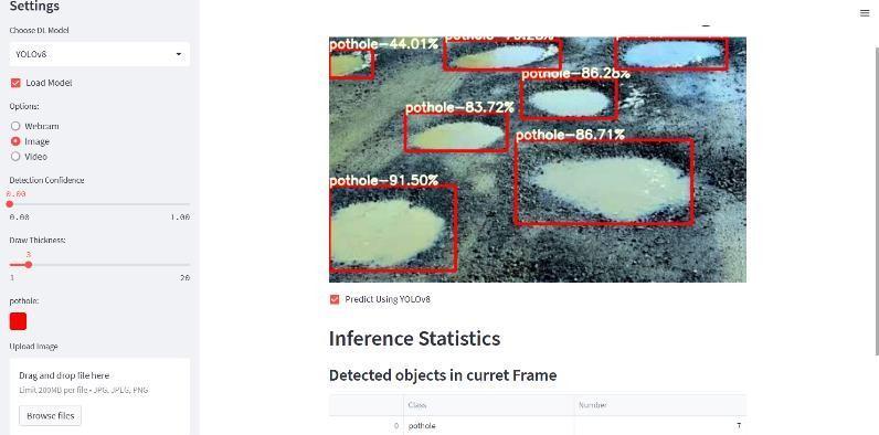
utilizing the YOLOv8 (You Only Look Once version 7) model for object detection. YOLOv8 is a state-of-the-art deeplearningmodelknownforitshighaccuracyandrealtimeobjectdetectioncapabilities.
Figure 8 displays a screenshot of a web application developed using Streamlit, a popular Python framework for building interactive data applications. The purpose of this web app is to detect and address potholes on roads. The user interface is designed to be user-friendly and intuitive, allowing users to easily interact with the application.
The web app built with Streamlit provides a platform for users to upload images or videos of roads containing potential potholes. It incorporates a backend algorithm,
In Figure 9, we see the predicted results produced by the YOLOv8 model. The imageshowsthe output of theobject detection algorithm, highlighting the detected potholes in the uploaded image or video. Each detected pothole is markedwithaboundingbox,clearlyindicatingitslocation withinthe road.Bycombiningthe user-friendlyinterface oftheStreamlitwebappandthepowerfulobjectdetection capabilitiesofYOLOv8,thisapplicationaimstostreamline the process of identifying and addressing potholes, ultimately contributing to safer and well-maintained roads.
An approach is presented for analyzing the images with potholesand performingoperationsonthemand labeling themaspotholeornon-potholeimagesaswellascreating theboundingboxesforbettervisualization.Thissystemis efficientlydesignedtofulfilltwomaincriteria:
1.Detectingpotholesontheroad.
2. Implement Web Based Application for detection purpose.
This Project will help many peoples to detect Potholes in theFuturethisSoftwarecanbeimplementedinthe Car as anin-buildsothespeedofdetectionwillincrease.
6. REFERENCES
[1] K Vigneshwar and B. H. Kumar, ”Detection and counting of pothole using image processing techniques, 2016 IEEE International Conference on Computational Intelligence and Computing Research (ICCIC), Chennai, 2016, pp. 1-4, DOI: 10.1109/ICCIC.2016.7919622
[2]”Smart Implementation of Computer Vision and Machine Learning for Pothole Detection” 2021 11th International Conference on Cloud Computing, Data Science Engineering (Confluence) DOI: 10.1109/Confluence51648.2021.9376886
[3]”Pothole Detection Using Machine Learning Algorithms”2021 15th International Conference on Signal Processing and Communication Systems (ICSPCS) DOI: 10.1109/ICSPCS53099.2021.9660216
[4] ”Detection of Potholes using Machine Learning and Image Processing” 2017. Multimedia Tools and Applications 78:37. Prof. Vijayalakshmi B, Kiran P, Kishor Jadav B, Madhusudan G R, Manoj K S DOI: 10.17577/IJERTCONV8IS15039
[5] Desai, A. Soni, D. Panchal and S. Gajjar, ”Design, Development and Testing of Automatic PotholeDetection and Alert System,” 2019 IEEE 16th India Council InternationalConference(INDICON),Rajkot,India, 2019, pp. 1-4, DOI: 10.1109/INDICON47234.2019.9030271
[6] Nienaber, S. Booysen, MJ, and Kroon, RS, 2015. Detecting potholes using simple image processing techniquesandreal-worldfootage.
[7] Review of Recent Automated Pothole-Detection Methods Young-Mok Kim 1, YoungGil Kim 1, Seung-Yong Son 2, Soo-Yeon Lim 3, Bong-Yeol Choi 4 and Doo-Hyun Choi
[8] Lee, S., Kim, S., An, K. E., Ryu, S.-K., Seo, D. (2018). ”Image processing-based pothole detecting system for the driving environment” 2018 IEEE International Conference on Consumer Electronics (ICCE). DOI: 10.1109/ICCE.2018.8326