
International Research Journal of Engineering and Technology (IRJET) e-ISSN: 2395-0056

Volume: 10 Issue: 05 | May 2023 www.irjet.net
IMPACT OF URBAN EXPANSION ON EAST KOLKATA WETLAND -A COMPARATIVE ANALYSIS
Anuska Ray1, Ritula Paul2 ,
1Post Graduate Student, Department Of Geography, Bijoy Krishna Girls’ College, Howrah, West Bengal, India
2Faculty, Department Of Geography, Bijoy Krishna Girls’ College, Howrah, West Bengal, India ***
Abstract - The East Kolkata Wetland, a Ramsar Site, is a natural ecosystem that serves as a natural sewage treatment system and provides a diverse range of Services to its surrounding areas. It is situated between the Kolkata megalopolis in the west and the satellite township in the north and it is responsible for purifying of over 800 million litres of sewage generated by the Kolkata metropolitan city each day. This wetland plays a crucial role in maintain the ecological balance of the region and is often referred to as the Kidney of Kolkata. In addition, the wetland also sequesters carbon and absorbs the city’s storm water during floods.
However, the rapid urban expansion of Kolkata city poses a serious threat to this valuable ecosystem. There has been significant challenge for East Kolkata wetland with the expansion of Kolkata city and also increase in urban landfills. In this perspective, the paper aims is to study the spatial variation of degree of urbanisation of East Kolkata wetland taking distance as a factor from Kolkata city to show the impact of urbanisation on East Kolkata Wetland. As the degree of urbanisation varies, so a comparative analysis has been done by taking four areas from East Kolkata wetland based on their distance from the Kolkata city.
Key Words: EastKolkataWetland,Urbanisation,Interaction,Distance
1.
INTRODUCTION
Wetlandsareuniqueecosystemsthatplayacrucialroleinmaintainingecologicalbalanceandsupportingadiverserange ofplantandanimallife.Notonlydotheyserve asacarbonsink,buttheyalsofilterwastewaterandprovidea habitatfor fish. Additionally, wetlands offer many economic benefits to humans, such as opportunities for agriculture, horticulture, aquaculture, and ecotourism. However, wetlands located near or within urban areas face numerous threats due to rapid urbanization. One such example is the East Kolkata Wetland, which is situated on the Eastern fringe of Kolkata and supportsthelivelihoodsofruralcommunitiesaswellasvariousspeciesofflora andfauna.EastKolkataWetlandactsasa Natural Sewage Treatment Plant. Despite efforts to protect this region following its designation as a Ramsar site, illegal activitiescontinuetoposeathreattoitssustainability.Inthisstudy,weaimtoexaminethechangesinlanduseandcover patternsintheEastKolkataWetlandareaovertheperiodof2005-2022,asaresultofKolkata'surbanexpansion.
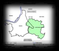
2. STUDY AREA
Kolkata City is located by the side of River Hooghly in Ganga Delta Region. The East Kolkata Wetland is situated in the eastern part of Kolkata City. This is a rural-urban fringe area which belongs to the old course of Bidyadhari River. The wetland area covers 37 mouzas, most of which belongs to North and South 24 Parganas. To analyse the impact of urban expansionontheEastKolkataWetlandawayfromtheKolkatacity,fourparticularareasfromdifferentdirectionshavebeen chosen.ThesearePaschimChowbhaga,Kheyadaha,DharmatalaPachuriaandGaral.
3. OBJECTIVES
Mainobjectivesofthisstudyarea:
TomeasuretheinteractionbetweenKolkata andmajortownsinWestBengal thatcausesurbanexpansionwhich affectthesurroundingUrban-RuralfringeareaincludingEastKolkataWetland
ToshowtheimpactofdistanceontheinteractionofKolkatawithnearbyTownsorcitiesanditsimpactontheEast KolkataWetland.
To conduct a comparative analysis of the Spatio- temporal changes in land use and land cover patterns focusing fourareasofEastKolkatawetlandtakingdistanceasafactorfromKolkataCity.
4. DATA AND METHODS
INITIAL STAGE: In the initial stage detailed literature study had been done. Pilot survey was done on the study areaforbetterunderstanding.
INTERMEDIATE STAGE: In this stage primary data were collected from field survey and secondary data were collectedfromdifferentsources.(Table:1)
FINAL STAGE:Allthemapswereprocessedusingdifferentsoftwareandthedataweretubulisedaccordingtothe researchplananddifferentdiagramswereprepared.(Table:2)
Table -1: PrimaryandSecondaryDataCollection
PRIMARY DATA COLLECTION
Semi-structuredquestionnairebased Survey.


Empirical observation around the whole area has also been done to gatherinformation.

SECONDARY DATA COLLECTION
PopulationdatawerecollectedfromCensusofIndia,2011


LANDSAT images have been downloaded from USGS Earth Explorer. LANDSAT8and9OLITRSandLANDSAT5imageshavebeendownloaded fortheLanduseandLandcoverclassification.
ForthepreparationandprocessingofLanduse andLandcovermaps,supervisedclassification hasbeendoneusingQGIS3.18software


AreacalculationforchangesindifferentLandUseand LandCoverhasbeencalculatedusingQGIS3.18Software
QGIS3.18
GOOGLEEARTHPRO
5. RESULTS AND DISCUSSIONS
KolkataisoneofthelargestmetropolitancitiesinIndiathatexperiencesrapid growthsince1971.Withtheemergenceof industrialization, transportation networks developed that connected Kolkata with different parts in India which resulted inthedevelopmentof highlevel ofcommunication, whichisa factorthatleadsto rapiddevelopment ofthisregion.East KolkataWetlandhasbeenborderedwithKolkataCityandRajarhatNewtown.Beingclosetothesetwoimportantcentres, thiswetlandareaisdrewattentionofthelandsharks.
5.1. KOLKATA-AS A FUNCTIONAL REGION

According to the Population Potential Analysis, the interaction between different places is directly proportional to the Populationsizeandinverselyproportionaltothedistancebetweenthem.Theanalysisrevealsthathighestpotentialvalue observed around Kolkata and the population potential decreases as we move outwards from the core area. It is noteworthy that areas with high population are also characterized by high levels of interaction, including transportation networks,populationflowsandsupplyofgoods.EastKolkatawetlandslocatedbetweenthehighpotentialzonebordering Kolkata to the west and Rajarhat- Newtown to the north-east appears to be attractive destination for land developers. Based on the analysis, it can be inferred that East Kolkata Wetlands could serve as a strategic location for real estate developmentduetoitsproximitytothehighpotentialzone.

5.2. IMPACT OF DISTANCE ON THE INTERACTION WITH NEARBY TOWNS FROM KOLKATA CITY

Table -3: DistanceandInteractionValue

TOWNS/
Chart -1:ImpactofDistanceontheinteractionofgoods andservices
Interaction of goods and people, economic activities is inversely related with the distances between the places. It can be observed from the table 3 and Chart- 1 that with increasing distances, values of interactions are decreasing. The highest interactionvalueiswithHabraandthelowestiswithSiliguri.ThishappenedwiththeEastKolkataWetlandalso,withthe increasing distance from the main city Kolkata, interaction of goods and people, economic activities area decreasing. (Table:4,Chart:2)
5.3. IMPACT OF DISTANCE ON THE INTERACTION WITH THE FOUR DIFFERENT AREAS OF EAST KOLKATA WETAND FROM KOLKATA CITY
PLACE
INTERACTION= (P1×P2)/D; Where, P1= Population of Kolkata City, P2= Population of other Places, D= Distance
Chart -2:CorrelationbetweenDistanceandInteraction ofServicesandgoods

Spatio-temporal changes in Built_up area


Paschim
Dharmatala
Pachuria
Pratapnagar
Spatio-temporal changes in Vegetation
Spatial temporal change in Waterbody


Spatial temporal change in Open land


Paschim
Chowbhaga
Kheyadaha
Dharmatala


Pachuria
Pratapnagar
Chowbhaga and Dharmatala Panchuria have strong interaction with Kolkata City, which is mainly due to the close proximity; hence the interaction value is high and strong. Close proximity to the city, Chowbhaga have witnessed high growth in property development. Dharmatala Panchuria has witnessed growth in ecotourism development. EM bypass that connects the main city Kolkata serves the area with good transportation networks and connectivity that allows population flow. As a result property developers real estate agents prefers this areas for development. These two places areunderthreattorapidurbanisationandpropertydevelopersbecauseofadjacenttotheKolkatacity. WhereasonthecontrarythedistancebetweenKheyadahaandPratapnagarfromKolkataishigh,asaresulttheinteraction valueisless.Thesetwoareasarelessthreatenedduetourbanisation.AsthedistanceishigherfromthemaincityKolkata andsatellitetownshipRajarhatNewtown,thepopulationflowisquietlowandhencelesscongestion.(Table:4,Chart:2)
5.4. COMPARATIVE ANALYSIS OF TEMPORAL CHANGE IN LANDUSE AND LANDCOVERS (2005- 2022)


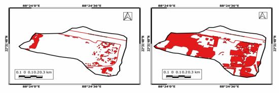
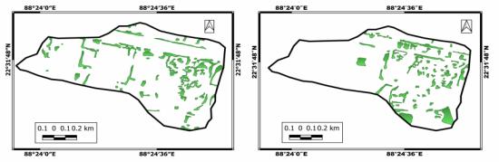
ThecomparativeanalysisexaminestheSpatio-temporalchangesinwaterbodies,built_upareas,vegetationandopenland todeterminethedegreeandintensityofimpactsduetourbanisation.Itbecomesclearthatthedistancehassignificantrole intheurbanisationprocess.Fortheanalysis,fourareaswereselectedfromthewetlandarea. PaschimChowbaga,located closeproximitytoKolkatacity,KheyadahaandPratapnagarsituatedfarfromKolkatacityandDharmatalaPanchuria,the fourth area taken from the North-eastern part of the wetland boundary which is near to the satellite township RajarhatNewtownarea.Thestudyrevealsarapidriseinbuiltupareas,sealingupofponds,conversionofopenlandareaaswellas agriculturallandincloseproximitytoKolkatacity.Ontheotherhand,thearealyingfarfromtheKolkatacityhasremained unchangedwithnoticeableimprovementincertainareas.(Fig:5)
ThepercentageofwaterbodiesinPaschimChowbagahassignificantlydeterioratedandthereasonbehindthisdeclineis attributed to the areas proximity to Kolkata city. Due to the increase in real estate business, many land sharks have illegally seized land for development purposes. As a result rampant illegal construction is observed in this region. Moreover, aqua cultural ponds have been sealed and covered with corrugated sheets, and random modifications of land forindustrializationhavefurtherimpactedtheenvironment.Theconversionofwetlandsintoconcretelayershasalsoled towaterlogginginmanypartsofKolkata.Incontrast,DharmatalaPanchuria,locatednearthesatellitetownshipRajarhat Newtown,hasexperiencedmuchdeteriorationofwaterbodies.(Chart:3,4,5and6)
Despitethesealingofsomeareasofwaterbodiesforconstructionpurposes,theyhavebeenwell-maintained.Fortunately, there has not been a significant decrease in the size of the water body, in comparison to Paschim Chowbaga, which is located close proximity to the city. In areas such as Dharmatala Panchuria, Kheyadaha, and Pratapnagar fishing is the primaryoccupationandtherehasbeenasignificantriseinfisheriesproduction. Thebuilt-upareasinallfourregionshave increased rapidly, with the highest growth rate found in Paschim Chowbaga in terms of area. Behind this changing land usetrend,realestateprojectsaretheprimarycause.Unfortunately,openlandshavealsodeteriorated,andthisisaserious concerns for wetlands. Although there has been a decrease in vegetation cover, it is not at an accelerating rate. Nevertheless,itisimportanttonotethatthedecreaseinwetlandareacouldhavepotentialimpactsonthelocalsystem.
Chart -5:ChangeinArealCoverage(%)ofdifferent LandUseandLandCoverinDharmatalaPachuria
6. CONCLUSION
Chart -6:ChangeinArealCoverage(%)ofdifferent LandUseandLandCoverinPratapnagar
The purpose of this study was to find out the impact of urbanisation on the surrounding regions, particularly the areas close to Kolkata and the satellite township of Rajarhat Newtown. The findings revealed that these areas are facing significantthreatsfromurbanisation,withthesealingofbherisandrampantillegalconstructionsbeingmajorconcernsin theselectedfourareas.ThewetlandconversionstoimperviouslayerwerefoundtobegreaterinPaschimChowbagaand Dharmatala panchuria, whereas less built up area conversion was noticed in Kheyadaha and Pratapnagar. The impact of urbanexpansiononEastKolkatawetlandhighlightstheneedforsustainableurbanplanningandconservationpractices.It is crucial that policymakers and stakeholders work together to ensure that the environment and the livelihoods of local communitiesareprotectedandpreservedforfuturegenerations.Consideringtheincreasingeffectsofglobalwarmingand climate change, it is crucial to preserve East Kolkata Wetland. Failure to do so could have disastrous consequences. Thereforeappropriatemeasuresneedtobetakentoensurethepreservationofthisvitalecosystem.However,thereisstill hope for the restoration and conservation of East Kolkata Wetland. The government and various non-governmental organizations have taken steps to protect and preserve the area through initiatives such as Ramsar convention and the east Kolkata wetland management authority. These efforts have focused on sustainable urban development and communitybasedconservationpractices.
REFERENCES
[1] Dey, F. (2021); “Dynamics of Urban Growth and Environmental Challenges: A Case Of Kolkata, India” . GEOGRAPHY, ENVIRONMENT, SUSTAINABILITY, 14(3),24-31.
[2] Mondal, B., & Samanta, G. (2017); “Commuting and metropolitan development of Kolkata” . Hill Geographer, XXXIII, 2, 61-79.
[3] SenS.,“AstudiesonimpactofurbanisationonEastKolkataWetlands”.DOI:10.13140/RG.2.2.24611.25122Thesisfor: M.PhilAdvisor:Dr.C.S.Rathore,Prof.PratapSing
[4] Ghosh, A., Saha, S. K., Banerjee, R. K., Mukherjee, A. B., & Naskar, K. R. (1985). “Package of practices for increased productioninrice-cum-fishfarmingsystem” Aquaculture Extension Manual, 4,1-14.


[5] Gardner, R. C., & Davidson, N. C. (2011). “The Ramsar convention. Wetlands: Integrating multidisciplinary concepts” 189-203.
[6] Ghosh.D(1999),“ParticipatoryManagementinWasteWaterTreatmentandReuseinWestBengal”,UWEPOccasional Paper,
[7] Mitra,A(1963),“CalcuttaIndia’scity,NewAge”,NewDelhi,India.
[8] Dhali,M.K.(2016).;“VerticalgrowthandACentury:AmicrostudyofKolkata,India”,InternationalResearchJournalof SocialSciences,Vol.5(6),16-23,June