In the the heart of the Potomac Highlands of West Virginia, discover an untamed, stunningly beautiful mountain village blessed with incredible outdoor adventure and warm, friendly people. Surrounded by the Monongahela National Forest, Petersburg is your guide to unrivaled fishing, boating, hiking, biking, climbing, and more. Discover a better view of your world and your life, in our naturally untamed mountain home.
LIFE IS BETTER… on the rocks
Home to iconic Seneca Rocks, Pendleton County is the best rock climbing destination in West Virginia for climbers of all skill levels. Our Via Ferrata at NROCKS is one of only three on the East Coast and is a mecca for climbing enthusiasts. Smoke Hole Canyon, Reed’s Creek, and Entrance Walls are just a few of the other great climbing spots throughout the county. Come find your favorite.
Discover Pendleton County, West Virginia, for yourself. It is always worth the climb. NROCKS
play outside the perfect place to
Miles of hiking, biking, and water trails are waiting to be explored in Berkeley County, West Virginia. Two Audubon Society managed preserves are the perfect locations for bird watchers to spend the day. Serene fishing spots, championship golf, and world-class geocaching make for the perfect adventure vacation.
FROM THE COPY EDITOR
Hello, Highland Outdoor s fam! Longtime copy editor Amanda here. If you pay attention to the masthead, you may notice my recent name change. Spoiler alert: I got married last October! Since our wedding on a small family farm, my husband, Tristan, and I moved to South Charleston.
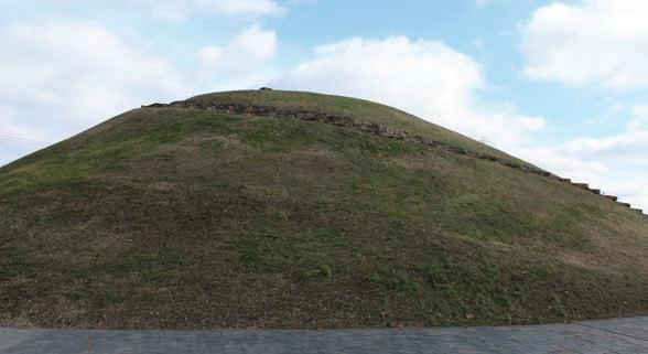
While West Virginia has some of the best outdoor recreation in the nation, undoubtedly most of it is, well, not exactly in my backyard, though many natural attractions are close by here in our state’s capital. Located along the historic Midland Trail, known by most as Route 60, South Charleston is a short drive from state and national parks in any direction: Beech Fork and Chief Logan state parks, Kanawha State Forest, the New River Gorge, and more. But a little closer to home, right in the heart of the city, one can enjoy another sort of outdoor attraction: the second-largest Indigenous burial mound in the Mountain State.
most of my life—until recently.
Part of Staunton Park, the Criel Mound is named after the family who previously owned the property. But the original owners were the Adena people, a prehistoric Indigenous culture that thrived in the fertile lands of the Ohio Valley from 500 BCE to 100 CE. They constructed the Criel burial mound some 2,500 years ago.
STAFF
Editor-in-Chief, Co-Publisher
Dylan Jones
Co-Publisher, Designer Nikki Forrester
Copy Editor Amanda Larch Hinchman
Pretty Much Everything Else
Dylan Jones, Nikki Forrester
CONTRIBUTORS
John Casto, Jess Daddio, Nikki Forrester, Frank Gebhard, Cara Giannone, Rosalie Haizlett, Dylan Jones, Julia Kastner, Amanda Larch Hinchman, Ryan McPherson, Mark Moody, Alex Runyon Jesse Shimrock, Kurt Schachner, Tracy Toler, John Weber
SUBSCRIPTIONS
The largest burial mound in West Virginia is found in the aptly-named town of Moundsville, some 150 miles north of Charleston. But few people are aware that a small slice of the Kanawha Valley, from the town of Institute to my new home of South Charleston, was once home to more than 50 Native American burial mounds, though most have been lost to time. It’s a shame that the age of industrialization, which built up our modern society, was also responsible for tearing down much of our Indigenous history. Sadly, only three burial mounds remain in this corridor: the Criel Mound, the Wilson Mound, and the Shawnee Mound.
I’ll admit that these vestiges of Indigenous history are not something I recall learning about in school. Having grown up just one county over from Kanawha County, the Criel Mound was something I’d taken for granted
This ancient structure is a citywide point of pride—the mound has inspired both local businesses and city imagery for decades. The Criel Mound was deeded to the City of South Charleston in 1931 from Union Carbide with the stipulation that the mound be preserved as a public park. I’m glad that the mound has been well-preserved and kept up over the years.
Determined to acclimate to my new home, I was recently inspired to climb to the top for the first time. Sitting on the bench atop the mound, I enjoyed a wonderful view of the city and could feel the awe of the place. Trekking to the top of a 33-foot-tall mound isn’t the most heart-pounding form of outdoor recreation, but it’s something that connects us to those who came before. I love it when history and the outdoors, especially in West Virginia, come together to keep these stories alive and accessible for all generations. As the weather warms this spring, I plan to explore and appreciate all the beauty and culture found right here in my backyard. We should all hope to learn more about these ancient people, and pay respect and homage to those who came before us in our corner of the Appalachians. w
Amanda Larch Hinchman
Get every issue of Highland Outdoors mailed straight to your door or buy a gift subscription for a friend. Sign up at highland-outdoors.com/store/ ADVERTISING
Request a media kit or send inquiries to info@highland-outdoors.com
SUBMISSIONS
Please send pitches and photos to dylan@highland-outdoors.com
EDITORIAL POLICY
Our editorial content is not influenced by advertisers.
SUSTAINABILITY
Highland Outdoors is printed on ecofriendy paper and is a carbon-neutral business certifed by Aclymate. Please consider passing this issue along or recycling it when you’re done.
DISCLAIMER
Outdoor activities are inherently risky. Highland Outdoors will not be held responsible for your decision to play outdoors.
COVER
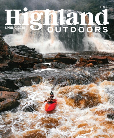
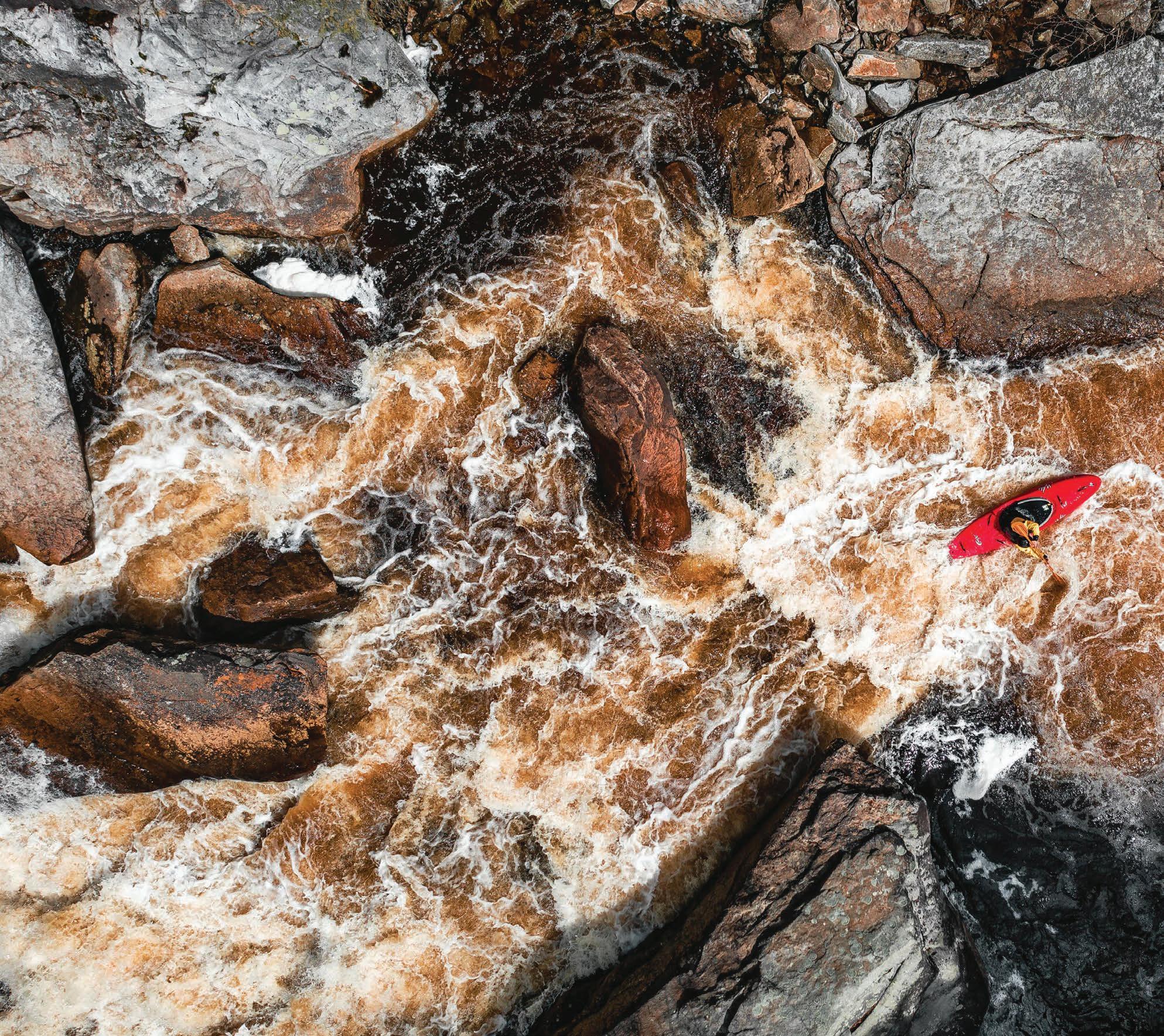
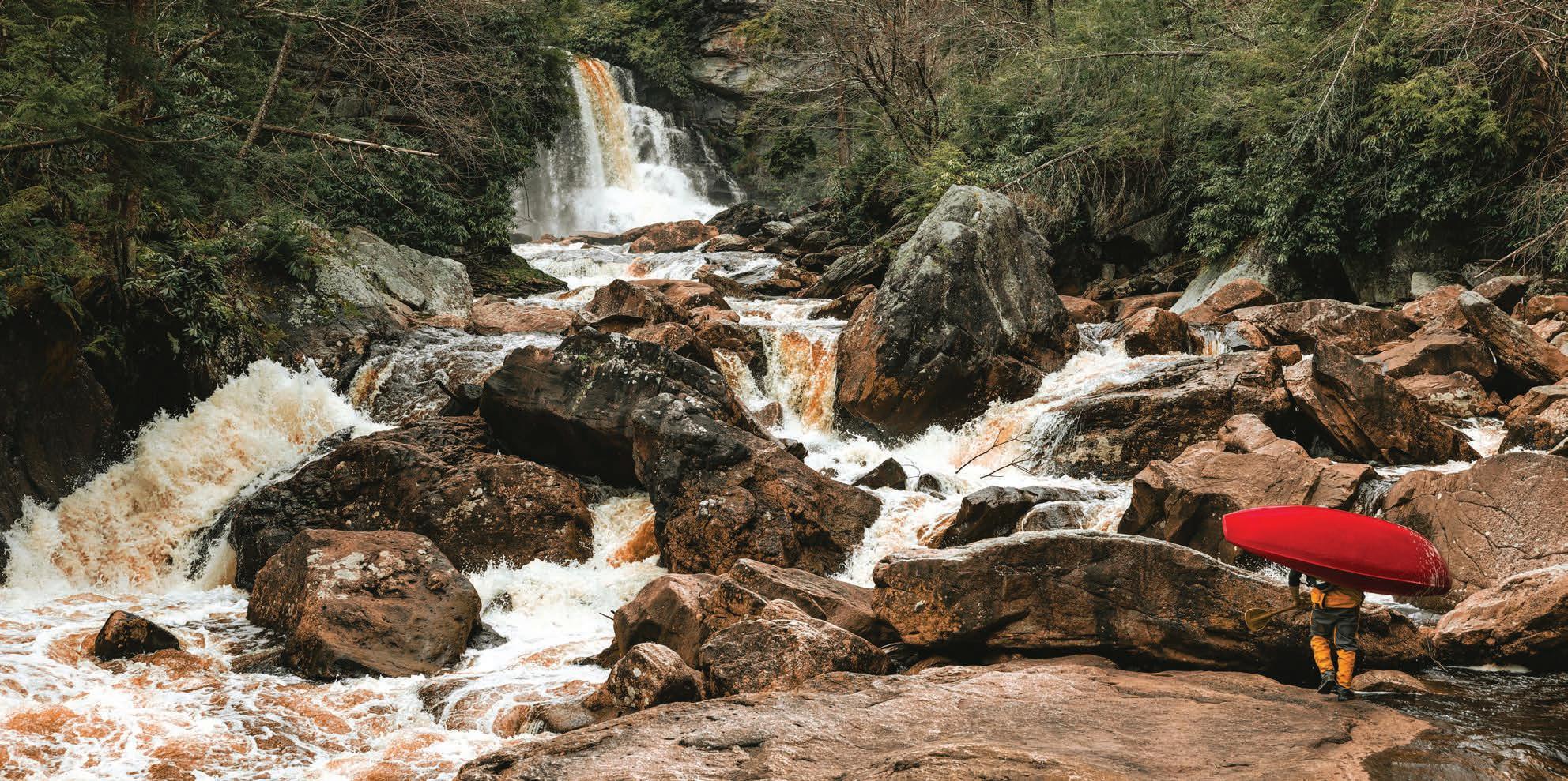
Putting on beneath the iconic Blackwater Falls, Jared Seiler embarks on the class V stretch of the Upper Blackwater River.
The Monday Lick mountain bike trail system in Marlinton is ready to rip, pg. 30
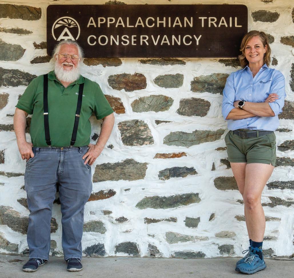
APPALACHIAN TRAIL CONSERVANCY CELEBRATES 100 YEARS
By Dylan Jones
Long-distance hikers, rejoice! The Appalachian Trail Conservancy (ATC), which is the advocacy organization that cares for and promotes the Appalachian Trail (AT), is turning 100 years old.
Running 2,190 miles from its southern terminus on Springer Mountain in Georgia to its northern terminus on Mount Katahdin in Maine, the AT is the world’s longest footpath. The AT was conceived in 1921 by Benton MacKaye, who published an article detailing his revolutionary idea to link the ridges and valleys of the entire Appalachian chain. The trail was officially completed in 1937 following a herculean joint effort from local, state, and federal agencies, including the Civilian Conservation Corp, which constructed many of the trail’s primitive shelters that are still in use today.
According to Ann Simonelli, ATC communications director, the ATC was established in 1925 as a driving force to coor-
dinate the trail’s construction, including mapping the trail’s treadway and shelter placements. Once the trail was established, the ATC shifted gears, working toward the long-term goal of permanent protection for every mile of the AT. “When the trail was first established, much of it ran on private land. As the value of this wonderful resource that connects people to nature was appreciated and more and more people started to visit, it became a priority to ensure that the land on which the trail existed could not be developed,” said Simonelli.
The AT achieved federal protection with the 1968 passage of the National Scenic Trails Act, but the ATC’s advocacy work still continues today with the protection of viewsheds along prominent overlooks and ridgetop sections. “We work to protect land so that natural and rugged experience can continue for hikers forever,” Simonelli said.
Nowadays, the ATC coordinates the 30 regional trail clubs that maintain specific sections of the trail from Georgia to Maine. The ATC has been especially active in coordinating repairs along the large chunk of the AT that was significantly damaged by Hurricane Helene last year. “The ATC serves as the unifying force between the trail clubs and they work closely with 5,000 or so volunteers each year on the trail,” said Simonelli.
The ATC is proudly headquartered in Harpers Ferry above the confluence of the Shenandoah and Potomac rivers. If you read my story last year about Harpers Ferry, you might recall that West Virginia only has about four miles of the AT fully within its borders (nearly 20 miles of the trail run along the WV-VA border, but they aren’t considered fully within either state), meaning that the Mountain State is home to just 0.1% of the trail. Despite having the smallest share of mileage out of the 14 states through which the AT passes, Harpers Ferry is considered the psychological half-way point for thru-hikers— those who hike the entirety of the AT in a single go.
Given the historical significance of the town as a major locus of activity during the Civil War, Harpers Ferry seems a fitting location for an organization celebrating the major milestone of being around for a century.
“Benton MacKaye’s vision for the trail was that it would be more than just a trail; it would be a realm for people to give themselves a break from the stress of what, during his time, was a quickly industrializing world,” Simonelli said. “But he never could have imagined all the technological advancements and pressures and stressors and anxieties facing people today. I think it’s really amazing that 100 years later, the Appalachian Trail has become such an internationally beloved piece of American culture.” w
The ATC is celebrating 100 years with a slew of trail-centric activities up and down the AT from Georgia to Maine. You can also celebrate via snail-mail with the new 15-piece set of stamps that honor the ATC’s lasting legacy.
David Tarasevich (left) and Melanie Spencer (right) at the ATC headquaters in Harpers Ferry. Photo by Dylan Jones.
ANNOUNCING OUR 2024 1% FOR WEST VIRGINIA RECIPIENTS
By Dylan Jones
I’m thrilled to announce last year’s recipients of donations from our 1% for WV campaign, an initiative that donates one percent of our annual print advertising revenue to environmental and social nonprofits based in West Virginia. 1% for WV is our localized version of the lauded 1% for the Planet campaign, but is solely focused on keeping these dollars within the Mountain State to maximize their financial impact.
This year’s environmental nonprofit is the West Virginia chapter of The Nature Conservancy (TNCWV), an organization whose mission is to conserve the lands and waters on which all life depends. TNCWV has been invaluable for securing big conservation wins here in the Mountain State, including the protection of Bear Rocks, Brush Creek, and Ice Mountain. The organization has also served as a bridge for public lands to remain in public hands. When a high-priority conservation parcel suddenly becomes available for purchase, TNCWV can act quickly to purchase the tract before taking the time required to transfer ownership of the tract to a state or federal land manager, just as it did in February of 2024 with the purchase and transfer of the Big Cove tract in the northern end of Canaan Valley.
This year’s social nonprofit is Experience Learning (EL), an outdoor education organization housed high up on Spruce Knob in the epic yurts of the Spruce Knob Mountain Center. EL’s mission is to deliver high-quality outdoor programming as a tool to develop competence, confidence, and community for people of all ages. EL hosts the annual Spruce Knob Kite Festival, runs trips throughout the wilds of the Monongahela National Forest, and maintains the mountain bike-friendly Sweetwater Farm Trail Center. It also has a campus in the Jefferson National Forest. If you’ve got some kiddos, consider sending them (or even yourself) to an EL camp or outdoor experience this year.
If you’re able, I highly encourage you to bolster our donations with a few bucks of your own to both of these amazing nonprofit organizations. Given the current environment of constant cuts to grant programs, I think it’s safe to say that our beloved WV nonprofits will need all the help they can get in the coming years. w
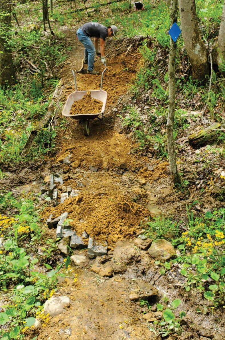
CONSIDER THE SHOVEL
By Julia Kastner
It was the spring of 2008, and I was a new mountain bike racer. After competing in the Big Ring Challenge in Texas’s Sam Houston National Forest, I relaxed at the team tent with Susan Stormer, a bit of a local legend. She and her then-husband Ryan had worked for the International Mountain Biking Association before starting their own professional trailbuilding company. She asked me, the newbie, “Are you putting in your trailwork hours?” “No,” I told her. I worked at a bike shop at the time, and the schedule made it hard. “If you have time for this,” she replied, “you need to make time for that.”
She was pleasant but firm in her assertion. Within the next few weeks, I found a weeknight trailwork party that fit my schedule. We mostly lopped small limbs and shaved a little dirt for drainage, but it was the start of something new for me: a hobby unto itself. A passion.
I spent my remaining years in Texas putting in my hours. It was rewarding work. The more I worked, the more I learned about trail design and the negative impact of riding off-trail, like erosion and the creation of multiple lines. I became a more thoughtful rider. I led some trailwork parties myself. My local, heavily trafficked, urban park didn’t allow volunteers to run power tools or build anything new without going through layers of bureaucratic permissions—trimming and drainage mitigation were the limit. I took a weekend-long course from Susan and Ryan, where I got my first taste of design-and-build concepts: how to use an inclinometer, place features, and assess grades for sustainability.
When I rolled into West Virginia more than 10 years later, I’d lived and traveled through a couple dozen states. The urban experience—lots of oversight, limited use of volunteers—would often repeat itself. As a brand-new and, I thought, temporary resident of Upshur County, I planned to teach a couple of semesters at the local college, get back in my van, and move on. I soon discovered the local trails and made a few friends. I found a lot to love here, including the riding and the people, but the element that really captured my attention was the freedom enjoyed by the local trail group to install features and grow the trail system. Before I knew it, I’d sold my ancient van and gone full brickand-mortar as a resident. The privilege of putting a berm wherever my friends and I wanted one was too much to walk away from.
A few summers later, on a cross-country drive, I rolled in to a random hotel outside a small town in Montana and was excited to find a trailhead right out the back door. For the price of a beer, the bartender agreed to dogsit my pup the next morning so I could get out and ride. It was an outstanding outing, much needed after four days of driving. “Those trails were so fun!” I gushed. “Who built them?”
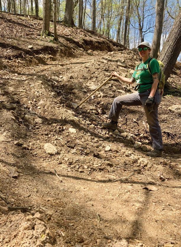
A volunteer digs up fresh loam at the Upshur County Trails. Photo by John Weber
“Built them?” The bartender cocked his head. He was a mountain biker. We’d already talked gear, and he’d described the ride I’d find: switchbacked climbs to rolling, flowing, whooping-fun descents. But it seemed as if he’d never considered the question of how these trails got here— trails that were an undeniable benefit to the hotel’s business. Did he think they’d sprouted there under the big sky?
I’ve long adopted Susan’s ethic: if I have time to make mountain biking (let alone racing) an important part of my life, I need to make time to give back to the places in which I play. Trails don’t grow on their own, and once built, they don’t maintain themselves. The way vegetation thrives in these lush hills, even a beautifully designed and constructed system will close itself right up if not used and maintained. It feels self-evident to me that trail users should contribute, even if only in small doses. Take the odd walk and kick sticks off the tread. Carry a folding saw; pull it out when a limb blocks the trail. Join your local volunteer group’s trailwork party, even just once a year. Trim back branches, clear downed trees, weed-eat and brushhog, pick up trash, clear drains, add dirt to refresh eroding berms and table-tops.
If your musculature is getting a little bike-specific, try shoveling dirt and hauling wheelbarrows for a few hours: it’s outstanding cross-training. If you think it’s fun to roll down a fresh trail with your friends, whooping along the way, just wait till you try it on a trail you helped design and build. “One of the most exciting things for me is to blaze new trail. It’s like if you were a painter and you had a blank canvas on the easel,” said Scott Creak of Upshur County Trails (UCT), my home trail system in Buckhannon. “You look at the terrain, you walk through the woods, and you think about how you want to use this particular section. It’s dirt painting. It’s my form of art.”
With UCT, I’ve made the kinds of friends who take me to the ER when I crash my bike and bring me home again at midnight with a quesadilla from Sheetz. My trailwork buddies help me out with home repairs, provide carpools to bike races, and send me postcards. “The Upshur County Trails all started as a couple of miles for a couple of locals to ride, but our core group became pretty great friends, getting together every couple of weekends to dig in the dirt,” Creak said. “Today, there’s 10 miles out there. A bunch of people who didn’t know each other, from different backgrounds, all working together—that’s pretty unique.”
The first time I visited the Baileys Trail System in Athens, Ohio, I think I alarmed my riding buddy when I squealed and hopped off the bike to take a picture of a pitch drain. I am always thrilled to find good dirt—just the right loamy mix of sand and clay with that golden color. These days, I get stoked about running a small excavator on a professional crew. I never thought I’d care for heavy machinery, but it’s
AMY BARB, BROKER
bestofcanaan.com
just like handwork, only on a grander scale. Bigger is not always better, but moving more dirt, in this line of work, is generally a boon.
I’ve found it rewarding, not only to build berms and then ride them, but to help build community with trailwork parties of college students who marvel at every rock and root. “Do you ever see wildlife out here?” “Why haven’t we seen any deer?” they ask. “Well, it would help if you turned off the music on your phone, but it’s always possible,” I’ll respond. After moving dirt all morning, I’ll hear things like: “That was actually really fun. Next time I’ll try and bring some guys from the frat house.”
Tracy Toler, owner-operator of Adventure Trail Systems (and my boss), also works with young people. “We get kids to come out, and sometimes they don’t know how to hold a shovel or dig a hole,” Toler said. “A lot of it is just teaching them how. It’s hard work, which gives them a better appreciation for hand labor and blue-collar work. Once people get a little taste of that, get their hands a little dirty, maybe get some blisters, it’s addictive.”
There are still days I sit down on a log and pull out a pepperoni roll for my
lunch and tear up, grateful that I get to be right here. Not everyone would get this giddy about shovels and blisters, but I think that if you enjoy that low whir of knobby tires in dirt, if you appreciate a perfectly angled turn, if you’re glad to have access to such experiences—you just might like being a part of the build.
West Virginians have a solid work ethic, and proof of this can be found in the volunteer efforts that created the mighty Meeks Mountain Trails in Hurricane. The dedicated and tightknight crew built 33 miles of purposebuilt trails entirely with volunteer labor in just six years. “It’s an exercise that allows people to detach from the mundane, and put some sweat equity into this thing,” said Brandon Doerner of the Meeks Mountain Trail Alliance (MMTA). “They’re able to see what their labor has produced in a short time, and that’s rewarding. That’s why we hike out on what we just built, so they can see the reward.”
I’m extremely proud of the work done by our UCT crew, folks with whom I’ve shed blood, sweat, and tears over the years. I’ve had the privilege of visiting with avid and hardworking trail groups
throughout West Virginia in the Ohio River Valley, Kanawha State Forest, Hurricane, Morgantown, Harrison County, Canaan Valley, and beyond.
This sport that I love only works because there are trails, and trails are built by human effort and investments of time, money, energy, and passion. I’m constantly honored to be a part of it all. I believe a home is not four walls, or a van, but a network of human connections. And I wouldn’t have the home I’ve found here in West Virginia if it weren’t for shoveling dirt.
So if you love a good berm, if you wish that turn worked a little differently, if you appreciate having trails in your backyard or wish you had trails in your backyard, if you’re wishing for a little more upper body work outside of the weight room, consider putting in the hours. Consider the grubber hoe. Consider the humble shovel. And to all of those who dig, trim, or pick up trash: thank you. I’ll see you out there. w
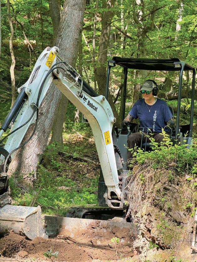
Julia Kastner is a book reviewer, trailbuilder, mountain biker, and lover of trees and mushrooms. She’s surprised and pleased to find herself in West Virginia, behind the sticks of a Bobcat E20 excavator.
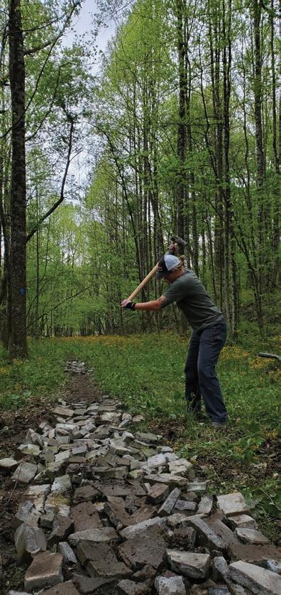
Left: The author using an excavator to carve out a fresh mountain bike trail. Photo by Tracy Toler. Middle: Julia Kastner smashing concrete at the Upshur County trail system. Photo by John Weber. Right: Kastner at work at Ridenour Lake in Nitro, West Virginia.
Photo by John Casto.
THE ULTIMATE R &R MOUNTAIN BIKING GETAWAY.
Cacapon State Park’s world-class trails have a smile-making ride for every style and skill. Enjoy black diamond downhills, blue rocky tech, green flowy berms, old-school Appalachia singletrack, drops, jumps, and everything in between. After the ride, refuel in our local breweries, restore your sore muscles in our legendary spas and do it all again the next day!
CHURCH FLOWS
Words by Jesse Shimrock
Photos by Mark Moody
Among the committed congregation of whitewater enthusiasts who call Appalachia’s righteous rivers home, there are certain days when the whitewater kingdom opens its pearly gates. As the holy water unleashes from the skies with great vengeance, the river swells beyond its walls and beckons us with the temptation of the unknown. For thine canyon is the realm of the high-water kingdom in all her power and glory. These extraordinary days are referred to by our congregation with a hallowed name: Church Flows. I have long yearned for an experience that devours the ego, commands transcendence, and culminates in a full surrender to a higher power. Ultimately, childbirth was not in my biological cards, and so began the quest to discover my own vision of the almighty.
Most traditional sports rely on a two-dimensional playing field, implying that the movements are largely confined to a forward and backward or side to side plane of play. Let’s take football, baseball, or wrestling for example. A player can run,
jump, leap, roll, or dive, all while the medium beneath them remains the same. A race car can reach nearly uncontrollable conditions, but the tarmac stays steady and constant. Reaching further into the extreme, adventure sports such as skiing, surfing, and motocross involve a chaotic ballet with gravity, which operates within a mostly predictable up and down relationship, sans the occasional avalanche. Yes, that dance with Earth’s might can certainly devour the ego and grant a one-way ticket to the holy land, but this often occurs by happenstance and not with direct intent.
Throughout my childhood, I played all of these traditional and adventure sports with great joy. Yet deeper down, my psyche sensed a yearning for something more divine. Near the end of a torturous freshman year of wrestling, right as the long winter’s snowpack was recharging the Appalachian water table, my wrestling coach approached me with an opportunity that would ultimately charge my spirit with decades of bountiful exploration and open a conduit for my pursuit of the almighty. His offer was a gift: learning the art of whitewater kayaking. I quickly realized I was holding the scripture to shatter the two-dimensional mold. The river became the third axis.
Whitewater is a dynamic, living force. The water doesn’t just push; it pulls, surges, and rolls beneath you, creating an environment where every paddle stroke dictates whether you stay on your line, synced with the flow, or get swallowed into the depths of disorientation. I was no longer just moving through space, I was interacting with it, and boy was it interacting with me. Conventional brute
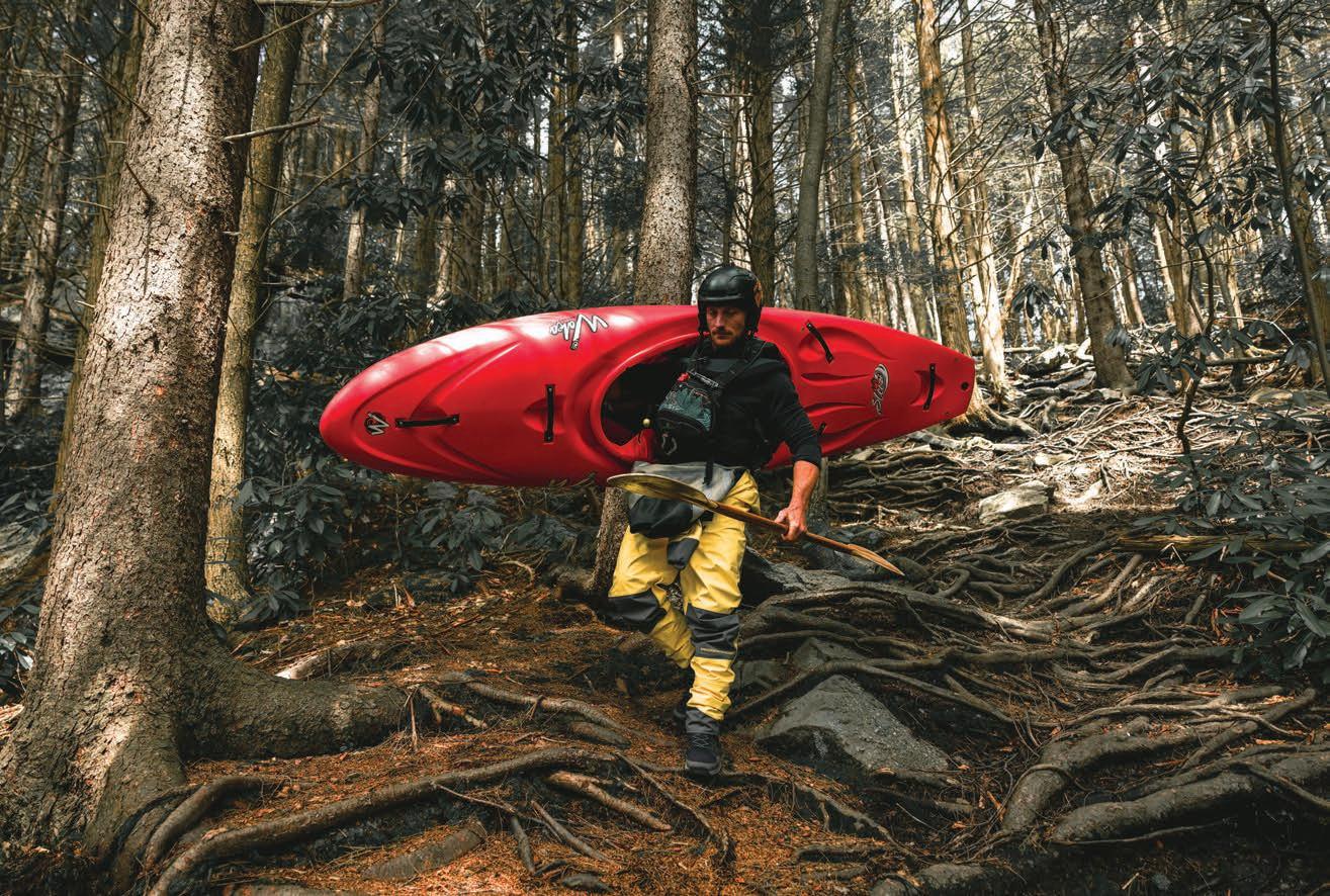
Left: The author carries his kayak down the steep trail to the put-in of the Upper Blackwater.
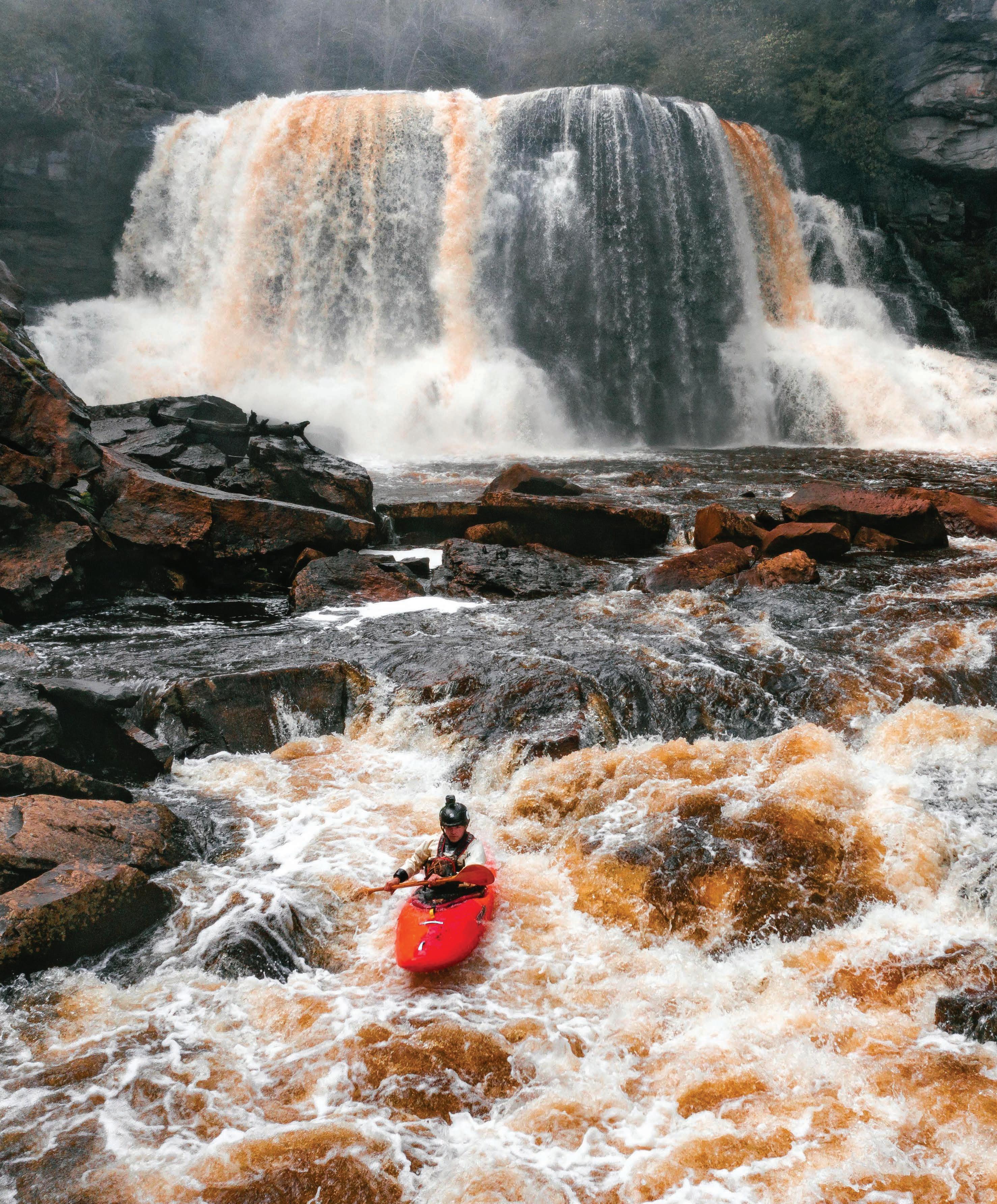
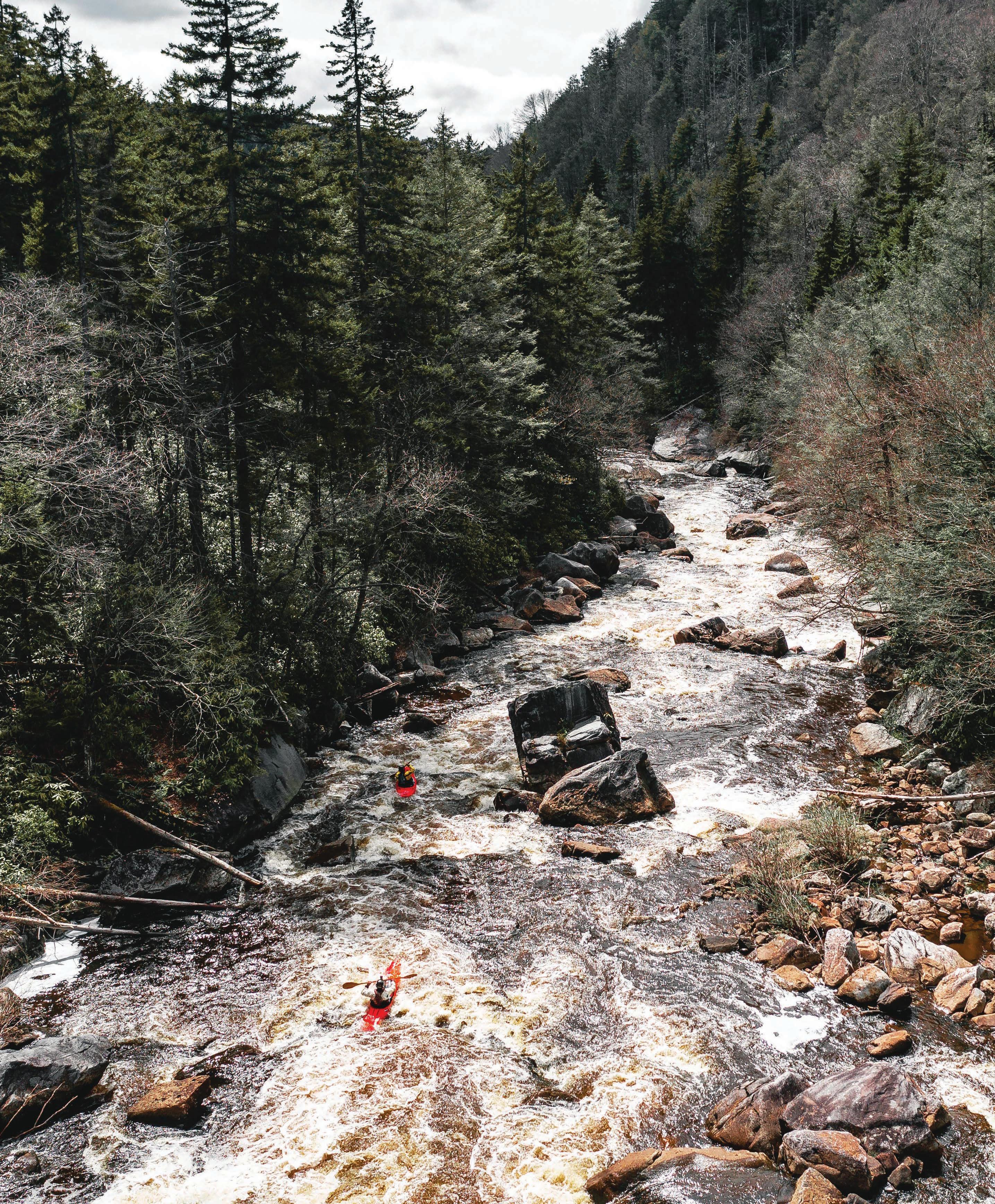
Right: Jared Seiler and Jesse Shimrock weave between boulders in the frothy waters of the Blackwater River.
strength, a classical athletic tactic, was suddenly useless here. I had to learn to work with the power of the water and harness the chaos into a more controlled motion, like a dance with an unpredictable partner that required my full presence and surrender to the process.
As humans, we have an innate desire to classify, perhaps out of instinct, but likely more often out of necessity. Tax brackets, security clearances, difficulty levels, clothing sizes, everything. Whitewater is no exception and was subject to a primitive classification system early in its evolution, which ranks rapids in a difficulty scale of class I through V, with class V being the most difficult (and
often, the most dangerous). Despite the ever-changing nature of rivers, outrageous variations in flow, enormous gradient differentials, geologic complexities that defy logic, and the rapid advance of skill, technology, and equipment, this simple classification system remains unchanged. Across the world, all rapids are still reduced to a range of five numbers, with class VI still standing as the supposed threshold where a rapid is considered unrunnable. Ah, to label something as unrunnable, unachievable, impossible—the chalice of temptation hath been dangled!
Every whitewater kayaker begins their journey in the same place: sitting in a kayak for the first time, struggling to paddle in
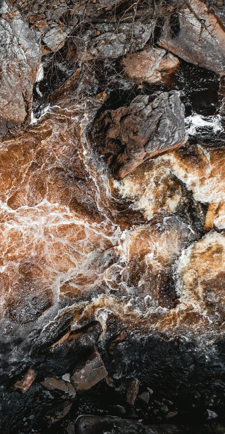
Jesse Shimrock navigates the chaotic and
of the Upper Blackwater River at
a straight line, with only a glimmer of hope that they might one day channel their inner Inuit (the Indigenous people who invented the kayak roll for survival in Arctic waters) and roll back up. But from this shared starting point, the progress matrix becomes far less predictable. For some, it clicks instantly, and progression is swift. For others, years pass as they settle into their comfort zone within the confines of the five-tier classification system.
One of the more intriguing aspects of this classification system is the concept of standard flow: the benchmark that defines a river’s character at average water levels. Thanks to dams constructed by agencies like the U.S. Army Corps of Engineers and the Civilian Conservation Corps, many rivers have become whitewater playgrounds with reliably predictable flows. Iconic whitewater runs such as the Gauley, Youghiogheny, and Savage rivers exist today largely due to these harnessed flows.
Learning to navigate rivers within these flows becomes an obsession for some. And while no river is ever truly static, standard flows offer a certain level of comfort and reliability. The same boulders pillow the water in a constant direction; a familiar surf wave crests at the same location; the choice line remains steady throughout a given rapid. This engineered predictability allows a kayaker to develop an intimate understanding of the river’s personality.
That is, until the water rises, consuming the familiar and transforming the playing field into an unrecognizable battlefield. As the river rises, so too do the stakes. The friendly eddy that always allowed you a moment to breathe becomes an undulating whirlpool grabbing at the edges of your boat, threatening a toss into the looming chaos below.
Kayaking whitewater at high flows is an artform. It demands reverence, composure, and a level of trust that borders on the
spiritual as the environment around you secretes pure mayhem, with water exploding unpredictably like an aquatic grenade. The river swallows the air around it as the power beneath the surface regurgitates upward like a rolling boil. When the river reaches these levels, the element of control is purely an illusion. Heaven and hell are in the same room.
This event horizon is the edge of the great doubt. For some this is the turning point, the retreat to the familiar. For others, this is where the universe opens its arms. No one has ever explained it better than my dear friend and sensei Jim Snyder: “When in doubt, remember that the universe always tends toward the ambiguous. You can bet on it.”
I’ve sat on that statement for quite some time, but I believe that in the context of whitewater, it suggests that, despite all the training, classifications, and expectations, the river is incapable of conforming to definitions. Adaptability, intuition, and an acceptance of the unknown are essential. This juncture in whitewater is where we give in to the divine and enter our holy place.
There’s a sort of solitude that comes with putting on the water in these conditions, an acceptance that you’re entering something far greater than yourself. There’s no room for ego, or for error. There’s no forgiveness for a second guess, which, if made, always dominates the first. It is in these moments that I find something far deeper than my pursuit of mastery, my perfect line, my fastest time—I find communion. The rhythm of my paddle in the water as my hymn, the rapids a scripture written in fluid motion, the river as my sacred force delivering me into the light at the end of its canyon walls. This is my church. w
Jesse Shimrock is a long-tenured disciple of the whitewater chapel. He built his home on the banks of the Youghiogheny River, where he and his partner are raising a river rat of their own.
UNSUNG HEROES
Words by Nikki Forrester
Photos by Frank Gebhard
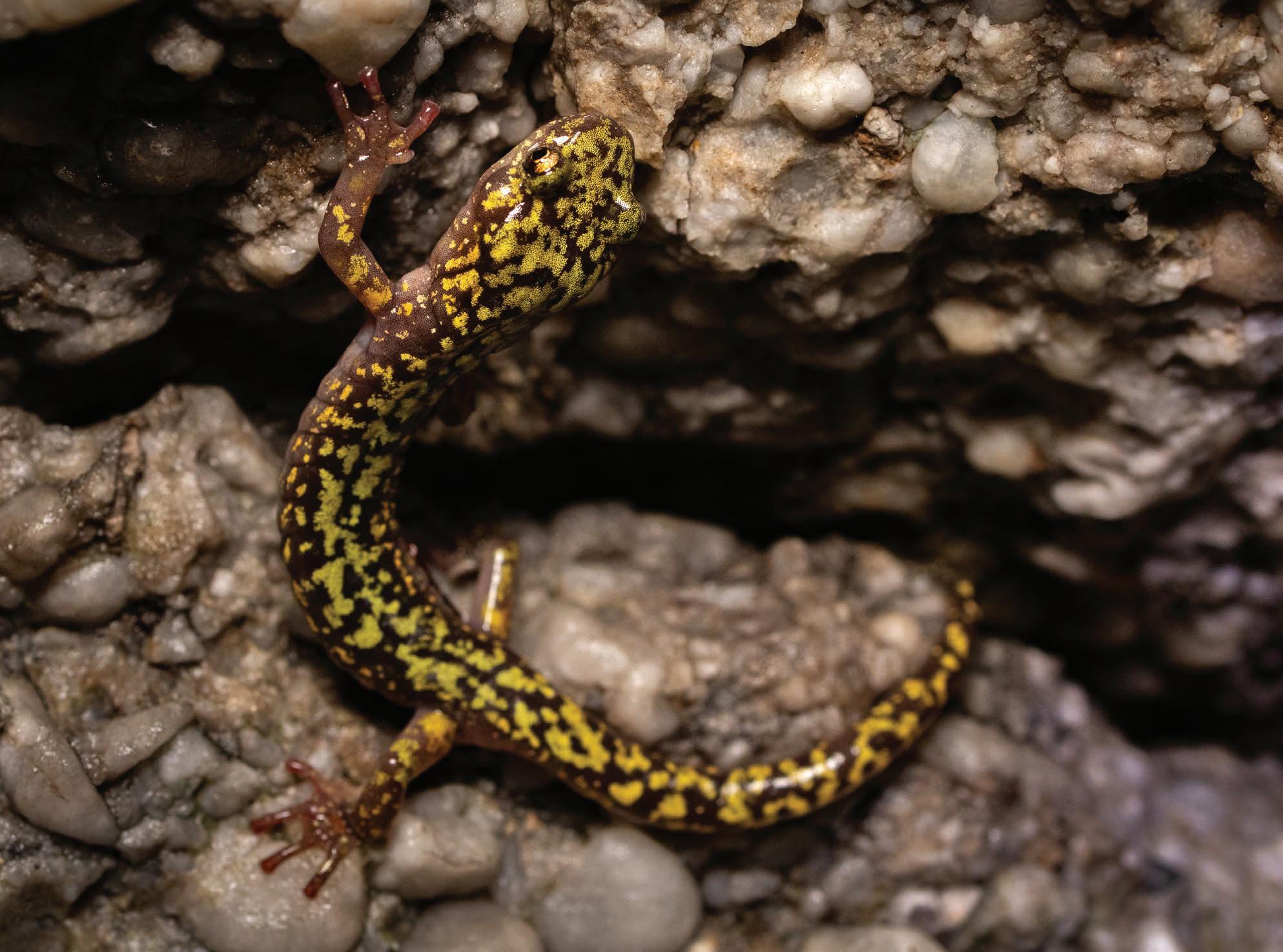
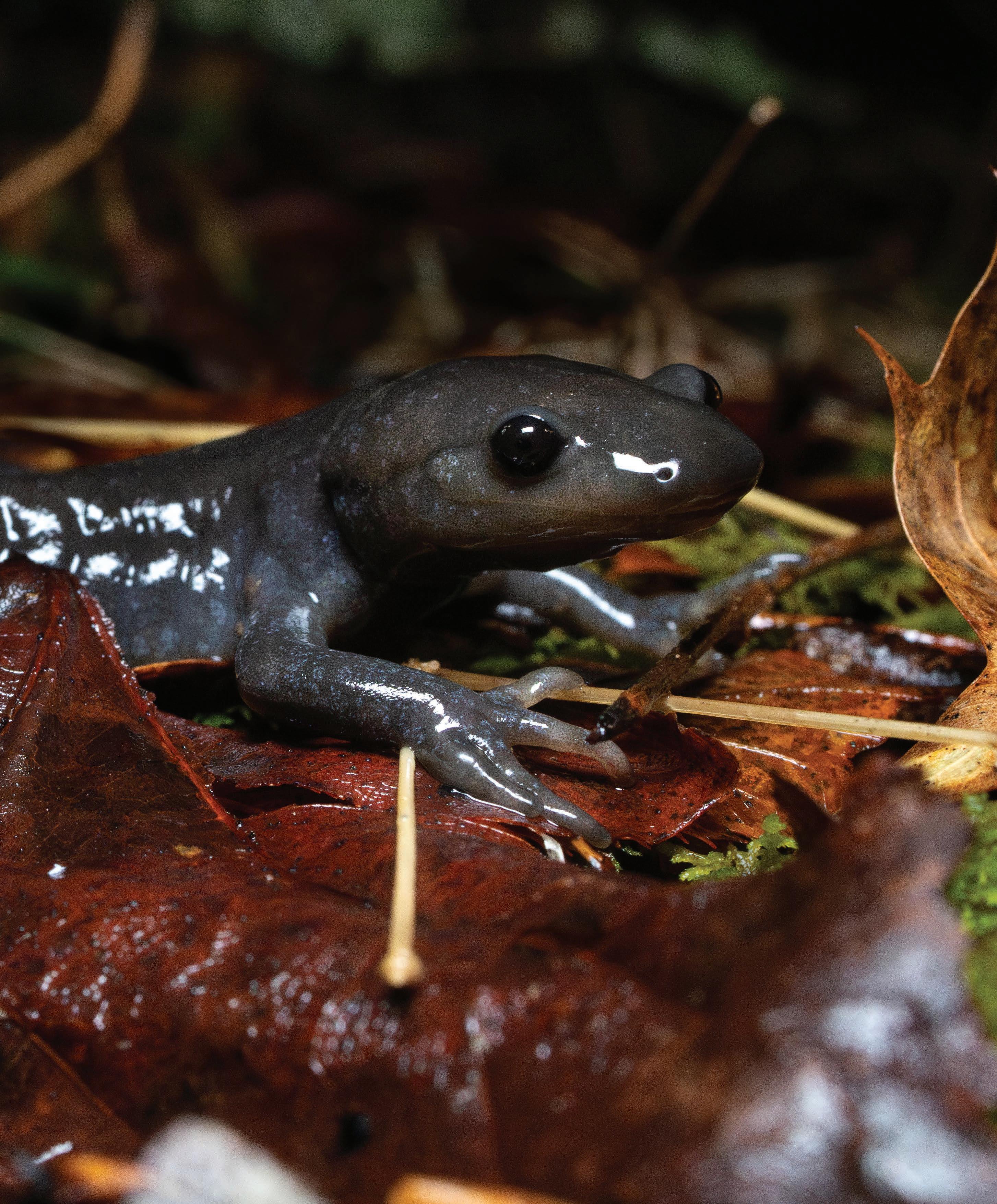
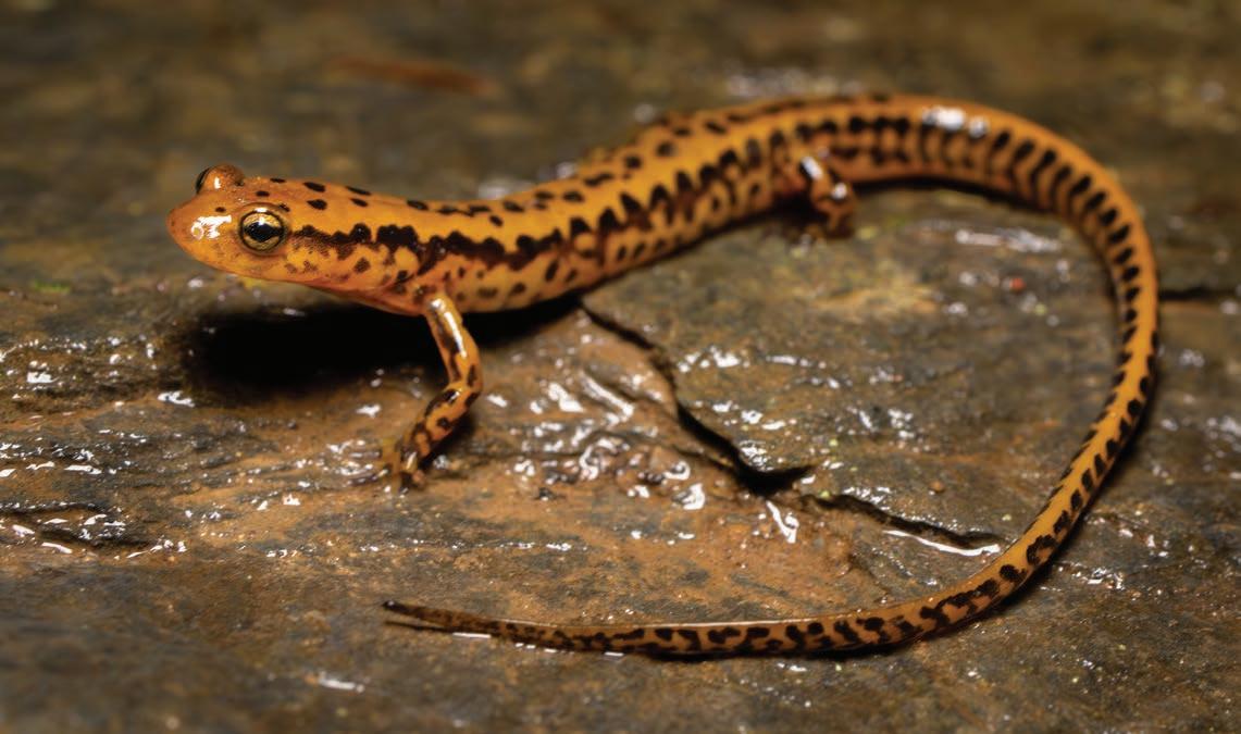
At two in the morning on a cold, rainy night, Frank Gebhard and his fiancé, Shannon, went scrambling across a shale outcrop along the New River in search of an extremely rare salamander. For years, Gebhard attempted to observe the yellow-spotted woodland salamander (Plethodon pauleyi ), but every time, he was defeated. The first time he trekked from his home in Davis down to the New River Gorge region was during the
middle of a dry, 95-degree day. “There was no chance I was going to find one,” recalls Gebhard.
As a kid growing up in Bel Air, Maryland, Gebhard frequently ventured to local ponds and streams to catch bullfrogs and other amphibians. Over time, he became more interested in salamanders, in part because they were so difficult to find. “They were kind of like my white whale,” he says. Then one day he came across an
eastern red-backed salamander (Plethodon cinereus) beneath a log, one of the most common salamander species in the eastern U.S. “Now, I’m just continually chasing that feeling,” Gebhard says.
Over the years, Gebhard learned more about salamanders and their habitats, increasing his odds of finding them whenever he ventured into the wild. On this trip, he was feeling hopeful. He had scouted the area for suitable habitats during the day and identified several spots that seemed fitting for the yellow-spotted woodland salamander. The duo returned in the middle of the night, when salamanders are most active, and began their search. “We started hiking straight down into this gorge. It was one of the steepest hikes that I’ve done to this day,” he says.
After making it down to the river, Gebhard and Shannon sat down on a rock to rest. After some time had passed, a juvenile yellow-spotted woodland salamander wriggled out of the rock crevice and into the crisp autumn night. Gebhard was thrilled but not quite satisfied, for his goal was to see and photograph a full-grown adult. At 3 a.m., they decided to continue their search, moving gently along the exposed and fragile rock. By the end of the night, they found five large adults, and Gebhard captured several photos of the elusive salamander in its natural habitat. According to Gebhard, perhaps only 100 people have ever seen this species. “It was 5 a.m. before I got to bed. It was a killer night. I still live off of the energy that I got from it.”
The yellow-spotted woodland salamander is one of three salamander species that have been discovered in West Virginia in the last six years. It was first described in May 2019 and named after Thomas Pauley, an emeritus professor of biology at Marshall University and the co-author of the first book on amphibians and reptiles in the state. In 2022, researchers discovered, based on DNA sequencing, that the black-bellied salamander (Desmognathus quadramaculatus) was actually five separate species, three of which were new to science. One of these species was the Kanawha black-bellied salamander, which can be found in swift streams south of Gauley Bridge in Fayette County. The third new species to the state was discovered in 2023, when researchers reported a disjunct population of the shovel-nosed salamander in the New River Gorge. Because this species was thought to only occur south of West Virginia, it was likely introduced as fishing bait.
“We still have new species lurking in our mountains,” Pauley says. When Pauley first began studying the Cheat Mountain salamander in West Virginia in the late 1970s, there were very few herpetologists in the state. Now, he says, there are more people studying amphibians and reptiles in West Virginia than ever before, and they’re likely to continue finding new species.
SPECKLED, SPOTTED WONDERS
The southeastern U.S. is home to more salamander species than anywhere else in world. In the Appalachian Mountains, there are at least 100 species of salamander, many of which are highly abundant. The eastern red-backed salamander (Plethodon cinereus) is only 2– 4 inches long, but in some northern hardwood forests, it comprises more biomass than all the mammals and birds combined. It’s also the most common vertebrate in North America.
Salamanders eat an enormous amount and wide variety of insects and invertebrates, including mosquitoes, earthworms, snails, ants, and termites. They’re also a critical, high-energy food source for fish, birds, reptiles, mammals, and other amphibians. “If all the salamanders disappeared, the forest would be destroyed,” says Pauley.
“They’re unsung heroes,” says Kevin Oxenrider, the Amphibian and Reptile Program Leader for the West Virginia Division of Natural Resources. Because of their small stature and elusive nature, salamanders are often overlooked and underappreciated, he says. Yet they make up a huge portion of the biomass of our eastern forests and are essential for maintaining healthy and balanced ecosystems.
In West Virginia, there are currently 36 species of salamanders that occupy a range of habitats from rivers, creeks, and springs to rock outcrops, caves, and forests. “They are just these beautiful arrays of colors and designs and patterns,” Oxenrider says. There’s the beloved hellbender, which grows up to 24 inches long and can live for up to 40 years, as well as the slightly smaller mud puppy. There are also five species of mole salamanders (Ambystomatidae), so named because they spend most of the year underground.
in May 2019.
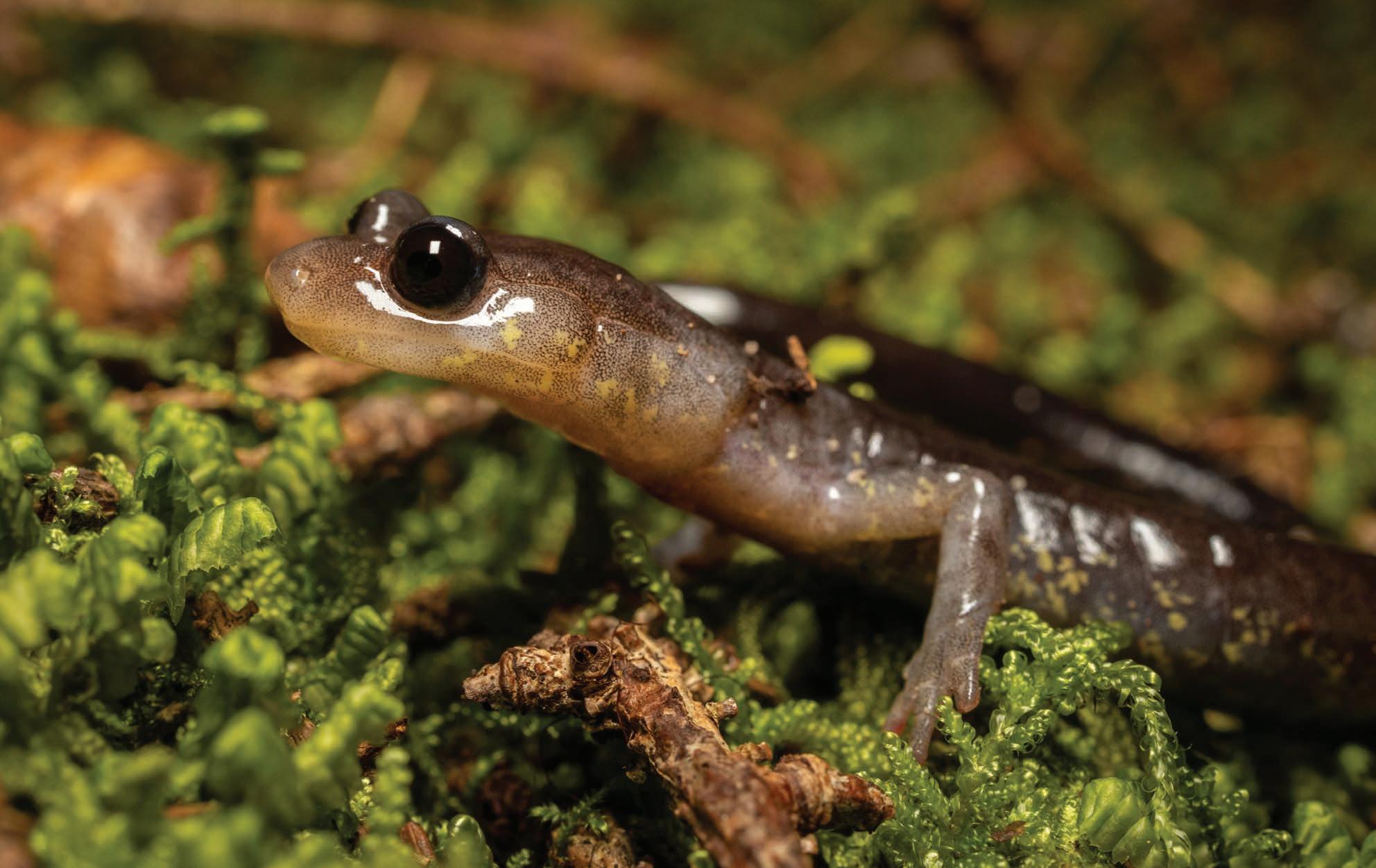
Previous: The green salamander (Aneides aeneus) has a flat body and wide feet that help it climb trees and rocks.
The yellow-spotted woodland salamander (Plethodon pauleyi ) is a rare and elusive creature that lives on rock outcrops south of the New River. It was described as a new species
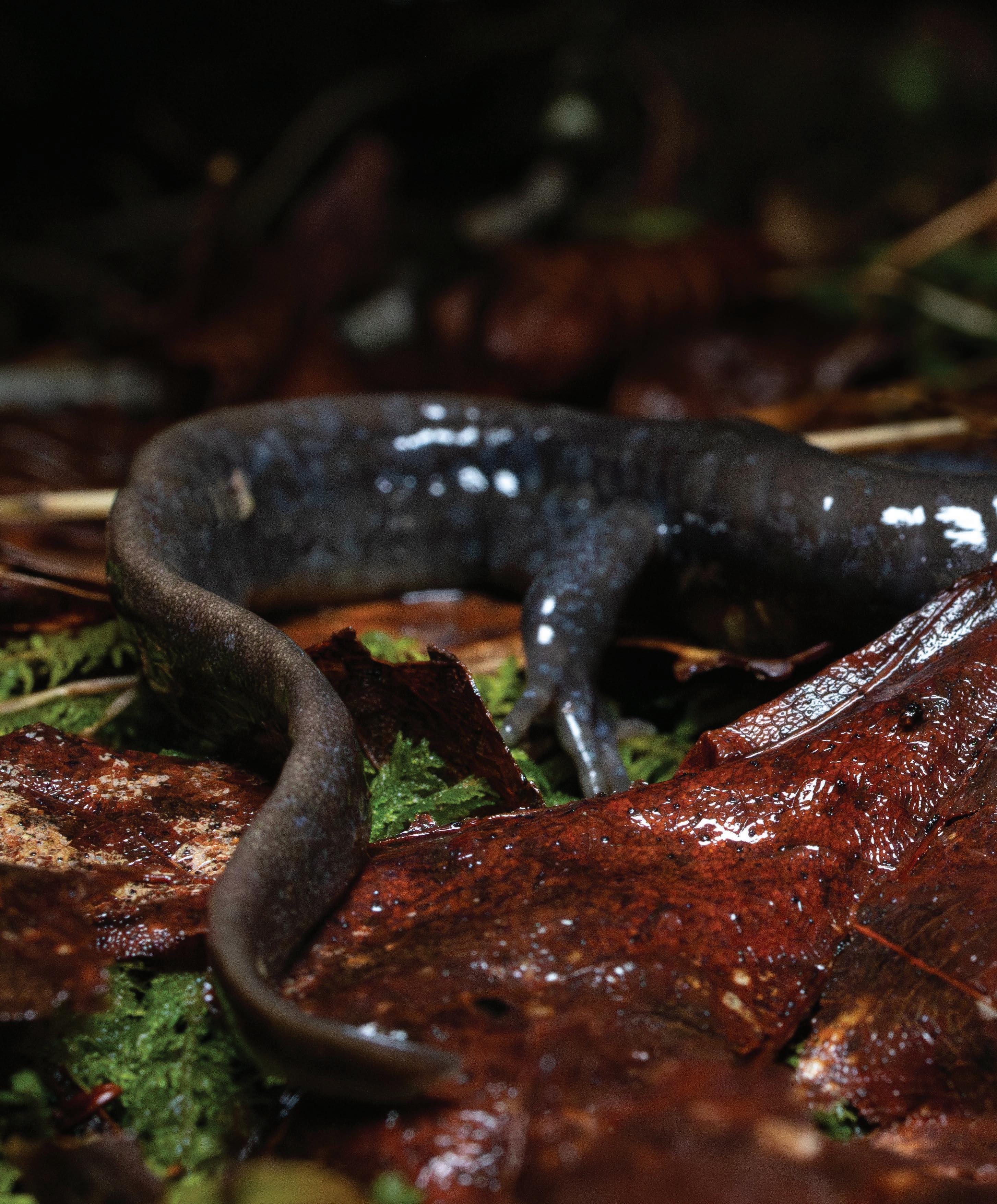
A distinguishing characteristic of the Jefferson salamander (Ambystoma jeffersonianum) is its long toes.
HAPPY HERPING
People willing to venture outdoors on a warm, rainy night can often find tens to hundreds of salamanders crawling around the forest. Since they don’t move quickly, it’s possible to observe a single salamander for several minutes or longer. When searching for salamanders, it’s best to practice responsible herping. Try to avoid flipping rocks and logs, since these delicate habitats can be destroyed if they’re manipulated. It’s also best to resist the urge to pick salamanders up since their skin is sensitive to chemicals, salts, and oils on our hands. If you’d like to learn more about salamander species and their habitats, check out the West Virginia Herpetological Society, a nonprofit organization that supports various science projects and educational programs. “A lot of people look unfavorably on things with scales and slime,” says Adam Weaver, director of communications for the society. “One of the intents of this group was to be a place for people to meet and share a love for these animals that often aren’t appreciated.” The society hosts two symposia each year that feature camping, hiking, and talks from various experts in the field. This year’s spring symposium will be April 11–13 at Mountwood Park in Wood County, WV.
These include the Jefferson, spotted, small-mouthed, streamside, and marbled salamanders. “When you see them, you are kind of in awe just at the size of those animals,” Oxenrider adds. “I love to refer to them as little chonkers.”
The Mountain State is also home to 22 species of lungless salamanders (Plethodontidae), which breathe through their skin and mouths. This group includes the dusky salamanders, brook salamanders, and woodland salamanders. Two species in the lungless salamander family are endemic to West Virginia. The Cheat Mountain salamander (Plethodon nettingi ) occurs in high-elevation red spruce and yellow birch forests in five counties. “They have black and slate gray coloration with brass flecking. There are so subtly beautiful,” Oxenrider says. The West Virginia spring salamander (Gyrinophilus subterraneus), lives in a single cave in Greenbrier County. It’s the only known population of that salamander species on the entire planet.
Because salamanders are nocturnal creatures that spend a lot of time underground, they can be difficult to spot. The notable exception is the eastern newt (Notophthalmus viridescens), which, during its juvenile stage, loves to wander about the forest on foggy, summer days. The neon orange skin of these juveniles, called red efts, serves as a warning to potential predators. “They’re super toxic,” says Gebhard. “They’re like Appalachia’s poison dart frogs.” Red efts secrete tetrodotoxin, a potent neurotoxin that can paralyze or even kill animals that try to eat them.
As amphibians, most salamanders spend their larval stage of life in the water and their adult stage on land. Yet, some terrestrial salamanders
The Wehrle salamander (Plethodon wehrlei )
have foregone the water altogether, opting to lay their eggs beneath moist logs or in damp rock crevices instead. The eastern newt has a unique lifecycle, in which the juvenile stage is sandwiched between two aquatic stages. First, the newts hatch from eggs attached to submerged vegetation in relatively still bodies of water, like ponds and slow-moving streams. Newt larvae persist in the water for up to five months before developing into juveniles with bright orange, hydrophobic skin. The juveniles spend 2– 6 years living in moist forests before entering the adult stage, when their skin becomes smooth and olive green as they venture back to the water to breed.
PERSISTENT PRESSURES
In 2023 and 2024, the West Virginia spring salamander and the eastern hellbender were proposed to be listed as federally endangered. The Cheat Mountain salamander was listed as federally threatened in 1989, and 15 additional salamander species in the state are currently considered Species of Greatest Conservation Need due to their risk of being extirpated from the state.
Declines in salamander abundances are attributed to a variety of stressors, most notably habitat destruction, pollution, warm temperatures, and less precipitation. For example, clear-cutting dries out the land, making it challenging for salamanders, which require moist environments, to survive. “We split the forest with roads and rights of way,” says Pauley, a process that separates salamander habitats and creates more isolated populations. “Down the slope, you have crystal clear, beautiful, rocky streams that gain sediment from the cutting because there aren’t any more live trees holding back all that sediment,” Gebhard adds. Pollution also poses a major threat to terrestrial and aquatic salamanders because they breathe and absorb nutrients through their skin.
Rising temperatures are also pushing species that depend on high-elevation forests, like the Cheat Mountain salamander and the Cow Knob salamander, to higher elevations. At the same time, the warming high-elevation forests are becoming more habitable to other salamander species, including some dusky salamanders, increasing competition and predation.
Just last summer, some of the state’s rivers and streams experienced their worst droughts in history. Hellbenders, which are territorial species, were forced together in the few remaining pools where frequent infighting occurred. Their high concentration also made them easy prey for raccoons, minks, and river otters.
Mole salamanders and other species that rely on ephemeral wetlands to breed in the late winter and early spring are also being impacted by declines in precipitation. “One thing that we have been seeing time and time again is that a lot of those wetlands are not filling because there’s no rain or snow melt,” says Oxenrider. And because climate change is causing warmer temperatures, these wetlands are drying out more quickly than they did in the past. “Some salamanders never get up to the metamorphosis stage where they’re able to persist outside of the water,” Oxenrider adds.
TINY BUT MIGHTY
While it can be easy to despair, salamanders can still be found in our forests, ponds, streams, and rivers. “They’re not in the numbers they were before, but they’re still there. They are resilient,” says Pauley. And individual actions can go a long way toward protecting these species and their habitats. Leaving leaves on the ground, establishing brush piles, and limiting logging are all things landowners can do to create and maintain salamander habitat on their properties. Avoiding the use of pesticides, fertilizers, and other pollutants that can run off into water supplies is another highly effective way of supporting salamander conservation. As Oxenrider says, “folks have so much power to move the conservation needle forward for these animals.”
A few years ago, Oxenrider and his colleagues launched a citizen science project to gain a better understanding of where hellbenders and mudpuppies occurred throughout the state. Participants submitted 164 observations (75 for hellbenders and 89 for mudpuppies) over the course of two years. Using this data, Oxenrider learned about new streams that had mudpuppies in them. “And people observed hellbenders in streams that hadn’t had a record of a hellbender in 50 or more years,” he adds. Next year, he’s kicking off a similar study for eastern newts.
It’s comforting to think of the ways in which small actions can improve the lives of salamanders. And for some people, these small, humble salamanders have changed the course of their lives. For Gebhard, salamanders were a large part of why he decided to move to the mountains of West Virginia and the sole reason he got into photography. His salamander searches have taken him to some of the highest peaks and most remote watersheds in the eastern U.S. “The pursuit of salamanders is not about the destination. You’re there to see this one thing, but you get this whole experience out of it,” he says.
For Pauley, salamanders have been an integral part of his life. He was one of the first people to start studying West Virginia’s reptiles and amphibians, dedicating 40 years to studying the Cheat Mountain Salamander. Throughout his career, he mentored more than 90 graduate students, many of whom still work in herpetology today. Now, at 84, his work isn’t done. He’s writing an updated edition of Amphibians and Reptiles of West Virginia along with another book about his life in the Central Appalachians. “I was just at the right place at the right time. No one else was doing this work and it needed to be explored,” he says. “If I had to do it all over again, I would.” w
Nikki Forrester is co-publisher of Highland Outdoors and the proud owner of a small pond full of wood frogs and spotted salamanders.
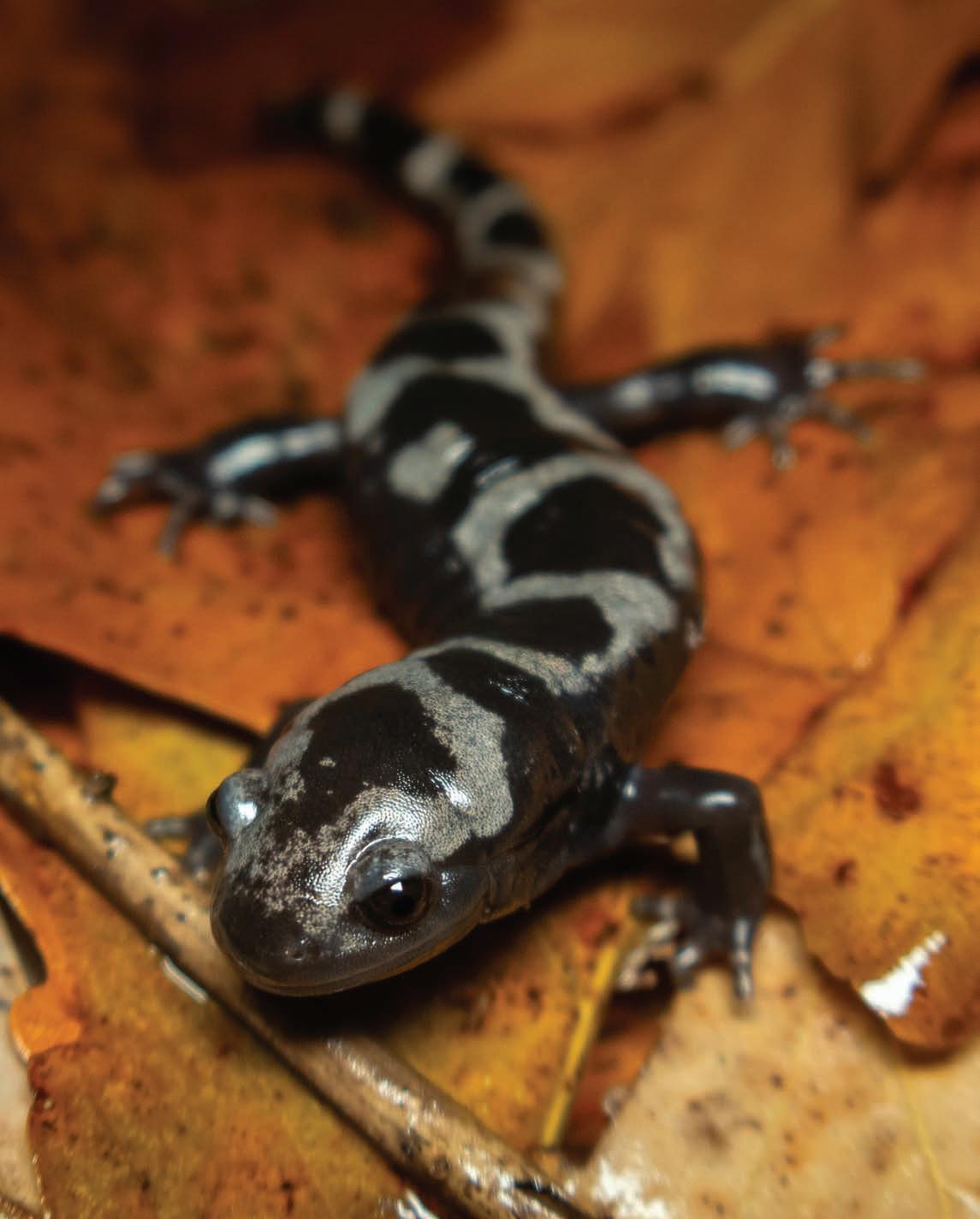
Top: Unlike other mole salamander species, the marbled salamander (Ambystoma opacum) breeds and lays eggs in the fall.
Bottom: As their name suggests, the tails of long-tailed salamanders (Eurycea longicauda) comprise more than half their total length of about six inches.
A CASE OF THE MONDAYS
Words by Jess Daddio
Photos by Kurt Schachner
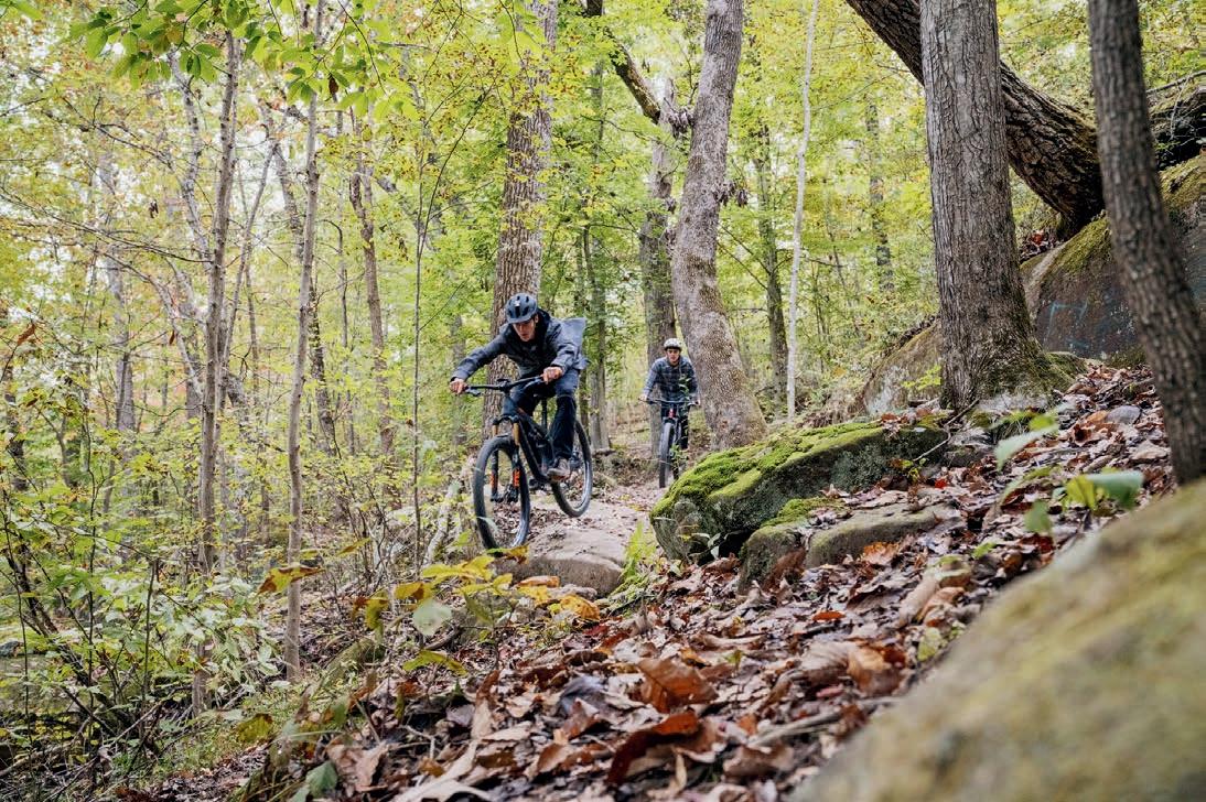
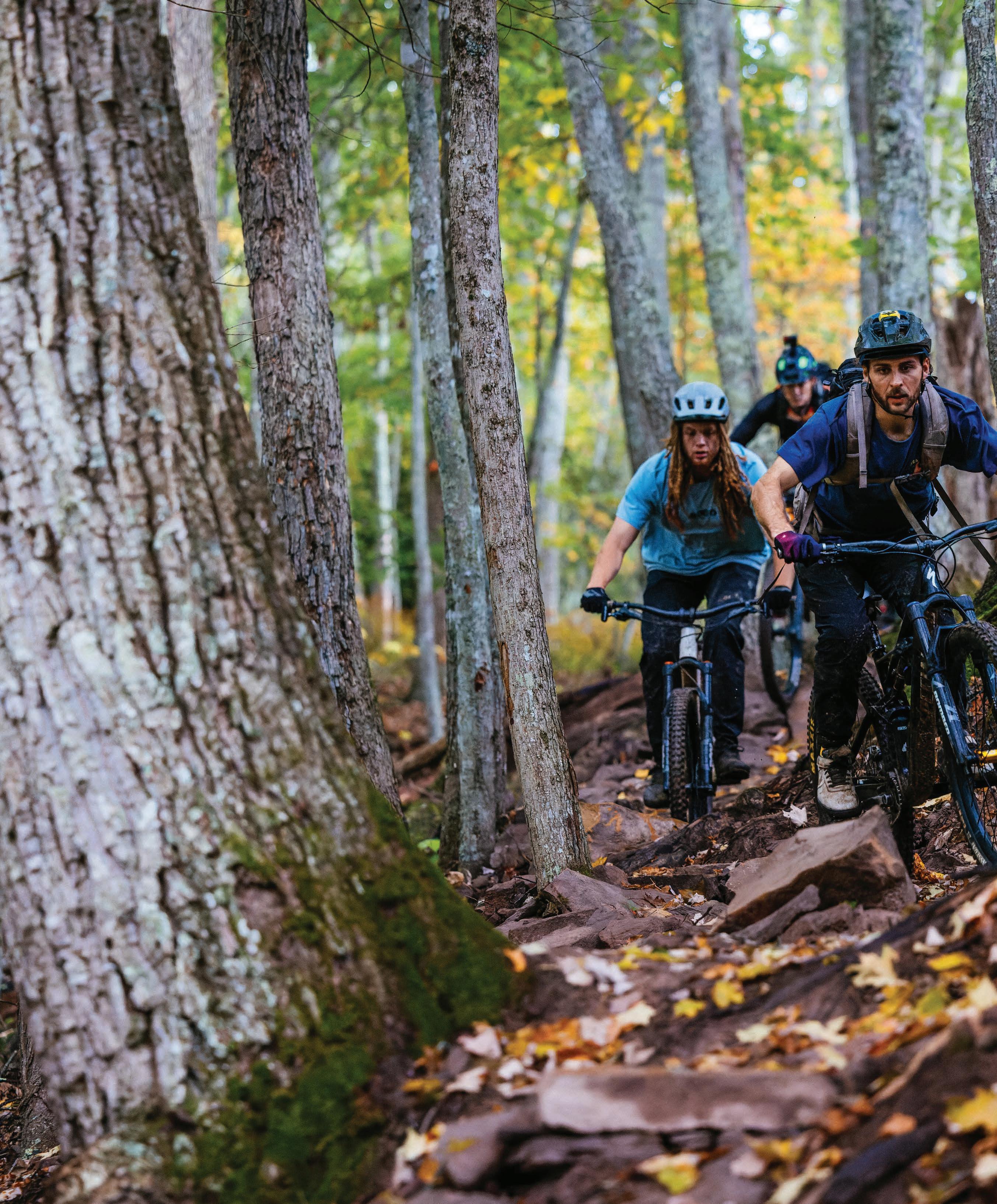
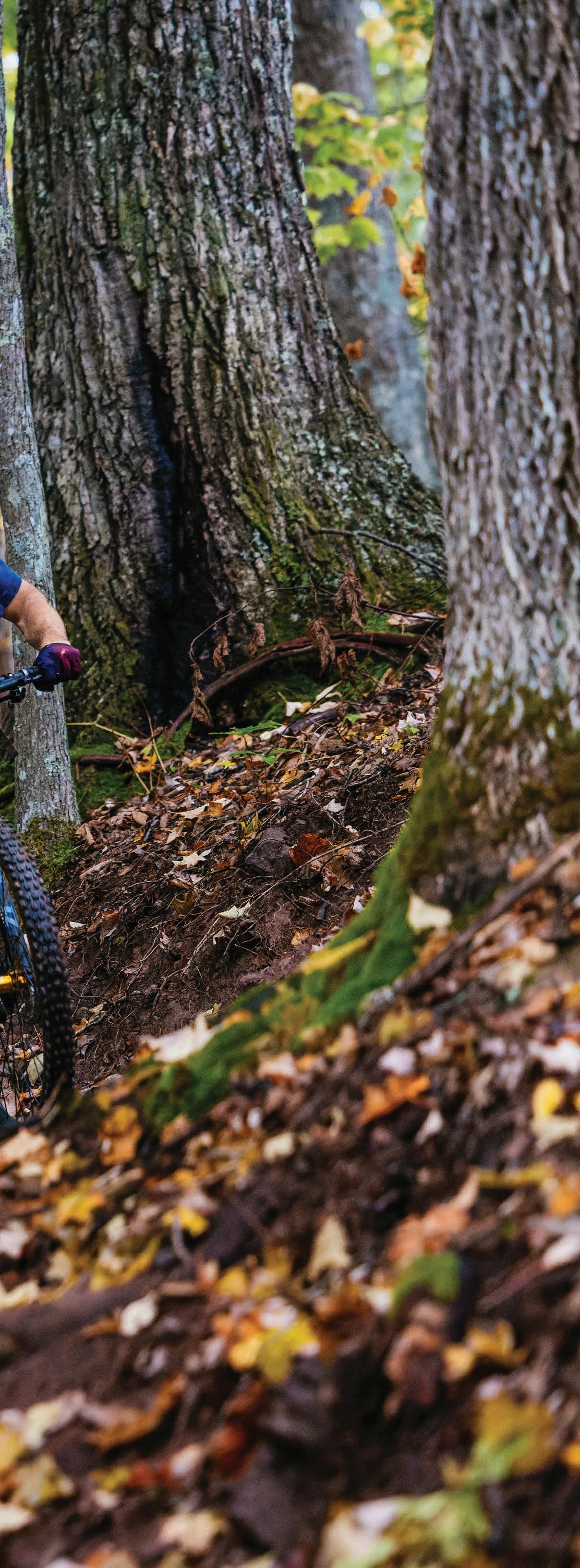
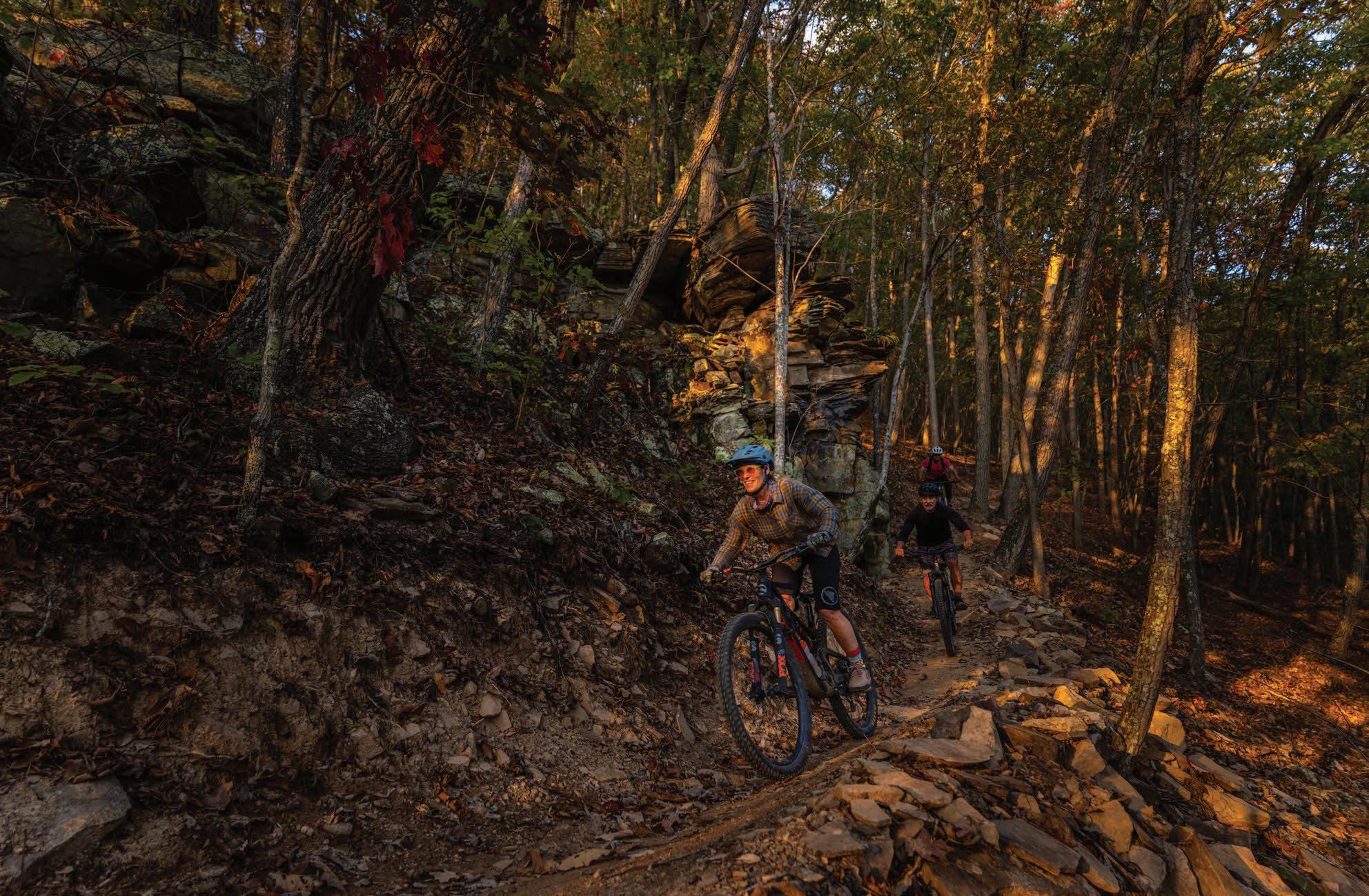
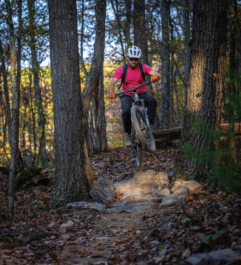
On May 17, mountain bikers in the Mountain State will officially be able to ride the Monday Lick Trail System, a purposebuilt network of mountain bike trails in the Monongahela National Forest (known as the Mon) just outside the rural town of Marlinton. Winding for 27 miles between the top of Buckley Mountain and the Greenbrier River, the Monday Lick system is the largest purpose-built mountain bike trail network in the Mon, a national forest which has historically been known for old-school rake-andrides and rugged backcountry singletrack. For many in the region, Monday Lick represents more than just another cool place to ride in Pocahontas County; it’s the newest poster child for the Snowshoe Highlands Area Recreation Collaborative (SHARC). It’s also a major step toward achieving the group’s collective dream of securing a gold-level ride center designation from the International Mountain Bicycling Association (IMBA).
In 2019, IMBA designated the Snowshoe Highlands as a bronzelevel ride center, making it West Virginia’s first and only IMBA ride center. Although centered around Pocahontas County, the Snowshoe Highlands Ride Center also includes bits of Randolph, Nicholas, and Webster counties. Just one year later in 2020, following a flurry of activity by SHARC to improve the ride center’s status, IMBA bumped up the ride center’s designation to silver. IMBA ride centers are categorized by bronze, silver, and gold levels based on the density and diversity of trails, mountain bike-specific amenities, and clear trail signage and mapping. To date, there are only four gold-level ride centers in the country, none of which are on the East Coast. SHARC wants to change that. For the past six years, the collaborative has been laser-focused on establishing the Snowshoe Highlands as the first gold-level IMBA ride center in the East. With over 400 miles (and counting) of singletrack in the Snowshoe Highlands, the completion of the Monday Lick system may just be enough to bring home the gold.
SHARC trail crew lead CJ Peterson first heard about the Monday Lick trails sometime around 2019. Back then, Peterson was working for Snowshoe Mountain Resort’s bike park in the summers and its terrain park during the winters. He remembers listening to the old guard of local riders talk around the campfire about a proposed trail system they called Monday Lick, which was then a mostly undeveloped 4,000-acre wildlife-designated tract in the Marlinton Ranger District of the Mon. “At the time it didn’t even seem real or feasible,” says Peterson. “There were so many stakeholders at play.”
Snowshoe Mountain Resort, the Pocahontas County Convention & Visitors Bureau (CVB), and even Mayor Sam Felton of Marlinton have all been heavily invested in not just the Monday Lick project but in SHARC’s larger ride center initiative. That many cooks in the kitchen can be hard to manage. Big trail construction projects are notoriously time-consuming and cumbersome. Between environmental impact studies and land manager cooperation, there are always obstacles to overcome. And then there’s the matter of finding funding—and lots of it. According to IMBA, construction for one mile of natural surface trail can cost anywhere between $15,000 and $40,000.
But the stars seemed to align for SHARC and the Monday Lick project. In 2022, SHARC received a $1.5 million grant from the Appalachian Regional Commission Partnerships for Opportunity and Workforce and Economic Revitalization (ARC POWER) Initiative. The grant was significant not only for SHARC, but for ARC as well. Prior to the Monday Lick project, ARC had only funded portions of trail projects, but never a trail system in its entirety.
After the grant announcement, progress on Monday Lick moved quickly. Between the summers of 2023 and 2024, two trail building companies constructed the initial 24 miles, which are slated to open this May. The final three miles of trail will be constructed in late spring this year, with the goal to have the entire network completed and open by summer.
“It’s been an incredible pace for securing the funding, getting the work on the ground, and the implementation,” says Jason Hattersley, forest service District Ranger for the Marlinton-White Sulphur Springs Ranger District. “It exceeded all expectations. I think that speaks to the passion of everyone involved.”
“We call it Cheat Mountain magic,” says SHARC trails coordinator Charles Evans. “Timing is everything, right? When there was that opportunity to seize the moment, there was already a plan in place. SHARC knew what they wanted to do and made it happen.”
Top: Jan Cios, Chris Cios, and Charles Evans ride beneath one of many rock outcroppings in the steep terrain of the Monday Lick drainage.
Bottom left: Charles Evans pops off a perfectly angled rock.
Bottom right: Zen Clements having a hoot on the new trails.
Previous: CJ Peterson, Zen Clements, and Geofry Branco float over chunky rock gardens beneath the towering trees.
Wake up from hibernation this Spring in ElkinsRandolph County! Explore the beauty of the Monongahela National Forest, bike scenic trails, hike breathtaking views,
ALLEGHENY HIGHLANDS TRAIL
As a grassroots collaborative, SHARC has prioritized not only the development of new trail systems like Monday Lick, but also the creation of new trail-related jobs. In 2023, Evans became SHARC’s first full-time employee. Since then, SHARC has expanded its trail staff to include two full-time crew leads, like CJ Peterson, as well as four other seasonal positions. These jobs are mostly funded through a cost-share agreement between the forest service and the CVB via the Great American Outdoors Act. The Benedum Foundation, Snowshoe Mountain Resort, and SHARC itself have also chipped in to support Evans and his team. Together, the crew is responsible for maintaining over 400 miles of trail throughout the ride center and hosting mountain bike races, including the inaugural Monday Lick Enduro, which is slated for the weekend of June 20.
“It’s impressive that [SHARC] has that level of dedication,” says Appalachian Dirt owner-operator Zach Adams, who was one of two trail builders on the Monday Lick system. “You can’t just drop almost 30 miles of new trail on a community that only has 1,000 people. It’s going to take a lot of love and care to keep Monday Lick in good shape, especially if it gets a lot of use, so it’s cool that SHARC already has that maintenance in place.”
Mountain bikers have been riding through Pocahontas County’s dank, spruce-studded forests since the inception of the sport, but until recently, they’ve only had two flavors of riding to choose from: lift-assisted downhill at Snowshoe or tight and boggy roottech in the Mon. Now, the trails at Monday Lick will offer a third flavor: flow trail à la rocks. The system’s high point on Buckley Mountain sits at 3,200 feet, where the long-distance Allegheny Trail runs high and dry along a predominantly oak- and hickory-canopied ridge. From there, veins of trails course through the Monday and Sunday Lick drainages, threading along cliff faces and diving some 1,200 feet down the mountain into moss-soaked loam and rhododendron corridors. The trails undulate between
fast flow and bike-optimized rock-tech, with a few features thrown in to level-up the fun. Greenbrier Bikes owner Scott Guyette says the Monday Lick trails are unique in that they manage both to pay homage to Pocahontas County’s riding roots while serving to contemporize the county’s overall ride experience.
“We’ve always had a reputation of being a gnarly, rocky, rooty place to ride,” says Guyette. “Monday Lick still delivers on that in sections, especially with its namesake trail. But the trails are unlike anything else in Pocahontas County. They’re a little more modern and well thought-out, not just a deer path in the woods that got beat in over time.”
Although technically a bi-directional backcountry trail system, Monday Lick definitely “rides better downhill,” says Adams, whose crew built about half of the mileage. That fact, combined with the two gravel Forest Service roads that bisect the network, make the Monday Lick system ideally suited for shuttle laps. Guyette is currently in the process of securing a shuttle permit from the Forest Service. Downtown Marlinton and Guyette’s bike shop are only two miles from the entrance to Monday Lick. Although mountain bikers could just as easily pedal up the Greenbrier River Trail to connect to the trail system, Guyette is excited about the shuttle potential and the new demographic of riders that kind of ride experience will bring.
“From a business perspective, I do think we’re going to see an uptick in visitation,” he says. “I hope there’s a little crossover from the Snowshoe people who come for the weekend and ride a day at the resort then do a day at Monday Lick.”
As for the IMBA ride center designation, it’s unclear whether or not the addition of the Monday Lick trails will finally elevate the Snowshoe Highlands to the coveted gold status. IMBA is planning on releasing new criteria for ride center designations later this year. But for Pocahontas Trails president and co-founder Eric Lindberg, SHARC’s quest for gold goes well beyond securing IMBA’s stamp of approval. SHARC has numerous other projects in the works, including updated trail signage, new construction on another 20-25 miles of singletrack at the Mower Tract, and planning and design for trail systems at Halfway Run and the Green Bank Observatory.
That so many people from such a remote part of West Virginia can come together, decide to do something positive for their community, and then make it happen is the real beauty, and Monday Lick is just the tip of the iceberg. “If we don’t get [the goldlevel ride center designation], we’ve still built an awesome place to live and ride,” says Lindberg. “That’s the bigger deal. Getting the ticket punched is really cool, but it’s not the end game.” w
Jess Daddio is a freelance writer, filmmaker, and West Virginia wannabe who resides in the Virginia mountains. When she is not plotting her imminent move to WV, Jess enjoys bikepacking and nature nerdery.
Felix Chuang catches mad air off a gnarly booter.
2025 SUMMER RACES
THE FIRST FOREST
By Dylan Jones
The fast-moving clouds break, permitting the sun’s rays to soak through the thick spruce canopy and bathe the mossy forest floor in golden light. A wind gust accompanies the rays, making the supersized cinnamon ferns dance as if waving hello. My mountain bike tires make a muffled yet satisfying crunch in the spruce needle duff as I drift through the forest.
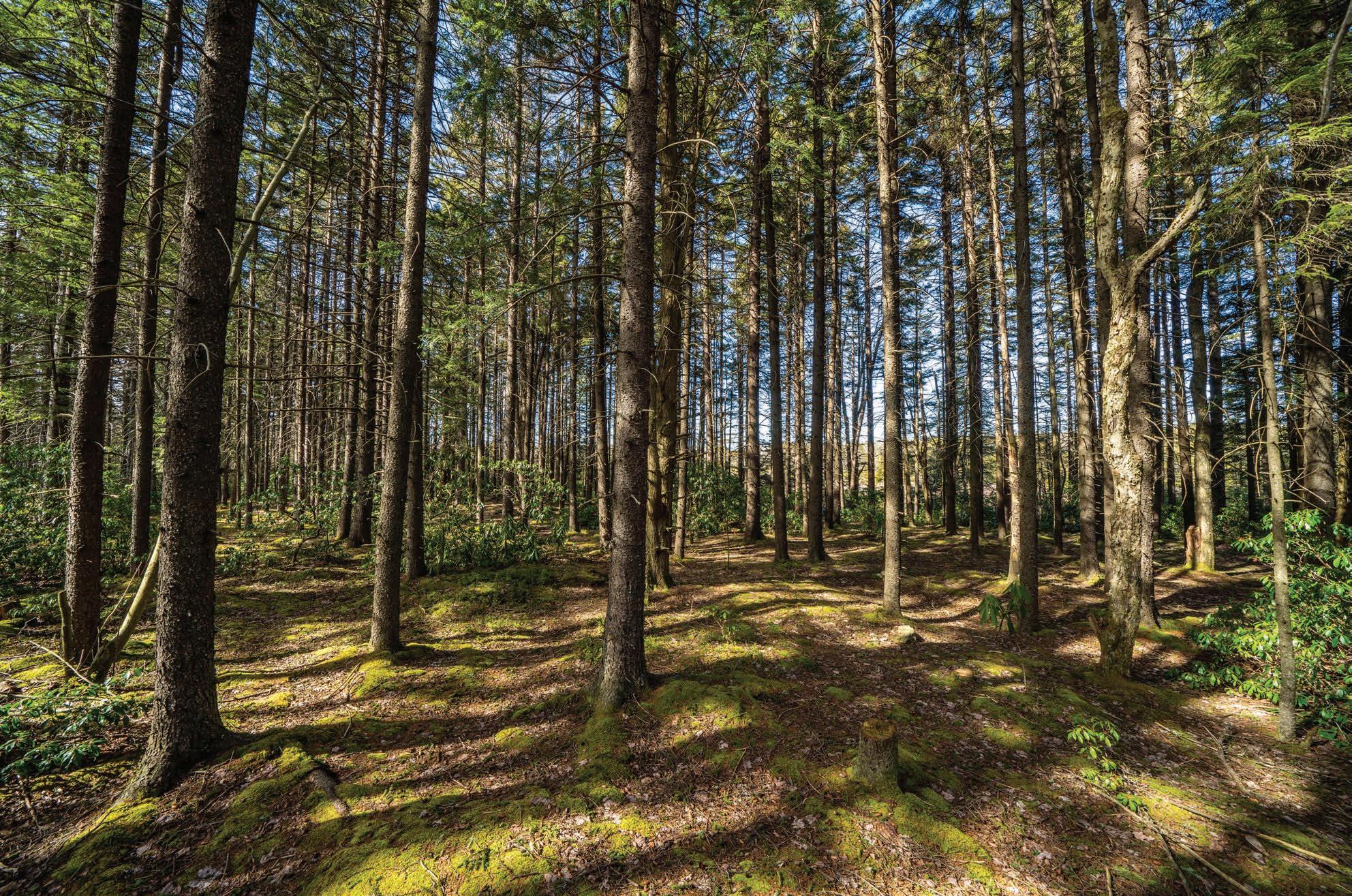
I’m in the thick of the Canaan Mountain Plantation, enjoying the results of the hardworking folks who planted these now towering trees when they were six-inch seedlings precisely 100 years ago. I’ve been on this trail a thousand times, but, as it
goes with most of my beloved haunts in West Virginia, it never gets old. There’s always something new to notice, like the way the light hits a mossy boulder or a unique plant tucked among the macro display of a hummock. Likewise, the familiar sights continue to evoke the same ethereal sense of awe that I experienced on my first foray.
While it may seem that this towering forest is ancient, timeless even, it was a barren wasteland just a century ago. Like most primeval forests in Central Appalachia, the sprawling red spruce forests that once covered nearly 16 million acres in West Virginia fell victim to relentless industrialization.
Dylan Jones
The first accounts from European settlers in the late 1700s described an impenetrable landscape choked with stands of 100-foot-tall red spruce trees and rhododendron hells so thick a human could not slip through them. The Canaan Valley area itself was described as so rugged and impassable that Indigenous cultures reportedly avoided the region altogether, opting to hunt and fish and farm down in the fertile river valleys thousands of feet below.
But as the clear-cutting spree of the early 1900s swept through the Allegheny highlands, even the most remote and rugged folds of these mountains could not escape the hungry sawblades of humankind. Not a single sapling was left standing on the broad shoulders of the mountains surrounding Canaan Valley.
In March of 1907, raging flood waters carrying car-sized blocks of ice inundated Pittsburgh, Pennsylvania, killing 12 people and grinding the Steel City to a halt. Investigators traced the source of the floods south across the Mason-Dixon line to the denuded slopes of the Cheat River watershed. With no trees to stabilize the steep river canyons, runoff was channeled directly into the rivers and north into Pittsburgh.
In 1914, Congress passed the Weeks Act, which authorized governmental purchase of lands for watershed and natural resource management. In April of 1920, President Woodrow Wilson signed a proclamation to establish the Monongahela National Forest with hopes of reforesting the slopes.
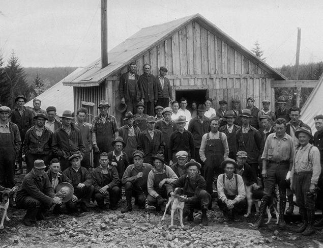
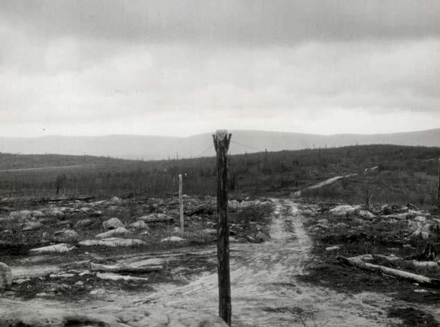
The first major restoration effort on the fledging national forest occurred at the northern end of Canaan Mountain, high above the sooty smokestacks and buzzing sawmills in the timber town of Davis. Encompassing a broad high-elevation plateau that reaches a high point of 4,145 feet at Pointy Knob, Canaan Mountain’s thick forests and mossy upland bogs of today are a year-round recreation destination. But this seemingly pristine paradise would be unrecognizable to the hardy men that worked the plantation camps 100 years ago. Upon their arrival they would have seen a barren landscape dotted with sandstone boulders, black with ash
from the constant wildfires that burned the remaining slash and soil down to the bedrock.
I often wonder what the people of that era felt upon seeing a completely ravaged landscape. Was there a warped sense of pride for the sheer dominance of humankind over the landscape? Was there sadness or despair over the razing of these great forests? Were these men excited by the prospect of having a direct hand in reforesting Appalachia? Plantation laborers earned a wage of $2.56 per day; foremen earned $3.00 per day. Perhaps, given the standard of living during the Depression era, they were simply grateful to have a job.
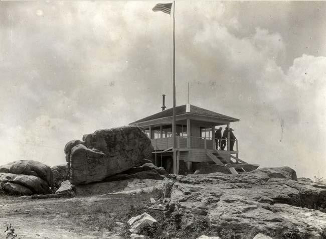
During the inaugural planting camp in the spring of 1925, workers planted seedlings near the site of the former Canaan Mountain fire lookout cabin on Forest Road 13, which sat directly atop a massive boulder and offered a commanding view across the plateau. The fact that one could see for miles from a structure just 10 feet off the ground offers insight into just how barren the mountaintop was at the time. As the seedlings grew, the structure’s low vantage point rendered it useless as a fire lookout tower. A taller tower was erected just to the north and the existing cabin was decommissioned in 1946—the only remnants are a few chunks of concrete rubble where the footers were placed in the sandstone.
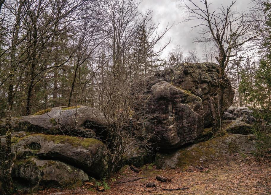
Standing atop the boulder, staring into the thick forest, it’s hard to believe the view once extended for miles. As I walk around where the cabin once stood, I imagine all the souls that set foot here while searching for signs of fire. Some of West Virginia’s wildest places that lie scattered throughout the million acres of the Mon were once buzzing hubs of industrious human activity. It’s always striking to me how much can be built and then removed by humans—and reclaimed by nature—in a single human lifetime.
Planting camp started in April each year as winter’s grip was still too strong upon the mountaintop in March. Seeds were brought up from local forest service nurseries along the rushing waters of the Cheat in Parsons and the Glady Fork in Gladwin, while some seeds for Norway spruce seedlings came all the way from their native
Left: The fire tower at Canaan Loop Road, which was decommissioned and disassembled in 1946. Photo courtesy USDA Forest Service. Right: The same boulder in 2025, surrounded by a mature forest. Photo by Dylan Jones.
Norwegian forests. Crews used handtools, like the Hazel hoe, for both tree planting and wildfire fighting, planting around 600 trees per day. They used the center hole method, which dictated that trees be planted six feet from one another in rows six feet apart. However, the exposed sandstone bones of the mountain presented planting challenges. The rockiest areas averaged about 600 trees per acre while more fertile plots allowed up to 1,200 trees per acre. I’ve enjoyed volunteering for red spruce planting events in and around Canaan Valley over the years, and although the dibble is a more popular tool nowadays for planting red spruce seedlings, the methods remain the same as they did a century ago. It’s a unique experience to plant six-inch seedlings in view of 100-year-old trees that were planted by human hands. After a day’s work, it’s rewarding to look around at a plot of several hundred seedlings and imagine what they’ll look like after I am long gone.
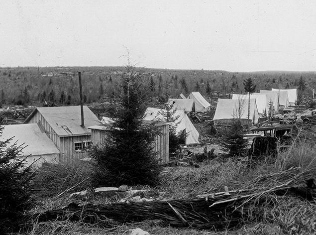
The logging camps atop Canaan Mountain offered barebones accommodations and backcountry conditions typical of the era. Canvas tents, wood for tent floors, and coal-burning stoves were hauled up to the site of each spring’s planting camp. Wooden-walled mess halls were eventually added, which must have felt luxurious to the laborers at the time. Telephone lines were extended down Forest Road 13 to permit communication about progress, resupplies, and fire conditions with the district ranger.
From 1925 to 1933, exactly 1,559,300 seedlings were planted across 2,462 acres on Canaan Mountain. The majority were Norway spruce and red spruce, which one can clearly observe while making the trek from east to west across the mountain. In some locations on the edge of bogs, eastern white pine and eastern hemlock dominate. Interestingly, a single acre of European larch—a deciduous conifer with characteristic needles that turn yellow in autumn—was test-planted in 1927, but only half of the 2,000 seedlings survived. This patch of larch can still be found if you know where to look on the outskirts of the plantation.
When planting ceased in 1933, the Civilian Conservation Corps stepped in to create a grid of fire control measures to protect the fledgling trees from the continued threat of wildfire. The grid of original fire trails allowed travel via jeep up and down the mountain’s north-facing slope. Fire breaks ran perpendicular to the fire trails and served to prevent wildfires from spreading. These trails are still in use today as recreational trails in the 13,000-acre Canaan Mountain Backcountry Area. Original trail names like Fire Break, Fire Trail #3, and Railroad Grade pay homage to the early days. The namesake Plantation Trail, which cuts from east to west for eight miles across the slope of Canaan Mountain, is considered one of the birthplaces of
Top: A planting camp on Canaan Mountain in spring 1933. Photo courtesy National Archives.
Middle: The 1933 planting crew and camp staff in front of the wooden mess hall. Photo courtesy National Archives.
Bottom: Looking east toward Cabin Mountain from a vantage point atop Canaan Mountain in 1933. A pole supporting a telephone line is visible in the foreground. Photo courtesy USDA Forest Service.
West Virginia mountain biking in the mid-1980s, and still sees use by avid riders who come to sample some of the Mountain State’s most rugged terrain on two wheels.
The reborn forest that now extends far beyond the plantation’s original borders supports a wealth of native hardwoods like beech, birch, cherry, and maple, plus a slew of unique high-elevation flora and fauna. As the forest continues to mature, it will undoubtedly change. I consider the plantation crews: how did they imagine the forest looking a century down the road? I often wonder what the ecological makeup of this mountain will be 100 years from now. Will it be mature forest? Will it be razed again? How will climate change affect the composition of species? Perhaps there will be a new era of citizens who rally to course-correct the short-sighted decisions of our era.
As a denizen of Davis, this mountainside is my backyard, and I take advantage of this incredible public resource every chance I get. While millions of acres of West Virginia have been reforested over the years, it’s fascinating to regularly visit a place where the first concerted efforts to reforest the Mon began a century ago.
When I head out into the wild, I often think about the plantation crews. I imagine a hardscrabble life filled with dangerous hazards and harsh conditions, but I also like to think that these men had a sense of pride and purpose in what they were accomplishing. I wish I could construct a time machine, travel to the first spring camp, and transport the crew members back to the future to experience the forest in its present state. I imagine their reactions as they gaze up at the towering canopies and hear the flute-like song of a hermit thrush. I’d hug them and thank them for their herculean efforts. I like to think that they’d break down in tears of awe and joy as they gazed upon the successes of their seedlings. w
Dylan Jones is co-publisher of Highland Outdoors and wishes he could be around in 2125 to see what West Virginia’s highelevation forests look like, but he’d be 140 years old, so that ain’t gonna happen!
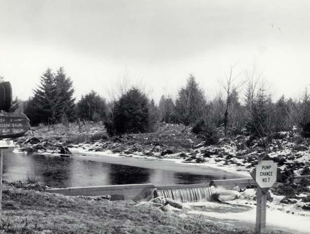
Top: Workers created small dams, called pump chances, along waterways to provide reliable water sources for wildfire mitigation. Pump Chance #7 was built along Red Run, just before it plunges down a steep canyon. Photo courtesy USDA Forest Service.
Bottom: 76 years later, the concrete dam of Pump Chance #7 is still visible where Canaan Loop Road crosses Red Run. Photo by Dylan Jones.
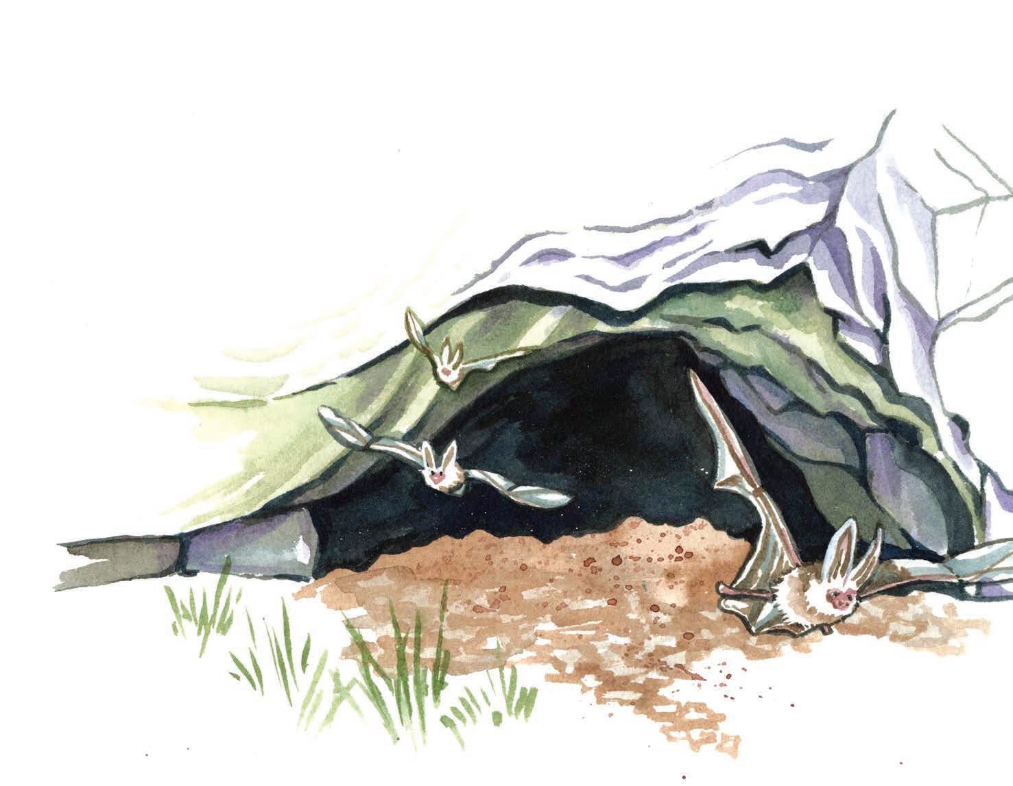
elcome to the first edition of Art in the Field! My name is Rosalie and I’m a nature illustrator. I use my art to call attention to the overlooked flora and fauna of the Appalachian region. Art in the Field is a four-part series of illustrated essays highlighting conservation efforts to protect sensitive species throughout West Virginia.
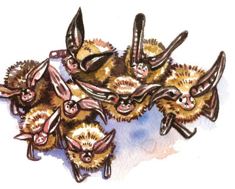
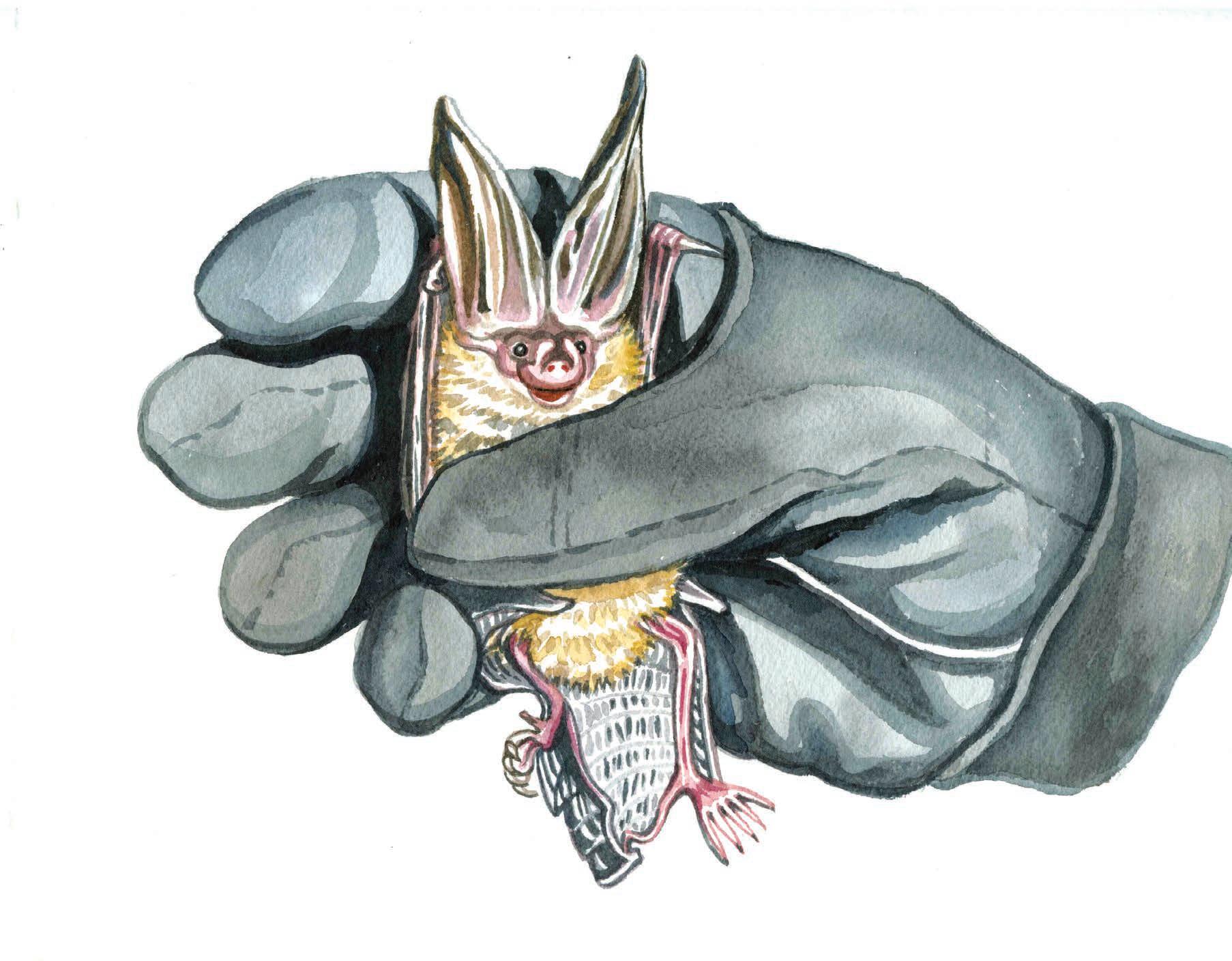
My debut Art in the Field takes place at a remote cave in Pendleton County. I’m accompanying a team of biologists from the West Virginia Division of Natural Resources and U.S. Fish and Wildlife Service as they determine whether this particular cave houses a male or female Virginia big-eared bat colony. Because this bat species is federally endangered, it’s crucial to know which sites have maternity colonies so scientists can place increased protections on caves where female bats raise their young.
I’ve taken a while to warm up to bats.
Maybe it’s because humans seem to have an innate uneasiness around creatures that only emerge at night, or maybe it’s because they’re often depicted as dirty and creepy in movies and books. Or maybe it’s because I’m an embarrassingly jumpy person, and things that come swooping in out of nowhere give me quite the startle. I’m curious how this evening’s up-close interactions with bats—and the people who study them— will impact these feelings.
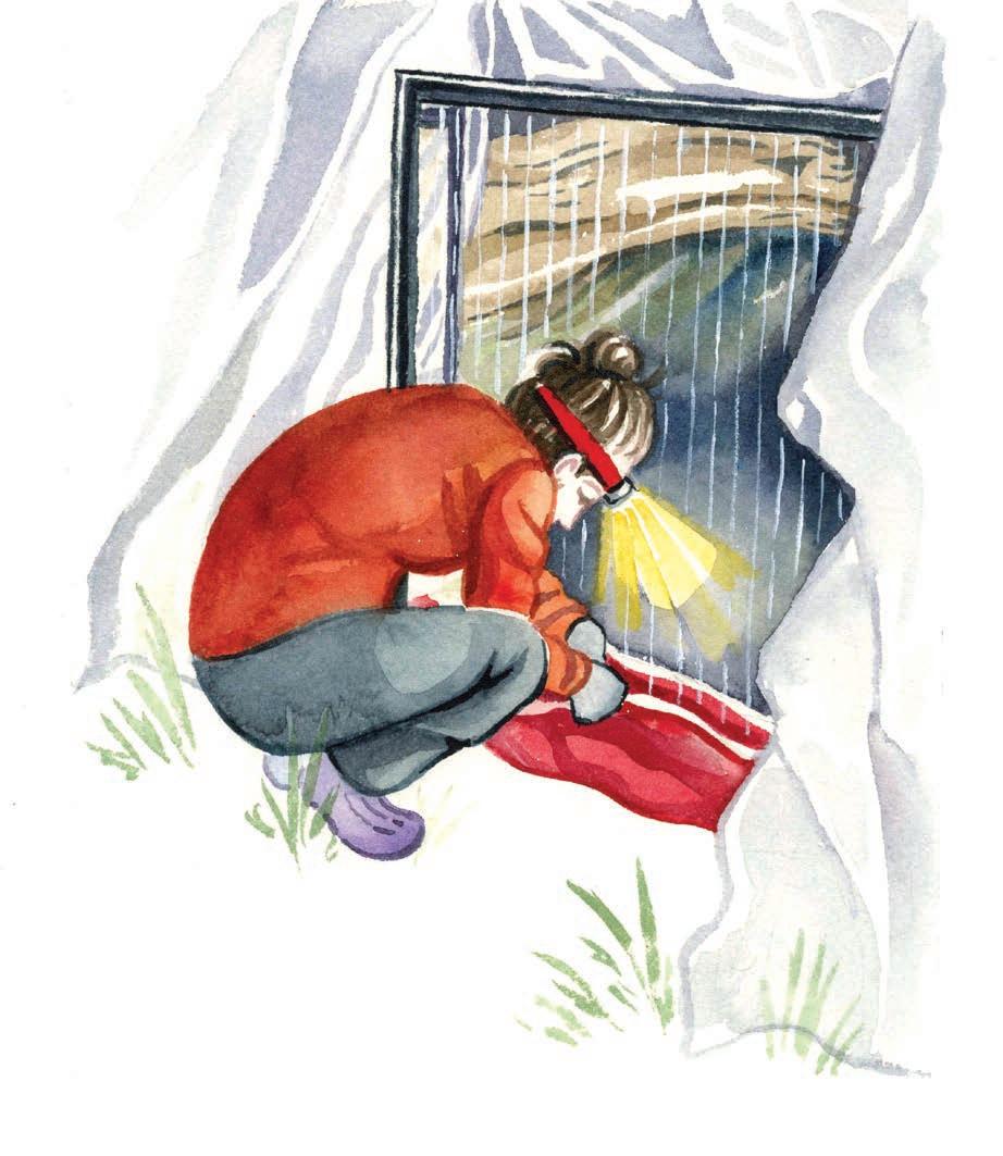
Because Virginia big-eared bats are highly sensitive to disturbance and temperature, individuals huddle together in fluffy clusters within their caves for warmth and protection during the day. But nighttime is when all the action happens. The crew gets to work setting up a harp trap, a frame with two vertical rows of thin lines and a plastic bag at the base, at the cave’s mouth. The sun slips behind the hills and we wait in silence for the bats to become active.
It doesn’t take long before I hear some soft commotion and peek into the cave to find dozens of bats zooming in circles. In one quick movement, the first bat tries to exit the cave for its evening meal, but instead gets caught between the harp trap’s strings and drops gently into the bag below. The research team takes turns carefully plucking each bat out to determine its sex. It’s a quick task, and in just a few seconds the bats are free to flutter away, calling out in their high-pitched squeaks as they disappear into the darkness to catch moths and other small insects. This is where their gigantic ears come in handy: they use them like satellite dishes to detect even the faintest
most about working with this species. “They’re the most sensitive species to noises and disturbances to their roosting areas,” she tells me. “They’re the ultimate introverts! Which is why I think I enjoy them so much—second only to their huge ears and cute faces.”
Tonight we catch only males, letting us know that this is a paternity colony. I’m struck by how much effort goes into protecting this small critter: all the late nights driving deep into Monongahela National Forest, hauling equipment up and down steep banks, and meticulously entering the collected information into databases. Harp-trapping is just one of several strategies used in bat conservation. Scientists also use acoustic monitoring to detect bats’ echolocation signals, mistnets to capture them for up-close examination, and radio telemetry to track their movements. Combining these techniques provides a fuller picture of this species’ habitat and behaviors, helping scientists devise conservation actions to help the Virginia big-eared bat thrive.
While this species is naturally immune from the threat of whitenose syndrome—a fungal disease that has decimated many bat populations in North America since 2006—the Virginia big-eared bat was listed as federally endangered in 1979 due to habitat destruction and human disturbance. But conservation efforts have already started to pay off. Over the past 50 years, the population has steadily increased thanks to initiatives like the protection of roosting caves and decreased use of toxic pesticides. Today, over half of the known populations of
COLLEEN LAFFEY
By Nikki Forrester
When I called Colleen Laffey to do this interview, her phone went straight to voicemail. A few minutes later, I got a text saying, “I’m so sorry! It snowed last night so I ran to Snowshoe to ski and completely spaced on our call.” I smiled. It was exactly something I would do. Colleen offered to give me a ring within the next hour, but when there’s fresh powder on the slopes, work can certainly wait.
We caught up the following week and chatted about her life as a whitewater photographer and video boater in Fayetteville in the early 1980s. She filled me in on some of her big projects as a camera operator, which include Love is Blind , Jersey Shore, World’s Toughest Race: Eco-Challenge Fiji , and Tough as Nails, just to name a few. Her work has taken her all over the country and around the globe, yet she continues coming back to the Mountain State. From the close friendships to the world-class adventures right out her front door, West Virginia is a special place that Colleen feels lucky to call home. I couldn’t agree more.
This interview has been edited for length and clarity.
What’s your coming to West Virginia story?
I grew up in Pittsburgh and went to school there for photography. One day we were having a portfolio review and a guy approached my table to look at my photos. He was wearing muddy boots, blue jeans, a river T-shirt, and a hat that said “Wild Rivers Photo Services.” His name was Greg Green. He handed me his card and asked if I wanted to shoot whitewater rafting.
That was in 1981. We went down to Big Nasty [a class IV rapid] on the Cheat River to shoot photos. I’d never been on a river or rafting before. The next day, Greg took me rafting on the river. It was March, so the river was very cold, but I loved it. After the trip, we went back to the lab to process the film. When he saw my photos, he offered me a job.
What was it like being a whitewater rafting photographer?
I worked on the New River my first year. I shot seven days a week and made $200 a week. Back then, there were 18 or 19 rafting companies, and I took photos for 16 of them. I would get a bag full of film and a list of all the different raft trips on it. I’d sit at Fayette Station [a class IV rapid on the Lower New] all day and shoot. Some of my favorite memories are of getting to know all of the people that worked at the different rafting companies.
How’d you get into guiding and video kayaking?
After spending a few years taking whitewater photos, I decided I wanted to spend more time rafting. I trained to be a raft guide with Charlie Waters at Appalachian Wildwaters and then guided for six years on the Cheat, Tygart, New, Gauley, and Upper Youghiogheny rivers. I loved trying to convince eight to 10 people to get my raft to go where I wanted it to. But I eventually reached a point where I was no longer happy guiding. I learned how to kayak and wanted to have a camera in my hand again, so I started video boating in the late 1980s.
What is video kayaking?
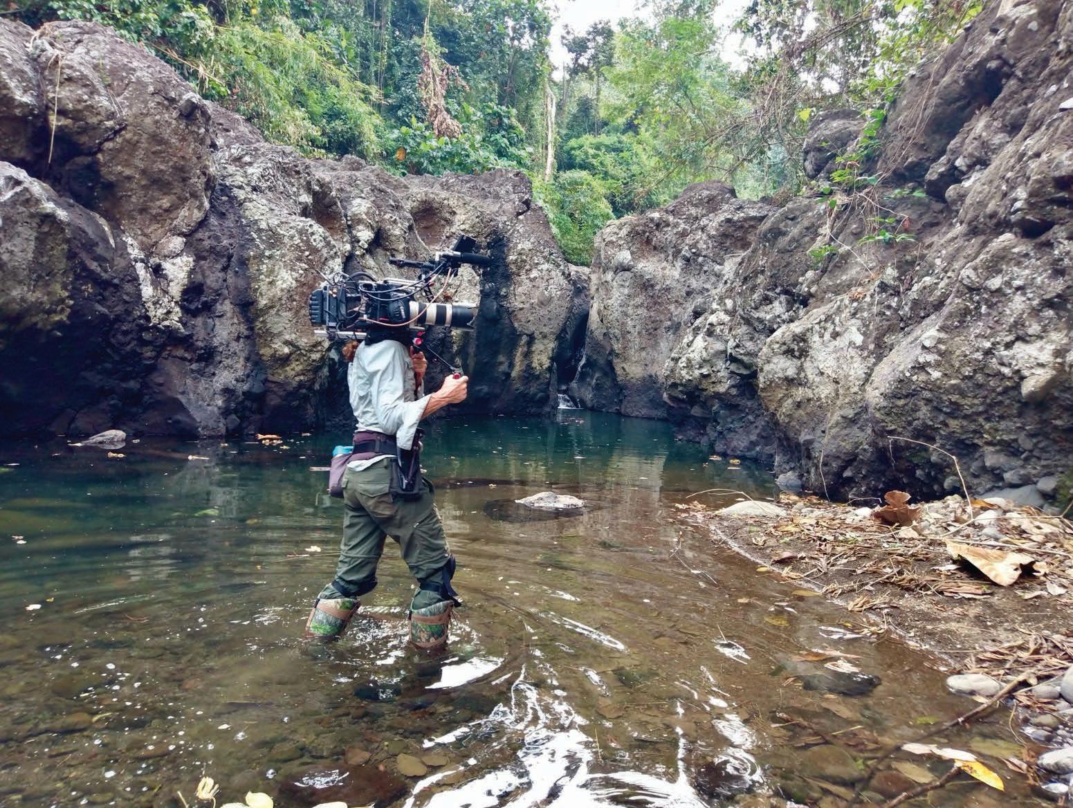
You’re paddling in a kayak alongside a rafting trip. You have a camera with you and basically leapfrog the trip. You start out with the trip, get ahead of them, hop out at a rapid and shoot photos, then pack up all your gear and do it all over again. It’s a dangerous job because you’re often all by yourself. And no matter how good of a paddler you are, everybody makes mistakes. Making a mistake when you’re by yourself is a whole different ball game than making a mistake when you’re with a group of people. My mantra was “Alert, Aware, Alive.”
Courtesy Colleen Laffey
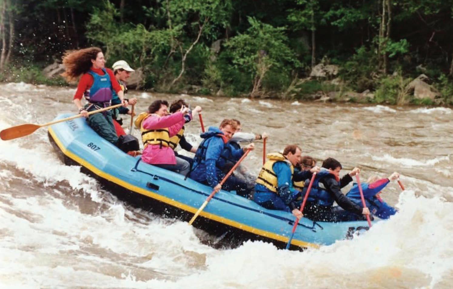
Laffey guiding on the New River in the 1980s. Photo by Whitewater Photography.
How was living in Fayetteville?
I moved to Fayetteville in a 1971 Oldsmobile Cutlass. I tried to find a place to live, but no one wanted to rent to me because I was a river rafter. Plus, I was only looking to rent a place from April until October, which is kind of a pain. I lived in my car at the North American River Runners campground for about a month. I was such a city person. I slept in the backseat of the Cutlass while everybody around me was in nylon tents.
Then I became friends with some locals and they told me about an apartment for rent in downtown Fayetteville. Back in the 80s, nobody had cell phones and getting a landline was super complicated. There were two phone booths across the street from my apartment near a liquor store where Water Stone Outdoors is now. I’d give out the number for one of the phones and one of the guys from the liquor store would run up to my apartment to tell me whenever I had a call.
Do you miss those days?
I miss the quiet of West Virginia. We were really lucky back then. We had this beautiful place all to ourselves. The rafting industry wasn’t even an industry. People just liked to paddle and share their stoke for whitewater. Every rafting company had its own personality and ethos. There would be a big party every year where all the rafting companies would get together and bond. It’s been hard to watch all the smaller businesses get gobbled up by bigger businesses and then get acquired by corporations.
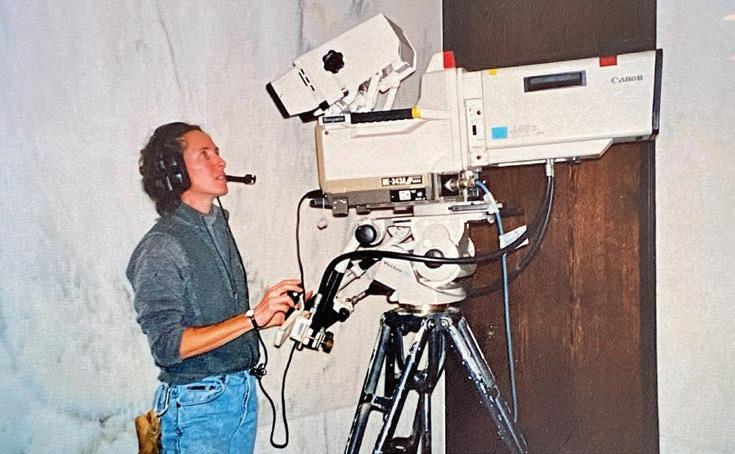
What were some of your first projects as a camera operator?
When I went to school for photography, I learned how to do some video filming and editing. While I was working as a video kayaker full-time for 11 years, every time a production would come through the area, I would try to get on it as a production assistant. But that was tough to do as someone from a small town in West Virginia.
One day I remember seeing a show called West Virginia Journal, which was part of West Virginia Public Broadcasting, and thinking, “I could do that ” I worked up a proposal with 10 story ideas for the senior producer. She said yes and that they’d paid $100 a story. I filmed a story about some friends that had a llama trekking company and ran trips along the Highland Scenic Highway. I also made stories about the White Grass Ski Touring Center, the Appalachian String Band Festival, and my friend Kim Shingledecker, who was training to be a boxer. Some of the stories took me three months to shoot, but I was so excited to have a platform and to take on challenging projects that I didn’t care about the money.
When was your first big shoot?
I filmed some adventure races in the late 1990s and early 2000s. Some of these races ended up being qualifying races for the 2001 Adventure Racing World Championships in Switzerland. Someone from the production company shooting the world championship contacted me to ask about using some of my footage for the background videos on the athletes. I told them they could use my footage under one condition: they had to hire me as one of their camera operators. That was for the Discovery Channel and it was my first really big shoot.
I got to go to Switzerland and since I had been doing all those regional races, I knew a lot of the racers and had a really good rapport with them. When someone’s going through a rough time, they don’t want a camera in front of their face. But these racers already trusted me to tell their stories, so a bunch of my footage ended up in the show.
What are some of your favorite projects to date?
I’d rather do something that sparks my creativity and engages my mind than do something just to make money. I was a camera operator for three seasons of MotoMaidens, which documents the journies of five women who get together and ride motorcycles. They’re such interesting people and I really enjoyed spending time with them. My producer, an audio person, and I were jammed up in a truck travelling all over Montana to shoot—it was amazing.
But I also film shows where I don’t necessarily fit the demographic of people who watch them. I shoot a lot of dating shows [including Temptation Island and Are You The One], where I get to work with a lot of beautiful equipment and great lenses. Because they’re bigger shows, I work with crews of 10 or 20 other camera operators. It’s a whole different dynamic, which can be really fun.
Do you watch the shows you film?
I generally do because I want to see what the editors liked and used so I can figure out what to focus on moving forward. It’s funny. I shot on the first four seasons of Jersey Shore. There were five or six camera operators, each shooting 12 hours a day. We thought the show was going to be so boring, but then the editors took all of our footage and turned it into something interesting. It gave me a real appreciation for the fact that editing is an art form in and of itself.
What’s kept you in West Virginia all these years?
I’m like a migratory bird that keeps coming back to the same nest. Over the years, I’ve lived in Los Angeles, Costa Rica, and Alaska. The thing that keeps me coming back to West Virginia is my strong network of friends here and easy access to all the things I love to do. I designed and built my house on a 2-acre property adjacent to the New River Gorge National Park and Preserve. I live halfway between the put-in and the take-out of the New. West Virginia is one of the best places in the world to kayak and the water is warm unlike the rivers out west. I’m also the world’s most mediocre mountain biker and I can hop on the trails right from my door. The people in the outdoor community here really care
for each other and look out for each other. There are communities all over the world, but there’s something about the community in West Virginia that is really special.
What are some of your hopes for the future of outdoor recreation in West Virginia?
I really love seeing the trend toward building more mountain bike trails. I would love to see West Virginia figure out a way to connect towns with trails. When I travel for my job, one of my favorite things to do is buy a cheap bicycle and ride around town. As much as I like riding around in circles in the woods, it’s an even greater pleasure to bike to a destination. Imagine if there was a nice trail between Thomas and Davis, or between Fayetteville and Oak Hill. I’d also love to see bike trails be developed along rivers where there used to be railroads, so people could easily and safely bike their shuttles.
Any final thoughts for outdoor lovers here?
I travel all over the world and sometimes locals want to share their favorite, lesser-known spots with me. But I don’t want locals to tell me their secret spots. I haven’t even seen the regular spots, so don’t give away the marrow of the bone. Keep something back for yourself. Not everybody needs to go everywhere. w
Left: Laffey shooting in Bali. Photo by Ryan McPherson. Right top: Laffey filming for West Virginia Public Broadcasting. Photo courtesy Colleen Laffey. Right bottom: Last year, Laffey paddled the Upper Yough to celebrate her 64th birthday. Photo by Cara Giannone.
I can’t quite explain why, but I’ve always been drawn to life on the macro scale. When I go on a hike, I find myself staring at rain droplets on spruce needles or a small spider nestled deep within a funnel-shaped web. Perhaps I love macrophotography because it invites me to slow down, pay attention, and forego my bipedal stance. I’ll lie down on the forest floor and watch as the sun subtly changes, hoping to capture that one moment where a single leaf becomes illuminated. This photo of a Polypodium fern was taken in early April, what most people call mud season here in the highlands. I used to think April was the least scenic month of the year, but ever since I started toting around a camera, I eagerly anticipate the soft awakening of life and the forest’s open invitation to look just a bit more closely. Photo and caption by Nikki Forrester.