Portfolio
 He Yang

He Yang
+61 0432843743 / +86 13535184415
heyangg98@gmail.com
483 Swanston Street, Melbourne, VIC 3000
University of Melbourne
- Master of Urban Design
University of Central Lancashire
- Bachelor of Arts (Honours) Spatial Design
Singapore Nanyang Academy of Fine Arts
- Diploma in Design (Landscape and Architecture)
Gold Winner | LSE Legacy Garden
London School of Economics and Political Science | Lodon
Gold Winner | Best Sustainable Design IDCS Design Excellent Awards | Singapore
Honorary Mention | Best in Retail Design SIDA Singapore Interior Design Awards | Singapore
Finalist | Global Design Graduate Show i-D and ARTSTHREAD | Lodon
Urban Designer (Internship) | GuangDong Urban & Rural Planning and Design Institute | Guangzhou, China
Urban Planning for Rural Revitalization of Daojiao Town, Guangdong Province: Responsible for the initial planning of the southern area of Jiuqu Village / Assist to figure out the Framework and concept
Landscape Architect | London School of Economics and Political Science | London
Legacy Terrace Garden “Chorus of ripples” : In charge of the the entire design process (completion in 2023)
Urban Planner (Inter nship) | Guangzhou Urban Planning & Design Survey Research Institute(GZPI) | Guangzhou, China
Urban Renewal of Industrial Park in Zhongshan, Guangdong Province: Research on Urban morphology and typology of industry 4.0
“Nansha district advanced manufacturing development in the outline of 14th Five-Year Plan 2021-2025”: Assist to data collection and analysis / Presentation preparation
Landscape Architect (Freelancer) | Rooot Studio | Singapore
Residential Project in Sentosa Cove / F&B project in KL : Propose external plan / Produce 3D rendering & volumetric diagram
Feature | “Construction Plus Asia” | Singapore
Invited to share personal student project "Decompose & Recompose" sustainable design concept in the magazine “Construction Plus Asia”July 2021
URUS Designer (Inter nship) | Studio 216 | Singapore
Web design: Assist to develop web framework and collaborate with IT, designers teams / Responsible for product visualization, including rendering, layout, etc.
Volunteer | National Parks Boards Botanic Gardens | Singapore
Renew Spices Garden in Botanic Garden: Redesign the garden / prepare the planting list
Nursery(PRC): Conservation Native Species / Databasing / Nursery management
Skills
Design | Landscape Architecture
AutoCAD / SketchUp / Rhino / Lumion Illustration | Animation Illustrator / InDesign / Photoshop / Lightroom / Premiere Pro
Model Maker (Internship) | 3-sixty Brand Communications | Singapore
Volvo advertising in OCBC Cycle: Design 3D Model track Model for Volvo Model car/ Produce 3D physical model for the event
Urban Designer (Internship) | Overseas Chinese Town Enterprise | China
Urban Renewal in Hengyang, Hunan Province: Involve in the preliminary analysis and development feasibility research / Coordinate with design firms
Exhibitor, MSDX
Exhibitor, NAFA open house
Exhibitor, ‘Superimposing Spaces’ Exhibition Exhibitor, ‘In-process’ Exhibition Facilitator, ArKIDecture@
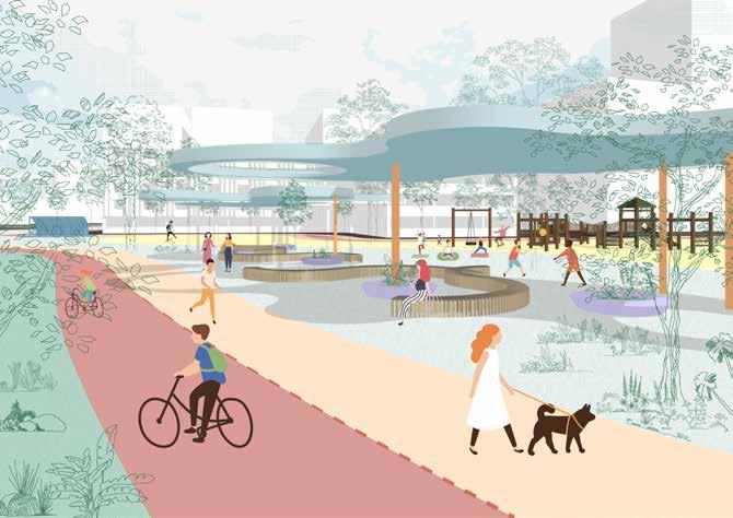
“The Sanuk Bangkok” responds to the existing context of Bangkok and proposes a new alternative to its future development. Drawing from the Thai philosophy “Sanuk”, this project aims to create a liveable neighbourhood that is based on the local culture and contemporary everyday life in Bangkok.

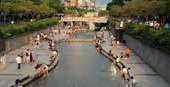
This project intends to revitalize the existing canal by activating the riverbank as a linear park. Based on existing urban fabrics, a new network with integrated modes of transportation is proposed to improve the area’s walkability and connectivity. New neighbourhoods are therefore redefined and redeveloped to provide better living conditions.
Water meanders through our city like blood flows in our bodies. The greenish saturates the image of our city with fresh air filling up our lungs. We reinvent a sustainable and resilient lifestyle in the metropolis.
This is a well-connected city where we are mobilised to wander every corner of the land. We embrace people from all over the world, from all walks of life. We give the city back to its people, We show love with warmth just like the golden sun.
With duty and care, we treasure our memories, honour the spirits embedded in our city, We live with our glamorous past side by side. We amplify delight in everydayness, Together we revive the soul of the city.
Be ready to expect the unexpected, The liveliness, the safety, The localness, the cosmopolitan, The dynamics, the unique charm, The joy, the love, The past, the future, All in one
We coin this “The Sanuk Bangkok”
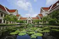
This project is located to the east of Bangkok’s historic city Rattanakosin. This area is home to Thailand’s oldest and best institute of higher education Chulalongkorn University. In the 20th century, this area saw large-scale


investments, especially after the operation of the mass public transportation system in 1999. This area is now the major shopping and commercial district and has become Bangkok’s modern city centre.
Due to climate change and the rapid pace of transforming canals into concrete roads, flooding has become very common and severe in recent years.


Khlong, commonly refers to as ‘canal’ in the Thai language, was an integral part of the development of this city. They not only protect the capital from invasion but also facilitate local transportation before the modern development of vehicles. Khlong Saen Saep travels through the site.
Bangkok in 1920


Thailand is one of the most dangerous countries in the world. 16% of traffic fatalities in Bangkok are pedestrians and motor vehicle users are the main categories of traffic fatalities. More than half a per cent of people already register Vehicles and one-third of people use motorcycles. When the footpath is wide, motor vehicles and street stalls often engage the human path.
Vehicle Registered Public Transportation in Bangkok

Share Bike Station

Interchange Station
MRT Station
BTS Train Station
Airport Rail Link Station
Bus Station
Bike Rote
MRT (underground) Blue Line
BTS Skytrain (elevated)Main Line
BTS Skytrain (elevated) Silom Line


Airport Rail Link (elevated)
Ferry route
Boat service could be a potential mode of transportation as it would be releasing some pressure on road traffic. It might be faster to reach the destination by boat compared to other road-based transportation. Nowadays locals rarely use boats as daily transportation due to water quality and safety issues.

The locally informal public transports are not reasonably regulated nor are they divided into specific roads which cause many traffic safety problems.
Pum pum bike sharing is a local program for people to rent bikes, there are quite a lot of bike-sharing stations gathering on the site. However, this program is not as successful as the government expected.

The incomplete bicycle system in Bangkok does not provide a proper cycling conditions. The existing bike lanes are in poor condition and most of the roads do not provide bike lanes.


Ferry Station Taxi
Traffic Composition in Bangkok

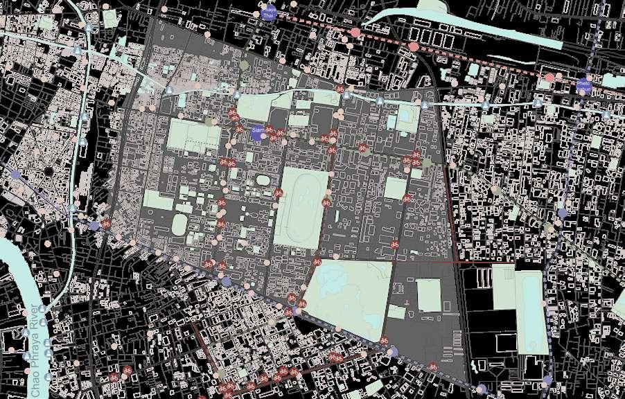
Fatal Accidents in Bangkok
(Bangkok Metropolitan Administration, 2021) (Bangkok Metropolitan Administration, 2015) (Bangkok Metropolitan Administration, 2018) MC(Motorcycle)
16% of fatal accidents in Bangkok are pedestrian crashes


Rd
Phaya Thai Rd

Popup markets and informal street stalls are important social infrastructures in local people’s daily life. They not only provide convenience to daily life but also provide significant job opportunities and many people make their living in such a way.

Source: Chulalongkorn University & Google Street View https://www.chula.ac.th/en/ Department of City Planning, Bangkok Metropolitan Administration, 2021 http://3d-cpd.bangkok.go.th/bmaall/Default.aspx


Popup Market
Informal settlement blocks the roads, causing bad effects on motorist’s and pedestrian’s use
Informal settlement
The informal settlement has poor living conditions and high building density

Lack of community facilities & open space

The inadequate transportation system. Narrow roads are a potential safety hazard

Canal Rama I Rd
Water quality is relatively low

Ferry facilities have low quality
Streets are not pedestrianfriendly
Severe traffic congestion
Current traffic condition causes potential safety issues
The sky train blocks views of the cityscape and creates an unpleasant experience
Provide job opportunities as the city’s main commercial and educational area

Local pop-up markets and street vendors add vitality to the community
Existing building typologies help preserve a sense of community
Mix-used shophouses provide convenience to both shop owners and the community


Local character is well preserved
Residential Areas

Commercial Activities
The canal has the potential to be transformed into a linear park

The ferry has the potential to reduce the traffic load

Part of the commercial street becomes a pedestrian street to reduce zoning separation and increase the connection between the north and south of the whole area.

Soften traffic safety issues


Make it easier for people living in the residential area to the north to use the public facilities in the school
Bike
Unsatisfied cycling systems

Chulalongkorn University
The university has the potential to provide high-quality educational/ cultural/health resources for the community
Next to the city’s sports facilities
A bike share initiative has been implemented-site

Convenient multi-mode public transportation

-- “the effort to achieve satisfaction in whatever one does and make the most of any situation; inject playfulness and fun into mundane activities”
-- Cultural Atlas from SBS

Blend nature into the concrete jungle
revitalise the soul of our beloved city
1 2 3 4 Sanuk
Infuse passion to explore a convenient and safe city
Knit the communities with joy and warmth
Water meanders through our city like blood flows in our bodies.
The greenish saturates the image of our city with fresh air filling up our lungs.
We reinvent a sustainable and resilient lifestyle in the metropolis.
This is a well-connected city where we are mobilised to wander every corner of the land. We embrace people from all over the world, from all walks of life. We give the city back to its people, We show love with warmth just like the golden sun.
With duty and care, we treasure our memories, honour the spirits embedded in our city, We live with our glamorous past side by side. We amplify delight in everydayness, Together we revive the soul of the city.
Be ready to expect the unexpected, The liveliness, the safety, The localness, the cosmopolitan, The dynamics, the unique charm, The joy, the love, The past, the future, All in one
We coin this “The Sanuk Bangkok”
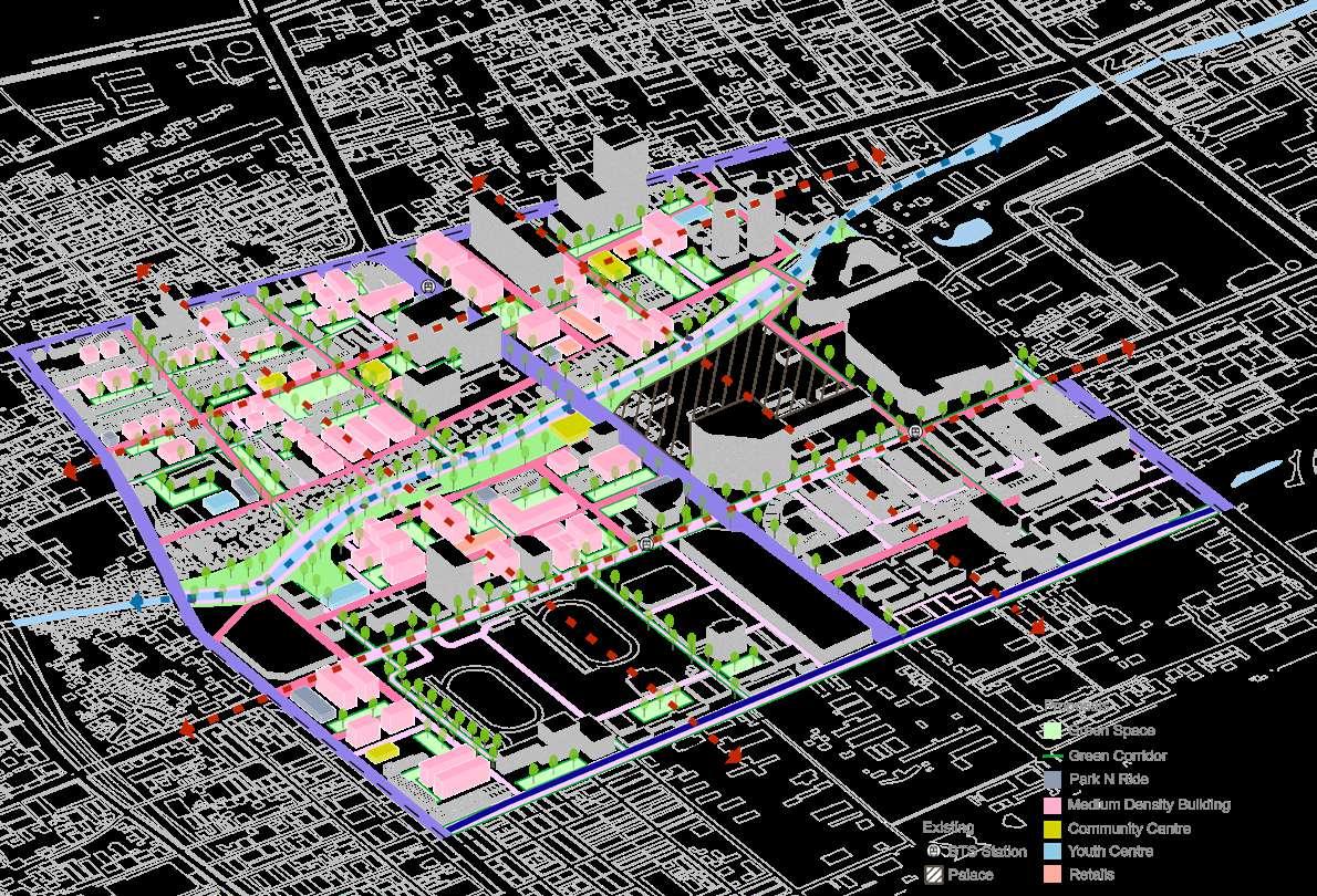


The revitalization of the canal is the axis of the new plan, taking into account its history and value to the city. The project aims to create a linear park along the canal to gather people, increase open spaces and improve the ecological environment. To provide a diversity of activities for residents and visitors, the park is divided into different zones

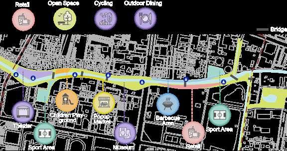
In addition to the existing bridges, four additional bridges have been added to improve the network and circulation. The ferry station was relocated to enhance accessibility and make it easier for people to get to the ferry station and promote it as a public transportation option.

Part of the informal houses in the north river are preserved as cultural heritage. The houses near the riverbank are demolished for parkland. There are some schools and residents surrounding this area and the campus has limited space to settle the infrastructure. Therefore, the south river bank transforms into a sports area for students and residents to exercise. Besides the basketball court is a shelter that allows people to take rest in a cooling environment and also can be a good meeting point.
Taking a ferry is a convenient way to commute, you don’t have to worry about traffic jams at all.
We can watch popup performances and films here!
A wetland along the river is designed to prevent flooding that treats and purifies the water. The canal will link to a network of drains in the city. During dry weather, the flow of water is confined to a narrow canal in the middle of the river. During the rainstorm, that will carry the rainwater downstream gradually and potentially reduce flooding in downstream areas.


Which reminds me of childhood!
Such a nice space for cycling.
That is a great space to exercise while enjoying the riverbank view. Let’s come here again after School tomorrow!


In scenario 2, the modification focuses on connectivity improvement. The commercial street and university are located in the south of the site, while the residential area is located in the north. The busy Rama I Road forms a physical barrier that discourages pedestrian flow. Therefore, this scenario intends to transform this road into a pedestrian street. An elevated bridge at the south is purposed for vehicle movement. Thus, the pedestrian street will not affect car movement in the east-west direction.

Rama I road, a high-end shopping street, connects to the stadium, where the art centre is also located. The design will propose the space underneath the infrastructure as an art plaza at the west and a market at the east. The open space serves as an extension of the building’s interior space, providing more possibilities for the use of the site. This area will be more permeable and facilitate both pedestrian and cyclist movement in the north-south direction.


Here it is glutted with a pronounced artistic atmosphere. That provides a different vibe with the indoor Art Centre Museum.
Yes! That encourages me to use the facilities inside the Uni. The vehicle won’t bother us anymore, is much more safety and cozy.


Scenario 3 is mainly focused on community transformation. This scenario optimizes the living conditions of the residents while preserving part of the original traditional cultural character of the shophouse and urban fabric.


The strategy is to demolish the middle row of the three rows of houses and keep the shophouses along both sides of the streets. Secondly, according to the new road network extend some of the original roads to improve connectivity. The demolished residents will be relocated to nearby medium-density housing. The open space in the middle will use for urban farming.
 Existing Shophouses
1. Proposed network
2. New Road
3. Demolition 4. Urban Farming
Existing Shophouses
1. Proposed network
2. New Road
3. Demolition 4. Urban Farming
All demolished households will be relocated to the nearest medium-density apartments. New apartment developments will also respond to population growth. A large open space located in the centre of the neighbourhood, this area provides activity space for residents as well as a pop-up market for vendors. That is also an ideal venue for hosting events and celebrations.


After a long day of hard work, we are eager to find a place to have a break. A sense of belonging and a pleasant atmosphere always cheers me up.
The road is much tidier and more orderly. No need to worry about fire trucks not getting in when there is an accident.
Docklands Water Purification Park: enabling the chain of ecosystems is a manifesto to make Melbourne more adaptive to climate change, in which the Docklands is envisaged as a pioneer to make change happen. In the Australian context, where urbanisation has always played a leading role, cities have left little room for original ecosystems that provided resistance and purification for our current problems. Restoring these ecosystems provide one of the solutions to protect the city from more severe conditions. In our design, the Docklands is among these enabling frontrunners, which ecosystem will revolve around purifying water. The Docklands will be launched as a large Water Purification Park, and in doing so it commits to research and education to make the effects measurable and apparent. Not just to researchers, but to all Melbourne residents and visitors. A research institute, hotel, kayak launch station, and swimming pool are proposed to facilitate this programmatically, along with better transport connectivity to the city.

was previously built as a port (1892). It was a strategic location near the city centre, to minimise transition costs. Today, Docklands has been redeveloped into new housing and offices. The historic value of having a wharf and central dock to store goods has been lost, although the dock is still used by small recreational boats. According to the “Plan Melbourne 2017-2050”, the future of Melbourne lies to the west of the Docklands, making the site even more central to the city.
Urbanization leaves too little room for pristine ecosystems to provide resilience to the problems we face today. In cities where the urban environment can barely cope with water pollution, aquatic species diversity, and extreme weather condi-

As the Docklands promoted the city of Melbourne to grow into the metropolis it is today in the 1890s, the Docklands is at a key position in the ecosystem chain, offering the opportunity to act as a pioneer and demonstrate that things can be done radically differently.


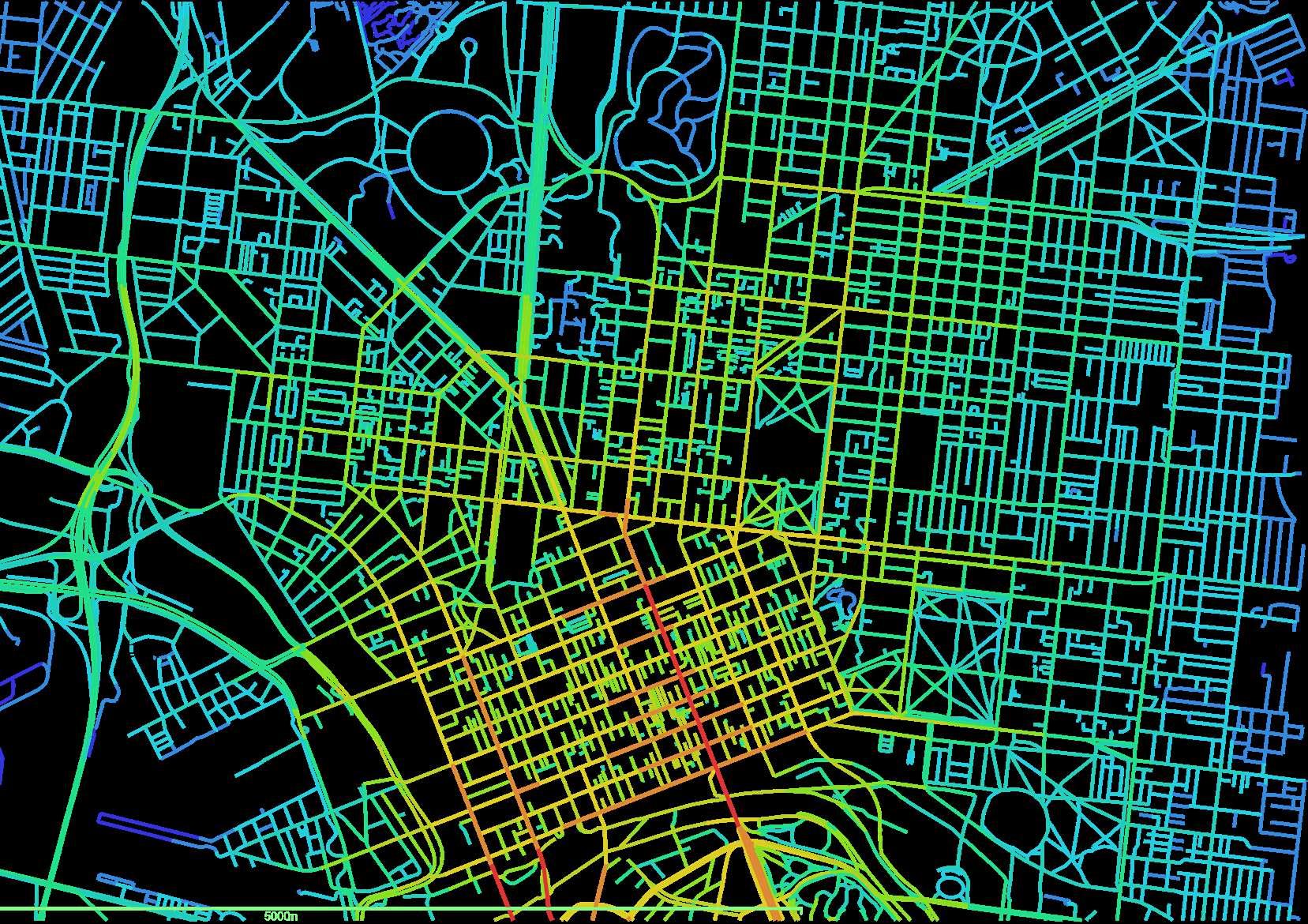
There are many parks and landmarks scattered along the Yarra River that can be classified by recreational purposes, botanical purposes, and forest reserves. These places are related to civic life or the conservation of terrestrial life. The “necklace” of the Yarra River connects these sparkling points into a


whole. The objective of the project is to create a series of planning schemes and urban design approaches to address water pollution and ecological damage to be piloted in the Docklands.

 The Royal Botanical Garden target to preserve the heritage character of the gardens while purifying the water. The garden connects the collected effluent through pipes to different wetlands and lakes, which in turn recharge the water to the Yarra River.
Collingwood Children’s Farm Royal Botanic Garden Yarra Bend Park Stoney Creek Nature Conservation Reserve
tions.
The Royal Botanical Garden target to preserve the heritage character of the gardens while purifying the water. The garden connects the collected effluent through pipes to different wetlands and lakes, which in turn recharge the water to the Yarra River.
Collingwood Children’s Farm Royal Botanic Garden Yarra Bend Park Stoney Creek Nature Conservation Reserve
tions.
By 2040, temperatures across the Greater Melbourne Metropolitan Region are expected to rise by an average of 1.3°C under a medium climate change scenario. The risk of fire in forests and grasslands will remain high under these conditions posing a serious threat to the Catchment’s communities, infrastructures, and high-value native forests including water supply catchments and ecosystems.


Source: EPA Victoria, 2021
Source: Department of Environment, Land , Water and Planning, 2022
The State Government published its latest Index of Stream Conditions for the Yarra. Five aspects of river condition – hydrology, streamside zone, physical form, water quality, and aquatic life – are combined to give an overall measure of environmental condition. The results show that only a small proportion of the Yarra and its tributaries (12% of their length) is in good or better condition and over half (57%) is in poor or worse condition.
Source: Yarra Riverkeeper Association, 2013
Source: Department of Environment, Land , Water and Planning, 2022
year 1750
year 2005
Wetlands (brackish/estuarine)
Riverine Grassy Woodlands/Forests
Riparian Forests or Woodlands
Herb-rich Woodlands (Alluvial terraces/creek lines)
Plains Grasslands and Chenopod Shrublands (Clay soils)
Lower Slopes
Box Ironbark Forests or Dry/Lower Fertility Woodlands
Plains Wood or Grasslands
Salt-tolerant/Succulent Shrub lands
Water quality is good in the forested areas of the upper Yarra catchment, but declined to very poor in highly urbanised areas. These results follow a clear pattern throughout the Port Phillip Bay catchments reflecting the impacts of land use on water quality


Ecological vegetation is rapidly declining due to urbanization and pollution. However, the Yarra River is still home to a large amount of wildlife and conserves many species. The graphic shows the value of biodiversity and the shape of the Yarra River can be identified.

Education Institute
Dockland Industry sector of Employment

Source: ABS, 2016
In addition to its ecological base, Dockland has an ample human resource pool of counterpart professionals and a water resources research base as a pilot advantage.


CBD Industry sector of Employment
Source: ABS, 2016
Professional, Scientific and Technical Services Professional, Scientific and Technical Services
Dockland is located between two national employment and innovation clusters, Parkville and Fishermans Bend. Parkville is recognized globally as a leading biomedical and research area. In addition, the University of Melbourne will open an Urban Water Infrastructure Lab in Fishermans Bend, a recognized engineering, manufacturing, and design region. Reducing wastewater and carbon emissions from this industry will fundamentally protect the ecosystem and provide laboratories and collaboration opportunities for these research institutions.
Metro Tunnel Station Tram Station Metro Station
Metro Tunnel Link Superloop
The Docklands is ideally located with an excellent public transport system and high accessibility. The port area offers a variety of public transport options. Port Phillip ferry provides direct routes to Geelong and Portarlington. With the completion of the new Arden Metro station, it is only half an hour from Docklands to Melbourne Airport.
 Port Phillip Ferry Station
Central Pier Station
Port Phillip Ferry Station
Central Pier Station


The locations of the two main programs are based on the existing condition and fabric of the purification wetland

The research centre will serve the maintenance of the entire wetland. Continuously track the progress of water management and biodiversity conservation, and make changes accordingly.
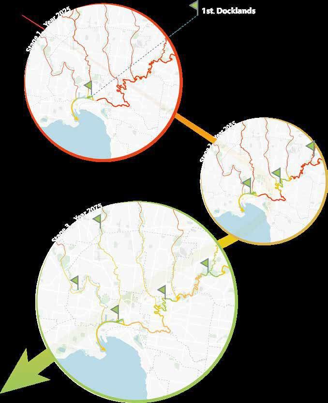
• Completed the hotel construction.
• Developed the swimming pool and water bath area.
The final stage of the project is the finishing touches. Enhancement of the entire water purification system and ecosystem, and provide more adequate habitat for wildlife. Improve the recreational facilities in the park.
• Planting and creating soft landscapes in wetlands.
• Completed roads and other infrastructure construction in the park and installed urban furniture.
• Adjusting the surroundings and reforming the public space between the park and the surrounding buildings to stitch the park and the city better. Increase the overall green coverage of the site and canopy density along the side road.
• Extend the Route 11 and 48 tram service from Collins Street to Wharf Road and construct a new tram stop.

• In the progress of developing the hotel.
The third phase focuses on the construction of park facilities and public infrastructure. Collaborate with relevant departments to transform wetlands and draft for vegetation list. Provide suitable habitats for aquatic wildlife.
Reshape the fabric to connect with the surroundings to enhance the accessibility
• Developed the water purifier technical system of wetlands in Dockland harbours.
• Developed research centre.


• Completed the planting of the Rain garden and built the initial ecological chain of the Rain garden.
• Developed the pedestrian bridge.

• Demolished the former kayak station and shifted it to the riverbank. Provided site for the upcoming construction of the tram station.
The second phase focuses on the construction of water purification systems for the wetlands, as well as continuing the construction of the incompleted.
Add in soft scape in between each purification pool. Relocated research centre and hotel in two extended floating platforms
• Relocated Port Philip Ferry Station and berth areas out of the wetland zone.
• Demolished Pier.
• A constructed canal connecting Yarra River and Harbour, and installed rain garden system in.
• Developing a pedestrian bridge connects both coasts.
The first phase prepares for the construction of the entire project. Relocation or demolition of some facilities to provide land for the next step of wetland construction. Modification of Dockland Park and construction of a canal to connect the Yarra River to Victoria Harbour to provide a water source for wetland purification, and installation of a Rain garden to provide initial filtration of the Yarra River and brackish water.
Construct one more pedestrian bridge at end of the banks. And switch the location of Port Phillip Ferries Station
Clean Water leaving treatment system reduced sediment and pesticide loads
Path Way - 2 m

Water level - 0 m

Processing of nutrients into wetland vegetation and biofilms

Vegetation slows water and prompts even flow
Wetland vegetation inhibits the release of deposited nutrients by pumping oxygen into the soil
Vegetation provides a surface for biofilms plus contributes carbon and oxygen to the soils, providing conditions that promote nitrification decertification, leading to nitrogen removal
Deposition of coarse ( and medium sized) sediment particles
Through pipe to Inlet Pool
Water run of, carrying sediment particles and dissolved pollutants nutrients and pesticides


Slowing down runoff increases sediment deposition rate
 Macrphage Zone
Inlet Pool
Sediment Basin
Research Center
Main Entrance
Macrphage Zone
Inlet Pool
Sediment Basin
Research Center
Main Entrance
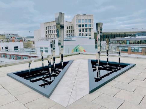
The deceased of the great person makes London’s rainy weather mixed with some sorrows. A drop of rain, insignificant yet able to bloom such a ravishing ripple. Dripping of rain droplets composed a hymn that worships the great persons, just like how their spirits are remembered and sung.
The Legacy Garden is for memory Dr. Mayling Birney and LSE staff who have passed away, commissioned by LSE( London School of Economics & Political Science). The aim of the legacy garden is a living, breathing space that invites people to utilize it. By putting a spotlight on their generosity, we hope it serves not only as a place of ornamental value, but as a focal point by which the school openly honors, thanks, and remembers its legators. Also, a place where we can communicate with them spiritually and honor their unique perspectives.
Considering local weather patterns, we fervently hope it will be part of the rainwater recycling system for a sustainable future.
* Dr. Mayling Birney was a professor at LSE in the Department of International Development. Her area of expertise was comparative Chinese politics, and the family is also funding a Global Scholar programme at LSE in her name.


Worse Than Dying Is Being Forgotten. Although their bodies have perished what is truly immortal is the thought of the pioneers. Their avant-garde thoughts and spirit have inspired generations of young people, and this is how their lives have continued.

There is a connection between everything in this world. It can be as small as dust or as large as outer space. The appearance of everything can be traced to the source.
The emergence of thought stems from the birth of life, the emergence of a family, a school, a society, the cognition he accepts, and his interpretation of the world, including his death. But the appearance of death does not mean the extinction of his thought. The thought will be interpreted and inspired differently by different people and passed down from generation to generation.
We are inspired by London’s wet weather and the ripple effect (a spreading effect or series of consequences caused by a single action or event.)
A single rain droplet is unable to form precipitation, but countless drops can turn into torrential rain, changing people’s lives. Just like every drop of rain cannot be exactly identical, everyone has independent thoughts, but the combination and collision of these thoughts can change the world.
The ripple effect is the notion that a single action has an effect on several different entities. Basically, it is where you make one little change, and it starts to “trickle” into, or affect other parts of your life.


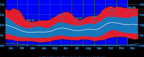
Average Monthly Rainfall in London
The number of rainy days (with more than 0.25mm of rainfall) is fairly consistent throughout the year in London, with between 11 and 15 rainy days every month. Overall rainfall is highest in November and August (64mm and 59mm respectively) and is lowest in March and April (37mm each).
 Inspiration
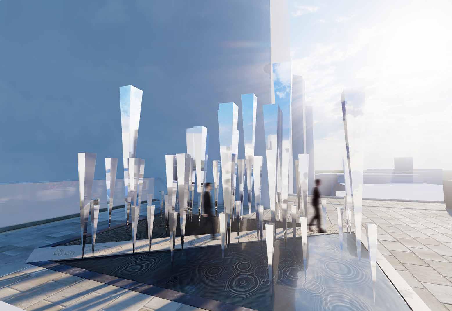
Inverse cone, impacts from different thoughts

Formation of ripples on water surfaces symbolized how thought creates influenc

Numerous inverse cones, formation of various thoughts, ripples on the water surface symbolized the collision of different thought
Cones come in different sizes shows the variability and dissimilarity of thoughts
Reflective materials enable the students of LSE to reflect and feel sentiment during the process of
Numerous inverse cones, formation of various thoughts, ripples on the water surface symbolized the


Rainwater recycling system for future sustainable development

The team aims to create a series of outdoor installations made of mirror materials. The process of presenting oneself as the materialistic of the thought-every-cone is reminiscent of a sharp and forward thought.
Every matter on Earth requires gravity to achieve stability. But not the case for thoughts, thoughts can exist independently. A pioneer’s thought can stand by itself without any medium or physical infrastructure.
Dr. Mayling Birney’s thinking is progressive. It is one of those sharp breakthroughs to our imprisoned way of thinking, creating significant impacts on the world. The cones are inserted directly into the water and create ripples, symbolizing how every small thought can become a great power. The collisions and extrusions of the ripples are the sparks between different thoughts, brilliant and elegant.
At the same time, We will build a rainwater recycling system at the bottom of the installation and every drop of rainwater will become a reserve force for future sustainable urban development, just like how every student from LSE will be a reserve force for social development.

Everyone in the world is like a raindrop and we should never feel small but proud of ourselves.
London is a rainy city with frequent showery weather. As an installation located on the rooftop garden, we hope to endow it with the idea of sustainable development. The design of the project intends to construct a rainwater recycling system with cones serving the purpose of rainwater filtering and gathering.
Rainwater Cistern will be placed beneath the rooftop garden to achieve the requirement of flora irrigation in the school.
Everyone has independent thought and consciousness. Those cones symbolize the wisdom of the legators, and through them, we see ourselves now, as if we are standing on the shoulders of giants and looking at the world.
The Chorus of Ripples provides a place for meditation. Through the refraction of mirrors from different angles, you will see the world and yourself from different perspectives. This is a process of seeing yourself and exploring the world clearly. There is an old Chinese saying called “one’s mind is as clear as a mirror”, which means observing and perceiving the people and things that appear in front of you thoroughly and understand.
The world is not black and white, economy is not, politics is not, nor is life, everything is multi-angled and multidimensional, which inspires students to have critical thinkings.
The names will be engraved on the facade of different cones, as well as some famous quotes from legators to motivate and inspire LSE students. As time goes by, more names will be added and remembered.

For future considerations, each cone can be added as an independent installation in different places in the school, with new names added as well.
can be also applied on some of the biggest cones for screen display, announcement and events.


When people are walking in the middle of the path, they are like being surrounded by the thoughts of pioneers, getting inspired from them.
The pronunciation of Dr Mayling Birneyand Plum Blossom Forest in Chinese is the same. The road with plum blossom pattern is not only a kind of yearning for Dr Mayling Birney but also a Chinese poem “Plum blossom is from the bitter cold”. Dr Mayling Birney’s persistent perseverance has contributed to the world. Her contribution is worth remembering, and her spirit will be the most immortal. The straight road was paved by the pioneers, but there is still a long way ahead for us to explore. We belive that our future will be brighter with the accompany of their spirits.
Magic Mirror Digital Display


-Death is not the opposite of life, but a continuation of it.
We humans have such destructive tendencies towards mother nature such that even as we die, our rite of passage to the afterlife causes environmental degradation.
This project aims to create a new cemetery concept through the “recompose” method, which converts the body remains into the soil. This keeps the entire procession environmentally friendly, while at the same time preserving the spiritual and emotional aspect of a conventional funeral.
This space offers the loved ones of the deceased to conduct their fnal farewell and use the soil to cultivate the plants in the Garden of Rebirth. The whole space through borrow nature scenery to bring a psychology journey for living relatives, that evokes a spiritual connection between the living and the deceased, allowing the living to reach an understanding of mortality in their respective ways as well as to offer spiritual sustenance and hope for the living.

- Generates Carbon dioxide
- Waste energy

- Land pollution
- Generates greenhouse gas

Both of the funeral procession methods in Singapore are proven to give a negative impact to the environment.
Objective Funeral Solution
This project creates a new cemetery concept with a method that aims to make funerals more environmentally friendly while also retaining the spiritual and emotional aspect of traditional funeral rites.


Recomposition is a corporate service offering organic reduction, a process which gently converts human remains into the soil in about 30 days. The soil can be used to cultivate new lives.

Location Map

Site

Yi Shun Nature Way
Mandai Crematorium
Residential
Nature Reserve
Sport & Recreation
Nature Park
Reserve Site (Jungle)
Special Use
Mandai Avenue
Seletar Expressway
Mandai Road
Sembawang Road
Lentor Avenue
Bus Stop
The site is located in Mandai crematorium that is nearby Central Catchment Nature Reserve and is a part of Yi Shun Nature Way. This area is far away from the downtown area, with a good ecological environment, therefore, you can see the monkeys and other varieties of species here.


Flourishing jungle around here with an excellent nature view and a water body in the lowest area.


Main Entrance Recompose Area Rest Area Soil Collection Car Park Sub-Entrance 1 2 3 5 4 6 7 1 2 3 4 5 6 7 0 Section A

Section A’

This helps the deceased to be reintegrated back to earth through the ecological cycle, contributing to environmental protection via a greener method of funeral rites. Death is not the opposite of life, but a continuation of it.

Original site
The form of my design inspired by the circle. Death is not just only an end but also a new beginning. And the circle is also like this, any point can be the starting point or the ending point.

Use circle as basic form
Raise up the service hall for borrow
Remove some part of the recompose area to opening view nature
Same language the entrance
Follow the contour line sloping down the recompose area


Increase water body
Add one more entrance, from crematorium underground car park
The death of relatives and friends is an indelible scar. I hope this space can break people’s impression of the traditional cemetery. When people think about it, it’s not only the pain, but also the warmth and hope. Death is not the opposite of life, but a continuation of it.
There is a huge acrylic water pool in the center and I’m using the mirror nish stainless steel as the shelter material for the Immaterial entities effect. Those kinds of materials will re ect the surrounding bamboos. This space allows the people to recall memories of the past.


After entering the entrance, people will go through the Garden of Death which is a bamboo forest. when the sun shines on the bamboo leaves, it will cast a beautiful shadow. When the wind blows over the bamboo or animals’ activities, the bamboo will swing and makes a slight sound. It’s a very long corridor for people to calm down and prepare the last farewell.

A lot of vertical and horizontal lines are used in the whole space to create frame. The sun will shine in from the side and bring people’s attention to the huge window. The window frames the view of deceased and nature together.·


In this area, people can see the opposite land symbolising hope, it’s just like another starting point of life and it bring hope to us. The cover will block a part of sight to force people looking to the water that re ect the surrounding environment.


This space expresses the cycle of death to the next stage. Just like the owering plants here, they bloom and bear fruit, then wither and return to the land for fertilizer. Whether it’s plants or people, life goes through the same cycle.


This is a lively garden where all life gathers around and make life a meaningful new chapter. I am using limestone for the road material as a metaphor of tracing time. The stone weathers, but life carries on.

Marina barrage is an iconic site for Singapore as it plays an important role in our daily needs in water. Despite being iconic and near to the Gardens by the Bay, a tourist attraction area, the designs of the bridge does not attract many people.
Over the years, urbanization had separated nature and humans, where they used to be united. Hence this project is to design the linkage where it allows people to get a sense of touch of nature in this urbanized city. The reasons for the chosen site is due to realizing that this bridge was transformed from nature due to urbanization. Hence, It would be better to return this back into the nature yet allowing it to function what it should be. This does not act as just a linkage for humans to walk through, but it also allows humans to feel nature, a place where the wildlife could feel home. With this, it allows one to reconsider the relations between nature and mankind.


he arina arra e was en isioned in a ore s frst ri e inister r ee uan ew ore than ears a o in after the co letion of a assi e clean u the in a ore and allan i ers
Singapore is one of the most urbanized countries in the world, particularly since its independence from the British Colony in 1965. The urbanization also linked with rapid industrialization, so during that time the government focuses on providing enough public housing and providing employment opportunities for the people. This led to priorities on urban developments that overlooked the preservation of nature and natural habitats, causing to Singapore lose 90 percent of its original forests today.

Since the 1960s, the government had planned to transform Singapore into a garden city. Until the late 1990s, the government takes immediate and basic measures to help protect the environment. However, Singapore is densely urbanized with a concrete jungle, so the land is limited.

The purpose of the design is to create a juxtaposition space that allows coexistence between humans and wildlife. It is to design a space allowing people to get a sense of touch nature in the cit and is also a re e i e ro ect for hu ans his desi n will a e a big contrast between the current situation and future at Marina Barrage. It prompts tourists to question the divide between nature and mankind in the modern world. This inspires the thought that can help bring about change in their relationship and ways to protect animals and provide more habitable space for them.

For this project, it is to design the linkage that allows people to get a sense of touch of nature in this urbanized city, while at the same time providing for wildlife needs. This way, the Barrage will not only be just an engineering masterpiece, but it also doubles as an ecological park that directs people towards an ecological environment where animals can become more involved.


his desi n in uenced by the water deop and sea water wave
1 .Used water drop element to design a space


2. Explore more spaces with different functions.
3. Create different levels of spaces that allow people touch the water.
4. Divide area for different function
The barrage can be separated into two areas, the top is the shelter and pathway for people to cross. There are 8 shelters on the barrage, below the shelter is the base of the barrage, in between are gate, that can open and close to control the water ow


Since Marina Barrage is an important structure in Singapore and plays an important role for majority, the existing function of the place must be maintained. This brings in the consideration of designing the project without touching the structure under the water.

As the new design will be taking up a wider space with a heavier weight than the e istin arra e a oatin structure which utili es anchors secured on the lake bottom as a foundation will be used in these parts to lighten the pressure on the barrage pier.


Choosing different Plant species depends on different environments. The lower three foors will be submerged by the sea when the high tide. Therefore, I chose the plant species that can survive in the seawater.


This design will imitate suitable habitats as far as possible to make it become the kind of environment that animals usually stay to attract wildlife to come.
 Aquatic life
Suitable for seaside
Land plants
Terricole
Amphibian
Tree/palm species
Licuala ferruginea assia fstula Gardenia tubifera idia densi ora Caryota mitis Baccaurea ar i ora
Elaeocarpus mastersii Clerodendrum laevifolium
Lumnitzera littorea
Alstonia scholaris Cyrtophyllum fragrans Cordia sebestena
Aquatic life
Suitable for seaside
Land plants
Terricole
Amphibian
Tree/palm species
Licuala ferruginea assia fstula Gardenia tubifera idia densi ora Caryota mitis Baccaurea ar i ora
Elaeocarpus mastersii Clerodendrum laevifolium
Lumnitzera littorea
Alstonia scholaris Cyrtophyllum fragrans Cordia sebestena


In the middle of the amphitheater, there will be a garden where there are seats provided for people to rest on, through the greenery and the natural to give a space of relaxation. At the same time, there are voids in the middle, where people can look down to see the barrage system, people then can see how this barrage can be work with the water supply and the food control between the Marina Reservoir and the sea. It provides a new kind of experience and visual enjoyment while watching the water food created when opening the gate of the barrage.


At the lowest level of the barrage, which is just the same as the water level, I have designed a bigger platform. These platforms are with the willing started from 30cm high, so the seawater can enter through this 30cm height gap, and it allows people to ste in water durin the low tide to et in touch with water he otters and fshes can enter through these gaps inside the marina barrage, where connected to the rain garden on the top, through the water elevator, you will be able to see otters in the rain garden too.
The rain garden is the center of the whole barrage. The rain garden will collect and flter the rainwater ro ide the source of water for the lants on the bridges at the same time provide the environment for the wildlife. It is to bring the visitors a different kind of experience.
 Model
Rain Garden
Model
Rain Garden


Access directly on the street without an interstitial zone of semi private space but low transparency


Enter private space through a zone of semi private space
This analysis shows that main streets generally have a good interface that people prefer to walk on. Interesting interface that attracts people to travel. The quality of the environment in small lane is much poorer, with monotonous walls and closed back gates that make the street unattractive.

Park/ Sidewalk / Medias / Public Toilate / PublicTransport / Libaray Housing

Store / Churche / Hotel lobby / Hospital / School without school fees
Cafe / Restaurant / University building / Parking need to pay


Some “medians” in the street I consider as “open public space” because the area is functionally accessible for humans to cross the street. If the “median” is narrow and is used for planting trees, I recognized it as inaccessible space because no one will use it.
The area is mostly residential with some offices, which is why the entire area is dominated by invitation spaces. From the diagram, we can easily conclude that the ticketed spaces and open private spaces are concentrated on Lygon Street, a street with the most retail restaurants and cafes in Carlton.


Open-Public Spaces
Quasi Public Spaces (Not in this analysis site)
Open Private Spaces
Invitation Spaces
Ticketed Spaces
Inaccessible Spaces